london's green belt and metropolitan open land
DESCRIPTION
In this special briefing we review the changes to London’s Green Belt and Metropolitan Open Land The paper looks at the history and future of London's Green Belt. We argue that there are still considerable opportunities for designing compact liveable neighbourhoods within London whilst also promoting our precious green spaces and corridors.TRANSCRIPT
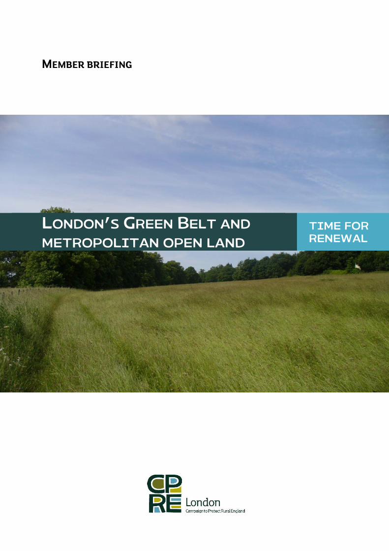
MEMBER BRIEFING
LONDON’S GREEN BELT AND
METROPOLITAN OPEN LAND
TIME FORRENEWAL
- 1 -
London’s Green Belt and Metropolitan Open Land – Time for Renewal
CPRE London Member briefing
CONTENTS
SUMMARY ..................................................................................................................................................2
1. LONDON’S GREEN BELT – BACKGROUND AND HISTORY ..........................................................3
2. CURRENT STATUS AND CHALLENGES............................................................................................4
2.1 Local Green Belt boundary reviews..................................................................................................7
2.2 Green Belt incursions and very special circumstances ...............................................................8
3. FUTURE OF LONDON’S GREEN BELT – CPRE LONDON RECOMMENDATIONS..................... 10
3.1 Reduce policy uncertainty ............................................................................................................. 10
3.2 Connecting up London’s landscapes and Green Belt ................................................................ 11
3.3 Track and fund connectivity.......................................................................................................... 11
3.4 Incorporate ‘liveability’ objectives within development ........................................................... 12
3.5 Improve local environmental participation................................................................................ 13
4. CONCLUSION...................................................................................................................................... 14
FURTHER RESOURCES.......................................................................................................................... 16
REFERENCES........................................................................................................................................... 16
ANNEX 1. LONDON BOROUGH GREEN BELT CHANGES................................................................. 17
GLOSSARY
ALGG All London Green Grid
CPRE Campaign to Protect Rural England
MOL Metropolitan Open Land
NPPF National Planning Policy Framework
PPG Policy Planning Guidance
SPG Supplementary Planning Guidance
CPRE London Member briefing Green Belt Review
SUMMARY
The aims of the Green Belt have changed over time. They have widened to include multiplebenefits for the natural environment, for people, for defining urban boundaries andpreventing urban sprawl. Current national policies, the National Planning Policy Framework(NPPF) and Localism Act, have given greater responsibility to individual London boroughs todefine the role and protection of Green Belt and large areas of ‘Metropolitan Open Land’(MOL) within their local plans and planning decisions. It is down to local councils to clarifywhat might be ‘inappropriate development’ in the Green Belt at the edges of London and tothe open land within London. It is also up to them to clarify the ‘very special circumstances’that might allow development on protected land. This local interpretation of policy is a realconcern where London boroughs face ever-greater pressures to meet increasing housing andinfrastructure targets.
In this paper CPRE London reviews current changes to London’s Green Belt and MetropolitanOpen Land (MOL). We argue that there are still considerable opportunities for designingcompact liveable neighbourhoods within London whilst also promoting our precious greenspaces and corridors. Our key recommendations are:
1. Reduce policy uncertainty: incorporate PPG2 wording into London Plan anddevelopment guidance and clarify Green Belt development exemptions
2. Connect up London’s landscapes and Green Belt: Plan positively for greenconnectivity
3. Track and fund connectivity: Monitoring All London Green Grid SPG implementationand identify additional resources
4. Incorporate ‘liveability’ objectives within development: Supportingneighbourhood inclusion and wellbeing, increased local powers, finance and qualityof affordable homes
5. Improve local environmental participation: Fulfilling the right to participate.
Call to action!
CPRE London needs our members and Londoners to get involved in promoting the Green Beltand Metropolitan Open Land. Things you can do:
Track local developments: monitor development proposals in and around London’sGreen Belt and Metropolitan Open Land and local plan changes in your local area, andkeep us informed: [email protected] or Tel: 0207 253 0300
Seek local funding: There are various grants available to enhance your local GreenBelt and green spaces, as well as encourage greater local use and involvement (seeCPRE London: ‘Living London’ paper for ideas)
Get involved in local planning: You can get involved in local neighbourhood planand Local Plans, to encourage greater investment in local green spaces andconnecting them up with MOL and Green Belt is they are present in your Borough.
Join CPRE London now! If you aren’t already a member, join us for a little as £3 amonth and help fight for London’s green spaces!
- 3 -
Briefing aim
This document aims to provide CPRE London members and others with a background toLondon’s Green Belt and Metropolitan Open Land (MOL). It is an update on current policy andlegislation relating to the role and protection of Green Belt and MOL, considering the currentstatus of this land and its future role. It discusses how the GLA, London boroughs, and CPRELondon members can further support effective management and enhancement of London’sstrategic open spaces.
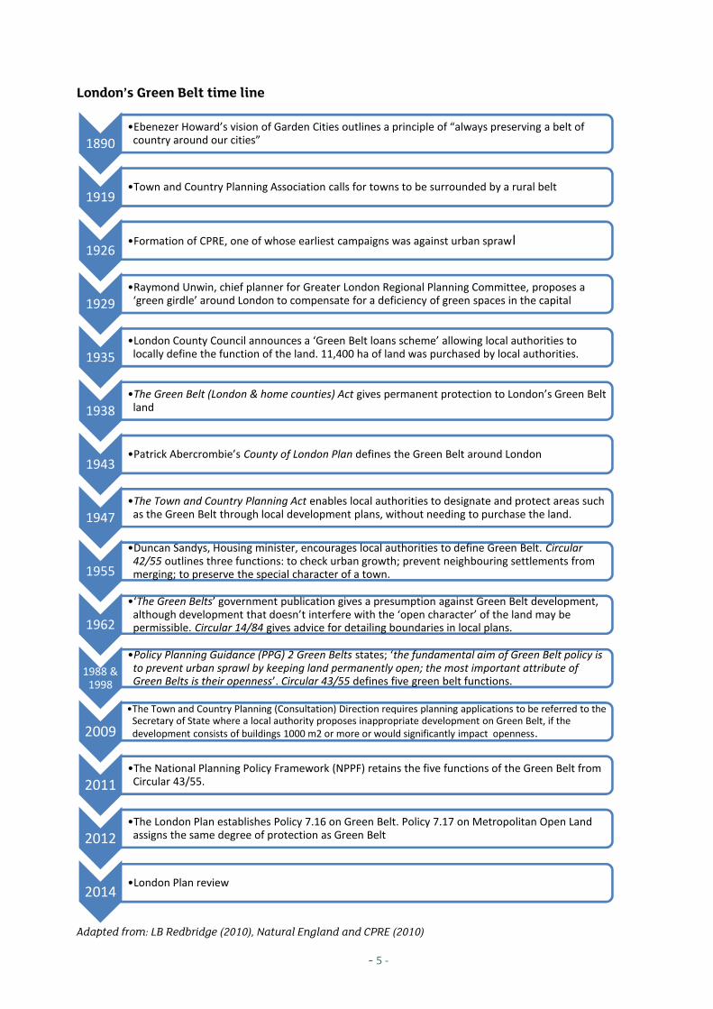
1. LONDON’S GREEN BELT – BACKGROUND AND HISTORY
The Green Belt is a permanent area of open land that surrounds an urban area. Early aims forthis land were to limit uncontrolled urban growth or ‘urban sprawl’ into rural areas. InLondon, the Green Belt dates back to pre-war initiatives that sought to retain a good qualityrural landscape that was clearly separate from urban areas. Its purpose and protection hasevolved (see the timeline below). According to the current National Policy PlanningFramework (NPPF);
“The fundamental aim of Green Belt policy is to prevent urban sprawl bykeeping land permanently open; the essential characteristics of Green Beltsare their openness and their permanence”
The five purposes of the Green Belt are defined as to:
1. Check the unrestricted sprawl of large built-up areas;2. Prevent neighbouring towns merging into one another;3. Assist in safeguarding the countryside from encroachment;4. Preserve the setting and special character of historic towns; and5. Assist in urban regeneration, by encouraging the recycling of derelict and other urban
land.
Table 1. Key Green Belt and Metropolitan Open Land policies
Policy ReferenceNational PlanningPolicy Framework
Ch. 9 Para 81 – 92Role of local authorities to plan ‘positively to achieve benefits from Green Beltland, including access, sport, and enhancement of landscape (NPPF para 81)Demonstrating ‘Exceptional Circumstances’ for development (NPPF para 82)Exceptional circumstances test (NPPF para 83 – 86)Very special circumstances test (NPPF para 87 – 92)
London Plan Policy 7.16 on Green Belt and Policy 7.17 on Metropolitan Open Land (Ch. 7,London Plan)All London Green Grid Supplementary Planning Guidance (SPG)
Sources: NPPF (2011), London Plan 2011, CPRE London 2013
Views on the purpose of the Green Belt are changing and often conflicting. Some argue that itis a ‘blunt’ tool that blocks vital access to land (Amati and Taylor, 2010). However, otherspoint to increasing threats to local food security and the environmental impact of
CPRE London Member briefing Green Belt Review
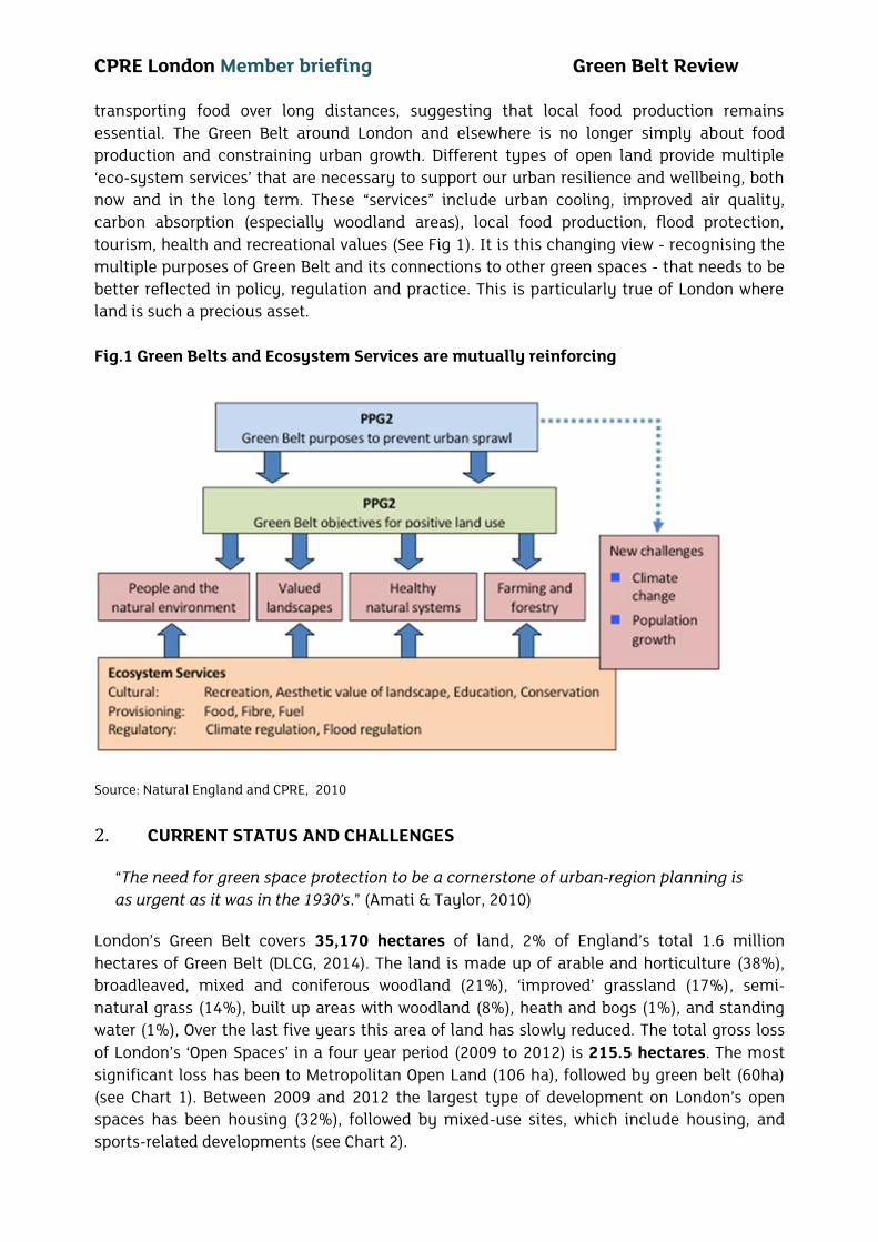
transporting food over long distances, suggesting that local food production remainsessential. The Green Belt around London and elsewhere is no longer simply about foodproduction and constraining urban growth. Different types of open land provide multiple‘eco-system services’ that are necessary to support our urban resilience and wellbeing, bothnow and in the long term. These “services” include urban cooling, improved air quality,carbon absorption (especially woodland areas), local food production, flood protection,tourism, health and recreational values (See Fig 1). It is this changing view - recognising themultiple purposes of Green Belt and its connections to other green spaces - that needs to bebetter reflected in policy, regulation and practice. This is particularly true of London whereland is such a precious asset.
Fig.1 Green Belts and Ecosystem Services are mutually reinforcing
Source: Natural England and CPRE, 20102. CURRENT STATUS AND CHALLENGES
“The need for green space protection to be a cornerstone of urban-region planning isas urgent as it was in the 1930’s.” (Amati & Taylor, 2010)
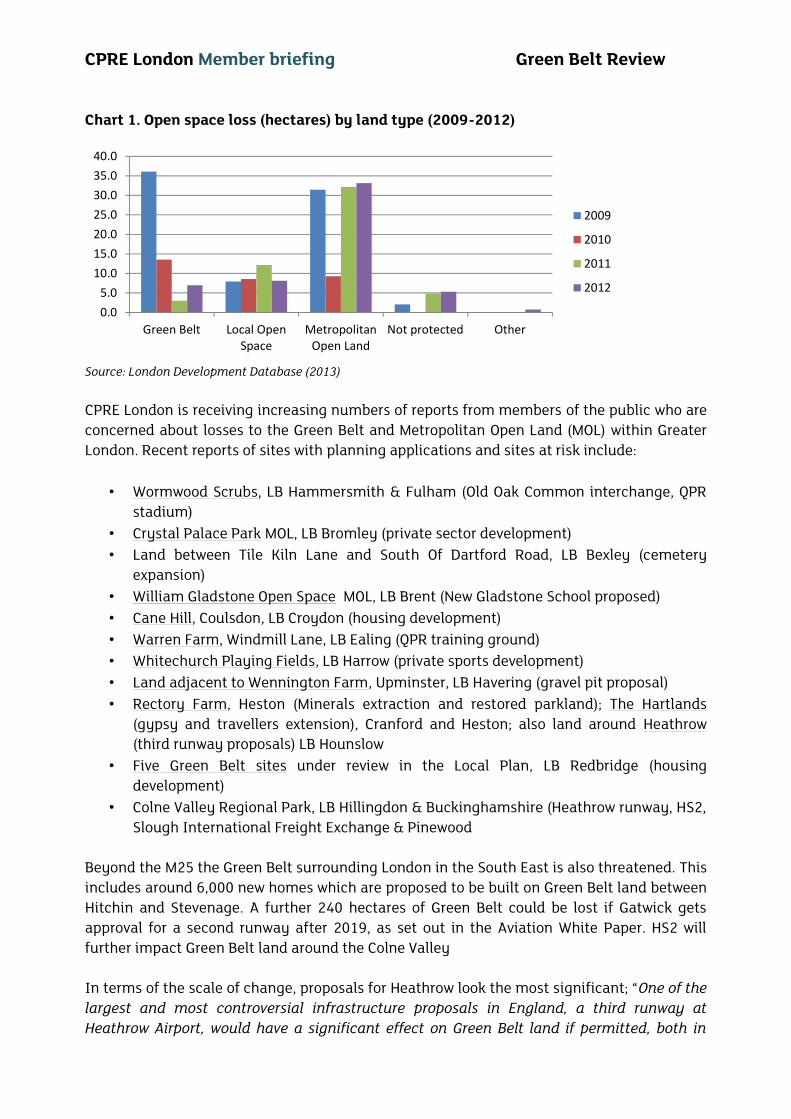
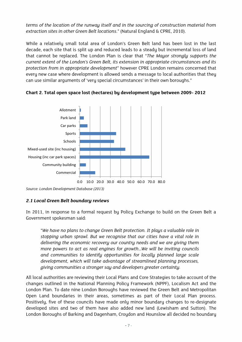
London’s Green Belt covers 35,170 hectares of land, 2% of England’s total 1.6 millionhectares of Green Belt (DLCG, 2014). The land is made up of arable and horticulture (38%),broadleaved, mixed and coniferous woodland (21%), ‘improved’ grassland (17%), semi-natural grass (14%), built up areas with woodland (8%), heath and bogs (1%), and standingwater (1%), Over the last five years this area of land has slowly reduced. The total gross lossof London’s ‘Open Spaces’ in a four year period (2009 to 2012) is 215.5 hectares. The mostsignificant loss has been to Metropolitan Open Land (106 ha), followed by green belt (60ha)(see Chart 1). Between 2009 and 2012 the largest type of development on London’s openspaces has been housing (32%), followed by mixed-use sites, which include housing, andsports-related developments (see Chart 2).
- 5 -
London’s Green Belt time line
Adapted from: LB Redbridge (2010), Natural England and CPRE (2010)
1890•Ebenezer Howard’s vision of Garden Cities outlines a principle of “always preserving a belt of
country around our cities”
1919•Town and Country Planning Association calls for towns to be surrounded by a rural belt
1926•Formation of CPRE, one of whose earliest campaigns was against urban sprawl
1929•Raymond Unwin, chief planner for Greater London Regional Planning Committee, proposes a
‘green girdle’ around London to compensate for a deficiency of green spaces in the capital
1935•London County Council announces a ‘Green Belt loans scheme’ allowing local authorities to
locally define the function of the land. 11,400 ha of land was purchased by local authorities.
1938•The Green Belt (London & home counties) Act gives permanent protection to London’s Green Belt
land
1943•Patrick Abercrombie’s County of London Plan defines the Green Belt around London
1947•The Town and Country Planning Act enables local authorities to designate and protect areas such
as the Green Belt through local development plans, without needing to purchase the land.
1955
•Duncan Sandys, Housing minister, encourages local authorities to define Green Belt. Circular42/55 outlines three functions: to check urban growth; prevent neighbouring settlements frommerging; to preserve the special character of a town.
1962
•‘The Green Belts’ government publication gives a presumption against Green Belt development,although development that doesn’t interfere with the ‘open character’ of the land may bepermissible. Circular 14/84 gives advice for detailing boundaries in local plans.
1988 &1998
•Policy Planning Guidance (PPG) 2 Green Belts states; ‘the fundamental aim of Green Belt policy isto prevent urban sprawl by keeping land permanently open; the most important attribute ofGreen Belts is their openness’. Circular 43/55 defines five green belt functions.
2009•The Town and Country Planning (Consultation) Direction requires planning applications to be referred to the
Secretary of State where a local authority proposes inappropriate development on Green Belt, if thedevelopment consists of buildings 1000 m2 or more or would significantly impact openness.
2011•The National Planning Policy Framework (NPPF) retains the five functions of the Green Belt from
Circular 43/55.
2012•The London Plan establishes Policy 7.16 on Green Belt. Policy 7.17 on Metropolitan Open Land
assigns the same degree of protection as Green Belt
2014•London Plan review
CPRE London Member briefing Green Belt Review
Chart 1. Open space loss (hectares) by land type (2009-2012)
Source: London Development Database (2013)
CPRE London is receiving increasing numbers of reports from members of the public who areconcerned about losses to the Green Belt and Metropolitan Open Land (MOL) within GreaterLondon. Recent reports of sites with planning applications and sites at risk include:
• Wormwood Scrubs, LB Hammersmith & Fulham (Old Oak Common interchange, QPRstadium)
• Crystal Palace Park MOL, LB Bromley (private sector development)• Land between Tile Kiln Lane and South Of Dartford Road, LB Bexley (cemetery
expansion)• William Gladstone Open Space MOL, LB Brent (New Gladstone School proposed)• Cane Hill, Coulsdon, LB Croydon (housing development)• Warren Farm, Windmill Lane, LB Ealing (QPR training ground)• Whitechurch Playing Fields, LB Harrow (private sports development)• Land adjacent to Wennington Farm, Upminster, LB Havering (gravel pit proposal)• Rectory Farm, Heston (Minerals extraction and restored parkland); The Hartlands
(gypsy and travellers extension), Cranford and Heston; also land around Heathrow(third runway proposals) LB Hounslow
• Five Green Belt sites under review in the Local Plan, LB Redbridge (housingdevelopment)
• Colne Valley Regional Park, LB Hillingdon & Buckinghamshire (Heathrow runway, HS2,Slough International Freight Exchange & Pinewood
Beyond the M25 the Green Belt surrounding London in the South East is also threatened. Thisincludes around 6,000 new homes which are proposed to be built on Green Belt land betweenHitchin and Stevenage. A further 240 hectares of Green Belt could be lost if Gatwick getsapproval for a second runway after 2019, as set out in the Aviation White Paper. HS2 willfurther impact Green Belt land around the Colne Valley
In terms of the scale of change, proposals for Heathrow look the most significant; “One of thelargest and most controversial infrastructure proposals in England, a third runway atHeathrow Airport, would have a significant effect on Green Belt land if permitted, both in
0.05.0
10.015.020.025.030.035.040.0
Green Belt Local OpenSpace
MetropolitanOpen Land
Not protected Other
2009
2010
2011
2012
- 7 -
terms of the location of the runway itself and in the sourcing of construction material fromextraction sites in other Green Belt locations.” (Natural England & CPRE, 2010).
While a relatively small total area of London’s Green Belt land has been lost in the lastdecade, each site that is split up and reduced leads to a steady but incremental loss of landthat cannot be replaced. The London Plan is clear that “The Mayor strongly supports thecurrent extent of the London’s Green Belt, its extension in appropriate circumstances and itsprotection from in appropriate development” however CPRE London remains concerned thatevery new case where development is allowed sends a message to local authorities that theycan use similar arguments of ‘very special circumstances’ in their own boroughs.”
Chart 2. Total open space lost (hectares) by development type between 2009- 2012
Source: London Development Database (2013)
2.1 Local Green Belt boundary reviews
In 2011, in response to a formal request by Policy Exchange to build on the Green Belt aGovernment spokesman said:
“We have no plans to change Green Belt protection. It plays a valuable role instopping urban sprawl. But we recognise that our cities have a vital role indelivering the economic recovery our country needs and we are giving themmore powers to act as real engines for growth…We will be inviting councilsand communities to identify opportunities for locally planned large scaledevelopment, which will take advantage of streamlined planning processes,giving communities a stronger say and developers greater certainty.
All local authorities are reviewing their Local Plans and Core Strategies to take account of thechanges outlined in the National Planning Policy Framework (NPPF), Localism Act and theLondon Plan. To date nine London Boroughs have reviewed the Green Belt and MetropolitanOpen Land boundaries in their areas, sometimes as part of their Local Plan process.Positively, five of these councils have made only minor boundary changes to re-designatedeveloped sites and two of them have also added new land (Lewisham and Sutton). TheLondon Boroughs of Barking and Dagenham, Croydon and Hounslow all decided no boundary
0.0 10.0 20.0 30.0 40.0 50.0 60.0 70.0 80.0
Commercial
Community building
Housing (inc car park spaces)
Mixed-used site (inc housing)
Schools
Sports
Car parks
Park land
Allotment
CPRE London Member briefing Green Belt Review
changes were necessary, as Hounslow indicates: “The 2012 Green Belt Review which foundthat no boundary changes were required as all boundaries are deemed to be both strong andpermanent to endure the length of the plan”. Barking and Dagenham stated ‘Given ourpriority to address our housing needs through the use of previously developed land we havetherefore not carried out a survey of Green Belt / MOL boundaries.’
Case study 1. Redbridge Green Belt boundary review
London Borough of Redbridge has been undertaking a review process since 2010 and will beconsulting on their proposals in 2014, as part of their Core Strategy Review. They have reviewed andselected five sites where they propose to remove the Green Belt designation in all or part of the site:
Beal High School & Redbridge Recreational Grounds Repton Park Estate Oakfields Playing Fields & Redbridge Sports and Leisure Centre King Solomon & Ilford Jewish Primary School Playing Fields King George & Goodmayes Hospitals (Stage 5 GB Review)
Whilst some of the land in these sites may have already been developed and therefore may no longerfulfill its original Green Belt functions, the proposal to reclassify other land, such as playing fields, isconcerning. Redbridge in the east has a number of areas where there is a green space deficit and alack of alternative sports / recreation grounds. Whilst Redbridge has to meet new housing targets, itremains unclear as to what degree it has sought alternative ‘brownfield’ sites first. Furthermore itsclassification of some of the Green Belt land as ‘mown grassland and playing fields with diminishedhabitat value’ appears to detract from the NPPF policy on Green Belt enhancement. The NPPF states;“local planning authorities should plan positively to enhance the beneficial use of the Green Belt,such as looking for opportunities to provide access; to provide opportunities for outdoor sport andrecreation; to retain and enhance landscapes, visual amenity and biodiversity; or to improvedamaged and derelict land.” (paragraph 81).
In comparison to Redbridge, the London Borough of Haringey talks explicitly about extendingboundaries. Their Local Plan SP13 on ‘Open Space and Biodiversity’ states; ‘All new development shall:Protect and enhance, and when and where possible, extend the existing boundaries of the borough’sGreen Belt, designated Metropolitan Open Land, designated Open Spaces, Green Chains, allotments,river corridors and other open spaces from inappropriate development’.
2.2 Green Belt incursions and very special circumstances
The National Planning Policy Framework (NPPF) commitments to the Green Belt are moreambiguous than those in the Planning Guidelines that preceded it (CPRE 2012). The LondonPlan policy 7.16 states: “The strongest protection should be given to London’s Green Belt, inaccordance with national guidance. Inappropriate development should be refused, except invery special circumstances’. Furthermore the plan provides the same protection forMetropolitan Open Land in policy 7.17. So it is left to the discretion of each London Boroughto decide what ‘circumstances’ are sufficiently ‘special’ to allow for development.
Paragraph 47 of the NPPF says that local councils must continue to maintain a rolling 5-yearsupply of housing land, calculated against their housing requirements. An additional bufferof 5% further homes (in some cases as much as 20%) is required to ensure sufficient choice
- 9 -
and competition (Savills 2012). Councils may decide that their Green Belt or MOL land can beused for housing as long as ‘Very Special Circumstances’ has been demonstrated. Howeverwith the loss of Planning Policy Guidance 2 (PPG2) we have also lost clarity about thedefinition of what is ‘inappropriate development’ and ‘very special circumstances’ that mightoverride ‘inappropriate’ proposals.
PPG2 stated “inappropriate development is by definition harmful to the Green Belt. It is forthe applicant to show why permission should be granted. Very special circumstances will notexist ‘unless the harm… is clearly outweighed by other considerations’. PPG2 also helped toclarify how brownfield sites within Green Belt should be treated and “remain subject todevelopment control policies for Green Belts”.
With regard to infilling of sites PPG2 stated that a proposal should:
a) have no greater impact on the purposes of including land in the Green Belt than theexisting development;
b) not exceed the height of the existing buildings; andc) not lead to a major increase in the developed proportion of the site.
As regards the redevelopment of a site PPG2 stated that sites should:
a) have no greater impact than the existing development on the openness of the GreenBelt and the purposes of including land in it, and where possible have less;
b) contribute to the achievement of the [beneficial] use of land in Green Belts;c) not exceed the height of the existing buildings; andd) not occupy a larger area of the site than the existing buildings (unless this would
achieve a reduction in height which would benefit visual amenity).
PPG2 advised taking account of: the character and dispersal of proposed redevelopment; aswell as that the location of new buildings should be decided having regard to the openness ofthe Green Belt and the purposes of including land in it, the objectives for the use of land inGreen Belts, the main features of the landscape, considering the site ‘as a whole’ andhighlights issues like visual amenity, and traffic and travel implications.
Case 2. Ockendon Kennels (LB Havering) Very special circumstances
A proposal to build 30 affordable homes on Green Belt land (Ockendon Kennels, Ockendon Road,Upminster, planning application no: P0742.13) was refused planning permission by Havering Councilon the following grounds:
“Owing to the heights of the proposed buildings, the intensity of the proposal’s layout, and the extentof development compared to the existing built development, it is considered that the proposal wouldhave significant adverse impact on the openness of the Green Belt and be contrary to the purposes ofincluding land within it. The proposal is considered inappropriate development and would also beharmful to the visual amenities of the Green Belt and the surrounding area. Very specialcircumstances have not been demonstrated in this case”Havering’s decision is in accordance with the NPPF which states that the erection of new buildings willconstitute inappropriate development in the Green Belt, unless it is possible to demonstrate thedevelopment: "would not have a greater impact on the openness of the Green Belt and the purposes ofincluding land within it than the existing building." (NPPF Para 89). It also states; “The planningsystem should contribute to and enhance the natural and local environment by: protecting andenhancing valued landscapes” (NPPF Para 109).
CPRE London Member briefing Green Belt Review
The NPPF has however retained a number of exemptions where development on the GreenBelt may be deemed allowable (see Table 2).
Table 2. Green Belt development exemptions (NPPF)
Green Belt development exemptionsBuildings Buildings for agriculture and forestry;
Facilities for outdoor sport, outdoor recreation and for cemeteries, as long as itpreserves the openness of the Green Belt and does not conflict with thepurposes of including land within it;
Extension or alteration of a building provided that it does not result indisproportionate additions over and above the size of the original building;
Replacement of a building, provided the new building is in the same use andnot materially larger than the one it replaces;
Limited infilling in villages, and limited affordable housing for localcommunity needs under policies set out in the Local Plan; or
Limited infilling or the partial or complete redevelopment of previouslydeveloped sites (brownfield land), whether redundant or in continuing use(excluding temporary buildings), which would not have a greater impact on theopenness of the Green Belt and the purpose of including land within it than theexisting development..
Other developments(provided theypreserve theopenness of theGreen Belt and don’tconflict with thepurposes of includingland in Green Belt)
Mineral extraction Engineering operations Local transport infrastructure which can demonstrate a requirement for a
Green Belt location Re-use of buildings provided that the buildings are of permanent and
substantial construction Development brought forward under a Community Right to Build Order. Renewable energy projects Community forests
Source: NPPF Ch.9 Protecting the Green Belt
3. FUTURE OF LONDON’S GREEN BELT – CPRE LONDON RECOMMENDATIONS
CPRE London believes that London’s Green Belt and Metropolitan Open Land (MOL) are asimportant if not more important than they have ever been. Policy makers, planners,landowners and developers need to re-examine the core functions of the Green Belt, how itcan be restored, enhanced and better connected to open spaces within London.
3.1 Reduce policy uncertainty
The interpretation of the National Planning Policy Framework (NPPF) and the definitions of‘inappropriate development’ and ‘very special circumstances’, leave London’s large greenspace protection at the discretion of individual authorities, when weighing up what benefitsoutweigh the original intended purposes of the land (including maintaining their openness,permanence and preventing urban sprawl, NPPF Para 87).
RecommendationsPPG2 wording: Guidance, as outlined in the former PPG2, should be reinstated within theLondon Plan and London Borough Local Plans to clarify the consideration of extensions,
- 11 -
infilling and redevelopment of brownfield or existing properties on Green Belt land andMetropolitan Open Land. The GLA should offer clear guidance, using PPG2 wording, on‘inappropriate development’ and ‘very special circumstances’ in line with the London Planpolicy.Clarify Green Belt development exemptions: there is a lack of clarity regarding theinterpretation of key words in the NPPF guidance, such as ‘disproportionate, ‘materiallylarger’ and ‘limited’. These words need to be quantified by clear proportions e.g. a maximumincrease of 5% of the current site, provided the proposal preserves the openness andfunctions of the Green Belt land.
3.2 Connecting up London’s landscapes and Green Belt
At the heart of the vision for the All London Green Grid (ALGG) is the objective to link up greenspaces for the benefit of wildlife and people, including connecting to the Green Belt. TheSupplementary Planning Guidance (SPG) states:
“To create a well-designed green infrastructure network of interlinked, multi-purpose open and green spaces with good connections to the places where peoplelive and work, public transport, the Green Belt and the Blue Ribbon Network,especially the Thames. This will provide a richly varied landscape that will benefitboth people and wildlife providing diverse uses to appeal to, and be accessible by,all.”
A larger number of outer London boroughs refer to the Green Grid in their Open SpaceStrategies or Local Plans than inner boroughs. There needs to be a clearer link betweenLondon’s planning guidance and the ALGG SPG and improved monitoring of its progress.Whilst some regions - such as the original green grid area in East London along the LeeValley and the Wandle Valley - are trying to enhance their connectivity and value, thereremains a lack of central mechanism to monitor and encourage further progress.
Recommendation: Plan positively for green connectivity
In accordance with the NPPF, CPRE London calls on the London Mayor, London boroughs andneighbouring counties and districts to plan positively for London’s Green Belt and MOL withinthe revised London Plan, Local Plans, and Development guidance. They need to prioritise theeffective management and connecting up of existing and new green spaces in a strategicway within and between boroughs, as outlined in the All London Green Grid SPG.
3.3 Track and fund connectivity
Current London Plan guidance on green infrastructure, including the Green Belt, recognisesthat it has multiple values and functions. DEFRA recently released a report (DEFRA2013) outlining how green infrastructure contributes directly to local economic growth in anumber of ways, including attracting businesses, workforce, health and educational benefits,as well as numerous potential ecosystem services, such as flood protection, air quality, foodproduction etc (see also CPRE London’s Living London paper).
Such ‘natural capital’ assets are still poorly assessed and not factored into local budgetingand monitoring processes, to ensure effective delivery of policies. Policies in themselves will
CPRE London Member briefing Green Belt Review
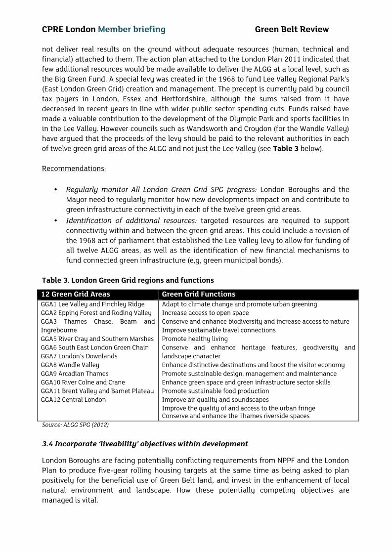
not deliver real results on the ground without adequate resources (human, technical andfinancial) attached to them. The action plan attached to the London Plan 2011 indicated thatfew additional resources would be made available to deliver the ALGG at a local level, such asthe Big Green Fund. A special levy was created in the 1968 to fund Lee Valley Regional Park’s(East London Green Grid) creation and management. The precept is currently paid by counciltax payers in London, Essex and Hertfordshire, although the sums raised from it havedecreased in recent years in line with wider public sector spending cuts. Funds raised havemade a valuable contribution to the development of the Olympic Park and sports facilities inin the Lee Valley. However councils such as Wandsworth and Croydon (for the Wandle Valley)have argued that the proceeds of the levy should be paid to the relevant authorities in eachof twelve green grid areas of the ALGG and not just the Lee Valley (see Table 3 below).
Recommendations:
Regularly monitor All London Green Grid SPG progress: London Boroughs and theMayor need to regularly monitor how new developments impact on and contribute togreen infrastructure connectivity in each of the twelve green grid areas.
Identification of additional resources: targeted resources are required to supportconnectivity within and between the green grid areas. This could include a revision ofthe 1968 act of parliament that established the Lee Valley levy to allow for funding ofall twelve ALGG areas, as well as the identification of new financial mechanisms tofund connected green infrastructure (e,g, green municipal bonds).
Table 3. London Green Grid regions and functions
12 Green Grid Areas Green Grid FunctionsGGA1 Lee Valley and Finchley RidgeGGA2 Epping Forest and Roding ValleyGGA3 Thames Chase, Beam andIngrebourneGGA5 River Cray and Southern MarshesGGA6 South East London Green ChainGGA7 London’s DownlandsGGA8 Wandle ValleyGGA9 Arcadian ThamesGGA10 River Colne and CraneGGA11 Brent Valley and Barnet PlateauGGA12 Central London
Adapt to climate change and promote urban greeningIncrease access to open spaceConserve and enhance biodiversity and increase access to natureImprove sustainable travel connectionsPromote healthy livingConserve and enhance heritage features, geodiversity andlandscape characterEnhance distinctive destinations and boost the visitor economyPromote sustainable design, management and maintenanceEnhance green space and green infrastructure sector skillsPromote sustainable food productionImprove air quality and soundscapesImprove the quality of and access to the urban fringeConserve and enhance the Thames riverside spaces
Source: ALGG SPG (2012)
3.4 Incorporate ‘liveability’ objectives within development
London Boroughs are facing potentially conflicting requirements from NPPF and the LondonPlan to produce five-year rolling housing targets at the same time as being asked to planpositively for the beneficial use of Green Belt land, and invest in the enhancement of localnatural environment and landscape. How these potentially competing objectives aremanaged is vital.
- 13 -
Economic assessments of housing ‘viability’ rarely factor-in the social and environmentimpacts of development at particular sites. This can result in a failure to fully assess theadvantages of developing of brownfield sites as compared to green spaces and Green Belt.Housing development must not ignore the essential functions of Green Belt and greenspaces. CPRE London does not believe that opening up the debate about London’s Green Beltboundaries will produce a change in the rate of house building or result in a better quality oflife for Londoners or the surrounding regions. Planner Andrew Lainton’s review of Green Beltland examined how much land is actually viable to develop for housing, and found only avery small proportion would be suitable (approx. 1km2 within the M25). We argue that Londonmust continue to protect the core aims of the Green Belt – preventing urban sprawl andkeeping a clear separation between rural and urban areas, as well as adjoining developments.These aims are even more relevant than in the past.
As the Mayor’s draft London Housing Strategy states, we need to avoid repeating themistakes of the past by not simply playing a ‘numbers game’ of building more houses.Instead we need to focus on the process of identifying who the new homes are for, wherethey is best placed and how they will best contribute to ‘neighbourhood liveability’ over time.CPRE London welcomes the Mayor proposed policy of continuing to focus on developingbrownfield sites first (Previously Developed Land) and intensifying the use of existing sites.We agree that there are still considerable opportunities to increase London’s density in theright places, involving local people in the process of intensification and re-design to ensuregood quality liveable neighbourhoods.
Cutting across all these issues is the need to put people back at the centre of the housingstrategy. Addressing housing needs requires targeted commitment to work with local peopleto better understand their needs and the best ways to deliver them, in active partnership withLondoners. CPRE London’s Campaign for a Liveable London is currently in the researchphase of a two-year project looking for people-centered solutions to London’s housing crisis.Our emerging research has indicated three inter-related issues that need to be strengthenedin the draft London Housing strategy:
Recommendations:
Neighbourhood inclusion and wellbeing - stimulate community ownership in newdevelopments and regeneration projects through investment in communityfacilitators, community-led governance and participatory budgeting arrangements.
Local powers - increase borough financial autonomy and integrated planning,housing choice, unlocking previously developed land and stalled sites, repurposingsuburbs, and introduce better transparency about available land.
Finance and quality of affordable homes - stimulate alternative and longer-terminvestment models, and creating a ‘liveability league’ table of developers.
3.5 Improve local environmental participation
In 1992 the UK signed up to the Rio Declaration on Environment and Development. Thedeclaration clearly defines the concept of sustainable development and includes a number ofprinciples, in particular Principle 10 – which states that environmental issues are besthandled with participation of all concerned citizens, at the relevant level. In Europe, Principle
CPRE London Member briefing Green Belt Review
10 has become formally developed into the ‘Aarhus Convention on Access to information,Public Participation in Decision Making, and Access to Justice in Environmental Matters’. TheLondon Plan (para 1.1) refers the Aarhus Convention in its creation. This same Conventionequally applies here, not only in the drafting of London wide and local plans, but also in thereview of new developments and their impact on the environment.
The London Mayor and London councils need to facilitate and equip local actors with theresources and skills to effectively engage in creating new green spaces and enhancingexisting ones. Holding early and on-going dialogue about plans and design with existingresidents, neighbourhood groups and other local groups, can support greater communityownership, reduce conflict, build trust, and promote local distinctiveness and innovation. TheGreen Belt and open spaces can also be places that promote community, entrepreneurshipand innovation, including ‘local food’ production. There needs to be greater flexibility to allowand encourage people to engage with the use of open and derelict spaces near where theylive and across London.
Recommendation: Fulfilling the ‘right to participate’
We need to better understand how people use and engage with green spaces and identify themost effective ways to encourage improved community engagement – including educationopportunities, shared communication, in the design and management of sites. The GLA andLondon Boroughs need to identify effective tools and adopt a more consistent approach topublic engagement in relation to the Green Belt and other green spaces across the city, inaccordance with the Aarhus Convention.
4. CONCLUSION
It is time to recognise the Green Belt’s contribution to London’s liveability and itsconnections with urban green infrastructure. We need to examine how to maximise thebenefits of such land for people and the natural environment.
Pressures to develop on Green Belt are growing and as such CPRE members and the publicwill need to monitor and actively engage in Local Plan reviews and planning applications toensure the Green Belt, Metropolitan Open Land, and other green spaces are protected.
“For the first time, I really believe that the warning Philip Larkin gave us inhis poem ‘Going, going’ will come true. The warning that a great wash ofconcrete and tyres will smother our green places, so ‘that will be Englandgone’ will come true, that is - unless we win the fight to oppose it.Chamberlain and Macmillan were right – we should never use the pretext ofan emergency to suspend planning.”
Andrew Motion, CPRE President, CPRE AGM July 2013
- 15 -
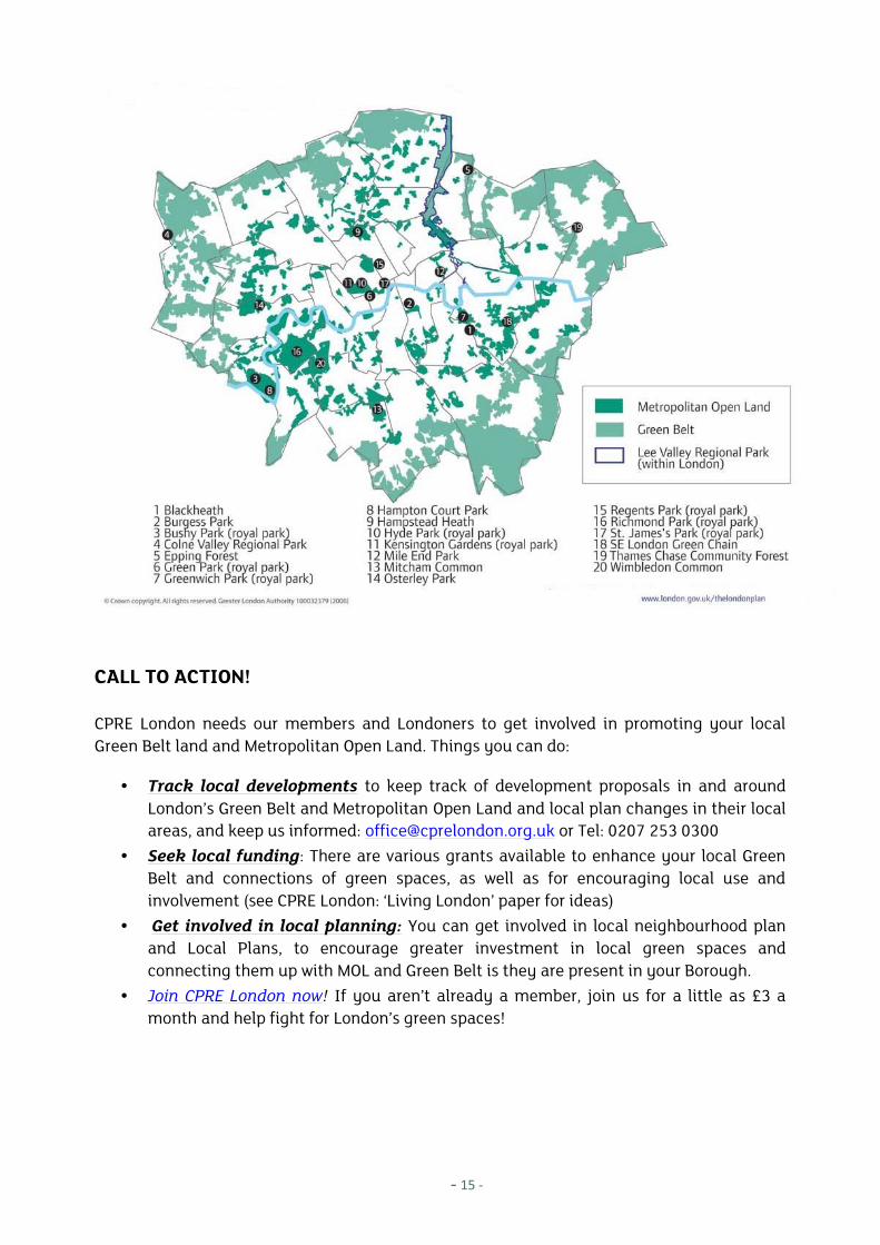
CALL TO ACTION!
CPRE London needs our members and Londoners to get involved in promoting your localGreen Belt land and Metropolitan Open Land. Things you can do:
Track local developments to keep track of development proposals in and aroundLondon’s Green Belt and Metropolitan Open Land and local plan changes in their localareas, and keep us informed: [email protected] or Tel: 0207 253 0300
Seek local funding: There are various grants available to enhance your local GreenBelt and connections of green spaces, as well as for encouraging local use andinvolvement (see CPRE London: ‘Living London’ paper for ideas)
Get involved in local planning: You can get involved in local neighbourhood planand Local Plans, to encourage greater investment in local green spaces andconnecting them up with MOL and Green Belt is they are present in your Borough.
Join CPRE London now! If you aren’t already a member, join us for a little as £3 amonth and help fight for London’s green spaces!
CPRE London Member briefing Green Belt Review
FURTHER RESOURCES
Greenspace information for Greater London (GiGL) Online database http://www.gigl.org.uk/online/
How to respond to Planning Applications (CPRE, 2011) http://www.cpre.org.uk/resources/housing-and-planning/planning/item/1903-how-to-respond-to-planning-applications
Planning Campaign Briefing 2 – Green Belts. CPRE (2012), June 2012www.cpre.org.uk/resources/housing-and-planning/planning/item/2958-planning-campaign-briefing-2-green-belts
Green Belts a greener future. CPRE and Natural England (2010)www.ruaf.org/ruaf_bieb/upload/3284.pdf
Living London – Green Infrastructure Explained (CPRE London, 2013) member briefing.www.cprelondon.org.uk/resources/item/2216-living-london-cpre-guide
London Green Belt Council: www.londongreenbeltcouncil.org.uk
London Gardens: Info on status and history of London’s Parks and Gardenwww.londongardensonline.org.uk
REFERENCES
Amati, M. & Taylor, L (2010) From Green Belts to Green Infrastructure. Planning Practice & Research,Vol 25. No.2, pp 143 – 155.
CPRE (2013) Larkin was right. We risk destroying England. Andrew Motion’s address at CPRE 2013AGM http://www.cpre.org.uk/magazine/opinion/item/3296-larkin-was-right-we-risk-destroying-england
DCLG (2011) The Department's response on the Policy Exchange report on building on green belt.https://www.gov.uk/government/news/the-departments-response-on-the-policy-exchange-report-on-building-on-green-belt
Natural England (2011) Landscape character ( pp 29) http://www.naturalengland.org.uk/Images/05-landscape-character_tcm6-14412.pdf
GLA (2011) London’s Living Places and Spaces. The London Plan 2011. Chapter 7. pp. 232http://www.london.gov.uk/sites/default/files/LP2011%20Chapter%207.pdf
GLA (2008) London Green Belt map: http://www.london.gov.uk/thelondonplan/images/maps-diagrams/jpg/map-3d-3.jpg
DCLG (2011) National Planning Policy Framework. Green Belt. pp19 – 22.
UK Parliament (2013) Green Belt. Standard Note: SN/SC/934. 4 Sept 2013. Louise Smith, SectionScience and Environment Section
Savilles (2012) NPPF Briefing Note. March 2012 http://www.savills.co.uk/planning-briefing-notes/savills-nppf-briefing-note.pdf
- 17 -
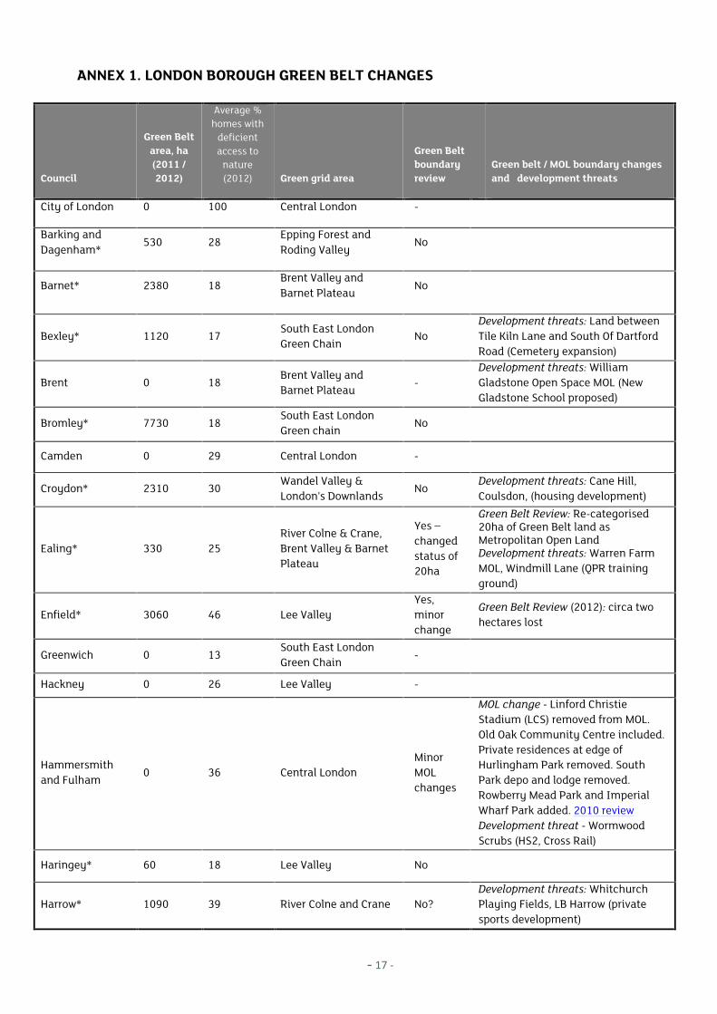
ANNEX 1. LONDON BOROUGH GREEN BELT CHANGES
Council
Green Beltarea, ha(2011 /2012)
Average %homes with
deficientaccess to
nature(2012) Green grid area
Green Beltboundaryreview
Green belt / MOL boundary changesand development threats
City of London 0 100 Central London -
Barking andDagenham*
530 28Epping Forest andRoding Valley
No
Barnet* 2380 18Brent Valley andBarnet Plateau
No
Bexley* 1120 17South East LondonGreen Chain
NoDevelopment threats: Land betweenTile Kiln Lane and South Of DartfordRoad (Cemetery expansion)
Brent 0 18Brent Valley andBarnet Plateau
-Development threats: WilliamGladstone Open Space MOL (NewGladstone School proposed)
Bromley* 7730 18South East LondonGreen chain
No
Camden 0 29 Central London -
Croydon* 2310 30Wandel Valley &London's Downlands
NoDevelopment threats: Cane Hill,Coulsdon, (housing development)
Ealing* 330 25River Colne & Crane,Brent Valley & BarnetPlateau
Yes –changedstatus of20ha
Green Belt Review: Re-categorised20ha of Green Belt land asMetropolitan Open LandDevelopment threats: Warren FarmMOL, Windmill Lane (QPR trainingground)
Enfield* 3060 46 Lee ValleyYes,minorchange
Green Belt Review (2012): circa twohectares lost
Greenwich 0 13South East LondonGreen Chain
-
Hackney 0 26 Lee Valley -
Hammersmithand Fulham
0 36 Central LondonMinorMOLchanges
MOL change - Linford ChristieStadium (LCS) removed from MOL.Old Oak Community Centre included.Private residences at edge ofHurlingham Park removed. SouthPark depo and lodge removed.Rowberry Mead Park and ImperialWharf Park added. 2010 reviewDevelopment threat - WormwoodScrubs (HS2, Cross Rail)
Haringey* 60 18 Lee Valley No
Harrow* 1090 39 River Colne and Crane No?Development threats: WhitchurchPlaying Fields, LB Harrow (privatesports development)
CPRE London Member briefing Green Belt Review
Council
Green Beltarea, ha(2011 /2012)
Average %homes with
deficientaccess to
nature(2012) Green grid area
Green Beltboundaryreview
Green belt / MOL boundary changesand development threats
Havering* 6010 41Thames Chase, Beamand Ingrebourne
Y
Green Belt Revisions (2008). Siteshave been removed from the GreenBelt: Whitworth Centre; Part of Lot 7Hornchurch Airfield; Tay Way.Development threats: Green Belt landadjacent to Wennington Farm,Upminster, LB Havering (Gravel pittproposal)
Hillingdon* 4970 16 Colne ValleyYes -Minorrevision
Green Belt revisions (2006). Sitesremoved from Green Beltdesignation: 470 Bath Road,Longford, 59 Reservoir Road, Ruislip,and Perry Oaks Sludge Works,Heathrow. Sites added to green Beltdesignation; Existing non Green Beltsites to be upgraded to Green Belt:Hillingdon House Farm, Land to westof Merle Avenue, Harefield, The DairyFarm Harefield.Development threats: Colne ValleyRegional Park, LB Hillingdon &Buckinghamshire (Heathrow runway,HS2, Slough Int Freight Exchange &Pinewood)
Hounslow* 1220 23River Colne and Crane,Brent Valley
Yes – nomajorrevision
Green Belt Review: (2012), no majorchangesDevelopment threats: Rectory Farm,Heston (Minerals extraction andrestored parkland); The Hartlands(Gypsy and Travellers extension),Cranford and Heston; also landaround Heathrow (Third runwayproposals)
Islington 0 32 Central London -
Kensington andChelsea
0 10 Central London -
Kingston uponThames*
640 32 Arcadian Thames -Development threat: Thames WaterSewage Treatment Works - limitedreleases of MOL in the Hogsmill Area
Lambeth 0 37South East LondonGreen Chain
-
Lewisham 0 14South East LondonGreen Chain
Yes –addedland
Added MOL: Sydenham Wells Park,Horniman Gardens and Telegraph HillPark added to in the South EastLondon Green Chain
Merton 0 14Wandle Valley,Arcadian Thames
-

- 19 -
Council
Green Beltarea, ha(2011 /2012)
Average %homes with
deficientaccess to
nature(2012) Green grid area
Green Beltboundaryreview
Green belt / MOL boundary changesand development threats
Newham* 80 39Lee Valley and EppingForest & Roding Valley
Yes - MOL
Redbridge* 2060 18Lee Valley and EppingForest & Roding Valley
Yes – 5poss sites
Green Belt review (2013): Beal HighSchool & Redbridge RecreationalGrounds; Repton Park Estate;Oakfields Playing Fields & RedbridgeSports and Leisure Centre; KingSolomon & Ilford Jewish PrimarySchool Playing Fields; King George &Goodmayes Hospitals
Richmond uponThames*
140 11Crane Valley, ArcadianThames
No
Southwark 0 30South East LondonGreen Chain
No
Sutton* 616 30London Downlands,Wandle Valley
Yes –minorMOLchange
Minor MOL change: Beddington,Hackbridge
Tower Hamlets 0 35 Lee Valley -
Waltham Forest* 840 42 Lee Valley No
Wandsworth 0 9The Arcadian Thames,Wandle Valley andCentral London
-Development threat: Putney HospitalSite, MOL
Westminster 0 27 Central London -
*councils with Green Belt
Sources: Public and member reports, London Development Database (2012) and DCLG (2011)
CPRE London Member briefing Green Belt Review
Bedfont Lakes Country Park © R Callway
© CPRE London, 2014
CPRE London is a regional branch of the national charity Campaign to Protect Rural England. TheLondon branch works to promote London’s green spaces and liveability for Londoners.
70-75 Cowcross StreetLondonEC1M 6EJTel: 0207 253 0300www.cprelondon.org.uk Registered charity number: 802622