i. basic profile s. information sought...
TRANSCRIPT

I. BASIC PROFILE
S.
No.
Information Sought Details
1. Name of the proponent NHAI, PIU- Thiruvananthapuram
2. Name of applicant NHAI, PIU- Thiruvananthapuram
3. Contact person R. Venkatakrishan
4. Designation Project Director,
T.C 36/414(5), Koyikkal Veedu,
Kavu Lane, Palkulangara,
Thiruvananthapuram
5. Telephone No. 0471-2460924
6. Mobile No. 9447071347
7. Fax No. 0471-2460924
8. Email Address [email protected], [email protected]
9. Website (if any) http://www.nhai.org/
10. Pin code 695024
11. State Kerala
12. District Thiruvananthapuram
13. Town/Village Thiruvananthapuram
II. PROJECT PROFILE
S.
No.
Information Sought Details
1. Name of the project Detailed Project Report (DPR) study for 4
laning of Cherthala – Thiruvananthapuram
Section of NH-47 (New NH-66) (from KM
379/100 to KM 551/900) [Package –III] under
NHDP Phase III in the State of Kerala
2. Project Sector HIGHWAY
3. Project Cost (In Lacs) INR 408894 Lacs
4. Location of the Project Kerala
5. Shape of the Project Land Strip
5.1 Upload GPS file (KML only) Enclosed in Folder as 03-NH47-CRZ-GPS
File.kml
5.2 Upload copy of Survey of India
Toposheet (pdf only- As Annexure
Survey of India Toposheet) (Scale
1:50,000)
Enclosed in Folder as 04-CRZ_Toposheets 1-
50000.pdf
6. Site alternative under consideration No
7. Brief summary of project The project is related to 4 laning of section of
National Highway no. 47 (NH-47, new NH-
66) from Chertalai to Thiruvananthapuram
(from km 379.100 to km 551.900). The project
road length is 172.8 km. It starts from km

S.
No.
Information Sought Details
379.100 of NH-47 at the junction of
Thuravoor and ends at Kazhakottam junction
at km 551.900. This stretch of road passes
through three districts viz. Alappuzha, Kollam
and Thiruvananthapuram. There are 88 built-
up locations along the project road. The
existing ROW along the project road is about
30m. There are 8 nos. of major bridges, 16
nos. of minor bridges, 165 nos. of culverts
existing along the project road. The project
road from Km 379.100 to 387.500 is 4-lane,
whereas rest of the project road is 2 lanes.
There are two under construction bypasses at
Alappuzha and Kollam along the project road.
It is proposed to develop the project road to
2x2 lane divided carriageway and service
roads as per IRC guidelines having a ruling
speed of 100kms per hour. The design length
of the project shall be 170.56 kms. All existing
major bridges, minor bridges and culverts will
be retained/reconstructed to match the road
configuration. Total 54 nos. of new culverts
have been proposed. Apart from existing
bypasses, a new bypass road is proposed for
Attingal town. All bypass shall be constructed
as 2x2 lane divided carriageway and service
roads as per IRC guidelines. Two toll plazas
are proposed at Km 409+000 in Alappuzha
Bypass and Km 488+500 in Kollam Bypass.
The project road is passing through Costal
Zone Regulation (CRZ) areas at 13 locations
as submitted in CRZ status report prepared by
Centre for Earth Science Studies (CESS) in
2010 (Report Attached). Based on this study,
the MoEF&CC had accorded two
separate CRZ clearances for (i) improvement
of 2 lane to 4/6 lane Cherthala - Kazhakuttam
Road except Alappuzha and Kollam Bypass
vide letter dated 13.10.2014 and (ii) for
construction of Alappuzha and Kollam Bypass
vide letter dated 30.12.2013 (Both clearance
letters are attached).
8. Does your project location fall under out None of above areas
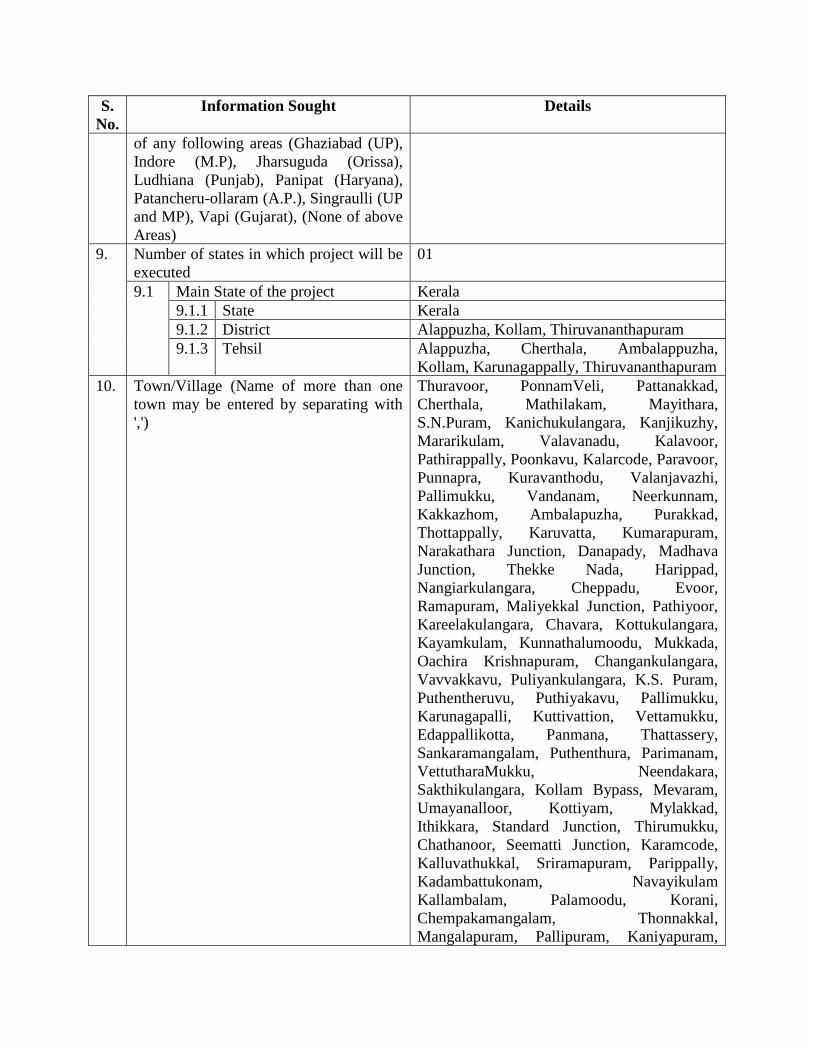
S.
No.
Information Sought Details
of any following areas (Ghaziabad (UP),
Indore (M.P), Jharsuguda (Orissa),
Ludhiana (Punjab), Panipat (Haryana),
Patancheru-ollaram (A.P.), Singraulli (UP
and MP), Vapi (Gujarat), (None of above
Areas)
9. Number of states in which project will be
executed
01
9.1 Main State of the project Kerala
9.1.1 State Kerala
9.1.2 District Alappuzha, Kollam, Thiruvananthapuram
9.1.3 Tehsil Alappuzha, Cherthala, Ambalappuzha,
Kollam, Karunagappally, Thiruvananthapuram
10. Town/Village (Name of more than one
town may be entered by separating with
',')
Thuravoor, PonnamVeli, Pattanakkad,
Cherthala, Mathilakam, Mayithara,
S.N.Puram, Kanichukulangara, Kanjikuzhy,
Mararikulam, Valavanadu, Kalavoor,
Pathirappally, Poonkavu, Kalarcode, Paravoor,
Punnapra, Kuravanthodu, Valanjavazhi,
Pallimukku, Vandanam, Neerkunnam,
Kakkazhom, Ambalapuzha, Purakkad,
Thottappally, Karuvatta, Kumarapuram,
Narakathara Junction, Danapady, Madhava
Junction, Thekke Nada, Harippad,
Nangiarkulangara, Cheppadu, Evoor,
Ramapuram, Maliyekkal Junction, Pathiyoor,
Kareelakulangara, Chavara, Kottukulangara,
Kayamkulam, Kunnathalumoodu, Mukkada,
Oachira Krishnapuram, Changankulangara,
Vavvakkavu, Puliyankulangara, K.S. Puram,
Puthentheruvu, Puthiyakavu, Pallimukku,
Karunagapalli, Kuttivattion, Vettamukku,
Edappallikotta, Panmana, Thattassery,
Sankaramangalam, Puthenthura, Parimanam,
VettutharaMukku, Neendakara,
Sakthikulangara, Kollam Bypass, Mevaram,
Umayanalloor, Kottiyam, Mylakkad,
Ithikkara, Standard Junction, Thirumukku,
Chathanoor, Seematti Junction, Karamcode,
Kalluvathukkal, Sriramapuram, Parippally,
Kadambattukonam, Navayikulam
Kallambalam, Palamoodu, Korani,
Chempakamangalam, Thonnakkal,
Mangalapuram, Pallipuram, Kaniyapuram,
S.
No.
Information Sought Details
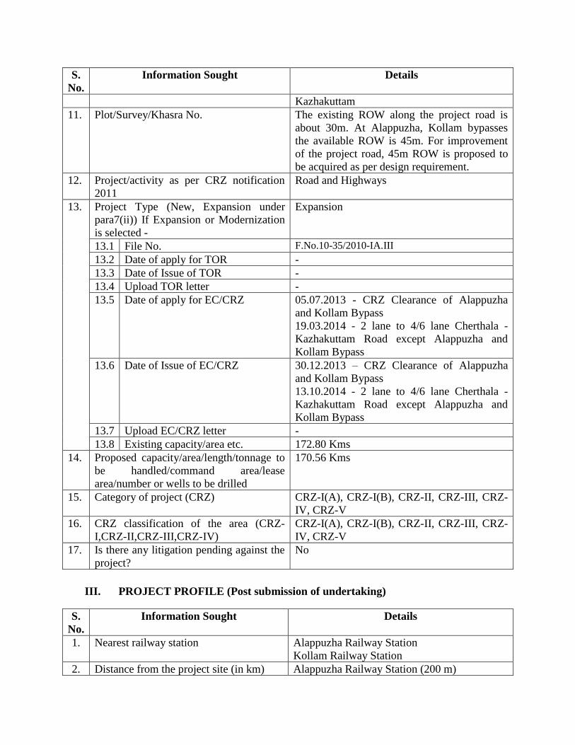
Kazhakuttam
11. Plot/Survey/Khasra No. The existing ROW along the project road is
about 30m. At Alappuzha, Kollam bypasses
the available ROW is 45m. For improvement
of the project road, 45m ROW is proposed to
be acquired as per design requirement.
12. Project/activity as per CRZ notification
2011
Road and Highways
13. Project Type (New, Expansion under
para7(ii)) If Expansion or Modernization
is selected -
Expansion
13.1 File No. F.No.10-35/2010-IA.III
13.2 Date of apply for TOR -
13.3 Date of Issue of TOR -
13.4 Upload TOR letter -
13.5 Date of apply for EC/CRZ 05.07.2013 - CRZ Clearance of Alappuzha
and Kollam Bypass
19.03.2014 - 2 lane to 4/6 lane Cherthala -
Kazhakuttam Road except Alappuzha and
Kollam Bypass
13.6 Date of Issue of EC/CRZ 30.12.2013 – CRZ Clearance of Alappuzha
and Kollam Bypass
13.10.2014 - 2 lane to 4/6 lane Cherthala -
Kazhakuttam Road except Alappuzha and
Kollam Bypass
13.7 Upload EC/CRZ letter -
13.8 Existing capacity/area etc. 172.80 Kms
14. Proposed capacity/area/length/tonnage to
be handled/command area/lease
area/number or wells to be drilled
170.56 Kms
15. Category of project (CRZ) CRZ-I(A), CRZ-I(B), CRZ-II, CRZ-III, CRZ-
IV, CRZ-V
16. CRZ classification of the area (CRZ-
I,CRZ-II,CRZ-III,CRZ-IV)
CRZ-I(A), CRZ-I(B), CRZ-II, CRZ-III, CRZ-
IV, CRZ-V
17. Is there any litigation pending against the
project?
No
III. PROJECT PROFILE (Post submission of undertaking)
S.
No.
Information Sought Details
1. Nearest railway station Alappuzha Railway Station
Kollam Railway Station
2. Distance from the project site (in km) Alappuzha Railway Station (200 m)
S.
No.
Information Sought Details
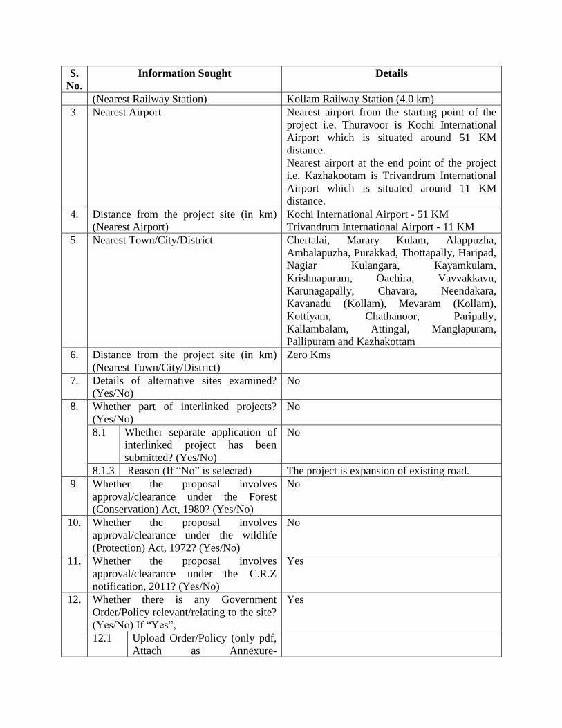
(Nearest Railway Station) Kollam Railway Station (4.0 km)
3. Nearest Airport Nearest airport from the starting point of the
project i.e. Thuravoor is Kochi International
Airport which is situated around 51 KM
distance.
Nearest airport at the end point of the project
i.e. Kazhakootam is Trivandrum International
Airport which is situated around 11 KM
distance.
4. Distance from the project site (in km)
(Nearest Airport)
Kochi International Airport - 51 KM
Trivandrum International Airport - 11 KM
5. Nearest Town/City/District Chertalai, Marary Kulam, Alappuzha,
Ambalapuzha, Purakkad, Thottapally, Haripad,
Nagiar Kulangara, Kayamkulam,
Krishnapuram, Oachira, Vavvakkavu,
Karunagapally, Chavara, Neendakara,
Kavanadu (Kollam), Mevaram (Kollam),
Kottiyam, Chathanoor, Paripally,
Kallambalam, Attingal, Manglapuram,
Pallipuram and Kazhakottam
6. Distance from the project site (in km)
(Nearest Town/City/District)
Zero Kms
7. Details of alternative sites examined?
(Yes/No)
No
8. Whether part of interlinked projects?
(Yes/No)
No
8.1 Whether separate application of
interlinked project has been
submitted? (Yes/No)
No
8.1.3 Reason (If “No” is selected) The project is expansion of existing road.
9. Whether the proposal involves
approval/clearance under the Forest
(Conservation) Act, 1980? (Yes/No)
No
10. Whether the proposal involves
approval/clearance under the wildlife
(Protection) Act, 1972? (Yes/No)
No
11. Whether the proposal involves
approval/clearance under the C.R.Z
notification, 2011? (Yes/No)
Yes
12. Whether there is any Government
Order/Policy relevant/relating to the site?
(Yes/No) If “Yes”,
Yes
12.1 Upload Order/Policy (only pdf,
Attach as Annexure-
S.
No.
Information Sought Details
order/policy)
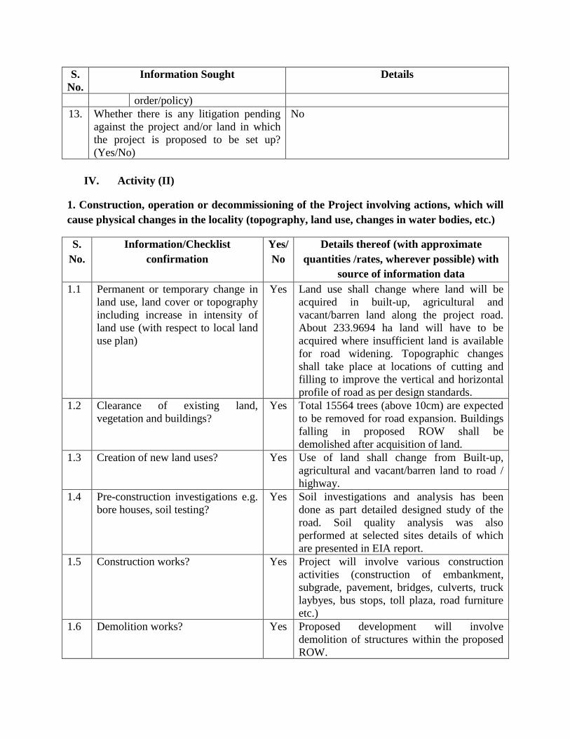
13. Whether there is any litigation pending
against the project and/or land in which
the project is proposed to be set up?
(Yes/No)
No
IV. Activity (II)
1. Construction, operation or decommissioning of the Project involving actions, which will
cause physical changes in the locality (topography, land use, changes in water bodies, etc.)
S.
No.
Information/Checklist
confirmation
Yes/
No
Details thereof (with approximate
quantities /rates, wherever possible) with
source of information data
1.1 Permanent or temporary change in
land use, land cover or topography
including increase in intensity of
land use (with respect to local land
use plan)
Yes Land use shall change where land will be
acquired in built-up, agricultural and
vacant/barren land along the project road.
About 233.9694 ha land will have to be
acquired where insufficient land is available
for road widening. Topographic changes
shall take place at locations of cutting and
filling to improve the vertical and horizontal
profile of road as per design standards.
1.2 Clearance of existing land,
vegetation and buildings?
Yes Total 15564 trees (above 10cm) are expected
to be removed for road expansion. Buildings
falling in proposed ROW shall be
demolished after acquisition of land.
1.3 Creation of new land uses? Yes Use of land shall change from Built-up,
agricultural and vacant/barren land to road /
highway.
1.4 Pre-construction investigations e.g.
bore houses, soil testing?
Yes Soil investigations and analysis has been
done as part detailed designed study of the
road. Soil quality analysis was also
performed at selected sites details of which
are presented in EIA report.
1.5 Construction works? Yes Project will involve various construction
activities (construction of embankment,
subgrade, pavement, bridges, culverts, truck
laybyes, bus stops, toll plaza, road furniture
etc.)
1.6 Demolition works? Yes Proposed development will involve
demolition of structures within the proposed
ROW.
S.
No.
Information/Checklist
confirmation
Yes/
No
Details thereof (with approximate
quantities /rates, wherever possible) with
source of information data
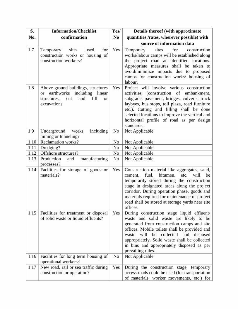
1.7 Temporary sites used for
construction works or housing of
construction workers?
Yes Temporary sites for construction
works/labour camps will be established along
the project road at identified locations.
Appropriate measures shall be taken to
avoid/minimize impacts due to proposed
camps for construction works/ housing of
labour.
1.8 Above ground buildings, structures
or earthworks including linear
structures, cut and fill or
excavations
Yes Project will involve various construction
activities (construction of embankment,
subgrade, pavement, bridges, culverts, truck
laybyes, bus stops, toll plaza, road furniture
etc.). Cutting and filling shall be done
selected locations to improve the vertical and
horizontal profile of road as per design
standards.
1.9 Underground works including
mining or tunneling?
No Not Applicable
1.10 Reclamation works? No Not Applicable
1.11 Dredging? No Not Applicable
1.12 Offshore structures? No Not Applicable
1.13 Production and manufacturing
processes?
No Not Applicable
1.14 Facilities for storage of goods or
materials?
Yes Construction material like aggregates, sand,
cement, fuel, bitumen, etc. will be
temporarily stored during the construction
stage in designated areas along the project
corridor. During operation phase, goods and
materials required for maintenance of project
road shall be stored at storage yards near site
offices.
1.15 Facilities for treatment or disposal
of solid waste or liquid effluents?
Yes During construction stage liquid effluent/
waste and solid waste are likely to be
generated from construction camps and site
offices. Mobile toilets shall be provided and
waste will be collected and disposed
appropriately. Solid waste shall be collected
in bins and appropriately disposed as per
prevailing rules.
1.16 Facilities for long term housing of
operational workers?
No Not Applicable
1.17 New road, rail or sea traffic during
construction or operation?
Yes During the construction stage, temporary
access roads could be used (for transportation
of materials, worker movements, etc.) for

S.
No.
Information/Checklist
confirmation
Yes/
No
Details thereof (with approximate
quantities /rates, wherever possible) with
source of information data
connecting camps with project road.
However, this will be limited to the duration
of the construction. During operation phase,
permanent access road shall be constructed to
site office. Necessary consents from land
owners and appropriate authorities shall be
obtained prior to construction of access road.
No rail or sea traffic is envisaged.
1.18 New road, rail, air waterborne or
other transport infrastructure
including new or altered routes and
stations, ports, airports etc.?
Yes The project will lead to construction of
various road related infrastructure including,
road pavement, bridges, culverts, truck lay
byes, bus stops, toll plaza, road furniture etc.
1.19 Closure or diversion of existing
transport routes or infrastructure
leading to changes in traffic
movements?
Yes Temporary diversions of existing roads
during the construction stage is envisaged.
IRC guidelines will be followed to ensure
uninterrupted traffic movement.
1.20 New or diverted transmission lines
or pipelines?
Yes Transmission lines shall be relocated/
diverted as per utility shifting plan.
1.21 Impoundment, damming,
culverting, realignment or other
changes to the hydrology of
watercourses or aquifers?
No All existing bridges, culverts shall be
retained/reconstructed/cleared to maintain the
natural water flow. No existing drain shall be
closed. In addition to existing cross drainage
structures 54 nos. of new culverts are
proposed along the project road.
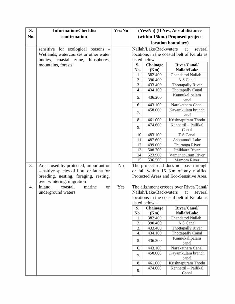
1.22 Stream crossings? Yes The alignment crosses over River/Canal/
Nallah/Lake/Backwaters at several locations
as listed below – S.
No.
Chainage
(Km)
River/Canal/
Nallah/Lake
1. 382.400 Chandatod Nallah
2. 390.400 A S Canal
3. 433.400 Thottapally River
4. 434.100 Thottapally Canal
5. 436.200 Kannukalipalam canal
6. 443.100 Narakathara Canal
7. 458.000 Kayamkulam branch
canal
8. 461.000 Krishnapuram Thodu
9. 474.600 Kennettil – Pallikal
Canal
10. 483.100 T S Canal
11. 487.600 Ashtamudi Lake
12. 499.600 Churanga River
13. 508.700 Ithikkara River

S.
No.
Information/Checklist
confirmation
Yes/
No
Details thereof (with approximate
quantities /rates, wherever possible) with
source of information data
14. 523.900 Vamanapuram River
15. 536.500 Mamom River
1.23 Abstraction or transfers of water
from ground or surface waters?
Yes Approximately, 1090573 KL of water will be
required during construction stage, which
shall be extracted from ground / surface
water body after obtaining necessary consent
from competent authority.
1.24 Changes in water bodies or the land
surface affecting drainage or run-
off?
No The proposed development is being planned
in such a way that natural drainage or runoff
will not be affected. Bridges and culverts at
appropriate locations are planned to maintain
natural flow of the rivers/streams/canals, etc.
1.25 Transport of personnel or materials
for construction, operation or
decommissioning?
Yes Construction Phase: Movement of
construction material including cement,
bitumen, aggregates, rock, sand, steel, etc.,
Movement of construction workers by
vans/buses. Operation Phase: Vehicular
traffic will ply over the roads during its
operation phase.
1.26 Long-term dismantling or
decommissioning or restoration
works?
No Not applicable
1.27 Ongoing activity during
decommissioning which could have
an impact on the environment?
No Not applicable
1.28 Influx of people to an area in either
temporarily or permanently?
Yes During the construction stage there will be
temporary influx of people to the project area
as labourers and other people who will be
involved in the proposed development.
Proposed project will provide resource for
people to commute between places and will
open up opportunities for setting up
businesses, other employment opportunities,
etc.
1.29 Introduction of alien species? No Not applicable
1.30 Loss of native species or genetic
diversity?
No Not applicable
1.31 Any other actions? No Not applicable

2. Use of Natural resources for construction or operation of the Project (such as land,
water, materials or energy, especially any resources which are non-renewable or in short
supply)
S.
No.
Information/Checklist
confirmation
Yes/
No
Details thereof (with approximate
quantities /rates, wherever possible) with
source of information data
2.1 Land especially undeveloped or
agricultural land (ha)
Yes About 233.9694 ha land will have to be
acquired where insufficient land is available
for road widening. Extent of undeveloped or
agricultural land required for the project shall
be worked out post completion of social
impact assessment study.
2.2 Water (expected source &
competing users) unit: KLD
Yes Approximately, 1090573 KL of water will be
required during construction stage, which
shall be extracted from ground / surface
water body after obtaining necessary consent
from competent authority. Daily water
demand shall be about 1454 KLD.
2.3 Minerals (MT) Yes Soil: 7,204,708 Cum
Coarse Aggregate: 70,829 Cum
Fine Aggregate: 273,750 Cum
2.4 Construction material – stone,
aggregates, sand / soil (expected
source – MT)
Yes Soil: 7,204,708 Cum
Coarse Aggregate: 70,829 Cum
Fine Aggregate: 273,750 Cum
Steel: 32,917 MT
Cement: 206,188 MT
2.5 Forests and timber (source – MT) No Not Applicable
2.6 Energy including electricity and
fuels (source, competing users)
Unit: fuel (MT), energy (MW)
Yes Energy requirement will mostly be during the
construction stage. Power requirement will
mostly be met from DG sets and/or supply
from Kerala State Electricity Board, if
available.
2.7 Any other natural resources (use
appropriate standard units)
No Not Applicable
3. Use, storage, transport, handling or production of substances or materials, which could
be harmful to human health or the environment or raise concerns about actual or
perceived risks to human health.
S.
No.
Information/Checklist
confirmation
Yes/
No
Details thereof (with approximate
quantities /rates, wherever possible) with
source of information data
S.
No.
Information/Checklist
confirmation
Yes/
No
Details thereof (with approximate
quantities /rates, wherever possible) with
source of information data
3.1 Use of substances or materials,
which are hazardous (as per
MSIHC rules) to human health or
the environment (flora, fauna, and
water supplies)
Yes Diesel for use in DG sets and other
equipment’s; however, no fuel storage
(except for very small quantities) is
envisaged to be stored at site.
3.2 Changes in occurrence of disease
or affect disease vectors (e.g. insect
or water borne diseases)
No Not Applicable
3.3 Affect the welfare of people e.g. by
changing living conditions?
No Proposed project is envisaged to have
positive impacts by providing benefits to the
people like providing new road connectivity
between places, reducing travel time,
reducing traffic congestions on the existing
roads thereby improving environmental
quality in the area. Project also provides
opportunities for business development.
Employment opportunities during
construction and operation stage, etc. will
provide economic benefits to the people.
3.4 Vulnerable groups of people who
could be affected by the project e.g.
Hospital patients, children, the
elderly etc.
Yes Project can be envisaged to have positive
impacts on Vulnerable Group, e.g. improved
connectivity especially if required to travel to
health care facilities, etc.
3.5 Any other causes No Not Applicable
4. Production of solid wastes during construction or operation or decommissioning
(MT/month)
S.
No.
Information/Checklist
confirmation
Yes/
No
Details thereof (with approximate
quantities /rates, wherever possible) with
source of information data
4.1 Spoil, overburden or mine wastes Yes Top soil removed from borrow areas, quarry
shall be stored scientifically to retain the
untiring and moisture content and shall be
subsequently used in other agricultural/
plantation areas and for spreading over fill
materials in low lying areas.
4.2 Municipal waste (domestic and or
commercial wastes)
Yes During construction stage, municipal waste
shall be generated from construction/labour
camps; which shall be collected and disposed
S.
No.
Information/Checklist
confirmation
Yes/
No
Details thereof (with approximate
quantities /rates, wherever possible) with
source of information data
appropriately as per prevailing rules. During
municipal waste shall be generated from site
offices, which again will be disposed off
according to the prevailing rules.
4.3 Hazardous wastes (as per
Hazardous Waste Management
Rules)
Yes During construction stage used oil/other
waste will be stored in closed drums/
containers and transferred to authorized
disposal locations/vendors.
4.4 Other industrial process wastes No Not Applicable
4.5 Surplus product No Not Applicable
4.6 Sewage sludge or other sludge
from effluent treatment
No Not Applicable
4.7 Construction or demolition wastes Yes Proposed development will have demolition
wastes which will be reused in the road
construction activities to maximum possible
extent; balance material will be disposed
safely/suitably as per KSPCB guidelines
4.8 Redundant machinery or
equipment
No Not Applicable
4.9 Contaminated soils or other
materials
No Not Applicable
4.10 Agricultural wastes No Not Applicable
4.11 Other solid wastes No Not Applicable
5. Release of pollutants or any hazardous, toxic or noxious substances to air (Kg/hr)
S.
No.
Information/Checklist
confirmation
Yes/
No
Details thereof (with approximate
quantities /rates, wherever possible) with
source of information data
5.1 Emissions from combustion of
fossil fuels from stationary or
mobile sources
Yes During construction stage, emissions are
envisaged from vehicles used for transporting
construction materials, machineries involved
in the construction, diesel generating (DG)
sets, hot mix plant, etc. However, these
emissions are local and short-term in nature
and will cease upon completion of
construction activities. During operation
stage, emissions are envisaged from vehicles

S.
No.
Information/Checklist
confirmation
Yes/
No
Details thereof (with approximate
quantities /rates, wherever possible) with
source of information data
running on the road.
5.2 Emissions from production
processes
No Not Applicable
5.3 Emissions from materials
handling including storage or
transport
Yes Dust generation is expected due to handling
(loading/unloading) and transportation of
materials at construction site/camps.
5.4 Emissions from construction
activities including plant and
equipment
Yes During construction stage emissions are
envisaged from DG Sets, construction
equipment/machineries, hot mix plant,
crusher plant, movement of vehicles, etc.
However, these emissions are local, short-
term in nature and will cease upon
completion of construction activities.
5.5 Dust or odours from handling of
materials including construction
materials, sewage and waste
Yes Dust will be generated during construction
related activities like site clearance,
transportation of materials, loading/unloading
of materials, construction, crusher plant, etc.
5.6 Emissions from incineration of
waste
No Not Applicable
5.7 Emissions from burning of waste
in open air (e.g. slash materials,
construction debris)
No Not Applicable. Strict measure shall be taken
to prevent burning of waste.
5.8 Emissions from any other sources No Not Applicable
6. Generation of Noise and Vibration, and Emissions of Light and Heat
S.
No.
Information/Checklist
confirmation
Yes/
No
Details thereof (with approximate
quantities /rates, wherever possible) with
source of information data
6.1 From operation of equipment e.g.
engines, ventilation plant,
crushers
Yes Noise standard at aggregate crushing plants,
batching plant, hot mix plant will be strictly
monitored to prevent exceeding of GOI noise
standards. Workers in the vicinity of strong
noise will be provide with ear plugs and their
working time should be limited as a safety
measure. In construction sites within 150 m
of sensitive receptors construction will be
stopped from 22:00 to 06:00. Machinery and
vehicles will be maintained to keep their
noise to a minimum. Temporary noise barrier
S.
No.
Information/Checklist
confirmation
Yes/
No
Details thereof (with approximate
quantities /rates, wherever possible) with
source of information data
will be provided during construction at noise
sensitive locations throughout the
construction period.
6.2 From industrial or similar
processes
No Not Applicable
6.3 From construction or demolition Yes Noise shall be generated from the
construction activities and running of the
construction equipment. This will be in the
range about 65-90 dB(A). In construction
sites within 150 m of sensitive receptors
construction will be stopped from 22:00 to
06:00. Equipment shall be maintained
regularly which will help in reducing these
noise level.
6.4 From blasting or piling No Not Applicable
6.5 From construction or operational
traffic
Yes Noise will be generated from various
construction activities like site clearance, use
of equipment, vehicular movements, etc.
Noise will also be generated during the
operation stage due to vehicular movements
on the road. During the construction activities
utmost care will be taken to control the noise
levels within the standards. Similarly, during
operation appropriate mitigation measures
will be implemented.
6.6 From lighting or cooling systems No Not Applicable
6.7 From any other sources No Not Applicable
7. Risks of contamination of land or water from releases of pollutants into the ground or
into sewers, surface waters, groundwater, coastal waters or the sea
S.
No.
Information/Checklist
confirmation
Yes/
No
Details thereof (with approximate
quantities /rates, wherever possible) with
source of information data
7.1 From handling, storage, use or
spillage of hazardous materials
Yes Storage of hazardous materials is not
envisaged. However, if needed to be stored,
hazardous materials will be stored and
handled as per the provisions of Hazardous
Wastes (Management and Handling) Rules

and Amendments thereof.
7.2 From discharge of sewage or
other effluents to water or the land
(expected mode and place of
discharge)
No During the construction stage liquid
effluent/waste will be generated from
construction camps for which mobile toilets
shall be provided. Discharge of sewage or
other effluents to water or land is not
envisaged. All liquid waste/sewage shall be
collected in tanks, which will be cleared off
regularly by approved collector.
7.3 By deposition of pollutants
emitted to air into the land or into
water
Yes There can be dust from back filters installed
in hot mix plant during construction phase.
This may deposit on land and surface water.
7.4 From any other sources No Not Applicable
7.5 Is there a risk of long term build-
up of pollutants in the
environment from these sources?
No Not Applicable
8. Risk of accidents during construction or operation of the Project, which could affect
human health or the environment
S.
No.
Information/Checklist
confirmation
Yes/
No
Details thereof (with approximate
quantities /rates, wherever possible) with
source of information data
8.1 From explosions, spillages, fires
etc. from storage, handling, use or
production of hazardous
substances
Yes During the construction stage, asphalt is to be
heated for use in road construction.
Appropriate care will be taken to maintain the
optimum temperature so as to prevent fire/
accident hazards. Adequate safety measures
will be taken in storage and handling of
hazardous materials, if stored at site. Also,
fire extinguishers shall be maintained at site.
No such risks are envisaged during the
operation stage.
8.2 From any other causes No Not Applicable
8.3 Could the project be affected by
natural disasters causing
environmental damage (e.g.
floods, earthquakes, landslides,
cloudburst etc.)?
Yes Identification of risk, suggesting risk
mitigation measures and observations made
towards the identification of landslide zones,
proposed mitigation measures for the
identified landslide zones, area seismicity and
evaluation of soil permeability. During the
design stage, the effects from natural disasters
will be considered and necessary
precautionary measures would be built in or
implemented (e.g. provision of adequate
number of cross drainage structures to
prevent flooding, etc.). Appropriate
engineering codes will be used during the
design process.
9. Factors which should be considered (such as consequential development) which could
lead to environmental effects or the potential for cumulative impacts with other existing or
planned activities in the locality
S.
No.
Information/Checklist
confirmation
Yes/No Details thereof (with approximate
quantities /rates, wherever possible)
with source of information data
9.1 Lead to development of supporting
facilities, ancillary development or
development stimulated by the project
which could have impact on the
environment e.g.
o Supporting infrastructure (roads,
power supply, waste or waste water
treatment, etc.)
o housing development
o extractive industries
o supply industries
o Other
Yes The proposed project will provide
various benefits to the people of the area
like providing improved connectivity
provide opportunities for business
development, support other
developmental activities by providing
improved accessibility, etc. Proposed
development is likely to bring in
induced developments and not cause
adverse impact on environment as well
as on the people living in the region.
9.2 Lead to after-use of the site, which
could have an impact on the
environment
Yes The proposed project will set precedent
for further induced developments in the
region.
9.3 Have cumulative effects due to
proximity to other existing or planned
projects with similar effects
No Not Applicable
V. ENVIRONMENTAL SENSITIVITY
S.
No.
Information/Checklist
confirmation
Yes/No (Yes/No) (If Yes, Aerial distance
(within 15km.) Proposed project
location boundary)
1. Areas protected under international
conventions, national or local
legislation for their ecological,
landscape, cultural or other related
value
Yes The project road is located in the coastal
belt of Kerala state, passing over CRZ-I,
CRZ-II, CRZ-III areas at several
locations.
2. Areas which are important or Yes The alignment crosses over River/Canal/
S.
No.
Information/Checklist
confirmation
Yes/No (Yes/No) (If Yes, Aerial distance
(within 15km.) Proposed project
location boundary)
sensitive for ecological reasons -
Wetlands, watercourses or other water
bodies, coastal zone, biospheres,
mountains, forests
Nallah/Lake/Backwaters at several
locations in the coastal belt of Kerala as
listed below – S.
No.
Chainage
(Km)
River/Canal/
Nallah/Lake
1. 382.400 Chandatod Nallah
2. 390.400 A S Canal
3. 433.400 Thottapally River
4. 434.100 Thottapally Canal
5. 436.200 Kannukalipalam
canal
6. 443.100 Narakathara Canal
7. 458.000 Kayamkulam branch
canal
8. 461.000 Krishnapuram Thodu
9. 474.600 Kennettil – Pallikal
Canal
10. 483.100 T S Canal
11. 487.600 Ashtamudi Lake
12. 499.600 Churanga River
13. 508.700 Ithikkara River
14. 523.900 Vamanapuram River
15. 536.500 Mamom River
3. Areas used by protected, important or
sensitive species of flora or fauna for
breeding, nesting, foraging, resting,
over wintering, migration
No The project road does not pass through
or fall within 15 Km of any notified
Protected Areas and Eco-Sensitive Area.
4. Inland, coastal, marine or
underground waters
Yes The alignment crosses over River/Canal/
Nallah/Lake/Backwaters at several
locations in the coastal belt of Kerala as
listed below – S.
No.
Chainage
(Km)
River/Canal/
Nallah/Lake
1. 382.400 Chandatod Nallah
2. 390.400 A S Canal
3. 433.400 Thottapally River
4. 434.100 Thottapally Canal
5. 436.200 Kannukalipalam
canal
6. 443.100 Narakathara Canal
7. 458.000 Kayamkulam branch
canal
8. 461.000 Krishnapuram Thodu
9. 474.600 Kennettil – Pallikal
Canal

S.
No.
Information/Checklist
confirmation
Yes/No (Yes/No) (If Yes, Aerial distance
(within 15km.) Proposed project
location boundary)
10. 483.100 T S Canal
11. 487.600 Ashtamudi Lake
12. 499.600 Churanga River
13. 508.700 Ithikkara River
14. 523.900 Vamanapuram River
15. 536.500 Mamom River
5. State, National boundaries No Not Applicable
6. Routes or facilities used by the public
for access to recreation or other
tourist, pilgrim areas
Yes The project area is a tourist hub. Hence,
tourist may face little difficulties due to
diversions during construction stage.
7. Defense installations No Not Applicable
8. Densely populated or built-up area Yes The project road passes through as many
as 88 densely populated areas along its
length.
9. Areas occupied by sensitive man-
made land uses (hospitals, schools,
places of worship, community
facilities)
Yes There are about 22 religious properties,
8 educational institutions, 4 medical
facilities and 23 common property
resources that are likely to affected due
to proposed project.
10. Areas containing important, high
quality or scarce resources (ground
water resources, surface resources,
forestry, agriculture, fisheries,
tourism, minerals)
Yes Fish resources of the variety of water
bodies constitute the major fauna of the
project area of influence. The Arabian
Sea, brackish water bodies and fresh
water rivers have distinct assemblages
of fishes. Common wetland birds and
birds of the rural, semi-urban and urban
areas are also components of the faunal
assemblage. Snakes, rodents, frogs etc.
are also found along the project
corridor. Ashtamudi estuary is a rich
bio-diversity spot because of its fish
resources and the wetland birds (both
resident and migratory).
11. Areas already subjected to pollution
or environmental damage. (those
where existing legal environmental
standards are exceeded)
No Not Applicable
12. Areas susceptible to natural hazard
which could cause the project to
present environmental problems
(earthquakes, subsidence, landslides,
erosion, flooding or extreme or
Yes Project area is in Seismic Zone III
(moderate earthquake zone) as per IS
1893 (Part I) of Indian Seismic
Map/Seism tectonic Atlas of India.
During the design stage, the effects from
S.
No.
Information/Checklist
confirmation
Yes/No (Yes/No) (If Yes, Aerial distance
(within 15km.) Proposed project
location boundary)
adverse climatic conditions) natural disasters will be considered and
necessary precautionary measures
would be built-in/implemented
PROJECT DETAILS IN CRZ AREA
1. DETAILS OF CRZ AREA
S.
No. Information/Checklist confirmation
Yes/
No
Details thereof (with approximate
quantities /rates, wherever possible)
with source of information data
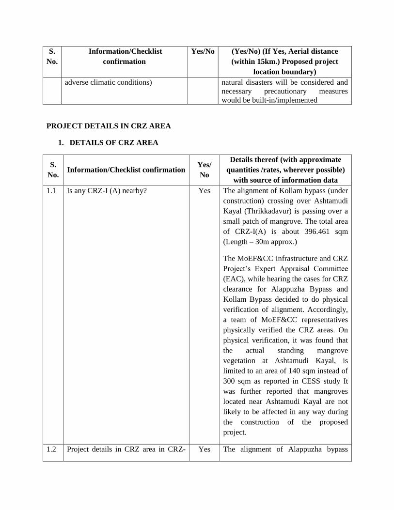
1.1 Is any CRZ-I (A) nearby? Yes The alignment of Kollam bypass (under
construction) crossing over Ashtamudi
Kayal (Thrikkadavur) is passing over a
small patch of mangrove. The total area
of CRZ-I(A) is about 396.461 sqm
(Length – 30m approx.)
The MoEF&CC Infrastructure and CRZ
Project’s Expert Appraisal Committee
(EAC), while hearing the cases for CRZ
clearance for Alappuzha Bypass and
Kollam Bypass decided to do physical
verification of alignment. Accordingly,
a team of MoEF&CC representatives
physically verified the CRZ areas. On
physical verification, it was found that
the actual standing mangrove
vegetation at Ashtamudi Kayal, is
limited to an area of 140 sqm instead of
300 sqm as reported in CESS study It
was further reported that mangroves
located near Ashtamudi Kayal are not
likely to be affected in any way during
the construction of the proposed
project.
1.2 Project details in CRZ area in CRZ- Yes The alignment of Alappuzha bypass

S.
No. Information/Checklist confirmation
Yes/
No
Details thereof (with approximate
quantities /rates, wherever possible)
with source of information data
I(B) (under construction) is crossing over an
intertidal zone near Alappuzha Sea
Coast. The total area of CRZ-I(B) is
about 528.569 sqm (Length – 20m
approx.)
1.3 Project details in CRZ area in CRZ-II Yes The alignment of Alappuzha bypass
(under construction) is crossing
between 500m distance from HTL on
landward side. The total area of CRZ-II
is about 150779.863 sqm (Length –
3319m approx.)
1.4 Project details in CRZ area in CRZ-
III
Yes The project road is crossing CRZ-III at
following locations –
From To
Length
of CRZ
(m)
Area
(Sq. m.)
382.359 382.396 22 929.118
423.886 433.065 9179 399303.488
456.079 456.179 100 2132.637
471.778 472.043 169 7685.632
480.118 480.300 133 5809.046
480.456 484.130 3674 167441.094
484.614 485.203 204 9316.494
487.278 487.99 226 10907.893
490.115 490.413 227 10516.084
491.829 492.965 322 11966.945
505.542 505.730 134 6001.898
529.308 529.445 96 4628.194
Total 14486 636638.523
1.5 Project details in CRZ area in CRZ-
IV
Yes The project road is crossing CRZ-IV
(between LTLs on opposite banks of
river/canal/backwaters) at following
locations –
From To Length of
CRZ (m)
Area
(Sq. m.)
382.359 382.396 15 677.488
456.079 456.179 81 1902.235
471.778 472.043 96 4294.362
480.118 480.300 49 2430.381
484.614 485.203 385 17541.177
487.278 487.99 486 21191.679

S.
No. Information/Checklist confirmation
Yes/
No
Details thereof (with approximate
quantities /rates, wherever possible)
with source of information data
490.115 490.413 69 2987.599
491.829 492.965 814 36105.755
505.542 505.730 54 2530.359
529.308 529.445 41 1929.928
Total 2090 91650.963
1.6 Project details in CRZ area in CRZ-V Yes The project is crossing rivers, lake and
backwaters at several locations in the
State of Kerala
1.7 Details of Shoreline Change No Not Applicable
1.8 Whether the area is prone to cyclone,
tsunami, tidal surge, subduction,
earthquake etc.?
Yes The Project area is prone to Cyclone,
Tsunami, Tidal Surage and subduction.
Detailed studies of the area based on
Metrological studies were done at every
regular interval.
The state Kerala comes under Zone-III
(Moderate) in Seismic zone mapping of
India
1.9
Whether the area is prone for
saltwater ingress?
No Not Applicable
1.10 Upload CRZ Map (Upload KML
only- normally covering 7km radius
around the project site) (Scale –
1:50,000)
Yes Enclosed in Folder as 05-NH47-CRZ
Map-7Km.kml
1.11 Upload Project Layout superimposed
on the CRZ Map (Upload KML only)
(Scale – 1:4000)
Yes Enclosed in Sub-Folder 06-NH47_CRZ
Maps_1-4000
PROPOSED TERMS OF REFERENCE FOR EIA STUDIES
1. Upload Proposed TOR File
(Upload pdf only and attach it as
Annexure- Proposed TOR File)
Enclosed in Folder as 07-TOR-EIA.docx
2. Upload scanned copy of covering
letter
(Upload pdf only)
Enclosed in Folder as 01-Draft Letter.docx
3. Upload Pre-feasibility
Report(PFR) (Upload pdf only
and attach it as Annexure-Pre-
feasibility Report(PFR) File)
Enclosed in Folder as 08-FFSR_Vol I Main
Report.pdf

4. Upload Additional Attachments if
any (Only single pdf file) (Upload
pdf only and attach it as
Annexure-Additional Attachments
File)
Enclosed in Folder as -
1. 09-CESS CRZ Report.pdf
2. 10-Draft EIA ANNEXURE_05.09.17.docx
3. 11-CRZ-Clearance-Widening of Cherthala –
Kazhakuttam Section of NH-47.pdf – dated
13.10.2014
4. 12-CRZ Clearance Letter – Alappuzha Bypass and
Kollam Bypass.pdf – dated 30.12.2013