hyspiri mission concept study
TRANSCRIPT

HyspIRI Mission Concept Study
Concept Science Leads – Robert Green, Simon Hook, Elizabeth Middleton Program Scientists - Woody Turner3/John LaBrecque
Program Executive - Steve Neeck Program Applications Leads - Woody Turner, Simon Hook, and Jeffrey Luvall
Mission Study Lead - Carl Bruce
HyspIRI Science Workshop, 15 Oct 2013 Jet Propulsion Laboratory, California Institute of Technology
1
2013 Earth Science Pre-Formulation Workshop
© 2013 All Rights Reserved
2012 Science Workshop

HyspIRI
Mission Concept Status Level 1 Measurement Requirements: Vetted by community and stable Payload: VSWIR Imaging Spectrometer, TIR Imaging radiometer, and IPM-Low Latency subsets Full Mission option: Baseline mission mature with Aerospace Independent Cost Estimate ($493M to $647M in FY12$) Options for Technology/Science ISS Demonstration: Submitted for VSWIR and TIR with IPM Studies for instrument on separate platforms: Draft Science whitepaper underway Summary: The HyspIRI mission measurement requirements and baseline instruments approach are mature and stable with good heritage, low risk and modest cost. Now exploring a range of instrument and data options to save cost, per guidance letter.
Mission Urgency The HyspIRI science and applications objectives are critical today and uniquely addressed by the combined imaging spectroscopy, thermal infrared measurements, and IPM direct broadcast.
0
0.1
0.2
0.3
0.4
0.5
0.6
0.7
0.8
0.9
1
3.00 4.00 5.00 6.00 7.00 8.00 9.00 10.00 11.00 12.00 13.00Wavelength (um)
Rel
ativ
e Sp
ectr
al R
espo
nse
H1 (m21)H2 (m28)H3 (a10)H4 (a11)H5 (a12)H6H7H8 (m32)
HyspIRI Key Science and Science Applications
Climate: Ecosystem biochemistry, condition & feedback; spectral albedo; carbon/dust on snow/ice; biomass burning; evapotranspiration Ecosystems: Global biodiversity, plant functional types, physiological condition, and biochemistry including agricultural lands Fires: Fuel status; fire frequency, severity, emissions, and patterns of recovery globally Coral reef and coastal habitats: Global composition and status Volcanoes: Eruptions, emissions, regional and global impact Geology and resources: Global distributions of surface mineral resources and improved understanding of geology and related hazards Measurement Imaging Spectrometer (VSWIR) - 380 to 2500nm in 10nm bands - 60 m spatial sampling - 19 days revisit - Global land and shallow water Thermal Infrared (TIR): - 8 bands between 4-12 µm - 60 m spatial sampling - 5 days revisit; day/night - Global land and shallow water IPM-Low Latency data subsets
Ecosystems
Snow & ice
Fires Evapotranspiration
Volcanoes Coastal Habitats

HyspIRI
Key Personnel & Affiliations
❑ Steven Neeck, Program Executive, NASA HQ ❑ Woody Turner, Program Scientist, NASA HQ ❑ John LaBrecque, Program Scientist, NASA HQ ❑ Robert Green, Concept Co-Lead, JPL ❑ Simon Hook, Concept Co-Lead, JPL ❑ Elizabeth Middleton, Concept Co-Lead, GSFC ❑ Carl Bruce, Concept Manager, JPL ❑ Bogdan Oaida, Concept System Engineer, JPL ❑ Stephen Ungar, Concept Team Member, GSFC/USRA ❑ Kevin Turpie, Concept Team Member, GSFC ❑ Daniel Mandl, Intelligent Payload Module (IPM), GSFC ❑ Martha Maiden, Flight Programs, NASA HQ ❑ Elizabeth Edwards, Flight Programs, NASA HQ ❑ Paula Bontempi, Coastal Ocean Science, NASA HQ ❑ Diane Wickland, Carbon Cycle and Ecosystems Science, NASA HQ ❑ Matthew Fladeland, Suborbital, ARC ❑ Charles Norton, ESTO, JPL ❑ Reggie Eason, Program Management, GSFC ❑ Petya Campbell, Concept Team Member, GSFC ❑ and the broader HyspIRI research, applications, and technology communities 3

HyspIRI
Key Guidance 2013
4
Proceeding into FY13, the following guidance is given to the HyspIRI team: “the team should … focus on the instrument and data management/data product development activities.” ü [i.1] Continue the broad community support by conducting workshops and data symposia.
ü [i.2] Complete a draft science objectives white paper specifying the value of the individual science measurements and the potential science return of individual instruments on separate platforms.
ü [i.3] Use the planned airborne activities, including the science-supported HyspIRI airborne campaign with flights in 2013, to better define the instrument capabilities and data product development and utilization related to a hyperspectral instrument.
ü [i.4] Examine instrument trades toward defining lower cost and more adaptable instrument and/or measurement approaches, for example VSWIR/TIR with a passive versus active cooler. The team should consider conducting Instrument Design Lab (IDL) studies to assist with this, in addition to enlisting the support of ESTO and the ESM SEWG.
ü [i.5] Participate in the Program-level data latency study being led by Applied Sciences.
ü [i.6] Support cross mission studies of possible ISS implementation options for advanced instrument demonstrations.
ü [i.7] Provide a schedule detailing the implementation of the FY13 tasks, due February 1, 2013.

HyspIRI
Ø The HyspIRI team supported cross mission studies of possible ISS implementation options for advanced instrument demonstrations. [i.6] q Both a VSWIR and TIR option were prepared and delivered, each included the IPM q These options provide important technology maturation/demonstration and early science
measurements for HyspIRI
Ø Instrument trade studies [i.4] ❑ Investigated lower cost cryocooler options from both the VSWIR and TIR
§ Thales LPT9510 for VSWIR and LPT9310 for TIR with Iris Technology electronics § Adds flexibility to VSWIR. Reduces cost of TIR.
q Investigated single spectrometer solution for VSWIR § Pointing mirror to support wide field of regard § More detector elements in the detector array (>1X2500 versus 2X1280) § Additional work planned in FY14
q Next level of compression and cloud screening (VSWIR) § Reduces downlink complexity and cost § Enables increased science and applications
Key Technical Progress in 2013 (1)
5
TIR VSWIR

HyspIRI
Ø Participated in the Program-level data latency study being led by Applied Sciences.[i.5] q Information gathering teleconferences led by Molly Brown, Mark Carroll and Vanessa
Escobar (program guidance by Frank Lindsay) q Experimented with rapid production of potential HyspIRI data products via the use of EO-1
data, the Matsu compute cloud provided by Open Cloud Consortium and various accelerated algorithms
q Providing feedback from experiments into draft “Data Latency Needs and Requirements” report
Ø Demonstrated large scale HyspIRI data processing over diverse environments as part of R&A HyspIRI Preparatory Campaign.[i.3] q VSWIR Level 1 radiance and Level 2 reflectance q TIR Level 1 radiance and level 2 emissivity and temperature q These algorithms are required for the HyspIRI mission science and applications success
Ø Maintained technical connection with other national and international activities related to HyspIRI.[i.1] q Made available HyspIRI information for USGS 2012 RFI; Ready to support future NASA
Sustainable Land Imaging Studies as requested q Continue to coordinate with international missions in Europe (e.g., PRISMA, EnMap),
Japan (HISUI), Argentina (NIRST) and elsewhere q International sampling missions support local process studies and complement HyspIRI global
mission needed to achieve the Decadal Survey and climate science
Key Technical Progress in 2013 (2)
6

HyspIRI
Key Science Progress for 2013 (1)
7
Ø 2013 HyspIRI Data Symposium, May 29-30 [i.1] q Significant outreach and data development, with a focus on applications for societal benefit and coastal/inland waters
Ø 2013 HyspIRI Science and Applications Workshop, October 15-17 [i.1] q Maintains alignment and active connection to scientific and applications communities q Includes several papers on results from R&A-funded HyspIRI calls q Used to vet Level 1 requirements and other HQ guidance
Ø Draft science objectives white paper developed for potential science return of individual instruments on separate platforms [i.2] q Based on vetted HyspIRI Science questions q Process described at Data Symposium, results to be reviewed by community at Science Workshop q Need study on impacts of separate platforms on cloud detection and our ability to register VSWIR
and TIR data sets Ø HyspIRI-related science papers, including from HyspIRI-related ROSES calls
q >50 recent science and technology papers relevant to HyspIRI (see bibliography in back up). q A number of the papers resulted from the R&A-funded HyspIRI calls
Ø HyspIRI Aquatic Studies Group is producing a whitepaper on potential coastal and inland aquatic products
Ø Working HyspIRI Special Issue of Remote Sensing of Environment q RSE has requested list of potential papers, special issue will focus on results from HyspIRI R&A calls
and in particular the HyspIRI airborne campaign Ø HyspIRI Science Study Group member Greg Asner elected to National Academy of Science

HyspIRI
Key Science Progress in 2013 (2) [i.2]
8
CQ2. Wildfire, Fuel and Recovery
VSWIR and TIR instruments
(HyspIRI)
VSWIR and TIR separated by < 3
minutes
VSWIR and TIR separated by < 1
week
VSWIR and TIR separated by > 1
year How does the timing, temperature and frequency of fires affect long-term ecosystem health?
ü ü ü 1 How does vegetation composition and fire temperature impact trace gas emissions?
ü ü ü 2 How do fires in coastal biomes affect terrestrial biogeochemical fluxes into estuarine and coastal waters and what is the subsequent biological response?
ü ü ü 3
What are the feedbacks between fire temperature and frequency and vegetation composition and recovery?
ü ü ü 1 How does vegetation composition influence wildfire severity? ü ü ü 4 On a watershed scale, what is the relationship of vegetation cover, soil type, and slope to frequency of debris flows?
ü ü ü 5
How does invasive vegetation cope with fire in comparison to native species? ü ü ü ü
1. Need VSWIR and TIR within a few weeks to relate any changes in vegeta=on composi=on to fire temperature 2. Need VSWIR and TIR data within a few weeks of the fire accurately es=mate emissions 3. Need VSWIR and TIR data within a few weeks to trace fire to fluxes and response 4. Need VSWIR and TIR data in same season to =e temperature to severity 5. Need VSWIR and TIR data within a few weeks to =e cover to moisture (debris flows)

HyspIRI
Key Science Accomplishments for 2013 (3) [i.3]
9
Ø Support R&A HyspIRI Preparatory Science Campaign [i.1], [i.3] q science team with 14 PIs q Delivered Level 1 and Level 2 data products
Ø Ecosystems, Seasonal, Climate, Coastal, Urban, Resources Ø 6 zones, 3 seasons, 2 years Ø Objective: Advance HyspIRI Mission Science and
Algorithm Readiness Ø Ecosystem composition, function, biochemistry,
seasonality, structure, and modeling Ø Coastal ocean phytoplankton functional types, habitat Ø Urban land cover, temperature, transpiration Ø Surface energy balance Ø Atmospheric characterization and local methane sources Ø Surface geology, resources, soils, hazards
HyspIRI
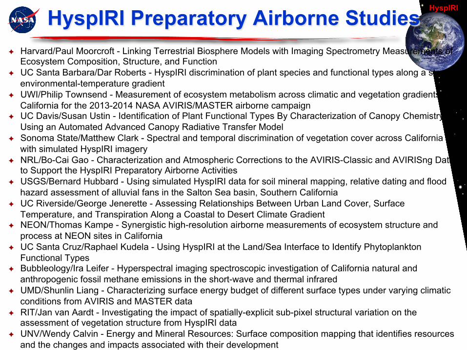
HyspIRI Preparatory Airborne Studies ✦ Harvard/Paul Moorcroft - Linking Terrestrial Biosphere Models with Imaging Spectrometry Measurements of
Ecosystem Composition, Structure, and Function ✦ UC Santa Barbara/Dar Roberts - HyspIRI discrimination of plant species and functional types along a strong
environmental-temperature gradient ✦ UWI/Philip Townsend - Measurement of ecosystem metabolism across climatic and vegetation gradients in
California for the 2013-2014 NASA AVIRIS/MASTER airborne campaign ✦ UC Davis/Susan Ustin - Identification of Plant Functional Types By Characterization of Canopy Chemistry
Using an Automated Advanced Canopy Radiative Transfer Model ✦ Sonoma State/Matthew Clark - Spectral and temporal discrimination of vegetation cover across California
with simulated HyspIRI imagery ✦ NRL/Bo-Cai Gao - Characterization and Atmospheric Corrections to the AVIRIS-Classic and AVIRISng Data
to Support the HyspIRI Preparatory Airborne Activities ✦ USGS/Bernard Hubbard - Using simulated HyspIRI data for soil mineral mapping, relative dating and flood
hazard assessment of alluvial fans in the Salton Sea basin, Southern California ✦ UC Riverside/George Jenerette - Assessing Relationships Between Urban Land Cover, Surface
Temperature, and Transpiration Along a Coastal to Desert Climate Gradient ✦ NEON/Thomas Kampe - Synergistic high-resolution airborne measurements of ecosystem structure and
process at NEON sites in California ✦ UC Santa Cruz/Raphael Kudela - Using HyspIRI at the Land/Sea Interface to Identify Phytoplankton
Functional Types ✦ Bubbleology/Ira Leifer - Hyperspectral imaging spectroscopic investigation of California natural and
anthropogenic fossil methane emissions in the short-wave and thermal infrared ✦ UMD/Shunlin Liang - Characterizing surface energy budget of different surface types under varying climatic
conditions from AVIRIS and MASTER data ✦ RIT/Jan van Aardt - Investigating the impact of spatially-explicit sub-pixel structural variation on the
assessment of vegetation structure from HyspIRI data ✦ UNV/Wendy Calvin - Energy and Mineral Resources: Surface composition mapping that identifies resources
and the changes and impacts associated with their development

HyspIRI
Key Science and Application Event 2013
11
Ø Unexpectedly, HyspIRI preparatory campaign has captured a large portion of the RIM fire area before it burned. This highlights the need for HyspIRI-like routine global coverage.
Ø Fire is a key science and application area for HyspIRI. Ø Fuels: Species-type, dry biomass, and canopy moisture Ø Burning: temperature and emissions Ø Post fire: severity and recovery
RIM Fire 2 Sep 2013 ~250,000 acres or 1000 km^2
VSWIR: Spectroscopy Coverage TIR: Land Surface Temperature
Yosemite Valley

HyspIRI
Ø As part of the HyspIRI Preparatory Airborne Campaign, AVIRIS obtained VSWIR spectroscopic coverage of the full RIM fire area on the 13th of September.
Ø VSWIR spectroscopy is used to measure fuels (species-type, water, dry biomass, etc.), hot fire temperature, smoke properties, severity and recovery processes.
HyspIRI Preparatory Campaign AVIRIS Rim Fire 13 Sept. 2013 Flight Line #5
Flight line #5 Example

HyspIRI
Key Applications Accomplishments 2013
Ø Recent Activities ❑ Special session on Science Applications as part of 2012 HyspIRI Workshop, included
overview talk by L. Friedl ❑ Science Applications incorporated as a major theme in 2013 Workshop ❑ For HyspIRI Symposium developed set of posters on HyspIRI applications; posters displayed
at Symposium, will be made available from website and shown at Workshop ❑ Developed HyspIRI Applications Traceability Matrix (ATM) ❑ Worked with community to develop proposals that evaluate impact of applications on
measurements requirements; first proposal submitted by Dr. Alfieri (USDA) titled: “Determining the Thermal Sensor Revisit Interval for Remotely Monitoring Evapotranspiration at Field Scales” for $79,000.
❑ Added Applied section to website (will be oriented around four ASP focus areas: Disasters, Ecological Forecasting, Health and Air Quality, and Water Resources)
Ø Involvement of other agencies ❑ Continued to encourage early involvement of agencies with science applications interest;
workshop included participation from USDA (7), USGS (8), NOAA (6), DoD (7), NIST (1) Ø Future Plans
❑ Update Applications Traceability Matrix and reconcile with Science Traceability Matrix ❑ Work with community on additional proposals for Applications-related studies as part of risk
reduction activities – i.e., where does Applications drive measurement requirements (latency, etc.)
❑ Science Applications session in 2013 workshop
13
HyspIRI Status of Significant Programmatic Products/Events
Ø Partnership Discussions/Agreements ❑ Conducted first HyspIRI International Working Group Meeting in Washington D.C., included
representatives from CSIRO, CNES, CONAE, ESA, Germany, Italy and Switzerland ❑ Calibration/Validation conversation with ENMAP
Ø Program Level Requirements q Level 1 Requirements presented and upheld at the recent HyspIRI Science Workshop q Requirements have been stable since 2009
Ø Technology Readiness Assessment q Worksheet completed in 2012
Ø Formulation Authorization Document/Formulation Agreement q Draft submitted to HQ
Ø Mission Cost and Schedule Development q ICE found costs within 12% of study estimate, with recommendations for an earlier start to achieve
a more conservative schedule
Ø Acquisition Strategy Planning q Ready to support
Ø Mission Concept Review q Will support Full MCR within 9 Months of request (FY15 is consistent with 2022 launch)
14

HyspIRI
Issues and Challenges
15
Ø Issue: Need for a lower cost and more adaptable mission implementation
options
q Response: Study science impact of instruments on separate platforms q Response: Explore technical options for instruments on different platforms q Response: Initial assessment of placing instruments on ISS q Response: Investigate smallsat versions for VSWIR and TIR in FY14
Ø Issue: Options to advance the HyspIRI Mission ❑ Response: Prepare for next Decadal Survey to ensure information provided for
HyspIRI is accurate and relevant ❑ Response: Support Sustainable Land Imaging Study
Ø Issue: Demonstrate ability to handle large data sets and maturity of Level 1 and 2 algorithms ❑ Response: HyspIRI airborne preparatory science campaign support ❑ Response: Update, refine, algorithm benchmarks in FY14 utilizing data from
preparatory campaign

HyspIRI
Integration with Other Program Elements
16
Ø R&A: HyspIRI Preparatory Airborne Campaign, 14 science investigations
Ø R&A: Ecosystem Spectral Information System (ECOSIS), Phil Townsend, U Wisc PI
Ø ESTO/R&A: Science-supported AVIRIS-NG is providing risk reduction and will support cal/val and precursor science Ø ESTO/R&A: HyTES providing risk reduction and supporting cal/val and precursor science, makes 1st gas detection in 2013 Ø Applied Sciences: Support for application science-related studies that potentially impact measurement requirements Ø ESTO: PHyTIR raised the TRL of the TIR focal plane assembly to 5
Ø ESTO: IPEX CubeSat, designed for flight validation of IPM autonomous planning, scheduling, and low-latency product generation, delivered to VAFB and integrated onto Atlas-V for NROL-39 GEMSat launch on 12/5/13
Ø ESTO: Award of Plume Tracer - Mapping 3D composition of atmospheric plumes from remotely measured TIR radiance spectra
Ø ESTO: Research grant for “A High Performance Onboard Multicore Intelligent Payload Module for Orbital and Suborbital Remote Sensing Missions”

HyspIRI
Recent HyspIRI-Related Papers (1)
17
1 Abrams, M. and S. Hook, 2013, NASA's Hyperspectral Infrared Imager (HyspIRI), in Kunzer and Dech (eds.), Thermal Infrared Remote Sensing: sensors, methods and applications, Remote Sensing and Digital Image Processing Springer, DOI 10.1007/978-94-007-6639-6_6
2 Abrams, M., Pieri, D., Realmuto, V., Wright, R., 2013, Using EO-1 Hyperion data as HyspIRI preparatory data sets for volcanology applied to Mt. Etna, Italy, J. Selected Topics in Applied Earth Observations and Remote Sensing, 6, 375-385.
3 Ainsworth, E.A., Serbin, S.P., Skoneczka, J.A., Townsend, P.A. (2013). Using leaf optical properties to detect ozone effects on foliar biochemistry.
4 Antonarakis, A.S., Munger, J.W., Moorcroft, P.R. (2013). Remote Sensing Constrained Predictions of Forest Ecosystem Dynamics. Geophysical Research Letters (in review).
5 Asner, G.P. 2013. Biological diversity mapping comes of age. Remote Sensing 5:374-376.
6 Asner, G.P., and R.E. Martin. 2011. Canopy phylogenetic, chemical and spectral assembly in a lowland Amazon forest. New Phytologist 189:999-1012.
7 Asner, G.P., D.E. Knapp, J. Boardman, R.O. Green, T. Kennedy-Bowdoin, M. Eastwood, R.E. Martin, C. Anderson, and C.B. Field. 2012. Carnegie Airborne Observatory-2: Increasing science data dimensionality via high-fidelity multi-sensor fusion. Remote Sensing of Environment 124:454-465.
8 Asner, G.P., R.E. Martin, and A. Bin Suhaili. 2012. Sources of canopy chemical and spectral diversity in lowland Bornean forest. Ecosystems 15:504-517.
9 Asner, G.P., R.E. Martin, R. Tupayachi, R. Emerson, P. Martinez, F. Sinca, G.V.N. Powell, J. Wright, and A. Lugo. 2011. Taxonomy and remote sensing of leaf mass per area (LMA) in humid tropical forests. Ecological Applications 21:85-98.
10 Babbar-Sebens, M., L. Li, K.S. Song, and S. S. Xie, On the Use of Landsat-5 TM Satellite for Assimilating Water Temperature Observations in 3D Hydrodynamic Model of Small Inland Reservoir in Midwestern US, Advances in Remote Sensing, 2: 214-227, 2013.
11 Baldeck, C.A. and G.P. Asner. 2013. Estimating vegetation beta diversity from airborne imaging spectroscopy and unsupervised clustering. Remote Sensing 5:2057-2071.
12 Banskota, A., Wynne, R.H., Serbin, S.P., Kayastha, N., Thomas, V.A., Townsend, P.A. (2013). Utility of the wavelet transform for LAI estimation using hyperspectral data. Photogrammetric Engineering & Remote Sensing, 79(7), 653-662
13 Banskota, A., Wynne, R.H., Thomas, V.A., Serbin, S.P., Kayastha, N., Gastellu-Etchegorry, J.P., Townsend, P.A. (2013). Investigating the Utility of Wavelet Transforms for Inverting a 3-D Radiative Transfer Model Using Hyperspectral Data to Retrieve Forest LAI. Remote Sensing, 5(6), 2639-2659. DOI: 10.3390/rs5062639
14 Bradley, E., Leifer, I., Roberts, D.A., Dennison, P.E., and Washburn, L., 2011, Detection of Marine Methane Emissions with AVIRIS Band Ratios, Geophysical Research Letters, 38, L10702, doi:10.1029/2011GL046729.
15 Cho M.A., R. Mathieu, G.P. Asner, L. Naidoo, A. Ramoelo, P. Debba, K. Wessels, R. Main, J.A.N. van Aardt, I. Smit and B. Erasmus. 2012. Mapping tree species composition in South African savannas using an integrated airborne spectral and LiDAR system. Remote Sensing of Environment 125: 214-226
16 Colgan, M., C. Baldeck, J.-B. Féret, and G.P. Asner. 2012. Mapping savanna tree species at ecosystem scales using support vector machine classification and BRDF correction on airborne hyperspectral and LiDAR data. Remote Sensing 4:3462-3480.
17 Couture, J.J., Serbin, S.P., and Townsend, P.A. (2013). Spectroscopic sensitivity of real-time, rapidly induced phytochemical change in response to damage. New Phytologist, 198(1), 311-319. DOI: 10.1111/nph.12159
18 D. R. Thompson, R. O. Green, D. Keymeulen, S. Lundeen, Y. Mouradi, D. Nunes, R. Castaño, S. A. Chien, "Rapid spectral cloud screening onboard aircraft and spacecraft." IEEE Trans. on Geoscience and Remote Sensing (submitted, 2013).
19 Dennison, P.E., Thorpe, A.K., Pardyjak, E.R., Roberts, D.A., Qi, Y., Green, R.O., Bradley, E.S., & Funk, C.C. (2013). High spatial resolution mapping of elevated atmospheric carbon dioxide using airborne imaging spectroscopy: Radiative transfer modeling and power plant plume detection. Remote Sensing of Environment
20 Dennison, P.E., Thorpe, A.K., Roberts, D.A., & Green, R.O. (2013). Modeling sensitivity of imaging spectrometer data to carbon dioxide and methane plumes. In, Proc. 5th Workshop on Hyperspectral Image and Signal Processing: Evolution in Remote Sensing. Gainesville, FL

HyspIRI
Recent HyspIRI-Related Papers (2)
18
21 Doughty, C.E., G.P. Asner, and R.E. Martin. 2011. Predicting tropical plant physiology from leaf and canopy spectroscopy. Oecologia 165:289-299.
22 Emmanuel C. Devred, Kevin R. Turpie, Victor V. Klemas, Tiffany Moisan, Wesley Moses, Marcel Babin, Marie-Hélène Forget, Gerardo Toro-Farmer, Young-Heon Jo, "Future Retrievals of Water Column Bio-Optical Properties using the Hyperspectral Infrared Imager (HyspIRI)" (submitted to Remote Sensing)
23 Féret, J.-B. and G.P. Asner. 2011. Spectroscopic classification of tropical forest species using radiative transfer modeling. Remote Sensing of Environment 115:2415-2422.
24 Féret, J.-B., and G.P. Asner. 2012. Tree species discrimination in tropical forests using airborne imaging spectroscopy. IEEE Transactions on Geoscience and Remote Sensing 51:73-84.
25 Gao, B.-C., and M. Liu, "A fast smoothing algorithm for post-processing of surface reflectance spectra retrieved from airborne imaging spectrometer data", submitted to Remote Sensing in June 2013.
26 Haselwimmer, C., Prakash, A., and Holdmann, G., 2013, Quantifying the heat flux and outflow rate of hot springs using airborne thermal imagery: case study from Pilgrim Hot Springs, Alaska, Remote Sensing of Environment, 136, 37-46.
27 Hook, S., Johnson, W., Abrams, M., 2013, NASA's Hyperspectral Thermal Emission Spectrometer (HyTES), in Kunzer and Dech (eds.), Thermal Infrared Remote Sensing: sensors, methods and applications, Remote Sensing and Digital Image Processing Springer, DOI 10.1007/978-94-007-6639-6_6.
28 Hulley, G. C., T. Hughes, and S. J. Hook (2012), Quantifying Uncertainties in Land Surface Temperature (LST) and Emissivity Retrievals from ASTER and MODIS Thermal Infrared Data, J. Geophys. Res. Lett, 117, D23113, doi:10.1029/2012JD018506.
29 Koeppen, W.C., Patrick, M., Orr, T., Sutton, J., Dow, D., and Wright, R. (2013). Constraints on the partitioning of Kilauea's lavas between surface and tubed flows, estimated from infrared satellite data, sulfur dioxide flux measurements, and field observations. Bulletin of Volcanology, 75, doi:10.1007/s00445-013-0716-3
30 Kratt, C., W. M. Calvin, M. F. Coolbaugh, Mineral mapping in the Pyramid Lake basin: Hydrothermal alteration, chemical precipitates and geothermal energy potential, Remote Sensing of Environment, 114 (10), pp. 2297-2304, Oct. 15 2010.
31 Kruse, F. A., J.V. Taranik, M. Coolbaugh, J. Michaels, E. F. Littlefield, W. M. Calvin and B. A. Martini, Effect of Reduced Spatial Resolution on Mineral Mapping Using Imaging Spectrometry-Examples Using Hyperspectral Infrared Imager (HyspIRI)-Simulated Data, Remote Sens. 2011, 3(8), 1584-1602; doi:10.3390/rs3081584, 25 July 2011
32 Kruse, F. A., Bedell, R. A., J. V. Taranik, W. A. Peppin, O. Weatherby, and W. M. Calvin, Mapping alteration minerals at prospect, outcrop and drill core scales using imaging spectrometry, Int. J. Remote Sensing, 33 (6), 1780-1798, available on line, Sept 2011, DOI:10.1080/01431161.2011.600350, 2012.
33 Leifer, I., Lehr, W.J., Simecek-Beatty, D., Bradley, E., Clark, R., Dennison, P., Hu, Y., Matheson, S., Jones, C.E., Holt, B., Reif, M., Roberts, D.A., Svejkovsky, J., Swayze, G., & Wozencraft, J. (2012). State of the art satellite and airborne marine oil spill remote sensing: Application to the BP Deepwater Horizon oil spill. Remote Sensing of Environment, 124, 185-209
34 Matheson, D.S., & Dennison, P.E. (2012). Evaluating the effects of spatial resolution on hyperspectral fire detection and temperature retrieval. Remote Sensing of Environment, 124, 780-792
35 Papes, M., R. Tupayachi, P. Martínez, A.T. Peterson, G.P. Asner, and G.V.N. Powell. 2013. Seasonal variation in spectral signatures of fire genera of rainforest trees. IEEE Journal of Selected Topics in Applied Earth Observations and Remote Sensing. 6(2):339-350.
36 Ramsey, M.S. and Harris, A.J.L., 2013, Volcanology 2020: How will thermal remote sensing of volcanic surface activity evolve over the next decade?, J. Volcanol. Geotherm. Res., 249, 217-233.
37 Ramsey, M.S., Wessels, R.L. and Anderson, S.W., 2012, Surface textures and dynamics of the 2005 lava dome at Shiveluch Volcano, Kamchatka, Geol. Soc. Amer. Bull., doi:10.1130/B30580.1, (cover issue).
38 Reath, K.A. and Ramsey, M.S., 2013, Exploration of geothermal systems using hyperspectral thermal infrared remote sensing, J. Volc. Geotherm. Res., (in press).
39 Roberts, D.A., D. A. Quattrochi, G. C. Hulley, S.J. Hook, and R.O. Green, (2011), Synergies between VSWIR and TIR data for the urban environment: An evaluation of the potential for the Hyperspectral Infrared Imager (HyspIRI) Decadal Survey mission, Remote Sensing of Environment.
40 Roberts, D.A., Dennison, P., Roth K., Hulley, G., 2013, RELATIONSHIPS BETWEEN SPECIES COMPOSITION, FRACTIONAL COVER AND LAND SURFACE TEMPERATURE IN A MEDITERRANEAN ECOSYSTEM, Proceedings of Whispers, 2013, Gainesville Florida, 4 pp.

HyspIRI
Recent HyspIRI-Related Papers (3)
19
41 Roberts, D.A., Quattrochi, D.A., Hulley, G.C., Hook, S.J. and Green, R.O., 2012, Synergies between VSWIR and TIR data for the urban environment: An evaluation of the potential for the Hyperspectral Infrared Imager (HyspIRI) Decadal Survey mission, Remote Sens. Environ., 117, 83-101.
42 Roth, K.L., Dennison, P.E., & Roberts, D.A. (2012). Comparing endmember selection techniques for accurate mapping of plant species and land cover using imaging spectrometer data. Remote Sensing of Environment, 127, 139-152
43 Schaaf, A., Dennison, P., Fryer, G., Roth, K., & Roberts, D. (2011). Mapping plant functional types at multiple spatial resolutions using imaging spectrometer data. GIScience and Remote Sensing, 48, 324-344
44 Scheidt, S., Lancaster, N. and Ramsey. M., 2011, Eolian dynamics and sediment mixing in the Gran Desierto, Sonora, MX: Fusion of infrared orbital and emission spectroscopy data, Geol. Soc. Amer. Bull., doi:10.1130/B30338.1.
45 Scheidt, S., Ramsey, M.S. and Lancaster, N., 2010, Determining soil moisture and sediment availability at White Sands Dune Field, NM from apparent thermal inertia (ATI) data, J. Geophys. Res., 115, F02019, doi:10.1029/2009JF001378.
46 Schimel, D.S., G.P. Asner, and P.R. Moorcroft. 2013. Observing changing ecological diversity in the Anthropocene. Frontiers in Ecology and the Environment 11(3):129-137.
47 Serbin, S.P., Dillaway, D., Kruger, E.L., Townsend, P.A. (2012). Leaf optical properties reflect variation in photosynthetic metabolism and its sensitivity to temperature. Journal of Experimental Botany, 63, 489-502. DOI: 10.1093/jxb/err294
48 Serbin, S.P., Singh, A., McNeil, B.E., Townsend, P.A., (in review). Spectroscopic determination of leaf morphological, nutritional, and biochemical traits for northern temperate and boreal tree species. Oecologia
49 Somers, B. and G.P. Asner. 2013. Invasive species mapping in rainforests using multi-temporal spaceborne imaging spectroscopy. IEEE Journal of Selected Topics in Applied Earth Observations and Remote Sensing 6:351-359.
50 Somers, B., G.P. Asner, L. Tits, and P. Coppin. 2011. Endmember variability in spectral mixture analysis: a review. Remote Sensing of Environment 115:1603-1616.
51 Starkenburg, D.,P., Fochesatto, G.J., Prakash, A., Cristóbal, J., Gens, R., and Kane, D.L., 2013, The Role of Coherent Flow Structures in the Turbulent Fluxes of an Alaskan Boreal Forest, Journal of Geophysical Research-Atmosphere, 118, 1-16.
52 Thorpe, A.K., Roberts, D.A., Bradley, E.S., Funk, C.C., Dennison, P.E., & Leifer, I. (2013). High resolution mapping of methane emissions from marine and terrestrial sources using a Cluster-Tuned Matched Filter technique and imaging spectrometry. Remote Sensing of Environment, 134, 305-318
53 Townsend, A.R. and G.P. Asner. 2013. Multiple dimensions of resource limitation in tropical forests. Proceedings of the National Academy of Sciences 110:4864-4865. Townsend, P.A., Serbin, S.P., Kruger, E.L., Gamon, J. (2013). Disentangling the contribution of biological and physical properties of leaves and canopies in imaging spectroscopy data. Proceedings of the National Academy of Sciences (PNAS),
54 Ustin, S.L. G.P. Asner, and R.O. Green. Monitoring canopy chemistry with HyspIRI and other planned imaging spectrometers. Submitted to JSTARS.
55 Wright, R., Glaze, L., and Baloga, S.M., (2011). Constraints on determining the eruption style and composition of terrestrial lavas from space. Geology, 39, 1127-1130
56 Wright, R., H. Garbeil, and Davies, A.G., (2010). Cooling rate of some active lavas determined using an orbital imaging spectrometer. Journal of Geophysical Research (Solid Earth), 115, B06205, doi:10.1029/2009JB006536.
57 Zhang, Q. Y., E. L. Middleton, B.-C. Gao, and Y.-B. Cheng "Using EO-1 Hyperion to Simulate HyspIRI Products for a Coniferous Forest: the Fraction of PAR Absorbed by Chlorophyll (fAPARchl) and Leaf Water Content (LWC)," IEEE Transactions on Geoscience and Remote Sensing, 50, 1844-1852, 2012 (doi:10.1109/TGRS.2011.2169267).

HyspIRI
Ø Based upon the NRC Decadal Survey and refined by the Science Study Group, a comprehensive set of science questions, science traceability matrices and related Level 1 requirements have been developed. From these requirements (reviewed at the annual workshop), a mature baseline Mission Concept has been developed that is high heritage and low risk.
Ø HyspIRI has a large, active, dedicated community supporting the science and science applications of this mission.
Ø In 2013, the HyspIRI team has pushed to understand the science impact and define options for alternate implementation approaches with the instruments accommodated on different platforms and flight opportunities. This work should be extended in 2014.
Ø In 2014, the HyspIRI team is ready to support working with the Sustainable Land Imaging study to explore options for efficiently meeting shared objectives where they coincide.
Ø Excellent options exist for technology maturation and early science for the VSWIR, TIR, and IPM on the ISS. These could be advanced in 2014/15 for HyspIRI, Decadal Survey, and Sustainable Land Imaging.
Critical Take-Aways
20

HyspIRI
© 2010. All Rights Reserved
Thank You http://HyspIRI.jpl.nasa.gov