status of the hyspiri mission concept - nasa · pdf file10/13/2014 · status of the...
TRANSCRIPT

Status of the HyspIRI Mission Concept
Robert Green(JPL), Simon Hook(JPL), Elizabeth Middleton (GSFC), and the HyspIRI Community
Jet Propulsion Laboratory, California Institute of Technology
© 2014 All Rights Reserved

Overview
• HyspIRI Objectives and Approach • FY14 Guidance • HyspIRI Team • FY14 Accomplishments • Requirements linked to Science and Applications
Questions • FY15 plan • Plans to support the next Decadal Survey • Status Summary

Mission Concept Status Level 1 Measurement Requirements: Vetted by community and stable Payload: VSWIR Imaging Spectrometer, TIR Multi-spectral Radiometer, and Intelligent Payload Module (IPM) Full Mission original option: Mature Separate Small Mission option: Pegasus-based solutions identified and studied *SLI Support: HyspIRI VSWIR evolving to 30m at 185km swath ECOSTRESS TIR: Selected EVI for ISS VSWIR Dyson Option: Technology/Science ISS Demonstration Summary: The HyspIRI mission measurement requirements and baseline instruments approach are mature and stable with good heritage, low risk and modest cost. Now exploring a range of instrument and data options to save cost, per guidance letter.
Mission Urgency The HyspIRI science and applications objectives are critical today and uniquely addressed by the combined imaging spectroscopy, thermal infrared measurements, and IPM direct broadcast.
0
0.1
0.2
0.3
0.4
0.5
0.6
0.7
0.8
0.9
1
3.00 4.00 5.00 6.00 7.00 8.00 9.00 10.00 11.00 12.00 13.00Wavelength (um)
Rel
ativ
e Sp
ectr
al R
espo
nse
H1 (m21)H2 (m28)H3 (a10)H4 (a11)H5 (a12)H6H7H8 (m32)
HyspIRI Objectives and Approach Key Science and Science Applications
Climate: Ecosystem biochemistry, condition & feedback; spectral albedo; carbon/dust on snow/ice; biomass burning; evapotranspiration Ecosystems: Global biodiversity, plant functional types, physiological condition, and biochemistry including agricultural lands Fires: Fuel status; fire frequency, severity, emissions, and patterns of recovery globally Coral reef and coastal habitats: Global composition and status Volcanoes: Eruptions, emissions, regional and global impact Geology and resources: Global distributions of surface mineral resources and improved understanding of geology and related hazards Applications: Disasters, EcoForecasting, Water, Health/AQ Measurement Imaging Spectrometer (VSWIR) - 380 to 2500nm in ≤10nm bands - 60 m spatial sampling* - 19 days revisit* - Global land and shallow water Thermal Infrared (TIR): - 8 bands between 4-12 µm - 60 m spatial sampling - 5 days revisit; day/night - Global land and shallow water IPM-Low Latency data subsets
Ecosystems
Snow & ice
Fires Evapotranspiration
Volcanoes Coastal Habitats

FY14 Guidance
Guidance Memo Actions Status Notes 1. Continue to build broad community support with workshops and symposia
Symposium held Jun 4th - 6th at GSFC Workshop scheduled for Oct 14th - 16th at Caltech (2013 “shutdown” Workshop ~100 people)
2. Science white paper specifying value of science from two separate platforms, ISS
Collaboration amongst science community yielded detailed report
3. Use airborne data to generate HyspIRI-like level 2 data products; airborne mission management
HyspIRI airborne campaign data processed to level 2 and convolved to HyspIRI spatial and spectral resolutions; Evaluated atmospheric correction algorithms
4. Perform instrument mission trade studies, including smallsat and ISS
Smallsat and ISS solutions have been identified with IPM; Advanced IPM towards space qual
5. Explore how HyspIRI VSWIR and TIR meet Sustainable Land Imaging measurement requirement
Modified VSWIR for 30m, 16 day revisit; Convolved entire AVIRIS HyspIRI dataset to Landsat bands for MSS, TM, and OLI
6. Engage potential international and domestic partners in addressing opportunities to lower the cost of a potential mission
ISRO, CNES, USGS and Sustainable Land Imaging Study Team
7. Support the Earth Systematic Missions (ESM) Systems Engineering Working Group (SEWG) studies on TRL definitions and instrument cost studies
Responded to requests and provided TRL assessment
8. Complete a comprehensive development report of the HyspIRI mission study activities
Version 1 complete; delivery after vetting at October workshop

Key Concept Personnel & Affiliations
– Steven Neeck, Program Executive, NASA HQ – Woody Turner, Program Scientist, NASA HQ – Robert Green, Concept Co-Lead, JPL – Simon Hook, Concept Co-Lead, JPL – Elizabeth Middleton, Concept Co-Lead, GSFC – Carl Bruce / Michael Mercury, Concept Manager, JPL – Ernesto Diaz, Concept System Engineer, JPL – Stephen Ungar, Concept Team Member, GSFC/USRA – Kevin Turpie, Concept Team Member, GSFC – Daniel Mandl, Intelligent Payload Module (IPM), GSFC – Elizabeth Edwards, Flight Programs, NASA HQ – Paula Bontempi, Coastal Ocean Science, NASA HQ – Diane Wickland, Carbon Cycle and Ecosystems Science, NASA HQ – Matthew Fladeland, Suborbital, ARC – Charles Norton, ESTO, JPL – Reggie Eason, Program Management, GSFC – Petya Campbell, Concept Team Member, GSFC – and the broader HyspIRI research, applications, and technology communities
5
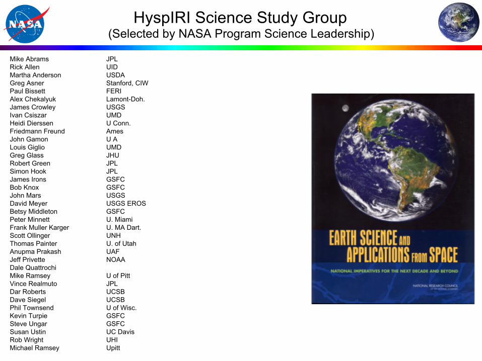
HyspIRI Science Study Group (Selected by NASA Program Science Leadership)
Mike Abrams JPL Rick Allen UID Martha Anderson USDA Greg Asner Stanford, CIW Paul Bissett FERI Alex Chekalyuk Lamont-Doh. James Crowley USGS Ivan Csiszar UMD Heidi Dierssen U Conn. Friedmann Freund Ames John Gamon U A Louis Giglio UMD Greg Glass JHU Robert Green JPL Simon Hook JPL James Irons GSFC Bob Knox GSFC John Mars USGS David Meyer USGS EROS Betsy Middleton GSFC Peter Minnett U. Miami Frank Muller Karger U. MA Dart. Scott Ollinger UNH Thomas Painter U. of Utah Anupma Prakash UAF Jeff Privette NOAA Dale Quattrochi Mike Ramsey U of Pitt Vince Realmuto JPL Dar Roberts UCSB Dave Siegel UCSB Phil Townsend U of Wisc. Kevin Turpie GSFC Steve Ungar GSFC Susan Ustin UC Davis Rob Wright UHI Michael Ramsey Upitt

• Demonstrated HyspIRI VSWIR & TIR Level 1 & Level 2 algorithms for large volumes of preparatory airborne data over diverse land forms and at a range of observation and illumination geometries. (3)
• Completed separate instrument smallsat studies showing that the VSWIR-SLI+IPM and TIR are each compatible with a Pegasus solution. This provides additional mission options. (4)
• Evolved VSWIR design with current Dyson technology to provide 185 km swath at 30 m to support SLI program. (5)
• Convolved all of the HyspIRI preparatory VSWIR data to LandSat MSS, TM, and OLI working towards data continuity from spectroscopy. All data available on the web. (5)
• Completed comprehensive report summarizing multi-year effort of HyspIRI concept study team. (8)
Technical
7
Smallsat VSWIR-Dyson SLI with IPM Smallsat TIR SLI
30 m and 185 km swath solution
HyspIRI Preparatory Airborne Campaign

HyspIRI SmallSat SLI/Landsat Compatibility
VSWIR-Dyson TIR
o Landsat has: o 60-120 meter spatial resolution o 16 day revisit (day + night) o 1-2 bands
o HyspIRI TIR has: o 60 m spatial resolution o 5 day revisit (day + night) o 8 bands
o HyspIRI-TIR matches all Landsat bands
o 30 meter spatial resolution o 16 day revisit o VSWIR spectra may be convolved to
all Landsat bands going back to Landsat MSS providing excellent data continuity

• Held Data Products Symposium Jun 4th - 6th at GSFC and Science and Application Workshop Oct 14th - 16th at Caltech assuring strong connection with the broad science community. (1)
• Complete science white paper specifying value of science from two separate platforms and the ISS to provide information and options for decision makers. (2)
• Science team meeting of the preparatory airborne campaign 17th and 18th of March at NASA HQ. Quad charts of 14 science and applications investigations prepared showing advances and maturation in HyspIRI science and applications. (1,3)
• Remote Sensing of Environment Special Issue (1) • Landsat underflights for cal/val investigations (5) • Study to evaluate impact of revisit times on retrieval of evapotranspiration (Alfieri,
USDA) and development of Application Traceability Matrices and Science Application Summaries and Whitepapers (available on HyspIRI website). (4)
Science and Applications
9

2014 HyspIRI Symposium
10
The 2014 HyspIRI Product Symposium June 4-5 at NASA Goddard Space Flight Center (GSFC),
HyspIRI: Enabling the Evolution of Sustainable Land and Aquatic Imaging with New Products
How can HyspIRI help address Sustainable Land Imaging requirements?
1
More than 120 scientists participated in the Symposium (116 registered). The HyspIRI Symposium included 42 talks, 6 posters, and 2 demonstration sessions on the HyspIRI Mission and new approaches and potential products for land and coastal imaging. Presentations are available on the HyspIRI Website (http://hyspiri.jpl.nasa.gov). The Symposium incorporated seven sessions, addressing: HyspIRI’s evolving mission and products; Compatibility with other US missions and the Sustainable Land Imaging (SLI); Ecosystem studies and aquatic ecology; Public health and disasters; New HyspIRI-like data sets, instrument and data calibration issues and product validation; Intelligent payload module; and Ground data processing and distribution. This year the Annual HyspIRI Product Symposium was followed by the 2ond annual forum of the HyspIRI Aquatic Study Group (HASG, lead K. Turpie/UMBC) and a one-day tutorial on Processing Routines in IDL for Spectroscopic Measurements (PRISM, instructor R. Kokaly/USGS).

• ESTO: PHyTIR was funded by the ESTO IIP and is a key part of HyspIRI pre-formulation efforts
• EV: ECOSTRESS selected as EVI for ISS - matures technology, science and applications of HyspIRI TIR
• R&A: HyspIRI airborne preparatory campaign advances data processing as well as selected science and applications for both VSWIR and TIR
• R&A: Ecosystem Spectral Information System (ECOSIS), Phil Townsend, U Wisc PI
• ESTO/R&A: Science-supported AVIRIS-NG is providing risk reduction and will support cal/val and precursor science
• ESTO/R&A: HyTES providing risk reduction and supporting cal/val and precursor science, makes 1st gas detection in 2013
• Applied Sciences: Support for application science-related studies that potentially impact measurement requirements
• ESTO: IPEX CubeSat, funded by ESTO ATI, successfully flight validated IPM autonomous product generation technology
• Support to Sustainable Land Imaging program • R&A/ESTO: Development of full wavelength range (VSWIR-TIR) optical
spectroscopy platform on ER-2 (PRISM, AVIRIS, HyTES). • ESTO: A High Performance Onboard Multicore Intelligent Payload Module for
Orbital and Suborbital Decadal Missions – linked to HyspIRI IPM
11
Other Elements
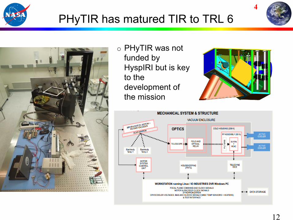
PHyTIR has matured TIR to TRL 6
12
o PHyTIR was not funded by HyspIRI but is key to the development of the mission
4
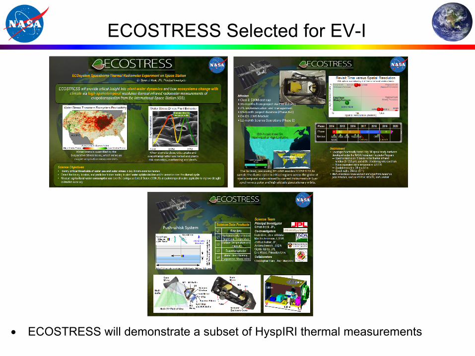
ECOSTRESS Selected for EV-I
• ECOSTRESS will demonstrate a subset of HyspIRI thermal measurements

HyspIRI Preparatory Airborne Campaign Third Year of Slights Added
14
Ø Support R&A HyspIRI Preparatory Science Campaign q science team with 14 PIs q Delivered Level 1 and Level 2 data products
Ø Ecosystems, Seasonal, Climate, Coastal, Urban, Resources Ø 6 zones, 3 seasons, 2 years Ø Objective: Advance HyspIRI Mission Science,
Algorithm and Processing Readiness Ø Ecosystem composition, function, biochemistry,
seasonality, structure, and modeling Ø Coastal ocean phytoplankton functional types, habitat Ø Urban land cover, temperature, transpiration Ø Surface energy balance Ø Atmospheric characterization and local methane sources Ø Surface geology, resources, soils, hazards

HyspIRI VSWIR Vegetation Species Mapping Across Seasons Kenneth Dudley (grad student), Phil Dennison – Univ. of Utah, Dar Roberts – UC Santa Barbara
Species
A multi-temporal endmember library provides equivalent performance for mapping species compared to single date classifications.
• Objective: Evaluate the ability of imaging spectroscopy data from the HyspIRI Preparatory Campaign to map vegetation species across a range of dates and illumination conditions – Imaging spectroscopy contains detailed spectral information that can be used to distinguish vegetation species and
functional types – Hypothesis: Species can be mapped using a uniform approach even though their phenology varies over space and
through time.
• Key Finding: A species map retrieval algorithm that accounts for the range of phenological variability in species reflectance can map species as well as any single date classification – A single spectral library created from a range of dates can be applied to any date, allowing species mapping without
knowing phenological state in advance
A data cube showing the spectral dimensionality of image spectroscopy data.
Reflectance of different vegetation species vary through time due to vegetation phenology. Subtle spectral differences can be used to distinguish a) Blue Oak from b) Chamise.
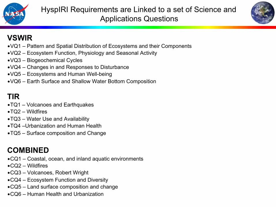
HyspIRI Requirements are Linked to a set of Science and Applications Questions
VSWIR • VQ1 – Pattern and Spatial Distribution of Ecosystems and their Components • VQ2 – Ecosystem Function, Physiology and Seasonal Activity • VQ3 – Biogeochemical Cycles • VQ4 – Changes in and Responses to Disturbance • VQ5 – Ecosystems and Human Well-being • VQ6 – Earth Surface and Shallow Water Bottom Composition
TIR • TQ1 – Volcanoes and Earthquakes • TQ2 – Wildfires • TQ3 – Water Use and Availability • TQ4 –Urbanization and Human Health • TQ5 – Surface composition and Change
COMBINED • CQ1 – Coastal, ocean, and inland aquatic environments • CQ2 – Wildfires • CQ3 – Volcanoes, Robert Wright • CQ4 – Ecosystem Function and Diversity • CQ5 – Land surface composition and change • CQ6 – Human Health and Urbanization

FY15 HyspIRI Plan

• HyspIRI has a large, active, dedicated community supporting the science and applications of this VSWIR and TIR mission.
• The preparatory HyspIRI airborne campaign is validating VSWIR and TIR Level 1 and Level 2 processing as well as calibration and validation approaches.
• In 2015, the HyspIRI team is committed to supporting the Sustainable Land Imaging program.
• A VSWIR-Dyson imaging spectrometer concept has been developed with 2014 technology that provides 30 m sampling and 185 km swath.
• Both the VSWIR and TIR instrument concepts are compatible with a smallsat Pegasus-based mission.
• We are working to fully support the next Decadal Survey with a focus on urgent and unique science and applications from HyspIRI class measurements.
18
Key Status Elements

Mission Concept Status Level 1 Measurement Requirements: Vetted by community and stable Payload: VSWIR Imaging Spectrometer, TIR Multi-spectral Radiometer, and Intelligent Payload Module (IPM) Full Mission original option: Mature Separate Small Mission option: Pegasus-based solutions identified and studied *SLI Support: HyspIRI VSWIR evolving to 30m at 185km swath ECOSTRESS TIR: Selected EVI for ISS VSWIR Dyson Option: Technology/Science ISS Demonstration Summary: The HyspIRI mission measurement requirements and baseline instruments approach are mature and stable with good heritage, low risk and modest cost. Now exploring a range of instrument and data options to save cost, per guidance letter.
Mission Urgency The HyspIRI science and applications objectives are critical today and uniquely addressed by the combined imaging spectroscopy, thermal infrared measurements, and IPM direct broadcast.
0
0.1
0.2
0.3
0.4
0.5
0.6
0.7
0.8
0.9
1
3.00 4.00 5.00 6.00 7.00 8.00 9.00 10.00 11.00 12.00 13.00Wavelength (um)
Rel
ativ
e Sp
ectr
al R
espo
nse
H1 (m21)H2 (m28)H3 (a10)H4 (a11)H5 (a12)H6H7H8 (m32)
Thank You Key Science and Science Applications
Climate: Ecosystem biochemistry, condition & feedback; spectral albedo; carbon/dust on snow/ice; biomass burning; evapotranspiration Ecosystems: Global biodiversity, plant functional types, physiological condition, and biochemistry including agricultural lands Fires: Fuel status; fire frequency, severity, emissions, and patterns of recovery globally Coral reef and coastal habitats: Global composition and status Volcanoes: Eruptions, emissions, regional and global impact Geology and resources: Global distributions of surface mineral resources and improved understanding of geology and related hazards Applications: Disasters, EcoForecasting, Water, Health/AQ Measurement Imaging Spectrometer (VSWIR) - 380 to 2500nm in ≤10nm bands - 60 m spatial sampling* - 19 days revisit* - Global land and shallow water Thermal Infrared (TIR): - 8 bands between 4-12 µm - 60 m spatial sampling - 5 days revisit; day/night - Global land and shallow water IPM-Low Latency data subsets
Ecosystems
Snow & ice
Fires Evapotranspiration
Volcanoes Coastal Habitats