highlights of usgs geospatial activities - c.ymcdn.com · lidar data acquisition 3dep lidar data...
TRANSCRIPT
+
Kevin T. Gallagher
Associate Director, Core Science Systems
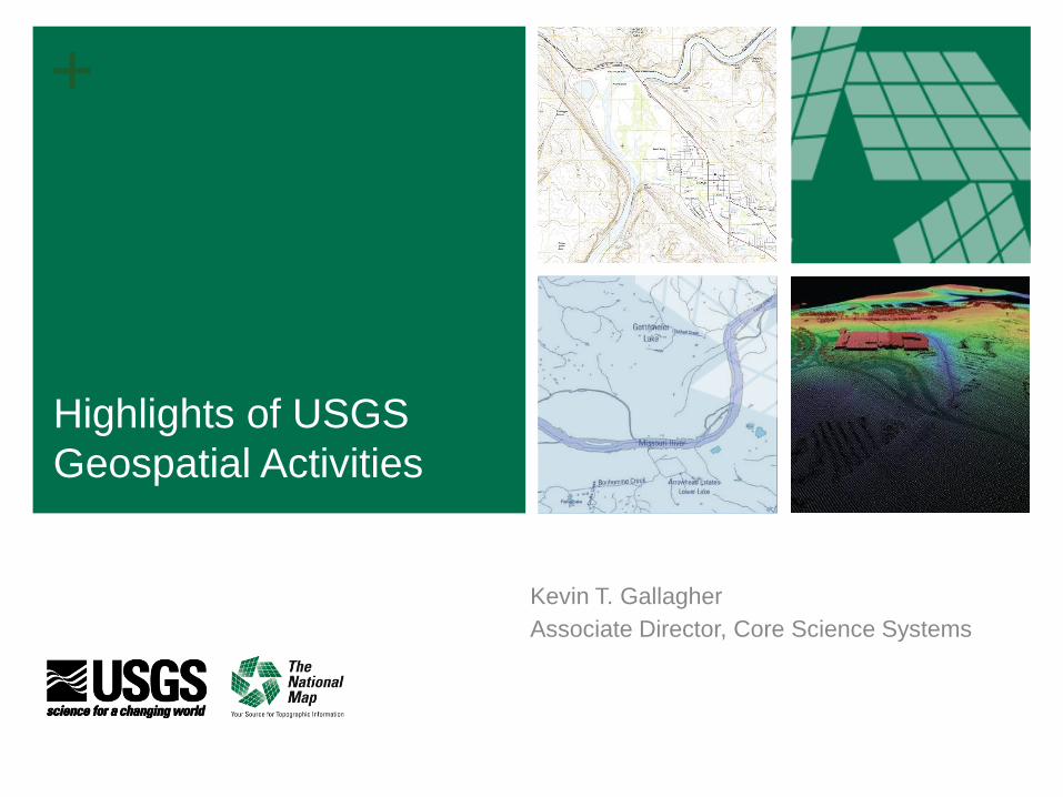
Highlights of USGS
Geospatial Activities

+ 2 + 2
Topics
3D Elevation Program
Hydrography Requirements and Benefits Study
Requirements Capabilities & Analysis for Earth
Observations (RCA-EO)
+ + 3
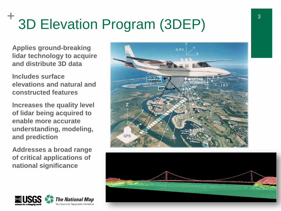
Applies ground-breaking
lidar technology to acquire
and distribute 3D data
Includes surface
elevations and natural and
constructed features
Increases the quality level
of lidar being acquired to
enable more accurate
understanding, modeling,
and prediction
Addresses a broad range
of critical applications of
national significance
3D Elevation Program (3DEP)

+ 4 + 4
3D Elevation Program (3DEP) Mission Critical Applications
Infrastructure Management
Geologic Hazards
Archaeology
Precision Forestry
Aviation Safety
Flood Risk Management
Alternative Energy

+ + 5
3DEP is a Partnership Program
■ National lidar coverage with ifsar in Alaska in 8 years
■ Address the mission-critical requirements of 34 Federal agencies, 50
states, and other organizations documented in the National Enhanced
Elevation Assessment
■ ROI = 5:1, designed to conservatively provide new benefits of $690
million/year with the potential to generate $13 billion/year in new benefits
through applications that span the economy
■ Leverage the capability and capacity of private industry mapping firms
■ Achieve a 25% cost efficiency gain by collecting data in larger projects
■ Completely refresh national elevation data holdings with new lidar and
IfSAR elevation data products and services
Natural Resource Conservation
Infrastructure Management
Flood Risk Mitigation Precision Farming Land Navigation
and Safety
Geologic Resources and Hazards Mitigation

+ 6 + 6
U.S. Interagency Elevation Inventory
3.4% of entire US
was acquired to
3DEP quality
in FY15 - includes
complete, in progress,
and planned/funded
13.9% of Lower 49
Meets 3DEP quality
(2008-2015 only)
63.6% of AK Meets
3DEP quality (QL5 –
ifsar)
Data Acquired through FY 2015

+ 7 + 7
FY15 3DEP
Preliminary
Summary
Lidar Data
Acquisition
3DEP Lidar Data Contracted in FY15
3DEP Funds $M Partner Funds $M Total $M Sq Miles
USGS FEMA NRCS Other Feds Non-Fed
$39.0 150,000 $7.2 $11.2 $7.1 $2.5 $11.0
$25.5 $13.5

+ 8 + 8
FY15 3DEP Summary Alaska Ifsar
BLM, FWS, NPS, USFS and
USGS provided ~$2.8M
end-of-year to acquire
~25,000 square miles of
ifsar in critical areas of Arctic
Alaska, the Kenai
Peninsula, and the Yukon
Delta
Funding from all contributors
totaled over $7.4M
Total square miles of ifsar
acquired were 69,000,
adding approximately 12%
coverage, raising the State's
overall coverage to 63.4%
Goal is to reach 70%
coverage in FY16

+ 9 + 9
3DEP DATA ACQUISITION Funding USGS and ALL PARTNERS
FY15 vs Estimated Funding for 8 Year Program
USGS
Other Federal
Agencies
Other Partners
(non-Federal)
TOTAL estimated data
acquisition GAP in
annual funding
needed for 8 year
program
FY15 3DEP Data Acquisition

+ 10 + 10
3DEP Funding Preliminary
Estimated USGS
Program Budget
FY16 Enacted
(14 Year Scenario)
FY17 President’s
Budget
(13 Year Scenario)
3DEP Call to
Action Goal
(8 Year Scenario)
FY16 FY17
USGS Base budget from prior
year (includes acquisition and
operations)
$20.4 M $24.7M
Increase (FY16 enacted, FY17
proposed President’s budget) $4.3 M $4.9 M
Total USGS 3DEP budget $24.7 M $29.6 M
FY16 Enacted Budget
FY17 President’s
Budget Increase
Gap in annual USGS
program budget to meet
8-year program
(includes operations
and 1/3 of total data
acquisition funding
needed)

+ 11 + 11
42 proposals submitted for projects in 30 states + 1 territory
Total project value of $38M; $22M in partner contributions, requesting $16M 3DEP funding
Coverage proposed 146,000 sq mi
BAA remains open to new proposals through the year
Information on each award is online at nationalmap.gov/3dep
FY16 Broad Agency Announcement (BAA) Project Selection In Progress

+ 12 + 12
FY16 BAA
# of
awards Sq. mi.
3DEP
USGS,
FEMA HQ,
NRCS GCE
$M
Other
Partners
$M
Total
$M
Geospatial
Products and
Services Contract
(GPSC)
18 77,021 $6.8 $12.4 $19.2
Cooperative
Agreements 5 15,916 $2.0 $2.4 $4.4
Total as of 3/1/16 23 92,937 $8.8 $14.8 $23.4
Summary to Date – Project Selection Ongoing
• Additional FY16 3DEP acquisitions funded by 3DEP Federal partners are underway
• FY16 increases will help increase overall totals for acquisition
• BAA remains open to new proposals
+ 13 + 13
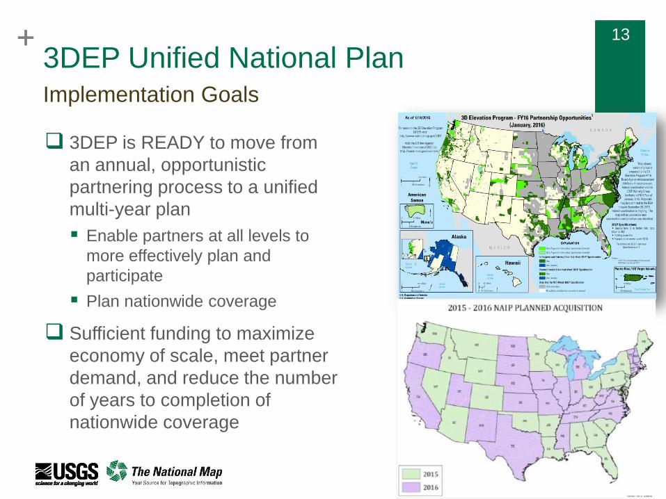
3DEP Unified National Plan
3DEP is READY to move from
an annual, opportunistic
partnering process to a unified
multi-year plan
Enable partners at all levels to
more effectively plan and
participate
Plan nationwide coverage
Sufficient funding to maximize
economy of scale, meet partner
demand, and reduce the number
of years to completion of
nationwide coverage
Implementation Goals
+ 14 + 14
3DEP Federal
Best Practices -
DRAFT
Developing in the 3DEP
Executive Forum and
Working Group (formerly
NDEP)
Taking feedback (already
received some ideas from
the Winter MAPPS meeting
Plan to expand to all
partners
Talking with NSGIC and
NACo about a project to
develop state and local
best practices

+ 15 + 15 3DEP is “Hill Ready” READY for a national, 8-year program
National lidar program is a priority of the National Science and
Technology Council’s National Plan for Civil Earth Observations
3DEP Partnership announced by White House in July, 2014
National Academy of Public Administration report on FEMA
Flood Mapping recommended that OMB implement the 3DEP
plan for national lidar
Endorsed by
American Society for Photogrammetry and Remote
Sensing (ASPRS)
Association of American State Geologists (AASG)
Association of State Floodplain Managers (ASFPM)
Coalition of Geospatial Organizations (COGO)
Management Association for Private Photogrammetric
Surveyors (MAPPS)
National Geospatial Advisory Committee (NGAC)
National Society of Professional Surveyors (NSPS)
National States Geographic Information Council (NSGIC)
3DEP Coalition with website 3DEP4America.com

+ 16 + 16
Geospatial Products and Services Contracts
FY15 final numbers: 68 task
orders with a value of $34.7M
FY16 numbers so far: 8 task
orders with a value of ~$10.3M
Expectation is that FY16 will
exceed FY15 – already have
$32M to award this year and
3DEP selections are ongoing
Update
GPSC3 Update
Three GPSC3 base contracts are under award (Dewberry, Woolpert, Quantum Spatial)
Two additional GPSC3 contracts have been negotiated and are expected to be
awarded this month (March)
Five remaining contracts will be negotiated and awarded April through June
+ 17 + 17
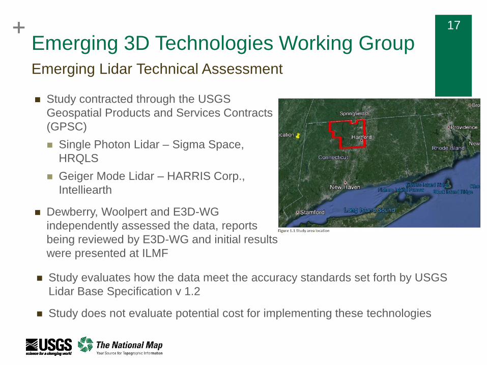
Emerging 3D Technologies Working Group
Study contracted through the USGS
Geospatial Products and Services Contracts
(GPSC)
Single Photon Lidar – Sigma Space,
HRQLS
Geiger Mode Lidar – HARRIS Corp.,
Intelliearth
Dewberry, Woolpert and E3D-WG
independently assessed the data, reports
being reviewed by E3D-WG and initial results
were presented at ILMF
Emerging Lidar Technical Assessment
Study evaluates how the data meet the accuracy standards set forth by USGS
Lidar Base Specification v 1.2
Study does not evaluate potential cost for implementing these technologies
+ 18 + 18
Next Steps
Continued analyses and dialog with Harris and Sigma Space
Sensor improvements have been reported since the evaluation collection
Need to do evaluations/validations on new instruments and in traditional leaf-
off conditions
Evaluate the full lifecycle costs of managing data, especially data with
nominal point spacing greater than QL1
NEEA/3DEP has not assessed the cost/benefits of data greater than QL1
Increased storage costs, longer/more difficult processing, noise points, etc.
Evaluate any necessary changes to the USGS Lidar Base
Specification
Further findings will be presented at IGTF 2016 annual conference

+
Kevin T. Gallagher
Associate Director, Core Science Systems
Hydrography
Requirements and
Benefits Study (HRBS)

+ 20 + 20
HRBS Information Collection Plan
Kick off Meeting
Federal – Contractor
Other – TNM Liaisons
COMPLETE
Agency Interview
Federal – Contractor
Other – TNM Liaisons
COMPLETE
Online Survey
Contractor
COMPLETE
Scenarios
USGS and Partners
May – Dec 2016
Clean Compilation
Contractor
May 2016
Program
Recommendations
USGS and Partners
Dec 2016
Raw Data
Compilation
Contractor
COMPLETE

+ 21 + 21
Preliminary questionnaire results
532 individual responses
595 Mission Critical Activities reported
222 identified as Federal (23 Agencies identified)
202 identified as State (all 50 states represented)
53 identified as Regional or local government
10 identified as Tribal government
26 identified as Not for Profit (including academia)
19 identified as Commercial
23 Federal Agencies, 50 states

+ 22 + 22
Benefits by Business Use Row Labels Current benefits Future Benefits
C
o
u
Agriculture and Precision Farming 1,253,000$ 4,148,200$
Coastal Zone Management 10,710,000$ 13,050,000$
Education K-12 and Beyond 525,000$ 5,360,000$
Flood Risk Management 30,624,500$ 1,074,042,000$
Forest Resources Management 1,760,000$ 6,010,000$
Geologic Resource Assessment and Hazard Mitigation 35,000$ 50,000$
Health and Human Services 960,000$ 1,000,000$
Homeland Security, Law Enforcement, and Disaster Response 100,000$ 5,500,000$
Infrastructure and Construction Management 1,643,000$ 8,951,000$
Marine and Riverine Navigation Safety -$ 100,000$
Natural Resources Conservation 54,273,000$ 22,038,000$
Oil and Gas Resources 100,000$ 100,000$
Rangeland Management -$ 100,000$
Recreation 1,410,000$ 200,000$
Renewable Energy Resources 2,802,500$ 580,250$
Resource Mining 1,025,000$ 1,100,000$
River and Stream Ecosystem Management 13,955,000$ 67,750,001$
River and Stream Flow Management 89,816,228$ 154,655,307$
Sea Level Rise and Subsidence 350,000$ 350,000$
Urban and Regional Planning 2,165,000$ 3,415,000$
Water Quality 521,710,728$ 530,404,227$
Water Resource Planning and Management 48,113,000$ 1,095,741,000$
Wildfire Management, Planning, and Response 10,000$ -$
Wildlife and Habitat Management 182,468$ 10,079,251$
Grand Total 783,523,424$ 3,004,724,236$

Requirements Capabilities and Analysis for Earth Observations
(RCA-EO)
U.S. Department of the Interior U.S. Geological Survey
23

Purpose of RCA-EO
USGS Land Remote Sensing Program Requirements,
Capabilities and Analysis for Earth Observations (RCA-EO)
project goal:
Provide decision support to optimize Earth Observation
investments to meet user needs
• Comprehensively understand USGS and other agency
needs for Earth observations
• Enhance products and services to better meet user needs
• Support Office of Science and Technology Policy (OSTP)
National Earth Observation Assessments
24

Example output: Impact of Observing Capabilities and Datasets on USGS activities (early results)
25
(March 2016 - Based on provisional USGS LRS RCA-EO data and subject to adjustment)
Very High Field Work/Campaigns
High
USGS Stream Gage Network Airborne Lidar Landsat GPS National Elevation Dataset Airborne High-Resolution Imagery

Key RCA-EO milestones
• June 2015 – RCA-EO data collection for USGS products and services complete
• July 2016 – OSTP national Earth Observation Assessment complete
• July 2016 – Initial set of civil land imaging requirements
• 2016-2017 – Ongoing user needs collection and analysis
26

+ 27
Thank you!