oregon lidar acquisition prioritization … documents/2014 oregon lidar...page 1 oregon lidar...
TRANSCRIPT

Page 1 Oregon Lidar Acquisition Prioritization Plan
OREGON LIDAR ACQUISITION PRIORITIZATION PLAN: 3DEP ANALYSIS PRIORITIZATION RESULTS
OREGON ELEVATION FRAMEWORK IMPLEMENTATION TEAM (E-FIT)
DATA ACQUISITION ADVISORY COMMITTEE (DAAC) PRIORITIZATION PLAN TASK FORCE
ENDORSED BY OGIC, SEPTEMBER 19, 2014
AUG 21, 2014
Document Details
Project Oregon Lidar Collection Prioritization Plan
Reference Oregon E-FIT Charter
Title Oregon Lidar Collection Prioritization Plan
File Name OregonLidarCollectionPrioritizationPlan_v7.docx
Version 3
Version Date 8/19/2014
Document Approval
Name Agency Date
Author Data Acquisition Advisory Committee
E-FIT 8/7/14
Approved By OGIC 9/19/14
Document History
Version Date Author Name Agency Changes
1 5/10/14 Ian Madin DOGAMI Original draft
2 6/6/14 Tyler Duffy City of Springfield Document info, formatting, strategy and methodology adjustments.
3 6/20/2014 Tyler Duffy City of Springfield Methodology, analysis, results based on adjusted methodology.
4 6/23/14 Brandt Melick City of Springfield Review, minor edits and recommendations.
5 8/19/2014 Bob DenOuden DAS GEO Incorporate DAAC edits and recommendations
Prioritization Plan Task Force Contacts
Name Role Email
Bob DenOuden Oregon FIT Chair [email protected]
Brandt Melick E-FIT Lead [email protected]
Ian Madin E-FIT Stakeholder [email protected]
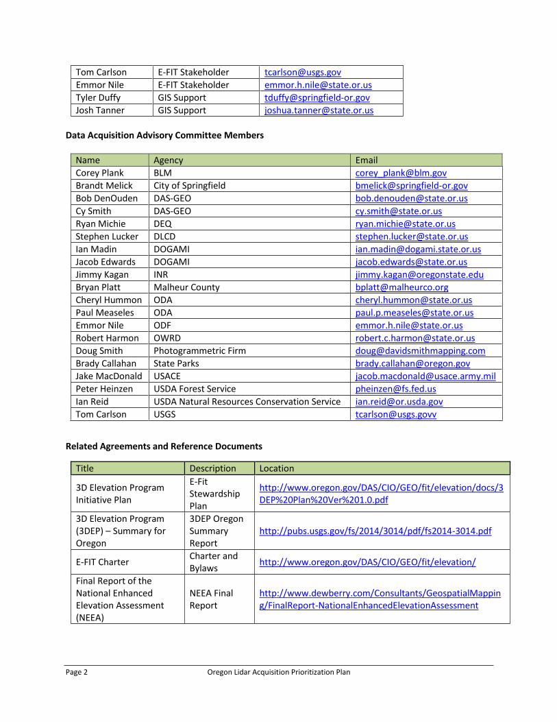
Page 2 Oregon Lidar Acquisition Prioritization Plan
Tom Carlson E-FIT Stakeholder [email protected]
Emmor Nile E-FIT Stakeholder [email protected]
Tyler Duffy GIS Support [email protected]
Josh Tanner GIS Support [email protected]
Data Acquisition Advisory Committee Members
Name Agency Email
Corey Plank BLM [email protected]
Brandt Melick City of Springfield [email protected]
Bob DenOuden DAS-GEO [email protected]
Cy Smith DAS-GEO [email protected]
Ryan Michie DEQ [email protected]
Stephen Lucker DLCD [email protected]
Ian Madin DOGAMI [email protected]
Jacob Edwards DOGAMI [email protected]
Jimmy Kagan INR [email protected]
Bryan Platt Malheur County [email protected]
Cheryl Hummon ODA [email protected]
Paul Measeles ODA [email protected]
Emmor Nile ODF [email protected]
Robert Harmon OWRD [email protected]
Doug Smith Photogrammetric Firm [email protected]
Brady Callahan State Parks [email protected]
Jake MacDonald USACE [email protected]
Peter Heinzen USDA Forest Service [email protected]
Ian Reid USDA Natural Resources Conservation Service [email protected]
Tom Carlson USGS [email protected]
Related Agreements and Reference Documents
Title Description Location
3D Elevation Program Initiative Plan
E-Fit Stewardship Plan
http://www.oregon.gov/DAS/CIO/GEO/fit/elevation/docs/3DEP%20Plan%20Ver%201.0.pdf
3D Elevation Program (3DEP) – Summary for Oregon
3DEP Oregon Summary Report
http://pubs.usgs.gov/fs/2014/3014/pdf/fs2014-3014.pdf
E-FIT Charter Charter and Bylaws
http://www.oregon.gov/DAS/CIO/GEO/fit/elevation/
Final Report of the National Enhanced Elevation Assessment (NEEA)
NEEA Final Report
http://www.dewberry.com/Consultants/GeospatialMapping/FinalReport-NationalEnhancedElevationAssessment

Page 3 Oregon Lidar Acquisition Prioritization Plan
1. Project Purpose and Overview
Since 2007, The Oregon Department of Geology and Mineral Industries (DOGAMI) has collected lidar data for Oregon by using the Oregon Lidar Consortium (OLC) to build funding partnerships to collect large blocks of high lidar quality data at the best possible price. In the 2007-2009 and 2009-2011 biennia, the state contributed a total of $2M to the program, and OLC partners contributed an additional $7.8 M. In the 2011-2013 and 2013-2015 biennia, the state contributed no funds, and OLC partners provided funds totaling $4.5 M in 2011-2013, and $2 M in 2013-2015 to date. The OLC lidar acquisition program (including its predecessor, the Portland Lidar Consortium) has made good progress, collecting lidar over approximately 30% of the state, some 19 million acres. This coverage includes:
94% of the state’s population
100% of the coast
60% of Oregon’s highways
81% of endangered Oregon Coho salmon habitat
When state seed money was available, the OLC prioritized the coast and Willamette Valley, and areas with significant problems with watershed health, like the Klamath Basin. Without state seed money acquisition is driven by the interests of the funding partners, which may not always serve the priorities of the state as a whole. The lidar collection program will face a very different funding landscape in 2015-2017, as the US Geological Survey (USGS) starts the 3D Elevation Program (3DEP), a national lidar data acquisition funding program. 3DEP has a goal of completing lidar coverage of the lower 48 U.S. states within 8 years and will be run cooperatively with the states. States will be required to develop a prioritization plan and then submit nationally competitive proposals for project funding.
The purpose of this project is for the Oregon Elevation Framework Implementation Team (E-FIT) to develop a prioritization plan for the state during 2014 in order to be well-positioned for participation in the 2015 3DEP program. The E-FIT has formed a Data Acquisition Advisory Committee (DAAC), which draws from a wide range of Oregon stakeholders and LIDAR users, and is working closely with the DOGAMI lidar program to complete this prioritization plan. 2. Strategies, Agreements, and Assumptions
In order to be competitive in the 2015 3DEP program, Oregon needs to develop a prioritization plan by the end of 2014. The prioritization plan developed for consideration of 3DEP funding will evolve to meet the following short, mid, and long-term E-FIT needs:
A. USGS 3DEP draft pre-proposal by August 2014 B. State legislative process by September, 2014
C. Ongoing state elevation data framework process
This document reports on analysis conducted for the purpose of meeting goal A., with consideration given to goals B. and C. in developing analysis methods.
In order to maximize the value of analysis efforts and meet deadlines several factors have been taken into consideration in the design and implementation of the lidar acquisition prioritization analysis. The following strategies, agreements, and assumptions shaped the development of the analysis:
Prioritization Plan Assumptions and Strategies:
o The DAAC created a task force to follow guidance, implement recommendations,
and perform analysis
Page 4 Oregon Lidar Acquisition Prioritization Plan
o The DAAC provided guidance and recommendations for the selection of data inputs
for the analysis, methods for the analysis, as well as the relative weighting factor
assigned to each data input in order to ensure a collaborative effort
o A simple, reusable, and easy to modify analytical model was developed to support
short term analysis needs of 3DEP and long term needs of the E-FIT
o For the 3DEP Proposal, the analysis parameters and methodology should align as
closely as possible with USGS 3DEP stated goals and requirements (highlighted
below)
o For the E-FIT, additional feedback is required from the DAAC regarding analysis
methods (data inputs, weighting, etc.). See list of methodology considerations in
Section 5.
Analysis Assumptions and Strategies:
o Large areas without lidar should be ranked higher than large areas with lidar for the
following reasons
the 3DEP program’s documents suggest a higher level of interest in funding
projects that cover large contiguous areas
DAAC survey feedback suggests acquiring lidar data for large project areas is
preferable to filling in smaller gaps
o Analysis will be raster based, with a cell size of 90m
o Project area units of analysis (zones) will be based on watershed boundaries to
coincide with realistic data needs, rather than orthogonal tiles that do not coincide
with geographies of interest
o Point and line features will be buffered to the distances indicated in Table 4 in order
to strengthen their representation in the raster analysis
Furthermore, the 3D Elevation Program - Summary for Oregon (Carswell, 2014) has highlighted the following benefits of a nationally funded program that may or may not reflect USGS criteria for funding:
“Economy of scale – Acquisition of data covering larger areas reduces costs by 25 percent”
“A systematic plan…”
“Higher quality data and national coverage…”
The same document also highlights the following factors as dependencies for successful implementation of the program:
“Increased partnerships among Federal, State, Tribal, and local governments”
“Partnerships that acquire elevation data to the program’s specifications across larger project areas”
“Support for the program from government and other stakeholders”
These points have been taken into consideration in the development and design of the prioritization plan.

Page 5 Oregon Lidar Acquisition Prioritization Plan
3. Lidar Acquisition Prioritization Analysis Methodology
A. Overview of Methods
In order to determine the relative priority of project areas for future lidar data acquisition, the DAAC task force performed a raster-based weighted sum overlay analysis. To accomplish this, twenty-seven individual datasets were used to produce eight thematic raster layers. The thematic raster layers were each assigned a weight and used as input to the weighted sum analysis.
To produce the thematic layers, raster datasets were reclassified to represent a presence (cell value = 1) or absence (cell value = 0) of a feature of interest, with the exception of the existing lidar coverage layer, which was assigned a cell value of -1. This was done to avoid assigning a high priority to project areas for which lidar data is already available.
Raster datasets that comprised each theme were then added using map algebra to produce the thematic raster datasets. The cell values of the thematic layers were then used as inputs to a weighted sum overlay, which multiplied cell values by a weighting factor derived from the results of a survey circulated among the Oregon E-FIT and added the resultant values together to produce a single output raster layer. Cell values from the weighted sum overlay output were then summed within for each project area in order to calculate the total representation of features of interest within that zone. The resulting sums for each project area were then grouped into five classes using natural breaks (Jenks). The end product is a map with project areas assigned relative priority that ranges from very low to very high (Figure 3) and a table that ranks project areas by priority as determined by the analysis (Table 3). A conceptual model of the analysis methods can be found in Exhibit 1 at the end of this document.
B. Community Survey
In order to determine which datasets to use and the relative importance (weight) of each data theme, the DAAC task force created an online survey and solicited input from E-FIT and DAAC members on May 27, 2014 on four items.
1) Importance of thematic layers to use in the analysis. A 3-level Likert scale was used to rank themes.
2) Importance of specific datasets to include in each thematic layer in the analysis. A 5-level Likert scale was used.
3) Suggestions for additional datasets to use that were not listed on survey. 4) Whether it is more important to collect data in small project areas to complete coverage for
a region or to collect data in large project areas for which there is currently no lidar data available. A 5-level Likert scale was used.
Summary tables of the survey results appear in the Table 5 below.
C. Acquisition Tiling and Project Area Prioritization
To date, OLC project boundaries have been driven by the needs of funding partners, resulting in the project areas shown below in Figure 1. At the OLC project level, data are tiled by USGS 7.5 minute quadrangles, and as a result some quadrangles have complete or partial coverage assembled from up to 3 different projects flown at different times. Fortunately, all data have been collected by the same vendor and to the same specifications, so the datasets are practically seamless. The DAAC has reached a consensus to collect data in project areas that are based on watershed boundaries. The project areas

Page 6 Oregon Lidar Acquisition Prioritization Plan
used in this analysis are illustrated below in Figure 1.One argument for this tiling is that 3DEP has stated a preference for large projects and the watersheds as delineated below have an average area of approximately 2900 square miles. DAAC survey results also support an emphasis placed on large project areas, as summarized in Table 1 below.
Figure 1. Existing Oregon Lidar Consortium project areas (OLC, 2014) and a proposed watershed boundary tiling scheme
developed by DOGAMI. Project areas are based on 4th and 6th field HUC boundaries.
Table 1. Survey results for project area size preference.
Project Area Size Preference Votes % Total
Large Blocks 5 42%
Neutral 4 33%
Small Gaps 3 25%
Total 12 100%

Page 7 Oregon Lidar Acquisition Prioritization Plan
D. Thematic Layers
LIDAR collection prioritization is based on uses and needs. Drawing from the National Enhanced Elevation Assessment (NEAA) and consultation with the Oregon lidar user community, a suite of geographic themes was developed that represents the various needs and uses. This approach allows for project areas to be rated for each need or use. Themes can then be weighted and used to arrive at a ranked prioritization of the project areas. The themes were derived from the Oregon summary from the NEAA (Figure 2). This approach ensures that the prioritization plan aligns with the uses and needs that were identified by USGS through polling of numerous Federal, State, Local, and NGO users and holding a series of user meetings. Eight themes were established that include the ten main business uses shown below in Figure 2, with each theme serving to represent several uses. The themes, the business uses they represent, and their constituent data layers are listed below. The themes are generally composed of data layers that are publically available, statewide, and comprehensive. Polygon features have been included in the analysis as is, while point and line features were buffered (see Table 3 for distances) to amplify their presence in the analysis. See Exhibits 2 through 9 for visual representations of the themes used in this analysis.
Figure 2. Oregon business uses for lidar from the NEAA, ranked by estimated annual benefits (Carswell, 2014, p. 3).
The thematic layers used in the analysis, along with their relative weights (derived from survey results) are summarized below.

Page 8 Oregon Lidar Acquisition Prioritization Plan
Table 2. Thematic data layers used in the prioritization analysis. Percent influence was calculated by dividing the number of vote points for a theme by the total number of vote points.
Theme Sum of Point Values % Influence
Water 56 16%
Natural Hazards 52 15%
Critical Habitat 46 13%
Forest 46 13%
Completeness 44 12%
Infrastructure 44 12%
Agriculture 36 10%
Population 31 9%
Total 355 100%
E. Data Inputs
The individual datasets used in the analysis were determined through a collaborative DAAC effort. The datasets were then evaluated on their importance in the survey. Because datasets from more than one source were included, the results of this survey largely served to aid in deciding between similar datasets (e.g. DEQ 303(d) Water Quality Limited Streams v. all NHD Streams), as well as to eliminate extraneous datasets from the analysis. Datasets that received less than 50% of the total points were eliminated from the analysis. The DAAC task force recommends that the full DAAC review and evaluate the narrowed-down list of datasets based on their relative importance within a theme, and also the relative weighting of the themes. A summary of datasets used in the analysis appear in Table 3, below.

Page 9 Oregon Lidar Acquisition Prioritization Plan
Table 3. Datasets used in project area prioritization analysis. *Denotes that the dataset does not clearly fit into a thematic data layer.
Theme Dataset Description Data Used Buffer Distance
Agriculture Agriculture (NLCD 2011) Cultivated Crops N/A
Critical Habitat Critical Habitat (ODFW) Compiled Crucial Habitat Rank = 1 N/A
Forest Forest (NLCD 2011) Deciduous, Evergreen, and Mixed Forest N/A
Infrastructure Dams (OWRD) Dam points for dams with height >= 10ft and storage >= 9.2 acre feet
200m
Infrastructure Highways (ODOT) All 100m
Infrastructure Oregon Bridges (ODOT) All (Bridge Points) 100m
Infrastructure Railways (ODOT) All 100m
Infrastructure Electric Substations (DOGAMI) All 100m
Infrastructure Electrical Towers (DOGAMI) All 100m
Infrastructure Electrical Transmission Lines (DOGAMI)
All 100m
Infrastructure Wind Farms (DOGAMI) All N/A
Natural Hazard Landslide Database (SLIDO-3) Historic Landslide Points 100m
Natural Hazard Flood Zones (FEMA) Flood Zones A; AE 100m
Natural Hazard Tsunami Evacuation Zones (DOGAMI)
All 100m
Natural Hazard Active Faults (DOGAMI) All 1000m
Natural Hazard Volcanic Vents (DOGAMI) All 1000m
Natural Hazard Slope (Percent)* Slope > 50% N/A
Natural Hazard Wildfire Risk (ODF Fire Threat Index) FTI > 25% N/A
Natural Hazard Oregon Coast* (NOAA) All 1000m
Population Population (2010 Census) Population density > 0.1/acre N/A
Water NHD Streams (USGS) All 100m
Water Lakes (USGS) All 100m
Water Drinking Water Protection (Ground; OWRD)
All N/A
Water Drinking Water Protection (Surface; OWRD)
All N/A
F. Analysis Results
The values obtained from the weighted sum analysis were grouped into five classes using natural
breaks (Jenks) classification. The classes were then assigned a relative priority ranking, ranging from very
low to very high. The results are illustrated below in Figure 3.

Page 10 Oregon Lidar Acquisition Prioritization Plan
Figure 3. Lidar Data Acquisition Project Area Priority Ranking

Page 11 Oregon Lidar Acquisition Prioritization Plan
A more detailed priority ranking is summarized below in Table 4. Rankings were derived from the values resulting from the weighted sum analysis.
Table 4. Priority rankings for all 34 project used in the weighted sum analysis.
Priority Rank Project Area (Subbasin) Priority Rank Project Area (Subbasin)
1 Upper Umpqua 18 Nehalem-Necanicum
2 McKenzie 19 Harney
3 Upper Rogue 20 Guano
4 Grande Ronde 21 Crooked
5 Upper John Day 22 Summer Lake
6 Umpqua-Coos-Siuslaw 23 Steens
7 Santiam 24 Hells Canyon
8 Walla Walla-Umatilla 25 Lower John Day
9 Klamath 26 Lower Deschutes
10 Coquille-Sixes 27 Middle Owyhee
11 Malheur 28 Upper Deschutes
12 Chetco-Illinois-Applegate 29 Siletz-Yaquina-Alsea
13 Clackamas 30 Lower Owyhee
14 Yamhill-Molalla 31 Lower Willamette
15 Goose-Warner-Abert 32 Willow
16 Middle Willamette 33 Wilson-Trask-Nestucca
17 Powder-Burnt 34 Middle Columbia-Hood
Lidar coverage has been overlaid on the analysis results in Figure 4 for reference.

Page 12 Oregon Lidar Acquisition Prioritization Plan
Figure 3. Analysis results overlaid with existing lidar coverage.

Page 13 Oregon Lidar Acquisition Prioritization Plan
4. Methodology Considerations and Discussion Items For Meeting Future E-FIT Goals
The DAAC task force recommends that the following items be addressed at some point as this prioritization plan evolves. Note that not all of items will be addressed in the initial effort to inform the 3DEP Proposal, as this plan will be refined over time to meet short, medium, and long term goals of the E-FIT.
Datasets to include in analysis should be reexamined or further refined o Some themes contain datasets that amplify a presence of what is essentially the same
feature Wetlands/Streams
o The following data sets do not fit into existing thematic layers State Parks (omitted from analysis) Slope (included in Natural Hazards theme) Coast (erosion) (included in Natural Hazards theme)
Data inputs should be reevaluated via survey or other means to determine the relative importance (weight) of a dataset within a theme and the relative importance of each theme. This is recommended for the following reasons:
o The survey that was conducted contained datasets that duplicate feature classes from differing sources, e.g. DEQ 303(d) Water Quality Limited Streams/NHD Streams. This may produce misleading results.
o There is already a weighting scheme in place for each thematic layer. Since all datasets were evaluated without regard to their theme, the survey results as they stand would have the effect of duplicating this weighting.
The DAAC should discuss in greater detail the parameters of certain data inputs. In this analysis, definition queries were used to isolate classes of data using best judgment. Datasets for which to discuss parameters:
o Flight date of existing lidar data (not factored into this analysis) o 1-6 Compiled Crucial Habitat Rank o Slope % o Fire Threat Index

Page 14 Oregon Lidar Acquisition Prioritization Plan
EXHIBIT 1: CONCEPTUAL MODEL OF ANALYSIS METHODS

Page 15 Oregon Lidar Acquisition Prioritization Plan
EXHIBIT 2: AGRICULTURE THEME

Page 16 Oregon Lidar Acquisition Prioritization Plan
EXHIBIT 3: COMPLETENESS THEME

Page 17 Oregon Lidar Acquisition Prioritization Plan
EXHIBIT 4: CRITICAL HABITAT THEME

Page 18 Oregon Lidar Acquisition Prioritization Plan
EXHIBIT 5: FOREST THEME

Page 19 Oregon Lidar Acquisition Prioritization Plan
EXHIBIT 6: INFRASTRUCTURE THEME

Page 20 Oregon Lidar Acquisition Prioritization Plan
EXHIBIT 7: NATURAL HAZARD THEME

Page 21 Oregon Lidar Acquisition Prioritization Plan
EXHIBIT 8: POPULATION THEME

Page 22 Oregon Lidar Acquisition Prioritization Plan
EXHIBIT 9: WATER THEME

Page 23 Oregon Lidar Acquisition Prioritization Plan
Table 5: Elevation FIT data acquisition prioritization survey results summary
Please rate the importance of each of the data themes below relative to the prioritization of elevation data acquisition
Select a rating (5 = highest importance)
Answer Options 5 4 3 2 1 Response
Count SUM
NHD rivers and lakes 8 2 2 0 0 12 54
Flood zones (DFIRM and Q3 A and AE zones) 7 3 1 1 0 12 52
SLIDO3 (landslides) 7 2 2 1 0 12 51
Slope 5 5 1 1 0 12 50
Wetlands 6 3 2 1 0 12 50
Dams 6 1 4 1 0 12 48
Tsunami Inundation (XXL scenario) 5 4 1 2 0 12 48
Current lidar coverage areas 5 2 4 1 0 12 47
Critical habitat 6 1 2 3 0 12 46
Forest 5 3 2 1 1 12 46
1km buffer on the coast to represent erosion hazards
4 3 3 1 1 12 44
Bridges 3 2 6 1 0 12 43
Wildfire Risk 4 3 2 2 1 12 43
Quaternary Faults 4 2 3 2 1 12 42
DEQ Water Quality limited streams and lakes 3 2 4 3 0 12 41
Groundwater Protection Areas 2 5 2 1 2 12 40
State Parks 3 2 3 4 0 12 40
Surface Water Protection areas 2 4 2 3 1 12 39
Urban-wildland interface 2 4 3 1 2 12 39
Highways 0 4 5 3 0 12 37 Cost to complete remaining lidar within watershed
3 1 4 1 3 12 36
Gas lines 2 2 3 4 1 12 36
Transmission lines, towers, substations 2 1 5 3 1 12 36
Agriculture 0 4 5 0 3 12 34
Quaternary volcanoes 2 1 2 5 2 12 32
Railroads 0 1 6 5 0 12 32
Airports 0 1 5 4 2 12 29
Urban Growth Boundaries 0 2 5 1 4 12 29
Population (at 2010 Census Block level) 0 1 5 3 3 12 28
Wind Farms 0 1 5 3 3 12 28 light sources at night (proxy for population/infrastructure)
0 1 2 4 5 12 23
Fiber 0 1 1 5 5 12 22

Page 24 Oregon Lidar Acquisition Prioritization Plan
Please rate the categories relative to their importance in the prioritization of elevation data acquisition
Answer Options Very Important Moderately Important
Not Important
Response Count
sum
Water 10 2 0 12 56
Natural Hazards 9 2 1 12 52
Forests 7 3 2 12 46
Critical Habitat 7 3 2 12 46
Infrastructure 5 6 1 12 44
Completeness 5 6 1 12 44
Agriculture 2 8 2 12 36
Population 1 8 2 11 31
It is more important to acquire data to fill in the large areas in Oregon where no lidar data is available than it is to complete smaller areas adjacent to existing lidar data
Answer Options Response
Count
Strongly agree 2
Agree 3
Neutral 4
Disagree 2
Strongly Disagree 1