harvesting, integrating and distributing large … · harvesting, integrating and distributing...
TRANSCRIPT
HARVESTING, INTEGRATING AND DISTRIBUTING LARGE OPEN GEOSPATIAL
DATASETS USING FREE AND OPEN-SOURCE SOFTWARE
Ricardo Oliveiraa
Rafael Morenob
University of Colorado Denver, Department of Geography and Environmental Sciences, USA a [email protected] b [email protected]
Commission VII, SpS10 - FOSS4G: FOSS4G Session (coorganized with OSGeo)
KEY WORDS: Open Data; Cloud services; geospatial Open-Source Software; large data sets.
ABSTRACT:
Federal, State and Local government agencies in the USA are investing heavily on the dissemination of Open Data sets produced by
each of them. The main driver behind this thrust is to increase agencies’ transparency and accountability, as well as to improve
citizens’ awareness. However, not all Open Data sets are easy to access and integrate with other Open Data sets available even from
the same agency. The City and County of Denver Open Data Portal distributes several types of geospatial datasets, one of them is the
city parcels information containing 224,256 records. Although this data layer contains many pieces of information it is incomplete
for some custom purposes. Open-Source Software were used to first collect data from diverse City of Denver Open Data sets, then
upload them to a repository in the Cloud where they were processed using a PostgreSQL installation on the Cloud and Python
scripts. Our method was able to extract non-spatial information from a ‘not-ready-to-download’ source that could then be combined
with the initial data set to enhance its potential use.
1. INTRODUCTION
The availability and accessibility to Open-Data sets has
exploded in recent years caused primarily by the ease that
organizations now have in exposing such datasets to citizens,
and also by the increasingly interest of the general public to
explore these datasets. However, some barrier still exists, such
as not all datasets are readily available for some custom
applications that require integration of information from
multiple data sets. It was with this challenge in mind that we
explored ways to integrate information from different open data
sets to facilitate new uses of these data.
For our tests we chose two data sets. First, the parcel data set
provided freely by the City and County of Denver
(http://data.denvergov.org/dataset/city-and-county-of-denver-
parcels). This dataset contains 224,256 records corresponding
to each parcel in the city and it is part of a larger collection of
open data offered by the city through their Open Data Catalogue
(http://data.denvergov.org/). It contains numerous attributes of
interest and it can potentially be used for a broad range of
applications. Second, we selected the tax property records
provided by the Denver Property Taxation and Assessment
System. This system provides a wide range of information for
each parcel in the city (224,256 of them). We identified that
some pieces of information available through the tax property
system are not present in the parcels data set available through
the city’s Open Data Catalog.
2. GOAL
Our goal was to demonstrate the use of Free and Open-Source
Software (FOSS) to harvest, integrate, and distribute a custom
version of the parcel data set with added information extracted
from the Denver Property Taxation and Assessment System.
Although there are multiple sophisticated ways to achieve this
goal, we concentrated in using mature well-known FOSS and
procedures that are as simple as possible with the aim of
demonstrating that users with a minimal set of skills can
develop similar applications to fulfil their specific needs.
3. METHODS
We used two FOSS: PostgreSQL-PostGIS and Python. Both of
these FOSS are mature, well-document and have multiple free
resources to learn them. PostgreSQL-PostGIS was used for data
storage and management providing a solid and flexible base to
support any distribution system that we may decide to use to
share our data. For data processing we decided to use Python
given its flexibility and power.
The first step was to test that through simple procedures that
both data sets (parcel data and tax records) can be integrated. To
do this, we created a free version of an Amazon Web Services
Relational Database Service (AWS-RDS)
(https://aws.amazon.com/rds/) that uses PostgreSQL as its
engine. This PostgreSQL instance was enabled with the
PostGIS spatial extension (http://postgis.net/). The city’s parcel
data in ESRI shapefile was downloaded to a local computer,
and the PostGIS shp2pgsql loader utility
(http://postgis.net/docs/manual-1.3/ch04.html#id435700) was
used to convert the shapefile to a spatial table in the
PostgreSQL-PostGIS instance running in the AWS-RDS. The
city parcel’s unique ID (known as the PIN number) exists in
both the tax records and the parcels table and we used it to test
that the records from both tables are correctly matched. A
Python script was written to: a) connect to the PostgreSQL-
PostGIS instance running in AWS-RDS; b) create and execute a
SQL statement that retrieves all the parcel’s unique ID (known
as the PIN number) from the parcels table just created in the
previous step; c) structure an URL for the specific entry at the
Denver Property Taxation and Assessment System
The International Archives of the Photogrammetry, Remote Sensing and Spatial Information Sciences, Volume XLI-B7, 2016 XXIII ISPRS Congress, 12–19 July 2016, Prague, Czech Republic
This contribution has been peer-reviewed. doi:10.5194/isprsarchives-XLI-B7-939-2016
939
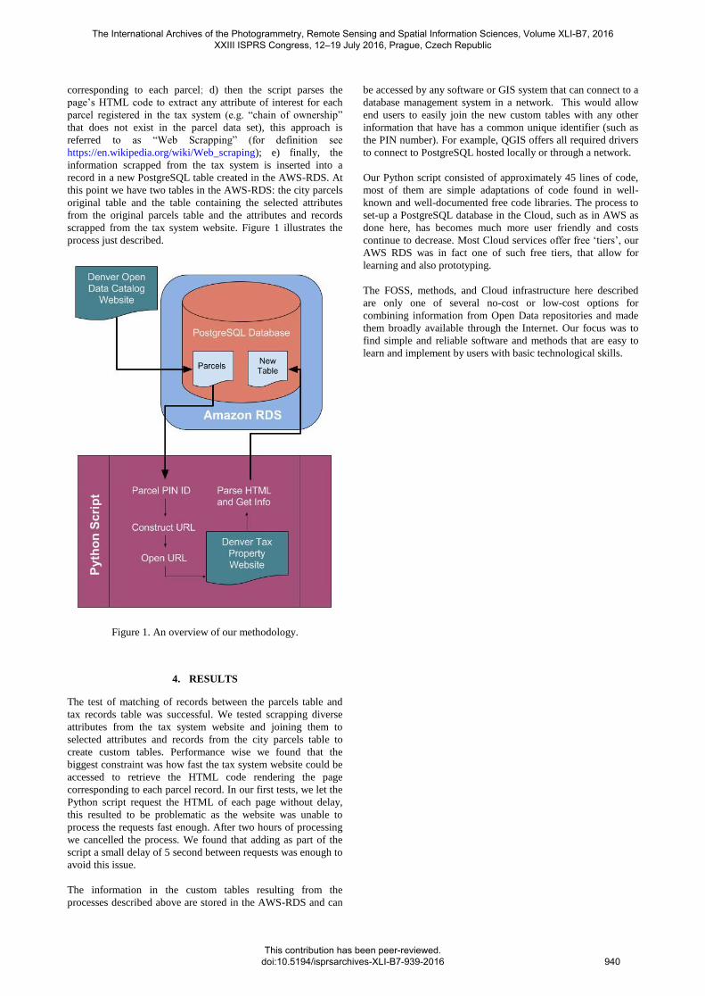
corresponding to each parcel; d) then the script parses the
page’s HTML code to extract any attribute of interest for each
parcel registered in the tax system (e.g. “chain of ownership”
that does not exist in the parcel data set), this approach is
referred to as “Web Scrapping” (for definition see
https://en.wikipedia.org/wiki/Web_scraping); e) finally, the
information scrapped from the tax system is inserted into a
record in a new PostgreSQL table created in the AWS-RDS. At
this point we have two tables in the AWS-RDS: the city parcels
original table and the table containing the selected attributes
from the original parcels table and the attributes and records
scrapped from the tax system website. Figure 1 illustrates the
process just described.
Figure 1. An overview of our methodology.
4. RESULTS
The test of matching of records between the parcels table and
tax records table was successful. We tested scrapping diverse
attributes from the tax system website and joining them to
selected attributes and records from the city parcels table to
create custom tables. Performance wise we found that the
biggest constraint was how fast the tax system website could be
accessed to retrieve the HTML code rendering the page
corresponding to each parcel record. In our first tests, we let the
Python script request the HTML of each page without delay,
this resulted to be problematic as the website was unable to
process the requests fast enough. After two hours of processing
we cancelled the process. We found that adding as part of the
script a small delay of 5 second between requests was enough to
avoid this issue.
The information in the custom tables resulting from the
processes described above are stored in the AWS-RDS and can
be accessed by any software or GIS system that can connect to a
database management system in a network. This would allow
end users to easily join the new custom tables with any other
information that have has a common unique identifier (such as
the PIN number). For example, QGIS offers all required drivers
to connect to PostgreSQL hosted locally or through a network.
Our Python script consisted of approximately 45 lines of code,
most of them are simple adaptations of code found in well-
known and well-documented free code libraries. The process to
set-up a PostgreSQL database in the Cloud, such as in AWS as
done here, has becomes much more user friendly and costs
continue to decrease. Most Cloud services offer free ‘tiers’, our
AWS RDS was in fact one of such free tiers, that allow for
learning and also prototyping.
The FOSS, methods, and Cloud infrastructure here described
are only one of several no-cost or low-cost options for
combining information from Open Data repositories and made
them broadly available through the Internet. Our focus was to
find simple and reliable software and methods that are easy to
learn and implement by users with basic technological skills.
The International Archives of the Photogrammetry, Remote Sensing and Spatial Information Sciences, Volume XLI-B7, 2016 XXIII ISPRS Congress, 12–19 July 2016, Prague, Czech Republic
This contribution has been peer-reviewed. doi:10.5194/isprsarchives-XLI-B7-939-2016
940