gulf of finland and gulf of bothnia
TRANSCRIPT

PUB.
(ENROUTE)SAILING DIRECTIONS
★
★
2021
195
GULF OF FINLAND AND
GULF OF BOTHNIA
Prepared and published by theNATIONAL GEOSPATIAL-INTELLIGENCE AGENCY
Springfield, Virginia
© COPYRIGHT 2021 BY THE UNITED STATES GOVERNMENTNO COPYRIGHT CLAIMED UNDER TITLE 17 U.S.C.
SIXTEENTH EDITION
For sale by the Superintendent of Documents, U.S. Government Printing Office
Internet: http://bookstore.gpo.gov Phone: toll free (866) 512-1800; DC area (202) 512-1800Fax: (202) 512-2250 Mail Stop: SSOP, Washington, DC 20402-0001

III
Pub. 195
Preface
0.0 Pub. 195, Sailing Directions (Enroute) Gulf of Finland andGulf of Bothnia, Sixteenth Edition, 2021, is issued for use inconjunction with Pub. 140, Sailing Directions (PlanningGuide) North Atlantic Ocean, Baltic Sea, North Sea, and theMediterranean Sea. The companion volumes are Pubs. 191,192, 193, and 194.0.0 Digital Nautical Chart 9 provides electronic chart coveragefor the area covered by this publication.0.0 This publication has been corrected to 14 August 2021, in-cluding Notice to Mariners No. 33 of 2021. Subsequent up-dates have corrected this publication to 19 February 2022,including Notice to Mariners No. 8 of 2022.
Explanatory Remarks
0.0 Sailing Directions are published by the National Geospatial-Intelligence Agency (NGA) under the authority of Departmentof Defense Directive 5105.60, dated 29 July 2009, and pursu-ant to the authority contained in U. S. Code Title 10, Chapter22, Section 451 and Title 44, Section 1336. Sailing Directions,covering the harbors, coasts, and waters of the world, provideinformation that cannot be shown graphically on nauticalcharts and is not readily available elsewhere.0.0 Sailing Directions (Enroute) include detailed coastal andport approach information which supplements the largest scalechart produced by the National Geospatial-IntelligenceAgency. This publication is divided into geographic areascalled “Sectors.”0.0 Bearings.—Bearings are true, and are expressed in degreesfrom 000° (north) to 360°, measured clockwise. Generalbearings are expressed by the initial letters of the points of thecompass (e.g. N, NNE, NE, etc.). Adjective and adverbendings have been discarded. Wherever precise bearings areintended, degrees are used.0.0 Charts.—Reference to charts made throughout thispublication refer to both the paper chart and the DigitalNautical Chart (DNC). 0.0 Corrective Information.—Users should refer corrections,additions, and comments to NGA’s Maritime Operations Deskor the Maritime Safety Office, as follows:
0.0 New editions of Sailing Directions are corrected through thedate of publication shown above. Important information toamend material in the publication is available is updated asneeded and available as a downloadable corrected publicationfrom the NGA Maritime Domain web site.
0.0 Courses.—Courses are true, and are expressed in the samemanner as bearings. The directives “steer” and “make good” acourse mean, without exception, to proceed from a point oforigin along a track having the identical meridional angle asthe designated course. Vessels following the directives mustallow for every influence tending to cause deviation from suchtrack, and navigate so that the designated course iscontinuously being made good.0.0 Currents.—Current directions are the true directions towardwhich currents set.0.0 Distances.—Distances are expressed in nautical miles of 1minute of latitude. Distances of less than 1 mile are expressedin meters, or tenths of miles.0.0 Geographic Names.—Geographic names are generallythose used by the nation having sovereignty. Names in paren-theses following another name are alternate names that mayappear on some charts. In general, alternate names are quotedonly in the principal description of the place. Diacritical marks,such as accents, cedillas, and circumflexes, which are related tospecific letters in certain foreign languages, are not used in theinterest of typographical simplicity.0.0 Geographic names or their spellings do not necessarily re-flect recognition of the political status of an area by the UnitedStates Government.0.0 Heights.—Heights are referred to the plane of referenceused for that purpose on the charts and are expressed in meters.0.0 Internet Links.—This publication provides Internet links toweb sites concerned with maritime navigational safety, includ-ing but not limited to, Federal government sites, foreign Hy-drographic Offices, and foreign public/private port facilities.NGA makes no claims, promises, or guarantees concerning the
NGA Maritime—Contact Information
Maritime Operations Desk
Toll free 1-800-362-6289
Commercial 571-557-5455
DSN 547-5455
E-mail [email protected]
Maritime Safety Office
DNC web site https://dnc.nga.mil
Maritime Domain web site
https://msi.nga.mil
E-mail [email protected]
Maritime Quality Feedback System (MQFS)
https://marhelp.nga.mil
Mailing address Maritime Safety OfficeNational Geospatial-Intelligence AgencyMail Stop N64-SFH7500 Geoint DriveSpringfield VA 22150-7500
NGA Maritime Safety Office Web Site
https://msi.nga.mil
NGA Maritime—Contact Information

IV
Pub. 195
accuracy, completeness, or adequacy of the contents of theseweb sites and expressly disclaims any liability for errors andomissions in the contents of these web sites.0.0 International Ship and Port Facility Security (ISPS)Code.—The ISPS Code is a comprehensive set of measures toenhance the security of ships and port facilities developed inresponse to the perceived threats to ships and port facilities inthe wake of the 9/11 attacks in the United States. Informationon the ISPS Code can be found at the International MaritimeOrganization web site:
0.0 Lights and Fog Signals.—Lights and fog signals are notdescribed, and light sectors are not usually defined. The LightLists should be consulted for complete information.0.0 National Ocean Claims.—Information on national oceanclaims and maritime boundary disputes, which have been com-piled from the best available sources, is provided solely in theinterest of the navigational safety of shipping and in no wayconstitutes legal recognition by the United States. These non-recognized claims and requirements may include, but are notlimited to:
1. A requirement by a state for advance permission ornotification for innocent passage of warships in the territorialsea.
2. Straight baseline, internal waters, or historic watersclaims.
3. The establishment of a security zone, where a stateclaims to control activity beyond its territorial sea for securi-ty reasons unrelated to that state’s police powers in its terri-tory, including its territorial sea.
0.0 Radio Navigational Aids.—Radio navigational aids and ra-dio weather services are not described in detail. PublicationNo. 117 Radio Navigational Aids and NOAA Publication, Se-lected Worldwide Marine Weather Broadcasts, should be con-sulted.0.0 Telephone and Facsimile Numbers.—Within this publica-tion, the international telephone and facsimile numbers provid-ed as contact information contain the minimum digitsnecessary to dial. Please note that these contact numbers do notinclude additional digits or special characters, such as (0) or(+), which may be required when dialing. The necessity ofsuch digits and characters depends upon numerous factors andconditions, such as the user’s geolocation and service provider.Mariners are advised to consult their communications equip-ment and service provider user manuals for guidance. 0.0 Soundings.—Soundings are referred to the datum of thecharts and are expressed in meters. 0.0 Time.—Time is normally expressed as local time unlessspecifically designated as Universal Coordinated Time (UTC).
0.0 Time Zone.—The Time Zone description(s), as well as in-formation concerning the use of Daylight Savings Time, are in-cluded. The World Time Zone Chart is available on the Inter-net at the web site given below.
0.0 U.S. Maritime Advisory System.—The U.S. MaritimeAdvisory System is a streamlined inter-agency approach toidentifying and promulgating maritime security threats. Thesystem replaces Special Warnings to Mariners (StateDepartment), MARAD Advisories (Maritime Administration),and Marine Safety Information Bulletins (U.S. Coast Guard)and consists of the following items:
1. U.S. Maritime Alert—Provides basic information(location, incident, type, date/time) on reported maritimesecurity threats to U.S. maritime industry interests. U.S.Maritime alerts do not contain policy or recommendationsfor specific courses of information.
2. U.S. Maritime Advisory—Provides more detailedinformation, when appropriate, through a “whole-of-gov-ernment” response to an identified maritime threat.
0.0 Winds.—Wind directions are the true directions from whichwinds blow.
Reference List
0.0 The principal sources examined in the preparation of thispublication were:0.0 British Hydrographic Department Sailing Directions.0.0 Estonia Sailing Directions.0.0 Netherlands Coast Pilot.0.0 Various port handbooks.0.0 Reports from United States naval and merchant vessels andvarious shipping companies.0.0 Other U.S. Government publications, reports, and docu-ments. 0.0 Charts, light lists, tide and current tables, and other docu-ments in possession of the Agency.0.0 Internet Web sites, as follows:
1. Sailing Directions for Estonian Watershttps://veeteedeamet.ee/en/sailing-directions
2. The State Port Registry (Estonia)https://veeteedeamet.ee/en/mariners-ports-and-ships/
state-port-register
International Maritime Organization Home Page
http://www.imo.org
Standard Time Zone of the World Chart
https://www.cia.gov/maps/world-regional
Maritime Administration (MARAD)—U.S. Maritime Advisory System
https://www.marad.dot.gov/environment-and-safety/office-of-security/msci

V
Pub. 195
Date of Change: 19 February 2022
Notice to Mariners: 8/2022
Sector Paragraphs
Sector 1 Paragraphs 1.9, 1.11, 1.12, and 1.18
Sector 2 Paragraphs 2.11, 2.18, 2.24, 2.26, and 2.29
Sector 3 Paragraph 3.1
Sector 7 Paragraphs 7.7, 7.9 and 7.14
Sector 9 Paragraph 9.19
Date of Change: 20 November 2021
Notice to Mariners: 47/2021
Sector Paragraphs
Sector 1 Paragraphs 1.1, 1.7, 1.9, 1.11, 1.12, 1.16, and 1.22
Sector 2 Paragraphs 2.3, 2.11, 2.13, 2.18, 2.19, 2.25, 2.26, and 2.29
Sector 3 Paragraphs 3.1 and 3.7
Sector 4 Paragraphs 4.15 and 4.17
Sector 5 Paragraph 5.6
Sector 7 Paragraphs 7.12 and 7.18
Sector 8 Paragraphs 8.9 and 8.18
Sector 9 Paragraphs 9.10, 9.17, and 9.19
Sector 10 Paragraphs 10.1 and 10.3
Pub. 195 VII
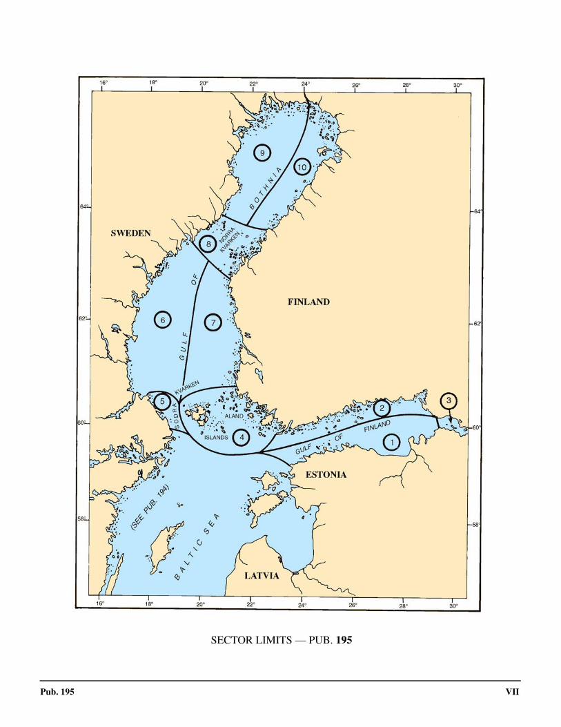
0.0SECTOR LIMITS — PUB. 195

VIII Pub. 195
Conversion Tables
Feet to MetersFeet 0 1 2 3 4 5 6 7 8 9 0 0.00 0.30 0.61 0.91 1.22 1.52 1.83 2.13 2.44 2.74 10 3.05 3.35 3.66 3.96 4.27 4.57 4.88 5.18 5.49 5.79 20 6.10 6.40 6.71 7.01 7.32 7.62 7.92 8.23 8.53 8.84 30 9.14 9.45 9.75 10.06 10.36 10.67 10.97 11.28 11.58 11.89 40 12.19 12.50 12.80 13.11 13.41 13.72 14.02 14.33 14.63 14.93 50 15.24 15.54 15.85 16.15 16.46 16.76 17.07 17.37 17.68 17.98 60 18.29 18.59 18.90 19.20 19.51 19.81 20.12 20.42 20.73 21.03 70 21.34 21.64 21.95 22.25 22.55 22.86 23.16 23.47 23.77 24.08 80 24.38 24.69 24.99 25.30 25.60 25.91 26.21 26.52 26.82 27.13 90 27.43 27.74 28.04 28.35 28.65 28.96 29.26 29.57 29.87 30.17
Fathoms to MetersFathoms 0 1 2 3 4 5 6 7 8 9
0 0.00 1.83 3.66 5.49 7.32 9.14 10.97 12.80 14.63 16.46 10 18.29 20.12 21.95 23.77 25.60 27.43 29.26 31.09 32.92 34.75 20 36.58 38.40 40.23 42.06 43.89 45.72 47.55 49.38 51.21 53.03 30 54.86 56.69 58.52 60.35 62.18 64.01 65.84 67.67 69.49 71.32 40 73.15 74.98 76.81 78.64 80.47 82.30 84.12 85.95 87.78 89.61 50 91.44 93.27 95.10 96.93 98.75 100.58 102.41 104.24 106.07 107.90 60 109.73 111.56 113.39 115.21 117.04 118.87 120.70 122.53 124.36 126.19 70 128.02 129.85 131.67 133.50 135.33 137.16 138.99 140.82 142.65 144.47 80 146.30 148.13 149.96 151.79 153.62 155.45 157.28 159.11 160.93 162.76 90 164.59 166.42 168.25 170.08 171.91 173.74 175.56 177.39 179.22 181.05
Meters to FeetMeters 0 1 2 3 4 5 6 7 8 9
0 0.00 3.28 6.56 9.84 13.12 16.40 19.68 22.97 26.25 29.53 10 32.81 36.09 39.37 42.65 45.93 49.21 52.49 55.77 59.06 62.34 20 65.62 68.90 72.18 75.46 78.74 82.02 85.30 88.58 91.86 95.14 30 98.42 101.71 104.99 108.27 111.55 114.83 118.11 121.39 124.67 127.95 40 131.23 134.51 137.80 141.08 144.36 147.64 150.92 154.20 157.48 160.76 50 164.04 167.32 170.60 173.88 177.16 180.45 183.73 187.01 190.29 193.57 60 196.85 200.13 203.41 206.69 209.97 213.25 216.54 219.82 223.10 226.38 70 229.66 232.94 236.22 239.50 242.78 246.06 249.34 252.62 255.90 259.19 80 262.47 265.75 269.03 272.31 275.59 278.87 282.15 285.43 288.71 291.99 90 295.28 298.56 301.84 305.12 308.40 311.68 314.96 318.24 321.52 324.80
Meters to FathomsMeters 0 1 2 3 4 5 6 7 8 9
0 0.00 0.55 1.09 1.64 2.19 2.73 3.28 3.83 4.37 4.92 10 5.47 6.01 6.56 7.11 7.66 8.20 8.75 9.30 9.84 10.39 20 10.94 11.48 12.03 12.58 13.12 13.67 14.22 14.76 15.31 15.86 30 16.40 16.95 17.50 18.04 18.59 19.14 19.68 20.23 20.78 21.33 40 21.87 22.42 22.97 23.51 24.06 24.61 25.15 25.70 26.25 26.79 50 27.34 27.89 28.43 28.98 29.53 30.07 30.62 31.17 31.71 32.26 60 32.81 33.36 33.90 34.45 35.00 35.54 36.09 36.64 37.18 37.73 70 38.28 38.82 39.37 39.92 40.46 41.01 41.56 42.10 42.65 43.20 80 43.74 44.29 44.84 45.38 45.93 46.48 47.03 47.57 48.12 48.67 90 49.21 49.76 50.31 50.85 51.40 51.95 52.49 53.04 53.59 54.13

IX
Pub. 195
. Abbreviations
The following abbreviations may be used in the text:
Units°C degree(s) Centigrade km kilometer(s)cm centimeter(s) m meter(s)cu.m. cubic meter(s) mb millibarsdwt deadweight tons MHz megahertzFEU forty-foot equivalent units mm millimeter(s)gt gross tons nrt net registered tonskHz kilohertz TEU twenty-foot equivalent units
DirectionsN north S southNNE northnortheast SSW southsouthwestNE northeast SW southwestENE eastnortheast WSW westsouthwestE east W westESE eastsoutheast WNW westnorthwestSE southeast NW northwestSSE southsoutheast NNW northnorthwest
Vessel typesLASH Lighter Aboard Ship Ro-ro Roll-on Roll-offLNG Liquified Natural Gas ULCC Ultra Large Crude CarrierLPG Liquified Petroleum Gas VLCC Very Large Crude CarrierOBO Ore/Bulk/Oil VLOC Very Large Ore CarrierLo-lo Lift-on Lift-off FSO Floating Storage and Offloading NGL Natural Gas Liquids FSU Floating Storage Unit
FPSO Floating Production Storage and Offloading
TimeETA estimated time of arrival GMT Greenwich Mean TimeETD estimated time of departure UTC Coordinated Universal Time
Water levelMSL mean sea level LWS low water springsHW high water MHWN mean high water neapsLW low water MHWS mean high water springsMHW mean high water MLWN mean low water neapsMLW mean low water MLWS mean low water springsHWN high water neaps HAT highest astronomical tideHWS high water springs LAT lowest astronomical tideLWN low water neaps
CommunicationsD/F direction finder MF medium frequencyR/T radiotelephone HF high frequencyGMDSS Global Maritime Distress and Safety System VHF very high frequencyLF low frequency UHF ultra high frequency
NavigationLANBY Large Automatic Navigation Buoy SBM Single Buoy MooringNAVSAT Navigation Satellite SPM Single Point MooringODAS Ocean Data Acquisition System TSS Traffic Separation SchemeCBM Conventional Buoy Mooring System VTC Vessel Traffic CenterMBM Multi-Buoy Mooring System VTS Vessel Traffic Service

X
Pub. 195
CALM Catenary Anchor Leg Mooring
MiscellaneousAIS Automatic Identification System MMSI Maritime Mobile Service Identity
CodeCOLREGS Collision Regulations No./Nos. Number/NumbersIALA International Association of Lighthouse
AuthoritiesPAPD
Position approximatePosition doubtful
IHO International Hydrographic Organization Pub. PublicationIMO International Maritime Organization SOLAS International Convention for
Safety of Life at SeaIMDG Intermational Maritime Dangerous Goods CodeLOA length overall St./Ste. Saint/SainteUKC Under keel clearance ISPS International Ship and Port facility
Security
The following abbreviations may be used in the text:

Pub. 195 XI
Contents
Preface. . . . . . . . . . . . . . . . . . . . . . . . . . . . . . . . . . . . . . . . . . . . . . . . . . . . . . . . . . . . . . . . . . . . . . . . . . . . . . . . . . . . . . . . . . . . . . . . IIIChartlet—Sector Limits . . . . . . . . . . . . . . . . . . . . . . . . . . . . . . . . . . . . . . . . . . . . . . . . . . . . . . . . . . . . . . . . . . . . . . . . . . . . . . . . . VIIConversion Tables. . . . . . . . . . . . . . . . . . . . . . . . . . . . . . . . . . . . . . . . . . . . . . . . . . . . . . . . . . . . . . . . . . . . . . . . . . . . . . . . . . . . . VIIIAbbreviations . . . . . . . . . . . . . . . . . . . . . . . . . . . . . . . . . . . . . . . . . . . . . . . . . . . . . . . . . . . . . . . . . . . . . . . . . . . . . . . . . . . . . . . . . . IX
Sector 1
Sector 1—The Gulf of Finland—Osmussaar, Estonia to St. Petersburg Guba . . . . . . . . . . . . . . . . . . . . . . . . . . . . . . . . . . . . . . . . . 1
Sector 2
Sector 2—The Gulf of Finland—Northern Shore—Hanko to St. Petersburg Guba . . . . . . . . . . . . . . . . . . . . . . . . . . . . . . . . . . . . 31
Sector 3
Sector 3—Russia—St. Petersburg Guba and Nevskaya Guba . . . . . . . . . . . . . . . . . . . . . . . . . . . . . . . . . . . . . . . . . . . . . . . . . . . . 67
Sector 4
Sector 4—The Aland Islands and the Adjacent Finnish Coast . . . . . . . . . . . . . . . . . . . . . . . . . . . . . . . . . . . . . . . . . . . . . . . . . . . . 81
Sector 5
Sector 5—Sodra Kvarken and the Adjacent Swedish Coast . . . . . . . . . . . . . . . . . . . . . . . . . . . . . . . . . . . . . . . . . . . . . . . . . . . . . . 93
Sector 6
Sector 6—Sweden—East Coast—Lovstabukten to Torhamnsudde . . . . . . . . . . . . . . . . . . . . . . . . . . . . . . . . . . . . . . . . . . . . . . . 101
Sector 7
Sector 7—Finland—West Coast—Isokari to Strommingsbadan . . . . . . . . . . . . . . . . . . . . . . . . . . . . . . . . . . . . . . . . . . . . . . . . . . 129
Sector 8
Sector 8—Norra Kvarken and the Adjacent Swedish and Finnish Coasts . . . . . . . . . . . . . . . . . . . . . . . . . . . . . . . . . . . . . . . . . . 143
Sector 9
Sector 9—Sweden—East Coast—Ratan to the Finnish Border . . . . . . . . . . . . . . . . . . . . . . . . . . . . . . . . . . . . . . . . . . . . . . . . . . 155
Sector 10
Sector 10—Finland—West Coast—Hallgrund to the Swedish Border . . . . . . . . . . . . . . . . . . . . . . . . . . . . . . . . . . . . . . . . . . . . . 173
Glossaries . . . . . . . . . . . . . . . . . . . . . . . . . . . . . . . . . . . . . . . . . . . . . . . . . . . . . . . . . . . . . . . . . . . . . . . . . . . . . . . . . . . . . . . . . . . . 189
Index—Gazetteer . . . . . . . . . . . . . . . . . . . . . . . . . . . . . . . . . . . . . . . . . . . . . . . . . . . . . . . . . . . . . . . . . . . . . . . . . . . . . . . . . . . . . . 199

1
Pub. 195
1. Sector 1—The Gulf of Finland—Osmussaar, Estonia to St. Petersburg Guba
1.0Additional chart coverage may be found in NGA/DLIS Catalog of Maps, Charts, and Related Products (Unlimited Distribution).
SECTOR 1 — CHART INFORMATION

3
Pub. 195
SECTOR 1
THE GULF OF FINLAND—OSMUSSAAR, ESTONIA TO ST. PETERSBURG GUBA
1.0 Plan.—This sector describes the S shore of the Gulf of Fin-land including the N shore of Estonia and the adjacent territoryof Russia concluding at St. Petersburg Guba. The descriptivesequence is E from Osmussaar Island to Mys Shepelevskiy(59°59'N., 29°08'E.).
General Remarks
1.1 Ice.—Ice first appears in the Neva Estuary, betweenSt. Petersburg and Kronshtadt, and in Vyborgskiy Zaliv(60°30'N., 28°22'E.) about the middle of November. Thespread of ice is much more rapid along the N shore than alongthe S. Toward the end of December, it extends along most ofthe N shore, filling the inlets; on the S shore, it does not reachmuch W of Narva. 1.1 In the middle of January, ice fills the E end of the gulf to aposition between Ostrov Moshchny (60°00'N., 27°50'E.) andOstrov Gogland (60°05'N., 26°53'E.), while ice along the Nshore has extended to form a wider coastal belt. On the S shore,the ice may have spread only slightly W of Narva, but in someyears reaches longitude 26°E. By the middle of February, arapid W extension has taken place, with ice covering the wholegulf E of Tallinn and reaching along the whole of the S shore,and farther W to enclose the island of Hilumaa. The only openpart of the gulf at this time is therefore at the W end, awayfrom the shores.
1.1 The ice attains its greatest extent about the first week ofMarch, when the whole gulf is encumbered. Before the end ofMarch, it is in retreat E. In the middle of April, the S shore isclear to about longitude 27°30'E; a little W of Narva, thoughice still remains between Hiiumaa and the Estonian shore.Most of the gulf to the E of longitude 26°E is still ice encum-bered, and ice persists in a wide belt along the N shore. Thesubsequent dispersal of the ice is rapid and at the beginning ofMay, ice is only found E of longitude 26°E, particularly be-tween Ostrov Moshchnyy and Zaliv Primorsk (60°22'N.,28°38'E.). By the middle of May, all ice has disappeared.1.1 The amount of ice in any particular part of the coast at a giv-en time may depend very much on the direction of the wind.For example, in Tallinn Harbor, drift ice is mostly formed by Nand NE winds; frequently this ice is driven out again by Swinds and the roadstead becomes quite safe for shipping with-out the aid of an icebreaker. For ice-breaking services contact-the Baltic Sea Ice-breaking Web (BIMWeb) (http://www.bal-tice.org).
1.1 For more information pertaining to ice-breaking services,see Pub. 140, Sailing Directions (Planning Guide) North Atlan-tic Ocean and Adjacent Seas.1.1 Ice reports for St. Petersburg and all of Russia are availablefrom the table titled St. Petersburg—Contact Information.1.1 Tides—Currents.—The fundamental circulation of the cur-rents in the Gulf of Finland is an inward flow of water E alongthe S shore, past Tallinn, and an outward flow W along the Nshore, past Helsinki. This outward flow, turning NW at themouth of the gulf, passes into the N current along the E coastof the Gulf of Bothnia.1.1 The current in the gulf at any time depends largely on thewind. During W and SW winds, the current sets into the gulfalong both the N and S shores. With light winds, the excess ofwater driven into the gulf emerges in a W direction. With Wgales, a strong current runs into St. Petersburg Guba, S of Kro-nstadt; this current runs out on the N side, continuing along theshore of the gulf towards Mys Seyveste, with considerableforce.1.1 If there is any N direction to the wind, a set into the bights onthe S shore of the gulf will generally be experienced.1.1 After the break-up of the ice in the early spring, the outflowof water from the gulf is temporarily increased.1.1 In the passage between Lavansaari and Kurgatski Rif, incalm weather, there is usually a weak SW current; at othertimes the direction and velocity depend on the wind.1.1 While the tidal range in this area is negligible, considerablechange in the water level may be caused by strong winds, vari-ation in atmospheric pressure, and the seasonal amount of wa-ter released by the rivers.1.1 Depths—Limitations.—All dangers along the immediatecoast from the island of Osmussaar ENE to Tallinn, a distanceof about 44 miles, are contained within the 40m curve, whichhas a greatest distance from the shore of about 8 miles.1.1 From Tallinn to Letipea Neem, there are a number of riversthat discharge into the gulf. The coast in this area is markedwith numerous off-lying islands, shoal banks, and shoal patch-
St. Petersburg—Contact Information
Ice Reports via Port Captain
Telephone7-812-2451675
7-812-7149264
Facsimile 7-812-3274021
E-mail [email protected]
Web site https://www.pasp.ru/sluzhba_kapi-tana_morskogo_porta_bo
Ice Operations HQ (24 hours)—Report for all Russian Ports
Telephone
7-812-6801930 (emergency only)
7-812-6801977
7-921-4440747
E-mail [email protected]
Web site https://www.pasp.ru/informaci-ya_shtaba_ledokolnyh_ope
St. Petersburg—Contact Information

4 Sector 1. The Gulf of Finland—Osmussaar, Estonia to St. Petersburg Guba
Pub. 195
es that extend up about 16 miles seaward.1.1 Aspect.—The S coast of the Gulf of Finland consists of longstretches of limestone cliffs rising abruptly from the sea. Thisprofile is prevalent in many of the coastal areas. The coastlineis well-wooded and rises to heights of 80 to 92m in some local-ities. 1.1 The Estonian coast from Osmussaar Island to Tallinn(59°27'N., 24°46'E.) ranges from a low and sandy aspect with aborder of woods to wooded hills. 1.1 The coast between Tallinn and Letipea (59°33'N., 26°35'E.)can be described as low, sandy, and bordered by woods, tosteep cliffs and ridges with wooded hills inland. 1.1 Between Letipea and Mys Shepelevskiy, where this sectorconcludes, the coast is low, rocky, and wooded. It is also inter-spersed with meadows and marshy ground. The meadows con-trast with the steep stone cliffs and partially-wooded hills,which rise to heights of 150m. 1.1 Pilotage.—The IMO recommends that vessels constrainedby their draft or vessels not registered in one of the Balticstates, and infrequently sailing the area, embark a deep-sea pi-lot.1.1 Finnpilot pilot order service is divided into three PilotageZones, as follows.
1. Southern Pilotage Zone.—comprised of the follow-ing:
a. Helsinki Pilotage Area (Emasalo, Helsinki, andPorkkala).
b. Hanko Pilotage Area.2. Eastern Pilotage Zone.—comprised of the follow-
ing:a. Kotka Pilotage Area (Haapasaari, Orrengrund, and
Santio).b. Saimaa Canal and Lake Saimaa.
3. Western Pilotage Zone.—comprised of the follow-ing:
a. Archipelago Pilotage Area: (Isokari, Mariehamnand Uto).
b. Rauma Sea Pilotage Area: (Pori and Rauma).c. Vaasa Pilotage Area: (Kaskinen, Kristiinankaupun-
ki and Vaasa).d. Kokkola Pilotage Area: (Kokkola, Pietarsaari and
vessels coming and going S from Kalajoki).e. Bay of Bothnia Pilotage Area: (Kemi, Oulu, Raahe,
Tornio and vessels coming and going N from Kalajoki).
1.1 The general procedures for all Pilotage Zones are, as fol-lows:
1. Pilotage is generally compulsory.2. Vessels requiring a licensed Deep Sea Pilot in the Bal-
tic Sea area should send a request at least 12 hours in ad-vance.
3. Pilots should be ordered by one of the followingmethods:
a. Using the pilot order form found on the web site.b. Telephone.c. Facsimile.d. E-mail.
4. All pilot stations and pilot vessels are equipped withthe commonly used maritime VHF channels.
5. The Finnpilot Order Center will confirm receipt of the
preliminary information or Pilot order using the same meth-od as used to make the order. An order placed using a formon the internet can also be confirmed via e-mail if requestedby the customer, providing an e-mail address is included inthe order information or is otherwise known by Finnpilot.(An order placed by telephone is not confirmed separatelyafter the telephone call).
6. There is no pilot ordering service via VHF radio.7. Inbound vessel requirements:
a. Vessels must provide advance notice to the PilotOrder Center 12 hours and 3 hours prior to expected arriv-al at the pilot boarding position.
b. Vessels must place a binding pilotage order to thePilot Order Center 3 hours prior to arrival at the pilotboarding position.8. Outbound vessels requirements:
a. The Pilot Order Center requires a 12 hour and 2hour advance notice of vessel departure from either theagent or the vessel.
b. The vessel or the agent must provide a binding pi-lotage order to the Pilot Order Center 2 hours before de-parture.9. Vessels shifting berth must provide 2 hour advance
notice to the Pilot Order Center.10. During the winter months, Pilot boarding positions
may be subject to alteration according to the prevailingweather conditions.
1.1 Pilot service is provided by three separate pilot stations with-in the Gulf of Bothnia Maritime District, as follows:
1. Perameri Pilot Station—provides pilotage for ship-ping lanes leading to the ports of Kemi, Oulu, Raahe, andTornio.
2. Tankar Pilot Station—provides pilotage for shippinglanes leading to the ports of Kokkola (Ykspihlaja), Pietar-saari, and Kalajoki.
3. Vaasa Pilot Station—provides pilotage for shippinglanes leading to the ports of Kaskinen (Kasko), Kristiinan-kaupunki (Kristinestad), and Vaasa.
Pilot Boarding Locations
Kemi and Tornio
Kemi (North) 65°33.0'N, 24°26.9'E
Kemi (South) 65°29.3'N, 24°19.0'E
Oulu (North) 65°10.9'N, 24°18.0'E
Oulu
Oulu (North) 65°10.9'N, 24°18.0'E
Oulu (South) 65°07.0'N, 24°16.9'E
Raahe
Raahe 64°38.8'N, 24°12.3'E
Pietarsaari
Pietarsaari 63°44.5'N, 22°28.5'E
Kokkola
Kokkola 64°00.5'N, 22°49.1'E

Sector 1. The Gulf of Finland—Osmussaar, Estonia to St. Petersburg Guba 5
Pub. 195
1.1 Regulations.—Certain areas (restricted and semi-restricted)in Finnish waters have been declared restricted for reasons ofnavigational safety, inadequate charting, or for defense rea-sons. Foreign vessels, including small craft, may not enterthese areas without permission, except to follow an officiallyrecognized fairway for which permission is not required.1.1 Anchoring within these areas is prohibited except in anemergency or when authorized to do so by the appropriate au-thority. However, a foreign vessel may anchor for not morethan 48 hours within a restricted area in a recognized anchor-age or mooring area indicated on the charts.1.1 Permission to stay within a restricted area or to navigate out-side the general fairways is granted on application to the Mili-tary Area Headquarters. Applications should be made on an
official form not later than 14 days before planned entry intothe area. Applications can be made after this time to the localFrontier Guard Authorities for a visit not exceeding 72 hours.1.1 Vessels should consult the pilot for information on localrules, including regulations on the operation of navigationequipment and radios.1.1 The sea areas in the Gulf of Finland are monitored jointly byFinland, Estonia, and the Russian Federation. GOFREP, amandatory ship reporting system under SOLAS, has been es-tablished in the Gulf of Finland and its approaches. This sys-tem is operated by VTS centers, as follows:
1. Tallinn (main: VHF channel 61—alternate: VHFchannel 81)
2. Helsinki (main: VHF channel 60—alternate: VHFchannel 80)
3. Saint Petersburg (main: VHF channel 74—alternate:VHF channel10).
1.1 The Traffic Centers monitor shipping by radar and AIS andprovide 24-hour information service in the Gulf of Finland. . 1.1 Vessels of 300 gross tons and over are required to participatein the mandatory ship reporting system. Certain vessels under300 gross tons may also be required to participate.1.1 The W limit of the reporting area is formed by a line joiningthe following points:
1. Bengtskar Light (59°43.4'N., 22°30.1'E.).2. 59°33.3'N, 22°30.0'E.3. 59°10.0'N, 21°30.0'E.4. Ristna (Kopu Poolsar) (58°56'N., 22°03'E.).
1.1 For further information concerning GOFREP, see Finland inPub. 140, Sailing Directions (Planning Guide) North AtlanticOcean and Adjacent Seas or see the VTS Finland GOFREPMaster’s Guide document found via the link below.
1.1 Vessel Traffic Services for Estonian and Russian waters arein effect for Tallinn (paragraph 1.9), Muuga (paragraph 1.12),and Reka Luga (Ust Luga) (paragraph 1.22).1.1 Vessels bound for Reka Luga (Ust Luga) also transit the cov-erage area of St. Petersburg Coastal VTS (paragraph 3.1). 1.1 The Navigational Assistance Service operates, as follows
1. Navigational assistance is given to identified vesselson request or when deemed necessary by the VTS Authorityin difficult navigational circumstances or weather or ice con-ditions.
2. Navigational assistance can be given in the VTS areafollowing the procedure under subsection 2 of section 6 inthe Finnish Vessel Traffic Service Act. Navigational assis-tance can be given in fairways and in areas where traffic iscontrolled by radar. Navigational assistance is given in theVTS area when an inbound vessel approaches the Pilotboarding position. The vessel can also be given navigationalassistance in another VTS area on request.
3. Navigational assistance given by the VTS Authoritymay include the following:
4. Information on the vessel's course and speed.5. Information on the vessel's position relative to the
fairway axis or waypoints in accordance with the VTS sail-
Kalajoki
Kalajoki 64°15.5'N, 23°30.0'E
Kaskinen, Kristiinankaupunki, and Vaasa
Vaasa (North) 63°15.8'N, 20°51.2'E (for NW approach)
Vaasa (South) 63°12.1'N, 20°45.4'E (for Vaski-luoto)
Kaskinen 62°15·5'N, 21°05.1'E
Kristiianankaupunki 62°11.5'N, 21°06.1'E
Finnpilot Order Center—Contact Information
Southern Pilot Zone
Telephone 358-400-907-977
Facsimile 358-29-52-53010
E-mail [email protected]
Web site https://pilotorder.fi
Eastern Pilot Zone
Telephone 358-400-907-978
Facsimile 358-29-52-53011
E-mail [email protected]
Web site https://pilotorder.fi
Western Pilot Zone
Telephone 358-400-907-979
Facsimile 358-29-52-53012
E-mail [email protected]
Web site https://pilotorder.fi
Head Office
Telephone 358-29-52-53000
Facsimile 358-29-52-53001
E-mail [email protected]
Web site https://finnpilot.fi
Pilot Boarding Locations
FinTraffic VTS Master’s Guide
https://www.fintraffic.fi/en/vts/masters-guide

6 Sector 1. The Gulf of Finland—Osmussaar, Estonia to St. Petersburg Guba
Pub. 195
1.1Gulf of Finland—Mandatory Ship Reporting System (GOFREP)
1.1Gulf of Finland—Estonian VTS Areas and Limits

Sector 1. The Gulf of Finland—Osmussaar, Estonia to St. Petersburg Guba 7
Pub. 195
ing plan.6. Information on the positions, identities and intentions
of surrounding traffic.7. Warnings to individual vessels.
1.1 The Traffic Organization Service operates, as follows:1. Vessel traffic can be managed with permanent traffic
arrangements in order to prevent dangerous situations andcongestion as specified in the decision to establish a VTS
2. For the purpose of organizing vessel traffic:3. Vessels must ask the VTS Authority for permission to
depart from a port or anchorage and to enter into a VTS area.Permission can be denied if deemed necessary by the VTSAuthority due to dangerous situations or congestion in thefairway area.
4. Vessel traffic in the VTS area is organized in terms ofdistance. Traffic separation can be initiated when there is a spe-cial transport traveling along the fairway, several vessels aretraveling in the same direction, or there are vessels whose routesintersect or meet. The separation distance required is 0.5 mile.
5. Vessels must request the VTS Authority to designatean anchorage area and it will usually be granted. However,the VTS Authority can prohibit assignment of an anchorageif it is deemed necessary.
6. The following permanent traffic arrangements areused regionally in VTS areas:
a. Prohibiting passing and overtaking.b. Clearance for departure from port or anchorage and
for entry into a VTS area.c. Separation of traffic in terms of time or distance.
7. The procedures regarding clearance for departure areused in all ports and anchorage areas. Clearance for entry in-to a VTS area is given to inbound vessels approaching theVTS area.
8. Clearance for departure from a port or anchorage orfor entry into a VTS area can be denied for the time it takesuntil the fairway is free, if an outbound or inbound vessel in-tends to enter a fairway where passing and overtaking is pro-hibited, and where there are already other vessels.
9. The clearance for departure and for entry into a VTSarea must be adjusted to the traffic separation, when trafficseparation is applied.
1.1 Directions.—Several IMO-adopted Traffic SeparationSchemes (TSS) form the main route through the Gulf of Fin-land (see paragraph 2.1). 1.1 A Traffic Separation Scheme (TSS), established by the localauthorities, exists in the approaches to the Port of Tallinn. Theauthorities advise that the principles of Rule 10 of the COL-REGS applies to this TSS.1.1 All of the above schemes may best be seen on the appropri-ate charts. 1.1 Caution.—It is reported that all navigational aids in the Spart of the Gulf of Finland may be unreliable.1.1 During the winter, many buoys are removed, while othersmay be damaged or break adrift.1.1 In the coastal waters within this sector, numerous logs maybe found adrift at all times of the year. Numerous chartedwrecks lie throughout the Gulf of Finland.1.1 Several unexploded ordnance areas lie off the shores of theGulf of Finland and may best be seen on the chart.1.1 Areas dangerous due to mines laid during World War II exist
within the Gulf of Finland. There is still a risk of danger inthese areas when anchoring or carrying out any seabed activi-ties.1.1 It is reported that a submarine gas pipeline is being con-structed between Russia and Germany. This pipeline will ex-tend in a WSW direction through the Gulf of Finland from thevicinity of Bukhta Portovaya (60°31'N., 28°05'E.) and thenlead in a SSW direction to pass E of Faro (57°57'N., 19°10'E.).
Off-lying Islands, Islets, and Dangers
1.2 Osmussaar Island (59°18'N., 23°22'E.) (World PortIndex No. 28510) lies 4 miles NW of Poosaspea Neem (seeparagraph 1.6). The center of the island, when viewed from aconsiderable distance, gives the impression that there are twoislands. Overhanging limestone cliffs on the N side of the is-land rise to a height of 10m, the lower parts of which have beenundermined by the action of the sea. The W and S sides havehills and ridges composed of gravel and sand. 1.2 A village is situated on a hill near the middle of the island;two windmills stand in this vicinity. A prominent white church,with a black spire, is situated 0.5 mile SE of the village. 1.2 Osmussaar Light is shown from a conspicuous tower, 35mhigh, standing on the NW extremity of the island. A beaconstands on the SE extremity of the island. A prominent tower isreported to stand about 0.8 mile SE of the light.1.2 Anchorage may be obtained off the S side of Osmussaar,about 1.5 miles S of the light, in a depth of 27m, mud and sand.Anchorage can also be obtained, in a depth of 13m, rock andsand, about 3.5 miles SE of the light.1.2 Neugrund, an extensive shoal area, lies 5 miles ENE of Os-mussaar and is marked by a lighted buoy on its N side.1.2 Suur Pakri (59°20'N., 23°54'E.) is mostly bare and flat,with steep cliffs at the N end where it is joined by a causewayto Vaike Pakri. A light is shown from a structure, 10m high,standing at the N end of the island. Several villages are located
1.1SBy Metsavend [CC BY-SA 4.0 (https://creativecommons.org/ licenses/by-sa/4.0)], via Wikimedia Commonsickr/Karl Agre
1.1Osmussaar

8 Sector 1. The Gulf of Finland—Osmussaar, Estonia to St. Petersburg Guba
Pub. 195
on the S part of the island.1.2 Krassigaar, an extensive shoal which dries in places, liesabout 2.5 miles W of Suur Pakri. It is marked by buoys at the Eand S sides, and by a lighted buoy at the N side.1.2 Vaike Pakri lies close E of Suur Pakri and is connected to itby a causeway. The N end of this island is high and steep, butthe S end is low and flat. The E side of the island is hilly andthe center is wooded. There are two villages, one on the E sideand the other on the W side. A light is shown from a frame-work structure, 16m high, standing on the NE end of the island.1.2 Pakri Madal, a shoal, has a depth of 6.2m. It lies about 1.5miles N of Pakri Neem (59°23'N., 24°02'E.) and is marked by alighted buoy.1.2 Caution.—A firing practice area lies centered 8 miles NE ofOsmussaar Light.1.2 A submarine cable, which may best be seen on the chart, ex-tends between the SE end of Osmussaar and the mainland. Ves-sels are prohibited to anchor within 0.4 mile of this cable.1.2 Rohukula (58°54'N., 23°25'E.), Rohukula is located on theW coast of Estonia opposite the off-lying Island of Hiiumaa.1.2 The port is situated in Ridala rural district, 5.6 miles fromHaapsalu. Its principal purpose is to service passenger shipshandling cargo and passengers.1.2 During the summer months vessels over 100m can be han-dled but during the winter months vessels of 100m or less arethe only vessels that can be handled. Maximum draft for thisport is 5.2m
1.3 Tallinna Madal (59°42'N., 24°44'E.), with a leastdepth of 2.6m, lies in the N approaches to Tallinn and is theoutermost danger in this vicinity. Tallinn Light is shown from atower, 31m high, standing on this shoal. A racon is situated atthe light.1.3 The islands and dangers lying S and W of this shoal are de-scribed later in the text.
Prangli Saar (59°38'N., 25°00'E.), a low and wooded island,lies on the E side of the approaches to Tallinn. This island issurrounded by foul ground and marked by lights on its NW, E,and S sides.1.3 Keri Saar (59°42'N., 25°01'E.), a low and rocky islet, is located3.5 miles N of Prangli Saar and surrounded by foul ground. Alight is shown from a prominent tower, 31m high, standing at itsSE end. A signal station is situated close to the light.
1.3 Kuradimuna, a shallow shoal, lies 3.5 miles W of Keri Saar.It is located on an area of foul ground and is marked by a light-ed buoy.1.3 Nygrund, with a least depth of 4.6m, lies about 2.5 milesSSW of Kuradimuna and is marked by a lighted buoy.1.3 Aksi Saar, a fairly high island, lies close E of Prangli Saarand is fronted by foul ground. A beacon (disused light tower),15m high, stands on the SE part of this island.1.3 Rammu Saar (59°35'N., 25°14'E.), a flat island, is locatedabout 4 miles SE of Aksi Saar. Foul ground fronts the N end ofthis island and is marked by a lighted buoy. 1.3 Anchorage may be obtained, in a depth of 10m, S of RammuSaar, about 0.5 mile offshore.1.3 Mohni Saar (59°41'N., 25°48'E.), an island lying off EruLaht, has a steep bank of shingle along its SW side. Its NW endis formed by a rocky hill and its NE side is fronted by foulground and shoal water.1.3 Mohni Light is shown from a tower, 27m high, standing onthe NW extremity of the island. A signal station is situated inthe vicinity of the light. 1.3 Caution.—A submarine cable, which may best be seen onthe chart, extends between Mohni Saar and the mainland.
1.4 Vaindlo (59°49'N., 26°22'E.) is a conspicuous rockyislet, 8m high, lying in the central portion of the Gulf of Fin-land. Foul ground and foul patches extend N, NE and S fromthe shores of this islet. Kakumadal, a shallow rock, lies at theextremity of a reef which extends up to 2 miles S from the Sextremity of the islet. An isolated shoal, with a depth of 6.8m,lies about 3 miles SE of the islet.1.4 Vaindlo Light is shown from a tower, 17m high, standing onthe central portion of the islet. A signal station is situated at thelight.1.4 Pohja Uhtja (59°41'N., 26°31'E.) is an extensive group of dan-gerous rocks, shoals, and islets lying 9 miles SSE of Vaindlo. Thisgroup extends for about 7 miles and is marked at its S end by abuoy. Uhtja Light is shown from a structure, 12m high, standingon the group, about 10 miles SSE of Vaindlo Light.1.4 Ostrov Rodsher (59°58'N., 26°41'E.) is a rocky islet surround-ed by a reef. A light is shown from a prominent tower, 19m high,standing on the N side of this islet. A racon is situated at the light.1.4 Ostrova Virginy (59°57'N., 26°52'E.) consists of two rocky is-lets lying 1 mile apart. They are fringed by reefs, which aremarked by buoys, and fronted by shoals. A light is shown from atower, 14m high, standing on the northeastern-most islet. 1.4 Ostrov Malyy Tyuters, lying 17 miles E of Vaindlo, is a low san-dy island with a pine forest at its center. The island is surroundedby foul ground, rocky reefs, and boulders rising from the water. 1.4 Otrov Bolshoy Tyuters (59°51'N., 27°11'E.), lying 7 milesENE of Ostrov Malyy Tyuters, is moderately high and denselywooded. A light is shown from a tower, 24m high, standing on thesummit of this island.1.4 A shoal bank, marked by a buoy, extends up to about 2.5miles SSE of this island.
1.5 Ostrov Gogland (60°03'N., 26°59'E.) is 176m highand wooded. It has three peaks and is reported to be visiblefrom a distance of 34 miles in clear weather. Gogland Light isshown from a framework tower, 23m high, standing on theheights at the N end of the island. Gogland S Light is shown
1.3Source: Flickr/Karl Agre
1.3Tallinn Light on Tallinna Madal

Sector 1. The Gulf of Finland—Osmussaar, Estonia to St. Petersburg Guba 9
Pub. 195
from a tower, 26m high, standing on Mys Lounatrivi (60°01'N.,27°00'E.), the S extremity of the island. A radio-beacon is situ-ated at this light.1.5 During E winds, vessels may anchor, in depths of 36 to 54m,about 1 mile off the W side of Ostrov Gogland, but the holdingground is not good.1.5 Small craft can anchor, in depths of 3 to 6m, within the smallbay at Suurkyla, 1.5 miles SSE of the N extremity of the island,but it is exposed to E winds. The bay is sheltered by a breakwa-ter and a village with a church stands at the head. 1.5 Vikalla, an extensive shallow reef, lies centered 7 miles S ofthe S extremity of Ostrov Gogland. The N and S extremities ofthe reef are marked by lighted buoys.
Ostrov Moshchnyy (60°00'N., 27°50'E.), located 24 miles Eof Ostrov Gogland, is moderately high and wooded. PoluostrovPromezhutchnyy, the E part of the island is connected to the Wand main part by a narrow isthmus, 5m high. Three small pen-insulas extend N from the NW end of the island. Shoals extendup to about 6 miles S from the S end of the island and aremarked by buoys. Bashnya Lavensari Light, equipped with aracon, is shown from a framework tower, 29m high, standing atthe N end of the island.1.5 Anchorage can be taken in Nore Kapel’lakht, about 0.7 mileN of the isthmus connecting the E and W parts of the island.The anchorage has depths of 8 to 14m, fine sand, but it is ex-posed to N winds. 1.5 Ostrov Malyy, lying 3 miles E of Ostrov Moschnyy, is low,wooded, and surrounded by reefs. The E and W sections of thisisland are joined by a sandy isthmus, 4m high. An islet, cov-ered with grass, lies close W of the N extremity of the island,which is formed by a low spit. A lighted beacon, 27m high,stands on the W part of the island. 1.5 Anchorage, protected from S winds, can be obtained E of theN end of the island, in depths of 18 to 20m. 1.5 Shoals extend up to about 7 miles NNW and 5 miles S of Os-trov Malyy. They are marked by buoys and may best be seenon the chart. 1.5 Ostrov Seskar (60°02'N., 28°23'E.) is low, densely wooded,and surrounded by foul ground. Several villages stand on its Wside. A light is shown from the SE extremity of the island. Ses-kar Light is shown from a prominent tower, 30m high, standingon the NW extremity of the island. Extensive shoals and reefsextend up to about 4 miles seaward from the W side of the is-land.1.5 A pilot boarding location is centered approximately 2 milesE of Ostrov Seskar and is best seen on the chart. The locationcoincides with a regulated anchorage area, with an obstructionlocated in its NE corner.1.5 Caution.—Prohibited areas, the limits of which are shown onthe chart, lie centered 4 miles NE of Ostrov Malyy, about 10 milesW of Ostrov Moshchnyy, and in the vicinity of Ostrova Seskar.
The Gulf of Finland
1.6 Poosaspea Neem (59°14'N., 23°31'E.) is a densely-wooded cape fronted by a rocky reef. Poosaspea Light isshown from a prominent framework tower, 16m high, standingon the cape. On the E side of the cape there is a conspicuousridge, on which stand several prominent windmills.
Dirhami, a small fishing harbor, is situated 1 mile S of Poo-saspea Neem. A dangerous wreck, best seen on the chart, lies2.4 miles NW of Dirhami Sadam, about halfway between theharbor and Osmusssaar.
The entrance to the Gulf of Finland lies between OsmussaarIsland, located 4 miles NW of Poosaspea Neem, and the islandof Russaro (59°46'N., 22°57'E.), the largest of the islands lo-cated S of Hankoniemi.1.6 Toomanina (59°15'N., 23°40'E.), a headland fronted byshoals, lies 4.8 miles ENE of Poosaspea Neem. The coast be-tween is sandy with wooded hills in places. A conspicuoustower stands on this headland.1.6 Keibu Laht, a bay, is entered between Toomanina and Ris-tinina, a precipitous point, 2.7 miles NE. This bay provides an-chorage, in depths of 6 to 9m, mud and sand, sheltered fromNE, through S, to W winds. Local knowledge is advised.1.6 Pakri Neem (59°23'N., 24°02'E.) is a headland faced by highcliffs. Pakri Light is shown from a tower, 52m high, standing onthis headland. A signal station stands near the light. The ruins of adisused tower are situated close W of the light.
1.6 Paldiski Laht (59°20'N., 24°00'E.), lying 13 miles E ofToomanina, extends SSE between Vaike Pakri and the main-land. It is the most sheltered bay in Estonia. The E shore ishigh and forms a plateau, while the S shore is low and marshyin some places.1.6 Caution.—Numerous sunken mines are reported to lie in theentrance of Paldiski Laht.
1.7 Paldiski (59°21'N., 24°02'E.) (World Port Index No.28505), a small commercial port and former Russian navalbase, is situated within Paldiski Laht. The North Harbor(Pohjasadam) consists of a small basin, protected by twomoles, lying adjacent to the town. The South Harbor (Lounasa-dam), situated about 1.2 miles SE, consists of a large basin pro-tected by a pier.1.7 This port is under the jurisdiction of Tallinn and is consid-ered to be part of the Port of Tallinn.
1.6By Ivar Leidus [CC BY-SA 3.0 (https://creativecommons.org/licenses/by-sa/3.0/ee/deed.en)], from Wikimedia Commons
1.6Pakri Light
Paldiski —Northern Port
https://www.portofpaldiski.ee

10 Sector 1. The Gulf of Finland—Osmussaar, Estonia to St. Petersburg Guba
Pub. 195
1.7 Winds—Weather.—Winds from E cause the water in thebasin to fall while W winds cause it to rise. The maximum dif-ference between highest and lowest water amounts to about0.9m.1.7 Ice.—Paldiski Laht freezes later than other ports in the Gulfof Finland. The ice lasts, on an average, for 33 days, but in amild winter there may be none. The bay is kept open by ice-breakers throughout the winter. The navigation season is nor-mally the period from March 15 to February 1.1.7 Depths—Limitations.—The entrance to North Harbor is25m wide and has a depth of 7m. The basin is about 145m long
and 37 to 73m wide. It provides 400m of quayage, with depthsof 6 to 7m alongside.1.7 South Harbor is protected by a pier, 400m long, which ex-tends S and SSE. It provides about 1,200m of total berth space,with depths of 9 to 13m alongside.
1.7 The port has facilities for tanker, ro-ro, timber, bulk, generalcargo, and passenger vessels. At the North Harbor, vessels upto 250m in length, 36m beam, and 12m draft can be accommo-dated alongside. At the South Harbor, vessels up to 230m inlength, 35m beam, and 14m draft can be accommodated along-side.1.7 Aspect.—Lighted ranges indicate the approach channel andthe fairway leading to the pier. 1.7 Pilotage.—Pilotage is available through Tallinn. Vesselsshould send an ETA and request for pilotage 24 hours and 4hours in advance. Pilots board in position 59°23'N, 24°00'E. 1.7 Regulations.—For the South Harbor, vessels are restrictedfrom entering or leaving Quays 7, 8, or 9 when winds areabove 30 mph.
Paldiski South Harbor
https://esteve.ee/en
Port of Tallinn (Paldiski South Harbor)
https://www.ts.ee/en
Paldiski (North)—Berthing Information
Berth Length DepthMaximum Vessel
RemarksLOA Draft Beam
1 196m 9.5m 195m — — Ro-ro.
1A 60m 5.1m 55m — — General cargo.
2 140m 5.1m 115m 5.25m — General cargo.
3 35m 5.1m 30m — — General cargo.
4 136m 3.9m 110m — — General cargo.
5 38m 3.9m 35m — — General cargo.
6 310m 11.7m 250m — — Ro-ro.
6B 155m 8.8m 195m — — Ro-ro.
7 170m 12.4m 250m 12.0m 36m Ro-ro and general cargo.
Paldiski (South)—Berthing Information
Berth Length DepthMaximum Vessel
RemarksLOA Draft Beam Size
1 193m 12.0m 230m 11.6m 35m 100,000 dwtCrude oil, aviation fuel, clean products, chemicals, dirty products, and LPG.
2 230m 12.0m 230m — — — General cargo.
3 123m 9.0m — — — — General cargo and ro-ro ramp.
3A 163m 9.0m — — — — General cargo and ro-ro ramp.
4 163m 9.0m — — — — General cargo and ro-ro ramp.
5 152m 9.0m 152m 8.6m 35m 15,000 dwt Vegetable oil.
6 225m 8.8m 230m — — — Bulk and general cargo.
7 250m 14.5m 250m 14.1m 35m 100,000 dwtAviation fuel, crude oil, dirty products, LPG, clean products, and chemicals.

Sector 1. The Gulf of Finland—Osmussaar, Estonia to St. Petersburg Guba 11
Pub. 195
1.7 Anchorage.—Three designated anchorage areas (A, C, andD), best seen on the chart, serve Paldiski’s North Harbor andSouth Harbor, as follows:
1. Area A lies to the W of the range line entering PakriLaht. It is centered in position 59°19.9'N., 24°02.3'E. An-choring is prohibited inside Area A within 0.1 mile of posi-tion 59°20.2'N, 24°02.4'E due to the presence of underwaterobstructions, in depths of 17m, and within 0.2 mile of posi-tion 59°20.5'N, 24°02.1'E due to the presence of a sunkenmine.
2. Area C lies just N and W of the North Harbor, E of theentrance range, with depths of 32 to 37m, clay and sand.
3. Area D lies just N of islands of Suur-Pakri and Vaike-Pakri centered in position 59°22.1'N., 23°54.7'E.
1.7 Small vessels may anchor SE of Vaike Pakri, in depths of 4to 6m, mud and sand, sheltered from winds from all directions.1.7 Caution.—A spit lies about 0.5 mile NW of the town ofPaldiski. It is formed by the remains of an old stone mole andextends about 0.2 mile from the shore in front of an old fort.1.7 A spoil ground area, which may best be seen on the chart,lies in the vicinity of the pilot boarding position.1.7 An explosives dumping area, which may best be seen on thechart, lies close off the E side of Vaike-Pakri.
1.8 Lahepere Laht (59°22'N., 24°12'E.), entered be-tween Pakrineem and Lohusalunina, 4.8 miles E, is open NWand has a bottom of rock covered with sand. The shores of thebay are wooded. Leetse is an estate standing on the W side ofthe bay, the buildings of which are visible from seaward. 1.8 Lohusalu Laht, lying between Lohusalunina and Suurupi,6.5 miles NE, is sheltered from offshore winds. It affords an-chorage for small vessels, in a depth of 5m, but is fringed byshoals. A marina is situated at the W side of this bay. Turisalu,
a resort, stands on high ground, faced with reddish cliffs, be-tween two rivers in the S part of the bay. A sewer pipe lies per-pendicular to the shore, extending about 600m into the bay justW of Turisalu, and is best seen on the chart.1.8 Suurupi (59°28'N., 24°23'E.) is a broad hilly promontory,43m high. Ninamaa, a wooded headland, forms the NW ex-tremity of this promontory and is fronted by shoals. SuurupiLight is shown from a prominent round tower, 22m high,standing 0.8 mile SE of this headland. 1.8 Naissaar (59°34'N., 24°31'E.), lying in the middle of the en-trance to Tallinna Laht, is densely wooded; the tops of the treesrise to a height of 30m in places. From seaward, this islandshows up distinctly as a dark belt against the mainland. The Eside is sandy and hilly, but the W side is more level. A settle-ment, with a red church, stands at the S end of the island.1.8 Naissaar Sadam (59°33.4'N., 24°33.3'E.) lies on the E sideof the island. The small harbor is protected by a breakwater onits NE side. Vessels up to 36m in length and 2.5m draft may beaccommodated. There are three berths along the inside of thebreakwater in addition to two floating docks.1.8 Hulkari Ots Light is shown from a framework tower, 15mhigh, standing on the SE extremity of the island.1.8 Naissaare Kari, a reef, extends about 1.5 miles SSE from thevicinity of Hulkari Ots Light. It has depths of 3 to 9m and maybest be seen on the chart.
1.8 Pikasaare Ots Light (59°36'N., 24°31'E.), also known asNaissaar Light, is shown from a prominent tower, 45m high,standing on the N extremity of the island. 1.8 Uus Madal (59°40'N., 24°36'E.), a shoal with a least depthof 3.2m, lies in the approaches about 4.3 miles NE of PikasaareOts Light and is marked by buoys.1.8 Niassaare Madal is an extensive rocky shoal lying parallelwith and 2 miles E of the E side of the island. It is marked on theN, W, and S sides by buoys and may best be seen on the chart.1.8 Kesk Madal, a shoal with a least depth of 7.4m, lies about3.8 miles ESE of Pikasaare Ots Light and is marked on its Eside by a lighted buoy.1.8 Aegna Saar, densely wooded, lies 7 miles E of Naissaar andis fronted by shoals. A narrow sandy isthmus extends 0.5 mileseaward and forms the NE extremity of this island.1.8 Aegna Light (59°36'N., 24°44'E.) is shown from a beaconstructure, 21m high, standing on a rock about 1 mile NNW ofthe island.1.8 Kopli Laht (59°27'N., 24°39'E.) is entered between KakumaeNeem and Kopli Nina, the NW extremity of a peninsula, 2.5miles E. Two shipyards, the buildings of which are conspicuousfrom seaward, as well as Vene-Balti, Bekkeri and Meeruse har-bors, are all situated on the SW side of the Kopli Nina peninsula.The bay provides good anchorage. A lighted range situated at thehead of the bay indicates the approach channel. See the Port ofTallinn (paragraph 1.9) for further details.
8 160m 13.0m 230m 12.7m — — General cargo.
9 248m 13.0m 230m — — — General cargo.
Paldiski (South)—Berthing Information
Berth Length DepthMaximum Vessel
RemarksLOA Draft Beam Size
Paldiski—Contact Information
Pilots
Call sign Paldiski Pilot
VHF VHF channel 9
Telephone372-674-1010
372-504-3825 (mobile)
Facsimile 372-674-1195
Port
Telephone 372-651-1010
Facsimile 372-651-1011
E-mail [email protected]
Web site http://www.portofpaldiski.ee

12 Sector 1. The Gulf of Finland—Osmussaar, Estonia to St. Petersburg Guba
Pub. 195
1.8 Tallinna Laht (59°36'N., 24°40'E.), entered between Nais-saar and Aegna Island, extends SSE to the roadstead of Tal-linna Reid. The port of Tallinn lies along the shore at the headof this roadstead.1.8 Vahemadal (59°31'N., 24°40'E.), an extensive shoal, lies inthe S part of Tallinna Reid, about 3.5 miles SE of the S extrem-ity of Naissaar, and has a least depth of 3m. A light is shownfrom a prominent beacon tower, 14m high, standing near the Send of this shoal.1.8 Leoutjevimadal (Kaguranna Madal) (59°30.8'N.,24°36.0.'E.) lies about 2 miles W of Vahemadal. This isolatedrocky shoal has a least depth of 11m and lies within the TSStraffic lane.
1.8 Caution.—Submarine cables are laid within about 0.2 mileof the entrance to the northwesternmost shipyard in Kopli La-ht; the area is marked by buoys.1.8 Submarine cables, which may best be seen on the chart, arelaid between the S end of Naissaar and the mainland.
1.8 A firing practice area lies centered about 4 miles WNW ofPikasaare Ots Light.1.8 A disused dumping ground area, the limits of which maybest be seen on the chart, extends about 0.6 mile seaward fromthe N side of Aegna Saar.
Tallinn (59°27'N., 24°46'E.)
World Port Index No. 28480
1.9 Tallinn, the capital of Estonia, is considered to be themost important port on the S side of the Gulf of Finland. Theport is approached through Tallinn Laht and consists of severalharbor areas. The Tallinn Port Authority is responsible for thefollowing five constituent harbors:
1. Vanasadam (Old City Harbor).2. Palijassaare Harbor, located some 3 miles W of Old
Harbor in Tallinn Bay.3. Paldiski South Harbor (see paragraph 1.7) located
about 25 miles W of Tallinn city.4. Muuga Harbor, (see paragraph 1.12) which is located
about 8 miles NW of the city.5. Saaremaa (see Pub. 194, Sailing Directions (Enroute)
Baltic Sea (Southern Part), which is located about 135 milesSW of Tallinn. These harbors are all considered to be part of,or under the authority of, the port of Tallinn. Additional har-
1.8Fantom 100 [CC BY-SA 4.0 (https://creativecommons.org/licenses/by-sa/4.0)], via Wikimedia Commons
Paldiski (South)
Aegna Saar

Sector 1. The Gulf of Finland—Osmussaar, Estonia to St. Petersburg Guba 13
Pub. 195
bors also lie in close proximity to Tallinn including Vene-Balti and Miiduranna.
1.9 With European Union (EU) funding, the port of Helsinki,Finland and the port of Tallinn, Estonia are working together todevelop and improve infrastructure and operations. The projectis titled TWIN-PORT.1.9 Winds—Weather.—In Tallinna Reid, the prevailing winds
are W or SW, but NE winds are the strongest. With strong Nwinds, especially during the autumn, heavy seas and swell areproduced which may interfere with vessels attempting to ma-neuver in the port.1.9 Ice.—Tallinna Laht may be frozen over in severe winters.From mid-January through March, the port is kept open by ice-breakers, with sometimes only a single lane available to ship-ping. Ice has appeared in the inlet as early as November andhas lasted until May.1.9 Tides—Currents.—The tidal range in Tallinna Laht is veryslight. The difference of the water level is due solely to the ef-fects of the wind. A rise of water of about 0.4 to 0.5m fromMLW is sometimes observed during NW and W winds. The re-duced level of water is caused by SE and E winds.1.9 Depths—Limitations.—Tallinn is situated on a natural deepharbor with small hillsides flanking the approaches.1.9 The approaches to the port from N and W via the TrafficSeparation Schemes (TSS) are deep and clear (see Directions).
Vanasadam
https://www.ts.ee/en/old-city-harbour
Port Operator—Tallinn Old City Harbor and Paldiski South Harbor
https://esteve.ee/en
Tallinn—Berthing Information
Berth Length DepthMaximum Vessel
RemarksLOA Draft Beam Size
Bekker Port
1 160m 8.0m 140m 5.5m 22.0m 12,523 dwt Others, project/heavy cargo, break-bulk, and bunkers.
2 140m 3.0m 120m 3.3m 22.0m 4,144 dwt Project/heavy and bunkers. Continu-ous berth length 280m.3 140m 3.4m 120m 3.3m 22.0m 5,155 dwt
4 195m 8.5m 149.6m 6.5m 23.6m 17,539 dwt Sand, ro-ro/lo-lo, containers, break-bulk, and bunkers.
Meeruse
1 64m 4.1m — — — — Breakbulk and bunkers.
2 64m 2.7m — — — — Breakbulk and bunkers.
3 68m 2.8m 64.34m — 10.51m 1,300 dwt Breakbulk and bunkers.
4 68m 2.8m — — — — Breakbulk and bunkers.
5 116m 5.2m 100.8m 5.0m 15.85m 4,114 dwt Breakbulk and bunkers.
6 50m 2.0m — — — — Breakbulk and bunkers.
7 42m 1.8m — — — — Breakbulk and bunkers.
8 30m 1.8m — — — — Breakbulk and bunkers.
10 54m 2.2m — — — — Breakbulk and bunkers.
11 153m 3.6m 103m 3.6-8.0m 12.5m 5,850 dwt Ro-ro/lo-lo, breakbulk, bunkers, and
reefer.
Passenger Terminal (Old City Harbor)
1 156m 8.5m 245.6m — 32.2m 7,505 dwtFast ferries, ro-ro/lo-lo, and bunkers. Berthing length 252m (including dol-phins).
3 246m 8.0m — — — — Fast ferries, ro-ro/lo-lo, and bunkers.
5 222m 8.3m — — — — Fast ferries, ro-ro/lo-lo, and bunkers.
7 242m 8.5m — — — — Fast ferries, ro-ro/lo-lo, and bunkers.
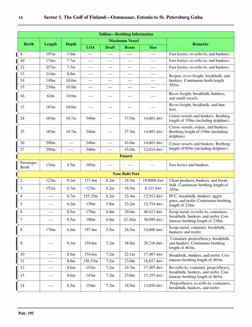
14 Sector 1. The Gulf of Finland—Osmussaar, Estonia to St. Petersburg Guba
Pub. 195
8 197m 7.0m — — — — Fast ferries, ro-ro/lo-lo, and bunkers.
10 174m 7.7m — — — — Fast ferries, ro-ro/lo-lo, and bunkers.
12 257m 7.5m — — — — Fast ferries, ro-ro/lo-lo, and bunkers.
13 214m 8.0m — — — — Ro/pax, ro-ro freight, breakbulk, and bunkers. Continuous berth length 593m.
14 149m 10.0m — — — —
15 230m 10.0m — — — —
16 62m 10.0m — — — — Ro-ro freight, breakbulk, bunkers, and small vessels.
17 183m 10.0m — — — — Ro-ro freight, breakbulk, and bun-kers.
24 165m 10.7m 340m — 37.5m 14,601 dwt Cruise vessels and bunkers. Berthing length of 339m (including dolphins).
25 165m 10.7m 340m — 37.5m 14,601 dwtCruise vessels, ro/pax, and bunkers. Berthing length of 339m (including dolphins).
26 290m — 340m — 43.0m 14,601 dwt Cruise vessels and bunkers. Berthing length of385m (including dolphins). 27 290m — 340m — 43.0m 12,614 dwt
Patarei
Passenger Berth 134m 4.5m 105m — — — Fast ferries and bunkers.
Vene Balti Port
2 123m 9.1m 157.4m 8.2m 24.5m 19,8000 dwt Clean products, bunkers, and break-bulk. Continuous berthing length of 385m.3 152m 6.7m 123m 6.2m 16.5m 8,321 dwt
4 — 6.7m 155.25m 6.2m 23.4m 12,912 dwt PCC, breakbulk, bunkers, aggre-gates, and reefer. Continuous berthing length of 254m.5 — 6.2m 139m 5.8m 23.2m 12,754 dwt
6 — 8.5m 179m 8.0m 29.0m 40,413 dwt Scrap metal, ro-ro/lo-lo, containers, breakbulk, bunkers, and reefer. Con-tinuous berthing length of 238m.7 — 8.5m 190m 8.0m 32.26m 58,099 dwt
8 170m 6.0m 157.4m 5.5m 24.5m 19,800 dwt Scrap metal, container, breakbulk, bunkers, and reefer.
9 — 8.3m 159.6m 7.2m 38.8m 20,216 dwt Container, project/heavy, breakbulk, and bunkers. Continuous berthing length of 465m.
10 — 8.6m 154.6m 7.2m 22.1m 17,407 dwt Breakbulk, bunkers, and reefer. Con-tinuous berthing length of 465m.11 — 8.6m 156.53m 7.2m 23.0m 16,657 dwt
12 — 8.6m 153m 7.2m 24.7m 17,407 dwt Ro-ro/lo-lo, container, project/heavy, breakbulk, bunkers, and reefer. Con-tinuous berthing length of 465m. 13 — 8.6m 143m 7.2m 23.0m 17,355 dwt
14 — 8.5m 154m 7.2m 18.9m 13,850 dwt Project/heavy, ro-ro/lo-lo. containers, breakbulk, bunkers, and reefer.
Tallinn—Berthing Information
Berth Length DepthMaximum Vessel
RemarksLOA Draft Beam Size

Sector 1. The Gulf of Finland—Osmussaar, Estonia to St. Petersburg Guba 15
Pub. 195
Vanasadam, formerly known as Kesklinna, lies in the S partof the Tallinn Laht and is a busy commercial harbor. The en-trance to Vanasadam, the Old City Harbor, is narrow with shoalwater to the S that is not particularly well marked. The harborcomprises 4 basins and two piers that extends NW of the har-bor with berths for tankers, Ro-Ro, container and passengervessels. Vanasadam can handle vessels up to 340m in length,42m in beam, and 10.3m in draft. See the accompanying Tal-linn Berthing Information table for more details. 1.9 Paljassaare Sadam and Lahesuu Sadam, lie at the W sideof the Tallinn Bay and are used by commercial vessels. Thereare four berths on the S side, with depth of 3.4 to 8.7m along-
side, and seven berths on the N side, with depths from 4 to 9malongside. The basin provides facilities for container, ro-ro,and tanker vessels. Cargo vessels up to 190m in length, 30m inbeam, and 8.6m draft can be accommodated; tankers up to120m in length and 6m draft can be accommodated.1.9 Several basins lie close SE of this harbor and are mostly usedby naval, port authority, icebreaker, and fishing vessels.1.9 Miiduranna Sadam lies on the NE side of the bay, 3.4 milesNNE of Vanasadam. The harbor is protected by a breakwaterand is divided into two basins. Vessels up to 196m in length,32m beam, and 12.3m draft can be accommodated. See para-graph 1.11 for more details.
15 — 8.5m 190m 7.2m 32.01m 21,277 dwtRo-ro/lo-lo, container, breakbulk, bunkers, and reefer. Continuous berthing length of 217m.
16 — 7.2m 179.87m 6.8m 29.0m 40,413 dwt
Containers, breakbulk, bunkers, and reefer. Continuous berthing length of 480m.
17 — 7.2m 179.87m 6.8m 29.0m 40,413 dwt
18 — 7.2m 179.87m 6.8m 29.0m 40,413 dwt
19 — 7.7m 179.87m 7.0m 29.0m 40,413 dwt
20 — 7.7m 179.87m 7.0m 29.0m 40,413 dwt
Dekoil Terminal (Vene-Balti Harbor)
0 84m 11.4m 185m 11.0m 35.0m 48,000 dwt Clean and dirty products and bunkers.
1 110m 9.2m 160m 8.3m 35.0m 15,000 dwt Clean and dirty products and bunkers. Continuous berthing length of 385m.
1.9By Port of Tallinn / Tallinna Sadam [CC BY-SA 3.0], via Wikimedia Commons
Vanasadam—Old City Harbor
Tallinn—Berthing Information
Berth Length DepthMaximum Vessel
RemarksLOA Draft Beam Size

16 Sector 1. The Gulf of Finland—Osmussaar, Estonia to St. Petersburg Guba
Pub. 195
1.9 Pirita harbor is located at the SE side of the Tallinna Laht atthe mouth of the Pirita river, 2 miles S of Miiduranna Sadam.This extensive yacht harbor is protected by two breakwaters.1.9 Vene-Balti Port (59°27'N., 24°39'E.), a shipbuilding and re-pair complex, lies at the NE side of Kopli Laht. It has two mainbasins and several floating docks. Vessels up to 200m in lengthand 10.6m draft can be handled. A basin area, used by patrolvessels, lies S of this shipbuilding complex.1.9 Contact Information.—See table titled Tallinn—ContactInformation.
1.9 Caution.—Several wrecks, best seen on the chart, lie in thevicinity of and approaches to Tallinn.
1.10 Bekkeri (Bekker) (59°27'N., 24°40'E.) and Meeruse(59°27'N., 24°40'E.) are small harbors lying at the E side ofKopli Laht. They are used by commercial vessels and fishingcraft. At Bekkeri vessels up to 170m in length, 32m beam, and8.1m draft can be accommodated. At Meeruse vessels up to140m in length, 24m beam, and 6.3m draft can be accommo-dated.
1.10 Aspect.—The lanes and separation zones of the main TrafficSeparation Schemes (TSS) located in the approaches to Tallinnare marked by lighted buoys and indicated by lighted rangesand sector lights, which may best be seen on the chart (see Di-rections).1.10 Tallinna Laht Rear Range Light is shown from a prominentround tower, 40m high, standing 1.5 miles SE of the entranceto Vanasadam, the old harbor. Tallinna Laht Front Range Lightis shown from a tower on a dwelling, 18m high, standing 0.6mile NNW of the rear range light. This lighted range indicatesthe main fairway leading into Tallinna Laht.1.10 For a description of the off-lying islands and islets in the ap-proaches, see paragraph 1.3.1.10 The city of Tallinn extends on two levels along the steeprocky coast in the SE portion of the bay. Numerous high build-ings, towers, chimneys, and masts stand in the vicinity of city.In good visibility, the spire of Oleviste Church can be recog-nized from a distance of 25 miles. It is 125m high and standsclose SW of Vanasadam harbor basin. Toompea Citadel, sur-rounded by a high stone wall, is also conspicuous. It stands 0.5mile SW of Oleviste Church and has a church with a darkgreen spire. The high ruins of a prominent monastery stand onthe E side of the bay, on the N bank of the Pirita River. A con-spicuous obelisk is situated 1 mile SW of these ruins.
Tallinn—Contact Information
Port Authority
Call sign Radio 5
VHF VHF channel 14
Telephone 372-631-8555
Facsimile 372-631-8166
E-mail [email protected]
Web site http://www.portoftallinn.com
Harbormaster
Telephone 372-631-8250
Pilots
Head Office
Telephone372-605-3888
372-526-8432
Facsimile 372-605-3881
E-mail [email protected]
Web site http://www.loots.ee
Muuga Pilots
Call sign Muuga Pilot
VHF VHF channels 13, 16, and 72
Telephone 372-631-9621
Facsimile 372-631-9120
Paldiski South Pilots
Call sign Paldiski Pilot
VHF VHF channel 9
Telephone372-674-1010
372-504-3825 (mobile)
Facsimile 372-674-1195
Paljassaare Pilots
Call sign Tallinn Pilot
VHF VHF channel 72
Saaremaa Pilots
Call sign Saaremaa Sadam
VHF VHF channels 14 and 16
Vanasadam Pilots
Call sign Tallinn Pilot
VHF VHF channel 72
Tallinn Pilots
Call sign Tallinn Pilot
VHF VHF channel 13
Traffic/VTS
Call sign Tallinn VTS
VHF VHF channel 13
Telephone 372-620-5766
E-mail [email protected]
Tallinn Bekkeri Port
https://tallinnbekkerport.com/en
Tallinn—Contact Information

Sector 1. The Gulf of Finland—Osmussaar, Estonia to St. Petersburg Guba 17
Pub. 195
1.10 Pilotage.—General information regarding pilotage in Esto-nian waters are listed, as follows:
1. Pilotage is compulsory for all foreign vessels navigat-ing in the following pilotage areas:
a. Tallinn Kunda-Loksa Paldiski.b. Vaiinameri.c. Parnu.d. Sillamae.
2. Pilotage is conducted at any time unless individualport rules and regulations have established other times of op-eration.
3. Pleasure craft (24m loa or less) are exempt from com-pulsory pilotage within Estonian territorial waters.
4. Pilotage for all ports in Estonia together with DeepSea Pilotage is provided by Eesti Loots (Estonian Pilot).
5. Pilots can be ordered from a company providing pilot-age services using e-mail through an agent licensed to oper-ate in Estonia.
6. Orders for a licensed Deep Sea Pilot in the Baltic Seaarea should be made 48 hours prior to arrival, and confirmed2 hours prior to arrival.
7. Requests for pilotage should be made 24 hours in ad-vance of expected arrival, and reconfirmed 6 hours and 2hours prior to arrival at the pilot station.
8. Departing vessels must request pilotage at 4 hours andagain at 1 hour in advance of ETD.
9. Vessels shifting position within port areas should doso with a pilot on board.
1.10 Pilots should be contacted by VHF through the TCS (Tallinn
on VHF channel 13 and Muuga on VHF channel 16 or 72).They board, as follows:
1. Tallinn Bay (call sign: Tallinn Pilot)—1.5 milesWNW of Tallinn No. 1 Lighted Buoy (59°36.5'N.,24°40.2'E.) or 0.5 mile S of Suurupi No. 3 Lighted Buoy(59°30.0'N., 24°32.6'E.).
2. Kopli Bay (call sign: Kopli Pilot)—0.5 mile S ofSuurupi No. 3 Lighted Buoy (59°30.0'N., 24°32.6'E.).
3. Port of Muuga (call sign: Muuga Pilot)—Vessels fromNW are boarded in position 59°39.0'N, 24°44.0'E. Vesselsfrom N or NE are boarded in position 59°39.0'N, 25°05.4'E.
1.10 It is reported that during periods of inclement weather pilotsmay request vessels to proceed a distance within the TSS be-fore boarding. Radar-assisted pilotage is available on request. 1.10 Regulations.—Vessels must send a report through TallinnCoast Radio Station or the agent 72 hours and 24 hours in ad-vance of arrival. The ETA report must include the draft (foreand aft), and purpose for the port-of-call.1.10 On approaching the port, vessels bound for Tallinn Bay andKopli Bay must contact the Tallinn Traffic Control by VHF.Vessels bound for Muuga Bay must contact the Muuga TrafficControl on VHF. Permission must be received before vesselscan enter, leave, or shift berth in the port area. 1.10 GOFREP is a mandatory ship reporting system under SO-LAS regulation, operates in the Gulf of Finland and its ap-proaches. Shore-based facilities at Tallinn (VHF channel 61),Helsinki (VHF channel 60), and Saint Petersburg (VHF chan-nel 74) are able to monitor shipping movements and provideimproved advice and information about navigational hazardsand weather conditions. For further information concerningGOFREP and other regulations pertaining to vessels approach-ing the ports along the S coast of the Gulf of Finland, see Gen-eral Remarks in paragraph 1.1 and Finland in Pub. 140, SailingDirections (Planning Guide) North Atlantic Ocean and Adja-cent Seas.1.10 The Traffic Separation Scheme (TSS) instituted by the localauthorities in the S part of Tallinn Reid is not IMO-adopted.However, the authorities advise that the principles of Rule 10of the COLREGS apply.
Vessels requiring icebreaker assistance should report, eitherdirectly to the harbormaster or through the agent, their ETA atthe meridian of Ristna Light (58°°56.3'N., 22°°03.3'E.) 24hours in advance. The Estonia Maritime Administration main-tains control over ice-breaking operations. Information pertain-ing to the position of the ice edge and icebreaker pilotage willbe supplied. Vessels bound for Tallinn, Kopli, or Muuga areusually requested to wait for icebreakers in position 59°10'N,22°00'E.1.10 Vessel Traffic Service.—A local Vessel Traffic Service(VTS) operates in the approaches to Tallinn Bay, Kopli Bay,and Muuga Bay. The VTS system area is bordered connectingthe following points:
1. Ninamaa (59°28.4'N., 24°21.6'E.).2. Position 59°29.5'N, 24°20.0'E.3. Position 59°30.5'N, 24°20.0'E.
1.10By Mona-Mia [CC BY-SA 3.0 ee (https://creativecommons.org/licenses/by-sa/3.0/ee/deed.en)], from Wikimedia Commons
1.10Tallinna Laht Rear Range Light
Estonian Pilots
https://www.loots.ee

18 Sector 1. The Gulf of Finland—Osmussaar, Estonia to St. Petersburg Guba
Pub. 195
4. Position 59°40.0'N, 24°30.0'E.5. Tallinn Light (59°42.7'N., 24°43.9'E.).6. Keri Light (59°41.9'N., 25°01.4'E.).7. Position 59°41.9'N, 25°12.3'E.8. Rammu Saar (Loodo Ots) (59°34.7'N., 25°12.3'E.).9. Ihasalu Nina (Uitru Spit) (59°32.5'N., 25°08.6'E.).
1.10 This system (Tallinn VTS) is mandatory for the following: 1. Vessels of 24m or more in length.2. Vessels less than 24m in length when not under com-
mand, when restricted in ability to maneuver, or when hav-ing navigational equipment not in working order.
3. On request from Tallinn VTS.All vessels within the VTS area must keep a continuous lis-
tening watch on VHF channel 13.Vessels are required to report to Tallinn VTS when entering
the area or leaving the port using the following format:
All vessels must then report to Tallinn VTS on VHF channel13 when passing abeam of the following Reporting Points:
1. Tallinn No. 1 Lighted Buoy (59°36.5'N., 24°40.2'E.).2. Suurupi No. 3 Lighted Buoy (59°30.0'N., 24°32.6'E.).
Vessels must also report immediately to Tallinn VTS in re-gard to the following:
1. Any incident, accident, danger, obstacle, or sea pollu-tion.
2. Altering from their planned route.3. When further information is requested by the VTS.
1.10 All vessels entering the area in order to anchor must adviseTallinn VTS of their intentions and report when anchoring orweighing anchor.1.10 Contact Information.—The port of can be contacted by e-
mail ([email protected]).1.10 Anchorage.—The bottom in the deeper parts of the roadstead isformed by soft mud. Close in, off the E shore, it is sand and, inplaces, rocks. Off the W shore it is mostly mud, sand, and stones. 1.10 Three designated anchorage areas, with depths of 15 to 30m,are situated in the roadstead and may best be seen on the chart.Area A, Area B, and Area C (dangerous cargo) lie centered 2.5miles N, 1.9 miles NW, and 3.5 miles NW, respectively, of Tal-linn Front Range Light.1.10 An additional five designated anchorage areas lie in the outerapproaches and may best be seen on the chart, as follows:
1. Area G lies centered 1 mile SW of Suurupi No. 3Lighted Buoy (59°30.0'N., 24°32.6'E.) and has a depth of30m, clay.
2. Area H lies centered 1.3 miles NW of Suurupi No. 3Lighted Buoy and has depth of 34 to 37m. A restricted an-chorage area abuts the E edge of Anchorage Area H.
3. Area F lies centered 1.3 miles NE of Hulkari OtsLight (59°32.5'N., 24°33.8'E.) and has depths of 17 to 33m,mud and sand. Anchoring and fishing is prohibited in an areajust N of Anchorage Area F and is best seen on the chart.
4. Area E, for dangerous cargo, lies centered 1.8 milesESE of Suurupi No. 3 Lighted Buoy and has depths of 31 to37m, sand.
5. Area D, in Kopl Laht, lies centered 3.5 miles SE ofSuurupi No. 3 Lighted Buoy and has depths of 19 to 26m,sand and mud.
1.10 Care is advised as obstructions have been reported to liewithin the vicinity of these anchorage areas.1.10 Directions.—Recommended routes and Traffic SeparationSchemes (TSS), which may best be seen on the chart, lie in theN and W approaches to Tallinn Reid.1.10 A Precautionary Area lies centered 4.5 miles SSW of TallinnLight (59°43'N., 24°44'E.). A TSS, for vessels approachingfrom the E, extends about 1.2 miles E from the E side of thePrecautionary Area. The inbound traffic lane is situated on theN side of the separation zone; the outbound traffic lane is situ-ated on the S side of the separation zone.1.10 Recommended Traffic Flow Routes, indicated by directionalarrows, are situated adjacent to the NE, N, and W sides of thePrecautionary Area; these routes are to be used by vessels ap-proaching from the NE, N, and WNW, respectively.1.10 The main TSS, which forms the approach route from N, isentered about 4.6 miles W of Pikasaare Ots Light (59°36'N.,24°31'E.). It extends SSE for about 7 miles from the S side ofthe Precautionary Area. The separation zone is marked by Tal-linn No. 1 Lighted Buoy (59°36.5'N., 24°40.2'E.), moored atthe N end, and by Tallinn No. 3 Lighted Buoy (59°29.8'N.,24°45.2'E.), moored at the S end. The inbound traffic lane issituated on the W side of the separation zone; the outboundtraffic lane is situated on the E side of the separation zone. AnInshore Traffic Zone is located adjacent to the E side of theoutbound lane.1.10 The alignment of the Tallinn range lights indicates the direc-tion of the separation zone in the TSS. It should be noted thatvessels are prohibited from navigating on this alignment whenproceeding between Tallinn No. 1 Lighted Buoy and TallinnNo. 3 Lighted Buoy.1.10 Tallinn may also be approached from W. The TSS, formingthe route from W, is entered about 2.5 miles NW of Suurupi
Designator Information Required
ALFA Name and call sign or IMO identification,or MMSI.
CHARLIE Position (latitude/longitude) in two 6-digitgroups.
DELTA Bearing from a clearly-identified landmark.
ECHO True course in a 3-digit group.
FOXTROT Speed in knots in a 2-digit group.
INDIA Destination within the VTS area and ETA.
LIMA Route information.
OSCAR Draft in meters.
PAPA Cargo and dangerous cargo by IMO class and total amount.
QUEBEC Brief details of defects or restrictions of navigability.
ROMEO Description of pollution or dangerous goods lost overboard.
UNIFORM Vessel type and length.
WHISKEY Total number of persons onboard.
X-RAY Miscellaneous remarks (ice class, bunkersetc.)
Sector 1. The Gulf of Finland—Osmussaar, Estonia to St. Petersburg Guba 19
Pub. 195
Light (59°28'N., 24°23'E.). It extends E for about 7 miles, ENEfor about 5 miles, and then joins the main TSS. The seawardentrance of the scheme is marked by Suurupi No. 1 LightedBuoy (59°30'N., 24°20'E.). The separation zone junction ismarked by Suurupi No. 3 Lighted Buoy (59°30.0'N.,24°32.6'E.). The inbound traffic lane is situated on the S side ofthe separation zone and passes S of Vahemadal Shoal(59°31'N., 24°40'E.). The outbound lane passes N of Vahema-dal Shoal and is situated on the N side of the separation zone.1.10 It should be noted that vessels constrained by their draft maybe required to deviate from the alignment of the lighted rangeindicating the outbound traffic lane in order to pass clear of Le-outjevimadal (Kaguranna Madal) (59°30.8'N., 24°36.0.'E.)(see paragraph 1.8.).1.10 It should be noted that the Traffic Separation Schemes (TSS)described above are not IMO-adopted but the Estonian authori-ties have advised mariners that the principles of Rule 10 of theCOLREGS applies.1.10 Caution.—A local magnetic anomaly has been reported toexist on the E side of Tallinn Reid. 1.10 Several obstructions lie in the S part of Tallinn Reid. Theyare marked by buoys and may best be seen on the chart.
Miiduranna (59°30'N., 24°49'E.)
1.11 Miiduranna lies on the E side of Tallinn Bay about 3miles NE of Vanasadam. This port is privately owned consist-ing of two basins. It has bulk and oil facilities. Tankers conductloading from the Milstrand Oil Terminal. It is open year-round.The N basin has two berths and an oil jetty on the inside of theN breakwater. The S basin has seven berths for small vesselsand general cargo.
1.11 Winds—Weather.—The windy season usually lasts fromOctober to November and can blow 54-58 knots, and in gustsof up to 62-69 knots. During strong W and SW winds, berthing
is inadvisable. 1.11 Ice.—Ice can start at the beginning of December and lastthrough to April.1.11 Depths—Limitations.—Vessels up to 196m in length, witha maximum beam of 32m and a maximum draft of12.3m, canbe accommodated in the harbor. 1.11 Pilotage.—Pilotage is compulsory for vessels entering, de-parting, and remooring, on a 24-hour basis, and is coordinatedthrough Tallinn pilot station. Pilot boards in position59°29.4'N, 24°33.0'E or position 59°36.8'N, 24°37.4'E.1.11 Regulations.—Vessels entering Tallinn Bay must make contactwith coast radar station, the Vessel Traffic Center, and contacted(call sign: Tallinn Traffic Control) on VHF channel 13. Miiduran-na harbor uses VHF channel 10 for communication.1.11 Anchorage.— Anchorages and traffic will be regulated byTallinn VTS.
Muuga (59°30'N., 24°56'E.)
World Port Index No. 28484
1.12 Muuga (Muuga Sadam), formerly known as Novotal-linnsakiy, is a newly-developed complex lying within MuugaLaht. It specializes in bulk grain, reefer, chemical, timber, andvehicle cargo. This port is under the jurisdiction of and is con-sidered to be part of the Port of Tallinn.
1.12 Winds—Weather.—The port and roadstead are unprotectedfrom winds out of the NW, N, and NE. Even with only moder-ate winds from a N direction, dangerous surges may be experi-enced at the berths.
1.12 Ice.—See General Remarks in paragraph 1.1 and the port ofTallinn in paragraph 1.9.1.12 Depths—Limitations.—The entrance channel is authorizedfor drafts up to 16.9m.
Port of Miiduranna
https://www.miidurannasadam.ee/en
Port of Muuga
https://www.ts.ee/en/muuga-harbour/
Miiduranna—Berth Information
Berth Length DepthMaximum Vessel
RemarksLOA Draft Beam
1 135m 4.6m 130m 4.2m 20m General cargo.
2 90m 3.4m 60m — 10m —
3 75m 2.0m 45m — 8m —
4 (inner) 80m 4.6m 70m 3.8m 18m —
4 (outer) 63m 5.9m 110m 5.6m 20m General cargo.
5 134m 3.6m 110m 3.3m 20m Wood chips.
6 20m 1.5m 12m 1.2m 4m —
7 55m 2.0m 24m 5.0m — —
8 83m 3.8m 80m 3.5m 18m —
9 88m 4.6m 85m 4.2m 20m Fuel oil.

20 Sector 1. The Gulf of Finland—Osmussaar, Estonia to St. Petersburg Guba
Pub. 195
1.12 The harbor is divided into two basins by the grain pier. Thebasins provide 28 berths, 65 to 365m long, with depths of 5.3to 17.8m alongside. There are facilities for bulk, container, ro-ro, reefer, ferry, and tanker vessels.1.12 The grain pier is 335m long and has depths of 17.2 alongside.
An oil terminal is situated in the NW part of the W basin. It pro-vides a jetty, 340m long, with a depth of 17.8m alongside.1.12 The port can accommodate vessels up to a maximum of 300min length, 48m beam, and 16.9m draft. See the table titled Muu-ga—Berth Information for more details.
10 93m 13.0m 196m 12.3m 32m Diesel, heating oil, gasoline, andaviation fuel.
Miiduranna—Berth Information
Berth Length DepthMaximum Vessel
RemarksLOA Draft Beam
Muuga—Berth Information
Berth Length DepthMaximum Vessel
RemarksLOA Draft Beam Size
Muuga Industrial Area (Liquid Bulk)
1 205m 11.4m 205m 11.0m 27.0m 37,343 dwt Aviation fuel, clean and dirty products, crude and bunkers.1A 210m 14.4m 252m 14.0m 44.0m 109,900 dwt
2 205m 11.2m 205m 10.8m 48.0m 35,000 dwt Clean and dirty products, crude, and bunkers.
2A 80m 6.6m 80m 6.2m — 3,000 dwt Dirty products and bunkers.
3 100m 8.2m 126m 7.8m 48.0m 15,000 dwt Aviation fuel, chemicals, clean and dirty products, and bunkers.
3A 218m 13.0m 218m 12.6m 48.0m 50,000 dwt Clean and dirty products, crude, and bunkers.
7 310m 14.4m 310m 14.0m 44.0m 300,000 dwtCrude, dirty products, fertilizer, break-bulk, multipurpose, and bunkers. Con-tinuous berthing length of 590m.
9A 98m 18.0m 340m 17.1m 50.0m 300,000 dwt Aviation fuel, clean and dirty products, crude, and bunkers.10A 98m 18.0m 340m 17.1m 50.0m 300,000 dwt
General Cargo Terminal
4 278m 7.5m 114m — 14.0m 6,050 dwt Fertilizer, breakbulk, and bunkers.
5 103m 7.1m 114m — 13.0m 5,465 dwtMixed cargo, bulk cargo, and ro-ro. Continuous berthing length of 443m.6 157m 9.5m 200m — 24.0m 34,946 dwt
6A 183m 10.9m 200m — 30.0m 37,933 dwt
11 259m 12.9m 180m — 30.0m 37,721 dwtBreakbulk, ro-ro freight, and bunkers. Continuous berthing length of 634m.12 175m 12.4m 186m — 28.0m 36,746 dwt
13 200m 8.6m 152m 8.6-12.4m 21.0m 16,884 dwt
Dry Bulk Terminal
8 280m 14.4m 229m — 38.0m 85,000 dwt Fertilizer, breakbulk, and bunkers. Con-tinuous berthing length of 590m.
9 331m 17.4m 250m 16.8m 44.0m 117,099 dwt Grain and bunkers.
10 335m 17.4m 250m 16.8m 44.0m 117,099 dwt Grain and bunkers.
Ro-Ro and Container Terminal
14 219m 12.4m — — — — Ro-ro freight and containers.
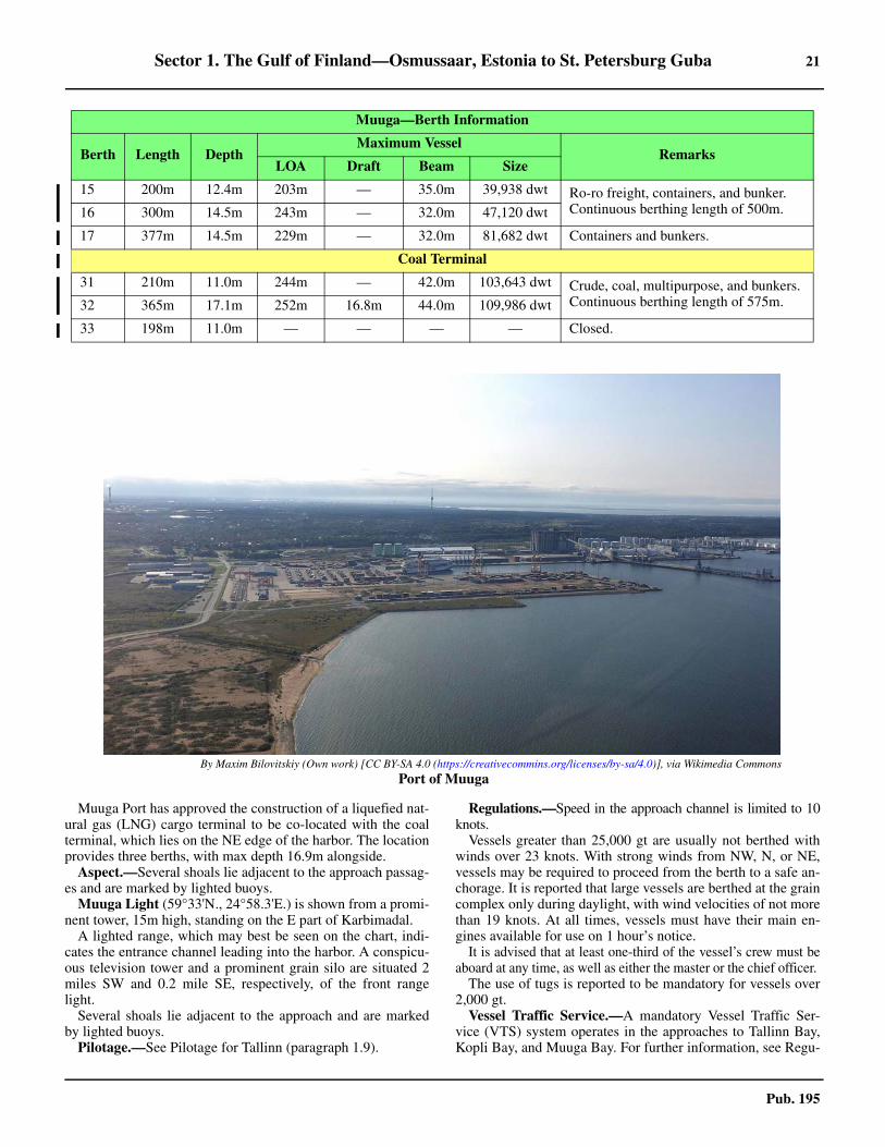
Sector 1. The Gulf of Finland—Osmussaar, Estonia to St. Petersburg Guba 21
Pub. 195
1.12 Muuga Port has approved the construction of a liquefied nat-ural gas (LNG) cargo terminal to be co-located with the coalterminal, which lies on the NE edge of the harbor. The locationprovides three berths, with max depth 16.9m alongside. 1.12 Aspect.—Several shoals lie adjacent to the approach passag-es and are marked by lighted buoys.1.12 Muuga Light (59°33'N., 24°58.3'E.) is shown from a promi-nent tower, 15m high, standing on the E part of Karbimadal. 1.12 A lighted range, which may best be seen on the chart, indi-cates the entrance channel leading into the harbor. A conspicu-ous television tower and a prominent grain silo are situated 2miles SW and 0.2 mile SE, respectively, of the front rangelight. 1.12 Several shoals lie adjacent to the approach and are markedby lighted buoys.1.12 Pilotage.—See Pilotage for Tallinn (paragraph 1.9).
1.12 Regulations.—Speed in the approach channel is limited to 10knots.1.12 Vessels greater than 25,000 gt are usually not berthed withwinds over 23 knots. With strong winds from NW, N, or NE,vessels may be required to proceed from the berth to a safe an-chorage. It is reported that large vessels are berthed at the graincomplex only during daylight, with wind velocities of not morethan 19 knots. At all times, vessels must have their main en-gines available for use on 1 hour’s notice. 1.12 It is advised that at least one-third of the vessel’s crew must beaboard at any time, as well as either the master or the chief officer. 1.12 The use of tugs is reported to be mandatory for vessels over2,000 gt.1.12 Vessel Traffic Service.—A mandatory Vessel Traffic Ser-vice (VTS) system operates in the approaches to Tallinn Bay,Kopli Bay, and Muuga Bay. For further information, see Regu-
15 200m 12.4m 203m — 35.0m 39,938 dwt Ro-ro freight, containers, and bunker. Continuous berthing length of 500m. 16 300m 14.5m 243m — 32.0m 47,120 dwt
17 377m 14.5m 229m — 32.0m 81,682 dwt Containers and bunkers.
Coal Terminal
31 210m 11.0m 244m — 42.0m 103,643 dwt Crude, coal, multipurpose, and bunkers. Continuous berthing length of 575m. 32 365m 17.1m 252m 16.8m 44.0m 109,986 dwt
33 198m 11.0m — — — — Closed.
1.12By Maxim Bilovitskiy (Own work) [CC BY-SA 4.0 (https://creativecommins.org/licenses/by-sa/4.0)], via Wikimedia Commons
Port of Muuga
Muuga—Berth Information
Berth Length DepthMaximum Vessel
RemarksLOA Draft Beam Size

22 Sector 1. The Gulf of Finland—Osmussaar, Estonia to St. Petersburg Guba
Pub. 195
lations for Tallinn (paragraph 1.9).1.12 Anchorage.—There are six designated anchorage areas, as fol-lows:
1. Anchorage Area N lies 2 miles SW of Uitri saar(59°32.4'N., 25°08.2'E.) and has depths of 19 to 38m, sand andclay. It provides shelter from winds from between ENE and S.
2. Anchorage Area K lies 1.5 miles S of Prangli SaarLight (59°36.9'N., 25°02.4'E.) and has depths of 22 to 60m,sand. It is for vessels carrying dangerous cargo.
3. Anchorage Area J and Anchorage Area M lie, respec-tively, 2.5 miles N and 1.5 miles NE of the grain pier. Theseareas have depths of 12 to 30m, sand and clay, and are situat-ed on either side of the entrance range.
4. Anchorage Area I lies just E of Aegna Saar, centeredon position 59°35.2'N, 24°49.0'E, with depths from 26 to60m, sand, gravel, and mud. An obstruction best seen on thechart lies in the SW corner of this anchorage.
5. Anchorage Area L lies 1.5 miles E of Karbimadal,centered on position 59°32.5'N, 25°03.0'E, with depths of 45to 60m, mud.
1.12 Directions.—Vessels from N may pass about 4 miles E ofKeri Saar and then either E or W of Aksi Saar. An alternativeroute leads SE from the TSS lying in the approach to Tallinn.The harbor is then entered from the NE. A lighted range, whichmay best be seen on the chart, indicates the entrance channelleading to the harbor complex.1.12 Karbimadal, an extensive rocky shoal, lies about 3.3 milesNNE of the front entrance range light and has a least depth of1.8m. It is marked on the E side by Muuga Light and a lightedbuoy. Vessels pass NE and SE of this shoal. 1.12 The VTS Ship Traffic Control Station may establish one-way traffic in the entrance channel with the passage of vesselsof over 25,000 dwt, or in reduced visibility (see paragraph 1.9).1.12 Caution.—It is reported that a container terminal is beingconstructed within the port.
Muuga to Sepelevskij
1.13 Ihasalu Nina (59°32'N., 25°09'E.), a headland, is lo-cated 7 miles ENE of Muuga and surmounted by a beacon anda tower. 1.13 Ihaslu Laht, a bay, is entered 2 miles SW of the headland, butis not suitable as an anchorage because it is deep and open tothe NW. A below-water reef extends up to about 1.3 miles NWfrom the head of the bay.1.13 Kaberneeme Laht (59°32'N., 25°14'E.) is entered betweenIhasalu Nina and Rammu Saar, 2.8 miles NE. This bay is notsuitable as an anchorage as it is also deep and open to the NW.A reef, with a least depth of 0.9m, extends about 1.7 miles NWfrom the head of the bay.1.13 Rammu Saar is described with off-lying dangers in para-graph 1.3.1.13 Koipsi Saar, lying 1 mile SE of Rammu Saar, is fairly highwith a flat top. A settlement stands on its NE side. The island isseparated from the mainland at Kaberneeme by a narrow chan-nel.1.13 Kolga Laht is entered between Rammu Saar and JumindaNina, 9 miles ENE. Kuusalu church stands 2.8 miles S of thehead of bay and is prominent. Valkla mill and several conspicu-ous buildings are situated on the high coast, about 3.8 miles
NW of this church. Leesi church, also conspicuous over thetops of the trees, stands 2.5 miles S of Juminda Nina. A promi-nent beacon stands near a village at the head of the bay.1.13 Juminda Nina, fronted by shoals, is a densely-wooded head-land surmounted by several conspicuous gray structures andtwo framework towers. A light is shown from a round tower,24m high, standing on this headland.1.13 Pohjar Malusi, a low and rocky island, lies 6 miles WSW ofthe light near the middle of the entrance to the bay. An exten-sive area of islets, shoals, and rocks extends SE into the bayfrom this island and may best be seen on the chart. Pedasaar, alarge islet, lies in the SW part of the bay and is connected to thehead by a shallow sandy ridge. It is densely wooded and prom-inent from seaward. Vessels may anchor in the W part of thebay, but local knowledge is advised. 1.13 Hara Laht is entered between Juminda Nina and PurekkariNeem, about 5.5 miles E. This bay extends about 6 miles SSEbetween two peninsulas. Purekkara Neem is surmounted by alarge rock and shoals, marked by a buoy at the seaward end,extend up to about 3 miles NNW of it.
1.13 The shores of this bay are mostly sandy and rocky, and theland is sparsely covered with pine woods. On the W side, arange of hills stretches the whole length of the peninsula andforms steep cliffs in places which are densely wooded. Severalvillages stand along the shores of the bay. At the head of the
1.13By Tuderna (Panoramio) [CC BY 3.0 (https://creativecommons.org/licenses/by/3.0)], via Wikimedia Commons
1.13Juminda Nina Light

Sector 1. The Gulf of Finland—Osmussaar, Estonia to St. Petersburg Guba 23
Pub. 195
bay the land is low. Between Loksa, in the SE corner, and Oda-kivi, 3.5 miles N, the land is high, but it becomes low again fur-ther to the N. Hara Saar, lying close off the SW shore of thisbay, is a densely wooded islet, 12m high, marked by a beacon.1.13 Large vessels may anchor, in a depth of 40m, mud, about 0.7miles NE of Hara Saar.
1.14 Loksa Sadam (59°35'N., 25°42'E.), a small harbor, issituated at the head of Hara Laht. Pilots are available and maybe contacted by VHF. They board in position 59°40'N,25°35'E. Vessels should send a request for pilotage and an ETAthrough the harbormaster or the Estonian Maritime Board Co-ordination Center at least 24 hours in advance.1.14 The harbor is protected by two breakwaters. There are threedesignated berths, between 120 and 140m in length, and depthsfrom 3.7 to 4.7m alongside.1.14 It is reported that several prominent chimneys stand at a fac-tory in the vicinity of the harbor.
Mohni Saar (59°41'N., 25°48'E.) is described with the off-lying dangers in paragraph 1.3.1.14 Eru Laht is entered between Purekkari Neem, on the W side,and Mohni Saar. The W shore of the bay is wooded. The Eshore of the bay is formed by the Kamu peninsula, which issandy, moderately high, and covered with tall pine trees. Aprominent tower is reported to stand on the NW extremity ofthis peninsula. Foul ground and rocks extend NNW betweenthe N end of the peninsula and Mohni Saar. The S shore of thebay is low and partly wooded. The village of Eru stands at thehead of the bay. A beacon stands at Turbu Neem, about 4.3miles SSE of Purekkari Neem. A river flows into the SW cor-ner of the bay and is fronted by foul ground. 1.14 Anchorage may be obtained as convenient in the bay, butvessels usually anchor about 1.5 miles N of Eru at the head.Local knowledge is advised.1.14 Kasmu Laht is entered between the NE extremity of theKamu Peninsula and Lobineem, about 1.7 miles ENE. Theshores of this bay are sandy, stony, and backed by trees. The Sshore is low. The village of Ihumae, with a prominent whitechurch, stands behind the trees on a steep hill, about 3 miles in-land from the head of the bay. 1.14 Lobineem, surmounted by a tower, is rocky and, at somedistance inland, covered with trees.1.14 Anchorage may be obtained in any part of the bay in a con-venient depth. Several dangerous wrecks are reported to lie inthe vicinity of the entrance to this bay.
1.15 Vergi Sadam (59°36'N., 26°05'E.), a small fishingand pleasure craft harbor, lies about 5 miles SE of Lobineem.The coast between is fronted by foul ground. The N side of theharbor is protected by an islet connected to the mainland by arocky reef. The E side is protected by a breakwater. A light isshown from a tower, 11m high, standing on the NE extremityof the islet.1.15 The harbor has a least depth of 4m and is open to E winds. Adredged channel, about 75m wide, leads into the harbor and isindicated by lighted range. Local knowledge is advised.1.15 Kalkgrund (Soemadal), an extensive shoal area, lies about6.5 miles N of Vergi Sadam. It has a least depth of 0.5m and ismarked by a buoy. 1.15 Vainupea (59°35'N., 26°16'E.) is located 5.2 miles E of Ver-
gi Sadam. A light is shown from a framework tower, 20m high,standing on this cape. A white church, with a prominent redroof, stands close S of the light.1.15 Snegi Madal, an extensive shoal area, lies about 6 miles N ofVainupea. It has a least depth of 2.6m and is marked buoys.1.15 Pohja Uhtja, lying 6 miles E of Snegi Madal, is describedwith off-lying dangers in paragraph 1.4.1.15 Toolse Neem, surmounted by the conspicuous ruins of a cas-tle, is located 6.8 miles ESE of Vainupea. The coast between isformed in places by several white sand hills.
1.16 Kunda Laht (59°32'N., 26°32'E.) (World Port IndexNo. 28440) is entered between Toolse Neem and Ulluneeme,3.5 miles ENE. This bay is sheltered from S and E winds. TheE and S shores are low and covered with trees, meadows, andswamps. A limestone ridge rises steeply about 1 mile S of thehead of the bay. The Kunda Jogi flows toward the bay throughthis ridge. Several cement works, with tall chimneys, stand onan area of high ground near the river bank, about 1.5 miles in-land. A prominent mill is situated about 1.5 miles SE of thehead of the bay. 1.16 Extensive reefs front the shores and for the most part arecovered at HW. In the E part of the bay, the depths are moreuniform and small vessels are able to approach within 0.8 mile
1.14By Tuderna (Panoramio) [CC BY 3.0 (https://creativecommons.org/licenses/by/3.0)], via Wikimedia Commons
1.14Vergi Sadam Light

24 Sector 1. The Gulf of Finland—Osmussaar, Estonia to St. Petersburg Guba
Pub. 195
of the shore.1.16 Kunda Sadam, a small harbor, lies at the head of the bay. Itconsists of two piers and is used for the export of cement. Theentrance channel is 70m wide and has a depth of 10.4m. It isindicated by a lighted range and marked by buoys.
1.16 There are three berths, 32 to 176m long, with depths of 7.5 to9m alongside. Vessels up to 8,000 dwt, 150m in length, and 8mdraft can be accommodated. 1.16 Pilotage is compulsory for all foreign vessels navigatingthrough Tallin, Vainmameri, Parnu, and Sillamie. Pilots for Es-tonian ports as well as Deep Sea are provided by Esti Loots(Estonian Pilots). Pilots can be ordered via e-mail through anagent licensed to operate in Estonia. Request for deep sea pi-lots in the Baltic should be made 48 hours prior to arrival andconfirmed 2 hours prior to arrival. Pilot requests should bemade 24 hours in advance and confirmed 6 hours and 2 hoursprior to pilot station arrival. Departing vessels must request pi-lots 4 hours and 1 hour prior to ETD. Vessels shifting positionswithin a port should have a pilot aboard.1.16 Pilots board in position 59°38.0'N, 26°29.5'E, within KundaBay and in position 59°27.0'N, 27°55.0'E and position9°29.0'N, 27°42.0'E, within Narva Bay.
1.16 Vessels may anchor, in depths of 12 to 14m, sand, midwaybetween the spar buoys marking the foul ground on either sideof the entrance channel.1.16 It is reported that a designated anchorage area lies about 4miles N of the port, centered in position 59°34'N, 26°32'E. 1.16 Letipea Neem (59°33'N., 26°37'E.), fronted by foul ground,is located 1 mile NE of Ulluneeme, the E entrance point ofKunda Laht. Letipea Light is shown from a prominent tower,14m high, standing on this cape.1.16 Diomidi Madal, an extensive shoal area, lies centered 7.5miles NE of Letipea Neem and has a least depth of 4.6m.1.16 Neugrund, an extensive group of shallow rocks and shoals,lies 24 miles NE of Letipea Neem and is marked by buoys onthe N, S, and W sides, and by a lighted buoy at the E side.
1.17 Narva Laht (59°33'N., 27°30'E.), also known asNarvskiy Zaliv, lies between Letipea Neem and Mys Kur-gal’skiy, about 47 miles ENE. The coast of this bay is mainlysandy and backed by cliffs, decreasing in height to the E; theplateau surmounting the cliffs is covered with pastureland andvillages, with small woodlands in places. The shore is frontedby shoals and foul ground in many places.1.17 A small craft harbor, protected by a breakwater, lies at Mahu,4 miles ESE of Letipea Neem, and has a depth of 3m.1.17 A cement factory, with several tall and conspicuous chim-neys, is situated at Aseri, about 9.5 miles SE of Letipea Neem.A prominent church stands about 4 miles W of Aseri.
Moldova (59°26'N., 27°03'E.) is situated 6 miles ESE ofAseri. A light is shown from a prominent framework tower,28m high, standing near this town. Two prominent windmillsare situated on a hill at Valaste, 15 miles E of Aseri.1.17 A conspicuous windmill is situated at Toila, 20 miles E ofAseri. The cliffs in the vicinity of Toila are very steep in places.1.17 Sillamae, a resort, stands on the high sandy coast, about 8miles E of Toila. Merikula, another resort, is situated in a wood-ed area, 6.5 miles E of Sillamae. The Sinimaed Hills, partlywooded and 90m high, extend between these two resorts. Theystand about 1.5 miles inland and are conspicuous from seaward.1.17 Caution.—Several dangerous wrecks, which may best beseen on the chart, lie in the SE part of Narva Laht.1.17 Extensive areas of foul ground and shoals, which may bestbe seen on the chart, extend up to 16 miles W and 15 miles Nof the peninsula forming the E side of Narva Laht. Banka Nam-si (59°46'N., 27°35'E.) is the outermost danger on the W side.This bank has a least depth of 1.4m and is marked by buoys onits N, S, and W sides, and by a lighted buoy on its E side. Foradditional dangers lying in the approach Narva Laht, see para-graph 1.4 and paragraph 1.15.1.17 A precautionary area, with a radius of 3 miles, lies centeredabout 4.5 miles NE of Sillamae and may best be seen on thechart. This area has been established due to the presence of asunken mine.
1.18 Sillamae (59°24'N., 27°45'E.), the commercial port of
1.16By Kunda Nordic Tsement [CC BY-SA 4.0 (https://creativecommons.org/licenses/by-sa/4.0)], via Wikimedia Commons
1.16Kunda Sadam
Kunda—Contact Information
Port
Call sign Kunda Port
VHF VHF channels 14 and 16
Telephone 372-322-9955
Facsimile 372-322-1463
E-mail [email protected]
Web site http://www.knc.ee
Harbormaster
Telephone372-322-9861
372-534-77861 (mobile)
Pilots
Call sign Kunda Pilots
VHF VHF channels 14 and 16
Telephone 372-506-0801
Facsimile 372-322-1940
Kunda—Contact Information

Sector 1. The Gulf of Finland—Osmussaar, Estonia to St. Petersburg Guba 25
Pub. 195
Sillamae, has been established on the S coast of Narva Laht,about 1 mile NNW of the town. It is reported to be under con-tinuing development.1.18 Ice.—The port is generally free of ice all year round but ice-breaking assistance is available if required. 1.18 Depths—Limitations.—The harbor consists of an L-shapedjetty extending about 0.6 mile N from the shore. A finger pierextends 0.2 mile N from the knuckle of the jetty. Lights areshown from the heads of the jetty and the pier.1.18 There is 1,180m of total quayage, which provides six maincommercial berths. These berths are 31 to 319m long and havedepths of 6.2 to 12.5m alongside. Facilities for general cargo,ro-ro, oil, LPG, and container vessels are under construction.Vessels up to 300m in length, 80m beam, and 11.9m draft canbe accommodated.1.18 Pilotage.—Pilotage is compulsory for all foreign commer-cial vessels. Vessels should send an ETA and a request for pi-lotage via their agent 24 hours in advance. The ETA should beconfirmed 6 hours and 2 hours prior to arrival. Vessels shouldthen contact the port on VHF channel 68 in order to receivepermission to enter the harbor. Pilots board 0.6 mile N the out-er fairway buoy, which is moored about 3.5 miles NW of theharbor.1.18 Contact Information.—The port can be contacted by e-mail([email protected]).1.18 Caution.—Extensive construction is being carried out in thevicinity of the harbor. Numerous wrecks, best seen on thechart, lie within the approaches to the harbor.
1.19 Narva Joesuu (59°28'N., 28°03'E.), a small commer-cial and fishing harbor, is situated on the SW side of the en-
trance of the Narva Jogi River, in the SE corner of Narva Laht.The river mouth is narrow and fronted by a bar. A dredgedchannel through the bar has a depth of 4.3m. The river be-comes wider inside the mouth and is navigable as far as thetown of Narva, 7.5 miles SE. Ocean-going vessels cannot as-cend the river above the town because of a waterfall.1.19 The harbor is well-sheltered from all winds, but access is im-possible during gales. The old town, on the W bank of the river,is of medieval appearance and surrounded by fortified wallsand towers. There is 260m of berthage, with depths of 3 to 9malongside.1.19 Narva Light is shown from a round tower, 30m high, stand-ing on the S side of the entrance. From the vicinity of FairwayBuoy (59°28.7'N., 28°01.1'E.), the approach track leads 0.8mile ESE toward the coast, about 0.3 mile NNW of the en-trance. A range, formed by beacon marks, then leads in a SSEdirection into the river entrance. 1.19 The approaches are usually free of ice from the middle ofApril until the beginning of November.1.19 Pilotage is compulsory. The pilot station is situated close tothe light tower. Pilots usually board vessels about 4 milesWSW of Narva Light.1.19 Vessels may anchor, in depths of 18 to 20m, about 2.8 milesWNW of the light. The anchorage is open to N and W winds,which on occasion will raise a heavy sea; however, the holdingground is good. Small vessels may anchor, in a depth of 15m,about 1.5 miles NW of the light.1.19 The boundary between Estonia and Russia is situated in thevicinity of the Narva Jogi River.1.19 Caution.—A disused spoil area, the limits of which areshown on the chart, lies centered about 2.5 miles NNW of the
1.17Sillamae (Silport)

26 Sector 1. The Gulf of Finland—Osmussaar, Estonia to St. Petersburg Guba
Pub. 195
mouth of the Narva Jogi River.
1.20 Mys Kurgal’skiy (59°47'N., 28°06'E.), the E en-trance point of Narva Laht, forms the NW extremity of theKurgal’skiy Peninsula.1.20 A small craft harbor, with depths of 3 to 4m, is situated atGakkovo, 11.3 miles N of Narva Joesuu. The approach channelis indicated by a lighted range. Ostrov Reymosaar lies about 1mile off the coast near this harbor. 1.20 A light is shown from a framework tower, 37m high, stand-ing at Kaybolova, 5 miles N of Gakkovo. A radiobeacon is sit-uated at this light. The coast between is fronted by foul ground,rocks, and islets, which may best be seen on the chart. 1.20 Caution.—A restricted area, the limits of which are shownon the chart, extends up to 5.5 miles N from the N end of theKurgal’skiy Peninsula.1.20 Extensive areas of foul ground and shoals, which may bestbe seen on the chart, extend up to 16 miles W and 15 miles Nof the Kurgal’skiy Peninsula.
1.21 Luzhskaya Guba (Luzskaja Guba) (59°44'N.,28°19'E.), at the head of which is the mouth of Ust’-Luga, isentered between Mys Kurgal’skiy and Kolganpja, 14 milesENE.
A lighted range, which may best be seen on the chart, is situ-ated on Kolganpja and indicates the approach from the N. Thefront light is shown from a framework tower, 42m high, stand-ing at an elevation of about 180m at Gorki, 3 miles SW of Kol-ganpja (59°43.9'N., 28°26.8'E.); the rear light (similarconstruction at 67m in height) is about 0.5 mile SE of frontlight. At the farm of Repino, about 2.5 miles SSW of Kolganp-ja, there is a prominent stone windmill. 1.21 The W shore of this bay is densely wooded; along the wholelength of the E shore are Soykina Gora, which from NW andNE appear as two separate ridges, the southernmost one beinggenerally about 90m high.1.21 A harbor, known as Ruch’i (Ruc’i), lies at the E side of the
bay, about 2 miles SW of Gorki Light. There were extensive fa-cilities for servicing naval vessels here, but it is reported thatthe harbor, for the most part, is in a state of disrepair and hasbeen abandoned.1.21 Reka Vyb’ya enters the SW corner of Luzhskaya Guba, andabout 1.8 miles E is the mouth of Reka Luga. Sandhills rise be-tween the mouths of these two rivers.1.21 Vessels may anchor within Luzhskaya Guba, in depths of 7to 18m. Winds from between N and W raise a heavy seathroughout the bay.1.21 Caution.—The bay and its approaches are encumbered byextensive shallow shoals which may best be seen on the chart.These shoals extend up to about 6 miles seaward of the en-trance to the bay and are marked by lighted buoys and beacons. 1.21 Two areas dangerous to navigation are centered on(59°44.3'N., 28°22.8'E.) and (59°43.9'N., 28°23.1'E.) with adanger circle of 0.1 mile radius. The latter one, close W of theLuzhskiy Maritime Channel, is marked with a buoy moored0.1mile E.
1.22 Ust’-Luga (Reka Luga) (59°40'N., 28°19'E.) (WorldPort Index No. 28410) is a major port area located on the S andE shores of Luzhskaya Guba. This growing port covers threedistinct areas:
1. The first area lies within the mouth of the Luga river,which forms a natural harbor available to small vessels, Atimber terminal is located here. A settlement is situated closeE of the mouth of the river. There is a red church with aprominent green roof.
2. The second area is located E of the river mouth andprovides extensive deep water commercial berthing. Sepa-rate coal, oil and LNG terminals are located here.
3. About midway up the E side of Luzhskaya Gubu, justN of the old naval base at Ruch’i, lies a new harbor wherethe Novaya Gavan Terminal is located.
1.22 Ice.—The harbor is usually frozen over from January untilthe middle of April.
Ust’-Luga (Reka Luga)—Berth Information
Berth Name/Quay No. Length Depth
Maximum VesselRemarks
Length Beam Size
Auto Rail Ferry Terminal
ARFT (West) 200m 9.5m — — — Ro-ro (passenger/vehicles/rail) and bunkers.
ARFT (East) 210m 9.5m — — — Ro-ro (passenger/vehicles/rail) and bunkers.
Coal Transfer Terminal
East Berth 282m 16.0m 240m 32.2m 85,000 dwt Coal and bunkers. Continuous berth length 565m. West Berth 282m 16.0m 240m 32.2m 85,000 dwt
Fertilizer Terminal
Fertilizer Berth — — — — — Under construction.
Metallurgical Terminal
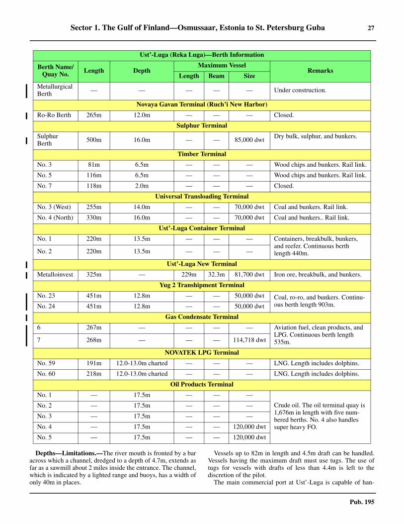
Sector 1. The Gulf of Finland—Osmussaar, Estonia to St. Petersburg Guba 27
Pub. 195
1.22 Depths—Limitations.—The river mouth is fronted by a baracross which a channel, dredged to a depth of 4.7m, extends asfar as a sawmill about 2 miles inside the entrance. The channel,which is indicated by a lighted range and buoys, has a width ofonly 40m in places.
1.22 Vessels up to 82m in length and 4.5m draft can be handled.Vessels having the maximum draft must use tugs. The use oftugs for vessels with drafts of less than 4.4m is left to thediscretion of the pilot.1.22 The main commercial port at Ust’-Luga is capable of han-
Metallurgical Berth — — — — — Under construction.
Novaya Gavan Terminal (Ruch’i New Harbor)
Ro-Ro Berth 265m 12.0m — — — Closed.
Sulphur Terminal
Sulphur Berth 500m 16.0m — — 85,000 dwt Dry bulk, sulphur, and bunkers.
Timber Terminal
No. 3 81m 6.5m — — — Wood chips and bunkers. Rail link.
No. 5 116m 6.5m — — — Wood chips and bunkers. Rail link.
No. 7 118m 2.0m — — — Closed.
Universal Transloading Terminal
No. 3 (West) 255m 14.0m — — 70,000 dwt Coal and bunkers. Rail link.
No. 4 (North) 330m 16.0m — — 70,000 dwt Coal and bunkers.. Rail link.
Ust’-Luga Container Terminal
No. 1 220m 13.5m — — — Containers, breakbulk, bunkers, and reefer. Continuous berth length 440m.No. 2 220m 13.5m — — —
Ust’-Luga New Terminal
Metalloinvest 325m — 229m 32.3m 81,700 dwt Iron ore, breakbulk, and bunkers.
Yug 2 Transhipment Terminal
No. 23 451m 12.8m — — 50,000 dwt Coal, ro-ro, and bunkers. Continu-ous berth length 903m. No. 24 451m 12.8m — — 50,000 dwt
Gas Condensate Terminal
6 267m — — — — Aviation fuel, clean products, and LPG. Continuous berth length 535m. 7 268m — — — 114,718 dwt
NOVATEK LPG Terminal
No. 59 191m 12.0-13.0m charted — — — LNG. Length includes dolphins.
No. 60 218m 12.0-13.0m charted — — — LNG. Length includes dolphins.
Oil Products Terminal
No. 1 — 17.5m — — —
Crude oil. The oil terminal quay is 1,676m in length with five num-bered berths. No. 4 also handles super heavy FO.
No. 2 — 17.5m — — —
No. 3 — 17.5m — — —
No. 4 — 17.5m — — 120,000 dwt
No. 5 — 17.5m — — 120,000 dwt
Ust’-Luga (Reka Luga)—Berth Information
Berth Name/Quay No. Length Depth
Maximum VesselRemarks
Length Beam Size

28 Sector 1. The Gulf of Finland—Osmussaar, Estonia to St. Petersburg Guba
Pub. 195
dling vessels up to 120,000 dwt. An entrance channel, 2.7miles long, leads to the port. It is 150m wide and has a leastdredged depth of 14m. Berthing details are given in the table ti-tled Ust’-Luga (Reka Luga)—Berthing Information.1.22 Pilotage.—Pilotage is compulsory for all vessels and isavailable at any time.
1. Requests for pilotage must be sent to the Pilot ServiceController at least 24 hours in advance and confirmed 1 hourbefore approaching the Port VTS boundary or the pilotboarding position.
2. Vessels intending to depart from the port or to carryout operations within the port must request pilotage at least 3hours in advance.
3. Pilot boards in the following positions:a. Eastern area of the port—At Lighted Buoy No. 1
(59°56.4'N 28°34.6'E).b. Western area of the port—In position 59°42.5'N
28°17.4'E. 1.22 Vessel Traffic Service.—Ust’-Luga (Reka Luga) VesselTraffic Service (VTS) operates in an area as defined below:
1. The port of Ust’-Luga water area and its approaches.2. Luzhskiy Fairway No. 19, S of latitude 59°59.17'N.3. Zapandyy Luzhskiy Fairway No. 21, S of latitude
60°02.31'N (Lighted buoy No. 1).4. Recommended track No. 22, S of latitude 59°49.69'N
(lighted buoy No 3).5. Luzhskiy Maritime Channel Fairway, S of latitude
59°44.55'N (line between Lighted Buoy No. 1 and LightedBuoy No. 2).
6. Recommended track S of latitude 59°43.4'N (line be-tween Lighted Buoy No. 1 and Lighted Buoy No. 2 of Lu-zhskiy Maritime Channel Fairway).
7. Northern Approach Channel S of latitude 59°44.9'N(line between Lighted Buoy No. 1 and Lighted Buoy No. 2of Luzhskiy Maritime Channel Fairway).
8. Anchorage Areas No. 10a, No. 11, and No. 12.
1.22 For further information on the requirements of St. PetersburgCoastal VTS, see paragraph 3.1. 1.22 Contact Information.—See the table titled Ust’-Luga—Contact Information. 1.22 Anchorage.—There are several charted anchorage areas lo-cated in the vicinity of Ust’-Luga, which are described as fol-lows:
1. Anchorage Area 10A is located 4.8 miles NE of MysKolganpya, and more than 7 miles NE of the main port areaof Ust’-Luga. An obstruction lies within the SW part this an-chorage area in position 59°54.5'N, 28°36.5'E.
2. Anchorage Area 11 lies approximately 1 mile due Wof the Novaya Gavan Terminal and is the closest anchorage
1.22By Aviateur - (http://fleetphoto.ru/photo/120972/) [CC BY-SA 4.0 (https://creativecommins.org/licenses/by-sa/4.0)], via Wikimedia Commons
1.22Ust’-Luga (Reka Luga)

Sector 1. The Gulf of Finland—Osmussaar, Estonia to St. Petersburg Guba 29
Pub. 195
area to Ust'-Luga.3. Anchorage Area 12 lies close to the NW shore of Lu-
zhskaya Guba, centered on position 59°46.6’N, 28°13.3’E,but the anchorage area is reserved exclusively for Russiannaval vessels.
1.22 Caution.—It is reported that several new cargo terminals areunder construction in the vicinity of the harbor.
1.23 Mys Ustinskiy (59°55'N., 28°59'E.), fronted by foulground and dangerous wrecks, is located 14 miles ENE of Kol-ganpja. A light is shown from a framework tower, 29m high,standing on this point.
1.23 Koporskaya Guba lies between the two points and derives itsname from Koporskiy Castle, now in ruins but still prominent,standing on a hill about 12 miles S of Mys Ustinskiy. A church,with a green dome and spires, is situated within the ruins of thecastle; another church, with a green dome, stands close SE.The land to the N of the castle is wooded, while meadows ex-tend to the S. 1.23 A tall white chimney stands at Sista Palkino, on the SE shoreof the bay, 6.5 miles S of Mys Ustinskiy. 1.23 The former Dibicha Palace is situated about 4.8 miles SE ofKolganpja. It is a prominent white stone building with a smalltower.
1.23 Koporskaya Guba is open to N winds and, at times, SWwinds raise a choppy sea. The shores of the bay are low, rocky,and covered with trees interspersed with meadows and marshyground. There are no harbors in the bay but shelter is available.1.23 During offshore winds, anchorage may be obtained, indepths of 11 to 18m, within the S part of the bay and in 23 to31m, mud and sand, in the N part. 1.23 Caution.—Foul ground and shoal patches extend up to 2miles from the shores of the bay and may best be seen on thechart.1.23 The W limit of the Kronshtadt Fortified Zone lies at the Eside of Koporskiy Guba and may best be seen on the chart.
1.24 Sepelevskij (Shepelevskiy) (59°59'N., 29°08'E.),fronted by foul ground and wrecks, is located 6 miles NE ofMys Ustinskiy. Sepelevskij Light is shown from a prominentstone tower, 36m high, standing on this point, at the N end ofthe Karavalday Peninsula. A taller conspicuous communica-tions tower is situated close to the light.1.24 Mys Osinovyy, surmounted by a beacon, is located 2.5 milesSW of the light.1.24 Banka Demanstey, an extensive shoal, lies centered 11 milesW of the light. It has a least depth of 4m and is marked bybuoys.1.24 The waters lying E of Sepelevskij are described in Sector 3.
Ust’-Luga—Contact Information
Port Authority
Telephone 78-901-375-1162 (0830-1700)
Facsimile 78-812-493-4987
E-mail [email protected]
Web site https://www.pasp.ru
Port Controller
Call sign Ust’-Luga Radio 5
VHF VHF channels 14 and 16
Telephone 78-921-3489319 (mobile—24 hours)
State Port Control Inspection
Call sign Ust’-Luga Radio 5
VHF VHF channels 4, 10, and 16
Telephone 78-901-3152095 (0830-2030)
E-mail [email protected]
Container Terminal
Telephone 78-812-454-0707
Facsimile 78-812-335-7711
E-mail [email protected]
Web site http://www.ulct.ru
Pilots
Call sign Ust’-Luga Pilot
VHF VHF channel 16
Telephone78-812-449-2598 (24 hours)
78-921-947-1282 (mobile)
Facsimile 78-813-759-1047
E-mail [email protected]
Vessel Traffic Service
Call sign Ust’-Luga Traffic
VHF VHF channels 16, 69, and 86
MMSI 002734468
Telephone78-921-945-1436 (mobile—24 hours)
78-813-754-6502 (0900-1700)
Facsimile 78-813-754-6501
E-mail [email protected]
Ust’-Luga—Contact Information

31
Pub. 195
2. Sector 2—The Gulf of Finland—Northern Shore—Hanko to St. Petersburg Guba
2.0Additional chart coverage may be found in NGA/DLIS Catalog of Maps, Charts, and Related Products (Unlimited Distribution).
SECTOR 2 — CHART INFORMATION

33
Pub. 195
SECTOR 2
THE GULF OF FINLAND—NORTHERN SHORE—HANKO TO ST. PETERSBURG GUBA
2.0 Plan.—This sector describes the N shore of the Gulf of Finlandfrom the cape of Hanko to Mys Stirsudden, the N entrance pointof St. Petersburg Guba. The descriptive sequence is W to E.
General Remarks
2.1 Winds—Weather.—Fog is frequent in the vicinity ofHanko, particularly during April. During the period of icethaw, thick patches of fog have also been reported along the in-ner routes as far E as Orrengrund.2.1 Ice.—See General Remarks in paragraph 1.1.2.1 For information pertaining to winter navigation, ice, andFinnish icebreaking services, including internet web sites, seePub. 140, Sailing Directions (Planning Guide) North AtlanticOcean and Adjacent Seas.2.1 Aspect.—Suomen Lahti is the Finnish name for the N shoreof the Gulf of Finland. The Russians refer to it as Finskiy Zaliv.The coast is dominated by numerous inlets and fronted by is-lets, rocks, and shoals all of which extend many miles seawardin places. The coast is very rugged, but appears flat and monot-onous. Elevation differences amount to no more than 10 to20m. Dense forest characterizes the landscape. The E portionof the coast is not as extensively fronted with islets as the Wpart. 2.1 Natural landmarks hardly exist and are difficult to recognizefrom seaward. The coast and archipelago form poor radar im-ages, but lights shown from many of the skerries along thesides of the approach passages make it possible to navigatesafely. It is advisable to stay in the recommended passages andfollow the designated Traffic Separation Schemes (TSS) androutes. 2.1 An inner passage (inshore route), authorized for drafts up to5 or 6m, and a Winter Channel (coastal route), authorized fordrafts up to 9m, lead through the off-lying dangers. Althoughboth of these routes are well-defined by lighted ranges, localknowledge is advised.2.1 Pilotage.—The IMO recommends that vessels constrainedby their draft or vessels not registered in one of the Balticstates, and infrequently sailing the area, embark a deep-sea pi-lot. See Pub. 140, Sailing Directions (Planning Guide) NorthAtlantic Ocean and Adjacent Seas for information on deep-seapilotage.2.1 All ordering of local pilots throughout Finland is carried outby the Finnpilot Order Center, Helsinki. For more information,see Pilotage in paragraph 2.11.2.1 Regulations.—The Finnish authorities have instituted a sys-tem of restricted areas and semi-restricted areas throughout thewhole of Finland’s coastal waters. The limits of these areasmay best be seen on the chart. Vessels are permitted to transitthese areas only through the approved channels and with a pilotaboard.2.1 Vessels are permitted to anchor within a restricted area only atspecially designated anchorages for a duration of 48 hours or less.2.1 See Pub. 140, Sailing Directions (Planning Guide) North At-
lantic Ocean and Adjacent Seas for regulations pertaining tovessels within the waters of Finland and Russia. Vessels shouldalso consult the pilot as well as the local authorities for detailson local regulations.2.1 Numerous nature reserve areas lie in the waters describedwithin this sector and are affected by many prohibitions andrules. The majority of these areas are situated clear of the rec-ommended routes. 2.1 The sea areas in the Gulf of Finland are monitored jointly byFinland, Estonia, and the Russian Federation. GOFREP is themandatory ship reporting system established in the Gulf of Fin-land and its approaches. 2.1 For further information concerning GOFREP, see paragraph1.1 in this publication and the Finland section in Pub. 140, Sail-ing Directions (Planning Guide) North Atlantic Ocean and Ad-jacent Seas. Additional information can be found in theMaster’s Guide provided on the VTS Finland website.
2.1 Vessel Traffic Service.—Vessel Traffic Services are in effectin Helsinki (paragraph 2.11), Kotka (paragraph 2.18), Vyborg/Vostok (paragraph 2.27), and Primorsk (paragraph 2.30). 2.1 Vessels bound for Vyborg/Vostok and Primorsk also transitthe coverage area of St. Petersburg Coastal VTS (paragraph3.1). 2.1 English was adopted (2019) as the primary communicationlanguage in the VTS areas along the Finnish coast. 2.1 Information Service.—Providing information to vessels inthe VTS area when they report, at set intervals, whenever nec-essary or when a vessel so requests. The reports include infor-mation about all vessel traffic services as provided in section 5of the Finnish Vessel Traffic Service Act. The VTS Authorityprovides vessels with information on the following items of in-terest:
1. Other vessels in the VTS area.2. Changes in matters concerning the VTS areas and
traffic within it.3. Meteorological and hydrological information.4. Operation of pilots and ice breakers.5. Condition and availability of fairways and status of
aids to navigation.6. Any danger threatening a vessel.7. Other matters affecting the safety of vessel traffic.
2.1 Directions.—Several IMO-adopted Traffic SeparationSchemes (TSS) form the main route through the Gulf of Fin-land. These include a TSS lying centered 20 miles SW of Rus-saro Light (59°46'N., 22°57'E.), a TSS lying centered 7.5 milesSSE of Porkkala Light (59°52'N., 24°18'E.), a TSS lying cen-tered 8 miles SSE of Helsinki Light (59°57'N., 24°56'E.), and aTSS lying centered 6 miles SSE of Kalbadagrund Light(59°59'N., 25°36'E.). In addition, a large Precautionary Area
FinTraffic VTS—Master’s Guide
https://www.fintraffic.fi/en/vts/masters-guide

34 Sector 2. The Gulf of Finland—Northern Shore—Hanko to St. Petersburg Guba
Pub. 195
lies centered 12 miles SW of Helsinki Light. All of the aboveschemes and areas may best be seen on the appropriate charts.2.1 For information concerning the Deep Water Route for loadedvessels outbound from Primorsk, see paragraph 2.30.2.1 For information concerning the waters lying SW of the TSScentered 20 miles SW of Russaro Light (59°46'N., 22°57'E.)and the Deep Water Route leading through the E part of theBaltic Sea to the Gulf of Finland, see Sector 4 in Pub. 194,Sailing Directions (Enroute) Baltic Sea (Southern Part).2.1 Caution.—Many sections of the inshore channels lyingwithin the waters described in this sector are subject to speedrestrictions.2.1 During the winter, many buoys are removed while othersmay be damaged or break adrift.2.1 Magnetic anomalies are reported to exist in several placeswithin the Gulf of Finland and may best be seen on the chart. 2.1 In the coastal waters within this sector, numerous logs maybe found adrift at all times of the year.2.1 Areas dangerous due to mines laid during World War II existwithin the Gulf of Finland. There is still a risk of danger inthese areas when anchoring or carrying out seabed activities.2.1 Due to various circumstances, including the discovery of ob-structions, depths within the channels leading through the off-shore dangers along this stretch of coast may changefrequently. Therefore, vessels are advised to contact the localauthorities in order to ascertain the latest information, includ-ing the maximum authorized drafts.2.1 The Nord Stream 2 submarine gas pipeline is being con-structed between Russia and Germany. This pipeline will ex-tend in a WSW direction through the Gulf of Finland from thevicinity of Bukhta Portovaya (60°31'N., 28°05'E.) and thenlead in a SSW direction to pass E of Faro (57°57'N., 19°10'E.).
Hanko to Helsinki
2.2 Hankoniemi (59°49'N., 22°54'E.), the peninsula ex-tending SW from the mainland, is the N entrance point of theGulf of Finland. It is bare, rocky, and rises to a height of 14m.The S side of this peninsula is fronted by numerous islands,rocks, and islets, between which lie deep passages.
The 40m curve lies up to 12 miles offshore in this vicinity. Arocky bank, with depths of less than 10m, extends up to about 8miles S from the W extremity of the peninsula.2.2 Russaro (59°46'N., 22°57'E.) is the largest of the islands ly-ing S of Hankoniemi. It is formed of granite, partly covered bytrees, and about 15m high. Foul ground fronts the island, ex-cept on its E side. Russaro Light is shown from a prominenttower, 21m high, standing at its S end of the island.
2.2 Lilla Tarnskar (59°45'N., 22°58'E.) lies about 1 mile SSEof Russaro Light and is the outermost of the islets lying in theS approach to Hankoniemi. A light is shown from a structure,3m high, standing on this islet. A racon is situated at the light.2.2 Georgsbank, with a least depth of 10m, lies 3.8 miles S ofLilla Tarnskar Light. It is marked by a buoy and is the outer-most shoal in this vicinity.2.2 Caution.—Due to the large number of dangers lying S and Wof Hankoniemi, only the most prominent and outermost are de-scribed. Vessels are advised to keep strictly to the charted routes inthe approaches. Navigation outside the recommended approachpassages should only be attempted with local knowledge.
2.3 Hanko (Hango) (59°49'N., 22°57'E.) (World Port In-dex No. 28140) is kept open throughout the winter by the useof icebreakers. It is an important railway terminus and a popu-lar resort during the summer.
2.3 Ice.—See General Remarks in paragraph 1.1.2.3 Depths—Limitations.—Vessels are urged to contact the lo-cal authorities for the latest information on berths and depths atHanko. The fairways leading to the port require local knowl-edge. 2.3 The main fairway channel, which is authorized for drafts upto 13m, approaches the port from the SE.2.3 An inshore fairway, authorized for drafts up to 9m, leadsfrom the pilot station at Uto (see paragraph 4.3). A route, au-thorized for drafts up to 7.3m, connects this 9m channel withHanko Outer Harbor. An outer coastal passage, authorized fordrafts up to 8.5m, and an inner coastal passage, authorized fordrafts up to 5.5m, also lead from the E to the port.2.3 Outer Harbor is situated close W of Tulliniemi, the SE ex-tremity of the Hankoinemi peninsula. West Harbor is situated2.5 miles E of Outer Harbor. Fishing Harbor lies close N of theentrance to West Harbor and its approach channel can be usedby vessels up to 4.5m draft. East Harbor, consisting of an ex-tensive yacht marina, is situated close E of West Harbor.2.3 Outer Harbor provides 350m of quayage with a depth of7.2m alongside. A jetty, with two ro-ro ferry berths, extendsfrom the NW side of the harbor.2.3 West Harbor has 1,570m of total quayage, including threero-ro berths, with depths of 6.6 to 14.2m alongside. Great MoleQuay, 704m long, forms the S side of the harbor and can ac-commodate vessels up to 6.8m draft. Germany Quay, 150mlong, is situated on the E side of the harbor and can accommo-date vessels up to 5.8m draft. Notholmes Quay, 425m long, lieson the N side of the harbor and can accommodate vessels withdrafts of 7.3 to 7.9m. Deep Quay extends NNE from the W endof Notholms Quay; it is 300m long and has a depth of 14.2malongside.2.3 Kune Oy Quay (Kuningattarenvuori) is situated on the SWside of the coast between East Harbor and West Harbor. It is135m long and can accommodate vessels up to 6.1m draft. Theaccess channel leading to this quay is authorized for drafts upto 9.1m.2.3 There are facilities for bulk, general cargo, container, ro-ro,and ferry vessels. Vessels up to 250m in length, 50m beam, and13m draft can be accommodated within West Harbor.2.3 Aspect.—The recommended routes and main channels lead-ing to the port are indicated by lighted ranges and marked bybuoys. Dangers lying adjacent to the fairways are marked bylights, beacons, or buoys.2.3 Hanko 1 Lighted Beacon is situated 2.5 miles SE of LillaTarnskar Light and marks the outermost danger in the vicinityof the entrance to the main approach passage.2.3 A water tower and a church, both conspicuous, stand in the Spart of the town. On a N bearing, the church tower can not beidentified due to the broad water tower situated directly behindit. A prominent multi-story white pilot station building stands
Hanko Home Page
https://www.portofhanko.fi/en/

Sector 2. The Gulf of Finland—Northern Shore—Hanko to St. Petersburg Guba 35
Pub. 195
on Tulliniemi, the SE extremity of the Hankoinemi peninsula.2.3 Pilotage.—Hanko pilot station, situated on Tulliniemi, pro-vides pilots for Koverhar, Tammisaari, and harbors in the Han-ko-Turku region.2.3 All ordering of local pilots throughout Finland is carried outby the Finnpilot Order Center, Helsinki. For more information,see Pilotage in paragraph 2.11.2.3 Pilotage is compulsory. Pilot can be contacted by VHF onchannel 16 and boards about 1.5 miles ENE of Russaro or, ifrequired, about 4 miles WSW of Ajax Light. 2.3 Pilot boards in the following positions:
1. Hanko pilot boarding N—position 59°46.9'N,23°00.3'E.
2. Hanko pilot boarding S—position 59°42.5'N,23°05.8'E.
3. In bad weather, pilot boarding will be in HankoRoads.
2.3 Hanko also provides pilotage for the Skuru area. The stationis equipped with radar. 2.3 Vessel Traffic Service.—The Hanko VTS area covers the ar-eas around Hankoniemi including the merchant shipping lanesin the area between Flackgrund and Jussaro, with the exceptionof the areas administered by the ports. The area is bounded bythe following positions:
a. 59°55.0'N, 22°53.0'E.b. 59°52.4'N, 22°50.2'E.c. 59°40.5'N, 23°50.2'E.
d. 59°40.5'N, 23°22.3'E.e. 59°42.0'N, 23°33.0'E.f. 59°52.1'N, 23°33.0'E. (Flackgrund—Western Limit)g. along latitude 59°40.5'N (Southern Limit)
2.3 See the graphic titled Helsinki and Hanko VTS System inparagraph 2.11 for reference.2.3 The Hanko VTS provides traffic information, navigationalassistance, and other information considered necessary for thesafety of navigation.2.3 All vessels of 24m loa and above are required to participatein Hanko VTS.2.3 All vessels operating in the VTS area shall maintain a con-tinuous listening watch on VHF channel 67.2.3 All vessels must report to Hanko VTS on VHF channel 67 asfollows:
1. Upon entering the VTS area. 2. Westbound vessels coming from the direction of
Barosund must report 20 minutes before passing the Kover-har Channel (Nyberskan).
Note.—Westbound vessels must also report 20 minutesbefore passing Flachgrund to the Archipelago VTS on VHFchannel 71.
3. Upon anchoring or berthing.4. Before departure from a port or leaving anchorage.
2.3 All reports must contain the following information:1. Vessel name.2. Position
2.3Courtesy of Port of Hanko http://portofhanko.fi/en/medialle/
2.3Hanko—West Harbor
36 Sector 2. The Gulf of Finland—Northern Shore—Hanko to St. Petersburg Guba
Pub. 195
3. Destination.4. Intended route and any change, or alternate route.
2.3 Vessels are required to notify Hanko VTS the following:1. Any incident or accident affecting the vessel’s safety.2. Any incident or accident endangering the safety of
navigation within the VTS area.3. Any circumstance that may cause pollution of waters
or the coast.4. Any pollutant spills and containers or packages drift-
ing in the sea. 5. If a vessel stops within the VTS area for any reason
and when it resumes underway status.6. Additional reports should be made in order to warn
other vessels in the area.2.3 Contact Information.—See the table titled Hanko—Con-tact Information.
2.3 Anchorage.—It is reported that a designated outer anchor-age area, with depths of 20 to 30m, lies centered 5 miles S ofLilla Tarnskar Light and may best be seen on the chart.2.3 Vessels may anchor, in depths of 29 to 31m, in a mud bot-tom, within the roadstead lying NW of Gustavsvarn. Gustavs-varn is an island located about 1 mile S of Hanko. Anchoragemay also be taken 0.4 mile WSW of the entrance to West Har-bor, in a depth of 29m. 2.3 Anchorage may be obtained at a loading place in Klamilan-lahti, about 0.2 miles ESE of the head of the fishing harbor60°30.4'N, 27°28.9'E, breakwater in a depth of about 5.5m.2.3 Directions.—From the Traffic Separation Scheme (TSS) inthe entrance of the Gulf of Finland, vessels should steer NNE
for about 13 miles. They should pass ESE of Georgsbank andthen approach the outer entrance of the main approach passage.
2.4 Tvarminneo (59°51'N., 23°14'E.), a peninsula, is lo-cated about 9 miles E of the port of Hanko. The coast betweenis quite rocky, indented by numerous inlets, and backed bywooded hills of moderate height. Numerous dangers, with ir-regular depths between them, extend up to about 6.5 miles sea-ward of the shore.2.4 Two inshore fairway channels lead between these offshoredangers, about 1.5 miles off the coast. The outer fairway is au-thorized for drafts up to 9m and the inner fairway is authorizedfor drafts up to 5m. These channels are marked by lights, rang-es, beacons, and buoys, but should not be used without localknowledge. Pilots for either of these channels may be obtainedat Hanko.2.4 Ajax Shoal (59°44'N., 23°13'E.), marked a by lighted bea-con, is located on the NW side of the approaches to Tammis-aari and is the outermost danger.2.4 Segelskar (59°46'N., 23°23'E.), a rocky islet, lies in the out-er approach, E of the main fairway. A conspicuous tower, 13mhigh, stands on this islet.2.4 Langden (59°47'N., 23°15'E.), a small islet, lies on the NWside of the main fairway. Langden Light is shown from a towerstanding on this islet. A racon is situated at the light.
2.5 Pohjanlahti (59°59'N., 23°27'E.), an inlet, extendsNNE for about 8 miles from the vicinity of Tammisaari. A rail-road swing bridge and a road lift bridge span the inlet at the Nend of Tammisaari. The fjord forming the approach to this inletis encumbered by numerous islands, islets, rocks, and shoals.2.5 A main outer approach passage, about 9 miles in length,leads NNE from the Gulf of Finland to the entrance of this in-let. The fairway passes ESE of Ajax Shoal and Langden. It isauthorized for drafts up to 12m as far as Syndalsholm(59°52'N., 23°15'E) and is indicated by lighted ranges. Localknowledge is required.2.5 Lappohja (59°54'N., 23°16'E.), Koverhar (59°55'N.,23°19'E.), and Skogby (59°55'N., 23°19'E.), three small load-ing places, are situated within the approaches to Tammisaari.2.5 Pilot boards in the following positions:
Hanko—Contact Information
Port
VHF VHF channels 12, 16, and 67
Telephone
358-10-235-5000 (Harbor Office)
358-10-235-5013 (West Harbor and OuterHarbor)
358-10-235-5018 (Koverhar)
[email protected] (West and Outer Harbors)
[email protected] (Koverhar)
Web site https://www.portofhanko.fi
Vessel Traffic Service
Call sign Hanko VTS
Telephone358-20-448-5391 (Supervisor)
358-20-448-5388 (Hanko VTS)
Facsimile 358-20-448-5380
Web site http://www.fintraffic.fi/en/masters-guide
2.4Langden Light

Sector 2. The Gulf of Finland—Northern Shore—Hanko to St. Petersburg Guba 37
Pub. 195
1. Hanko pilot boarding N—position 59°46.9'N,23°00.3'E.
2. Hanko pilot boarding S—position 59°42.5'N,23°05.8'E.
3. In bad weather, pilot boarding will be in HankoRoads.
2.5 The channel leading from Syndalsholm to Koverhar is autho-rized for drafts up to 9m. There are two quays at Koverhar. Theold quay is 250m long and the new quay is 120m long. Vesselsup to 190m in length, 23m beam, and 9m draft can be handled.Two conspicuous chimneys and a tower stand in the vicinity ofthe harbor.2.5 The channel leading from Syndalsholm to Lappohja is au-thorized for drafts up to 9.4m. The harbor provides several pri-vately-owned piers.2.5 Skogby provides a jetty, with a depth of 7m alongside, whichcan handle vessels up to 18,000 dwt and 165m in length.2.5 It is reported that a new quay was under construction, but theharbor remains closed to commercial shipping.
2.6 Tammisaari (59°59'N., 23°26'E.) (World Port IndexNo. 28170), formerly known as Ekenas, is a small commercialand fishing port allowing 4.6m fresh water draft at two jetties.The main channel leading from Syndalsholm (59°52'N.,23°15'E) is authorized for drafts up to 4.9m. An overhead ca-ble, with a vertical clearance of 35m, spans the fjord about 0.4mile SW of Odenso (59°56'N., 23°22'E). The harbor has twoquays, 49m and 152m long, and a small craft basin. Vessels upto 4.6m draft can be accommodated. An anchorage, with adepth of 5.5m, lies about 3.5 miles SW of the harbor. 2.6 Navigating is generally possible between the end of Apriland the end of December. A waiting anchorage is establishedcentered in position 59°40.5'N, 23°18.5E, in depths of 35 to45m, for vessels approaching Tammisaari and Lappohja.
The Tammisaari Archipelago fronts the mainland and ex-tends up to about 6 miles offshore between the approach toPohjanlahti and Hoggrund (59°55'N., 24°02'E.), which lies atthe W entrance of Porkkalanselka.2.6 The 40m curve lies 5 to 7 miles S of this archipelago; alldangers lie within this curve. 2.6 A fairway extends between Tammisaari and Porkkalanselka,leading S of the islands, and is authorized for drafts up to 5m.This fairway is intricate and, although well-marked with navi-gational aids, should not be attempted without local knowl-edge.
2.7 Jussaro (59°50'N., 23°34'E.) (World Port Index No.28180), a rocky island, is covered with pine trees and isswampy in places. Its S extremity is marked by a cairn. Aprominent disused light tower, 21m high, stands on the SE sideof the island.
Lill Jussaro, a small island, lies close N of Jussaro and asheltered harbor is formed between them. Range beacons indi-cate the entrance channel. Small vessels can anchor in the har-bor in depths of 5.8 to 12m, mud. A jetty is situated at the Wend of the harbor. An intricate passage, authorized for drafts upto 5m, leads from seaward to this harbor. Local knowledge isadvised.
Sundharu (59°47'N., 23°33'E.), an islet, lies about 2 miles Sof Jussaro. Jussaro Light is shown from a square tower, 24m
high, standing on this islet.Stengrund lies about 1.7 miles NE of the light. A fishing
light is occasionally shown from a structure standing on thisrock. 2.7 Vasterbadan (59°50'N., 23°47'E.) is a shoal with a depth of3.7m. An above-water rock with the same name lies about 2.7miles WNW of this shoal and is marked by a beacon. A rock,awash, lies about 0.8 mile ENE of the beacon.
2.8 Porkkalanselka (60°00'N., 24°10'E.), formerly knownas Baro Sound, is an extensive bay encumbered with numerousislets and dangers. The entrance, about 10 miles wide, extendsbetween Hoggrund (59°55'N., 24°02'E.) and the island of Maki-luoto (59°55'N., 24°20'E.). The N shore of the bay is indented bymany small inlets. The W side is formed by the Tammisaari Ar-chipelago, which extends up to 6 miles S from the coast. The Eside is formed by a peninsula extending about 7 miles SSW fromthe coast and terminating in Porkkalanniemi.2.8 The islets in the bay are mostly bare and rocky. The coast islow and wooded.2.8 The port of Inkoo is situated in the NW part of the bay;Kantvik (Porrkala) lies in the NE part.2.8 Porkkala Kallbadan Reef (59°52'N., 24°18'E.), an extensiverocky shoal area, lies 3.3 miles SSW of Makiluoto. KalbadanLight is shown from a prominent tower on a dwelling, 20m high,standing on the NW side of this reef.2.8 Haststen, a rock, lies about 3.7 miles W of the light and ismarked by a beacon. A racon is situated at this beacon.2.8 A main passage, authorized for drafts up to 13m, leads NNEfrom seaward, at the E side of the bay, to the pilot boardingplace. It passes NW of Haststen and is indicated by a lightedrange which may best be seen on the chart. A racon is situatedat the front range light.2.8 Another passage, authorized for drafts up to 7.9m, leadsNNE from seaward and passes W of Porkkala Kallbadan Reef.It is indicated by a lighted range situated on islets lying close toMakiluoto.2.8 There is also an inshore route, authorized for drafts up to 5m,for small vessels with local knowledge.
2.9 Inkoo (60°01'N., 23°58'E.) is the collective name giv-en to the berthing areas situated around Fagervik, the north-
2.7Jussaro Light

38 Sector 2. The Gulf of Finland—Northern Shore—Hanko to St. Petersburg Guba
Pub. 195
western-most inlet of the bay. The town of Inkoo, fronted by amarina, stands about 2.6 miles NE of these berths. 2.9 Depths—Limitations.—The main approach channel is au-thorized for drafts up to 15.5m, as far as Sommargrundet(59°53.3'N., 24°13.3'E.) and then for a draft of 13.0m as far asthe berths. The access fairway leading to the oil terminal is au-thorized for drafts up to 10m. 2.9 The IVO Quay, also known as the Power Plant Quay, has240m of berthage, with a depth of 13m alongside on the E side,and 210m of berthage, with a depth 10m alongside on the Wside. Vessels up to 80,000 dwt and 13m draft can be accommo-dated.2.9 Coal Harbour Basin provides two quays, with a depth of7.8m alongside. Coal Quay is 180m long and Paper Quay is145m long. The oil terminal consists of a T-shaped jetty.2.9 Aspect.—The intricate approach fairway is indicated bylighted ranges and marked by beacons. A conspicuous chim-ney, 152m high, stands at the power station.2.9 Pilotage.—See Pilotage in paragraph 2.11.
2.10 Kantvik (Porkkala) (60°05'N., 24°23'E.) (World PortIndex No. 28185), situated at the NE end of the bay, is the siteof a sugar refinery.2.10 Depths—Limitations.—The main approach channel is ini-tially authorized for drafts as deep as 12m as far as Adgr-undskobben (59°5.7'N., 24°16.8'E.), then 11.5m as far as Svino(60°04'N., 24°21'E.), and then 10.2m as far as Stora Tallhol-men (60°04.6'N., 24°20.9'E.). The fairway leading N to theberths is authorized for drafts up to 9.2m. 2.10 Outer Quay is 110m long and can handle vessels with draftsup to 9.2m alongside; Inner Quay is 50m long and can handlevessels with drafts up to 5.3m alongside; and South Quay is60m long and can handle vessels with drafts up to 9.2m along-side. Vessels up to 200m in length and 9.2m draft can be ac-commodated in the harbor. 2.10 Pilotage.—See Pilotage in paragraph 2.11.2.10 Caution.—The main channel is subject to silting and the lo-cal authorities should be contacted for the latest informationconcerning minimum depths.2.10 Several submarine cables and pipelines extend across thefairways in the approaches to the harbor.
Between the island of Makiluoto, at the E side of Porkka-lanselka, and Helsinki, about 24 miles E, the coast is fronted bynumerous islets and patches of foul ground. Coastal fairways,used by small craft with local knowledge, lie about 1.5 milesoffshore and lead between these dangers. 2.10 Espoonlahti (60°05'N., 24°40'E.), an inlet, indents the coastabout 8 miles W of Helsinki and trends in a NW direction foralmost 6 miles.2.10 A conspicuous television mast stands at an elevation of about300m at Esbo (60°11'N., 24°39'E.), on the N side of Espoola-hti.2.10 Helsinki Light (59°57'N., 24°56'E.), equipped with a racon,is shown from a prominent concrete tower, 25m high with a he-licopter platform, standing about 14 miles S of the port area. Itis situated at the E end of Helsingin Matala, a shoal area with aleast depth of 10.5m.2.10 A shoal patch, with a depth of 4m, lies about 3.7 miles NNW ofthe light and is marked by a lighted beacon. Another shoal patch,with a depth of 2.7m, lies about 1.4 miles WSW of the lighted
beacon.2.10 Isolated depths of less than 20m lie up to about 6 miles Wand SW of Helsinki Light.2.10 A shoal patch, with a depth of 9.7m, lies about 4.7 miles SWof Helsinki Light. This shoal is the outermost danger in this vi-cinity and is marked by a buoy.2.10 Graskarsbadan Light (60°02'N., 24°54'E.) is shown from acolumn standing on the northeasternmost of an extensive groupof rocks and shallow shoals lying about 5.4 miles NNW of Hel-sinki Light.
Helsinki (60°10'N., 24°58'E.)
World Port Index No. 28190
2.11 The port of Helsinki, which is the capital of Finland,is of considerable commercial importance. It consists of sever-al natural harbors lying on either side of a peninsula on whichthe city stands. There are also several repair and shipbuildingdocks in the port.2.11 Numerous islands and islets front the city and lie in the ap-proaches to the port areas. They extend up to about 5.5 miles Sof the city and may best be seen on the chart.
2.11 Ice.—Icebreakers keep the port open all year round. Govern-ment icebreakers assist vessels from the open sea to the harborwhen necessary.2.11 Depths—Limitations.—The port can be divided into sixseparate harbor areas, as follows:
1. West Harbor (Lansistama), consisting of the basinsand berths in the W part of the port.
2. South Harbor (Etelasatama), lying on the SW side ofKatajanokka, a peninsula, which projects E from the NE partof the city.
3. North Harbor (Sornainen Satama), fronting the NEpart of the city and situated at both sides of a peninsula,about 1 mile N of South Harbor.
4. Herttoniemen Satama is situated 1.5 miles E of NorthHarbor. This area is reported to be closed to commercialshipping and is used only by pleasure craft.
5. Laajasalo, the oil terminal, which is situated about 1.2miles E of North Harbor. Tankers up to 200m in length and9.6m draft can be accommodated at the oil terminals in Laa-jasalo.
2.11 For additional information see the Helsinki Berthing infor-mation table.2.11 Vuosaari (60°13'N., 25°11'E.) is located approximately 9miles W of the West Harbor. There are facilities for generalcargo, ro-ro, container, bulk, tanker, passenger, ferry, fishing,and cruise vessels. The main channel has a dredged depth of11.0m. There are depths from 10.5 to 12.5m alongside. Vesselsup to 230m in length, 33m beam, and 11m draft can be han-dled.2.11 Aspect.—Lauttasaarenselka, the W roadstead, lies betweenWest Harbor and Lauttasaari, an island joined to the mainlandby a causeway and several bridges.
Helsinki Home Page
https://www.portofhelsinki.fi

Sector 2. The Gulf of Finland—Northern Shore—Hanko to St. Petersburg Guba 39
Pub. 195
2.11 Kruunuvuorenselka, the E roadstead, lies between NorthHarbor and Laajasalo oil terminal. It is enclosed by numeroussmall islands and shoal patches.
2.11 Several inlets lie at either side of the peninsula on which the citystands and may best be seen on the chart. These inlets are encum-bered by numerous islands which are connected by bridges.
Helsinki—Berth Information
Berth Length DepthMaximum Vessel
RemarksLOA Draft Beam Size
Helsinki Power Plant
Hanasaari SHA Quay 150m 9.35m 160m — 26.0m 25,532 dwt
Coal. Continuous berthing length of 310m. Hanasaari SHB
Quay 160m 9.35m 159m — 24.6m 21,353 dwt
South Harbor (Etelasatama)
EKJ 330m 5.5m — 5.5-8.8m — — Closed. Coastal and bunkers. Ice
breaking quay.
Katajanokka Quay EK5 120m 8.8m 131m — 18.0m 1,377 dwt Cruise vessels. Continuous berth
length 520m.
Katajanokka Quay EK6 220m 8.8m — — — — Closed.
Katajanokka Quay EK7 215m 8.8m — — — — Closed.
Katajanokka Quay EKL 180m 8.8m — — — — Closed.
Katajanokka Quay ERB 300m 9.5m — — — — Closed.
Lubeck Quay ELY 75m 3.8m — — — — Closed.
Makasiini Quay EM3 260m 7.3m — — — — Closed.
Olympia Quay E01 150m 7.5m — — — — Closed.
Olympia Quay E02 200m 8.8m — — — — Closed.
Pakkahuone Quay EPL 130m 6.0m — — — — Closed.
Vuosaari Harbor (Container Terminal)
Pier AP North 180m 10.5m — 10.5m — — Closed. Ro-ro/lo-lo and containers.
Pier AP South 180m 10.5m — 10.5m — — Closed. Ro-ro/lo-lo.
Pier BP VB2 250m 12.5m 201m — 32.2m 62,041 dwtRo-ro/lo-lo and containers.
Pier BP VB3 250m 12.5m 189m — 28.5m 38,146 dwt
Pier CP VC1 220m 10.5m 217m — 26.5m 14,509 dwt Fast ferries, ro-ro, passengers, vehi-cles, and rail.Pier CP VC2 220m 10.5m 187m — 26.5m 11,170 dwt
Pier GP1 VG7 200m — 162m — 20.6m 8,702 dwt Ro-ro/lo-lo and containers.
Pier GP1 VG8 200m — 162m — 20.6m 8,702 dwt Ro-ro/lo-lo and containers.
Pier GP2 VG5 200m — 162m — 20.6m 8,702 dwt Ro-ro/lo-lo and bunkers.
Pier GP2 VG6 200m — 187m — 26.5m 11,623 dwt Ro-ro/lo-lo, containers, and bunkers.

40 Sector 2. The Gulf of Finland—Northern Shore—Hanko to St. Petersburg Guba
Pub. 195
Quay A VA6 180m 12.5m 179m — 24.3m 7,477 dwt Fast ferries.
Quay D VD5 187m 12.5m 158m — 21.7m 13,965 dwt
Ro-ro freight and containers. Contin-uous berthing length of 745m.
Quay D VDA 186m 12.5m 200m — 35.2m 39,938 dwt
Quay D VDB 186m 12.5m 200m — 35.2m 39,964 dwt
Quay D VDC 186m 12.5m 169m — 26.9m 20,290dwt
Quay E VEA 186m 12.5m 244m — 32.2m 40,881 dwt
Ro-ro freight and containers. Contin-uous berthing length of 745m.
Quay E VEB 186m 12.5m 244m — 32.2m 40,881 dwt
Quay E VEC 186m 12.5m 244m — 32.2m 40,881 dwt
Quay E VED 187m 12.5m 216m — 32.2m 33,659 dwt
Quay F VF3 163m 10.5m 217m — 26.5m 14,509 dwtRo-ro freight and containers. Contin-uous berthing length of 490m. Quay F VF4 163m 10.5m 217m — 26.5m 14,500 dwt
Quay F VFA 164m 10.5m 217m — 26.5m 14,509 dwt
Quay G VG9 156m — — — — — Closed. Ro-ro/lo-lo.
West Harbor (Lansisatama)
Hietalahti Quay LKL 80m 6.5m — — — — Closed. Coastal vessels.
Jatkasaari Quay LJ3 156m 7.5m — 7.5-
8.2m — —Closed. Cruise vessels and ro-ro passengers/vehicle/rail. Continuous berthing length of 470m.
Jatkasaari Quay LJ4 190m 8.8m — — — —
Closed. Cruise vessels, ro-ro passen-gers/vehicles/rail, and bunkers. Con-tinuous berthing length of 380m.
Jatkasaari Quay LJ5 190m 9.0m — — — — Closed. Cruise vessels and bunkers.
Continuous berthing length of 380m.
Jatkasaari Quay LJ6 320m 9.5m 201m — 32.0m 4,650 dwt Cruise vessels, ro-ro passengers/vehi-
cles/rail, and bunkers.
Jatkasaari Quay LJ7 235m 11.0m 201m — 32.0m 4,650 dwt Cruise vessels and bunkers.
Jatkasaari Quay LJ8 275m — 175m — 27.6m 5,506 dwt Cruise vessels and bunkers.
Jatkasaari Quay LJC 157m 6.0m — 6.0-
7.5m — —Closed. Breakbulk. Continuous berthing length of 470m. Jatkasaari Quay
LJD 157m 6.0m — 6.0-7.5m — —
Mekki Quay LMB 200m 12.1m — — — — Closed. Cruise vessels and bunkers.
Continuous berthing length of 400m.
Mekki Quay LMA 200m 12.1m — — — —
Closed. Cruise vessels, ro-ro passen-gers/vehicles/rail, and bunkers. Con-tinuous berthing length of 400m.
Munkkisaari Quay LHA 196m 7.4m — — — — Closed. Cruise vessels and bunkers.
Helsinki—Berth Information
Berth Length DepthMaximum Vessel
RemarksLOA Draft Beam Size
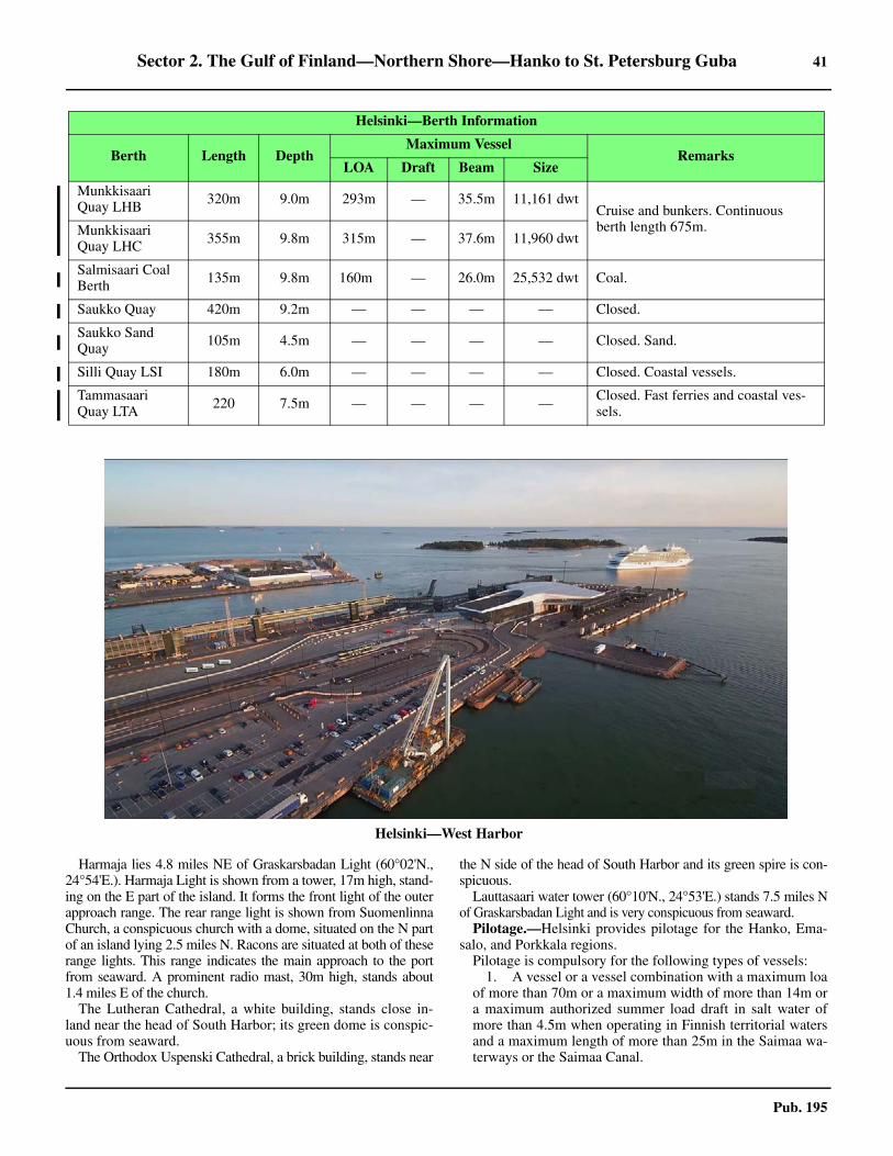
Sector 2. The Gulf of Finland—Northern Shore—Hanko to St. Petersburg Guba 41
Pub. 195
2.11 Harmaja lies 4.8 miles NE of Graskarsbadan Light (60°02'N.,24°54'E.). Harmaja Light is shown from a tower, 17m high, stand-ing on the E part of the island. It forms the front light of the outerapproach range. The rear range light is shown from SuomenlinnaChurch, a conspicuous church with a dome, situated on the N partof an island lying 2.5 miles N. Racons are situated at both of theserange lights. This range indicates the main approach to the portfrom seaward. A prominent radio mast, 30m high, stands about1.4 miles E of the church.2.11 The Lutheran Cathedral, a white building, stands close in-land near the head of South Harbor; its green dome is conspic-uous from seaward.2.11 The Orthodox Uspenski Cathedral, a brick building, stands near
the N side of the head of South Harbor and its green spire is con-spicuous.2.11 Lauttasaari water tower (60°10'N., 24°53'E.) stands 7.5 miles Nof Graskarsbadan Light and is very conspicuous from seaward.2.11 Pilotage.—Helsinki provides pilotage for the Hanko, Ema-salo, and Porkkala regions.2.11 Pilotage is compulsory for the following types of vessels:
1. A vessel or a vessel combination with a maximum loaof more than 70m or a maximum width of more than 14m ora maximum authorized summer load draft in salt water ofmore than 4.5m when operating in Finnish territorial watersand a maximum length of more than 25m in the Saimaa wa-terways or the Saimaa Canal.
Munkkisaari Quay LHB 320m 9.0m 293m — 35.5m 11,161 dwt
Cruise and bunkers. Continuous berth length 675m. Munkkisaari
Quay LHC 355m 9.8m 315m — 37.6m 11,960 dwt
Salmisaari Coal Berth 135m 9.8m 160m — 26.0m 25,532 dwt Coal.
Saukko Quay 420m 9.2m — — — — Closed.
Saukko Sand Quay 105m 4.5m — — — — Closed. Sand.
Silli Quay LSI 180m 6.0m — — — — Closed. Coastal vessels.
Tammasaari Quay LTA 220 7.5m — — — — Closed. Fast ferries and coastal ves-
sels.
2.11Helsinki—West Harbor
Helsinki—Berth Information
Berth Length DepthMaximum Vessel
RemarksLOA Draft Beam Size

42 Sector 2. The Gulf of Finland—Northern Shore—Hanko to St. Petersburg Guba
Pub. 195
2. A vessel carrying oil, liquefied gas, noxious liquidsubstances or dangerous goods in solid form in bulk.
3. A vessel carrying Irradiated Nuclear Fuel (INF) car-go.
2.11 Helsinki provides pilotage for Hanko, Emasalo and Porkkalaregions. Pilots are ordered through the Finnpilot Order Centre,Southern Pilotage Zone.2.11 Inbound vessels must provide 24-hour and 6-hour advancewarning of their ETA at the pilot boarding position. Vesselsmust then place a binding pilotage order 3 hours prior to arriv-al. Pilots will contact inbound vessels on VHF when they areless than 1 hour from the boarding position.
2.11 Departing vessels must provide 24-hour and 6-hour advancewarning through their agent. Vessels must then place a bindingpilotage order 2 hours prior to departure.2.11 Vessels shifting berth must provide 6 hours advance notice tothe Pilot Order Center with a confirmation sent 2 hours in ad-vance. 2.11 The Finnpilot Order Center will confirm receipt of the orderusing the same method as used to make the order. Orders usingthe form on the Internet Service can also be confirmed by e-mail if requested, providing an address is included. Ordersplaced by telephone are not confirmed separately after the call.2.11 Finland is divided into three Pilotage Zones, as follows:
1. Southern Pilotage Zone—Includes the pilotage areasof Helsinki, Porkkala, Emasalo, and Hanko.
2. Eastern Pilotage Zone—Includes the pilotage areasof Kotka (Orrengrund, Haapasaari, and Santio) and theSaimaa Canal (Lake Saimaa).
3. Western Pilotage Zone—Includes the pilotage areasof the Archipelago Sea (Uto, Isokari, and Mariehamn), Rau-ma, Mantyluoto (Pori), Vaasa (Kristiinankaupunki andKaskinen), Kokkola (Pietarsaari and vessels coming and go-ing S from Rahja), and the Bay of Bothnia (Tornio, Oulu,Raahe, and vessels coming and going N from Rahja).
2.11 To provide preliminary information and to place an order forpilotage, see the table titled Finnpilot Order Center—Con-tact Information.
2.11 During winter months, pilot boarding positions may be sub-ject to alteration according to the prevailing weather condi-tions.
2.11 Vessels having a draft of more than 9m, a length of morethan 160m, or a registered tonnage exceeding 18,000 tons canbe piloted through Kustaanmiekka (60°08.3'N., 24°59.7'E.),the narrow fairway leading between the islands in the E part ofthe port, only during daylight hours. The master or pilot mayalso consider it necessary to request the assistance of a strongtug. Vessels having a length of more than 201m or a registeredtonnage of more than 25,000 tons cannot be piloted throughKustaanmiekka, even though their draft is less than 9.6m. Suchvessels will be instructed to anchor off the port.2.11 Regulations.—The Gulf of Finland Reporting System(GOFREP), a mandatory ship reporting system under SOLAS,has been established in the Gulf of Finland and its approaches.This system is operated by the VTS centers at Tallinn (VHFchannel 61), Helsinki (VHF channel 60), and Saint Petersburg(VHF channel 74). For further information concerning GOF-REP, see Finland in Pub. 140, Sailing Directions (PlanningGuide) North Atlantic Ocean and Adjacent Seas.
Finnpilot Pilot Order Service
https://pilotorder.fi
Finnpilot Order Center—Contact Information
Southern Pilot Zone
Telephone 358-400-907-977
Facsimile 358-29 52 53010
E-mail [email protected]
Web site https://pilotorder.fi
Eastern Pilot Zone
Telephone358-400-907-978 (Kotka)
358-40-487-3133 (Saimaa)
Facsimile 358-29 52 53011
E-mail [email protected]
Web site https://pilotorder.fi
Western Pilot Zone
Telephone 358-400-907-979
Facsimile 358-29-52-53012
E-mail [email protected]
Web site https://pilotorder.fi
Head Office
Telephone 358-29-52-53000
Facsimile 358-29-52-53001
E-mail [email protected]
Web site https://finnpilot.fi
Pilot Boarding Locations
Porkkala (Inkoo and Kantvik)
Porkkala (South) 59°53'36.0''N, 24°11'39.6''E
Porkkala
Porkkala (North) 59°55'39.6''N, 24°14'12.0''E
Helsinki
Helsinki (South) 59°59'00.0''N, 24°56'54.0''E
Helsinki (North) 60°04'00.0''N, 24°58'12.0''E
Vuosaari
Vuosaari 60°04'57.6''N, 25°09'47.4''E
Emasalo (Porvoo, Skoldvik, Tolkkinen & Kalkkiranta)
Emasalo (North) 60°02'36.0''N, 25°33'48.0''E
Emasalo (South) 60°00'00.6''N, 25°32'37.2''E
Finnpilot Order Center—Contact Information

Sector 2. The Gulf of Finland—Northern Shore—Hanko to St. Petersburg Guba 43
Pub. 195
2.11 Vessel Traffic Service.—A Vessel Traffic Service (VTS) op-erates in the approaches to the coast.
2.11 The VHF channels cover the main navigation routes in theHelsinki, Emasalo, and Porkkala regions. This VTS systemconsists of the following sectors:
1. Helsinki VTS Sector 1—The approaches to the portof Helsinki in the area between Kyto Lighthouse, Helsinkicaisson and in the E, the area between Kaunissaari and Kalk-kiranta. The sector also include the administrative area of theport of Helsinki. The area is bounded by lines joining the fol-lowing positions:
a. 60°08.7'N, 24°43.5'E.b. 59°55.5'N, 24°43.5'E c. 59°58.2'N, 25°20.0'E.d. 60°10.3'N, 25°20.0'E e. 60°15.5'N, 25°25.0'E.
An updated version of the Helsinki VTS Master’s Guide isposted on the Traffic Management Finland web site. See the
link above for VTS Finland.2. Helsinki VTS Sector 2 (Western and Eastern)—
Covers the areas around Porkkala and Emasalo including themerchant shipping lanes, in the west the area between Jus-sarö and Kyto and in the east the area between Kalkkirantaand Emasalo, with the exception of the areas administeredby the ports. The sector also covers the areas administered bythe Port of Skoldvik and the Port of Tolkkinen.
3. Helsinki VTS Sector 2 (Western)—The area isbounded by lines joining the following positions:
a. 59°52.1'N, 23°33.0'E.b. 59°42.0'N, 23°33.0'E c. 59°55.5'N, 24°43.5'E.d. 60°08.7'N, 24°43.5'E
Fairways in Inkoo harbor are excluded. 4. Helsinki VTS Sector 2 (Eastern)—The area is
bound by lines joining the following positions:e. 60°15.5'N, 25°25.0'E.f. 60°10.3'N, 25°20.0'E g. 59°58.2'N, 25°20.0'E.h. 59°59.5'N, 25°44.5'E i. 60°12.5'N, 25°41.2'E.
2.11 The following areas are where passing and overtaking are
2.11Henri Bergius [CC BY-SA 2.0 (https://creativecommons.org/licenses/by-sa/2.0)] via Wikimedia Commons
2.11 Helsinki—South Harbor in summer
FinTraffic VTS Master’s Guide
https://www.fintraffic.fi/en/vts/masters-guide

44 Sector 2. The Gulf of Finland—Northern Shore—Hanko to St. Petersburg Guba
Pub. 195
prohibited in VTS Sector 1:1. In the 7.9m channel in the Sarkansalmi Strait between
latitude 60°08.8'N and latitude 60°09.1'N.2. In the Kustaanmiekka Strait between latitude
60°08.1'N and latitude 60°08.6'N in the 9.6m fairway.3. In the 11.0m fairway in the N part of Vuosaari Chan-
nel between latitude 60°11.1'N and latitude 60°12.5'N. 2.11 This prohibition does not apply to meeting and overtakingsituations in which at least one of the parties is a tug or a vesselwhose size is comparable to a tug.2.11 The following areas are where passing and overtaking shouldbe avoided in VTS Sector 2 and the Emasalo Fairway:
1. Vessels should avoid passing and overtaking in theharbor area north of latitude 60°17.8'N (Quay 8). This prohi-bition does not apply to passing and overtaking situations inwhich at least one of the vessels is a tug or a vessel, the sizeof which is comparable to a tug.
2. Between Estamsudden and Varlaxudden.3. Between Kollhallan and Neste C.4. In the 9.0m fairway marked with lateral buoys in
Stenoren.2.11 Vessels are obligated to agree, well in advance, on passing
and overtaking so that they meet outside these areas. Whennecessary, Helsinki VTS determines a place for passing orovertaking. 2.11 The working channel of Helsinki VTS Sector 1 is VHF chan-nel 71. The working channel of Helsinki VTS Sector 2 is VHFchannel 9. 2.11 Vessels must report their vessel name, reporting point name,destination, and intended route. If an alternative route is select-ed, this must be reported.2.11 Before departure from Port of Helsinki, vessels shall submita departure report in order to be given permission to depart.2.11 In Helsinki South Harbor and West Harbor, vessels mustsubmit a departure report when they are ready to depart in 5minutes.2.11 When leaving Vuosaari Harbor, the permission to depart is inforce for 15 minutes, during which time the vessel must get un-derway. The vessel is required to give a report when underway.2.11 At the reporting points in the area:
1. Vessels must report 15 minutes before arriving at theKustaanmiekka or Sarkansalmi straits.
2. Northbound vessels must report when passing Itatoukki.3. Eastbound vessels must report 15 minutes before
2.11Helsinki City Museum [CC BY 4.0 (https://creativecommons.org/licenses/by/4.0)] via Wikimedia Commons
2.11Helsinki—North Harbor

Sector 2. The Gulf of Finland—Northern Shore—Hanko to St. Petersburg Guba 45
Pub. 195
passing Kuiva Hevonen in the coastal fairway.4. Fifteen (15) minutes before entering Barosund.
2.11 A preliminary notice of departure for vessels departing fromPort of Helsinki is required. All vessels, except those in linertraffic sailing according to a published timetable, must give apreliminary notice of departure after berthing. Any changes tothe time of departure indicated in the notice of departure or inthe published liner traffic timetable must be reported to VTS assoon as possible. If a vessel departs later than the time reportedin the notice of departure, the vessel must immediately reportthis to the VTS.2.11 The following procedures apply to the Vuosaari fairway:
1. The organization of vessel traffic departing from Vu-osaari Harbor includes a procedure regarding permission todepart. When a vessel that is ready to leave port submits adeparture report, the VTS grants or denies permission to de-part from the port depending on the traffic situation. A grant-ed permission to depart is in force for 15 minutes. VTS doesnot grant permission to depart if there is a vessel in the fair-way entering the harbor, and that vessel has passed Itatoukki,reported 15 minutes to Kuiva Hevonen or entered the areafrom the east from another sector. If the vessel is not ready todepart within 15 minutes and there are other vessels waitingfor their turn to enter the area where meeting and overtakingis prohibited, the vessel misses its turn to depart. In that casethe vessel must give a new departure report to the VTS be-fore being granted permission to depart. The procedure re-
garding permission to depart also concerns vessels movingfrom one berth to another in the harbor area.
2. Vessels reporting at Itatoukki, entering sector 1 areafrom the E or reporting 15 minutes prior to passing KuivaHevonen, will be given information by the VTS about meet-ing traffic and other information relevant to the safe passageof the ship.
3. During strong winds (mean wind 13 m/s or more) theVTS recommends that vessels in Vuosaari fairway only meetsouth of Ostra Rodhallen. The VTS does not organize thetraffic of meeting vessels outside the area where meeting andovertaking is prohibited, but vessels are requested to agreeamong themselves on how to meet safely.
4. When the use of the fairway is restricted due to thewind situation and vessels have to wait for entrance into thefairway, they have the option to reduce speed in order to en-sure a safe meeting south of Ostra Rodhallen. When organiz-ing the traffic, the VTS makes sure that the vessel does notlose its turn to enter the fairway because of its reducedspeed, by taking into account the original speed at which thevessel would have arrived at Itatoukki.
2.11 The following procedures apply to the approach to the Hel-sinki West Harbor fairway.
1. The VTS organizes inbound and outbound vessels tothe West Harbor according to the schedules submitted by thevessels in advance.
2. A vessel leaving the West Harbor in Helsinki must
2.11Helsinki and Hanko VTS

46 Sector 2. The Gulf of Finland—Northern Shore—Hanko to St. Petersburg Guba
Pub. 195
submit a departure report in order to be granted permissionto depart by the VTS. The departure report shall be submit-ted when the vessel is ready to depart within 5 minutes.During strong winds (maximum wind speed 15 m/s) the ves-sel will not be granted permission to depart if another vessel,with a length over 215m, is already in or about to enter themaneuvering basin.
3. Inbound vessels are well in advance informed aboutthe order in which to enter the fairway. The order is based onthe agreed berthing times obtained by the Port of Helsinki.
2.11 The following speed limits apply to the Helsinki VTS:1. In all fairway sections leading to a Helsinki port N of
the latitude 60°06.0’N, with Itakari as the E limit, the speedlimit is 16 knots.
2. In the harbor basins in the Port of Helsinki and aroundKlippan the speed limit is 5 knots.
3. In the Vuosaari fairway a speed limit of 16 knots is inforce between Ostra Rodhallen and Krokholmshallet.
4. A speed limit of 9 knots is in force between Krokhol-mshallet and Vuosaari Harbor as well as in the Vuosaari Har-bor area.
5. During the winter season (1 November-31 March) aspeed limit of 13 knots will be in force in the Vuosaari fair-way between Krokholmshallet and Vuosaari Harbor.
2.11 Contact Information.—See the table titled Helsinki—Con-tact Information.
2.11 Anchorage.—A designated outer anchorage area, withdepths of 22 to 45m, is centered about 1.4 miles NNW of Hel-sinki Light (59°57'N., 24°56'E.) and may best be seen on thechart.2.11 Anchorage can be taken, in a depth of 22m, mud and stones,off the W side of Susisaari, about 0.6 mile SW of HarmajaRear Range Light (Suomenlinna Church). This is a good tem-porary anchorage but is open to onshore winds.2.11 Kruunuvuorenselka, the E roadstead, affords the best an-chorage, in depths of 12 to 16.5m, mud. This anchorage iswell-protected from all winds.2.11 Directions.—The main approach to the port leads in a N di-rection from the Traffic Separation Scheme (TSS) in the Gulfof Finland. This route, which is authorized for drafts up to11m, passes close E of Helsinki Light (59°57'N., 24°56'E.) andis indicated by a lighted range (see Aspect). It then branchesNW and N, at a junction about 3.8 miles N of the light, to ap-proach the W and E areas of the port.2.11 From the junction, the main channel, authorized for drafts upto 11m, leads NW and passes close NE of GraskarsbadarneLight (60°02'N., 24°54'E.). It then turns in a N direction andleads into West Harbour (Lansistama).2.11 From the junction, the alternate channel, authorized fordrafts up to 9.6m, leads NNE. It passes close E of HarmajaFront Range Light, through narrow passages between the is-lands, and into the harbors in the E part of the port.2.11 The port may also be approached from W or E by using theWinter Channel. This coastal fairway is authorized for draftsup to 9m. The routes from the E and W lead in a W directionand in a NE direction, respectively, and meet the main alternatechannel, authorized for drafts up to 9.6m, about 0.9 mile NNEof Harmaja Front Range Light.2.11 A secondary channel, authorized for drafts up to 9m, alsoleads NNW from the alternate channel at a position about 1.5miles S of Harmaja Front Range Light. It extends for 2 milesand joins the Winter Channel (coastal fairway) about 0.7 mileWNW of Harmaja Front Range Light.2.11 Another approach route, authorized for drafts up to 7.5m,leads NE from seaward. It passes about 2.5 miles NW of Hel-sinki Light and meets the main approach channel 3.5 miles Nof the light. This route is used by passenger ferries.
Helsinki—Contact Information
Port
VHF VHF channels 12 and 16
Telephone 358-9-310-1621
Facsimile 358-9-310-33802
E-mail [email protected]
Web site https://www.portofhelsinki.fi
Harbormaster
Telephone 358-9-310-33676
Docking Master
VHF VHF channels 12 and 71
Telephone 358-9-310-33600
Facsimile 358-9-310-33619
Vuosaari Harbor
VHF VHF channel 12
Telephone
358-4-012-93745 (24 hours)
358-4-065-73350
358-4-04829571 (Supervisor: 0700-1500)
[email protected] (ship services)
[email protected] (waste handling)
VTS
Call sign Helsinki VTS
VHFVHF channel 71 (Sector 1)
VHF channel 9 (Sector 2)
Telephone
358-20-448-5385 (Sector 1)
358-20-448-5389 (Sector 2)
358-20-448-5391 (Supervisor)
Facsimile 358-20-448-5380
Tugs
VHF VHF channels 6, 8, and 16
Helsinki—Contact Information

Sector 2. The Gulf of Finland—Northern Shore—Hanko to St. Petersburg Guba 47
Pub. 195
2.11 The fairway channels and routes, which may best be seen onthe chart, are indicated by lighted ranges and marked by light-ed beacons and buoys. 2.11 The seaward approach route to Vuosaari leads NE for 3miles and N for 4 miles to the vicinity of Ytter Tjarhall Light(60°08'N., 25°19'E.), which is equipped with a racon. The in-ner part of the route, which is authorized for drafts up to 7.5m,passes close SW of the light and continues in a NW directionfor about 4.5 miles through the off-lying dangers. It then leadsin a NNE direction for about 1.5 miles to the harbor.2.11 It is reported that a new primary seaward approach route to Vu-osaari has been established. It has a minimum width of 200m, adredged depth of 12.5m, and is authorized for drafts up to 11m.The route extends in a NNE direction from a position locatedabout 3.5 miles E of Helsinki Light (59°57'N., 24°56'E.). It passesabout 1.2 miles SSE of Lansitoukki (Vastertokan) (60°05.5'N.,25°08.0'E.) and close NNW of Itatoukki (Oster Tokan)(60°06.0'N., 25°11.8'E.), an islet marked with a racon. From closeN of this islet the track continues in a N direction for about 5.5miles through the off-lying dangers. It passes about 0.6 mile W ofEstlotan (Estiluoto) (60°07.5'N., 25°13.5'E.), an islet marked by aprominent tower; close W of Kulva Hevonen (Torra Hasten)(60°10.5'N., 25°13.3'E.); and close W of Krokholmen(60°11.6'N., 25°13.9'E.). From close E of the E end of LillaBaston (60°12.2'N., 25°12.7'E.) the route then extends for about 1mile in a NW direction to the harbor entrance. Pilots for this routewill board vessels about 2 miles SSW of Itatoukki (Oster Tokan).An anchorage area has been established along this route. It lies ad-jacent to the W side of the fairway, between Kulva Hevonen (TorraHasten) and Krokholmen. 2.11 Caution.—Numerous submarine cables and pipelines,which may best be seen on the chart, extend between the manyislands in the harbor and the approaches.2.11 A dangerous rock, best seen on the chart, lies close N of theisland of Harmaakari. 2.11 Due to silting, the authorized drafts in the approach routesmay, on occasion, be reduced. Vessels are advised to contactthe authorities in advance for the latest information concerningdepths in the approach passages.
Helsinki to Kotka
2.12 Loviisa (60°27'N., 26°14'E.), a port, lies about 40miles ENE of Helsinki. The coast between is hilly, wooded,and fronted by numerous islands, islets, rocks, and shoals.These dangers lie up to 13 miles seaward of the coast and sev-eral inshore passages lead between them. Vessels should not at-tempt to enter the inshore channels without local knowledge.2.12 The 40m curve lies up to 16 miles offshore in this vicinity.Within this curve, the depths are very irregular.2.12 Porvoo and Loviisa are the only ports of any importancealong this stretch of coast.2.12 Kalbadagrund (59°59'N., 25°36'E.), an extensive reef, liesabout 20 miles E of Helsinki Light and has a least depth of 2m.Kalbadagrund Light is shown from a prominent tower, 25mhigh with a helicopter platform, standing on the S part of thisreef. A racon is situated at the light.2.12 Shoals, with depths of 3.1m and 9.7m, lie about 4 miles E ofthe light and form the outermost dangers in this vicinity. 2.12 Porvoo Light (60°06'N., 25°36'E.) is shown from a promi-
nent tower, 10m high, standing 6.5 miles N of KalbadagrundLight. A racon is situated at the light.2.12 Soderskar Beacon (60°07'N., 25°25'E.), a disused lighttower, stands on an islet about 5.5 miles WNW of PorvooLight. It is 30m high and prominent.2.12 Tiiskeri (Digskar) (60°10'N., 26°16'E.), the largest islet of agroup surrounded by foul ground, lies about 23 miles NE ofKalbadagrund. A light is shown from a tower, with a wind gen-erator, standing on this islet. A racon is situated at the light.2.12 Shoals, with depths of 7.2m to 10m, lie within about 3.5miles SW of this light and form the outermost dangers in thisvicinity.2.12 Skarvgaddarna Light (60°11'N., 26°08'E.) is shown from atower standing 4.2 miles WNW of Tiiskeri. A racon is situatedat this light.2.12 Gasskvattan Beacon (60°11'N., 26°03'E.), standing on anabove-water rock, lies 2.3 miles W of Skarvgaddarna Light. Aracon is situated at this beacon.2.12 Emsalo (60°15'N., 25°37'E.) and Vessolandet (60°17'N.,25°43'E.) are two large islands occupying the greater portion ofthe indentation of the coast close S of Porvoo. Numerous is-lands and foul ground lie between the N ends of these islands.
2.13 Porvoo (60°23'N., 25°40'E.) (World Port Index No.28210), also known as Skoldvik, is situated 27 miles E of Hel-sinki. The channel leading to this oil port is kept open by ice-breakers, but is affected by ice from about the middle ofDecember until April. For Traffic Service, see details on Hel-sinki VTS. 2.13 Depths—Limitations.—The main approach channel lead-ing to the port is 270m wide and authorized for drafts up to15.3m.2.13 There are six berths for oil products and one for petrochemi-cals. There are LPG facilities at Berth No. 1 and Berth No. 5.The berths have depths of 7.3 to 17.6m alongside. Vessels up to262,200 dwt, 340m in length, and 15.3m draft can be accom-modated.2.13 During the ice-free period, all berths are surrounded by oilbooms. In winter, vessels are limited to a maximum beam of21.3m.2.13 Aspect.—Beacons and buoys, including virtual aids to navi-gation, mark the dangers in the approaches to the port. PorvooLight along with Larsskar Light, 3.2 miles N, forms a range,which indicates the main approach from seaward. The routeleads NNE and passes about 1.8 miles W of KalbadagrundLight. 2.13 Pilotage.—Pilotage is provided by Helsinki (see paragraph2.11). The pilot boards in Emasalo S (60°00.1'N., 25°32.6'E.)or in Emasalo N (60°02.6'N., 25°33.8'E.), about 2 miles WNWof Kalbadagrund Light. 2.13 Regulations.—Vessels should send the following informa-tion to the port (Fortum Harbour) 72 hours prior to arrival:
1. Vessel’s name and nationality. 2. Master’s name.3. Owner or operator of vessel.4. Telex, facsimile, and telephone numbers of vessel.5. Draft fore and aft. 6. Port of departure. 7. Confirmed ETA. 8. Quantity, type, IMO class, and UN number of cargo.

48 Sector 2. The Gulf of Finland—Northern Shore—Hanko to St. Petersburg Guba
Pub. 195
9. Quantity, type, and IMO class of cargo to be loaded.10. Three previous cargoes.11. If cargo tanks are inerted and confirmation that oxy-
gen content is below 8 per cent.12. Thrusters, bow or stern (number and effect). 13. All equipment functioning well.14. Quality and quantity of contained ballast water or
mixtures containing oil or chemicals to be discharged.15. Quality and quantity of waste to be discharged.16. Quality and quantity of bunkers to be loaded.17. Any measures subject to permission.18. List of equipment relating to navigation, safety, or
cargo handling not in working order.19. If vessel is ready to load or discharge upon arrival.
2.13 Vessels should confirm the ETA 24 hours in advance andstate the vessel’s name and nationality, gt, draft fore and aft,ETA at pilot boarding position, and date and time of the notice.2.13 Any change to the ETA must be forwarded immediately.2.13 Vessels Traffic Service.—The Helsinki VTS provides ves-sels proceeding to or departing from Porvoo with service. Seeparagraph 2.11 for details.2.13 Contact Information.—See the table titled Porvoo—Con-tact Information.
2.13 Anchorage.—Anchorage can be taken, in a depth of 22m,good holding ground, close E of the oil harbor.2.13 A designated anchorage area, with depths of 19 to 30m, liescentered about 3 miles NW of Kalbadagrund Light, W of themain entrance fairway. Generally, anchorage in the outer ap-proaches is not safe except during calm weather.
2.14 Pellinge (Suur Pellinki) (60°13'N., 25°50'E.) is thelargest island of a group which fronts the mainland and extendsE for almost 7 miles. Numerous rocks and shoal patches extendup to about 13.5 miles S from this island, terminating in the vi-cinity of Kalbadagrund Light. 2.14 Fairways, with draft limitations of 7m and 7.3m, lead E andS of the group. They then branch to lead in a N directionthrough the E part of the islands and NE of Vatskar (60°18'N.,
26°07'E.), where they rejoin and lead ENE to Boiso (60°20'N.,26°30'E.). A fairway, with a least charted depth of 2m, leadsthrough the N part of the islands. These fairways, althoughwell-marked by buoys, beacons, and lighted ranges, should notbe used without local knowledge. 2.14 Kejvsalo Fjarden (60°22'N., 26°08'E.), entered about 3 miles Nof Vatskar, extends about 11 miles NW. This inlet is encumberedby numerous islets and shoals, but a fairway, authorized for draftsup to 6.1m and marked by buoys, leads along the NE part to Per-naja (60°26'N., 26°03'E.), an anchorage loading place for Loviisa,located about 6 miles from the entrance. A fairway, authorized fordrafts up to 4.3m, branches W about 2.3 miles SE of Pernaja andleads to a loading place in Isnasvik, 3 miles SW of Pernaja. Thereis a jetty, with a depth of 4.2m alongside, at Isnasvik.2.14 Hamnskar (60°13'N., 26°18'E.), fronted by foul ground, is alow, bare islet with a monument situated at its W side. A light,used by fishing vessels, is shown from a structure standing onthe E side of the islet.2.14 Tainio Light (60°13'N., 26°25'E.) is shown from a tower,14m high, standing on a shoal at the E side of the fairway lead-ing to Loviisa. A racon is situated at the light. 2.14 Skarven Light (60°18'N., 26°21'E.) is shown from a towerstanding on the N end of a group of reefs on which lie severalislets. A racon is situated at this light.2.14 Orrengrund (60°16'N., 26°27'E.) is a low sparsely-woodedisland. It is steep-to on the W side, but foul ground extends upto about 0.5 mile SE from the S part of the island. The island ofBaksor lies on this foul ground. A light is shown from a flood-lit tower standing on the W side of the island. A prominenttower, 23m high, is situated close NE of the light. A lightedrange is shown from the E part of the island; a racon is situatedat the front light.2.14 Vastra Baken Light is shown from a structure standing about0.5 mile W of the W end of Orrengrund. 2.14 Lalatta Light (60°17'N., 26°33'E.) is shown from an isletsurrounded by foul ground. A racon is situated at this light.2.14 Range lights are also shown from Ostergrund, an islet about1 mile NE of Orrengrund. 2.14 Stor Taktaren (60°20'N., 26°22'E.), with Yttre Taktaren lo-cated close S of it, lies on the SW side of the fairway leading toLoviisa. Foul ground extends up to 1.7 miles SE of these isletsand is marked by spar buoys. Patches of foul ground also lie upto 1 mile E and between Stor Taktaren and Stora Rovaren,about 0.5 mile N. Range beacons are situated at various placeson these islets.2.14 Caution.—It is reported that overhead lines, with a mini-mum vertical clearance of 10.8m, extend across the channelleading to Pernaja (60°26'N., 26°03'E.). A shoal with a danger-ous rock in position 60°19.1'N, 26°34.7'E is marked by a light-ed buoy.
2.15 Loviisa (Lovisa) (60°27'N., 26°14'E.) (World Port In-dex No. 28220), a small port, lies at the head of Loviisanlahti(Lovisaviken) and includes the facilities at Valkom, which issituated on the W shore of the inlet, 2 miles S. The facilities atLoviisa are used mostly by local coasters.2.15 Ice.—The main navigation season lasts from the end ofApril to the beginning of December. Generally, icebreakerskeep the port open all year.2.15 Depths—Limitations.—The main approach channel lead-
Porvoo—Contact Information
Port
Call sign Neste Oil Harbor
VHF VHF channels 16 and 21
Telephone358-10-4583115 (24 hours)
358-10-4583117 (24 hours)
Facsimile 358-10-4583757
E-mail [email protected]
Traffic Coordinator
Telephone 358-10-4583101
Hours Monday-Friday (0800-1600)
Harbormaster
Telephone 358-10-4583106
Hours Monday-Friday (0800-1600)

Sector 2. The Gulf of Finland—Northern Shore—Hanko to St. Petersburg Guba 49
Pub. 195
ing from seaward to the berthing facilities at Valkom is autho-rized for drafts up to 8.5m. The fairway continuing to Loviisais authorized for drafts up to 4m.2.15 North Quay is 142m long and has a depth of 8.5m alongside;Middle Quay is 280m long and has a depth of 7.3m alongside;Connection Quay is 115m long and has a depth of 7.3m along-side; and South Pier is 135m long and has a depth of 8.5malongside. There are facilities for container, ro-ro, tanker, bulk,and general cargo vessels.2.15 The Sawmill Wharf at Loviisa is 60m long, with a depth of4m alongside. There is also a basin for small craft and yachts.2.15 Pilotage.—Pilotage is compulsory and must be requestedthrough the Finnpilot Order Center, Helsinki (see paragraph2.11). Pilots may be contacted by VHF and generally board inposition 60°14'18.0''N, 26°25'21.6''E (Orrengrund). 2.15 Anchorage.—Anchorage can be taken, in a depth of 17m,mud, about 0.5 mile SW of Svartholm (60°23'N., 26°18'E.)and, in a depth of 9m, mud, about 0.5 mile NNE of Valkom.2.15 Directions.—From E of Tiiskeri Light (60°10'N., 26°16'E.),an outer approach route, indicated by a lighted range, leadsabout 5.5 miles NNE to the vicinity of Orrengrund and the pi-lot boarding place. It passes SE of Hamnskar and NW of TainioLight. An intricate fairway then leads in a NNW direction tothe berths. It is indicated by ranges, sector lights, and beacons.
2.16 The coast between Loviisa and Hamina (60°34'N.,27°12'E.), 29 miles ENE, is densely wooded, as are several ofthe islands fronting it. The shore is indented by a number of in-lets. The ports are Kotka and Hamina are situated along thisstretch.2.16 The 40m curve lies about 13 miles offshore to the W of Os-trov Gogland, which was described in paragraph 1.5. Thedepths are irregular and the dangers in this vicinity extend S towithin 2 miles NW of Ostrov Gogland.
Between Munapirtti (60°25'N., 26°30'E.) and Kotko, 8 milesENE, the islands, islets, and areas of foul ground extend up to3.5 miles seaward. The outer dangers are marked by buoys,beacons, and lights.
Mustaviiri, an island, lies 1.8 miles SE of Lalatta Light and aconspicuous tower stands near its center. A shoal extends up toabout 2.5 miles SSW from the SW part of this island.
Kotkan Majakka Light (60°10'N., 26°39'E.) is shown froma column, with a helicopter platform, standing on a shallowshoal. A racon is situated at the light.
A shoal area, with depths less than 10m, extends up to about5.5 miles SSE from the light. Banka Margasova, marked by alighted buoy, lies 1 mile NW of the light. 2.16 Haapasaari (60°17'N., 27°12'E.) is one of an extensivegroup of islands which, lying close to one another, appear asone island when seen from a distance. The larger islands arepartly wooded and moderately high, while the smaller are lowand bare. 2.16 Haapasaari is divided into E and W parts which are connect-ed by a narrow isthmus. A prominent church, with a gray roof,stands on the E part and a radio tower is situated on the SWpart. A prominent square tower, with a pointed roof, stands onthe NW side of the island. A light is shown from the NE ex-tremity of the island; another light is shown from Kivikare, a
rock lying close NE of the island.2.16 Pilot boards in position 60°15.4'N, 26°26.8'E. 2.16 Good anchorage can be obtained off the S side of Haapas-aari, in depths of 9 to 11m, clay, but local knowledge is ad-vised. Anchorage can be obtained about 0.4 mile N of the Nside of the island, in depths of 22 to 29m, mud. Anchorage mayalso be taken about 0.4 mile E of the island, in depths of 18 to20m, sand and stone, but this anchorage is exposed to SWwinds.2.16 Veitkara (60°16'N., 27°15'E.), a small island, lies on a shoalat the SE end of the group. A light is shown from its N part. Aracon is situated at the light.
2.17 Luppi (60°14'N., 27°02'E.), marked by a light, is theoutermost of the islands and shoals which extend up to about 6miles SW from Haapasaari.2.17 Reippo, a shoal with above and below-water rocks, lies 1.5miles W of Luppi. Numerous dangers, including rocks awash,extend up to about 6 miles SW from this shoal.2.17 Tuomalamatala, a shoal with a depth of 7.9m, lies about 2.2miles SSW of Veitkara. It is marked by a buoy and is the outer-most danger in the approach to Haapasaari.2.17 Merikari (60°21'N., 27°06'E.), an islet, lies 5 miles NW ofHaapasaari and is marked by a light. Shoals, marked by buoys,front this islet on its S and W sides.2.17 Rankki (60°22'N., 26°58'E.), an island, lies near the S endof an extensive shoal area. A light is shown from a tower, 6mhigh, standing on an islet located close S of the S extremity ofthe island.2.17 Retonpaasi (60°22'N., 27°01'E.), a rock awash, lies about1.5 miles E of the S end of Rankki and is marked by a lightedbeacon. 2.17 Rankin Kivikari (60°21'N., 26°57'E.), a shoal with above-waterrocks, lies about 0.8 mile SW of the S end of Rankki and ismarked by a light at the N end. A racon is situated at the light.2.17 Lellerinsaaret (60°24'N., 26°58'E.), a group of three isletsand foul ground patches, lies about 1.5 miles NNE of Rankki.A light is shown from the easternmost islet of this group.2.17 Hietakari (60°24'N., 27°00'E.) lies about 1 mile E of Leller-insaaret on an area of foul ground about 0.5 mile off the W sideof Kirkkomaansaari. A light is shown from this islet. 2.17 Kiviletto (60°18'N., 26°57'E.), a shoal with above-waterrocks, lies about 4 miles NW of Luppi Light and is marked bya light.2.17 Ristisaari, an islet, lies 4.2 miles WNW of Kiviletto near the Send of an area of foul ground. This foul area extends up to about 5miles NNW and Kaunissaari, an island, is located in its N part. Alight is shown from the N extremity of Kaunissaari and a beaconstands on a shoal about 0.3 mile S of the S extremity of Risisaari.
Kotka (60°28'N., 26°58'E.)
World Port Index No. 28230
2.18 Kotka, the second largest port of Finland, is situated atthe mouth of the Kymijoki River and in a bay which is protect-ed by numerous islands and islets. The city stands on the islandof Kotka. The area is typically industrial with sawmills, sugar

50 Sector 2. The Gulf of Finland—Northern Shore—Hanko to St. Petersburg Guba
Pub. 195
mills, pulp, cellulose, fertilizer, and chemical plants.
2.18 Ice.—The main navigation season lasts from the middle ofApril to the beginning of January, but the harbor is usually keptopen all year by icebreakers. The quays are kept ice free by anunderwater compressed air system which prevents ice forma-tion.2.18 Tides—Currents.—The water level is affected greatly bythe winds. Gales from S to SW increase the water level of theharbor up to 0.9m above normal. Gales from N decrease thelevel about 0.3m. The currents are inappreciable, but since theKymijoki, one of the largest rivers flowing into the Gulf of Fin-land from the numerous inner lakes, empties into the harbor,the set is nearly always S.2.18 Depths—Limitations.—The main route leading from sea-ward to the harbor is authorized for vessels with drafts up to15.3m, weights up to 120,000 dwt, and lengths up to 300m.The smaller northeastern VTS route has a maximum autho-rized draft of 5.9m.2.18 The port has facilities for ro-ro, bulk, tanker, general cargo,timber, container, and passenger vessels. In addition to themain facilities described below, several private quays and piersare situated within the port.2.18 The Mussalo (60°27'N., 26°53'E.) district is situated in theSW part of the port and includes terminals for container, drybulk, and liquid bulk vessels.2.18 The container terminal basin, which is straddled by the B-Quay and C-Quay, has 1,436m of total dockage and provideseight berths. Vessels up to 10m draft can be handled at six ofthe berths and vessels up to 12m draft can be handled at theother two. The completion (2019) of a 620m breakwater proj-ect, along with land reclamation and dredging, immediately tothe W the Mussalo Container Terminal, created a new D-Quayarea with a deep water basin and a charted depth of 17.5m.2.18 The Mussalo Dry Bulk Terminal Quay, located along the A-Quay, has a continuous length of 612m and provides fourberths. Vessels up to 15.3m draft can be handled.2.18 The liquid bulk terminal, operated by Oiltankings, consistsof a pier which provides two berths (N1 & N2). Tankers up to13.5m draft can be handled.
2.18 Approximately 0.4 mile N of the bulk liquid terminal is theJanska or Baltic Tank basin, with depths from 8.6 to 9.6m.2.18 The City Terminal (Kantasatama) district, located approxi-mately 3 mile NNE of Mussalo, is situated at the N most sideof Kotka island. The Kantasatama is the oldest part of the portof Kotka and is gradually shifting from a wood-processing-in-dustry cargo port to a passenger and cruise traffic hub. 2.18 The main quays at the City Terminal include Italaituri, 455mlong, with depths of 8.3 to 9.1m alongside; Valilaituri, 425mlong, with charted depths of 8.3 to 9.1m alongside; Pohjoislai-turi, 265m long, with charted depths of 7.3 to 7.8m alongside;and Harniemenlaituri, 975m long, with charted depths of 6.5 to7.2m alongside.2.18 The Hietanen South Terminal, a bulk terminal, is situatedclose W of the City Terminal. The quay (T1-T4), also known
as the Poland Quay, or sometimes Vasikkasaaten, is 363m longand can handle vessels up to 8.5m draft.2.18 Hietanen harbor and ro-ro terminal are situated 1 mile N ofthe City Terminal. The quay is about 1,000m long and providessix berths (H1-H6). Vessels up to 10m draft can be accommo-dated alongside.2.18 Sunila Quay, a dry bulk terminal, is situated on the W side ofthe island of Pyotinen, close E of Hietanen. The quay is 390mlong and provides two berths (S1-S2). Vessels up to 7.4m draftcan be handled alongside.2.18 The Halla Terminal, involved in timber processing and ex-port, is located on the E side of the Halla island/peninsula. It’s
Port of Haminakotka
https://www.haminakotka.com
2.18Kotka—Mussalo (oil terminal)
2.18Kotka—Mussalo (dry bulk terminal)
2.18Kotka—City Terminal

Sector 2. The Gulf of Finland—Northern Shore—Hanko to St. Petersburg Guba 51
Pub. 195
two berths (U1-U2) comprise 240m of quay and may handlevessels up 8.5m draft.2.18 Aspect.—The harbor lies at the seaward end of a heavilywooded valley formed by the Kymijoki River. From seaward,the islands and the coast blend together.2.18 A prominent tower, with a chimney situated close NW,stands in the E part of Kotka. Another prominent chimneystands about 1 mile NNE of the tower. A conspicuous monu-ment stands on the E part of Varissaari, an islet lying about 1.2miles S of the tower. A prominent water tower is situated in theW part of the city. Kotka Church stands in the NE part of thecity and is conspicuous.2.18 The approach routes and entrance channels are indicated by
lighted ranges which may best be seen on the chart. Adjacentdangers are marked by lights, beacons, and buoys.2.18 Pilotage.—Kotka is part of the Finnpilot Pilotage Authority,Eastern Zone. See paragraph 1.1 for details on Finnpilot. Pilot-age is compulsory for the following:
1. A vessel or a vessel combination with a maximum loaof more than 70m or a maximum width of more than 14m orwhose greatest summer load draft in salt water is more than4·5m.
2. A vessel carrying bulk cargo of hazardous substancesor substances that can pollute the sea.
3. A vessel belonging to a foreign government, which isnot used in commercial operations.
Kotka—Berth Information
Berth Length DepthMaximum Vessel
RemarksLOA Draft Beam Size
City Terminal (Kantasatama Harbor)
Italaituri Quay 172m — 153m 9.0m 20.6m 9,595 dwt Cruise vessels and ro-ro/lo-lo.
Pohjoislaituri Quay 98m — — 6.3m — — Cruise vessels and ro-ro/lo-lo.
Valilaituri North Quay 205m — 165m — 23.4m 11,407 dwt Cruise vessels and ro-pax.
Valilaituri South Quay 200m — 165m 7.7m 23.4m 11,407 dwt Cruise.
Halla Terminal
U1- U2 240m — 132m 8.5m 18.8m 8,733 dwt Ro-ro/lo-lo
Hietanen Harbor
H1 140m — 134m 7.9m 20.0m 7,200 dwt Ro-ro/lo-lo.
H2 155m — 205m 10.0m 26.2m 18,250 dwt —
H3-H5 580m 10.0m 217m 10.0m 26.5m 18,250 dwt Ro-ro/lo-lo and containers.
H6 186m 10.0m 217m 10.0m 26.5m 18,250 dwt Ro-ro freight.
Hietanen South (Poland Quay)
T1-T4 360m 8.5m 153m 8.5m 23.6m 20,406 dwt Bulk cargo.
Mussalo Bulk Terminal
A1-A4 600m 13.5m 225m 13.5m 32.2m 75,800 dwt Others.
Mussalo Container Terminal
B0 142m 10.0m 156m 10.0m 25.6m 18,148 dwt
Ro-ro/lo-lo and containers. Continuous berthing length of 852m.
B1 142m 10.0m 201m 10.0m 32.2m 62,045 dwt
B2 142m 10.0m 179m 10.0m 29.9m 35,737 dwt
B3 142m 10.0m 189m 10.0m 28.5m 37,125 dwt
B4 142m 10.0m 189m 10.0m 28.5m 38,146 dwt
B5 142m 10.0m 201m 10.0m 32.2m 62,041 dwt

52 Sector 2. The Gulf of Finland—Northern Shore—Hanko to St. Petersburg Guba
Pub. 195
2.18 Pilots board, as follows:1. Vessels with a maximum draft of 10m are advised to
use the Orrengrund 10m fairway and the Orrengrund pilotboarding position (0°14'18.0''N., 26°25'21.6''E.).
2. Vessels with a maximum draft of 15.3m using theMussalo Fairway—Kotkan Majakka pilot boarding position(60°07'N., 26°30'E.).
3. Vessels with a maximum draft of 7.3m from or to theE—Haapasaari pilot boarding position (60°15'N., 27°16'E.)(closed during winter).
4. Vessels approaching from the E may embark a pilot atSantio (60°27'N., 27°42'E.).
2.18 Pilots can be contacted on VHF channel 13 or 16.
2.18 All ordering of local pilots throughout Finland is carried outby the Finnpilot Order Center with the major areas and morelocal areas, including Kotka.2.18 Regulations.—GOFREP, a mandatory ship reporting systemunder SOLAS, operates in the Gulf of Finland and its ap-proaches (see paragraph 2.1 for more details). More informa-tion regarding GOFREP and Kotka VTS may be found at theVTS Finland web site below.2.18 Vessel Traffic Service.—Kotka Vessel Traffic Service(VTS) system operates within the approach fairways of theport pilotage area. Radio communications are in English, Finn-
C0 155m
10.0-12.0m
140m 10.0m 23.2m 12,193 dwt
Ro-ro/lo-lo and containers. Continuous berthing length of 930m.
C1 155m 244m 10.0m 35.2m 40,881 dwt
C2 155m 244m 10.0m 35.2m 40,881 dwt
C3 155m 216m 10.0m 35.2m 40,079 dwt
C4 155m 244m 10.0m 35.2m 40,881 dwt
C5 155m 244m 10.0m 35.2m 46,852 dwt
Pohjolan Voima Power Plant (Mussalo)
J1-J2 134m 8.0-9.0m
100m 8.0m 13.3m 5,250 dwt Breakbulk.
M1-M2 200m 124m 8.0m 18.0m 10,624 dwt Coal and breakbulk.
Sunila Terminal
S1 195m 6.0-7.0m 154m 6.0m 18.9m 14,595 dwt
Others. Continuous berthing length of 390m.
S2 195m 7.4-7.7m 156m 7.4m 25.6m 18,148 dwt
Oiltanking Sonmarin OY Terminal (Mussalo)
N1 69m 15.0m 230m 13.5m 30.0m 40,000 dwt Chemicals and bunkers.
N2 60m 11.5m 175m 10.0m 25.0m 20,000 dwt Chemicals, crude products, and bun-kers.
Kotka—Berth Information
Berth Length DepthMaximum Vessel
RemarksLOA Draft Beam Size
Finnpilot Order Center—Contact Information
Southern Pilot Zone
Telephone 358-400-907-977
Facsimile 358-29-52-53010
E-mail [email protected]
Web site https://pilotorder.fi
Eastern Pilot Zone
Telephone358-400-907-978 (Kotka)
358-40-487-3133 (Saimaa)
Facsimile 358-29-52-53011
E-mail [email protected]
Web site https://pilotorder.fi
Western Pilot Zone
Telephone 358-400-907-979
Facsimile 358-29-52-53012
E-mail [email protected]
Web site https://pilotorder.fi
Head Office
Telephone 358-29-52-53000
Facsimile 358-29-52-53001
E-mail [email protected]
Web site https://finnpilot.fi
Finnpilot Order Center—Contact Information

Sector 2. The Gulf of Finland—Northern Shore—Hanko to St. Petersburg Guba 53
Pub. 195
ish, and Swedish.2.18 All vessels operating in the VTS area shall maintain a con-tinuous watch on VHF channel 67. 2.18 All vessels with an loa of 24m and above are required to par-ticipate in the Kotka VTS.
2.18 The Kotka VTS includes the approaches to the Ports of Kot-ka, Hamina and Lovisa and the coastal fairway and is boundedby lines joining the following approximate positions:
a. 60°12.5'N, 25°41.2'E.b. 60°05.6'N, 25°43.0'E.c. 60°10.3'N, 26°39.0'E.d. 60°12.1'N, 26°45.9'E.e. 60°12.0'N, 27°17.6'E.f. The maritime boundary between Finland and Russia.
2.18 When reporting to the VTS, reports shall contain the follow-ing information:
1. Vessel’s name.2. Name of reporting point.3. Destination.4. Intended route. If an alternative route is selected, this
must be reported.2.18 Reporting is required:
1. When entering the VTS area.2. Before anchoring.3. Before leaving an anchorage.4. After berthing.5. Before leaving port.6. At the reporting points in the area as well as 10 min-
utes before entering Ruotsinsalmi.2.18 Meeting and overtaking is permanently prohibited in the fol-lowing areas covered by Kotka VTS:
1. In the Ruotsinsalmi 6.1m fairway between latitude60º27'24''N and latitude 60º27'57''N.
2. In the Hamina 12,0m fairway between latitude60º26.2’N and latitude 60º27.4’N.
2.18 Vessels must notify Kotka VTS of the following events tak-ing place in the VTS area or its vicinity:
1. Any incident or accident affecting the vessel’s safety.2. Any incident endangering the safety of navigation.3. Any circumstance that may cause pollution of waters
of the coast.4. Any pollutant spills and containers of packages drift-
ing in the sea.2.18 Contact Information.—See the table titled Kotka—Con-tact Information.
2.18 Anchorage.—Anchorage can be taken by vessels with localknowledge in Norskansalmi, the E roadstead of the N end ofKotka Island, in depths of 12 to 15m, clay and mud. Anchoragemay also be taken, in depths of 6 to 11m, clay and sand, shel-tered from all winds, off the N end of the island.2.18 It is reported that designated outer anchorage areas are cen-tered about 2 miles and 6 miles E of Tiiskeri Light (60°10'N.,26°16'E.).2.18 Directions.—The main route, authorized for drafts up to15.3m, leads from the SW to the harbor. From SE of TiiskeriLight the channel leads in a NE direction, passing SE of TainioLight, NW of Kotkan Majakka Light, and SE of Banka Mar-gasova. Off the SW side of Kiviletto, the channel turns N. Itthen leads N and NNE into the harbor, passing W of RankinKivikari Light.
2.18 Another route, authorized for drafts up to 10m, leads fromthe W into the harbor. This route leads from E of Tiskeri Lightand joins the Winter Channel coastal fairway, passing SE ofOrrengrund and NNW of Lalatta Light. It continues in a NE di-rection and passes N of Kaunissaari Light. The channel thenturns NNE and joins the main route leading into the harbor.2.18 Two alternate fairways, authorized for drafts up to 7.3m, leadfrom the S and pass through the Haapasaari group. At the Nside of the group they meet and form a single channel. Thischannel then leads NW and NNW into the harbor, passing Eand N of Vahakari Light and ENE of Rankin Kivikari Light.2.18 Caution.—An overhead cable, with a vertical clearance of33m, spans the channel in the N part of the harbor.
2.18 Several submarine cables lie in the approaches to the harborand may best be seen on the chart.2.18 A submarine pipeline, which may best be seen on the chart,leads S and SE from the harbor area to the Haapasaari group.
FinTraffic VTS—Master’s Guide
https://www.fintraffic.fi/en/vts/masters-guide
2.18Kotka—Hietanen (ro-ro terminal)
Kotka—Contact Information
Vessel Traffic Service
Call sign Kotka VTS
VHF VHF channel 67
Telephone358-20-448-5660 (Kotka VTS)
358-20-448-5391 (Supervisor)
Web site http://www.fintraffic.fi/en/masters-guide

54 Sector 2. The Gulf of Finland—Northern Shore—Hanko to St. Petersburg Guba
Pub. 195
Hamina (60°34'N., 27°12'E.)
World Port Index No. 28240
2.19 The port of Hamina, formerly known as Frederik-shamn, lies at the head and along the W side of an inlet that in-dents the coast about 9 miles NE of Kotka. The shores of theinlet are steep-to for about 1 mile within the entrance. Numerouspatches of foul ground and many islets, which may best be seenon the chart, extend across the inlet, providing shelter to the out-er part of the harbor. Most of the islets are heavily wooded.2.19 Ice.—The main navigation season lasts from the end ofApril to the end of December. Generally, the port is kept openall year by icebreakers.2.19 Depths—Limitations.—The deepest passage leading to theport is authorized for drafts up to 10m.2.19 The Oil Terminal is situated in the S part of the port. There isan LPG pier, 170m long, which can handle vessels up to 9mdraft. There are also three oil berths, the largest of which canaccommodate tankers up to 250m in length and 10m draft.2.19 Palokangas Basin, lying close NNE of the Oil Terminal, hassix berths, 150 to 234m long, which can accommodate vesselsup to 10m draft.2.19 Hiirenkari Quay, close ENE of Palokangas Basin, has fiveberths, 158 to 210m long, which can accommodate vessels upto 210m in length, with drafts of 7.9 to 8.6m.2.19 Lakulahti Basin, close N of Hiirenkari Quay, has about 800mof total quayage. There are eight berths which can accommo-date vessels of 7.9 to 8.6m draft.2.19 Hillo Quay, close NNE of Lakulahti, has 345m of berthageand can accommodate vessels up to 6.9m draft.2.19 The port has extensive facilities for LPG, oil, general cargo,
ro-ro, container, bulk, and timber vessels. Vessels up to 72,000dwt and 10m draft can be accommodated in the harbor. 2.19 Aspect.—Einonkarinmatala (60°26'N., 27°08'E.) is an iso-lated shoal marked by a light. 2.19 Hamina is a small commercial town with several prominentfactories and sawmills. Tank farms situated in the port area areprominent from seaward.2.19 The approach routes and entrance channels are best seen onthe chart. Adjacent dangers are marked by lights, beacons, andbuoys.2.19 Pilotage.—Pilotage is compulsory. Pilots may be obtainedfrom Kotka (see paragraph 2.18).2.19 All ordering of local pilots throughout Finland is carried outby the Finnpilot Order Center, Helsinki. For more information,see Pilotage in paragraph 2.11.2.19 The agent should advise the port authority of the vessel’sETA no later than on the Friday preceding the week of arrival.An ETA must be given 24 hours in advance of expected arrival,or upon departure from previous port if less than 24 hoursaway. 2.19 Contact Information.—See the table titled Hamina—Con-tact Information.
2.18Hamina
Hamina—Contact Information
Port
Call signHaminan Satama
Hamina Port
VHF VHF channels 12, 13, and 16
Telephone 358-20-790-8831

Sector 2. The Gulf of Finland—Northern Shore—Hanko to St. Petersburg Guba 55
Pub. 195
2.19 Anchorage.—Anchorage can be obtained, in a depth of14m, mud, outside the entrance of the inlet.2.19 Within the harbor, anchorage may be taken 1.3 miles N ofthe entrance, in depths of 7 to 10m, and W of the fairway in theinner roadstead.2.19 Directions.—The main and deepest passage leading to theport is the continuation of the Winter Channel (coastal route).This channel, which is authorized for drafts up to 10m, leads inan E direction from Kaunissaari, passing S of Merikari Light. Itthen turns NNE and passes SE and E of Aarholma (60°25'N.,27°18'E.). About 1.5 miles NE of Aarholma, the channel turnsand approaches the harbor from the SE.2.19 The most direct passage from seaward, which is authorizedfor drafts up to 7.3m, leads from S, passing through theHaapasaari group and approaching the port from the SW. Ves-sels with drafts up to 8.6m may enter the port by using theroute leading in an E direction from Kaunissaari and then join-ing the S approach channel, about 3.5 miles N of the Haapas-aari group.2.19 Caution.—Submarine cables and pipelines, which may bestbe seen on the chart, extend across the harbor area.2.19 Several mooring buoys are laid in the roads and in the vicini-ty of the berths.
Hamina to Vyborg
2.20 Between the entrances of the ports of Hamina and Vy-borg (60°43'N., 28°45'E.), the coast is rocky, hilly, and pre-dominately wooded. It is indented by several bays, inlets, andfjords. Virolahti (60°33'N., 27°45'E.), the largest of these in-lets, is entered midway along this stretch of the coast.
The boundary between Finland and Russia runs through Vi-rolahti.2.20 Between Hamina and Virolahti, the coast is fronted by nu-merous islets and dangers, but E of Virolahti the off-lying fea-tures are not as numerous. There are several loading places andanchorages along this stretch of the coast, but none of commer-cial importance. 2.20 The inshore coastal channel, leading E from S of Kuorsalo(60°28'N., 27°23'E.) is authorized for vessels with drafts up to7.3m, but is only available to vessels with local knowledge. Pi-lots for the passage may be obtained from Hamina.2.20 Tammio (60°25'N., 27°25'E.) is the largest of an extensivegroup of barren islets and rocks. Foul ground surrounds thisgroup and also lies in patches within 1.3 miles N and 1.5 milesNW and W of it. A lighted range is shown from structuresstanding on the W part of Tammio and the S end of an islet ly-ing close W of it.2.20 The Vasikkasaari group lies about 1 mile NE of Tammio. A
light is shown from Lotouri, a rock, lying midway on an area offoul ground extending NW from the group.2.20 The route, authorized for drafts up to 7.3m, passes close N ofthis light and between the buoys marking the dangers extend-ing S from Kuorsalo and N from Tammio and the Vasikkasaarigroup. 2.20 Mustamaa, an island, lies 2 miles E of the Vasikkasaarigroup. It is steep-to on the W side. An above-water rock,marked by a buoy moored close N, lies about 0.2 mile W of theNW extremity of the island. A cairn stands on the NW extrem-ity and a pair of range beacons stands close NE. This rangemarks the fairway, authorized for drafts up to 4.6m, whichleads through the foul ground lying between Mustamaa andRuissaari, an island located 0.5 mile NNW. A light is shownfrom the SW extremity of Mustamaa. 2.20 The route leading between the off-lying islands to the E ofMustamaa is authorized for drafts up to 7.3m.2.20 A large bay, indenting the coast in a NW direction, lies about 1mile N of Mustamaa. It is formed by the mainland on the W andN sides and Siikasaari, an island connected to the mainland byan isthmus, on the E side. The bay has general depths of 11 to18m, but is encumbered by several shoals and rocks. Fairways,authorized for drafts up to 7.3m and drafts up to 5.5m, lead toseveral loading anchorages situated within the bay. Local knowl-edge is required and pilots are available from Hamina.2.20 Maringinlahti, a bay, lies on the NE side of the peninsula ofSiikasaari (60°29' 27°36'E) and is entered close E of the SE ex-tremity of the island. It has general depths of 4 to 11m. Thefairway leading into the bay is authorized for drafts up to 3m.Anchorage can be taken in the N part of the bay, in a depth of7.3m, stone and sand. Local knowledge is required.2.20 Between the Haapasaari group and Virolahti, the offshore ar-ea offers no recognized access to the inshore channel.2.20 Kilpisaari (60°17'N., 27°18'E.), moderately high, is one ofthe outermost islands in this vicinity and is covered with pinetrees. Itakarit and Koivuluotok are islets marked by beacons ly-ing 1 mile E and 3 miles NE, respectively, of Kilpisaari.2.20 Majakartti (60°19'N., 27°35'E.), an islet, lies about 4.2miles SE of Tammio. It is surrounded by shoals and marked bya beacon, 24m high. Isolated shoal patches and rocks extend upto about 6 miles ESE of this beacon. Banka Pitkyanen, the out-ermost danger, is marked by a buoy.
2.21 Ostrov Sommers (60°12'N., 27°39'E.), an islet, lies6.5 miles SSE of Majakartti and is 15m high. A light is shownfrom a framework tower, 37m high, standing on the W part ofthis islet.2.21 Ostrov Malyy Sommers, a rock, lies about 0.8 mile E of thelight and is 1m high. A stranded wreck lies on a reef in the vi-cinity of this rock.2.21 Ostrov Nerva (60°15'N., 27°57'E.), an above-water rock,lies 10 miles ENE of Ostrov Sommers. A light is shown from aframework tower, 37m high, standing on this rock. BankaNarvinmatala, an isolated shoal with a depth of 7m, lies about3 miles NE of this light.2.21 Parrio (60°28'N., 27°42'E.), an island, lies about 5 milesENE of Mustamaa. A beacon stands on the E side of the islandand a light is shown from the SW side. Santio lies close E ofParrio. Both these islands are steep-to on their N and W sides,but are fringed by dangers elsewhere. A buoy marks the S ex-
Port Authority
Telephone 358-20-790-8800
E-mail [email protected]
Web site https://www.haminakotka.fi
Ship Service
Telephone 358-20-790-8840
Hamina—Contact Information

56 Sector 2. The Gulf of Finland—Northern Shore—Hanko to St. Petersburg Guba
Pub. 195
tremity a shoal which extends up to about 1 mile SSE from theS side of Santio.
2.22 Ostrov Kopytin (60°26'N., 27°42'E.), an island, liesnear the center of an extensive bank of foul ground, 1.5 miles Sof Parrio. Islets and rocks extend up to about 1 mile NW andSE from this island. Detached shoal patches, with depths of 4.5to 7m, lie up to about 0.7 mile farther NW and 1.2 miles SE.Lighted ranges are shown from structures standing on the is-land and on the islets in this vicinity.2.22 Huovari, an islet, is located about 2 miles S of Ostrov Kopy-tin. It is marked by a light and lies on the S part of a shoalpatch. Isolated shallow rocks lie up to about 1 mile W and 0.6mile E of this shoal patch. Banka Okhtamatala, with depths ofless than 20m, lies about 4 miles E of Huovari and is markedby a lighted buoy. 2.22 Ostrov Kozlinyy (60°27'N., 27°47'E.), an island 24m high,lies at the S end of an area of foul ground extending about 3miles SE from the W entrance point of Virolahti. It forms theSW side of Kavonselka (Reyd Shtandart). A light is shownfrom the S extremity of the island.2.22 Isolated shoals, marked by buoys, lie up to about 1.5 milesSE and 1.2 miles SW of the light. The W side of the island isfronted by foul ground and rocks.2.22 Khemminginletto (60°27'N., 27°50'E.), a rock, lies 1.5miles E of the part of Ostrov Kozlinyy and forms the E en-trance point of Kavonselka (Reyd Shtandart). A light is shownfrom a framework tower, 6m high, standing on this rock. 2.22 Kavonselka (Reyd Shtandart) (60°28'N., 27°48'E.) is en-tered between Khemminginletto and Ostrov Kozlinyy. It ex-tends about 2.5 miles NNW and has general depths of 7 to27m. It was reported that this inlet is closed to navigation.2.22 Caution.—An explosives dumping ground area, the limits ofwhich may best be seen on the chart, lies centered 2.3 miles Nof Ostrov Nerva.
2.23 Virolahti (60°32'N., 27°45'E.) may be enteredthrough a narrow channel NE of Santio. This inlet extendsabout 5.5 miles from its entrance. The SE part of the inlet isformed by three large islands, of which Ostrov BolshoyPogranichnyy is the southernmost. There are general depths of4 to 9m within the inlet, which gradually shoals near its head.
Pitkyapasskiy Reyd (60°29'N., 27°56'E.) is sheltered byOstrov Bolshoy Pogranichnyy on the W side and by an archi-pelago of islands on the S side. This inlet affords safe anchor-age, in depths of 11 to 13m, mud and sand. A fairway channel,having a least depth of 6.1m, enters the inlet at the E side of theanchorage. Local knowledge is required.
Ostrov Dolgiy Kamen (60°28'N., 27°52'E.), the main islandin the archipelago lying S of Pitkyapasskiy Reyd, is 25m highand located 1.2 miles NNE of Khemminginletto Light.
Arkhipelag Bol’shoy Fiskar (60°29'N., 27°56'E.), a promi-nent group of comparatively high islets, lies centered 3.8 milesSE of Khemminginletto Light. The islets have a reddish ap-pearance and are covered with low bushes. A light is shownfrom a tower, 10m high, standing on Ostrov Kinima, the centralislet. Shoal patches and rocks extend up to about 2 miles N,S,and E, and 1.5 miles W of this light.
Mys Krestovyy (60°31'N., 28°14'E.) is located 12 milesENE of the entrance to Pitkyapasskiy Reyd. Three small penin-
sulas project about 1.5 miles SSE from the intervening coastand are located equidistant from each other. Foul ground, shoalpatches, and isolated rocks front the shore and extend up toabout 4.5 miles seaward in places. The dangers lying adjacentto the recommended routes are marked by lights, buoys, andbeacons.2.23 The three bays (Bukhta Chistopol’skaya, Bukhta Portovayaand Bukhta Dal’nyaya) formed between the three peninsulas(Mys Urpalanniemi, Poluostrov Burunnyy and PoluostrovKonyok) and Mys Krestovyy have general depths of 7 to 18mand afford safe anchorage to vessels with local knowledge.2.23 The Portovaya compressor station lies on the Konyok penin-sula and is the starting point of the Nord Stream 1 gas pipeline. 2.23 The Portovaya LNG Terminal (60°30'N., 28°37'E.) pier ex-tends SE from the Konyok peninsula and across Ostrov Podve-sel’nyy. The marine shipping terminal lies on the NE side ofthe L-shaped mole. Details regarding berth size, depths, andoperations are currently unavailable (2020).2.23 Mys Krestovyy, the W entrance point of Vyborgskiy Zaliv, islow, covered with trees, and surmounted by a conspicuousbuilding. Its sandy extremity is barren and covered with rocks.A shoal bank extends about 1 mile SE from this headland andis marked by a lighted buoy.2.23 A light is shown from a tower, 15m high, standing on a rockymass about 1.4 miles SE of the headland. Shoal patches androcks extend up to about 2 miles SE and SSE of the light.2.23 Ostrov Malyy Fiskar, an islet fringed by foul ground, lies about1.5 miles offshore, 5 miles W of Mys Krestovyy Light. A light isshown from a framework tower, 14m high, standing on this islet.2.23 Banka Posluoto, with a least depth of 1.6m, lies about 1.8 milesESE of Ostrov Malyy Fiskar and is marked by a buoy. Isolatedshallow shoal patches extend up to about 3.8 miles SE of thisrocky bank.
Ostrov Rondo (60°27'N., 28°22'E.), an island fronted byfoul ground, lies 4 miles SE of Mys Krestovyy Light and is11m high. A light (front range) is shown from a frameworktower, 10m high, standing on the N part of this island. 2.23 Banka Ruonninmatala, with a least depth of 5.4m, lies about
2.23Povorotnyy Light (Ostrov Mayachnyy)
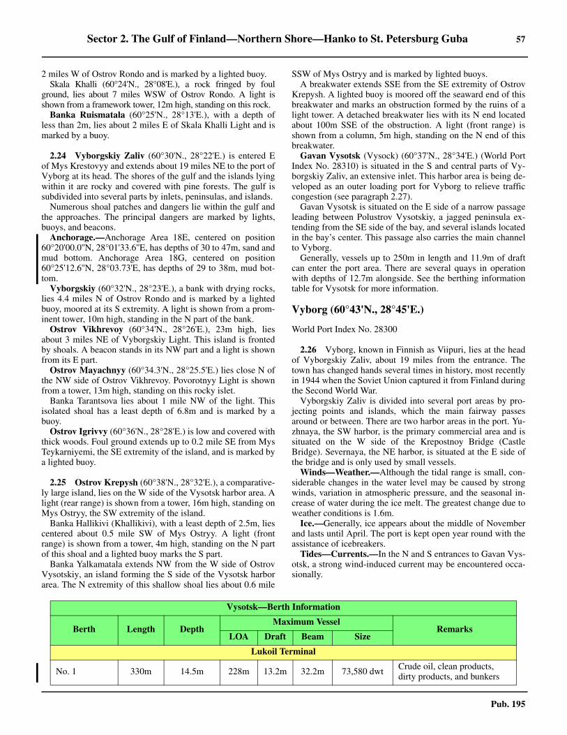
Sector 2. The Gulf of Finland—Northern Shore—Hanko to St. Petersburg Guba 57
Pub. 195
2 miles W of Ostrov Rondo and is marked by a lighted buoy. Skala Khalli (60°24'N., 28°08'E.), a rock fringed by foul
ground, lies about 7 miles WSW of Ostrov Rondo. A light isshown from a framework tower, 12m high, standing on this rock.
Banka Ruismatala (60°25'N., 28°13'E.), with a depth ofless than 2m, lies about 2 miles E of Skala Khalli Light and ismarked by a buoy.
2.24 Vyborgskiy Zaliv (60°30'N., 28°22'E.) is entered Eof Mys Krestovyy and extends about 19 miles NE to the port ofVyborg at its head. The shores of the gulf and the islands lyingwithin it are rocky and covered with pine forests. The gulf issubdivided into several parts by inlets, peninsulas, and islands. 2.24 Numerous shoal patches and dangers lie within the gulf andthe approaches. The principal dangers are marked by lights,buoys, and beacons.2.24 Anchorage.—Anchorage Area 18E, centered on position60°20'00.0''N, 28°01'33.6''E, has depths of 30 to 47m, sand andmud bottom. Anchorage Area 18G, centered on position60°25'12.6''N, 28°03.73'E, has depths of 29 to 38m, mud bot-tom. 2.24 Vyborgskiy (60°32'N., 28°23'E.), a bank with drying rocks,lies 4.4 miles N of Ostrov Rondo and is marked by a lightedbuoy, moored at its S extremity. A light is shown from a prom-inent tower, 10m high, standing in the N part of the bank.2.24 Ostrov Vikhrevoy (60°34'N., 28°26'E.), 23m high, liesabout 3 miles NE of Vyborgskiy Light. This island is frontedby shoals. A beacon stands in its NW part and a light is shownfrom its E part.2.24 Ostrov Mayachnyy (60°34.3'N., 28°25.5'E.) lies close N ofthe NW side of Ostrov Vikhrevoy. Povorotnyy Light is shownfrom a tower, 13m high, standing on this rocky islet.2.24 Banka Tarantsova lies about 1 mile NW of the light. Thisisolated shoal has a least depth of 6.8m and is marked by abuoy.2.24 Ostrov Igrivvy (60°36'N., 28°28'E.) is low and covered withthick woods. Foul ground extends up to 0.2 mile SE from MysTeykarniyemi, the SE extremity of the island, and is marked bya lighted buoy.
2.25 Ostrov Krepysh (60°38'N., 28°32'E.), a comparative-ly large island, lies on the W side of the Vysotsk harbor area. Alight (rear range) is shown from a tower, 16m high, standing onMys Ostryy, the SW extremity of the island.2.25 Banka Hallikivi (Khallikivi), with a least depth of 2.5m, liescentered about 0.5 mile SW of Mys Ostryy. A light (frontrange) is shown from a tower, 4m high, standing on the N partof this shoal and a lighted buoy marks the S part.2.25 Banka Yalkamatala extends NW from the W side of OstrovVysotskiy, an island forming the S side of the Vysotsk harborarea. The N extremity of this shallow shoal lies about 0.6 mile
SSW of Mys Ostryy and is marked by lighted buoys.2.25 A breakwater extends SSE from the SE extremity of OstrovKrepysh. A lighted buoy is moored off the seaward end of thisbreakwater and marks an obstruction formed by the ruins of alight tower. A detached breakwater lies with its N end locatedabout 100m SSE of the obstruction. A light (front range) isshown from a column, 5m high, standing on the N end of thisbreakwater.2.25 Gavan Vysotsk (Vysock) (60°37'N., 28°34'E.) (World PortIndex No. 28310) is situated in the S and central parts of Vy-borgskiy Zaliv, an extensive inlet. This harbor area is being de-veloped as an outer loading port for Vyborg to relieve trafficcongestion (see paragraph 2.27).2.25 Gavan Vysotsk is situated on the E side of a narrow passageleading between Polustrov Vysotskiy, a jagged peninsula ex-tending from the SE side of the bay, and several islands locatedin the bay’s center. This passage also carries the main channelto Vyborg. 2.25 Generally, vessels up to 250m in length and 11.9m of draftcan enter the port area. There are several quays in operationwith depths of 12.7m alongside. See the berthing informationtable for Vysotsk for more information.
Vyborg (60°43'N., 28°45'E.)
World Port Index No. 28300
2.26 Vyborg, known in Finnish as Viipuri, lies at the headof Vyborgskiy Zaliv, about 19 miles from the entrance. Thetown has changed hands several times in history, most recentlyin 1944 when the Soviet Union captured it from Finland duringthe Second World War. 2.26 Vyborgskiy Zaliv is divided into several port areas by pro-jecting points and islands, which the main fairway passesaround or between. There are two harbor areas in the port. Yu-zhnaya, the SW harbor, is the primary commercial area and issituated on the W side of the Krepostnoy Bridge (CastleBridge). Severnaya, the NE harbor, is situated at the E side ofthe bridge and is only used by small vessels.2.26 Winds—Weather.—Although the tidal range is small, con-siderable changes in the water level may be caused by strongwinds, variation in atmospheric pressure, and the seasonal in-crease of water during the ice melt. The greatest change due toweather conditions is 1.6m.2.26 Ice.—Generally, ice appears about the middle of Novemberand lasts until April. The port is kept open year round with theassistance of icebreakers.2.26 Tides—Currents.—In the N and S entrances to Gavan Vys-otsk, a strong wind-induced current may be encountered occa-sionally.
Vysotsk—Berth Information
Berth Length DepthMaximum Vessel
RemarksLOA Draft Beam Size
Lukoil Terminal
No. 1 330m 14.5m 228m 13.2m 32.2m 73,580 dwt Crude oil, clean products, dirty products, and bunkers

58 Sector 2. The Gulf of Finland—Northern Shore—Hanko to St. Petersburg Guba
Pub. 195
No. 2 330m 14.5m 255m 13.2m 44.0m 117,055 dwt Crude.
No. 3 80m 7.0m 141m 5.5m 16.9m 7,087 dwt Dirty products and bunkers.
Cryogas LNG Terminal
No 1 235m — 163m — 24.5m 12,344 dwt LNG and LPG.
No 2 160m — 137m — 19.8m 10,446dwt LNG and LPG.
Bulk Terminal
No. 1 195m 12.7m 229m 11.9m 36.8m 87,340 dwt
Coal and breakbulk. Continu-ous berthing length of 780m.
No. 2 195m 12.7m 230m 11.9m 38.0m 93,296 dwt
No. 3 195m 12.7m 230m 11.9m 38.0m 93,296 dwt
No. 4 195m 12.7m 229m 11.9m 38.0m 93,296 dwt
Vyborg—Berth Information
Berth Length DepthMaximum Vessel
RemarksLOA Draft Beam Size
Passenger Terminal
No. 1 70m — 111m 4.4m 18.0m — Fast ferries and bunkers.
No. 2 68m 4.6m — — — — Fast ferries, breakbulk, and bunkers.
Sea Port Vyborg Multipurpose Terminals
No. 3 80m 4.6m — — — — Breakbulk and bunkers.
No. 4 80m — 128m 6.0m — 6,477 dwt Cement, breakbulk, and bunkers.
No. 5 130m 7.2m 128m 6.5m — 8,488 dwt Cement, containers, and bunkers.
No. 6 103m 7.0m 150m 6.5m 25.0m 18,000 dwtClean products, cement, fer-tilizer, containers, steel products, and breakbulk.
No. 7 130m 8.2m 150m 6.5m 25.0m 18,000 dwt
Rail link. Clean products, aggregates, fertilizer, con-tainers, steel products, scrap metal, breakbulk, and bun-kers.
No. 8 130m 8.2m 150m 6.5m 25.0m 18,000 dwt
Clean products, coal, fertil-izer, steel products, scrap metal, containers, and breakbulk.
No. 9 130m 8.2m 150m 6.5m 25.0m 18,000 dwtCement, coal, fertilizer, steel products, scrap metal, containers, and breakbulk.
No. 10 130m 8.2m — — — — Others. Continuous berth length 560m.
No. 11 75m 8.2m — — — — Coal, breakbulk, and bun-kers.
Vysotsk—Berth Information
Berth Length DepthMaximum Vessel
RemarksLOA Draft Beam Size

Sector 2. The Gulf of Finland—Northern Shore—Hanko to St. Petersburg Guba 59
Pub. 195
2.26 Signals indicating a rising or falling water level and thevelocity of the current are displayed from masts on either sideof the harbor, day and night.2.26 Depths—Limitations.—From seaward to the bulk terminalat Gavan Vysotsk the least dredged depth is charted at 12.7m.The dredged (2012) fairway leading NE and passing S of theSE extremity of Ostrov Krepysh has a charted depth of 6.9m.2.26 The S harbor at Vyborg provides 2,020m of quayage. Theare 13 berths, with depths of 4.6 to 8.2m alongside. The N har-bor is restricted by a bridge to small vessels with a maximumbeam of 7.3m. It provides 2,340m of quayage, with a depth of3m alongside.
2.26 Vessels up to 150m in length and 6.5m draft can enter the Sharbor area. See the berthing information table for Vyborg formore information.2.26 Vessels exceeding the above dimensions must receive specialpermission prior to entering the port areas. It is reported thatvessels up to 15,900 dwt and 173m in length have entered theport areas. There are facilities for timber, bulk, general cargo,and passenger vessels.2.26 Aspect.—The approach routes, entrance channels, and innerfairways are indicated by lighted ranges. The dangers lyingadjacent to the fairways are marked by lights, beacons, andbuoys.2.26 The most prominent feature in the city of Vyborg is the cas-tle standing on the small island which is connected to the NEside of the Krepostnoy Bridge. Its conspicuous tower, 74mhigh, dominates the surrounding area.2.26 Pilotage.—Pilotage is compulsory. The pilot station is situ-ated at the NW end of Ostrov Vikhrevoy. Vessels should send arequest for pilotage and an ETA 24 hours in advance. Pilotsmay be contacted by VHF on channel 10.2.26 Pilots can be contacted through the Pilot Service Controller.
2.26 Vessels bound for the Lukoil II Terminal, Vysotsk, board thepilot, as follows:
1. In the vicinity of Khalli Lighted Buoy (60°24.5'N.,28°05.0'E.) at the N end of the TSS.
2. In the vicinity of the Fairway Lighted Buoy(60°26'N., 27°43'E.).
2.26 Vessels bound for the ports of Vyborg or Vysotsk board thepilot boards about 0.6 mile W of the N end of Ostrov May-achnyy (60°34'N., 28°25'E.). 2.26 During inclement weather, the pilot boat will lead vessels in-to more sheltered waters within Bol’shoy Tranzundskiy Reid(60°35.5'N., 28°30.0'E.) before boarding.2.26 Regulations.—Between the inner pilot boarding place andBanka Hallikivi, a speed restriction of 8 knots is in effect; thenthrough the port entrance, a speed restriction of 6 knots is in ef-fect. Within the intricate channel leading to the entrance of Vy-bork at the N end of Vyborgskiy Zaliv, overtaking is prohibitedand a speed restriction of 6.5 knots is in effect.2.26 Entry into the port areas of Vysotsk and Vyborg may only becarried out with special permission from the authorities whenthe visibility is less than 1 mile and/or the wind is greater thanforce 6.2.26 All inbound vessels should send a message to the Port Au-thority at least 48 hours in advance. In the case of their voyagebeing less than 48 hours, vessels should send a message not lat-er than 1 hour after leaving their last port of call. The messageshould include the ETA at the pilot boarding place, last port ofcall, volume and nature of cargo to be discharged or loaded, de-tails of any dangerous cargo, details of any heavy lifts, name ofcharterer, length, draft, number of passengers, and details ofany services required.2.26 Vessels entering the port areas with maximum allowabledrafts are considered to be constrained by their drafts. Suchvessels must display one black ball by day and one all-roundred light at night above the forward steaming light.2.26 The use of tugs is compulsory for vessels over 100m inlength without a bow thruster arriving at Vyborg. Tugs are alsocompulsory for vessels over 80m in length and 5m draft leav-ing Vyborg.2.26 Vessel Traffic Service.—Vyborg and Vystok Vessel TrafficService (VTS) operates in the following area:
1. Fairway No. 4 E of Lighted Buoy No. 3.2. Vyborgskiy Zaliv Traffic Separation Scheme E of
Khalii Lighted Buoy.3. North of Veprevskiy Light.4. The water area of Vyborg and Vysotsk, including Lu-
koil II Terminal2.26 Vessels bound for Vyborg, Vysotsk, or the Saymenskiy Ca-nal must establish contact with the VTS (call sign: Vyborg Ra-dio 5) on VHF channel 12 or 16 when approaching the Sentrance to the Vysotsky Roads and follow instructions.
No. 12 150m 8.2m 150m 6.5m 25.0m 18,000 dwt Coal, breakbulk, and bun-kers
No. 13 168m 8.2m 150m 6.5m 25.0m 18,000 dwtChemicals, coal, project/heavy cargo, breakbulk, and bunkers.
Vyborg—Berth Information
Berth Length DepthMaximum Vessel
RemarksLOA Draft Beam Size
Pilot Service Controller—Contact Information
Call sign Vyborg/Vysotsk Pilot
VHFVHF channel 10 (Vyborg)
VHF channel 18 (Vysotsk)
Telephone78-812-380-7149 (24 hours)
78-813-783-2481 (ext. 226) (Mon-Fri)
Facsimile 78-812-380-7149
E-mail [email protected]

60 Sector 2. The Gulf of Finland—Northern Shore—Hanko to St. Petersburg Guba
Pub. 195
2.26 Vessels bound for Vyborg, Vysotsk, or the Saymenskiy Ca-nal transit the coverage area of St. Petersburg Coastal VTS. Forfurther information on the requirements of St. PetersburgCoastal VTS, see paragraph 3.1. 2.26 Contact Information.—The ports of Vyborg and Vysotskcan be contacted by e-mail ([email protected]). 2.26 Anchorage.—Three designated anchorage areas, the limitsof which are shown on the chart, lie within Tranzundskiy Reid,the outer roadstead located between Ostrov Igrivvy and the en-trance to the port areas. They have general depths of 14 to 18m,mud and sand.2.26 Two designated anchorage areas, the limits of which areshown on the chart, lie between Gavan Vystock and Vyborg.They have depths of 11 to 17m, sand and mud, but require local
knowledge.2.26 An anchorage area, with depths of 11 to 14m, lies adjacent tothe N side of the deep-water route (see Directions) and maybest be seen on the chart. Several obstructions and wrecks liewithin the anchorage.2.26 Directions.—The main approach from seaward is via theTraffic Separation Scheme (TSS) which leads NE from E ofOstrov Sommers to a position located about 2 miles W of SkalaKhalli Light (60°24'N., 28°08'E.). A divided Safety Fairway,which may best be seen on the chart, then leads to the port en-trance. This route leads ENE from the N end of the TSS towardOstrov Rondo. The inbound track is situated on the S side ofthe fairway and passes S of Banka Ruismatala (see paragraph2.23). The outbound track is situated on the N side of the fair-way and passes N of Banka Ruismatala. From the vicinty ofOstrov Rondo, the route turns NE and N and passes about 0.7mile W of Vyborgskiy Bank. About 1.5 miles NNW of Vy-borgskiy Bank, the route turns NE and leads to the inner pilotboarding place located W of Ostrov Mayachnyy. It then contin-ues ENE, NE, and ENE to join the entrance fairway, passing Sof Mys Teykarniyemi and between Banka Hallikivi and BankaYalkamatala. The entrance fairway leads ENE between the ru-ins of the light tower, on the N side, and the N end of the de-tached breakwater, on the S side.2.26 The inshore channel leads 6.4 miles in a NE direction from Sof Mys Krestovyy to the inner pilot boarding place in the vicin-ity of Ostrov Mayachnyy.2.26 A deep-water route also leads into the port. This channel,which is swept to a depth of 10.7m, is marked by buoys. Itbranches NNE for about 0.7 mile from the NW side of theSafety Fairway at a position located about 1 mile SW of BankaHallikivi. The channel then leads ENE for about 0.6 mile andSE for 0.3 mile, passing N of Banka Hallikivi and SW of MysOstryy. It continues E for about 0.2 mile and joins the mainfairway close outside the port entrance.2.26 Caution.—Care should be exercised when within the harbor ar-eas of Gavan Vystock as numerous piles, many in a dilapidatedcondition, are present.2.26 Several isolated patches, with depths of less than 10m, liewithin Tranzundskiy Reid, the outer roadstead, and adjacent tothe designated anchorage areas. 2.26 Care should be taken when navigating in the vicinity of Vy-borgskiy Bank as vessels have frequently wrecked on this shoalarea.2.26 A recommended route, which may best be seen on the chart,extends in a N direction from the vicinity of Veprevskiy Light(60°28'N., 28°26'E.) to the inner pilot boarding place locatedW of Ostrov Mayachnyy. It is reported that navigation alongthis route is prohibited for foreign vessels.2.26 It is reported that extensive dredging has been carried out inthe TSS leading NE from the vicinty of Ostrov Sommers and,in parts, has a minimum depth of 14.5m. This is to enabledeep-draft vessels to reach the new facilities at Vystock.
Vyborg to St. Petersburg Guba
2.27 The Saimaa Canal (60°43'N., 28°45'E.) connects theGulf of Finland with lakes and inland waterways extending forover 200 miles N of Lake Saimaa. It was originally opened in1856 and extensively modified in 1968.
2.26Vyborgskiy Light
2.26Vyborg Castle and Tower
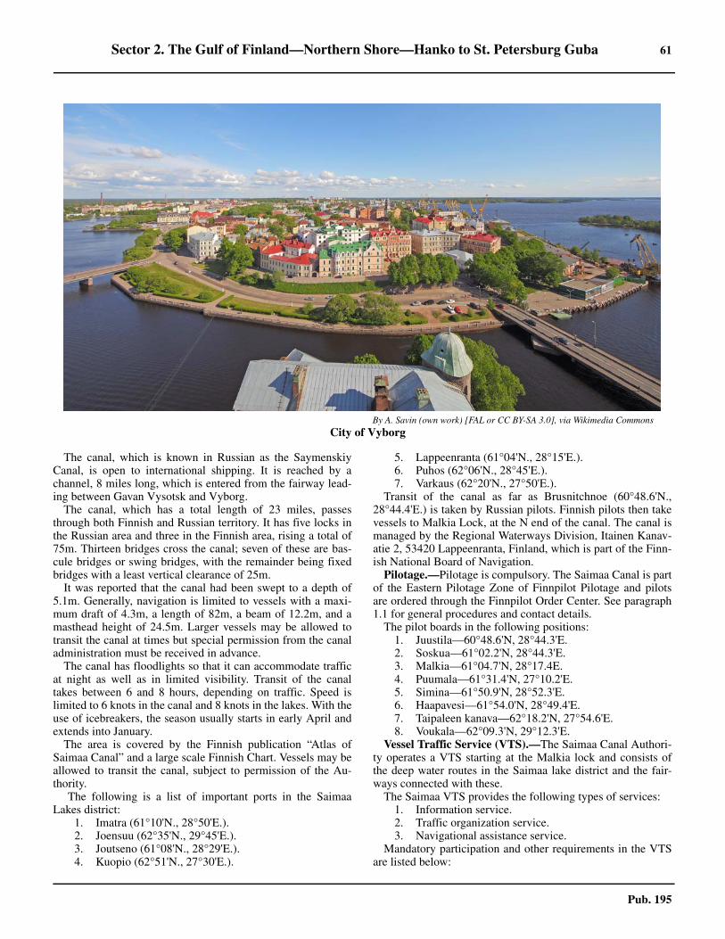
Sector 2. The Gulf of Finland—Northern Shore—Hanko to St. Petersburg Guba 61
Pub. 195
2.27 The canal, which is known in Russian as the SaymenskiyCanal, is open to international shipping. It is reached by achannel, 8 miles long, which is entered from the fairway lead-ing between Gavan Vysotsk and Vyborg.2.27 The canal, which has a total length of 23 miles, passesthrough both Finnish and Russian territory. It has five locks inthe Russian area and three in the Finnish area, rising a total of75m. Thirteen bridges cross the canal; seven of these are bas-cule bridges or swing bridges, with the remainder being fixedbridges with a least vertical clearance of 25m. 2.27 It was reported that the canal had been swept to a depth of5.1m. Generally, navigation is limited to vessels with a maxi-mum draft of 4.3m, a length of 82m, a beam of 12.2m, and amasthead height of 24.5m. Larger vessels may be allowed totransit the canal at times but special permission from the canaladministration must be received in advance.2.27 The canal has floodlights so that it can accommodate trafficat night as well as in limited visibility. Transit of the canaltakes between 6 and 8 hours, depending on traffic. Speed islimited to 6 knots in the canal and 8 knots in the lakes. With theuse of icebreakers, the season usually starts in early April andextends into January. 2.27 The area is covered by the Finnish publication “Atlas ofSaimaa Canal” and a large scale Finnish Chart. Vessels may beallowed to transit the canal, subject to permission of the Au-thority.
2.27The following is a list of important ports in the SaimaaLakes district:
1. Imatra (61°10'N., 28°50'E.).2. Joensuu (62°35'N., 29°45'E.).3. Joutseno (61°08'N., 28°29'E.).4. Kuopio (62°51'N., 27°30'E.).
5. Lappeenranta (61°04'N., 28°15'E.).6. Puhos (62°06'N., 28°45'E.).7. Varkaus (62°20'N., 27°50'E.).
2.27 Transit of the canal as far as Brusnitchnoe (60°48.6'N.,28°44.4'E.) is taken by Russian pilots. Finnish pilots then takevessels to Malkia Lock, at the N end of the canal. The canal ismanaged by the Regional Waterways Division, Itainen Kanav-atie 2, 53420 Lappeenranta, Finland, which is part of the Finn-ish National Board of Navigation.2.27 Pilotage.—Pilotage is compulsory. The Saimaa Canal is partof the Eastern Pilotage Zone of Finnpilot Pilotage and pilotsare ordered through the Finnpilot Order Center. See paragraph1.1 for general procedures and contact details.2.27 The pilot boards in the following positions:
1. Juustila—60°48.6'N, 28°44.3'E.2. Soskua—61°02.2'N, 28°44.3'E.3. Malkia—61°04.7'N, 28°17.4E.4. Puumala—61°31.4'N, 27°10.2'E.5. Simina—61°50.9'N, 28°52.3'E.6. Haapavesi—61°54.0'N, 28°49.4'E.7. Taipaleen kanava—62°18.2'N, 27°54.6'E.8. Voukala—62°09.3'N, 29°12.3'E.
Vessel Traffic Service (VTS).—The Saimaa Canal Authori-ty operates a VTS starting at the Malkia lock and consists ofthe deep water routes in the Saimaa lake district and the fair-ways connected with these. 2.27 The Saimaa VTS provides the following types of services:
1. Information service.2. Traffic organization service.3. Navigational assistance service.
2.27 Mandatory participation and other requirements in the VTSare listed below:
2.26By A. Savin (own work) [FAL or CC BY-SA 3.0], via Wikimedia Commons
2.26City of Vyborg

62 Sector 2. The Gulf of Finland—Northern Shore—Hanko to St. Petersburg Guba
Pub. 195
1. Vessels of 24m loa or longer.2. When navigating in the VTS area, vessels are required
to maintain a continuous listening watch on VHF channel 9.3. Vessels navigating in the VTS area, which are not
obliged to participate in the VTS, are recommended to main-tain a listening watch on VHF channel 9.
4. Participating vessels are required to make reports, asfollows:
a. Upon entry into the VTS area.b. Before anchoring.c. Before leaving an anchorage.d. After berthing.e. Before leaving port.f. At the reporting points in the area 10 minutes before
passing the following places:i. Kuhaluoto, southbound.ii. Vekaransalonsalmi.iii. Hatinvirta.iv. Puumalansalmi.v. Pahikka.vi. Vekaransalmi.vii. Harkinsalo, northbound.viii. Kommersalmi, southbound.ix. Laitaatsalmi.x. Matarinsalmi.xi. Haponlahden kaivanto, northbound.xii. Sorsavirta, when from direction of Joensuu.xiii. Virtasaari, when from direction of Varkaus.xiv. Tappuvirta.xv. Tahkosalmi.xvi. Sinikonniemi, southbound.xvii. Muuraispuro, northbound.xviii. Patasalmi, northbound.xix. Kolikon kaivanto, southbound.xx. Kortesalmi, northbound.xxi. Aittoluoto, southbound.xxii. Hanhivirta.xxiii. Vihtakanta. (report is not required if vessel has
reported 1 hour before the opening bridge)xxiv. Vuosalmi, northbound.xxv. Vuoharju, southbound.
g. Vessels towing timber rafts are an exception to theabove. These should report to the VTS when approachingthe above mentioned narrow passages so far in advancethat the towage can be interrupted before the narrow pas-sage, in case for example, a vessel in distress or some oth-er obstruction.
h. Opening bridges—Kyronsalmi Road and RailwayBridge and the Vihtakanta.
i. Vessels using deep water route must report toSaimaa VTS 1 hour before passing the bridges and thenthe Saimaa VTS will order the opening of the bridges.
2.27 Reports should include the following information:1. Vessel’s name.2. Name of reporting point.3. Destination.4. Intended route. If an alternative route is selected, this
must be reported.2.27 Contact Information.—See the table titled Saimaa—Con-
tact Information.
2.28 Between the main entrance to Vyborgskiy Zaliv andMys Stirsudden, about 29 miles SE, the coast is indented byseveral bays. The shore is fronted by irregular depths and nu-merous detached dangers.2.28 Proliv Byerkezund (Koiviston Salmi) (60°28'N., 28°30'E.),a sound, connects Vyborgskiy Zaliv with the E part of the Gulfof Finland and provides a direct route between Vyborg and St.Petersburg.2.28 The mainland coast on the NE side of the sound rises gradu-ally to a chain of hills, 55 to 85m high. Numerous houses andvillages are situated on the slopes of these hills. The threeBerezovyy islands, which are comparatively high and wooded,form the SW side of this sound. A remarkable hill rises to aheight of 115m on Ostrov Zapadnyy Berezovyy, the outermostisland.
2.28 The sound has general depths of 14 to 33m. The fairwaychannel leading through the dangers in the sound is well-marked and available for vessels with drafts up to 9.1m.2.28 Sheltered anchorage can be found within the sound, but Swinds cause a heavy swell in its S part and local knowledge isrequired. 2.28 Caution.—It is reported that passage through the N part ofProliv Byerkezund is restricted to local fishing vessels andRussian naval vessels.
2.29 Primorsk (60°22'N., 28°38'E.) (World Port Index No.28360), a major oil export terminal, is situated along the shoresof an enclosed bay at the E side of Proliv Byerkezund.2.29 Ice.—In severe conditions, icebreaker assistance is provided.Generally, the ice season lasts from the beginning of December tothe end of April. The maximum ice coverage occurs in March.2.29 The Captain of the Port of St. Petersburg directs all icebreak-er operations. Vessels requiring assistance should send a re-quest via their agent 24 hours in advance.2.29 During the period of ice navigation, vessels proceeding tothe port are advised to send their ETA at the designated convoyposition to the Port Captain at Primorsk 48 hours, 24 hours,and 12 hours in advance. On approaching the convoy position,vessels should establish VHF contact with the nearest ice-breaker and follow instructions. Vessels should advise Pri-morsk VTS (SUDS) the times of commencement andcompletion of icebreaker pilotage.2.29 Depths—Limitations.—The harbor is protected by break-waters and has depths of 5.5 to 9m, decreasing gradually to-ward the shore. There are two piers with depths of 8.5 and
Saimaa—Contact Information
Vessel Traffic Service
Call sign Saimaa VTS
VHF VHF channel 9
Telephone 358-20-637-3745
E-mail [email protected]
Web site http://www.fintraffic.fi/en/masters-guide

Sector 2. The Gulf of Finland—Northern Shore—Hanko to St. Petersburg Guba 63
Pub. 195
9.4m alongside their heads.2.29 The oil terminal consists of a T-shaped jetty, which extendsabout 0.2 mile SW from the shore, and several mooring buoys.The head of the jetty has depths of 17.7 to 18m alongside. Theroot of the jetty has a depth of 7.4m alongside. Tankers up toabout 150,000 dwt, 307m in length, 50m beam, and 15m load-ed draft can be handled.2.29 Aspect.—A church with a prominent spire stands on the Nside of the harbor entrance.2.29 It is reported that the Safety Fairway is marked by lightedbuoys and is indicated by a lighted range.2.29 Pilotage.—Waiting Area No. 6, which may best be seen onthe chart, is situated 3 miles W of Ostrov Rodsher (59°58'N.,26°41'E.). Pilotage is compulsory for vessels of 50,000 dwtand over between this waiting area, or the entrance of the TSSlocated about 9 miles E of Ostrov Rodsher, and the port.2.29 Waiting Area No. 7, which may best be seen on the chart, issituated about 11 miles NE of Ostrov Seskar (60°02'N.,28°23'E.), on the NW side of the Safety Fairway. Pilotage iscompulsory for vessels of less than 50,000 dwt between thiswaiting area, or the beginning of the second reach of the SafetyFairway, and the port.2.29 Tug service is compulsory between Waiting Area No. 7 andthe port for vessels in ballast, and between Ostrov Seskar andthe port for loaded vessels.2.29 Pilots can be contacted on VHF channels 15 and 17 andboard, as follows:
1. Pilotage is compulsory for all vessels in the Bol’shoyKorabel’nyy fairway to and from Primorsk Oil Terminal.The pilot boarding position for all vessels is in 60°11.8'N,28°44.7'E.
2. By special request pilots will board in position59°59.8'N, 26°40.0'E, about 1.7 miles NNW of Ostrov Rod-sher Light. A shoal depth of 27m was reported (2021) to lieon the bank located approximately 1.25 miles NW of Rodsh-er Light and can best be seen on the chart.
3. Vessels proceeding SE through Proliv Byerkezund—Position 60°22.4'N, 28°34.4'E.
4. Vessels proceeding NW through Proliv Byerkezund—Position 60°14.7'N, 28°50.7'E.
2.29 Vessels should send an ETA at Waiting Area No. 7, via theagent, to the Port Captain 48 hours and 24 hours in advance.This ETA should be confirmed by VHF 4 hours prior to arrival.2.29 Vessels should sent a request for pilotage to the Port Captain24 hours before arriving at the appropriate boarding position.This request should be confirmed by VHF 2 hours in advance.2.29 Any changes should be sent via the agent not less than 1 hour30 minutes in advance.2.29 Vessels transiting the port area should contact the Port Cap-tain by VHF 2 hours prior to arriving at the appropriate board-ing position in Proliv Byerkezund.2.29 Departing vessels should request pilotage in writing or bytelephone not less than 2 hours before sailing.2.29 Regulations.—Tankers bound for the port in winter are re-
2.27Primorsk Oil Terminal

64 Sector 2. The Gulf of Finland—Northern Shore—Hanko to St. Petersburg Guba
Pub. 195
quired to be double-hulled.2.29 In addition to regular navigation equipment, tankers are re-quired to be fitted with an Electronic Chart Display and Infor-mation System (ECDIS) and a Satellite System (GPS/GLONASS). If these systems are not available, they may beprovided by the pilot service. 2.29 Vessel Traffic Service.—Primorsk Vessel Traffic Service(VTS) operates in the port area and includes Proliv Byorkyo-zund S of 60°25'N, including Fairway No. 5 S to its intersec-tion with Fairway No. 1, and Primorskiy Fairway No. 5A SWto the intersection with the Ostrov Seskar TSS (the line be-tween Lighted Buoy No. 1 and Lighted Buoy No. 2. Also in-cluded is the inner roadstead, including anchorage Area No. 6and anchorage Area No. 6A; and the turning circle for swing-ing large tankers. 2.29 Vessels must contact the Traffic Control Center of the Pri-morsk VTS (call sign: Primorsk Traffic) on VHF channel 68(reserve channel: VHF channel 9) 1 hour before entering theVTS area. 2.29 Vessels must, on request, advise the Traffic Control Centerof their bearing and distance from Seskar Light (60°02'N.,28°22'E.).2.29 Vessels should maintain a continuous listening watch onVHF channel 68.2.29 Vessels proceeding to Proliv Byerkezund should establishVHF contact with Primorsk VTS when 30 miles from the portto request permission to enter the area.2.29 Vessels bound for Primorsk transit the coverage area of St.Petersburg Coastal VTS. For further information on the re-quirements of St. Petersburg Coastal VTS, see paragraph 3.1.
2.29 Contact Information.—See the table titled Primorsk—Contact Information.2.29 Directions.—The main approach from seaward is via theTraffic Separation Scheme (TSS), which leads N of OstrovRodsher (59°58'N., 26°41'E.) and S of Ostrov Gogland(60°03'N., 26°59'E.). This scheme continues in a NE directionto the junction centered about 4 miles ESE of Ostrov Sommers(60°12'N., 27°39'E.) and then ESE and SE to a position N ofOstrov Seskar (60°02'N., 28°23'E.).
2.29 A Deep-Water Route has been established between the S endof Ostrov Gogland and a position about 7 miles NW of OstrovRodsher. This route, which has a least depth of 15m, passes Nof the TSS traffic lanes and is for the use of outbound loadedvessels from Primorsk. It is 1,000m wide and may best be seenon the chart.2.29 A Precautionary Area has been established about 3 miles Nof Ostrov Seskar. The TSS traffic lanes and a Safety Fairway,which leads to St. Petersburg, extend E from the E side of thisarea and may best be seen on the chart (see paragraph 3.1).2.29 Primorsk Safety Fairway, which extends about 14 miles in aNE direction and then about 4 miles in a NW direction, leadsfrom the NE side of the Precautionary Area to the oil terminal.
2.30 Ostrov Syarkkyaluoto (60°18'N., 28°48'E.), an islet,lies near the outer end of an area of foul ground on the SE sideof Proliv Byerkezund. A light is shown from a framework tow-er,12m high, standing on this islet.2.30 Mys Kyurenniyemi (60°16'N., 28°55'E.) is located 4 milesSE of Ostrov Syarkkyaluoto. A light is shown from a frame-work tower, 12m high, standing on this headland. Shoals ex-tend up to about 2 miles S and SW of this light.2.30 The 20m curve lies between less than 1 mile and about 2miles off the W sides of the Berezovyy islands, but numerousdetached shoal patches, with depths less than 10m, lie withinabout 8 miles W and SW of these islands.2.30 Banka Shrednyaya (60°11'N., 28°20'E.), with a least depthof 6.4m, lies about 17.5 miles WSW of Mys Kyurenniyemi andis marked by a lighted buoy. Banka Agamemnon, with a leastdepth of 8.2m, lies about 6 miles E of this isolated shoal bankand is marked by a buoy.
Primorsk—Contact Information
State Port Control Inspection
Call sign Primorsk Port Control
VHF VHF channels 9 and 67
Telephone78-812-245-1664
78-921-348-9487
Facsimile78-812-245-1664
78-812-245-1667
Pilots
Call sign Primorsk Pilot
VHF VHF channels 15 and 17
Vessel Traffic Service
Call sign Primorsk Traffic
VHF VHF channels 9 and 68
MMSI 002734453
Telephone78-812-380-7153
78-921-951-9312 (mobile)
Facsimile 78-812-380-7086
E-mail [email protected]
Tugs
VHF VHF channel 6
2.30 Stirsudden Light
Primorsk—Contact Information

Sector 2. The Gulf of Finland—Northern Shore—Hanko to St. Petersburg Guba 65
Pub. 195
2.30 Mys Stirsudden (60°11'N., 29°01'E.), the N entrance pointof St. Petersburg Guba, is a low and rocky headland located 6miles SE of Mys Kyurenniyemi. Gora Torkalla, a prominenthill, is 100m high and rises 5.8 miles NNE of this headland.2.30 Stirsudden Light is shown from a prominent tower, 28m
high, standing 0.6 mile ENE of the headland. Shoals front theshore in the vicinity of this headland and Banka Diomid, withdepths of less than 10m, extends up to about 4.5 miles S of it.2.30 The waters lying E of Mys Stirsudden are described inSector 3.

67
Pub. 195
3. Sector 3—Russia—St. Petersburg Guba and Nevskaya Guba
3.0Additional chart coverage may be found in NGA/DLIS Catalog of Maps, Charts, and Related Products (Unlimited Distribution).SECTOR 3 — CHART INFORMATION

69
Pub. 195
SECTOR 3
RUSSIA—ST. PETERSBURG GUBA AND NEVSKAYA GUBA
3.0 Plan.—This sector describes the S and N coasts of St. Peters-burg Guba and the approach from seaward to Kronshtadt thatforms part of the main shipping channel to St. Petersburg. In addi-tion, Kronshtadt, the S and N coasts of Nevskaya Guba, and theport of St. Petersburg are also detailed. The descriptive sequence isfrom W to E.
General Remarks
3.1 Tides—Currents.—At Kronshtadt, regular observa-tions of the effects of wind on the water level have been madeover a period of decades. These observations indicate that thereare periodic changes in the water level due mainly to the flowof river water into the Baltic Sea and then into the North Sea,and due partly to meteorological conditions. The periodicchanges are relatively small and follow a definite routine,showing two maximum and two minimum effects in each year.The former changes occur in August, December, and Januaryand the latter in April, May, and October. The extreme differ-ence in level between the maximum rise and the minimum fallof these seasonal changes may reach 0.9m. 3.1 The effect of the tide is small; the range at Kronshtadt due tothis cause is not more than about 0.1m. The changes due to me-teorological conditions are more pronounced at times, espe-cially in the mouth of the Neva, where they cause heavy floodsand serious damage.3.1 At Kronshtadt, the water has been known to rise about 1.4min 6 hours due to the meteorological changes. These conditionsare more noticeable in their effect during the autumn and win-ter than during spring and summer. In general, E winds lowerthe water level and the W winds raise it. The force of the windis of greater consequence than its direction.
3.1 The water level begins to rise somewhat earlier than thefreshening or shifting of the wind, and it attains its maximumheight before the wind reaches its greatest force. Any apprecia-ble rise of the water level is a certain indiction of W winds.When certain conditions of wind and barometric pressure oc-cur at the same time, the rise of the water level may be consid-erable. 3.1 At Kronshtadt, an increase of more than 3m above normalhas been recorded, and at St. Petersburg, a rise of more than3.5m above normal has been recorded. These extreme rises,which cause floods, are not frequent in October and November;the maximum rise at St. Petersburg during the months of Feb-ruary, March, April, and June has not exceeded 1.8m. Themaximum difference between the high and low level at Kro-nshtadt in the last 100 years is 4.6m.3.1 With winds from NNE through N to SSE, the water rises atKronshtadt and falls with those from other directions.3.1 The current in Nevskaya Guba sets W in mid-channel be-tween Ostrov Kotlis and Mys Lisiy Nos at a velocity of about0.25 knot, but in the S area of the estuary it is weaker. Duringlight E winds, there is a W set with a velocity of about 0.5 knotand with strong winds from that direction, the set attains a ve-
locity, at times, of about 1.5 knots. No current is perceptiblealong the shores of the estuary.3.1 Depths—Limitations.—The Safety Fairway, which extendsbetween the TSS traffic lanes located off Ostrov Seskar(60°02'N., 28°23'E.) and St. Petersburg Lighted Buoy(60°02'N., 29°26'E.), has general depths of 20 to 31m; howev-er, several shoal patches, wrecks, and obstructions exist withinand adjacent to the fairway. All these dangers may best be seenon the chart. This fairway also passes through a former MineDanger Area, as well as the Kronshtadt Fortified Zone.3.1 Vessels up to 260m in length, 40m beam, and 11m fresh wa-ter draft are able to proceed to St. Petersburg.3.1 Vessels exceeding 170m in length or with drafts of 8.5m andover are considered to be constrained by their draft. Such ves-sels must display the appropriate signals. Vessels displayingthese signals are given the right-of-way. Vessels constrained bydraft must employ tugs in the narrows between Lesnoy Mol(59°53'N, 30°12'E.) and Bolshaya Neva (59°55'N, 30°15'E.).3.1 Pilotage.—Pilotage is compulsory for all vessel and is avail-able 24 hours.3.1 Requests for pilotage should be ordered through the agents12 hours, and confirmed 4 hours, in advance, unless stated oth-erwise in station entry.3.1 Vessels intending to arrive at or depart from the freight oper-ations areas of Gorskaya, Litke (Ostrov Kotlin), and the Port ofLomonovskaya Gavan must request pilotage at least 3 hours inadvance.3.1 Vessels intending to arrive or depart the Port of Saint Peters-burg must request pilots at least 2 hours in advance.3.1 Pilots board in the vicinity of St. Petersburg Lighted Buoy(60°01.6'N., 29°25.9'E.), or near the Lighted buoy No. 2(60°05'.2N., 29°48'.0E). In bad weather, vessels may be re-quired to follow the pilot vessel to a sheltered area for board-ing.3.1 See the table titled Saint Petersburg—Pilot Contact Infor-mation.3.1 Regulations.—The sea areas in the Gulf of Finland are mon-itored jointly by Finland, Estonia, and the Russian Federation.GOFREP is the mandatory ship reporting system, under SO-LAS, established in the Gulf of Finland and its approaches.
Saint Petersburg—Pilot Contact Information
Pilot Vessel Controller
Call signSaint Petersburg Pilot
Peterburg Lotsman
VHF VHF channels 9, 16, 67, and 70
Telephone 78-812-7161973
MMSI 273436530
Marine Pilots Controller
Call sign Petersburg Radio 21

70 Sector 3. Russia—St. Petersburg Guba and Nevskaya Guba
Pub. 195
3.1 For further information concerning GOFREP, see paragraph1.1 in this publication and in the Finland section of Pub. 140,Sailing Directions (Planning Guide) North Atlantic Ocean andAdjacent Seas.3.1 Vessels bound for ports in Russia should send an ETA totheir agents 12 days, 96 hours, and 12 hours in advance. All oil,gas, and chemical tankers should send an ETA 14 days, 72hours, and 12 hours in advance. 3.1 In Kronshtadtskiy Korabelnyy Farvater and St. PetersburgMorskoy Kanal W of the sea walls, speed is restricted to 10knots. Within the moles and in the harbor area, speed must notexceed 6 knots; the speed limit is 3 knots when passing vesselssecured alongside and engaged in diving operations, etc. Ifsteerage-way can not be maintained at these speeds, tugs mustbe employed.
3.1 Overtaking in the main fairway is permitted only along theport side of the vessels being passed. Elsewhere in the port,overtaking is permitted on either side.3.1 Vessels carrying explosives, inflammables, or poisonous ma-terials are to await instructions at the St. Petersburg LightedBuoy.3.1 Vessels are urged to contact the local authorities and the pilotfor information on local navigation regulations. The use of thevessel’s bridge equipment may be restricted. 3.1 See Pub. 140, Sailing Directions (Planning Guide) North At-lantic Ocean and Adjacent Seas for regulations pertaining tovessels in Russian waters. 3.1 Vessels must send their ETA at Saint Petersburg LightedBuoy or in ice conditions (at the beginning edge of the ice) 48hours, 24 hours, and 4 hours in advance through their agent. 3.1 With a visibility of less than 2 miles, vessels navigating be-tween Uuzhnaya Damba (the NE entrance breakwater of St.Petersburg) and St. Petersburg Lighted Buoy are required tomaintain a listening watch on VHF channel 12.3.1 Anchored vessels or vessels berthed alongside are requestednot to use VHF channel 6, 8, 9, 11, 12, 13, 14, or 26 for inter-ship communications. 3.1 Vessel Traffic Service.—The Saint Petersburg Coastal Ves-sel Traffic Service (VTS) covers the E part of the Gulf of Fin-land from the E boundary of the Gulf of Finland ShipReporting System (GOFREP) within the Russian territoriallimits, excluding the areas covered by individual port VTS cen-ters (Vyborg, Vysotsk, Primorsk, Ust-Luga, and the Saint Pe-
tersburg Port VTS). The Saint Petersburg Coastal VTS area isdivided into two sectors:
1. Sector 1 (W of longitude 28°00.0'E).2. Sector 2 (E of longitude 28°00.0'E).
3.1 In addition to inbound and outbound vessels, the Saint Pe-tersburg Port VTS controls traffic from Lighted Buoy No. 14(60°01.7'N., 28°20.1'E.) to Zolotyye Vorota. Within the port ofSaint Petersburg, the Saint Petersburg Internal Port VTS Centercontrols the traffic from Zolotyye Vorota to the Blagoveshcens-kiy Bridge (59°56.1'N., 30°17.4'E.).3.1 Participation in the Vessel Traffic Services (Saint PetersburgCoastal VTS, Saint Petersburg Port VTS, Primorsk Port VTS,Vyborg and Vystok VTS, and Ust Luga Port VTS) is mandato-ry for the following vessels:
1. All vessels of 300 gross tons and over.2. Vessels of less than 300 gross tons, as follows:
a. If there is a loss of control or if it is necessary to an-chor in a TSS fairway of a channel.
b. When restricted in maneuverability.c. When the vessel’s navigational equipment is mal-
functioning.3. The working languages of the VTS are Russian and
English.4. Vessels of less than 80 gt and non self-propelled ves-
sels with a load capacity of 150 kg or more (small vessels)must obtain permission to navigate in the VTS area and sub-sequently follow instructions issued by the Coastal or PortVTS Centers.
5. Vessels must repeat instructions from a VTS Centerrelating to them and, if unable to comply with the instruc-tions, must state the reason and describe their subsequent ac-tion.
3.1 The two types of required reports are known as a Full Reportand a Short Report.
VHF VHF channels 9 and 67
Telephone
78-812-7149595 (24 hours)
78-921-9057808 (mobile)
78-812-3807067 (Monday-Friday)
Facsimile 78-812-324-5737
E-mail [email protected]
Pilot Organization
Call sign Peterburg Radio 11
VHF VHF channels 9, 20, and 67
Saint Petersburg—Pilot Contact Information
Contents of Short Report
ID Information Required
A Vessel name, type of vessel, IMO number,country of ownership, and flag.
C Position of vessel (latitude/longitude).
D Position of vessel (bearing and distancefrom landmark).
E Course
F Speed in knots, including maximum andminimum speed.
X Engine power, ice strengthening class, orother information.
Contents of Full Report
ID Information Required
A Vessel name, type of vessel, IMO number,country of ownership, and flag.
F Speed in knots, including maximum andminimum speed.
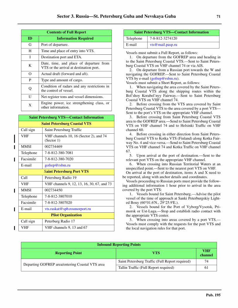
Sector 3. Russia—St. Petersburg Guba and Nevskaya Guba 71
Pub. 195
3.1 Vessels must submit a Full Report, as follows: 1. On departure from the GOFREP area and heading in
to the Saint Petersburg Coastal VTS.—Sent to Saint Peters-burg Coastal VTS on VHF channel 74 or via AIS.
2. On departure from a Russian port towards the W andnavigating the GOFREP.—Sent to Saint Petersburg CoastalVTS by e-mail ([email protected]).
3.1 Vessels must submit a Short Report, as follows: 1. When navigating the area covered by the Saint Peters-
burg Coastal VTS along the shipping routes within theBol’shoy Korabel’nyy Fairway.—Sent to Saint PetersburgCoastal VTS on VHF channel 74.
2. Before crossing from the VTS area covered by SaintPetersburg Coastal VTS to the area covered by a port VTS—Sent to the port’s VTS on the appropriate VHF channel.
3. Before crossing from Saint Petersburg Coastal VTSarea to the GOFREP area.—Send to Saint Petersburg CoastalVTS on VHF channel 74 and to Helsinki Traffic on VHFchannel 60.
4. Before crossing in either direction from Saint Peters-burg Coastal VTS to Kotka VTS (Finland) along Kotka Fair-way No. 4 and vice-versa.—Send to Saint Petersburg CoastalVTS on VHF channel 74 and Kotka Traffic on VHF channel67.
5. Upon arrival at the port of destination.—Sent to therelevant port VTS on the appropriate VHF channel.
6. When crossing into Russian Territorial Waters at anunspecified point.—Sent to the nearest port VTS on VHF.
3.1 On arrival at the port of destination, items A and X need tobe reported, along with anchor details and coordinates. 3.1 Vessels proceeding to Russian ports must provide the follow-ing additional information 1 hour prior to arrival in the areacovered by the port VTS:
1. Vessels bound for Saint Petersburg.—Advise the pilotvessel of the time of approach at Sanki Peterburgskiy Light-ed Bouy (60°01.6'N., 29°25.9'E.).
2. Vessels bound for the Port of Vyborg/Vysotsk, Pri-morsk or Ust-Luga.—Stop and establish radio contact withthe appropriate VTS center.
3. When crossing into areas covered by a port VTS.—Vessels must comply with the requests for the port VTS andthe local navigation rules for that port.
G Port of departure.
H Time and place of entry into VTS.
I Destination port and ETA.
K Date, time, and place of departure fromVTS or the arrival at destination port.
O Actual draft (forward and aft).
P Type and amount of cargo.
Q Condition of radars and any restrictions inthe control of vessel.
U Net register tons and vessel dimensions.
X Engine power, ice strengthening class, orother information.
Saint Petersburg VTS—Contact Information
Saint Petersburg Coastal VTS
Call sign Saint Petersburg Traffic
VHF VHF channels 10, 16 (Sector 2), and 74 (Sector 1)
MMSI 002734469
Telephone 7-8-812-380-7081
Facsimile 7-8-812-380-7020
E-mail [email protected]
Saint Petersburg Port VTS
Call Petersburg Radio 19
VHF VHF channels 9, 12, 13, 16, 30, 67, and 73
MMSI 002734450
Telephone 7-8-812-3807010
Facsimile 7-8-812-3807020
E-mail [email protected]
Pilot Organization
Call sign Peterburg Radio 17
VHF VHF channels 9, 13 and 67
Contents of Full Report
ID Information Required Telephone 7-8-812-3274120
E-mail [email protected]
Saint Petersburg VTS—Contact Information
Inbound Reporting Points
Reporting Point VTS VHF channel
Departing GOFREP area/entering Coastal VTS areaSaint Petersburg Traffic (Full Report required) 74
Tallin Traffic (Full Report required) 61

72 Sector 3. Russia—St. Petersburg Guba and Nevskaya Guba
Pub. 195
Entering Russian territorial waters from the Kotka VTS area
Saint Petersburg Traffic (Short Report required) 74Passing Lighted Buoy No. 1 (59°58.5'N., 27°03.0'E.)
Passing Lighted Buoy No. 4 (60°11.6'N., 27°46.2'E.)
Vessels bound for Vyborg and Vysotsk
On entering the VTS port area and on arrival Vysotsk Traffic (Short Report required) 9
Vessels bound for Vyborg
Between the breakwaters at Vysotsk (60°36.6'N., 28°33.0'E.) and on arrival Vyborg Radio 5 12
Vessels bound for Ust’Luga
Upon entering the VTS port area and on arrival Ust’Luga Traffic (Short Report Required) 69
Vessels bound for Primorsk
When entering the VTS port area and upon arrival Primorsk Traffic (Short Report Required) 68
Vessels bound for Saint Petersburg
Passing Buoy No. 8 (60°02.8'N., 28°31.9'E.) Saint Petersburg Traffic (Short Report Required) 10
One (1) hour before entering the VTS port area Petersburg Lotsman/Saint Petersburg Pilot to confirm pilot request (Short Report Request) 9
Passing Lighted Buoy No. 14 (60°01.7'N., 29°20.0'E.)Petersburg Radio 9 (Short Report required) 12
Saint Petersburg Traffic (Short Report required) 10
Passing Saint Petersburg Lighted Buoy (60°02.0'N., 29°25.9'E.)
Petersburg Radio 17 9
Passing the protective dam (59°59.2'N., 29°41.5'E.)
Passing Lighted Buoys No. 23/24 (59°57.8'N., 29°48.'E.)
Passing Lighted Buoys No. 29/30 (59°56.2'N., 29°55.8'E.)
Upon entering Saint Petersburg Morskoy Canal (59°54.2'N., 30°05.8'E.) and on arrival
Outbound Reporting Points
Reporting Point VTS VHF Channel
Vessels departing Saint Petersburg
Departing Saint Petersburg Morskoy Canal (59°54.2'N., 30°05.8'E.)
Petersburg Radio 17 9
Passing Lighted Buoys No. 29/30 (59°59.2'N., 29°55.8.'E.)
Passing Lighted Buoys No. 23/24 (59°57.8'N., 29°48.0'E.)
Passing the protective dam (59°59.2'N., 29°41.5'E.)
Passing Saint Petersburg Lighted Buoy (60°01.6'N., 29°25.9'E.)
Inbound Reporting Points
Reporting Point VTS VHF channel

Sector 3. Russia—St. Petersburg Guba and Nevskaya Guba 73
Pub. 195
3.1 Vessels in transit from Reka Neva to the port of SaintPetersburg, or in transit to the W, must send a report to SaintPetersburg Port VTS on VHF channel 9, 1 hour beforeapproaching the Leytenanta Shimidta Bridge or the TuchkovBridge. 3.1 Additionally, any incidents of pollution or sightings of ma-rine environmental pollution should also be reported. 3.1 Vessels intending to operate in the main ship channel be-tween the harbor entrance and the harbor area NE of LesnoyMol, should request permission to proceed before passing theharbor entrance if inbound, and before departing berth, if out-bound. 3.1 Vessels intending to navigate between the area NE of LesnoyMole and the NE end of the harbor should contact theNevskiye Vorota signal station before reaching the SE end ofBerth 31 if northeast bound, or before passing Nevskiye Vorotaif southeast-bound. In winter, permission should be obtainedfrom the Ship Control Center. 3.1 The radar station is available for assistance in poor visibility. 3.1 Storm warnings or a water rise of 1.5m above normal will bebroadcast to vessels in St. Petersburg harbor or anchorages. 3.1 Anchorage.—Waiting Anchorage Area No. 4, which maybest be seen on the chart, lies centered about 1 mile NW of St.Petersburg Lighted Buoy (60°02'N, 29°26'E.). It has depths of20 to 25m, mud and sand, with good holding ground. Marinersare cautioned to the existence of numerous obstructions con-sisting of lost anchors and chains, best seen on the chart, whichlie within and adjacent to this waiting area.3.1 It is reported that Anchorage Area No. 5 and Anchorage AreaNo. 5A have been established about 5 miles NNW of St. Pe-tersburg Fairway Lighted Buoy.3.1 Directions.—Vessels approaching St. Petersburg Guba
should make use of the several Traffic Separation Schemes(TSS) in the Gulf of Finland, which are best seen on the chart.3.1 A buoyed Safety Fairway leads from the TSS traffic lanes lo-cated at the E side of the Precautionary Area off Ostrov Seskar(60°02'N., 28°23'E.), through the Kronshtadt Fortified Zone, tothe pilot boarding place and waiting anchorage. This channelhas a bottom width of 80m and is marked by buoys. The Rus-sian authorities recommend adhering to this fairway, particu-larly within the Kronshtadt Fortified Zone.3.1 Caution.—Deep-draft vessels sometimes conduct cargo light-ering operations in the vicinity of the outer anchorage prior to en-tering the ports.3.1 It is reported that the buoys, lights, and beacons of the TSSlying in the outer approach to St. Petersburg may be missing orunlit.3.1 There is periodic dredging of the main channel fairways in boththe approaches and the ports during the summer navigation sea-son.3.1 Uncharted floating aids may be established in the vicinity ofdredging operations and charted floating aids may be out of po-sition. Care must be exercised when navigating in the work ar-eas.3.1 A number of designated spoil (dumping) ground areas lie inthe outer approaches and may best be seen on the chart.3.1 Several restricted areas, including unexploded ordnance ar-eas and mine sweeping exercise areas, lie in the outer ap-proaches and may best be seen on the chart.3.1 Kronshtadt Fortified Zone is entered on passing longitude29°00'E. Practically the whole of St. Petersburg Guba lies in aFortified Zone, which may best be seen on the chart. See Pub.140, Sailing Directions (Planning Guide) North Atlantic Oceanand Adjacent Seas for regulations pertaining to Fortified Zones.
Passing Lighted Buoy No. 13A (60°01.7'N., 29°20.0'E.)Petersburg Radio 9 (Short Report Required) 12
Saint Petersburg Traffic (Short Report Required) 10
Passing Lighted Buoy No. 8 (60°02.8'N., 28°31.9'E.) Saint Petersburg Traffic (Short Report Required) 10
Vessels departing from Ust’Luga
Upon departure from the port VTS area Saint Petersburg Traffic (Short Report Required) 74
Vessels departing from Primorsk
Upon departure from the port VTS area Primorsk Traffic (Short Report Required) 74
Vessels departing from Vyborg and Vysotsk
Upon departure from the port VTS area Saint Petersburg Traffic (Short Report Required) 74
Vessels transiting Coastal VTS area
Passing Lighted Buoy No. 4 (60°11.6'N., 27°48.2'E.)Saint Petersburg Traffic (Short Report Required) 74
Passing Lighted Buoy No. 1 (59°58.5'N., 27°03.0'E.)
Departing Russian Territorial Waters and entering Kotka VTS area
Kotka VTS (Short Report Required) 67
Saint Petersburg Traffic (Short Report Required) 74
Departing Coastal VTS area/entering GOFREP areaHelsinki Traffic (Short Report Required) 60
Saint Petersburg Traffic (Short Report Required) 74
Outbound Reporting Points
Reporting Point VTS VHF Channel

74 Sector 3. Russia—St. Petersburg Guba and Nevskaya Guba
Pub. 195
3.1 Extensive areas are prohibited to navigation, the limits ofwhich are subject to change without notice. Permission to enterthe Fortified Zone must be secured from the military authori-ties in advance, as well as permission to enter Kronshtadt or St.Petersburg. 3.1 Vessels must not deviate from the charted courses. A vesselentering a prohibited area will be warned by the firing of a gunor rocket, and such vessel must stop and await orders. Vesselsfailing to heave-to may be detained.
St. Petersburg Guba
3.2 St. Petersburg Guba, including Nevskaya Guba, ex-tends in an ESE direction for 35 miles from its entrance be-tween Sepelevskij and Mys Stirsudden, 12 miles NNW.3.2 Kronshtadtskiy Korabelnyy Farvater, about 12 miles long,leads from the E end of the buoyed channel (Safety Fairway) tothe vicinity of Kronshtadt. The St. Petersburg Morskoy Kanalthen leads to St. Petersburg. Secondary channels, for smallcraft, lie on either side of this canal.
North shore.—Mys Flotskiy, a low point, is located 4 miles
ESE of Mys Stirsudden (see paragraph 2.31). A light is shownfrom a framework tower, 20m high, standing on this point.3.2 Mys Pesochnyy is located 9 miles E of Mys Flotskiy and thecoats is moderately high and predominantly wooded.3.2 Gora Torkalla, 100m high, stands about 6 miles NNE of MysStirsudden and is conspicuous, as it is the highest hill on thispart of the coast.3.2 A conspicuous church is situated at Gorod Zelenogorsk(60°12'N., 29°42'E.).3.2 Between Mys Pesochnyy and Mys Dubovskiy, about 15miles ESE, the shore is mostly sandy, with some marshy areas,and fringed with boulders. Numerous dangers lie between MysDubovskiy and Ostrov Kotlin.3.2 A conspicuous tower stands on Mys Lisiy Nos, 4.5 miles Sof Mys Dubovskiy. The coast between is low, sandy, and wood-ed. Numerous holiday resorts stand along this stretch, someclose to the shore.
South shore.—The coast is low between Sepelevskij (seeparagraph 1.24) and Mys Seraya Loshad, about 2.5 miles ENE.At Sepelevskij, a range of low hills rises, increasing in heightas they trend E, until at Mys Krasnaya Gorka, 4 miles farther E,
3.1Russian Baltic Coast VTS Boundaries

Sector 3. Russia—St. Petersburg Guba and Nevskaya Guba 75
Pub. 195
they form a red sandy cliff. This cliff is conspicuous from sea-ward, but invisible from W. Between Mys Krasnaya Gorka andBronnaya Gora, 9.5 miles E, the coast is bordered by low, san-dy hills.3.2 Conspicuous churches are situated at Gory Valday(59°58'N., 29°12'E.) and Bol’shaya Izhora (59°56'N.,29°34'E.).
3.3 Ostrov Kotlin (60°00'N., 29°46'E.) is located at theseaward entrance to Nevskaya Guba. The island is low and itscenter and W parts are covered with vegetation. The W end ofthe island consists of a low, rocky cape. The port of Kronshtadtlies at the SE side of the island.3.3 A causeway, with a road, extends in an E direction and con-nects the N part of the island to Mys Lisiy Nos, on the N shore.
3.3 An area of reclaimed land, about 0.4 mile wide, extendsSSW from the S shore of the island to the N edge of the fair-way channel. Opposite this reclaimed area, a dam extends forabout 3 miles from the S shore to the S edge of the fairwaychannel.
3.3 Tolbukhin Light (60°03'N., 29°33'E.) is shown from a con-spicuous tower with a dwelling, 30m high, standing on a rockyislet, 3 miles WNW of the W end of Ostrov Kotlin.3.3 The island is fringed by a rocky shoal which extends W fromits W side to the vicinity of the light.3.3 Londonskaya Otmel (59°59'N., 29°30'E.), an extensiverocky shoal, extends up to about 2.5 miles from the S shore, Sof Tolbukhin Light. Several dangers lie on this shallow shoaland may best be seen on the chart.
3.4 Kronshtadt (59°59'N., 29°47'E.) (World Port IndexNo. 28400) is situated at the E end of Ostrov Kotlin and is thelargest Russian military harbor on the Baltic. The port consistsof a town fronted by five artificial harbors. Foreign commercialvessels may enter the harbor only with special permission.3.4 Tides—Currents.—The current in the roadstead runs to theE with winds from the W, at a velocity of 0.5 to 1.5 knots; aftersustained W winds bank up the water, the velocity may evenreach 3 knots.3.4 Depths—Limitations.—Kabotazhnaya Gavan, the coasterharbor, has depths of 1.5 to 7m, with the greatest depths beingin the S part.3.4 Kupecheskaya Gavan, the commercial harbor, has depths of7.3 to 9.4m in the S part and 1.8 to 5.2m in the N part.3.4 Srednyaya Gavan, used by naval vessels, has depths of 8.5 to10.7m in the S and E parts, but the N part is shallow.3.4 Voyennaya Gavan, also used by naval vessels, is connectedto Srednyaya Gavan. 3.4 Zavodskaya Gavan fronts the E side of the island and is usedby power boats. 3.4 Vessels up to 200m in length and 8m draft can enter the port.3.4 Aspect.—The approach channels are indicated by lightedranges and marked by buoys, which may best be seen on thechart. 3.4 A foundry chimney and the dome of the Naval Cathedral,both prominent, are situated in the town. 3.4 Ostrov Kronshlot, a fortified island, lies close S of the fair-way, in the vicinity of the port, and is marked by lights.3.4 For determining the error of the compass during the transit ofthe roadstead, marks are placed on the outer walls of the harborbasins indicating the true bearing of the foundry chimney.These marks are visible from a distance of 5 miles.3.4 Each complete 10° is shown by two white figures on a back-ground of black and red diagonal stripes. The intervening degreesare shown only by the last number, with even numbers on a blackbackground and odd numbers on a red background. Half degreesare marked by a small white circular disc with a black border. 3.4 In Bol’shoy Reyd, the bearings shown are from 079° throughE to 101°; in Malyy Reyd, from 078° through N to 355°; and inVostochny Reyd, from 337° to 254° through W. Separate marksfor 271° and 278° are shown on two of the piers. 3.4 Regulations.—When approaching the harbor entrances, pro-ceeding through narrow passages, and generally whenever aclose-quarters situation is possible, vessels shall proceed atslow speed and sound a prolonged blast of the whistle.3.4 Vessels intending to enter or leave a harbor shall, at a dis-tance of about 100m from the entrance, sound several pro-longed blasts of the whistle to warn vessels on the other side ofthe harbor wall. The entrance shall not be approached by ves-sels intending to pass through until the passage is clear; this is
3.2By Alexandrov [CC BY-SA 3.0], via Wikimedia Commons
3.2Kronshtadt—Dome of the Naval Cathedral
3.3Tolbukhin Light

76 Sector 3. Russia—St. Petersburg Guba and Nevskaya Guba
Pub. 195
shown by a signal hoisted at the signal mast at the entrance. 3.4 Anchorage.—Anchoring in the roadstead of Kronshtadt isstrictly prohibited, except in the following authorized anchor-ages:
1. Area 2 (59°58.09'N., 29°47.77'E.)—A small anchor-age area situated just NE of the intersections of Fairway No.2 and Fairway No. 7, SSE of the S point of Kronshtadt is-land. An obstruction is situated in the E part of the anchor-age.
2. Area 3—Anchorage may be obtained on the S side ofFairway No. 2, with a minimum depth of 7m, in position59°58'51.6''N., 29°42'50.4''E., which lies on the E side of theS causeway that connects Kronshtadt island to the mainland.
3.4 Directions.—Kronshtadtskiy Korabel’nyy Farvater leadsfrom the pilot boarding place, in the vicinity of St. PetersburgLighted Buoy, to the roadstead of Kronshtadt. 3.4 Caution.—During the day, some ranges in the vicinity of theroadstead are difficult to identify against the buildings in thebackground.3.4 A submarine cable extends SW and W into the fairway fromthe port and may best be seen on the chart.
Nevskaya Guba
3.5 Nevskaya Guba lies between Ostrov Kotlin and themouth of the Reka Neva. The S shore, on which there are manyvillages, descends to the sea in terraces. Both the N and Sshores are densely wooded.3.5 Between Mys Lisiy Nos and Lakhta, 6 miles ESE, the Nshore of Nevskaya Guba is low, sandy, and wooded. Off the
villages of Dubi and Verperow, about 1.2 and 1.8 miles SE ofMys Lisiy Nos, respectively, are two low-lying rocky islets, theeasternmost of which is Ostrovki Verperluda. The white towerof the biological institute, standing 5.2 miles E of Mys LisiyNos, and Lakhtinskiy Rescue Station, now disused, situated 1.5miles farther E, are good landmarks. Numerous holiday re-sorts, some close to the shore, are situated between Mys LisiyNos and Lakhta.3.5 On the S shore, a prominent palace stands on a hill near thetown of Lomonosov, S of the E end of Ostrov Kotlin. Martysh-kina Church, also prominent, is situated 1.8 miles ESE of thepalace. 3.5 At Petrodvorets, 5 miles ESE, the former palace, with itsgolden emblem, and the cathedral are conspicuous.3.5 The St. Petersburg Morskoy Kanal connects the E end ofKronshtadtskiy Korabel’nyy Farvater with the harbor of St. Pe-tersburg. This canal is about 15 miles long. It is marked bybuoys and indicated by lighted ranges which may best be seenon the chart.3.5 Vessels entering the canal are usually limited to a maximumlength of 260m, a maximum beam of 40m, and a maximumfresh water draft of 11m.3.5 Other minor channels, used by local craft, connect severalsmall harbors within Nevskaya Guba and may best be seen onthe chart.3.5 Lomonosov (59°55'N., 29°46'E.) (World Port Index No.28390) is a small naval harbor protected by two breakwaters. Achannel leads S from the main fairway at the E end of OstrovKotlin to this harbor. There are depths of 3.6 to 7.2m alongsidethe principal quays.
3.4By Amendment22 [CC BY-SA 4.0], via Wikimedia Commons
Port Bronka
Sector 3. Russia—St. Petersburg Guba and Nevskaya Guba 77
Pub. 195
3.5 Caution.—An obstruction lies 0.4 mile N from the head ofE mole; another obstruction lies with a depth of 5.7m at theedge of the channel from the same mole.
3.6 Port Bronka (59°56'N., 29°41'E) has been estab-lished in order to supplement the future container growth po-tential in Russia. The port will be developed in three stages.Stage I has been completed and the annual handling is approxi-mately 1,450,000 teu and 260,000 vehicles. Stage II should becompleted in 2017, and Stage III will be completed in 2022. 3.6 The approach channel leading to the terminal is reported tobe dredged to a depth between 10.7m and 13.4m. 3.6 Port Bronka has a container terminal that consists of fiveberths with a total length of 1220m and a depth of 14.4malongside. The RoRo Terminal consists of one berth 220m longwith a depth of 12.4m and a two more are planned for the fu-ture.
St. Petersburg (59°56'N., 30°18'E.)
World Port Index No. 28370
3.7 The port of St. Petersburg (Sankt Peterburg) is situat-ed on the banks of the Reka Neva and the islands forming itsdelta. The city, which was once the capital of Russia, was pre-viously known as Leningrad and Petrograd. The port, used byboth naval and commercial vessels, is connected by an interiorwaterway canal system with the White Sea, the Caspian Sea,and the Black Sea.
3.7 Ice.—Navigation is possible all year round with icebreaker as-sistance from the end of November until about the last week ofApril. Ice first begins to form in the middle of November. Thethickness of the ice averages 0.7m and is never more than 1m. 3.7 Winds—Weather.—Within Nevskaya Guba, SW and Wwinds prevail in winter and represent 70 to 75 per cent of re-cordings. In summer, W and NW winds prevail and represent21 per cent and 18 per cent of recordings, respectively. Inspring, the most frequent winds are W and represent 16 to 27per cent of recordings. In the fall, SW winds prevail and repre-sent 17 to 24 per cent of recordings. Wind force decreases inspring and summer, but increases in the fall and winter. 3.7 Calms are most frequent in spring and summer and represent30 per cent of recordings. Storms are mainly recorded duringfall and winter; their occurrence fluctuates around 10 per centof recordings. 3.7 Storms are most frequently related to S and SW winds,though they also occur during NW, NE, and E winds. The dura-tion of these storms seldom exceeds 24 hours.3.7 The number of days with fog in Nevskaya Guba averages 57per year. The largest number of days with fog is recordedduring the September to April period, and varies from 5 to 8days per month. During this period, fogs are thicker and lastlonger. In winter, fogs occur most frequently during E and NEwinds and more rarely during NW and N winds. In spring, fogsare formed during SW and W winds.
3.7 Tides—Currents.—Basic level fluctuations are caused bythe cumulative effect of rollers and by the seiche phenomena.The cumulative fluctuations usually occur suddenly, last ashort period of time, and are intensive. Level increases are usu-ally brought on by winds of W directions and decreases bywinds of E directions. The value of these fluctuations of levelseldom exceeds 0.5m in the spring and summer, but in the falland winter it reaches 1.2m. 3.7 Particularly high rises of water are observed in NevskayaGuba, which in some years has recorded 2.5 to 3.5m, althoughit was reported that the rise has been as high as 3.9m. In the Re-ka Neva estuary, the strongest water level fluctuations occurduring SW fall storms. 3.7 Seiche level fluctuations usually do not exceed 0.2 to 0.3m,and only in isolated cases do they reach 1m. 3.7 The current velocity of the Reka Neva averages about 2knots, increasing to 3 knots with N winds, and becoming weak-er during W winds. 3.7 Depths—Limitations.—Vessels entering the port of St. Pe-tersburg are restricted to a maximum draft of 11m, a length of260m, and a beam of 40m. Ocean-going vessels enter via theSt. Petersburg Morskoy Kanal. Four other minor channels leadto the port and are used by local small craft.3.7 The port is separated from Nevskaya Guba by KanonerskayaOtmel. The canal, the main entrance channel, enters the S partof the port. A fairway, swept to a depth of 9.8m, then leads NEto the N part. The main harbor basins lie E of this fairway.3.7 Between the entrance sea walls, the channel is reported to bedredged to a depth of 11.3m.3.7 Ugolnaya Gavan, at the S end of the harbor complex, isbound on its SW side by Ugolnyy Mol and on its NE side byLesnoy Mol. This basin has an entrance, 140m wide, anddepths up to 11m alongside the quays.3.7 An oil berth, with a depth of 10.8m alongside, is situated inthe NW part.3.7 Reyd Lesnoyo Mola, the basin lying N of Lesnoy Mol, hasdepths of 5 to 11.5m alongside the quay on the SW side.3.7 Barochnyy Basseyn lies close NE of Reyd Lesnoyo Mola.This basin has an entrance, 220m wide, and depths up to 11.5malongside the quays.3.7 Vostochnyy Basseyn is approached via a channel, with adredged depth of 8.5m, which leads from the SE side of Ba-rochnyy Basseyn and along the N side of Krivaya Damba, a de-tached breakwater. This basin has depths of 6 to 8m alongsidethe quays.3.7 Morskoy Kanal, leading to the N part of the port, has berthssituated along its E side with depths up to 11.5m alongside.3.7 Gutuyevskiy Kovsh is a small basin which extends E fromthe N end of the canal. This basin has depths of 4 to 7.6malongside the quays.3.7 Novaya Kanonerskiy Gavan, a ship repair harbor, has depthsof 6.5 to 8m in the approach channel and 4 to 8m in the basin.This harbor area lies between Ostrov Kanonerskiy and OstrovBelyy. The approach channel leads W between Bolshaya Nevaand Neviskiye Vorota, the N entrance to the port.3.7 An international passenger terminal is situated on the Nshore of Bolshaya Neva. The berths and approach channel havedepths of 9.5m.3.7 There is a total of 1,200m of berthage alongside the N and Wbanks of the river, with depths of 4.2 to 6.1m alongside.
St. Petersburg Port Authority
https://www.rosmorport.ru

78 Sector 3. Russia—St. Petersburg Guba and Nevskaya Guba
Pub. 195
3.7 The port has facilities for tanker, bulk, general cargo, con-tainer, ro-ro, timber, reefer, cruise, and passenger vessels.There are also facilities for pleasure craft and yachts.3.7 A turning circle with a radius of 280m has been establishedfor use by container vessels, and is centered at (59°59'N.,29°43.1'E.) close N of Waiting Area No 3, and can best be seenon the chart.3.7 Aspect.—The entire St. Petersburg area is comparativelylow, varying from 5m high in the S and E parts, to 10m high inthe N part. The region is dominated by the delta of the river.3.7 When approaching the port, the Admiralty, is conspicuous.This large building is 74m high with a gilded tower and spire.It is situated on the S bank of the Reka Neva, nearly 0.5 mileabove the Lieutenant Shmidt Bridge.3.7 Dvoryetz Iskussrv, or Palace of Arts, formerly the WinterPalace, stands close NE of the Admiralty.3.7 The gilded dome of Issacs Cathedral, standing close S of theAdmiralty, is very conspicuous. Also conspicuous is the gildedand lofty spire of the cathedral rising from the Peter and PaulFortress. It is situated on the opposite shore of the Reka Neva,NE of the Admiralty.
3.7 Pilotage.—Pilotage is compulsory for entry and departurefrom all Russian Ports. Pilots are also required for docking andundocking. 3.7 See Pilotage under General Remarks in paragraph 3.1. De-parting vessels should order a pilot at least 2 hours prior to de-parture. Deep-sea pilots are available upon request.
1. In bad weather vessels may be required to follow thepilot vessel until the pilot can board.
2. The pilot boards in the following positions: a. Near Sankt Peterburgskly Lighted Buoy
(60°01.6'N., 29°25.9'E.).b. Near Lighted Buoy No. 2 (60°05.3'N., 29°48.0'E.).
3.7 Regulations.—See Regulations under General Remarks inparagraph 3.1.3.7 Vessels exceeding 170m in length or with drafts of 8.5m andover are considered to be constrained by their draft and mustdisplay the appropriate signals. Such vessels have the right ofway and must employ tugs in the narrows within the St. Peters-burg Morskoy Kanal. 3.7 Vessel Traffic Service.—In addition to participating in theSaint Petersburg Port Vessel Traffic Service, vessels bound forSaint Petersburg transit the coverage area of St. PetersburgCoastal VTS. See paragraph 3.1 for further information. 3.7 Signals.—Storm signals are shown, by day, from the meteo-rological station at Lebyazh’ye (59°58'N., 29°26'E.) and fromthe lower yardarm of a mast at Lomonosov.3.7 Contact Information.—See the table titled Saint Peters-burg—Contact Information.
3.7 Anchorage.—Several anchorage waiting areas are situatedadjacent to the sides of the St. Petersburg Morskoy Kanal andmay best be seen on the chart.3.7 A waiting area for Outer Anchorage Area No. 3a, centeredon position 59°59.1'N, 29°42.5'E, has a radius of 265m, in anarea dredged to 11.4m (2013). Care should be taken to avoidanchoring near a submarine cable laid through the upper half of
3.7By User: Drozdov VA [Public Domain], via Wikimedia Commons
3.7St. Petersburg—Passenger Terminal Berths
3.7St. Petersburg—Container Terminal Berths
St. Petersburg SPB Pilot Ltd
https://www.spb-pilot.com
Saint Petersburg—Contact Information
Saint Petersburg Port VTS
Call sign Petersburg Radio 19
VHF VHF channels 9, 12, 13, 16, 30, 67, and 73
Telephone 7-8-812-3807010
Facsimile 7-8-812-3807020
E-mail [email protected]
Internal Port VTS
Call sign Peterburg Radio 17
VHF VHF channels 9, 13, and 67
Telephone 7-8-812-3274120
E-mail [email protected]

Sector 3. Russia—St. Petersburg Guba and Nevskaya Guba 79
Pub. 195
the anchorage. 3.7 Anchorage Area No. 4a is centered 2.5 miles WSW of SaintPetersburg No. 1 Lighted Buoy (60°01.6'N., 29°25.9'E.), onFairway No. 1. Waiting Area No. 1, directly N of AnchorageArea No. 4a, can be used by non-Russian vessels for anchor-ing; however, care should be taken to avoid obstructions which
lie within and along the boundary of both anchorage areas. Alost anchor with attached chain was reported (2020) as a sub-merged obstruction within Anchorage Area 4a. 3.7 Caution.—Care is advised as the entrance channel narrowsto a width of about 70m between the sea walls, which were re-ported to be in a poor state of repair.
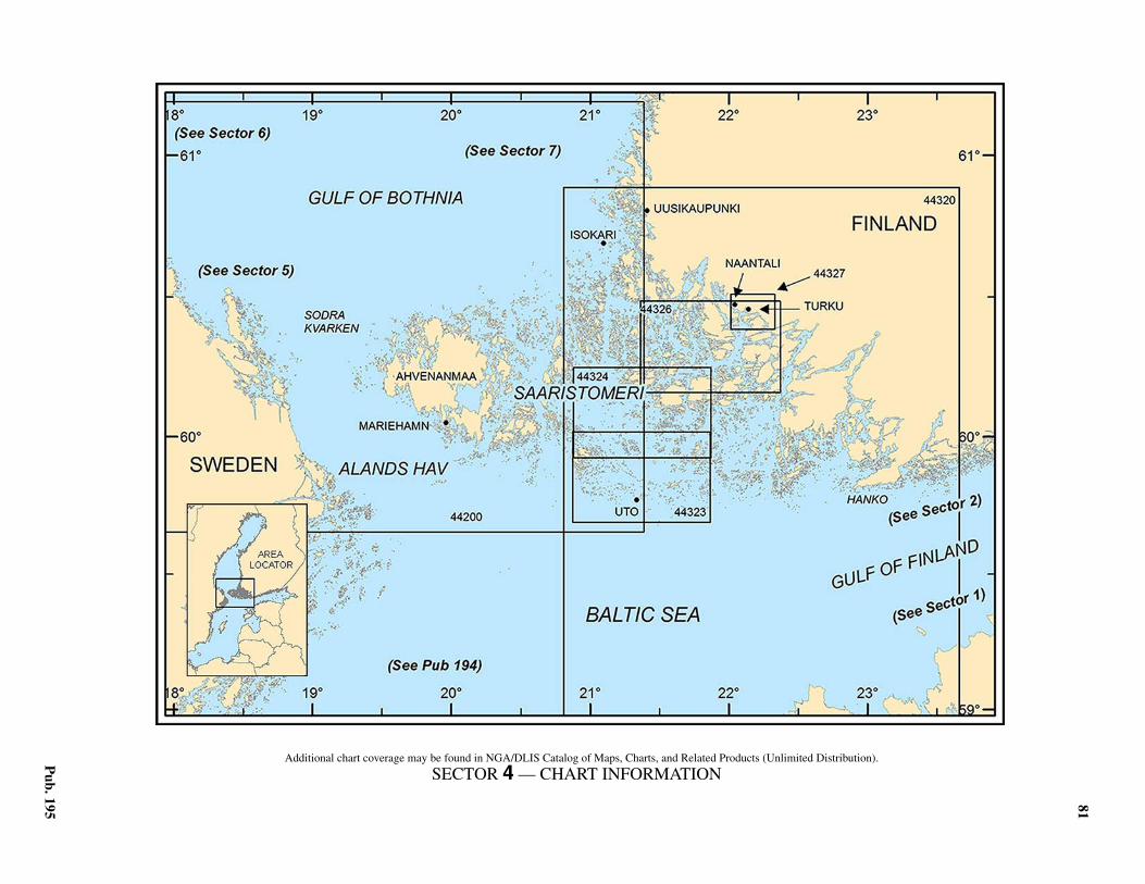
81
Pub. 195
4. Sector 4—The Aland Islands and the Adjacent Finnish Coast
4.0Additional chart coverage may be found in NGA/DLIS Catalog of Maps, Charts, and Related Products (Unlimited Distribution).
SECTOR 4 — CHART INFORMATION

83
Pub. 195
SECTOR 4
THE ALAND ISLANDS AND THE ADJACENT FINNISH COAST
4.0 Plan.—This sector describes the Aland Islands and thosedangers lying along the seaward edges of the archipelago ex-tending from the Finnish coast. The descriptive sequence is Wfrom the cape of Hanko (Hangoudd) (59°49'N., 22°54'E.) toSodra Kvarken (60°18'N., 19°00'E.) and then E to Isokari(60°43'N., 21°01'E.). The ports of Turku and Naantali, situatedat the SW corner of Finland, are described at the end of thissector.
General Remarks
4.1 Winds—Weather.—Among the islands, SW windsprevail. Winds from SE are usually accompanied by rain and Nwinds are accompanied by squalls.4.1 Fog occurs in the spring and autumn. The fog is usually thickand dry in the spring, and damp with fine rain in the autumn. 4.1 Ice.—During an average winter ice forms within the inlets ofthe Ahvenanmaa Islands in the middle of January, and quicklyextends around these islands and over the sea to the E of them.By the beginning of February the whole sea area between theAhvenanmaa Islands and the Finnish coast is ice-encumbered. Inthe middle of February, the N part of the Aland Sea and SodraKvarken are ice-covered. After the middle of March the ice be-gins to decrease, and by the beginning of April, the Aland Seaand Sodra Kvarken are open. At the end of April the sea betweenthe Ahvenanmaa Islands and the Finnish coast is clear.4.1 A passage is usually kept open all winter through Rodhamns-fjarden and Foglofjard as far as Turku. If the winter antic-ycloneto the SE extends W and N, giving a period of E winds and coldweather over the Baltic, a great deal of ice is heaped up on the Scoast off the Ahvenanmaa Islands. On the S side of the AlandSea, traffic is unhindered in very mild winters.4.1 The earliest reports of ice in the N part of the Gulf of Bothniaoccur usually in November. Ice first forms within inlets and inshallow water along the coasts. It is slow to extend seaward butextends quite rapidly along the coasts. By the middle of Januarya continuous belt of ice surrounds most of the coasts and muchof the sea area in the gulf N of latitude 63° is frozen. Ice condi-tions are usually at their peak by the end of February. Normally,ice conditions improve from early March onward. Ice recedes Nand has usually left Turku (60°27'N., 22°15'E.) and Gavle(60°41'N., 17°10'E.) by 14 April. The N part of the gulf is nor-mally ice-free by the middle of May.4.1 For information pertaining to winter navigation, ice, andFinnish icebreaking services, including internet web sites, seePub. 140, Sailing Directions (Planning Guide) North AtlanticOcean and Adjacent Seas.4.1 Tides—Currents.—Currents are generally dependent on thedirection of the wind, but strongly divided by the islands andshoals. The water level is a good indication of expected winds.A rise precedes winds from the SE or SW, and a fall precedesthose from the N.4.1 Aspect.—The peninsula of Hankoinemi and the dangers ad-jacent to it are described in paragraph 2.2.
4.1 The Aland Islands, located in the entrance of the Gulf ofBothnia, are separated from the coast of Sweden by the AlandSea and Sodra Kvarken.4.1 Saaristomeri, the waters lying between the Aland Islands andthe mainland of Finland, are encumbered by islands, islets, andinnumerable rocks and shoals.4.1 Aland Island (Ahvenanmaa), the largest of the group, is par-tially wooded and intersected by numerous inlets. It is reportedthat about two-thirds of the inhabitants of the group reside onthis island and are of Swedish extraction.4.1 Pilotage.—Pilotage is compulsory within the archipelago ar-ea for all merchant vessels and foreign warships; all tankersover 15,000 dwt when loaded must carry two pilots.4.1 All ordering of local pilots throughout Finland is carried outby the Finnpilot Order Center. For more details on the Finn-pilot Center see paragraph 1.14.1 The IMO recommends that vessels constrained by their draftor vessels not registered in one of the Baltic states, and infre-quently sailing the area, embark a deep-sea pilot. 4.1 Vessels requiring a licensed Deep Sea Pilot in the Balticshould make a request at least 12 hours in advance to the localagents.4.1 Pilots should be ordered by one of the following methods:
1. Web site, using the Pilot Order Form.2. Telephone.3. Facsimile.4. E-mail.
4.1 The Finnpilot Order Center will confirm receipt of the pre-liminary information or Pilot order using the same method asused to make the order. An order placed using a form on the in-ternet can also be confirmed via e-mail if requested by the cus-tomer, providing an e-mail address is included in the orderinformation or is otherwise known by Finnpilot. (An orderplaced by telephone is not confirmed separately after the tele-phone call). There is no pilot ordering via VHF radio.4.1 The following procedures are in place for inbound and out-bound vessels:
1. Inbound vessels:a. Vessels must provide 12 hour and 3 hour advance
notification of ETA at the pilot boarding position to the Pi-lot Order Center.
b. Vessels must place a binding pilotage order to thePilot Order Center 3 hour prior to arrival at the pilot board-ing position.2. Outbound vessels:
a. The vessel's agent or the vessel must provide 12hour and 2 hour advance notification of departure to thePilot Order Center.
b. The vessel’s agent or the vessel must provide abinding pilotage order 2 hour before departure to the PilotOrder Center.3. Vessels shifting berth must provide 2 hour advance
notice to the Pilot Order Center.4. During the winter months, pilot boarding positions

84 Sector 4. The Aland Islands and the Adjacent Finnish Coast
Pub. 195
may be subject to alteration according to the prevailingweather conditions.
4.1 Pilots for the archipelago area board vessels in the followingpositions:
1. For vessels approaching from S—About 3 miles SSWof Uto.
2. For vessels approaching from W bound for Farjsun-det, Degerby, and all other destinations in the E part of thearchipelago—In position 59°56.6'N, 19°57.6'E. This board-ing position is also used by vessels transiting the Archipela-go Sea bound for Hanko during ice conditions.
3. For vessels approaching from N—In position60°44.47'N, 20°55.03'E (Isokari).
4. For vessels approaching from SE—About 1.5 milesENE of Russaro.
5. For the port of Mariehamn (Maarianhamina)—In aposition approximately 1.5 miles SSW of Nyhamn Tower or1.25 miles WSW of Marhallan Light.
6. For vessels transiting Saarstomeri bound for Hankoduring ice conditions—In position 59°56.3'N, 19°56.3E.
4.1 Regulations.—The Finnish authorities have instituted a sys-tem of restricted areas and semi-restricted areas throughout thewhole of Finland’s coastal waters. The limits of the areas lyingwithin the waters described in this sector may best be seen onthe chart.4.1 Vessels are permitted to transit these restricted areas onlythrough an approved channel, with a pilot aboard. 4.1 Anchoring is prohibited in marked areas. Short-time anchor-ing is allowed by permission of the VTS.4.1 Areas dangerous due to mines laid during World War II existwithin the waters described in this sector. There is still a risk ofdanger in these areas and anchoring or carrying out any seabedactivities are prohibited without special permission.4.1 See Pub. 140, Sailing Directions (Planning Guide) North At-lantic Ocean and Adjacent Seas for regulations pertaining tovessels within the waters of Finland. Vessels should also con-sult the pilot as well as the local authorities for details on localregulations. 4.1 Vessel Traffic Service (VTS).—The Archipelago VTS areacovers the Archipelago Sea, including merchant shippinglanes. The eastern boundary is Flackgrund Light, the northernboundary Hylkkari Light and at sea the boundary line followsthe outer limits of the VTS area. The VTS area also covers theareas administered by the Port of Turku and the Port of Naanta-li. See the graphic titled Archipelago (Saaristomeri) VTS forclarification.
4.1 The Archipelago VTS provides the following types of ser-vices:
1. Information service.2. Traffic organization service.3. Navigational assistance service.
4.1 Mandatory participation and other requirements in the VTSare listed below:
1. Vessels of 24m loa or over are obliged to participatein the VTS.
2. When navigating in the VTS area, vessels are requiredto maintain a continuous listening watch on VHF channel71.
3. Vessels navigating in the VTS area, which are notobliged to participate in the VTS, are recommended to main-tain a listening watch on VHF channel 71.
4. Participating vessels are required to make reports, asfollows:
a. Upon entry into the VTS area.b. Before anchoring.c. Before leaving an anchorage.d. After berthing.e. A departure report before leaving the Port of Turku
or Naantali. The permission to depart issued by the VTS isvalid for 20 minutes, during which time the vessel mustget underway. If the vessel’s departure is delayed, it willhave to request a new permission to depart. This does notapply to departures from the Aura River.
f. At 20 minutes before passing the following report-ing points:
i. Fagerholm (60°06.2'N, 21°41.6'E.).ii. Lovskar (60°13.3'N, 21°42.9'E.).iii. Smorgrund (60°10.3'N, 21°26.1'E.).iv. Hylkkari (60°57.0'N, 21°08.5'E.).v. Ljungo (60°05.7'N, 20°40.5'E,) westbound ves-
sels report their selected route.vi. Ledsund (59°57.9'N, 20°10.6'E.). or S of
Ledskar (59°57.4'N, 20°10.3'E,) eastbound vessels re-port their selected route.
vii. Flackgrund (59°52.2'N, 22°50.0'E.)viii. Askgrund (60°11.8'N, 22°10.3'E.).ix. Marhallan or Korso, on arrival at the VTS area.
g. Southbound vessels shall report 20 minutes beforepassing Hylkkari Light to Archipelago VTS on VHF chan-nel 71.
h. Northbound vessels shall report 20 minutes beforepassing Hylkkari Light to West Coast VTS on VHF chan-nel 9.
i. Westbound vessels shall report 20 minutes beforepassing Flackgrund Light to Archipelago VTS on VHFchannel 71.
j. Eastbound vessels shall report 20 minutes beforepassing Flackgrund Light to Hanko VTS on VHF channel67.
k. When passing the following reporting points:i. Orhisaari, only westbound vessels report their se-
lected route.l. East of Kihti Light 60°0.64'N, 21°0.38'E, commut-
er and archipelago ferries with operational AIS in use areonly required to report when the visibility is less than 1mile.
m. At 10 minutes before arriving in Langnas60°07.30'N, 20°17.94'E, for vessels arriving from the di-rections of Godby.
4.1 Reports should include the following information:1. Vessel’s name.2. Name of reporting point.3. Destination.4. Intended route. If an alternative route is selected, this
must be reported.
FinTraffic VTS—Master’s Guide
https://www.fintraffic.fi/en/vts/masters-guide

Sector 4. The Aland Islands and the Adjacent Finnish Coast 85
Pub. 195
Within the VTS there are certain areas with meeting andovertaking prohibitions (unless one of the parties is a tug or avessel whose size in comparable to a tug). Meeting and over-taking is permanently prohibited in the following areas:
1. At Lovskar between longitude 21°43.0'E and longi-tude 21°45.2'E, in the 15.3m fairway.
2. At Ledsund between the longitude 20°09.7'E and lon-gitude 20°10.6'E, in the 7.0m fairway.
3. At Ljungo between the longitudes 20°40.7'E and lon-gitude 20°42.0'E, in the 8.2m fairway.
4. At Hulgrund between the longitudes 20°22.2'E and20°23.2'E, in the 7.0m fairway.
5. At Ronngrund between the latitudes 60°17.3'N and60°16.3'N, in the 10.0m fairway.
6. In the fairway section Porokari.Saaronniemi betweenlatitudes 60°24.4'N and 60°25.3'N in the 15.3m fairway.
4.1 Contact Information.—See the table titled Saaristomeri—Contact Information.
4.1 Directions.—The main offshore shipping routes leading toports in the Gulf of Bothnia pass W of the Aland Islands andthrough Sodra Kvarken (see paragraph 5.8).
4.1 Channels, requiring extensive local knowledge, lead betweenthe islands and dangers, and connect the Aland Islands with themainland. The main approaches to these channels from sea-ward are, as follows:
1. From the SW—through Rodhamnsfjarden (via Ny-hamn).
2. From the S—by a channel passing W of Uto(59°47'N., 21°22'E.).
3. From the E—using the NW approaches to Hanko.4. From the N—via Isokari.
4.1 Caution.—Strong S to SW winds cause treacherous seasamong the islands off the S and SW coasts of Finland, between
Archipelago (Saaristomeri) VTS
Saaristomeri—Contact Information
Archipelago (Saaristomeri) VTS
Call sign Archipelago VTS
VHF VHF channel 71
Telephone358-204-486521 (Archipelago VTS)
358-204-486522 (Supervisor)
Web site https://www.fintraffic.fi/en/masters-guide
Saaristomeri—Contact Information
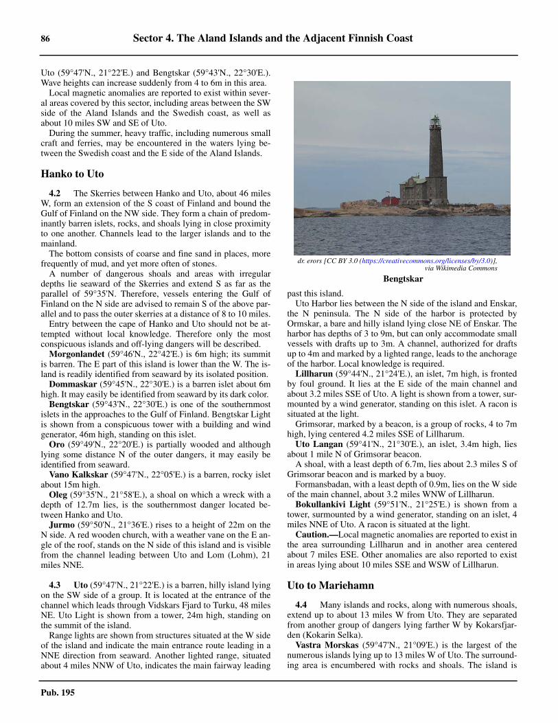
86 Sector 4. The Aland Islands and the Adjacent Finnish Coast
Pub. 195
Uto (59°47'N., 21°22'E.) and Bengtskar (59°43'N., 22°30'E.).Wave heights can increase suddenly from 4 to 6m in this area.4.1 Local magnetic anomalies are reported to exist within sever-al areas covered by this sector, including areas between the SWside of the Aland Islands and the Swedish coast, as well asabout 10 miles SW and SE of Uto.4.1 During the summer, heavy traffic, including numerous smallcraft and ferries, may be encountered in the waters lying be-tween the Swedish coast and the E side of the Aland Islands.
Hanko to Uto
4.2 The Skerries between Hanko and Uto, about 46 milesW, form an extension of the S coast of Finland and bound theGulf of Finland on the NW side. They form a chain of predom-inantly barren islets, rocks, and shoals lying in close proximityto one another. Channels lead to the larger islands and to themainland.4.2 The bottom consists of coarse and fine sand in places, morefrequently of mud, and yet more often of stones.4.2 A number of dangerous shoals and areas with irregulardepths lie seaward of the Skerries and extend S as far as theparallel of 59°35'N. Therefore, vessels entering the Gulf ofFinland on the N side are advised to remain S of the above par-allel and to pass the outer skerries at a distance of 8 to 10 miles.4.2 Entry between the cape of Hanko and Uto should not be at-tempted without local knowledge. Therefore only the mostconspicuous islands and off-lying dangers will be described.4.2 Morgonlandet (59°46'N., 22°42'E.) is 6m high; its summitis barren. The E part of this island is lower than the W. The is-land is readily identified from seaward by its isolated position.4.2 Dommaskar (59°45'N., 22°30'E.) is a barren islet about 6mhigh. It may easily be identified from seaward by its dark color. 4.2 Bengtskar (59°43'N., 22°30'E.) is one of the southernmostislets in the approaches to the Gulf of Finland. Bengtskar Lightis shown from a conspicuous tower with a building and windgenerator, 46m high, standing on this islet. 4.2 Oro (59°49'N., 22°20'E.) is partially wooded and althoughlying some distance N of the outer dangers, it may easily beidentified from seaward. 4.2 Vano Kalkskar (59°47'N., 22°05'E.) is a barren, rocky isletabout 15m high. 4.2 Oleg (59°35'N., 21°58'E.), a shoal on which a wreck with adepth of 12.7m lies, is the southernmost danger located be-tween Hanko and Uto.4.2 Jurmo (59°50'N., 21°36'E.) rises to a height of 22m on theN side. A red wooden church, with a weather vane on the E an-gle of the roof, stands on the N side of this island and is visiblefrom the channel leading between Uto and Lom (Lohm), 21miles NNE.
4.3 Uto (59°47'N., 21°22'E.) is a barren, hilly island lyingon the SW side of a group. It is located at the entrance of thechannel which leads through Vidskars Fjard to Turku, 48 milesNE. Uto Light is shown from a tower, 24m high, standing onthe summit of the island.4.3 Range lights are shown from structures situated at the W sideof the island and indicate the main entrance route leading in aNNE direction from seaward. Another lighted range, situatedabout 4 miles NNW of Uto, indicates the main fairway leading
past this island.4.3 Uto Harbor lies between the N side of the island and Enskar,the N peninsula. The N side of the harbor is protected byOrmskar, a bare and hilly island lying close NE of Enskar. Theharbor has depths of 3 to 9m, but can only accommodate smallvessels with drafts up to 3m. A channel, authorized for draftsup to 4m and marked by a lighted range, leads to the anchorageof the harbor. Local knowledge is required. 4.3 Lillharun (59°44'N., 21°24'E.), an islet, 7m high, is frontedby foul ground. It lies at the E side of the main channel andabout 3.2 miles SSE of Uto. A light is shown from a tower, sur-mounted by a wind generator, standing on this islet. A racon issituated at the light.4.3 Grimsorar, marked by a beacon, is a group of rocks, 4 to 7mhigh, lying centered 4.2 miles SSE of Lillharum.4.3 Uto Langan (59°41'N., 21°30'E.), an islet, 3.4m high, liesabout 1 mile N of Grimsorar beacon.4.3 A shoal, with a least depth of 6.7m, lies about 2.3 miles S ofGrimsorar beacon and is marked by a buoy.4.3 Formansbadan, with a least depth of 0.9m, lies on the W sideof the main channel, about 3.2 miles WNW of Lillharun.4.3 Bokullankivi Light (59°51'N., 21°25'E.) is shown from atower, surmounted by a wind generator, standing on an islet, 4miles NNE of Uto. A racon is situated at the light.4.3 Caution.—Local magnetic anomalies are reported to exist inthe area surrounding Lillharun and in another area centeredabout 7 miles ESE. Other anomalies are also reported to existin areas lying about 10 miles SSE and WSW of Lillharun.
Uto to Mariehamn
4.4 Many islands and rocks, along with numerous shoals,extend up to about 13 miles W from Uto. They are separatedfrom another group of dangers lying farther W by Kokarsfjar-den (Kokarin Selka).4.4 Vastra Morskas (59°47'N., 21°09'E.) is the largest of thenumerous islands lying up to 13 miles W of Uto. The surround-ing area is encumbered with rocks and shoals. The island is
4.2dr. erors [CC BY 3.0 (https://creativecommons.org/licenses/by/3.0)],via Wikimedia Commons
4.2Bengtskar

Sector 4. The Aland Islands and the Adjacent Finnish Coast 87
Pub. 195
17m high in the S part, about 13m high in the NE part, and iscovered with bushes.4.4 Bogskar (59°30'N., 20°21'E.), a group of rocks fronted byshoals, is the southernmost danger in the Aland archipelago.Bogskar Light is shown from a tower with a building and windgenerator, 46m high, standing on the westernmost rock. Aracon is situated at the light. On the easternmost and highestrock, lying about 2.5 miles ENE of the light, there is a beacon.4.4 Suomen Leijiona (59°28'N., 20°49'E.), a shoal, has a leastdepth of 10.4m and lies about 14.5 miles ESE of Bogskar.Suomen Leijiona Light is shown from a tower, 14m high,standing on the S part of this shoal. An AIS is situated at thelight.4.4 Svenska Bjorn Light (59°33'N., 20°01'E.) is shown from atower, with a helicopter platform,32m high, standing on SodraKlatten, a shoal. A racon is situated at the light. Sodra Klatten,along with Norra Klatten, another shoal lying 1 mile NW, has aleast depth of 10m. These shoals lie at the E edge of the dan-gers extending up to over 30 miles from the Swedish mainland.4.4 During wintertime, vessels bound for Swedish and Finnishports with traffic restrictions in the Gulf of Bothnia are request-ed to report the information by VHF as shown in the table titledWinter Reporting Information.
4.4 Armbagen (59°38'N., 19°58'E.), a shoal, has a least depth of6.7m and lies about 5 miles NNW of Svenska Bjorn Light. Alight is shown from a mast with a helicopter platform, 20mhigh, standing on this shoal. A racon is situated at the light.4.4 Caution.—It is reported that a large ODAS buoy is mooredabout 17 miles SSE of Suomen Leijiona Light.
4.5 Troskeln (59°39'N., 19°50'E.), an extensive shoal,lies about 9 miles NNW of Svenska Bjorn Light and has a leastdepth of 7.6m. 4.5 Troskeln Vastra Light (59°40'N., 19°52'E.) is shown from amast with a helicopter platform, 20m high, standing about 1.2miles E of the shallowest part of the shoal, 4.6 miles NW ofArmbagen. It is reported that this light structure has been de-stroyed and a lighted buoy is moored close E of the ruins.4.5 Trosleln Ostra Lighted Beacon stands on a shoal on the NEside of the fairway. 4.5 Flotjan (59°49'N., 19°47'E.), a large rocky shoal, lies about9 miles NW of Troskeln Ostra Light and is the outermost dan-ger in the SW approach to Foglofjard. Flotjan Light is shownfrom a tower standing on the S part of the shoal. A racon is sit-uated at the light.
4.5 Lagskar (59°50'N., 19°55'E.), an islet fronted by an exten-sive area of foul ground and rocks, lies 4.5 miles ENE of Flot-jan. A light is shown from a tower, 33m high, standing on the Nside of this islet.4.5 Nyhamn Light (59°58'N., 19°57'E.) is shown from a tower,34m high with a wide top, standing on the S side of Lilla Bats-kar, a small island lying 7.3 miles N of Lagskar. A small har-bor, used by pilot vessels, is situated at the NE side of thisisland. It is reported that this light is no longer operational. 4.5 Pilotage.—Pilots board in the following positions:
1. Uto (59°44.6'N., 21°20.5'E.).2. Nyhamn (59°56.3'N., 19°56.3'E.).3. Isokari NW (60°44.5'N., 20°54.5'E.).4. Isokari SE (60°42.1'N., 20°59.9'E.).5. Hanko N (59°46.9'N., 23°00.3'E.).6. Hanko S (59°42.5'N., 23°05.8'E.).7. Lillmalo (60°13.8'N., 22°06.6'E.).8. Flackgrund (59°52.9'N., 22°48.5'E.)
4.5 Rodhamnsfjarden (59°56'N., 19°58'E.) is entered betweenLilla Batskar and Oxbadar, a group of dangerous rocks lying3.2 miles SSE. A main route, authorized for drafts up to 9m,leads from seaward through this passage. The fairway is indi-cated by a lighted range, but is reported to be dangerously nar-row in places for large vessels.
4.6 Offshore route.—The offshore route leading fromthe S to the Gulf of Bothnia passes though the AhvenanmerenDeep-Draft Channel and the Aland Sea. The channel is sweptto a depth of 18.2m and is authorized for drafts up to 15.3m. Itcan be used by all vessels.4.6 The channel can be entered W of Bogskar Light (59°30'N.,20°21'E.) and E of Svenska Bjorn Light (59°33'N., 20°01'E.).It then leads 4 miles N and turns NW, passing, with a minimumwidth of 1 mile, N of Armbagen Light (59°38'N., 19°58'E.), Nof Troskeln Vastra Light (59°40'N., 19°52'E.), and S ofTroskeln Ostra Light (59°40'N., 19°55'E.). The route then con-tinues in a NW direction, passing SW of Flotjan Light(59°49'N., 19°47'E.).4.6 Vessels proceeding W out of the Gulf of Finland into the Al-and Sea can pass N of Suomen Leijiona Light (59°28'N.,
Winter Reporting Information
Reporting Line
Latitude 60°00'N. A more southerly line may be given depending on the ice condi-tions
Call sign ICE INFO
VHF VHF channel 78
Telephone 46-10-492-76-00
Required Information
Vessel name, call sign, nationality, destina-tion, ETA, and speed
Language Swedish or English
4.5By Islander [CC BY 3.0 (https://creativecommons.org/licenses/by/3.0)], viaWikimedia Commons
4.5Lagskar Light

88 Sector 4. The Aland Islands and the Adjacent Finnish Coast
Pub. 195
20°49'E.) and join the main route in the vicinity of BogskarLight.4.6 For the route and dangers lying S of Bogskar Light, see Pub.194, Sailing Directions (Enroute) Baltic Sea (Southern Part). 4.6 Caution.—A Traffic Separation Scheme (TSS) and two-wayroute, best scene on the chart, lie in an E-W direction betweenFlotjan Light (59°49'N., 19°47'E.) and the Halder Buoy some14 miles in distance. Vessels with drafts greater than 7.6mshould avoid this route and instead use the main TSS routethrough the South Aland Sea to and from the Svenska BjornLight (59°33'N., 20°01'E.). See paragraph 4.9 for further infor-mation.
4.7 Between Nyhamn Light (59°58'N., 19°57'E.) andHammarudda, the SW extremity of Aland Island, 10 milesNW, there are many off-lying dangers. The entrance fairwaysleading to Mariehamn lie between these dangers and requirelocal knowledge.4.7 Marhallan (60°02'N., 19°52'E.), a rock, lies about 3.5 milesSW of the harbor entrance and 5 miles NNW of NyhamnLight. A light is shown from a floodlit tower standing on thisrock. 4.7 Kobbaklintar, a group of islets lying on an area of foulground, is located about 0.3 mile E of Marhallan. 4.7 Korso is the westernmost islet of this group. Two sets oflighted ranges are shown from structures standing in this vicin-ity and indicate channels leading N and S of Marhallan. Aracon is situated at the front range light.4.7 A light is shown from Tvibenan Islet, which lies on the Wside of the main channel, 0.5 mile W of Korso. Hetronklubb Is-let lies on the E side of the channel and is marked by a beacon.The islet of Skogo, 0.7 mile of Korso, has foul ground extend-ing up to about 0.3 mile NE and SE from it. 4.7 A shoal, with a depth of 4.9m, lies between Skogo and Vitfa-gelskar, another islet located 0.7 mile NE. Vitfagelskar ismarked by a cairn beacon. Another beacon, fitted with a radarreflector, stand on the W side of the channel, about 0.3 mile Eof Skogo. 4.7 Druvan Beacon stands on the N extremity of an islet of thesame name, about 0.3 mile N of Skogo. 4.7 Grano, with its adjacent dangers, fronts the entrance of theharbor and lies about 0.8 mile NE of Korso. Granoklubb andGranskar, fronted by foul ground, lie close NW and 0.3 mile Wof Grano, respectively. A beacon stands on the N end of Gra-noklubb. 4.7 Foul ground extends about 0.3 mile S of Grano; a 5.8m shoallies 0.3 mile N of Grano. A 5.5m shoal lies in the fairway closeW of Granskar. A light is shown from the NE extremity of Gra-no; buoys mark the surrounding dangers.
Mariehamn (Maarianhamina)(60°06'N., 19°55'E.)
World Port Index No. 27920
4.8 The port of Mariehamn, a major ferry terminal, is sit-uated on the S side of Aland Island, about 89 miles WNW ofthe cape of Hanko. The town is the largest in this island group.The small natural E and W harbors are well sheltered, but the Eharbor is now used only for small craft. An airport is situated
close N of the town.4.8 Winds—Weather.—See the General Remarks in paragraph4.1.4.8 Ice.—The port is free of ice, except when the harbor is af-fected by the coldest winters, and then the harbor is kept openby icebreaker assistance.4.8 Depths—Limitations.—The E harbor has depths of 1 to4.5m and is used only by small craft.4.8 The W harbor provides a total of 795m of quayage, withdepths of 5 to 7.8m alongside the berths. The oil berth at thepower station has a depth of 5m alongside; the Oil Harbor Ter-minal berth has a depth of 6m alongside. There are facilities forro-ro, timber, general cargo, passenger, automobile ferry, andtanker vessels.4.8 Vessels up to 160m in length and 7m draft can be accommo-dated, but require twin screw propellers and a bow thruster forsafe maneuvering. Tankers up to 44,700 dwt and 6m draft havebeen handled.4.8 Aspect.—Mariehamn is difficult to view from seaward dueto the heavily-wooded hills in the vicinity.4.8 An aeronautical light is shown from a tower standing at anelevation of 81m in the vicinity of the airport, 2 miles N of thetown. A prominent television tower, 196m high, stands about 9miles NE of the town and is visible from all directions fromseaward. A conspicuous water tower is situated in the town.
4.8 The fairway channels leading to the port are indicated bylighted ranges. Dangers lying adjacent to the fairways aremarked by lights, beacons, and buoys.4.8 Pilotage.—Pilotage is compulsory for foreign vessels. Seeparagraph 4.1 for further details. 4.8 Pilots board in the following positions:
1. Marhallan—In a position approximately 1.5 milesSSW of Nyhamn Tower or 1.25 miles WSW of MarhallanLight.
2. Nyhamn (for the ports of Farjsundet, Degerby and allother destinations in the Eastern Aland Archipelago)—In po-sition 59°56.3'N, 19°56.3'E.
4.8 The Nyhamn pilot boarding position is also used for vesselstransiting Saaristomeri bound for Hanko during ice conditionsin the Northern Baltic. 4.8 Contact Information.—See the table titled Mariehamn—Contact Information.
Mariehamn—Contact Information
Port
Call sign Mariehamn Port
VHF VHF channels 12, 13, and 16
Telephone 358-18-5310 (switchboard)
E-mail [email protected]
Web site https://www.mariehamnshamn.ax
Port Service Office
Telephone358 18 531476
358-400-789556 (mobile)
E-mail [email protected]

Sector 4. The Aland Islands and the Adjacent Finnish Coast 89
Pub. 195
4.8 Anchorage.—Anchorage is available about 0.5 mile NE ofSkogo, in depths of 17 to 29m, mud and stones. The port pro-vides well-sheltered anchorage because of the numerous off-lying islands.4.8 Directions.—Vessels can reach the port by using a mainchannel authorized for drafts up to 8.0m. This channel can beentered from seaward by steering in a NE direction, on a light-ed range, and passing close SE of Marhallan Light. It can alsobe approached from S by steering in a NNE direction for 1.5miles and passing between Masskar and Kvasten, 0.5 mile W.This fairway then leads about 0.7 mile NNW to join the mainchannel, passing between Kobbaklintar and Artskar.4.8 A channel from Ledskar, authorized for drafts up to 3.3m,leads close NE of Lango and then NNW to Slemmern, lying onthe E side of Mariehamn.4.8 Caution.—Two submarine cables extend in a SW directionfrom Mockelo to the W side of the port.
The Aland Islands
4.9 Between Hammarudda (60°05'N., 19°46'E.), the SWextremity of Aland Island, and the islet of Sodra Salskar(60°25'N., 19°36'E.), 20 miles NNW, the Aland Islands extendW about 12 miles to Yttre Borgen (Ytre Borgen) (60°16'N.,19°16'E.), their outermost rock. 4.9 Eckero, the largest island of the group, is separated from Al-and Island by Marsund, a narrow strait, authorized for drafts upto 2.1m. Numerous islets, rocks, and reefs lie within this areaand many navigable channels lead between them. 4.9 The dangers situated at the E side of Sodra Kvarken are de-scribed beginning in paragraph 5.8. 4.9 A channel, with a least depth of 6.1m, leads between the is-lets and reefs fringing the W and N side of Eckero and into theGulf of Bothnia. It is marked by beacons and buoys, but localknowledge is necessary. 4.9 Eckero Fjord, indenting the S side of Eckero, affords anchor-age for vessels with local knowledge, in depths of 12 to 14m.The anchorage lies about 0.5 mile N of the N extremity of theisland of Torpo (60°10'N., 19°37'E.), which is located on theW side of the entrance to the fjord.4.9 The fairway leading to this anchorage runs ENE betweenRodskar and Vittingen and then leads E of Torpo in a NNW di-rection.4.9 The bay lying between Hammarudda and the S extremity ofEckero, about 6 miles NW, is encumbered with a number ofdangerous shoals. 4.9 Utbadan, an above-water rock fronted by dangers, lies about1.5 miles WSW of Hammarudda. A lighted beacon, 6m high,stands on this rock.4.9 Regulations—Vessels navigating in the South Aland Searouting system are monitored by Aland Sea Traffic by meansof AIS. Vessels violating the COLREGs or neglecting the car-riage requirements of AIS are identified and reported to the rel-
evant flag state. The traffic separation scheme (TSS) off SouthAland Islands is best seen on the chart.4.9 Caution.—Numerous submarine cables have been laidacross Alands Hav, between the large island of Aland and theSwedish coast. These cables may best be seen on the chart.
4.10 Off-lying islands and dangers.—The southwestern-most danger is Gisslan (60°10'N., 19°18'E.), an islet lyingabout 14 miles WNW of Hammarudda. This islet, which ismarked by a light, is fronted by foul ground extending up toabout 0.4 mile seaward.4.10 Signilskar (60°12'N., 19°20'E.) (World Port Index No. 27870),a large island, lies about 2.5 miles NE of Gisslan. It is separatedfrom Eckero by a channel 4.5 miles wide, in which lie several is-lets and numerous dangers. Close to the NNW side of Signilskar,the island of Enskar provides anchorage for vessels with localknowledge within the entrance of a bay indenting its S side. 4.10 Glasskar and Tollingarna lie 1.5 miles ESE and 2.5 miles E,respectively, of the S extremity of Signilskar, with Tolling-badarna, marked by a light, located 0.5 mile farther E.4.10 Batgrund, with a depth of 5.2m and marked by a buoy on itsW side, lies midway between Tollingarna and the W side ofEckero.4.10 Yttre Borgen (60°16'N., 19°16'E.), the westernmost dangerin this area, is located 6.5 miles NNW of Gisslan. This rock isclosely surrounded by shallow water. Lagbadan, Masskar, andFlyttorna lie between Enskar and this rock. Sydbrotten, with adepth of 0.6m, lies about 6 miles NNE of Yttre Borgen.4.10 Markallarna, formed by two rocks, lies 4.7 miles NNE ofSydbrotten. Sydbrotten and Markallarna form the outermostdangers on the NW side of the Aland Islands.4.10 Caution.—Submarine cables, which may best be seen on thechart, extend between Enskar and Signilskar. They also extendESE and then ENE to the W side of Eckero.
4.11 The N side of the Aland Islands is moderately highand the elevated land standing on the E side of Eckero can beseen from a considerable distance seaward. A radio mast, 40mhigh, stands at an elevation of 138m on Getaberget (60°23'N.,19°51'E.) and is a prominent landmark.
4.11 The area SE of a line drawn between Sodra Salskar and
Harbormaster
Telephone358-400-781181 (mobile)
358-18-531473
Mariehamn—Contact Information
4.11Sodra Salskar Light

90 Sector 4. The Aland Islands and the Adjacent Finnish Coast
Pub. 195
Isokari (60°43'N., 21°01'E.), about 46 miles ENE, is encum-bered by a myriad of islets, rocks, and reefs between which areseveral hazardous, but navigable channels. In this area severalisolated dangers lie almost 5 miles NW of a line of bearing pre-viously mentioned, but since their positions have not been de-termined accurately, mariners are cautioned to stay clear ofthese dangers.4.11 Isokari, situated 10 miles off the mainland coast of Finland,is profusely indented and fronted by hundreds of islets, rocks,and reefs.
4.12 Off-lying islands and dangers.—Hogsten (60°21'N.,19°27'E.), an islet, lies about 10 miles ENE of Market Light(60°18'N., 19°08'E.) (see paragraph 5.9) and is marked by a bea-con, 16m high. The islet of Rodakon lies on foul ground, about 2.5miles SSE of Hogsten. Several above-water rocks and shallowshoals lie up to 7 miles from Hogsten at the seaward side.4.12 Sodra Salskar (60°25'N., 19°36'E.), a large rocky islet, lies5.5 miles NE of Hogsten. A light is shown from a tower, 32mhigh, standing on this islet.4.12 Tartarusa, a rocky shoal with a depth of 4m, lies about 4.2miles NNW of Salskar Light.4.12 Ostra Malen and Vastra Malen, above-water rocks, lie about4.5 miles W of Salskar Light and a group of shoals, with a leastdepth of 1.2m, lies about 3.2 miles farther W.4.12 Below-water rocks and shoals compound the dangers lyingwithin 3 miles NW and SW of Vastra Malen.4.12 Dano Gamlan, an island, lies 4.7 miles E of Sodra SalskarLight. A beacon stands on the W side of Mellanskar and anoth-er on Halvman, two islets, located about 0.5 mile N and 0.5mile NNW, respectively, of the NW extremity of Dano Gam-lan.4.12 Iarnbodan is the southernmost of two above-water rocks ly-ing about 3.7 miles NNW of Halvman Beacon. Yttre Margrundand Inre Margrund, each with a depth of 0.6m, lie about 1.2miles ESE and 1.7 miles SE, respectively, of Iarnbodan.4.12 Brunkan, an above-water rock, lies on the N side of thecoastal track about 0.5 mile NE of Mellanskar; shoals, withdepths of 0.6 to 6.1m, lie within 1 mile NE and NW of thisrock. Shoal water fringes the S side of Brunkan and is markedby a buoy. 4.12 Kallan (60°27'N., 19°45'E.), an islet from which a light isshown, lies 1 mile WNW of Brunkan. 4.12 Jarngrynnorna (60°34'N., 19°53'E.), a shoal, lies about 8miles NNE of Mellanskar Beacon. It has a depth of 2.7m and ismarked by buoys. Isolated shoal patches, with depths of lessthan 10m, lie up to about 5 miles N of this shoal.
4.13 Koxnan (Koksnan) (60°28'N., 19°57'E.), from whicha light is shown, lies about 5.5 miles ENE of Mellanskar Bea-con. Shoal water extending about 0.5 mile S from Koxnan ismarked by a buoy.4.13 Ranno (60°32'N., 20°12'E.), with Norrskar close N, is oneof the outermost islets in this vicinity. A light is shown from abuilding standing on this islet. A racon is situated at the light.4.13 Ytterstberg (60°34'N., 20°32'E.), an above-water rock, liesabout 16 miles SW of Isokari Light; it is fringed by shoalswhich extend up to about 1 mile S. A rocky shoal, with a depthof 2.4m, and another shoal, with a depth of 4m, lie about 1.5miles SW and 1.2 miles WNW, respectively, of Ytterstberg.
4.13 Lights are occasionally shown from Inre Bredan, an islet ly-ing 5.8 miles E of Ytterstberg, and from Langor, another isletlying 4.5 miles SSE of Inre Bredan. 4.13 Ytterstbergsbrott (60°37'N., 20°33'E.) lies about 2.2 milesN of Ytterstberg and has a depth of 0.9m. It is one of the outer-most dangers lying NW of Saaristomeri. Numerous rocks,shoals, and islets encumber the seaward approaches to this areaand to the SSW. 4.13 Petterssonsgrund (60°41'N., 20°44'E.), an isolated shoalpatch, has a least depth of 8.1m, and lies about 8.5 miles WSWof Isokari Light (60°43'N., 21°01'E.). A shoal, with a depth of1.8m, lies about 1.2 miles SE of this patch at the NE edge of anarea of foul ground.4.13 An extensive area encumbered with numerous islets, rocks,and shoals lies E and SE of Petterssonsgrund.4.13 Matinmatala, a shoal with a least depth of 2.7m, lies 2 milesS of Isokari and is marked by a buoy.4.13 The main approach channel from seaward in this vicinity,which is authorized for drafts up to 10m, leads SE and passesSW of Isokari.
Fairways from Seaward to Turku and Naantali
4.14 The following are the five main fairways leading tothe ports of Turku and Naantali, as follows:
1. From the Baltic Sea by way of Uto—a 61-mile longfairway authorized for drafts up to 13m.
2. From the Baltic Sea by way of Uto—a 53-mile longfairway authorized for drafts up to 10m.
3. From the Aland Sea via Nyhamn—an 83-mile longfairway authorized for drafts up to 9m.
4. From the Gulf of Bothnia via Isokari—a 58-mile longfairway authorized for drafts up to 10m.
5. From the Gulf of Finland via Hanko—a 61-mile longfairway authorized for drafts up to 7.5m.
4.14 The authorized drafts for the above routes are sometimesslightly reduced for temporary periods and the authoritiesshould be contacted for the latest information.4.14 See paragraph 4.1 for details concerning pilotage. The har-bors are kept open all year with icebreaker assistance. Al-though the fairways are well marked, they are extremely long,narrow, and intricate. Local knowledge is necessary. Pilotsshould be consulted for information concerning anchoragesalong the fairways.
Turku (60°27'N., 22°15'E.)
World Port Index No. 27820
4.15 The port of Turku, formerly known as Abo, is situatedat the mouth of the Aurajoki River. The port is a major automo-bile ferry terminal and is connected by railways and roadwaysto towns in Finland, Sweden, Germany, and Russia. There arealso facilities for shipbuilding and repairs.
4.15 Tides—Currents.—The harbor has virtually no tide and the
Turku Home Page
https://www.portofturku.fi

Sector 4. The Aland Islands and the Adjacent Finnish Coast 91
Pub. 195
current is negligible.4.15 Depths—Limitations.—The main berthing facilities arespread along the mainland, which is fronted by several islands.The largest of these islands are Hirvensalo (60°25'N.,22°10'E.), Ruissalo (60°26'N., 22°10'E.), and Luonnonmaa(60°28'N., 22°00'E.). The channels leading to the main portcomplexes lead between these islands. The facilities lie at themouth of the Aurajoki River, along the river channel, and alongthe fairway lying between the mainland and the fronting is-lands on either side of the river mouth. 4.15 The entrance channel leading to the main harbor is autho-rized for drafts up to 10m. The entrance channel leading to theoil terminal is authorized for drafts up to 9m.4.15 The main harbor has a total of 5,090m of quayage and pro-vides 39 berths, with depths of 6 to 11m alongside. There arefacilities for passenger, cruise, bulk, general cargo, container,ro-ro, timber, ferry, oil, and LPG vessels. Generally, vessels upto 250m in length and 10m draft can be accommodated in themain harbor. Tankers up to 170m in length and 9m draft can behandled at the oil terminal.4.15 The largest drydock, generally used for building, is 365mlong and 80m wide. The largest repair drydock is 183m longand 25.6m wide, with a depth of 8.2m on the sill.4.15 Pilotage.—Pilotage from seaward is compulsory, although,harbor pilotage is not. See paragraph 4.1 for further details.The sea pilot will be able to advise vessels on pilot exchangepoints and recommendations with regard to harbor pilotage.See the table titled Sea Pilot Stations—Pilot Boarding Posi-tions.4.15 Harbor pilots generally board regular vessels in the vicinityof Kalkkiniemi Lighted Buoy T12 (60°25'.3N., 22°10.6'E.) anddeep-draft vessels in the vicinity of Kuuva Light (60°24.5'N.,22°07.5'E.).4.15 Regulations.—See paragraph 4.1 for details concerning theArchipelago Vessel Traffic Service (VTS) and multiple Re-stricted Areas. 4.15 When passing Rajakari Light (60°22.7'N., 22°06.0'E.), allvessels bound for the port must report to Turku Port Control onVHF channel 12.4.15 Tankers are prohibited from passing in Pansio Channel andmust report to Turku Port Control.4.15 Generally, vessels are prohibited from passing in Rajakari-Port of Turku Channel (10m draft limit) between Kuuva Light(60°24.5'N., 22°07.5'E.) and the port. However, minor vessels
may pass each other between Kuuva Light and Janissaari Light(60°25.3'N., 22°10.9'E.).4.15 Between Janissaari Light and the port, minor vessels andcargo vessels of such size that they can pass each other safelymay do so. It is assumed that both vessels have agreed betweenthemselves on this matter in advance and both vessels acceptsuch an encounter. In addition, Turku Port Control must be in-formed of this situation.4.15 All vessels must report to Archipelago VTS Center when en-tering and exiting the Turku Port Control area.4.15 Vessels need to advise agents of their ETA 24 hours, 12hours, and 6 hours prior to arrival. 4.15 Contact Information.—See the table titled Turku—Con-tact Information.
4.15 Caution.—Several submarine cables and pipelines cross theapproach channels at numerous points along the route.
Naantali (60°28'N., 22°02'E.)
World Port Index No. 27805
4.16 Naantali, a ferry terminal and commercial bulk port,is situated close W of Turku. There are also facilities for ship-building and repairs.
4.16 Tides—Currents.—The harbor has virtually no tide and thecurrent is negligible.4.16 Depths—Limitations.—The main entrance channel is au-thorized for drafts up to 13m.4.16 The oil terminal (Tupavuori) has three berths. No. 1 Berth is50m long and has a depth of 7m alongside; No. 2 Berth is 80mlong and has a depth of 10m alongside; and No. 3 Berth is 70mlong and has a depth of 13m alongside.4.16 Bulk Cargo Quay is 370m long and has a depth of 14.3malongside. Timber Quay is 110m long and has a depth of 8malongside. Sugar Quay is 32m long and has a depth of 4.5malongside.
4.15Turku
Turku—Contact Information
Port
VHF VHF channel 12
Telephone 358-2-2674122
Facsimile 358-2-2674124
E-mail [email protected]
Web site https://www.portofturku.fi
Harbormaster
Telephone 358-2-2674123
Traffic/VTS
VHF VHF channel 71
Naantali Home Page
https://www.naantali.fi/satama

92 Sector 4. The Aland Islands and the Adjacent Finnish Coast
Pub. 195
4.16 There are three ro-ro ferry berths, up to 165m long, withdepths of 6.9m alongside.4.16 The port provides facilities for ro-ro ferry, bulk, general car-go, timber, and tanker vessels. Vessels up to 70,000 dwt, 250min length, and 13m draft can be accommodated.4.16 A fairway, authorized for drafts up to 7.7m, leads to the ship-yard. The drydock, generally used for building, is 255m longand 70m wide, with a depth of 8.2m on the sill.4.16 Aspect.—Several conspicuous silos stand in the vicinity ofthe harbor berths.4.16 Pilotage.—Pilotage is compulsory. See paragraph 4.1 forfurther details. The sea pilot will be able to advise vessels onpilot exchange points. Harbor pilots are stationed in the vicini-ty of Tupalahti Light (60°27'.4N., 22°03.6'E.).4.16 Regulations.—See paragraph 4.1 for details concerning theVessel Traffic Service (VTS). In addition, see Regulations un-der Turku in paragraph 4.15.4.16 Vessels are required to maintain a listening watch on VHFchannel 11, while in the harbor area. 4.16 Vessels at anchor must report to Naantali Port Control 20minutes prior to weighing anchor.
4.16 Contact Information.—See the table titled Naantali—Contact Information.
4.16 Caution.—Several submarine cables and pipelines cross theapproach channels at numerous points along the route.
Naantali—Contact Information
Port
Call sign Naantali Port Control
VHF VHF channels 11, 12, 13, and 16
Telephone358-44-7334550 (mobile)
358-2-4375515
Facsimile 358-2-4351420
Web site http://www.portofnaantali.fi
Sea Pilot Stations—Pilot Boarding Positions
Southeast approach
Hanko N 59°46.9'N, 23°00.3'E
Hanko S 59°42.5'N, 23°05.8'E
In bad weather, in Hanko Roads
South approach Uto 59°44.6'N, 21°20.5'E
Southwest approach
Marhallan 60°01.0'N, 19°50.5'E
Nyhamn
59°56.3'N, 19°56.3'E for the ports of Farjsundet, Degerby and to all other destinations in the eastern Aland Archipelago. This pilot board-ing position is also used for vessels transiting Saaristomeri bound for Hanko during ice conditions in the northern Baltic.
Northwest approachIsokari NW 60°44.5'N, 20°54.5'E
Isokari SE 60°42.1'N, 20°59.9'E
Lillmalo Lillmalo 60°13.8'N, 22°06.6'E

93
Pub. 195
5. Sector 5—Sodra Kvarken and the Adjacent Swedish Coast
5.0Additional chart coverage may be found in NGA/DLIS Catalog of Maps, Charts, and Related Products (Unlimited Distribution).
SECTOR 5 — CHART INFORMATION

95
Pub. 195
SECTOR 5
SODRA KVARKEN AND THE ADJACENT SWEDISH COAST
5.0 Plan.—This sector describes a portion of the E coast of Swe-den between Arholma and Lovstabukten, with its limits on theAland Sea; and Sodra Kvarken, the main passage leading Nfrom the Aland Sea into the Gulf of Bothnia. The descriptivesequence is N and NW from Arholma.
General Remarks
5.1 Tides—Currents.—Discharge from the rivers andthe general counterclockwise water circulation in the BalticSea cause what the Swedes refer to as the “net current” throughthe Stockholm archipelago. The “net current” is very weak,about 0.2 knot, and is easily allowed for. However, currentscaused by weather and winds, particularly in narrow passagessuch as Sodra Kvarken, may reach a velocity of several knots.5.1 Ice.—The Swedish Maritime Administration IcebreakingDivision, in Gothenburg, operates ten icebreakers around theSwedish coast and maintains 24-hour operations at the IceCenter.5.1 The Icebreaking Division provides a brief account of the icesituation for each day from the areas where icebreakers are op-erating, together with instructions on safe ship routes and anupdated “Ice Chart” for winter navigation the “Ice Chart” canbe accessed at the Swedish Maritime Administration homepage.
5.1 Daily updated ice maps and current ice restrictions are alsopublished on the following web sites:
5.1 The main function of ice-breaking is to break ice betweenopen waters and the waters protected from sea ice, pack ice,and other obstacles.5.1 The purpose of icebreaking is to procure the efficiency ofcommercial shipping by minimizing cost and maximizing stan-dards of service in winter months. The services also provide anappropriate traffic restriction policy to accomplish safe and ef-
ficient transits to and from Swedish ports.5.1 Restrictions are imposed to improve on safety and efficiencyof vessels traffic. Icebreaker assistance is given only to vesselsthose meet with the appropriate classification society require-ments on hull integrity.5.1 Information on ice report, restraining conditions, existing re-strictions, traffic directions, cargo limitations and restrictions,port infrastructure, and winter navigation guidance can be ob-tained from the web sites. 5.1 During the winter months vessels bound for Swedish and Fin-ish ports in the Gulf of Bothnia are requested to report to ICE IN-FO. For further details, see Pub. 140, Sailing Directions (PlanningGuide) for the North Atlantic Ocean and Adjacent Seas. 5.1 Pilotage.—Pilotage is compulsory in Swedish coastal watersand along certain fairways connecting ports along the coast.The vessels subject to compulsory pilotage vary in type andsize according to location; these vessels are divided into thefollowing categories:
1. Category 1—Vessels carrying or with uncleaned tankswhich last carried:
a. Liquefied gas.b. Liquid chemicals defined in MARPOL/73 Supple-
ment 2, Annex 2 as category A, B, or (if vessel does nothave a double-skin hull under all cargo tanks) C.
c. Liquid chemicals which, according to the IMO bulkchemical code, should be carried in Type 1 or 2 vessels. 2. Category 2—All other chemical tankers which are
laden or have uncleaned tanks and all laden oil tankers.3. Category 3—All other vessels.
5.1 Generally, pilots must be requested at least 5 hours in ad-vance stating when and the area where pilotage is required.Any amendments should be sent at least 3 hours before the re-quested time. If continuous pilotage is required on voyages ex-ceeding 12 hours, this must be reported when ordering.5.1 Deep-sea pilots and pilotage service required outside of nor-mal operating hours should be ordered at least 24 hours in ad-vance. Vessels should establish VHF radio contact with thepilot station before arrival. 5.1 Application for pilotage exemption certificates for certainfairways may be made to the pilotage authority in the area con-cerned. Exemption certificates may be held for a period of twoyears for certain pilotage areas and channels.5.1 The main pilot station along this part of the coast is situatedat Svartklubben. Pilots, who may be contacted on VHF channel13, will board vessels at the following pilot boarding positions,best seen of the chart, as follows:
1. The North Pilot Boarding Position is located about 3miles ENE of Svartklubben Light in position 60°11.7'N,18°55.0'E.
2. The South Pilot Boarding Position is located about2.25 miles SE of Svartklubben Light in position 60°08.8'N,18°52.5''E.
5.1 The Svartklubben pilotage area lies between a line extendingE from Rodhall (60°36.0'N., 17°59.5'E.) and latitude 59°50'N.
Swedish Maritime Administration Home Page
https://www.sjofartsverket.se/en
Icebreaking Management—Contact Information
Telephone 46-771-63-25-25
E-mail [email protected]
Swedish Meteorological and Hydrological Institute
https://www.smhi.se/en/services
Baltic Icebreaking Management
http://www.baltice.org

96 Sector 5. Sodra Kvarken and the Adjacent Swedish Coast
Pub. 195
5.1 Pilotage is compulsory for vessels, as follows:1. All Category 1 vessels.2. Category 2 vessels of over 80m length or 15m beam.3. Category 3 vessels of over 90m length or 16m beam.
5.1 In certain pilot channels between Svartklubben and Hall-stavik, pilotage is compulsory, as follows:
1. All Category 1 vessels.2. Category 2 and 3 vessels of over 80m length, 15m
beam, and 5m draft.5.1 In certain pilot channels between Svartklubben and Fors-mark, pilotage is compulsory, as follows:
1. All Category 1 vessels.2. Category 2 and 3 vessels of over 80m length, 15m
beam, and 4.5m draft.5.1 All ordering of pilots from the station at Svartklubben mustbe carried out through VTS Stockholm.5.1 See Pub. 194, Sailing Directions (Enroute) Baltic Sea(Southern Part) for information concerning VTS Stockholm.5.1 For information pertaining to icebreaking vessels, see Pub.140, Sailing Directions (Planning Guide) North Atlantic Oceanand Adjacent Seas.5.1 It should be noted that ordering of pilots in the Swedish wa-ters described within this sector is presently carried out throughthe main VTS systems. However, it is reported that proceduresfor the initial ordering of pilots via the internet will be intro-duced in the near future. For additional information concerningthese procedures, see the following Swedish Maritime Admin-istration web site:5.1 Regulations.—Channels leading through and into the Stock-holm archipelago (Stockholms Skargard) are subject to a manda-tory Vessel Traffic Service (VTS) system. The information centerswill pass navigational and traffic details as required. Reporting ismandatory for vessels over 300 gt or over 50m in length, as well asvessels under tow that have a combined length of over 50m.5.1 See Pub. 194, Sailing Directions (Enroute) Baltic Sea(Southern Part) for information concerning VTS Stockholm.5.1 The Swedish authorities have instituted a system of restrict-ed areas and semi-restricted areas throughout the coastal wa-ters. The limits of these areas may best be seen on the chart.Vessels are generally permitted to transit these areas onlythrough the approved channels, and with a pilot aboard. Forfurther details, see Pub. 140, Sailing Directions (PlanningGuide) North Atlantic Ocean and Adjacent Seas. 5.1 Directions.—From the vicinity of Flotjan Light (59°49'N.,19°47'E.) (see paragraph 4.5), the main offshore route contin-ues in a NW direction through the center of the Aland Sea. Itthen turns N and passes though Sodra Kvarken.5.1 Caution.—When proceeding through the Aland Sea andSodra Kvarken, the Swedish coast and its fringing islands willbe observed to be comparatively high, in contrast to the lowFinnish coast. With the Swedish side being steep-to, it maytend to appear closer than the low Finnish side. Vessels shouldtake care in ascertaining their position before altering coursetoward the Finnish side of the gulf. The Stockholm archipelagoarea has few distinguishing landmarks.5.1 Special marks and buoys are occasionally placed temporarilyon and off the Swedish coast, during the summer season, forthe purpose of making surveys. Vessels are warned not to mis-take these special marks for the navigational aids. 5.1 Fishing for herring during the autumn months is carried out
around the shoals lying N of Orskar, in the approaches to Gav-lebukten, and on Finnegrunden. Vessels may encounter heavyconcentrations of fishing gear in these areas.5.1 Several submarine cables extend across the Alands Sea andmay best be seen on the chart.5.1 During the winter, many buoys in these waters are removedwhile others may be damaged or break adrift.5.1 In the coastal waters within this sector, numerous logs maybe found adrift at all times of the year.5.1 Areas dangerous due to mines laid during World War II existwithin the waters described in this sector. There is still a risk ofdanger in these areas when anchoring or carrying out any sea-bed activities.
Arholma to Sodra Kvarken
5.2 Arholma (59°50'N., 19°07'E.), an island, lies off theE coast of Sweden, about 20 miles W of Flotjan Light(59°49'N., 19°47'E.). The coast between this island andGrisslehamn, 17 miles NNW, is heavily wooded and fronted byBjorko and Vaddo. A prominent beacon tower, 16m high,stands on the W and tallest part of Arholma. 5.2 Stockholms Skargard is an area consisting of numerous is-lands, islets, rocks, and shoals lying S of Arholma. It extends,in places, up to 30 miles seaward of the mainland coast.5.2 The Arholma entrance to Stockholm Skargard is authorizedfor vessels with drafts up to 7m. The main channel from sea-ward leads SSE and passes close W of Simpnasklubb Light.5.2 Stockholms Skargard and the channels passing through it aredescribed in Pub. 194, Sailing Directions (Enroute) Baltic Sea(Southern Part).
5.2 Simpnasklubb Light (59°54'N., 19°05'E.), equipped with aracon, is shown from a prominent floodlit tower, 16m high,standing on a rock 2.4 miles NW of the N extremity of Arhol-ma.5.2 Norrbadan, a rock awash, lies about 0.4 mile ENE of thelight. This rock forms the outermost danger in this vicinity andis marked by a buoy.
Vaddo Kasberg, located on the S part of Vaddo, is 50m highand bare on the S side of its summit. This hill is therefore con-spicuous along the otherwise wooded section of coastline. Aconspicuous television tower, with aeronautical lights, stands
5.2Simpnasklubb Light

Sector 5. Sodra Kvarken and the Adjacent Swedish Coast 97
Pub. 195
close N of the summit, 8.5 miles NW of Simpnasklubb Light.5.2 In contrast to this part of the coast, Vaddo is quite rocky, ex-cept for a moderately steep-to 3.5 mile stretch extending S ofGrisslehamn. In the vicinity of Grisslehamn, a number of hous-es and other buildings are clearly visible from seaward on the Eand SE side of the town.5.2 The Vaddo Kanal, 12 miles long, connects Stockholm Skar-gard to Oregrunds Skargard. It leads along the W side of VaddoIsland and has a least depth of 2m. Several overhead cables andbridges span the fairway of this canal.5.2 Caution.—A defensive minefield area, through which sur-face navigation is permitted, lies between Arholma and Bjorko.Anchoring and fishing are prohibited in the fairway within thisarea. Vessels should avoid transiting the area during thunder-storm activity.5.2 An area in which anchoring, diving, and fishing are prohibit-ed lies centered 13.5 miles ESE of Simpnasklubb Light andmay best be seen on the chart. A wreck with unexploded am-munition lies in this area.5.2 Several submarine cables, which may best be seen on thechart, extend seaward from the E sides of Bjorko and Vaddo.
5.3 Grisslehamn (60°06'N., 18°49'E.) (World Port IndexNo. 25440) is situated on the narrow isthmus connecting the Nend of Vaddo with the peninsula of Byholma. This small portconsists of two natural harbors, one on each side of the isth-mus. The harbor on the W side is only used by small craft. Theharbor on the E side is used by automobile ferries and fishingvessels.5.3 Winds—Weather.—The easternmost harbor is open towinds between the E and W. 5.3 Ice.—The port is normally closed by ice from early Januaryto early March.5.3 Depths—Limitations.—The easternmost harbor is enteredthrough a channel, which is authorized for vessels with draftsup to 6m. Local knowledge is advised.5.3 An automobile ferry berth, 98m long, is situated at the Nside of the harbor and has a depth of 5.5m alongside. A lay-byquay, 160m long, is situated next to the ferry berth and has adepth of 6m alongside. The inner part of the harbor has depthsof 2 to 4.5m alongside and provides piers for small craft andfishing vessels.5.3 Aspect.—Loskaret, a barren and rocky islet, lies off the Nentrance point of the easternmost harbor and is prominent.5.3 A conspicuous radio mast stands, at an elevation of 140m,about 0.5 mile S of the easternmost harbor.5.3 A lighted range indicates the approach channel, but the postsare unmarked and are reported to be difficult to make out by day.5.3 Regulations.—A maximum speed of 5 knots is enforced inthe vicinity of the harbor.5.3 Anchorage.—Vessels with local knowledge can anchor, indepths of 8 to 9m, sand and clay, W of Loskaret, but vesselsmust be ready to put to sea if the wind shifts to between E and S.
5.4 A chain of islands, of which the largest are Singo(60°11'N., 18°46'E.) and Graso (60°24'N., 18°27'E.), extends28 miles in a NNW direction from the N end of Vaddo. Oregr-unds Skargard and Oregrundsgrepen lie between these islandsand the mainland to the W. Several small harbors are situatedalong the shores of these two areas of water.
5.4 Svartklubben Light (60°11'N., 18°50'E.), equipped with aracon, is shown from a prominent floodlit tower, 12m high,standing on a skerry, 7m high, lying close off the wooded is-land of Singo.5.4 Stora Laget, a group of small islets, lies 2 miles N of Svart-klubben Light. A racon is situated at this group.5.4 From seaward of Svartklubben Light, an aeronautical lightshown at an elevation of 375m at Palsmoraasen (60°16'N.,18°05'E.) may be seen.5.4 Oregrunds Skargard (60°16'N., 18°36'E.), consisting ofthe waters lying SE of Oregrund (60°20'N., 18°27'E.), is en-closed on the E side by Singo and other off-lying islands andon the W side by the mainland. The waters lying NW of Oregr-und are known as Oregrundsgrepen5.4 The main entrance leading from seaward into OregrundsSkargard is through Jossans Inlopp, situated about 2 miles NEof Svartklubben Light. This channel is authorized for drafts upto 10.4m as far as Vassaro (60°15'N., 18°42'E.). The fairwaythen continues NW to Oregrund and is authorized for drafts upto 6.5m.5.4 The secondary entrance channel leads NW and passes closeNE of Svartklubben Light. This channel, which is authorizedfor drafts up to 7m, continues NW for about 6 miles and thenjoins the main fairway, close SW of Vassaro.5.4 These entrance routes are well-marked and may best be seenon the chart.5.4 The channels leading through Oregrunds Skargard and Ore-grundsgrepen can be used to good advantage, particularly atnight and in bad weather, as an alternative to passing throughSodra Kvarken. Good anchorage may be obtained in severalplaces along this route; however, local knowledge or the ser-vices of a pilot is necessary (see paragraph 5.1).5.4 Singofjarden is the expanse of water lying W of Singo andFogdo; extending from it are Raggarofjarden, Galtfjarden, andHerrang. A route, authorized for drafts up to 8.5m, leads in a Sdirection from SW of Vassaro into Singofjarden.5.4 Caution.—An area, which has not been fully surveyed, ex-tends up to 7 miles E of Graso (60°24'N., 18°27'E.) and maybest be seen on the chart.5.4 It is reported that less depths than charted exist within themain entrance channel leading from seaward into OregrundsSkargard through Jossans Inlopp. The local authorities should
5.4Svartklubben Light

98 Sector 5. Sodra Kvarken and the Adjacent Swedish Coast
Pub. 195
be contacted for the latest information concerning maximumauthorized drafts.
5.5 Hallstavik (60°03'N., 18°35'E.) (World Port IndexNo. 25460) is situated at the head of the Edeboviken, a narrowinlet leading S from Singofjarden. This small port, which isprivately owned, exports paper and timber products.5.5 Ice.—The harbor is normally obstructed by ice from earlyJanuary to the end of March, but is kept open by an icebreaker.5.5 Depths—Limitations.—The main entrance channel is au-thorized for drafts up to 6.9m. Overhead cables, with a verticalclearance of 40m, span the entrance channel and the S part ofthe harbor.5.5 The paper factory quay, at the E side of the harbor, is 310m longand has depths of 7.0 to 7.4m alongside. Oil can be discharged atthis quay. It is reported that pontoons are situated between the sideof the vessel and the quay for mooring purposes.5.5 The paper warehouse quay, at the SW side of the harbor,forms a berth, 160m long, with two breasting dolphins, and hasa depth of 7.2m alongside. A ro-ro ramp, with a depth of 6.4malongside, is located inside the dolphins.5.5 Clay Pier, 72m long, projects into the harbor and provides aro-ro berth with a depth of 6.6m alongside.5.5 Vessels up to 185m in length, 28m beam, and 7m draft canbe accommodated in the harbor.5.5 Regulations.—Tankers may enter and leave only duringdaylight. Vessels over 150m in length and 20m beam may onlyenter by daylight.5.5 Speed restrictions are in force within the entrance channel.5.5 Caution.—Numerous log rafts may be secured along thesides of the approach channel.
5.6 Hargshamn (60°11'N., 18°27'E.) (World Port Index
No. 25480), a small harbor, lies at the W side of Galtfjardenand exports ore products and timber.
5.6 Ice.—The harbor is normally obstructed by ice from earlyJanuary to the end of March, but is kept open by an icebreaker.5.6 Depths—Limitations.—The main entrance channel is au-thorized for drafts up to 8.5m. The harbor consists of a series ofberths situated along the SW shore of the mainland oppositethe island of Glotan.
5.6 The Large Quay is 100m long and has a depth of 10.8malongside. The Ferry Dock is 40m long and has a depth of 7.2malongside. The Ore Quay is 90m long and has depths of 11.6malongside. The Small Quay is 40m long and has a depth of8.4m alongside. 5.6 Vessels up to 185m in length, 26m beam, and 8.5m draft canbe accommodated in the harbor.5.6 Pilotage.—Pilotage is compulsory for vessels of more than80m loa, a beam of 16m, or draft of 5.5m. 5.6 Pilots are normally ordered through the e-services section onthe Swedish Maritime Administration web site (http://www.sjofartsverket.se), in conjunction with the reporting onthe Vessel Reporting System (FRS) section. 5.6 The request for pilots must be made through the FRS at least24 hours in advance of ETA, then reconfirmed at least 5 hoursin advance. Only in exceptional cases can a pilot be orderedthrough e-mail, telephone, or VHF.5.6 Pilots primarily board off Svartklubben Light. They will alsoboard off Oregrund, off Engelska Light (60°22.2'N., 18°20'E.),
5.4Hargshamn
Port of Hargshamn
https://www.hargshamn.se/eng

Sector 5. Sodra Kvarken and the Adjacent Swedish Coast 99
Pub. 195
and off Djursten Light (60°22.2'N., 18°24.3'E.) on a request basis.
5.6 Vessel Traffic Service (VTS).—Vessels proceeding to andfrom this port must participate in the VTS managed by the portof Stockholm. See Pub. 194, Sailing Directions (Enroute) Bal-tic Sea (Southern Part) for information concerning VTS Stock-holm.5.6 Anchorage.—Vessels may anchor, in depths of 6.5 to 12m,loose mud, within the basin lying SW of Glotan.
5.7 Oregrund (60°20'N., 18°27'E.) (World Port IndexNo. 25510), a small harbor, is situated at the head of Oregr-undsgrepen and protected by a breakwater, 150m long. It isusually closed by ice from January until the beginning of April.5.7 The belfry of the church in the town is prominent and an oldlightship stands as a monument on the E side of the entrance.5.7 The harbor is used by fishing vessels, small craft, yachts, andan automobile ferry. The main quay, 100m long, is situated atthe W side of the harbor basin and has depths of 2.5 to 4malongside. The roadstead has depths of 14 to 20m, stiff mud,but is seldom used by vessels because the anchorage is exposedto N winds.5.7 Kallero (60°21'N., 18°16'E.), a small harbor, is situatedabout 2.5 miles inside Kallrigafjarden, which is entered 4.5miles WNW of Oregrund. The entrance channel is authorizedfor drafts up to 4.3m. The main quay is 110m long and hasdepths of 3.5 to 5m alongside. Vessels with local knowledgecan anchor, in a depth of 5m, clay and mud, off the harbor.
Forsmark (60°24'N., 18°13'E.), a small private harbor, issituated 8 miles NW of Oregrund and serves a power station. Itis formed by a breakwater and a pier. The entrance channel isauthorized for drafts up to 5.5m. There is a quay, 95m long,and a ro-ro ramp, with three breasting dolphins. Both berthshave depths of 6m alongside.5.7 Caution.—It is reported that less depths than charted existwithin the entrance channel leading to Kallero and the local au-thorities should be contacted for the latest information con-cerning maximum authorized drafts.5.7 A restricted area extends SE from the harbor at Fosmark to-ward the entrance fairway. Entry into this area is prohibitedwithout permission from the authorities.
Sodra Kvarken
5.8 Sodra Kvarken (60°18'N., 19°00'E.), the main off-shore passage, lies between the E edge of the dangers extend-ing N for 20 miles from Svartklubben Light and those dangers
extending W from the Aland Islands (Ahvenanmaa).5.8 The main channel, through which the route passes, is sweptto a least depth of 18.2m. The approaches on the N and S sidesof this channel have depths of over 100m.5.8 Aside from occasional drift ice, the passage is normally freefrom ice until the late winter freeze in March.
5.9 East side.—Solovjeva (60°11'N., 19°11'E.), markedby a lighted beacon, lies 3 miles WNW of Gisslan Light(60°10'N., 19°18'E.) (see paragraph 4.10) It is the southern-most danger of a line of detached rocks that extends about 7miles SSE from Market, on the E side of the passage.5.9 Brentonsgrund, with a depth of 4.9m; Sodra Sankan, with adepth of 0.6m; Stor Sankan, awash; and Norra Sankan, with adepth of 1.2m, lie, respectively, 2.3, 3.5, 5.2, and 6.7 miles N ofSolojeva. 5.9 Market (60°18'N., 19°08'E.), an islet through which the bor-der between Sweden and Finland runs, lies about 7 miles N ofSolojeva. A light is shown from a tower, 14m high, at the cor-ner of a prominent white house standing on this islet.5.9 Marketshaller, an above-water rock, lies about 0.7 mile NWof Market Light.5.9 Marketskallen Light (60°19'N., 19°02'E.) is shown from atower, 17m high with a helicopter platform, situated 3 miles Wof Market. A racon is situated at this light.
5.9 Sodra Kvarken Light (60°26'N., 19°05'E.) is shown from aprominent structure, 17m high, standing on a shoal about 8miles N of Market. A racon is situated at this light.5.9 Caution.—Vessels are advised against passing E of Marketas the area is not well-marked nor adequately surveyed. 5.9 An area dangerous to fishing and anchoring due to bottommines is formed between Understen and Market; the limits ofthe area are best seen on the chart.
5.10 West side—Halsaren (60°13.2'N., 18°54.8'E.) is asmall pinnacle rock, 6m high, lying 4.8 miles NE of SvartklubbenLight. It is dark in color and can be distinguished from a consider-able distance, particularly from the N. An isolated shoal patch,with a depth of 9.7m, lies about 0.5 mile NE of this rock.5.10 Travarn, a small rocky shoal, lies about 1 mile N of Halsaren.When there is any sea, the breakers in the vicinity of this shoalare visible from a considerable distance.
Hargshamn—Pilot Contact Information
Pilot
Call sign East Coast Pilot
VHF VHF channel 13
Telephone 46-771-630645
Facsimile 46-10-4785049
E-mail [email protected]
Web site http://www.sjorartsverket.se
5.9Market Light

100 Sector 5. Sodra Kvarken and the Adjacent Swedish Coast
Pub. 195
5.10 Understen Light (60°17'N., 18°55'E.) is situated on a rockyledge 3.2 miles N of Halsaren. It is shown from a prominenttower, 39m high. A dark round tower stands close W of thelight and is conspicuous in contrast to the other buildings onthe rock.5.10 Nyberget and Oldbergsgrund, marked by buoys, lie about 1.5and 2.2 miles NNE of Light.5.10 Oldbergsgrund Lighted Buoy(60°19'N., 18°59'E.) marksthe E side of a shoal area extending NE from Nyberget.5.10 Hoppetsgrund (60°22'N., 18°53'E.), with a depth of 2.3m,is marked on its E side by a buoy. This shoal lies about 5 milesNNW of Understen Light. Baldersgrund, a rock awash, lies 1mile NNW of Hoppetsgrund.
5.10 Grundkallen Light (60°30'N., 18°51'E.) is shown from aprominent tower, 34m high with a helicopter platform, stand-ing 8 miles NW of Sodra Kvarken. A racon is situated at thislight.5.10 Grundkallegrund, an extensive bank, extends up to about 5.5miles S and 3 miles SE of the light. This bank is composed ofnumerous steep-to and shallow shoals, some awash. It ismarked on the E side by buoys. A conspicuous disused lightstructure is reported to stand near the S end of the bank, about4 miles SSW of Grundkallen Light.5.10 Giffardsgrund, a group of shoals with a least depth of 1.4m,lies about 4 miles NW of Grundkallen Light and is marked by abuoy.
Directions.—The main offshore route continues in a NW di-rection up the middle of the Aland Sea, passing NE of Simpna-sklubb Light and W of Solovjeva. It then turns N and passes Eof Understen Light and between Marketskallen Light and Old-bergsgrund Lighted Buoy, about 1.2 miles WNW. The routethen leads W of Sodra Kvarken Light and NE of GrundkallenLight.5.10 Caution.—An area, which is incompletely surveyed, lies Wof Understen Light and extends up to 7 miles from the E coastof Graso.5.10 Generally, the soundings give very little warning of the closeapproach to the off-lying shoals which are mostly steep-to.
5.11 Argos Grund Light (60°38'N., 18°22'E.) is shown
from a prominent structure, 18m high, standing on the N partof a shoal about 16.5 miles NW of Grundkallen Light. A raconis situated at this light.5.11 Orskar Light (60°32'N., 18°23'E.) is shown from a promi-nent tower, 33m high, standing on the N part of Orskar.5.11 Two prominent radio masts stand at an elevation of 120mabout 2 miles SSE of the light, on the island of Graso.
5.11 A prominent lookout tower, 15m high, is situated at the vil-lage of Norrboda, close SSW of the radio masts. 5.11 Bjorn Light (60°38'N., 17°59'E.) is shown from a tower,25m high, standing on an islet lying 2.3 miles N of the main-land. This islet lies 11 miles W of Argos Grund Light at theouter edge of the numerous rocks and shoals fronting the main-land in this vicinity. A number of conspicuous buildings are sit-uated on the islet.5.11 The main approach into Oregrundsgrepen, which is encum-bered by numerous shoals on both sides of the passage, lies be-tween Bjorn Light and Argos Light. The fairway channelcontinues SE to Oregrund and is authorized for drafts up to6.5m.5.11 For details of the waters lying W and N of Bjorn Light, seeparagraph 6.2.
5.11Orskar Light

101
Pub. 195
6. Sector 6—Sweden—East Coast—Lovstabukten to Torhamnsudde
6.0Additional chart coverage may be found in NGA/DLIS Catalog of Maps, Charts, and Related Products (Unlimited Distribution).
SECTOR 6 — CHART INFORMATION

103
Pub. 195
SECTOR 6
SWEDEN—EAST COAST—LOVSTABUKTEN TO JARNASUDDE
6.0 Plan.—This sector describes the greater part of the Swedishcoast bordering the S portion of the Gulf of Bothnia, betweenLovstabukten and Jarnasudde (63°26'N., 19°39'E.). The de-scriptive sequence is S to N.
General Remarks
6.1 Tides—Currents.—Along the Swedish shore of theGulf of Bothnia, the general set of the current is S in calmweather, with a tendency to set toward the land. The currentsare affected by the wind. A change in the current often pre-cedes a storm by an interval of several hours to a day. 6.1 The current in the Angermanalven river sets generally Sthrough the estuary and is usually weak. However, duringspring freshets the current may sometimes attain a considerablevelocity at Nyland (63°00'N., 17°46'E.) and in the narrow pas-sages.6.1 Near Ostra and Vastra Finngrunden (60°59'N., 18°36'E.) thecurrent usually sets SE or ESE, and frequently attains a rate of1 knot. The direction varies with sudden changes of wind andweather. In the approaches to Gavle (60°41'N., 17°10'E.), thecurrent is weak and its direction variable.
6.1 Ice.—See General Remarks in paragraph 5.1.6.1 Pilotage.—See paragraph 5.1 and Pub. 140, Sailing Direc-tions (Planning Guide) North Atlantic Ocean and AdjacentSeas for information pertaining to vessels in Swedish waters.6.1 The main pilot stations along this part of the coast are situat-ed at Gavle, Sundsvall, and Ornskoldsvik.6.1 The station at Gavle provides pilotage for the area lying be-tween a line bearing 090° from Rodhall (60°36'N., 17°59'E.)and latitude 62°08'N (see paragraph 6.7).6.1 The station at Sundsvall provides pilotage for the area lyingbetween latitude 62°08'N and latitude 62°50'N, including Ga-viksfjarden and Angermanalven (see paragraph 6.43). Re-quests for pilotage in this area must be made through the VTSstation at Gavle (see paragraph 6.7).6.1 The station at Ornskoldsvik provides pilotage for the areabetween a line bearing 140° through Norrbyskar (63°33'N.,19°52'E.) and latitude 62°50'N (see paragraph 6.52). Requestsfor pilotage in this area must be made through the VTS stationat Lulea (see paragraph 9.19). 6.1 It should be noted that ordering of pilots in the Swedish wa-ters described within this sector is presently carried out throughthe main VTS systems. However, it is reported that proceduresfor the initial ordering of pilots via the internet will be intro-duced in the near future. For additional information concerningthese procedures, see the following web site:6.1 Regulations.—Channels leading through and into the Stock-holm archipelago are subject to a mandatory Vessel Traffic Ser-
vice (VTS) system. The information centers will pass navigationaland traffic details as required. Reporting is mandatory for vesselsover 300 gt or over 50m in length, as well as for vessels under towthat have a combined length of over 50m.6.1 The Swedish authorities have instituted a system of restrict-ed areas and semi-restricted areas throughout the coastal wa-ters. The limits of these areas may best be seen on the chart.Vessels are generally permitted to transit these areas onlythrough the approved channels, and with a pilot aboard. Forfurther details, see Pub. 140, Sailing Directions (PlanningGuide) North Atlantic Ocean and Adjacent Seas. 6.1 Caution.—During the winter, many buoys in these watersare removed while others may be damaged or break adrift.6.1 In the coastal waters within this sector, numerous logs maybe found adrift at all times of the year.6.1 Areas dangerous due to mines laid during World War II existwithin the waters described in this sector. There is still a risk ofdanger in these areas when anchoring or carrying out any seabed activities.6.1 Due to various circumstances, including the discovery of ob-structions, depths within the channels leading through the off-shore dangers along this stretch of coast may changefrequently. Therefore, vessels are advised to contact the localauthorities in order to ascertain the latest information, includ-ing the maximum authorized drafts.
Lovstabukten to Gavle
6.2 Lovstabukten (60°38'N., 17°45'E.), a large bay, is en-tered between Bjorn and a point on the mainland about 10.5miles W. It is encumbered with numerous islets and dangers,and should not be entered without local knowledge. The shoresof the bay are low and wooded.
Several small harbors, mostly used by fishing vessels andsmall craft, are situated within this bay. Timber rafts are assem-bled off some of these harbors.
Swedish Maritime Administration Home Page
https://www.sjofartsverket.se/en
6.2Bjorn Light

104 Sector 6. Sweden—East Coast—Lovstabukten to Jarnasudde
Pub. 195
Bjorn Light (60°38'N., 17°59'E.), described in paragraph5.11, is shown from the northernmost islet of a group of dan-gers extending up to about 2.5 miles N from the mainlandcoast, on the E side of Lovstabukten.
Boliviagrundet, a rocky shoal with a depth of 6.9m, liesabout 2.4 miles E of Bjorn Light and is the outermost danger inthis vicinity.
Campsgrund (60°42'N., 17°51'E.) lies about 5 miles NW ofBjorn Light in the approach to Lovstabukten. This shoal has aleast depth of 8m and is marked by a lighted buoy.6.2 Caution.—A firing and bombing practice exercise area,which extends 1.5 miles N from the shore, is situated offNorrskaten, in the NE part of Lovstabukten, about 3.5 milesSW of Bjorn Light.
6.3 Finngrunden (60°58'N., 18°03'E.) lies about 40miles offshore and fronts the approach to Gavlebukten. It con-sists of two extensive banks of sand and gravel, which may bestbe seen on the chart.6.3 Ostra Banken, the outer bank, lies with its S extremity locat-ed about 21 miles NE of Bjorn Light. A shoal patch, with aleast depth of 1.5m, lies near the S end of the bank and otherpatches, with depths of 3.2 to 3.5m, are located in the N part.The S end and E sides of this bank are marked by buoys.6.3 The position of this bank can be easily distinguished duringdaylight as the color of the water, being dark at a greater depth,suddenly changes and becomes very light at the edges. 6.3 Finngrundet Light (60°59'N., 18°36'E.), equipped with aracon, is shown from a prominent tower, 25m high, standing 27miles NE of Bjorn and 4 miles E of Ostra Banken.6.3 An isolated shoal patch, with a least depth of 6.6m, lies 13miles WNW of Finngrundet Light and is marked by a buoy.6.3 Vastra Banken, the inner bank, lies about 6 miles W of OstraFinngrunden and consists of several shoal patches. The north-easternmost patch has a least depth of 0.6m and is marked by alighted buoy moored on its E side.6.3 Vastra Banken Light (60°53'N., 17°55'E.), equipped with aracon, is shown from a prominent tower, 27m high, standing onthe S part of Vastra Banken, about 21 miles WSW of Finngrun-det Light. A patch lying about 2 miles NNE of this light has aleast depth of 3.2m and is marked by a buoy.6.3 Utknallen, a shoal with a depth of 6.8m, lies about 4 milesWNW of Vastra Banken Light and is marked by a buoy.6.3 Blockbanken, with a depth of 5.8m, lies about 5.5 milesSSW of Utknallen and consists of large boulders.6.3 Sylen (61°15'N., 18°27'E.), an isolated shoal patch, liesabout 16.5 miles NNW of Finngrunden Light. It has a leastdepth of 9.4m and is marked by a lighted buoy.6.3 Directions.—The coastal route leads NW from NNE ofBjorn Light. Vessels may pass NE of Campsgrund, SW of Vas-tra Banken Light, NE of Blockbanken, and WSW of Utknallen.They may then continue NNW to a position located E ofGashallan Light (61°01'N., 17°17'E.).6.3 The depths along this route are irregular, especially betweenBlockbanken and Utknallen, where there are isolated shoaldepths of less than 15m.
Approaches to Gavle
6.4 Gavlebukten is a bight lying between Bjorn and
Gashallan, about 30 miles NW. The coast in this vicinity isgenerally low and wooded. The shores of the bight are frontedby numerous islands, islets, and shoals, which may best beseen on the chart.6.4 The SW part of the bight fronts the port of Gavle and is en-cumbered with numerous dangers, which lie up to about 8miles offshore in places.6.4 Iggon Light (60°52'N., 17°18'E.) is shown occasionallyfrom a structure standing on the E side of an island lying closeoffshore, 8 miles S of Gashallan. The island is covered by dark,dense woods and is prominent from seaward.6.4 Vicksellsgrundet, a large bank formed by several shoals, liescentered 3 miles NNE of Iggon Light and is the outermost dan-ger in this vicinity. It has a least depth of 2m and is marked bybuoys.6.4 Eggegrund Light (60°44'N., 17°34'E.) is shown from a promi-nent tower, 26m high, standing on the SE end of an islet of thesame name, lying about 13.5 miles WNW of Bjorn Light. Somehouses are situated near the light tower. The islet is sandy, 5mhigh, partly wooded, and fringed by a narrow reef.6.4 Purrutsgrund Light (60°47'N., 17°27'E.), equipped with aracon, is shown from a metal tower, 5m high, standing on ashoal lying 4.3 miles NW of Eggegrund Light. This light marks
6.3Esborn Hillberg[CC BY-SA 3.0 (https://creativecommons.org/licenses/by-sa/3.0)], via Wikimedia Commons
6.3Eggegrund Light

Sector 6. Sweden—East Coast—Lovstabukten to Jarnasudde 105
Pub. 195
the SE extremity of the coastal bank, which extends up to about4.5 miles seaward on the N side of the approach to the port ofGavle.6.4 Trodjehallan Light (60°48'N., 17°21'E.) is shown from atower, 10m high, standing on a barren rock, 4m high, lyingabout 0.7 mile offshore, 3.2 miles WNW of PurrutsgrundLight. 6.4 Lovgrunds Rabbar is a large shoal area, with several rocksawash, lying between 1 mile and 4 miles NE of PurrutsgrundLight. This shoal area is steep-to on its NW side and is markedby buoys.6.4 Petres Bank, a detached gravel shoal, lies S of the SE end ofLovgrunds Rabbar, 2.8 miles NNE of Eggegrund Light. It has aleast depth of 2.4m and is marked by a buoy.6.4 Hansbadan, a shoal with a least depth of 5.9m, lies centered1 mile ENE of Eggegrund Light and is marked at the N end bya buoy.6.4 Grussankan, a narrow shoal, extends about 0.5 mile SSEfrom the S end of Hansbadan. It has a least depth of 10.4m andis marked at its S end by a buoy.6.4 Vaktaren lies about 1.2 miles S of the S end of Grussankanand 2 miles SE of Eggegrund Light. This shoal has a leastdepth of 8m and is marked on its N side by a lighted buoy. It islocated at the N end of an area of foul ground and dangerousrocks, which extends about 4 miles NNE from the mainland onthe S side of the approach to the port of Gavle.
6.5 Skraddarha lan Light (60°46'N., 17°22'E.) is shownfrom a structure standing on an islet about 0.3 mile offshore, 3miles WSW of Purrutsgrund Light.6.5 Vitgrund and Norrskar are two low islets, fringed by shoals,lying 1 mile E and 1.3 miles ENE, respectively, of Skraddarh-allan Light.6.5 Limo Light (60°42.9'N., 17°22'E.) is shown from a frame-work tower, with a white rectangle and a red band, 14m high,standing on an island of the same name. The island is wooded,15m high, and lies in the middle of the approach, 6 miles W ofEggegrund Light. 6.5 Ytteriskan Light (60°44'N., 17°20'E.) is shown from a met-al floodlit tower, 5m high, standing on a rock lying about 1.3miles NNW of Limo Light.
6.5 Bonan Light (60°44'N., 17°19'E.) is shown from a tower,10m high, standing on the mainland, 0.6 mile NW of Ytteriss-kan Light. A prominent disused light tower with a dwelling islocated near the light.6.5 Lovgrund, 10m high and partly wooded, lies 3.5 milesWNW of Eggegrund Light. A chapel and some cottages standon the NE part of this island.6.5 Sjalstenarna lies 2 miles W of Eggegrund Light and consistsof two bare islets fringed by partly awash rocks.6.5 Grasjalsbadan, a wooded islet, lies 0.8 mile W of Sjalste-narne and is also fringed by rocks. Sjalstensgrund, a shoal witha least depth of 1.4m, lies about midway between Sjalstenarnaand Grasjalsbadan.6.5 Numerous other shoals and dangers, with depths of less10m, lie in the approaches and may best be seen on the chart.6.5 Limo Island lies in the NE part of an extensive area of rocksand shoals which fronts the port. Orarnas, a low and woodedisland, lies 1 mile SSW of Limo, in the S part of this area.
6.5 Holmuddsrannan (60°44'N., 17°20'E.), entered close SWof Ytteriskan Light, is the main channel leading to the port.This channel, which is about 1 mile long and 126m wide, ex-tends SW through the N part of the above area of rocks andshoals. This channel may only be used by vessels not exceed-ing 40m in length during daylight hours.6.5 Caution.—Several submarine cables lie in the approaches tothe W of Eggegrund Island and may best be seen on the chart.
6.6 Directions—Approach Routes.—There are threemain approach routes and one inshore channel leading to theport entrance.6.6 The East Deep-Water Route, which is authorized for draftsup to 10.2m, leads W for about 18 miles from a position locat-ed NE of Bjorn Light. It passes N of Campsgrund, between Va-karen and Grussankan, and S of Eggegrund Light to a positionlocated 0.7 mile S of Grasjalsbadan. The route continuesWNW for about 4 miles using the white sector of Bonan Light.It then passes close N of Ytteriskan Light and leads SW to theouter entrance of Holmuddsrannan.6.6 Vessels requiring more maneuvering room may head NW,using the white sector of Skraddarhallan Light, from the posi-tion located S of Grasjalsbadan before changing course to SW.6.6 The East Alternative Route, which is authorized for draftsup to 9.5m, leads WNW for about 17 miles from a position lo-cated NE of Bjorn Light. It passes NNE of Campsgrund, be-tween Hansbadan and Petres Bank, and NNE of EggegrundLight to a position located 0.7 mile S of Purrutsgrund Light.The route then continues SW for 1.5 miles and WSW for 2.5miles to the outer entrance of Holmuddsrannan. It passes be-tween Vitgrund and Lovgrund, and close N of YtteriskanLight.6.6 At night, vessels may pass between Hansbadan and PetresBank by using the white sector of Trodjehallan Light. Whenabout 0.4 mile E of Purrutsgrund Light, they should changecourse to the SW and follow the route leading between Vitgr-und and Lovgrund. Vessels may then use the white sector ofBonan Light to approach the outer entrance of Holmuddsran-nan. This route may be used in the winter.6.6 The North Route leads SE for about 5 miles from a positionlocated off Iggon Light. It passes between Purrutsgrund Lightand the SW end of Lovgrunds Rabbar. The route then leadsSW and joins the East Alternative Route. At night, the route
6.5Bonan Light

106 Sector 6. Sweden—East Coast—Lovstabukten to Jarnasudde
Pub. 195
initially leads SE using the white sector of Eggegrund Light.This route has a least depth of 12.9m up to the vicinity ofPurrutsgrund Light, but, after joining the East AlternativeRoute it is only authorized for drafts up to 9.5m.6.6 The Inshore Channel, which is authorized for drafts up to3.7m, leads S and SSE for 5 miles from a position SSE of Ig-gon Light. It passes close E of Trodjehallan Light and Skradd-arhallan Light. Vessels should then steer SW to the outerentrance of Holmuddsrannan. The channel is very narrow inplaces and should be used only by small vessels. Local knowl-edge is advised. 6.6 Anchorage.—Anchorage may be obtained, in depths of 15to 21m, within an area, designated A, centered 0.6 mile ENE ofBonan Light (60°44'N., 17°19'E.). The bottom is formed ofsand and clay, with good holding ground, but this roadstead isexposed to E winds.6.6 Anchorage may be obtained, in depths of 13 to 23m, sand,within an area, designated B, centered 2 miles ESE of LimoLight (60°43'N., 17°22'E.). Vessels must remain clear of thewhite sector of this light. During E winds, pilots are often un-able to embark in this roadstead and the anchorage, designatedA, located ENE of Bonan Light is preferable.6.6 It is reported that anchorage may be obtained, in depths of 18to 25m, sand and clay, within an area, designated G, centeredclose SW of Lovgrund, 2.3 miles NE of Limo Light (60°43'N.,17°22'E.).6.6 Anchorage may also be obtained off Skutskar-Harnas (seeparagraph 6.8).6.6 Caution.—A mined area, through which surface navigationis permitted, lies across Holmuddsrannan and the NE end ofYttrefjarden. Vessels transiting the area during a thunderstormdo so at their own risk.6.6 The maximum authorized drafts stated for the approachroutes may vary due to silting and the local authorities shouldbe contacted prior to entry.
Gavle (60°41'N., 17°10'E.)
World Port Index No. 25590
6.7 Gavle (Gefle), one of the oldest towns in Sweden, issituated at the mouth of the Gavle River. The port consists ofYttrefjarden, the outer harbor and roadstead, and Inre Fjarden,the small natural inner harbor.
6.7 Tides—Currents.—Normal HW is approximately 0.3mabove mean sea level; normal LW is approximately 0.2m be-low. Gales from the NE cause an exceptionally high HW level,which is usually followed by an exceptionally low LW level;the former is as much as 1.2m above mean sea level while thelatter is much as 0.9m below mean sea level. 6.7 The current in the approaches is weak and variable in direc-tion. Within Yttrefjarden, there is a slight current generally set-ting E. 6.7 Tide gages are displayed close by Holmudden (60°43.9'N.,17°19.0'E.) and on the NE side of Lighted Beacon No. H4
(60°43.9'N., 17°19.6'E.). 6.7 Ice.—Ice obstructs navigation from the end of January to theend of March, but the harbor is kept open by ice breakers. 6.7 Depths—Limitations.—Yttrefjarden, the outer harbor androadstead of the port, can be entered via two channels.Bakharsrannan, the S channel, leads between the islands of Li-mon and Orarna. It is available only for small craft, with draftsup to 2.7m, during daylight hours.6.7 Holmuddsrannan, the N and main channel, has a dredgeddepth of 13.5m and is authorized for vessels with drafts up to10.4m. 6.7 The least depths for the berths in the port are listed below:
1. Container Terminal basin—10.1m.2. Basin off Berth Nos. 12 to 14—8.6m.3. Basin off Berth Nos. 4 to 8—9.3m.4. Basin off Berth Nos. 1 to 8—9.0m.5. Fredriksskanshamnen to Gavlean—has a channel
depth of 3.6m, but maintenance dredging no longer takesplace W of Fredriksskans.
6. Oil Terminal (Berth No. 27) and Granudden Termi-nal—13.5m.
6.7 For routes and draft limitations in the approaches, see para-graph 6.6.6.7 Inre Fjarden, the inner harbor, fronts the town and is closedto commercial shipping. The entrance channel is no longerdredged and is only used by pleasure craft. 6.7 The main facilities are situated in the vicinity of Frederikss-kans, at the W end of Yttrefjarden.6.7 New Oil Quay, berth 21 (60°41.6'N., 17°13.7'E.) at the outerend on the N side, is 200m long and has a depth of 10.1malongside.6.7 East Basin (60°41.5'N., 17°13.3'E.) has a quay, 575m long,at its W side, with a depth of 8.7m alongside. Vessels, withdrafts up to 8.7m, can be handled here. A floating quay instal-lation, 90m long, is situated at the E side of the basin and has adepth of 6m alongside. A quay, 75m long, is situated at the Nend of this basin and has a depth of 8.3m alongside.6.7 South Quay and Southwest Quay provide 465m of total ber-thage, with a depth of 7.7m alongside. Vessels, with drafts upto 7.4m, can be accommodated here. A ro-ro berth is situated atthe W end of Southwest Quay.6.7 Old Oil Quay is 85m long and has a depth of 7.7m alongside.Coastal Tanker Quay, consisting of a wharf with a breastingdolphin, provides 75m of berthage with a depth of 5.4m along-side.6.7 Granudden Terminal, on the S side, has two timber productberths. The E berth is 350m long, with a depth of 8.8mto10.1m alongside; the W berth is 150m long with depth of9.2m alongside. 6.7 There are facilities for general cargo, bulk, tanker, ro-ro, andtimber product vessels. The port can accommodate vessels upto 220m in length, 28m beam, and 10.2m draft.6.7 For additional outport facilities, see paragraph 6.9.6.7 Aspect.—The approach routes are indicated by lighted rang-es and directional sector lights. Holmuddsrannan, the main en-trance channel, is marked by lighted buoys and lighted floodlitbeacons.6.7 Herosgrund Light is shown from a floodlit tower standing inthe vicinity of a group of shoals lying within Yttrefjarden,about 1 mile SW of the inner entrance of Holmuddsrannan.
Port of Gavle
https://gavlehamn.se

Sector 6. Sweden—East Coast—Lovstabukten to Jarnasudde 107
Pub. 195
6.7 A prominent wind generator, 54m high, stands close N of theNew Oil Quay. A conspicuous tank farm is situated in the vi-cinity of the harbor.6.7 Pilotage.—The pilotage area for Gavle lies between a linebearing 090° from Rodhall (60°36'N., 17°59'E.) and latitude62°08'N.6.7 Pilotage is compulsory for vessels, as follows:
1. All Category 1 vessels.2. Category 2 vessels of 80m in length or 15m beam and
over.3. Category 3 vessels of 90m in length or 16m beam and
over.6.7 Vessels should send an ETA and request for pilotage 5 hoursin advance. All requests for pilotage in the area (includingSundsvall, Hudiksvall, and Soderhamn) must be made throughthe Gavle VTS station.6.7 Pilots board vessels, as follows:
1. For Soderhamn and Ljusnefjarden—in position61°12.9'N, 17°20.9'E.
2. For Gavle—close S of Grasjalsbadan (60°42.0'N.,17°29.0 'E.).
3. For Hudiksvall—in position 61°15.9'N, 17°24.0'E or,by special arrangement, about 1.5 miles S of Hurnsudde inposition 61°35.7'N, 17°29.0'E.
6.7 Regulations.—A Reporting and Information System hasbeen established in the Gulf of Bothnia and is operated by Ves-sel Traffic Services (VTS) at Gavle and Lulea.6.7 The system is mandatory for vessels over 300 gt, and vessels,including tows, over 45m in length.6.7 Approaching vessels must send a report to VTS Gavle 30minutes before passing the first Reporting Point (see below).Vessels with an Automated Identification System (AIS) are notobliged to send this report.6.7 Participating vessels must report to VTS Gavle on passing
the following Reporting Points (RP):1. RP No. 11 Vaktaren (60°42.7'N., 17°36.2'E.).2. RP No. 12 Purrutsgrund (60°46.7'N., 17°27.5'E.).3. RP No. 13 Valkommen (60°57.8'N., 17°15.0'E.).4. RP No. 21 Storjungfrun S (61°06.9'N., 17°21.3'E.).5. RP No. 22 Blomman (61°11.5'N., 17°17.5'E.).6. RP No. 23 Hallgrund (61°15.8'N., 17°22.0'E.).7. RP No. 31 Tihallsten (61°31.5'N., 17°19.0'E.).8. RP No. 32 Hudiksgrund (61°35.0'N., 17°24.0'E.).9. RP No. 41 Britas Klack (61°53.1'N., 17°27.7'E.).10. RP No. 52 Bramon N (62°17.4'N., 17°40.4'E.).11. RP No. 53 Astholmsudde (62°22.8'N., 17°43.8'E.).12. RP No. 61 Hamo (62°36.6'N., 18°05.8'E.).13. RP No. 62 Storon S (62°43.4'N., 18°12.8'E.).14. RP No. 63 Storon N (62°47.6'N., 18°17.0'E.).15. RP No. 64 Ramon (62°50.0'N., 17°54.0'E.).16. RP No. 65 Brunne (62°56.0'N., 17°50.0'E.) (out-
bound).6.7 Reports must include the vessel’s name, call sign, position,and destination.6.7 Vessels must report their name, position, and destinationwhen arriving at or leaving a berth (including an anchorage),when changing route, when being involved in an accident (in-cluding groundings and collisions), and on the occurrence ofany defect affecting the safety of navigation. The report shouldbe sent 10 minutes prior to leaving a berth or an anchorage.6.7 Participating vessels must maintain a continuous listeningwatch on VHF channel 13 after the first report.6.7 Gavle VTS may be contacted on VHF channels 13 and 16 orby e-mail ([email protected]).6.7 All vessels must proceed through Holmuddsrannan, the mainentrance channel, at a slow speed.6.7 Vessels entering Yttrefjarden have priority in the channelover those leaving. However, towed vessels have priority over
6.7Gavle Harbor

108 Sector 6. Sweden—East Coast—Lovstabukten to Jarnasudde
Pub. 195
all other vessels.6.7 Vessels over 172m in length or 7.35m draft are prohibitedfrom passing through Holmuddsrannan during darkness.6.7 Vessels with drafts over 9m must use tugs when passingthrough Holmuddsrannan.6.7 Berthing at the New Oil Quay at night is restricted to tankersof 172m in length, 25m beam, and 7.5m draft.6.7 Anchorage.—Three inner anchorage areas, designated D, E,and F, are situated in the S part of Yttrefjarden. They havedepths of 11 to 15m, mud and clay, and may best be seen on thechart. For information concerning anchorages in the outer ap-proaches, see paragraph 6.6.6.7 Caution.—Prohibited anchorage areas, the limits of whichmay best be seen on the chart, are situated in the SW part ofYttrefjarden, close N of Herosgrund Light, and in the vicinityof Holmuddsrannan, the main entrance channel.
6.8 Skutskar-Harnas (60°39'N., 17°24'E.) (World PortIndex No. 25550), a small harbor, is situated 18 miles W ofBjorn, in the S approach to Gavle. It is well-protected by twobreakwaters. This harbor serves the towns of Skutskar and Har-nas, which stand, respectively, on its SE and W sides.6.8 Ice.—The harbor is normally closed because of ice from ear-ly January to early April.6.8 Depths—Limitations.—The harbor is approached by usingthe East Deep-Water Route for Gavle (see paragraph 6.6) andthen proceeding SW toward the port entrance. An entrancechannel, which leads S between the breakwaters, has a leastdepth of 9.1m and is authorized for vessels with drafts up to7.2m.6.8 Several shallow areas lie within the harbor and dredged fair-ways lead through them to the berths. The fairway leading toSkutskar, situated at the E side of the harbor, has a least depthof 8.1m. The fairway leading to Harnash, situated at the SWside of the harbor, has a least depth of 7.1m.6.8 Massakajen is the main wood pulp pier at Harnash. Theberth on the W side is 245m long and has depths of 6.2 to 6.8malongside. The berth on the E side is 95m long and has a depthof 5.8m alongside.6.8 The two berths at Skutskar, T1 and T2, provide 260m of totalquayage with a depth of 7.4m alongside. The maximum draftauthorized for these berths is 7.1m.6.8 It is reported that the harbor is used only for the import ofpulpwood.6.8 Aspect.—The entrance channel is indicated by a lightedrange and is marked by buoys. A light is shown from a maststanding at the head of the W breakwater.6.8 A church, with a prominent black pointed spire, stands in thetown of Skutskar. The tower and chimneys of the wood pulpfactory, standing at the SW side of the harbor, are clearly visi-ble from seaward. A prominent water tower is situated at theSE side of the harbor.6.8 Pilotage.—Pilots are provided by the Gavle pilot station.6.8 Anchorage.—Vessels can anchor, at the outer anchorage,Yttre Fjarden which is a sheltered anchorage with a depth of14m, clay, within an area, designated as anchorage area E. An-choring is prohibited in Holmuddsrannan, the dredged channel,and in Gavle Harbor. 6.8 Caution.—Local knowledge is required and large vesselsshould not enter the harbor during darkness.
6.9 Karskar (60°41'N., 17°16'E.) (World Port Index No.25570), an out-port of Gavle, is situated in the S part of Yttrefjar-den. It is approached through a channel authorized for drafts up to7.8m.6.9 There is an oil pier, 195m long, with berths for tankers oneach side. The maximum permitted drafts are 6.5m on the Wside and 7.8m on the E side.6.9 There are also two quays. One is 90m long, with a depth of4.8m alongside; the other is 110m long, with depths of 4.8 to6.3m alongside.6.9 The pier at Kastet, 0.5 mile NW of Kaskar, is reported to bedisused.
Langharen (60°41'N., 17°17'E.), another outport of Gavle,is situated in the S part of Yttrefjarden, close E of Karskar. Itconsists of a tanker terminal. The berth is 60m long and has adepth of 10.9m alongside. Tankers up to 220m in length and10.4m draft can be accommodated. Berthing is carried outduring daylight only and vessels enter stern first.
Gavle to Ljusnefjarden
6.10 Gashallan (61°01'N., 17°17'E.), a barren islet, liesabout 0.5 mile offshore and is 6m high. A light is shown from aprominent tower, 8m high, standing on this islet.
Knaggen, a group of shoals, extends up to about 0.8 mile Eand SE of the light. This group has a least depth of 3.4m and ismarked by a buoy.
The approaches to Norrsundet include the area lying be-tween Iggon Light (60°52'N., 17°18'E.) and Gashallan, about 8miles N.
The mainland and larger islands bordering this area are cov-ered with forest. The shore is fronted by numerous islands, is-lets, rocks, and shoals, which may best be seen on the chart.
Several anchorages and small harbors of refuge lie along thispart of the coast, but local knowledge is required for entry. 6.10 Vicksellsgrundet, a large shoal bank, lies on the S side of theapproach and has been previously described in paragraph 6.4.6.10 A group of small islands, islets, and shoals, which may bebest seen on the chart, fronts Norrsundet and extends about 3miles NE from the coast.
6.11 Bjorn Beacon (60°57.0'N., 17°13.3'E.), a frameworkmast, 11m high, stands on a barren islet lying on the outer partof this group.6.11 Forstugund, a shoal patch, lies about 1.7 miles ESE of BjornBeacon. It has a least depth of 3.4m and is marked by a buoy.Valkommen, a shoal patch, lies about 1 mile ENE of BjornBeacon. It has a least depth of 7m and is marked by a buoy.These two shoal patches form the outermost dangers in the ap-proach to Norrrsundet.6.11 Saltarsfjarden (60°56'N., 17°11'E.), a bay lying close S ofNorrsundet, provides anchorage, exposed to E winds, in adepth of 18m, sand. The entrance lies about 1.3 miles SW ofBjorn Beacon and is encumbered by a group of dangerousshoals, known as Saltarsgrundet, on the N side.6.11 This anchorage is usually icebound from the end of Januaryto the beginning of April. The approach is indicated by rangebeacons. Vessels should head in a SW direction and pass be-tween Forstugund and Valkommen shoals. When within about0.4 mile of the shore, vessels should change course and head W

Sector 6. Sweden—East Coast—Lovstabukten to Jarnasudde 109
Pub. 195
into the bay. Local knowledge is advised.
6.12 Norrsundet (60°56'N., 17°10'E.) (World Port IndexNo. 25610), a small and well-sheltered harbor, is situated 5miles SW of Gashallan Light. It handles timber products.6.12 Ice.—Ice usually obstructs the harbor from the end of Janu-ary to the beginning of April.6.12 Depths—Limitations.—From a position located about 2miles SSE of Gashallan Light, the main approach route leadsWSW for 5 miles between the dangers fronting the port. Itpasses about 0.4 mile NNW of Valkommen shoal and BjornBeacon. A dredged entrance channel, which is authorized fordrafts up to 6.4m, then continues SW and leads into the harbor.6.12 A secondary approach route, authorized for drafts up to5.4m, leads from S. From a position NE of Iggon Light, theroute leads in a NW direction for about 6 miles and joins themain route, 1.3 miles NE of Bjorn Beacon. It passes close SWof the SW side of Vicksellsgrundet, close NE of Forstugund,and close ENE of Valkommen.6.12 The commercial facilities are situated on the SW side of theharbor. Trautlastingskajen, a timber-loading quay, is 91m longand has depths of 3.5 to 4.3m alongside; and Massakajen, apulp quay, is 172m long and has a depth of 6.8m alongside.6.12 Vessels up to 135m in length and 6.4m draft can be accom-modated. Vessels entering at night are limited to a length of100m. 6.12 Aspect.—The harbor lies within an inlet, which is formed bythe island of Granskar, on the N side, and the peninsula of Far-holmen, on the S side. The island of Granskar is connected tothe mainland by causeways.6.12 The approach route is indicated by a sector light. The en-trance channel is indicated by a lighted range and is marked bybuoys.6.12 A prominent chimney stands in the vicinity of the pulp milland is illuminated at night.6.12 Pilotage.—Pilots may be obtained from the Gavle pilot sta-tion (see paragraph 6.7).6.12 Anchorage.—Anchorage is available close N of the islandof Dodmanskar (60°57'N., 17°12'E.), about 0.7 mile W ofBjorn Beacon. This inner roadstead has depths of 15 to 17m,sand, gravel, and clay.6.12 An outer anchorage area, designated N, lies centered about 2miles SSW of Gashallan Light (60°01'N., 17°17'E.), on the Nside of the approach track. It has depths of 16 to 20m and maybest be seen on the chart.6.12 Caution.—It is reported that severe magnetic disturbanceshave been experienced in the approach to the port.
6.13 Kuson (61°02'N., 17°14'E.), a wooded island, lies 2miles NW of Gashallan Light. This island is 33m high and isfringed by shoals extending up to 1.2 miles E of it.
A prominent radio mast stands 8 miles WNW of Kuson.Sundsmars Redd (61°01'N., 17°13'E.), a sheltered roadstead,
lies 2.3 miles WNW of Gasholmen Light. It is located between thepeninsula of Sundsmarnaset, 41m high, and the SW part of Kuson.This roadstead is considered to be one of the best refuge anchorag-es along this part of the coast. It is usually icebound from the mid-dle of December to the end of April. 6.13 The anchorage has depths from 10 to 13m, stones, sand, andclay. The anchorage may be entered from the N via a channel
leading S and passing close W of the Kuson or from the E via achannel, available for drafts up to 5m, leading W and passing Sof Kuson. Both channels are buoyed. A reef extends from the Sside of Kuson and constricts the fairway to a width of about180m. Local knowledge is advised.
6.14 Between Kuson and Ljusnefjarden, about 9 miles N,the coast is generally low and wooded. The shore is fronted bya number of islands, islets, and shoals, which may best be seenon the chart. Only the outer dangers are described below.6.14 An extensive area of islets, rocks, and shoals fronts the main-land shore to the N of Kuson and extends up to about 5 milesNNE of this island.6.14 Tupparna (61°10'N., 17°20'E.), a low and partly wooded is-let, lies about 4 miles offshore, at the NE end of this area. Tup-pstorgrund, a shoal with a least depth of 2.4m, lies about 0.4mile E of this islet, near the edge of the area.6.14 Reveljen (61°07'N., 17°21'E.), a detached shoal, lies about1.3 miles E of Tupparna. It has a least depth of 5.7m and ismarked by a buoy. 6.14 Storjungfrun (61°10'N., 17°20'E.), a densely-wooded is-land, lies about 4 miles offshore and is 22m high. The W sideof the island is clear of dangers. However, the E side and S endof the island are fronted by dangers and should not be ap-proached within 1 mile.
6.14 A light is shown from a prominent tower, 21m high, standingon the NE end of the island. A number of cottages and a chapelare situated in the vicinity of the light.6.14 Anchorage may be obtained by vessels with local knowledgeclose to the W side of this island, about 1 mile SSW of Kalkud-den, the W extremity, in depths of 9 to 18m, but the bottomshelves steeply. Anchorage may also be obtained within an ar-ea centered 1 mile NW of Kalkudden. 6.14 Storgrundet (61°09'N., 17°27'E.), an extensive shoal, liescentered 3 miles E of Storjungfrun and consists of gravel, sand,and shingle. It has a least depth of 0.5m and is marked on the Eand W sides by buoys.6.14 Enskar (61°14'N., 17°17'E.), an indented island, lies 2 milesoffshore, about 4.5 miles NNW of Storjungfrun Light. It is lo-cated on the outer part of an extensive area of dangers frontingthe coast. Klumpudden Light is shown from a structure stand-
6.14Storjungfrun Light

110 Sector 6. Sweden—East Coast—Lovstabukten to Jarnasudde
Pub. 195
ing on the N part of this island.6.14 Ellegrund, a shoal with a depth of 1.1m, lies about 0.5 mile Eof the SE end of Enskar. A detached shoal patch, with a leastdepth of 8.4m, lies 0.7 mile ENE of Ellegrund and is the outer-most danger in this vicinity. 6.14 Caution.—Permanent fishing equipment may be foundaround Storjungfrun.6.14 A submarine pipeline, which may best be seen on the chart,extends between the W side of Storjungfrun and the mainland.
Ljusnefjarden
6.15 Ljusnefjarden (61°13'N., 17°12'E.) is entered about4 miles WNW of the N end of Storjungfrun. The approach tothe inlet lies between Storjungfrun and Enskar, 4.5 milesNNW. The S side of the approach is comparatively free fromdangers, but on the N side, shoals extend up to about 3.5 milesfrom the mainland.
The harbors of Vallvik, Ljusne, Orrskarshamnen, and Ala aresituated within this large inlet.6.15 Blomman (61°12'N., 17°16'E.), a shoal with a least depth of7m, lies about 2 miles S of the SW end of Enskar and ismarked by a lighted buoy. It is the outermost shoal on the SEside of the dangers bordering the N approach to Ljusnefjarden.6.15 Fabodvallshararna (61°11.5'N., 17°10.7'E.), a group ofwooded islets, lies near the shore, close within the S entrancepoint of Ljusnefjarden.6.15 Vallvik Light (61°11.5'N., 17°10.8'E.) is shown from a tow-er standing on the S end of the southernmost islet of Fabodvall-shararna. 6.15 Saggrund (61°12'N., 17°12'E.), a shoal with a least depth of1.3m, lies about 0.5 mile NE of Fabodvallshararna and ismarked by a buoy. It is the outermost shoal on the SW side ofthe dangers bordering the N approach to Ljusnefjard.6.15 Storgrytan, a sparsely wooded islet, lies about 0.5 mile NWof the NW end of Fabodvallshararna and steep, rugged reddishrocks fringe its NE side. A light is shown from a structurestanding at the N extremity of this islet.6.15 Lekskaraen, a shoal with rocks awash, lies about 0.3 mile NNEof Storgrytan Light. It is marked by a beacon and two buoys. 6.15 Nestorsgrund, a shoal with a least depth of 3.3m, lies about0.4 mile ENE of WSW Storgrytan Light and is marked by alighted buoy.6.15 Abrahamsharen, an islet, lies about 1 mile ENE of Storgry-tan Light, near the S end of the dangers extending S from themainland.6.15 Ice.—The harbors within the inlet are usually icebound be-tween February and April.6.15 Aspect.—The main approach route leading into the inlet isindicated by a lighted range and a directional sector light.6.15 Vardberget, a rounded hill, stands on the NW side of the in-let, 1.8 miles NW of Vallvik Light. It is 50m high and promi-nent from seaward.6.15 A number of conspicuous chimneys, 65m high, stand in thevicinity of the wood pulp factory, 0.2 mile S of Vallvik Light.A tower is situated close S of the factory.6.15 Pilotage.—Pilots for the harbors in Ljusnefjarden are pro-vided by the Gavle pilot station (see paragraph 6.7). Pilotageshould be requested 24 hours in advance. It is reported that ves-sels must contact VTS Gavle on VHF channel 13 prior to en-
tering the harbor area. Pilots board about 2.8 miles N ofStorjungfrun Light.6.15 Directions.—The main approach route, which is authorizedfor drafts up to 11.1m, leads NNW for about 10 miles from aposition located E of Gashallan Light. It passes between the is-land of Storjungfrun and Storgrundet shoal. The route thencontinues W for about 4.5 miles and leads into the S part of theinlet. This section of the route passes S of Blomman and is in-dicated by the white sector of Vallvik Light.6.15 From the N, a route, which passes 1.6 miles ESE of the SEend of Enskar, leads SSW and joins the main approach routeabout 1.7 miles NW of Storjungfrun Light.6.15 An alternate route, which is authorized for drafts up to 7.5m,leads in a NW direction for about 7 miles to a position located0.6 mile E of Vallvik Light, at the inlet entrance. It passes be-tween Reveljen and the dangers fronting the S end of Storjung-frun. The route then continues NW between the mainland andthe W side of Storjungfrun.6.15 An inshore route, which is authorized for drafts up to 5.1m,leads inside the dangers fronting the coast between GashallanLight and Storjungfrun. The channel is narrow in places and lo-cal knowledge is required. This route is usually blocked by icebetween December and April.
6.16 Vallvik (61°11'N., 17°10'E.) (World Port Index No.25640), a small industrial harbor, is situated near the S en-trance point of Ljusnefjarden.6.16 Depths—Limitations.—The harbor can be entered throughtwo channels, which are both authorized for drafts up to 7.5m.6.16 The shorter channel leads WNW for 0.7 mile from a positionlocated 0.6 mile E of Vallvik Light. It then continues SW be-tween Fabodvallshararna and Storgrytan. This part of the chan-nel is marked by buoys and is very narrow in places.6.16 The longer channel leads NW for 1.3 miles from a positionlocated 0.6 mile E of Vallvik Light. It passes SW of Saggrun-dand and Nestorsgrund. The channel then continues SW,rounds the N end of Storgrytan, and leads SE for 0.7 mile to theharbor.6.16 The main pier extends NW into the harbor and is 200m long.It has depths of 5 to 8.1m alongside the NE side. The berth atthe SE side is 70m long and has depths of 5.3 to 7.4m along-side.6.16 A quay extends about 190m ESE from the root of the pier onthe NE side. It has depths of 2.4 to 5m alongside, but is no lon-ger used by commercial vessels.6.16 Aspect.—The inner part of the entrance channel is indicatedby a lighted range and is marked by buoys.6.16 Anchorage.—Vessels can anchor, in depths of 12 to 15m,clay, N or S of Nestorsgrund, staying clear of the harbor en-trance channels.6.16 Well-sheltered anchorage may also be obtained, in a depth of10m, clay, about 0.3 mile WSW of Lekskaraen.6.16 Caution.—Vessels over 5,000 dwt are advised to enter orleave the harbor during daylight hours only.
6.17 Ljusne (61°12'N., 17°08'E.) (World Port Index No.25650), a small commercial and fishing harbor, is situated atthe W side of Ljusnefjarden, at the mouth of a river.6.17 Depths—Limitations.—The harbor is initially approachedby using the longer channel to Vallvik. From a position located

Sector 6. Sweden—East Coast—Lovstabukten to Jarnasudde 111
Pub. 195
N of Storgrytan, a buoyed fairway, which is authorized fordrafts up to 3.6m, leads W to the entrance.6.17 The commercial quay, on the N side of the harbor, is 100mlong and has a depth of 4.5m alongside. The fishing quay, onthe S side of the harbor, is 80m long and has a depth of 4malongside.6.17 A quay extends about 190m ESE from the root of the pier onthe NE side. It has depth of 2.4 to 5m alongside, but is no lon-ger used by commercial vessels.6.17 Aspect.—The inner part of the entrance channel is indicatedby lighted ranges and is marked by buoys.6.17 Anchorage.—Vessels may find well-sheltered anchorage, ina depth of 10m, clay, W of Storgrytan.
6.18 Orrskarshamnen (61°13'N., 17°10'E.), a small com-mercial harbor, is situated at the NW side of Ljusnefjarden. Ithas a pier for unloading general cargo.6.18 Depths—Limitations.—From a position located 0.6 mile Eof Vallvik Light, a buoyed channel, 110m wide, leads in a NWdirection for about 1.5 miles to the harbor. It passes SW of Sag-grund and NE of Nestorsgrund. This channel is authorized fordrafts up to 11.0m.6.18 A concrete pier, equipped with a conveyor system for load-ing wood chips, is situated in the S part of the harbor. The berthon the E side of the pier is 100m long and has a depth of 11malongside. The berth on the W side is 90m long and has a depthof 10.8m alongside. 6.18 A quay, situated close NW of the pier, has a berth, 100mlong, with a depth of 9.7m alongside. 6.18 Aspect.—The inner part of the entrance channel is indicatedby a lighted range.
6.19 Ala (61°13'N., 17°10'E.), a small commercial harbor,is situated at the N side of Ljusnefjarden.6.19 Depths—Limitations.—From a position located 0.6 mile Eof Vallvik Light, the channel leads in a NNW direction forabout 1.7 miles to the harbor. It passes close WSW of Saggr-und and between Nestorsgrund shoal and the islet of Abraham-sharen. This channel is authorized for drafts up to 7.4m.6.19 A concrete pier, 160m long, extends ESE into the harbor andis used for exporting timber products. The berth on the S sideof this pier is 120m long and has depths of 7.7 to 8m alongside.The berth on the N side is 130m long and has depths of 5.8 to5.9m alongside.6.19 Aspect.—The inner part of the entrance channel is indicatedby a lighted range and is marked by buoys.6.19 Caution.—Vessels with drafts over 5.5m must enter duringdaylight.
Ljusnefjarden to Hudiksvall
6.20 Hallgrund Light (61°17'N., 17°24'E.), equipped witha racon, is shown from a prominent floodlit tower, 23m high,standing on a rock, awash, 4 miles NE of Enskar. Shoals, withdepth of less than 10m, extend up to about 0.8 mile NE and 0.4mile SW of the light.
Soderhamnsfjarden (61°17'N., 17°10'E.), entered 3.5 milesW of Hallgrund Light, extends about 5.5 miles NW. The en-trance to this inlet lies between the N side of Enskar and the Eend of the Skaton Peninsula, 2.1 miles N.
The approaches and entrance to Soderhamnsfjarden are en-cumbered by numerous small islands, islets, rocks, and shoals,which may best be seen on the chart.
Norrutharet Light (61°16'N., 17°18'E.) is shown from aprominent tower, 10m high, standing on the N end of a smallisland, 3.2 miles WSW of Hallgrund Light.
Storgrund, a shoal area with a least depth of 0.6m, lies cen-tered 1 mile ESE of Norrutharet Light. It is marked by buoysand is the outermost danger on the S side of the approach to theinlet.
Otterhallan Light (61°16'N., 17°18'E.), equipped with aracon, is shown from a framework tower standing on a red rocklying 1.5 miles WNW of Norrutharet Light.6.20 Caution.—A submarine cable, which may best be seen onthe chart, extends between Hallgrund Light and the SkatonPeninsula.
6.21 Soderhamn (61°18'N., 17°05'E.) (World Port IndexNo. 25720) is situated at the head of Soderhamnsfjarden. Theport includes the facilities at Stugsund, in the NW part of theinlet; at Sandarne, in the SW part; and at Langror, close N ofSandarne.6.21 Tides—Currents.—The water level normally varies from0.6m above to 0.4 below mean level. A higher level occurs withS and W winds, a lower level with N winds.6.21 Currents in the approach to the inlet are negligible.6.21 Ice.—In the Soderhamn archipelago, ice usually occurs fromearly January to early April. Shipping channels are kept openwith the aid of icebreakers. 6.21 Depths—Limitations.—The main approach route leads Wfor about 5 miles from a position located 0.8 mile S of Hallgr-und Light. It passes N of Storgrund, N of Norrutharet Light,and S of the dangers fronting the S side of the Skaton Peninsu-la. A dredged entrance channel, which is authorized for draftsup to 7.9m, then leads W and passes S of Otterhallan Light. Itis 1 mile long and 60m wide.6.21 The branch channel leading WSW to Sandarne is authorizedfor drafts up to 6.3m. 6.21 The branch channel leading NW and WSW to Langror is au-thorized for drafts up to 7.9m. 6.21 The branch channel leading NW to Stugsund is authorizedfor drafts up to 5.7m. The continuing channel leading NW toSoderhamn is authorized for drafts up to 2.5m.6.21 Soderhamn has 1,600m of berthage, with a depth of 2m
6.20Hallgrund Light
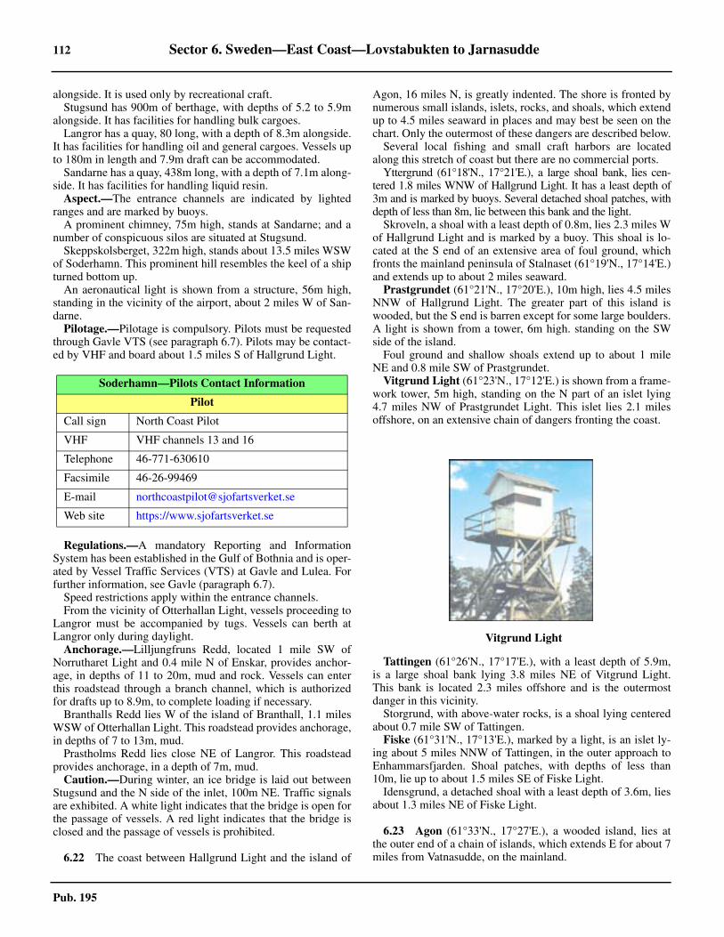
112 Sector 6. Sweden—East Coast—Lovstabukten to Jarnasudde
Pub. 195
alongside. It is used only by recreational craft.6.21 Stugsund has 900m of berthage, with depths of 5.2 to 5.9malongside. It has facilities for handling bulk cargoes.6.21 Langror has a quay, 80 long, with a depth of 8.3m alongside.It has facilities for handling oil and general cargoes. Vessels upto 180m in length and 7.9m draft can be accommodated. 6.21 Sandarne has a quay, 438m long, with a depth of 7.1m along-side. It has facilities for handling liquid resin.6.21 Aspect.—The entrance channels are indicated by lightedranges and are marked by buoys.6.21 A prominent chimney, 75m high, stands at Sandarne; and anumber of conspicuous silos are situated at Stugsund.6.21 Skeppskolsberget, 322m high, stands about 13.5 miles WSWof Soderhamn. This prominent hill resembles the keel of a shipturned bottom up.6.21 An aeronautical light is shown from a structure, 56m high,standing in the vicinity of the airport, about 2 miles W of San-darne. 6.21 Pilotage.—Pilotage is compulsory. Pilots must be requestedthrough Gavle VTS (see paragraph 6.7). Pilots may be contact-ed by VHF and board about 1.5 miles S of Hallgrund Light.
6.21 Regulations.—A mandatory Reporting and InformationSystem has been established in the Gulf of Bothnia and is oper-ated by Vessel Traffic Services (VTS) at Gavle and Lulea. Forfurther information, see Gavle (paragraph 6.7).6.21 Speed restrictions apply within the entrance channels.6.21 From the vicinity of Otterhallan Light, vessels proceeding toLangror must be accompanied by tugs. Vessels can berth atLangror only during daylight.6.21 Anchorage.—Lilljungfruns Redd, located 1 mile SW ofNorrutharet Light and 0.4 mile N of Enskar, provides anchor-age, in depths of 11 to 20m, mud and rock. Vessels can enterthis roadstead through a branch channel, which is authorizedfor drafts up to 8.9m, to complete loading if necessary.6.21 Branthalls Redd lies W of the island of Branthall, 1.1 milesWSW of Otterhallan Light. This roadstead provides anchorage,in depths of 7 to 13m, mud. 6.21 Prastholms Redd lies close NE of Langror. This roadsteadprovides anchorage, in a depth of 7m, mud.6.21 Caution.—During winter, an ice bridge is laid out betweenStugsund and the N side of the inlet, 100m NE. Traffic signalsare exhibited. A white light indicates that the bridge is open forthe passage of vessels. A red light indicates that the bridge isclosed and the passage of vessels is prohibited.
6.22 The coast between Hallgrund Light and the island of
Agon, 16 miles N, is greatly indented. The shore is fronted bynumerous small islands, islets, rocks, and shoals, which extendup to 4.5 miles seaward in places and may best be seen on thechart. Only the outermost of these dangers are described below.
Several local fishing and small craft harbors are locatedalong this stretch of coast but there are no commercial ports.
Yttergrund (61°18'N., 17°21'E.), a large shoal bank, lies cen-tered 1.8 miles WNW of Hallgrund Light. It has a least depth of3m and is marked by buoys. Several detached shoal patches, withdepth of less than 8m, lie between this bank and the light.
Skroveln, a shoal with a least depth of 0.8m, lies 2.3 miles Wof Hallgrund Light and is marked by a buoy. This shoal is lo-cated at the S end of an extensive area of foul ground, whichfronts the mainland peninsula of Stalnaset (61°19'N., 17°14'E.)and extends up to about 2 miles seaward.
Prastgrundet (61°21'N., 17°20'E.), 10m high, lies 4.5 milesNNW of Hallgrund Light. The greater part of this island iswooded, but the S end is barren except for some large boulders.A light is shown from a tower, 6m high. standing on the SWside of the island.6.22 Foul ground and shallow shoals extend up to about 1 mileNE and 0.8 mile SW of Prastgrundet.
Vitgrund Light (61°23'N., 17°12'E.) is shown from a frame-work tower, 5m high, standing on the N part of an islet lying4.7 miles NW of Prastgrundet Light. This islet lies 2.1 milesoffshore, on an extensive chain of dangers fronting the coast.
Tattingen (61°26'N., 17°17'E.), with a least depth of 5.9m,is a large shoal bank lying 3.8 miles NE of Vitgrund Light.This bank is located 2.3 miles offshore and is the outermostdanger in this vicinity.
Storgrund, with above-water rocks, is a shoal lying centeredabout 0.7 mile SW of Tattingen.
Fiske (61°31'N., 17°13'E.), marked by a light, is an islet ly-ing about 5 miles NNW of Tattingen, in the outer approach toEnhammarsfjarden. Shoal patches, with depths of less than10m, lie up to about 1.5 miles SE of Fiske Light.
Idensgrund, a detached shoal with a least depth of 3.6m, liesabout 1.3 miles NE of Fiske Light.
6.23 Agon (61°33'N., 17°27'E.), a wooded island, lies atthe outer end of a chain of islands, which extends E for about 7miles from Vatnasudde, on the mainland.
Soderhamn—Pilots Contact Information
Pilot
Call sign North Coast Pilot
VHF VHF channels 13 and 16
Telephone 46-771-630610
Facsimile 46-26-99469
E-mail [email protected]
Web site https://www.sjofartsverket.se
6.22Vitgrund Light

Sector 6. Sweden—East Coast—Lovstabukten to Jarnasudde 113
Pub. 195
6.23 Ago Light (61°32.5'N., 17°28.0'E.) is shown from a prominentround tower, 15m high, standing at the E extremity of Agon. Adisused light tower, with a dwelling, is located near the light.6.23 Small vessels, with local knowledge, may obtain shelteredanchorage, in depths of 7 to 25m, gravel and mud, within a nar-row inlet indenting the SW side of the island. A channel, au-thorized for drafts up to 5.8m, leads to this anchorage.6.23 Tihalan, an islet, lies 1 mile S of Agon and is located near thecenter of a group of dangers, about 3 miles long, which frontthe S side of the island.6.23 Gretasklackar (61°30'N., 17°46'E.), a group of four shoalswith a least depth of 9m, lies 9 miles ESE of Ago Light.6.23 Caution.—Due to the numerous shoals lying between Prast-grundet and the mainland, vessels passing W of this island re-quire local knowledge.
Approaches to Hudiksvall
6.24 Hudiksvall (61°35'N., 17°28'E.), an extensive inlet, isencumbered by numerous small islands, rocks, and shoals,which may best be seen on the chart. The shores are woodedand hilly.6.24 Iggesund and Hudiksvall are the main commercial ports situ-ated within this inlet. Krakon (61°34'N., 17°20'E.), Njutanger(61°36'N., 17°04'E.), Holick (61°38'N., 17°26'E.), Karingon(61°39'N., 17°14'E.), Saltvik (61°41'N., 17°15'E.), and Lingaro(61°43'N., 17°15'E.) are harbors used only by small craft andpleasure boats. There are also several marinas.6.24 The approach to Hudiksvall is bordered, on the S side, by achain of islands extending 7 miles E from the mainland. Agonis the outermost island of this chain (see paragraph 6.23). Theapproach, on the N side, is bordered by the S side of the penin-sula of Hornslandet, located 4.8 miles N.6.24 The peninsula of Hornslandet is 115m high and partly wood-ed. At a distance, from the NE, it appears to be separated fromthe mainland. The E side of this peninsula is light colored andmoderately steep.6.24 Krakskar Light (61°34'N., 17°20'E.) is shown from a prom-inent tower, 6m high, standing on the N extremity of Krakon,4.3 miles WNW of Ago Light.6.24 Holickskar Light (61°37'N., 17°27'E.) is shown from a tow-er, 6m high, standing on the SW extremity of the HornslandetPeninsula, 4.5 miles NE of Krakskar Light.
6.24 Myran (61°36'N., 17°28'E.), a group of shoals with a leastdepth of 2.9m, lies about 1 mile SE of Holickskar Light andfronts the S side of the Hornslandet Peninsula.6.24 Olofsgrund (61°34'N., 17°28'E.), a detached shoal bank,lies 1.4 miles N of Ago Light. It has a least depth of 5.1m andis marked by buoys.6.24 Hudiksgrund (61°36'N., 17°25'E.), a detached shoal bank,lies about 1.5 miles SSW of Holickskar Light. It has a leastdepth of 4.6m and is marked by a buoy.6.24 An isolated shoal, with a depth of 9.6m, lies about 1 mile Sof Hudiksgrund, 2.8 miles NW of Ago Light, and is marked bya buoy.6.24 Pilotage.—Pilotage within Hudiksvall is compulsory. Pilotsmust be requested through Gavle VTS (see paragraph 6.7). Pi-lots may be contacted by VHF and board in the vicinity ofHallgrund Light (61°17'N., 17°24'E.) or, by special arrange-ment, about 3 miles N of Ago Light.6.24 Directions.—Two main approach routes lead from seawardand are both authorized for drafts up to 9.9m.6.24 Vessels may head WSW and pass between Myran shoal andOlofsgrund shoal or they may head W and pass between the Nside of Agon Island and Olofsgrund shoal.6.24 Vessels may then pass S and W or N of the isolated 9.6mshoal lying 1 mile S of Hudiksgrund. Deep-draft vessels areadvised to pass S and W of the latter shoal.
Hudiksvall (61°44'N., 17°07'E.)
World Port Index No. 25780
6.25 The port, which mainly handles timber products, issituated at the head of Hudiksvallsfjarden, about 14 miles NWof the entrance to the inlet.6.25 Ice.—Hudiksvallsfjarden is usually ice-covered from themiddle of December to the end of April. The channel is keptopen by icebreakers but berthing delays may occur. 6.25 Tides—Currents.—The water level within the inlet is low-ered by N winds and raised by S winds. Currents in the ap-proaches are negligible.6.25 Depths—Limitations.—The route leading NW from S ofHudiksgrund has a least depth of 11m and is authorized fordrafts up to 9.9m.6.25 The main channel leading into Hudiksvallsfjarden passesthrough Saltvikssundet, a narrow passage 1.5 miles long, located 5miles SE of the port. Kastellholm, a small islet, lies in the ap-proach to the berths and buoyed channels pass each side of it.6.25 Oljekajen, a T-shaped oil jetty, is 69m long and has a depthof 10.9m alongside. Tankers up to 60,000 dwt, 230m in length,32m beam, and 9.9m draft can be accommodated.6.25 Stenkajen, the main quay, is 400m long and has depths of 4.8to 7.3m alongside. Kattvikskajen, with a ro-ro ramp at the Send, is 365m long and has depths of 5.3 to 9.3m alongside.Cargo vessels up to 30,000 dwt, 165m length, 32m beam, and8.6m draft can be accommodated.6.25 Aspect.—The entrance channel is indicated by lighted rang-es and marked by buoys and beacons.6.25 Blaxasberget, 460m high, stands 11 miles WSW of Hu-diksvall. This hill is precipitous on its E and S sides and is es-pecially conspicuous from SE.6.25 Storberget, a prominent hill, rises 8 miles W of Hudiksvall.
6.23Ago Light

114 Sector 6. Sweden—East Coast—Lovstabukten to Jarnasudde
Pub. 195
An aeronautical light is shown from a mast, with an elevationof 335m, standing on the N side of this hill.6.25 Regulations.—A mandatory Reporting and InformationSystem has been established in the Gulf of Bothnia and is oper-ated by Vessel Traffic Services (VTS) at Gavle and Lulea. Forfurther information, see Gavle (paragraph 6.7).6.25 At night, berthing at Oljekajen, the oil jetty, is restricted totankers of not more than 100m in length.6.25 Speed restrictions apply within the port.6.25 Tugs are compulsory for cargo vessels over 8,000 tons andtankers over 6,000 tons.6.25 Anchorage.—Vessels may anchor, in depths of 8 to 23m,mud and sludge, close SE of Kastellholm islet. 6.25 Caution.—A submarine cable and a submarine pipeline,which may best be seen on the chart, extend across the harborclose W of the oil jetty.
Hudiksvall to Sundsvallsbukten
6.26 Iggesund (61°38'N., 17°07'E.) (World Port Index No.25760) is situated at the head of a narrow inlet, 5 miles S ofHudiksvall. 6.26 Ice.—The channel leading to Iggesund is normally obstruct-ed by ice from January to April.6.26 Depths—Limitations.—The routes leading from seawardinto Hudiksvall are authorized for drafts up to 9.9m.6.26 The entrance channel leading to the harbor is authorized fordrafts up to 8m as far W as Skarnas Terminal, the commercialfacility.
6.26 Skarnas Terminal consists of a concrete pier and a quay. Thepier, at the E side of the terminal, is 152m long and has a berthon each side. The berth on the N side is 150m long and has adepths from 7 to 8.2m alongside. The berth on the S side is140m long and has a depth of 8.2m alongside.6.26 The quay, located W of the pier, is 240m long and has adepth of 7.6m alongside.6.26 Regulations.—A mandatory Reporting and InformationSystem has been established in the Gulf of Bothnia and is oper-ated by Vessel Traffic Services (VTS) at Gavle and Lulea. Forfurther information, see Gavle (paragraph 6.7).6.26 Vessels bound to or from Skarnas Terminal should make ageneral call on VHF channel 16 prior to proceeding throughDukarsund, the narrow entrance channel. Inbound vesselsshould call when passing Bondgrund shoal (61°37'N.,17°16'E.); outbound vessels should call before leaving theberth. 6.26 Contact Information.—See the table titled Iggesund—Contact Information.
6.26 Aspect.—The entrance channel is indicated by a lightedrange and marked by buoys.6.26 The buildings and chimneys, up to 125m high, of the textilefactory at Iggesund are conspicuous.6.26 Anchorage.—Anchorage can be obtained, in depths of 10 to12m, mud, SW of Skarnas Terminal.6.26 Caution.—It is reported that less depths than charted existwithin the entrance channel leading to Skarnas Terminal andthe local authorities should be contacted for the latest informa-tion concerning maximum authorized drafts.
6.27 The coast between the peninsula of Hornslandet andthe S entrance of Sundsvallsbukten, 32 miles N, is mostly highand wooded. The shore is fronted by numerous islands, rocks,and shoals, which may best be seen on the chart. Only the outerdangers are described below. Several small fishing boat harborsare situated along this stretch of the coast.
Balson (61°43'N., 17°32'E.), a wooded island, lies close offthe NE side of the peninsula of Hornslandet and is fringed byshoals. Its N and S sides should not be approached within 1mile and its E side should not be approached within 0.5 mile.
Balson Light is shown from a prominent tower, 6m high,standing on a rock lying close off the E side of the island.6.27 Balsosund, a narrow passage encumbered by rocks andshoals, separates Balson from the NE side of Hornslandet. Abuoyed channel, which is authorized for drafts up to 3.9m,leads through this passage and may be used by small vesselswith local knowledge.6.27 Kuggorarna, a bare islet, lies at the SW end of Balsosund. Aprominent chapel, with a belfry, stands on this islet.6.27 Anchorage may be obtained by small vessels, with localknowledge, in a depth of 13m, sand and stones, between the Nend of Kuggorarna and the E side of the mainland peninsula.6.27 Arnoviken (61°43'N., 17°24'E.) lies at the NW side of Horn-slandet, 3.5 miles W of Balson. This inlet provides shelteredanchorage and is accessible to vessels of medium draft. Hal-varskar, a wooded islet, lies on the W side of the entrance andHastholmen, another islet, lies close off the N extremity ofHornslandet. The best anchorage is in depths of 20 to 25m,mud and sand, at the head of the inlet. The entrance channel isavailable to vessels with drafts up to 4.9m. Local knowledge isadvised. Ice usually obstructs this inlet from November toMay.
6.28 Bergo Light (61°49'N., 17°25'E.) is shown occasion-ally from a structure standing on the mainland, 7 miles NW ofBalso Light. Rocks and shoals extend up to about 1 mile sea-ward from the shore in the vicinity of this light.6.28 Remmarharet (61°51'N., 17°26'E.), an above-water rock,lies on a large shoal bank centered 2 miles NNE of BergoLight. A prominent beacon, 4m high, stands on this rock.6.28 Britas Klack (61°53'N., 17°28'E.), with a least depth of2.3m, lies 3 miles offshore, about 5 miles NNE of Bergo Light.This shoal is marked at its S and W sides by buoys.6.28 A detached shoal bank, with above-water rocks, lies centered1.7 miles NNE of Britas Klack.
Iggesund—Contact Information
Pilots
Call sign North Coast Pilot
VHF VHF channels 13 and 16
Telephone 46-771-630610
Facsimile 46-26-99469
E-mail [email protected]
Web site https://www.sjofartsverket.se
Iggesund—Contact Information

Sector 6. Sweden—East Coast—Lovstabukten to Jarnasudde 115
Pub. 195
6.28 Glavsberget, rising 9.5 miles WNW of Bergo Light, is 187mhigh and consists of several large rocky hummocks, which areclearly visible from SE. From the E, this hill appears morecompact.6.28 Bolleberget, rising about 14 miles NW of Bergo Light, is294m high. This hill can be easily distinguished from the oth-ers in the vicinity and is conspicuous from seaward.6.28 Caution.—Eystrasaltbanken (61°46'N., 18°52'E.), a shoalbank with a least depth of 12m, lies about 38 miles E of the NEextremity of the island of Balson.
6.29 Stocka (61°54'N., 17°21'E.) (World Port Index No.25800), a former commercial harbor, is situated on the S sideof a small inlet, 12 miles NNW of Balso Light.
The inlet is sheltered by several shoals and the islets of In-gaskar and Ronnskar, which lie in the entrance. A breakwaterextends NE from the S shore of the inlet toward Ingaskar.There are depths of 5.5 to 6.4m, clay, gravel and stones in theinlet, which narrows toward its head. The entrance channel,which leads close S of Britas Klack shoal, is authorized fordrafts up to 5.4m. Ice usually obstructs the harbor from Januaryto March. Local knowledge is required.6.29 A pier, used for laying up, is situated in the SW part of theharbor. The outer part of the N side of the pier provides a berth,110m long, with a depth of 5.1m alongside. The inner part pro-vides a berth, 50m long, with depths of 1.9 to 3.9m. The S sideof the pier provides a berth, 65m long, with a depth of 3.8malongside.6.29 Anchorage may be taken, in depths of 4 to 6.5m, stone, clay,and sand, close W of Ingaskar. 6.29 Four prominent wind generators stand near the coast about 1mile SSE of Stocka.6.29 A conspicuous chimney is situated at Stromsbuck, about 1.5miles S of Stocka. A tower stands close N of this chimney butis prominent only when viewed from the S and SE.6.29 Jattholmarna (61°57'N., 17°31'E.), lying about 3 miles off-shore, consists of two moderately-high wooded islands, whichare separated from each other by a narrow channel. This chan-nel may only be seen from N or S. The islands are fringed byrocks and shoals. 6.29 Vitorarna, consisting of two islets, lies on a shoal bank 1.2miles N of Jattholmarna. The N and larger islet is mostlywooded; a beacon stands on the S islet.6.29 Hartefjarden, an inlet, indents the mainland, 2.5 miles W ofVitorarna. Harteskar, a small islet, lies in the middle of the en-trance. Anchorage may be obtained, in a depth of 10m, sand,within this inlet but it is open to winds from between E and S.The entrance channel leads SW of Harteskar and is authorizedfor small vessels with drafts up to 7m. Local knowledge is ad-vised.6.29 Gran (62°01'N., 17°38'E.), a moderately-high wooded is-land, lies about 5 miles offshore, 4.5 miles NE of Jattholmarna.A small fishing harbor, protected by a breakwater, is situated atthe E side of this island.6.29 A light is shown from a prominent framework tower sur-mounting a dwelling near the center of the island.
6.30 Lillgrund (62°03'N., 17°40'E.), a shoal bank withrocks, awash, lies centered 2 miles NNE of Gran and is markedby buoys.
6.30 Norra Myran, a shoal bank with a least depth of 3.2m, liescentered 2.3 miles WNW of Gran and is marked by a buoy.6.30 Hundgrund (62°07'N., 17°48'E.), with a least depth of 6m,lies 7.5 miles NE of Gran. This shoal is the outermost danger inthis vicinity and is marked by a buoy.6.30 Orraklinten, 242m high, rises 12.3 miles NW of Gran. Thisprominent hill is very steep on its N side, but appears to havethree summits of equal elevation when viewed from the S. 6.30 Bramon (62°13'N., 17°43'E.), 73m high and densely wood-ed, lies 1.5 miles off the Bjorko Peninsula, 12 miles NNE ofGran. A light is shown from a prominent tower, 16m high,standing on the NE side of this island.
6.30 Revhallan, a shoal with a least depth of 0.8m, lies about 0.4mile NE of the light and is marked by a buoy. 6.30 Bramo Kalv, a wooded islet, lies close off the SW end ofBramon. A light is shown from a prominent tower, 9m high,standing on the SW side of this islet.6.30 Bramosund lies between the mainland and the W side ofBramon. This sound is generally clear of dangers but foulground fringes the mainland shore. The passage is available tovessels with drafts up to 10m. Local knowledge is advised.6.30 Anchorage may be obtained, in depths of 14 to 25m, sandand mud over clay, close off Sanna, a village standing on the Wside of Bramon 1.2 miles N of Bramo Kalv Light.6.30 The current sets moderately through the sound and is fre-quently strong. The most troublesome sea is raised by SWwinds.6.30 Lorudden (62°14'N., 17°39'E.), a high point, is situated onthe mainland at the NW end of Bramosund and is marked by alight.6.30 Caution.—Several nature reserves, including the waters sur-rounding the island of Gran and the islets of Vitorarna, are situ-ated along the coast between Hornslandet and the S entrance ofSundsvallsbukten. Entry into these reserves is affected by nu-merous restrictions.6.30 Submarine cables, which may best be seen on the chart, ex-tend across Bramosund, about 1.3 miles S of Lorudden Light.
Sundsvallsbukten
6.31 Sundsvallsbuken (62°20'N., 17°35'E.), a large bay, is
6.30Bramon Light

116 Sector 6. Sweden—East Coast—Lovstabukten to Jarnasudde
Pub. 195
entered between the island of Bramon and the island of Aston,9.5 miles N. Sundsvall, with its associated harbors, is the prin-cipal port lying within this bay. A number of former timber-loading berths are situated throughout the bay but most of theseare no longer open to commercial shipping.6.31 Astholmsudde (62°23'N., 17°44'E.) is the SE point of Astonand the highest part of the island. A light is shown from astructure standing on this point. A beacon, 5m high, is situatedclose N of the light.6.31 The bay is encumbered by many islands, rocks, and shoals,which may best be seen on the chart. Only the outermost dan-gers are described below.
Kattgrundet (62°16'N., 17°45'E.), with a least depth of9.9m, lies about 3.2 miles N of Bramon Light. This shoal is theoutermost danger on the S side of the approach.6.31 Sjogrund, a shoal patch with a least depth of 8.5, lies about3.8 miles NW of Lorudden Light. Storgrunden, a shoal bankwith a rock, awash, lies centered about 1 mile WNW of Sjogr-und. Knuten, a shoal with a least depth of 2.8m, lies near theNW side of Storgrunden, about 1.4 miles NW of Sjogrund.These three shoals form the outermost dangers on the S side ofthe entrance.6.31 Alnon (62°23'N., 17°28'E.), a large island, encumbers theinner part of the bay and rises to a height of 120m in its SWpart.6.31 Gubben Light (62°21'N., 17°35'E.) is shown from a promi-nent floodlit tower, 10m high, standing an islet lying 1.5 milesESE of the SE extremity of Alnon.6.31 Draget, lying 1.3 miles SSW of Gubben light, is the south-ernmost islet of a chain of islands and islets extending up to 1.8miles S from the SE extremity of Alnon.6.31 A shoal, with a depth of 6.3m, lies about 0.3 mile SSW ofDraget. Vastra Asen, a detached shoal with a depth of 2.7m liesabout 0.3 mile WSW of Draget and is marked by buoy. Thesetwo shoals form the outermost dangers in this vicinity.6.31 Rodon, 92m high and hilly, is located 2.5 miles N of GubbenLight and is the largest of several islands lying close off the Eside of Alnon. Its shoreline is reddish in color.6.31 Rodogubben Light (62°23'N., 17°36'E.) is shown from aprominent tower, 12m high, standing on a small islet lyingclose off the SE side of Rodon.6.31 Granon, an island marked by a light on its NW side, lies 3.5miles NNW of Rodogubben Light.
6.32 Draghallan Light (62°20'N., 17°26'E.) is shownfrom a prominent tower, 14m high, standing on a rocky shoallying about 0.8 mile S of the SW extremity of Alnon. The Nside of this rocky shoal is marked by a lighted buoy.6.32 A shoal, with a least depth of 2.7m, lies close SE of the light
and is marked by a buoy. A detached shoal patch, with a depthof 8.2m, lies 0.4 mile N of the light and is marked by a lightedbuoy.6.32 Alnosundet (62°26'N., 17°24'E.) is the passage lying be-tween the mainland and the W side of Alnon. The AlnobronBridge spans this passage about 5.7 miles NNW of DraghallanLight and is marked by a racon.6.32 The navigable channel leading under the bridge is 70m wideand has a vertical clearance of 39m.6.32 Klingerfjarden (62°29'N., 17°28'E.) is an inlet lying be-tween the N end of Alnon and the head of the bay.6.32 Anchorage.—Designated anchorage areas lie in the outerpart of the bay and may best be seen on the chart. Area A andArea B are centered about 5 miles S and 1 mile ENE, respec-tively, of Gubben Light (62°13'N., 17°43'E.). Area C is cen-tered 2 miles N of Rodogubben Light (62°23'N., 17°36'E.).6.32 Directions.—Two approach routes, which may best be seenon the chart, lead into the bay and converge in the vicinity ofDraghallan Light.6.32 The main route, which is authorized for drafts up to 13m,leads W for about 2 miles from a position located 0.6 mile SEof Astholmsudde Light. It continues WSW for about 5 milesand passes midway between Rodogubben Light and GubbenLight and close SSE of the SE extremity of Alnon island. Thismain route then leads SW and rounds Draghallan Light on theS side.6.32 Vessels, with drafts up to 8m, may use the channel leadingbetween the N side of Draghallan Light and the detached 8.2mshoal patch lying 0.4 mile N.6.32 The secondary approach route, which is authorized for draftsup to 10m, leads NW for about 5 miles from a position located1.2 miles E of Bramon Light (62°13'N., 17°43'E.). It passes be-tween the N side of Bramon island and Kattgrundet shoal. Theroute then continues WNW for about 7 miles and rounds Dra-ghallan Light, on the S side. It passes about 0.9 mile NNE ofKnuten shoal and 0.6 mile SSW of Vastra Asen shoal.6.32 The alternate route through Bramosund, which is authorizedfor drafts up to 10m, joins this secondary route at a position lo-cated about 4.5 miles SE of Gubben Light (see paragraph6.31).6.32 Caution.—Floating logs may be encountered in the ap-proaches to Sundsvallsbuken.6.32 A military exercise area lies in the approaches to Sundsvalls-bukten. It is situated between Bramon (62°13'N., 17°43'E.) andSkarpudden (62°29'N., 17°49'E.) and extends up to 10 milesseaward.6.32 Several submarine cables, which may best be seen on thechart, extend across the routes within Sundsvallsbuken.6.32 A restricted area and dumping ground for chemicals lies ap-proximately 4 miles ESE of Astholmsudde.
Sundsvall (62°23'N., 17°21'E.)
World Port Index No. 25910
6.33 Sundsvall is situated at the head of Sundsvallsfjarden,an inlet located at the W side of Sundsvallsbukten. The port al-so includes the facilities at Vindskarvarv, Ortviken, Kubiken-borg, Skonsberg, and Cementsilokajen, which are situatedwithin Sundsvallfjarden; and the harbors of Tunadalshamnen,
6.31Draghallan Light from SW

Sector 6. Sweden—East Coast—Lovstabukten to Jarnasudde 117
Pub. 195
Johannedal, and Ostrand, which are situated in Alnosundet.The head of Sundsvallsfjarden, W of Vindskarsvarv(62°23.0'N., 17°21.1'E.), is spanned by a bridge. The main nav-igable passage under Sundsvallsbron has a width of 90m and ismarked by lighted buoys, with vertical clearance of 32m. Aracon transmits from the center of the bridge.
The port exports various wood products and aluminum, andimports bauxite, oil, and fertilizers.6.33 Ice.—The port is usually operated all year round. However,ships may be delayed by ice from December to April.6.33 Tides—Currents.—The greatest extremes of water levelobserved in Sundsvallsbukten are about 0.8m above and 1.1mbelow mean sea level. Higher water levels occur with E and SEwinds, and low water levels with N and prolonged NNE winds.The timing of high or low water is unpredictable and dependsentirely on the wind direction and velocity.6.33 Aspect.—The approach routes and entrance channels are in-dicated by directional sector lights and lighted ranges. The fair-ways are marked by buoys.6.33 Tjuvholmen, an islet 35m high, lies in the entrance to Sunds-vallsfjarden and is marked by a light on its W side.6.33 Five prominent chimneys, at an aluminum works, and a con-spicuous silo stand on the S side of Sundsvallsfjarden, about0.4 mile SSW of Tjuvholmen Light.6.33 A conspicuous radio mast stands on a hill about 3 milesSSW of Draghallan Light. 6.33 An aeronautical light is shown from a conspicuous frame-work tower standing on the N slope of Sodra Stadsberget, 3.8miles WNW of Draghallan Light.6.33 A conspicuous floodlit pilot lookout tower stands on Skor-ven, an islet lying close off the SE extremity of Alnon.6.33 A conspicuous church, with a square tower and a spire,stands in the S part of Njurunda, 5.3 miles SSW of DraghallanLight.6.33 Depths—Limitations.—From close W of Draghallan Light,the main route, which is authorized for drafts up to 13m, leads2.5 miles NW to the entrance of Sundsvallsfjarden. The chan-nel passing N of Tjuvholmen is authorized for drafts up to 12mand the channel passing S of this islet is authorized for draftsup to 11.3m. The channel leading to the inner part of Sunds-vallsfjarden is authorized for drafts up to 7.8m.6.33 The channel leading into Alnosundet from the vicinity ofTjuvholmen is authorized for drafts up to 12m as far as Tunad-alshamnen, 1 mile S of the bridge. The channel continuing tothe anchorage off Ostrand, at the NW end of Alnosundet, is au-thorized for drafts up to 9m. The channel leading from Ostrandanchorage to the berths is authorized for drafts up to 7m.6.33 Vindskarvarv, an oil terminal, is situated on the SE side ofthe inlet. It has a berth, 100m long, with a depth of 12m along-side.6.33 Ortviken, a harbor situated on the NE side of the inlet, hasthree quays. They are 157m, 90m, and 160m long, with depthof 6.9m, 6.5m, and 11.3m alongside, respectively.6.33 Kubikenborg, a harbor situated on the SE side of the inlet,has a quay, 153m long, with a depth of 10.1m alongside. At adistance of 3m off the quay the depth is 11m.6.33 Skonsberg, a harbor on the N side of the inlet, has a quay,50m long, with a depth of 6.7m alongside. Vessels should notethe presence of a supply pipeline, best seen on the chart, whichlies just off Berths No. 30 and No. 32 at Norra kajen.
6.33 Cementsilokajen, a harbor on the S side of the inlet, has aquay, 15m long with two breasting dolphins, with a depth of6.9m alongside.6.33 Sundvall Harbor, also known as Stadshamnen, has 740m ofquayage, with depths of 5.3 to 8.1m alongside. There is also areserve berth, 325m long, with a depth of 3.9m alongside.6.33 A new ferry berth, 130m long with a ro-ro ramp, has beenconstructed at the Town Quay. It has a depth of 8.1m alongsideand can handle vessels with drafts up to 7.8m.6.33 Tunadalshamnen Harbor is situated at the SW side of Alno-sundet and provides three quays. Timber Quay is 195m longand has depths of 4.5 to 7.3m alongside; Sundsvall TerminalQuay is 660m long and has depths of 9.1 to 12.3m alongside;and Gas Oil Quay is 62m long and has a depth of 11.8m along-side.6.33 Johannedal Harbor is situated on the W side of Alnosundet,close N of the bridge. It has a timber quay, 120m long, withdepths of 2.5 to 5.5m alongside.6.33 Ostrand Harbor, at the NW end of Alnosundet, has a quay,90m long, with a depth of 8.1m alongside. Vessels up to 135min length and 7.5m draft can be accommodated. Obstructionslie both N and S of the berth and can best be seen on the chart.6.33 The port has facilities for tanker, ro-ro, container, timber,bulk, general cargo, LPG, cruise, and ferry vessels. Tankers upto 60,000 dwt, 250m in length, and 11.4m draft can be handled.LPG vessels up to 200m in length and 10.4m draft can be han-dled.6.33 Pilotage.—The pilotage area for Sundsvall lies between lati-tude 62°08'N and latitude 62°50'N (including Gaviksfjardenand Angermanalven). 6.33 Pilot ordering should normally be carried out via the e-Ser-vices section on the Swedish Maritime Administration web site(https://www.sjofartsverket.se), in conjunction with the report-ing on the Vessel Reporting System (FRS) section.6.33 Pilotage is compulsory for vessels, as follows:
1. All Category 1 vessels.2. Category 2 vessels of 90m in length or 16m beam and
over.3. Category 3 vessels of 100m in length or 17m beam
and over.6.33 In certain pilot channels within Angermanalven, on passagefor Sannasundet, pilotage is compulsory, as follows:
1. All Category 1 vessels.2. Category 2 vessels of 80m in length, 15m beam, and
5m draft and over.3. Category 3 vessels of 90m in length, 16m beam, and
5.5m draft and over.6.33 In certain pilot channels for passage through Alnobron forthe following:
1. All Category 1 vessels.2. Category 2 and 3 vessels of 70m LOA, 14m beam,
and 4.5m draft and over.6.33 Pilot ordering should normally be carried out via the e-Ser-vices section on the Swedish Maritime Administration web site(https://www.sjofartsverket.se), in conjunction with the report-ing on the Vessel Reporting System (FRS) section:
1. A preliminary pilot request must be made via the FRSat least 24 hours in advance.
2. The definitive pilot request must be made via the FRSat least 5 hours in advance.

118 Sector 6. Sweden—East Coast—Lovstabukten to Jarnasudde
Pub. 195
3. In exceptional cases, the pilot may be ordered via e-mail, telephone, or VHF.
6.33 Pilots can be contacted by VHF and board in Sundsvallsbuk-ten, about 2.5 miles E of Gubben Light.6.33 Regulations.—A mandatory Reporting and InformationSystem has been established in the Gulf of Bothnia and is oper-ated by Vessel Traffic Services (VTS) at Gavle and Lulea. Forfurther information, see Gavle (paragraph 6.7).6.33 Contact Information.—See the table titled Sundsvall—Contact Information.
6.33 Anchorage.—Anchorage may be obtained, in depths of 29to 32m, mud, E of Tjuvholmen islet or, in depths of 10 to 20m,clay and mud, within Sundsvallsfjarden.6.33 Anchorage may be obtained by vessels with drafts up to 9mclose off the quays at Ostrand. 6.33 Caution.—Submarine pipelines, which may best be seen onthe chart, extend 0.8 mile ENE from a point located on the Nside of Sundsvallsfjarden, 0.5 mile NNW of TjuvholmenLight; and extend 1.2 miles ENE from the vicinity of Ostrand.6.33 Several submarine cables and a pipeline, which may best beseen on the chart, extend across Alnosundet.
6.34 Stockvik (62°20'N., 17°23'E.) (World Port Index No.25900) is situated on the NW side of Ljungan Inlet, about 2 milesW of Draghallan Light. Limestone, coke, methanol, and oil areimported here; and ammonium nitrate and carbide are exported.6.34 The channel leading to the anchorage from the vicinity ofDraghallan Light is authorized for drafts up to 13m. The chan-nel leading to the berth is authorized for drafts up to 6.3m.6.34 The harbor is protected by a detached breakwater, 200mlong. Stora Kajen, the N and main berth, is 195m long and hasdepths of 6 to 6.5m alongside. A T-headed jetty, 20m long, issituated close S of the main berth and has a depth of 4.6malongside. Vessels up to 190m in length and 6.3m draft can behandled at the port. Silting occasionally occurs at the N end ofStora Kajen.
6.34 Vessels can anchor, in a depth of 29m, clay, close off the har-bor.
6.35 Klingerfjarden (62°29'N., 17°28'E.), lying betweenthe N end of Alnon and the head of Sundsvallsbukten, can beentered from seaward and via the N end of Alnosundet. Bothroutes are authorized for drafts up to 9m.
The ports of Vivstavarv and Soraker are situated in Klinger-fjarden along with several small craft harbors.
The main route from seaward leads between the E side of Al-non and the mainland to the NE. An alternative channel, whichjoins the main route, passes between the E side of Alnon andthe W side Rodon islet.6.35 Regulations.—Designated safety areas, which may best beseen on the chart, lie S of Sundsvall Airport (62°32'N., 17°27'E.),in the NE part of Klingerfjarden. Vessels with an air draft over20m must contact North Coast Pilots on VHF channel 13 or bytelephone (46-771-630620) at least 2 hours prior to entering AreaA, which extends about 0.7 mile SSE from the N shore. Vesselswith an air draft over 40m must contact North Coast Pilots at least2 hours prior to entering Area B, which extends between about 0.7mile and 1.2 miles SSE from the N shore.
6.36 Vivstavarv (62°29'N., 17°22'E.) (World Port IndexNo. 26140) lies on the NW side of Klingerfjarden. Liquid resinand paper products are exported; and fuel oil and caustic sodaare imported.6.36 The channel leading to the anchorage is authorized for draftsup to 9m; the channel leading to the berths is authorized fordrafts up to 7.3m.6.36 Papperskajen, the paper quay, is 145m long and has depthsof 7.8 to 10.6m alongside. Pulp Quay is 90m long and hasdepths of 4.7 to 6m alongside. Vessels up to 130m in lengthcan be handled with the maximum draft depending on theirlength. Vessels with drafts up to 9m can anchor off the harborand secure to stern moorings.6.36 Soraker (62°30'N., 17°30'E.) (World Port Index No. 26180)lies on the E side of Klingerfjarden. Salt, fertilizer, steel, andlimestone are imported; and machine goods are exported.6.36 The approach channel is authorized for drafts up to 5.8m.The harbor consists of a dredged basin, 190m long and 30mwide. The quay, situated in the inner part of the basin, is 180mlong and has a depth of 6.1m alongside. 6.36 Vessels up to 90m in length and 5.8m draft can be accommo-dated. Vessels with drafts of 4m and over must be assisted by atug.
Caution.—Several log pond areas are situated adjacent tothe shore in the vicinity of Vivstavarv.
Sundsvallsbukten to Harnosand
6.37 Skarpudden (62°29'N., 17°49'E.), marked by a light,is located 6 miles NE of Astholmsudde Light.
Nygrund, a detached shoal with a depth of 4.8m, lies about0.8 mile SW of Skarpudden and is marked by a buoy; Isaks-grundet, a rock awash, lies about 0.5 mile ESE of Skarpuddenand is marked by a buoy; and Glogrund, a detached shoal witha depth of 10m, lies about 0.5 mile offshore, 1.5 miles NE ofSkarpudden.
Avikebukten (62°28'N., 17°44'E.), a large bay, is entered S
Sundsvall—Contact Information
Pilot Ordering Center
Call sign North Coast Pilot
VHF VHF channels 13 and 16
Telephone 46-771-630610
Facsimile 46-26-99469
E-mail [email protected]
Web site https://www.sjofartsverket.se
Sundsvall Pilots
Call signLotsarna Spikarna (Sundsvall)
Spikarna (Sundsvall) Pilots
VHF VHF channels 13 and 16
Telephone46-60-586000
46-60-586007
Facsimile 46-60-586403

Sector 6. Sweden—East Coast—Lovstabukten to Jarnasudde 119
Pub. 195
of Skarpudden. Fjardgrunden, a shoal with a least depth of3.8m, lies in the S part of this bay, about 3 miles SW of Skar-pudden Light.
Anchorage can be obtained, by vessels with local knowl-edge, in various locations within Avikebikten, in depths of 5 to25m, sand.6.37 Byviken (62°33'N., 17°53'E.), entered about 4 miles NNE ofSkarpudden Light, is clear of dangers to within 0.4 mile of itshead. This inlet affords anchorage to vessels, with local knowl-edge, in depths of 10 to 13m, sand and stone, but it is exposedto winds from the SE. Norra Baden and Sodra Baden are twoislets lying close off the N entrance point.
An aeronautical light is shown, at an elevation of 270m, froma prominent framework mast standing at Ljustorp, 15 milesWNW of Skarpudden Light.
Caution.—Vanta Litets Grund (62°30'N., 18°16'E.), lying12.5 miles E of Skarpudden Light, consists of two steep-toshoals, which are composed of stones and pointed rocks. Thenortheasternmost shoal has a least depth of 6.3m; the south-westernmost shoal has a least depth of 4.1m. A light is shownfrom a prominent tower, 20m high, standing on the NE shoaland a buoy marks the SW shoal.6.37 The depths in the vicinity of Vanta Litets Grund are very ir-regular and the area should be given a wide berth.
Approaches to Harnosand and Angermanalven
6.38 The approaches to Harnosand and Angermanalven liebetween the N entrance point of Byviken and Karingbergsud-den Light (62°47.5'N., 18°11.2'E.), about 18 miles NE. Themainland coast in this vicinity is fronted by several large is-lands and islets. A number of entrance channels lead betweenthe islands. Several small craft harbors lie along the sides ofthese passages.
Harnon (62°36'N., 17°59'E.), an island lying with its S ex-tremity located about 5.7 miles NE of Skarpudden Light, ismoderately high, with wooded ridges separated by deep val-leys. The sides of the hills near the sea are gray, bare, and inter-sected by ravines. From seaward, this island appears to be thesame height as the mainland behind it.6.38 Storholmen Light is shown from a structure standing at theSW end of the island. Harno Vardkasberget, a gray hill, risesabout 3.5 miles NNE of the light and is conspicuous from sea-ward. It is 175m high and surmounted by a small lookout tow-er. A prominent radio mast stands 0.3 mile ESE of this hill.6.38 Harnoklubb Light (62°36'N., 18°04'E.) is shown from atower, 6m high, standing on a point located on the E side of theisland, 4.5 miles NE of Storholmen Light. A barren hill, 82mhigh, rises close WSW of the light and is surmounted by a bea-con, 11m high. Close SE of and below the beacon is a large,white mark, which is conspicuous from seaward.6.38 Harno Sodra Light is shown from a tower, 6m high, standing0.6 mile NNE of Harnoklubb Light. A conspicuous white build-ing, a former pilot station, is situated on the coast, 0.5 mile NNWof this light.
Lungon (62°39'N., 18°04'E.), lying 1 mile N of Harnon, is awooded island, which rises to a height of 50m in its N part. Alight is shown from a prominent tower, 15m high, standing onthe SE extremity of the island.
Anchorage can be taken, in depths of 8 to 15m, within Sund-
hamn, a narrow inlet indenting the NE side of the island. Localknowledge is required. 6.38 Stromskaten Light (62°40'N., 18°00'E.) is shown from afloodlit structure standing on the SW extremity of the island.6.38 Bogrundet, a shoal bank with rocks awash, lies about 0.3mile off the S side of the island, 1.3 miles ESE of StromskatenLight. Hakansgrund, a shoal with a least depth of 2m, liesabout 0.3 mile off the S side of the island, 0.7 mile W of the SEextremity. Both of these dangers are marked by buoys.
6.39 Hemson (62°43'N., 18°05'E.), lying close N of Lun-gon, is high and hilly. The shores of this island are reddish incolor in several places. Hemsohatt, a prominent hill, rises onthe SE part of the island. It is 208m high and resembles a hatwith a wide brim. Another prominent hill, 223m high, standsabout 2 miles NNW Hemsohatt.
Utanofjarden, an inlet, indents the middle of the E side ofHemson and provides anchorage to vessels with local knowl-edge. Storgrundet, a shoal with a least depth of 4.5m, lies nearthe center of the entrance. The entrance channel, which is au-thorized for drafts up to 6m, leads W and passes N of thisshoal. Juviken, a small bay lying on the S side of the inlet, hasdepths of 15 to 25m, clay. Prasthushamn, a small bay lying onthe N side of the inlet, has depths of 12 to 20m, clay and sand. 6.39 Two prominent radio masts stand on the shore of Prasthushamn.
Nordanoviken, a bay indenting the middle of the N side ofHemson, provides well-sheltered anchorage, in depths of 18 to22m, clay, within its S part. Local knowledge is required. The Npart of the bay is unsuitable because the depths are considerable.
Storon (62°46'N., 18°13'E.), a wooded island, lies 2 milesNE of the NE end of Hemson. It is fairly high and attains an el-evation of 56m in the N part.
Karingsbergsudden Light is shown from a point on the main-land located 1.6 miles WNW of the NE extremity of Storon.Gronviksfjarden, a bay used only by small craft and pleasureboats, is entered close W of this light.
Gronviksgrundet, an islet, lies 0.4 mile SSE of Karingsberg-sudden Light and is marked by a beacon at its N end.6.39 Caution.—A submarine cable, which may best be seen onthe chart, extends across the W side of Utanofjarden.6.39 A spoil ground area, which may best be seen on the chart,lies centered 2.5 miles ENE of Harnoklubb Light.6.39 The approaches to Harnosand and Angermanalven lie withinthe Hemson Semi-restricted Area, which includes the watersbetween the islands of Storon, Hemson, Lungon, and Harnon.The limits of this area may best be seen on the chart. Vesselsproceeding through the area must keep to the designated pilot-age routes.6.39 For further information on restricted and semi-restricted ar-eas, see Pub. 140, Sailing Directions (Planning Guide) NorthAtlantic Ocean and Adjacent Seas.6.39 A cable ferry is in use during the ice-free part of the year be-tween Strinningen (62°41.5'N., 17°59.1'E.) and Sanna(62°41.4'N., 17°59.8'E.). Vessels may only pass the route whenthe ferry is stopped at any of the ferry berths and the wires havebeen lowered. Vessels over 300 gross tons should call the ferryon VHF channel 6 upon passing any of the following radio re-porting points to obtain information prior to passage:
1. Northbound—South of Stromskatan in position62°39.2'N, 18°00.2'E.

120 Sector 6. Sweden—East Coast—Lovstabukten to Jarnasudde
Pub. 195
2. Westbound—North of Ornskarsgrund in position62°40.4'N, 18°05.4'E.
3. Southbound—East of Valon in position 62°44.3'N,17°59.8'E.
6.40 Sodrasundet (62°36'N., 17°56'E.), forming the S ap-proach to Harnosand, leads in a N direction between the Wside of Harnon and the mainland. An overhead cable, with avertical clearance of 20m, spans this passage about 3 miles Nof the seaward entrance.6.40 An inlet, lying at the SE end of the passage, leads to Solum-shamn, which is situated on the SW part of Harnon. This inletprovides good anchorage to vessels with local knowledge, indepths of 10 to 33m, clay and sand. Vessels should not proceedtoo far inside a line joining the entrance points because twoshoals, with least depths of 7.4m and 3.6m, lie about 0.2 mileand 0.3 mile, respectively, SSE of the N entrance point.6.40 Anchorage can also be taken, in depths of 10 to 12m, clayand mid, within Norra Falloviken, a narrow inlet indenting themainland, about 4.7 miles N of the seaward entrance. Localknowledge is required.6.40 Stora Inlopp (62°39'N., 18°00'E.), the principal N approachroute to Harnosand, lies between Harnon and Lungon. Thischannel also provides access to Angermanalven by way ofSannasundet and Abordssundet. The fairway has depths of 46to 82m and is clear of dangers, except on its NE side.6.40 Alandsfjarden (62°40'N., 17°56'E.), leading in a WNW di-rection, is a continuation of Stora Inlopp. This inlet may be en-tered via a channel, which is authorized for drafts up to 10m.Local knowledge is advised.6.40 Lungosundet (62°40'N., 18°03'E.) leads between Lungonand Hemson. Vessels from the N, with local knowledge, some-times use this passage when bound for Harnosand or Alands-fjarden. The channel is authorized for drafts up to 9.9m.6.40 Bonskaret is a low, gray, and barren islet lying on the N sideof the entrance, close off the SE side of Hemson.6.40 Sannasundet (62°42'N., 18°00'E.) lies between the W sideof Hemson and the mainland. This passage leads N for 4.5miles from the W end of Lungosundet and is narrow in places.6.40 Valon (62°44.2'N., 17°59.5'E.), an island marked by a lightat its NE end, lies at the N end of this passage. The main routepasses E of this island.6.40 Abordssundet (62°46'N., 17°58'E.), the continuation ofSannasundet, lies between the W side of Abordson and themainland. This passage leads NNW for about 3.5 miles andnarrows at its N end.6.40 The main route from S leading into Angermanalven (seeparagraph 6.43) passes through Sannasundet and Abordssun-det. It is authorized for drafts up to 10m.6.40 Snattsundet, a narrow channel, leads between the S end ofAbordson and the N end of Hemson. It is used only by smallcraft and local knowledge is required.6.40 Anchorage.—A designated anchorage area, which may bestbe seen on the chart, lies in Alandsfjarden and is centeredabout 1.6 miles NW of the NW end of Harnon.6.40 Good anchorage can be obtained in the inner part of Alands-fjarden, in depths of 10 to 20m, mud. Anchorage can be alsotaken, in depths of 12 to 14m, off Alandsbro, a village situatedat the head of the inlet, and off Nasslandssund, a village stand-ing close N of Alandsbro. Vessels at these anchorages may se-
cure their sterns to dolphins.6.40 Caution.—A submarine cable extends across Alandsfjarden,about 0.7 mile NW of the NW end of Harnon.6.40 A ferry runs between Hemson and the mainland in San-nasundet.
6.41 Ulvvik (62°40'N., 17°52'E.) (World Port Index No.26280), a small harbor, is situated on the N side of Alandsfjar-den, about 2.2 miles NW of the NW end of Harnon. The mainquay is 80m long and has depths of 6.5 to 10m alongside. Mi-nor repairs can be effected. Provisions and water are obtain-able.
Utansjo (62°46'N., 17°56'E.) (World Port Index No. 26290)is situated on the mainland W of the island of Abordson. Theentrance channel leading to the harbor is authorized for draftsup to 8.2m. This small port imports oil and exports timberproducts.6.41 The pulp factory quay is 120m long and has a depth of 9malongside. A concrete quay is situated close S of the pulp quay.It is 113m long and has a depth of 8.5m alongside. A small ba-sin lying between these two quays provides a quay, 50m long,with depths of 4 to 6m alongside.
Harnosand (62°38'N., 17°56'E.)
World Port Index No. 26240
6.42 Harnosand (Hernosand) stands on the NW side ofHarnon. The port facilities are situated along both sides of thenarrow channel separating the NW side of the island from themainland. Forest products and iron oxide are exported; oil, as-phalt, sulfuric acid, and general cargo are imported.6.42 Winds—Weather.—The harbor is considered to be one ofthe best in the N part of Sweden, being easy of access, spa-cious, and well-protected from all winds.6.42 Ice.—Ice obstruction normally occurs from January untilearly or mid-April. However, the port is usually kept open byicebreakers.6.42 Tides—Currents.—Higher water levels normally occur inthe fall with S and SE winds; lower water levels occur in thespring with N and NW winds. On the average, the annual max-imum and minimum water levels differ by about 0.8m from themean water level. The current in the harbor is not very trouble-some. 6.42 Depths—Limitations.—The N and S harbors of the port areconnected by two canals, which can be used by small craft.Vessels bound for the S harbor must enter through Sodrasun-det. The main commercial facilities are situated in the N har-bor. Vessels bound for the N harbor must enter through StoraInlopp.6.42 The approach channel, via Stora Inlopp, is authorized fordrafts up to 10.5m.6.42 Oljekajen, an oil terminal, has a quay, 62m long, with adepth of 11.2m alongside.6.42 Djuphamnskajen, a concrete quay with a ro-ro ramp at the Nend, is 260m long and has depths of 7.5 to 8m alongside.6.42 Norra Skeppsbron Quay is 190m long and has depths of 4.3to 4.6m alongside.6.42 Utspranskajen, an iron piled quay, is 169m long and hasdepths of 6.3 to 8.1m alongside.

Sector 6. Sweden—East Coast—Lovstabukten to Jarnasudde 121
Pub. 195
6.42 Sodra Skeppsbron, a concrete quay, is 310m long and hasdepths of 4.9 to 5.7m alongside.6.42 There are also several small craft quays, with depths of 2 to5m alongside.6.42 Tankers up to 200m in length and 10.5m draft can be accom-modated in the port.6.42 Aspect.—Harnosands Hamn Light (62°38.7'N., 17°57.5'E.),a directional sector light, is shown from a prominent tower, 6mhigh, standing on the NW end of Harnon at the E side of theentrance to the harbor.6.42 Pilotage.—Pilotage is compulsory. Pilots are provided bythe Sundsvall pilot station (see paragraph 6.33). All requestsfor pilotage must be made through the VTS station at Gavle(see paragraph 6.7). Pilots can be contacted by VHF and boardin Sundsvallsbukten, about 2.5 miles E of Gubben Light(62°21'N., 17°35'E.).6.42 It is reported that pilots can also be obtained from theOrnskoldsvik pilot station (see paragraph 6.52). Requests forpilotage must be made through the VTS station at Lulea. Pilotscan be contacted by VHF and board about 2 miles S of the out-ermost shoal near Skagsudde (63°11'N., 19°01'E.).6.42 Regulations.—A mandatory Reporting and InformationSystem has been established in the Gulf of Bothnia and is oper-ated by Vessel Traffic Services (VTS) at Gavle and Lulea. Forfurther information, see Gavle (paragraph 6.7).6.42 Vessels must not exceed a speed of 5 knots in the harbor.6.42 Anchorage.—The roadstead lying close N of the N harborprovides anchorage, in depths of 14 to 45m, clay.6.42 Caution.—Two submarine cables extend across the N har-bor and may best be seen on the chart.6.42 It is reported that a bridge is being constructed across thefjord about 2 miles NW of Harnosand.
Angermanalven
6.43 Angermanalven (62°48'N., 17°58'E.), with its tribu-taries, forms one of the largest river systems in Sweden. Theriver is navigable by ocean-going vessels as far as Nyland(63°00'N., 17°46'E.), about 20 miles above the mouth. Howev-er, it is reported that commercial vessels no longer use thisport.6.43 The principal inlets branching from Angermanalven areNorafjarden (62°50'N., 18°02'E.), Lugnviksfjarden (62°55'N.,17°55'E.), and Strinnefjarden (62°58'N., 17°53'E.), on the Eside; and Bollstafjarden (62°59'N., 17°44'E.), on the W side.6.43 Norafjarden, the entrance of which is spanned by a bridgewith a vertical clearance of 18m, and Strinnefjarden are usedonly by small craft.6.43 Numerous small harbors are situated along the river, whereboth anchorage and berthing are available. However, many ofthese loading places are no longer open to commercial ship-ping and are used only by small craft and pleasure boats.6.43 Tides—Currents.—The water level varies between 0.5 and0.7m above or below mean level. Higher water levels occur inautumn, during freshets, and with S, SE, and E winds. Lowerwater levels occur in early summer, and with N, NW, and Wwinds. 6.43 Ice.—Ice obstruction usually occurs from mid-January toearly or mid-April. 6.43 In addition to the route via Stora Inlopp and Sannasundet, it
can also be entered through channels leading N or S of Storonand N or S of a group of islets lying N of the NE end of Hem-son Sannasundet and Abordssunde6.43 The routes leading through Sannasundet and N or S of Sto-ron are authorized for drafts up to 10m. 6.43 Depths—Limitations.—The river can be entered from the Svia Stora Inlopp or Lungosundet and then through Sannasundetand Aborsundet (see paragraph 6.40).6.43 The river can also be entered from the N through the chan-nels leading N and S of Storon (see paragraph 6.39).6.43 The northernmost route leads in a W direction and passes Nof the N end of Storon and N of the islet of Gronviksgrundet. Itcontinues SW and passes N of a group of islets lying off theNE end of Hemson. This route then joins the southernmostroute.6.43 The southernmost route leads in a NW direction and passesS of the S end of Storon. It continues W and NW, passing be-tween the N coast of Hemson and Hyndan, the dome-shapedand southernmost islet of the group. This route then leads NWfor 5 miles.6.43 All these routes leading from seaward converge close off theNW extremity of Abordson in the vicinity of Veda (62°48'N.,17°56'E.) and the Hogakustenbron Bridge. From the bridge,the route leads NW and N for about 5 miles to the vicinity ofSando (62°53'N., 17°54'E.).6.43 The entrance route leading through Sannasundet and thoseleading N and S of Storon are authorized for drafts up to 10mas far as Sando.
6.43 The Hogakustenbron Bridge, a suspension bridge, spansthe fairway channel in the vicinity of Veda (62°48'N., 17°56'E.)and has a vertical clearance of 40m.6.43 The main channel (Svanosund) leads W of the island of San-do and W of the island of Svanon, lying close N. A secondarychannel leads E of these islands. The two channels rejoin closeN of Svanon and continue N and NW for about 6 miles.6.43 The Sandobron Bridge, a high level bridge, spans the mainchannel between the mainland and the W side of Sando. It hasa vertical clearance of 40m over a navigable width of 50m.6.43 An overhead power cable, with a vertical clearance of 40m,
6.43The Hogakustenbron Bridge

122 Sector 6. Sweden—East Coast—Lovstabukten to Jarnasudde
Pub. 195
extends across the main channel at the N end of Svanon.6.43 A bridge spans the secondary channel between the mainlandand the E side of Sando. It has a vertical clearance of 12m overa navigable width of 62m.6.43 The main channel leading W of Sando and Svanon is autho-rized for drafts up to 8.5m as far as Vaja, which is situatedclose N of Dynas (62°58'N., 17°46'E.).6.43 The secondary channel, passing E of the islands, is autho-rized for drafts up to 5m. However, it is reported that less waterexists in this passage.6.43 From the vicinity of Vaja, the main channel leading intoBollstafjarden (62°59'N., 17°43'E.) is authorized for drafts upto 7.7m.6.43 Aspect.—Racons are situated at the Hogakustenbron Bridgeand the Sandobron Bridge.6.43 Pilotage.—Pilotage is compulsory. Pilots are provided bythe Sundsvall pilot station (see paragraph 6.33). All requestsfor pilotage must be made through the VTS station at Gavle(see paragraph 6.7). Pilots can be contacted by VHF and boardin Sundsvallsbukten, about 2.5 miles E of Gubben Light(62°21'N., 17°35'E.).6.43 It is reported that pilots can also be obtained from theOrnskoldsvik pilot station (see paragraph 6.52). Requests forpilotage must be made through the VTS station at Lulea. Pilotscan be contacted by VHF and board about 2 miles S of the out-ermost shoal near Skagsudde (63°11'N., 19°01'E.).6.43 Regulations.—Tankers with drafts over 7m are required totransit Svanosund, the main channel passing W of Sando,during daylight and accept the assistance of a tug.6.43 Vessels must not exceed a speed of 7 knots when proceedingbetween the S end of Sando and Svanon; when proceedingthrough the narrow passage between the mainland and the NWend of the island of Abordson; and when in the vicinity of theferry, which crosses Sannasundet, about 2 miles N ofStromskaten Light (62°40'N., 18°00'E.).6.43 During the period when Angermanalven can be crossed onthe ice between Frano (62°55'N., 17°51'E.) and Kinnmargen,about 1 mile N of Svanon, vessels must adhere to the same icelead, which must not be make wider than 24m. On each side ofthe ice lead in the vicinity of the crossing is a red post, sur-mounted by a triangle, 2m high. Traffic signals are displayedfrom a flagstaff standing at the W side of the ice lead, By day ablack ball, or at night a red light, indicates that the lead isclosed. A red light over a white light indicates that the lead isopen for traffic. A vessel about to pass the crossing must re-duce to the slowest possible speed in good time and soundthree blasts (short-long-short).6.43 Similar regulations are enforced for the ice lead situated inthe vicinity of Utansjo (62°46'N., 17°56'E.). By day brooms,sufficiently tall to avoid being snowed under, and at night whiteilluminated boards are set up on each side of the ice lead nearthe crossing. In addition, a red light is exhibited, at an elevationof 2m, on either side of the crossing. Vessels must reduce speedto 5 knots while passing through this lead.6.43 When the ice in the alternate channel leading E of Sando isavailable for crossing, the passage is closed to marine traffic.
6.44 Gustavsvik (62°50'N., 17°53'E.) (World Port IndexNo. 26310) is situated on the W side of the river, 2.5 milesabove the Hogakustenbron suspension bridge. This small har-
bor provides a drydock, with a depth of 8m over the sill. Ves-sels up to 18,000 dwt, 165m in length, and 21m beam can behandled.6.44 A concrete quay, 100m long, is situated at the E side of thedrydock and has depths of 4 to 8m alongside. Another quay,40m long, is situated at the W side of the drydock and has adepth of 4m alongside.6.44 Lunde (62°53'N., 17°53'E.) (World Port Index No. 26340),the site of a former shipyard, is a small harbor located on the Wside of the river, close S of Sando. There is a quay, 90m long,with a depth of 4.8m alongside.6.44 Lugnvik (62°56'N., 17°55'E.), a small harbor, is situated onthe E side of Lugnviksfjarden and exports timber products. Theentrance channel leading to the harbor is authorized for draftsup to 8.5m. Vessels should pass E of a shoal, with a least depthof 7.9m and marked by a buoy, which lies in the center of theentrance to the fjord. 6.44 The main quay is 42m long and has a depth of 8.8m along-side. Vessels up to 114m in length can be handled, with the as-sistance of a tug. There is also a wooden quay, 120m long, witha depth of 4.5m alongside. However, this quay is reported to bein poor condition and no longer used. A large prominent shedstands in the vicinity of the quay.
6.45 Kramfors (62°56'N., 17°48'E.) (World Port IndexNo. 26380), a small harbor, is situated about 4.5 miles NW ofthe island of Sando and exports timber products. The entrancechannel leading to the berth is authorized for drafts up to 6.3m.The concrete quay is 150m long and has depths of 6.4 to 8malongside.6.45 Vaja (62°59'N., 17°43'E.) (World Port Index No. 26420), asmall harbor, is situated on the SW side of Bollstafjarden, closeN of Dynas. Fuel oil is imported and timber products are ex-ported. Several prominent buildings, chimneys, and tanks standin the vicinity of the berths.6.45 The entrance channel leading to the berths is authorized fordrafts up to 8.5m. The pulp and paper factory quay is 170mlong and has depths of 8 to 9.2m alongside. There are facilitiesfor discharging oil at the N end of this quay. The ro-ro quay is120m long and has a depth of 8m alongside. A quay, frontingthe former sawmill, is 136m long and has depths of 4.3 to 5.9malongside.6.45 Bollsta (62°59'N., 17°42'E.) (World Port Index No. 26430),a small harbor, is situated near the head of Bollstafjarden andexports timber products. The entrance channel leading to theberth is authorized for drafts up to 7.7m. The loading quay is135m long and has depths of 6 to 8m alongside.6.45 Caution.—Several unsurveyed areas extend up to about200m from the shore between Kramfors and Dynas (62°58'N.,17°46'E.). These areas, which should be avoided, may containthe remains of mooring dolphins and ruined quays.
Angermanalven to Ornskoldsviksfjarden
6.46 Gaviksfjarden (62°52'N., 18°16'E.), a large indentedbay, is entered about 3.5 miles NNE of Storon. Its shores aremostly steep-to. Ringkallen, a hill, rises on the E side of thisbay. It is 280m high, reddish in color, precipitous on the S side,and has a wooded summit. A prominent radio mast standsabout 0.5 mile SSW of this hill. The bay is used only by small

Sector 6. Sweden—East Coast—Lovstabukten to Jarnasudde 123
Pub. 195
craft, pleasure boats, and fishing vessels, with local knowledge. Barstahamn (62°52'N., 18°24'E.), a small harbor of refuge,
lies about 7 miles NE of Storon and is fronted by five islets.Barstaon, the largest of these islets, is 85m high, wooded at thesummit, and appears reddish from the S. Three approach chan-nels lead between the islets to the harbor. The S and E ap-proach channels are authorized for drafts up to 5m; and the Nchannel is authorized for drafts up to 3m. Local knowledge isadvised. 6.46 Alggrund, a rock awash, lies in the center of the S approachchannel and is marked by a buoy. Vessels should pass W of thisrock. The harbor affords anchorage, in depths of 11 to 18m,clay and sand, about 0.2 mile E of the village. There is a smalljetty with a depth of 3m alongside. The harbor is usually clearof ice, but during a hard winter it may be icebound during Feb-ruary and March.
6.47 Hogbonden Light (62°52'N., 18°29'E.) is shownfrom a prominent tower, 14m high, standing on the NE part ofan island of the same name lying 0.8 mile offshore. A conspic-uous red dwelling is situated near the light tower.
6.47 The island is dome-shaped and partly wooded. It has steepsides and may be easily identified from N or S. Dangers, in-cluding a group of above-water rocks, extend up to about 0.5mile SSW, S, and SSE of the S end of the island.6.47 Hoglosmen, a partly wooded island, lies close N of Hogbon-den but is lower than the latter. From SW, a conspicuous moun-tain knob is visible rising from about the middle of the island.6.47 Furan, an islet, lies close W of the N end of Hoglosmen andis fronted on its E and S sides by foul ground.
6.48 Edsatterfjarden (62°54'N., 18°27'E.), NW of Hoglos-men, is a narrow inlet 2.5 miles long, with steep-to shores. Thereare no dangers in the entrance, but a shoal with a depth of 9.5mlies in mid-channel 1 mile inside the entrance. Anchorage is avail-able within the bays on the N side of its outer part, in depths of 20to 29m, clay and sand. The inner part of the inlet provides anchor-age to vessels, with local knowledge, in depths of 11 to 26m, but abar, with a least depth of 4.5m, has to be crossed. 6.48 Algsjoberget, a conspicuous hill, stands on the S side of Ed-satterfjarden, 1.1 miles WNW Hoglosmen. It is 196m high andflat-topped.
6.48 Omnefjarden (62°57'N., 18°28'E.), entered 3.5 miles NNEof Edsatterfjarden, provides several good anchorages, whichcan be used by vessels with drafts up to 10m.6.48 Skotbadan, a shoal bank with a least depth of 7m, lies cen-tered about 3.2 miles NNE of Hogbonden Light, in the S ap-proach to this inlet. Laskaren, consisting of two islets locatedon a shoal bank, lies in the entrance, about 0.8 mile NE of the Sentrance point. Orana, a group of islets connected by foulground and shoals, lies within 1 mile of the head of the inlet.6.48 Small vessels, with local knowledge, may obtain anchorage,in depths of 10 to 11m, clay, off the village of Omne, near thehead of the inlet that trends S from the head. Anchorage is alsoavailable, in depths of 14 to 18m, clay, off Maviken, a smallcraft harbor located on the N side of the inlet. Vessels enteringmay pass either N or S of Laskaren and Orana. 6.48 Caution.—Several islands along this stretch of coast, in-cluding Hogbonden, Hoglosmen, Furan, and Gnaggen havebeen designated as nature reserves.
6.49 Gnaggen Light (62°57'N., 18°37'E.) is shown from astructure standing on the N part of a small island of the samename lying 6 miles NE of Hogbonden Light. A detached shoal,with a least depth of 11.5m, lies about 1 mile E of the light.
Storgrund, with rocks awash at its SW end, lies between 0.5mile and 1.5 miles SW of Gnaggen Light. This shoal bank ismarked at the SW end by a buoy.6.49 The mainland coast between Gnaggen Light and Skagsudde,about 18 miles NE, is mostly high and wooded. The shore isfronted by a chain of large islands and numerous rocky shoalsthrough which several channels pass. A number of small craftharbors, fishing boat harbors, and marinas are situated amongthese islands. Only the outer islands and dangers are describedbelow.6.49 Ulvoama (63°01'N., 18°38'E.) consists of Norra Ulvon andSodra Ulvon, two large wooded islands, which are separatedfrom each other by Ulvosundet, a narrow strait. The S end ofSodra Ulvon is situated 1.5 miles N of Gnaggen Light.6.49 Norra Ulvo Kasberg, a flat-topped hill, rises near the N endof Norra Ulvon, the N island. It is 141m high and conspicuousfrom seaward.6.49 Askaret, a bare light-colored island, lies across the NE en-trance of Ulvosundet and is marked by a light at the N side.This narrow strait can be entered by small vessels with localknowledge. Entrance channels pass N and S of Askaret and areauthorized for drafts up to 6m and 4m, respectively. Anchoragecan be obtained, in depths of 18 to 25m, clay, off Ulvohamn(63°01'N., 18°39'E.), a small fishing harbor situated on the Nside of the strait. The entrance channel at the SW end of thestrait is authorized for drafts up to 2.5m. 6.49 Ytternasan Light (62°58'N., 18°33'E.) is shown from aprominent tower, 8m high, standing on the N entrance point ofOmnefjarden, 2 miles WNW of Gnaggen Light.6.49 Ullangersfjarden (63°01'N., 18°25'E.), a large inlet entered2.5 miles N of Ytternasan Light, is deep and clear of dangers.Norrfjarden and Dockstafjarden indent the N side of this inlet.6.49 Mjallomberget, 282m high, rises on the S shore of the inlet,4.7 miles WNW of Ytternasan Light. This hill is prominentfrom seaward and its summit is surmounted by a conspicuousmast.6.49 Valaberget, 151m high, rises on the S part of the peninsula
6.47Hogbonden Light

124 Sector 6. Sweden—East Coast—Lovstabukten to Jarnasudde
Pub. 195
situated between Norrfjarden and Dockstafjarden, 5.7 milesNW of Ytternasan Light. Varnsberget, 265m high, stands 0.7mile NNW of Valaberget. These two hills are visible from sea-ward but are reported to be not easy to identify at a distance.6.49 Skuleberget, 296m high, stands about 1.3 miles N of thehead of Dockstafjarden, 2.7 miles NNW of Varnsberget. Thishill, with a flat top and steep sides, is easy to identify, but it ishidden by other hills when bearing more than NW.6.49 Ice usually obstructs navigation from January to April withinthe inlet. 6.49 Askja (63°01'N., 18°13'E.), a small harbor, lies at the headof the inlet. There is a quay, 45m long, with depths of 3 to 4malongside. Vessels may anchor off the harbor, in depths of 9 to15m, clay.6.49 Docksta (63°03'N., 18°20'E.), a former loading place, lies atthe head of Dockstafjarden and contains a small shipyard. An-chorage can be taken by large vessels, in depths of 10 to 16m,clay, secured to stern moorings.6.49 The channels leading to Askja and Docksta are authorizedfor drafts up to 10m.6.49 Caution.—Two submarine power cables, which may best beseen on the chart, extend WSW between the SW side of SodraUlvon and the mainland.
6.50 Flasan Light (63°01'N., 18°41'E.) is shown from aprominent tower, 7m high, standing on an islet of the samename lying 0.7 mile E of the N end of Sodra Ulvon, 4.6 milesNNE of Gnaggen Light.
Storgrunden, a large shoal with a least depth of 6.5m, liescentered about 1.5 miles off the E side of Sodra Ulvon, 2.3miles S of Flasan Light.
Varnsinsklubbarna, fringed by foul ground, lies about 2.1miles NE of the N extremity of Norra Ulvon and at the NE endof a chain of islets and shoals, which extends between 1.2miles and 5 miles NNE of Flasan Light.
Skagsudde Light (63°11'N., 19°01'E.) is shown from aprominent tower, 26m high, standing on a point at the S end ofa small relatively low peninsula. The peninsula may be identi-fied by its dark trees and, on nearer approach, by Skag Beacon,which consists of a stack of poles in the form of a cairn. Thisbeacon stands on a barren hill, which rises about 1 mile NNWof the point. An area of foul ground, with two islets, extends upto about 2 miles WNW of the point.
Skaghallan Light (63°11'N., 19°00'E.), equipped with aracon, is shown from a prominent tower, 6m high, standing onthe westernmost rock of Sjalbadarna, an area of above-waterrocks and foul ground lying centered 0.5 mile SSW of Skag-sudde Light.
Skommarskaten Light (63°12'N., 18°53'E.), marking theW side of the entrance to Ornskoldsvikfjarden, is shown from aprominent tower, 7m high, standing on the SE end of a main-land peninsula, 3.7 miles WNW of Skagsudde Light.
It is reported that two conspicuous wind generators standclose WNW of Skommarskaten Light.
Raskarson (63°12'N., 18°53'E.), lying 0.5 mile SSE ofSkommarskaten Light, is marked by a light on its NE side andby a floodlit beacon on its NW side.This small island is thenorthernmost of a chain of islands, islets, and foul ground,
which extends SSW for about 6 miles. Skrubban, the southern-most island of the chain, lies 3.5 miles NE of the N extremityof Norra Ulvon. Some of the islands and islets in this chain areprominent from seaward due to their dark color.6.50 Directions.—An inshore passage, authorized for drafts up to10m, leads along this part of the coast. The route leads N andpasses W of Hogbonden, Hoglosmen, and Furan. It continuesNNE and passes W of Skotbadan and between YtternasanLight and the SW end of Sodra Ulvon. The route then leadsNNE and passes close W of Norra Ulvon. It continues NEacross the outer approach to Natrafjarden and passes W of thechain of islands extending SSW from the vicinity of Skom-marskaten Light. The route then leads through a narrow pas-sage lying between Skommarskaten Light and the NW side ofRaskarson. Local knowledge is advised.
6.51 Kopmanholmen (63°10'N., 18°35'E.) (World Port In-dex No. 26710) is situated at the NW end of Natrafjarden, about 6miles NNW of the N extremity of Norra Ulvon. This small portexports timber products and imports salt and fertilizer.6.51 Ice.—Ice usually obstructs navigation from the middle ofJanuary to the middle of April.6.51 Depths—Limitations.—Vessels from seaward should passbetween Skrubban and Varnsinsklubbarna. Algon, 156m high,is an island lying in the approach, 2.5 miles SE of the port. Theentrance channels leading W and N of this island are autho-rized, respectively, for drafts up to 10m and 9m.6.51 The factory pier in the S part of the harbor provides twoberths. The outer berth is 98m long and has depths of 9.2 to9.5m alongside. The inner berth is 73m long and has depths of4 to 6m alongside. Vessels up to 160m in length and 9m draftcan be accommodated.6.51 Aspect.—Balesudden, 116m high, rises at the S end of apeninsula, about 3.5 miles E of the port. This hill is easily iden-tified by its reddish color and by its shape which, in certainlights, resembles the gable of a house.6.51 Regulations.—A mandatory Reporting and InformationSystem has been established in the Gulf of Bothnia and is oper-ated by Vessel Traffic Services (VTS) at Gavle and Lulea. Forfurther information, see Lulea (paragraph 9.19).6.51 Contact Information.—See the table titled Kopmanhol-
6.50Skagsudde Light

Sector 6. Sweden—East Coast—Lovstabukten to Jarnasudde 125
Pub. 195
men—Contact Information.
6.51 Anchorage.—Vessels can anchor within the inner part of thefjord, in a depth of 30m, clay and sand, but the roadstead is ex-posed to SE winds.6.51 Caution.—Submarine pipelines associated with a fish farm,which may be best seen on the chart, extend across the innerpart of Natrafjarden.
Ornskoldsvik (63°17'N., 18°43'E.)
World Port Index No. 26730
6.52 Ornskoldsvik is situated at the NW end of Ornskolds-vikfjarden, about 9 miles NW of Skagsudde Light. This shel-tered port exports timber products and engineering goods andimports oil, chemicals, and general cargo.
The port also includes the loading places situated at Domsjo(63°15.8'N., 18°44.0'E.), Alfredshem (63°15.9'N., 18°42.9'E.),Horneborg (63°16.6'N., 18°43.0'E.), and Jarved (63°16.7'N.,18°44.8'E.).6.52 Winds—Weather.—Strong SE winds raise the water levelup to 0.5m above normal and N winds lower it a similaramount.6.52 Ice.—The port is usually kept open all year round exceptduring extreme ice conditions, which may occur from Januaryto March.6.52 Depths—Limitations.—Ornskoldsvikfjarden is entered be-tween the E side of Raskarson and the S end of the island ofMalmon, lying about 0.5 mile NE. Vessels from seaward ap-proaching this entrance should head in a NW direction andpass about 1 mile SW of Skaghallan Light.6.52 The route through the fjord leads N for about 2.3 miles andthen in a WNW direction for 5.5 miles. The fairway channelleading to Ornskoldsvik and the other loading places is autho-rized for drafts up to 10m.6.52 There are two main quays at Ornskoldsvik. Stenkajen, with aro-ro ramp at the N end, is 345m long and has a depths of 7.5to 9.1m alongside. Sliperikajen is 165m long and has depths of5 to 6m alongside.6.52 Two timber-product quays are located at Domsjo. ExportQuay, 130m long, has a depth of 6.7m alongside; FS Quay,100m long, has a depth of 3.7m alongside.6.52 Two piers are located at Alfredshem. The North Pier, usedfor handling chemicals, is 200m long and has depths of 5 to 6malongside. The South Pier, used for handling oil, is 135m longand has depths of 7 to 8.5m alongside.
6.52 There are five main quays, with a ro-ro ramp, at Horneborg.The largest berth is 162m long and has a depth of 11m along-side. There is also an oil terminal jetty, with berthing dolphins.It is 70m long and has a depth of 10m alongside.6.52 A T-shaped oil jetty at Jarved is 100m long and has a depthof 9.9m alongside.6.52 Vessels up to 213m in length, 30.5m beam, and 10m draftcan be accommodated within the port.6.52 Aspect.—Faleberget (63°13'N., 18°40'E.), rising about 6miles W of Skommarskaten Light, is 233m high and has steepsides. This hill is visible from a considerable distance to sea-ward, but is not easily distinguished from the other hills in thevicinity.6.52 Asberget (63°18'N., 18°40'E.) stands 5 miles N of Faleber-get. This hill is 217m high and a radio mast is situated on thesummit. It is the westernmost of three large hills which, thoughvisible from seaward, are not easily distinguished. 6.52 Hornoberget (63°16'N., 18°50'E.), rising 4.2 miles NNW ofSkommarskaten Light, is 131m high. This hill, which has a flattop, falls steeply on its E side to a somewhat lower and longplateau. Because of its peculiar form, the hill can easily beidentified when approaching Ornskoldsvik.6.52 A conspicuous radio mast stands on a hill, on the S side ofthe narrows at Bonassund, about 2.6 miles SW of Hornoberget.6.52 Pilotage.—The main pilot station at Ornskoldsvik providespilotage for the area between latitude 62°50'N (not includingGaviksfjarden and Angermanalven) and a line bearing 140°through Norrbyskar (63°33'N., 19°52'E.). All requests for pi-lotage must be made through the VTS station at Lulea (seeparagraph 9.19).6.52 Pilotage is compulsory for vessels, as follows:
1. All Category 1 vessels.2. Category 2 vessels of 90m in length or 16m beam and
over.3. Category 3 vessels of 100m in length or 17m beam
and over.6.52 In certain channels for Angermanalven, pilotage is compul-sory, as follows:
1. All Category 1 vessels.2. Category 2 vessels of 80m length, 15m beam, and 5m
draft and over.3. Category 3 vessels of 90m length, 16m beam, and
5.5m draft and over.6.52 Pilots can be contacted by VHF and board about 2 miles S ofthe outermost shoal near Skagsudde (63°11'N., 19°01'E.).6.52 Regulations.—A mandatory Reporting and InformationSystem has been established in the Gulf of Bothnia and is oper-ated by Vessel Traffic Services (VTS) at Gavle and Lulea. Forfurther information, see Lulea (paragraph 9.19).6.52 Vessels must not exceed a speed of 7 knots when passingthrough the narrows at Bonassund (63°15.5'N., 18°46.1'E.).6.52 Contact Information.—See the table titled Ornskolds-vik—Contact Information.
Kopmanholmen—Contact Information
Pilot
Call sign North Coast Pilot
VHF VHF channel 11
Telephone 46-771-630620
Facsimile 46-26-99469
E-mail [email protected]
Web site https://www.sjofartsverket.se
Ornskoldsvik—Contact Information
Pilot
Call sign North Coast Pilot
VHF VHF channel 11

126 Sector 6. Sweden—East Coast—Lovstabukten to Jarnasudde
Pub. 195
6.52 Anchorage.—Vessels can anchor, in depths of 26m, clayand mud, in N of Malmon, clear of the pipelines. Vessels canalso anchor, in a depth of 20m, clay, off Domsjo, with theirsterns moored to dolphins.6.52 Two designated anchorage areas, with depths from 22 to32m and best seen on the chart, are located in the approaches toOrnskoldsvi. Anchorage A (63°10.3'N., 18°55.5'E.) and An-chorage B (63°08.2'N., 18°58.0'E.), each with a radius of 0.5mile, lie approximately 2.1 miles WSW and 2.8 miles S ofSkagshallan Light.6.52 Caution.—Two submarine power cables, which may best beseen on the chart, extend NNW between the NW side of Ras-karson island and the mainland.6.52 A submarine pipeline extends across the channel in the vi-cinity of the narrows at Bonassund (63°15.5'N., 18°46.1'E.).6.52 A spoil ground area, which may best be seen on the chart,lies close E of Alfredshem.6.52 Numerous mooring buoys are situated adjacent to the shorein the vicinity of Alfredshem.6.52 A submarine cable and two pipelines, which may best beseen on the chart, extend across the fjord close S of Alfredsh-em (63°15.9'N., 18°42.9'E).6.52 A submarine pipeline extends 0.3 mile S from the shore inthe vicinity of Ornskoldsvik and may best be seen on the chart.
Ornskoldsviksfjarden to Jarnasudde
6.53 Sjalnoudde (63°20'N., 19°15'E.), a wooded pointwith steep light-colored sides, is located 10 miles NNE ofSkagsudde Light. The coast between is wooded and fronted bynumerous islets, rocks, and shoals.
Sjalnoudde, with the hills rising N of it, appears to be higherthan Skagsudde. It is reported that several prominent wind gen-erators stand in the vicinity of the point.6.53 Mosjobergen rises 6.5 miles W of Sjalnoudde. The SE parthas a round bare yellowish summit, 97m high. The NW part isformed by a wooded plateau, 155m high, which falls on its Sside nearly perpendicularly from the summit for some distanceand then slopes more gradually. This hill is visible from sea-ward and forms the best landmark along this stretch of coast. 6.53 Skags Flaser Light (63°12.4'N., 19°05.2'E.) is shown froma structure, 6m high, standing on the N part of an islet, 2.3miles NE of Skagsudde Light.6.53 Storgrund (63°12'N., 19°07'E.), a shoal with a least depth of3.9m, lies about 1 mile SE of Skags Flaser Light and is markedby a buoy. Klinten, a shoal with a depth of 6.9m, lies 1 mile Eof Skags Flasor Light and is marked by a buoy. 6.53 Nygrund, a shoal with a least depth of 1.4m, lies about 1.2miles NNE of Klinten and is marked by a buoy.6.53 Sjalbadan Beacon (63°15'N., 19°12'E.), 8m high andequipped with a racon, stands on an islet lying 4 miles NE ofSkags Flasor Light. Finngrundet, a shoal area with rocks,
awash, extends up to about 1.5 miles ENE of the beacon and ismarked by two buoys.
Skagshamn (63°13'N., 19°02'E.), a well-protected fishingharbor, lies 1.3 miles W of Skags Flasor Light. The channelleading through the coastal dangers is authorized for drafts upto 6m as far as the anchorage and up to 3m as far as the berths.Local knowledge is required. Ice usually obstructs navigationin the channel from February to April. 6.53 Anchorage may be obtained in the roadstead, in a depth of30m, clay, and within the inner harbor, in a depth of 7m, clay.
Bergofjarden (63°15'N., 19°02'E.), entered 1.5 miles N ofSkags Flasor Light, provides excellent shelter to small vessels.
Skedet (63°15'N., 19°01'E.), a small harbor, is situated onthe W side of this inlet. The entrance channel is authorized fordrafts up to 4m. Local knowledge is required. The inlet can beobstructed by ice from the middle of November to May. An-chorage may be obtained, in a depth of 10m, mud, off Skedet.
Fanbyviken (63°20'N., 19°13'E.), a narrow inlet, is entered1 mile W of Sjalnoudde. It provides anchorage to small vesselswith local knowledge, in depths of 12 to 18m, clay. The en-trance channel is authorized for drafts up to 6m. The inlet isonly 300m wide and does not afford much swinging room.6.53 Caution.—Local magnetic anomalies exist between Skag-sudde Light and Sjalnoudde.
6.54 Husum (63°20'N., 19°09'E.) (World Port Index No.26790) is situated 2.5 miles W of Sjalnoudde and 4.5 miles NNWof Sjalbadan Beacon. This small port imports limestone, sodiumsulfate, and cement and exports timber products and turpentine.6.54 Ice.—The harbor is often obstructed by ice from January toApril. It is kept open except in extreme ice conditions.6.54 Tides—Currents.—Higher water levels occur with protract-ed SE winds; and lower water levels occur with N winds. Thecurrent caused by the outflow of the rivers at the head of the in-let can be somewhat troublesome when mooring, especially inthe spring.6.54 Depths—Limitations.—From seaward, vessels should ap-proach the harbor by heading W and passing about 1.2 miles Sof Sjalnoudde. The main entrance channel is authorized fordrafts up to 10.5m.6.54 An inshore route, which leads NE and inside the outer dan-gers, is authorized for drafts up to 6m. Local knowledge is re-quired.6.54 In the S part of the harbor a pontoon jetty provides a berth,90m long, with a depth of 10.2m alongside. It is connected tothe shore by a bridge, 130m long.6.54 Ravarukajen, a concrete quay, is situated close N of the pon-toon jetty. The outer berth is 180m long and has a depth of10.8m alongside. The inner berth has a fixed ro-ro ramp at theN end. It is 65m long and has a depth of 9m alongside.6.54 Utlastningskajen, situated close N of Ravarukajen, is anotherconcrete quay, with a ro-ro ramp at the S end. It is 300m longand has depths of 7 to 9m alongside.6.54 Aspect.—The woodpulp factory and chimney standing onthe E side of the harbor are conspicuous from seaward. A num-ber of prominent tanks are located in the vicinity of the quays.6.54 Pilotage.—Pilots are provided by the station at Ornskolds-vik (see paragraph 6.52). All requests for pilotage must bemade through the VTS station at Lulea (see paragraph 9.19).6.54 Anchorage.—Anchorage may be obtained in position
Telephone 46-771-630620
Facsimile 46-26-99469
E-mail [email protected]
Web site https://www.sjofartsverket.se
Ornskoldsvik—Contact Information
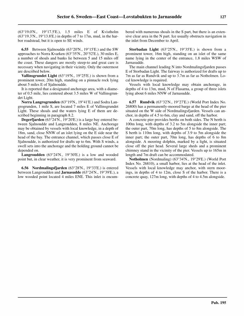
Sector 6. Sweden—East Coast—Lovstabukten to Jarnasudde 127
Pub. 195
(63°19.0'N., 19°17.5'E.), 1.5 miles E of Kvistholm(63°19.3'N., 19°13.8'E.) in depths of 7 to 17m, mud, in the har-bor roadstead, but it is open to SE winds.
6.55 Between Sjalnoudde (63°20'N., 19°15'E.) and the SWapproaches to Norra Kvarken (63°35'N., 20°52'E.), 30 miles E,a number of shoals and banks lie between 5 and 15 miles offthe coast. These dangers are mostly steep-to and great care isnecessary when navigating in their vicinity. Only the outermostare described below. 6.55 Vallinsgrundet Light (63°19'N., 19°25'E.) is shown from aprominent tower, 20m high, standing on a pinnacle rock lyingabout 5 miles E of Sjalnoudde.6.55 It is reported that a designated anchorage area, with a diame-ter of 0.5 mile, lies centered about 3.5 miles W of Vallinsgrun-det Light.6.55 Norra Langrogrunden (63°19'N., 19°41'E.) and Sodra Lan-grogrunden, 1 mile S, are located 7 miles E of VallinsgrundetLight. These shoals and the waters lying E of them are de-scribed beginning in paragraph 8.2.6.55 Degerfjarden (63°24'N., 19°20'E.) is a large bay entered be-tween Sjalnoudde and Langroudden, 8 miles NE. Anchoragemay be obtained by vessels with local knowledge, in a depth of18m, sand, close NNW of an islet lying on the E side near thehead of the bay. The entrance channel, which passes close E ofSjalnoudde, is authorized for drafts up to 6m. With S winds, aswell sets into the anchorage and the holding ground cannot bedepended on.6.55 Langroudden (63°24'N., 19°30'E.) is a low and woodedpoint but, in clear weather, it is very prominent from seaward.
6.56 Nordmalingsfjarden (63°28'N., 19°33'E.) is enteredbetween Langroudden and Jarnasudde (63°24'N., 19°39'E.), alow wooded point located 4 miles ENE. This inlet is encum-
bered with numerous shoals in the S part, but there is an exten-sive clear area in the N part. Ice usually obstructs navigation inthe inlet from December to April.
6.56 Storbadan Light (63°25'N., 19°35'E.) is shown from aprominent tower, 16m high, standing on an islet of the samename lying in the center of the entrance, 1.8 miles WSW ofJarnasudde.6.56 The main channel leading N into Nordmalingsfjarden passesE of Storbadan Light. The fairway is authorized for drafts up to7m as far as Rundvik and up to 3.7m as far as Notholmen. Lo-cal knowledge is required.6.56 Vessels with local knowledge may obtain anchorage, indepths of 4 to 13m, mud, N of Flasarna, a group of three isletslying about 6 miles NNW of Jarnasudde.
6.57 Rundvik (63°32'N., 19°27'E.) (World Port Index No.26800) has a permanently-moored barge at the head of the piersituated on the W side of Nordmalingsfjarden. Vessels can an-chor, in depths of 4.5 to 6m, clay and sand, off the harbor.6.57 A concrete pier provides berths on both sides. The N berth is100m long, with depths of 3.2 to 5m alongside the inner part;the outer part, 70m long, has depths of 5 to 8m alongside. TheS berth is 110m long, with depths of 3.9 to 5m alongside theinner part; the outer part, 70m long, has depths of 6 to 8malongside. A mooring dolphin, marked by a light, is situatedclose off the pier head. Several large sheds and a prominentchimney stand in the vicinity of the pier. Vessels up to 165m inlength and 7m draft can be accommodated.
Notholmen (Nordmaling) (63°34'N., 19°29'E.) (World PortIndex No. 26810), a small harbor, lies at the head of the inlet.Vessels with local knowledge may anchor, with stern moor-ings, in depths of 4 to 12m, close S of the harbor. There is aconcrete quay, 127m long, with depths of 4 to 4.5m alongside.

129
Pub. 195
7. Sector 7—Finland—West Coast—Isokari to Strommingsbadan
7.0Additional chart coverage may be found in NGA/DLIS Catalog of Maps, Charts, and Related Products (Unlimited Distribution).
SECTOR 7 — CHART INFORMATION

131
Pub. 195
SECTOR 7
FINLAND—WEST COAST—ISOKARI TO STROMMINGSBADAN
7.0 Plan.—This sector describes the W coast of Finland and thecontiguous off-lying area in the Gulf of Bothnia betweenIsokari (60°43'N., 21°01'E.), at the N side of the Aland Islands,and Strommingsbadan, in the vicinity of the S approach toNorra Kvarken. The descriptive sequence is N.
General Remarks
7.1 The Finnish coast is low and difficult to make outfrom seaward. It is fronted by numerous islands, rocks, andshoals extending as far as 12 miles offshore. It should be notedthat this coast has not been completely surveyed, and that dan-gers in addition to those shown on the chart may exist. Vesselslacking local knowledge should exercise the appropriate cau-tion. 7.1 Winds—Weather.—The great volume of water entering theGulf of Bothnia from many rivers causes a uniform S surfacemovement during calm weather. This prevailing current in thegulf usually causes vessels from Sodra Kvarken to NorraKvarken to be set E of their course towards the dangers off theFinnish coast.7.1 Along the Finnish coast, there is a current setting to the Nand during the autumn a branch of the N current sets W of theAland Islands and then toward the Finnish shore. Under normalconditions the current has a velocity of not more than 1 to 2knots. The currents in the Gulf of Bothnia have seldom beenobserved to exceed 1.5 knots.7.1 A dominant factor in the movements of the current is thewind direction, which can cause great irregularities in the pat-tern of the currents in these waters. The currents are not onlyaffected by the local winds, but also from those of other locali-ties. A change in the current often precedes the striking of astorm by several hours. During gales the current generally setswith the wind, from 1 to 2 knots in the open sea and from 3 to 4knots near shore.7.1 The tidal range in these waters is of little consequence, butconsiderable change in the water level may be caused by strongwinds, atmospheric pressure, and the seasonal amount of waterreleased by the rivers. A combination of these factors raises orlowers the water in the Gulf of Bothnia, from the mean waterlevel, by as much as 0.1m, although at the heads of the inlets itmay be much more under exceptional circumstances. For ex-ample, at Haparanda, located at the head of the gulf, the levelmay change by up to 1.5m. 7.1 Ice.—See General Remarks in paragraph 1.1 and paragraph4.1.7.1 For information pertaining to winter navigation, ice, andFinnish icebreaking services, including internet web sites, seePub. 140, Sailing Directions (Planning Guide) North AtlanticOcean and Adjacent Seas.7.1 Depths—Limitations.—The coast between Isokari(60°43'N., 21°01'E.) and Sappi (61°29'N., 21°21'E.), about 45miles NNE, is almost entirely fronted by foul ground, small is-
lands, islets, rocks, and shoals. The depths are uneven and ves-sels operating within the 40m curve risk the possibility ofencountering unsurveyed dangers in some localities. Thiscurve lies as far as 15 miles offshore in places.7.1 The low coast between Sappi and Kasko (62°23'N.,21°14'E.), about 54 miles N, has foul ground extending as faras 10 miles from the mainland. Numerous islands and islets al-so front the shore. The depths are uneven and vessels operatingbetween Sappi and Kasko are also advised to stay, as nearly aspossible, in depths of not less than 40m. 7.1 Between Kasko and Strommingsbadan (62°59'N., 20°45'E.),the groups of islets and shoals fronting the coast become wider,with the outermost lying as far as 18 miles from the mainland.The coast of the mainland is low, wooded, and appears to pass-ing vessels to be farther away than it really is. The depths areirregular off this part of the coast and the charted soundings tooscattered to be relied upon during periods of low visibility. Inthis area, vessels are advised to stay outside the 40m curve forsafe navigation.7.1 Several inshore routes lead between the dangers fronting themainland coast. However, these channels, which are mostlynarrow and tortuous, are used only by shallow draft vesselswith local knowledge. 7.1 Pilotage.—See paragraph 1.1 and paragraph 4.1 for infor-mation concerning pilotage and VTS systems in the vicinity ofIsokari, the Aland Islands, and the Saaristomeri area, includingthe approaches to Uusikaupunki.7.1 Regulations.—See paragraph 7.12 for information concern-ing the West Coast Vessel Traffic Service (VTS) system, whichoperates off the SW coast of Finland between Rauman MjakkaLight (61°09'N., 21°10'E.) and Kaijakari (61°37'N., 21°22'E.).7.1 See paragraph 10.1 for information concerning the BothniaVessel Traffic Service (VTS) system, which operates off theNW coast of Finland. This system is mandatory and includesthe routes leading to Kasko (Kaskinen) and Kristinestad (Kris-tiinankaupunki).7.1 See paragraph 1.1 for regulations regarding restricted areasand semi-restricted areas in Finnish waters.
7.1 Caution.—During the winter, many buoys are removedwhile others may be damaged or break adrift.7.1 Numerous logs may be found adrift at all times of the year inthe coastal waters described within this sector.7.1 Areas dangerous due to mines laid during World War II existwithin these waters. There is little risk for surface navigationbut risk of danger in these areas still exists when anchoring orcarrying out any seabed activities.7.1 Due to various circumstances, including the discovery of ob-structions, depths within the channels leading through the off-
FinTraffic VTS — Master’s Guide
https://www.fintraffic.fi/en/vts/masters-guide

132 Sector 7. Finland—West Coast—Isokari to Strommingsbadan
Pub. 195
shore dangers along this stretch of coast may changefrequently. Therefore, vessels are advised to contact the localauthorities in order to ascertain the latest information, includ-ing the maximum authorized drafts.
Isokari to Uusikaupunki and Rauma
7.2 Isokari (60°43'N., 21°01'E.) is an island lying about12 miles W of Uusikaupunki. The pilot station, a yellow one-story building, is situated on the E side of the island.7.2 A reef extends about 0.5 mile S from the S side of the island.Santkari, an islet, is located on this reef and is marked by a bea-con. Foul ground, on which several above-water rocks lie, ex-tends between 0.3 mile and 2.5 miles NW from the NW side ofthe island.7.2 A light is shown from a prominent tower, 37m high, standingon the island.7.2 Sandback (60°46'N., 20°45'E.), a rock awash, is the outer-most danger in this vicinity. It lies on a bank about 8.5 milesWNW of Isokari. A light, equipped with a racon, is shownfrom a tower, 8m high and surmounted by a helicopter plat-form, standing on the rock.7.2 A shoal bank, with a least depth of 6.8m, extends 1.5 milesNW from the light and is marked by a buoy.7.2 Numerous dangers, which extend up to about 10 miles sea-ward, front the mainland coast in vicinity of the approaches toUusikaupunki and Rauma. Only the outermost are describedbelow.7.2 Merikivi, a detached shoal with a least depth of 7.8m, liesabout 2.5 miles S of Sandback Light. Etela Sandback, a rock0.6m high, lies about 1 mile N of this rock and is fringed byshoal water. 7.2 Melanderinmatala, a rocky shoal with a least depth of 6.8m,lies about 4 miles SE of Sandback. Between the two are severalshoals with depths of 2.5 to 8.8m. 7.2 Ljungberginkivi, with a depth of 6.5m, lies 2.3 miles W ofIsokari. A light is shown from a structure standing on the Nside of this shoal.7.2 Ahlstedtinmatala, with a depth of 7.8m, lies 4 miles ENE ofSandback Light and is marked by a buoy. 7.2 An isolated shoal, with a depth of 9.6m, lies 4.5 miles NE ofSandback Light.
7.3 Vekara (60°51'N., 21°01'E.), an island surrounded byshoals, lies 7.5 miles N of Isokari. A beacon stands on this is-land but it is reported to be totally obscured by trees.7.3 Sammo (60°51'N., 21°06'E.), an islet fronted by shoals, lies2.3 miles E of Vekara. A light is shown from a frameworkstructure, 8m high, standing on this islet.7.3 Kajakulma Light (61°00'N., 21°11'E.), equipped with aracon, is shown from a tower, red rectangle with a yellowstripe, 8m high, standing on an islet lying close N of a small is-land, about 10 miles NNE of Vekara. Approximately 1.5 milesNW of From Kajakulma Light, an offshore channel leads N tothe entrance of Rauma with an authorized draft of 5.5m. 7.3 A chain of islets, rocks, and shoals, which may best be seen onthe chart, extends between Vekara and this Kajakulma Light.7.3 Hylkkari Light (60°57'N., 21°10'E.) is shown from a tower, 6mhigh, standing on the NW side of a small island, 2.7 miles SSW ofKajakulma Light. The island is fronted by shoal banks on its NW,
7.4 Lyokki Tower (60°56'N., 21°08'E.), a prominent con-ical structure 16m high, stands on one of a group of small isletslying 1.4 miles SSW of Hylkkari Light.7.4 Harmaatietot (Harmaatletot), consisting of a number of isletslying on an extensive area of rocks and shoals, is centered 2.3miles SSW of Lyokki Tower.7.4 Aukkomatala, an isolated shoal with a depth of 6.5m, liesabout 3.2 miles NW of Lyokki Tower.7.4 Suomenkari, one of the outermost dangers in this area, has adepth of 7.8m. This isloated shoal lies about 6 miles WNW ofLyokki Tower and 3 miles W Aukkomata.7.4 Karlssoninmatala, the northwesternmost of a group of threeshoals, is one of the outermost dangers in this area. This shoalhas a depth of 9m and lies about 5.5 miles W of KajakulmaLight. Karlinmatala, with a depth of 5.3, and Jonssoninmatala,with a depth of 1m, lie 0.4 mile S and 1 mile ESE, respectively,of Karlssoninmatala.7.4 A detached shoal, with a depth of 7.8m, lies about 1 mileNNW of Kajakulma Light and is marked by a buoy. It is locat-ed at the W end of Vanhanpudanmatala, a chain of dangerswhich extends about 3 miles WNW from the mainland.7.4 A detached shoal, with a depth of 8.5m, lies about 1.9 milesNW of Kajakulma Light and is marked by a buoy. It is locatedat the N end of a chain of dangers extending about 2 miles S.
7.5 Laitakari Light (61°03'N., 21°13'E.), a fishing light,is occasionally shown from a framework structure, 8m high,standing on the E side of an islet. A framework beacon, 5mhigh, is situated close W of the light.7.5 A detached shoal, with a depth of 7.1m, lies about 3.5 milesNW of Kajakulma Light and is marked by a buoy. This shoal islocated at the outer end of a group of dangers extending about3 miles W from Laitakari Light. A beacon stands on an above-water rock lying in this group, about 1.2 miles W of LaitakariLight.7.5 A detached shoal, with a depth of 5m, lies about 1.8 milesWNW of Laitakari Light and is marked by a buoy. Another de-tached shoal, with a depth of 9.3m, lies about 2.7 miles NW ofLaitakari Light.7.5 Rihtniemi Light (61°05'N., 21°18'E.), a rear range light, isshown from a rectangular structure standing on the NW side ofa mainland peninsula, 3.4 miles NE of Laitakari Light.7.5 Rauman Majakka Light (61°09'N., 21°10'E.), equipped
7.3Lyokki Tower
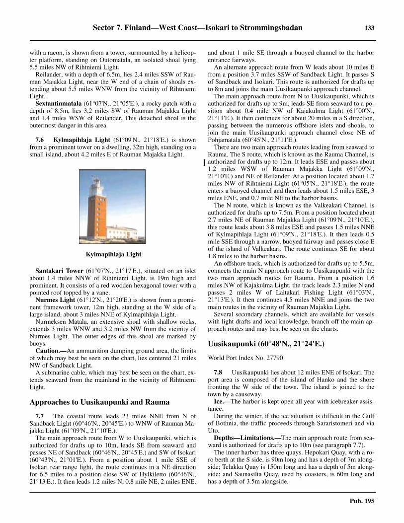
Sector 7. Finland—West Coast—Isokari to Strommingsbadan 133
Pub. 195
with a racon, is shown from a tower, surmounted by a helicop-ter platform, standing on Outomatala, an isolated shoal lying5.5 miles NW of Rihtniemi Light.7.5 Reilander, with a depth of 6.5m, lies 2.4 miles SSW of Rau-man Majakka Light, near the W end of a chain of shoals ex-tending about 5.5 miles WNW from the vicinity of RihtniemiLight.
Sextantinmatala (61°07'N., 21°05'E.), a rocky patch with adepth of 8.5m, lies 3.2 miles SW of Rauman Majakka Lightand 1.4 miles WSW of Reilander. This detached shoal is theoutermost danger in this area.
7.6 Kylmapihlaja Light (61°09'N., 21°18'E.) is shownfrom a prominent tower on a dwelling, 32m high, standing on asmall island, about 4.2 miles E of Rauman Majakka Light.
7.6 Santakari Tower (61°07'N., 21°17'E.), situated on an isletabout 1.4 miles NNW of Rihtniemi Light, is 19m high andprominent. It consists of a red wooden hexagonal tower with apointed roof topped by a vane.7.6 Nurmes Light (61°12'N., 21°20'E.) is shown from a promi-nent framework tower, 12m high, standing at the W side of alarge island, about 3 miles NNE of Kylmapihlaja Light.7.6 Nurmeksen Matala, an extensive shoal with shallow rocks,extends 3 miles WNW and 3.2 miles NW from the vicinity ofNurmes Light. The outer edges of this shoal are marked bybuoys.7.6 Caution.—An ammunition dumping ground area, the limitsof which may best be seen on the chart, lies centered 21 milesNW of Sandback Light.7.6 A submarine cable, which may best be seen on the chart, ex-tends seaward from the mainland in the vicinity of RihtniemiLight.
Approaches to Uusikaupunki and Rauma
7.7 The coastal route leads 23 miles NNE from N ofSandback Light (60°46'N., 20°45'E.) to WNW of Rauman Ma-jakka Light (61°09'N., 21°10'E.).
The main approach route from W to Uusikaupunki, which isauthorized for drafts up to 10m, leads SE from seaward andpasses NE of Sandback (60°46'N., 20°45'E.) and SW of Isokari(60°43'N., 21°01'E.). From a position about 1 mile SSE ofIsokari rear range light, the route continues in a NE directionfor 6.5 miles to a position close SW of Hylkiletto (60°46'N.,21°13'E.). It then leads 1.2 miles N, 0.8 mile NE, 2 miles ENE,
and about 1 mile SE through a buoyed channel to the harborentrance fairways.
An alternate approach route from W leads about 10 miles Efrom a position 3.7 miles SSW of Sandback Light. It passes Sof Sandback and Isokari. This route is authorized for drafts upto 8m and joins the main Uusikaupunki approach channel.
The main approach route from N to Uusikaupunki, which isauthorized for drafts up to 9m, leads SE from seaward to a po-sition about 0.4 mile NW of Kajakulma Light (61°00'N.,21°11'E.). It then continues for about 20 miles in a S direction,passing between the numerous offshore islets and shoals, tojoin the main Uusikaupunki approach channel close NE ofPohjamatala (60°45'N., 21°11'E.).
There are two main approach routes leading from seaward toRauma. The S route, which is known as the Rauma Channel, isauthorized for drafts up to 12m. It leads ESE and passes about1.2 miles WSW of Rauman Majakka Light (61°09'N.,21°10'E.) and NE of Reilander. At a position located about 1.7miles NW of Rihtniemi Light (61°05'N., 21°18'E.), the routeenters a buoyed channel and then leads about 1.5 miles ESE, 3miles ENE, and 0.7 mile NE to the harbor basins.
The N route, which is known as the Valkeakari Channel, isauthorized for drafts up to 7.5m. From a position located about2.7 miles NE of Rauman Majakka Light (61°09'N., 21°10'E.),this route leads about 3.8 miles ESE and passes 1.5 miles NNEof Kylmapihlaja Light (61°09'N., 21°18'E.). It then leads 0.5mile SSE through a narrow, buoyed fairway and passes close Eof the island of Valkeakari. The route continues SE for about1.8 miles to the harbor basins.
An offshore track, which is authorized for drafts up to 5.5m,connects the main N approach route to Uusikaupunki with thetwo main approach routes for Rauma. From a position 1.6miles NW of Kajakulma Light, the track leads 2.3 miles N andpasses 2 miles W of Laitakari Fishing Light (61°03'N.,21°13'E.). It then continues 4.5 miles NNE and joins the twomain routes in the vicinity of Rauman Majakka Light.
Several secondary channels, which are available for vesselswith light drafts and local knowledge, branch off the main ap-proach routes and may best be seen on the charts.
Uusikaupunki (60°48'N., 21°24'E.)
World Port Index No. 27790
7.8 Uusikaupunki lies about 12 miles ENE of Isokari. Theport area is composed of the island of Hanko and the shorefronting the W side of the town. The island is joined to thetown by a causeway.7.8 Ice.—The harbor is kept open all year with icebreaker assis-tance.7.8 During the winter, if the ice situation is difficult in the Gulfof Bothnia, the traffic proceeds through Sararistomeri and viaUto.7.8 Depths—Limitations.—The main approach route from sea-ward is authorized for drafts up to 10m (see paragraph 7.7).7.8 The inner harbor has three quays. Hepokari Quay, with a ro-ro berth at the S side, is 90m long and has a depth of 7m along-side; Telakka Quay is 150m long and has a depth of 5m along-side; and Saunasilta Quay, used by coasters, is 60m long andhas a depth of 3.5m alongside.
7.6Kylmapihlaja Light

134 Sector 7. Finland—West Coast—Isokari to Strommingsbadan
Pub. 195
7.8 The buoyed channel leading to the inner harbor is authorizedfor drafts up to 7m.7.8 The Esso Harbor Quay is 40m long and has a depth of 5malongside. The buoyed channel leading to this harbor is autho-rized for drafts up to 5m.7.8 Kemira Harbor Quay is 340m long and has a depth of 10malongside. The harbor channel leading to this quay is autho-rized for drafts up to 10m.7.8 There are facilities for passenger, general cargo, LPG, bulk,chemical, timber, and ro-ro vessels. Vessels up to 40,000 dwt,200m in length, and 10m draft can be accommodated in theport.7.8 Aspect.—The main approach channels are indicated by di-rectional sector lights and lighted ranges, and are marked bybuoys and beacons. A conspicuous television mast stands inthe vicinity of the town. 7.8 Pilotage.—Pilotage is compulsory. Pilots are ordered fromand provided by the Finnpilot order center; see paragraph 1.1for details. Vessels should send a request for pilotage and anETA at least 12 hours in advance. Pilots may be contacted byVHF and will board in the following positions:
1. Isokari NW—60° 44.5'N,. 20° 54.5'E2. Isokari SE—60° 42.1'N,. 20° 59.9'E
7.8 Regulations.—Vessels with drafts greater than 8m must notexceed a speed of 7 knots in certain parts of the main approachroute.
7.8 See paragraph 4.1 for information concerning VTS systemsin the vicinity of Isokari, the Aland Islands, and the Saari-stomeri area, including the approaches to Uusikaupunki.7.8 Anchorage.—Good sheltered anchorage is available, in adepth of 7m, clay, close SW of Hepokari Quay.7.8 Caution.—During N and E winds, the water level can fallabout 0.4m below normal, which may sometimes delay deeply-loaded vessels reaching the port.7.8 It is reported that submarine pipelines lie in the vicinity ofthe channel leading to Esso Harbor Quay.7.8 The approach channels are well-marked, but care should beexercised as they are fringed by dangers, and are tortuous inplaces.
Rauma (61°08'N., 21°30'E.)
World Port Index No. 27780
7.9 Rauma, situated 20 miles NNE of Uusikaupunki, liesat the head of a bight, which is encumbered by islets and reefs.The port exports paper products and imports oil, coal, andgrains.7.9 Ice.—The port is kept open all year with the assistance of anicebreaker service. Since the adjacent sea area is wide and thearchipelago protects the harbor from pack ice belts, it is not toodifficult to keep the port open.
7.9Courtesy of the Port of Rauma
7.9Rauma Harbor

Sector 7. Finland—West Coast—Isokari to Strommingsbadan 135
Pub. 195
7.9 Tides—Currents.—The tidal range is about 0.5m. 7.9 Depths—Limitations.—Rauma Channel, authorized fordrafts up to 10m (see paragraph 7.7), is the main approachroute from seaward.7.9 The port consists of inlets lying on the N and S sides of theIso-Hakuni Peninsula. The N inlet provides access to a ship-yard and a small craft harbor.7.9 The principal commercial berths are situated along the S sideof the peninsula, within a basin at its W end, and within a basinat its SE end. 7.9 Suoja Coal Quay, at the S side of the SE basin, is 110m longand has a depth of 5.7m alongside. Chemical Berth K1 andChemical Berth K2, at the N side, are 90m and 130m long, re-spectively, and have depths of 5.1m and 7m alongside.7.9 Oil Quay, at the SW end of the SE basin, is 200m long andhas a depth of 9.1m alongside.7.9 Laitsaari Quay, at the S side of the peninsula, is 285m longand has a depth of 9m alongside. Central Quay, close W ofLaitsaari Quay, is 410m long and has depths of 6.1 to 6.9malongside.7.9 Six ro-ro berths are situated alongside the S side of the pen-insula. They are 130 to 225m long and have depths of 6.2 to10m alongside.7.9 Petajas Bulk Quay, at the N side of the W basin, is 314mlong and has a depth of 11m alongside. Container Quay, at theS side, is 130m long and has a depth of 10m alongside.7.9 It is reported that the Container Quay is being extended andtwo additional ro-ro berths are under construction at the W endof the peninsula.7.9 There are facilities for container, ro-ro, general cargo, bulk,chemical, oil, and timber product vessels. Tankers up to 180min length and 8.8m draft can be handled. Cargo vessels are lim-ited only by the authorized approach draft.7.9 Aspect.—The main approach channels are indicated by di-rectional sector lights and lighted ranges, and are marked bybuoys, beacons and virtual aids to navigation. A conspicuoussilo stands in the NW part of the harbor. In the Rauma 12mfairway the brightness of aids to navigation can be adjusted bythe West Coast VTS upon request.7.9 Pilotage.—Vessels should send a request for pilotage and anETA at least 12 hours in advance of arrival. For information re-quired to be included in the message, see Pilotage under Man-tyluoto (paragraph 1.1).7.9 Pilots can be contacted on VHF channel 13 and board atValkeakari (61°10.6'N., 21°15.1'E.) and Rauma S (61°07.3'N.,21°10.8’E.). 7.9 Regulations.—A designated restricted area, which may bestbe seen on the chart, covers the approaches to the port. Vesselsmust remain within the authorized route channel in this area.7.9 Vessel Traffic Service.—The West Coast Vessel Traffic Ser-vice (VTS) extends along the W coast of Finland through theSea of Bothnia from Hylkkari Light to Valassaaret Light and Eto Ritgrund Light and E to Vassa. This includes the merchantshipping lanes, with the exception of the areas administered bythe ports. For details of this VTS, see paragraph 7.12 and thegraphic titled West Coast Finland VTS.7.9 Contact Information.—See the table titled Rauma—Con-tact Information.7.9 Caution.—A submarine pipeline and a submarine cable,which may best be seen on the chart, extend across the channel
from the NW end of the Iso-Hakuni Peninsula.
7.9 A designated nature reserve area, within which numerousrestrictions apply, surrounds the island of Hylkikarta(61°07'N., 21°21'E.) in the S approach to the port.
Rauma to Mantyluoto
7.10 The coast between Rauma and Mantyluoto, about 29miles N, is fronted by numerous islands, rocks, and shoals,which may best be seen on the chart. These dangers extend upto about 8 miles seaward in places. Only the outer dangers andsignificant landmarks are described below.
Kalla Light (61°16'N., 21°21'E.) is shown from a frame-work tower, 10m high, standing on the NW side of an islet ly-ing 4.5 miles N of Nurmes Light (61°12'N., 21°20'E.).
Ulko-Royska, with a least depth of 5m, lies about 1.8 milesW of Kalla Light. This detached shoal is marked by a buoy andis the outermost danger in this vicinity.
Olkiluoto (61°14'N., 21°27'E.), a small craft harbor, is situ-ated on the S side of the W part of a peninsula. An approachroute, authorized for drafts up to 5m, leads from a positionabout 4 miles SW of Kalla Light. This route, which is markedby buoys and range beacons, leads ENE and ESE for about 6.5miles to the harbor. Local knowledge is required.
Eurajoki (61°15'N., 21°30'E.), a small craft harbor, is situat-ed on the N side of a peninsula. An approach route, authorizedfor drafts up to 6m, leads from a position about 2 miles NW ofKalla Light. This route, which is marked by buoys and rangebeacons, leads SE and ESE for about 5.5 miles to the harbor.Local knowledge is required.
Pietari (61°21'N., 21°23'E.), a small islet, lies 4.5 mile N ofKalla Light. A conspicuous beacon, consisting of poles withred and white supports forming a pyramid 18m high, stands onthis islet.
Caution.—A submarine cable, which may best be seen onthe chart, extends seaward from the vicinity of Kalla Light.
7.11 Sappi Light (61°29'N., 21°21'E.) is shown from aprominent tower, 31m high, standing on the NW side of an is-land lying in the S approaches to Mantyluoto, about 12.5 milesN of Kalla Light.
An extensive shoal area, with depths of less 10m, extends upto about 3.5 miles W and 5.5 miles SW of Sappi Light. The
Rauma—Contact Information
Port
Telephone 358-2-83711
Facsimile 358-2-8226369
E-mail [email protected]
Web site https://www.portofrauma.com
Harbor Traffic Control
VHF VHF channel 10
Telephone 358-500-597579
E-mail [email protected]

136 Sector 7. Finland—West Coast—Isokari to Strommingsbadan
Pub. 195
outer edge of this shoal area is marked by a buoy. An area, withdepths less than 20m, extends up to about 5 miles WNW of thelight and is also marked by a buoy.
Kaijakari Light (61°37'N., 21°22'E.) is shown from aframework tower, 16m high, standing on an islet in the N ap-proaches to Mantyluoto, 8.5 miles N of Sappi Light.
Kupeli Light (61°38'N., 21°20'E.), equipped with a racon, isshown from a mast, 7m high, standing 1.3 miles NNW of Kai-jakari Light. Shoals extend between these lights and aremarked on the seaward side by buoys.7.11 Sumparbadar, a group of shoals with depths of less than10m, extends up to about 4 miles NW of Kupeli Light.
Morris Lighted Beacon (61°35'N., 21°25'E.) is shown froma mast, 10m high, standing in the S approach to Mantyluoto,2.6 miles SSE of Kaijakari Light. It is equipped with a racon.
Porin Majakka Light (61°42'N., 21°14'E.), equipped with aracon, is shown from a prominent structure with a wind gener-ator, 18m high, standing 5.2 miles NW of Kupeli Light.
Mantyluoto (61°36'N., 21°29'E.)
World Port Index No. 27750
7.12 Mantyluoto (Pori), lying 55 miles NNE of Isokari,fronts the N side of an island of the same name. It is the outerport for Pori, which is situated 10 miles SE along the shallowestuary of the Kokemaenjoki. A fishing harbor fronts the SEend of Reposaari, an island lying close NW of Mantyluoto. Ta-hkoluoto, the deep-water terminal for Pori, lies 3 miles NW ofMantyluoto, at the NW extremity of Reposaari.7.12 Winds—Weather.—The prevailing winds are from the SW.7.12 Ice.—The harbor is closed by ice for only a short time inwinter, and in very favorable winters it is never closed. This isbecause of the area of open sea on one side and the currentssetting up in the inner side by the discharge of the Koke-maenjoki (River Kumo) at the head of the bight. Icebreakersare available if required. 7.12 Depths—Limitations.—Kallo, an islet, lies close off theNW extremity of the island of Mantyluoto to which it is con-nected by a causeway. Kolmikulma, a shoal bank with a leastdepth of 0.8m, lies in the approach, about 0.5 mile W of the Nend of Kallo. The harbor entrance lies between the heads oftwo breakwaters, which extend about 400m N from Kallo andabout 500m S from the S end of Reposaari.7.12 The main approach channel, which is authorized for draftsup to 10m, leads ENE for 3.5 miles and NE for 2 miles fromthe pilot boarding place. It passes close SE of Morris LightedBeacon and close SE of Kolmikulma shoal bank. An entrancefairway then continues NE between the breakwaters and intothe harbor.7.12 An alternate approach channel, which is authorized for draftsup to 6.5m, leads E and SE from a position 1.8 miles SW ofKaijakari Light. It passes NE of Kolmikulma shoal bank andthen joins the main approach channel.7.12 The river has a depth of 2m; Pori is only used by recreationalcraft. The harbor at Reposaari has 250m of berthage, withdepths up to 4.5m alongside, and is used by fishing vesselswith drafts up to 3.9m.7.12 The harbor at Mantyluoto provides 2,000m of main quayage,with depths of 6.5 to 11.2m alongside. There are facilities for
general cargo, ro-ro, container, bulk, and timber vessels. Ves-sels up to 10m draft can be handled.7.12 Tahkoluoto(61°38'N., 21°24'E.) (World Port Index No.27755), the deep-water terminal, can be approached by twochannels. The N channel, which is authorized for drafts up to15.3m, leads SE for 7 miles from a position about 1.5 milesNW of Porin Majakka Light. It passes close NE of the latterlight and leads to the turning basin at the N side of the harbor.7.12 The S channel, which is authorized for drafts up to 10m,leads 2 miles in a NE direction from a position about 1.5 milesSW of Kupeli Light. It passes close SE of the latter light andleads to the turning basin.7.12 There are two berthing complexes at Tahkoluoto. The OilTerminal, with an L-shaped pier, is situated at the NE side ofthe harbor. It has a berth, 145m long, with a depth of 11.5malongside and can handle vessels with drafts up to 10m. A bulkquay is situated close W of the oil berth on the inside of abreakwater. It has a berth, 120m long, with a depth of 11.5malongside.7.12 The Coal Terminal is situated at the W side of the harbor. Ithas a quay, 450m long, with a depth of 17.5m alongside. Ves-sels up to 120,000 dwt and 15.3m draft can be handled.7.12 Aspect.—The approach channels are indicated by lighted rang-es and marked by buoys, which may best be seen on the chart.7.12 A prominent chimney stands on the NE side of Reposaari,about 1 mile NNW of the root of the breakwater. A prominentradio mast stands on the S side of Reposaari, about 0.2 mileNW of the root of the breakwater. A conspicuous water tower,64m high, is situated about 2 miles SE of Mantyluoto. A ship-yard, which is used for the construction of offshore platforms,is situated at the NE side of Mantyluoto harbor.7.12 Two bridges span the river 1.5 miles E of the breakwaters. 7.12 A conspicuous chimney stands on the W side of the harbor atTahkoluoto.7.12 Pilotage.—Pilotage is compulsory. Vessels should send a re-quest for pilotage and an ETA 24 hours prior to arrival. Pilotsare ordered from and provided by the Finnpilot order center;see paragraph 1.1 for details.7.12 Pilots can be contacted on VHF channel 13 and board at twopositions. The Pori S boarding area is located in position61°34.0'N, 21°22.1'E about 3.25 miles WSW of Morris Light-ed Beacon. Vessels bound for Tahkoluoto use the Pori N board-ing area which is located in position 61°36.8'N, 21°17.0'E
7.12Mantyluoto
Sector 7. Finland—West Coast—Isokari to Strommingsbadan 137
Pub. 195
about 4 miles SW of Kupeli Light. 7.12 Vessel Traffic Service.—The West Coast Vessel Traffic Service(VTS) extends along the W coast of Finland through the Sea ofBothnia from Hylkkari Light to Vassa. This includes the merchantshipping lanes, with the exception of the areas administered by theports. See the graphic titled West Coast Finland VTS.7.12 The boundary line of the West Coast VTS Area runs betweenthe following positions:
1. Hylkkari Light (60°57.2'N., 21°09.5'E.).2. West to position 60°57.2'N 20°46.5'E.3. To the limit of the territorial sea limit (61°07.6'N.,
20°46.5'E.).4. Observing the limit of the territorial waters to position
62°36.5'N, 20°30.0'E.5. Position 63°21.5'N, 20°30.0'E.6. Valassaaret Light (63°25.3'N 21°04.1'E).7. Ritgrund Light (63°25.5'N 21°30.5'E).
7.12 The West Coast VTS provides the following types of ser-vices:
1. Information service.2. Traffic organization service.3. Navigational assistance service.
7.12 Mandatory participation and other requirements in the VTSare listed below:
1. Vessels of 24m loa or longer.2. When navigating in the VTS area, vessels are required
to maintain a continuous listening watch on VHF Channel 9.3. Vessels navigating in the VTS area, those who are not
obliged to participate in the VTS, are recommended to main-tain a listening watch on VHF channel 9.
7.12 Participating vessels are required to make reports as follows:1. Upon entry into the VTS area.2. Before anchoring.3. Before leaving an anchorage.4. After berthing.5. Before leaving port.6. At the reporting points in the area:
a. Southbound vessels shall report 20 minutes beforepassing Hylkkari Light to Archipelago VTS on VHFChannel 71.
b. Northbound vessels shall report 20 minutes beforepassing Hylkkari Light to West Coast VTS on VHF chan-nel 9.
Reports should include the following information:1. Vessel's name.2. Name of reporting point.3. Destination.4. Intended route. If an alternative route is selected, this
must be reported.
7.12 Before departing from the ports of Pori and Vaasa, vesselsmust submit a departure report in order to obtain permission todepart. Once permission is granted by the VTS, vessels have 20minutes to depart their berths. A new permission request mustbe submitted after departure delays exceeding 20 minutes. Ves-
sels are required to give a report once underway.7.12 Meeting and overtaking is permanently prohibited in the fol-lowing areas covered by the West Coast VTS:
1. Vaasa—Nygrundin portti—Port of Vaasa betweenlongitude 21°18.1'E and longitude 21°32.1'E in the 9m fair-way.
2. Kaskinen—In the fairway section Rasken—Port ofKaskinen between latitude 62°19.3'N and latitude 62°20.8'Ein the 9m fairway.
3. Kristiinankaupunkië—Kristiinankaupunki Light-house—Port of Kristiinankaupunki between longitude21°10.2'and longitude 21°18.5'E in the 12m fairway.
4. Rauma—Rauma S fairway between the longitude21°15.5'E and longitude 21°23.8'E in the 12m fairway.
These prohibitions do not apply to meeting and overtakingsituations in which at least one of the vessels is a tug or a vesselthe size of which is comparable to a tug.7.12 Contact Information.—See the table titled Mantyluoto—Contact Information.
7.12 Anchorage.—Anchorage may taken, in a depth of 7m, mud,in an area lying 0.3 mile E of the SE end of Reposaari. Howev-er, strong winds from SW to W cause heavy seas in this road-stead.7.12 Caution.—Anchorage is prohibited within an area, whichmay best be seen on the chart, lying close E of the breakwaterheads due to the existence of submarine pipelines and cables.7.12 A spoil ground area, which may best be seen on the chart,lies close NW of Tahkoluoto.7.12 A dangerous wreck is reported to lie close SE of the mainapproach channel in the vicinity of Morris Lighted Beacon.
FinTraffic VTS — Master’s Guide
https://www.fintraffic.fi/en/vts/masters-guide
Mantyluoto—Contact Information
Port Authority
Telephone 358-2-621-2600
Facsimile 358-2-634-9498
E-mail [email protected]
Web site http://www.portofpori.fi
Port Control
VHF VHF channel 11, 12, and 16
Telephone 358-44-7012623 (24 hours)
E-mail [email protected]
West Coast VTS
Call sign West Coast VTS
VHF VHF channel 9
Telephone358-20-448-6645 (West Coast VTS)
358-20-448-6522 (Supervisor)
Web site https://www.fintraffic.fi/en/masters-guide

138 Sector 7. Finland—West Coast—Isokari to Strommingsbadan
Pub. 195
West Coast Finland VTS

Sector 7. Finland—West Coast—Isokari to Strommingsbadan 139
Pub. 195
Mantyluoto to Kristinestad
7.13 The coast between Mantyluoto (Pori) and Kristines-tad, about 40 miles N, is fronted by numerous islands, rocks,and shoals, which may best be seen on the chart. These dangersextend up to about 9 miles seaward in places. Only the outerdangers and significant landmarks are described below. 7.13 Fadikari (61°44'N., 21°18'E.), a shoal patch, lies near theouter edge of the coastal bank, 2.3 miles ENE of Porin Majak-ka Light. It has a depth of 4.8m and is marked by a buoy.7.13 Karviankivi, a pinnacle rock with a depth of 6.3m, lies 5.5miles NNW of Fadikari. It is located near the outer edge of thecoastal bank and marked by a buoy.7.13 Stakki (61°51'N., 21°18'E.) is the westernmost of a group ofislets lying centered from 2 to 5 miles offshore, 8.5 miles NEof Porin Majakka Light. Shoals, with depths of less than 5m,extend up to about 2.5 miles WSW and 1.5 miles W of this is-let. A prominent pyramid beacon, 14m high, stands on an isletlying at the S end of the group.7.13 Hiidensilta, an extensive area of shallow shoals, lies centered2.5 mile NW of Stakki. A patch, with a depth of 4.5m, is locat-ed at the seaward edge of this area. It lies about 4.3 milesWNW of Stakki and is marked by a buoy.7.13 An isolated shoal patch, with a depth of 9.4m, lies about 6miles WNW of Stakki and is the outermost danger in this vi-cinity.7.13 Merikarvian Majakka Light (61°56'N., 21°17'E.), which isequipped with a racon, is shown from a mast standing on the Npart of Hiidensilta, 5.6 miles NNW of Stakki.7.13 Yttergrund Light (61°59'N., 21°18'E.) is shown from aprominent tower, 41m high, standing on an island lying closeoff the mainland, 3 miles NNE of Merikarvian Majakka Light.7.13 Silverbergsgrund, a shoal with a depth of 3.9m, lies about 2miles WSW of Yttergrund Light.7.13 Rakaren, a large shoal, lies centered 5.5 miles NW of Ytter-grund Light, near the edge of the shallow coastal bank. It has aleast depth of 0.8m and is marked by two buoys.
7.14 Merikarvia (61°51'N., 21°29'E.), a small mainlandharbor, is situated 5 miles E of Stakki and sheltered by Brando,an island lying close offshore. It is used by coasters and recre-ational craft. A quay, which fronts a sawmill, can handle ves-sels up to 115m in length.7.14 A main approach route, which is authorized for drafts up to4.0m, leads E for about 3.5 miles from a position located 3miles WNW of Merikarvian Majakka Light. The route passesN of the light and then leads SE for about 8 miles to the harbor.The channel is indicated by lighted ranges and marked bybuoys. Local knowledge is required.7.14 Small vessels can anchor, in a depth of 10m, within an outerroadstead lying about 2.5 miles NW of Brando.7.14 Kassala (61°57'N., 21°21'E.), a small fishing harbor, lies 6.5miles NNW of Merikarvia. It can be entered through a partlybuoyed channel, which is authorized for drafts up to 3.3m. Thischannel branches NNE from the main route leading to Meri-karvia at a position about 1.2 miles SE of Merikarvian Majak-ka Light. A buoyed channel close SW of Kassala, best seen onthe chart, has a maximum authorized draft of 4.0m. 7.14 Sideby (Siipyy) (62°02'N., 21°20'E.), a small town, is situat-ed about 3.5 miles NNE of Yttergrund Light. It may be identi-
fied by a conspicuous yellow church, with a black roof andsteeple, standing at an elevation of 61m.
7.15 Kristiinankaupungin Majakka Light (62°12'N.,21°10'E.), equipped with a racon, is shown from a prominenttower with a helicopter platform, 20m high, standing in the ap-proach to Kristinestad, about 14 miles NNW of YttergrundLight.7.15 Hoijers, a shoal with a least depth of 3.9m, lies centered 5.5miles SSW of Kristiinankaupungin Majakka Light. It is locatedabout 5 miles offshore and marked by two buoys.7.15 Mossbada, a large shoal area with a least depth of 2.3m, liescentered 3 miles N of Kristiinankaupungin Majakka Light. It islocated 5 miles offshore, at the outer edge of the coastal bank,and is marked by buoys.7.15 Harkmeri (62°12'N., 21°20'E.) is an islet lying 4.3 milesESE of Kristiinankaupungin Majakka Light, in the approach toKristinestad. A conspicuous pyramid beacon, 19m high with aball topmark, stands on the N end of this islet.7.15 Norra Storbadan (62°12'N., 21°20'E.), a rocky and shallowshoal, lies 2.5 miles ENE of Kristiinankaupungin MajakkaLight and is marked by a prominent lighted beacon. Its N endis marked by a buoy.7.15 Phavuori (Botomsberg) (62°17'N., 21°39'E.), a hill 130mhigh, stands 7.5 miles E of Kristinestad and is a conspicuouslandmark. It is the only high land in this vicinity and appears asthree separate hills from a distance of about 20 miles. An aero-nautical light is shown from a mast standing on the SE side ofthe middle hill.
Kristinestad (Kristiinankaupunki)(62°17'N., 21°24'E.)
World Port Index No. 27680
7.16 Kristinestad is situated at the head of Stads Fjard, asmall and narrow inlet. It is fronted by numerous small isletsand rocks. The inner harbor lies within the inlet at the E side ofthe Bjornon Peninsula. The outer harbor lies at the W side ofthe peninsula, about 1.8 miles SW of the town center.7.16 Winds—Weather.—The outer roadstead is protected fromwinds from all directions except those from SSW; however,these winds do not raise a heavy sea. The inner harbor is well-protected from all directions. 7.16 Ice.—Depending on the ice, the port usually closes at theend of December and reopens during April. The outer harbormay be kept open for a longer period.
7.14Merikarvia

140 Sector 7. Finland—West Coast—Isokari to Strommingsbadan
Pub. 195
7.16 Depths—Limitations.—The main approach route leadingto the inner harbor from seaward is authorized for drafts up to5m. This route leads in an ENE direction for 4.7 miles from aposition located 2.3 miles S of Kristiinankaupungin MajakkaLight (62°12'N., 21°10'E.). It then continues NNE for 1.5 milesand N for 2.3 miles to the harbor entrance. This route passesclose N of the islet of Harkmeri.7.16 An alternate route, which is authorized for drafts up to 5m,may only be used by day. This route leads SE for 3.5 milesfrom a position located 2.5 miles NNW of KristiinankaupunginMajakka Light. It passes close S of Mossbada shoal and closeNE of Norra Storbadan Lighted Beacon. The route then contin-ues SSE to join the main channel.7.16 The inner harbor has a wooden quay, 75m long, with a depthof 4.6m alongside, and a stone quay, 250m long, with a a depthof 5.6m alongside. Vessels up to 130m in length and 5m draftcan be accommodated.7.16 The main approach route leading to the outer harbor fromseaward is authorized for drafts up to 12m. This route leads in aNE direction for 6 miles from a position located 2 miles SW ofKristiinankaupungin Majakka Light. It passes close NW of thelatter light and close NW of Norra Storbadan Lighted Beacon.7.16 The outer harbor has a T-shaped coal pier, with a depth of12m alongside, and a T-shaped oil jetty, with a depth of 10malongside. Bulk vessels up to 240m in length and 12m draft canbe accommodated; and tankers up to 23,000 dwt can be han-dled.7.16 Aspect.—The approach routes are indicated by lighted rang-es and beacons. The inner channels are marked by buoys andbeacons.7.16 Pilotage.—Pilotage is compulsory. Pilots are ordered via theFinnpilot Order Center, Southern Pilotage Zone but may becontacted by VHF. Pilots board in position 60°11.5'N,21°06.8'E.7.16 Regulations.—The approach route leading to Kristinestad(Kristiinankaupunki) is situated within Sector A of the BothniaVessel Traffic Service (VTS) system. This system operates off theNW coast of Finland and is mandatory. For further details of theVTS system, including reporting procedures, see paragraph 10.1.7.16 Contact Information.—The port can be contacted on VHFchannel 24. 7.16 Anchorage.—Anchorage, with good shelter and good hold-ing ground, is available, in a depth of 9m, mud, about 1.5 milesS of the inner harbor entrance.
Kristinestad to Strommingsbadan
7.17 The coast between Kristinestad and Strommings-badan (62°59'N., 20°45'E.), about 42 miles N, is fronted by nu-merous islands, rocks, and shoals, which may best be seen onthe chart. These dangers extend up to about 17 miles seawardin places. Only the outer dangers and significant landmarks aredescribed below. 7.17 Salgrund Light (62°20'N., 21°12'E.) is shown from a prom-inent tower, 25m high, standing at the SW end of an island ofthe same name.7.17 Storremmargrund Light (62°20'N., 21°13'E.), equippedwith a racon, is shown from a floodlit tower, 7m high, standing0.7 mile E of Salgrund Light.7.17 Storgrund (62°19'N., 21°05'E.), one of the outermost dan-
gers in this vicinity, lies 3.5 miles WSW of Salgrund Light.This shoal has a least depth of 3.4m and is marked by twobuoys. A detached patch, with a least depth of 7.2m, lies about1.6 miles WNW of Storgrund.7.17 Yttergrund, another of the outermost dangers in this vicinity,lies about 5 miles offshore, 6.5 miles NW of Salgrund Light.This rocky shoal has a least depth of 4.9m and is marked by abuoy.
Caution.—A local magnetic anomaly exists within the areaextending 2 miles W and 4 miles SW of Strommingsbadan.
7.18 Kasko (Kaskinen) (62°23'N., 21°14'E.) (World PortIndex No. 27670) is situated on the W side of the island ofKasko, about 8 miles NW of Kristinestad. This small port con-sists of a natural harbor lying between the islands of Kasko andEsko (Eskilso), close W of the town.
7.18 Winds—Weather.—The harbor is well-sheltered from allwinds. 7.18 Ice.—During the winter this port is usually the northernmostwithin the Gulf of Bothnia to be kept open by icebreakers.7.18 Depths—Limitations.—The main approach route leads NEfor about 4 miles from a position located 5 miles SW of Salgr-und Light. The entrance channel then leads in a N direction be-tween Salgrund Light and Storremmargrund Light. The route isauthorized for drafts up to 9m as far as the Deep Water Quayand then for drafts up to 6m as far as the Inner Harbor Quay.7.18 Deep Water Quay is 250m long and has depths of 8 to 10malongside. Outer Harbor Quay is 35m long and has a depth of6.5m alongside. Inner Harbor Quay is 160m long and has adepth of 6m alongside. Vessels up to 185m in length and 9mdraft can be handled.7.18 Aspect.—The approach and entrance channels are indicatedby lighted ranges and marked by buoys.7.18 Pilotage.—Pilotage is compulsory. Pilots can be contactedby VHF and board about 5.5 miles SW of Salgrund Light, inposition 62°15.5'N, 21°05.1'E.7.18 Vessel Traffic Service.—The approach route leading to Kas-ko (Kaskinen) is situated within Sector A of the Bothnia VesselTraffic Service (VTS). This system operates off the NW coastof Finland and is mandatory. For further details of this VTS in-cluding reporting procedures, see paragraph 10.1.
7.17Salgrund Light
Kasko (Kaskinen) Home Page
https://kaskinen.fi

Sector 7. Finland—West Coast—Isokari to Strommingsbadan 141
Pub. 195
7.18 Contact Information.—See the table titled Kasko—Con-tact Information.
7.18 Anchorage.—Anchorage is available, in depths of 15 to20m, within an area lying about 3 miles WSW of Salgrund.Anchorage may also be obtained, in a depth of 5m, clay, withinthe harbor, off the middle of the town.
7.19 Gashallan (62°35'N., 21°03'E.) is the westernmost ofa group of islets lying about 3 miles offshore, 15 miles NNWof Salgrund Light. A red and white two-story former pilotwatch house stands on this islet. It is 11m high and conspicu-ous from seaward. 7.19 Shoals, with depths of less than 5m, extend up to about 2.5miles SW, W, and NW of Gashallan. A detached patch, with adepth of 9.8m, lies about 3.5 miles W of Gashallan.7.19 Skomakarsgrund, with a depth of 3.7m, and Rosengrund,with a depth of 4m, lie, respectively, about 5.5 and 4.2 miles Sof Gashallan. These shoals lie about 3 miles offshore and aremarked by buoys. 7.19 Judasternarne (62°40'N., 20°45'E.), with a least depth of2.5m, lies 9 miles offshore, about 10 miles NW of Gashallan,and is marked by a buoy. A lighted buoy is moored about 1.3miles NW of this shoal.7.19 Eriksson, a large shoal area, lies centered 2.5 miles E of Ju-dasternarne. It has a least depth of 1.9m and is marked by three
buoys. A shoal area, with depths of 8.3 to 9.8m, lies centered1.7 miles SE of Judasternarne.
7.20 Sjogrund (62°47'N., 20°32'E.), with a least depth of8.2m, lies 9 miles NW of Judasternarne and is marked by abuoy. This shoal is located 16.5 miles W of the mainland and isthe outermost danger in along this stretch of coast.7.20 Storkallegrund, an extensive shoal flat, lies with its outer partlocated 9 miles N of Judastenarne, about halfway between Sjo-grund and the mainland.
7.20 Strommingsbadan (62°59'N., 20°45'E.) is a small islet ly-ing 18.5 miles N of Judasternarne. Above-water rocks lie 1mile S and 1.2 miles SSE of this islet. A light is shown from aprominent tower, 13m high, standing on this islet.7.20 Vesterhallan, a rock, lies about 0.5 mile WSW of the light. Ithas a least depth of 5.5m and is marked by a buoy. Karpoff, ashoal, lies about 1.5 miles SSW of the light. It has a least depthof 2.3m and is marked by a buoy. 7.20 Strommingsbadan lies near the NW edge of a shoal, with aleast depth of 2.5m, which extends for about 2.3 miles in a gen-eral N-S direction and is nearly joined to another shoal, with aleast depth of about 2.4m, which extends N for an additional1.5 miles.
7.20 A description of the waters lying N of Strommingsbadan, be-gins in paragraph 8.13.
Kasko—Contact Information
Port Authority
Telephone 358-6-220-7283
Facsimile 358-6-220-7300
E-mail [email protected]
Web site https://www.portofkaskinen.fi
Port Services
Telephone 358-400-868783
E-mail [email protected]
7.20Strommingsbadan Light

143
Pub. 195
8. Sector 8—Norra Kvarken and the Adjacent Swedish and Finnish Coasts
8.0Additional chart coverage may be found in NGA/DLIS Catalog of Maps, Charts, and Related Products (Unlimited Distribution).
SECTOR 8 — CHART INFORMATION

145
Pub. 195
SECTOR 8
NORRA KVARKEN AND THE ADJACENT SWEDISH AND FINNISH COASTS
8.0 Plan.—This sector describes Norra Kvarken and the parts ofthe E coast of Sweden and the W coast of Finland bordering onthat passage. The descriptive sequence is NE from Jarnasudde,on the Swedish side, then N from Strommingsbadan, on theFinnish side. The routes through Norra Kvarken are then de-scribed.
General Remarks
8.1 Norra Kvarken, the narrowest part of the Gulf ofBothnia, connects Bottenhavet (Selkameri), the S part of thegulf, with Bottenviken (Perameri), the N part. This passagecomprises the waters on either side of Holmoarne, a group ofislands lying between 4 and 10 miles off the Swedish main-land. These islands divide Norra Kvarken into two main chan-nels, Vastra Kvarken and Ostra Kvarken. Norra Kvarkenextends about 40 miles NE from Bonden (63°26'N., 20°03'E.)and Norrskar Light (63°14'N., 20°36'E.), and is encumberedwith numerous islands, rocks, and shoals. 8.1 The Swedish coast, between Jarnasudde (63°26'N., 19°39'E.)and Ratan (64°24'N., 20°54'E.), about 48 miles NE, is indentedby numerous fjords, bays, and coves into which several riversflow. Many detached dangers front the coast. 8.1 On the Finnish side of Norra Kvarken, to the SE, an exten-sive area, containing numerous islands, rocks, and shoals, ex-tends about 60 miles NE between Strommingsbadan (62°59'N.,20°45'E.) and Hallgrund (63°39'N., 22°25'E.). The coast hereis also indented by many fjords, bays, and coves. A fewstreams discharge along this coast.
8.1 Several commercially-important ports and loading places aresituated in the inlets on both coasts. The principal ports areUmea, in Sweden, and Vaasa, in Finland. 8.1 The channels leading to the ports are marked by aids. Lightsand buoys mark some of the dangers adjacent to the main chan-nels of Norra Kvarken both coasts are comparatively low andheavily wooded. 8.1 Winds—Weather.—Winds from the S to SW prevail overthe Gulf of Bothnia in the summer months, but N winds arequite common in June. The winds show a tendency to flow par-allel to the coasts in either direction in the Gulf of Bothnia.8.1 There is a tendency for cloud coverage to be greater with on-shore winds than with offshore winds; this, combined with thefact that the predominant winds are from a W quarter, explainsthe more cloudy conditions on the Finnish coast, comparedwith the Swedish coast of the Gulf of Bothnia.8.1 Fog is most frequent in April and least frequent in August.Good or very good visibility is common over this sector. Re-cords show that about 80 per cent of observations show visibil-ity greater than 10 miles during summer. 8.1 Snowfall is a common cause of poor visibility, especiallyfrom December to April.8.1 The region is very cold during winter and the average airtemperature is below freezing from late October to the middleof April.
8.1 Humidity is usually high in the winter and comparativelylow in spring and summer.8.1 Ice.—For Finland, see General Remarks in paragraph 1.1and paragraph 4.1.8.1 For Sweden, see General Remarks in paragraph 5.1.8.1 For information pertaining to winter navigation, ice, andFinnish icebreaking services, including internet web sites, seePub. 140, Sailing Directions (Planning Guide) North AtlanticOcean and Adjacent Seas. 8.1 Pilotage.—See Pub. 140, Sailing Directions (PlanningGuide) North Atlantic Ocean and Adjacent Seas for general in-formation on pilotage within Finnish and Swedish waters. Seealso paragraph 1.1 and paragraph 5.1.8.1 Deep-sea pilots for the Baltic Sea should be ordered throughthe Malmo, Lulea, or Stockholm pilot stations at least 24 hoursin advance. 8.1 The main pilot stations along the Swedish part of the coastare situated at Umea and Ornskoldsvik (63°17'N., 18°44'E.).All requests for pilotage must be made through the VTS stationat Lulea.8.1 The pilotage area for Ornskoldsvik lies between a line bear-ing 140° through Norrbyskar (63°33'N., 19°52'E.) and latitude62°50'N (see paragraph 6.52).8.1 The pilotage area for Umea lies between a line bearing 140°through Norrbyskar (63°33'N., 19°52'E.) and latitude 64°03'N(see paragraph 8.9).8.1 The main pilot station along the Finnish part of the coast issituated at Vaasa (see paragraph 8.18 and paragraph 10.1). 8.1 It should be noted that ordering of pilots in the Swedish wa-ters described within this sector is presently carried out throughthe main VTS systems. However, it is reported that proceduresfor the initial ordering of pilots via the internet will be intro-duced in the near future. For additional information concerningthese procedures, see the following web site:
8.1 Regulations.—See Pub. 140, Sailing Directions (PlanningGuide) North Atlantic Ocean and Adjacent Seas for regulationspertaining to vessels within the waters of Sweden and Finland.8.1 See paragraph 10.1 for information concerning the BothniaVessel Traffic Service (VTS) system, which operates off theNW coast of Finland. This system is mandatory and includesthe routes leading to Vaasa and the main shipping routes situat-ed in the S part of Norra Kvarken.8.1 See paragraph 1.1 for details of restricted areas and semi-re-stricted areas in these waters.8.1 Several offshore islands, islets, and rocky shoals within these
Swedish Maritime Administration Home Page
https://www.sjofartsverket.se/en
FinTraffic VTS—Master’s Guide
https://www.fintraffic.fi/en/vts/masters-guide

146 Sector 8. Norra Kvarken and the Adjacent Swedish and Finnish Coasts
Pub. 195
waters have been designated as nature reserves. Landing is pro-hibited and many restrictions apply.8.1 Caution.—The coast of Finland, bordering on the Gulf ofBothnia, has not been thoroughly surveyed. Dangers may existoutside the charted and described off-lying dangers. Vesselsshould proceed with care when approaching this coast.8.1 During the winter, many buoys are removed while othersmay be damaged or break adrift.8.1 In the coastal waters within this sector, numerous logs maybe found adrift at all times of the year.8.1 Areas dangerous due to mines laid during World War II existwithin these waters. There is still a risk of danger in these areaswhen anchoring or carrying out any seabed activities. 8.1 Due to various circumstances, including the discovery of ob-structions, depths within the channels leading through the off-shore dangers along this stretch of coast may changefrequently. Therefore, vessels are advised to contact the localauthorities in order to ascertain the latest information, includ-ing the maximum authorized drafts.
Sweden—Jarnasudde to Umea
8.2 The depths lying between Jarnasudde and Ratan arevery irregular. The depths surrounding the detached offshoredangers may vary between 11m and 90m.8.2 Foul ground fringes the coast, and numerous shoals androcky patches, lying close together in some places, extend upto 8 miles offshore. Other detached rocks and shoals lie up to13 miles offshore.8.2 The dangers fronting the coast may best be seen on the chartand only the outermost are described below. Most of these off-lying dangers are steep-to and great care is necessary whennavigating in their vicinity.8.2 Jarnasudde (63°26'N., 19°39'E.), the E entrance point ofNordmalingsfjarden, is low and wooded. 8.2 Jarnashamn (63°26'N., 19°41'E.), a small harbor, lies in aninlet on the E side of Jarnasudde. Small vessels, with drafts upto 4.5m, can use the narrow entrance channel. Ice obstructsnavigation in the fairway from the middle of December to May.Local pilots may be obtained through the pilotage area ofOrnskoldsvik. Anchoring is restricted within the harbor, indepths of 4 to 7m, clay and mud. Local knowledge is advised.8.2 Norra Langrogrundet (63°19'N., 19°41'E.), a bank withshallow ledges and rocks awash at its N end, lies 6.5 miles S ofJarnasudde. A light, equipped with a racon, is shown from aprominent tower, 21m high, standing at the N end of this bank.8.2 Sodra Langrogrundet, a rocky bank with a least depth of4.9m, lies 2 miles S of Norra Langrogrundet and is marked bya buoy at its W end.8.2 Elinsgrund (63°18'N., 19°53'E.), an isolated shoal, has adepth of 5.9m and lies about 5.5 miles E of Norra Langrogrun-det Light.
8.3 Bonden (63°26'N., 20°03'E.) is a moderately-high redrock resembling, from a distance, the ruins of an old castle.This rock lies 10.5 miles E of Jarnasudde and is fronted by areef on its S side. A light is shown from a prominent tower,20m high, standing on the rock.8.3 A detached shoal patch, with a depth of 8m, lies about 3miles NE of Bonden.
8.3 The area surrounding Bonden is a designated nature reserveand numerous restrictions apply. Landing is prohibited withoutpermission.8.3 Sydvastbrotten (63°25'N., 20°02'E.), consisting of twolight-colored rocks lying close together, is located about 1.5miles SSW of Bonden Light and fronted by foul ground on itsN side. A shoal, with a depth of 7.9m, lies 0.4 mile S of theserocks.8.3 Tjaruskarssund (63°28'N., 19°46'E.) is the SW entrancepoint of Orefjarden. The coast extending between this pointand Jarnasudde is thickly wooded. The shore is fronted by sev-eral islets and numerous rocks and shoals.8.3 Efesgrund (63°23'N., 19°47'E.), a detached shoal with adepth of 6.4m, lies about 5 miles S of Tjaruskarssund and ismarked by a buoy.8.3 Lordagshallan (63°26'N., 19°54'E.), a rocky shoal area, liescentered about 3.5 miles W of Bonden. It dries in places and ismarked by a beacon.8.3 Bondensgrund (63°28'N., 19°46'E.), a detached shoalpatch, lies 4 miles ESE of Bonden Light and has a least depthof 2.4m. 8.3 Sydostbrotten Light (63°21'N., 20°11'E.), equipped with aracon, is situated 7 miles SE of Bonden Light. It is shown froma prominent tower, 34m high, standing on Vernersgrundet, adetached shoal patch.8.3 Sydostbrotten (63°23'N., 20°07'E.), an extensive chain ofshoals, lies with its NE end located about 4.3 miles NNW ofSydostbrotten Light. It extends SW for about 5 miles and isawash in places.
8.4 The coast between Tjaruskarssund and Blagrundsud-de (63°36'N., 20°00'E.), about 10 miles NE, is indented by ma-ny shallow inlets. The shore is fronted by small islands, islets,and numerous shoals, which extend up to about 8 miles sea-ward and may best be seen on the chart.8.4 Orefjarden (63°30'N., 19°48'E.), a fjord, lies between themainland, on the W side, and a chain of islands and islets ex-tending S, on the E side.8.4 Snoan (63°29'N., 19°54'E.) lies 5 miles NW of BondenLight and is the most easily-recognized island of the chain. It is1.3 miles long, moderate high, and has a flat top with light-col-ored slopes. A chapel is situated near the S end; a light isshown from the SE side of the island.
Orefjarden may be approached from the S by a buoyed channel,which is authorized for drafts up to 4m. Local knowledge is re-quired. There are also a number of shallow alternate passages,
8.3Bonden Light

Sector 8. Norra Kvarken and the Adjacent Swedish and Finnish Coasts 147
Pub. 195
which lead through the offshore dangers. This fjord is usuallyclosed by ice from the middle of December to the middle of April.8.4 Kylorn (63°32'N., 19°46'E.), a former timber-loading place,is situated on the NW side of Orefjarden and provides an an-chorage, in depths of 5 to 10m, mud and sand.
8.5 Norrbyskar (63°33'N., 19°52'E.), a former timber-loading place, is situated in the NE part of the fjord. It is nowonly used by small craft, including a ferries and recreationalboats. There is a quay, 53m long, with depths of 3.7 to 4.3malongside. The anchorage has depths of 7 to 13m, clay, mud,and stones. Local knowledge is required.8.5 Hornefors (63°37'N., 19°54'E.), a former timber and pulp-loading place, is situated in Vasterfjarden, an inlet indentingthe mainland about 3 miles NNE of Norrbyskar. The mainquay provides 170m of berthage at its outer end, with a depthof 6.9m alongside. Vessels up to 105m in length and 6.3m draftcan be handled. The main approach channel, authorized fordrafts up to 6.3m, leads NW from a position 5.5 miles NE ofBonden Light. Ice usually obstructs the harbor from January toApril. Local knowledge is required.8.5 An outer anchorage lies N of Ronnskar, an island locatedclose S of the harbor entrance, in a depth of 8m, clay and mud.8.5 Prominent radio masts, 60 to 75m high, stand 4.5 miles SW,1.5 miles NNE, and 7 miles ENE of Hornefors.8.5 It is reported that commercial traffic ceased. Hornefors isnow completely disused.
Approach to Umea
8.6 The coast between Blagrundsudde and the SW en-trance point of Umeafjarden, about 6.5 miles NE, is very irreg-ular. The shore is fronted by numerous dangers, which maybest be seen on the chart.
Norrmjole, a small fishing harbor, lies about 3 miles W ofthe SW entrance point of Umeafjarden.
Umea (63°49'N., 20°16'E.), a moderate-sized town, stands atthe head of Umeafjarden, about 10 miles above the entrance.
This fjord is divided near the mouth into Osterfjarden andVasterfjarden by Obbolaon, the largest of several islands lyingwithin it. Both of these fjords are encumbered by numerous is-lets, rocks, and shoals.
The commercial port facilities, which are described in para-graph 8.9, are situated within Osterfjarden, the easternmostfjord. Vasterfjarden, the westernmost fjord, is only navigable inStrombacksfjarden, its S part.8.6 Simphamn (63°40'N., 20°14'E.), a pleasure craft harbor, issituated on the W side of Vasterfjarden, near the S end ofStrombacksfjarden. An approach channel, which is authorizedfor drafts up to 4m, leads N from seaward to the harbor. Smallvessels may anchor, in depths of 4 to 5.5m, mud, off the harbor.Local knowledge is advised.
8.7 Gunvorsgrund Light (63°29'N., 20°27'E.), equippedwith a racon, is shown from a prominent tower, 23m high,standing on a shoal lying 11.5 miles ENE of Bonden Light.8.7 Vaktaren Light (63°37'N., 20°25'E.), equipped with a racon,is shown from a prominent tower, 21m high, standing on ashoal 7.5 miles N of Gunvorsgrund Light and 4 miles SE of theS end of Obbolaon.
8.7 Numerous dangers lie in the approach to Umeafjarden. Theyextend up to about 5 miles seaward and may best be seen onthe chart.8.7 Bredskar (63°39.6'N., 20°19.3'E.), a moderately-high andmostly bare island, lies close off the SE end of Obbolaon.Range lights and range beacons are situated on this island.8.7 Storbranningen Light (63°38.3'N., 20°22.0'E.) is shownfrom a prominent tower, 8m high, standing 2 miles NW of Vak-taren Light.8.7 Lillbadan Light (63°38.9'N., 20°20.5'E.) is shown from aprominent white hut, with a radar reflector, standing on anabove-water rock 0.9 mile NW of Storbranningen Light.8.7 Petlandskar (63°39.3'N., 20°23.9'E.), a small island, lies 1.3miles NE of Storbranningen Light. Range lights are situated onthis island.8.7 Revet Light (63°39.3'N., 20°20.4'E.) is shown from a prom-inent floodlit tower, 11m high, standing 0.4 mile N of Lill-badan Light.8.7 Fjardgrund Light (63°40.1'N., 20°20.5'E.) is shown from aprominent floodlit tower, 21m high and adjoining a house,standing 0.8 mile N of Revet Light.
8.8 Directions.—There are three channels leading intoUmeafjarden, all of which join at a position W of FjardgrundLight (63°40.1'N., 20°20.5'E.).
The main deep-water channel leads NNW from SE of Vak-taren Light (63°37'N., 20°25'E.).8.8 The main coastal passage leads to the vicinity of VaktarenLight. Vessels should steer in a NE direction to pass SE of theS end of Lordagshallan Shoal and NW of Bonden Light. Theyshould then steer in an ENE direction for a position about 1.5miles N of Gunvorsgrund Light. From this position vesselsshould steer in a NE direction for about 4.5 miles, using thewhite sector of Bergudden Light (63°47.5'N., 20°50.5'E.), situ-ated on the NW side of Holmen, until they reach a positionabout 5 miles SE of Vaktaren Light.8.8 Vessels should then head in a NNW direction and pass 0.3mile WSW of Vaktaren Light. They should continue NNW, us-ing the white sector of Fjardgrund Light or the Hillskar LightedRange (63°40.8'N., 20°20.7'E.), until the alignment ofBredskar Lighted Range (63°39.7'N., 20°19.9'E.), is reached.8.8 Vessels proceeding to the ferry terminal should remain onthe Hillskar Lighted Range and continue in a NNW directionfor about 3 miles.8.8 Other vessels should steer in a NW direction, using Bredskar
8.7Fjardgrund Light

148 Sector 8. Norra Kvarken and the Adjacent Swedish and Finnish Coasts
Pub. 195
Lighted Range, and pass close NE of Storbranningen Light(63°38.3'N., 20°22.0'E.) and close SW of Revet Light(63°39.3'N., 20°20.4'E.). When within about 0.3 mile ofBredskar Island, vessels should change course and steer in a Ndirection in order to pass about 0.3 mile W of FjardgrundLight. They should then continue to follow the buoyed fairwayinto the port.8.8 A secondary channel leads in a N direction from a positionabout 6 miles SSW of Vaktaren Light. Vessels should use theBredskarssund Lighted Range (63°39.8'N., 20°18.8'E.) untilthey reach a position about 2.8 miles W of Vaktaren Light.They should then continue in a N direction through the buoyedfairway, using the range beacons situated on the W end ofBredskar Island. When within about 0.3 mile of Bredskar Is-land, vessels should change course as necessary to pass W of it.After passing between the NW side of the island and the SEend of Obbolaon, vessels should steer NE and join the mainchannel at a position about 0.3 mile W of Fjardgrund Light.8.8 Another secondary channel leads in a W direction from a po-sition about 6 miles E of Petlandskar Island. Vessels should ap-proach, using the Petlandskar South and East Range Lights,and pass close N of the island. They should then steer in aWNW direction, using the Petlandskar South and East RangeLights, astern, and pass close SSW of Fjardgrund Light. Ves-sels should then join the main channel at a position about 0.3mile W of Fjardgrund Light.8.8 Vessels may also approach the port via the recommendedtrack (Deep-Water Route) that is used for passing through Os-tra Kvarken (see paragraph 8.24). Such vessels should departthe recommended track when about 2.5 miles SW of Nord-valen Light. They should head NNW and then in a NW direc-tion using the white approach sector of Vaktaren Light.
Umea (63°42'N., 20°21'E.)
World Port Index No. 26890
8.9 The commercial facilities of Umea are situated at theS end of Osterfjarden. The town of Holmsund stands at the Eside and is fronted by the harbor of Umea Hamn. Hillskar ferryterminal is situated at the E side of a narrow peninsula, whichextends SSW from Holmsund. The town of Obbola stands atthe W side. Timber products are exported; and cement, grain,and petroleum products are imported.8.9 Ice.—Generally, the port is kept open year round. During se-vere ice conditions, the harbor may be closed for short periods.8.9 Tides—Currents.—There is a range of about 0.6m betweenmean and ordinary low water. Strong S and SE winds causehigher water levels; N and NW winds cause lower water levels.The greatest range occurs in the spring and fall.8.9 Within the harbor entrance channels, there is always a strongoutgoing current. At the beginning of June, during the springflood, this current attains a velocity of 4 knots.8.9 Depths—Limitations.—The main approach channel is au-thorized for drafts up to 11m as far as a position W of Fjardgr-und Light. The secondary channel leading from S throughBredskarssund is authorized for drafts up to 4m. The secondarychannel leading from E via Petlandskar is authorized for draftsup to 4.3m.8.9 There are three main berths, with ro-ro ramps, at Umea
Hamn (Holmsund). Pirkajen Quay is 168m long and has adepth of 10m alongside; North Quay is 360m long and hasdepths of 5.5 to 7.9m alongside; and South Quay is 150m longand has a depth of 11m alongside. The fairway leading to theseberths is authorized for drafts up to 10.2m.8.9 Stormskar Oil Terminal, in the S part of Umea Hamn, con-sists of a berth, 80m long, with a depth of 11.1m alongside.The fairway leading to this terminal is authorized for drafts upto 10.2m.8.9 At Obbola, there is a T-shaped oil terminal jetty, 70m long,with a depth of 11m alongside. The fairway leading to this jettyberth is authorized for drafts up to 10.2m. Vessels up to 40,000dwt and 200m in length have been handled.8.9 There is also a chemical quay, 85m long, with depths of 4.5to 6m alongside. The fairway leading to this quay is authorizedfor drafts up to 4.7m.8.9 The ferry terminal at Hillskar has four berths. The largestberth is 160m long and has a depth of 7.5m alongside.8.9 Holmen road bridge spans the port at the N end of Holm-sund. The W section has a vertical clearance of 10m; the E sec-tion has a vertical clearance of 7m. The channel leading N ofthe bridge is used only by small craft.8.9 Patholmensviken, a small craft harbor, lies 1 mile NNE ofHillskar ferry terminal. It is protected by a breakwater and hasdepths of 2 to 4m. Bredvik, a yacht harbor, lies close S of Ob-bola.8.9 There are facilities for general cargo, bulk, ferry, tanker, andro-ro vessels in the port. Tankers up to 57,000 dwt, 215m inlength, and 10.2m draft have been accommodated.8.9 Aspect.—Djaknebolsklinten, 132m high, stands 5 miles SWof Umea. This wooded hill has three peaks, of which the west-ernmost is the tallest. It is conspicuous from seaward, particu-larly from the S.8.9 A water tower and a factory building standing in Obbola areconspicuous from seaward. A water tower surmounted by astructure resembling a beacon, a radio mast, and a watch towerstand in the N part of Holmsund and are all prominent.8.9 A conspicuous wind generator, 53m high, stands on a break-water, which extends S from the vicinity of Hillskar ferry ter-minal.8.9 The approach channels are marked by lighted ranges, buoys,and beacons (see paragraph 8.8).8.9 Pilotage.—The pilotage area for Umea lies between a linebearing 140° through Norrbyskar (63°33'N., 19°°52'E.) andlatitude 64°03'N. All requests for pilotage must be madethrough the VTS station at Lulea (see paragraph 9.19).8.9 Pilotage is compulsory, as follows:
1. All Category 1 vessels.2. Category 2 vessels of 80m in length and over or 15m
beam and over.3. Category 3 vessels of 90m in length and over or 16m
beam and over.8.9 In certain channels between Vaktaren and Skagsudde/Rund-vik, pilotage is compulsory, as follows:
1. All Category 1 vessels.2. Category 2 vessels of 80m in length, 15m beam, and
5m draft and over.3. Category 3 vessels of 90m in length, 15m beam, and
5.5m draft and over.8.9 The pilot can be contacted by VHF and boards in the vicinity

Sector 8. Norra Kvarken and the Adjacent Swedish and Finnish Coasts 149
Pub. 195
of Vaktaren Light (63°37'N., 20°25'E.). In bad weather, the pi-lot generally boards in the entrance fairway.8.9 Regulations.—A mandatory Reporting and InformationSystem has been established in the Gulf of Bothnia and is oper-ated by Vessel Traffic Services (VTS) at Lulea and Gavle. Forfurther information, see Lulea (paragraph 9.19).8.9 It is reported that tankers over 13,000 dwt and 7.6m draftbound for Stormskar Oil Terminal and cargo vessels over 8.5mdraft bound for Umea Hamn are restricted to daylight move-ments.8.9 Contact Information.—See the table titled Umea—Con-tact Information.
8.9 Anchorage.—Vessels waiting for the pilot may anchor, indepths of 18 to 25m, about 1.5 miles SE of Vaktaren Light.8.9 Anchorage can be taken, in depths of 14 to 18m, close N ofBredskar Island. Anchorage can also be taken, in depths of 15to 16m, clay and mud, close E of Obbola, about 0.8 mile belowthe Holmen road bridge. 8.9 Directions.—Three entrance channels, which may best beseen on the chart, lead into the port (see paragraph 8.8).8.9 Caution.—Several submarine cables, which may best beseen on the chart, lie across the channel close S of the Holmenroad bridge.8.9 A submarine outfall pipeline, which may best be seen on thechart, extends SE into the fairway from the S part of Obbola.Anchorage is prohibited within 150m above and 100m belowthis pipeline.8.9 A mined area, which may best be seen on the chart, liesacross the main fairway about 0.7 mile N of Bredskar Island.Navigation is permitted, but anchorage and fishing are prohib-ited due to the possible presence of sub-surface mines. Passagethrough the area during thunderstorms may also be dangerous.
Sweden—Umea to Ratan
8.10 Norrfjarden (63°52'N., 20°45'E.), a small local ferryharbor, is situated about 15 miles NE of Osterfjarden. Thecoast between, which forms the W side of Vastra Kvarken, isindented by several other fjords and is mostly low and thicklywooded. The shore is fronted by numerous small islands,rocks, and shoals. Norrfjarden is protected by a curved break-water, 100m long, and has depths up to 4m.8.10 Taftelandet (63°47'N., 20°33'E.) is an irregularly-shaped pen-insula, which separates Taftefjarden, on the W side, from Saf-varfjarden, on the E side. A lighted range, for the use of fishingvessels, is shown from Rovogern (63°44'N., 20°32'E.), one ofseveral islets lying close off the SW side of the peninsula. 8.10 Bjuren (63°45'N., 20°36'E.), an island, lies in the SW part ofSafvarfjarden. Anchorage can be taken by small vessels be-tween this island and the Taftelandet, in a depth of 5m, mud.Local knowledge is required as the channel is narrow and intri-cate. It can be used by small vessels with drafts up to 3.9m.Several pairs of range beacons mark the fairway.8.10 Tarngrunden (63°48'N., 20°47'E.) lies 2.5 miles offshore,6.2 miles NE of Bjuren. This shoal lies at the edge of the coast-al bank and is marked by a buoy.8.10 Karingskar (63°54'N., 20°51'E.), a high and almost bare is-let, lies about 1 mile offshore, 3.3 miles NE of Norrfjarden. Arocky shoal extends about 1 mile E from this islet and ismarked by a buoy.
8.11 Brednoret (63°56'N., 20°48'E.), a small loadingplace, is situated on the W side of Nyhamnsfjard, 2 miles NWof Karingskar. Ice usually obstructs this fjord from Decemberto the middle of May. Anchorage can be taken, in a depth of6m, sand and clay, close SW of Farskaren, two islets lyingabout 0.5 mile SE of the village. Two entrance channels, avail-able to small vessels with drafts up to 5m, lead to the anchor-age. Vessels may approach from E and pass N of Karingskar orfrom S and pass W of this islet. Numerous dangers lie in theapproaches and local knowledge is required. 8.11 Ratan (64°24'N., 20°54'E.), a small natural harbor, is situat-ed about 5 miles NNE of Karingskar and is described in para-graph 9.2.8.11 For Vastra Kvarken and Ostra Kvarken, see paragraph 8.23and paragraph 8.24, respectively.
Finland—Strommingsbadan to Vaasa
8.12 The Finnish coast, from a point on the mainland 15miles SE of Strommingsbadan, trends very irregularly NE forabout 60 miles to a point on the mainland located 2.5 miles Eof Hallgrund (63°39'N., 22°25'E.), which is described in para-graph 10.2.
Many fjords, bays, and coves, which may best be seen on thechart, indent this entire stretch of coast. Hundreds of islands,islets, rocks, and other dangers encumber these inlets, fringethe shore, and extend up to about 30 miles seaward. Severallarge areas lying among these dangers have not been fully sur-veyed.
Umea—Contact Information
Port
Call signUmea Hamnradio
Umea Harbour Radio
VHF VHF channels 12 and 16
Telephone 46-90-63280
Facsimile 46-90-24306
Web site http://www.kvarkenports.com/about/umea.html
Pilot
Call sign North Coast Pilot
VHF VHF channel 11
Telephone 46-771-630620
Facsimile 46-26-99469
E-mail [email protected]
Web site https://www.sjofartsverket.se
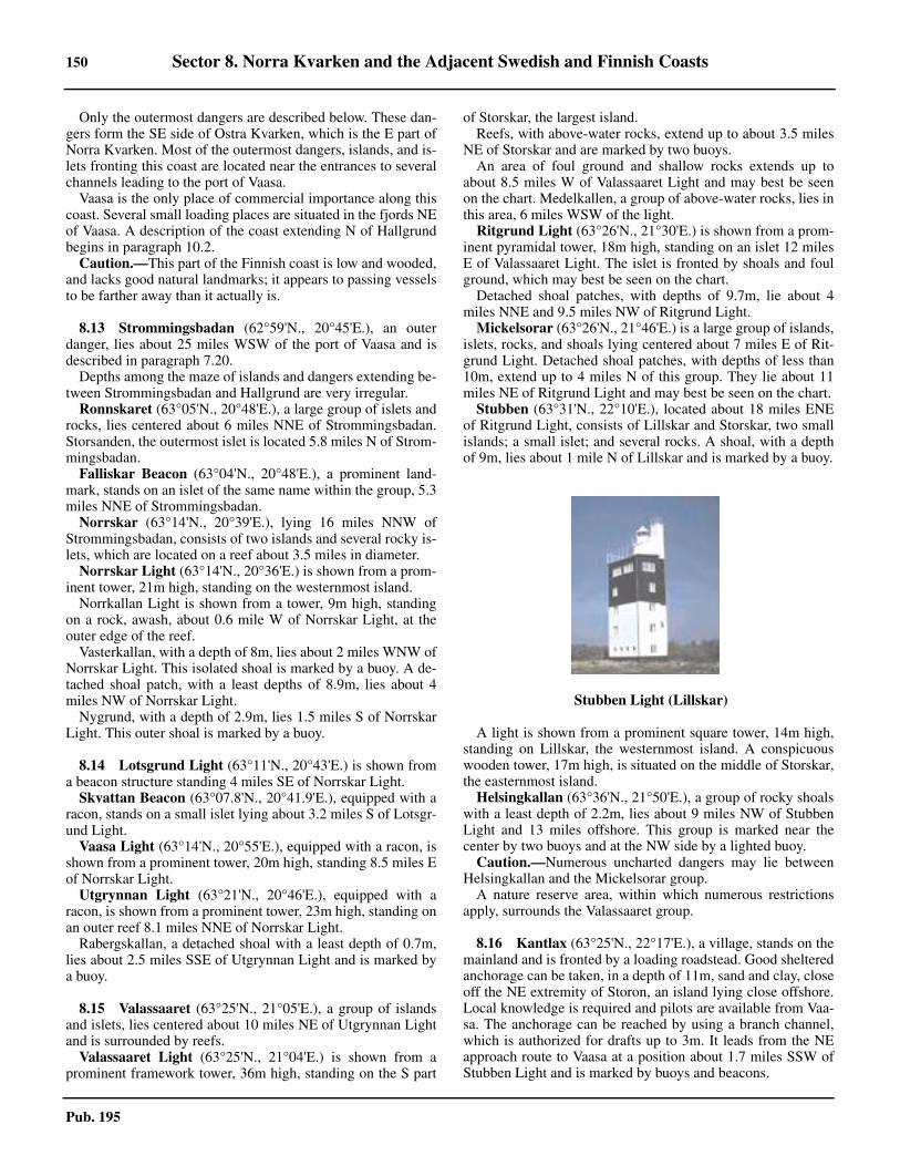
150 Sector 8. Norra Kvarken and the Adjacent Swedish and Finnish Coasts
Pub. 195
8.12 Only the outermost dangers are described below. These dan-gers form the SE side of Ostra Kvarken, which is the E part ofNorra Kvarken. Most of the outermost dangers, islands, and is-lets fronting this coast are located near the entrances to severalchannels leading to the port of Vaasa.8.12 Vaasa is the only place of commercial importance along thiscoast. Several small loading places are situated in the fjords NEof Vaasa. A description of the coast extending N of Hallgrundbegins in paragraph 10.2. 8.12 Caution.—This part of the Finnish coast is low and wooded,and lacks good natural landmarks; it appears to passing vesselsto be farther away than it actually is.
8.13 Strommingsbadan (62°59'N., 20°45'E.), an outerdanger, lies about 25 miles WSW of the port of Vaasa and isdescribed in paragraph 7.20. 8.13 Depths among the maze of islands and dangers extending be-tween Strommingsbadan and Hallgrund are very irregular. 8.13 Ronnskaret (63°05'N., 20°48'E.), a large group of islets androcks, lies centered about 6 miles NNE of Strommingsbadan.Storsanden, the outermost islet is located 5.8 miles N of Strom-mingsbadan. 8.13 Falliskar Beacon (63°04'N., 20°48'E.), a prominent land-mark, stands on an islet of the same name within the group, 5.3miles NNE of Strommingsbadan.8.13 Norrskar (63°14'N., 20°39'E.), lying 16 miles NNW ofStrommingsbadan, consists of two islands and several rocky is-lets, which are located on a reef about 3.5 miles in diameter.8.13 Norrskar Light (63°14'N., 20°36'E.) is shown from a prom-inent tower, 21m high, standing on the westernmost island.8.13 Norrkallan Light is shown from a tower, 9m high, standingon a rock, awash, about 0.6 mile W of Norrskar Light, at theouter edge of the reef.8.13 Vasterkallan, with a depth of 8m, lies about 2 miles WNW ofNorrskar Light. This isolated shoal is marked by a buoy. A de-tached shoal patch, with a least depths of 8.9m, lies about 4miles NW of Norrskar Light.8.13 Nygrund, with a depth of 2.9m, lies 1.5 miles S of NorrskarLight. This outer shoal is marked by a buoy.
8.14 Lotsgrund Light (63°11'N., 20°43'E.) is shown froma beacon structure standing 4 miles SE of Norrskar Light.8.14 Skvattan Beacon (63°07.8'N., 20°41.9'E.), equipped with aracon, stands on a small islet lying about 3.2 miles S of Lotsgr-und Light.8.14 Vaasa Light (63°14'N., 20°55'E.), equipped with a racon, isshown from a prominent tower, 20m high, standing 8.5 miles Eof Norrskar Light.8.14 Utgrynnan Light (63°21'N., 20°46'E.), equipped with aracon, is shown from a prominent tower, 23m high, standing onan outer reef 8.1 miles NNE of Norrskar Light.8.14 Rabergskallan, a detached shoal with a least depth of 0.7m,lies about 2.5 miles SSE of Utgrynnan Light and is marked bya buoy.
8.15 Valassaaret (63°25'N., 21°05'E.), a group of islandsand islets, lies centered about 10 miles NE of Utgrynnan Lightand is surrounded by reefs. 8.15 Valassaaret Light (63°25'N., 21°04'E.) is shown from aprominent framework tower, 36m high, standing on the S part
of Storskar, the largest island.8.15 Reefs, with above-water rocks, extend up to about 3.5 milesNE of Storskar and are marked by two buoys.8.15 An area of foul ground and shallow rocks extends up toabout 8.5 miles W of Valassaaret Light and may best be seenon the chart. Medelkallen, a group of above-water rocks, lies inthis area, 6 miles WSW of the light.8.15 Ritgrund Light (63°26'N., 21°30'E.) is shown from a prom-inent pyramidal tower, 18m high, standing on an islet 12 milesE of Valassaaret Light. The islet is fronted by shoals and foulground, which may best be seen on the chart. 8.15 Detached shoal patches, with depths of 9.7m, lie about 4miles NNE and 9.5 miles NW of Ritgrund Light.8.15 Mickelsorar (63°26'N., 21°46'E.) is a large group of islands,islets, rocks, and shoals lying centered about 7 miles E of Rit-grund Light. Detached shoal patches, with depths of less than10m, extend up to 4 miles N of this group. They lie about 11miles NE of Ritgrund Light and may best be seen on the chart.
Stubben (63°31'N., 22°10'E.), located about 18 miles ENEof Ritgrund Light, consists of Lillskar and Storskar, two smallislands; a small islet; and several rocks. A shoal, with a depthof 9m, lies about 1 mile N of Lillskar and is marked by a buoy.
A light is shown from a prominent square tower, 14m high,standing on Lillskar, the westernmost island. A conspicuouswooden tower, 17m high, is situated on the middle of Storskar,the easternmost island.8.15 Helsingkallan (63°36'N., 21°50'E.), a group of rocky shoalswith a least depth of 2.2m, lies about 9 miles NW of StubbenLight and 13 miles offshore. This group is marked near thecenter by two buoys and at the NW side by a lighted buoy.8.15 Caution.—Numerous uncharted dangers may lie betweenHelsingkallan and the Mickelsorar group.8.15 A nature reserve area, within which numerous restrictionsapply, surrounds the Valassaaret group.
8.16 Kantlax (63°25'N., 22°17'E.), a village, stands on themainland and is fronted by a loading roadstead. Good shelteredanchorage can be taken, in a depth of 11m, sand and clay, closeoff the NE extremity of Storon, an island lying close offshore.Local knowledge is required and pilots are available from Vaa-sa. The anchorage can be reached by using a branch channel,which is authorized for drafts up to 3m. It leads from the NEapproach route to Vaasa at a position about 1.7 miles SSW ofStubben Light and is marked by buoys and beacons.
8.15Stubben Light (Lillskar)
Sector 8. Norra Kvarken and the Adjacent Swedish and Finnish Coasts 151
Pub. 195
8.16 Munsalan (63°23'N., 22°18'E.), situated 1.5 miles S ofKantlax, consists of an oil jetty, 30m long, and two mooringbuoys. It is approached via a buoyed fairway, authorized fordrafts up to 7m, which branches off from the outer part of thechannel leading to Hellnas. 8.16 Hellnas (63°17'N., 22°14'E.), a village situated on the main-land about 20 miles NE of Vaasa, is the loading place for thesawmills in the vicinity. The protected roadstead lies about 0.7mile N of the village. A branch channel leads from the NE ap-proach route to Vaasa. Vessels with drafts up to 7m can be tak-en to within 3.2 miles NNE of the roadstead; vessels withdrafts up to 3.8m can be taken to the anchorage area in theroadstead. 8.16 Monassundet (63°29'N., 22°19'E.), an inlet extending about4 miles SE, is entered 4 miles SE of Stubben Light. An anchor-age, with depths of 9 to 11m, lies about 1 mile within the en-trance near the village of Monas. An approach channel,suitable for vessels with drafts up to 4m, leads 3 miles SE tothe narrow entrance. The inlet is only used by small craft andrecreational boats.
Hallgrund (63°39'N., 22°25'E.), a small islet, lies about 10miles NE of Stubben Light and is described in paragraph 10.2.
Approaches to Vaasa
8.17 Several approach routes lead toward Vaasa throughthe many islands, islets, and dangers lying off the coast. Thetwo main channels and the two secondary channels are de-scribed below. The other inshore passages are only used bysmall craft with local knowledge.
Two main routes leading from the NW are each about 27miles in length. Norrskar South passes S of Norrskar Light andis authorized for drafts up to 8.5m. Norrskar North passes N ofof Norrskar Light and is authorized for drafts up to 9m.
Norrskar South, the first main route, leads from a positionabout 4 miles S of Norrskar Light (63°14'N., 20°36'E.). It leads6 miles NE, using the white sector of Vaasa Light (63°14'N.,20°55'E.), and passes close NW of Lotsgrund Light (63°11'N.,20°43'E.). The route then leads about 5 miles ESE, usingNorrskar Lighted Range astern, until a position 3 miles SE ofVaasa Light is reached. It continues for 6.3 miles in a SE direc-tion through a partly-buoyed channel. The route then leads 1mile ESE and passes close NNE of Glasrund Front Light(63°06'N., 21°11'E.), which is equipped with a racon. It contin-ues 3.7 miles ENE, 1 mile SE, and 5.5 miles ESE through anarrow channel to the port.8.17 Norrskar North, the second main route, leads from a positionabout 4.3 miles SW of Utgrynnan Light (63°21'N., 20°46'E.)and 4.4 miles NNE of Norrskar Light. It leads in a SE directionfor about 9 miles to a position close NE of Vaasa Light. Theroute then continues in a SE direction for about 3 miles andjoins the first main channel.8.17 An alternate fairway, which is authorized for drafts up to4.5m, leads SE for 11 miles from a position 0.7 mile SE ofVaasa Light. It passes close SW of Korso Light (63°11'N.,21°09'E.) and joins the main channel about 4 miles ENE ofGlasrund Front Light.8.17 Ronnska, a secondary route, which is authorized for draftsup to 4m, leads from a position 6 miles WSW of FaliskaretBeacon (63°04'N., 20°48'E.). It is mostly used by small vessels
with local knowledge. The route leads in a general ENE direc-tion for about 17 miles and passes through the Ronnskaretgroup of islets. It then joins the first main channel close NNEof Glasrund Front Light. 8.17 Ritgrund, another secondary route, which is authorized fordrafts up to 4.8m, leads from a position 5 miles NNW of Ritgr-und Light (63°26'N., 21°30'E.). The route leads in a general Sdirection for about 25 miles, passing between the island ofVallgrund and the mainland, to join the main channel. A roadbridge, with a vertical clearance of 24m and an opening 60mwide, spans the channel. It connects the SE end of the island ofVallgrund to a causeway extending W from the mainland.8.17 Stubben, an inshore route, used in daylight only, leads from aposition about 2 miles N of Stubben Light (63°31'N.,22°10'E.). It leads S and SW for 26 miles, passing S of theMickelsorar group (63°26'N., 21°46'E.), and then joins the sec-ondary channel leading S from Ritgrind Light. This inshoreroute is authorized for drafts up to 7m as far as Stor Ljusen(63°26.0'N., 22°05.5'E.) and then for drafts up to 3.6m.8.17 Regulations.—The approach route leading to Kristinestad(Kristiinankaupunki) is situated within Sector A of the BothniaVessel Traffic Service (VTS) system. This system operates offthe NW coast of Finland and is mandatory. For further detailsof the VTS system, including reporting procedures, see para-graph 10.1.8.17 Caution.—It is reported that, due to more frequent surveys,the Finnish Board of Navigation advises deep-draft vessels ap-proaching from the NW to use the route leading N of Norrskarin preference to the one passing to the S.8.17 A designated restricted area surrounds the island of Norrskar(63°14'N., 20°36'E.).
Vaasa (63°06'N., 21°35'E.)
World Port Index No. 27650
8.18 Vaasa, formerly known as Nikolaistad, is situated onthe Finnish coast bordering on Norra Kvarken. The port areacomprises the facilities at the outer harbor of Vaskiluoto, thoseat Palosaari to the N, and those at the inner or town harbor.8.18 Ice.—The harbors have been closed to navigation because ofice on dates varying between December 25 and January 25, andwere reopened on dates ranging from March 31 to May 16. Ice-breaker service is furnished at the beginning and end of the iceseason. 8.18 Tides—Currents.—The water level in the harbors rises withS winds and falls with N winds. 8.18 Depths—Limitations.—The main approach channel is au-thorized for drafts up to 9m (see paragraph 8.17).8.18 The island of Vaskiluoto lies close W of the town of Vaasaand is connected to it by a causeway. A road bridge links the is-land to the town and also to the mainland on the S side. Thisbridge (63°04.8'N., 21°34.6'E.) has a vertical clearance of2.5m.8.18 Palosaari Harbor lies close NW of the N part of the town. Itprovides a quay, 65m long, with a depth of 3.7m alongside.The main fairway leading to this harbor from Vaskiluoto is au-thorized for drafts up to 4.2m.8.18 A power cable (63°06.0'N., 21°35.3'E.) spans the 4.2m ap-proach to Vaassa Town Harbor close NW of the quays.The ver-

152 Sector 8. Norra Kvarken and the Adjacent Swedish and Finnish Coasts
Pub. 195
tical clearance W of the central support pylon is 32m; E of thepylon the vertical clearance is 30m. 8.18 Town Harbor fronts Vaasa. It provides 500m of total quay-age, with depths up to 5m alongside.8.18 Vaskiluoto Harbor is situated on the SW side of the islandand is the site of the main commercial facilities. It is protectedby a detached breakwater lying on the N side of the entrancechannel.8.18 Coal Quay is 145m long and has a depth of 10m alongside.8.18 Reins Quay is 240m long and has depths of 6 to 8m along-side.8.18 Ferry Pier has two ro-ro berths, 128m and 140m long, withdepths of 5.7m alongside.8.18 North Pier is 180m long and has depths of 6.4 to 9.6m along-side. It has ro-ro berths on each side of its root.8.18 South Pier is 180m long and has depths of 6.4 to 9.6m along-side.8.18 Oil Pier is 105m long and has a depth of 10m alongside.8.18 There are facilities for ro-ro, passenger, automobile ferry,bulk, tanker, and general cargo vessels. Vessels up to 200m inlength and 9m draft can be accommodated.8.18 Aspect.—The approach channels are marked by directionalsector lights, lighted ranges, buoys, and beacons (see paragraph8.17).8.18 Pilotage.—Pilotage is ordered via the Finnpilot Order Cen-ter, Western Pilotage Zone (see paragraph 10.1).8.18 Vessels must send a request for pilotage 24 hours prior to ar-rival at the boarding place. A confirmation must be sent 6hours in advance and any changes after this time must be for-warded not later than 3 hours before arrival. In the Gulf ofBothnia, the binding order for a pilot must be made by tele-phone to the appropriate pilot station 3 hours before arrival.8.18 Pilots can be contacted by VHF, and board in the followingpositions:
1. Vaasa N—(63°15.8'N., 20°51.2'E.)2. Vaasa S—(63°12.1'N., 20°45.4'E.)
8.18 Vessels approaching from the NE may request a pilot fromthe station at Tankar (63°57'N., 22°51'E.) (see paragraph 10.1).Such requests must be made 24 hours in advance and arrange-ments may be made to embark the pilot in the vicinity of Stub-ben Light (63°31'N., 22°10'E.). Vessels approaching from the Smay arrange to embark the pilot about 5.5 miles SW of Salgr-und Light (62°20'N., 21°12'E.).
8.18 Regulations.—A speed limit of 10 knots is in effect for thesection of the channel between Nygrund (63°07.6'N., 21°20.2'E.) and the port. It is reported that a speed limit of 8 knotsapplies to vessels with drafts over 8m.8.18 At night, tankers carrying more than 4,000 tons of oil areprohibited in the section of the channel between Nygrund(63°07.6'N., 21°20.2'E.) and Vaasa.8.18 Vessels shall submit a departure report in order to be givenpermission to depart. The permission to depart issued by theVTS is valid for 20 minutes.8.18 Vessel Traffic Service.—The approach route leading to Vas-sa is situated within Sector B of the Bothnia Vessel Traffic Ser-vice (VTS) system. This system operates off the NW coast ofFinland and is mandatory. For further details of the VTS, in-cluding reporting procedures, see paragraph 10.1.8.18 Contact Information.—See the table titled Vaasa—Con-tact Information.
8.18 Anchorage.—Anchorage may be taken as directed by thepilot.8.18 Caution.—A submarine track guide cable has been estab-lished in the fairway between Nygrund (63°07.6'N., 21°20.2'E.) and Nagelprick, 3.5 miles ESE, to assist navigation.The use of this guide system is only possible with a special re-ceiver. Anchoring and fishing are prohibited in this part of thechannel.
Norra Kvarken
8.19 Norra Kvarken, the narrowest part of the Gulf ofBothnia, includes the waters extending about 40 miles NE froma line joining Bonden (63°26'N., 20°03'E.), Sydostbrotten(63°21'N., 20°11'E.), and Norrskar (63°14'N., 20°36'E.). It isencumbered with numerous islands, islets, rocks, and shoals. 8.19 A traffic separation scheme exists in the Norra Kvarken. Itincludes two-way routes for each segment, as best seen on thechart. The least depth in the new Traffic Separation Schemeand two-way routes is reported (2019) to be16.7m.
The part of the Gulf of Bothnia situated S of Norra Kvarkenis known in Swedish as Bottenhavet and in Finnish asSelkameri. The part of the gulf situated N of Norra Kvarken isknown in Swedish as Bottenviken and in Finnish as Perameri.8.19 Holmoarne (63°40'N., 20°52'E.), a group of islands androcks, divides Norra Kvarken into two channels or passages.Vastra Kvarken, on the W side, leads between the group and
8.18Bergudden Light
Vaasa—Contact Information
Port
VHF VHF channels 12, 13, and 16
Telephone 358-400-479163
Facsimile 358-6-3254511
E-mail [email protected]
Web site http://www.kvarkenports.com/about/vaasa.html
Harbormaster/Port Manager
Telephone 358-400-479163

Sector 8. Norra Kvarken and the Adjacent Swedish and Finnish Coasts 153
Pub. 195
the dangers fronting the coast of Sweden; Ostra Kvarken, onthe E side, leads between the group and the dangers frontingthe coast of Finland.8.19 Great care is necessary when navigating within both VastraKvarken or Ostra Kvarken, particularly during foggy weather,which is not infrequent. Mariners should bear in mind that thecurrents are uncertain and their movements sometimes precedethe wind.
8.20 Holmon (63°47'N., 20°54'E.), the northernmost andlargest island of the Holmoarne group, lies about 4 miles offthe Swedish coast. The summit of this island is situated in theN part. It is 24m high and consists of a bare ridge surroundedby woods. Several houses, a lookout tower, and a church, witha high pointed tower, stand on this ridge and are prominentfrom seaward.8.20 A chain of small islets, rocks, and shoals extends about 5miles NE from the N end of the island and is marked at its out-er edge by a buoy. 8.20 Byviken (63°48'N., 20°52'E.), a small harbor protected bybreakwaters, lies within a narrow bay at the NW end of the is-land. It has a depth of 4m and is used by fishing vessels andpleasure craft. The bay is exposed to winds and heavy seasfrom the N and NE. Vessels with local knowledge can anchor,in a depth of 20m, sand, close off the W shore of the bay. It isreported that a submarine pipeline lies along the W shore andlands at the root of the E breakwater. 8.20 A conspicuous radio mast stands close E of Byviken. 8.20 Bergudden Light (63°47.5'N., 20°50.5'E.) is shown from aprominent wooden tower, 18m high, standing on the NW sideof Holmon.8.20 Lillhallansgrund (63°49'N., 20°52'E.), a shoal with a leastdepth of 5.9m, lies about 1 mile N of Byviken and is marked onits SW side by a buoy. 8.20 Falkgrund (63°51'N., 20°53'E.), a shoal with a least depthof 9.9m, lies 2.3 miles NNW of the N extremity of Holmon andis marked by a buoy. Shoal patches, with depths of 7.6m and9.4m, lie about 0.6 mile ESE and 0.7 mile SSW of Falkgrund. 8.20 Stora Fjaderagg (63°48'N., 21°00'E.), a mostly barren is-land, lies 1.5 miles NE of the NE extremity of Holmon. Achapel, some fishing huts, and a beacon, 7m high, are situatedon the S side of the island. A prominent tower, formerly a light-house, 13m high, stands on the summit of the island.8.20 An extensive shoal bank fronts the N and E sides of StoraFjaderagg. Lillgrund, an above-water rock, and Osterbadan, ashoal with a depth of 6.9m, lie about 1 mile N and 1 mile E, re-spectively, of the island. 8.20 Vessels can take anchorage, in depths of 9 to 16m, sand,about 0.3 mile S of the S end of Stora Fjaderagg. They mustapproach from the E and take care to avoid the reef extendingup to about 1.5 miles from the E side of the island.8.20 Angeson (63°44'N., 20°54'E.), low and wooded, lies close Sof Holmon Island. Rocks and shoals extend up to about 1.8seaward of the W side of this island and up to 4 miles seawardof the E side. These dangers are marked by buoys and may bestbe seen on the chart. 8.20 Grossgrunden (63°39'N., 20°51'E.), low and wooded, liesclose S of Angeson and is fronted by shoals on each side. Abeacon, with a radar reflector, stands on a group of above-wa-ter rocks about 1.5 miles WSW of the N end of this island.
8.20 Jagaroren (63°41'N., 20°55'E.), a shoal, lies about 1.6 milesENE of the N end of Grossgrunden. A disused light tower, 12mhigh, stands on this shoal and is equipped with a racon.
8.21 Holmogadd (Gadden) (63°36'N., 20°47'E.), thesouthernmost island of the group, is bare except for a few clus-ters of low trees and bushes. It is separated from the S end ofGrossgrunden by Gaddstrommen. A conspicuous tower, 8mhigh, stands on the N part of the island.8.21 A light is shown from a prominent granite tower, 20m high,standing on the S end of the island. Some dwellings are situat-ed close to the light tower and a cairn stands on the beach closeS of them.8.21 Gaddstrommen, a narrow passage leading between reefs, is theonly navigable channel through the island group. It is marked bybeacons and only used by small craft with local knowledge.8.21 A rocky coastal bank extends about 2 miles S and 2.5 milesSE from the S end of Holmogadd. It is marked by buoys andmay best be seen on the chart.
8.21 Huginsgrund (63°34'N., 20°46'E.), a shoal with a depth of5.9m, lies 2 miles S of Holmogadd Light, at the edge of thebank, and is marked by a buoy.8.21 Regulations.—The main shipping route in the S part of Nor-ra Kvarken is situated within Sector B of the Bothnia VesselTraffic Service (VTS) system. This system operates off theNW coast of Finland and is mandatory. Northbound vessels en-tering Norra Kvarken, with destinations of Tornio, Rahja, Raa-he, Pietarsaari, Oulu, Kokkola, or Kemi, are requested to makean advance report when 20 miles S of Nordvalen Light(63°32'N., 20°47'E.). For further details of the VTS system, in-cluding reporting procedures, see paragraph 10.1.8.21 Caution.—Submarine cables, which may best be seen on thechart, extend between the NE side of Holmon and StoraFjaderagg, and between the SE side of Holmogadd and Nord-valen Light.8.21 A restricted area, within which entry is prohibited withoutpermission, surrounds the island of Holmogadd and the S partof Grossgrunden.8.21 A designated nature area, within which numerous restric-tions apply, has been established around the E part of Holmon,most of Angeson, Grossgrunden, Holmogadd, and a large num-ber of the adjacent skerries and rocks.
8.20Stora Fjaderagg Tower

154 Sector 8. Norra Kvarken and the Adjacent Swedish and Finnish Coasts
Pub. 195
8.21 Due to the numerous off-lying dangers, vessels proceeding Nin the gulf are advised to keep at least 4 miles from the E sideof the Holmoarne group.
8.22 Nordvalen Light (63°32'N., 20°47'E.), equipped with aracon, is shown from a prominent floodlit tower, 26m high,standing 3.5 miles S of Holmogadd Light and 11 miles N ofUtgrynnan Light.8.22 A chain of rocks and shallow shoals extend up to about 7miles S of Nordvalen Light. The outer shoals are marked bybuoys and may best be seen on the chart.8.22 Gerdasgrundet lies 1.5 miles SSW of Norvaken Light. Thisshoal has a least depth of 4.8m and is marked by a buoy.8.22 Vastra Snipansgrundet, with a least depth of 2.3m, lies 6.2miles SSW of Nordvalen Light. This shoal, which is the south-easternmost danger lying in the entrance to Ostra Kvarken, ismarked by two buoys.8.22 Odelgrund (63°25.5'N., 20°34.0'E.), with a depth of 11.9m,lies about 7 miles NW of Utgrynnan Light (63°21'N., 20°46'E.)and 8.5 miles SW of Nordvalen Light. This shoal lies at theouter edge of a bank extending SE from the vicinity of Gun-vorsgrund Light (63°29'N., 20°27'E.) and is marked by a light-ed buoy.8.22 Waldersgrund, a detached shoal with a depth of 11.9m, liesabout 1 mile ESE of Odelgrund and is marked by a buoy.
8.23 Vastra Kvarken (63°42'N., 20°43'E.) is bordered onthe W side by the dangers fronting the Swedish coast and onthe E side by the Holmoarne group (see paragraph 8.19). Thispassage leads in a general NNE direction for 23 miles from aposition 5 miles SE of Vaktaren Light (63°37'N., 20°25'E.) tothe vicinity of Karingskar (63°54'N., 20°51'E.).8.23 A coastal passage leads to the vicinity of Vaktaren Light (seeparagraph 8.8).8.23 The recommended route, which may best be seen on thechart, leads NNE using the white sector of Bergudden Light(63°47.5'N., 20°50.5'E.). When about 2 miles from the lighttower, vessels should steer more to the N and adjust theircourse in order to pass WNW of the light and ESE of Tarn-grunden.8.23 The route then leads in a NNE direction and passes closeWNW of Lillhallansgrund and Falkgrund. After passing Falk-grund, vessels should steer more to the NE and head for a posi-tion 2.3 miles ESE of Karingskar. They should then head NNEusing the white sector of Bergudden Light, astern.8.23 Vessels entering from the N should head in a SSW directionusing the white sector of Bergudden Light. When about 7 milesfrom the light structure and E of Karingskar, they should headSW to pass close W of Falkgrund shoal. The route then leadsSSW and passes close WNW of Lillhallansgrund and about 0.4mile WNW of Bergudden Light. When about 1.5 miles SSW ofthe light, vessels should adjust course and steer in a SSW di-rection using the white sector of Bergudden Light, astern.8.23 Pilotage.—The pilotage area for Umea lies between a linebearing 140° through Norrbyskar (63°33'N., 19°52'E.) and lati-tude 64°03'N. The main boarding station is in the vicinity of
Vaktaren Light. All requests for pilotage through VastraKvarken must be made through the VTS station at Lulea (seeparagraph 9.19).8.23 Caution.—Submarine cables, which may best be seen on thechart, lie across the N part of the passage. They extend NW be-tween the NE side of Holmon, in the vicinity of Byviken har-bor, and the mainland coast of Sweden.8.23 A submarine cable, which may best be seen on the chart, liesacross the S part of the passage. It extends WNW between theW side of Holmogadd and the mainland coast in the vicinity ofUmea.8.23 Buoys moored within Vastra Kvarken are sometimes dis-placed by drift ice in the early part of the navigation season,and may also be fouled by timber rafts.8.23 An area, within which anchoring, fishing, and diving are pro-hibited, extends across Vastra Kvarken in the vicinity of Ber-gudden Light and may best be seen on the chart.
8.24 Ostra Kvarken (63°33'N., 20°51'E.), the main off-shore passage in Norra Kvarken, is bordered on the NW sideby the dangers fronting the S and E sides of the Holmoarnegroup and on the SE side by the dangers fronting the coast ofFinland.8.24 Depths—Limitations.—A Deep-Water Route, which ismarked by buoys, has been established through Ostra Kvarken.It extends for about 8 miles SW and 7 miles ENE of NordvalenLight (63°32'N., 20°47'E.) and has a least depth of 16.2m.8.24 The recommended track passing through Ostra Kvarken isauthorized for drafts up to 13m.8.24 Directions—Vessels should proceed in a N direction up thegulf to a position located about 8 miles WNW of NorrskarLight (63°24'N., 20°36'E.). The recommended track then leadsNE from this position to the S entrance of the Deep-WaterRoute. It passes about 6 miles SE of Sydostbrotten Light(63°21'N., 20°11'E.), close SE of Odelgrund (63°25.5'N.,20°34.0'E.), and close NW of Waldersgrund, using the whitesector of Nordvalen Light (63°32'N., 20°47'E.).8.24 From a position about 5 miles SW of Nordvalen Light, therecommended track (Deep-Water Route) leads in a NE direc-tion to pass close WNW of the shoals lying SW of the light. Itthen rounds the light, at a distance between 0.2 mile and 0.6mile, and leads ENE toward a position located 11.7 miles NNEof Valassaaret Light (63°25'N., 21°04'E.), using the white sec-tor of Nordvalen Light, astern.8.24 Vessels bound for Umea or intending to use the coastal routethrough Vastra Kvarken should depart the recommended track(Deep-Water Route) in a NW direction when about 2.5 milesSW of Nordvalen Light.8.24 Caution.—A submarine cable, which may best be seen onthe chart, lies across the passage. It extends NNW from the vi-cinity of Ritgrund Light (63°26'N., 21°30'E.), rounds the islandof Stora Fjaderagg, and extends W to the mainland coast ofSweden.8.24 Care should be taken when approaching the S part of the pas-sage as the Swedish side, being high, may tend to appear closerthan the low Finnish side.

155
Pub. 195
9. Sector 9—Sweden—East Coast—Ratan to the Finnish Border
9.0Additional chart coverage may be found in NGA/DLIS Catalog of Maps, Charts, and Related Products (Unlimited Distribution).
SECTOR 9 — CHART INFORMATION

157
Pub. 195
SECTOR 9
SWEDEN—EAST COAST—RATAN TO THE FINNISH BORDER
9.0 Plan.—This sector describes the E coast of Sweden up to theN part of the Gulf of Bothnia. The descriptive sequence is NNEfrom Ratan to Ranefjarden, then E to the Finnish border.
General Remarks
9.1 The water in the N part of the Gulf of Bothnia is dis-colored and almost fresh because of the numerous rivers dis-charging into it.
The coast of Sweden between Ratan and Tomsvarten(64°58'N., 21°23'E.), about 67 miles NNE, is fronted by nu-merous islands, rocks, and shoals. Although soundings off thispart of the coast are very irregular, vessels should remain indepths of not less than 50m to ensure that they stay a safe dis-tance from all off-lying dangers. 9.1 Between Pitea (65°19'N., 21°29'E.) and the Finnish border,shoals lie as far as 20 miles seaward of the outermost islets.Consequently, when vessels are in the vicinity of these dan-gers, the coast will be visible only in very clear weather. Thedepths are irregular. In a few places soundings give good warn-ing of approach to dangers. However, for the most part, theshoals are steep-to.9.1 In thick weather, the greatest care should be taken when ap-proaching the land. Off this coast, the water is very muddy, es-pecially during and just after freshets in the rivers, making itimpossible to detect dangers by discoloration.9.1 Ice.—See General Remarks in paragraph 5.1.9.1 Pilotage.—See paragraph 1.1, paragraph 5.1, and Pub. 140,Sailing Directions (Planning Guide) North Atlantic Ocean andAdjacent Seas for general information on pilotage.9.1 The main pilot stations along this part of the coast are situat-ed at Skelleftehamn and Lulea. All requests for pilotage mustbe made through the VTS station at Lulea.9.1 The pilotage area for Skelleftehamn lies between a line bear-ing 152° from position 65°24'N, 21°49'E and latitude 64°03'N.The pilotage area for Lulea lies between a line extending 152°from position 65°24'N, 21°49'E and the Finnish border. Forfurther information, see paragraph 9.10 and paragraph 9.19.9.1 It should be noted that ordering of pilots in the Swedish wa-ters described within this sector is presently carried out throughthe main VTS systems. However, it is reported (2007) that pro-cedures for the initial ordering of pilots via the internet will beintroduced in the near future. For additional information con-cerning these procedures, see the following web site:
9.1 Regulations.—See paragraph 1.1 and Pub. 140, Sailing Di-rections (Planning Guide) North Atlantic Ocean and AdjacentSeas for regulations pertaining to vessels in Swedish waters,including restricted areas and semi-restricted areas.9.1 Caution.—Parts of the coast and some areas off the coast are
incompletely surveyed.9.1 Special marks and buoys are occasionally placed temporarilyon and off the coast, during the summer season, for the purposeof making surveys. Vessels are warned not to mistake thesespecial marks for the navigational aids. 9.1 During the winter, many buoys in these waters are removed,while others may be damaged or break adrift.9.1 In the coastal waters within this sector, numerous logs maybe found adrift at all times of the year.9.1 Areas dangerous due to mines laid during World War II existwithin these waters described in this sector. There is still a riskof danger in these areas when anchoring or carrying out anyseabed activities. 9.1 Due to various circumstances, including the discovery of ob-structions, depths within the channels leading through the off-shore dangers along this stretch of coast may changefrequently. Therefore, vessels are advised to contact the localauthorities in order to ascertain the latest information, includ-ing the maximum authorized drafts.
Ratan to Skelleftehamn
9.2 Rata Storgrund (63°59'N., 21°07'E.), with a leastdepth of 2.7m, lies about 6 miles E of the mainland coast. Thisshoal area consists of rock and shingle, and is marked on its Wside by a buoy. A light is shown from a prominent tower, 17mhigh, standing on the S and shallowest part of the shoal.
Rickleagrunden, a group of shoals, lies centered about 5.5miles N of Rata Storgrund Light. The group has a least depthof 2.9m and is marked by a buoy moored on its W side.
Rataskar Light (64°00'N., 20°54'E.) is shown from a toweron a building, 8m high, standing on the W side of a wooded is-land of the same name lying close off the coast, 5.5 miles W ofRata Storgrund Light.9.2 Ratan Sodra Light is shown from a tower standing on themainland 0.2 mile W of the S extremity of Rataskar. 9.2 Ratan (64°24'N., 20°54'E.) is a small natural harbor situatedon the mainland. It lies abreast the middle of the sound be-tween the coast and the island of Rataskar, close E.9.2 The harbor can be approached from the SSE or the NE viachannels, which are available to vessels with drafts up to 2m.The main quay is 95m long and has a depth of 4.5m alongside.9.2 It is reported that the harbor is no longer open to commercialshipping and is used only by recreational craft.9.2 Rataskar Beacon, octagonal shaped with a high pointed roof,is conspicuous. The prominent yellow lookout tower of the for-mer pilot station is situated close S of this beacon. A number ofknobby mountain tops are visible in clear weather behind thebeacon; however, at close range, these mountain tops are ob-scured by the coastal land.9.2 A large white spot on Norrklubb, the N part of Rataskar, isconspicuous. It is painted on a cliff and partially obscured bybushes. Norrklubb Beacon, a round-topped cairn, 4m high,stands on the N extremity of Rataskar and is prominent.
Swedish Maritime Administration Home Page
https://www.sjofartsverket.se/en

158 Sector 9. Sweden—East Coast—Ratan to the Finnish Border
Pub. 195
9.2 Dodmanskar, an islet overgrown with brush, lies about 1mile NNE of Norrklubb. A conspicuous large and dark rock,with a flat top, is located at the E side of this islet. 9.2 Soderklubb Beacon, a round-topped cairn, 4m high, standson an islet lying close S of Rataskar. 9.2 Vessels with local knowledge can anchor in the N roadsteadbetween the mainland and Norrklubb, the N part of Rataskar.This anchorage has depths of 10 to 13m, clay, but is exposed toN winds.9.2 Anchorage may also be obtained in the harbor, betweenRataskar and the mainland, in a depth of 4m, clay.
9.3 Rataskar Anchorage (64°02'N., 20°55'E.) lies about2 miles NNE of Rataskar. It is the loading place for Dalkarlsa,which stands 3 miles NW. The roadstead has a depth of 7m,sand, and is suitable for vessels with drafts up to 5m. It is ex-posed to SE and E winds. The anchorage can be approachedfrom the SE, but local knowledge is required. 9.3 Sikea (64°09'N., 20°59'E.), a very small natural harbor, issituated near the head of Sikeafjarden, about 10 miles N ofRatan. The fairway leading to the harbor passes N of Ricklea-grunden and is authorized for vessels with drafts up to 4.6m.There is a pier, 93m long, with a depth of 3m alongside. Theharbor is no longer open to commercial shipping and is onlyused by recreational craft.9.3 Vannskaren Light (64°10'N., 21°08'E.) is shown from atower, 11m high, standing on the outermost of a group of tree-less islets situated about 4 miles E of Sikea.
9.4 Gumboda (64°14'N., 21°06'E.) is a small natural har-bor situated within Gumbodafjarden, 3.5 miles NNW ofVannskaren Light. Approach channels lead from the S, passingW of Vannskaren Light, and from the E, passing N of the light.The S fairway is available to vessels with drafts up to 6.5m.The E fairway is available to vessels with drafts up to 4.9m.Local knowledge is required. 9.4 The harbor is closed to commercial shipping and used onlyby recreational craft. It is reported that tugs towing timber oc-casionally find refuge here. 9.4 Gumbodahamn affords anchorage to vessels with local knowl-edge inside Sparren, in depths of 6 to 10m, sand and clay. Vesselscan also anchor, in depths of 16 to 24m, clay, about 0.2 mile W ofLilla Vannskar, which lies 0.6 mile WNW of Vannskaren Light.
9.4 Bodbergen, 58m high, stands 1 mile NNE of the head ofGumbodafjarden. This hill has two rocky summits, the west-ernmost of which is the higher and conspicuous from seaward. 9.4 Vardstuteberg and Markberget, 95m and 104m high, standabout 3 and 4 miles NE, respectively, of the head of Gum-bodafjarden. Both of these rocky crests are conspicuous fromseaward.
9.5 Lovsele (64°18'N., 21°15'E.) is a loading place withinLovselefjarden, which is entered about 8 miles NNE ofVannskaren Light.
Knavringen, with a least depth of 7.9m, lies about 2 miles Sof Blekeudden, the E entrance point of the fjord. Kallan, a rockawash, lies close N of Knavringen. A main channel leads fromS and passes W of Kallan. Local knowledge is required. Thefairway is available to vessels with drafts up to 4.9m. There is aquay, 150m long, with a depth of 4.8m alongside, but only 50mof berthage along the central part is available.9.5 The harbor is closed to commercial shipping and used onlyby recreational craft. 9.5 Lovselefjarden is usually ice bound from the middle of De-cember to the middle of May. 9.5 Anchorage can be obtained by vessels with local knowledgewithin the fjord, in depths of 5 to 8m, mud, but the roadstead isexposed from S.9.5 Varberget is a bare, conspicuous summit, 46m high, risingclose to the shore, 2.7 miles NE of the W entrance point. Stork-lubben, an islet, lies about 0.2 mile SSE of the W entrancepoint and can be easily recognized.
9.6 Sorkallen (64°14'N., 21°28'E.), with a least depth of6.2m, lies about 5 miles offshore, 10 miles NE of VannskarenLight. 9.6 Trindkallen (64°16'N., 21°31'E.), with a least depth of4.3m, lies about 2.5 miles NNE of Sorkallen. These shoalsform the outermost dangers in this vicinity.
Kallviken (64°20'N., 21°22'E.) a loading place, is entered3.5 miles NE of Lovsele. The main approach route to the road-stead leads from S. Vessels can use the fairways passing eitherE of Kallviksklubben (64°18'N., 21°23'E.) or W of Laskar(64°18.2'N., 21°21.4'E.). The least depth in these entrancechannels is 3.9m.
The roadstead has depths of 3 to 4.5m, clay and sand. It isvery confined and can only accommodate a few small vessels.Vessels can also anchor, in a depth of 9m, near the mouth of thefjord.9.6 Viksberget (64°21'N., 21°22'E.), a narrow rocky ridge withtwo prominent summits, is 60m high.9.6 Bredberget, 71m high, rises about 1 mile NNE of Viksberget.This prominent hill is steep on its N side but slopes to the S.9.6 Oxberget, 33m high, is steep on its SW side and surmountedby a white cairn beacon. This hill stands on the E side of theentrance to Kallviken. Kallviksskar, an islet, lies close inshoreon the W side of the entrance. It is also marked by a white cairnbeacon.
9.7 The coast between Kallviken and Bjuroklubb, 11miles NNE, is wooded and fronted by numerous shoals, whichextend up to 3 miles offshore in places. 9.7 Blackkallen Light (64°20'N., 21°31'E.) stands on a rock
9.2Rataskar Light

Sector 9. Sweden—East Coast—Ratan to the Finnish Border 159
Pub. 195
fronted by shoals about 1.5 miles offshore, 3.5 miles ENE ofKallviken. Blackkallen Light is marked by a beacon.9.7 Grundskaten (64°26'N., 21°37'E.), the SE extremity of Bju-ron, a wooded peninsula, is located 6.5 miles NNE of Black-kallen Light. This point is fronted by a reef, which extends 0.5mile seaward and is marked by a buoy. Shoals with depths ofless than 10m front the coast between the light and Grundskat-en and extend up to about 3 miles offshore in places.9.7 Bjuroklubb (64°29'N., 21°35'E.) is a steep point, 43m high,which forms the end of a narrow promontory extending 1.5miles NNW from the N side of Bjuron. A light is shown from aprominent yellow stone tower, 8m high, standing on the point,with a yellow house situated very near it. A light is also shownfrom a structure situated on the NE extremity of the point.
9.7 An area of shoals lies centered about 1.5 miles E of Bjuro-klubb Light and is marked on its W side by a buoy. 9.7 Hokmarksberget, located 8 miles WSW of Bjuroklubb Light,consists of two hills, which lie in a N and S direction. The Wside is steep and shows up well from seaward, especially whenN of Bjuroklubb. 9.7 Kulberget, standing about 4 miles SW of the N extremity ofBjuroklubb, has several summits. The southwesternmost sum-mit, 65m high, is the tallest and a prominent radio mast is situ-ated 1 mile E of it.
9.8 Gardfjarden (64°28'N., 21°43'E.), an inlet, lies onthe N side of Bjuron, about 0.7 mile SSW of Bjuroklubb Light.Vessels can anchor, in depths of 9 to 14m, clay and sand, with-in this inlet, but winds between N and NNE raise some sea.9.8 The roadstead within the inlet can be approached throughtwo channels. Local knowledge is required. An inshore fairwayleading from SE passes between the E side of Bjuron and theoff-lying shoals. Another fairway leads from NE. Vessels withdrafts up to 6.8m can reach the anchorage.9.8 Bjuroklubb Harbor, a small oil depot, is situated at the SEend of Gardfjarden. There is a quay, 70m long, with depths of 5to 6.2m alongside. The channel leading to the quay is availableto vessels with drafts up to 4.8m.9.8 Ice is an obstruction to navigation in this area from the endof November to the beginning of May. 9.8 Anchorage may also be obtained by vessels with localknowledge, in depths of 7 to 12m, clay and sand, within Brat-
tasfjarden, an inlet lying close W of Gardfjarden. The fairwayleading to this anchorage is available to vessels with drafts upto 6.1m.9.8 Caution.—A magnetic anomaly is reported to exist off Bju-roklubb.
9.9 Vanoren (64°32'N., 21°33'E.), the E extremity of alow wooded peninsula, lies on the N side of Gardfjarden, 2.5miles NNW of Bjuroklubb Light. It is fronted on the NE sideby shoals, which extend about 1 mile seaward and are markedby a buoy.9.9 Skotgronnan (64°36'N., 21°30'E.), fronted by shoals, is alow, sandy island with a knoll on its SW end lying about 7.5miles NNW of Bjuroklubb Light and 1.3 miles off the coast. Abeacon, fitted with a radar reflector, stands near its N end.9.9 Skelleftebukten (64°41'N., 21°15'E.), a bay 5 miles long,lies at the mouth of the Skelleftealv, the principal river alongthis part of the coast. It is encumbered by numerous islets,rocks, and shoals, which may best be seen on the chart.9.9 The bay is entered between Korsoren, a small peninsula ly-ing 3 miles W of Skotgonnan, and Skelleftenaset, a large pen-insula located about 5 miles NNW.9.9 Burea (64°37'N., 21°14'E.), a former small port, is situatedin the SW part of Skelleftenbukten. A conspicuous church,with a red roof and black spire, stands in the town. The harboris now only used by recreational craft.
Skelleftehamn (64°41'N., 21°14'E.)
World Port Index No. 27080
9.10 Skelleftehamn (Skelleftea), a large industrial harbor,is situated on the N side of Skelleftebukten. This harbor is theport for Skelleftea, a town standing on the N bank of the river,8 miles NW.9.10 Ice.—The port is usually closed by ice from the beginning ofDecember to the middle of May. 9.10 Tides—Currents.—Ordinary HW and LW are about 0.5mabove and below mean water level, respectively. The water lev-el usually rises in the autumn with SE and SW winds, and fallswith prolonged N and NE winds. Lower water levels usuallyoccur in the spring and early summer. The average annual max-imum and minimum water levels deviate 0.6m from the meanlevel. 9.10 With the breaking up of ice in the spring, the outgoing rivercurrent runs strongly for about 4 to 6 weeks and may attain avelocity of 1.5 to 2 knots. 9.10 Depths—Limitations.—Most of the port facilities are situ-ated on the shores of Kallholmsfjarden. This inlet lies betweenNasdden, on the NE side, and a narrow peninsula formed by aline of connected former islands on the S side. The narrow pen-insula projects 1.5 miles SE from the head of the bay and endsat Ronnskar. 9.10 The port may be approached from either E or SE throughroutes, which are shown on the chart. The approach from E,which is suitable for vessels with drafts up to 11m, is recom-mended, especially in poor visibility. The approach from SEcan be used by vessels with drafts up to 7m. For Skelleftehamninner harbor the maximum draft allowed is 8.2m.9.10 The channel leading from E passes at least 1 mile clear of the
9.7Bjuroklubb Light

160 Sector 9. Sweden—East Coast—Ratan to the Finnish Border
Pub. 195
fronting dangers. The channel leading from SE passes betweenSkotgronnan and the mainland.9.10 The principal facilities at Skelleftehamn, on the N and Wsides of Kallholmsfjarden, are described below:
1. The oil quay is 70m long and has a depth of 10.2malongside. It can handle tankers up to 200m in length and9.3m draft. Significant land reclamation, best seen on thechart, was ongoing adjacent to the oil quay (2021).
2. Siporexkajen, a cement berth, is 47m long and has adepth of 5.8m alongside. The channel leading to this berth isavailable to vessels with drafts up to 5.5m.
3. The general cargo quay is 375m long and has depthsof 8.2 to 8.9m alongside. Two ro-ro berths have depths up to8.2m alongside. Vessels up to 25,000 dwt, 160m in length,and 8.5m draft have been handled at this quay.
9.10 The principal facilities at Ronnskar, at the S end of Kallhol-msfjarden, are described below:
1. North Quay is 580m long and provides five berthswith depths of 5.7 to 13.4m alongside. Vessels up to 40,000dwt, 200m in length, and 11m draft have been accommodat-ed at this quay.
2. South Quay, a T-shaped pier with dolphins, provides aberth, 120m long, with a depth of 9m alongside.
9.10 The pier at Orviken has a berth, 75m long, with depths of 3.4to 4.6m alongside. It is in poor condition and no longer used bycommercial vessels.9.10 Aspect.—Gasoren Light (64°40'N., 21°19'E.) is shown froma prominent tower, 13m high, standing about 0.8 mile E ofRonnskar. A prominent dwelling, with a red roof, is locatednear the light.
9.10 Sor-Olsgrundet Light, equipped with a racon, is shown froma structure, 12m high, standing about 1 mile S of Ronnskar.9.10 Bureberget, a dark wooded hill, stands on the SW side of thebay, 4.5 miles SSW of Gasoren Light. It is 99m high and prom-inent from seaward. This hill slopes gradually on the S side anda radio mast, 32m high, is situated close SE of the summit.9.10 Noppelberget rises 1.2 miles NNE of Skelleftea. This hill isbare, light gray, and rocky. It is 140m high and easily identifiedfrom the SE. 9.10 A conspicuous chimney, 145m high, and a prominent ware-house, 300m long, are situated on Ronnskar and may be seen
from a considerable distance to seaward.9.10 A conspicuous radio mast, 60m high, stands near Orvikenabout 3 miles W of Gasoren Light.9.10 A church, a water tower, and a radio mast, which are allprominent, are situated at Skelleftehamn. 9.10 Pilotage.—A main pilot station is situated at Skelleftehamn.Pilots can be contacted on VHF channel 13 with boarding loca-tions located approximately 2.5 and 4.5 miles E of GasorenLight. Requests for pilotage must be made through the VTSstation at Lulea.9.10 Pilotage is compulsory within this area for the following:
1. All Category 1 vessels.2. Category 2 vessels of 80m in length, 15m beam, and
5m draft and over.3. Category 3 vessels of 90m in length, 16m beam, and
5.5m draft and over.9.10 In certain channels between Nygran and Pitea, pilotage iscompulsory for the following:
1. All Category 1 vessels.2. Category 2 and 3 vessels of 70m in length, 14m beam,
and 4.5m draft and over.9.10 Pilots for Pitea are also provided by this station and boardabout 5 miles E of Gasoren Light. 9.10 Regulations.—A mandatory Reporting and InformationSystem has been established in the Gulf of Bothnia and is oper-ated by Vessel Traffic Services (VTS) at Gavle and Lulea. Forfurther information, see Lulea (paragraph 9.19). 9.10 Contact Information.—See the table titled Skelleft-ehamn—Contact Information.
9.10Gasoren Light
Skelleftehamn—Contact Information
Port
Call signSkelleftehamn Radio
Skelleftehamn Harbor Radio
VHF VHF channels 13 and 16
Port Authority
Telephone 46-910-33130
Facsimile 46-910-34438
E-mail [email protected]
Web site http://www.skellefteahamn.se/
Harbormaster
Telephone 46-910-736338
E-mail [email protected]
Pilots
Call sign North Coast Pilot
VHF VHF channel 11
Telephone 46-771-630620
Facsimile 46-26-99469
E-mail [email protected]
Web site https://www.sjofartsverket.se

Sector 9. Sweden—East Coast—Ratan to the Finnish Border 161
Pub. 195
9.10 Anchorage.—The outer anchorage lies in position 64°40'N,21°19'E and has depths of 11 to 26m.
Skelleftehamn to Pitea
9.11 The coast between the entrance to Skelleftehamn andNygran (65°01'N., 21°42'E.), about 22 miles NNE, is well-wooded and fronted by numerous small islands, islets, rocks,and shoals.9.11 Kagnashallan Light (64°45'N., 21°18'E.) is shown from astructure standing on the E extremity of Kagnaset. Kagnaset isan area that appears from E as a chain of sloping hills, high tothe S, but steeper at the N end.9.11 Finnhallan (64°47'N., 21°15'E.), standing on the N side ofKagnaset, rises above the cliffs and is wooded. Two above-wa-ter rocks lie at the foot of this prominent hill.9.11 Armbagen (64°41'N., 21°26'E.), with a least depth of 8.5m,lies about 3 miles ENE of Gasoren Light and is marked by abuoy on the SE side. Villan, with a depth of 9.7m, lies about1.7 miles N of Armbagen. Fordarvet, with a depth of 6m, liesabout 4.5 miles Nof Armbagen. It lies 3.2 miles offshore at theE end of the foul ground fronting Kagnashallan Light and ismarked by a buoy. Utiken, with a depth of 10m, lies 3.5 milesNNE of Fordarvet and about 6 miles offshore.9.11 The above four shoals form the outermost dangers along thispart of the coast. Numerous shoal patches lie inside of thesedangers and may best be seen on the chart.9.11 Kagefjarden (64°49'N., 21°07'E.), an inlet situated SW ofOstnaset, is entered 5 miles NW of Kagnashallan Light.9.11 Bergskaret (64°48'N., 21°07'E.), a partly-wooded islet, lies onthe S side of the entrance to Kagefjarden, 6 miles NW of Kag-nashallan Light. A sector light, which indicates the entrance route,is shown from a tower, 7m high, standing on this islet.
9.12 Kagehamn (Storkage) (64°50'N., 21°02'E.) (WorldPort Index No. 27090), a small port used for exporting timber,is situated on the S side of Kagefjarden.9.12 Ice.—The port is usually closed by ice from November tothe middle of May. 9.12 Tides—Currents.—Strong S winds cause higher water lev-els and N winds cause lower water levels. The current in theentrance channel is not troublesome.9.12 Depths—Limitations.—Kagefjarden can be entered fromthe NE or ESE. A marina is situated at the former W quay atKagehamm. The main E quay is 200m long and has a depth of7.2m alongside. Two cross quays, 30m and 40m long, are situ-ated at the ends of the main quay and have depths of 3.5 to7.2m alongside. Vessels up to 8,000 dwt, 110m in length, and6.7m draft can reach the harbor and berth alongside.9.12 Pilotage.—Pilots are available from the station at Gasoren(Skelleftehamn) and must be ordered through VTS Lulea. Lo-cal knowledge is required.9.12 Anchorage.—Vessels may anchor, in depths of 9 to 18m,
clay, off the NW point of Bergskaret or, in depths of 16 to 24m,sand, close NE of the islet.
9.13 Romelso (64°53'N., 21°17'E.), lying 6.3 miles NE ofBergskaret Light, is a high wooded island of dark appearance.It is tallest in the center and drops off toward the N end. Theland behind this island has several mountain hillocks. 9.13 Hamnskaret, a small islet, lies about 0.5 mile off the middleof the E side of Romelso. A few trees and a white hut with ablack roof stand on this islet.9.13 A firing practice area, best seen on the chart, extends E ofRomelso and S of Nygran.9.13 Utkiken, with a least depth of 10m, lies about 6 miles SE ofRomelso and is the outermost shoal in this vicinity.9.13 Furuogrund (64°55'N., 21°14'E.), a former timber-loadingplace, is situated 0.5 mile NW of Romelso. The small naturalharbor is now only used by recreational craft. The channelleading to the harbor from SE is available to small craft withdrafts up to 5.5m. Local knowledge is required.9.13 Byske (64°57'N., 21°14'E.), a small craft harbor, is situatedat the head of Byskefjarden, 2 miles N of Furuogrund. Vesselsmay obtain anchorage, in a depth of 7m, off the entrance toByskefjardento. Local knowledge is required because of theshoals in the approaches.9.13 A prominent church, with a white tower surmounted by aspire, stands in the town at Byske. A large warehouse and aconspicuous red sawmill, with a chimney, are situated at Ytter-stfors, on the W side of Byskefjarden.9.13 Norra Degerberget, standing 9.5 miles NW of Byske, is 217mhigh and has a bare rocky crest. This hill is steep on the S side andsloping on the N. It can be easily identified from SE and, becauseof the shape, it is often referred to as “Likkistan” or “The Coffin.”9.13 Sidra Degerberget, rising about 2 miles SW of Norra Deger-berget, is the tallest of the two hills. This hill is 229m high, butit is rounded, wooded, and not so easily distinguished fromseaward.
9.14 Brannfors (65°01'N., 21°24'E.), a small craft harbor,is situated at the head of Abyfjarden, 6 miles NE of Byske. Achannel, which is available to vessels with drafts up to 7.3m,leads through the numerous shoals lying in the approach. Localknowledge is required. There is a quay, 180m long, with depthsof 2.7 to 4.6m alongside, but most of the wharves are derelict. 9.14 Selaxgrundet, with a depth of 8.8m, lies about 4.2 miles SEof the entrance to Abyfjarden and is the outermost shoal in thisvicinity.9.14 It is reported that a prominent radio mast, 60 high, standsabout 3 miles NNE of Brannfors.9.14 Ronnskar (65°02'N., 21°33'E.), an island lying 4 miles ENEof Brannfors, is wooded except at its SE end. A chapel, somebuildings, and a beacon, 17m high, are situated on the SE partof this island.9.14 Kinnbacksfjarden (65°03'N., 21°28'E.) is a good harbor ofrefuge lying close WNW of Ronnskar. Local knowledge is es-sential. A channel, available to vessels with draft up to 3.5m,leads from seaward to an anchorage, with depths of 5 to 12m,mud and sand.
9.15 The approaches to the ports of Pitea and Lulea are en-cumbered by numerous islands, islets, rocks, and shoals, which
Skelleftea Pilot Station
Call sign Skelleftea Pilots
VHF VHF channel 11
Skelleftehamn—Contact Information

162 Sector 9. Sweden—East Coast—Ratan to the Finnish Border
Pub. 195
may best be seen on the chart. Only the outermost dangers aredescribed below.9.15 Nygran Light (65°01'N., 21°42'E.), equipped with a racon,is shown from a prominent tower, 21m high, standing on ashoal about 7.5 miles E of Brannfors. The light tower has a he-licopter landing platform and is floodlit.
9.15 Norstromsgrund Light (65°07'N., 22°19'E.), equipped witha racon, is shown from a prominent tower, 29m high with a he-licopter platform, standing about 16.8 miles ENE of NygranLight.9.15 Norstromsgrund (65°10'N., 22°25'E.), an extensive shoalwith a least known depth of 1.5m, lies with its shallowest partlocated about 4 miles NE of Norstromsgrund Light. Grytet, adetached shoal patch with a least depth of 6.4m, lies 2.3 milesNE of Norstromsgrund Light.
9.15 Rodkallen (65°19'N., 22°22'E.), one of the outermost isletsin the approaches, lies 12.5 miles NNE of NorstromsgrundLight. It is mostly barren and fronted by foul ground.9.15 Rodkallen Sodra Light (65°19'N., 22°22'E.) is shown froma yellow and red building, 18m high, standing on the S part ofthe islet. The metal framework tower of a former light is situat-ed 0.4 mile NW of Rodkallen Sodra Light. It is 21m high andprominent. A number of huts and a chapel stand between thetwo structures. 9.15 Borussiagrund Light (65°21'N., 22°16'E.), equipped with aracon, is shown from a prominent floodlit tower, 17m high,standing 3.5 miles NW of Rodkallen Light.9.15 Simpgrund (64°58'N., 22°04'E.), an isolated shoal patch,lies about 10 miles ESE of Nygran Light. It has a least depth of7m and is marked by buoys.
9.16 Falkensgrund (65°01'N., 22°41'E.), a detached shoalpatch, lies about 11 miles SE of Norstromsgrund Light. It has aleast depth of 9.4m and is marked by a buoy.
9.16 Svalansgrund (65°05'N., 22°38'E.), a detached shoal patch,lies about 5 miles NNW of Falkensgrund. It has a least depth of7.9m and is marked by a buoy. 9.16 Edvardsklack (65°15'N., 22°34'E.), a shoal with a leastdepth of 4.6m, lies about 6.5 miles SE of Rodkallen Light.9.16 Edvardsgrundet, a shoal with a least depth of 2.4m, andMarakallen, a shoal with rocks awash, lie about 2.5 miles NWand NE, respectively, of Edvardsklack. 9.16 Farstugrundet Light (Farstugrunden) (65°20'N., 22°45'E.),equipped with a racon, is shown from a tower, 25m high, stand-ing 9.5 miles E of Rodkallen Light.9.16 Grillklippan (65°23'N., 22°31'E.), a small islet, lies about6.5 miles WNW of Farstugrundet Light. A racon is situated onthis islet.9.16 Larsgrundet Light (65°28'N., 22°28'E.) is shown from aprominent tower, 18m high, standing on a small islet, 11 milesNW of Farstugrundet Light.9.16 Kadetten (65°23'N., 22°41'E.), an isolated shoal with a leastdepth of 7.8m, lies about 4 miles NNW of Farstugrundet Lightand is marked by a buoy.9.16 Smaskaren (65°29'N., 22°44'E.), a small island, lies 9 milesN of Farstugrundet Light; a chapel stands on its SE end.9.16 Kallen (65°28'N., 22°43'E.) is a moderately-high barrenrock lying close S of Smaskaren. It can be easily identified upto a distance of 4 miles by vessels approaching from E.9.16 Manshallorna and Bjasshallen are two small above-water rockslying, respectively, 0.6 mile E and 1.3 miles NE of Kallen.9.16 Jacksgrundet, with a depth of 6.8m, and Vasterbotten, with adepth of 9.8m, are two isolated shoal patches lying, respective-ly, about 0.9 mile SE and 1.7 miles ESE of Kallen.9.16 Uddskaret lies about 5 miles NNE of Kallen. A prominentchapel stands near the S end of this island.9.16 Hollorsgrundet, an extensive shoal, lies 3.5 miles E ofUddskaret and has a least depth of 6.4m.9.16 Caution.—Several areas, within which surveys are not com-plete and uncharted shoals may exist, lie in the inner approach-es to Pitea and Lulea, and may be seen on the chart.9.16 Restricted areas, which may best be seen on the chart, liewithin the inner approaches to Pitea and Lulea. See Pub. 140,Sailing Directions (Planning Guide) North Atlantic Ocean andAdjacent Seas for information and regulations pertaining to re-stricted areas and semi-restricted areas in Swedish waters.
Pitea (65°19'N., 21°29'E.)
World Port Index No. 27190
9.17 Pitea is situated about 18 miles NNW of Nygran Lightand on the NE side of Inrefjarden. The port consists of PiteaSodra Hamn, the inner harbor; Skuthamn, a harbor situated onthe NE side of Yttrefjarden; and Haraholmen, a deep-waterharbor, lying 6 miles SE of Pitea at the NW end of Bondon, alow wooded peninsula.
9.17 Ice.—The harbors and loading places in the approach to Pi-
9.15Norstromsgrund Light
9.15Rodkallen Disused Light Tower
Port of Pitea
https://www.piteaportandhub.se/en

Sector 9. Sweden—East Coast—Ratan to the Finnish Border 163
Pub. 195
tea are normally blocked by ice from the middle of Decemberto early May; however, Haraholmen is kept free of ice. 9.17 Tides—Currents.—The water level may vary from 0.9mbelow mean level to 0.9m above. Winds from the N cause low-er water levels and winds from the S cause higher water levels.The variations in level are greatest in the spring and fall. Devi-ations up to 1.2m have been observed.9.17 The current from the Pitealv River sets through the inner fjords, at-taining at times, in the spring and fall, a velocity of 2 to 3 knots.9.17 Depths—Limitations.—Pitea Sodra Hamn, the inner har-bor, has depths of 5.2 to 5.8m, but is closed to commercialshipping. A channel, which is authorized for vessels with draftsup to 4.8m, leads through Munksundet to this harbor. 9.17 Skuthamn provides 435m of total berthage, with depths of 4to 6.3m alongside, but the quays are in poor condition. Thisharbor is only used as a reserve waiting area for small vessels.A channel, which is authorized for vessels with drafts up to5.3m during daylight, leads through Pitsundet to this harbor.9.17 Haraholmen, with its five numbered berths, is the main com-mercial harbor for Pitea. Berths No. 2 through No. 5 encompass acontinuous length of 580m with a charted depth of 12.3m along-side. A ro-ro ramp projects from the center of the quay betweenBerths No. 3 and No. 4, with propellers installed below it used tokeep the berths free of ice in the winter.9.17 Haraholmen Oil Quay, designated as Berth No. 1, is 60m long witha depth of 12.5m alongside. It can accommodate tankers up to 75,000dwt.9.17 Four approach channels lead from seaward to Bondofjardenon the NE side of which lies Haraholmen (65°14'N., 21°38'E.). 9.17 The main channel leading from seaward to Haraholmenpasses about 1 mile E of Nygran Light (65°01'N., 21°42'E.). Itcontinues NNW for about 11.5 miles and then leads NE forabout 2.5 miles across the fjord. This route is available to ves-sels with drafts up to 11.5m.9.17 A secondary channel passes about 5 miles E of NygranLight. It continues N for 6 miles and then NW for about 7miles along the NE part of the fjord before joining the mainchannel. This route is available to vessels with drafts up to10m.9.17 Two side channels, available to vessels with drafts up to 6m,lead W of Nygran Light and join the main channel at LeskarLight (65°08'N., 21°38'E.).9.17 Aspect.—Kalen, a wooded hill with gradual slopes, is one ofthe most conspicuous features along this part of the coast. It is130m high and rises about 9.5 miles NW of Nygran Light. 9.17 Hogberget, standing 2 miles NE of Kalen, is 85m high. Thishill is considerably smaller and more thinly wooded thanKalen. It appears from some directions to have several sum-
mits.9.17 Degerberget, standing about 10 miles NNE of Hogberget,rises on the E part of Pitholm. It is 80m high with two summits.This hill slopes toward the S and is steeper toward the N. Fromthe S, to the W of Nygran Light, a notch is visible on the E sideof the southernmost summit.9.17 Leskar Light is shown from a prominent tower, 9m high,standing on the easternmost of two wooded islets lying closetogether, 7.5 miles NNW of Nygran Light. The westernmost is-let is considerably the larger and more densely wooded.
9.17 Renoragrundet Light, equipped with a radar reflector, isshown from a tower standing 3.8 miles NNW of Leskar Light.9.17 The approach routes and entrance fairways are indicated bylighted ranges and marked by buoys and beacons.9.17 Pilotage.—The main pilot station at Skelleftehamn providespilot coverage for Pitea. Pilot services are arranged through theSwedish Maritime Administration eServices web site at least24 hours in advance. In exceptional circumstances pilots maybe ordered via VHF, telephone, or e-mail. 9.17 Pilots, who may be contacted on VHF channel 11, will boardvessels at the following pilot boarding locations that are bestseen on the chart:
1. Approximately 4.5 miles E of Gasoren Light in posi-tion 64°39.9'N, 21°29.8'E.
2. Seasonally, in the channel just N of Laskar Light inposition 65°09.1'N, 21°37.5'E.
3. Approximately 2 miles SE of Laskar Light in position65°06.4'N, 21°39.6'E.
9.17 Regulations.—A mandatory Reporting and InformationSystem has been established in the Gulf of Bothnia and is oper-ated by Vessel Traffic Services (VTS) at Gavle and Lulea. Forfurther information, see Lulea (paragraph 9.19).9.17 Contact Information.—See the table titled Pitea—ContactInformation.
Pitea—Contact Information
Pilots
Call sign North Coast Pilot
VHF VHF channel 11
Telephone 46-771-630620
Facsimile 46-26-99469
E-mail [email protected]
Web site https://www.sjofartsverket.se
Pitea (Haraholmen)—Berth Information
Berth Length DepthMaximum Vessel
RemarksLOA Draft Beam
Pitea Oil Terminal Haraholmen
1 60m 12.5m 250m 11.5m 35m Heavy fuel oil, diesel, petrol, and chemicals.
Pitea Terminal
2 153m — — — — Dry bulk and breakbulk.

164 Sector 9. Sweden—East Coast—Ratan to the Finnish Border
Pub. 195
9.17 Anchorage.—Javrefjarden affords anchorage, in a depth of10.1m, mud, about 2 miles WSW of Leskar Light, but it is ex-posed to E and S winds.9.17 Anchorage may also be obtained, in depths of 9 to 11m,mud, W of Huvan (65°13.8'N., 21°34.5'E.), an island lying atthe N end of Bondofjaren, but S winds raise some sea.9.17 Vessels can anchor off Skuthamn, on the E side of Yttrefjar-den, in depths of 7 to 9m, mud.9.17 Caution.—A submarine cable, which may best be seen onthe chart, lies in the outer approaches and extends betweenRonnskar and Nygran Light.
Pitea to Lulea
9.18 An inshore channel, suitable for vessels with drafts upto 3.3m, leads between Pitea and Lulea. Local knowledge andlarge scale Swedish charts are required for this route. The fair-way leads for about 26 miles in a NE direction from Bondofjar-den through the numerous islands and shoals fronting themainland. It approaches Lulea via Germandofjarden and thenarrow passage of Tjuvholmsundet (65°32.5'N., 22°11.1'E.). Itis reported (2001) that the latter narrow passage has a depth ofonly 3m. The latter passage also has a speed limit of 9 knots.9.18 Caution.—Vessels over 15m in length or 4m beam must reporton VHF channel 14 to the Vessel Traffic Service (VTS) systemTraffic Information Center at Lulea (see paragraph 9.19) before at-tempting to transit the narrow passage of Tjuvholmsund.
9.18 In Tjuvholmsund, the current may at times be extremelyswift and unpredictable, attaining a velocity of 3 knots duringspring freshets.9.18 It is reported (2002) that less depths than charted exist withinthe entrance channels leading to Pitea and the local authoritiesshould be contacted for the latest information concerning max-imum authorized drafts.
Lulea (65°35'N., 22°10'E.)
World Port Index No. 27220
9.19 Lulea, the northernmost port in Sweden, stands on apeninsula at the SE end of Lulefjarden. It is one of the principalports in the country. The harbor serves as the S outlet for one ofthe largest iron ore mines in the world situated at Kiruna 146miles NNW. The N outlet is at Narvik in Norway.
9.19 Ice.—The approaches to the port are usually closed to navi-gation by ice from the beginning of January to the end of April.In unusually warm winters, the harbor can be kept open duringthe entire winter. An icebreaker is available. 9.19 Tides—Currents.—Water level normally varies between0.8m below mean level with N winds and 0.9m above meanlevel with S winds, but in strong wind conditions the level canvary by up to 1.4m above or below mean level.9.19 Within Sandoleden the current is unpredictable but may at-tain a velocity of 3 knots during the flood tide at springs. 9.19 Depths—Limitations.—The Southeast Approach Channel,which forms the main deep-water entrance route, is known lo-cally as Sandoleden. However, strictly speaking, the name ap-plies only to that part of the route located NW ofVitfagelrannan Light.9.19 From seaward, this channel leads in a NW direction for 20miles to the port. The fairway passes about 1 mile NE of Farst-ugrundet Light (65°20'N., 22°45'E.), close NE of LarsgrundetLight (65°28'N., 22°28'E.), and close NE of VitfagelrannanLight (65°29.2'N., 22°25.5'E.). It then continues via a channel,which is dredged to a depth of 12.2m, through the narrow cut atKlubbnaset (65°30'N., 22°22'E.) and across Sandofjarden tothe port.9.19 This route is authorized for vessels with drafts up to 11.1m.Vessels larger than 45,000 dwt and all tankers are limited to amaximum draft of 11.1m.9.19 The South Approach Channel, the secondary entrance route,is known locally as Sandgronnleden. From seaward the fairwaypasses about 1.5 miles W of Norstromsgrund Light (65°10'N.,22°25'E.) and leads NNE for 7.5 miles. It then leads N forabout 5 miles and passes 1.5 miles W of Rodkallen Sodra Light(65°19'N., 22°22'E.). The fairway continues NNE for about 5miles passing, 1.5 miles E of Borussiagrund Light (65°21'N.,22°16'E.) and through a narrow cut, dredged to a depth of 10m,lying between the shoals fronting the SE end of Grasjalgrundet(65°24'N., 22°17'E.) and the NW end of Sandgronnorna(65°23'N., 22°23'E.). It then leads NE for 3 miles and N for 2.5miles, passing SE and E of Junkon, to join the main deep-waterroute (Southeast Approach Channel) close SE of Vitfagelran-nan Light (65°29.2'N., 22°25.5'E.). This route is authorized forvessels with drafts up to 8.7m.9.19 The principal facilities of the port are situated along the NEand E sides of Grasjalfjarden, to the S of the town, and alongthe NW side of Sandofjarden, to the SE of the town.9.19 Lulefjarden, with depths of 7 to 9m, lies N of Grasjalfjarden.The passage connecting these two parts of the harbor isspanned by a bascule bridge (Bergnasbron). The BergnasbronBridge (65°34.7'N 22°07.4'E) opening has a navigable width of30m. The vertical clearance, when the bridge is closed, is
3 153m — — — — Containers, dry bulk, breakbulk, and ro-ro.
4 114m — — — — Containers, dry bulk, breakbulk, and ro-ro.
5 114m — — — — Containers, dry bulk, and breakbulk.
Note.—Berths 2 through 5 have a continuous berthing length of 580m.
Pitea (Haraholmen)—Berth Information
Berth Length DepthMaximum Vessel
RemarksLOA Draft Beam
Lulea Home Page
https://www.lulea.se/hamnen

Sector 9. Sweden—East Coast—Ratan to the Finnish Border 165
Pub. 195
7.3m. It is reported that Lulefjarden is now only used by recre-ational craft. 9.19 The Bergnasbron Bridge is opened twice per day (0900-1000and 1900-2000) on weekdays except for Saturdays and holi-days. Vessels requiring the bridge to be opened should give atleast 3 hours notice by telephone (46-702-561051). 9.19 There is a fixed bridge over Lulea Alv, in Gaddviksund, 2.5miles W of Lulea. The vertical clearance is 7.3m under the 5thspan from S.9.19 The bridge opening shall be ordered at least 2 hours beforepassage. Vessels requesting bridge opening shall order by tele-phone (46-771-24-2424). See chart for opening signals. 9.19 The main facilities in Sandofjarden are, as follows:
1. Victoriahamnen is situated at the easternmost end ofthe peninsula of Svarton. The outer quay is 770m long andhas depths of 9 to 12.3m alongside. The inner basin quay is150m long and has a depth of 7.8m alongside.
2. Malmhamn (Sandskar), an ore quay, is situated 0.7mile E of Victoriahamnen. It is 250m long and has a depth of12.1m alongside.
3. Stromoren lies between Victoriahamnen and UddeboHamn. It contains a pier and a small craft harbor. The quay atthe S side of the pier, which is equipped with a ro-ro ramp, is120m long and has a depth of 9m alongside.
4. Uddebo Hamn is situated at the SE end of the peninsu-la of Svarton, 0.6 mile WNW of Victoriahamnen. The OldOil Quay is 20m long and has a depth of 7.8m alongside. Itcan accommodate tankers up to 215m in length and 7.4mdraft.
5. The New Oil Quay is 60m long and has a depth of12.2m alongside. It can accommodate tankers up to 45,000dwt, 299m in length, and 11.2m draft.
9.19 The main facilities in Grasjalfjarden are described below.There are six quays on the NE and E sides, as follows:
1. The Jarnverket Quays (SSAB Quay) is 498m long andhas a depth of 8m alongside.
2. The Malmka Quayj (LKAB Quay) is 415m long andhas a depth of 13m alongside.
3. The Cement Quay is 60m long and has a depth of 9malongside.
4. The SJ-Kolkaj Quay is 190m long and has a depth of6m alongside.
5. The Djupkajen Quay is 150m long and has a depth of8m alongside.
6. The Hamnoiren Quay is 100m long and has a depth of6m alongside.
9.19 There are facilities for tanker, ro-ro, bulk, general cargo, andtimber vessels. Vessels up to 110,300 dwt, 265m in length, 38.5mbeam, and 11.1m draft have been accommodated in the port.9.19 Aspect.—Mattsundberget (65°33'N., 21°56'E.) rises about5.2 miles WSW of Lulea and is best seen from the ESE. Thishill is 143m high, with a long slope on its S side. A prominentradio mast stands 0.8 mile SW of the summit.9.19 Hertsoberget (65°36’N., 22°12’E), 77m high, rises about 1mile NNE of Lulea. This hill slopes gradually S, but is steeperon the N side, and is best seen from SE.9.19 Vitfagelrannan Light (65°29.2'N., 22°25.5'E.) is shown froma prominent tower, 15m high, standing 1.5 miles NW of Lars-grundet Light. 9.19 A conspicuous water tower, 61m high, is situated about 1 mile
SW of Lulea, at Bergnaset. A radio mast, 41m high, stands closeto the tower.9.19 The main channels are indicated by lighted ranges, sectorlights, and beacons, which may best be seen on the chart. Thedredged fairway is marked by lighted buoys and cairns.9.19 Pilotage.—The station at Lulea provides pilotage for the ar-ea between a line extending 152° from position 65°24'N,21°49'E and the Finnish border. 9.19 Pilotage is compulsory in the area for vessels, as follows:
1. All Category 1 (see paragraph 5.1 for definition ofvessels categories) vessels.
2. Category 2 vessels of 80m in length and over or 15mbeam and over.
3. Category 3 vessels of 90m in length and over or 16mbeam and over.
9.19 In certain channels between the Finnish border and a line ex-tending 148° from position 65°45'N, 22°41'E, pilotage is com-pulsory for the following vessels:
1. All Category 1 vessels.2. Category 2 and 3 vessels of 70m in length and over,
14m beam and over, and 4.5m draft and over.9.19 Pilot ordering should normally take place via the SwedishVessel Reporting System (FRS) on the Swedish Maritime Ad-ministration web site (https://www.sjofartsverket.se).
9.19 Bengt A Lunberg / Riksantikvarieambetet [CC BY-SA 4.0 (https://creativecommons.org/licenses/by-sa/4.0)], via Wikimedia Commons
9.19Lulea—Victoriahamnen
9.19Tortap [CC BY-SA 3.0 (https://creativecommons.org/licenses/by-sa/3.0)], via Wikimedia Commons
Lulea—Victoriahamnen

166 Sector 9. Sweden—East Coast—Ratan to the Finnish Border
Pub. 195
9.19Lulea VTS Zones and Pilots

Sector 9. Sweden—East Coast—Ratan to the Finnish Border 167
Pub. 195
9.19 In exceptional cases, the pilot may be ordered via e-mail,telephone or VHF. A preliminary request for a pilot should bemade at least 24 hours in advance. The pilot must be confirmedvia the FRS at least 5 hours in advance.9.19 Pilot boards in the following positions:
a. 65°20.0'N 22°46.2'E—Farstugrunden.b. 65°18.1'N 22°19.1'E—Rodkallen.
9.19 The station also provides deep-sea pilots for the Baltic Sea. 9.19 Regulations.—Sandoleden is considered to be that part ofthe fairway leading from Vitfagelrannan Light through thedredged narrow cut at Klubbnaset and across Sandofjarden.9.19 Vessels with drafts exceeding 3.5m are not permitted to passeach other within Sandofjarden. Likewise, there is a strictmeeting ban in the Sandoleden fairway for vessels greater than300 tons or greater that 45m in length. Exceptions are made forwork vessels. The ban applies to vessels with reporting obliga-tions to the Lulea VTS area.9.19 In order to assist in steering through Sandoleden, vesselsover 150m in length must show a blue light at night on the for-estay in the vicinity of the jackstaff.9.19 Large vessels must not attempt to transit Sandoleden duringwinds of Force 8 and above.9.19 Vessel Traffic Service.—A Reporting and Information Sys-tem has been established in the Gulf of Bothnia and is operatedby Vessel Traffic Services (VTS) at Lulea and Gavle.9.19 The system is mandatory for vessels over 300 gt; and ves-sels, including tows, of over 45m in length.9.19 All vessels of 20 gt and over or of 15m loa and over, orsmaller registered fishing vessels should participate in the re-porting system if their passage or activity is considered to af-fect the safe passage of other vessels.9.19 The VTS area is bound by lines joining the following posi-tions:
1. Kalkholmen (65°32.1'N., 22°25.3'E.).2. Storbrandon SW (65°29.1'N., 22°30.2'E.).3. Storbrandon S (65°28.5'N., 22°33.4'E.).4. Kluntama W (65°27.4'N., 22°36.0'E.).5. Kluntama SE (65°27.2'N., 22°37.8'E.). 6. Position 65°26.6'N, 22°45.0'E. (8 miles N of Farstu-
grunden Light.)7. The arc of a circle with a radius of 7 miles centered on
Grillklippan Light (65°22.7'N., 22°30.9'E.) and joining posi-tion (6) and position (8).
8. Position 65°22.7'N, 22°14.2'E. 9. Liljeudden (65°25.1'N., 22°14.1'E.).10. Germandon (65°28.8'N., 22°10.3'E.).11. Lulnaset (65°30.5'N., 22°08.1'E.).
9.19 All vessels should maintain a continuous radio watch onVHF channels 14 and 16.9.19 Vessels must report to the VTS, as follows:
1. Before entering the VTS area and immediately priorto departure from a berth or anchorage:
2. When passing the reporting point in the VTS area:
3. When deviating from the planned route:
4. When arriving at a berth or anchorage:
5. When damage has occurred to machinery, engine ornavigational equipment which may significantly affect thevessel's safe navigation and maneuverability:
6. At the request of the VTS, vessels shall also give in-formation at other times and shall give supplementary infor-mation if it is considered necessary for the safety andefficiency of the vessel traffic in the VTS area.
9.19 A Reporting System is in effect in the Bay of Bothnia, as fol-lows:
1. Vessels of 300 gt or more and vessels, including tows,45m loa or more, are advised to make a general call in En-glish on VHF channel 16, as follows:
ID Information Required
A Name and call sign or IMO identification,or MMSI.
C or D Name of nearest Reporting Line orgeographical position.
L Planned route
I Destination.
O Actual draft.
ID Information Required
A Name and call sign or IMO identification,or MMSI.
C Reporting Point.
I Destination.
ID Information Required
A Name and call sign or IMO identification,or MMSI.
C or D Position.
L New planned route.
I Destination.
ID Information Required
A Name and call sign or IMO identification,or MMSI.
C or D Position.
ID Information Required
A Name and call sign or IMO identification,or MMSI.
C or D Position.
I Destination.
O The defect or damage causing the vessel toreport.
ID Information Required
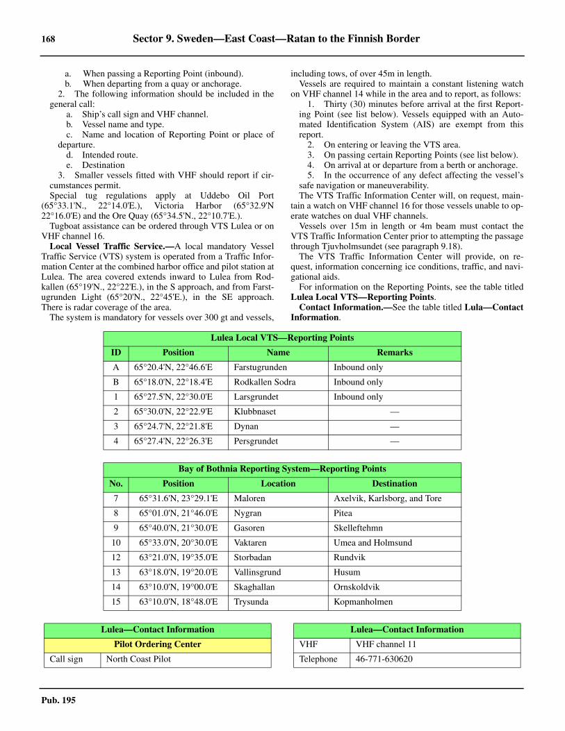
168 Sector 9. Sweden—East Coast—Ratan to the Finnish Border
Pub. 195
a. When passing a Reporting Point (inbound).b. When departing from a quay or anchorage.
2. The following information should be included in thegeneral call:
a. Ship’s call sign and VHF channel.b. Vessel name and type.c. Name and location of Reporting Point or place of
departure.d. Intended route.e. Destination
3. Smaller vessels fitted with VHF should report if cir-cumstances permit.
9.19 Special tug regulations apply at Uddebo Oil Port(65°33.1'N., 22°14.0'E.), Victoria Harbor (65°32.9'N22°16.0'E) and the Ore Quay (65°34.5'N., 22°10.7'E.).9.19 Tugboat assistance can be ordered through VTS Lulea or onVHF channel 16. 9.19 Local Vessel Traffic Service.—A local mandatory VesselTraffic Service (VTS) system is operated from a Traffic Infor-mation Center at the combined harbor office and pilot station atLulea. The area covered extends inward to Lulea from Rod-kallen (65°19'N., 22°22'E.), in the S approach, and from Farst-ugrunden Light (65°20'N., 22°45'E.), in the SE approach.There is radar coverage of the area.9.19 The system is mandatory for vessels over 300 gt and vessels,
including tows, of over 45m in length.9.19 Vessels are required to maintain a constant listening watchon VHF channel 14 while in the area and to report, as follows:
1. Thirty (30) minutes before arrival at the first Report-ing Point (see list below). Vessels equipped with an Auto-mated Identification System (AIS) are exempt from thisreport.
2. On entering or leaving the VTS area.3. On passing certain Reporting Points (see list below). 4. On arrival at or departure from a berth or anchorage. 5. In the occurrence of any defect affecting the vessel’s
safe navigation or maneuverability.9.19 The VTS Traffic Information Center will, on request, main-tain a watch on VHF channel 16 for those vessels unable to op-erate watches on dual VHF channels.9.19 Vessels over 15m in length or 4m beam must contact theVTS Traffic Information Center prior to attempting the passagethrough Tjuvholmsundet (see paragraph 9.18). 9.19 The VTS Traffic Information Center will provide, on re-quest, information concerning ice conditions, traffic, and navi-gational aids. 9.19 For information on the Reporting Points, see the table titledLulea Local VTS—Reporting Points. 9.19 Contact Information.—See the table titled Lula—ContactInformation.
Lulea Local VTS—Reporting Points
ID Position Name Remarks
A 65°20.4'N, 22°46.6'E Farstugrunden Inbound only
B 65°18.0'N, 22°18.4'E Rodkallen Sodra Inbound only
1 65°27.5'N, 22°30.0'E Larsgrundet Inbound only
2 65°30.0'N, 22°22.9'E Klubbnaset —
3 65°24.7'N, 22°21.8'E Dynan —
4 65°27.4'N, 22°26.3'E Persgrundet —
Bay of Bothnia Reporting System—Reporting Points
No. Position Location Destination
7 65°31.6'N, 23°29.1'E Maloren Axelvik, Karlsborg, and Tore
8 65°01.0'N, 21°46.0'E Nygran Pitea
9 65°40.0'N, 21°30.0'E Gasoren Skelleftehmn
10 65°33.0'N, 20°30.0'E Vaktaren Umea and Holmsund
12 63°21.0'N, 19°35.0'E Storbadan Rundvik
13 63°18.0'N, 19°20.0'E Vallinsgrund Husum
14 63°10.0'N, 19°00.0'E Skaghallan Ornskoldvik
15 63°10.0'N, 18°48.0'E Trysunda Kopmanholmen
Lulea—Contact Information
Pilot Ordering Center
Call sign North Coast Pilot
VHF VHF channel 11
Telephone 46-771-630620
Lulea—Contact Information

Sector 9. Sweden—East Coast—Ratan to the Finnish Border 169
Pub. 195
9.19 Anchorage.—Vessels waiting to enter the port may anchor,in a depth of 24m, clay, about 2 miles N of FarstugrundenLight (65°20'N., 22°45'E.).9.19 Large vessels may anchor, in depths of 21 to 33m, about 1mile SE of Larsgrundet Light (65°28'N., 22°28'E.), on the Nside of the main channel.9.19 Anchoring is prohibited in Sandofjarden from a line just Nof Klubbnaset to a line just W of Uddebo Hamn.9.19 Caution.—Local magnetic anomalies exist in the vicinity ofthe South Approach Channel.
Lulea to the Finnish Border
9.20 The coast between Lulea and the Finnish border,about 50 miles ENE, is fronted by numerous islands, rocks,and shoals. These dangers, which may best be seen on thechart, extend up to 20 miles offshore. The islands are woodedand not easily distinguished from seaward. Only the outermost
dangers are described below.Maloren (65°32'N., 23°34'E.), located 23.5 miles ENE of
Farstugrunden Light (65°20'N., 22°45'E.), is the southernmostof the islands lying off the coast between Lulea and the Finnishborder. This island is composed of sand and fronted by foulground. It lies near the W end of an extensive shoal area.
9.20 Maloren Light (65°32'N., 23°34'E.), equipped with a racon,is shown from a prominent tower, 17m high, standing on theNE side of the island.9.20 A light is also shown from a structure situated on the W sideof the island. A conspicuous chapel, with a spire and a belfry,stands on the island, along with numerous houses and huts.
9.21 Lutskarsgrund Light (65°40'N., 23°20'E.) is shownfrom a prominent red tower with a white top, 8m high, standingon a rock, 10 miles NNW of Maloren Light.9.21 Storo Light (65°42'N., 23°06'E.) is shown from a prominenttower, 10m high, standing at the S extremity of a peninsula, 6miles WNW of Lutskarsgrund Light. 9.21 Halsoklippor Light (65°43.1'N., 23°27'E.), equipped with aracon, is shown from a prominent red tower with a white top,6m high, standing on a rock, 4.5 miles NE of LutskarsgrundLight.
9.21 Trutskarsbaden Light (65°44'N., 23°23'E.) is shown from aprominent tower, 7m high, standing on a rock, 4.5 miles NNEof Lutskarsgrund Light. 9.21 Vippgrund Light (65°45'N., 23°28'E.), equipped with aracon, is shown from a framework tower standing on a small is-land, 1.6 miles N of Halsoklippor Light. 9.21 Anchorage.—Anchorage may be obtained, during goodweather, in a depth of 20m, about 3.5 miles SW of Maloren.9.21 Caution.—Vessels should not attempt to approach the coastfrom seaward between Farstugrundet Light (65°20'N.,22°45'E.) and Maloren, except by the authorized channels androutes. No authorized channels or routes exist between Ma-loren and Kemi 1 Light (65°23'N., 24°06'E.) (Finnish), 16miles SSE.
9.22 Sandskar (65°35'N., 22°45'E.), lying 5 miles NE ofMaloren, may be identified by its light-colored sand hills, 21mhigh. This island is partly wooded and a narrow tongue of landwith a few trees extends 1.5 miles N from its main body. The
Facsimile 46-26-99469
E-mail [email protected]
Web site https://www.sjofartsverket.se
Lulea Pilot Area
Call sign Lulea Pilot
VHF VHF channel 11
Telephone 46-920-258393
Facsimile 46-920-258392
E-mail [email protected]
Vessel Traffic Service
Call sign VTS Lulea
VHF VHF channels 14 and 16
Telephone 46-771-630675
Facsimile 46-31-647779
E-mail [email protected]
Port
Call signLulea Hamnradio
Lulea Harbour Radio
VHF VHF channels 10, 11, 12, 13, 14, and 16
Telephone 46-920-453000
Facsimile 46-920-454027
E-mail [email protected]
Web site http://www.portlulea.com
Lulea Signal Station
Telephone 46-920-258390
Tugs
VHF VHF channel 16
Lulea—Contact Information
9.20Maloren Light

170 Sector 9. Sweden—East Coast—Ratan to the Finnish Border
Pub. 195
isthmus by which this tongue is joined to the N side is bare andlight-colored. The S extremity of the island is also mostly bare,with a chapel and some huts standing close to the edge of thewoodland. 9.22 Sjoasen (65°32'N., 23°21'E.), with a least depth of 7.6m, isan isolated shoal lying about 5 miles W of Maloren Light.9.22 Launaja, with a least depth of 4.2m, and Kanningen, with aleast depth of 7.7m, lie, respectively, about 3 miles and 7 milesSE of Maloren Light.9.22 Flatbotten, with a least depth of 7.7m, lies 3 miles NNW ofMaloren Light. Torget, with a least depth of 7.4m, lies 1 mileNW of Flatbotten. Nordvastgrundet, with a least depth 4.4m,lies centered 1.5 miles W of Torget and is marked by a buoy atits SE end.9.22 Utbredan, with a least depth of 6.7m, lies about 7.3 milesWNW of Maloren Light. Karten, with a least depth of 5.8m,lies 1.1 miles W of the N end of Utbredan.9.22 Dynan, with a depth of 6.8m, lies 1.3 miles WNW of Karten.Another detached shoal patch, with a depth of 7.8m, lies 1 mileNW of Karten.9.22 Stolpgrundet, with a least depth of 7.4m, lies about 5 milesW of Utbrendan. A detached patch, with a depth of 7.8m, lies 1mile NNE of this shoal.9.22 The above shoal patches form the outermost dangers in thisvicinity.9.22 Caution.—Restricted areas, which may best be seen on thechart, lie within the inner approaches to Torehamn and Kalix.See Pub. 140, Sailing Directions (Planning Guide) North At-lantic Ocean and Adjacent Seas for information and regula-tions pertaining to restricted areas and semi-restricted areas inSwedish waters.9.22 Magnetic anomalies exist in the vicinity of the islands front-ing Torehamn and Kalix.
9.23 Torehamn (65°54'N., 22°39'E.) (World Port IndexNo. 27250) is a loading place at the head of Torefjarden, whichis entered about 5 miles E of Ranefjarden. There is a small nat-ural harbor which handles lumber, cement, fertilizer, flour, andgeneral cargo. 9.23 Ice.—Ice usually obstructs navigation in Torefjarden fromthe beginning of November to the middle of May. 9.23 Tides—Currents.—Winds from N lower the water level byas much as 1.8m and S winds raise water levels as much as1.7m. 9.23 Depths—Limitations.—The recommended track, whichmay best be seen on the chart, leads 34 miles in a NW directionfrom a position 1.5 miles SW of Maloren Light. It passes be-tween Torget and Nordvastgrundet Shoals, 1.5 miles SW ofLutskarsgrund Light, and close SW of Storo Light. The routeleads through Gunnarsfjarden (65°37'N., 23°26'E.), Storofjar-den (65°44'N., 23°00'E.), and Ranofjarden (65°45'N.,22°57'E.) before finally turning NNW along the E side of To-refjarden to the port.9.23 The fairway channel is authorized for drafts up to 8m as faras the anchorage located in the bight NW of Skagsudden(65°42'N., 23°06'E.). From this anchorage to the port the fair-way is authorized for drafts up to 6m.9.23 The main quay is 186m long, with depths of 6.5 to 8m along-side. There is also a small craft harbor with a depth of 2m.9.23 Aspect.—Palangeberget (65°48'N., 22°57'E.) is a prominent
flat-topped hill, 106m high. Rormyrberget, 78m high, is theprominent summit of the island of Ranon (65°43'N., 22°55'E.).9.23 The approach channel is indicated by lighted ranges and sec-tor lights. The fairway is marked, in places, by buoys and bea-cons.9.23 Pilotage.—Pilotage is compulsory. Pilots must be requestedthrough the Lulea VTS station and will board vessels about 1 mileE of Farstugrunden Light (65°20'N., 22°45'E.) (see paragraph9.19).9.23 Anchorage.—Anchorage may be obtained by vessels with localknowledge in the bight NW of Skagsudden (65°42'N., 23°06'E.),where there is good shelter, in depths of 14 to 22m, mud. 9.23 Anchorage may be obtained by vessels with local knowl-edge, in a depth of 9m, mud, about 0.5 mile N of Stora Faron(65°42'N., 22°44'E.), an island lying in the S part of Torefjar-den. The fairway leading to this anchorage has a least depth of6.4m.
9.24 Karlsborg (65°48'N., 23°17'E.) (World Port IndexNo. 27280), an important timber-exporting center, is the portfor Kalix, which stands on the E side of Kalix Alv, 5 miles NW.
Ice.—Ice usually obstructs navigation from the beginning ofNovember to the end of May. 9.24 Tides—Currents.—The maximum observed range of waterlevel is 1.5m above and below mean water level. The greatestvariation occurs in September and October. A rise of the waterlevel is caused by strong S and SW winds, and a fall is causedby strong N and NW winds. 9.24 During freshets and in mid-summer a strong current settingout of Kalix Alv may be experienced in the approach to the riv-er entrance, but it is not sufficiently strong enough to hindernavigation. 9.24 Depths—Limitations.—The recommended track, whichmay best be seen on the chart, leads 7.5 miles NNW from a po-sition 1 mile NNW of Maloren Light to a position NE of Vik-stromsgrundet Shoal. It then leads N for about 2.5 miles to aposition about 1 mile S of Halsoklippor Light (65°43'N.,23°27'E.). The route continues in a NW direction for 4.5 miles,passing close SW of Trutskarsbaden Light (65°44'N.,23°23'E.), into Repskarsfjarden. The facilities at Karlsborg, atthe NW end of Repskarsfjarden, and Axelsvik, at the NE side,can then be easily entered.9.24 The main approach channel leading from seaward (Maloren)to Gunnarsfjarden is authorized for drafts up to 8.8m. Thechannel from Gunnarsfjarden to Repskarsfjarden is authorizedfor drafts up to 6.6m. The main fairway leading to Karlsborgfrom Repskarsfjarden is authorized for drafts up to 8.5m. Abuoyed channel, which is authorized for drafts up to 1.5m,leads up the river to a small craft harbor at Kalix. The bridgejust N of Kalixalven has a vertical clearance of 6.9m. 9.24 The main facilities at Karlsborg consist of Massakajen, awood pulp quay fronting the sulphate factory, which is 140mlong and has a depth of 6.9m alongside, and Trakajen, a stoneand concrete quay, which is 270m long and has a depth of 6.2malongside.9.24 The main facilities at Axelsvik (65°46'N., 23°22'E.) consistof an oil quay, 60m long, with a depth of 10m alongside. Tank-ers up to 25,000 dwt and 6.6m draft can be handled, but theberth is very exposed.9.24 Aspect.—Golihatten, a wooded hill, 69m high, stands 2

Sector 9. Sweden—East Coast—Ratan to the Finnish Border 171
Pub. 195
miles N of Axelsvik and is prominent. 9.24 Two chimneys stand in the SW part of Karlsborg and areprominent from seaward. The pulp mill chimney is red and52m high and the sawmill chimney is yellow and 42m high. 9.24 The approach channel is indicated by lighted ranges and sec-tor lights. The fairway is marked, in places, by buoys and bea-cons.9.24 Pilotage.—Pilotage is compulsory. Pilots must be requestedthrough the Lulea VTS station and will board vessels about 1mile E of Farstugrunden Light (65°20'N., 22°45'E.) (see para-graph 9.19).9.24 Anchorage.—Anchorage may be obtained, in depths of 13to 14m, mud, in the S part of Repskarsfjardean, about 0.9 mileW of Trutskarsbaden Light (65°44'N., 23°23'E.).9.24 Anchorage may be obtained by small vessels, in depths of 8to 10m, mud, within Rossorsundet, about 1.8 miles SSW ofKarlsborg.
9.25 Inshore route.—An inshore route, well marked bybuoys, leads from Lulea to Harparanda (65°50'N., 24°08'E.),about 50 miles ENE. It is used by small vessels, with localknowledge, and is authorized for drafts up to 3.2m.9.25 Several shallow entrance channels branch off from this in-
shore route and lead to numerous small craft harbors. Most ofthese small harbors were former timber-loading places that arenow used only by local fishing vessels and recreational craft.
9.26 Sandvik (65°44'N., 23°46'E.) (World Port Index No.27330), a small timber-loading place, is situated on the N sideof the island of Seskaro, at the head of Sanviken. A concretequay, 150m long, fronts a sawmill and has depths of 5.4 to5.7m alongside. The entrance channel, which is authorized fordrafts up to 3.2m, leads off the inshore route.
Anchorage can be taken, in depths of 8 to 11m, mud, on theSE side of Sandviken, close to the quay.
Granviken Anchorage, with depths of 6 to 9m, consists of anarea lying N and on either side of Koijuluoto, an islet located0.6 mile NNW of the quay at Sandvik.
9.26 Haparanda (65°50'N., 24°08'E.), a small Swedish frontiertown, is situated on the W bank of the Tornealven River, 1.2miles above the mouth. The depth in the river and the smallharbor is only 1.5m. This town is connected by bridges to Tor-nio, a Finnish town standing on the E bank.
The border between Finnish and Swedish waters in this vi-cinity extends S, close to the meridian of 24°10'E.

173
Pub. 195
10. Sector 10—Finland—West Coast—Hallgrund to the Swedish Border
10.0Additional chart coverage may be found in NGA/DLIS Catalog of Maps, Charts, and Related Products (Unlimited Distribution).
SECTOR 10 — CHART INFORMATION

175
Pub. 195
SECTOR 10
FINLAND—WEST COAST—HALLGRUND TO THE SWEDISH BORDER
10.0 Plan.—This sector describes the Finnish coast bordering onthe Gulf of Bothnia between Norra Kvarken and the Swedishborder, at the head of the gulf. The descriptive sequence is Nfrom Hallgrund, an islet lying near the coast in the NE part ofNorra Kvarken.
General Remarks
10.1 This section of the coast of Finland forms the E shoreof Bottenviken, the N part of the Gulf of Bothnia. Like thecoast to the S, it is low and has few natural landmarks. Vesselsmust rely almost exclusively on lighthouses, beacons, and oth-er aids to navigation. 10.1 Ice.—See General Remarks in paragraph 1.1 and paragraph4.1.10.1 For information pertaining to winter navigation, ice, andFinnish icebreaking services, including internet web sites, seePub. 140, Sailing Directions (Planning Guide) North AtlanticOcean and Adjacent Seas.10.1 Pilotage.—The Baltic Pilotage Authorities Commission, aregional organization, recommends that vessels constrained bytheir draft, or vessels not registered in one of the Baltic Statesand infrequently sailing the area, take a deep-sea pilot. 10.1 See Pub. 140, Sailing Directions (Planning Guide) North At-lantic Ocean and Adjacent Seas for information on deep-sea pi-lotage. 10.1 Vessels desiring deep-sea pilotage to any coastal pilot stationin Finland should send a request at least 12 hours and 3 hoursin advance to the local agents.10.1 Pilotage procedures are, as follows:
1. Pilotage is generally compulsory.2. Vessels requiring a licensed Deep Sea Pilot in the Bal-
tic Sea area should send a request at least 12 hours in ad-vance to the local agents.
3. Pilots should be ordered by one of the followingmethods:
a. Web site, using the Pilot Order Form.b. Telephone.c. Facsimile.d. E-mail.
4. All pilot stations and pilot vessels are equipped withthe usual maritime VHF channels.
5. The Finnpilot Order Center will confirm receipt of thepreliminary information or pilot order using the same meth-od as used to make the order. An order placed using a formon the internet can also be confirmed via e-mail if requestedby the customer, providing an e-mail address is included inthe order information or is otherwise known by Finnpilot.(An order placed by telephone is not confirmed separatelyafter the telephone call)
6. There is no pilot ordering service via VHF radio.7. Inbound vessels:
a. Vessels must provide a 12-hour and 3-hour advancenotification of ETA at the pilot boarding position to the Pi-
lot Order Center.b. Vessels must place a binding pilotage order to the
Pilot Order Center 3 hours prior to arrival at the pilotboarding position8. Outbound vessels:
a. The vessel's agent or the vessel must provide a 12-hour and 2-hour advance notification of departure to thePilot Order Center.
b. The vessel’s agent or the vessel must provide abinding pilotage order 2 hours before departure to the PilotOrder Center.9. Vessels shifting berth must provide 2 hour advance
notice to the Pilot Order Center with 2 hours confirmation.10. During the winter months, pilot boarding positions
may be subject to alteration according to the prevailingweather conditions.
10.1 Pilotage is ordered via the Finnpilot Order Center, WesternPilotage Zone. Pilot stations are located, as follows:
1. Kemi and Tornio:a. Kemi N—position 65°33.1'N, 24°26.9'E.b. Kemi S—position 65°29.3'N, 24°19.0'E.
2. Oulu:a. Oulu N (for vessels with drafts between 8 and
10m)—position 65°10.9'N, 24°18.0'E.b. Oulu S (for vessels with drafts of 8m or less—posi-
tion 65°07.1'N, 24°16.6'E. 3. Raahe—position 64°38.8'N, 24°12.3'E.4. Pietarsaari—position 63°44.5'N, 22°28.5'E. 5. Kokkola—position 64°00.5'N, 22°49.1'E. 6. Kalajoki—position 64°15.5'N, 23°30.0'E. 7. Kaskinen, Kristiinankaupunki, and Vaasa:
a. Vaasa N (for the NW approach)—position63°15.8'N, 20°51.2'E.
b. Vaasa S (for Vaskiluoto)—position 63°12.1'N,20°45.4'E.
c. Kaskinen—position 62°15.5'N, 21°05.1'E. d. Kristiinankaupunki—position 62°11.5'N,
21°06.1'E.10.1All vessels must send a request for pilotage 12 hours pri-
or to arrival at the appropriate boarding place. A confirma-tion must be sent 6 hours in advance and any changes afterthis time must be forwarded not later than 3 hours before ar-rival. In the Gulf of Bothnia, the binding order for a pilotmust be made by telephone to the appropriate pilot station 3hours before arrival.
Finnpilot Order Center—Contact Information
Southern Pilotage Zone (Helsinki Pilotage Area and Hanko)
Telephone 358-400-907977
Facsimile 358-29-525310
E-mail [email protected]

176 Sector 10. Finland—West Coast—Hallgrund to the Swedish Border
Pub. 195
10.1 Vessel Traffic Service.—Gulf of Bothnia VTS covers thecoast along the Bay of Bothnia from Ritgrund Light to Tornioincluding the merchant shipping lanes (with the exception ofthe areas administered by the ports). The VTS Area also coversthe area administered by the Port of Pietarsaari and the Port ofOulu. The boundary line of the Bothnia VTS area runs betweenthe following positions:
1. Ritgrund Light (63°25'50''N., 21°30'50''E.).2. The territorial sea limit in position 63°40'00''N,
21°31'00''E.3. Observing the territorial limit to Tornio.
10.1 Gulf of Bothnia VTS provides the following types of ser-vice:
1. Information service.2. Traffic organization service.3. Navigation assistance service.
10.1 The boundary line of the Bothnia VTS area runs between thefollowing positions:
1. From Ritgrund Light (63°25.5'N, 21°30.5'E).2. To the territorial sea limit in position 63°40'.0N,
21°31'.0E.3. Observing the territorial sea limit to Tornio.
10.1 Vessels of 24m in length overall or more are obliged to par-ticipate in the vessel traffic services.10.1 When navigating in the VTS area, vessels are required tomaintain a continuous listening watch on the working channelused in the area. Furthermore, vessels are obliged to obey therules relevant to the traffic in the VTS area. More detailed in-structions about the required reports and working channels canbe found in the regional VTS mater’s guide.10.1 Vessels navigating in the VTS area, which are not obliged toparticipate in the vessel traffic services, are recommended tomaintain a listening watch on the working channel in the VTSarea or sector in question.10.1 Vessel traffic services are provided as required in Finnish,Swedish, and English. However, English is the primary com-munication language in the VTS areas along the Finnish coast.10.1 Vessels shall report, as follows:
1. Upon entry into the VTS Area.2. Before anchoring.3. Before leaving anchorage.4. After berthing.5. Before leaving port.
10.1 Vessels bound for Finnish ports in the Gulf of Bothnia via theQuark are required to submit an advance report 20 nautical milesbefore the Nordvalen Lighthouse (63°32'09''N 020°46'36''E).10.1 All reports to the VTS Center, including the Advance Re-port, should include the following information:
1. Vessel’s name.2. Name of reporting point.3. Destination.4. Intended route. If an alternative route is selected, this
must be reported.10.1 See paragraph 1.1 for details concerning restricted areas andsemi-restricted areas within Finnish waters. 10.1 Meeting and overtaking is permanently prohibited in the fol-lowing areas covered by Bothnia VTS:
1. Tornio: Harbor basin—buoy pair T27 and T28 be-tween latitude 65º44.8'N and latitude 65º43.2'N in the 9.0mfairway.
2. Tornio—Narrow passage at Keila between Buoy T5and Buoy T7 between longitude 24º20.8'E and longitude24º18.9'E in the 9.0m fairway.
3. Tornio—Europa bend, in the area between Buoy Eu-ropa and Buoy T18 between latitude 65º39.8'N and latitude65º40.4'N in the 9.0m fairway.
4. Kemi—Ajos Harbor buoy pair Inakari 1 and Inakari 2between latitude 65º39.5’N and latitude 65º38.9’N in the10.0m fairway.
5. Kemi: Veitsiluoto fairway—Veitsiluoto Harbor W ofAjoskrunni between latitude 65º40.9'N and latitude65º37.8'N in the 6.8m fairway.
6. Oulu—Suumatala in the area between Buoy Oulu 5and Hammasmatala between longitude 24º50.5'E and longi-tude 2’4º53.1'E in the 10.0m fairway.
7. Oulu—Löyhänmutka fairway area between Hookanaand Löyhänmutka edge mark between latitude 65º07.3’Nand latitude 65º06.8’N in the 10.0m fairway.
8. Oulu port entrance—Kyrönkari–Port of Oulu betweenlongitude 25º20.8'E and longitude 25º23.5'E in the 12.5m
Web site https://pilotorder.fi
Eastern Pilotage Zone (Kotka Pilotage Area)
Telephone 358-400-907978
Facsimile 358-29-525311
E-mail [email protected]
Web site https://pilotorder.fi
Eastern Pilotage Zone (Saimaa Canal and Lake Saimaa)
Telephone 358-400-4873133
Facsimile 358-29-525311
E-mail [email protected]
Web site https://pilotorder.fi
Western Pilotage Zone (Gulf of Bothnia Pilotage Area)
Telephone 358-400-907979
Facsimile 358-29-525312
E-mail [email protected]
Web site https://pilotorder.fi
Head Office
Telephone 358-29-5253000
Facsimile 358-29 5253001
E-mail [email protected]
Web site https://pilotorder.fi
FinTraffic VTS—Master’s Guide
https://www.fintraffic.fi/en/vts/masters-guide
Finnpilot Order Center—Contact Information

Sector 10. Finland—West Coast—Hallgrund to the Swedish Border 177
Pub. 195
10.1Gulf of Bothnia VTS Zones

178 Sector 10. Finland—West Coast—Hallgrund to the Swedish Border
Pub. 195
fairway.9. Raahe—Elkonredi–Johan edge mark between longi-
tude 24º22.3'E and longitude 24º16.9'E in the 10.0m fairway.10. Kokkola—Vessels of 200m or more in length when
operating between latitude 63º53.5’N and latitude 63º59.2’Nin the 13.0m fairway.
11. Pietarsaari: Port of Pietarsaari–Ado island betweenlongitude 22º41.0’E and longitude 22º37.9’E in the 11.0mfairway.
10.1 These prohibitions do not apply to meeting and overtakingsituations in which at least one of the parties is a tug or a ves-sel, the size of which is comparable to a tug.10.1 Contact Information.—See the table titled Gulf of Both-nia—Contact Information.
10.1 Caution.—The area has not been thoroughly surveyed. Off-lying dangers may exist to seaward of those charted. Most ofthe coast is fringed by close-lying islands, islets, rocks, andshoals. The recommended routes leading to the ports and load-ing places are described and should be strictly followed. Ves-sels without local knowledge should proceed with cautionwhen approaching this coast.10.1 Due to various circumstances, including the discovery of ob-structions, depths within the channels leading through the off-shore dangers along this stretch of coast may changefrequently. Therefore, vessels are advised to contact the localauthorities in order to ascertain the latest information, includ-ing the maximum authorized drafts. All depths are to be con-sidered as in fresh water.
Hallgrund to Pietarsaari
10.2 Hallgrund (63°39'N., 22°25'E.) is a small and low is-let lying about 2.5 miles offshore on the W side of the ap-proach to Uusikaarlepyy. It is fronted by shoals on the N and Esides.10.2 Socklothallan, a large islet with several small islets lyingclose off its S end, is located close to and extends about 0.3mile S from Hallgrund. Tuvan, a small islet, lies about 0.2 mileNE of Hallgrund. Torson, a wooded island, lies 2 miles SSW ofHallgrund.10.2 Hallgrund Light is shown from a framework tower standingon Socklothallan. Hallgrund Beacon, a conspicuous pyramid-shaped tower, 21m high, is situated 0.2 mile S of the light.10.2 A partly-buoyed approach channel, authorized for drafts upto 4m, leads in a S direction and passes E of Hallgrund and
Torson. This channel leads to the anchorage for Uusikaarlepyy.Vessels, with local knowledge, may anchor, in depths of 12 to14m, clay, about 0.7 mile E of the S end of Torson.10.2 Uusikaarlepyy (63°31'N., 22°32'E.) (World Port Index No.27580), a small town, is situated 3 miles from the mouth of a shal-low river estuary and cannot be reached by ocean-going vessels.10.2 Kallan Light (63°45.2'N., 22°31.5'E.) is shown from aprominent tower, 19m high, standing on Kallan, an above-wa-ter rock lying about 0.5 mile off the S end of an extensive areaof foul and rocky ground. A racon is situated on this light.10.2 Hellstenen, another above-water rock, lies on the foulground about 0.8 mile NNE of Kallan. Storviken, an isolatedrock that covers 0.7m, lies 0.5 mile N of Hellstenen.10.2 Nygrundet Light (Pietarsaaren Majakka) (63°44'N.,22°32'E.) is shown from a prominent yellow tower standing ona rocky shoal, awash, about 0.7 mile SSE of Kallan Light. Aracon is situated at this light.10.2 Alholmsfjarden, within which the port of Pietarsaari is situ-ated, lies about 8 miles NE of Hallgrund and 4 miles SE ofKallan Light. It is part of a large bay filled with numerouswooded islands, rocks, and shoals.10.2 Masskar Tower (63°44'N., 22°35'E.), a red structure with agray pointed roof, stands on Masskar Island, about 2 miles SEof Kallan Light. It is 21m high and prominent from seaward. 10.2 The main entrance into Alholmsfjarden leads betweenKallan Light and Nygrundet Light. The outermost danger onthe N side of the approach is an isolated shoal, lying about 1.3miles NNW of Kallan Light. It has a least depth of 7.5m and ismarked by a buoy.
10.2 Storgrundet, a detached shoal bank, lies about 3 miles SW ofKallan Light and is the outermost danger on the S side of theapproach. It has a least depth of 3.2m and is marked by buoys.10.2 Gammalgrundet, with depths of less than 2m, is an extensiveshoal lying on the S side of the entrance. It is situated on alarge shallow bank, which extends about 3.5 miles N from themainland.
Pietarsaari (63°41'N., 22°40'E.)
World Port Index No. 27570
10.3 Pietarsaari, formerly known as Jakobstad, is situatedwithin Alholmsfjarden, about 8 miles NE of Hallgrund. Thissheltered harbor lies on the NW side of Adholme and E of
Gulf of Bothnia—Contact Information
Vessel Traffic Service
Call sign Gulf of Bothnia VTS
VHF VHF channel 67
Telephone358-20-448-7356
358-20-448-6522 (supervisor)
Web site https://www.fintraffic.fi/en/masters-guide
10.2Masskar Tower

Sector 10. Finland—West Coast—Hallgrund to the Swedish Border 179
Pub. 195
Adon, a peninsula located 1 mile W.
10.3 Depths—Limitations.—The main approach channel fromseaward leads between Kallan Light and Nygrundet Light. Theentrance fairway, which is authorized for drafts up to 11mpasses between numerous islets and shoals fronting the harbor.The principal facilities are described below. 10.3 The Ro-Ro Quay is 160m long and has a depth of 7.4malongside. Laucko Quay is 150m long and has a depth of 9malongside. It is used as an oil berth and can handle tankers up to200m in length.10.3 New Quay is 200m long and has a depth of 7.4m alongside.Allhomen Pier provides a ro-ro berth. It has depths of 4.9malongside the E side and 6m alongside the W side.10.3 Vessels up to 47,940 dwt, 217m in length, and 9m draft havebeen accommodated in the harbor.10.3 Aspect.—The main entrance fairway leading to the harbor isindicated by lighted ranges and marked by lights, buoys, andbeacons.10.3 The commercial harbor is situated on the NW side of Leppa-luoto, a peninsula extending 2 miles N of the town.10.3 The spire of a church and a water tower situated in the S partof the town are conspicuous from seaward. A prominent chim-ney stands 2.5 miles N of the church spire.10.3 Pilotage.—Pilotage is ordered via the Finnpilot Order Cen-tre, Western Pilotage Zone (see Sector 1.1 for details). 10.3 During inclement weather, vessels may be directed to a moresheltered area by VHF.10.3 Regulations.—The main routes leading to Pietarsaari aresituated within Sector C of the Gulf of Bothnia Vessel TrafficService (VTS) system. This system operates off the NW coastof Finland and is mandatory. For further details of the VTS sys-tem, including reporting procedures, see paragraph 10.1.10.3 At night tankers carrying more than 4,000 tons of oil are pro-hibited from navigating in the channel between the oil berthand the sea.10.3 Vessels shall submit a departure report in order to be givenpermission to depart. The permission to depart issued by theVTS is valid for 20 minutes. If the vessel’s departure is de-layed, it will have to request a new permission to depart.10.3 Contact Information.—See the table titled Pietarsaari—Contact Information.
10.3 Anchorage.—Vessels with local knowledge may anchor Nof Masskar, in a depth of 16m, mud. Anchorage may also betaken in the roadstead about 1.5 miles E of Masskar, in depthsof 11 to 12m.
Pietarsaari to Kokkola (Ykspihlaja)
10.4 Kokkola Majakka (64°00'N., 22°52'E.), is locatedmiles NNE of Kallen Light. It is shown from a prominent tow-er, 23m high, standing on the W side of Kredens Shoal. Thecoast between is fronted by numerous small islands, islets,rocks, and patches of foul ground extending up to about 11miles offshore.10.4 Orgrundet Beacon (63°47'N., 22°33'E.), 12m high, standson the N extremity of Orgrundet Island, about 2.2 miles NNEof Kallan Light.
Lillgrundet (63°51'N., 22°37'E.), marked by range beacons,is situated about 6.4 miles NNE of Kallan Light and surround-ed by foul ground.10.4 An inshore channel leading from sea to Ykspihlaja, which isauthorized for drafts up to 3m, passes S and E of Lillgrundet. Itis suitable only for small vessels during daylight.10.4 Koppargrundet Beacon (63°55.7'N., 22°43.1'E.), consist-ing of a prominent steel mast, stands in an islet about 5.8 milesSW of Kokkola Light.10.4 Tankar (63°57'N., 22°51'E.) lies about 3 miles SSW of Kok-kola Light and is fronted by shoals extending up to about 1.7miles seaward. A main pilot station (Bothnia Pilot) is situatedon this island. A harbor used by small craft is located at the Eside.10.4 Tankar Light is shown from a prominent metal tower, 29mhigh, standing near the center of the island.
10.4 A secondary passage leading from sea to Ykspihlaja, whichis authorized for vessels with drafts up to 5.2m, is enteredabout 2 miles NW of Tankar. It passes NE of the island andjoins the primary channel close NE of Repskaret, 3.5 miles SE.The fairway is indicated by a lighted range, buoys, and bea-cons.10.4 Trullevin (63°57'N., 23°03'E.), marked by range beacons, is
Pietarsaari Home Page
https://www.portofpietarsaari.fi
Pietarsaari—Contact Information
Port Authority
Telephone 358-6-7236128
E-mail [email protected]
Web site https://www.portofpietarsaari.fi
Port Control
VHF VHF channels 13 and 16
Telephone 358-6-7231388
E-mail [email protected]
10.4Tankar Light

180 Sector 10. Finland—West Coast—Hallgrund to the Swedish Border
Pub. 195
a small island lying about 5.8 miles SE of Kokkola Light.10.4 An inshore channel leading from sea to Ykspihlaja, which isauthorized for drafts up to 2.5m, passes close W of this island.It is indicated by range beacons and is partly buoyed.10.4 Caution.—An explosives dumping area, which may best beseen on the chart, lies centered 13 miles NW of Kokkola Light.
10.4Kokkola (Ykspihlaja) (63°51'N., 23°06'E.)
World Port Index No. 27560
10.5 The harbor of Kokkola (Ykspihlaja), formerly knownas Karleby, is situated 2.5 miles W of the town and 20 milesNE of Hallgrund. It lies between the mainland and an island,and is divided into two parts by a breakwater.10.5 The principal imports handled are oil, liquid chemicals, andzinc concentrates. Timber products and zinc are exported.
10.5 Winds—Weather.—Winds, from NW through N to NE,sometimes cause a heavy sea in the harbor.10.5 Ice.—Ice obstructions exist from December through April;however, efforts are made to keep the harbor open by means oficebreakers. Ice class restrictions apply in winter.10.5 Tides—Currents.—The water level may vary as much as0.6m, depending on the wind. 10.5 Depths—Limitations.—The main approach channel, whichis authorized for drafts up to 14m, leads from the NW andpasses close SW of Kokkola Light. Local knowledge is re-quired to enter the harbor. For the secondary entrance channels,see paragraph 10.4. The principal facilities are described be-low. Depths are to be considered as in fresh water. 10.5 Deep Quay is 600m long and has a depths of 11 to 13malongside.10.5 Outokumpu Quay is 210m long and has a depth of 11malongside. 10.5 Kemira Quay, a liquid chemical and gas berth, is 160m longand has a depth of 9.5m alongside.10.5 Oil Quay, at the S side of the breakwater, is 83m long andhas a depth of 9.5m alongside.10.5 Shore Quay is situated in the S part of the harbor. The N sideis 100m long and has a depth of 7.1m alongside. The S side is320m long and has a depth of 9.5m alongside.10.5 Ro-Ro Quay, in the S part, is 85m long and has a depth of6m alongside.10.5 Stone Quay, in the S part, is 137m long and has a depth of7.1m alongside.10.5 There are facilities for LPG, tanker, general cargo, bulk, andro-ro vessels. There are no restrictions for length or beam. Ves-sels with drafts (fresh water) up to 13m can be accommodated.10.5 Aspect.—The main fairway channel is entered from NW ofKokkola Light. It is indicated by lighted ranges and marked bylighted buoys and beacons.10.5 Bergbadan Beacon, equipped with a racon, stands on an isletat the S side of the main channel, about 2 miles SSE of Kokko-la Light.10.5 A water tower and several prominent tanks and chimneys
stand in the vicinity of the harbor area. 10.5 Pilotage.—Pilotage is compulsory. Pilotage is ordered viathe Finnpilot Order Centre, Western Pilotage Zone. FinnpilotPilot order service is divided into three Pilotage Zones, South-ern, Eastern, and Western. For details on the specific coverageas well as contact information for each of these pilotage zones,see Sector 1.1.10.5 Pilot boards in position 64°00.5'N 22°49.1'E. 10.5 Arrangements may be made to embark the pilot in the vicin-ity of Kokkola Light. 10.5 Vessel Traffic Service.—The main routes leading to Kokko-la are situated within Sector C of the Gulf of Bothnia Vessel
Port of Kokkola
https://portofkokkola.fi/en/port-of-kokkola/
10.5Kokkola—Deep Quay
10.5Kokkola (General Port)
10.5Kokkola
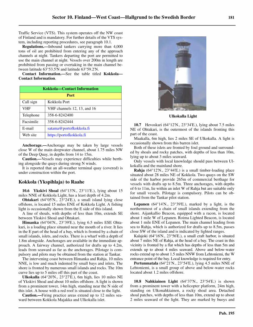
Sector 10. Finland—West Coast—Hallgrund to the Swedish Border 181
Pub. 195
Traffic Service (VTS). This system operates off the NW coastof Finland and is mandatory. For further details of the VTS sys-tem, including reporting procedures, see paragraph 10.1.10.5 Regulations.—Inbound tankers carrying more than 4,000tons of oil are prohibited from entering any of the approachchannels at night. Tankers departing the port are permitted touse the main channel at night. Vessels over 200m in length areprohibited from passing or overtaking in the main channel be-tween latitude 63°53.5'N and latitude 63°59.2'N.10.5 Contact Information.—See the table titled Kokkola—Contact Information.
10.5 Anchorage.—Anchorage may be taken by large vesselsclose W of the main deepwater channel, about 1.75 miles NWof the Deep Quay, in depths from 14 to 15m. 10.5 Caution.—Vessels may experience difficulties while berth-ing alongside the quays during strong N winds.10.5 It is reported that an all-weather terminal quay (covered) isunder construction within the port.
Kokkola (Ykspihlaja) to Raahe
10.6 Ykskivi Shoal (64°13'N., 23°11'E.), lying about 15miles NNE of Kokkola Light, has a least depth of 4.2m.10.6 Ohtakari (64°05'N., 23°24'E.), a small island lying closeoffshore, is located 15 miles ENE of Kokkola Light. A fishinglight is occasionally shown from the E side of this island. 10.6 A line of shoals, with depths of less than 10m, extends SEbetween Ykskivi Shoal and Ohtakari.10.6 Himanka (64°04'N., 23°39'E.), lying 6.5 miles ESE Ohta-kari, is a loading place situated near the mouth of a river. It liesin the E part of the head of a bay, which is fronted by a chain ofsmall islands, islets, and rocks. There is a wharf with a depth of1.8m alongside. Anchorages are available in the immediate ap-proach. A fairway channel, authorized for drafts up to 4.2m,leads from seaward as far as the anchorages. Pilotage is com-pulsory and pilots may be obtained from the station at Tankar. 10.6 The intervening coast between Himanka and Rahja, 10 milesNNE, is low and much indented by small bays and inlets. Theshore is fronted by numerous small islands and rocks. The 10mcurve lies up to 5 miles off this part of the coast. 10.6 Ulkokalla (64°20'N., 23°27'E.), 6m high, lies 10 miles NEof Ykskivi Shoal and about 10 miles offshore. A light is shownfrom a prominent tower, 14m high, standing near the N side ofthis islet. A house with a red roof is situated close to the light.10.6 Caution.—Firing practice areas extend up to 12 miles sea-ward between Kokkola Majakka and Ulkokalla islet.
10.7 Hevoskari (64°12'N., 23°34'E.), lying about 7.5 milesNE of Ohtakari, is the outermost of the islands fronting thispart of the coast. 10.7 Maakalla, 6m high, lies 2 miles SE of Ulkokalla. A light isoccasionally shown from this barren islet.10.7 Both of these islets are fronted by foul ground and surround-ed by shoals and rocky patches, with depths of less than 10m,lying up to about 3 miles seaward.10.7 Only vessels with local knowledge should pass between Ul-kokalla and the mainland shore. 10.7 Rahja (64°12'N., 23°44'E.) is a small timber-loading placesituated about 28 miles NE of Kokkola. Two quays on the SWside of the harbor provide 265m of commercial berthage forvessels with drafts up to 8.5m. Three anchorages, with depthsof 6 to 11m, lie within an inlet W of Rahja but are suitable onlyfor small vessels. Pilotage is compulsory. Pilots can be ob-tained from the Tankar pilot station.
Lepanen (64°14'N., 23°39'E.), marked by a light, is thenorthernmost of a chain of small islands extending from theshore. Aijankallio Beacon, equipped with a racon, is locatedabout 1 mile W of Lepanen. Roima Lighted Beacon, is locatedabout 1 mile ENE of Lepanen. The main channel leading fromsea to Rahja, which is authorized for drafts up to 8.5m, passesclose SW of the island and is indicated by lighted ranges. 10.7 Kalajoki (64°16'N., 23°56'E.), a small craft harbor, is situatedabout 7 miles NE of Rahja, at the head of a bay. The coast in thisvicinity is fronted by a flat which has depths of less than 5m andextends up to about 4 miles seaward. Above and below-waterrocks extend up to about 1.5 miles NNW from Lehtoniemi, the Wentrance point of the bay. Local knowledge is required for entry. 10.7 Pertunmatala (64°21'N., 23°54'E.), lying 4.5 miles NNE ofLehtoniemi, is a small group of above and below-water rockslocated about 1.2 miles offshore.
10.8 Nahkiainen Light (64°37'N., 23°54'E.) is shownfrom a prominent tower with a helicopter platform, 24m high,standing on Ulkonahkiainen, a rocky shoal area. Detachedshoal patches, with depths of less than 10m, extend up to about2 miles seaward of the light. They are marked by buoys and
Kokkola—Contact Information
Port
Call sign Kokkola Port
VHF VHF channels 12, 13, and 16
Telephone 358-6-8242400
Facsimile 358-6-8242444
E-mail [email protected]
Web site https://portofkokkola.fi
10.6Ulkokalla Light

182 Sector 10. Finland—West Coast—Hallgrund to the Swedish Border
Pub. 195
may best be seen on the chart.10.8 An isolated shoal patch, with a depth of 7.3m, lies 4.5 milesSSE of the light.10.8 Raahe Light (64°39.1'N., 24°13.4'E.), equipped with aracon, is shown from a prominent tower, 24m high, standing 9miles ENE of Nahkiainen Light.10.8 Maanahkiainen, a detached shoal, has a least depth of 3.5mand lies about 3 miles SSW of the light.10.8 Caution.—A local magnetic anomaly exists within a smallarea located 9 miles SSW of Nahkiainen Light. 10.8 A local magnetic anomaly exists in the area lying betweenNahkiainen Light and Raahe Light.
Raahe (64°41'N., 24°25'E.)
World Port Index No. 27530
10.9 Raahe is situated 15 miles ENE of Nahkiainen Light.The coast in this vicinity is fronted by many small islands, is-lets, and shoals. Rautaruukki, the outer harbor, is protected bydetached breakwaters which have been formed by causewaysjoining several islets. Lapaluoto, the inner harbor, is protectedby a number of small islands. The town stands 2.5 miles NE ofthe port.
10.9 Winds—Weather.—The harbors are, to a great extent, protect-ed against N, E, and S winds and to some degree against W winds. 10.9 Ice.—The harbor is kept open year round with icebreaker as-sistance.10.9 Tides—Currents.—There are no regular tides or currents. 10.9 Depths—Limitations.—The main approach channel lead-ing from seaward, which is authorized for drafts up to 7.5m,passes N of Nahkiainen Light and close S of Raahe Light. 10.9 The principal wharves include Lapaluoto Quay, which is100m long and has a depth of 8m alongside; Import Quay,which is 370m long and has a depth of 8m alongside; ExportQuay, which is 270m long and has a depth of 8m alongside;and Oil Quay, which is 207m long and has a depth of 8malongside. There are facilities for tanker, bulk, ro-ro, and gen-eral cargo vessels. Vessels up to 40,000 dwt, 200m in length,and 8m draft can be accommodated in the port.10.9 Aspect.—On approaching the coast, a range of hills, 100 to120m high, can be seen rising about 7 miles inland, 10 milesSSE of the town.10.9 The main entrance channel is indicated by lighted ranges,lighted buoys, and beacons. Heikinkari Light, the front rangelight, is situated 3.4 miles E of Raahe Light and is equippedwith a racon.10.9 A church, with a conspicuous tower, stands in the town and asquare water tower is situated 0.3 mile SW of it. A prominentchimney, 110m high, stands 2.5 miles SW of the church in thevicinity of the harbor.10.9 Pilotage.—Pilotage is compulsory. Pilots are provided bythe Perameri Pilot Station (Bothnia Pilot) located at Hailuoto(see paragraph 10.10). For further information concerning pi-lotage in the approaches, see paragraph 10.1.
10.9 Vessel Traffic Service.—The main routes leading to Raaheare situated within Sector D of the Gulf of Bothnia Vessel Traf-fic Service (VTS). This system operates off the NW coast ofFinland and is mandatory. For further details of the VTS, in-cluding reporting procedures, see paragraph 10.1.10.9 Contact Information.—The port can be contacted by e-mail([email protected]).10.9 Anchorage.—Anchorage may be taken seaward of RaaheLight, in depths of 15 to 20m. Vessels, with local knowledge,may also obtain sheltered anchorage S of the fairway, in adepth of 11m, about 0.6 mile NE of Heikinkari Light.
Raahe to Oulu
10.10 The coast extends in a general NE direction from Raa-he to Oulu, a distance of 32 miles. The intervening coast is in-dented by several bays and a number of rivers flow into the seain this area. The 10m curve lies up to 9 miles offshore.
Tauvo (64°49'N., 24°33'E.), a peninsula, projects from themainland about 8 miles NNE of Raahe. It is fronted by rocksextending up to about 1 mile seaward. A light is shown from aprominent framework structure, 30m high, standing near theNW extremity of this peninsula. 10.10 Hailuoto (65°03'N., 24°46'E.), a low and wooded island, lieswith its S extremity located 8.5 miles N of Tauvo. 10.10 Marjaniemi Light (65°02'N., 24°34'E.) is shown from aprominent tower, 25m high, standing on the W extremity ofHailuoto.10.10 Pilotage.—Pilotage is provided by Bothnia Pilot from themain pilot station situated near the W point of Hailuoto islandand close by Marjaniemi Light (65°02'N., 24°34'E.). This sta-tion provides pilots for Raahe, Rahja, Oulu, Kemi, and the Tor-nio/Roytta Channels (see paragraph 10.1). 10.10 Merikallat (65°02'N., 24°05'E.), a shoal area of sand andstones, lies between 10 and 14 miles W of Hailuoto. It has aleast depth of 6.7m and is marked by buoys. 10.10 Artunmatala (65°15'N., 24°07'E.), with a least depth of 8m,lies about 17 miles NNW of Marjaniemi Light. This shoal,which is marked by a buoy, is the outermost patch with a depth
Port of Raahe
https://www.raahensatama.fi
10.9Oulu 1 Light

Sector 10. Finland—West Coast—Hallgrund to the Swedish Border 183
Pub. 195
of less than 10m lying off this stretch of coast.10.10 Oulu 1 Light (65°11'N., 24°30'E.), equipped with a racon, isshown from a prominent tower, 24m high, standing about 9miles N of Marjaniemi Light.10.10 Oulun Portti Lighted Beacon is situated 3.4 miles W of thislight. An isolated shoal patch, with a depth of 8.2m, lies about0.6 mile S of the lighted beacon and is marked by a buoy.10.10 Oulu 2 Light (65°10'N., 24°35'E.) is shown from a promi-nent tower, 24m high, standing 2.3 miles ESE of Oulu 1 Light. 10.10 Oulu 3 Light (65°09'N., 24°40'E.) is shown from a promi-nent tower, 24m high, standing 2.5 miles SE of Oulu 2 Light.10.10 Luodematala Light (65°10'N., 25°00'E.), equipped with aracon, is shown from a structure, 29m high, standing 10.3miles E of Oulu 2 Light.
Directions.—The waters fronting Oulu are encumbered bynumerous islets, rocks, and shoal areas. Recommended routes(channels), which may best be seen on the chart, lead throughthese dangers and obstructions to the port.
The fairways are indicated by lighted ranges and marked bybuoys and beacons. 10.10 The main approach channel from seaward, which is autho-rized for drafts up to 10m, is entered about 24 miles WNW ofMarjaniemi Light. This route leads E for about 20 miles andpasses close S of Oulun Portti Lighted Beacon and 0.5 mile Sof Oulu 1 Light. It then leads in a SE direction for about 24miles, passing NE of Hailuoto, to the port. The fairway passesclose NE of Oulu 2 Light and close SW of Oulu 3 Light.10.10 Two alternate channels, which are authorized for drafts up to8m, lead N or E of Merikallat shoal and merge together. This
route then leads NE for about 7 miles and joins the main chan-nel 1.5 miles SW of Oulu 1 Light.10.10 Another alternate channel, which is authorized for drafts upto 6.1m, leads about 6 miles SE. This route passes close N ofOulu 1 Light and joins the main channel about 0.5 mile NW ofOulu 2 Light.10.10 A secondary channel, which is authorized for drafts up to4.2m, is entered about 6 miles SW of Marjaniemi Light. Thisroute leads N and NE for about 14 miles. It passes 1.6 miles Wof Marjaniemi Light and joins the main channel in the vicinityof Oulu 3 Light.10.10 Another secondary channel, which is authorized for drafts upto 3.5m, is entered about 8 miles NW of Marjaniemi Light. Itleads 6 miles ESE and joins the first secondary channel 3.2miles NNW of Marjaniemi Light. The secondary channels areused only in daylight.10.10 A shallow inshore channel, for small craft with local knowl-edge, leads from Raahe to Oulu. It passes between the S side ofHailuoto and the mainland.10.10 A main coastal route, which is authorized for drafts up to 10m,leads between the approaches to Oulu and the approaches to Ke-mi. This channel leaves the main approach route about 4.3 milesSE of Luodematala Light and leads NE and E for 3 miles througha narrow passage. It then leads about 27 miles in a NW directionto a position 4.5 miles W of Harkaletto Light (65°30'N., 24°50'E.).From this position the channel leads 7 miles W to join the mainapproach route for Kemi (see paragraph 10.14).10.10 Caution.—Local magnetic anomalies exist within an area,the limits of which are shown on the chart, centered 9 miles W
10.9Courtesy of Port of Raahe
10.9Port of Raahe

184 Sector 10. Finland—West Coast—Hallgrund to the Swedish Border
Pub. 195
of Tauvo Light.
Oulu (65°01'N., 25°28'E.)
World Port Index No. 27520
10.11 Oulu, formerly known as Uleaborg, lies on the S sideof the Oulujoki River (Ulea River), about 10 miles E of Hailuo-to. It is an important harbor and industrial city.
10.11 Ice.—The port is normally closed for almost half the year byice, but icebreakers are available.10.11 Depths—Limitations.—The main channel leading fromseaward to the port is authorized for drafts up to 10m (see para-graph 10.10).
10.11 The port consists of five harbor areas, which provide facili-ties for general cargo, ro-ro, bulk, tanker, chemical, and timber-product vessels.10.11 Pateniemi lies 5 miles NNW of the town. A channel, whichis authorized for drafts up to 6.3m, leads N to this harbor.There is a berth, 85m long, with a depth of 6.3m alongside. It isreported that this harbor is no longer open to commercial ship-ping.10.11 Toppila lies 1.5 miles NW of the town. It is reported that thisharbor is used only for the discharge of cement. Toppila Quay,990m long, is situated on the N side of this harbor and has adepth of 6.1m alongside. Hietasaari Quay, 600m long, is situat-ed on the S side and has a depth of 6.1m alongside. The chan-nel in the vicinity of these two quays has a maximumauthorized draft of 5.0m.10.11 An overhead power cable, with a vertical clearance of 50m,spans the entrance to Toppila harbor.10.11 Vihreasaari lies at the SW extremity of the southernmost is-let fronting the town. Oil Quay, 72m long and T-shaped, is situ-ated on the N side of this harbor and has a depth of 10malongside. Bulk Quay, 150m long, is situated on the S side and
has and a depth of 10m alongside.10.11 Oritkari lies 1 mile SW of the town on the S bank of the riv-er. Main Quay, situated at the S side, is 270m long and has adepth of 9m alongside. North Quay, situated at the N side, is170m long and has a depth of 10m alongside. There are alsothree ro-ro berths, with depths of 7 to 10m alongside.10.11 Nuottasaari lies 0.5 mile WSW of the town on the S bank ofthe river. Nuottasaari Quay, 320m long, has a depth of 6.4malongside. Two chemical quays, situated close W, have depthsof 7.5m and 9.5m alongside.10.11 Vessels up to 50,000 dwt, 200m in length, and 10m draft canbe accommodated within the port.10.11 Aspect.—The recommended entrance channels are indicatedby lighted ranges and marked by lighted buoys and beacons.Several chimneys and silos standing in the vicinity of the har-bor at Oritkari are prominent from seaward.10.11 Pilotage.—Pilotage is compulsory deep-sea pilots are pro-vided by the Perameri Pilot Station, Bothnia Pilot (see para-graph 10.10). For further information concerning pilotage, seealso paragraph 10.1.10.11 Pilotage is ordered via the Finnpilot Order Centre, WesternPilotage Zone. See paragraph 1.1 for details.10.11 Pilot will boards in the following position for vessels pro-ceeding to Oulu:
1. Oulu N—65°10'57.0''N, 24°18'00.0''E.2. Oulu S—65°07'00.0''N, 24°16'56.4''E.
10.11 Vessel Traffic Service.—The main routes leading to Ouluare situated within Sector D of the Gulf of Bothnia Vessel Traf-fic Service (VTS). This system operates off the NW coast ofFinland and is mandatory. For further details of the VTS, in-cluding reporting procedures, see paragraph 10.1.10.11 Anchorage.—The roadstead between Oulu and Pateniemi,5.5 miles N, affords anchorage, in depths of 7 to 8m, mud. 10.11 Anchorage may also be taken, in depths of 10 to 14m, clayand sand, about 3 miles WNW of Oulu. 10.11 Caution.—Numerous quantities of timber may be found ly-ing in the vicinity of the harbor at Pateniemi.
Oulu to Kemi
10.12 The coast between Oulu and Kemi, 49 miles NNW, islow, wooded, and fronted by numerous islands, islets, rocks,and shoals. Some of these dangers lie up to 30 miles seawardof the E shore of the gulf.10.12 Other than the direct approach from seaward, there are tworoutes leading from Oulu to Kemi. The principal coastal ap-proach route is authorized for drafts up to 10m (see paragraph10.10). The secondary inshore route, which detours via Martin-niemi and Iin Roytta, is authorized for drafts up to 5.5m.10.12 Martinniemi (65°13'N., 25°17'E.), a loading place with asmall harbor, lies about 11 miles N of Oulu and is approachedfrom the Oulu to Kemi inshore route. The entrance channel isauthorized for drafts up to 4.2m. Anchorage may be taken, in adepth of 8m, good holding ground, about 0.4 mile off the har-bor breakwaters or, in a depth of 16m, about 1.3 miles WSW ofthe breakwaters. Local knowledge is required. 10.12 It was reported that the harbor is only used by small craft andis no longer open to commercial traffic.10.12 Iin Roytta (65°16'N., 25°12'E.), a small craft harbor, lies atthe SE end of an island of the same name. It is protected by
Port Oulu
https://ouluport.com
10.11Courtesy of Port of Oulu
10.11Oulu

Sector 10. Finland—West Coast—Hallgrund to the Swedish Border 185
Pub. 195
breakwaters, which extend from the E and S ends of the island,and has depths of 2 to 3m.10.12 An outer anchorage lies about 0.5 mile W of the island andhas a depth of 16m. An inner anchorage lies about 0.2 mile Eof the S extremity of the island and has a depths of 7 to 9m.The anchorages are approached from the Oulu to Kemi inshoreroute. The entrance channel is authorized for drafts up to 5.5m.Local knowledge is required. 10.12 Kemi 1 Light (65°23'N., 24°06'E.) is shown from a promi-nent tower, 21m high with a helicopter platform, standing inthe SW approach to Kemi. A racon is situated at this light.10.12 Rajamatalat, an isolated shoal patch with a least depth of6.6m, lies about 4 miles N of Kemi 1 Light. Mutkamatala, witha least depth of 5.7m, is a shoal patch lying on the E side of themain approach channel, 8.5 miles NE of Kemi 1 Light.10.12 Kemi 2 Light (65°30'N., 24°22'E.) is shown from a mast,with a wind generator, standing 10 miles NE of Kemi 1 Light.10.12 Lallin Moyly, an isolated shoal patch with a depth of 3.5m,lies about 2 miles NNW of Kemi 2 Light.
10.13 Keminkraaseli Light (65°36.6'N., 24°33.8'E.) isshown from a prominent concrete tower, 25m high, standing 8miles NE of Kemi 2 Light. A racon is situated at this light.10.13 Pohjantahti Beacon (65°37.6'N., 24°22.4'E.), equippedwith a racon, is situated about 7 miles N of Kemi 2 Light.
Directions.—The approach to this section of the Finnishcoast is difficult due to the wide belt of islands, islets, shoals,and rocks fronting the coast at the N end of the Gulf of Both-nia. These dangers may best be seen on the chart.10.13 Recommended routes (channels), which may best be seen onthe chart, lead through these dangers and obstructions to theports. The inner fairways are indicated by lighted ranges andmarked by buoys and beacons.10.13 From seaward, the land in the approach to Kemi is uniformlylow and cannot be distinguished from the offshore islands.However, good references are provided by the lighthouses,both Finnish and Swedish, and by the off-lying islands of Ma-loren (65°31'N., 23°34'E.) and Sandskar (65°35'N., 23°45'E.).10.13 The main approach route leading to Kemi, which is autho-rized for drafts up to 10m, begins in the vicinity of Kemi 1
Light and leads NE and NNE for about 20 miles. It passesclose NW of Kemi 2 Light and about 2 miles W of Kemink-raaseli Light.10.13 The principal coastal route from Oulu, which is authorizedfor drafts up to 10m, joins the main channel about 1 mile NNEof Kemi 2 Light (see paragraph 10.12).10.13 Caution.—Local magnetic anomalies exist within an arealying between about 1.2 miles and 6 miles W of HarkalettoLight (65°30'N., 24°50'E.).
Kemi (65°44'N., 24°34'E.)
World Port Index No. 27410
10.14 The port of Kemi is situated at the mouth of a riverthat flows into the head of the Gulf of Bothnia. The town,which is fronted by a small craft harbor, is served by two com-mercial harbors. Ajos, the outer harbor, lies at the SW end of apeninsula, about 4.5 miles SSW of the town. Veitsiluoto, theinner harbor, lies at the SW side of an island, 3 miles SSE ofthe town.10.14 The principal imports are oil and chemicals. Steel and timberproducts are exported.
10.14 Ice.—The harbor is normally frozen over from the beginningof December to the end of May. Attempts are made to keep theharbor open with the assistance of icebreakers. The FinnishBoard of Navigation determines the restrictions and require-ments for vessels allowed to enter the harbor at this time. 10.14 Tides—Currents.—The tides are negligible, but winds willcause the water level to vary. During S winds, the water levelmay rise up to 1.5m above normal. During N winds, the levelmay fall as much as 0.8m.10.14 Depths—Limitations.—The principal entrance channelleading from seaward to the harbor at Ajos is authorized fordrafts up to 8.7m.10.14 The installations at Ajos are protected by a detached break-water, which lies at the W side of the harbor. Quay No. 1 hastwo berths on each side and a ro-ro ramp. The NW side pro-vides 185m of quayage, with depths of 7.3 to 8.3m alongside.The SE side provides 160m of quayage, with a depth of 11.4malongside.10.14 Quay No. 2 has three berths along the SE side. It provides290m of quayage, with a depth of 9.3m alongside. Quay No. 3has two berths along the NW side. It provides 185m of quay-age, with a depth of 5.3m alongside. Quay No. 4 has one berthalong the SE side. It provides 90m of quayage, with a depth of5.3m alongside.10.14 The oil jetty, located at the SE side of the harbor, provides aberth, 90m long, with a depth of 11.4m alongside. Tankers upto 244m in length and 10m draft can be accommodated.10.14 The main branch channel leading to Veitsiluoto is authorizedfor drafts up to 7m.10.14 The harbor at Veitsiluoto is centered around a pier which ex-tends 235m SSW from the island. Berth No. 1, which is 135mlong, extends W from the root of the pier; Berth No. 2 and
10.12Kemi 1 Light
Kemi Home Page
https://www.portofkemi.fi/en

186 Sector 10. Finland—West Coast—Hallgrund to the Swedish Border
Pub. 195
Berth No. 3, situated along the W side of the pier, provide209m of quayage; Berth No. 4 and Berth No. 5, situated alongthe E side of the pier, provide 230m of quayage; and Berth No.6, which is 120m long, is situated close E of the pier. A ro-roramp is located at the E side of the pier root. Vessels up to 7mdraft can be handled alongside within this harbor. 10.14 Aspect.—The inner entrance fairways are indicated by light-ed ranges and marked by buoys and beacons.10.14 A church with a tower and the town hall situated at Kemi areprominent from seaward. Several conspicuous chimneys standin the vicinity of the harbor at Veitsiluoto.10.14 Three conspicuous wind generators, 35m high, stand on theS side of Ajos.10.14 Pilotage.—Pilotage is compulsory. Pilots board in either Ke-mi N: (65°33.1'N., 24°26.9'E.) or Kemi S: (65°29.3'N.,24°19.0'E.). 10.14 Pilotage is ordered via Finnpilot Order Center, Western Pi-lotage Zone. 10.14 Vessel Traffic Service.—The main routes leading to Kemiare situated within Sector D of the Gulf of Bothnia Vessel Traf-fic Service (VTS). This system operates off the NW coast ofFinland and is mandatory. For further details of the VTS, in-cluding reporting procedures, see paragraph 10.1.10.14 Anchorage.—Anchorage can be taken, in a depth of 16m,about 0.9 mile SSW of the oil jetty head, close W of the mainentrance channel.
Kemi to the Swedish Border
10.15 Tornio (Roytta) (65°50'N., 24°09'E.), which is situat-ed about 1.5 miles above the mouth of the Torniojoki River,can only be reached by small craft. Roytta, the commercial har-bor for this industrial town, lies about 5 miles S and is situatedclose to the border between Sweden and Finland, on the SWside of the island of Sellei.
The border between Finnish and Swedish waters in this vi-cinity extends S, close to the meridian of 24°10'E.10.15 Ice.—From the middle of January to the beginning of May,the harbor is generally frozen over.10.15 Depths—Limitations.—The main entrance channel lead-ing to Roytta is authorized for drafts up to 8m. It initially fol-lows the main route leading from seaward to Kemi to a positionabout 6 miles NNE of Kemi 2 Light. The channel then leads ina general NW direction for about 11 miles to the harbor.10.15 There are three main berths, the largest being 185m long,with a depth of 8m alongside. Vessels up to 160m in length and8m draft can be handled. There are facilities for timber, generalcargo, bulk, LPG, and LNG vessels. 10.15 Aspect.—The main entrance fairway is indicated by lightedranges and marked by buoys. A conspicuous chimney stands inthe vicinity of the harbor.10.15 Pilotage.—Pilotage is compulsory. Pilots are provided bythe Perameri Pilot Station (Bothnia Pilot) located at Hailuoto
10.14Source: Port of Kemi, https://www.portofkemi.fi/portofkemi/media/
10.14Kemi—Ajos

Sector 10. Finland—West Coast—Hallgrund to the Swedish Border 187
Pub. 195
(see paragraph 10.10). Pilots board in the following positions:1. Kemi N—65°33.1'N, 24°26.9'E.2. Kemi S—65°29.3'N, 24°19.0'E.3. Oulu N—65°10.9'N, 24°18.0'E.
10.15 For further information concerning pilotage, see paragraph10.1. 10.15 Vessel Traffic Service.—The main routes leading to Tornio
are situated within Sector D of the Gulf of Bothnia Vessel Traf-fic Service (VTS). This system operates off the NW coast ofFinland and is mandatory. For further details of the VTS, in-cluding reporting procedures, see paragraph 10.1.10.15 Anchorage.—Anchorage can be obtained, by vessels withlocal knowledge, in a depth of 8m, close E of the fairway,about 1.2 miles SSE of the front range light.

Pub. 195
Glossaries 189
Glossaries
Swedish
SWEDISH English
A
a, alv, alven....................................................... stream, riverankarplats .............................................................anchorageankarsattning ...................................... roadstead, anchoragearna, arne ...................................... group of islands or rocksas .................................................................................. ridge
B
back .............................................................................brookbacke................................................................................hillbadan, bade, baden ................................................ reef, rockbak .............................................................................beaconbank .............................................................................. bankbarrskog.................................................... coniferous woodsbassang .........................................................................basinbat .................................................................................. boatberg, berget.....................................................mountain, hillbergspets..........................................................peak, summitblock....................................................................... bouldersboj................................................................................. buoyborg...................................................................... castle, fortbranning.............................................................. rock awashbranningar ...............................................................breakersbrant.......................................................... steep, precipitousbredning.................................wide place in river or channelbro .............................................................................. bridgebrottsjo.....................................................................breakersbrygga................................................................. jetty, wharfbukt, bukten .......................................................... bight, bayby.................................................................................. town
D
dal ................................................................................valleydammar.........................................................................weirsdjup, djupet................................................... channel, sounddjupranna......................................................... deep channeldomkyrk .................................................................cathedraldy................................................................................... muddykdalb..................................................................... dolphin
E
ebb .................................................................................. ebbelv..................................................................................riverensamt ..............................................................isolated rockenslingje ............................................................... range line
F
fabrik ......................................................................... factoryfabriksskorten ......................................................... chimneyfamn........................................................................... fathomfarja............................................................................... ferryfartprovsbana...........................................measured distancefarvatten, farled ........................................................ fairwayfastning ..................................................................... fortress
fiskegarn.................................................................. fish trapfiskehamn ....................................................... fishing harborfiskelage .........................................................fishing villagefiskevatten ............................................................... fisheriesfjall ................................................................. mountain, hillfjard, fjarden.... fjord, bay, inlet, lake, sound, channel, straitfjord, fjorden .................................................................fjordflack, flak ..............................................................flat, shoalflat ................................................................................... flatflod ......................................................................flood, riverflyg .................................................................... aeronauticalflytdocka ......................................................... floating dockforbjuden .............................................................. prohibitedforbjudet omrade.......................................... prohibited areaforhalningsboj ................................................ mooring buoyforstord..................................................................destroyedfortojningsring................................................. mooring ringfot ................................................................................... footframtradante ................................... conspicuous, prominentfyr.................................................................................. lightfyrhus ...................................................................lighthousefyrskepp.................................................................. lightshipfyrtorn ................................................................. light tower
G
gammal, gamla ................................................................ oldgap.................................................... opening, inlet, passagegard ....................................................... farm, country placegatt............................................................ opening, entrancegrans............................................................. boundary, limitgron ..............................................................................greengrund, grundet .............................................................. shoalgrundklack........................................................... shoal headgrus..............................................................................gravelgul ..............................................................................yellow
H
hak, hake ................................ hook (of land), pointed shoalhal...................................................................... hole, mouthhals ................................................................. neck (of land)halvo, halvon......................................................... peninsulahammar ................................................... conspicuous pointhamn................................................. anchorage, bay, harborhandelshamn .......................................... commercial harborhav.................................................................bay, sea, oceanhavsbukt ......................................................................... gulfhog....................................................................... height, hillhogslat .................................................................... tablelandhogvatten..............................................................high waterhojd ................................................................................. hillholm, holme, holmen .................................................. islandhus ............................................................................... househufvud, huvud ......................................................cape, head
SWEDISH English
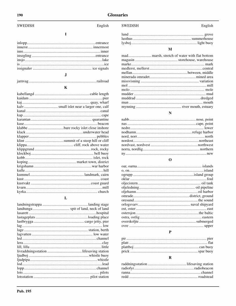
Pub. 195
190 Glossaries
I
inlopp.......................................................................entranceinnerst ................................................................... innermostinre................................................................................ innerinsegling ..................................................................entranceinsjo ................................................................................lakeis .......................................................................................iceissignaler ............................................................. ice signals
J
jarnvag ......................................................................railroad
K
kabellangd .........................................................cable lengthkaidam ............................................................................ pierkaj ...................................................................... quay, wharfkalv ................................... small islet near a larger one, calfkanal .............................................................................canalkap .................................................................................capekarantan ............................................................... quarantinekase............................................................................beaconklabbe .....................................bare rocky islet close inshoreklack ...........................................................underwater headklapper...................................................................... pebblesklint ........................................summit of a steep hill or cliffklippa................................................ cliff, rock above waterklippgrund .......................................................... rock, rockyklockboj................................................................. bell buoykobb...................................................................... islet, rockkoping.................................................. market town, districtkrigshamn............................................................war harborkulle.................................................................................hillkummel........................................................ landmark, cairnkust ............................................................................... coastkustvakt ..............................................................coast guardkvarn...............................................................................millkyrka.......................................................................... church
L
landningstrappa ............................................... landing stagelandtunga ...................................... spit of land, neck of landlasarett ......................................................................hospitallastageplats ......................................................loading placelastbrygga .................................................... cargo jetty, pierlag................................................................................... lowlage .................................................................. station, berthlagvatten ............................................................... low waterled.............................................................................channellera..................................................................................claylill, lilla .......................................................................... littlelivraddningsstation .................................... lifesaving stationljudboj ..............................................................whistle buoyljudpipa......................................................................whistlelod...................................................................................leadlopp...........................................................................channellots ............................................................................... pilotslotsstation .......................................................... pilot station
SWEDISH English
lund ............................................................................. grovelusthus ............................................................ summerhouselysboj.................................................................... light buoy
M
mad........................ marsh, stretch of water with flat bottommagasin ............................................ storehouse, warehousemarke............................................................................ markmedlerst, mellerst .......................................................centralmellan......................................................... between, middleminerada omradet................................................mined areamissvisning ............................................................ variationmol ................................................................................. millmolo ............................................................................. molemudder .......................................................................... mudmuddrad ...................................................................dredgedmun ............................................................................ mouthmynning ............................................... river mouth, estuary
N
nabb.....................................................................nose, pointnas ....................................................................... cape, pointnedre............................................................................ lowernodhamn..........................................................refuge harbornord, norr...................................................................... northnordost....................................................................northeastnordvast, nordvest .................................................northwestnorra, nordlig...........................................................northernny....................................................................................new
O
oar, oarna................................................................... islandso, on............................................................................. islandogrupp ...............................................................island groupoklar ............................................................................... fouloljecistern................................................................. oil tankoljeledning.......................................................... oil pipelineoljehamn................................................................oil harboromrade.......................................................... district, groundoresund.................................................................. the soundorlogsvarv...................................................... naval shipyardost, oster ......................................................................... eastostersjon .................................................................the balticostra, ostlig................................................................ easternoverskoljte ........................................................... submergedovre ............................................................................. upper
P
pir ................................................................................... pierplatt ................................................................................. flatplattboj ................................................................... can buoyprick ...................................................................... spar buoy
R
raddningsstation ........................................ lifesaving stationradiofyr.............................................................. radiobeaconranna......................................................................... channelredd ....................................................................... roadstead
SWEDISH English

Pub. 195
Glossaries 191
rev................................................................. reef, spit, bankrod ................................................................................... redros, rose ............................................... cairn, heap of stonesrott ................................................................................... red
S
samhalle................................................................settlementsand ...............................................................................sandsjo .................................................................................... seasjogras ..................................................................... seagrasssjomarke .................................................................. seamarksjukhus......................................................................hospitalskal .............................................................................. shellsskans................................................................. fort, redoubtskar .........................................above-water rock, rocky isletskargard .............................fringing rocks, islets, and shoalsskog ............................................................................woodsskogbevaxt................................................................woodedskorsten .................................................................. chimneyskrent .................................................................. slope, bluffskyddsomrade............................................... protection areaslatprick ........................................................plain spar buoyslick ...............................................................................oozeslip ................................................................ marine railwayslott .............................................................................. castlesluss ............................................................................... locksma ...............................................................................smallsoder, sodre, syd ...........................................................southsodra, sydlig ........................................................... southernspets.............................................................................. pointspetsboj.............................................................conical buoyspir................................................................................ spirespirboj....................................................................spar buoystad ............................................................................... townstang ......................................................................pole, sparstangda farvatter ..............................................closed watersstangmark .......................................................... pole beaconsten ...............................................................................stonestor, stora ......................................................... great or largestrand ...........................................................................beachstrom..........................................................................currentsund,sundet..................................................................soundsvart ..............................................................................black
SWEDISH English
syd, sodre .....................................................................southsydost .....................................................................southeastsydvast, sydvest.................................................... southwest
T
tavla.............................................................. board daymarktidssignal .............................................................time signaltidvatten.......................................................................... tidetidvattensdocka.......................................................wet docktippningsplats ................................................... spoil groundtopp .......................................................................... summittidssignal .............................................................time signaltidvatten.......................................................................... tidetorn .............................................................................. towertorrdocka ................................................................. drydocktrianglepunkt ........................................... triangulation pointtullkammare ....................................................custom officetunga...........................................................................tongue
U
udde.................................................... cape, point, headlandundervattenskabel....................................... submarine cableundre ........................................................................... lowerutkikstorn ....................................................... lookout tower
V
vagbrytare............................................................breakwatervaderkvarn.............................................................. windmillvall....................................................................... steep coastvarv..........................................................................shipyardvast, vest........................................................................ westvastra, vastlig............................................................ westernvatten............................................................................watervattenstandssignalstation.......................... tide signal stationvattentorn ...........................................................water towervik ........................................................................ bay, creekvit .................................................................................whitevrak .............................................................................wreckvrakboj ....................................... wreck or obstruction buoy
Y
ytstrom ..........................................................surface currentytterest.................................................................. outermostyttre, ytter ..................................................................... outer
SWEDISH English

Pub. 195
192 Glossaries
Russian—Estonian—Latvian—Lithuanian
RUSSIAN (r)ESTONIAN (e)LATVIAN (la)LITHUANIAN (li) English
A
aar (e) ........................................................................... coastabajas (e) ........................................................................ bayakmens (la) ...................................................................stonealev, -id (e).........................................market town, boroughallvett (e) ........................................................... above wateralumine (e) .........................................................lower, frontankruplats, ankrupagaid (e) ..................................anchorageasula, asundus (e) .................................................settlementaustrumi (la) ................................................................... east
B
baak (e)......................................................................beaconbakan (r) .............................................................. large buoybaklysh (r) .................................................rock above waterbalts (la)....................................................................... whitebanka (r) ............................................................. shoal, bankbar (r)............................................................................... barbashnya (r)................................................................... towerbasseyn (r) ................................................... basin, wet dockbel-yy-aya, -oye (r)...................................................... whitebereg (r) ........................................... shore, river bank, coastberegov-oy, -aya, -oye (r) .......................................... coastalberezhn-y, -aya, -oye (r) .......................inner, close offshorebochka (r) ...................................mooring buoy, barrel buoybol'sh-oy,-aya,-oye (r) ........................................ great, largebryuaga (r) ...............................................pier, landing stagebuek (r) .................................................... small boat or floatbugor (r)..............................................................hill, moundbukhta (r) .................................... bight, inlet, bay, roadsteadbukhtochka (r) ....................................................... cove, bayburun (r).................................................................... breakerbuy (r) ........................................................................... buoy
C
chern-yy, -aya, -oye (r) .................................................blackciems (la) ...................................................... village, hamlet
D
damba (r) ......................................................... seawall, dikedel'ta (r) ........................................................................ deltaderevnya (r) ............................................................... villagederevo (r) ................................................................. tree freedienvidi (la) ..................................................................southdlinn-yy, -aya, -oye (r)................................................... longdok (r)........................................................................... dockdolgota (r).............................................................. longitudedolina (r)......................................................................valleydom (r).........................................................................housedoroga (r)....................................................................... roaddyun-y, a (r) ....................................................... dunes, dune
E
edela (e)................................................................ southwestelling (r) ................................................................... slipwayezers (la)......................................................................... lake
F
faarvater (e) .................................................... channel, straitfarvater (r) ..................................................channel, fairway
G
gavan' (r) .................................................. harbor, basin, bayglubok-iy, -aya, -oye (r) ................................................deepgolets, gol'tsy (r) ..........................................mountain, peakgolomyann-yy, -aya, -oye (r)...................................open seagolova (r).........................................................head (of pier)gora (r) ...........................................................mountain, hillgorlo (r) ........................................................................ straitgorod (r) ................................................................city, towngorodok (r) .......................................................... small towngranitsa (r) ............................................................. boundarygreben (r)...................................................................... ridgegrund (e)....................................................................... shoalgryada, gryady (r)..................... mountains, hill, bank, ridgeguba.............................................................arm, recess, bay
H
haabjas (e) ......................................................................boathall (e) ........................................................................... grayhoone (e) ..................................................................... house
I
ida (e) ............................................................................. eastil (r) ............................................................................... mudilist-yy, -aya, -oye (r)................................................. muddy
J
jaa (e) ...............................................................................icejaam (e) ........................................................ railroad stationjame (e) ............................................................. thick, heavyjarsk (e) ........................................................................ steepjarv, -ed (e) ..................................................................... lakejoesuu (e)............................................................ river mouthjoed (e) .........................................................................riversjogi (e) ........................................................................... riverjoom (e) ........................................................ reef, sand bank
K
kaevand (e) ............................................................... channelkagu (e) ..................................................................southeastkai (e) ............................................................................quay
RUSSIAN (r)ESTONIAN (e)LATVIAN (la)LITHUANIAN (li) English

Pub. 195
Glossaries 193
kalasadam (r) ..................................................fishing harborkalda (e)........................................................................ coastkalju (e) ......................................................................... rockkallas (e) .......................................................................shorekallutus (e)...................................................................... tidekalnas (li )........................................................................hillkamen' (r) ............................................................rock, stonekamennyy (r) ..................................... masonry, stony, rockykamni (r)...........................................................rocks, stoneskamyennaya banka (r) ........................................rocky shoalkamyennaya gryada (r)................................................... spitkanal (e)........................................................................canalkanal (r) ......................................................... channel, canalkants (e) .......................................................................... fortkapp (e)..........................................................................capekare (e) ............................................................... grassy isletkari (e) ................................................... reef, shallow, shoalkarestik ......................................................... rapids, cataractkarestiku (e)...........................................................waterfallskari (e) ..............................................................reef, shallowkekur (r)...............................................................pillar, rockkesk (e) ......................................................... middle, centralkeskmine (e) ................................................. middle, centralkevad (e) ..................................................................... springkholm (r).................................................................... hillockkhram (r).................................................................... templekhrebet (r)....................... ridge, mountain range, mountainskindlus (e)....................................................................... fortkink (e) ............................................................................hillkirde (e) ..................................................................northeastkirik, kirikud (e) ........................................................ churchkitsus (e) .................................................................. narrowskivi (e) .................................................................stone, rockkoleno (r) ............................. reach (of a channel, etc.), bendkollane (e).................................................................. yellowkorga (r)..............................................................rocky shoalkorge (e) ........................................................................ highkorotk -iy, -aya, -oye (r) ............................................... shortkorsten (e)............................................................... chimneykosa (r)............................................................................ spitkoshka (r).......................................................... drying shoalkosk (e)....................................................... waterfall, rapidskovsh (r) ........................................................................covekran (r)..........................................................................cranekrasn-yy, -aya, -oye (r) .................................................... redkrest (r) ......................................................................... crosskrutoy, -aya, -oye, -ye (r).............................................. steepkruus (e) ..................................................................... gravelkryazh (r) ............................................ ridge, hill, mountainskuiv (e) ............................................................................drykungas (r) ............................................... flat-bottomed craftkurk (e) ............................................... channel, strait, soundkula, -d (e) ................................................................. villagekulm (e) ......................................................................... coldkultuk (r)......................................................................... bay
RUSSIAN (r)ESTONIAN (e)LATVIAN (la)LITHUANIAN (li) English
kungas (e)........................................................................ hillL
laas, laane (e) ................................................................ westlaev (e).........................................................................vessellaevasild (e) .................................................................... pierlaguna (r) ....................................................................lagoonlaht (e) ............................................bay, inlet, sound, harborlaid (e) ......................................................................... islandlainetemurd (e) ........................................................ breakerslakhti (r) ..............................................bay, cove, bight, gulfled (r)................................................................................icelednik (r).....................................................................glacierlesnoy (r) .......................................................wooded, forestliiva kunkad (e) ...................................................sand dunesliivakivi (e) ............................................................sandstoneliman (r) .......................................estuary, lake, lagoon, baylinn (e) ...................................................................town, citylodu (e) ................................................................bog, marshloode, loe (e) .........................................................northwestloots (e) ......................................................................... pilotloss (e) ......................................................................... castlelotsman (r) ..................................................................... pilotlotsmanskaya stantsiya (r)................................. pilot stationlouna (e) .......................................................................southlounaida (e) ............................................................southeastlounalaane (e)....................................................... southwestluda, ludka (r)............................................. small rocky isletlumi (e)......................................................................... snowlyuna (e) .......................................................................south
M
maa (e) ....................................................... shoal, islet, landmaabumis sild (e) ............................................ landing stagemaamark (e) .......................................................... landmarkmachta (r) ......................................................................mastmadal (e) ................................................ low, shallow, shoalmadal vesi (e) ........................................................low watermadalik, -ud (e) ................................................ shoal, shoalsmalen'k -iy, -aya, -oye (r) ................................... little, smallmal -yye, -aya, -oye (r) ...................................... little, smallmarios (li)...................................................................lagoonmaterik (r) .............................................mainland, continentmaed (e) ......................................................mountains, hillsmagi (e) .......................................................... mountain, hillmarkpuu (e) ................................................conspicuous treemayak (r) ..............................................................lighthousemel' (r).......................................................................... shoalmelk -iy, -aya, -oye (r) ................................... shallow, shoalmelkovodn -y, -aya, -oye (r)..................................... shallowmerekael (e) ...................................................... sound, straitmerelaht (e) ............................................................ gulf, baymeremark (e) ........................................................... seamarkmererand (e ) ...........................................................seashoremererohi (e)............................................................. seaweed
RUSSIAN (r)ESTONIAN (e)LATVIAN (la)LITHUANIAN (li) English
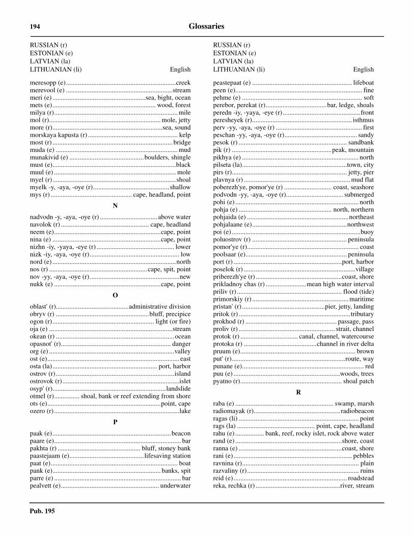
Pub. 195
194 Glossaries
meresopp (e).................................................................creekmerevool (e) ...............................................................streammeri (e) .......................................................sea, bight, oceanmets (e)............................................................. wood, forestmilya (r)......................................................................... milemol (r).................................................................. mole, jettymore (r).................................................................sea, soundmorskaya kapusta (r) ..................................................... kelpmost (r) ....................................................................... bridgemuda (e) ........................................................................ mudmunakivid (e) ............................................boulders, shinglemust (e).........................................................................blackmuul (e) ........................................................................ molemyel (r).........................................................................shoalmyelk -y, -aya, -oye (r).............................................shallowmys (r) ................................................ cape, headland, point
N
nadvodn -y, -aya, -oye (r) .................................. above waternavolok (r) .................................................... cape, headlandneem (e)...............................................................cape, pointnina (e) ................................................................cape, pointnizhn -iy, -yaya, -eye (r) .............................................. lowernizk -iy, -aya, -oye (r)..................................................... lownord (e) .........................................................................northnos (r) ..........................................................cape, spit, pointnov -yy, -aya, -oye (r).....................................................newnukk (e) ...............................................................cape, point
O
oblast' (r)...........................................administrative divisionobryv (r) .......................................................bluff, precipiceogon (r)............................................................ light (or fire)oja (e) .........................................................................streamokean (r) ......................................................................oceanopasnot' (r)................................................................. dangerorg (e) ..........................................................................valleyost (e).............................................................................. eastosta (la).............................................................. port, harborostrov (r) ......................................................................islandostrovok (r) .....................................................................isletosyp' (r)...................................................................landslideotmel (r)............... shoal, bank or reef extending from shoreots (e)...................................................................point, capeozero (r) ..........................................................................lake
P
paak (e)......................................................................beaconpaare (e)........................................................................... barpakhta (r) ................................................. bluff, stoney bankpaastejaam (e)............................................ lifesaving stationpaat (e)........................................................................... boatpank (e)................................................................ banks, spitparre (e) ........................................................................... barpealvett (e).......................................................... underwater
RUSSIAN (r)ESTONIAN (e)LATVIAN (la)LITHUANIAN (li) English
peastepaat (e) ........................................................... lifeboatpeen (e)........................................................................... finepehme (e) ....................................................................... softperebor, perekat (r)....................................bar, ledge, shoalsperedn -iy, -yaya, -eye (r)..............................................frontperesheyek (r)........................................................... isthmusperv -yy, -aya, -oye (r) ................................................... firstpeschan -yy, -aya, -oye (r)........................................... sandypesok (r) ................................................................ sandbankpik (r) ...........................................................peak, mountainpikhya (e) ..................................................................... northpilseta (la)..............................................................town, citypirs (r).................................................................... jetty, pierplavnya (r) ............................................................... mud flatpoberezh'ye, pomor'ye (r) ............................ coast, seashorepodvodn -yy, -aya, -oye (r).................................. submergedpohi (e) ......................................................................... northpohja (e) ....................................................... north, northernpohjaida (e) ............................................................northeastpohjalaane (e)........................................................northwestpoi (e) ............................................................................buoypoluostrov (r) ........................................................ peninsulapomor'ye (r).................................................................. coastpoolsaar (e)............................................................ peninsulaport (r) ................................................................port, harborposelok (r) ..................................................................villagepriberezh'ye (r) ...................................................coast, shoreprikladnoy chas (r) ........................mean high water intervalpriliv (r) .............................................................. flood (tide)primorskiy (r) ......................................................... maritimepristan' (r) .................................................pier, jetty, landingpritok (r) ..................................................................tributaryprokhod (r) ...................................................... passage, passproliv (r) ......................................................... strait, channelprotok (r) .................................. canal, channel, watercourseprotoka (r) ...........................................channel in river deltapruum (e).................................................................... brownput' (r)...................................................................route, waypunane (e)........................................................................ redpuu (e) ...............................................................woods, treespyatno (r)............................................................ shoal patch
R
raba (e) .......................................................... swamp, marshradiomayak (r)................................................... radiobeaconragas (li) ....................................................................... pointrags (la) .............................................. point, cape, headlandrahu (e) ................. bank, reef, rocky islet, rock above waterrand (e) ...............................................................shore, coastranna (e) .............................................................coast, shorerani (e) ...................................................................... pebblesravnina (r)..................................................................... plainrazvaliny (r).................................................................. ruinsreid (e) ................................................................... roadsteadreka, rechka (r) ..................................................river, stream
RUSSIAN (r)ESTONIAN (e)LATVIAN (la)LITHUANIAN (li) English
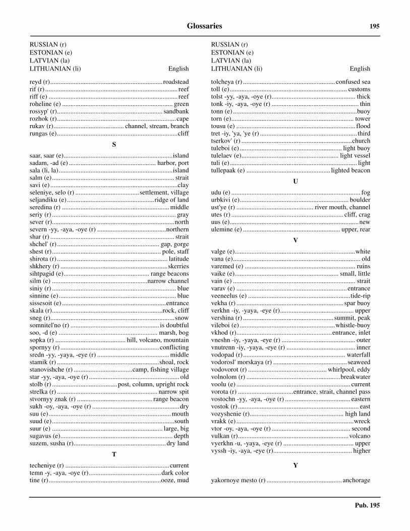
Pub. 195
Glossaries 195
reyd (r)................................................................... roadsteadrif (r) ............................................................................... reefriff (e) ............................................................................. reefroheline (e) .................................................................. greenrossyp' (r)............................................................... sandbankrozhok (r).......................................................................caperukav (r).......................................... channel, stream, branchrungas (e)........................................................................cliff
S
saar, saar (e).................................................................islandsadam, -ad (e) .................................................... harbor, portsala (li, la)....................................................................islandsalm (e)......................................................................... straitsavi (e) ............................................................................clayseleniye, selo (r) ......................................settlement, villageseljandiku (e) ....................................................ridge of landseredina (r) ................................................................ middleseriy (r) .......................................................................... graysever (r).........................................................................northsevern -yy, -aya, -oye (r) .........................................northernshar (r) .......................................................................... straitshchel' (r) ............................................................. gap, gorgeshest (r)................................................................. pole, staffshirota (r) .................................................................. latitudeshkhery (r) ................................................................skerriessihtpagid (e)................................................... range beaconssilm (e) .........................................................narrow channelsiniy (r) .......................................................................... bluesinnine (e)...................................................................... bluesissesoit (e) ..............................................................entranceskala (r)..................................................................rock, cliffsneg (r)..........................................................................snowsomnitel'no (r) ..................................................... is doubtfulsoo, -d (e) ........................................................... marsh, bogsopka (r) .......................................... hill, volcano, mountainspornyy (r) ...........................................................conflictingsredn -yy, -yaya, -eye (r) ........................................... middlestamik (r) .............................................................shoal, rockstanovishche (r) ...................................camp, fishing villagestar -yy, -aya, -oye (r) ...................................................... oldstolb (r) .......................................post, column, upright rockstrelka (r) ............................................................ narrow spitstvornyy znak (r) ............................................. range beaconsukh -oy, -aya, -oye (r) ....................................................drysuu (e).........................................................................mouthsuud (e).........................................................................southsuur (e) .................................................................. large, bigsugavus (e)................................................................... depthsuzem, susha (r)....................................................... dry land
T
techeniye (r) ..............................................................currenttemn -y, -aya, -oye (r)...........................................dark colortine (r)...................................................................ooze, mud
RUSSIAN (r)ESTONIAN (e)LATVIAN (la)LITHUANIAN (li) English
tolcheya (r) ....................................................... confused seatoll (e)...................................................................... customstolst -yy, -aya, -oye (r).................................................. thicktonk -iy, -aya, -oye (r) .................................................... thintonn (e) ..........................................................................buoytorn (e)......................................................................... towertousu (e) ....................................................................... floodtret -iy, 'ya, 'ye (r) .......................................................... thirdtserkov' (r) ..................................................................churchtuleboi (e) ............................................................. light buoytulelaev (e).......................................................... light vesseltuli (e)............................................................................ lighttullepaak (e) .................................................. lighted beacon
U
udu (e) ............................................................................. fogurbkivi (e)................................................................. boulderust'ye (r) .............................................. river mouth, channelutes (r) ................................................................... cliff, craguus (e).............................................................................newulemine (e) .......................................................... upper, rear
V
valge (e)........................................................................whitevana (e)............................................................................ oldvaremed (e) .................................................................. ruinsvaike (e).............................................................. small, littlevain (e) ......................................................................... straitvarav (e) .................................................................. entranceveeneelus (e) .............................................................tide-ripvekha (r) ................................................................ spar buoyverkhn -iy, -yaya, -eye (r)............................................ uppervershina (r) ...................................................... summit, peakvileboi (e) .........................................................whistle-buoyvkhod (r).........................................................entrance, inletvneshn -iy, -yaya, -eye (r) ............................................ outervnutrenn -iy, -yaya, -eye (r) ......................................... innervodopad (r)............................................................. waterfallvodorosl' morskaya (r) ............................................ seaweedvodovorot (r) ............................................... whirlpool, eddyvolnolom (r) ........................................................breakwatervoolu (e) .................................................................... currentvorota (r) .................................entrance, strait, channel passvostochn -yy, -aya, -oye (r) ....................................... easternvostok (r) ........................................................................ eastvozyshenie (r)........................................................ high landvrakk (e) ......................................................................wreckvtor -oy, -aya, -oye (r) ............................................... secondvulkan (r)..................................................................volcanovyerkhn -u, -yaya, -eye (r) .......................................... uppervyssh -iy, -aya, -eye (r)............................................... higher
Y
yakornoye mesto (r) ............................................. anchorage
RUSSIAN (r)ESTONIAN (e)LATVIAN (la)LITHUANIAN (li) English

Pub. 195
196 Glossaries
Yar(y) (r)............................................. cliff(s), steep bank(s)yug (r)...........................................................................southyuzhn -yy, -aya, -oye (r) ......................................... southern
Z
zadn -iy, -yaya, -eye (r) .................................................. rearzaimka (r) ................................................... settlement, farmzaliv (r) .......................................................... gulf, bay, inletzamok (r) ..................................................................... castlezapad (r) ........................................................................west
RUSSIAN (r)ESTONIAN (e)LATVIAN (la)LITHUANIAN (li) English
zapadn -yy, -yaya, -oye (r) ....................................... westernzastruga (r) ............................... sandbar, sandspit, sandbankzavod (r) .................................................. factory, mill, plantzavod' (r) .............................................................. cove, inletzelen -yy, -aya, -oye (r) ................................................greenzemlya (r) ........................................................... land, islandzhelt -y, -aya, -oye (r).................................................yellowznak (r) ............................................................beacon, markzona (r) ..........................................................................zonezvelav'ye (r)......................................................... cape, point
RUSSIAN (r)ESTONIAN (e)LATVIAN (la)LITHUANIAN (li) English

Pub. 195
Glossaries 197
Finnish
FINNISH English
A
alempi .......................................................................... lowerankkuripaikka........................................................ roadsteadankkuripohja.........................................................anchorageaukko ..............................................................strait, channel
E
etela ..............................................................................southetelainen ................................................................. southern
H
hieta, hiekka ..................................................................sand
I
iso ....................................................................... great, largeita.................................................................................... eastitainen ........................................................................eastern
J
jaa .....................................................................................icejarvi ................................................................................lakejoki.................................................................................riverjyrkka.............................................................................bluff
K
kallio.................................................... rock, cliff, mountainkanaali ......................................................................channelkannas.......................................................................isthmuskanava.......................................................................channelkari............................................................ reef, shoal, islandkaupunki ................................................................city, townkello................................................................................ bellkeltainen .................................................................... yellowkirkko ........................................................................ churchkivi.......................................................................rock, stonekumpeli......................................................................beaconkyla ............................................................................ villagekynnys ............................................................................. bar
L
lahti.......................................................bay, gulf, cove, inletlaituri ............................................................pier, quay, jettylaivaranta ........................................................... wharf, quaylansi ...............................................................................westlantinen.....................................................................westernlieju................................................................................ mudlinna..................................................................... fort, castlelinnotus ........................................................................... fortloisto .............................................................................. lightluoto.............................. island, shoal, peninsula, rocky isletluotsi ............................................................................ pilots
M
majakka .................................................. lighthouse, beaconmaki................................................................ hill, mountainmatala.................................................... shallow, shoal bankmatalikko............................................................ bank, shoalmeri ...................................................................... sea, oceanmerimerkki.................................................beacon, seamarkmerkki ..................................................................mark, signmetsa ........................................................................... forestmusta ............................................................................blackmuta............................................................................... mud
N
niemeke ......................................................... point (of land)niemi ...................................... peninsula, point, cape, island
P
pieni..............................................................................smallpikku .................................................................. small, littlepohja.................................................. north, bottom, groundpohjoinen.................................................................northernpoiju ..............................................................................buoypookin ......................................................................... towerpunainen.......................................................................... redpurjehdusmerkki .............................................beacon, markpuro ............................................................................stream
R
rannikko ....................................................................... coastranta.........................................................shore, beach, bankreimari ................................................................... spar buoyreitti ....................................................strait, course, channelreivi ................................................................................ reefriutta ............................................................................... reef
S
saari ............................... island, section of island, peninsulasalmi....................................................... strait, channel, baysatama ........................................................................ harborsavi .................................................................................clayselka ............................................................... body of watersilta..................................................................... bridge, piersininen ............................................................................bluesisa.....................................................................inside, innersisamainen.................................................................... innersora..............................................................................gravelsuomi......................................................................... finlandsuu ......................................................mouth, entrance, inletsuuri....................................................................... big, great
T
taipale....................................................................... isthmustalo................................................................house, buildingtie....................................................................... road, course
FINNISH English

Pub. 195
198 Glossaries
torni ................................................................ tower, steepletulli .......................................................................... customstumma............................................................................ dark
U
ulkomainen ................................................................... outer
V
vaalea................................................................. light (color)vaara ...............................................................hill, mountain
FINNISH English
valkoinen......................................................................whitevayla ...........................................................channel, fairwayvesi ................................................................. body of waterviheria, vihrea ..............................................................greenviitta ...................................................................... spar buoyvuori ...................................................................... mountain
Y
ylempi ......................................................................... upper
FINNISH English

Sec. Para.
199
Pub. 195
How to use the Index—Gazetteer
Geographic names of navigational features are generally those used by the nation having sovereignty and are listedalphabetically. Diacritical marks, such as accents, cedillas, and circumflexes, which are related to specific letters in certain foreignlanguages, are not used in the interest of typographical simplicity.
Geographic names or their spellings do not necessarily reflect recognition of the political status of an area by the United StatesGovernment. Positions are approximate and are intended merely as locators to facilitate reference to the charts.
To use as a Gazetteer note the position and Sector number of the feature and refer to the Chart Information diagram for theSector. Plot the approximate position of the feature on this diagram and note the approximate chart number.
To use as an Index of features described in the text note the paragraph number at the right. To locate this feature on the bestscale chart use the Gazetteer procedure above.
Index—Gazetteer
Position° ' ° '
Position° ' ° '
Sec. Para.
AABORDSSUNDET 62 46 N 17 58 E 6.40AEGNA LIGHT 59 36 N 24 44 E 1.8AGO LIGHT 61 33 N 17 28 E 6.23AHVENAN-MEREN CHANNEL 59 32 N 20 18 E 4.6AJAX SHOAL 59 44 N 23 13 E 2.4ALA 61 13 N 17 10 E 6.19ALAND ISLANDS 60 05 N 19 47 E 4.9ALANDSFJARDEN 62 40 N 17 56 E 6.40ALMON 62 23 N 17 28 E 6.31ALNOSUNDET 62 26 N 17 24 E 6.32ANGERMANALVEN 62 48 N 17 58 E 6.43ANGESON 63 44 N 20 54 E 8.20ARGON 61 33 N 17 27 E 6.23ARGOS GRUND LIGHT 60 38 N 18 22 E 5.11ARHOLMA 59 50 N 19 07 E 5.2ARKHIPELAG BOL’SHOY FISKAR 60 24 N 27 56 E 2.23ARMBAGEN 59 38 N 19 58 E 4.4ARMBAGEN 64 41 N 21 26 E 9.11ARNOVIKEN 61 43 N 17 24 E 6.27ARTUNMATALA 65 15 N 24 07 E 10.10ASKJA 63 01 N 18 13 E 6.49ASTHOLMSUDDE 62 23 N 17 44 E 6.31AVIKREBUKTEN 62 28 N 17 44 E 6.37AXELSVIK 65 46 N 23 22 E 9.24
BBALSON 61 43 N 17 32 E 6.27BANKA RUISMATALA 60 25 N 28 13 E 2.23BANKA SHREDNYAYA 60 11 N 28 20 E 2.30BARSTAHAMN 62 52 N 18 24 E 6.46BEKKERI 59 27 N 24 40 E 1.10BENGTSKAR 59 43 N 22 30 E 4.2BERGO LIGHT 61 49 N 17 25 E 6.28BERGOFJARDEN 63 15 N 19 02 E 6.53BERGSKARET 64 48 N 21 07 E 9.11BERGUDDEN LIGHT 63 47 N 20 51 E 8.20BJORN BEACON 60 57 N 17 14 E 6.11BJORN LIGHT 60 38 N 17 59 E 5.11BJUREN 63 45 N 20 36 E 8.10BJUROKLUBB 64 29 N 21 35 E 9.7BLACKKALLEN LIGHT 64 20 N 21 31 E 9.7BLOMMAN 61 12 N 17 16 E 6.15BOGSKAR 59 30 N 20 21 E 4.4BOISTO 60 20 N 26 30 E 2.14BOKULLANKIVI LIGHT 59 51 N 21 25 E 4.3BOLLSTA 62 59 N 17 42 E 6.45BONAN LIGHT 60 44 N 17 19 E 6.5BONDEN 63 26 N 20 03 E 8.3BONDENSGRUND 63 28 N 19 46 E 8.3BORUSSIAGRUND LIGHT 65 21 N 22 16 E 9.15BRAMON 62 13 N 17 43 E 6.30BRANNFORS 65 01 N 21 24 E 9.14BREDNORET 63 56 N 20 48 E 8.11BREDSKAR 63 40 N 20 20 E 8.7BRITAS KLACK 61 53 N 17 28 E 6.28
BUREA 64 37 N 21 14 E 9.9BYSKE 64 57 N 21 14 E 9.13BYVIKEN 62 33 N 17 53 E 6.37BYVIKEN 63 48 N 20 52 E 8.20
CCAMPSGRUND 60 42 N 17 51 E 6.2
DDEGERFJARDEN 63 24 N 19 20 E 6.55DIGSKAR 60 10 N 26 16 E 2.12DOCKSTA 63 03 N 18 20 E 6.49DOMMASKAR 59 45 N 22 30 E 4.2DRAGHALLAN LIGHT 62 20 N 17 26 E 6.32
EEDSATTERFJARDEN 62 54 N 18 27 E 6.48EDVARDSLACK 65 15 N 22 34 E 9.16EFESGRUND 63 23 N 19 47 E 8.3EGGEGRUND LIGHT 60 44 N 17 34 E 6.4ELINSGRUND 63 19 N 19 53 E 8.2EMSALO 60 15 N 25 37 E 2.12ENSJKAR 61 14 N 17 17 E 6.14ESPOONLAHTI 60 05 N 24 40 E 2.10EURAJOKI 61 15 N 21 30 E 7.10EYSTRASALTBANKEN 61 46 N 18 52 E 6.28
FFABODVALLSHARARNA 61 12 N 17 11 E 6.15FADIKARI 61 44 N 21 18 E 7.13FALKENSGRUND 65 01 N 22 41 E 9.16FALKGRUND 63 51 N 20 53 E 8.20FALLISKAR BEACON 63 04 N 20 48 E 8.13FANBYVIKEN 63 20 N 19 13 E 6.53FARSTUGRUNDEN LIGHT 65 20 N 22 45 E 9.19FARSTUGRUNDET LIGHT 65 20 N 22 45 E 9.16FINNGRUNDEN 60 59 N 18 36 E 6.3FINNGRUNDET LIGHT 60 59 N 18 36 E 6.3FINNHALLAN 64 47 N 21 15 E 9.11FISKE 61 31 N 17 13 E 6.22FJARDGRUND LIGHT 63 40 N 20 20 E 8.7FLASAN LIGHT 63 01 N 18 41 E 6.50FLOTJAN 59 49 N 19 47 E 4.5FORSMARK 60 24 N 18 13 E 5.7FURUOGRUND 64 55 N 21 14 E 9.13
GGARDFJARDEN 64 28 N 21 43 E 9.8GASHALLAN 61 01 N 17 17 E 6.10
200 Index—Gazetteer
Pub. 195
Position° ' ° '
Position° ' ° '
Sec.Para
Sec.Para
GASHALLAN 62 35 N 21 03 E 7.19GASOREN LIGHT 64 40 N 21 19 E 9.10GASSKVATTAN BEACON 60 11 N 26 03 E 2.12GAVAN VYSOTSK 60 37 N 28 34 E 2.25GAVIKSFJARDEN 62 52 N 18 16 E 6.46GAVLE 60 41 N 17 10 E 6.7GETABERGET 60 23 N 19 51 E 4.11GISSLAN 60 10 N 19 18 E 4.10GNAGGEN LIGHT 62 57 N 18 37 E 6.49GRAN 62 01 N 17 38 E 6.29GRASKARSBADAN LIGHT 60 02 N 24 54 E 2.10GRETASKLACKAR 61 30 N 17 46 E 6.23GRILLKLIPPAN 65 23 N 22 31 E 9.16GRISSLEHAMN 60 06 N 18 49 E 5.3GROSSGRUNDEN 63 39 N 20 51 E 8.20GRUNDKALLEN LIGHT 60 30 N 18 51 E 5.10GRUNDSKATEN 64 26 N 21 37 E 9.7GUBBEN LIGHT 62 21 N 17 35 E 6.31GUMBODA 64 14 N 21 06 E 9.4GUNVORSGRUND LIGHT 63 29 N 20 27 E 8.7GUSTAVSVIK 62 50 N 17 53 E 6.44
HHAAPASAARI 60 17 N 27 12 E 2.16HAILUOTO 65 03 N 24 49 E 10.10HALLGRUND 63 39 N 22 25 E 10.2HALLGRUND LIGHT 61 17 N 17 24 E 6.20HALLSTAVIK 60 03 N 18 35 E 5.5HALSAREN 60 13 N 18 55 E 5.10HALSOKLIPPOR LIGHT 65 43 N 23 27 E 9.21HAMINA 60 34 N 27 12 E 2.19HAMMARUDDA 60 05 N 19 46 E 4.9HAMNSKAR 60 13 N 26 18 E 2.14HANKO 59 49 N 22 57 E 2.3HANKONIEMI 59 49 N 22 54 E 2.2HAPARANDA 65 50 N 24 08 E 9.26HARGSHAMN 60 11 N 18 27 E 5.6HARKMERI 62 12 N 21 20 E 7.15HARMAJA LT 60 06 N 24 59 E 2.11HARNOKLUBB LIGHT 62 36 N 18 04 E 6.38HARNON 62 36 N 17 59 E 6.38HARNOSAND 62 38 N 17 56 E 6.42HELLNAS 63 17 N 22 14 E 8.16HELSINGKALLAN 63 36 N 21 50 E 8.15HELSINKI 60 10 N 24 58 E 2.11HELSINKI LIGHT 59 57 N 24 56 E 2.10HEMSON 62 43 N 18 05 E 6.39HERTSOBERGET 65 36 N 22 12 E 9.19HEVOSKARI 64 12 N 23 34 E 10.7HIETAKARI 60 24 N 27 00 E 2.17HIMANKA 64 04 N 23 39 E 10.6HOGBERGET 65 08 N 21 30 E 9.17HOGBONDEN LIGHT 62 52 N 18 29 E 6.47HOGGRUND 59 55 N 24 02 E 2.8HOGSTEN 60 21 N 19 27 E 4.12HOLICKSKAR LIGHT 61 37 N 17 27 E 6.24HOLMOARNE 63 40 N 20 52 E 8.19HOLMOGADD 63 36 N 20 47 E 8.21HOLMON 63 47 N 20 54 E 8.20HOLMSUND 63 42 N 20 21 E 8.9HOLMUDDSTRANNAN 60 44 N 17 20 E 6.5HOPPETSGRUND 60 22 N 18 53 E 5.10HORNEFORS 63 37 N 19 54 E 8.5HUDIKSGRUND 61 36 N 17 25 E 6.24HUDIKSVALL 61 35 N 17 28 E 6.24HUDIKSVALL 61 44 N 17 07 E 6.25HUGINSGRUND 63 34 N 20 46 E 8.21HULKARI OTS LIGHT 59 32 N 24 34 E 1.8HUNDGRUND 62 07 N 17 48 E 6.30HUSUM 63 20 N 19 09 E 6.54HYLKKARI LIGHT 60 57 N 21 10 E 7.3
IIGGESUND 61 38 N 17 07 E 6.26IGGON LIGHT 60 52 N 17 18 E 6.4IHASALU NINA 59 32 N 25 09 E 1.13IIN ROYTTA 65 16 N 25 12 E 10.12
INKOO 60 01 N 23 58 E 2.9ISOARI 60 43 N 21 01 E 4.11ISOKARI 60 43 N 21 01 E 7.2
JJAGAROREN 63 41 N 20 55 E 8.20JARNASHAMN 63 26 N 19 41 E 8.2JARNASUDDE 63 26 N 19 39 E 8.2JARNGRYNNORNA 60 34 N 19 53 E 4.12JATTHOLMARNA 61 57 N 17 31 E 6.29JUDASTERNARNE 62 40 N 20 45 E 7.19JUMINDA NINA LIGHT 59 39 N 25 31 E 1.13JURMO 59 50 N 21 36 E 4.2JUSSARO 59 50 N 23 34 E 2.7
KKABERNEEME LAHT 59 32 N 25 14 E 1.13KADETTEN 65 23 N 22 41 E 9.16KAGEFJARDEN 64 49 N 21 07 E 9.11KAGEHAMN 64 50 N 21 02 E 9.12KAGNASHALLAN LIGHT 64 45 N 21 18 E 9.11KAIJAKARI LIGHT 61 37 N 21 22 E 7.11KAJAKULMA LIGHT 61 00 N 21 11 E 7.3KALAJOKI 64 16 N 23 56 E 10.7KALBADAGRUND 59 59 N 25 36 E 2.12KALLA LIGHT 61 16 N 21 21 E 7.10KALLAN 60 27 N 19 45 E 4.12KALLAN LIGHT 63 45 N 22 32 E 10.2KALLEN 65 28 N 22 43 E 9.16KALLERO 60 21 N 18 16 E 5.7KALLVIKEN 64 20 N 21 22 E 9.6KALLVIKSKLUBBEN 64 18 N 21 23 E 9.6KANTLAX 63 25 N 22 18 E 8.16KANTVIK 60 05 N 24 23 E 2.10KARINGSKAR 63 54 N 20 51 E 8.10KARLSBORG 65 48 N 23 17 E 9.24KARSKAR 60 40 N 17 18 E 6.9KASKINEN 62 23 N 21 14 E 7.18KASKO 62 23 N 21 14 E 7.18KASSALA 61 57 N 21 21 E 7.14KATTGRUNDET 62 16 N 17 45 E 6.31KAVONSELKA 60 28 N 27 48 E 2.22KEJVSALO FJARDEN 60 22 N 26 08 E 2.14KEMI 65 44 N 24 34 E 10.14KEMI 1 LIGHT 65 23 N 24 06 E 10.12KEMI 2 LIGHT 65 30 N 24 22 E 10.12KEMINKRAASELI LIGHT 65 37 N 24 34 E 10.13KERI SAAR 59 42 N 25 01 E 1.3KHEMMINGINLETTO 60 27 N 27 50 E 2.22KILPISAARI 60 17 N 27 18 E 2.20KINNBACKSFJARDEN 65 03 N 21 28 E 9.14KIVILETTO 60 18 N 26 57 E 2.17KLINGERFJARDEN 62 29 N 17 28 E 6.35KOIVISTON SALMI 60 28 N 28 30 E 2.28KOKKOLA 63 51 N 23 06 E 10.5KOKKOLA LIGHT 64 00 N 22 52 E 10.4KOKSNAN 60 28 N 19 57 E 4.13KOPLI LAHT 59 27 N 24 39 E 1.8KOPMANHOLMEN 63 10 N 18 35 E 6.51KOPPARGRUNDET BEACON 63 56 N 22 43 E 10.4KOTKA 60 28 N 26 58 E 2.18KOTKAN MAJAKKA LIGHT 60 10 N 26 39 E 2.16KOVERHAR 59 55 N 23 19 E 2.5KOXNAN 60 28 N 19 57 E 4.13KRAKSKAR LIGHT 61 34 N 17 20 E 6.24KRAMFORS 62 56 N 17 48 E 6.45KRISTIINANKAUPUNGIN LIGHT 62 12 N 21 10 E 7.15KRISTIINANKAUPUNKI 62 17 N 21 24 E 7.16KRISTINESTAD 62 17 N 21 24 E 7.16KRONSHTADT 59 59 N 29 47 E 3.4KUNDA LAHT 59 32 N 26 32 E 1.16KUNDA SADAM 59 32 N 26 32 E 1.16KUORSALO 60 28 N 27 23 E 2.20KUPELI LIGHT 61 38 N 21 20 E 7.11KUSON 61 02 N 17 14 E 6.13KYLMAPIHLAJA LIGHT 61 09 N 21 18 E 7.6KYLORN 63 32 N 19 46 E 8.4

Index—Gazetteer 201
Pub. 195
Position° ' ° '
Position° ' ° '
Sec.Para
Sec.Para
LLAGSKAR 59 50 N 19 55 E 4.5LAHEPERE LAHT 59 22 N 24 12 E 1.8LAITAKARI LIGHT 61 03 N 21 13 E 7.5LALATTA LIGHT 60 17 N 26 33 E 2.14LANGDEN 59 47 N 23 15 E 2.4LANGHAREN 60 41 N 17 17 E 6.9LANGROUDDEN 63 24 N 19 31 E 6.55LAPPOHJA 59 54 N 23 16 E 2.5LARSGRUNDET LIGHT 65 28 N 22 28 E 9.16LASKER 64 18 N 21 21 E 9.6LELLERINSAARET 60 24 N 26 58 E 2.17LEPANEN 64 14 N 23 39 E 10.7LETIPEA NEEM 59 33 N 26 37 E 1.16LILLA TARNSKAR 59 45 N 22 58 E 2.2LILLBADAN LIGHT 63 39 N 20 21 E 8.7LILLGRUND 62 03 N 17 40 E 6.30LILLGRUNDET 63 51 N 22 37 E 10.4LILLHALLANSGRUND 63 49 N 20 52 E 8.20LILLHARUN 59 44 N 21 24 E 4.3LIMO LIGHT 60 43 N 17 22 E 6.5LJUSNE 61 12 N 17 08 E 6.17LJUSNEFJARDEN 61 13 N 17 12 E 6.15LOKSA SADAM 59 35 N 25 42 E 1.14LOMONOSOV 59 55 N 29 46 E 3.5LONDONSKAYA OTMEL 59 59 N 29 30 E 3.3LORDAGSHALLAN 63 26 N 19 54 E 8.3LORUDDEN 62 14 N 17 40 E 6.30LOTSGRUND LIGHT 63 11 N 20 43 E 8.14LOVIISA 60 27 N 26 14 E 2.15LOVISA 60 27 N 26 14 E 2.15LOVSELE 64 18 N 21 15 E 9.5LOVSTABUKTEN 60 38 N 17 45 E 6.2LUGNVIK 62 56 N 17 55 E 6.44LULEA 65 35 N 22 10 E 9.19LUNDE 62 53 N 17 53 E 6.44LUNGON 62 39 N 18 04 E 6.38LUNGOSUNDET 62 40 N 18 03 E 6.40LUODEMATALA LIGHT 65 10 N 25 00 E 10.10LUPPI 60 14 N 27 02 E 2.17LUTSKARSGRUND LIGHT 65 40 N 23 20 E 9.21LUZHSKAYA GUBA 59 44 N 28 19 E 1.21LYOKKI TOWER 60 56 N 21 08 E 7.4
MMAARIANHAMINA 60 06 N 19 55 E 4.8MAJAKARTTI 60 19 N 27 35 E 2.20MAKIHUOTO 59 55 N 24 20 E 2.8MALOREN 65 32 N 23 34 E 9.20MALOREN LIGHT 65 32 N 23 34 E 9.20MANTYLUOTO 61 36 N 21 29 E 7.12MARHALLAN 60 02 N 19 52 E 4.7MARIEHAMN 60 06 N 19 55 E 4.8MARJANIEMI LIGHT 65 02 N 24 34 E 10.10MARKET 60 18 N 19 08 E 5.9MARKETSKALLEN 60 19 N 19 02 E 5.9MARTINNIEMI 65 13 N 25 17 E 10.12MASSKAR TOWER 63 44 N 22 35 E 10.2MATTSUNDBERGET 65 33 N 21 56 E 9.19MEERUSE 59 27 N 24 40 E 1.10MERIKALLAT 65 02 N 24 05 E 10.10MERIKARI 60 21 N 27 06 E 2.17MERIKARVIA 61 51 N 21 29 E 7.14MERIKARVIAN MAJAKKA LIGHT 61 56 N 21 17 E 7.13MICKELSORAR 63 26 N 21 46 E 8.15MO 63 33 N 19 52 E 8.5MOHNI SAAR 59 41 N 25 48 E 1.14MOHNISAAR 59 41 N 25 48 E 1.3MOLDOVA 59 26 N 27 03 E 1.17MONASSUNDET 63 29 N 22 19 E 8.16MORGONLANDET 59 46 N 22 42 E 4.2MORRIS LT BEACON 61 35 N 21 25 E 7.11MUNSALAN 63 23 N 22 18 E 8.16MUUGA 59 30 N 24 56 E 1.12MYRAN 61 36 N 17 28 E 6.24MYS KRESTOVYY 60 31 N 28 14 E 2.23MYS KURGAL'SKIY 59 47 N 28 06 E 1.20MYS KYURENNIYEMI 60 16 N 28 55 E 2.30MYS LOUNATRIVI 60 01 N 27 00 E 1.5
MYS STIRSUDDEN 60 11 N 29 01 E 2.30MYS USTINSKIY 59 55 N 28 59 E 1.23
NNAANTALI 60 28 N 22 02 E 4.16NAHKIAINEN LIGHT 64 37 N 23 54 E 10.8NAISSAAR 59 34 N 24 31 E 1.8NAISSAAR SADAM 59 33 N 24 33 E 1.8NARVA JOESUU 59 28 N 28 03 E 1.19NARVA LAHT 59 33 N 27 30 E 1.17NARVA LIGHT 59 28 N 28 03 E 1.19NORDMALINGSFJARDEN 63 28 N 19 33 E 6.56NORDVALEN LIGHT 63 32 N 20 47 E 8.22NORRA KVARKEN 63 40 N 20 53 E 8.19NORRA LANGROGRUNDET 63 19 N 19 41 E 8.2NORRA STORBADAN 62 12 N 21 20 E 7.15NORRBYSKAR 63 33 N 19 52 E 8.5NORRFJARDEN 63 52 N 20 45 E 8.10NORRSKAR 63 14 N 20 39 E 8.13NORRSKAR LIGHT 63 14 N 20 36 E 8.13NORRSUNDET 60 56 N 17 10 E 6.12NORRUTHARET LIGHT 61 16 N 17 18 E 6.20NORSTROMSGRUND 65 10 N 22 25 E 9.15NORSTROMSGRUND LIGHT 65 07 N 22 19 E 9.15NORTHOLMEN 63 34 N 19 29 E 6.57NOTHOLMEN 63 34 N 19 29 E 6.57NURMES LIGHT 61 12 N 21 20 E 7.6NYGRAN LIGHT 65 01 N 21 42 E 9.15NYGRUNDET LIGHT 63 44 N 22 32 E 10.2NYHAMN LIGHT 59 58 N 19 57 E 4.5
OODELGRUND 63 25 N 20 34 E 8.22OHTAKARI 64 05 N 23 24 E 10.6OLEG 59 35 N 21 58 E 4.2OLKILUOTO 61 14 N 21 27 E 7.10OLOFSGRUND 61 34 N 17 28 E 6.24OMNEFJARDEN 62 57 N 18 28 E 6.48OREFJARDEN 63 30 N 19 48 E 8.4OREGRUND 60 20 N 18 27 E 5.7OREGRUNDS SKARGARD 60 16 N 18 36 E 5.4ORGRUNDET BEACON 63 47 N 22 33 E 10.4ORNSKOLDSVIK 63 17 N 18 43 E 6.52ORO 59 49 N 22 20 E 4.2ORRENGRUND 60 16 N 26 27 E 2.14ORRSKARSHAMMEN 61 13 N 17 10 E 6.18ORSKAR LIGHT 60 32 N 18 23 E 5.11OSMUSSAAR ISLAND 59 18 N 23 22 E 1.2OSTRA KVARKEN 63 33 N 20 51 E 8.24OSTROV DOLGIY KAMEN 60 28 N 27 52 E 2.23OSTROV GOGLAND 60 03 N 26 59 E 1.5OSTROV IGRIVVY 60 36 N 28 28 E 2.24OSTROV KOPYTIN 60 26 N 27 42 E 2.22OSTROV KOTLIN 60 00 N 29 46 E 3.3OSTROV KOZLINYY 60 27 N 27 47 E 2.22OSTROV KREPYSH 60 38 N 28 32 E 2.25OSTROV MAYACHNYY 60 34 N 28 26 E 2.24OSTROV MOSHCHNNY 60 00 N 27 50 E 1.5OSTROV NERVA 60 15 N 27 57 E 2.21OSTROV RODSHER 59 58 N 26 41 E 1.4OSTROV RONDO 60 27 N 28 22 E 2.23OSTROV SESKAR 60 02 N 28 23 E 1.5OSTROV SOMMERS 60 12 N 27 39 E 2.21OSTROV SYARKKYALUOTO 60 18 N 28 48 E 2.30OSTROV VIKHREVOY 60 34 N 28 26 E 2.24OTROV BOLSHOY TYUTERS 59 51 N 27 11 E 1.4OTTERHALLAN LIGHT 61 16 N 17 18 E 6.20OULU 65 01 N 25 28 E 10.11
PPAKLISKI LAHT 59 20 N 24 00 E 1.6PAKRI NEEM 59 23 N 24 02 E 1.6PALDISKI 59 21 N 24 02 E 1.7PARRIO 60 28 N 27 42 E 2.21PELLINGE 60 13 N 25 50 E 2.14PERNAJA 60 26 N 26 03 E 2.14

202 Index—Gazetteer
Pub. 195
Position° ' ° '
Position° ' ° '
Sec.Para
Sec.Para
PERTUNMATALA 64 21 N 23 54 E 10.7PETLANDSKAR 63 39 N 20 24 E 8.7PETTERSSONSGRUND 60 41 N 20 44 E 4.13PHAVUORI 62 17 N 21 39 E 7.15PIETARI 61 21 N 21 23 E 7.10PIETARSAARI 63 41 N 22 40 E 10.3PIKASAARE OTS LIGHT 59 36 N 24 31 E 1.8PITEA 65 19 N 21 29 E 9.17PITKYAPASSKIY REYD 60 29 N 27 56 E 2.23POHJA UHTJA 59 41 N 26 31 E 1.4POHJANLAHTI 59 59 N 23 27 E 2.5POHJANTAHTI BEACON 65 38 N 24 22 E 10.13POOSASPEA NEEM 59 14 N 23 31 E 1.6PORIN MAJAKKA LIGHT 61 42 N 21 14 E 7.11PORKKAL KALLBADAN REEF 59 52 N 24 18 E 2.8PORKKALANSELKA 60 00 N 24 10 E 2.8PORRKALA 60 05 N 24 23 E 2.10PORTOVAYA LNG TERMINAL 60 30 N 28 37 E 2.23PORVOO 60 23 N 25 40 E 2.13PORVOO LIGHT 60 06 N 25 36 E 2.12POVOROTNYY LIGHT 60 34 N 28 26 E 2.24PRANGLI SAAR 59 38 N 25 00 E 1.3PRASTGRUNDET 61 21 N 17 20 E 6.22PRIMORSK 60 22 N 28 38 E 2.29PROLIV BYERKEZUND 60 28 N 28 30 E 2.28PURRUTSGRUND LIGHT 60 47 N 17 27 E 6.4
RRAAHE 64 41 N 24 25 E 10.9RAAHE LIGHT 64 39 N 24 14 E 10.8RAHJA 64 12 N 23 44 E 10.7RAMMUSAAR 59 35 N 25 14 E 1.3RANKIN KIVIKARI 60 21 N 26 57 E 2.17RANKKI 60 22 N 26 58 E 2.17RANNO 60 32 N 20 12 E 4.13RASKARSON 63 12 N 18 53 E 6.50RATA STORGRUND 63 59 N 21 07 E 9.2RATAN 64 00 N 20 54 E 9.2RATASKAR ANCHORAGE 64 02 N 20 55 E 9.3RATASKAR LIGHT 64 00 N 20 54 E 9.2RAUMA 61 08 N 21 30 E 7.9RAUMAN MAJAKKA LIGHT 61 09 N 21 10 E 7.5REKA LUGA 59 40 N 28 19 E 1.22REMMARHARET 61 51 N 17 26 E 6.28RETONPAASI 60 22 N 27 01 E 2.17REVELJEN 61 07 N 17 21 E 6.14REVET LIGHT 63 39 N 20 20 E 8.7REYD SHTANDART 60 28 N 27 48 E 2.22RIHTNIEMI LIGHT 61 05 N 21 18 E 7.5RITGRUND LIGHT 63 26 N 21 30 E 8.15RODHALL 60 36 N 17 59 E 5.1RODHAMNSFJARDEN LIGHT 59 56 N 19 58 E 4.5RODKALLEN 65 19 N 22 22 E 9.15RODKALLEN SODRA LT 65 19 N 22 22 E 9.15RODOGUBBEN LIGHT 62 23 N 17 36 E 6.31ROHUKULA 58 54 N 23 25 E 1.2ROMELSO 64 53 N 21 17 E 9.13RONNSKAR 65 02 N 21 33 E 9.14RONNSKARET 63 05 N 20 48 E 8.13ROYTTA 65 50 N 24 09 E 10.15RUNDVIK 63 32 N 19 27 E 6.57RUSSARO 59 46 N 22 57 E 2.2
SSAGGRUND 61 12 N 17 12 E 6.15SAIMAA CANAL 60 43 N 28 45 E 2.27SALGRUND LIGHT 62 20 N 21 12 E 7.17SALTARSFJARDEN 60 56 N 17 11 E 6.11SAMMO 60 51 N 21 06 E 7.3SANDBACK 60 46 N 20 45 E 7.2SANDSKAR 65 35 N 22 45 E 9.22SANDVIK 65 44 N 23 46 E 9.26SANKT PETERBURG 59 56 N 30 18 N 3.7SANNASUNDET 62 42 N 18 00 E 6.40SANTAKARI TOWER 61 07 N 21 17 E 7.6SAPPI LIGHT 61 29 N 21 21 E 7.11SEGELSKAR 59 46 N 23 23 E 2.4SEPELEVSKIJ 59 59 N 29 08 E 1.24
SEVERNYY VIRGINY 59 57 N 26 52 E 1.4SEXTANTINMATALA 61 07 N 21 05 E 7.5SIDEBY 62 02 N 21 20 E 7.14SIGNILSKAR 60 12 N 19 20 E 4.10SIIPYY 62 02 N 21 20 E 7.14SIKEA 64 09 N 20 59 E 9.3SILLAMAE 59 24 N 27 45 E 1.18SILPORT 59 24 N 27 45 E 1.18SIMPGRUND 64 58 N 22 04 E 9.15SIMPHAMN 63 40 N 20 14 E 8.6SIMPNASKLUBB 59 54 N 19 05 E 5.2SJALBADAN BEACON 63 15 N 19 12 E 6.53SJALNOUDDE 63 20 N 19 15 E 6.53SJOASEN 65 32 N 23 21 E 9.22SJOGRUND 62 47 N 20 32 E 7.20SKAGHALLAN LIGHT 63 11 N 19 00 E 6.50SKAGS FLASER LIGHT 63 12 N 19 05 E 6.53SKAGSKAMN 63 13 N 19 02 E 6.53SKAGSUDDE 63 11 N 19 01 E 6.50SKAGSUDDEN 65 42 N 23 06 E 9.23SKALA KHALLI 60 24 N 28 08 E 2.23SKARPUDDEN 62 29 N 17 49 E 6.37SKARVEN LIGHT 60 18 N 26 21 E 2.14SKARVGADDARNA LIGHT 60 11 N 26 08 E 2.12SKEDE 63 15 N 19 01 E 6.53SKELLEFTEBUKTEN 64 41 N 21 15 E 9.9SKELLEFTEHAMN 64 41 N 21 14 E 9.10SKOGBY 59 55 N 23 19 E 2.5SKOLDVIK 60 23 N 25 40 E 2.13SKOMMARSKATEN LIGHT 63 12 N 18 53 E 6.50SKOTGRONNAN 64 36 N 21 30 E 9.9SKOTGRUNNAN 64 36 N 21 30 E 9.9SKRADDARHALLAN LIGHT 60 46 N 17 22 E 6.5SKUTSKAR HARNAS 60 39 N 17 24 E 6.8SKVATTAN BEACON 63 08 N 20 42 E 8.14SMASKAREN 65 29 N 22 44 E 9.16SNOAN 63 29 N 19 54 E 8.4SODERHAMN 61 18 N 17 05 E 6.21SODERHAMNSFJARDEN 61 17 N 17 10 E 6.20SODERSKAR BEACON 60 07 N 25 25 E 2.12SODRA KVARKEN 60 18 N 19 00 E 5.8SODRA KVARKEN LIGHT 60 26 N 19 05 E 5.9SODRA SALSKAR 60 25 N 19 36 E 4.12SODRASUNDET 62 36 N 17 56 E 6.40SOLOVJEVA 60 11 N 19 11 E 5.9SORAKER 62 30 N 17 30 E 6.36SORKALLEN 64 14 N 21 28 E 9.6ST. PETERSBURG 59 56 N 30 18 E 3.7STAKKI 61 51 N 21 18 E 7.13STIRSUDDEN LIGHT 60 11 N 29 01 E 2.30STOCKA 61 54 N 17 21 E 6.29STOCKVIK 62 20 N 17 23 E 6.34STOR TAKTAREN 60 20 N 26 22 E 2.14STORA FJADERAGG 63 49 N 21 00 E 8.20STORA INLOPP 62 39 N 18 00 E 6.40STORBADAN LIGHT 63 25 N 19 35 E 6.56STORBRANNINGEN LIGHT 63 38 N 20 22 E 8.7STORGRUND 62 19 N 21 05 E 7.17STORGRUND 63 12 N 19 07 E 6.53STORJGRUNDET 61 09 N 17 27 E 6.14STORJUNGFRUN 61 10 N 17 20 E 6.14STORO LIGHT 65 42 N 23 06 E 9.21STORON 62 46 N 18 13 E 6.39STORREMMARGRUND LIGHT 62 20 N 21 13 E 7.17STROMMINGSBADAN 62 59 N 20 45 E 7.20STROMSKATEN LIGHT 62 40 N 18 00 E 6.38STUBBEN 63 31 N 22 10 E 8.15SUNDHARU 59 47 N 23 33 E 2.7SUNDSMARS REDD 61 01 N 17 13 E 6.13SUNDSVALL 62 23 N 17 21 E 6.33SUNDSVALLSBUKEN 62 20 N 17 35 E 6.31SUOMEN LEIJIONA 59 28 N 20 49 E 4.4SUUR PAKRI 59 20 N 23 54 E 1.2SUUR PELLINKI 60 13 N 25 50 E 2.14SUURUPI 59 28 N 24 23 E 1.8SVALANSGRUND 65 05 N 22 38 E 9.16SVARTKLUBBEN LIGHT 60 11 N 18 50 E 5.4SVENSKA BJORN LIGHT 59 33 N 20 01 E 4.4SYDOSTBROTTEN 63 23 N 20 07 E 8.3SYDOSTBROTTEN LIGHT 63 21 N 20 11 E 8.3SYDVASTBROTTEN 63 25 N 20 02 E 8.3SYLEN 60 15 N 18 27 E 6.3

Index—Gazetteer 203
Pub. 195
Position° ' ° '
Position° ' ° '
Sec.Para
Sec.Para
TTAFTELANDET 63 47 N 20 33 E 8.10TAINIO LIGHT 60 13 N 26 25 E 2.14TALLINN 59 27 N 24 26 E 1.9TALLINNA LAHT 59 36 N 24 40 E 1.8TALLINNA MADAL 59 42 N 24 44 E 1.3TAMMIO 60 25 N 27 25 E 2.20TAMMISAARI 59 59 N 23 26 E 2.6TANKAR 63 57 N 22 51 E 10.4TARNGRUNDEN 63 48 N 20 47 E 8.10TATTINGEN 61 26 N 17 17 E 6.22TAUVO 64 49 N 24 33 E 10.10TIISKERI 60 10 N 26 16 E 2.12TJARUSKARSSUND 63 28 N 19 46 E 8.3TOLBUKHIN LIGHT 60 03 N 29 33 E 3.3TOOMANINA 59 15 N 23 40 E 1.6TOREHAMN 65 54 N 22 39 E 9.23TORNIO 65 50 N 24 09 E 10.15TORPO 60 10 N 19 37 E 4.9TRINDKALLEN 64 16 N 21 31 E 9.6TRODJEHALLAN LIGHT 60 48 N 17 21 E 6.4TROSKELN 59 39 N 19 50 E 4.5TROSKELN VASTRA LIGHT 59 40 N 19 52 E 4.5TRULLEVIN 63 57 N 23 03 E 10.4TRUTSKARSBADEN LIGHT 65 44 N 23 23 E 9.21TUPPARNA 61 10 N 17 20 E 6.14TURKU 60 27 N 22 15 E 4.15TVARMINNEO 59 51 N 23 14 E 2.4
UUITRI SAAR 59 32 N 25 08 E 1.ULKOKALLA 64 20 N 23 27 E 10.6ULLANGERSFJARDEN 63 01 N 18 25 E 6.49ULVOAMA 63 01 N 18 38 E 6.49ULVOHAMN 63 01 N 18 39 E 6.49ULVVIK 62 40 N 17 52 E 6.41UMEA 63 42 N 20 21 E 8.9UNDERSTEN LIGHT 60 17 N 18 55 E 5.10UST LUGA 59 40 N 28 19 E 1.22UTANSJO 62 46 N 17 56 E 6.41UTGRYNNAN LIGHT 63 21 N 20 46 E 8.14UTO 59 47 N 21 22 E 4.3UTO LANGAN 59 41 N 21 30 E 4.3UUS MADAL 59 40 N 24 36 E 1.8UUSIKAARLEPYY 63 31 N 22 32 E 10.2UUSIKAUPUNKI 60 48 N 21 24 E 7.8
VVAASA 63 06 N 21 35 E 8.18
VAASA LIGHT 63 14 N 20 55 E 8.14VAHEMADA 59 31 N 24 40 E 1.8VAINDLO 59 49 N 26 22 E 1.4VAINUPAA 59 35 N 26 16 E 1.15VAJA 62 59 N 17 43 E 6.45VAKTAREN LIGHT 63 37 N 20 25 E 8.7VALASSAARET 63 25 N 21 05 E 8.15VALASSAARET LIGHT 63 25 N 20 04 E 8.15VALLINSGRUNDET LIGHT 63 19 N 19 25 E 6.55VALLVIK 61 11 N 17 10 E 6.16VALLVIK LIGHT 61 12 N 17 11 E 6.15VANNSKAREN LIGHT 64 10 N 21 08 E 9.3VANO KALKSKAR 59 47 N 22 05 E 4.2VANOREN 64 32 N 21 33 E 9.9VANTA LITETS GRUND 62 30 N 18 16 E 6.37VASTERBADAN 59 50 N 23 52 E 2.7VASTRA BANKEN LIGHT 60 53 N 17 55 E 6.3VASTRA KVARKEN 63 42 N 20 43 E 8.23VASTRA MORSKAS 59 47 N 21 09 E 4.4VATSKAR 60 18 N 26 07 E 2.14VEITKARA 60 16 N 27 15 E 2.16VEKARA 60 51 N 21 01 E 7.3VENE-BALTI PORT 59 27 N 24 39 E 1.9VERGI SADAM 59 36 N 26 05 E 1.15VESSOLANDET 60 17 N 25 43 E 2.12VIKSBERGET 64 21 N 21 22 E 9.6VIPPGRUND LIGHT 65 45 N 23 28 E 9.21VIROLAHTI 60 32 N 27 45 E 2.23VITFAGELRANNAN LIGHT 65 29 N 22 25 E 9.19VITGRUND LIGHT 61 23 N 17 12 E 6.22VIVSTAVARV 62 29 N 17 22 E 6.36VYBORG 60 43 N 28 45 E 2.26VYBORGSKIY 60 32 N 28 23 E 2.24VYBORGSKIY ZALIV 60 30 N 28 22 E 2.24VYSOTSK 60 37 N 28 34 E 2.25
YYKSKIVI SHOAL 64 13 N 23 11 E 10.6YKSPIHLAJA 63 51 N 23 06 E 10.5YTTERGRUND 61 18 N 17 21 E 6.22YTTERGRUND LIGHT 61 59 N 21 18 E 7.13YTTERISKAN LIGHT 60 44 N 17 20 E 6.5YTTERNASAN LIGHT 62 58 N 18 33 E 6.49YTTERSTBERG 60 34 N 20 32 E 4.13YTTERSTBERGSBROTT 60 37 N 20 33 E 4.13YTTRE BORGEN 60 16 N 19 16 E 4.10
ZZALIV PRIMORSK 60 22 N 28 38 E 1.1ZALIV VIRO-LAKHTI 6032N2745E 2.19