godalming tunbridge godalming wells … · by bus: there are regular ... founder of lord’s...
TRANSCRIPT

LIPHOOKTO MILLAND
GODALMING
LEWES
BOGNOR REGIS
BRIGHTON & HOVE
MIDHURSTPULBOROUGH
PORTSMOUTH
PETERSFIELD
EASTBOURNE
TUNBRIDGEWELLS
WINCHESTER
SOUTHAMPTON
CHICHESTER
GODALMING
LEWES
BOGNOR REGIS
BRIGHTON & HOVE
MIDHURSTPULBOROUGH
PORTSMOUTH
PETERSFIELD
EASTBOURNE
TUNBRIDGEWELLS
SOUTHAMPTON
WEST MEON
GETTING HEREBy bus: There are regular services to West Meon and Wickham, visit traveline.info/se to plan your journey.
By rail: The nearest railway station is Fareham, visit nationalrail.co.uk to plan your journey.
CONTACTSouth Downs National Park Authority: 01730 814810
@SDNPA /SDNPA
hants.gov.uk/meonvalleytrail
@TheMVT
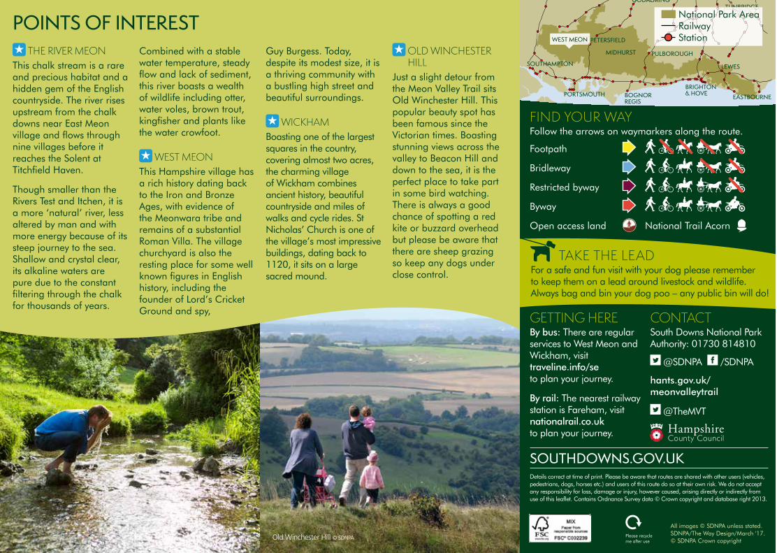
FIND YOUR WAYFollow the arrows on waymarkers along the route.
Details correct at time of print. Please be aware that routes are shared with other users (vehicles, pedestrians, dogs, horses etc.) and users of this route do so at their own risk. We do not accept any responsibility for loss, damage or injury, however caused, arising directly or indirectly from use of this leaflet. Contains Ordnance Survey data © Crown copyright and database right 2013.
Please recycle me after use
SOUTHDOWNS.GOV.UK
Footpath
Bridleway
Restricted byway
Byway
Open access land National Trail Acorn
National Park Area Railway Station
TAKE THE LEADFor a safe and fun visit with your dog please remember to keep them on a lead around livestock and wildlife. Always bag and bin your dog poo – any public bin will do!
All images © SDNPA unless stated. SDNPA/The Way Design/March '17. © SDNPA Crown copyright
RESPECT. PROTECT. ENJOY.Respect other people• Leave gates and property as you find them• Keep to the paths unless on Access Land
Protect the natural environment• Take your litter home• Keep dogs under effective control
Enjoy the outdoors• Plan ahead and be prepared• Follow advice and local signs • If cycling, take a puncture repair kit and pump
SOUTH DOWNS NATIONAL PARKFrom rolling hills to bustling market towns, the South Downs National Park’s landscapes cover 1,600km² of breathtaking views, hidden gems and quintessentially English scenery. A rich tapestry of wildlife, landscapes, tranquillity and visitor attractions, weave together a story of people and place in harmony.
For your guide to everything there is to see and do in the National Park visit southdowns.gov.uk/discovery-map
MEON VALLEY WEST MEON TO WICKHAM
NEARBY LONG DISTANCE ROUTESMONARCH’S WAYThis mighty 615-mile path from Worcester to Shoreham-on-Sea is based on the route taken by King Charles II when he escaped after his defeat in the final battle of the Civil War in 1615.
PILGRIMS’ TRAILFollow the medieval footsteps of the Miquelots; pilgrims who took the epic 155 mile journey to worship St Michael in Normandy. Starting at the shrine of St Swithun at Winchester Cathedral, you’ll pass though Bishop’s Waltham and Southwick, and end on English soil at Portsmouth harbour. The route continues over the border at the sanctuary of Mont St Michel.
SOUTH DOWNS WAYThis stunning 100 mile long trail begins in the ancient cathedral city of Winchester, and continues to the white chalky cliffs of the Seven Sisters and Beachy Head at Eastbourne. It is one of 15 National Trails in England and Wales, it was the first bridleway National Trail in England and it is also the only National Trail to lie entirely within a National Park.
WAYFARER’S WALKFollowing the tracks used by shepherds driving their sheep to fairs, Wayfarer’s Walk links the mudflats along the coast, with the highest downland in southern England. Highlights on the route include the National Trust owned Hinton Ampner stately home with its wonderful gardens and Watership Down – the delightful setting for Richard Adams’ 1972 novel.
POINTS OF INTEREST THE RIVER MEON
This chalk stream is a rare and precious habitat and a hidden gem of the English countryside. The river rises upstream from the chalk downs near East Meon village and flows through nine villages before it reaches the Solent at Titchfield Haven.
Though smaller than the Rivers Test and Itchen, it is a more ‘natural’ river, less altered by man and with more energy because of its steep journey to the sea. Shallow and crystal clear, its alkaline waters are pure due to the constant filtering through the chalk for thousands of years.
Combined with a stable water temperature, steady flow and lack of sediment, this river boasts a wealth of wildlife including otter, water voles, brown trout, kingfisher and plants like the water crowfoot.
WEST MEONThis Hampshire village has a rich history dating back to the Iron and Bronze Ages, with evidence of the Meonwara tribe and remains of a substantial Roman Villa. The village churchyard is also the resting place for some well known figures in English history, including the founder of Lord’s Cricket Ground and spy,
Guy Burgess. Today, despite its modest size, it is a thriving community with a bustling high street and beautiful surroundings.
WICKHAMBoasting one of the largest squares in the country, covering almost two acres, the charming village of Wickham combines ancient history, beautiful countryside and miles of walks and cycle rides. St Nicholas’ Church is one of the village’s most impressive buildings, dating back to 1120, it sits on a large sacred mound.
OLD WINCHESTER HILL
Just a slight detour from the Meon Valley Trail sits Old Winchester Hill. This popular beauty spot has been famous since the Victorian times. Boasting stunning views across the valley to Beacon Hill and down to the sea, it is the perfect place to take part in some bird watching. There is always a good chance of spotting a red kite or buzzard overhead but please be aware that there are sheep grazing so keep any dogs under close control.
Old Winchester Hill © SDNPA
LIPHOOKTO MILLAND
GODALMING
LEWES
BOGNOR REGIS
BRIGHTON & HOVE
MIDHURST PULBOROUGH
PORTSMOUTH
PETERSFIELD
EASTBOURNE
TUNBRIDGEWELLS
WINCHESTER
SOUTHAMPTON
CHICHESTER
GODALMING
LEWES
BOGNOR REGIS
BRIGHTON & HOVE
MIDHURST PULBOROUGH
PORTSMOUTH
PETERSFIELD
EASTBOURNE
TUNBRIDGEWELLS
SOUTHAMPTON
WEST MEON
GETTING HEREBy bus: There are regular services to West Meon and Wickham, visit traveline.info/se to plan your journey.
By rail: The nearest railway station is Fareham, visit nationalrail.co.uk to plan your journey.
CONTACTSouth Downs National Park Authority: 01730 814810
@SDNPA /SDNPA
hants.gov.uk/meonvalleytrail
@TheMVT
FIND YOUR WAYFollow the arrows on waymarkers along the route.
Details correct at time of print. Please be aware that routes are shared with other users (vehicles, pedestrians, dogs, horses etc.) and users of this route do so at their own risk. We do not accept any responsibility for loss, damage or injury, however caused, arising directly or indirectly from use of this leaflet. Contains Ordnance Survey data © Crown copyright and database right 2013.
Please recycle me after use
SOUTHDOWNS.GOV.UK
Footpath
Bridleway
Restricted byway
Byway
Open access land National Trail Acorn
TUNBRIDGETUNBRIDGETUNBRIDGETUNBRIDGETUNBRIDGETUNBRIDGETUNBRIDGETUNBRIDGETUNBRIDGETUNBRIDGETUNBRIDGETUNBRIDGETUNBRIDGETUNBRIDGETUNBRIDGETUNBRIDGETUNBRIDGEWELLSWELLSWELLSWELLSWELLSWELLSWELLSWELLSWELLSWELLSWELLSWELLSWELLSWELLSWELLSWELLSWELLSWELLSWELLSNational Park Area
Railway Station
TAKE THE LEADFor a safe and fun visit with your dog please remember to keep them on a lead around livestock and wildlife. Always bag and bin your dog poo – any public bin will do!
All images © SDNPA unless stated. SDNPA/The Way Design/March '17. © SDNPA Crown copyright
RESPECT. PROTECT. ENJOY.Respect other people• Leave gates and property as you find them• Keep to the paths unless on Access Land
Protect the natural environment• Take your litter home• Keep dogs under effective control
Enjoy the outdoors• Plan ahead and be prepared• Follow advice and local signs • If cycling, take a puncture repair kit and pump
SOUTH DOWNS NATIONAL PARKFrom rolling hills to bustling market towns, the South Downs National Park’s landscapes cover 1,600km² of breathtaking views, hidden gems and quintessentially English scenery. A rich tapestry of wildlife, landscapes, tranquillity and visitor attractions, weave together a story of people and place in harmony.
For your guide to everything there is to see and do in the National Park visit southdowns.gov.uk/discovery-map
MEON VALLEY WEST MEON TO WICKHAM
NEARBY LONG DISTANCE ROUTESMONARCH’S WAYThis mighty 615-mile path from Worcester to Shoreham-on-Sea is based on the route taken by King Charles II when he escaped after his defeat in the final battle of the Civil War in 1615.
PILGRIMS’ TRAILFollow the medieval footsteps of the Miquelots; pilgrims who took the epic 155 mile journey to worship St Michael in Normandy. Starting at the shrine of St Swithun at Winchester Cathedral, you’ll pass though Bishop’s Waltham and Southwick, and end on English soil at Portsmouth harbour. The route continues over the border at the sanctuary of Mont St Michel.
SOUTH DOWNS WAYThis stunning 100 mile long trail begins in the ancient cathedral city of Winchester, and continues to the white chalky cliffs of the Seven Sisters and Beachy Head at Eastbourne. It is one of 15 National Trails in England and Wales, it was the first bridleway National Trail in England and it is also the only National Trail to lie entirely within a National Park.
WAYFARER’S WALKFollowing the tracks used by shepherds driving their sheep to fairs, Wayfarer’s Walk links the mudflats along the coast, with the highest downland in southern England. Highlights on the route include the National Trust owned Hinton Ampner stately home with its wonderful gardens and Watership Down – the delightful setting for Richard Adams’ 1972 novel.
POINTS OF INTEREST THE RIVER MEON
This chalk stream is a rare and precious habitat and a hidden gem of the English countryside. The river rises upstream from the chalk downs near East Meon village and flows through nine villages before it reaches the Solent at Titchfield Haven.
Though smaller than the Rivers Test and Itchen, it is a more ‘natural’ river, less altered by man and with more energy because of its steep journey to the sea. Shallow and crystal clear, its alkaline waters are pure due to the constant filtering through the chalk for thousands of years.
Combined with a stable water temperature, steady flow and lack of sediment, this river boasts a wealth of wildlife including otter, water voles, brown trout, kingfisher and plants like the water crowfoot.
WEST MEONThis Hampshire village has a rich history dating back to the Iron and Bronze Ages, with evidence of the Meonwara tribe and remains of a substantial Roman Villa. The village churchyard is also the resting place for some well known figures in English history, including the founder of Lord’s Cricket Ground and spy,
Guy Burgess. Today, despite its modest size, it is a thriving community with a bustling high street and beautiful surroundings.
WICKHAMBoasting one of the largest squares in the country, covering almost two acres, the charming village of Wickham combines ancient history, beautiful countryside and miles of walks and cycle rides. St Nicholas’ Church is one of the village’s most impressive buildings, dating back to 1120, it sits on a large sacred mound.
OLD WINCHESTER HILL
Just a slight detour from the Meon Valley Trail sits Old Winchester Hill. This popular beauty spot has been famous since the Victorian times. Boasting stunning views across the valley to Beacon Hill and down to the sea, it is the perfect place to take part in some bird watching. There is always a good chance of spotting a red kite or buzzard overhead but please be aware that there are sheep grazing so keep any dogs under close control.
Old Winchester Hill © SDNPA

MEONVALLEY
OLD OLD WINCHESTER WINCHESTER
HILLHILL
WARNFORD WARNFORD WARNFORD PARKPARK HEN
WOOD
A32
A32
KINGS WAY
MEO
N V
ALLE
Y TR
AIL
M
EON VALLEY TRAIL
WAY
FARE
R’S W
ALK
WAY FARER’S WALK
WA
YFARER’S
WALK
R I VER M
EON
SOBERTON
B2150
A32
WARNFORD
WARNFORD
EXTON
A32
MEONSTOKEB2150
BROCKBRIDGE
CORHAMPTON
A32
DROXFORD
DENMEAD
SOUTHWICK
WATERLOOVILLE
SHIRRELLHEATH
WALTHAMCHASE
SWANMORE
BISHOP’SWALTHAM
HAMBLEDON
STAT
ION
RO
AD
A32
A3
B2177
B477
M27
M27
R
START
FINISH
WALL ING TON RIVER
SOBERTON HEATH
S
OUTH DOW
NS W
AY
SOUTH DOW
NS W
AY
FAREHAM
WEST MEON
WICKHAM
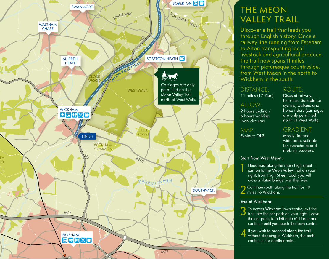
THE MEON VALLEY TR AIL Discover a trail that leads you through English history. Once a railway line running from Fareham to Alton transporting local livestock and agricultural produce, the trail now spans 11 miles through picturesque countryside, from West Meon in the north to Wickham in the south.
DISTANCE:11 miles (17.7km)
ALLOW: 2 hours cycling / 6 hours walking (non-circular)
MAP: Explorer OL3
ROUTE: Disused railway. No stiles. Suitable for cyclists, walkers and horse riders (carriages are only permitted north of West Walk).
GRADIENT: Mostly flat and wide path, suitable for pushchairs and mobility scooters.
Start from West Meon:
1 Head east along the main high street – join on to the Meon Valley Trail on your right, from High Street road; you will cross a slated bridge over the river.
2 Continue south along the trail for 10 miles to Wickham.
End at Wickham:
3 To access Wickham town centre, exit the trail into the car park on your right. Leave the car park, turn left onto Mill Lane and continue until you reach the town centre.
4 If you wish to proceed along the trail without stopping in Wickham, the path continues for another mile.
N
0 0.5 miles
1km
KEY: Point of interest
Bus stop
Train station
Toilets
Refreshments
Pub
Shops
Shared path
A Road
B Road
Long Distance Path
Bridleway
Footpath
Woodland
A32
A32
KINGS WAY
MEO
N V
ALLE
Y TR
AIL
M
EON VALLEY TRAIL
WAY
FARE
R’S W
ALK
WAY FARER’S WALK
WA
YFARER’S
WALK
R I VER M
EON
SOBERTON
B2150
A32
WARNFORD
EXTON
MEONSTOKE
BROCKBRIDGE
CORHAMPTON
DROXFORD
DENMEAD
SOUTHWICK
WATERLOOVILLE
SHIRRELLHEATH
WALTHAMCHASE
SWANMORE
BISHOP’SWALTHAM
HAMBLEDON
STAT
ION
RO
AD
A32
A3
B2177
B477
M27
M27
START
FINISH
WALL ING TON RIVER
SOBERTON HEATH
S
OUTH DOW
NS W
AY
SOUTH DOW
NS W
AY
FAREHAM
WEST MEON
WICKHAM
National Park area
Buildings
Railway station
Carriages are only permitted on the Meon Valley Trail north of West Walk.
A32
A32
KINGS WAY
MEO
N V
ALLE
Y TR
AIL
M
EON VALLEY TRAIL
WAY
FARE
R’S W
ALK
WAY FARER’S WALK
WA
YFARER’S
WALK
R I VER M
EON
WEST WALK
LITTLE LITTLE FOREST FOREST FOREST FOREST
CLOSE CLOSE CLOSE CLOSE CLOSE WOODWOODWOODWOOD
BOTLEY WOOD
WICKHAM WICKHAM WICKHAM WICKHAM COMMONCOMMONCOMMON
W
SOBERTON
B2150
A32
WARNFORD
EXTON
MEONSTOKE
BROCKBRIDGE
CORHAMPTON
DROXFORD
DENMEAD
SOUTHWICK
WATERLOOVILLE
SHIRRELLHEATH
WALTHAMCHASE
SWANMORE
BISHOP’SWALTHAM
HAMBLEDON
STAT
ION
RO
AD
A32
A3
B2177
B477
M27
M27
START
WICKHAM WICKHAM WICKHAM
FINISH
WALL ING TON RIVER
SOBERTON HEATH
S
OUTH DOW
NS W
AY
SOUTH DOW
NS W
AY
FAREHAM
WEST MEON
WICKHAM
THE MEON VALLEY TR AIL Discover a trail that leads you through English history. Once a railway line running from Fareham to Alton transporting local livestock and agricultural produce, the trail now spans 11 miles through picturesque countryside, from West Meon in the north to Wickham in the south.
DISTANCE:11 miles (17.7km)
ALLOW: 2 hours cycling / 6 hours walking (non-circular)
MAP: Explorer OL3
ROUTE: Disused railway. No stiles. Suitable for cyclists, walkers and horse riders (carriages are only permitted north of West Walk).
GRADIENT: Mostly flat and wide path, suitable for pushchairs and mobility scooters.
Start from West Meon:
1 Head east along the main high street – join on to the Meon Valley Trail on your right, from High Street road; you will cross a slated bridge over the river.
2 Continue south along the trail for 10 miles to Wickham.
End at Wickham:
3 To access Wickham town centre, exit the trail into the car park on your right. Leave the car park, turn left onto Mill Lane and continue until you reach the town centre.
4 If you wish to proceed along the trail without stopping in Wickham, the path continues for another mile.
N
0 0.5 miles
1km
KEY: Point of interest
Bus stop
Train station
Toilets
Refreshments
Pub
Shops
Shared path
A Road
B Road
Long Distance Path
Bridleway
Footpath
Woodland
A32
A32
KINGS WAY
MEO
N V
ALLE
Y TR
AIL
M
EON VALLEY TRAIL
WAY
FARE
R’S W
ALK
WAY FARER’S WALK
WA
YFARER’S
WALK
R I VER M
EON
SOBERTON
B2150
A32
WARNFORD
EXTON
MEONSTOKE
BROCKBRIDGE
CORHAMPTON
DROXFORD
DENMEAD
SOUTHWICK
WATERLOOVILLE
SHIRRELLHEATH
WALTHAMCHASE
SWANMORE
BISHOP’SWALTHAM
HAMBLEDON
STAT
ION
RO
AD
A32
A3
B2177
B477
M27
M27
START
FINISH
WALL ING TON RIVER
SOBERTON HEATH
S
OUTH DOW
NS W
AY
SOUTH DOW
NS W
AY
FAREHAM
WEST MEON
WICKHAM
National Park area
Buildings
Railway station
Carriages are only permitted on the Meon Valley Trail north of West Walk.