glimpses of medieval norwich - industrial norwich
TRANSCRIPT
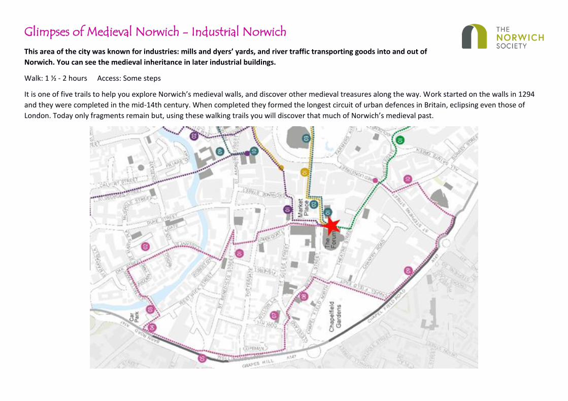
Glimpses of Medieval Norwich - Industrial Norwich
This area of the city was known for industries: mills and dyers’ yards, and river traffic transporting goods into and out of
Norwich. You can see the medieval inheritance in later industrial buildings.
Walk: 1 ½ - 2 hours Access: Some steps
It is one of five trails to help you explore Norwich’s medieval walls, and discover other medieval treasures along the way. Work started on the walls in 1294
and they were completed in the mid-14th century. When completed they formed the longest circuit of urban defences in Britain, eclipsing even those of
London. Today only fragments remain but, using these walking trails you will discover that much of Norwich’s medieval past.

Route directions Notable features along the way
Start at the Forum. Turn left and pass in front of City Hall
The Forum was opened in 2001 and replaces the old Norwich Central Library and Record Office, which burned down in 1994. Opened in 1938, City Hall boasts the longest balcony in England (at 111m / 365ft long). It replaced the adjacent Guildhall which had become too small and was rat infested.
Keep going straight ahead with the Guildhall on your right
The Guildhall (built 1407-24), is the largest and most elaborate city hall ever built outside London. Henry IV’s charter of 1404 gave the City the right to elect a Mayor and two Sheriffs, effectively making Norwich an independent, self-governing entity. From 1412 until 1597 the common gaol of Norwich was in the cellars of the Guildhall. Norwich Castle was the county gaol and held the more important prisoners.
Bear slightly left and go down Upper Goat Lane
You are now in the Norwich Lanes, a series of alleyways and open communal spaces intermixed with a large number of medieval buildings. Today the lanes are home to a thriving independent retail area and a vast array of cafes, restaurants and bars.
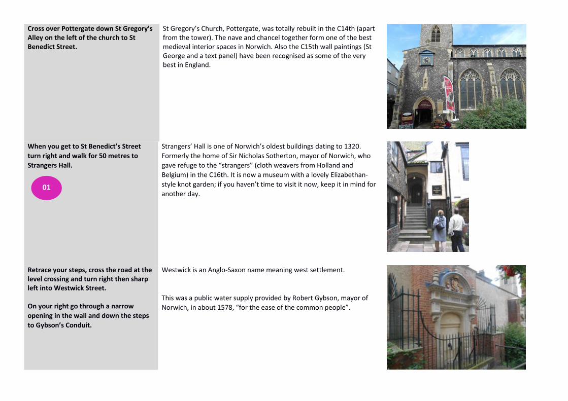
Cross over Pottergate down St Gregory’s Alley on the left of the church to St Benedict Street.
St Gregory’s Church, Pottergate, was totally rebuilt in the C14th (apart from the tower). The nave and chancel together form one of the best medieval interior spaces in Norwich. Also the C15th wall paintings (St George and a text panel) have been recognised as some of the very best in England.
When you get to St Benedict’s Street
turn right and walk for 50 metres to
Strangers Hall.
Strangers’ Hall is one of Norwich’s oldest buildings dating to 1320.
Formerly the home of Sir Nicholas Sotherton, mayor of Norwich, who
gave refuge to the “strangers” (cloth weavers from Holland and
Belgium) in the C16th. It is now a museum with a lovely Elizabethan-
style knot garden; if you haven’t time to visit it now, keep it in mind for
another day.
Retrace your steps, cross the road at the level crossing and turn right then sharp left into Westwick Street. On your right go through a narrow
opening in the wall and down the steps
to Gybson’s Conduit.
Westwick is an Anglo-Saxon name meaning west settlement.
This was a public water supply provided by Robert Gybson, mayor of
Norwich, in about 1578, “for the ease of the common people”.
01

Come back up the steps and carry on
down Westwick Street.
On your left is St Lawrence’s Church (entrance in St Benedict’s St), dramatically sited on a steep incline down to the river. It bears a brass plaque to a curate’s daughter, Sarah Glover, who developed the Norwich sol-fa method of singing in the mid C19th, later modified to form the tonic scale used today and immortalised in the song, Doe a deer, a female deer, in the musical The Sound of Music. However, the origins of the tonic sol fa go back to the C11th. Benedictine monk, Guido of Arezzo, took the first notes of each line of a Latin hymn, written around 770 A.D., which happen to be the first six notes of a major scale, and used the syllables of the Latin words that were sung on those notes to represent the notes of the scale.
Turn right into Coslany Street to Coslany Square and across the bridge.
In the Middle Ages, this area of the city was known for industries: mills and dyers’ yards, and river traffic transporting goods into and out of Norwich. Coslany (St Miles) Bridge is the site of two C13th bridges crossing islands in the centre of the river along the line of what had been a Roman road. The current iron bridge dates from 1804 and is the earliest iron bridge in the city.
Once over the bridge look back at Bullards Brewery building.
Beer was the drink of the masses during the medieval period as the brewing process killed bacteria in the water. Norwich developed many local breweries and this is the site of Bullard & Sons Anchor Brewery. For over a hundred years Bullards was one of the major brewers in Norwich and supplied public houses across Norfolk. It was said that Norwich had a church for every week of the year and a pub for every day.
Continue along Coslany Street which becomes Oak Street.
St Michael Coslany (St Miles) Church, Oak Street dates from the C13th but is much rebuilt. It is noted for its remarkable display of C15th flushwork on the south aisle. Flushwork is the decorative treatment of the surface of an outside wall with flints split to show their smooth black surface, combined with dressed stone to form patterns such as tracery or initials. The church is now a centre for circus skills. This area was the location of St Marys Mill. When it closed in 1981 it brought to an end 700 years of silk weaving and textile manufacture in Norwich.
02

It is worth making a slight detour to your right down St Mary’s Plain to see St Mary’s Church.
It is one of only three round towered churches surviving in Norwich and pre dates the Norman Conquest.
On the corner of St Mary’s Plain on your right is St Mary’s Works.
Since the C13th, and probably well before, boots and shoes had been made in the city. This is the site of one of the ‘big five’ in the city ‘Sexton Son and Everard’, with 17% of the city’s workforce in 1931 employed in the shoe trade.
Turn left into New Mills Yard and the New Mills Sewage Pumping Station
Before the Norman Conquest this was the site of a mill used for grinding corn and fulling (cleaning cloth). Later it was used to pump drinking water from the river to Market Cross. The sewage pumping station was built in 1897. Inadequate management of sewage contributed to the spread of disease in medieval England. It was not until the industrial age of the C19th that a proper solution was found. This pumping station was operated by water turbines driving pumping engines that compressed air in order to force sewage in low-lying areas to the treatment works. It is believed to be one of only two surviving examples of this machinery (the other being in the Houses of Parliament).
03

At the end, as you approach the river,
turn left, then right and cross over the
bridge until you get to Westwick Street
again and turn right. Continue down
Westwick Street until you reach Barn
Road, a 4-lane busy traffic thoroughfare.
At the junction of Westwick Street and Barn Road stood
Helgate/Heigham Gate. Various origins of the name “Helgate” have
been suggested: the land was low-lying and marshy, and probably not
very healthy, the mills and dyers’ yards would have polluted the river,
and it may not have been a very safe place, particularly at night. It was
also not used very much, as it was small and had a narrow archway,
difficult for carts to get through; the river provided a better means of
transporting goods. The archway was eventually widened before the
gate was finally demolished just before 1800.
Turn left onto Barn Road. You are now
following the line of the medieval walls.
As the path turns away from the road you will find several small
stretches of city wall. The last three bays have been consolidated and
restored.
Please note that the paving is somewhat uneven so keep an eye out for
trip hazards.
04
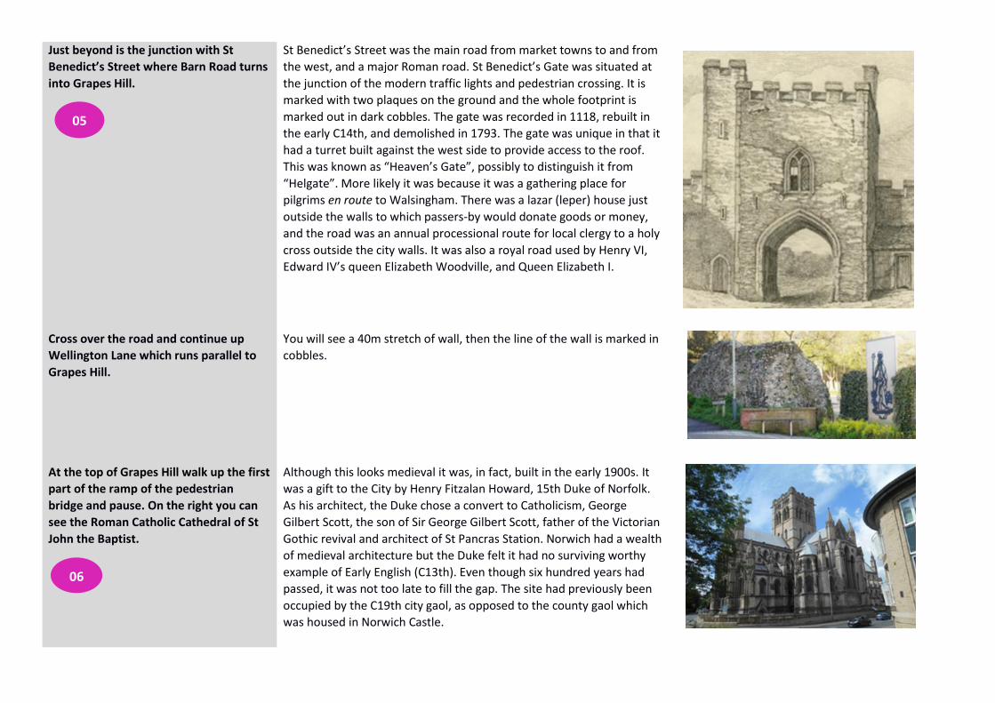
Just beyond is the junction with St
Benedict’s Street where Barn Road turns
into Grapes Hill.
St Benedict’s Street was the main road from market towns to and from
the west, and a major Roman road. St Benedict’s Gate was situated at
the junction of the modern traffic lights and pedestrian crossing. It is
marked with two plaques on the ground and the whole footprint is
marked out in dark cobbles. The gate was recorded in 1118, rebuilt in
the early C14th, and demolished in 1793. The gate was unique in that it
had a turret built against the west side to provide access to the roof.
This was known as “Heaven’s Gate”, possibly to distinguish it from
“Helgate”. More likely it was because it was a gathering place for
pilgrims en route to Walsingham. There was a lazar (leper) house just
outside the walls to which passers-by would donate goods or money,
and the road was an annual processional route for local clergy to a holy
cross outside the city walls. It was also a royal road used by Henry VI,
Edward IV’s queen Elizabeth Woodville, and Queen Elizabeth I.
Cross over the road and continue up
Wellington Lane which runs parallel to
Grapes Hill.
You will see a 40m stretch of wall, then the line of the wall is marked in
cobbles.
At the top of Grapes Hill walk up the first
part of the ramp of the pedestrian
bridge and pause. On the right you can
see the Roman Catholic Cathedral of St
John the Baptist.
Although this looks medieval it was, in fact, built in the early 1900s. It
was a gift to the City by Henry Fitzalan Howard, 15th Duke of Norfolk.
As his architect, the Duke chose a convert to Catholicism, George
Gilbert Scott, the son of Sir George Gilbert Scott, father of the Victorian
Gothic revival and architect of St Pancras Station. Norwich had a wealth
of medieval architecture but the Duke felt it had no surviving worthy
example of Early English (C13th). Even though six hundred years had
passed, it was not too late to fill the gap. The site had previously been
occupied by the C19th city gaol, as opposed to the county gaol which
was housed in Norwich Castle.
05
06

Continue straight on the ramp and turn
right down the ramp and left into Upper
St Giles Street.
This is the site of St Giles’ Gate. First recorded in 1288, rebuilt in the
C14th and demolished in 1792. The house sign over No.84 on the right
bears the image of St Giles Gate as it was, the exterior on one side and
the interior on the other.
Walk along Upper St Giles Street for
c.100m.
On your left is St Giles Church with one of the tallest towers in Norwich
at 120ft. Once the city walls had been built the medieval city operated a
curfew system. St Giles’ Church, built in the C14th at the highest point
within the walls, housed a curfew bell. Curfew bells were also rung at St
Peter Mancroft and St Lawrence. The tolling of the bells marked the
beginning or end of daily activity. As the bells rang, the main gates of
the City were opened or closed. The curfew bell at St Giles was rung at
least until the 1960s.
Cross over Cleveland Road into Bethel
Street. Around 70m along on your right
you will find the Coach and Horses public
house.
It is the oldest Coach House in Norwich and the second oldest pub after
the Adam and Eve at Bishop Gate. Parts of the building are believed to
date back as far as 1200. A parish marker on the outside dated 1710
states the pub is between the parishes of St Peter Mancroft and St Giles
and was the site of the Ascension tradition of ‘beating the bounds’,
where choirboys were ‘bumped and dusked’ at their parish boundaries.
07
08

Just beyond Little Bethel Street on your
right is the old Bethel Hospital.
This was opened in 1713 and was the first purpose-built asylum in the
country. In the medieval period, the burden of keeping vulnerable
individuals rested almost entirely on their families. ‘Mad’ people who
could not be kept at home wandered free, begging for food and shelter.
The causes of madness was often deemed to be demonic possession,
witchcraft or sorcery. In Europe a few small Christian institutions
dedicated to sheltering the insane emerged in the early Middle Ages.
London’s Bedlam was the most famous.
Turn right down Little Bethel Street. Cross the road at the pedestrian crossing and enter Chapelfield Gardens. Take the path to the left and walk to the end of the gardens exiting by the iron gates.
Throughout the medieval period much land inside the walls seems to
have been open space or gardens. In 1406 Chapel in the Field extended
for 4½ acres, much larger than the present Chapelfield. Chapelfield is
bordered on the south side by a long fragment of wall, which is
unfortunately is hidden by an earth bank and various buildings. A good
exterior view can only be had from the very busy road.
Cross the road at the pedestrian crossing.
You will immediately see a fragment of all ahead of you – the continuation of the section that borders Chapelfield.
09
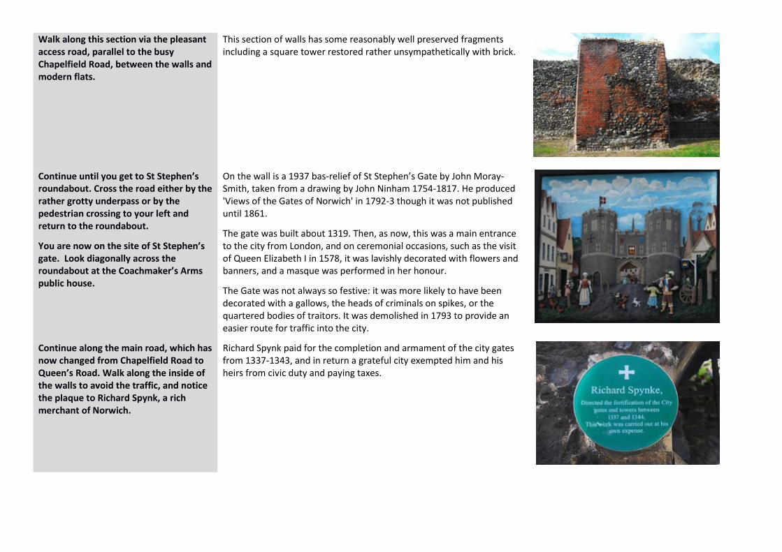
Walk along this section via the pleasant access road, parallel to the busy Chapelfield Road, between the walls and modern flats.
This section of walls has some reasonably well preserved fragments including a square tower restored rather unsympathetically with brick.
Continue until you get to St Stephen’s roundabout. Cross the road either by the rather grotty underpass or by the pedestrian crossing to your left and return to the roundabout.
You are now on the site of St Stephen’s gate. Look diagonally across the roundabout at the Coachmaker’s Arms public house.
On the wall is a 1937 bas-relief of St Stephen’s Gate by John Moray-Smith, taken from a drawing by John Ninham 1754-1817. He produced 'Views of the Gates of Norwich' in 1792-3 though it was not published until 1861.
The gate was built about 1319. Then, as now, this was a main entrance to the city from London, and on ceremonial occasions, such as the visit of Queen Elizabeth I in 1578, it was lavishly decorated with flowers and banners, and a masque was performed in her honour.
The Gate was not always so festive: it was more likely to have been decorated with a gallows, the heads of criminals on spikes, or the quartered bodies of traitors. It was demolished in 1793 to provide an easier route for traffic into the city.
Continue along the main road, which has now changed from Chapelfield Road to Queen’s Road. Walk along the inside of the walls to avoid the traffic, and notice the plaque to Richard Spynk, a rich merchant of Norwich.
Richard Spynk paid for the completion and armament of the city gates from 1337-1343, and in return a grateful city exempted him and his heirs from civic duty and paying taxes.

About 100m from the roundabout is a pedestrian entrance to Norwich Bus Station (just before the bathstore shop).
Pause here.
Just beyond this point is the site of the Brazen Gate or doors, built like a miniature fortress as part of the walls in the late C13th. It had various names: Swine Gate (because of the street’s swine market), Iron Door (the door was reinforced with iron bars), then, after 1500, Brazen Gate, as the gate was remodelled and bronze-edged side-gates installed. It was demolished in 1792.
Turn into Norwich Bus Station, walk
through to Surrey Street and turn left.
About 50m on your right is Surrey
House, HQ for Norwich Union Life
Insurance Society, now Aviva.
This was the site of the Duke of Surrey’s mansion in the C16th – hence
the street name. The house was demolished, and the HQ built by
George Skipper, a celebrated Norwich architect, beginning in 1900. The
interior is a sumptuous homage to the English Renaissance. You can
visit on weekdays and gaze in wonder at the Marble Hall, fashioned
from 15 kinds of marble which were destined for Westminster
Cathedral. The cost proved too much for the Cathedral authorities, but
Skipper persuaded NU to buy the entire consignment and he used it to
stunning effect.
At the bottom of the road turn right into
St Stephen’s Street. At the junction with
Theatre Street (M&S is on the corner)
you can turn left and return to The
Forum, or reward yourself with some
refreshment in one of Norwich’s many
cafes.
If you want to find out more about
Norwich’s medieval past visit Norwich
Castle Museum & Art Gallery, the
Museum of Norwich at the Bridewell
and Strangers’ Hall.
10