gis based pcraster-polflow approach to modeling · pdf filegis based pcraster-polflow approach...
TRANSCRIPT

GIS BASED PCRASTER-POLFLOW APPROACH TO MODELING OF COUPLED SURFACE WATER AND GROUNDWATER HYDROLOGY IN THE BÜYÜK MENDERES CATCHMENT
Assoc.Prof.Dr.Ömer Faruk Durdu Adnan Menderes University
Faculty of Agriculture, Irrigation and Drainage Engineering 09100 AYDIN
ABSTRACT
The Büyük Menderes river basin has populated farmland and rapidly develop-ing urban and suburban areas. Its agriculture and industrial sectors are highly devel-oped and therefore water management in this region is one of the biggest stakes. The basin has a watershed are of 24976 km2. Total population of the basin is 2.5 million and 37% of this population is involved in agricultural activities. Mean annual pre-cipitation in the basin is 635 mm. Precipitation occurs mainly in the winters while during the summer irrigation period there is very little rain. This brings up frequent droughts and flooding in the region. Due to increase in population and agricultural practices, the limited water resources of the catchment is under big influence. To manage water resources at optimal level and to decrease risk on agricultural produc-tion, the collected hydrogeological, meteorological, and spatial data should be simu-lated and analyzed with appropriate models. Geographic Information Systems based hydrological models are powerful tools for decision making about integrating man-agement of water resources. In this study, the catchment-scale hydrologic modeling approach PCRaster-POLFLOW is applied to simulate Büyük Menderes river basin water resources. The model is a raster-based GIS modeling tool and based on three determinant factors: the long-term average total runoff or precipitation, the ground-water recharge index and the groundwater residence time. The results of the model produce a water budget for the basin and gives reference outputs such as estimates of the surface runoff, shallow groundwater recharge, and deep groundwater re-charge. Using these outputs, stakeholders may have with provision a useful tool for decision-making in the field of water management and agricultural policies such as water pollution, irrigation water distribution, flood and droughts.
Keywords: hydrologic modeling, PCRaster-POLFLOW, geographic information systems.

PRACTICES ON RIVER BASIN MANAGEMENT 259
INTRODUCTION
Negative effects of global warming, enlargement of irrigated farm lands, multi-plication of population, and development of industries brought more attention on effective and suitable use of the water resources in the Büyük Menderes river basin. Regarding to water resources, Turkey is classified as a poor country and limited water resources forces government agencies to pay more attention to the water is-sues. Last two decades, influences on the quality and quantity of surface and groundwater have caused some degradation of water resources which is difficult to restore. Büyük Menderes catchment, a watershed area of 24976 km2 and 3.2% of the total area of the country, is located in the southwestern part of the Turkey (Figure 1). Mean annual precipitation in the river basin is 635 mm and precipitation occurs mainly in the winters while during the summer irrigation period there is very little rain. Büyük Menderes river basin has a population of 2.5 million and the density of population is higher in comparison to other basins in Turkey. 37% of this population is employed in agricultural activities. The catchment’s agriculture and industrial sectors are highly developed and therefore water resources in this region are under pressure. In winter seasons, precipitation causes large amount of runoff, therefore, the basin faces flood incidents every year. However, in summer times frequent droughts are main issue increasing potential disruption to the agricultural output. Considerable seasonal variations in the runoff of the rivers and the frequent droughts require immediate attention on water storages which are absolutely necessary in Turkey.
Figure 1. A scheme of Western Anatolia and location of Büyük Menderes River Basin.

260 INTERNATIONAL CONGRESS ON RIVER BASIN MANAGEMENT
With large alluvial farm lands, Büyük Menderes catchment has a great agricul-tural potential and therefore water resources of the basin must be managed at an optimal level. To minimize agricultural risk due to irregular seasonal precipitation, hydrological modeling should be considered as a main parameter for the manage-ment of water resources. Analyzing the collected hydrogeologic, meteorologic, and spatial data with appropriate models exhibits valuable information about the behav-ior of the rainfall in the drainage basin and the level of groundwater recharge. Geo-graphic Information Systems based hydrological models are powerful tools for inte-grated management of water resources in a river basin.
It is important to mention that such a study of water flow at a catchment scale, integrating GIS and hydrological process, has not been carried out for Büyük Menderes river basin. However, it should be mentioned that there were several joint projects between Turkish government and EU countries. For example, State Hydrau-lic Works (DSİ) and Netherland, under MATRA program, analyzed the possibilities of implementation of EU Water Framework Directive in the Büyük Menderes river basin. MATRA project was related to assessment of the available water resources, determination of water budget, and specification of surface and groundwater quality. Furthermore, Austrian firm Verbundplan and DSİ made an agreement for develop-ing an integrated water resources management (IRBM) strategy for Çine Creek Basin which is a sub-basin of Büyük Menderes catchment. Çine Creek Basin has been se-lected as a pilot project with the main objectives to optimize reservoir operations and hydropower production, to improve flood control and irrigation, and control the water quality monitoring network within the entire river basin (Dreher et al., 2002). Theoretically developed IRBM strategy has not been implemented in the basin. Re-garding to climate changes, Baykan (1999) was analyzed possible effects of variations in rainfall and temperature on water budget of the Büyük Menderes river basin.
In this study, a catchment scale hydrologic modeling approach PCRaster-POLFLOW model was used for estimation of changes in surface and groundwater resources. The PolFlow model is embedded in PCraster, a raster based GIS modeling tool [De Wit, 1999]. The model contains three factors that are seen as determinant to describe water fluxes [Greffe, 1999]. The long term average total runoff, the ground-water recharge index, and the groundwater residence time are the determinant fac-tors in the model. GIS based PCRaster-PolFlow model was applied in several EU river basins [De Wit, 1999,2001; Greffe, 2004; Darracq et al., 2003; Jerker et al., 2004]. In these studies, measured and modeled discharge values were compared to obtain ideas about the water resources of the basins. The objectives of this paper is to: 1) development of a water budget model for the Büyük Menderes river basin; 2) com-parison of measured discharges obtained from several stations and modeled dis-charges for validation of the GIS based model; 3) generation of reference data for decision-making in the field of water management and agricultural policies such as water pollution, irrigation water distribution, flood and droughts.
PRACTICES ON RIVER BASIN MANAGEMENT 261
METHODS
PolFlow hydrological model has been implemented in the PCRaster, a raster GIS suitable modeling. As input for the hydrologic modeling in PolFlow model, each grid cell is assigned properties of elevation, precipitation, temperature, land cover, vege-tation, aquifer porosity and aquifer capacity. Some of these basic input data are pre-processed before running the hydrological modeling tool. For instance, the ground slope is calculated on the basis of the digital elevation model [Jarsjö, 2004]. ArcGIS 9.1 was used for processing the input data. Basically, PolFlow model compromises two different modules. First module is water flux model which analyses quantity of surface and groundwater and define direction of flow in the basin. The module esti-mates discharges in the rivers and residence times for the groundwater. Second module uses the data generated by first module as input data and models nutrient transport (nitrogen, phosphorus) in the drainage basin. In this paper, water flux module of PolFlow model was implemented for the Büyük Menderes catchment. The water flux model consists in determining three factors that are seen as basic elements to describe the water flow: 1) the long-term average total runoff or precipi-tation surplus Q (mm/year) [Greffe, 2003]:
)( aEPQ −= (1)
where P is long-term average annual runoff (mm/year); Ea is long-term average actual evapotranspiration (mm/year). The denomination “long term” always refers to an annual average made over several years (in this study it is ten years); 2) the groundwater recharge index, groundwater recharge/total runoff [Greffe, 2003]:
f gwgw = (2)
where Qgw is long-term average total groundwater recharge (mm/year). In this study, it is assumed that a certain fraction of Q is available for groundwater recharge, according to a groundwater recharge index (fgw), which takes on values between 0 and 1, where 0 implies zero groundwater recharge and 1 implies groundwater re-charge equal to Q.; 3) the groundwater residence time RTgw(year), average time that a water particle needs to flow from the groundwater table to the point of outflow to the surface water [Greffe, 2003]. It is important to mention that the simulation of PolFlow modeling will give a single value of each of these parameters (Q, fgw, RTgw) for each single grid cell of the Büyük Menderes catchment. In order to assessment of these parameters, two different approaches have been reported in De Wit (2000): Wendland (1992) and Meinardi et al. (1994). There are some major differences be-tween the two methodologies, first in the calculation of the long-term average total

262 INTERNATIONAL CONGRESS ON RIVER BASIN MANAGEMENT
runoff (Q). In the case of Wendland (1992), the total runoff can be simply calculated with an evapotranspiration related empirically to soil and land cover [Greffe, 2003]. In this approach the effect of temperature and temperature changes is not taken into consideration. However, in the case of Meinardi et al. (1994) the actual evapotranspi-ration (Ea) depends on the precipitation Pp and the potential evapotranspiration, function itself of the long-term average annual temperature [Greffe, 2003].
2
2
9.0p
pa
EP
PE
+
= (3)
where Pp is long-term average annual precipitation (mm/year); Ep is long-term average potential evapotranspiration (mm/year) and T is long-term average annual temperature (oC).
Wendland (1992) approach divides the total runoff (Q) into direct runoff (Qdr) which is surface runoff that flows directly on the soil surface and interflow that infil-trates superficially into the soil and is drained by the upper soil layer and groundwa-ter recharge which is the part that infiltrates deeper into the soil to the aquifer [Greffe, 2003]. On the other hand, Meinardi et al. (1994) divides total runoff in surfi-cial runoff which contains surface runoff, interflow and shallow groundwater re-charge, which part of the aquifer and has therefore a rather short residence time, and groundwater recharge. In this method, only deep groundwater recharge, the groundwater recharge that flows in the deeper part of the aquifer and has a longer average residence time then the shallow groundwater, is concerned [Greffe, 2003]. From the total and deep groundwater recharge indexes, the shallow groundwater recharge (Qgws/Q) can be estimated as follows [Greffe, 2003]:
Q
Q gwdgwgws == (4)
The total groundwater recharge (Qgw/Q) index is estimated by Wendland (1992) as depending on the terrain slope and the depth of groundwater level. The recharge index decreases when the slope increases or when the groundwater level is near the surface:
))))*0.1(*3(1(2)( 6.0slopeELSETHENsurfacethenearlevelrgroundwateIFQQ
gw
+= (5)
where slope represents slope derived from the elevation map (km/km). The deep groundwater recharge index (Qgwd/Q) depends according to Meinardi et al. (1994) on

PRACTICES ON RIVER BASIN MANAGEMENT 263
several parameters like the aquifer type, texture of the soil, groundwater level, slope, land use and average January temperature: according to the following empirical formula an important groundwater recharge would occur mostly on a permeable aquifer (aq), a coarse soil (so), flat terrain (sl), highly vegetated land (lc) and in a re-gion with mild temperature during winter time(tj) [Greffe, 2003]:
tj
gwd
lc
gwd
sl
gwd
so
gwd
aq
gwdgwd
= **** (6)
Wendland (1992) evaluates the shallow groundwater residence time (RTgw) as a function of the groundwater flow velocity (v), conductivity of aquifer (ca), hydraulic gradient (h), primary effective aquifer porosity (pp) and average length of under-ground flow path (lp) [Greffe, 2003]:
pphcavand
nslpwhere
vlpRTswg
**2
1000365*
=== (7)
Meinardi et al. (1994) indicates that the deep groundwater residence time (RTdgw) can be calculated as a function of the total effective porosity of the aquifer (tp), the aquifer thickness (at) and the long-term average deep groundwater recharge (Qgwd):
gwdswg Q
attpRT **1000= (8)
The aquifer thickness in the Büyük Menderes river basin varies along the catch-ment. Therefore, this value for the all basin is assumed to be 50 m.
Source of Data
The sources of input data for this study were numerous. Most of the data was obtained from internet resources but some data from State Hydraulic Works (DSİ) were valuable for the modeling. The input data used in this modeling study repre-sents for a ten-year period of 1993-2003. The input data choices were made according to the resolution available and the cost of data. The choices have a great influence on the quality of results. For example, the most accurate digital elevation model could not be afforded, therefore, the free one on the internet resources was used instead. The sources of data used to model water fluxes in the catchment are listed below:

264 INTERNATIONAL CONGRESS ON RIVER BASIN MANAGEMENT
Table 1. Data used to model water fluxes in the Büyük Menderes River Basin
Data Resolution References
Average annual precipitation - GLOBALSOD http://www1.ncdc.noaa.gov/pub/data/globalsod/
Average annual temperature - http://www1.ncdc.noaa.gov/pub/data/globalsod/
Hydrogeological map 1/250000 DSİ and MTA resources
Digital Elevation Model (DEM) 1 degree, DEM 30 arc second or 1/250000 GTOPO30/, US Geological Survey
Slope 1 km2 Derived from digital elevation model
Land cover 1/250000 http://glcf.umiacs.umd.edu/data/landcover/
Soil Map 1/5000000 http://www.lib.berkeley.edu/EART/fao.html
Discharge data for rivers www.dsi.gov.tr and DSİ unpublished reports
Digital Elevation Model (DEM) GTOPO30 used in this project has been downloaded freely from the internet web page of the US Geological Survey (USGS). Using ArcGIS 9.1 hydrology extension, GTOPO30, a 30 arc second digital elevation model from the USGS, corrected to suit hydrological modeling [Hannerz, 2002]. The elevation model is available in Lambert Azimuthal Equal Area projection and raster formatted with a 1000 m resolution. The land cover map used in this study downloaded freely from the AVHRR Global Land Cover Facility web pages. The map was resampled to a 1000 m resolution grid and reprojected in the UTM36 sys-tem. The land cover data classification system includes 5 classes: forest, open land (farm lands), urban areas, wetlands and water bodies [Greffe, 2003]. The soil map for model was obtained from FAO/UNESCO Soil Map of the World web pages. The data set was reprojected in UTM36 and rasterized with a 1000 m resolution. The nine classes included in the Büyük Menderes river basin: peat, clay, silt, sand gravel gla-cio-fluvial sediment, clayey till boulder clay, till, none or thin cover of quaternary deposit, till and weathered surface layer above the tree limit, water. From this soil map a texture map was created, using a lookup table by Greffe (2003), to determine the grain size of the soil. Aquifer properties (primary effective porosity (pp), conduc-tivity (ca) and total effective porosity (tp)) of the Büyük Menderes river basin were subtracted from the geologic and aquifer maps published by DSİ. Depending upon aquifer types, aquifer properties were assigned by using De Wit (1999) classification. All the precipitation and temperature data were obtained from the NOAA Satellite and Information Service GLOBALSOD web pages without any charge. The data concern the decade 1993-2003 for several stations (15 stations for the precipitation and temperature data). A map locating the meteorological stations was created with ArcMap and ArcCatalog. For each station the long-term average precipitation under the period of 1993-2003 was calculated as well as the long-term average annual tem-perature and the average January temperature.

PRACTICES ON RIVER BASIN MANAGEMENT 265
BULGULAR VE TARTIŞMA
The simulation of PolFlow water flux model generated six different maps, de-scribe water behavior, for the Büyük Menderes river basin drainage area. These maps are: long-term annual average total runoff Q (mm/year), long-term annual average direct runoff Qdr (mm/year), the total groundwater recharge index (Qgw/Q), the deep groundwater recharge index (Qgwd/Q), the average shallow groundwater residence time RTsgw (year), the average deep groundwater residence time RTdgw(year). In order to validate the results of the model for the basin, measured annual average dis-charges for the Büyük Menderes river were compared with the model outputs. Only fifteen measurement stations in the basin were considered for the comparison. Also total groundwater recharge index (Qgw/Q) should have been compared to a ratio between average weekly lowest discharge and average annual discharge but weekly measurements were not available, only monthly data could be obtained from the resources. Therefore this comparison was not carried out. As seen in Figure 2, com-parison between the measured discharge and modeled discharge values seem to be in good agreement. However, the annual discharges calculated with Wendland (1992) and Meinardi et al. (1994) appears to be different from each other. Both meth-ods give results in the same range of values but the results from Meinardi et. al (1994) approach are close to measured values and the results from Wendland (1992) ap-proach are slightly over measured discharge values. For this reason the annual aver-age discharges calculated by Meinardi et. al (1994) were chosen for following other calculations.
Figure 2. Modelled vs. measured annual average discharge (m3/s) in a logarithmic scale.

266 INTERNATIONAL CONGRESS ON RIVER BASIN MANAGEMENT
Figure 3 displays absolute error or difference between measured and modeled discharge. The analysis indicates that it increases with the discharge value, which is reasonable. The relative error graph indicates that the error on discharges lie under 25% for most of them.
Figure 3. Discharge absolute error vs. measured discharge (logarithmic scale)
for each of the 15 stations.
Figure 4. Discharge relative error vs. measured discharge (logarithmic scale)
for each of the 15 stations.
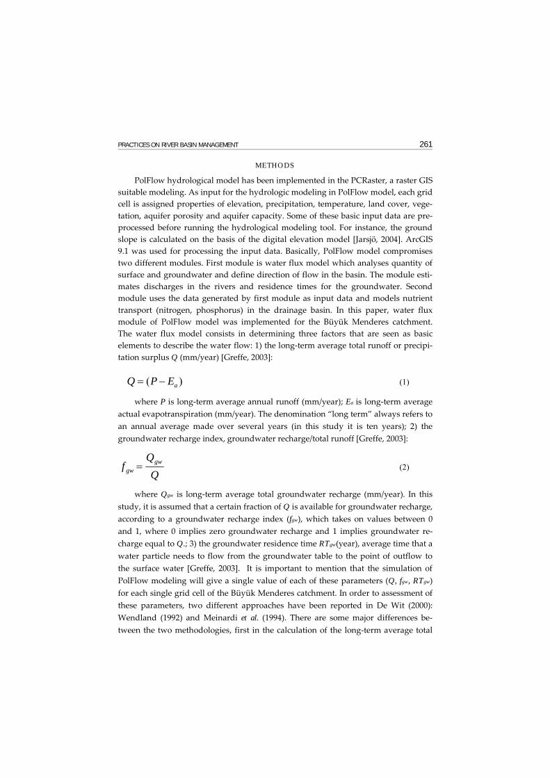
Figure 5 and 6 show deep and shallow groundwater residence time maps. The model generates shallow groundwater residence times mainly between 0 and 5
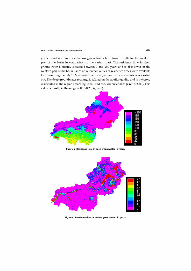
PRACTICES ON RIVER BASIN MANAGEMENT 267
years. Residence times for shallow groundwater have lower results for the western part of the basin in comparison to the eastern part. The residence time in deep groundwater is mainly situated between 0 and 200 years and is also lower in the western part of the basin. Since no reference values of residence times were available for concerning the Büyük Menderes river basin, no comparison analysis was carried out. The deep groundwater recharge is related on the aquifer quality and is therefore distributed in the region according to soil and rock characteristics [Greffe, 2003]. This value is mostly in the range of 0.15-0.2.(Figure 7).
Figure 5. Residence time in deep groundwater in years.
Figure 6. Residence time in shallow groundwater in years.

268 INTERNATIONAL CONGRESS ON RIVER BASIN MANAGEMENT
Figure 7. Deep groundwater recharge index.
According to the model results, the total groundwater recharge index is mostly
ranged between 0.5 and 1, except for the lakes where it is assumed to be zero (Figure 8). The eastern part of the basin has higher recharge value in comparison to the west-ern part.
Figure 8. Total groundwater recharge index.
PRACTICES ON RIVER BASIN MANAGEMENT 269
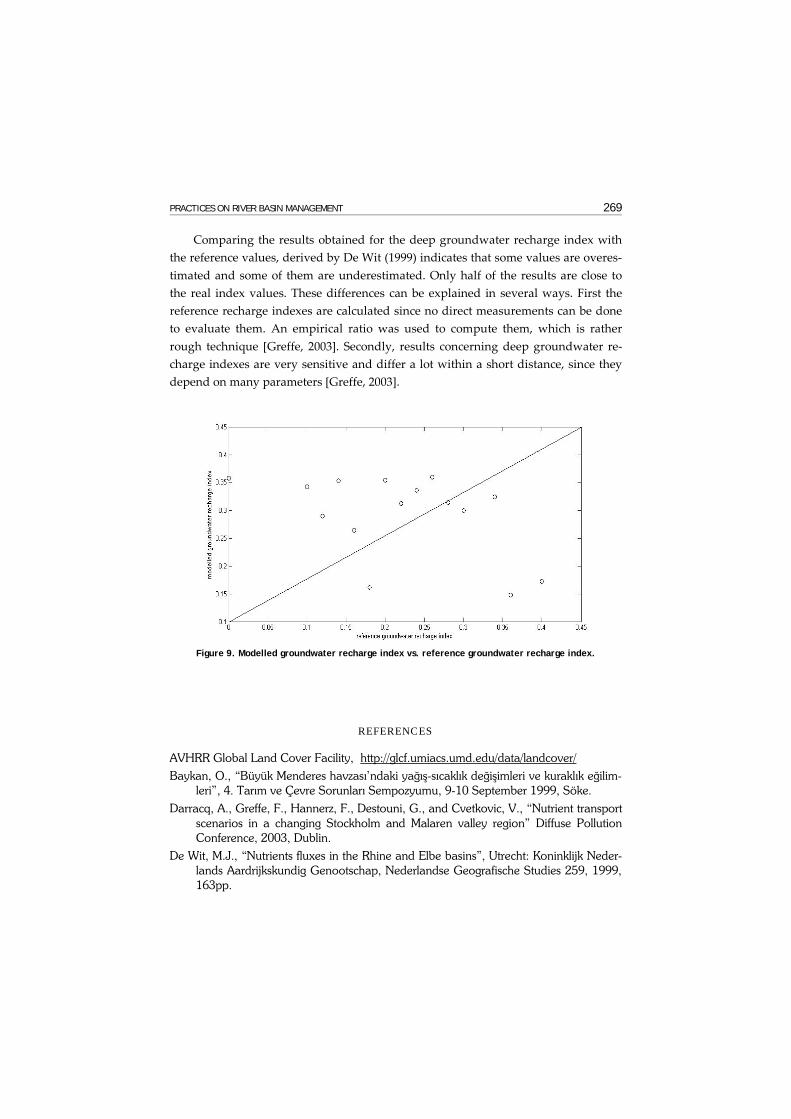
Comparing the results obtained for the deep groundwater recharge index with the reference values, derived by De Wit (1999) indicates that some values are overes-timated and some of them are underestimated. Only half of the results are close to the real index values. These differences can be explained in several ways. First the reference recharge indexes are calculated since no direct measurements can be done to evaluate them. An empirical ratio was used to compute them, which is rather rough technique [Greffe, 2003]. Secondly, results concerning deep groundwater re-charge indexes are very sensitive and differ a lot within a short distance, since they depend on many parameters [Greffe, 2003].
Figure 9. Modelled groundwater recharge index vs. reference groundwater recharge index.
REFERENCES
AVHRR Global Land Cover Facility, http://glcf.umiacs.umd.edu/data/landcover/ Baykan, O., “Büyük Menderes havzası’ndaki yağış-sıcaklık değişimleri ve kuraklık eğilim-
leri”, 4. Tarım ve Çevre Sorunları Sempozyumu, 9-10 September 1999, Söke. Darracq, A., Greffe, F., Hannerz, F., Destouni, G., and Cvetkovic, V., “Nutrient transport
scenarios in a changing Stockholm and Malaren valley region” Diffuse Pollution Conference, 2003, Dublin.
De Wit, M.J., “Nutrients fluxes in the Rhine and Elbe basins”, Utrecht: Koninklijk Neder-lands Aardrijkskundig Genootschap, Nederlandse Geografische Studies 259, 1999, 163pp.

270 INTERNATIONAL CONGRESS ON RIVER BASIN MANAGEMENT
De Wit, M.J., “Nutrient fluxes at the river basin scale. I: the PolFlow model”, Hydrologi-cal Processes 15, 2001, pp. 743-759.
DSİ, State Hydraulic Works web pages, http://www.dsi.gov.tr Dreher. J., Gunatilaka, A., Pühringer, C., and Akaya C., “The Çine Creek basin Project,
Turkey, An integrated river basin management strategy”, Verbundplan, 2002, Vi-enna, Austria.
Durdu, Ö.F., “Su kaynakları planlaması ve yönetiminde bilişim teknolojisinin önemi”, Akademik Bilişim 2004, Karadeniz Teknik Üniversitesi, Turkey.
Durdu, Ö.F., “Nesneye dayalı (object-oriented) programlama tekniklerinin entegre su kaynakları yönetiminde uygulamaları”, I.Çevre ve Ormancılık Şurası, 21-24 March 2005, Antalya, Turkey
Durdu, Ö.F., “Coğrafik bilgi sistemlerinin AB Su Çerçeve direktifi kriterleri doğrultusunda su kaynakları uygulamalarında kullanılması”, I.Çevre ve Ormancılık Şurası, 21-24 March 2005, Antalya, Turkey.
FAO/UNESCO Soil Map of the World web pages. http://www.lib.berkeley.edu/ EART/fao.html
Greffe, F., “Material transport in the Norrström Drainage basin: integrating GIS and hydrological process modeling”, Yüksek lisans tezi, Kungl Tekniska Högskolan, 2003, Stockholm, Sweden.
Hannerz, F., “Harmonization and applications of transboundary geographic databases of the Baltic Sea Region: characterization of BSR drainage basins”, 2002. Sweden.
Jarsjö, J., Shibuo, Y., and Destouni, G., “Using the PCraster-POLFLOW approach to GIS based modelling of coupled groundwater surface water hydrology in the Fors-mark Area”, 2004, SKB report R-04-54, Stockholm.
MATRA Project, “Implementation of Water Framework Directive in Turkey”, Grontmij firması, December 2003, http://www.artiproje.com.tr/downloads/ R3%20Handbook %20WFD%20Turkey%20TR.pdf
Meinardi, C., Beusen, A., Bollen, M., and Klepper, O., “Vulnerability of diffuse pollution of European soils and groundwater”, National Institute of Public Health and Envi-ronmental Protection (RIVM), Report 4615001002, 1994, Bilthoven: RIVM.
Maden Teknik Arama Birimi, MTA web pages, http://www.mta.gov.tr. NOAA Satellite and Information Service web pages http://www1.ncdc.noaa.gov/
pub/data/globalsod/ PCraster Version 2 manual, http://pcraster.geog.uu.nl/manuals/pcrman/book1.htm Wendland, F., “Die Nitrabelastung in den Grundwasserlandschaften der “alten” Bunes-
lander (BRD)” Bercht asu der Okologıschen Forschung, 1992, Band 8. Jülich for-schungszentrum Jülich (KFA)