geotechnical/geological reconnaissance study … · the feasibility study report completed by...
TRANSCRIPT

ENGINEERING PLANNING SURVEYING
GEOTECHNICAL/GEOLOGICAL RECONNAISSANCE STUDY REPORT
CHIGNIK LAGOON ROAD
CHIGNIK LAGOON, ALASKA


Geotechnical/Geological Reconnaissance Report Chignik Lagoon, Alaska Chignik Lagoon Road January 2012
TABLE OF CONTENTS Page
Page i
1.0 INTRODUCTION ...............................................................................................................1 1.1 Planned Development .......................................................................................................1 1.2 Purpose of Investigation ...................................................................................................2 1.3 Scope of Work ..................................................................................................................3
2.0 PHYSICAL SETTING ........................................................................................................4 2.1 Regional Geology .............................................................................................................4 2.2 Climate ..............................................................................................................................4
3.0 RESEARCH AND FIELD WORK .....................................................................................6 3.1 Research ............................................................................................................................6 3.2 Field Work ........................................................................................................................6
4.0 FINDINGS ...........................................................................................................................8 4.1 Site Geology......................................................................................................................8 4.2 Landfill Access Route along Shoreline .............................................................................9 4.3 Hillside Route Alignment ...............................................................................................10 4.4 Potential Borrow Marshinlak Creek Area .......................................................................10
5.0 CONCLUSIONS/RECOMMENDATIONS ......................................................................12 5.1 Landfill Access Route along Shoreline ...........................................................................12 5.2 Hillside Route Alignment ...............................................................................................13 5.3 Potential Borrow Marshinlak Creek Area .......................................................................15 5.4 Summary Conclusions ....................................................................................................15
6.0 ADDITIONAL INVESTIGATIONS.................................................................................17 6.1 Landfill Access ...............................................................................................................17 6.2 Hillside Route .................................................................................................................17
7.0 LIMITATIONS ..................................................................................................................18
8.0 REFERENCES ..................................................................................................................19
FIGURES Figure 1: Vicinity Map....................................................................................................................2
TABLES Table 1: Chignik Lagoon Tide Elevations and Exceedance Probabilities ....................................13
APPENDICES Appendix A .................................................................Geologic Mapping (Plan and Profile Sheets) Appendix B .............................................................................................................. Photograph Log Appendix C ................................................................................................... Typical Cross Sections Appendix D ................................................................................................. Laboratory Test Results

Geotechnical/Geological Reconnaissance Report Chignik Lagoon, Alaska Chignik Lagoon Road January 2012
Page 1
1.0 INTRODUCTION
Western Federal Lands is evaluating the feasibility of constructing an approximate 14-mile road
between Chignik Lagoon and Chignik Lake. This report presents the results of a
Geotechnical/Geological Reconnaissance Study of an approximate 1.3-mile portion of the
proposed roadway that runs along steep hillside areas from Chignik Lagoon south to the existing
Chignik Lagoon landfill. This study also includes an assessment of the current landfill access
route that runs along the shoreline immediately below the proposed hillside route. A site vicinity
map showing the study area is presented in Figure 1. Site mapping is also provided on Figures
A-1 through A-3 of Appendix A.
The purpose of the study was to perform an initial reconnaissance level assessment of slope
stability concerns with the proposed hillside route and the feasibility of upgrading the existing
landfill access road as an alternate route to the hillside alignment. Additionally, the
reconnaissance level study was to allow scoping of more in depth geotechnical investigations.
The study included review of existing feasibility studies and geologic literature, a site visit,
informal interviews with Chignik Lagoon Public Works personnel and other tribal members of
the Village of Chignik Lagoon, and sampling of potential borrow materials. The results of the
study are presented in detail in this report.
1.1 Planned Development
The Chignik Lagoon Road project is part of a planned development by Western Federal Lands
and the Denali Commission to construct a link between the communities of Chignik Lake and
Chignik Lagoon, and possibly provide future staging and access for commercial development in
the area, such as oil, gas, and geothermal.

Geotechnical/Geological Reconnaissance Report Chignik Lagoon, Alaska Chignik Lagoon Road January 2012
Page 2
Figure 1: Vicinity Map
1.2 Purpose of Investigation
The Feasibility Study Report completed by Western Federal Lands in March 2011 did not
include any geological or geotechnical studies of the proposed hillside route. The purpose of this
study is to conduct a preliminary evaluation of the geotechnical feasibility of constructing a new
road along the existing concrete plank shoreline road, evaluate the potential affect of
construction of the proposed hillside route on the slope stability of the hillside, and identify
potential material sites for use during construction. The specific project objectives are as
follows:
• Evaluation of the existing shoreline road and geotechnical feasibility study to
rehabilitate/reconstruct as an alternative to the hillside road,
• Slope stability of the proposed hillside route/geotechnical feasibility study of
construction, and

Geotechnical/Geological Reconnaissance Report Chignik Lagoon, Alaska Chignik Lagoon Road January 2012
Page 3
• Identification of material sites along the proposed Chignik connection road, specifically
near the head of Mallard Duck Bay and Marshinlak Creek Valley.
1.3 Scope of Work
On August 11, 2011, DOWL HKM submitted a proposal for geotechnical engineering services
for the Chignik Lagoon Road project. Numerous levels of investigative scopes of work were
presented and discussed. Because of the densely vegetated and steep, limited access terrain, a
phased investigative approach has been agreed upon. This initial scope of work consists of a
Geotechnical/Geological Reconnaissance Study. The purpose of this initial study is to allow
determination of the extent of additional investigative work (test pits or borings) required to
more accurately define the surface and subsurface conditions along the subject alignments and
further assess the feasibility of construction along the steep hillside and shoreline alignments.
The scope of this initial study is defined as the Alternative Scope of Work
(Geotechnical/Geological Reconnaissance) on page three of our proposal dated August 11, 2011,
and includes the following tasks.
• Conduct a four- to five-day site visit
• Complete geologic mapping along both the proposed shoreline and hillside routes,
looking specifically for evidence of slope instability, potential drainage issues, and
erosion due to wave action along the shoreline.
• Visit potential material sites along the proposed hillside route, near Marshinlak Creek,
and obtain grab samples of potential borrow material.
• Determine the availability of local equipment and the ability to access areas of interest for
the subsurface exploration.
• Conduct informal discussions with locals regarding the condition of the shoreline road
and area of the proposed hillside road during various times of year - information such as
areas of slumping/landslides, unstable ground, or drainage issues.
• Evaluate the feasibility of drill equipment accessibility to perform test borings in the
future.

Geotechnical/Geological Reconnaissance Report Chignik Lagoon, Alaska Chignik Lagoon Road January 2012
Page 4
2.0 PHYSICAL SETTING
The Chignik communities are located on the south shore of the Alaska Peninsula, approximately
450 miles southwest of Anchorage. Chignik Lagoon lies 180 air miles south of King Salmon,
8.5 miles west of Chignik, and 16 miles east of Chignik Lake. The primary year-round
employers are the Village of Chignik Lagoon Council, Chignik electric plant, and Chignik
school. Subsistence activities significantly contribute to food sources. Chignik Lake lies 13
miles from Chignik and 265 miles southwest of Kodiak. The people of Chignik Lake depend
heavily on subsistence hunting and fishing, and utilize salmon, other fish, caribou, moose and
seal.
2.1 Regional Geology
The Alaska Peninsula is divided into two major and one minor physiographic sub-provinces.
The major divisions are the Aleutian Mountain Range and the Bering Sea lowlands. The narrow
lowlands adjacent to the Pacific Ocean constitute the minor division. Within the study area the
lowlands are extremely narrow and limited, with mountains rising directly from the ocean in
many places.
Geologically, sedimentary rocks (mid-Jurassic to late Cretaceous shale, sandstone, and
conglomerate) compose the base of the northeast headlands of the Chignik Peninsula. Tertiary
formations of sedimentary rocks, especially sandstones, siltstones and interbedded volcanic
lavas, are found to the southwest of the older headland formations. This area is on the Pacific
“ring of fire” of seismically active areas, but has been generally free of earthquakes of more than
five on the Richter scale. Mt. Veniaminof (8,450 feet) is located about 25 miles west of Chignik
Lagoon; it last erupted in June 1983 (U.S. Army Corps of Engineers 1984).
2.2 Climate
The village of Chignik Lagoon is partially protected from the most severe southerly Pacific
storms by a ridge of mountains rising to 3,000 feet. Frequent cyclonic storms crossing the
Northern Pacific and the Bering Sea are the predominant weather factors. These storms account
for the frequent high winds and the common occurrence of fog and low visibility. Fog occurs
most often from mid-July to mid-September.

Geotechnical/Geological Reconnaissance Report Chignik Lagoon, Alaska Chignik Lagoon Road January 2012
Page 5
The climate at Chignik Lagoon is basically maritime due to the nearness of the open ocean.
Temperature extremes, both seasonal and diurnal, are generally confined to fairly narrow limits,
with differences between maximum and minimum temperatures for all individual months
averaging less than 15 degrees Fahrenheit. Temperatures below zero degrees Fahrenheit occur in
occasional years when the Bering Sea freezes and allows the influx of cold continental air.

Geotechnical/Geological Reconnaissance Report Chignik Lagoon, Alaska Chignik Lagoon Road January 2012
Page 6
3.0 RESEARCH AND FIELD WORK
3.1 Research
Numerous reports and geologic maps were reviewed during the reconnaissance study. Following
are the more significant publications reviewed:
• Feasibility Report Chignik Lake to Lagoon Road; Federal Highway Administration
Western Federal Lands Highway Division, March 2011.
• Roadway Plan and Profile Sheets, Chignik Lagoon Road; January 2010.
• Draft Small Hydropower Interim Feasibility Report and Draft Environmental Impact
Statement, Chignik Alaska; Department of The Army Alaska District, Corps of
Engineers, July 1984.
• Detterman, R.L. Miller , T.P., Yount, M.E. and Wilson, F.H. , 1981a Geologic Map of
the Chignik and Sutwik Island Quadrangles, Alaska: U.S. Geological Survey
Miscellaneous Investigations Map I-229, Scale 1:250,000, 1 sheet.
• Reger and Others 2003, Geologic Map of Proposed Transportation Corridors. In The
Chignik Quadrangle, Alaska: Miscellaneous Publications 61a and 61d.
Other research literature used is detailed in the Reference Section of this report.
3.2 Field Work
Field work consisted of a site visit, field reconnaissance of the shoreline and hillside routes, and
sampling of potential road surfacing/fill materials at Marshinlak Creek. The field work consisted
of a walkover of the shoreline (current landfill access route) and hillside routes between stations
640+00 and 712+70, mapping of geological features, and discussions with Chignik Lagoon
Public Works personnel and other residents. Photographs were taken of the project features. A
geologic mapping of the project area between the landfill and Chignik Lagoon has been
developed and is included in Figures A-1, A-2 and A-3 of Appendix A. Plan and profile sheets
(produced by Western Federal Lands) have been used as the map base which includes hillside
route stationing for reference. Photograph locations are also indicated on the maps. Photographs

Geotechnical/Geological Reconnaissance Report Chignik Lagoon, Alaska Chignik Lagoon Road January 2012
Page 7
are included in Appendix B. Select typical cross sections taken along the hillside alignment are
presented in Appendix C. Laboratory test results from the field samples are included in
Appendix D. Access and visual assessment of the surficial geologic conditions along the hillside
route was challenging due the extensive, dense vegetation and steep topography (See photograph
P-18, Appendix B)

Geotechnical/Geological Reconnaissance Report Chignik Lagoon, Alaska Chignik Lagoon Road January 2012
Page 8
4.0 FINDINGS
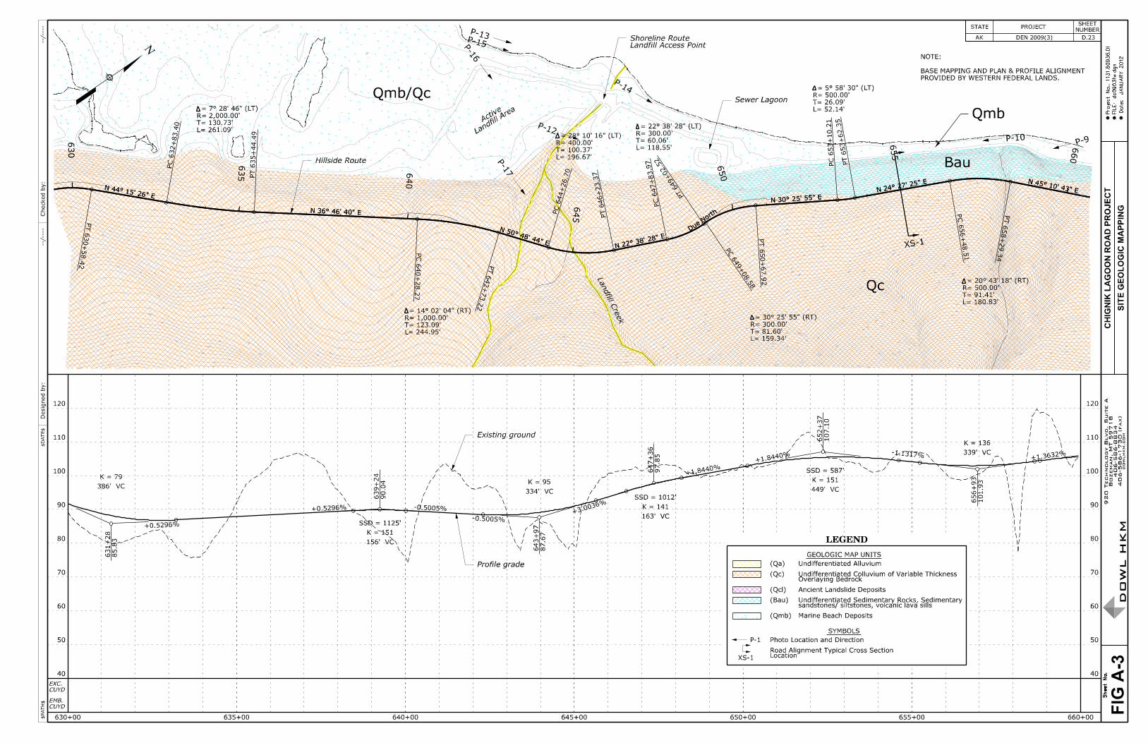
4.1 Site Geology
Geologic mapping is presented in Appendix A on plan and profile sheets of the alignment
(Figures A-1, A-2 and A-3) for both the hillside and shoreline routes. The plan and profile
sheets used for base mapping were produced by Western Federal Lands during the Feasibility
Study for the project. In general, the geology along the hillside route consists predominately of a
veneer of colluvium overlying either volcanic rock or sedimentary rock (photographs P- 8 and P-
17). The hillside alignment crosses a large ancient landslide between approximate stations
690+00 and 700+50. No indications of active moment were observed within the landslide
feature; however, considerable seepage was emerging from the toe area. Based on observations
of road cuts and along the toe of the landslide, the landslide material consists of angular cobbles
and boulders within a predominantly sand and silt matrix with some clay. It is likely the initial
movement occurred tens of thousands of years ago during periods of glacial melting.
The hillside alignment crosses numerous small drainages and one relatively large drainage at
station 681+30 (named Jerrys Point Creek in the Feasibility Study Report). The smaller
drainages contain predominately colluvial soils consisting of angular volcanic and sedimentary
rock fragments, sand and silt, and some clay. The larger drainage consists of more intensely
worked alluvial soils consisting of subrounded to round sedimentary and volcanic rock fragments
with sand and silt. The shoreline alignment is situated on marine sediments and slope wash
colluvium which generally consist of subrounded cobbles, gravel, sand and silt with clayey
zones.
Extensive geologic mapping has not been conducted by the United States Geological Survey
within the Chignik Lagoon area. Based on generalized geologic mapping (R.D. Reger, et. al.
2003), the predominate bedrock geology consists of undifferentiated sedimentary rocks along the
majority of the hillside alignment area between Chignik Lagoon and the landfill. These deposits
consist of sandstone, siltstone and volcanic layers. The majority of the exposed bedrock
outcrops along the shoreline and exposed in the hill slopes appear to be fairly competent and
weather resistant (photographs 4 and 10). Some relatively weak shale zones were observed
along the shoreline alignment below approximate station 665+00 (photograph 8). Quaternary
alluvial deposits consisting primarily of cobbles, gravel, and course sand with silt underlay the

Geotechnical/Geological Reconnaissance Report Chignik Lagoon, Alaska Chignik Lagoon Road January 2012
Page 9
Village of Chignik Lagoon area. These deposits are derived from relatively extensive deposition
by Packer Creek.
4.2 Landfill Access Route along Shoreline
The current landfill and sewage lagoon access route follows along the shoreline. Access along
this alignment is controlled by tidal events. The landfill or sewage lagoon can only be accessed
during low tide events. The length of the current access route from the village to the landfill is
approximately 5,130 feet. Photographs have been taken along the alignment, the locations of
which are shown on Figures A-1, A-2 and A-3 (see photographs 2 through 10 and 13 through
14). The alignment subgrade is comprised of marine sediments and colluvial slope-wash
materials which consist predominately of fine gravel with cobble zones, sand, silt, and at some
locations, clay. Portions of the alignment subgrade have been stabilized by concrete planks
(photographs 6, 7 and 14). The shoreline adjacent to the beach (alignment subgrade) consists of
either relatively steep colluvial soil slopes or bedrock outcrops. The outcrops form small to large
cliffs dependent upon location, and the majority of the rock outcrops appear to be relatively
weather resistant. In general the shoreline along the landfill access route is stable with no
indication of excessive wave action erosional areas. Based on conversations with the landfill
operator, Mr. Larry McCormick, the access route subgrade is generally stable and has held up
well over the years. There is a clayey subgrade area between the last rock point (+/- station
658+00 of the hillside route) and the landfill that occasionally requires maintenance
(photograph 14) consisting of the placement of gravel or rock fill on the unstable subgrade areas.
The concrete pads have held up well over the years with exception of the pads closest to the
landfill, which have experienced some settlement (photograph 14). At the time of the site visit
there was no indication of active landslides or unstable areas on the hillside immediately adjacent
to the beach along the alignment. Mr. McCormick also stated that he has not observed any
landslides or excessive rock fall over the years along the landfill access route. Mr. McCormick
indicated that the most significant problem with the access route is during the winter when
clearing of ice buildup deposited by wave and wind action is required. It can take up to two to
three days to clear the intermittent ice deposition because of scheduling work between tidal
events.

Geotechnical/Geological Reconnaissance Report Chignik Lagoon, Alaska Chignik Lagoon Road January 2012
Page 10
4.3 Hillside Route Alignment
The portion of the proposed hillside route investigated is located along the hillside above the
shoreline route and extends for approximately 6,900 feet from the Village of Chignik Lagoon to
the drainage immediately above the landfill (station 645+00) which is named Landfill Creek in
the Feasibility Study Report. Photographs have been taken along the alignment, the locations of
which are shown on Figures A-1, A-2 and A-3 (see photographs 1, 2, 4, 5, 11, 11A, and 12
through 16). Additionally, three cross sections were taken at select locations along the proposed
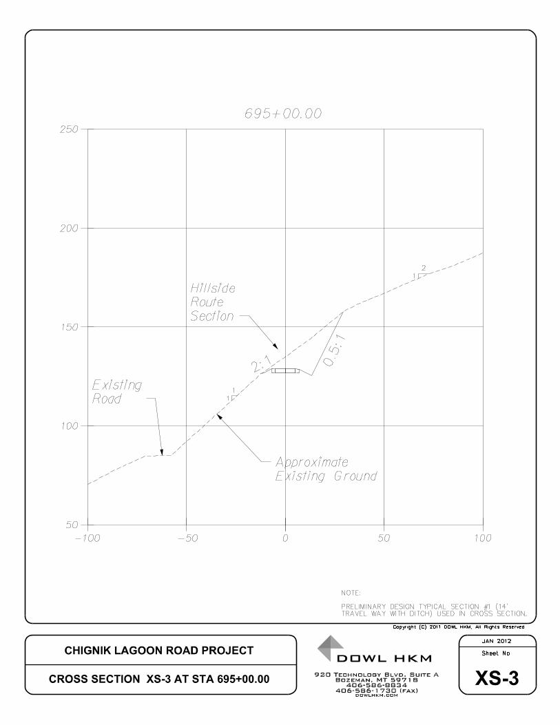
route and are presented as Figures XS-1, XS-2 and XS-3 in Appendix C.
The alignment “side hills” across very steep terrain between stations 645+00 (photographs P-12
and P-14) and 675+00 (photograph P-11A). Cross sections XS-1 (+/-station 655+00) and XS-2
(+/- station 665+25) indicate steep side slope angles of 1H:1V (horizontal to vertical) along these
alignment areas. The alignment also crosses some smaller incised drainages between these
stations. The alignment crosses the relatively large Jerrys Point Creek drainage at station
681+30. Between approximate stations 690+00 and 700+50 the alignment crosses an ancient
landslide (photographs P-2, P-3 and P-4). Cross section XS-3 (photograph 2) indicates an
existing ground slope angle of approximately 1H:1V. From station 700+50 to 707+00 the
alignment crosses a structural bench. Natural slope angles along this bench are relatively low
angle. As stated previously, the geology along the alignment, with the exception of drainage
crossings and the landslide locations, consists predominately of colluvial soils overlaying
bedrock at varying depths. It was not possible to determine depth to bedrock by visual
inspections. Test pits or drilling will be required to accurately determine the thickness of the
colluvial soil cover at specific locations. With the exception of the ancient landslide area, there
were no blatant indications of active landslide zones along the hillside alignment. However, the
extensive vegetation and difficult access due to the very steep terrain made it very difficult to
visually identify subtle indications of potentially unstable areas.
4.4 Potential Borrow Marshinlak Creek Area
Sampling of potential borrow materials was performed from delta deposits at the mouth of
Marshinlak Creek. Photographs were taken of the delta deposits and locations (see photographs
P-22 through P-25). Weather conditions limited access to the alignment area further up the
creek. However, the materials deposited within the deltaic deposit at the mouth of the creek are

Geotechnical/Geological Reconnaissance Report Chignik Lagoon, Alaska Chignik Lagoon Road January 2012
Page 11
representative of parent rock and soils further up the drainage in the vicinity of the road
alignment crossing area.
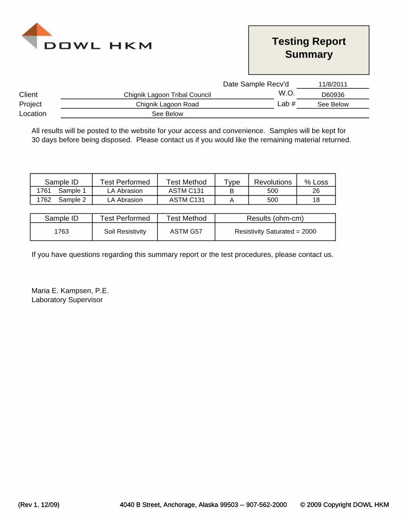
Marshinlak Creek outlet has formed a fairly significant deltaic deposit. Three bulk samples were
taken from the delta deposits and submitted to DOWL HKM’s Anchorage laboratory for testing
to determine physical and engineering characteristics. The following testing was conducted:
• Particle size distribution (ASTM D422);
• LA Abrasion (ASTM C131);
• Soundness (ASTM C88);
• Resistivity (ASTM G57); and
• Percent Soluble Sulfates.
Geotechnical/Geological Reconnaissance Report Chignik Lagoon, Alaska Chignik Lagoon Road January 2012
Page 12
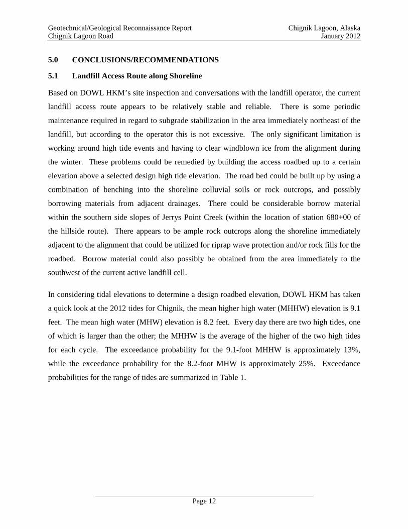
5.0 CONCLUSIONS/RECOMMENDATIONS
5.1 Landfill Access Route along Shoreline
Based on DOWL HKM’s site inspection and conversations with the landfill operator, the current
landfill access route appears to be relatively stable and reliable. There is some periodic
maintenance required in regard to subgrade stabilization in the area immediately northeast of the
landfill, but according to the operator this is not excessive. The only significant limitation is
working around high tide events and having to clear windblown ice from the alignment during
the winter. These problems could be remedied by building the access roadbed up to a certain
elevation above a selected design high tide elevation. The road bed could be built up by using a
combination of benching into the shoreline colluvial soils or rock outcrops, and possibly
borrowing materials from adjacent drainages. There could be considerable borrow material
within the southern side slopes of Jerrys Point Creek (within the location of station 680+00 of
the hillside route). There appears to be ample rock outcrops along the shoreline immediately
adjacent to the alignment that could be utilized for riprap wave protection and/or rock fills for the
roadbed. Borrow material could also possibly be obtained from the area immediately to the
southwest of the current active landfill cell.
In considering tidal elevations to determine a design roadbed elevation, DOWL HKM has taken
a quick look at the 2012 tides for Chignik, the mean higher high water (MHHW) elevation is 9.1
feet. The mean high water (MHW) elevation is 8.2 feet. Every day there are two high tides, one
of which is larger than the other; the MHHW is the average of the higher of the two high tides
for each cycle. The exceedance probability for the 9.1-foot MHHW is approximately 13%,
while the exceedance probability for the 8.2-foot MHW is approximately 25%. Exceedance
probabilities for the range of tides are summarized in Table 1.

Geotechnical/Geological Reconnaissance Report Chignik Lagoon, Alaska Chignik Lagoon Road January 2012
Page 13
Table 1: Chignik Lagoon Tide Elevations and Exceedance Probabilities
Tide Elevation Exceedance Probability
(FT) (%) 11.8 0.2 11.0 1.0 10.0 5.0 9.4 10.0 8.7 20.0 7.9 30.0 7.0 40.0 5.1 50.0 3.2 60.0 2.0 70.0 0.9 80.0 -0.4 90.0
In summary, if it is desired to have the landfill access road open about 75 percent of the time
during high tide events, then the roadway elevation should be approximately eight feet above the
existing beach elevation. These elevations should be considered preliminary at this time.
It would be relatively easy to connect the shoreline alignment to the southern portion of the
proposed Chignik Lagoon Road at approximate station 640+00 by excavating into the southern
side of the Landfill Creek drainage which the current hillside route crosses at station 643+50.
Appropriate permitting would be required to allow placement of fill along the shoreline. The
extent of permitting required has not been determined at this time. Geotechnical investigations
should be conducted to further define subgrade conditions along the landfill access roadway and
further define borrow material and riprap availability. The results of the investigation will allow
a more informed determination of the feasibility of using the landfill access alignment as an
alternative to the hillside route.
5.2 Hillside Route Alignment
Based on the visual reconnaissance investigation, which was limited by the dense vegetation and
steep terrain, there does not appear to be any blatant indications of active slope instability along
the hillside route. However, there are some significant construction considerations associated

Geotechnical/Geological Reconnaissance Report Chignik Lagoon, Alaska Chignik Lagoon Road January 2012
Page 14
with locating the roadbed along the hillside. The predominate considerations are cut slope
stability and roadbed drainage. Other considerations are safety measures (guardrails) during
road use.
Cut slope stability. The alignment side hills very steep terrain for the majority of the distance
between the landfill and Village of Chignik Lagoon. The existing ground slope angles approach
1H:1V (horizontal to vertical) at the steepest areas. Typical cross sections shown in Figures
XS-1, XS-2 and XS-3 indicate that, in order to catch the existing ground at reasonable distances
from the roadbed, the backslope angles would have to be at 0.75H:1V or 0.5H:1V. These angles
would still intersect the existing ground at heights equal to or greater than 25 feet above the
roadbed.
Colluvial soils would not remain stable at 0.75H:1V cut slope angles and raveling would likely
be excessive. There is also the potential that more significant global instability could occur
further upslope as a result of the excavations. At a minimum, soil nailing or other stabilization
methodologies likely would be required to maintain long-term stability for cut slopes at these
angles within the colluvial soils.
Geotechnical investigations will be required to define subgrade conditions and to determine if
the cut slope excavations would extend into competent bedrock or colluvial soils along these
alignments and if the excavations would maintain adequate stability.
Roadbed Drainage. The alignment immediately above the village between stations 692+50 to
710+00 crosses numerous small drainages. These drainages flow directly through town. Road
ditch drainage will concentrate up gradient runoff flows into the existing drainages, thus
increasing historic flows down gradient. As these drainages flow directly through town,
increased flows could cause localized flooding. Particular attention must be given to drainage
design along this section of the roadway. Upgrading of drainage infrastructure through the town
will be required. Additionally, roadbed drainage is critical along portions of the roadway sited
on the steep hillsides. Routing of drainage is critical so runoff does not “pool” and saturate the
roadway subgrade or cut/fill toe areas. Dependent upon geologic conditions, saturation of these
zones could initiate large scale instability along the alignment.

Geotechnical/Geological Reconnaissance Report Chignik Lagoon, Alaska Chignik Lagoon Road January 2012
Page 15
Roadway Safety Considerations. Another consideration is safety during use of the roadway.
The alignment side hills very steep terrain for the majority of the alignment between the landfill
and Village of Chignik Lagoon. The existing ground slope angles approach 1H:1V at the
steepest alignment areas. These angles approach cliff-like exposures, and with the proposed
narrow road widths, guardrails should be utilized along these steep foreslope areas. The current
proposed road templates are narrow and consideration should be given to allow adequate width
for placement of a guardrail.
5.3 Potential Borrow Marshinlak Creek Area
Results of the sampling indicate that deltaic soil materials consist of well graded to poorly
graded gravels. Additionally, based on the samples taken, gravels exhibit relatively high
resistance to weathering; however, the samples taken slightly exceed the State of Alaska
Department of Transportation and Public Facilities’ Standard Specifications for sodium sulfate
soundness for gravel road surfacing. If the gravel source were quarried and crushed the material
may pass specification. It is recommended that additional sampling and testing be performed for
this potential source area aggregate.
Weather conditions during the site reconnaissance, coupled with the challenging topographic
conditions, limited access to the actual alignment area further up Marshinlak Creek Drainage.
However, the gravel soils sampled are representative of parent rock materials which would be
located up drainage.
It is recommended that further borrow investigations be conducted for the Marshinlak Creek and
Duck Creek crossing areas. Access is challenging due to variable often extreme weather
conditions and shallow, narrow creek channels coupled with dense vegetation. Proper pre-
planning and coordination with Tribal personnel will be required with regard to access to
potential borrow areas.
5.4 Summary Conclusions
In summary, construction on the steep side hill areas along the proposed hillside route will be
challenging. Cut slope stability is a concern in regard to the steep backslope angles (0.75H:1V
or 0.5H:1V), which will be required in order to achieve excavation catch points that are not at
excessive distances and elevations above the roadbed. There is also concern that larger scale

Geotechnical/Geological Reconnaissance Report Chignik Lagoon, Alaska Chignik Lagoon Road January 2012
Page 16
slope instability could occur if proper drainage and backslope stabilizations are not achieved.
The geologic conditions must be further confirmed along the steep side hill locations in order to
assess to affect construction of the road will have on the global slope stability. It must be
determined if the roadbed will be within bedrock or colluvial soils and the engineering
characteristics of the colluvial soil veneer must also be defined.
It is DOWL HKM’s opinion that the landfill access route may be a feasible alternative to the
hillside route, provided permitting can be obtained to allow fill placement along the shoreline
and ample borrow material can be obtained to allow construction of an approximately eight-foot
fill along the shoreline route. Additionally, in depth geotechnical investigations will also be
required to further determine feasibility. The geotechnical investigations will allow confirmation
of subgrade conditions and availability of borrow and riprap.

Geotechnical/Geological Reconnaissance Report Chignik Lagoon, Alaska Chignik Lagoon Road January 2012
Page 17
6.0 ADDITIONAL INVESTIGATIONS
In depth geotechnical investigations should be conducted for both the landfill access and hillside
routes. At this time, DOWL HKM proposes to utilize a local contractor and tracked excavator to
dig test pits at select locations along both alignments. The soil and groundwater characteristics
will be recorded for each excavation and soil and rock samples will be obtained and submitted to
our Anchorage laboratory for testing to define physical and engineering characteristics.
6.1 Landfill Access
Geotechnical investigations should be conducted along the existing landfill access route to
further define subgrade stability and availability of borrow material and riprap. Investigation
along the existing alignment will be relatively easy as access is straightforward with open
country along the shoreline.
6.2 Hillside Route
Geotechnical investigations should be conducted along the proposed hillside alignment. As
discussed in the report, access to portions of the alignment area is challenging due to the
extensive vegetation and steep topography. It will be required to pioneer temporary roadways to
allow excavator access at locations adjacent to the steep hillside areas. It is mandatory that at a
minimum, test pits be excavated at representative locations along the steep hill sides in order to
obtain suitable information for stability assessments. It is our understanding that there are
earthwork contractors in Chignik Lagoon that have the capabilities and operator expertise to
access the steep hillside areas utilizing excavators to construct temporary pads and access
roadways. It is anticipated that portions of the steep hill slope areas can be accessed from the
south side of Jerrys Point Creek and north side of Landfill Creek.

Geotechnical/Geological Reconnaissance Report Chignik Lagoon, Alaska Chignik Lagoon Road January 2012
Page 18
7.0 LIMITATIONS
This report was prepared for the use of the Owner and Engineer in the preliminary planning of
the development. It should be made available to prospective contractors for information on
factual data only and not as a warranty of subsurface conditions.
Any conclusions by a construction contractor or bidder relating to construction means, methods,
techniques, sequences, or costs based upon the information provided in this report are not the
responsibility of the Owner or DOWL HKM. The contractors and bidders are encouraged to
perform additional investigations necessary to develop subsurface data for construction purposes.

Geotechnical/Geological Reconnaissance Report Chignik Lagoon, Alaska Chignik Lagoon Road January 2012
Page 19
8.0 REFERENCES
Detterman, R.L. Miller , T.P., Yount, M.E. and Wilson, F.H. , 1981a Geologic Map of the
Chignik and Sutwik Island Quadrangles, Alaska : U.S. Geological Survey Miscellaneous
Investigations Map I-229, Scale 1:250,000, 1 sheet.
Draft Small Hydropower Interim Feasibility Report and Draft Environmental Impact Statement,
Chignik Alaska; Department of The Army Alaska District , Corps of Engineers , July
1984
Feasibility Report Chignik Lake to Lagoon Road; Federal Highway Administration Western
Federal Lands Highway Division, March 2011
Johnson & Hartman, 1984, Environmental Atlas of Alaska, 2nd Ed. Revised: Institute of Water
Resources, University of Alaska, Fairbanks, 95p.
Pewe, T.L., 1975, Quaternary Geology of Alaska, U.S. Geological Survey, Professional
Paper 835, U.S. Government Printing Office, Washington, 145p., 1 map, 2 tables in
pocket.
Reger and Others 2003, Geologic Map of Proposed Transportation Corridors In The Chignik
Quadrangle, Alaska: Miscellaneous Publications 61a and 61d
Roadway Plan and Profile Sheets, Chignik Lagoon Road; January 2010
Wahrhaftig, Clyde, 1965. Physiographic Divisions of Alaska, US Geological Survey
Professional Paper 482, US Government Printing Office, Washington D.C., 52p.,
6 plates.

APPENDIX A
GEOLOGIC MAPPING (Plan and Profile Sheets)


APPENDIX B
PHOTOGRAPH LOG

CHIGNIK LAGOON ROAD PHOTOGRAPH LOG
Page 1
Photograph 1: Looking south east showing road alignment along structural bench above village
Photograph 2: Looking SE at road alignment (yellow line ) and ancient landslide area (white line).
Approximate location of Cross section XS-3

CHIGNIK LAGOON ROAD PHOTOGRAPH LOG
Page 2
Photoraph 3: Looking SW at landfill access road along shoreline and toe of ancient landslide.
Bedrock exposed in cliffs above landslide.
Photograph 4: Close up of toe of ancient landslide. Proposed road alignment shown by yellow line.
Bedrock outcrops
Bedrock outcrops
Toe of ancient landslide
Landfill access route along shore

CHIGNIK LAGOON ROAD PHOTOGRAPH LOG
Page 3
Photograph 5: Looking south at landfill access along shore from drainage outlet adjacent to Tract U..
Proposed road alignment shown along hillside (yellow line).
Photograph 6: Looking SSW along landfill access. Concrete road pads in foreground. Colluvium soil
veneer overlaying bedrock is visible on hillside adjacent to shoreline.
Photos 11 and 11a taken from knoll

CHIGNIK LAGOON ROAD PHOTOGRAPH LOG
Page 4
Photograph 6a: Looking NNE along landfill access.
Photograph 7: Looking SSW along landfill access. Sedimentary bedrock exposed at toe of hillside.
Bedrock exposed in cliffs in background.
Sedimentary bedrock outcrops
Sedimentary bedrock
Sedimentary bedrock outcrops

CHIGNIK LAGOON ROAD PHOTOGRAPH LOG
Page 5
Photograph 8: Sedimentary rock outcrop with colluvial soil veneer along landfill access roadway
(near station 664+00).
Photograph 9: Landfill access looking SSW at rocks forming cliffs along shoreline.
Sedimentary bedrock
Colluvial soil veneer
CHIGNIK LAGOON ROAD PHOTOGRAPH LOG
Page 6
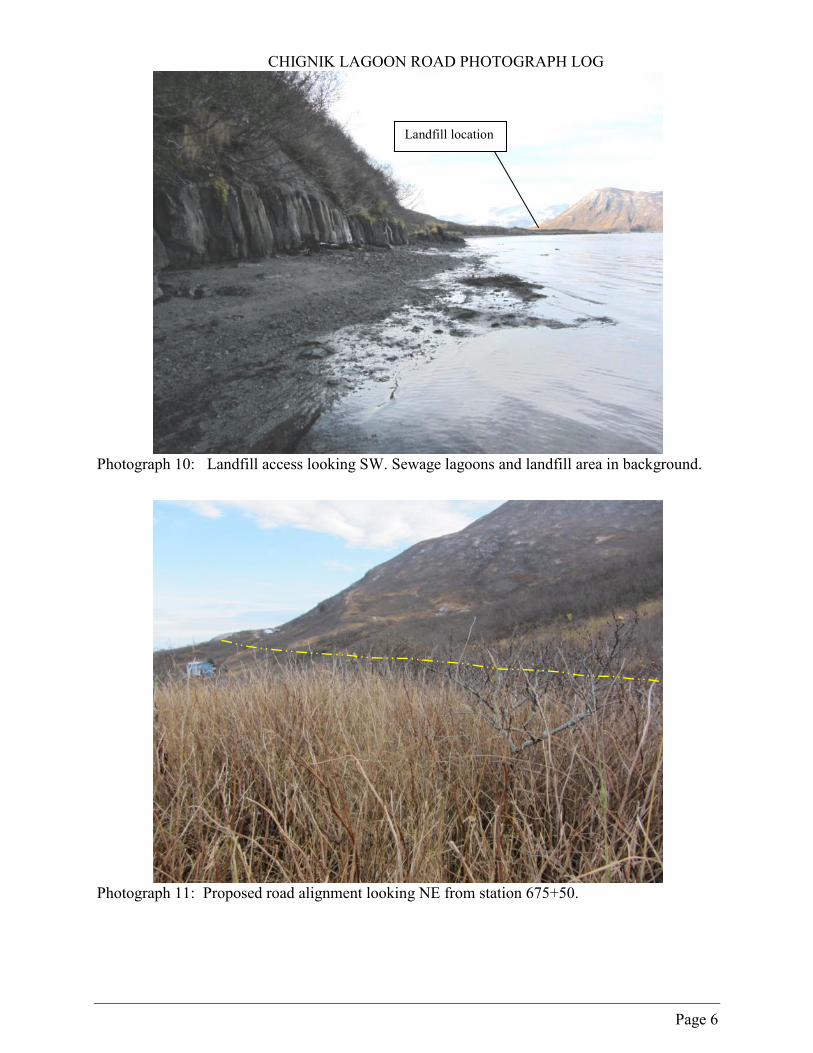
Photograph 10: Landfill access looking SW. Sewage lagoons and landfill area in background.
Photograph 11: Proposed road alignment looking NE from station 675+50.
Landfill location

CHIGNIK LAGOON ROAD PHOTOGRAPH LOG
Page 7
Photograph 11A: Proposed road alignment from station 675+50 looking SSW. Landfill area in
background.
Photograph 12: Looking NE from berm between landfill and lagoon at alignment on hillside.
Landfill area
Current landfill access route along shoreline
Approximate location of Cross section XS-1
Approximate location of Cross section XS-2

CHIGNIK LAGOON ROAD PHOTOGRAPH LOG
Page 8
Photograph 13: From shoreline by landfill looking NE at hillside alignment.
Photograph 14: From shoreline by landfill looking NE along landfill access and hillside route
alignment (yellow line).
Approximate location of Cross section XS-1
Cliffs formed of sedimentary rock ock

CHIGNIK LAGOON ROAD PHOTOGRAPH LOG
Page 9
Photograph 15: From shoreline by landfill looking NE at hillside alignment.
Photograph 16: From shoreline by landfill looking east at hillside alignment.

CHIGNIK LAGOON ROAD PHOTOGRAPH LOG
Page 10
Photograph 17: Test pit excavation by landfill showing silty gravel colluvium and large blocks of
volcanic rock.
Photograph 18: Typical dense vegetation encountered along alignment (8- to 12-foot alders with
salmon berry bush and mixed grasses).

CHIGNIK LAGOON ROAD PHOTOGRAPH LOG
Page 11
Photograph 19: Showing colluvial slope / marine sediment interface along landfill access route.
Colluvium consists of angular cobble and boulder size sedimentary and volcanic rocks in sand,
silt and clay matrix. Large boulder “rockfall is infrequent.
Photograph 20: Showing colluvial slope / marine sediment interface along landfill access route.

CHIGNIK LAGOON ROAD PHOTOGRAPH LOG
Page 12
Photograph 21: Showing bedrock subgrade area just northeast of sewer lagoon and landfill. Landfill
access road concrete pads in foreground.
Bedrock outcrop

CHIGNIK LAGOON ROAD PHOTOGRAPH LOG
Page 13
Photograph 22: Marshanlak Creek Delta.
Photograph 23: Marshanlak Creek delta deposits.
Delta deposits

CHIGNIK LAGOON ROAD PHOTOGRAPH LOG
Page 14
Photograph 24: Marshanlak sample sites.
Photograph 25: Marshanlak Creek sample site No. 1.

CHIGNIK LAGOON ROAD PHOTOGRAPH LOG
Page 15
Photograph 26: Typical excavator available at Chignik Lagoon.

APPENDIX C
TYPICAL CROSS SECTIONS


APPENDIX D
LABORATORY TEST RESULTS

Maria E. Kampsen, P.E • 4041 B Street • Anchorage • Alaska • 99503 • 907/562-2000 • Fax 907/563-3953
Client:
Project:
Work Order:
Chignik Lagoon Tribal Council
Chignik Lagoon Road
D60936
11/8/2011
2011-1763Lab Number
Received
Reported 12/8/2011
#200 1.7%
#100 3%
#60 4%
#50 5%
#40 6%
#30 8%
#20 10%
#16 13%
#10 17%
#8 19%
Total Weight of Fine Fraction: 327.5g
#4 30%
Ȩ" 53%
½" 64%
¾" 79%
1" 89%
1½" 94%
2" 100%
3" 100%
Total Weight of Coarse Fraction: 4420g
Size Passing Specification
ASTM D422
Particle Size Distribution
Engineering Classification:
Frost Classification:
Well Graded Gravel with Sand, GW
Not Measured
Location: Sample 3 Depth 0'-1'

Maria E. Kampsen, P.E • 4041 B Street • Anchorage • Alaska • 99503 • 907/562-2000 • Fax 907/563-3953
Client:
Project:
Work Order:
Chignik Lagoon Tribal Council
Chignik Lagoon Road
D60936
11/8/2011
2011-1761Lab Number
Received
Reported 12/8/2011
0.02 mm 1%
#200 1.7%
#100 3%
#60 6%
#50 7%
#40 8%
#30 9%
#20 10%
#16 10%
#10 11%
#8 11%
Total Weight of Fine Fraction: 415.8g
#4 13%
Ȩ" 21%
½" 29%
¾" 48%
1" 62%
1½" 84%
2" 94%
3" 100%
Total Weight of Coarse Fraction: 26197g
Size Passing Specification
ASTM D422
Particle Size Distribution
Engineering Classification:
Frost Classification:
Poorly Graded Gravel, GP
NFS MOA
Location: Sample 1 Depth 0'-1'

Maria E. Kampsen, P.E • 4041 B Street • Anchorage • Alaska • 99503 • 907/562-2000 • Fax 907/563-3953
Client:
Project:
Work Order:
Chignik Lagoon Tribal Council
Chignik Lagoon Road
D60936
11/8/2011
2011-1762Lab Number
Received
Reported 12/8/2011
#200 .4%
#100 1%
#60 1%
#50 1%
#40 1%
#30 2%
#20 2%
#16 3%
#10 4%
#8 4%
Total Weight of Fine Fraction: 327g
#4 7%
Ȩ" 10%
½" 12%
¾" 17%
1" 22%
1½" 32%
2" 85%
3" 100%
Total Weight of Coarse Fraction: 16658g
Size Passing Specification
ASTM D422
Particle Size Distribution
Engineering Classification:
Frost Classification:
Poorly Graded Gravel, GP
Not Measured
Location: Sample 2 Depth 0'-1'
W.O. Lab #
All results will be posted to the website for your access and convenience. Samples will be kept for30 days before being disposed. Please contact us if you would like the remaining material returned.
TypeBA
If you have questions regarding this summary report or the test procedures, please contact us.
Resistivity Saturated = 20001763 Soil Resistivity ASTM G57
Sample ID Test Performed Test Method Results (ohm-cm)
Sample ID Test Performed Test Method Revolutions % Loss1761 Sample 1 LA Abrasion ASTM C131 500 26
D60936
1762 Sample 2 LA Abrasion
Project Chignik Lagoon Road See BelowLocation See Below
Testing Report Summary
ASTM C131 500 18
Date Sample Recv'd 11/8/2011Client Chignik Lagoon Tribal Council
(Rev 1, 12/09) 4040 B Street, Anchorage, Alaska 99503 -- 907-562-2000 © 2009 Copyright DOWL HKM
Maria E. Kampsen, P.E.Laboratory Supervisor
(Rev 1, 12/09) 4040 B Street, Anchorage, Alaska 99503 -- 907-562-2000 © 2009 Copyright DOWL HKM

W.O. #Lab #
All results will be posted to the website for your access and convenience. Samples will be kept for30 days before being disposed. Please contact us if you would like the remaining material returned.
5 cycles / Sodium Sulfate
Retained On
Sieve #
Original
Gradation
Before Test
Weight
After Test
Weight
After Test
Percentage
Weighted
Percentage
Loss
-200200 0100 950 36 0.0 0.0 0.0 0.0030 18 100.1 84.9 15.2 2.7616 9 100.1 74.9 25.2 2.298 9 100.1 68.7 31.4 2.854 18 100.0 68.2 31.8 5.78
Total 100 Total 13.7 Weighted Percentage
5 cycles / Sodium Sulfate
Retained On
Sieve #
Original
Gradation
Before Test
Weight
After Test
Weight
After Test
Percentage
Weighted
Percentage
Loss
3/8-no4 9 300.5 178.1 40.7 3.753/8 331.21/2 673.7
3/4-3/8 31 1004.9 835.7 16.8 5.233/4 506.3
1 1014.91 1/2-3/4 41 1521.2 1459.5 4.1 1.68
1 1/2 2012.12 3003.1
2 1/2-1 1/2 18 5015.2 4929.0 1.7 0.31
Total 100 11.0 Weighted Percentage
If you have questions regarding this summary report or the test procedures, please contact us.
Maria E. Kampsen, P.E.Laboratory Supervisor
Soundness of Coarse Aggregate - ASTM C88
Project Chignik Lagoon Road 1761Location Sample 1, 0-1
Client Chignik Lagoon Tribal Council D60936
Soundness of Fine Aggregate - ASTM C88
Testing Report Summary
Date Sample Recv'd 11/8/2011
(Rev 1, 12/09) © 2009 Copyright DOWL HKM