reconnaissance quaternary geological investigations in peace
TRANSCRIPT
RECONNAISSANCE QUATERNARY GEOLOGICAL INVES’TIGATIONS IN PEACE RIVER DISTRICT, BRITISH COLUMBIA
(93P, 94A)
By P.T. Bobrowsky, N. Catto, Memorial University of Newfoundland and V. Levson
KEYWORDS: Surficial geology, Quaternary, Pleistocene, Peace River. sedimentology, stratigmphy, Wisconsinan glaciation, diamicton, rhythmite, till, glaciolacustrine.
INTRODUCTION Geologic investigations were undertaken in the area bor-
dering the Peace River in northeastern British Columbia.
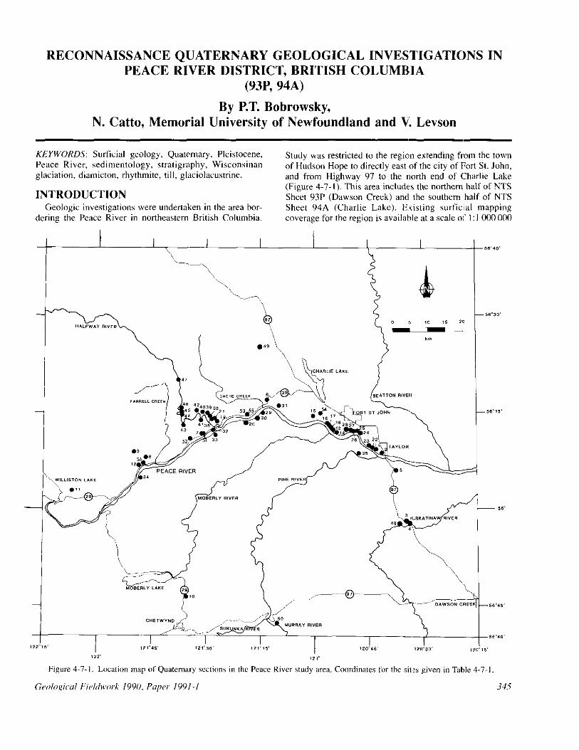
Study was restricted to the regio’n extending from the town of Hudson Hope to directly east of the city of Fort St. John, and from Highway 97 to the north end of Charlie Lake (Figure 4-7-l). This area includes the northern half of NTS Sheet 91P (Dawson Creek) and the southern half of NTS Sheet 94A (Charlie Lake). E,risting surficial mapping coverage for the region is available at a scale 01‘ I: I 000 000

Plate 4-7-l. Section PTB90-43 (HalSw,ay River land- slide). View to south of recent Attach&like slope failure, which originally extended across the Halfway River and temporarily blocked drainage until breached several hours law. Note small channelline and leverine atow the surface Sormcd during and aft& the failure. (GSB photo PTBYO-13-15).
Figure 4~7.2. Index map of I:50 000.scale NTS map sheets comprising study area. Shaded sheets indicate regions Inapped in 1990, and accompanying report by Catto (1991).
for NTS Sheet 94 (Beatton River; Mathews rf ul., 1975) and at a scale of I :250 000 for NTS Sheet 94A (Mathews. 1978a) and NTS Sheet 93P (Reimchen, 1980). Aggregate data for the area are poor, as are the data on peat deposits, both issues recommended as requiring attention (How, 1988: Maynard, 1988).
The objectives of this project are to provide detailed surficial geological maps (I:50000 scale) of practical use to
346
industry, as well as municipal, regional and provincial go,- emments; determine the occurrence of, and assess the exploration potential for, aggregate and peat deposits in the same area; study mass-movement deposits along the Peace River Canyon, and if possible determine the timing of occurrznce of these past events (Plate 4-7-l); to contribute to the provincial geoscience database by refining the Quaternary geologic history of the Peace District through stratigraphic investigation. Field activities during the 19’10 season included surficial mapping of four map sheets (Fig- ure 4-7-Z). as well as extensive reconnaissance to locate exposures and sections suitable for further detailed study. This paper presents the results of the reconnaissance efforts and therefore addresses the latter two project objectives, whereas the surficial maps and their accompanying inter- pretation which are published separately will cover the first two project objectives (Catto. 1991).
The earl&t published description of the Peace River Canyon appears in the journal of Sir Alexander Mackenzie during his trip through the region in 1793. Almost 100 years later, in 1872, Captain W.F. Butler provided a detailed and picturesque description of the Peace River valley, and in I X75. A.R.C. Selwyn provided the first geologic description of the area. concentrating on the bedrock geology: only passing reference was made to the unconsolidated sedi- ments by Selwyn (Beach and Spivak, 19433. The most significant contributions to the Quaternary geology of the Peace Region occurred in the period 1950-1980 by W.H. Mathews, and 1967.1977 by N.W. Rutter (Mathews, 1954, 1962, 1972. 1973, 197Xa. b, 1980; Rutter, 196X, l96Ya, b, 1974, 1976. 1977, 1980, 1981, 1984). However, recent geologic interpretations in the adjacent Rocky Mountain Trench (Bobrowsky, 1984, 1987, 1988, 1989% b: Bobrowsky and Rutter, 1989, 1990) and the Peace District of Alberta (Livennan, 19X7, 1989% b; Liverman it al., lYX9) may have significant effects on interpretations pres- ently applied to the study area. These recent investigations, coupled with the need for an assessment of aggregate and peat exploitation potential, and the continued threat of fre- quent nxtss movements, provide a necessary stimulus for renewed geologic work along the Peace River.
SETTING The study area lies along the western edge of the Alberta
Plateau within the Interior Plains (Mathews, 1986). Low- relief topography characterizes the region and consists of broad rolling plateaus and cuestas at elevations near 900 metres. These upland areas are dissected by the Peace River and its major tributaries including the Halfway, Mabel-ly, Pine, Beatton and Kiskatinaw rivers, as well as Lynx, Far- rell and Cache creeks (Holland, 1976). The elevation of the Peace River is 520 metres at Hudson Hope and less than 450 metm at the mouth of the Kiskatinew. The disorganized drainage in the uplands is imprinted upon unconsolidated glacial deposits which cover flat-lying or gently east- dipping sedimentary bedrock of Cretaceous age. Most of the sedimentary rocks in the area belong to the Fort St. John Group. The oldest rocks. which belong to the Gates Forma- tion, are composed of marine shale, siltstone and sandstone

MODEL 1 MODEL 2
Distance from Rocky Mountain Trench , t I 1 10 100 km
:ordilleran Montane Ice I Laurentide Ice I
Distance from Rocky Mountain Trench
1 10 100 km
I------
Cordilleran Montane I Ice Laurentimde Ice
and outcrop in the west, near Hudson Hope. Marine silt- smnc, silty shale and shale belonging to the Shaftesbury Formation overlie the Gates Formation and outcrop in sev- cm, places rhroughout the study ilrril. These rocks. I” turn, grade upward into more resistzmt siltstone and sandstone of the Dunvegan Formation (Mathew, 1978~1).
The Pcxc River, which rises farther west at the Rocky Mounlain Trench, is part of the Mackenzie River system. and is a prcglecial feature which cuts across the Rocky Mountains perpendicular to the regional bedrock trend. If is likely thaw the course of the Peace River was established in the early Tertiary, and it is thus anteccdcnt to the Rocky Mountain uplift which formed, in this imz, during the lute Tertiary (Holland, 1976). The preglacial Peace River occupied it much bn,8der channel than the present river. Notable changes in its course include: ii preglacial channel between Bull and Portage mountains (now occupied by the Portage Mountain moraine): palzoriver-flow I to 2 kilo- metres south of the present channel between Hudson Hope and Halfway River; and. paleoriver-flow 4 to 5 kilomerres south of the present channel between Bear Flat arId Fort St.
John (Beach and Spivak, 196:;; Mathews, 197X& 19X0; Rutter, 1977; Seyers and Buchanan, 1990).
Historically the northwest put of British Columbia has lone been favored as a primary centre for Pleistocene ice build-up (c:f. Bobrowsky, 198% for a detailed review). Modifications to this theme are Iminor and include recogni- tion of other glacial ice accumulation cenfres such as the Cassiar, Cariboo and northern Rocky Mountains. The style, extent, intensity and timing of ghiciations, howwer, attract a greaw diversity of opinions and interpretations. The most contentious issue of the Pleistocr:ne history in the study xea centres on two aspects: the influence of Laurentide glacial ice in the province of British Columbia; and the number of glacial events. In the Peace Di!;trict, two primary models and their variants have been put forward to describe the Pleistocene glacial history of the region (Figure 4-7-3). Model I recognizes two to three Laurentide and three to four Cordillcran glacial events, whereas Model 11 recognizes onr Laurentide and two Cordilleran events. More importantly, Model I recognizes a coalescence of Cordilleran and Lao- rentide ice sheets, not recognized in Model II.
3J7

Lu A . DIAMICTON
l$C D”:“: GRAVEL (Pebble lo Boulder)
RHYTHMITE (Sand Rich)
COLLUVIUM
LI SAND
m SILT
M CLAY
!tszz& RHYTHMITE (Clay Rich)
RHYTHMITE [Silt Rich)
m BEDROCK
m/ ORGANIC
DEFORMED BEDDING
WELL STRATIFIED
CRUDELY STRATIFIED
SHARP CONTACT
GRADATIONAL CONTACT
FINING UP i COARSENING UP
Eq FAULT
LEGRN” FOR FIGURES 4-7-4 through 4-7-12.
Plate 4-l-2. Section PTB90-26. View to north illustrates bluff exposure consisting of late Quaternary glacial scdi- mmts. Majority of exposed sediment at this site is late Wisconsinan diamicton deposited by Laurentide ice sheet. (GSB photo PTBYO- I I-34).
RESULTS AND INTERPRETATIONS
Field reconnaissance in the study area during 1990 resulted in the identification of 56 sites (Figure 4-7-l). providing some form of subsurface exposure of the uncon- solidated sediments (Plate 4-7-2). Table 4-7-l lists the cow dinates and elevations of these sites. Preliminary sedimen- tologic and stratigraphic work at a few of these locations supports the contention of a complex glacial history for the area, involving ice interaction from three independent
348
sources (Laurentide, Cordilleran and Montane). Descrip- tions and genetic interpretations for several localities are discussed below.
DIAMICTON DEPOSITS
SECTION PTB90-06 Section PTBYO-06 is located 17. I kilometres west of Fort
St. John. along Highway 29 (Figure 4-7-l). The 15.7 mews of sediment exposed at this locality comprises four units (Figure 4-7-4). Overlying the shaly bedrock along a brecci- ated regolith-like contact is a coarse, matrix-supported diamicton, 2.3 metres thick, containing planar silt lenses which are approximately 2 centimetres thick and 20 to 30 centimetres in length (Unit I). Clasts in the unit are all angular and of local lithology. Unit 2 which is 8 metres thick, consists of 672, stone-free. normally graded silty sand and sandy silt rhythmite couplets, which are I to 5 cen- timetres thick. Both upper and lower contacts are sharp and erosional. The rhythmites are overlain by a stratified, matrix-supported diamicton. 4.3 metres thick, containing many planar and biconvex, fine silt lenses, which are I to 2 centimetres thick and up to 20 centimetres in length (Unit 3: Plate 4-7-3). The diamicton grades upward into approx- imately I metre of silt and clayey silt rhythmites which show postdepositional disturbance and pedogenesis (Unit 4). Large clasts, up to boulder size, are present in the upper rhythmites.
The lower diamicton. overlying bedrock. is interpreted to be local colluvium or debris-flow deposits. The remaining

PTB90-06
- .
units all represent facies formed in a glacial-l;lke ewirow mat. Unit 2 rhythmites probably represent sediment depos- ited during the early stapcs of glacial-lake formation as drainage to the east was blocked by Laurentide ice. The diamicton overlying these rhythmites is either a subaqueous sediment gravity-flow accumulation depwited in the impounded lake. or a deformation till of unknown prove- nance. The topmost rhythmitrs with drop-stones reflect the

lTB90-09
Plate 4-7-3. Section PTB90-06 (Bear Flat section). Strat- ified glacial diamicton near top of section. approximately 5 mctrcs thick, is interpreted to be either a subaqueous debris-flow deposit or deformation till related to the late Wisconsinan glaciation. (GSB photo PTB90-08-20).
retreating stages of the glacial event and thus the later stages of the lake history.
SECTION PTB90-09 This section is located 13 kilometres northeast of Hudson
Hope, 2.5 kilometres north of Highway 29 in a small unnamed ravine (Figure 4-7-l). Nine units are represented in the 27.2 metres of sediment exposed in the section (Fig- ure 4-7-5). At the base, 1 I metres of horizontally stratified pebble-gravel, with some boulders (Unit I), is gradationally overlain by 3.4 metres of massive matrix-supported diamic- ton containing silty sand lenses (Unit 2). The Unit 2 diamic- ton grades upward into 2 metres of pebble-rich, slightly stratified, clast-supported diamicton (Unit 3), which in turn, grades up into 0.7 metre of poorly stratified, open-work pebble-gravel (Unit 4). Unit 5 comprises 1.1 metres of massive to slightly stratified matrix-supported diamicton which rests upon a sharp lower contact marked by a well- cemented, pebble lag bed. The upper contact shows sheared horizontal bedding with slickenside structures. Unit 6 con- sists of I.8 metres of massive, matrix-supported diamicton
.vio
3
I M
0
Figure 4-7-S Composite stratigraphic column for Section PTB90-09.
with vertical jointing. Sharply overlying the diamicton is a 1.9.metre fining-upward sequence of horizontally stratified sand and imbricated gravel beds (Unit 7). Discontinuous and thin silty diamicton lenses are intercalated within the sand and gravel. A 2.3.metre matrix-supported diamicton, with some crude stratification and sharp upper and lower contacts overlies the sand and gravel (Unit 8). The top of the section consists of approximately 3 metres of sandy silt and clayey silt rhythmite couplets.
The complex sequence exposed at this section may reflect one or two glacial/nonglacial events. The interpretation that follows is tentative. The basal gravel represents fluvial deposition in a braided stream system, probably advance outwash (Unit I). Over-riding ice may then have deposited the massive diamicton which is interpreted to be a till (Unit 2). As ice retreated. local deposition of resedimented diamicton within gravel occurred, as interpreted from the sediments in Unit 3. A second depositional cycle in a braided stream system is then inferred for the Unit 4 deposit. A period of erosion (= boulder lag) clearly pre-

PTBSO- 14 l'TB90-53
1
1 M 0
crdcd accumulation of the resedimented diamicton beds in gravel (Unit S) and till (Unit 6) as ice once again advanced over the area. This was followed by addhional resedimcnta- tion in ice-contact gravel deposits during ice retreat (Unit 7). Continued ice retreat blocked the regional drai- nage, resulting in a proglacial lake environment into which a subaqueous sediment gravity-llow would have deposited the stratified diamicton (Unit 8) and subsequently &laciolacustrinc rhythmitcs iUnit 9).
COARSE-GRAINED DEPOSITS
SECTION PTB90-14
Section PTB90.I4 is located 41.5 kilomrtres southwest of Fort St. John, along the north bank of Peace River (Figure
Figure 4-7-7. Composite straligraphic column for Section PTBYO-53.
4-7-l). With the exception of the upper I metre of sandy and clayey silt rhythmites, the remaining 14 mctres of sediment exposed at this location is predominantly composed of sand and gravel interbeds (Units I to IO) (Figure 4-7-h). Several fining-upward cycles are evident III the deposit. Much of the sediment ranges from massive, open-work coht’le-gravel to stratified and imbricated pebble-gravel with a sandy matrix. Horizontally laminated, well-sorted, medium sand is found near the base of the section (IJnit 2).
This sequence is interpreted to represent flwvial deposi- tion in a relatively high-energy channel of :I braided or wandering stream system. The multiple fimng-upward cycles of gravel, and sporadic intxbeds of sand, reflect the shifting of channels and fluctuatinp energy levels which are characteristic of the braided stream environment.
SECTION PTB90-53
This section, located 27.2 kilomrtrcs west OC Fort St. John, along the north side of Highway 29, is a currently

F'TB90-52
Figure 4-7-8. Composite stratigraphic column for Section flB90-55.
inactive borrow pit (Figure 4-7-l). Exposed sediment totals 10.8 metres in thickness (Figure 4-7-7). At the base, Unit I, is dominated by coarse, imbricated pebble-gravel, and shadow structures indicating consistent flow toward 105”. This unit is at least 8 metres thick. An abrupt, erosional upper contact separates the gravel from an interbedded sequence of clayey silt, silty clay and fibrous or&anic detri- tal beds totalling 2.8 metres in thickness (Unit 2). All beds within Unit 2 are internally structureless.
The sequence exposed in this section is interpreted to be a tluvial succession. The basal gravel unit is interpreted to represent thalweg deposition in a moderate to high-velocity stream, similar to the modem Peace River. The overlying unit represents overbank deposition in a similar environ- ment. The sharp contact between the two units is either erosional and produced under conditions of a continuous single fluvial system, or represents a discontinuity in time.
SEmIoN PTB90-55 Section PTB90-55, located 2.8 kilometres northwest of
Highway 29, along Road 167, is in a borrow pit exposing 8.7 metres of sediment (Figure 4-7-l). Three units are present at this site (Figure 4-7-S). Unit I is more than 6 metres thick and fines upward from open-worked cobble-
352
1
I
M
0
Figure 4-l-9. Composite stratigraphic column for Section PTBYO-52.
gravel to matrix-filled coarse pebble-gravel. Imbricated bedding indicates depositional flow to the east and east- southeast. The mineralogy indicates derivation from west- cm sources. The upper contact is erosional. Unit I is over- lain by a pebble-gravel, 2 metres thick, with coarse and medium sand, consisting of several graded cycles (Unit 2). The uppermost Unit 3 gradationally overlies the pebble- gravel and consists of structureless fine to medium sand which has been pedogenically altered in the upper part.
This sequence is interpreted to represent fluvial deposi- tion in a relatively high-energy channel of a braided or wandering stream system. The absence of clasts from the Canadian Shield indicates that the exposure may lie beyond the limits of influence of Laurentide ice or the deposit predates Laurentide glaciation.

PTB90-56
Figure 4-l. IO. Composite stratigraphic column for Section PTR!W56.
FINE&RAINED DEPOSITS
SECTION PTB90-51 This section is located 40.8 kilometres east of Hudson
Hope, along the north side of Highway 29 (Figure 4-7-l). It consists of 18.6 mews of laminated silt and silty clay couplets. varying in thickness from I to 5 centimetres. Generally, the couplets at the base of the sequence arc thicker than those in the upper IO metres. Minor, structure- less sand beds, 2 to 8 centimetres thick. are present in the bnsal 2 metres of the sequence. A total of 576 couplets were identified.
This sequence is interpreted as the product of low-density turbidity currents in a deep glaciolacustrine environment. In the basal part of the exposure, draped silt lenses. erosional structures and lateral fcxtural gradation in wmc silt mem- bers suggest that flow during deposition was toward the northeast or east. Glaciolacustrine depositional envirw- merits were common during the Pleistocene in the Peace District and most often resulted from drainage impound- ment to the east by the Laurentide ice sheet (Mathews, 1980). The gredual upward decrease in couplet thickness reflects either deepening of the lake waters or expansion of the lake to the west. The absence of a rrgressivc sequence is probably due to subsequent erosion.
ITBSO-04
A A A
A A A
A A A,
SI3C.I.ION PTB90-52 Section PTB90-52 is located 35.4 kilometres east of Hud-
son Hope, along the north side of Highway 29 (Figure 4.7. I). This exposure consists of 3.36 metres of silty clay and clayey silt units overlying bedrock at road level, with a gradational upper contact to colluvium near the surface (Figure 4-7-9). A total of 193 couplets were counted. The basal I.85 metres consists of silt and silty c:,ay couplets, with a modal thickness of 2 centimetres (Unit I). Contacts between the couplets are all sharp, but not necessarily em- sional. These couplets are overlain, along a planar upper contact, by I5 centimetres of laminated clayey silt (Unit 2), which grades upward into couplets of silty clay and clay totalling 96 centimetres (Unit 3). Couplets in this sequence are generally thinner and finer in texture than those of Unit 2. The Unit 3 couplets are overlain by the 2’). centimetre-thick Unit 4, along a gradational contact, by couplets similar to those of Urlit I. A gradetivnal upper contact separates Unit 4 from I I centimetres of structureless silt (Unit 5), which completes the exposed section.
The units exposed at this locality are interpreted as the products of low-density glaciolacustrine turbidity currems,

originating from the west. The fluctuations in couplet thick- ness and texture probably indicate changes in the energy regimes of the turbidity currents, induced either by fluctua- tions in shoreline position or by changes in the axis of deposition of the current.
SECTWN PTB90-56 Section PTBYO-56 is located 16.4 km east of Hudson
Hope, along the north side of Highway 29 (Figure 4-7. 1). The exposure consists of three units and is 3.73 metres thick (Figure 4-7-10). Unit I is more than 67 centimetres thick. and is composed of an imbricated pebble-gravel indicating flow to the east. Clasts indicate a western provenance. Overlying Unit I along an erosional contact are I87 cen- timetres of complexly interbedded, mottled sandy silt, silt and silty sand beds (Unit 2). The upper part of this unit is truncated along an erosional contact. The uppermost 1 I9 centimetres (Unit 3) consists of silt to clay couplets, with gradational contacts between silt and clayey silt members, and erosional contacts between clay and silt members. A total of 44 couplets were counted in the unit. with a modal average of 3 centimetres in thickness.
Llnit I is interpreted to be the product of a moderate- energy fluvial system. The overlying sediments may repre- sent low-energy fluvial deposition, either as overbank deposits or in minor channels of a wandering stream. The high modal thickness of the uppermost rhyrhmites suggests that they represent periodic overbank sedimentation or palu- dal deposition in a fluvial system, rather than deposition in a lacustrine environment.
SLUMP DEPOSITS
SECTION PTB90-04 Section PTB90.04 is located 41.5 kilometres southeast of
Fort St. John. along the north bank of the Kiskatinaw River
Plate 4-7-4. Section PTBYO-IS (Target section). View of Unit 1, stratified glacial diamicton, containing prominent sand interbeds, numerous blat-lying boulders, and grada- tionally overlying Unil 2 rhythmites. Pebble fabric in diamicton approximately east-west. Pick for scale. Diamic- tan interpreted to be basal meltout-till. (GSB photo PTBUO-I I-OR).
354
90.12 1117.22 0.4910 :!.7mh ‘1 KO”~, 1 YO-tot: ,I%.?3 ,,.‘Bw,, :!.3lhi iz ~I,i,OOO
\,,,r: ,:;d,rir “urnher i,my”,,L,\ ID \CC,i’,ll n”lnhrr\ ,,rtr<, 111 ‘MdC 1.7-1.
near the Highway 97 bridge (Figure 4-7-l). River erosion has resulted in a transverse section through the distal part of a slump. Approximately 9.5 metres of sediment is exposed (Figure 4-7. I I). Horizontally bedded and well-imbricated boulder-gravel grading up into pebble-gravel (Unit I) is conformably overlain by I.5 metres of ripple-laminated sand (Unit 2). Climbing ripple sets, 2 to I5 centimetres thick, show convolution in the upper 0.5 metre of the unit. Wood and other organic debris, which is abundant in the upper I metre of Unit 2, has been dated to I IO?90 years B.P. (AECV-1213C). A sharp, subhorizontal erosional con- tact separates Unit 2 from the overlying 2 metres of sand and clay interbeds of Unit 3. Approximately 4 metres of clay-rich, matrix-supported diamicton occurs at the top of the section. Numerous subhorizontal slickensided surfaces, brecciated beds and faults are evident in Unit 3 and the lower pan of Unit 4.
Units I and 2 in this section are interpreted to represent a fining-upward channel-gravel sequence and fine overbank sedimentation, respectively, of a moderate to high-energy wandering braided-stream system. Unit 3 represents the lower cohesive sediment or contact zone of the slump which shears during sediment remobilization. In this unit, sorted beds are still preserved but overprinted with numerous shear planes formed during slumping. The overlying diamicton is interpreted to he the product of an upper zone of viscous resedimentation which also resulted from the same event.
DISCUSSION SEDIMENT TYPE
Based on a preliminary examination of several sections, Quaternary deposits in the study area can be grouped into
-
12
four broad textural groups including diamicton, gravel, sand and fines (silt and clay). Although additional work is required to identify and discuss all of the facie\ variations which may be present in these groups. a cursory review of .some of the ohsrrvations can be presented in this report.
Diamictons observed thus far include those that arc strut- tureless, stratified or massive with some interbeds (Plate 4-7-4). Their genesis is variable. For instance. the two diamictons (Units 2 and 6) observed at Section PTBYO-09 are both interpreted to be basal till deposits, whereas the diamicton at the top of Section PTB90-04 is a debris-flow xcumulation formed during slumping. The Unit 3 diamic- ton at Section PTB90-06 is interpreted to have been deposi- ted by a subaqueous sediment gravity-flow. Detailed work
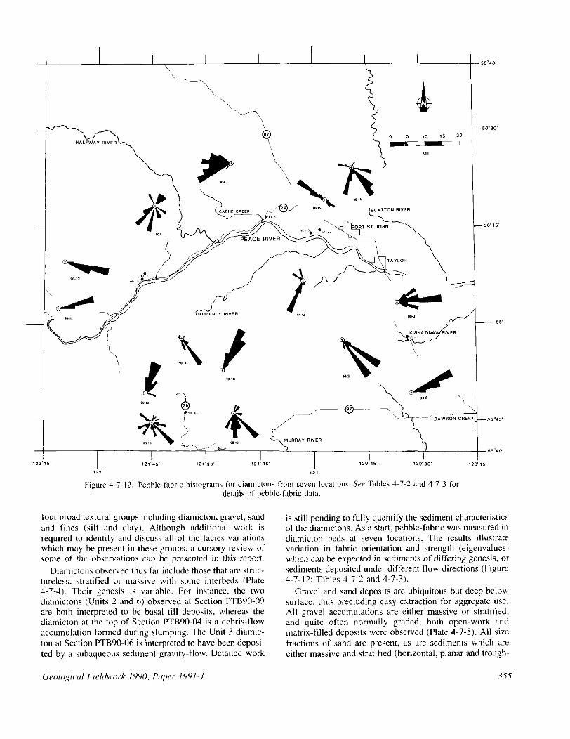
is still pending to fully quantify the sediment characteristics of the diamictons. As a start, pebble-fabric was measured in diamicton beds at seven localdons. The results illustrate variation in fabric orientation and strength (eigenvalucsl which can be expected in sediments of differiog genesis, or sediments deposited under diffuent flow diretztions (Figure 4-7-12; Tables 4-7-2 and 4-7-3).
Gravel and sand deposits arc: ubiquitous but deep below surface, thus precluding easy extraction for a.ggregate use. All gravel accumulations are (either massive or stratified, and quite often normally graded; both open-work and matrix-filled deposits were obsxved (Plate 4..7-5). All sizt: fractions of sand are present, as are sedimants which an: either massive and stratified (horizontal, planx and trough-
,355

Plate 4-7-S. Section PTB9O-14 (Rib section). View of Unit 7 illustrating the massive to crudely stratified, oxidized gravel with sand interbeds. Minor manganese staining. (GSB photo PTBVO-IO-20
Plate 4-7-6. Section PTB9O-12 (Red Paleosol section). View near base of section showing rhythm% variation in couplet thickness, and random interbeds of send and grant- lar diamicton. Couplets range from silty clay and clayey silt to sandy silt and silt textures. Charcoal wood fragments taken at top of paleosol (Sample PTBYO-12.02) and below upper diamicton, radiocarbon dated to 3400+90 yews B.P. (AECV-1204C). (GSB photo PTB90-10-04).
Plate 4-7-7. Section PTB90-02. (Ostero Gravel Pit). View of Bison tibia (Sample PTB90-02-01) recovered 5.5 metres above base of gravel pit and 12.8 mefres below upper ground surface. Proximal end of tibia broken during rcrovery: trowel for scale. Sample radiocarbon dad 10 ,024”rihO years B.P. (AECV-12060 (GSB photo
PTB90-07-36).
crass-stratified). Sand deposits occur either independently
of the gravel or quite often interbedded with gravel LS discrete beds or lenses. Most gravel deposits examined reflect deposition by moderate to high-energy braided- stream systems including cyclic fining-upward sequences characteristic of shifting channels (q. Section PTB90-14). Most sand deposits represent waning-flow conditions in braided channels (6d.g. Section PTB90-14) or overbank sedi- mentation in general fluvial environments (q Unit 2 at Section PTBUO-53).
A significant portion of the unconsolidated sediment blanketing the study area consists of texturally fine rhyth- mites. Rhythmites observed in section exposures display considerable variability in bed thickness and integrity, with couplets ranging in texture from coarse sand to clay (Plate 4-7-6). Most of the couplet beds are nommlly graded and support scattered out-sized clasts. Load structures, rip-up clasts, graded beds and directional flow structures, as well as stratigraphic association with other sediment types indi- cate that the rhythmites represent episodic deposits resulting from sedimentation of turbid density-driven underflow into proglacial lake environments with intervening quiet-water sedimentation.
The preliminary nature of the 1990 fieldwork restricts stratigraphic interpretations which would support either of the stratigraphic models presented earlier. Sections with multiple diamictons examined to date contain no more than two till units, but other sections with multiple diamictons (till?) have been recorded and have yet to be examined. Only a few radiocarbon dates were obtained during this season. Two mass movements were dated, indicating both recent [llOi90 years B.P. (AECV-121X) at Section

PTB90-041 and Mid-Holocene [3400+90 years B.P. (AECV-l204C) at Section PTB90-121 slope-failure events.
One Bisotr sp, bone was recovered from stratified pebble- gravel at Section PTB90-02 and resulted in a radiocarbon date of I02402 160 years B.P. (AECV-I206C; Plate 4-7-7). Bison sp. and other large mammals were common in the area as early as IO 000 years ago (Driver, 19X8). so the bone discovery is not unusual. In fact, large game occupied the Rocky Mountain Trench before 9000 years ago (Rutter er al., 1972). However, a previous date of 274OO-tSXO years B.P. (GSC-2034) on mammoth bone from this section led Mathews (1978a) to correlate the gravel with other gravel of mid-Wisconsinan age. In light of the new date, a reworked fauna1 assemblage in postglacial gravel seems warranted as a more plausible interpretation for the deposit. Spurious dates from elsewhere in the Peace District have resulted in considerable misinformation regarding late Pleistocene glaciation (e.,~. White er ol., 1979, 1985).
SUMMARY AND IMPLICATIONS Quaternary geologic investigations in the Peace River
region of northeastern British Columbia provide an oppor- tunity to address concerns of importance and interest to the general populace in the area and to Quatemary geoscien- tists. During the summer of 1990, 56 sites were located for further study to address the following issues:
. Given the high frequency of slope failures in the Peace area. dating of historic and prehistoric failures can shed light on the mitigation of future slope-instability issues;
l Detailed sedimentologic and stratigraphic study of these sites will improve understanding of the glacial and nonglacial history for the region.
Surficial mapping, not discussed here, but presented elsewhere, addresses the following two questions:
l What is the location and integrity of aggregate deposits in the Peace District’!
l Do economically viable and potentially commercial peat deposits occur in the region?
Field activities are planned for the sutnmers of 1991 and 1992 to meet the ahove objectives.
ACKNOWLEDGMENTS The authors thank G. Bailey for assistance in the field and
W. Speyers for providing unpublished B.C. Hydro reports. T. Giles drafted Figure 4-7-l. C. Smith drafted the remain- ing figures.
REFERENCES Beach, H.H. and Spivak, J. (1943): The Origin of Peace
River Canyon, British Columbia; Antwica~l .lounrul of’ Scirne, Volume 241, pages 366-376.
Bohrowsky, P.T. (1984): Quate~mary Geologic History of the North Central Rocky Mountain Trach, British Columbia; in Proceedings of the 1st Notthem Work- shop, A. S. Mohsen and W.C. MacKay. Editors; ln.stitut~~ for Nwrhem .Sfuri’ir.s. Uni\‘el.~i/~> of A/hem. Edmonton, pages 59-60.
Bobrowsky, P.T. (19X7): Quatwwy Stratigraphy of the Northern Canadian Cordillera Based on New Evidence from the Finlay River of Northeastern British Colum- bia; Intmmional Qrrutemar:~ Associarinn, XIIth Inter- national Congress, Program with Abstracts, Ottawa, page 132.
Bobrowsky, P.T. (1988): Ice Free Conditions in the North- ern Canadian Cordillera at I8 ka and the Timing of the Late Wisconsinan: Amer-icrrn Quartwmry Associution, Tenth Biennial Meeting, Abstracts and Program, Amherst, page 108.
Bobrowsky, P.T. (1989a): Late Cenozoic Geology of the Northern Rocky Mountain Trench. British Columbia; unpublished Ph.D. thesis, I/niwrsir~ of A/her-trr, Edmonton, 463 pages.
Bobrowsky, P.T. (1989b): Quaternary Diamictons in the Inter-montanc Environmem of B.C.; Geo,‘o#ol Assn- ciation of Canuda, Program with Abstracts, Montreal, Volume 14, page 89.
Bobrowsky, P.T. and Rutter, N.W. (1989): Quwmary Strat- igraphy of the Northern Cordillera in British Colum- bia; Canadian Quarewar-y ~4ssociution. 11289 Meeting, Program and Abstracts, Edmonton, page 27.
Bobrowsky, P.T. and Rutter, N.W. (1990): Geologic Evi- dence for an Ice-free Corridor in Norihwstem British Columbia, Canada; Current Research in thr Pleisrocerw, Volume 7, (in press).
Catto, N. (1991): Surficial Geology of Peace River, British Columbia (NTS Y4A/I, 2, 7, 8); B.C. Minkfry of Enrrgy. Mines und Pcrr-o/rum Rrxourcex, in preparation.
Driver, J.C. (1988): Late Pleistocene and Holocene Verte- brates and Palaeonvironments from Charlie Lake Cave, Northeast British Columbia; Cmodiau Journal of Eurth Scienm, Volume 25, pages 154.5-1553.
Holland, S.S. (1976): Landforms of British Columbia, a Physiographic Outline; 8.C Ministry ofEner-xy, Mine.\ and Prtml~um Resounds, Bulletin 48, I38 pages.
Hors, Z.D. (19X8): Sand and Gravel Study 1985; B.C. Ministry of Eneqy. Mbws and P~woleum Rr.wurc~~s, Open-Rle 1988.27, 41 pages.
Livcrman, D. (1987): Glaciolacustrine Sedimentation in the Grande Prairie Region, Alberta, Canada; Inter-nutional Q~arwnary Associurio~~, Xllth International Congrers. Program with Abstracts, Ottawa, page 2 14.
Livemwt, D. (1989,): The Laurentide Ice Sheet in West- centrttl Alberta - Implications for the lze Free Cor- ridor: Conudim Quaternary Associution 1989, Pra- gram and Abstracts, Edmonton, page 36.

Liverman. D. (1989b): The Quaremary Geology of the Grande Prairie Area, Alberta; unpublished Ph.D. thesis, Uniwr.yiry of Alberta. Edmonton.
Liverman, D.G.E., Catto, N.R. and Rotter, N.W. (1989): Laurentide Glaciation in West-central Alberta: a Single (Late Wisconsinan) Event; Canal&~ .lorrr-nal of Earfh Sciences, Volume 26. pages 266-274.
Mathews, W.H. (1954): Quatemary Stratigraphy and Geo- morphology of the Fort St. John Area, Northeastern British Columbia; Geo/o,qiu/ So<,irt.v of’Amer-ice, Bul- letin 65, page 1345.
Mathews, W.H. (1962): Quaternary Geology, Peace River District, British Columbia; in Peace River, Edmonfw,lr Geological Socicr.v. 4th Annual Field Trip, Guide Book, pages l-4.
Mathews, W.H. (1972): Quaternary Geology, Charlie Lake, British Columbia (94 A); in Report of Activities, Part A. Geolo@ral Surwy of Canudu, Paper 12mlA, pages 169-170.
Mathews. W.H. (1973): Quaternary Geology, Charlie Lake, British Columbia; irr Report of Activities, Part A. Geolqqiml Survey of Cunado, Paper 73.IA, pages 210.21 I.
Mathews, W.H. (1978a): Quaternary Stratigraphy and Geo- morphology of Charlie Lake (94A) Maparea, British Columbia; Grologiml Survey r$Canuda, Paper 76-20, 25 pages. Includes Map 1460A.
Mathews, W.H. (1978h): The Geology of the Ice-free Cor- ridor Discussion - Northeastern British Columbia and Adjacent Alberta; American Quarrrnary Associu- rion, Fifth Biennial Meeting, Program and Abstracts, Edmonton, pages 16-18.
Mathews, W.H. (1980): Retreat of the Last Ice Sheets in Northeastern British Columbia and Adjacent Alberta; Grologicol Surrey of Canada, Bulletin 331, 22 pages.
Mathews, W.H. (19X6): Physiographic Map of the Canadian Cordillera; Geolo~icrrl Sunq ofCanada, Map 1701A.
Mathews, W.H., Gahrielse. H. and Rotter, N.W. (1975): Glacial Map, Beatton River Map Area, British Colum- bia (NTS 94); Geologiml Swvq <If Canada. Open File 274.
Maynard, D.E. (1988): Peatland Inventory of British Columbia; B.C. Ministry of EIIPI;?~. Mines und Perro/cum Resorwce.s, Open File 1988-33, 73 pages.
Reimchen, T.H.F. (1980): Surficial Geology, Dawson Creek; Geological SWwy of Canada, Map 1467A.
Rutter, N.W. (1968): Surficial Geology of the Peace River Dam and Reservoir Area, British Columbia; in Current Research, Part A, Report of Activities, Gcwlogicol Sur- wy of Cmuda, Paper 68. I A, pages I X2- 183.
Rotter, N.W. (1969a): Summary of Preliminary Work on the Quaternary Geology of the Lake Williston Area, B.C.; in Field Conference Guidebook, P.A. Ziegler, Editor, Edmmton Geological Snr~irry, Field Conference 1969, pages l-3.
Rutter, N.W. (l969b): Surficial Geology of the Peace River Dam and Reservoir Area, British Columbia (Parts of 93N, 0, 94B, C, E); in Report of Activities, Part A, GNhRiUd .Swvey c~f Canado, Paper 69-l A, pages 216.217.
Rutter, N.W. (1974): Surficial Geology and Landforms, Williston Lake Area, British Columbia; Geologicul Surlier @Cmada, Maps 138lA. 1382A and I3X3A.
Rutter. N.W. (1976): Multiple Glaciation in the Canadian Rocky Mountains with Special Reference on North- eastern British Columbia: in Quaternary Stratigraphy of North America, W.C. Mahaney, Editor, Dmvden. Hrrt~~hinson R Ross, Stmudshurg, Pennsylvania, pages 409.440.
Rotter, N.W. (1977): Multiple Glaciation in the Area of Williston Lake, British Columbia; Geokqical Sur-vey of Cmradrr. Bulletin 273, 3 I pages.
Rutter, N.W. (1980): Late Pleistocene History of the West- ern Canadian Ice-free Corridor; Canadian Journal qf Anrhrqmlo,~y, Volume I, pages I-8.
Rutter, N.W. (1981): Relationship between Late Pleistocene Laurentide and Cordilleran Glaciations, Canada; in Quaternary Glaciations in the Northern Hemisphere, V. Sihrava and F.W. Shotton, Editors, Czechoslocukiu Geo/o,+a/ Surwy, Prague, IGCP Project 73/l/24, Report No. 6, pages 205.218.
Rutter, N.W. (19X4): Pleistocene History of the Western Canadian Ice-free Corridor; in Quaternary Stratigraphy of Canada a Canadian Contribution to IGCP Project 24, R.J. Fulton, Editor, Geologicul Sunq of Canadu, Paper 84.10, pages 49-56.
Rutter, N.W., Geist, V. and Schackleton, D.M. (1972): A Bighorn Sheep Skull 9280 Years Old from British Columbia; Journai of~ummo/oyy, Volume 53, pages 64 I -644.
Seyers. W. and Buchanan, P. (1990): Assessment of Upper Left Bank Overburden Deposits - Task C9B-B03D. Peace River Site C: KlohwCl-@pen Consultants. Ltd., Report No. KC53.
White, J.M., Mathews. R.W. and Mathews, W.H. (1979): Radiocarbon Dates from Boone Lake and their Rela- tion to the “Ice-free Corridor” in the Peace River District of Alberta, Canada; Canodinn Journal (4 Earth S&nws, Volume 16, pages 1870-1874.
White, J.M., Mathews. R.W. and Mathews, W.H. (1985): Late Pleistocene Chronology and Environment of the “Ice-free Corridor” of Iiorthwestem Alberta; Quurcr-- nur:v Rereawh, Volume 24, pages 173.186.