geological investigations at southern indian lake ... · geological investigations at southern...
TRANSCRIPT
Geological investigations at Southern Indian Lake: implications for mineral explorationT. Martins
Introduction and Objectives
Ongoing geological investigations in the Southern Indian Lake area for the last decade by both the Geological Survey of Canada and the Manitoba Geological Survey, have revealed a number of targets for new exploration projects.
The area has seen little to no exploration activity in the past several decades despite the recent results from mapping and sampling (e.g. Kremer et al., 2009a,b; Martins and Kremer, 2013) yielded anomalous values of base and precious metals indicating mineral potential for a variety of mineral deposits: volcanogenic massive sulphide (VMS), and Magmatic Ni-Cu- s (PGE)platinum-group elementintrusion-related gold deposits. This area was also identified as having potential for diamonds.
The final objective of this project is to release a compilation of all the geological information collected throughout the years. This information will help northern communities on taking informed decisions on how to manage their natural resources, and can also help exploration companies defining new targets to develop projects and consequently bring economic development in these isolated areas of Manitoba.
Bedrock geology of Southern Indian Lake
Metasedimentary and metavolcanic rocks from the central area of Southern Indian Lake are interpreted to belong to the Partridge Breast assemblage, which is defined to include psammitic to pelitic sedimentary rocks, greywacke-mudstone turbidites, local resedimented volcaniclastic rocks, minor conglomerate, and mafic volcanic and volcaniclastic rocks (Kremer et al., 2010).
Metagranitoid rocks belonging to the Southern Indian domain, with minor rafts of metavolcanic and metasedimentary rocks, were also observed in the central area of the lake.
Examples of supracrustal rocks
Fold with Z-asymmetry in feldspathic greywacke. This unit occurs interbedded with aluminous greywacke, which is well exposed along Long Point (central area of Southern Indian Lake).
Polymictic conglomerate is foliated, matrix supported, with subrounded to rounded clasts. Locally, garnets are present, interpreted to be associated with a late hydrothermal event.
The aluminous greywacke is medium grey and fine grained, and contains garnet and sillimanite that likely formed during peak, upper-amphibolite–facies metamorphism (Kremer, 2008a).
Examples of intrusive rocks
Quartz gabbro is dark grey when weathered and very dark grey when fresh. It is magnetic, homogeneous and weakly foliated with cognate xenoliths.
Stretching lineation in K-feldspar crystals in tectonized K-feldspar–phyric monzogranite (Loon Island intrusion).
K-feldspar megacrystic granite is porphyritic, beige to cream colour when weathered and light pink when fresh, and has xenoliths of amphibolite and greywacke. Its distinctive characteristic is the presence of K-feldspar megacrysts measuring up to 5 cm.
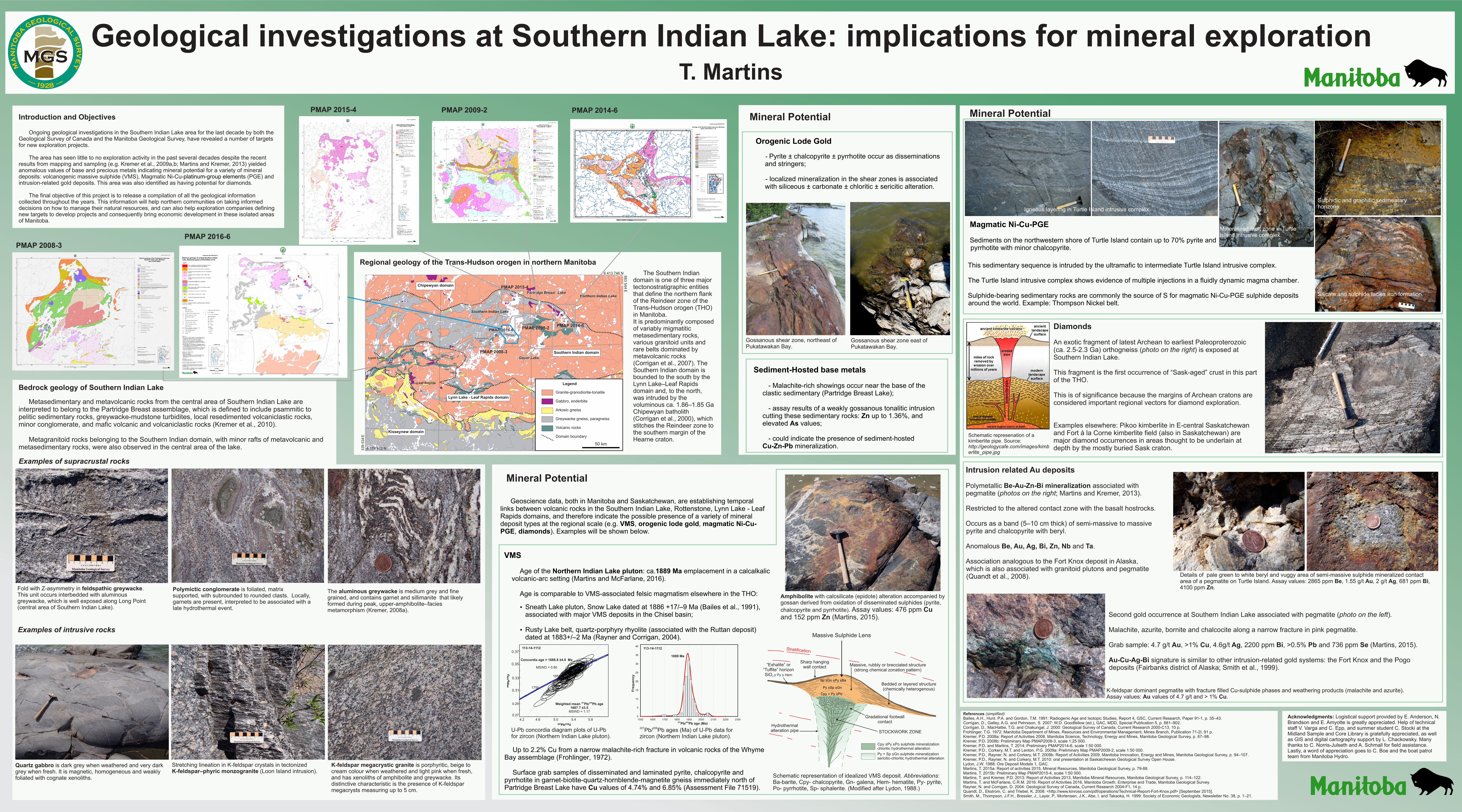
The Southern Indian domain is one of three major tectonostratigraphic entities that define the northern flank of the Reindeer zone of the Trans-Hudson orogen (THO) in Manitoba. It is predominantly composed of variably migmatitic metasedimentary rocks, various granitoid units and rare belts dominated by metavolcanic rocks (Corrigan et al., 2007). The Southern Indian domain is bounded to the south by the Lynn Lake–Leaf Rapids domain and, to the north, was intruded by the voluminous ca. 1.86–1.85 Ga Chipewyan batholith (Corrigan et al., 2000), which stitches the Reindeer zone to the southern margin of the Hearne craton.
Regional geology of the Trans-Hudson orogen in northern Manitoba
Southern Indian domain
Kisseynew domain
Lynn Lake - Leaf Rapids domain
Chipewyan domain
Leaf Rapids
Lynn Lake
Northern Indian LakeNorthern Indian Lake
PMAP 2014-6
PMAP 2015-4
PMAP 2009-2
PMAP 2008-3
Southern Indian LakeSouthern Indian Lake
Long PointLong Point
Legend
Granite-granodiorite-tonalite
Gabbro, enderbite
Arkosic gneiss
Greywacke gneiss, paragneiss
Volcanic rocks
Domain boundary
339 5
34
6 178 912 N
6 413 746 N
50 km
E
Gauer LakeGauer Lake
Partridge Breast LakePartridge Breast Lake
PukatawakanBay
PukatawakanBay
68
3 5
44
E
PMAP 2016-6
Acknowledgments: Logistical support provided by E. Anderson, N. Brandson and E. Amyotte is greatly appreciated. Help of technical staff V. Varga and C. Epp, and summer student C. Stocki at the Midland Sample and Core Library is gratefully appreciated, as well as GIS and digital cartography support by L. Chackowsky. Many thanks to C. Norris-Julseth and A. Schmall for field assistance. Lastly, a word of appreciation goes to C. Boe and the boat patrol team from Manitoba Hydro.
References (simplified)Bailes, A.H., Hunt. P.A. and Gordon, T.M. 1991: Radiogenic Age and Isotopic Studies, Report 4, GSC, Current Research, Paper 91-1, p. 35–43.Corrigan, D., Galley, A.G. and Pehrsson, S. 2007: W.D. Goodfellow (ed.), GAC, MDD, Special Publication 5, p. 881–902.Corrigan, D., MacHattie, T.G. and Chakungal, J. 2000: Geological Survey of Canada, Current Research 2000-C13, 10 p.Frohlinger, T.G. 1972: Manitoba Department of Mines, Resources and Environmental Management, Mines Branch, Publication 71-2I, 91 p.Kremer, P.D. 2008a: Report of Activities 2008, Manitoba Science, Technology, Energy and Mines, Manitoba Geological Survey, p. 87–98.Kremer, P.D. 2008b: Preliminary Map PMAP2008-3, scale 1:25 000.Kremer, P.D. and Martins, T. 2014: Preliminary PMAP2014-6, scale 1:50 000.Kremer, P.D., Corkery, M.T. and Lenton, P.G. 2009a: Preliminary Map PMAP2009-2, scale 1:50 000.Kremer, P.D., Rayner, N. and Corkery, M.T. 2009b: Report of Activities 2009, Manitoba Innovation, Energy and Mines, Manitoba Geological Survey, p. 94–107.Kremer, P.D., Rayner, N. and Corkery, M.T. 2010: oral presentation at Saskatchewan Geological Survey Open House.Lydon, J.W. 1988: Ore Deposit Models 1, GAC.Martins, T. 2015a: Report of activities 2015, Mineral Resources, Manitoba Geological Survey, p. 79-88.Martins, T. 2015b: Preliminary Map PMAP2015-4, scale 1:50 000.Martins, T. and Kremer, P.D. 2013: Report of Activities 2013, Manitoba Mineral Resources, Manitoba Geological Survey, p. 114–122.Martins, T. and McFarlane, C.R.M. 2016: Report of Activities 2016, Manitoba Growth, Enterprise and Trade, Manitoba Geological Survey.Rayner, N. and Corrigan, D. 2004: Geological Survey of Canada, Current Research 2004-F1, 14 p.Quandt, D., Ekstrom, C. and Triebel, K. 2008: <http://www.kinross.com/pdf/operations/Technical-Report-Fort-Knox.pdf> [September 2015].Smith, M., Thompson, J.F.H., Bressler, J., Layer, P., Mortensen, J.K., Abe, I. and Takaoka, H. 1999: Society of Economic Geologists, Newsletter No. 38, p. 1–21.
Schematic represenation of a kimberlite pipe. Source: http://geologycafe.com/images/kimberlite_pipe.jpg
Second gold occurrence at Southern Indian Lake associated with pegmatite (photo on the left).
Malachite, azurite, bornite and chalcocite along a narrow fracture in pink pegmatite.
Grab sample: 4.7 g/t Au, >1% Cu, 4.6g/t Ag, 2200 ppm Bi, >0.5% Pb and 736 ppm Se (Martins, 2015).
Au-Cu-Ag-Bi signature is similar to other intrusion-related gold systems: the Fort Knox and the Pogo deposits (Fairbanks district of Alaska; Smith et al., 1999).
Gossanous shear zone east of Pukatawakan Bay.
Gossanous shear zone, northeast of Pukatawakan Bay.
VMS
Age of the Northern Indian Lake pluton: ca.1889 Ma emplacement in a calcalkalic volcanic-arc setting (Martins and McFarlane, 2016).
Age is comparable to VMS-associated felsic magmatism elsewhere in the THO:
Ÿ Sneath Lake pluton, Snow Lake dated at 1886 +17/–9 Ma (Bailes et al., 1991), associated with major VMS deposits in the Chisel basin;
Ÿ Rusty Lake belt, quartz-porphyry rhyolite (associated with the Ruttan deposit) dated at 1883+/–2 Ma (Rayner and Corrigan, 2004).
Magmatic Ni-Cu-PGE
Sediments on the northwestern shore of Turtle Island contain up to 70% pyrite and pyrrhotite with minor chalcopyrite.
Mineral Potential
Geoscience data, both in Manitoba and Saskatchewan, are establishing temporal links between volcanic rocks in the Southern Indian Lake, Rottenstone, Lynn Lake - Leaf Rapids domains, and therefore indicate the possible presence of a variety of mineral deposit types at the regional scale (e.g. VMS, orogenic lode gold, magmatic Ni-Cu-PGE, diamonds). Examples will be shown below.
Silicate and sulphide facies iron formation.
Igneous layering in Turtle Island intrusive complex.
Mineralized fault zone in Turtle Island intrusive complex.
Sulphidic and graphitic sedimentary horizons.
Diamonds
An exotic fragment of latest Archean to earliest Paleoproterozoic (ca. 2.5-2.3 Ga) orthogneiss (photo on the right) is exposed at Southern Indian Lake.
This fragment is the first occurrence of “Sask-aged” crust in this part of the THO.
This is of significance because the margins of Archean cratons are considered important regional vectors for diamond exploration.
Examples elsewhere: Pikoo kimberlite in E-central Saskatchewan and Fort à la Corne kimberlite field (also in Saskatchewan) are major diamond occurrences in areas thought to be underlain at depth by the mostly buried Sask craton.
Intrusion related Au deposits
Polymetallic Be-Au-Zn-Bi mineralization associated with pegmatite (photos on the right; Martins and Kremer, 2013).
Restricted to the altered contact zone with the basalt hostrocks.
Occurs as a band (5–10 cm thick) of semi-massive to massive pyrite and chalcopyrite with beryl.
Anomalous Be, Au, Ag, Bi, Zn, Nb and Ta.
Association analogous to the Fort Knox deposit in Alaska, which is also associated with granitoid plutons and pegmatite (Quandt et al., 2008).
Orogenic Lode Gold - Pyrite ± chalcopyrite ± pyrrhotite occur as disseminations and stringers;
- localized mineralization in the shear zones is associated with siliceous ± carbonate ± chloritic ± sericitic alteration.
Sediment-Hosted base metals
- Malachite-rich showings occur near the base of the clastic sedimentary (Partridge Breast Lake);
- assay results of a weakly gossanous tonalitic intrusion cutting these sedimentary rocks: Zn up to 1.36%, and elevated As values;
- could indicate the presence of sediment-hosted Cu-Zn-Pb mineralization.
Mineral Potential
Up to 2.2% Cu from a narrow malachite-rich fracture in volcanic rocks of the Whyme Bay assemblage (Frohlinger, 1972).
Surface grab samples of disseminated and laminated pyrite, chalcopyrite and pyrrhotite in garnet-biotite-quartz-hornblende-magnetite gneiss immediately north of Partridge Breast Lake have Cu values of 4.74% and 6.85% (Assessment File 71519).
Mineral Potential
Amphibolite with calcsilicate (epidote) alteration accompanied by gossan derived from oxidation of disseminated sulphides (pyrite,
chalcopyrite and pyrrhotite). Assay values: 476 ppm Cu and 152 ppm Zn (Martins, 2015).
K-feldspar dominant pegmatite with fracture filled Cu-sulphide phases and weathering products (malachite and azurite). Assay values: Au values of 4.7 g/t and > 1% Cu.
Details of pale green to white beryl and vuggy area of semi-massive sulphide mineralized contact area of a pegmatite on Turtle Island. Assay values: 2865 ppm Be, 1.55 g/t Au, 2 g/t Ag, 681 ppm Bi, 4100 ppm Zn.
This sedimentary sequence is intruded by the ultramafic to intermediate Turtle Island intrusive complex.
The Turtle Island intrusive complex shows evidence of multiple injections in a fluidly dynamic magma chamber.
Sulphide-bearing sedimentary rocks are commonly the source of S for magmatic Ni-Cu-PGE sulphide deposits around the world. Example: Thompson Nickel belt.
MGS
ma
nit
ob
a
geological
su
rv
ey
1928
PMAP 2016-6
PMAP 2015-4 PMAP 2009-2 PMAP 2014-6
PMAP 2008-3
U-Pb concordia diagram plots of U-Pb for zircon (Northern Indian Lake pluton).
207 206Pb/ Pb ages (Ma) of U-Pb data for zircon (Northern Indian Lake pluton).
Concordia age = 1888.8 ±4.0 Ma
MSWD = 0.80
4.2 4.6 5.0 5.4 5.8
0.37
0.35
0.33
0.31
0.29
0.27
1750
1850
1950
207 206Weighted mean Pb/ Pb age 1887.7 ±3.5
MSWD = 1.17
113-14-1112
Fre
qu
en
cy
207 206Pb/ Pb age (Ma)
1889 Ma
113-14-1112
Sp ±Gn ±Py ±Ba
Py ±Sp ±Gn
Cpy + Py ±Po
Massive Sulphide Lens
Stratification
Sharp hanging wall contact“Exhalite” or
“Tuffite” horizonSiO ± Py ± Hem2
Massive, rubbly or brecciated structure(strong chemical zonation pattern)
Bedded or layered structure(chemically heterogenous)
Hydrothermalalteration pipe
Gradational footwallcontact
STOCKWORK ZONE
Cpy ±Py ±Po sulphide mineralizationchloritic hydrothermal alteration
Py + Sp ±Gn sulphide mineralizationsericitic-chloritic hydrothermal alteration
Sp ±Gn ±Py ±Ba
Py ±Sp ±Gn
Cpy + Py ±Po
Schematic representation of idealized VMS deposit. Abbreviations: Ba-barite, Cpy- chalcopyrite, Gn- galena, Hem- hematite, Py- pyrite, Po- pyrrhotite, Sp- sphalerite. (Modified after Lydon, 1988.)