geochemical baselines in the assessment of soil...
TRANSCRIPT

Academic Dissertation
Geological Survey of Finland
gtk.fi
2016
ISBN 978-952-217-367-6 (PDF version without articles)ISBN 978-952-217-366-9 (paperback)
Geochemical baselines in the assessment of soil contamination in FinlandJaana Jarva
Geological Survey of FinlandEspoo 2016
Geochemical baselines in the assessment of soil contamination in Finland
by
Jaana JarvaGeological Survey of Finland
P.O. Box 96FI-02151 Espoo, Finland
ACADEMIC DISSERTATIONDepartment of Geography and Geology, University of Turku
To be presented, with the permission of the Faculty of Mathematics and Natural Sciences of the University of Turku, for public criticism in the Lecture Hall XXI, Agora Building of the
University of Turku on 16 December, 2016, at 12 noon.
Unless otherwise indicated, the figures have been prepared by the author of the publication.

SupervisorsDr Timo TarvainenGeological Survey of FinlandEspoo, Finland
Dr Petri LintinenGeological Survey of FinlandEspoo, Finland
Pre-examinersEmeritus Professor Reijo SalminenKorsipiha 11Salo, Finland
Dr Anna LadenbergerGeological Survey of SwedenUppsala, Sweden
OpponentProfessor Stefano AlbaneseUniversity of Naples ”Federico II”Department of Earth Sciences, Environment and ResourcesNaples, Italy
Front cover: Sampling for the urban geochemical mapping project in the city centre of Hämeenlinna. Photo: Timo Tarvainen, GTK.
Jarva, J. 2016. Geochemical baselines in the assessment of soil con-tamination in Finland. Geological Survey of Finland, Espoo. 52 pages, 15 figures and 5 tables, with original articles (I–VI).
ABSTRACT
This study provides an overview on the development of the guidelines and legislation related to soil contamination in Finland, with the main focus on geochemical baselines. The use of geochemical baseline sur-veys in the assessment soil contamination in Finland and in some oth-er countries is briefly discussed and the current practices in Finland are presented. Finally, the geochemical baselines in the assessment of soil contamination in Finland are outlined with suggestions for further applications and recommendations for future research needs.
The growing demand to increase sustainable land management in ur-ban areas has involved various applications of geochemical surveys. Soil contamination was acknowledged as a leading environmental problem in the industrialized countries in the 1980s. The Government of Finland highlighted the importance of studying the level of soil contamination in Finland in 1988. The practices and guidelines for the assessment of soil contamination have been further developed by the environmental authorities and other interest groups, and in 2007, a Government De-cree on the Assessment of Soil Contamination and Remediation Needs (214/2007) was issued. According to the Government Decree (214/2007), the assessment of soil contamination shall be based on a site-specific estimate of the risks to human health and the environment. Three cat-egories of soil screening values, the threshold value and the lower and the upper guideline value, are introduced in the Government Decree (214/2007). The threshold value is used as a trigger value, which if ex-ceeded indicates the necessity for further investigations on potential contamination. The geochemical baseline concentration, however, is re-garded as the assessment threshold in areas with a baseline concentra-tion higher than the threshold value. The Government Decree (214/2007) refers both to the natural geological background concentrations of ele-ments and the diffuse anthropogenic input with the term “geochemi-cal baseline”. For estimating the regional or local baseline concentration the upper limit of geochemical baseline variation for potentially harmful elements can be used.
Today, geochemical background information is available from national and regional geochemical mapping surveys, as well as from targeted ge-ochemical baseline surveys, from which geochemical baseline mapping of sub-urban and urban areas has had a special focus on environmental applications and land use planning. The geochemical baseline studies provide information on baseline concentrations for remediation pro-jects, land extraction, land use planning and other urban functions. Fur-thermore, they provide information for mineral exploration, for studies on the baseline status of the environment, as well as for environment impact assessment. The baseline information can also be applied in multidisciplinary studies such as the protection of human health.
The main sample parent material used in the geochemical baseline stud-ies is minerogenic soil. Both composite and single samples are used. Single samples are often used when the data are targeted for use in

calculating statistics for different soil parent materials and land use pat-terns. The sampling depth in geochemical mapping is traditionally quite variable, but in urban geochemical baseline studies the main focus is on topsoil. In Finland, the guidelines are given for soil contamination analy-sis and they are also followed in geochemical baseline surveys. For deter-mining the concentrations of inorganic elements, the samples are to be sieved to the <2 mm fraction following aqua regia extraction or strong ni-tric acid leach. Different gas chromatographic methods are recommended to be used to analyse organic compounds. For risk assessment purposes, as well as for tracing the origin of elevated concentrations, i.e. whether it is anthropogenic or geogenic, weaker extraction methods provide additional information to be applied in data analysis. The utilization of geochemical baseline information is important when assessing the possible soil contamination and remediation needs. Re-gional variation due to differences in the geological environment can be high and should be taken into consideration in contamination as-sessment. Various sampling materials may reveal different geochemi-cal baseline levels. Finnish legislation supports the use of geochemical baseline information, and the Finnish national geochemical baseline database (TAPIR) provides end-users with nationally comparable and scientifically sound geochemical baseline data that enhance the ration-ality and transparency of decision-making.
Keywords: environmental geology, geochemical surveys, baseline studies, chemical elements, background level, soils, soil pollution, guide values, Finland
Jaana JarvaGeological Survey of FinlandP.O. Box 96FI-02151 Espoo, Finland
E-mail: [email protected]
ISBN 978-952-217-366-9 (paperback)ISBN 978-952-217-367-6 (PDF version without articles)
Layout: Elvi Turtiainen OyPrinting house: Lönnberg Print & Promo, Finland

5
CONTENTS
PREFACE ................................................................................................................................ 7
LIST OF ORIGINAL PUBLICATIONS ............................................................................................ 7
1 INTRODUCTION................................................................................................................... 9 1.1 Terminology ............................................................................................................... 9 1.1.1 Geochemical baseline ........................................................................................... 9 1.1.2 Soil ................................................................................................................... 11 1.1.3 Other terminology used in this research ............................................................... 11 1.2 Development of the soil contamination guidelines and legislation in Finland ................. 12 1.3 The role of geochemical baseline concentrations in soil contamination studies ............... 13 1.4 Geochemical baseline surveys in Finland .....................................................................14 1.5 Geochemical baseline surveys in other countries ..........................................................16 1.6 Land use-based soil screening values in soil contamination assessment .........................17
2 CURRENT PRACTICES IN FINLAND .......................................................................................19 2.1 Implementation of geochemical baseline information in soil contamination assessment – examples from Finland ..........................................................................25
3 MATERIALS AND METHODS ............................................................................................... 26 3.1 Sampling and sample materials ................................................................................. 26 3.2 Analytical methods ................................................................................................... 29 3.3 Quality control in geochemical baseline studies ............................................................30
4 OVERVIEW OF THE INDIVIDUAL STUDIES .............................................................................33
5 DISCUSSION AND RECOMMENDATIONS ...............................................................................38 5.1 Current use and future applications of geochemical baseline information .......................39 5.2 TAPIR – Finnish national geochemical baseline database .............................................. 40 5.3 The use of geochemical baseline information in risk assessment studies ........................43
6 CONCLUSIONS .................................................................................................................. 44
ACKNOWLEDGEMENTS ..........................................................................................................45
REFERENCES ........................................................................................................................ 46
ORIGINAL PUBLICATIONS

6
Geological Survey of FinlandJaana Jarva

7
Geochemical baselines in the assessment of soil contamination in Finland
PREFACE
The research for this thesis was carried out at the Geological Survey of Finland (GTK) during 2008-2015. The synopsis integrates six original articles dealing with different applications and uses of geochemical baselines in soil contami-nation assessment and other environmental decision processes. The research material was collected within the urban geochemical mapping project of GTK. This thesis focuses on practical
applications and further recommendations for geochemical baselines based on literature re-views, interpretation of the statistical analysis of baseline data and scientific discussions. Ap-plicable information is also provided for this re-search by individual technical reports that have been produced within the geochemical mapping projects of GTK.
LIST OF ORIGINAL PUBLICATIONS
This thesis is based on the following papers:
I Jarva, J., Tarvainen, T. & Reinikainen, J. 2008. Application of arsenic baselines in the as-sessment of soil contamination in Finland. Environmental Geochemistry and Health 30 (6), 613–621.
II Tarvainen, T., Jarva, J. & Kahelin, H. 2009. Geochemical baselines in relation to analyti-cal methods in the Itä-Uusimaa and Pirkan-maa regions, Finland. Geochemistry : Explo-ration, Environment, Analysis 9 (1), 81–92.
III Jarva, J., Tarvainen, T., Lintinen, P. & Reini-kainen, J. 2009. Chemical characterization of metal-contaminated soil in two study areas in Finland. Water, Air, & Soil Pollution 198 (1−4), 373–391.
IV Jarva, J., Tarvainen, T., Reinikainen, J. & Ek-lund, M. 2010. TAPIR - Finnish national geo-chemical baseline database. Science of the Total Environment 408 (20), 4385–4395.
V Tarvainen, T. & Jarva, J. 2011. Using geo-chemical baselines in the assessment of soil contamination in Finland. In: Johnson, C. C., Demetriades, A., Locutura, J. & Ottesen, R. T.
(eds) Mapping the chemical environment of urban areas. A John Wiley & Sons, Ltd., Publi-cation, 223–231.
VI Jarva, J., Ottesen, R. T. & Tarvainen, T. 2014. Geochemical studies on urban soil from two sampling depths in Tampere Central Re-gion, Finland. Environmental Earth Sciences 71:4783–4799
The publications are referred to in the text by their Roman numerals.
J. Jarva’s contribution to the original publica-tions was as follows:
I J. Jarva had the main responsibility for data processing and the main conclusions for Pa-per I with the support of Dr T. Tarvainen. The geochemical baselines used for the article were collected and analysed under the urban geochemical mapping project of the Geologi-cal Survey of Finland (GTK). Mr Jussi Reini-kainen contributed to the scientific basis of the soil screening values.
II J. Jarva carried out the data processing for Paper II. J. Jarva conducted the statisti-cal analysis for the comparison between

8
Geological Survey of FinlandJaana Jarva
different analytical methods with the sup-port of Dr T. Tarvainen. Dr T. Tarvainen was responsible for the NORMA model. Mrs H. Kahelin supported the work with expertise on chemical analysis. The geochemical data used for the article were collected and ana-lysed under the urban geochemical mapping project of GTK.
III J. Jarva had the main responsibility for plan-ning and carrying out the study for Paper III. The geochemical data used for the article were collected and analysed under the envi-ronment geology research projects of GTK. Dr T. Tarvainen supported the selection of feasi-ble statistical analysis and contributed to the writing. Dr P. Lintinen and Mr Juha Reini-kainen provided geochemical data and site-specific information for the paper.
IV J. Jarva had the main responsibility for car-rying out the presented statistical analysis of the TAPIR data and writing Paper IV. Dr T. Tarvainen supported the selection of feasi-ble statistical analysis. Mr Jussi Reinikainen contributed to the writing of legislative back-ground and applications of guideline values. Mr M. Eklund had performed the background studies for geochemical provinces within his Master’s Thesis. The geochemical data used for the article were collected and ana-lysed under the urban geochemical mapping
project of GTK and are available via the TAPIR database maintained by GTK.
V J. Jarva and Dr T. Tarvainen were equally re-sponsible in writing and explaining the prac-tices in using information on geochemical baselines in the assessment soil contamina-tion in Finland in Paper V. The geochemical data used for the article were collected and analysed under the urban geochemical map-ping project of GTK. The Ministry of the En-vironment gave permission to publish the scheme on the main steps of soil contamina-tion assessment in Finland.
VI J. Jarva had the main responsibility for plan-ning and carrying out the study for Paper VI. Dr R.T. Ottesen supported the work with his wide experience in urban geochemical studies in Norway and internationally. Dr T. Tarvain-en supported the selection of feasible statis-tical analysis and contributed to the interpre-tation of the results. The geochemical data used for the article were collected and ana-lysed under the urban geochemical mapping of GTK. Concentrated nitric acid (HNO3) leach based analysis was performed and offered by the laboratory of the Geological Survey of Norway. The statistical analysis and research were funded by the Academy of Finland.

9
Geochemical baselines in the assessment of soil contamination in Finland
1 INTRODUCTION
The world’s population is growing, and more and more people are expected to live in an urban en-vironment in the near future. According to the United Nations (2012), the world’s population was ca. 6.9 billion in 2010, and it will grow from 8.0 billion in 2025 to 9.5 billion in 2050. At the same time, the urban population will increase. In 2014, 53.6% of the world’s population was considered as urban. It is estimated that by 2025, 58.2% of people will live in urban areas and in 2050 nearly 67% of the world’s population will be urban. In Europe, the expected growth in the ur-ban population will be from 73.4% in 2014 to 82% in 2050, and in Finland respectively from 84.1% to 89.1% (United Nations 2014). The direct im-pact of urbanization is more intensive land use with strong industrial and economic activities. Since urban soils are identified as important re-cipients of pollutants from a number of sources such as road traffic, industry and waste incinera-tion (e.g. Albanese & Breward 2011), the increas-ing anthropogenic activities may also sometimes lead to soil contamination. The growing demand to increase sustainable land management in ur-ban areas is associated with various applications of geochemical surveys.
Soil contamination was acknowledged as a foremost environmental problem in the indus-trialized countries in the 1980s. This was also true in Finland (Assmuth et al. 1990). Thus, in 1988, the Government of Finland highlighted
the importance of studying the level of contami-nation of surficial deposits and assessing their remediation needs. The Ministry of the Envi-ronment of Finland established an internal con-taminated soil survey and remediation project in order to map the contaminated sites in Fin-land and to recommend appropriate remediation methods when necessary (Puolanne et al. 1994).
The geochemical baseline concentration is a crucial factor while assessing soil contamina-tion. Johnson & Demetriades (2011) have ac-knowledged the importance of the urban geo-chemical baseline as follows: “Once we have defined the urban geochemical baseline, then we can monitor it for future changes, understand the sources of contamination and, with epidemiological and hu-man health data, have a better understanding of the chemical elements and their compounds that dam-age our health.”
In the following, a brief overview on the devel-opment of the guidelines and legislation related to soil contamination in Finland is provided, with the main focus on geochemical baselines. The use of geochemical baseline surveys in the assessment soil contamination in Finland and in some other countries is briefly discussed and the current practices in Finland are presented. Finally, the geochemical baselines in the assess-ment of soil contamination in Finland are out-lined with suggestions for further applications and recommendations for future research needs.
1.1 Terminology
1.1.1 Geochemical baseline
The term “geochemical background” has been used in mineral exploration geochemistry and
was defined, for example, by Hawkes & Webb (1962) as “the normal abundance of an element in barren earth material.” They also pointed out that in addition, reflecting the element composition
10
Geological Survey of FinlandJaana Jarva
of the underlying bedrock, the background com-position of residual soil is also subject to soil type variation and soil horizon characteristics.
The term “geochemical baseline” was of-ficially introduced in the context of the Inter-national Geoscience Programme (IGCP) project Global Geochemical Baselines in 1993 (Darnley et al. 1995). However, Tidball et al. (1974) already used the term “baseline” in a geochemical con-text and defined it to be based on the central 95% of recorded element concentration values. Lat-er, Tidball & Ebens (1976) defined a geochemi-cal baseline more hypothetically as “a collection of data points each defined as the natural value of a given geochemical measurement in a given sample that one would expect in the absence of man-induced alteration.” This definition excludes the anthro-pogenic input when determining the baseline. Salminen & Gregorauskiene (2000) have con-cluded that the definition of a geochemical base-line takes into account basic geological aspects, but also anthropogenic influences. They also highlighted how the selection of sampling me-dia allows the determination of the geochemi-cal baseline without any anthropogenic input. Albanese et al. (2008) pointed out the difficulty in determining the geogenic background value of an element in an urban soil due to the diffuse nature of pollution in the urban environment. They suggested the definition of two baselines for urban areas: the regional anomaly thresh-old, related to the background concentration interval, and the local anomaly threshold, re-ferring not only to the geochemical background concentration but also to diffuse urban pollu-tion. The challenge in defining the geochemical baseline was also acknowledged by Salminen & Tarvainen (2008) when they discussed regional and local variety in natural background concen-trations due to differences in the type and gen-esis of overburden, but also due to the analytical methods and particle-size fraction used in investigations.
The usage of the terms “baseline” and “back-ground” has been recognized to be misleading in some contexts (e.g. Reimann & Garrett 2005, Garret et al. 2008). The term “natural back-ground” is widely used to indicate background levels reflecting natural processes uninfluenced by human activities (Reimann & Garrett 2005), while the term “baseline” is often used to refer
both to the natural geological background con-centrations and the diffuse anthropogenic input of substances at the regional scale. According to Johnson & Demetriades (2011), “a geochemi-cal baseline simply reports the chemical state of the surface environment, exactly as it is, with no inter-pretation or partitioning of the data.” Thus, it is a concentration that is determined from a given sample of a certain geological material, with a particular method at a specific point of time (e.g. Salminen & Tarvainen 1999, Garret et al. 2008, Johnson & Demetriades 2011). Johnson & Dem-etriades (2011) also express “urban baseline” with a simple equation of the sum of the natural background concentration and the anthropo-genic contribution. Garret et al. (2008) highlight that “it is important in environmental and ecologi-cal contexts to recognize that what has to be estab-lished are the scales and range of natural or ambient background (or baseline) variation in different envi-ronments across the Earth’s terrestrial surface.”
Thornton (1991) was one of the first to start using the term “urban geochemistry” in con-nection with the metal contamination of soils in urban areas. He pointed out how the chemistry of pollutants in urban soils is little understood, and the behavior of chemicals in these soils must be studied. He also raised a question and brought out his worry concerning how contaminants in-teract with urban soil constituents and whether this affects their behavior. Thornton (1991) also questioned how threshold or trigger values could be defined for urban soil in the case of soil con-tamination and remediation actions.
The urgent need for data on geochemical base-lines was highlighted by European geochemists while environmental authorities were more ex-tensively starting to define limits for levels of contaminants in soils used for different purposes in most European countries (e.g. Salminen et al. 1998). The question of how to take natural back-ground concentrations into account while de-fining action limits or guideline values requires close co-operation between experts, policy mak-ers and other stakeholders. This is nowadays well acknowledged, and many good practices and examples exist in relation to soil quality criteria that take the geochemical background into ac-count, e.g. in Norway (Statens forurensningstil-syn 1999, Norwegian Pollution Control Author-ity 1999), Finland (Ministry of the Environment

11
Geochemical baselines in the assessment of soil contamination in Finland
2007, 2014a), Sweden (Naturvårdsverket 2009) and the UK (Environment Agency 2009).
1.1.2 Soil
Term “soil” holds various definitions (Reimann et al. 2014b). The Glossary of Geology (Neuen-dorf et al. 2005, 2011) describes soil as “the un-consolidated mineral or organic material on the im-mediate surface of the earth that serves as a natural medium for the growth of land plants.” The broad description also pays attention to effects on the climate and organisms and the altering of many physical, chemical, biological, and morphologi-cal properties and characteristics. The INSPIRE Directive (2007/2/EC) specifies soil (D2.8.III.3) as “the upper part of the earth’s crust, formed by mineral particles, organic matter, water, air and liv-ing organisms. It is the interface between rock, air and water which hosts most of the biosphere.” Fur-thermore, the EU Directive on Industrial Emis-sions (2010/75/EU) describes soil as “the top layer of the Earth’s crust situated between the bedrock and the surface. The soil is composed of mineral particles, organic matter, water, air and living organisms.” The two latter examples follow the definitions of soil given by the Thematic Strategy for Soil Pro-tection (COM/2006/0231).
While the term “soil” in geological research often only refers to the immediate surface of the earth, many other applications uses the term in a much wider sense, covering all material be-tween the bedrock and earth surface. This is also true in many environmental applications. In this thesis, “soil” is used to define the immediate surface of the earth, which includes the organic soil layer and the uppermost organic-mineral layer. However, when necessary, the meaning of soil follows the existing practices of the study in question.
1.1.3 Other terminology used in this research
Background concentration refers to the back-ground levels of elements reflecting natural pro-cesses uninfluenced by human activities.
Baseline concentration refers to both the natu-ral geological background concentrations and the diffuse anthropogenic input of substances at the regional scale, often referred to as the base-line or the geochemical baseline.
Guideline value is a concentration level for harmful elements or compounds, which when exceeded creates a need for remediation or other risk management actions.
Humus is the upper natural organic matter-containing layer, mainly of podzolised soils. It is commonly referred to as the O horizon.
ICP-AES, or inductively coupled plasma atomic emission spectroscopy, is an analytical tech-nique used for the detection of trace elements.
ICP-MS, or inductively coupled plasma mass spectroscopy, is an analytical technique used for the detection of trace elements.
Man-made soil is an occasionally used term for a soil layer or soil parent material that has been formed or heavily modified by human activity.
Near-total leach or partial leach refers to aqua regia (AR) leach or concentrated nitric acid (HNO3) leach followed by ICP-AES/MS. Accord-ing to Sandström et al. (2005) in the environ-mental chemistry, term “near-total”, is often used to describe the maximum concentration of an element that can be liberated from a material in its natural environment. An aqua regia leach is commonly used for simulating this character-istic in the laboratory.
Organic soil is the upper layer of soil, which could be comprised of natural humus or a mix-ture of roots, leaves and compost in man-made soil material. It is sometimes referred to as the O horizon.
Podzol is the most common soil in Finland (56%) (Yli-Halla & Mokma 2002), and podzolisa-tion is the principal soil forming process in the forested soils in Finland (Aaltonen 1952). Typi-cally, podzol is comprised of O (organic), A (elu-vial), B (illuvial, enrichment) and C (parent ma-terial) horizons in Finland.
Weak leach refers to 1M ammonium acetate (pH 4.5) leach (often with EDTA) followed by ICP-AES/MS. Typically used to indicate highly mobile or bioaccessible concentrations.
Soil screening value is a concentration level of a harmful element or compound, which when ex-ceeded may create the need for risk assessment and risk management.
Subsoil refers to unweathered geogenic soil parent material, and in geochemical mapping it is often a 25-cm layer within a depth range of 50–200 cm. It is commonly referred to as the C horizon.
12
Geological Survey of FinlandJaana Jarva
Surficial deposit or subsurface sediment is the geologic deposit lying on bedrock.
Threshold value is a concentration level of harmful elements or compounds, which when exceeded creates the need for soil contamination assessment.
Topsoil is the uppermost mineral soil beneath any organic soil layer and is usually less than 25 cm thick. It is commonly referred to as surface soil or the A horizon.
Total analysis is used to determine measure-ments carried out with X-ray fluorescence spec-troscopy (XRFS) or neutron activation analysis (NAA).
Total leach correlates to 4-acid leach followed by ICP-AES/MS.
Urban soil is a common term for soil deposits in urban areas where natural soil horizons are rarely found and the soil is often a mixture of different man-made layers.
1.2 Development of the soil contamination guidelines and legislation in Finland
The Ministry of the Environment of Finland published a Memorandum on “Contaminated soil site survey and remediation projects” in 1994 (Puolanne et al. 1994). It was based on stud-ies that were carried out by the environmental authorities in 1990–1993 within the so-called SAMASE project (Saastuneiden maa-alueiden selvitys- ja kunnostusprojekti). The main aim of the SAMASE project was to investigate and pro-pose measures for the clean-up and restoration of contaminated soils. During the project, new guideline and limit values were proposed for contaminated soils. These values were used in Finland for soil contamination assessment until 2007.
At the beginning of the SAMASE project, in 1990, preliminary national limit values were set for about 80 potentially harmful elements and substances (Puolanne et al. 1994). These limit values were mainly based on the Dutch reference values for soil quality (so-called Dutch ABC list) that were published in 1983 as a part of the Inter-im Soil Remediation Act by the Dutch Ministry of the Environment (e.g. Moen et al. 1986, Lamé 2010). Heikkinen (2000) compared the differ-ences in geology and climate between Finland and the Netherlands and discussed how these differences affect the migration and sorption of harmful substances. According to the Dutch ref-erence values, concentrations below the A value indicate that there is no soil contamination. The B value is the trigger value for soil contamina-tion investigations and preliminary impact as-sessment. The C value is a limit above which extensive risk assessment and remediation is
generally necessary. Today, within the frame-work of the Dutch Soil Protection Act, interven-tion values for soil remediation in the Nether-lands are used to discriminate contaminated soil from cases of severe soil contamination (e.g. Rijkswaterstaat Environment 2009, Brand et al. 2012). The Finnish guidelines primarily suggest-ed comparing investigated concentrations with the geochemical baseline concentrations of the surroundings, and secondarily with the Dutch reference values. The applicable information on geochemical baseline concentrations was to be based on already existing surveys of the Finn-ish environmental authorities (e.g. sludges), Agrifood Research Finland (arable land) and the Geological Survey of Finland (till). However, it was pointed out by the SAMASE working group that there was a lack of systematic geochemi-cal baseline mapping in Finland (Puolanne et al. 1994). Existing geochemical baseline studies also had certain limitations such as diversity in the sampling media, sampling preparations and an-alytical methods, and they did not offer any in-formation on the concentration levels of organic compounds. The national limit values to assess soil contamination were updated during the SA-MASE project when more precise information on toxicity as well as the health and ecological im-pacts of elements and substances was obtained.
Local environmental conditions and land use were already noted in the SAMASE project to be taken into account in soil contamination assess-ment (Puolanne et al. 1994). This approach was further developed in the forthcoming guidelines.
13
Geochemical baselines in the assessment of soil contamination in Finland
1.3 The role of geochemical baseline concentrations in soil contamination studies
Knowledge of the natural occurrence of elements in soil deposits is necessary in determining the degree of soil pollution (e.g. Assmuth et al. 1992). Assmuth (1997) presented a more site-specific approach to defining and applying guideline val-ues for harmful substances in soil deposits in Finland. The suggested target and guideline limit values of Assmuth (1997) were mainly based on eco-toxicological factors, but among other fac-tors, other properties such as the organic mat-ter and clay fraction content were also taken into account. Geochemical baselines and their role in contamination assessment were also discussed. Assmuth (1997) suggested that target values should be determined so that they are higher than the 90% fractal geochemical baseline con-centration of fine-grained topsoil. In order to avoid too optimistic an approach, case-specific risk assessment with studies on bioavailability were recommended in the case of elevated con-centrations of potentially harmful elements. Assmuth (1997) also pointed out that elevated geochemical baseline concentrations may ad-ditionally cause risks to human health and the environment. However, instead of remediation, minimizing the exposure is to be considered in these cases.
After the suggestions presented by Assmuth (1997), guidelines for the assessment of soil contamination were further developed by the national environmental authorities and other interest groups. In Finland, a Government De-cree on the Assessment of Soil Contamination and Remediation Needs (214/2007) came into force on 1 June 2007. According to the Govern-ment Decree (214/2007), the assessment of soil contamination shall be based on a site-specific estimate of the risks to human health and the environment. The contamination assessment should take into account the concentrations,
total amounts, properties and locations of harm-ful substances in the soil deposits. Natural back-ground concentration levels should also be taken into account when assessing potential contami-nation and the need for remediation. This par-ticularly applies in the case of toxic metallic el-ements, since background concentrations may naturally be rather high. Three categories of soil screening values, the threshold value and the lower and the upper guideline value, were in-troduced in the Government Decree (214/2007). The threshold value is used as a trigger value, which if exceeded indicates the necessity for further investigations on potential contamina-tion. The geochemical baseline concentration, however, is regarded as the assessment thresh-old in areas with a baseline concentration higher than the threshold value. Here, the geochemical baseline concentration refers to both the natural geological background concentrations and the diffuse anthropogenic input of elements. The Government Decree (214/2007) prescribes soil screening values for 52 substances or groups of substances. The Finnish soil screening values for 11 elements and for PAH, PCB and PCDD-PCDF compounds are presented in Table 1.
The implementation of the Government De-cree (214/2007) was described with specific guidelines by Ministry of the Environment (2007), which were updated in 2014 (Ministry of the Environment 2014a). According to these im-plementation guidelines, geochemical baseline concentrations are not only needed when as-sessing the potential soil contamination and re-mediation needs, but also in the risk assessment procedure. The geochemical baseline concen-trations are recommended to take into account while defining the risk management goals and site-specific reference values for remediation.

14
Geological Survey of FinlandJaana Jarva
Table 1. Soil screening values for some potentially harmful elements and organic compounds prescribed in Appendix 1 of the Finnish Government Decree on the Assessment of Soil Contamination and Remediation Needs (214/2007).
Background concentration
(mg kg-1)
Threshold value(mg kg-1)
Lowerguideline value
(mg kg-1)
Higher guideline value
(mg kg-1)Antimony (Sb) (p) 0.02 (0.01–0.2) 2 10 (t) 50 (e)
Arsenic (As) (p) 1 (0.1–25) 5 50 (e) 100 (e)
Mercury (Hg) 0.005 (<0.005–0.05)
0,5 2 (e) 5 (e)
Cadmium (Cd) 0.03 (0.01–0.15) 1 10 (e) 20 (e)
Cobalt (Co) (p) 8 (1–30) 20 100 (e) 250 (e)
Chrome (Cr) 31 (6–170) 100 200 (e) 300 (e)
Copper (Cu) 22 (5–110) 100 150 (e) 200 (e)
Lead (Pb) 5 (0.1–5) 60 200 (t) 750 (e)
Nickel (Ni) 17 (3–100) 50 100 (e) 150 (e)
Zinc (Zn) 31 (8–110) 200 250 (e) 400 (e)
Vanadium (V) 38 (10–115) 100 150 (e) 250 (e)
PAH1 15 30 (e) 100 (e)
PCB2 0.1 0.5 (t) 5 (e)
PCDD-PCDF-PCB3 0.00001 0.0001 (t) 0.0015 (e)
(p) = groundwater pollution risk should be considered (e) = based on ecological risk (t) = based on health risk1 Total concentration of PAH compounds includes the following compounds: anthracene, acenaphthene, acenaphthylene, benzo(a)anthracene, benzo(a)pyrene, benzo(b)fluoranthene, benzo(g,h,i)perylene, benzo(k)fluoranthene, dibenzo(a,h)anthracene, phenan-threne, fluoranthene, fluorene, indeno(1,2,3-c,d)pyrene, chrysene, naphthalene and pyrene.
2 Total concentration of PCBs includes PCB congeners 28, 52, 101, 118, 138, 153, 180.3 Total concentration of PCDD-PCDF-PCBs is stated as the WHO toxicity equivalent, including PCDD/F compounds and dioxin-like PCB compounds.
1.4 Geochemical baseline surveys in Finland
In Finland, the first geochemical surveys were carried out in the 1930s and 1940s (e.g. Rankama 1944, 1946), as described by Koljonen (1992b), and already in the late 1930s the geochemi-cal surveys were related to mineral exploration purposes (e.g. Rankama 1940). In addition to minerogenic soil parent material, for instance Björklund (1971) also took samples from organic topsoil and birch twigs in order to identify the lead mineralization in Korsnäs, Finland. Cur-rently, geochemical background data are avail-able from national and regional surveys. The Geological Survey of Finland (GTK) carried out a nationwide geochemical mapping of till on a re-connaissance scale in 1983 (Koljonen 1992a) and on a regional scale during 1984–1992 (Salminen 1995). These surveys have provided information on the natural elemental distribution in till par-
ent material, which is the most common surfi-cial sediment type in Finland.
The Nordkalott geochemical mapping project (Bølviken et al. 1986) and the foreword of the Geochemical Atlas of Finland (Koljonen 1992a) already pointed out the usability of the knowl-edge on geochemical background concentra-tions in environmental monitoring, pollution assessment and other environmental studies, in addition to mineral exploration. It was also rec-ognized that environmental studies would need samples not only from subsurface sediments but additionally from the topsoil. Subsurface sedi-ment samples are good reference materials to monitor the natural state of the environment, but they do not reflect the diffuse anthropogenic input. Today, it has also become clear, especial-ly from the urban geochemical survey point of

15
Geochemical baselines in the assessment of soil contamination in Finland
view, that some important trace elements such as arsenic, cadmium and lead are lacking from the analysis of previous geochemical mapping projects, or the applied analysis methods have not been able to provide sufficiently accurate measurements.
Glacial till is a mixture of local and trans-ported mineral material and it corresponds to the composition of the bedrock. It is formed from bedrock, pre-glacial sediments and in situ weathered bedrock. Basal till is transported a short distance and represents the composition of the local bedrock, while ablation till has been carried further on top of the ice sheet. Basal till consists of finer fractions than ablation till and is almost unsorted (e.g. Salminen 1992a, Kol-jonen & Tanskanen 1992). Thus, basal till is com-monly used for geochemical surveys targeted at mineral exploration. Regional variation exists in till properties in Finland that may affect the element distribution in till. This variation is not only due to elemental concentrations of bedrock, but also due to the origin and other character-istics of the fine fraction of till (Lintinen 1995). Sand and gravel are sorted by the melt water from glaciers or other flowing waters. The finest material, silt and clay, is carried as a suspension in the waters and finally deposited at the bottom of water basins. These processes greatly affect the mineral and chemical composition of differ-ent sediments. Koljonen et al. (1992) and Kol-jonen & Tanskanen (1992) have pointed out that coarse sorted sediments are mainly composed of quartz and feldspars and are enriched in heavy, weathering-resistant minerals, while till also contains dark mafic minerals such as micas and amphipoles. Räisänen et al. (1992) studied the chemical and physical characteristics of the fine fraction of till in a known metallogenic area in central Finland. They found that the main fac-tor affecting the increased element concentra-tions in the anomalous zone is the variation in mica and clay mineral types. All these factors influence regional and areal distributions in the concentrations of elements in different soil par-ent materials. The composition of clays differs from the chemical composition of bedrock and reflects the environment in which they have de-posited (Koljonen et al. 1992, Koljonen & Tans-kanen 1992). In Finland, weathering does not play a major role in the chemical composition of
clay minerals due to the short time of weather-ing processes.
GTK continued the geochemical mapping of Finland by examining geochemical baselines around the city of Porvoo in southern Finland using humus, topsoil and subsurface sediment samples from different soil parent materials in 2002 (Tarvainen et al. 2003). This study not only focused on the geological characteristics but also on the land use of the study area. The sampling points were located both in rural and sub-urban areas of the city of Porvoo. The geochemical mapping of the city of Porvoo was also used as a pilot study to test different sample media, sam-pling depths and leaching methods in geochem-ical baseline studies. The geochemical baseline mapping project of GTK continued around the Helsinki Metropolitan Area in 2004–2005 (Tar-vainen et al. 2006), in the Satakunta Region in 2006 (Kuusisto et al. 2007), in the Pirkanmaa Region in 2006–2009 (Tarvainen 2007, Kuu-sisto & Tarvainen 2008, Hatakka et al. 2010a), in the Häme region in 2008–2009 (Tarvainen 2010a) and in the Helsinki Metropolitan Area in 2009–2011 (Tarvainen et al. 2013a). All of these studies provided geochemical baseline informa-tion from both rural and sub-urban areas of the municipalities and cities (Fig. 3).
Urban geochemical studies have been carried out in many countries during recent years (e.g. Johnson et al. 2011). The on-going study of geo-chemical baselines in Finland aims at investi-gating baseline concentrations of heavy metals and other trace elements around urban growth centres. During recent years, the need for infor-mation on geochemical baseline concentrations within urban areas has been acknowledged and GTK has also broadened its geochemical studies to such areas. Samples have been taken within urban centres in addition to rural and sub-ur-ban areas (Jarva & Tarvainen 2008, Tarvainen 2010b,c, 2011, Jarva 2012, Tarvainen et al. 2013b, 2014, Hatakka et al. 2014, Taivalkoski 2015). In these studies, the samples have been taken from the areas that are actively used by the public. Thus, sampling sites are located in the central parks of the cities and municipalities, and spe-cifically in areas where children can be in close contact with soil, i.e. day-care centres, school yards and other playgrounds (Fig. 1).
16
Geological Survey of FinlandJaana Jarva
The purpose of the geochemical baseline studies in Finland is to provide information on baseline concentrations for remediation projects, land extraction, land use planning and other urban operations. They also provide information for studies on the baseline status of the environ-ment as well as for environment impact assess-ment (EIA). The revised Environmental Protec-tion Act (527/2014) implements the EU Directive on Industrial Emissions (2010/75/EU) on a na-tional level and requires the operators to provide a baseline survey of their area in order to assess the baseline status of the soil and groundwater (Ministry of the Environment 2014b). The exist-ing geochemical baseline information can sup-port these surveys. The baseline information can also be applied in multidisciplinary studies such as the protection of human health. Studies on children exposure risk associated to known soil contamination have been conducted in many
countries especially for lead (e.g. Mielke et al. 1983, Mielke & Reagan 1998, Taylor et al. 2013, Zahran et al. 2013) and mercury (Morisset et al. 2013), and possible relationships between high element concentrations in urban soil and male fertility has been studied (Giaccio et al. 2012). In Finland, the Finnish Food Safety Authority (Evira) and GTK have just started a preliminary desktop study on the potential exposure of chil-dren to certain potentially harmful elements from food and soil with elevated baseline con-centrations (Suomi et al. 2015). The results on geochemical baseline concentrations will also contribute to the future needs of the Thematic Strategy for Soil Protection (COM/2006/0231). The overall objective of the Strategy is the pro-tection and sustainable use of soil with guiding principles such as preventing further soil degra-dation and preserving its functions.
1.5 Geochemical baseline surveys in other countries
It is commonly acknowledged in soil contami-nation studies that reliable information on geo-chemical baseline concentrations is essential. Natural background concentrations may vary greatly depending on geological characteristics. Diffuse pollution may cause elevated concentra-tions in wide areas that in most cases could also be considered as a normal (or acceptable) geochemi-cal baseline concentration of the environment.
Carlon (2007) published a review of methods for determining soil screening values, which are generic quality standards used to regulate land contamination in Europe. Background concen-trations in the derivation of soil screening values mainly concern naturally occurring substances. Natural background values have influenced the determination of target values for example in Belgium, the Netherlands and Finland. In some
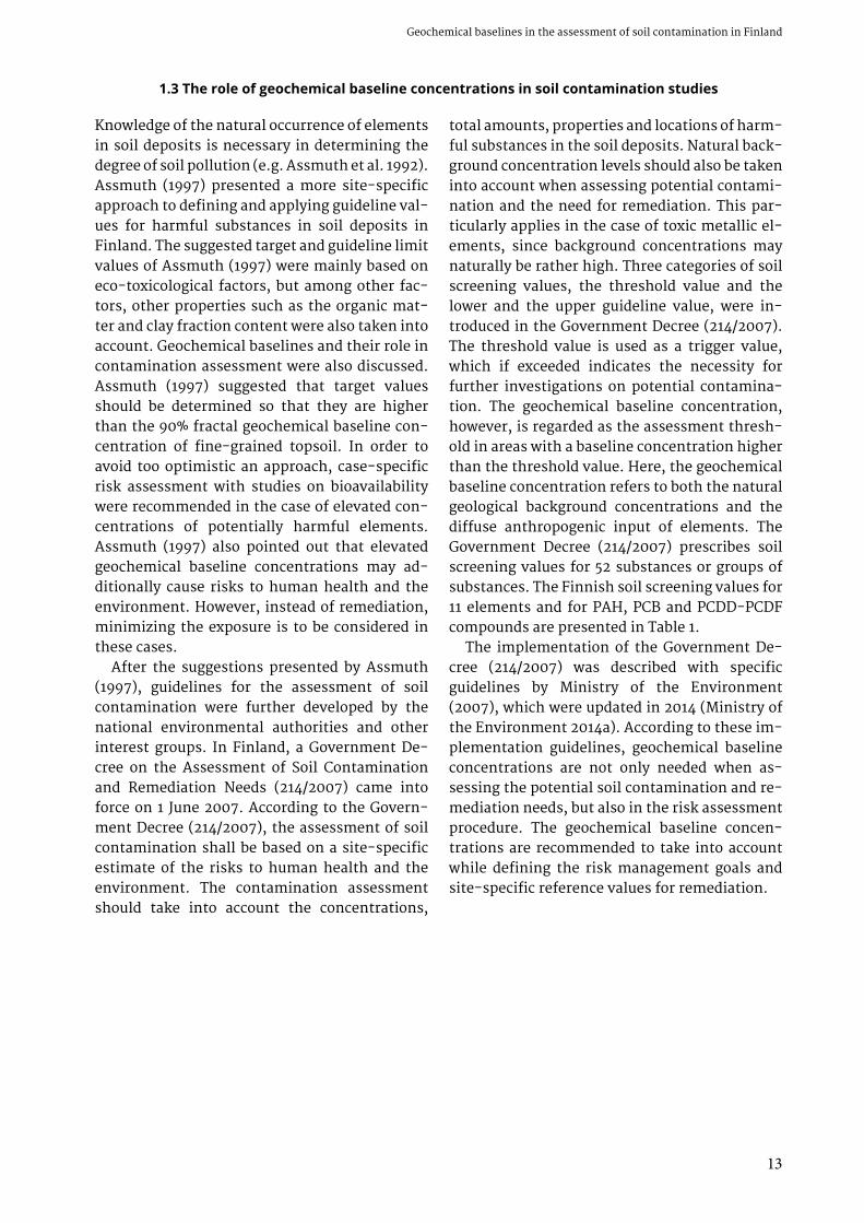
Fig. 1. Sampling sites of urban geochemical mapping located in playgrounds a) in the city of Heinola (Photo: Tauno Valli, GTK) and b) in the city Espoo (Photo: Mikael Eklund, GTK). In playgrounds, samples are taken from the material around the play structures brought in for landscaping purposes and not from the sand material, which is sieved and washed and very often regularly changed.
a) b)

17
Geochemical baselines in the assessment of soil contamination in Finland
countries, the soil screening values indicating negligible risk are related to geochemical base-line concentrations, either for contaminants of natural origin or diffuse contamination.
In Norway, the geochemical background con-centration refers to the concentration of a sub-stance that is naturally present. If concentra-tions are greater than the defined national soil quality guidelines, it should be assessed whether the high concentration values are due to con-tamination or the local background (Statens forurensningstilsyn 1999, Norwegian Pollution Control Authority 1999). Generic soil quality cri-teria are set so that no risk to the environment or human health is posed. However, the risk as-sessment practices allow the development of site-specific acceptance criteria that take into account local conditions such as soil parameters and land use (Norwegian Pollution Control Au-thority 1999, Langedal & Ottesen 2011).
In Sweden, geochemical background levels referring the natural origin of substances or dif-fuse anthropogenic emissions need to be taken into account in soil contamination assessment. If the concentrations of substances at a site are at the same level or below the background level, no further investigation or remediation is needed. When a site or an area has concentrations that exceed local or regional geochemical background levels, it is assumed to be contaminated and risk assessment should be initiated (Naturvårdsvär-ket 2002, 2009, Rosén 2010).
In Denmark, geochemical background lev-els are compared with measured contamina-tion levels in soil contamination studies, and high background levels will in principal allow higher levels of the substance in remediation goals (Danish Environmental Protection Agency 2002). National background levels presented by the Danish Environmental Protection Agency (Miljøstyrelsen) are provided for many of the substances, but site-specific background levels may also be detected (Danish Environmental Protection Agency 2002, Rosén 2010).
In New Zealand, background concentrations are suggested to be determined for each soil con-
tamination investigation (New Zealand Govern-ment 2011). However, due to the unfeasibility of this type of approach, existing studies can also be used. National assessment of natural back-grounds is provided for some elements, such as cadmium and arsenic. However, data limitations have been noted, which include inadequate geo-graphical coverage and a lack of investigations on variation in soil parent types.
In Canada, naturally occurring elements with high local natural background concentrations are considered and site-specific guidelines in-volving site-specific assessment are recom-mended (CCME 2006, 2007).
In England and Wales, methodology for the determination of normal background concentra-tions of contaminants in soil has been developed (Ander et al. 2013). This approach has similar factors and elements to the current practices in determining geochemical baselines in Finland as described by Reinikainen (2007) and in Paper I and Paper IV. The used term “normal back-ground concentration (NBC)” refers to both geo-genic and diffuse sources of elements and sub-stances that are defined as contaminants. The spatial distribution of the selected contaminants has been studied, and NBCs are determined for the most important specific areas called “domains”. These domains could be compared to geochemical provinces introduced in the na-tional geochemical baseline database of Fin-land (TAPIR – taustapitoisuusrekisteri) in Paper IV. The domains, however, have a slightly more sophisticated approach. They are delineated ac-cording to three main factors: the soil parent material, urbanization degree and non-ferrous mineralization and associated mining activities. The area outside of any defined domain is called “the principal domain”. Domains are separately determined for six elements (As, Cd, Cu, Hg, Ni and Pb) and one organic substance, benzo-a-pyrene (BaP). NBCs are determined for each ele-ment/substance and domain is based on the 95th percentile of the analysed concentrations (Ander et al. 2013).
1.6 Land use-based soil screening values in soil contamination assessment
Aquifers and their protection have played a ma-jor role in the assessment of soil contamination
in Finland (Puolanne et al. 1994). In the SAMASE project, the location of contaminated sites was

18
Geological Survey of FinlandJaana Jarva
analysed and evaluated according to their dis-tance from water intakes. Land use changes, i.e. when old industrial or commercial areas are changed to residential areas, are the most common situation when soil contamination assessment is carried out. The re-use of these so-called brownfield areas has been the start-ing point for soil contamination studies in many industrialized countries. In the SAMASE project, the preliminary risk assessment was carried out for the identified, potential or observed contam-inated sites in Finland. In order to prevent any risks posed by soil contamination, sites with low or insignificant contamination were also regis-tered. This was additionally intended to assist land use planning actions in the future.
Land use-based soil screening values and their use in other countries were discussed by Assmuth (1997). Assmuth (1997) suggested that land use-based exposure and risk level estima-tions should also be included in site-specific risk assessment and remediation plans in Finland. It has been pointed out by Assmuth (1997) that ele-vated geochemical baseline concentrations could additionally pose a risk to human health or the environment. Here, Assmuth (1997) highlighted radon and asbestos. Again, site-specific risk as-sessment and risk management measures were suggested. In order to set environmentally sus-tainable and health-protective goals for reme-diation when elevated baseline concentrations may pose a risk, the minimization of exposure or reduction of damage should be considered.
Currently, the Government Decree on the As-sessment of Soil Contamination and Remedia-tion Needs (214/2007) describes the guideline values for potential soil contamination. The guideline values, referring to significant risks to human health or the soil ecosystem, are used as tools in the assessment. The upper guideline values are applied at industrial or similar insen-sitive sites and the lower guideline values in the case of other, more sensitive land use (Reini-kainen 2007). In many European countries, soil screening values for soil contamination assess-ment are land use specific (e.g. Carlon 2007).
In Norway, soil quality guidelines for the most sensitive land uses form the basis for soil con-tamination assessment. In the first step, when soil contamination is suspected, detected con-centrations are compared with these generic
soil quality values. It must be assessed whether the concentrations that exceed the acceptance criteria are due to the contaminant or natural background levels. If soil quality guidelines are exceeded, site-specific risk assessment should take place. This phase of assessment allows the adjustment of soil quality guidelines to the cur-rent land use (Statens forurensningstilsyn 1999, Norwegian Pollution Control Authority 1999). For example, in Trondheim, the city has even established local land use-based soil quality cri-teria. These are based on health risk evaluation developed by the Norwegian Institute of Public Health (Folkehelseinstituttet), and on city-spe-cific concentrations in urban soil and geochemi-cal background concentrations (Langedal & Ot-tesen 2011). In Norway, even special guideline limits for acceptable concentrations of pollut-ants for the soil in kindergartens, playgrounds and schools are developed by the Norwegian Institute of Public Health (Alexander 2006, Ot-tesen et al. 2007).
In Sweden, soil quality criteria are provid-ed for two types of land use: sensitive and less sensitive uses. Sensitive land use refers to areas that require the highest protection for humans and the environment, and can support all types of utilisation of the ground (Naturvårdsvärket 2009, Rosén 2010). The Swedish Environmental Protection Agency (Naturvårdsverket) has rec-ommended generic guideline values that apply throughout Sweden. Guideline values are given for both sensitive and less sensitive land uses. In cases where generic guideline values are not useful or applicable to the conditions at a con-taminated site, site-specific guideline values can be determined, taking into account the actual site conditions. Site-specific guidelines, how-ever, cannot be lower than the background levels (Naturvårdsverket 2009).
In Denmark, three categories for land use ex-ist that are considered in soil contamination studies: highly sensitive land use, sensitive land use and non-sensitive land use. Highly sensitive land use includes farming and gardening, and also kindergartens. Sensitive land use includes parks and park-like areas, and non-sensitive land use comprises land that is used for industry and other non-sensitive activities. The Danish guideline values set a secure level of contami-nation at which no negative effects will occur

19
Geochemical baselines in the assessment of soil contamination in Finland
for recipients. Four different criteria exist: soil quality, cut-off, groundwater quality and evap-oration quality criteria (Rosén 2010, Miljøsty-relsen 2014). All quality criteria are set for highly sensitive land use. Soil quality criteria are set for the protection of human health, mainly the di-rect exposure of children. Eco-toxicological soil quality criteria and corresponding background levels for a selection of substances are also avail-able. The cut-off criteria state the level of soil contamination at which no contact with the up-per soil can be allowed in the current or planned land use and when it is necessary to prevent all contact with the soil. In Denmark, no site-spe-cific limit values are provided, but site-specific assessment with a special focus on exposure is conducted (Danish Environmental Protection Agency 2002, Rosén 2010, Miljøstyrelsen 2014).
The decision making and actions related to soil contamination are enacted by several pieces of legislation in Finland. The main statute is the Environmental Protection Act (527/2014), which issues prohibition of soil and groundwater con-tamination, as well as the duty to treat soil and groundwater in case of contamination. The Gov-ernment Decree on the Assessment of Soil Con-tamination and Remediation Needs (214/2007) lays down the provisions for the assessment of soil contamination and remediation needs. The Land Use and Building Act (132/1999) promotes a safe, healthy, pleasant, socially functional living and working environment. The Act (132/1999) does not have any regulations on the content requirements of the various plans in case of
potential contamination, but soil contamina-tion usually sets limitations on land use that should be taken into account in land use plan-ning and construction activities (e.g. Ministry of the Environment 2014a). The Association of Finnish Local and Regional Authorities has pub-lished guidelines for local authorities to support the implementation of the National Building Code of Finland (Suomen Kuntaliitto 2013). The constructor could be put under an obligation to conduct detailed soil contamination studies. The results of such studies and the possible need for actions such as remediation should be pointed out in the building permit documents. Elevated geochemical baseline concentrations are also discussed in the guidelines, but the focus is on groundwater quality (arsenic, radon) and on res-piratory air quality (radon). Contaminated sites may also be subject to restrictions on use, i.e. a contaminated area may be considered unsuitable for any sensitive land use, and any changes in current land use will require an updated assess-ment of remediation needs.
In Finland, the licensing and supervisory au-thorities operating within soil contamination control are the regional Centres for Economic Development, Transport and the Environment (so-called ELY centres) and the municipal en-vironment institutes operating in Helsinki and Turku. For environmental permits that are required in some specific cases related to soil remediation, the regional state administration agencies act as the responsible authority.
2 CURRENT PRACTICES IN FINLAND
To support the proper consideration of geo-chemical baselines in soil contamination stud-ies, GTK has introduced regional baseline con-centrations for pre-described geographical regions, referred to as geochemical provinces, which were originally delineated by Eklund (2008). Based on studies by Eklund (2008), sev-en geochemical baseline provinces where sev-eral metals (Co, Cr, Cu, Ni, V and Zn) showed anomalous concentrations have been formed (Fig. 2a). In addition, four geochemical baseline provinces for arsenic have been delineated (Fig. 2b). The geochemical statistics for these prov-
inces are discussed in more detail in Paper IV. This rough delineation of geochemical prov-inces has proven to be a useful tool for prelimi-nary soil contamination assessment. It enables the elevated concentrations to be considered as geogenic in origin if such doubts are present-ed. Besides the pre-defined geochemical prov-inces, the upper limit of geochemical baseline variation for potentially harmful elements is used for estimating the baseline concentration, as described in Papers IV and V. This parameter is suggested in Annex B of the ISO 19258:2005 standard to be used to detect the outliers of

20
Geological Survey of FinlandJaana Jarva
dataset in question and to provide an estima-tion of geochemical baseline variation.
The upper limit of geochemical baseline vari-ation for element X (ULBLX) is calculated as fol-lows:
ULBLX = P75 + 1.5 × (P75−P25)
where P75 is the 75th percentile and P25 is the 25th percentile of element X concentrations.
Natural background concentrations are provid-ed for the whole of Finland with various sam-pling densities. The previously performed till geochemical studies provide information on element concentrations in till parent material covering potentially harmful elements that are
also relevant from the mineral exploration point of view (e.g. Co, Cr, Cu, Ni, V and Zn) (Bølvik-en et al. 1986, Koljonen 1992c, Salminen 1995). Geochemical mapping surveys in the Barents region (Reimann et al. 1998, Salminen et al. 2004) continuing to the European scale (Salmi-nen et al. 2005) have also provided informa-tion on background concentrations from other soil horizons than only subsoil and other sam-pling materials. Geochemical surveys on arable land have been carried out within the Baltic Sea Region (Reimann et al. 2003), as well as at the European scale (Reimann et al. 2014a). Table 2 summarizes some reconnaissance and regional-scale geochemical mapping projects carried out in Finland.
Fig. 2. a) Geochemical baseline provinces for metals. 1 = Southern Finland metal province; 2 = Varkaus metal province; 3 = Northeastern metal province; 4 = Oulainen metal province; 5 = Kemi metal province; 6 = Lapland metal province; 7 = Enontekiö metal province.b) Geochemical baseline provinces for arsenic. 1 = Southern Finland arsenic province; 2 = Ilomantsi arsenic province; 3 = Kittilä arsenic province; 4 = Southern Pirkanmaa arsenic province. Contains data from the National Land Survey of Finland and ICT Agency HALTIK. Map layout: Kirsti Keskisaari, GTK.
a) b)

21
Geochemical baselines in the assessment of soil contamination in Finland
Table 2. Reconnaissance and regional-scale geochemical mapping projects carried out in Finland.
Region Year Number of sampling sites
Sampling depth, sample media
Reference
Northern Fennoscandia
1980–1983 5,400 (3,150)* 50–60 cm (till)Stream sedimentStream organic matterStream moss
Bølviken et al. 1986
Finland 1982–1991 1,057 0.5–2.0 m (till) Koljonen 1992Finland 1982–1994 82,062 1.5 m (till) Salminen 1995Central Barents Region
1992–1995 593 (180)*617 (191)*609 (188)*609 (188)*605 (187)*
MossHumus0-5cmB horizonC horizon
Reimann et al. 1998
Baltic Sea Region 1996–1997 750 (66)* 0–25 cm (arable land)50–75 cm (arable land)
Reimann et al. 2003
Eastern Barents Region
2000–2001 1,373 (288)* MossTopsoil (organic)C horizonStream water
Salminen et al. 2004
Europe(FOREGS)
1998–2001 385 (65)*852 (66)*790 (65)*
Humus0–25 cmC horizonStream water and sedimentOverbank sediment (0–25 cm, bottom layer)Floodplain sediment (0–25 cm, bottom layer)
Salminen et al. 2005
Eastern Baltic Region
2000–2001,2003
476 (132)* Organic soilMoss
Salminen et al. 2011
Europe(GEMAS)
2008–2009 2,108 (148)*2,023 (41)*
0–20 cm (ploughed land)0–10 cm (grazing land)
Reimann et al. 2014a
*Number of sampling sites in Finland
The geochemical studies around urban centres have also taken samples from other natural soil parent materials than till, and the selection of analysed elements has been broadened to better meet the needs of environmental applications (Peltola & Åström 2003, Tarvainen et al. 2003, 2006, 2010a,c, 2013a, Peltola 2005, Pitkäranta 2006, Kuusisto et al. 2007, Tarvainen 2007, Kuu-sisto & Tarvainen 2008, Hatakka et al. 2010a).
Geochemical mapping has also been carried out within the pre-described geochemical baseline provinces to collect more precise information on element distribution within these provinces (e.g. Tarvainen 2010a, Peltoniemi-Taivalkoski 2013). Figure 3 and Table 3 summarize the geochemi-cal studies carried out around urban centres or within the pre-described geochemical baseline provinces in Finland.
22
Geological Survey of FinlandJaana Jarva
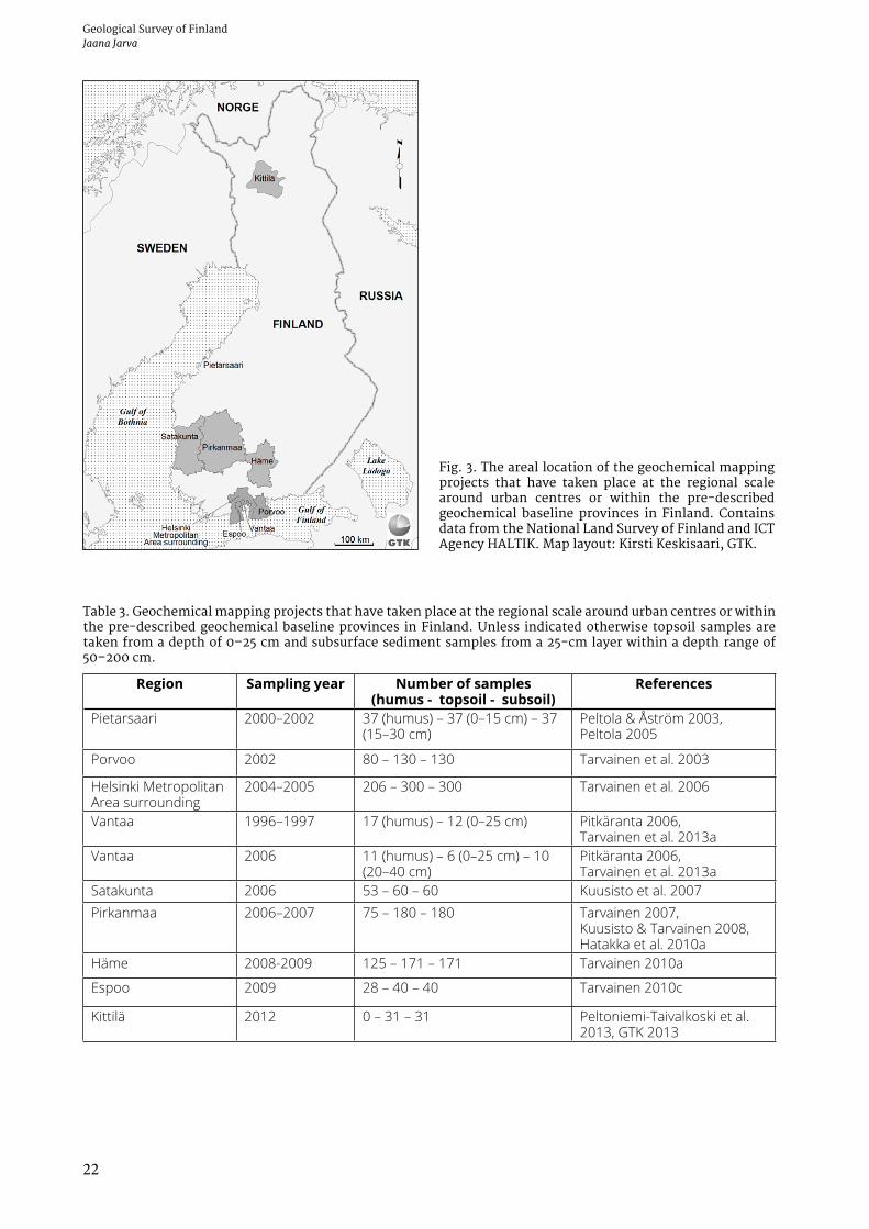
Fig. 3. The areal location of the geochemical mapping projects that have taken place at the regional scale around urban centres or within the pre-described geochemical baseline provinces in Finland. Contains data from the National Land Survey of Finland and ICT Agency HALTIK. Map layout: Kirsti Keskisaari, GTK.
Table 3. Geochemical mapping projects that have taken place at the regional scale around urban centres or within the pre-described geochemical baseline provinces in Finland. Unless indicated otherwise topsoil samples are taken from a depth of 0–25 cm and subsurface sediment samples from a 25-cm layer within a depth range of 50–200 cm.
Region Sampling year Number of samples(humus - topsoil - subsoil)
References
Pietarsaari 2000–2002 37 (humus) – 37 (0–15 cm) – 37 (15–30 cm)
Peltola & Åström 2003, Peltola 2005
Porvoo 2002 80 – 130 – 130 Tarvainen et al. 2003
Helsinki Metropolitan Area surrounding
2004–2005 206 – 300 – 300 Tarvainen et al. 2006
Vantaa 1996–1997 17 (humus) – 12 (0–25 cm) Pitkäranta 2006, Tarvainen et al. 2013a
Vantaa 2006 11 (humus) – 6 (0–25 cm) – 10 (20–40 cm)
Pitkäranta 2006, Tarvainen et al. 2013a
Satakunta 2006 53 – 60 – 60 Kuusisto et al. 2007Pirkanmaa 2006–2007 75 – 180 – 180 Tarvainen 2007,
Kuusisto & Tarvainen 2008, Hatakka et al. 2010a
Häme 2008-2009 125 – 171 – 171 Tarvainen 2010a
Espoo 2009 28 – 40 – 40 Tarvainen 2010c
Kittilä 2012 0 – 31 – 31 Peltoniemi-Taivalkoski et al. 2013, GTK 2013

23
Geochemical baselines in the assessment of soil contamination in Finland
Geochemical baseline studies within urban areas have been carried out in Finland since the 1990s. Kohonen (1994) used humus and moss samples to describe the atmospheric deposition of metals and sulphur in the city of Turku and its close sur-roundings. Most of the samples were impacted by diffuse atmospheric input, but single pollu-tion sources were also possible to identify, such as the municipal waste incinerator and fuel oil heating plants. This study was followed by Sa-lonen & Korkka-Niemi (2007), who took both organic topsoil and subsurface sediment sam-ples from the Turku metropolitan area. Peltola & Åström (2003) and Peltola (2005) have examined the geochemical baselines within the munici-pality of Pietarsaari. Samples were taken from both urban and rural areas. Urban geochemical studies have also been carried out in the Tam-pere region (Jarva & Tarvainen 2008, Hatakka et al. 2010a) and in the cities of Espoo (Tarvainen 2010c, Jarva 2012), Rovaniemi (Taivalkoski et al. 2015), Lahti (Hatakka et al. 2014) and Heinola (Tarvainen et al. 2014). Land use targeted ur-ban geochemical baseline studies have also been implemented, especially in the city of Helsinki (Salla 1999, 2010, Nurmi 2010, Härkönen 2010).
The University of Turku has carried out several geochemical studies in the River Kokemäenjoki delta area (e.g. Niinikoski 2011, Isotalo 2014). In these studies, in addition to river sediment sam-pling, reference samples have been taken from sampling pits representing the geochemical background of various subsurface sediments of the area. These results are to be utilized in future flood protection and dredging and depositing ac-tions. Recent urban geochemical studies within urban centres in the Helsinki Metropolitan Area, Hämeenlinna and Tampere have broadened the selection of analysed elements even more to cover some precious metals (PGEs, gold) and or-ganic compounds, and they have also targeted the sampling at areas dominated by man-made soil material (Immonen 2001, Salla 1999, 2010, Hatakka et al. 2010b, Tarvainen 2010b, 2011, Tarvainen et al. 2013a,b). Figure 4 and Table 4 summarize some of the urban geochemical stud-ies carried out in Finland.
A European-wide urban geochemical map-ping project (URGE) started in 2010. It includes the urban geochemical mapping of ten cit-ies located in different parts of Europe. The URGE project is also utilizing the experiences of
Fig. 4. The areal location of the geochemical mapping projects that have taken place within the urban cen-tres in Finland, a) cities, municipalities and regions with urban geochemical data, b) areal distribution of sampling points in the Tampere region and the cit-ies of Hämeenlinna, Lahti and Heinola. Contains data from the National Land Survey of Finland and ICT Agency HALTIK. Map layout: Kirsti Keskisaari, GTK.
a) b)

24
Geological Survey of FinlandJaana Jarva
Finnish urban geochemical mapping surveys. In Finland, the URGE project guidelines for sam-pling and analysis have already been used in the city of Hämeenlinna (Tarvainen 2010b, 2011). The same research methodology has also fur-ther been applied in the cities of Tampere (Tar-vainen et al. 2013b), Lahti (Hatakka et al. 2014) and Heinola (Tarvainen et al. 2014), providing the city environmental administration with an urban geochemical overprint of their area.
In order to provide geochemical baseline in-formation to be utilised in soil contamination assessment and other environmental deci-sion processes, a national geochemical baseline database, TAPIR, was established. The TAPIR database offers scientifically sound, easily ac-cessible and generally accepted information on the geochemical baseline concentrations in Fin-land. The TAPIR database is introduced in more detail in Paper IV.
The potentially contaminated and already re-mediated sites in Finland are registered in the soil status system (MATTI - Maaperän tilan ti-etojärjestelmä) maintained by the Finnish en-vironmental authorities. In February 2013, ap-proximately 24,000 land areas were recorded in the MATTI register (Pyy et al. 2013). The estimat-ed total costs of investigation and remediation of these documented sites are expected to rise as high as €4 billion (Pyy et al. 2013).
In the MATTI register, the sites are classified into four classes based on the status and ac-tion needs of the site. The sites with activities that may possibly cause soil contamination and sites that require soil contamination assessment comprise nearly 75% of sites recorded in the MATTI register. Less than 10% of the recorded sites are found to be contaminated and require assessment of remediation needs and possible remediation. About 17% of recorded sites have been remediated to an acceptable level for their current purpose or have been noted to be clean. However, these sites may still include land use restrictions in the case of land use changes (Pyy et al. 2013).
The latter class within the MATTI register is closely related to risk-based remediation of con-taminated soil. It is essential that the remedia-tion levels applied are recorded for future needs. Especially in case of land use changes from less sensitive land use (e.g. industrial site) to more sensitive land use (e.g. residential area), updates may be needed in risk assessment and addition-al remediation may ultimately be required. For these sites with elevated concentrations, it is also possible to set restrictions for aggregate ex-cavation and utilization off-site (Pyy et al. 2013). It is worth of noting here that restrictions for aggregate excavation and utilization in Finland are to be based on threshold values or regional
Table 4. Geochemical mapping projects that have taken place within the urban centres in Finland.
City / municipality Sampling year Number of samples
Sampling depth
Reference
Helsinki 1996–2009 441 Organic layer0–40 cm
Salla 1999, 2010
Pietarsaari 2000–2002 3232
0–15 cm15–30 cm
Peltola & Åström 2003, Peltola 2005
Turku 2004 10050
0–5 cm50–100 cm
Salonen & Korkka-Niemi 2007
Espoo 2009 3030
0–2 cm0–25 cm
Tarvainen 2010c, Jarva 2012
Tampere region 2006–2007 1818
0–2 cm0–25 cm
Jarva & Tarvainen 2008
Helsinki Metropolitan Area
2009, 2011 48 0–25 cm Tarvainen et al. 2013a
Hämeenlinna 2010 40 0–25 cm Tarvainen 2010bHämeenlinna 2010 400 0–10 cm Tarvainen 2011Tampere 2012 360 0–10 cm Tarvainen et al. 2013bLahti 2013 195 0–10 cm Hatakka et al. 2014Heinola 2013 161 0–10 cm Tarvainen et al. 2014Rovaniemi 2013–2014 100 0–10 cm Taivalkoski et al. 2015

25
Geochemical baselines in the assessment of soil contamination in Finland
geochemical baseline concentrations (Ministry of the Environment 2015).
At present, the assessment of soil contami-nation and remediation needs according to the guidelines is to be based on the risk assessment process. This means the recognition of poten-tially harmful substances and the risks and threats they may cause to human health and to
the environment. The remediation needs and its goals are to be based on site-specific risk assess-ment. However, this practice has not complete-ly found its way to Finnish soil contamination applications. There is still a need to promote justified risk-based decisions and to increase sustainability in contaminated site remediation (Reinikainen 2014).
2.1 Implementation of geochemical baseline information in soil contamination assessment – examples from Finland
In order to attain a better overview on the practi-cal use of geochemical baselines in soil contami-nation assessment, a small number of unofficial interviews have been carried out. The questions on current practices were directed to responsi-ble environmental authorities of the city of Hel-sinki (A. Salla, personal communication, June 2013) and to the regional Centres for Economic Development, Transport and the Environment of Uusimaa (K. Savelainen, personal communi-cation, October 2013) and Pirkanmaa (K. Pyötsiä, personal communication, October 2013) repre-senting licensing and supervisory authorities concerning soil contamination in their area. The locations of these three study areas are indicated in Figure 5.
In all three cases, no official statistics ex-ist on risk assessment or remediation projects that have been based on geochemical baseline concentrations instead of threshold or guide-line values presented in the Government De-cree (214/2007). However, geochemical baseline concentrations have been taken into account in soil remediation goals, even before the Govern-ment Decree (214/2007) came into force. Already in the 1990s, baseline concentrations of arsenic and vanadium in the Uusimaa region were con-sidered to be higher than the valid soil screen-ing values. This was especially noted in areas with clay deposits. In the city of Helsinki, one of the first examples of using baseline concentra-tions as a remediation goal is from 2003. In the
Fig. 5. The areal location of the city of Helsinki and the Regional Centres for Economic Development, Trans-port and the Environment of Uusimaa and Pirkanmaa, whose responsible environmental authorities were inter-viewed on soil contamination assessment practices. Contains data from the National Land Survey of Finland and ICT Agency HALTIK. Map layout: Kirsti Keskisaari, GTK.
26
Geological Survey of FinlandJaana Jarva
construction of a harbour area, elevated concen-trations of arsenic were found to be geogenic in origin. The remediation goal was accepted to be based on the background level of arsenic. Some other cases with suggestions to use higher re-mediation goals have also been introduced to the environmental authorities of the city of Helsinki prior to the Government Decree (214/2007), but the elevated concentrations have found to be anthropogenic in origin and the plans have not been accepted. In the Pirkanmaa region, from 2003, arsenic and vanadium have been the most common elements whose baseline concentra-tions have been considered higher than valid soil screening values, and remediation goals have followed this presumption.
The city of Helsinki already started to map the geochemical baselines of the city area in 1996 (Salla 1999). Presently, the city is using both its own mapping results and the TAPIR database for geochemical baseline concentration esti-mations. Arsenic is the most common element whose baseline concentrations are typically higher than the threshold value in the area of the city of Helsinki.
In the Uusimaa region, arsenic is practi-cally always considered to be higher than the threshold value. Vanadium and zinc also have elevated concentrations in clay deposits and are often considered to be geogenic in origin. Pres-ently, the environmental authorities recom-mend the use of the TAPIR database or the exist-ing separate geochemical baseline studies (e.g. Salla 1999, 2010, Tarvainen 2010c, Jarva 2012, Tarvainen et al. 2013a) for soil contamination assessment. Risk assessment has not been
required if measured concentrations are below the regional geochemical baseline. Experience has also shown that topsoil (0–25 cm) is the most applicable material for preliminary risk as-sessment, especially if the contaminated site is located in an area with clay deposits.
In the Pirkanmaa region, practically all soil contamination assessments include the estima-tions of geochemical baseline concentrations. Arsenic and vanadium are the most common el-ements whose geochemical baseline concentra-tions in the Pirkanmaa region are often higher than the threshold value. Presently, the regional geochemical baseline information is based on the TAPIR database.
The environmental authorities have pointed out some challenges in the practical implemen-tation of geochemical baseline concentrations in soil contamination studies. The Government Decree (214/2007) includes rather common terms in defining the geochemical baseline con-centrations such as “concentrations of hazardous substances in topsoil in a wide area”. The soil screening values are defined only for some el-ements, and elements that are missing from the Government Decree (214/2007) are often also lacking from the contamination assess-ment studies. However, the Government Decree (214/2007) also requires other harmful sub-stances than those presented in the Decree to be taken into account in the assessment of soil contamination and remediation needs. There is additionally a need for more information on the potential risks associated with certain organic compounds appearing in the living environ-ment.
3 MATERIALS AND METHODS
3.1 Sampling and sample materials
The main sample parent material that has been used in geochemical baseline studies is min-erogenic soil. In Finland, geochemical mapping surveys have traditionally used the most com-mon soil parent material, glacial till. In order to provide geochemical baseline information on other natural soil parent materials than glacial till, the geochemical baseline mapping projects of GTK have also taken samples from sand and
other coarse-grained sorted sediments, as well as from clay and other fine-grained sediments. In urban areas, the sample parent material var-ies greatly, ranging from relatively undisturbed natural soils to completely man-made soil with variable textures.
The organic soil layer (humus) is sometimes used in geochemical studies. The humus layer is considered to reflect both the atmospheric input

27
Geochemical baselines in the assessment of soil contamination in Finland
and underlying geology (Kohonen & Salminen 1993, Salminen et al. 2011). The characteristics of organic layer samples vary depending on the study area. In urban areas, the organic layer is often a mixture of roots, leaves and compost under the planted grass in the park or in flow-erbeds, while in sub-urban areas the organic layer often represents the natural humus layer of podzol or other forest soil. A humus sample is usually taken under the green vegetation and lit-ter. Both sample types have also been used in the geochemical baseline mapping projects of GTK.
Vegetation is also used in some urban geo-chemical baseline studies. In Athens, Greece, the determination of lead and cadmium concen-trations in the urban environment was based on the surveying of both soil parent material and plants (Chronopoulos et al. 1997). In Sweden, water and terrestrial moss samples were used in parallel with soil parent material during an urban geochemical mapping programme (Lax & Andersson 2011). In Oslo, Norway, terrestrial moss and different plant materials (leaves, nee-dles, bark, wood) were used in order to identify the urban contamination footprint (Reimann et al. 2006, 2007a,b). A transect through Oslo with different sampling media was used (Reimann et al. 2011). Since terrestrial mosses indicate the atmospheric input, they have been used to map recent emissions from anthropogenic sources (e.g. Salminen et al. 2011). In Finland, snow has been used as an indicator for atmospheric input in the close vicinity to main roads (Tarvainen & Jarva 2009a).
Both composite and single samples have com-monly been used in geochemical baseline stud-ies. The selection between composite and sin-gle samples greatly depends on the main aim of the geochemical baseline study. Composite sampling is used for screening the local average level of element contents within a certain area (Gustavsson 1992). Combining several samples, however, has the ability to reduce heterogene-ity and mask high concentrations (Gustavsson 1992, Ottesen et al. 2008). Composite sampling is commonly used in urban geochemical studies to indicate diffuse contamination and to map the general distribution of element concentrations. Single samples are especially used in areas with very heterogeneous conditions when the mix-ing of sample media could mislead the interpre-
tation of results. At GTK, single samples were chosen for geochemical baseline studies. This was because the data were targeted to be used for calculating statistics on different soil parent materials and land use patterns. This approach also aimed at supporting environmental author-ities in their decision making. Salla (1999) noted, based on the first geochemical mapping results in Helsinki, that the detected urban geochemi-cal baselines displayed significant variation, and areas with similar characteristics could not be identified within the city. This was mainly due to considerable variety in the soil parent material.
The selection of the sampling grid has varied among urban geochemical baseline studies, and both systematic and targeted surveys have been used (Johnson & Demetriades 2011). In system-atic surveys, a sampling grid with a particular size is used and sampling does not target or avoid any areas, such as sites with known or suspected contamination (Glennon et al. 2014). The urban geochemical baseline studies of GTK are target-ed. Known or suspected contamination sites are avoided and the sampling scheme takes into ac-count both the land use and soil parent material in order to achieve as extensive an overview of the geochemical baseline variation as possible.
Selection of the appropriate sampling density is an essential part of geochemical mapping. If the sampling density is too coarse, many de-tails may be undetected. Thus, the aim of the geochemical mapping determines the appropri-ate sampling density. Salminen (1992b) has di-vided the sequence of geochemical exploration into three phases: regional, local and detailed. In the regional phase, the sampling density is 1 sample/4 km2, in the local phase the sampling density varies from 10 to 30 samples/km2, and in the detailed study phase the sampling density is about 400 to 1000 samples/km2. Large regional differences in geochemical background levels can be observed, even from surveys with a low sample density (Salminen 1992b, Birke et al. 2015). Low-density geochemical surveys provide a cost-effective means to assess information over large areas. However, anthropogenic influ-ences are better detected by using high-density sampling (e.g. Birke et al. 2015). The nominal sampling density of the EuroGeoSurveys urban topsoil geochemical project (URGE) for sys-tematically covering a town or city was set to

28
Geological Survey of FinlandJaana Jarva
4 samples/km2. In principle, central parts of the cities were recommended to have grid size of 500 x 500 m, and newer parts a 1000 x 1000 m grid size with less dense sampling (Demetria-des & Birke 2015a, b). The density suggested by Demetriades & Birke (2015a,b) is considered to be appropriate to obtain a sufficient overview of the spatial distribution of chemical elements in urban topsoil. In the urban geochemical baseline studies of GTK, the sampling density has been 3–4 samples/km2, and sampling has been con-centrated in old city centres with the most in-tensive land use. In the geochemical mapping projects of GTK that have taken place at the re-gional scale around urban centres or within the pre-described geochemical baseline provinces, the sampling density has been 1 sample/10 km2.
The sampling depth in geochemical map-ping is traditionally quite variable, but in urban geochemical baseline studies the main focus is on topsoil (Johnson & Demetriades 2011). Top-soil is considered to give the most representa-tive information on the concentrations in the urban environment due to its role as the main receptor of urban contamination (Mielke et al. 1999, Johnson & Demetriades 2011, Glennon et al. 2014). Especially when the land surface is not grass covered, it can increase the risk of exposure. Here, it must be noted that the ma-terial termed “topsoil” often varies from sam-ples of the top 0–2 cm layer to 0–25 cm topsoil samples (Johnson & Demetriades 2011). During the current geochemical baseline studies at GTK, humus, topsoil (0–25 cm) and subsurface sedi-ment samples from a 25-cm layer within a depth range of 50–200 cm were taken around urban centres or within the pre-described geochemical baseline provinces to indicate the geochemical baseline concentrations (Fig. 6). Within the ur-ban areas, samples are nowadays taken from the upper 0–10 cm for urban geochemical baseline determination (Fig. 7).
Fig. 7. A sample pit from the city of Espoo represent-ing typical man-made soil material with a varying grain-size distribution. The sample was taken from the uppermost 10 cm below the grass-covered layer. Photo: Mikael Eklund, GTK.
Fig. 6. A podzol soil profile from sub-urban area of the city of Espoo representing distinctive soil horizons. The samples have been taken from the uppermost humus layer (black colour), the 25-cm-thick minero-genic topsoil beneath the humus layer (the A horizon) (light brown) and the C horizon of sand (dark brown). Photo: Tauno Valli, GTK.

29
Geochemical baselines in the assessment of soil contamination in Finland
3.2 Analytical methods
There is considerable variety in the pre-treat-ment and chemical analytical methods that are used in soil contamination studies, as well as in determining geochemical baselines. Total or near-total element concentrations of inorganic contaminants are determined. The samples are dried with different methods and they might be crushed and sieved to different fractions (i.e. < 2 mm, < 1 mm). And finally, in risk assess-ment procedures, various analytical methods are used to determine the bioavailable concen-trations.
In Finland, guidelines are given for the ana-lytical methods to be used in soil contamina-tion assessment (Ministry of the Environment 2007, 2014a), and they are also followed in the geochemical baseline surveys of GTK. For de-termining inorganic elements, samples are to be sieved to the <2 mm fraction, while for de-termining organic compounds, the extraction is carried out from unsieved sampling material. Sample drying should be carried out in appro-priate conditions taking into account the be-haviour of different elements and substances. For example, mercury is easily evaporated and organic compounds may include volatiles. To determine the inorganic elements, aqua re-gia (AR) extraction is recommended for min-erogenic material and nitric acid (HNO3) leach for minerogenic material with a high organic matter content (humus, sludge). Aqua regia leaches carbonates and most of the sulphides. It is widely accepted in environmental sciences as providing a good estimate of the maximum potential of soluble elements in soil parent ma-terial (Niskavaara 1995). The residual elements that are not leached by aqua regia digestion are mostly bound to silicates and are often consid-ered unimportant when estimating the mobility and behaviour of the elements (Niskavaara et al. 1997). Different gas chromatographic methods are recommended to be used to analyse organic compounds. It is recommended to use accred-ited or standardized analysis methods as far as possible. The concentrations are to be reported in terms of the dry matter content.
Urban geochemical surveys usually concen-trate on studying the distribution of inorganic elements in the surface soil. The major elements commonly found in the urban environment are
As, Pb, Zn, Ni, Hg, Cu, Cd and Cr, i.e. elements that are also identified with soil screening values within Finnish legislation (Government Decree 214/2007). Recently, it has been further noted that, for example, catalytic converters release platinum and palladium to the urban environ-ment (e.g. Cicchella et al. 2003, Albanese et al. 2008).
In Norway, organic compounds are also sys-tematically mapped in urban geochemical base-line studies (e.g. Ottesen et al. 1995, 1999, Haug-land et al. 2008). Gas chromatography is often used in the analysis of organic compounds, but it is notable that detection limits vary greatly. The concentrations of organic compounds re-sulting from diffuse contamination are usually very low and close to the detection limits (e.g. Tarvainen et al. 2013a). Elevated concentra-tions of organic compounds are often related to point contamination sources such as PCBs from building fragments (Hellman et al. 2003, Jartun 2011), dioxins and furans from municipal solid waste incinerators (Andersson & Ottesen 2008, Andersson et al. 2011) and old sawmills with wood impregnation areas (Reinikainen 2007). However, elevated concentrations of or-ganic compounds in urban soil may also occur due to atmospheric diffuse emissions such as PAH compounds from industry, domestic heat-ing and vehicle emissions (Jensen et al. 2011). In the current geochemical baseline studies at GTK, organic compounds are not systematically analysed. When organic compounds (mainly PAH and PCB compounds) have been included to the survey programme, samples for these analyses have been taken from every 10th sam-pling point.
The chemical analysis chosen for the geo-chemical baseline study is of great importance. Many investigations use more than one analyti-cal technique in order to obtain a wider view of the total or near-total concentrations of ele-ments. Different analytical methods can be used to distinguish between natural and anthropo-genic contamination sources, as well as for de-termining the bioaccessible fraction of the ele-ments (e.g. Johnson & Demetriades 2011). For example, in Athens, Greece, both near-total and weak leaches were used while investigat-ing the concentrations of metals in playgrounds

30
Geological Survey of FinlandJaana Jarva
(Massas et al. 2010). Weak leach with diethylene triamine penta-acetic acid (DTPA) was used to indicate the bioavailable fraction of a metal, but
it was also used to provide information on recent soil pollution.
3.3 Quality control in geochemical baseline studies
Quality control is essential in order to ensure that the obtained data are fit for purpose. Quality control should cover all aspects of work from the start (field sampling) to the finish (laboratory analysis) (Johnson & Demetriades 2011). Quality control is part of the quality assurance process that should be used throughout the different phases of the project in question (Johnson 2011).
In the geochemical baseline studies of GTK, sampling has been carried out by certified sam-pling personnel applying sampling methods that have been selected for urban geochemical map-ping (Tarvainen et al. 2003, Ottesen 2009). The majority of the used chemical analysis methods are accredited (Tarvainen et al. 2003, 2013a, Ha-takka et al. 2010a). Traditionally, quality control within urban geochemical mapping has included two phases: the collection of field-site duplicates for sampling quality control (mostly every 20th sample) and the use of laboratory standard sam-ples for the control of analysis quality at regular intervals (5% at minimum). Quality control has been based on expert reviews of analysis results promoted with field recording and photographs as well as on statistical tests and on visual in-spection of analytical results with boxplots or
other statistical graphs. The detection limits of different sampling batches have also been re-viewed (e.g. Hatakka et al. 2010a, Tarvainen et al. 2013a). In the city of Porvoo, analysis of vari-ance (ANOVA) was also applied for field-site du-plicates (Tarvainen et al. 2003), but the ANOVA method is not currently in systematic use. In re-cent studies, a project standard prepared by the Research Laboratory of GTK from natural gla-cial till from the Tampere region has also been used as part of quality control. Project standards have been included in the sample set at the same frequency as the field-site duplicates, i.e. at an average rate of one in twenty. In 2014, a Qual-ity Control (QC) programme on the urban soil geochemical dataset was conducted in three cities of Finland, Tampere, Lahti and Heinola, where geochemical mapping was carried out with similar methods. Scatterplots, “Thompson and Howarth” plots, together with the Spear-man’s rho were used to determine the statisti-cal acceptability of the analysis results of project standards (Fig. 8), laboratory standards (Fig. 9) and field duplicates (Figs. 10 and 11) (Guagliardi & Tarvainen 2014).

31
Geochemical baselines in the assessment of soil contamination in Finland
Fig. 8. Schematic diagram of zinc concentrations in the GTK project standard sample showing quality control patterns. The median value for zinc is 36.55 mg kg-1 (based on aqua regia extraction of the <2 mm particle-size fraction). The project standards were analysed during three different urban geochemical mapping projects (based on Guagliardi & Tarvainen 2014).
Fig. 9. Schematic diagram of zinc concentrations in the laboratory standard sample (QCTILL4) showing quality control patterns. The median value for zinc is 57.3 mg kg-1 (based on aqua regia extraction). The laboratory stand-ards were analysed during three different urban geochemical mapping projects (based on Guagliardi & Tarvainen 2014).

32
Geological Survey of FinlandJaana Jarva
Fig. 11. “Thompson and Howarth” plot of field duplicate analysis for the zinc content (based on aqua regia extraction of the <2 mm particle-size fraction). The dashed and continuous lines respectively indicate 10% and 20% precision. The analytical batches are from three different urban geochemical mapping projects (based on Guagliardi & Tarvainen 2014).
Fig. 10. Scatter plot of zinc concentrations in the field duplicate samples based on aqua regia extraction of the <2 mm particle-size fraction. All data, except for a few outliers presumably due to the heterogeneity of soil pattern, are compactly distributed along the 1:1 line, indicating good repeatability of the sample grades. The ana-lytical batches are from three different urban geochemical mapping projects (based on Guagliardi & Tarvainen 2014).
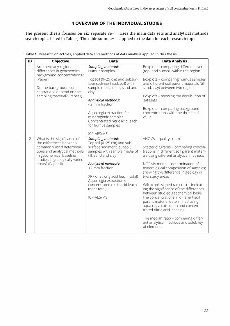
33
Geochemical baselines in the assessment of soil contamination in Finland
4 OVERVIEW OF THE INDIVIDUAL STUDIES
The present thesis focuses on six separate re-search topics listed in Table 5. The table summa-
rizes the main data sets and analytical methods applied to the data for each research topic.
Table 5. Research objectives, applied data and methods of data analysis applied in this thesis.
ID Objective Data Data Analysis1 Are there any regional
differences in geochemical background concentrations? (Paper I)
Do the background con-centrations depend on the sampling material? (Paper I)
Sampling material:Humus samples
Topsoil (0–25 cm) and subsur-face sediment (subsoil) with sample media of till, sand and clay
Analytical methods:<2 mm fraction
Aqua regia extraction for minerogenic samplesConcentrated nitric acid leach for humus samples
ICP-AES/MS
Boxplots – comparing different layers (top- and subsoil) within the region
Boxplots – comparing humus samples and different soil parent materials (till, sand, clay) between two regions
Boxplots – showing the distribution of datasets
Boxplots – comparing background concentrations with the threshold value
2 What is the significance of the differences between commonly used determina-tions and analytical methods in geochemical baseline studies in geologically varied areas? (Paper II)
Sampling material:Topsoil (0–25 cm) and sub-surface sediment (subsoil) samples with sample media of till, sand and clay
Analytical methods:<2 mm fraction
XRF or strong acid leach (total)Aqua regia extraction or concentrated nitric acid leach (near-total)
ICP-AES/MS
ANOVA – quality control
Scatter diagrams – comparing concen-trations in different soil parent materi-als using different analytical methods
NORMA model – determination of mineralogical composition of samples; showing the difference in geology in two study areas
Wilcoxon’s signed rank test – indicat-ing the significance of the differences between studied geochemical base-line concentrations in different soil parent material determined using aqua regia extraction and concen-trated nitric acid leaching.
The median ratio – comparing differ-ent analytical methods and solubility of elements

34
Geological Survey of FinlandJaana Jarva
Table 5. Cont.
ID Objective Data Data Analysis3 Is it possible to carry out
simplified chemical charac-terization of metal-contami-nated soil? (Paper III)
How can we separate the site-specific metal contami-nation from the elevated geochemical baseline con-centrations? (Paper III)
Sampling material:Topsoil and subsurface sedi-ment samples (subsoil)
Analytical methods:<2 mm fraction
Aqua regia extraction Acid ammonium acetate leachSynthetic rainwater leachDe-ionised water leach
ICP-AES/MS
Comparison of concentrations with the geochemical baselines and Finnish soil screening values
Boxplots – showing the distribution of elements at different sample depths
Leachability – determining the ratio between ammonium acetate and aqua regia extractable concentrations
Cluster analysis – characterization of the soil parent material, sources of elements and potential contamination
Factor analysis – characterization of the soil parent material, sources of elements and potential contamination
4 How can the nationwide soil geochemical baseline data be applied in decision mak-ing? (Paper IV)
Data clustering by identified geochemical provinces
National geochemical baseline database (TAPIR)
Kolmogorov-Smirnov test – testing the cumulative distribution of pre-defined geochemical provinces
Mann-Whiteny test – testing medians of pre-defined geochemical provinces
QQ-plots and beanplots – visualizing the difference between pre-defined geochemical provinces
Calculation of the upper limit of base-line variation
5 How can the geochemical baseline data be applied in the assessment of soil con-tamination at regional and local levels? (Paper V)
Regional geochemical baseline studies
Government Decree on the Assessment of Soil Con-tamination and Remediation Needs (214/2007)
Soil contamination assessment – Finnish practice
Calculation of the upper limit of baseline variation
6 What is the representative sampling depth for geo-chemical baseline studies in urban areas? (Paper VI)
Sampling material:Topsoil samples (0–2 cm and 0– 25 cm) from urban soil (two commonly used sampling depths)
Analytical methods:<2 mm fraction
Aqua regia extraction Concentrated nitric acid leach
ICP-AES/MS
Bean plots and boxplots – compar-ing two sample depths; showing the distribution of datasets
Scatter diagrams – comparing differ-ent analytical methods
Statistical tests – indicating the signifi-cance of the differences between two sample depths and analytical methods

35
Geochemical baselines in the assessment of soil contamination in Finland
Paper I. Based on the previous and on-going geochemical studies in Finland, the natural vari-ation in background concentrations is gener-ally rather significant. Geochemical background concentrations of two regions, Satakunta and Pirkanmaa, are discussed in Paper I with the fo-cus on arsenic. The regional differences in geo-chemical background concentrations and influ-ence of sample material on concentrations were investigated (research objective 1 in Table 5). The measured background concentrations were compared to threshold values described by the Finnish Government Decree on the Assessment of Soil Contamination and Remediation Needs (214/2007).
When comparing arsenic concentrations be-tween two regions, the regional difference in concentration levels was clearly detected in minerogenic soil parent material. The arsenic concentrations were notably higher in the Pir-kanmaa Region than in Satakunta. The con-siderable variability in arsenic concentrations between two regions illustrates the importance of information on regional geochemical back-ground concentrations while assessing potential soil contamination. Thus, in order to distinguish actual contamination from background or base-line concentrations and to identify regional dif-ferences due to geological characteristics, geo-chemical baseline studies provide substantial information.
The soil screening values prescribed in the Government Decree (214/2007) are grounded in various risk-based reference values considering ecological risks, health risks and risks to ground-water quality. For arsenic, the threshold value of 5 mg kg-1 is mainly based on the potential risk from groundwater contamination and the lower guideline value of 50 mg As kg-1 is based on the ecological reference value. The upper guideline value of 100 mg As kg-1 was set based on arsenic toxicity to terrestrial species. The studied refer-ence values representing significant health risks from arsenic were higher than the corresponding ecological values and did not therefore contrib-ute to the Finnish guideline values for arsenic.
In the Pirkanmaa Region, differences in soil type do not significantly affect the concentra-tions of arsenic, while in the Satakunta Region the arsenic concentrations in fine-grained sedi-ments were higher than in coarser-grained soil
parent materials. In the humus layer, no differ-ence in arsenic concentrations was identified between the two regions. The studied geochemi-cal background concentrations of arsenic in Sa-takunta and Pirkanmaa were below the Finnish guideline values in all sampling media. Thresh-old value was exceeded in Pirkanmaa which should be taken into account in soil contamina-tion studies.
Jarva, J., Tarvainen, T. & Reinikainen, J. 2008. App-lication of arsenic baselines in the assessment of soil contamination in Finland. Environmental Geoche-mistry and Health 30 (6), 613−621.
Paper II. In Finland, the analytical methods rec-ommended for use while investigating possi-ble soil contamination are specified, and either aqua regia extraction or the concentrated nitric acid leach method are suggested for metals and metalloids. The same analytical methods are also used in geochemical baseline studies. In addition to these, total analyses (XRF) and total leach (4-Acid Leach) are also used in geochemi-cal mapping. Paper II compares trace element concentrations analysed with these commonly used analytical methods in geochemical baseline studies (research objective 2 in Table 5). Statisti-cal tests indicate that aqua regia and concentrat-ed nitric acid digestions reveal differences for some elements (e.g. As, Pb and Sb) between the two analytical methods when measuring geo-chemical baseline concentrations, i.e. relatively low concentrations in soil deposits. The detec-tion limits of these two methods may differ, and especially when assessing low geochemical baseline concentrations this should be carefully considered.
The studies showed that the significance of differences between total and near-total concen-trations is high for all studied elements. While the soil screening values are defined for near-to-tal concentrations in the Finnish legislation, the total concentration determined by XRF cannot be used instead of strong acid digestion results in non-contaminated areas while assessing regional geochemical baselines. Paper II also remarks that comprehensive risk assessment studies addi-tionally require information on element concen-trations based on sequential extractions.

36
Geological Survey of FinlandJaana Jarva
Two regions, Itä-Uusimaa (mainly Porvoo re-gion) and Pirkanmaa (mainly Tampere region), with different geological environments were selected for the study (see Fig. 3 for locations of study regions). The NORMA model was used to estimate the normative mineralogical com-position of samples collected. The differences in regional geochemical baselines are partly explained by the abundance of micas and sec-ondary minerals. Concentrations of Sb, Cd, Co, Cr, Cu, Ni, Pb, V and Zn in topsoil are strongly correlated with the content of normative biotite and chlorite. The comparison demonstrated that near-total concentrations of several elements were strongly controlled by the abundance of micas, goethite and hydrous Al-silicates, and the organic carbon content was strongly corre-lated with some elements.
Tarvainen, T., Jarva, J. & Kahelin, H. 2009. Geoche-mical baselines in relation to analytical methods in the Itä-Uusimaa and Pirkanmaa regions, Finland. Geochemistry : exploration, environment, analysis 9 (1), 81−92.
Paper III. Two study areas representing con-taminated land were compared with regional geochemical baselines using various analytical methods: aqua regia extraction, concentrated nitric acid leach, ammonium acetate extraction and synthetic rainwater or distilled, de-ionised water extraction in Paper III (research objective 3 in Table 5). The same metals that showed enrich-ment compared to the geochemical baselines of-ten had elevated leachability to ammonium ac-etate (research objective 3 in Table 5). It can be assumed that these elements are also more bio-available in contaminated land and can therefore pose a risk to the environment. The vast major-ity of the investigated samples showed very lim-ited metal solubility to waters. However, in a single sample representing high contamination, both ammonium acetate and water extractable concentrations were high. The combination of various analytical methods revealed the hetero-geneity of the man-made soil material. Studies of this kind on the potential leachability of ele-ments are of great importance in the risk assess-ment of contaminated land.
Study area 1 of Paper III represented an area with entirely man-made soil material. In study area 1, Co, Cr, Ni and V concentrations were of the same order of magnitude as the regional ge-ochemical baseline levels, while Cu, Hg, Pb and Zn showed general enrichment and potential pollution.
Study area 2 of Paper III represented an area with less than 1 m anthropogenic soil covering undisturbed glaciofluvial sediments. In study area 2, Co, Cr, Ni, V and As concentrations were within the regional geochemical baseline levels, while Cu, Hg, Pb, Zn, Sb and Cd showed general enrichment as well as a few hotspot concentra-tions. The highest concentrations were found in the upper 25 cm. The studies on groundwater supported the estimations of soil contamination in study area 2.
The ratio between ammonium acetate (AA) and aqua regia (AR) extractable concentrations was determined in order to estimate the poten-tial overall leachability of selected elements in (man-made) soil deposits of two study areas. In addition, the ratio between water (W) and aqua regia extractable concentrations was studied. The solubility based on AA/AR ratio was gener-ally higher in contaminated soil than those from geochemical baseline studies. Some elements in contaminated soils were found to be slightly sol-uble in water. In general, concentrations based on water leach were below the detection limits.
Cluster analysis illustrated with dendrograms was found to be a feasible tool for characterizing contaminated soil. With a sufficient number of samples and an appropriate sampling density, the geochemical classification of contaminated soil could be carried out using dendrograms. In study area 1, separate clusters with high metal contamination were possible to identify. How-ever, the scattered sampling density hindered any specific analysis of fill material character. In study area 2, the elements with median con-centrations similar to the geochemical baseline level could be distinguished from those with general enrichment due to anthropogenic ac-tivities. On the other hand, the clusters were able to distinguish the most leachable elements. Thus, cluster analysis could also be used to make a preliminary assessment of the nature of the potential contamination. Together with cluster analysis, factor analysis can help to recognize

37
Geochemical baselines in the assessment of soil contamination in Finland
different groups of chemical elements with the same geochemical pattern. Different factors can also be used to interpret the origin of elements under investigations.
Jarva, J., Tarvainen, T., Lintinen, P. & Reinikainen, J. 2009. Chemical characterization of metal-contami-nated soil in two study areas in Finland. Water, Air, & Soil Pollution 198 (1−4), 373−391.
Paper IV. Finnish national geochemical base-line database, TAPIR, is introduced in Paper IV. The general background, structure and content of TAPIR are explained. In addition, the principle for determining the maximum acceptable base-line concentration for a geochemical province is introduced.
According to Paper IV, the pre-defined geo-chemical provinces presented in TAPIR can be used while estimating the geochemical baselines for sand deposits and especially for glacial tills. The upper limit of the baseline concentration based on the 25th and 75th percentile is a robust estimate for the regional geochemical baseline concentration. However, geochemical baselines of fine-grained sediments do not necessar-ily follow the distribution of these geochemical provinces. Geochemical baseline data are still very scarce for many essential trace elements such as As, Cd, Hg, Pb or Sb. However, the na-tional database, which combines data from various data producers, provides the means to gather information on all soil parent materials and all provinces in a reasonable time and limits the costs for such a national inventory. Paper IV suggests that the delineation of the pre-defined geochemical provinces should be revised and the upper limit of the baseline variations within ge-ochemical provinces should be recalculated after more analytical information is available for the database.
Paper IV brings out that reliable data on the geochemical baselines is of special importance from the viewpoint of decision makers, authori-ties and site owners in regions where the geo-chemical baselines may exceed the threshold values given in the Finnish Government Decree on the Assessment of Soil Contamination and Remediation Needs (214/2007) (research objec-tive 4 in Table 5). Reliable information on geo-
chemical baselines enables case-specific guide-lines for soil contamination assessment to be determined. If regional geochemical baseline values are available, the guideline values based on ecological risks can be modified accordingly. The recalculations of regional guideline values will give tools to better assess the remediation needs as well as to choose the best available re-mediation technique for the area in question.
Jarva, J., Tarvainen, T., Reinikainen, J. & Eklund, M. 2010. TAPIR - Finnish national geochemical baseline database. Science of the Total Environment 408 (20), 4385−4395.
Paper V. An example of applying geochemical baseline data is presented in Paper V. Studies on geochemical baselines have revealed consider-able natural variation in trace-element concen-trations throughout Europe. Assessment of soil contamination cannot be performed without prior knowledge of geochemical baseline con-centrations. Usually, all soil screening values are based on various risk-based reference val-ues. Assessment of soil contamination without information on geochemical baselines can therefore lead to unnecessary risk calculations and even to costly remediation actions.
In Finland, a Government Decree on the As-sessment of Soil Contamination and Remedia-tion Needs (214/2007) gives the possibility to use geochemical baselines in soil contamination assessment. Paper V introduces the main steps of soil contamination assessment in Finland and provides practical examples of geochemi-cal baselines in a region with naturally elevated arsenic concentrations. Paper V discusses the principles of the upper limit of baseline varia-tion within a geochemical province (research objective 5 in Table 5). The need for identifica-tion of local geochemical provinces for geological anomalies (mineralisations) and anthropogenic hot spots (urbanized areas) is also highlighted.
Tarvainen, T. & Jarva, J. 2011. Using geochemical baselines in the assessment of soil contamination in Finland. In: Johnson, C. C., Demetriades, A., Locutura, J. & Ottesen, R. T. (eds) Mapping the chemical envi-ronment of urban areas. A John Wiley & Sons, Ltd., Publication, 223–231.

38
Geological Survey of FinlandJaana Jarva
Paper VI. The importance of sampling depth in urban geochemical studies is discussed in Paper VI. Two sample depths, 0–2 and 0–25 cm, were chosen for the study. Statistical analysis re-vealed that element concentrations for the two studied sample depths were different for most of the studied elements. This demonstrated that urban surface soil appears to be very heteroge-neous and elements are not evenly distributed vertically. For most studied elements, the me-dian concentrations were higher in the 0–25 cm samples, but large variation in concentrations was found in the topmost 0–2 cm layer. The dif-ference between concentrations in urban soils of different layers was mostly seen with elevated Pb concentrations in the 0–2 cm layer near main roads. This study did not conclusively establish whether a sampling depth of 0–2 or 0–25 cm should be recommended for similar studies in the future. The selection of the sampling depth in geochemical studies greatly depends on the aims of the project. This study demonstrated that even in urban surface soils that are main-ly man-made in origin, the 0–25 samples were more homogeneous and did not have as many
extreme values as the 0–2 cm samples. In order to determine the upper limits of geochemical baseline variation, the deeper sampling depth appears to be more feasible (research objective 6 in Table 5). On the other hand, focusing stud-ies on the topmost layer provides an overview of concentration levels in the most easily accessible part of the soil surface (research objective 6 in Table 5). Studies on the topmost layer could also enable a preliminary assessment of the amount and extent of dust-related, diffuse contamina-tion in urban surface soil. This study illustrated that the organic content does not always ex-plain the elevated concentrations of potentially harmful elements in urban surface soil, but such concentrations are more closely related to the availability of local sources of dusting, creating favourable conditions for site-specific hotspots in urban topsoil.
Jarva, J., Ottesen, R. T. & Tarvainen, T. 2014. Geoche-mical studies of urban soil using two sample depths in Tampere Central Region, Finland. Environmental Earth Sciences 71(11), 4783−4799.
5 DISCUSSION AND RECOMMENDATIONS
Papers I–VI report that the utilization of geo-chemical baseline information is important while assessing possible soil contamination and remediation needs. Regional variation due to differences in the geological environment can be high and should be taken into considera-tion in soil contamination assessment. Various sampling materials may reveal different geo-chemical baseline levels. The Finnish legislation supports the use of geochemical baseline infor-mation and the TAPIR database provides nation-ally comparable geochemical baseline data that are easily accessed. The recommended leaching methods (HNO3 and AR) for soil contamination assessment studies that are also used in geo-chemical baseline studies result in slightly dif-ferent concentration levels for some elements. The differences in sampling depth do not reveal significant problems for the estimation of prop-er geochemical baselines. Compared to weak leach, near-total leach is useful when assessing the concentration levels of a possibly contami-
nated site. However, weak leach (e.g. ammo-nium acetate leach) provides valuable informa-tion for risk assessment purposes, as well as for tracing the origin of elevated concentrations, i.e. whether it is anthropogenic or geogenic.
The broadening of geochemical baseline stud-ies to the urban environment and man-made land areas has provided more exact informa-tion on diffuse anthropogenic concentrations. The studies have demonstrated that in Finland, the geochemical baseline level of potentially harmful elements in the urban environment is rather low compared to many other European countries. Some elements, such as lead, tend to enrich in organic matter and may show el-evated concentrations in the central parks of cities. This is seen in the city of Helsinki, where the highest concentrations of lead, mercury, arsenic and PCB compounds were found in the organic topsoil (Salla 2010). However, the high-est measured lead concentration in Helsinki, 290 mg kg-1 (Ministry of the Environment 2007), is
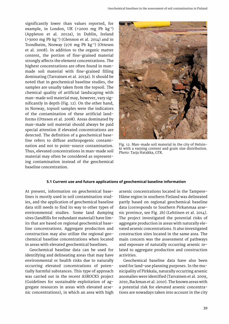
39
Geochemical baselines in the assessment of soil contamination in Finland
significantly lower than values reported, for example, in London, UK (>2000 mg Pb kg-1) (Appleton et al. 2012a), in Dublin, Ireland (>3000 mg Pb kg-1) (Glennon et al. 2014) and in Trondheim, Norway (976 mg Pb kg-1) (Ottesen et al. 2008). In addition to the organic matter content, the portion of fine-grained material strongly affects the element concentrations. The highest concentrations are often found in man-made soil material with fine-grained filling dominating (Tarvainen et al. 2013a). It should be noted that in geochemical baseline studies, the samples are usually taken from the topsoil. The chemical quality of artificial landscaping with man-made soil material may, however, vary sig-nificantly in depth (Fig. 12). On the other hand, in Norway, topsoil samples were the indicators of the contamination of these artificial land-forms (Ottesen et al. 2008). Areas dominated by man-made soil material should always be paid special attention if elevated concentrations are detected. The definition of a geochemical base-line refers to diffuse anthropogenic contami-nation and not to point-source contamination. Thus, elevated concentrations in man-made soil material may often be considered as represent-ing contamination instead of the geochemical baseline concentration.
Fig. 12. Man-made soil material in the city of Helsin-ki with a varying content and grain size distribution. Photo: Tarja Hatakka, GTK.
5.1 Current use and future applications of geochemical baseline information
At present, information on geochemical base-lines is mostly used in soil contamination stud-ies, and the application of geochemical baseline data still needs to find its way to other types of environmental studies. Some land dumping sites (landfills for redundant material) have lim-its that are based on regional geochemical base-line concentrations. Aggregate production and construction may also utilize the regional geo-chemical baseline concentrations when located in areas with elevated geochemical baselines.
Geochemical baseline data can be used for identifying and delineating areas that may have environmental or health risks due to naturally occurring elevated concentrations of poten-tially harmful substances. This type of approach was carried out in the recent ASROCKS project (Guidelines for sustainable exploitation of ag-gregate resources in areas with elevated arse-nic concentrations), in which an area with high
arsenic concentrations located in the Tampere-Häme region in southern Finland was delineated partly based on regional geochemical baseline data (corresponds to Southern Pirkanmaa arse-nic province, see Fig. 2b) (Lehtinen et al. 2014). The project investigated the potential risks of aggregate production in areas with naturally ele-vated arsenic concentrations. It also investigated construction sites located in the same area. The main concern was the assessment of pathways and exposure of naturally occurring arsenic re-lated to aggregate production and construction activities.
Geochemical baseline data have also been used for land-use planning purposes. In the mu-nicipality of Pirkkala, naturally occurring arsenic anomalies were identified (Tarvainen et al. 2009, 2010, Backman et al. 2010). The known areas with a potential risk for elevated arsenic concentra-tions are nowadays taken into account in the city

40
Geological Survey of FinlandJaana Jarva
planning and construction in Pirkkala. Site-spe-cific investigations are required if construction is located in an area with elevated arsenic con-centrations. It is planned that an arsenic risk map and associated measures will also be in-cluded in the building code of the municipality.
New guidelines on the exploitation of excavat-ed land have just been published (Ministry of the Environment 2015). The guidelines designate the classification of excavated land as a waste or ex-ploitative material. In principle, aggregates with elevated background concentrations, i.e. where the concentration is higher than the threshold value given in the Government Decree (214/2007), are not considered contaminated. They can be
exploited or placed in areas with similar or high-er regional geochemical baseline concentra-tions. The regional geochemical baseline is also taken into consideration when evaluating the suitability of excavated land for specific land-fill sites. The guidelines state that without any site-specific environmental permit, the landfill sites located on important groundwater areas may not accept material with concentrations over the threshold value or regional geochemical baseline. In the Tampere region, the regional baseline has already been used as a screening value for some landfill sites (T. Tarvainen, per-sonal communication, February 2015).
5.2 TAPIR – Finnish national geochemical baseline database
The TAPIR database has been recognized as a data source that provides scientifically sound geochemical baseline values that can be used at the national level for transparent decision-making. The database is regularly updated and more precise information on regional or local geochemical baselines is provided when suf-ficient data are available. This will expand the use of geochemical baseline information from soil contamination studies, for example, to de-lineate potential risk areas, for risk assessment procedures as well as for environmental baseline studies (Fig. 13) (Jarva & Tarvainen 2014).
While the TAPIR database is meant to distrib-ute scientifically sound statistical information on geochemical baselines, certain restrictions and guidelines are given for data providers. For inorganic substances, the database only accepts analysis results from the <2 mm particle-size fraction. The leaching method has to be either aqua regia extraction or concentrated nitric acid leach, as these are the suggested methods for soil contamination assessment (Ministry of the Environment 2007, 2014a). Samples are pre-ferred to be taken from the upper part of the ground, i.e. from topsoil. Single samples are fa-voured, but composite samples are also accepted in the database. The TAPIR database also gath-ers information on baseline concentrations of organic compounds, mainly PAH and PCB com-pounds. The concentrations can be reported as total concentrations of PAH compounds or PCB congeners based on Appendix 1 of the Govern-
ment Decree (214/2007), or as concentrations of a single compound or congener. The analysis methods for organic compounds should follow the ones recommended for soil contamination assessment (Ministry of the Environment 2007, 2014a). As described in Paper IV, acceptable con-centration levels for each element to be con-sidered as a baseline concentration have been determined. The lower guideline value is set as the maximum acceptable concentration for those trace elements and organic compounds that are indicated in the Decree (214/2007). For other el-ements, the limits are based on other existing risk-based reference values. However, GTK as a managing authority of the TAPIR database is able to decide whether higher concentrations are also eligible to be included in the database, e.g. due to the specific geological conditions of an area.
While existing data on geochemical baselines based on aqua regia extraction or concentrated nitric acid leach from the <2 mm particle-size fraction is still rare, the TAPIR database also contains geochemical data that are derived from the <0.06 mm particle-size fraction. The prima-ry dataset within the TAPIR database is derived from regional geochemical mapping in Finland, where samples represent glacial till and have been taken as composite samples from an av-erage depth of 1.5 m. The samples are analysed with aqua regia extraction from the <0.06 mm fraction (Salminen 1995). Tarvainen (1995) has defined linear functional relationships that can be used to estimate element concentrations in

41
Geochemical baselines in the assessment of soil contamination in Finland
the coarse till fraction (<2 mm) if concentrations in the fine fraction (<0.06 mm) have been deter-mined. These linear functions have been used in the TAPIR database for Co, Cr, Cu, Ni, V and Zn to calculate concentrations that correspond to the <2mm particle-size fraction.
Currently, it is possible to interactively cal-culate geochemical baseline statistics, including the upper limit of baseline variation, for a site of interest, and statistics are not only provided for pre-described geochemical provinces, as previ-ously. A circle with a radius from 2 to 50 kilo-metres can be drawn and geochemical baseline statistics for different soil parent materials and provinces are provided by the database for ele-ments that have 30 analysis results at minimum (Figs. 14 and 15) (Jarva & Tarvainen 2014). This update enables more effective use of geochemi-cal baseline information in various environmen-tal studies.
The TAPIR database provides information on inorganic elements prescribed in the Appendix 1 of the soil contamination-related Government Decree (214/2007), as well as some other ele-ments (e.g. thallium, beryllium, molybdenum, tin) considered to be significant due to their environmental or health impacts. It is, how-
ever, the spirit of the law (Government Decree 214/2007) that soil contamination studies should be based on all relevant harmful elements and substances in question, not only on elements that are prescribed in the Appendix of the Gov-ernment Decree (214/2007). This lays down the necessity to update the TAPIR database with el-ements that will appear in soil contamination studies. For example, the lack of information on geochemical background concentrations of ele-ments appearing in shooting ranges (e.g. bis-muth, tungsten) and platinum-group metals (e.g. palladium, platinum, rhodium) has been acknowledged. The replacement of lead with steel, bismuth, tungsten, tin and zinc in bullets and shot (Kajander & Parri 2014) has resulted in elevated concentrations of these elements in soil deposits (Tarvainen et al. 2011c). Traffic-related platinum group elements in urban surface soils have been studied and elevated concentrations are strongly related to surface soils adjacent to major roads with high traffic volumes (e.g. Mor-ton et al. 2001, Morcelli et al. 2005, Tarvainen & Jarva 2009a, Mihaljevič et al. 2013).
Several regional geochemical anomalies exist in Finland with clearly elevated concentrations of potentially harmful elements that are geological
Fig. 13. A screen shot of the TAPIR database starting page. The database is available in Finnish and in English. Source: http://gtkdata.gtk.fi/tapir/

42
Geological Survey of FinlandJaana Jarva
Fig. 15. A screen shot of the TAPIR database after selecting a 15 km radius circle around the area of interest (black dot) and selecting samples existing within the geochemical province (blue figure). Existing sampling points can be seen on the screen. Orange circles denote till and green circle sand. Triangles denote humus. By clicking on the calculator button, statistics for selected soil parent materials from the selected area (blue figure) will appear in a separate window. Source: http://gtkdata.gtk.fi/tapir/index.html
Fig. 14. A screen shot of the TAPIR database after selecting a 15 km radius circle around the area of interest (black dot). Existing sampling points can be seen on the screen. Orange circles denote till and green circles sand. Tri-angles denote humus. By clicking on the calculator button, statistics for selected soil parent material from the selected area (blue circle) will appear in a separate window. Source: http://gtkdata.gtk.fi/tapir/index.html

43
Geochemical baselines in the assessment of soil contamination in Finland
in origin. The most well known is the Tampere–Häme region, with elevated concentrations of arsenic in bedrock, soil parent material and groundwater. This area is also recognized in the TAPIR database as a separate geochemical prov-ince, the Southern Pirkanmaa arsenic province (Fig. 2b). Elevated concentrations in soil depos-its can also be related to high mineralisation.
This is true, for example, in the Kittilä area (Fig. 2b), which is recognized in the TAPIR database with elevated concentrations of arsenic, cobalt, chromium, nickel and vanadium, and is also indicated as a metallogenic area with precious metals (mainly gold) (GTK 2012, Peltoniemi- Taivalkoski et al. 2013).
5.3 The use of geochemical baseline information in risk assessment studies
In the preliminary risk assessment of soil con-tamination, the source, pathway and recipient are recognized. The risk may be directed to the environment, human health or living organisms. The risk assessment process in soil contamina-tion studies has been divided into three parts: risk identification, risk quantification and risk char-acterization. If the final analysis reveals that the risk is acceptable for the current state, remedia-tion is not needed. However, this does not neces-sarily mean that no risk exists. Monitoring results or land use change may lead to the need for re-mediation (Ministry of the Environment 2014a). Although risk-based soil contamination assess-ment has been the key policy principle in Finland since 2007, risk-based remediation is still rare. According to Reinikainen (2014), up to 95% of the remediation cases between 2007 and 2013 were based on guideline values instead of site-specific risk assessment. The updated national guidelines further encourage risk-based assessment, while sustainable risk management is given stronger weighting (Ministry of the Environment 2014a).
Feasibility studies are commonly used to in-vestigate preferable and applicable remedial measures. Rosén (2010) described five major steps of feasibility studies that were identified from Sweden and Denmark: 1) setting the re-mediation goal, 2) identifying applicable reme-dial measures, 3) evaluating applicable reme-dial methods, 4) identifying the criteria for the evaluation of applicable remedial methods, in-cluding cost–benefit and effective analysis, and 5) selecting the best option and also evaluating this from social and practical perspectives. In both countries, the remediation goals can be set by reducing the contamination source, by leav-ing contaminants in the ground fully or partly based on protective measures, or by administra-tive measures. In Sweden, the first option is the
most common, while protective measures are more often applied in Denmark. Both countries use site-specific risk assessment for setting remediation goals, although with a different approach and emphasis (Rosén 2010).
In Norway, risk-based soil contamination as-sessment has taken place since the early 1990s, when the Norwegian Pollution Control Author-ity (Statens forurensningstilsyn, SFT) published technical guidelines for environmental site in-vestigations (Statens forurensningstilsyn 1991, Norwegian Pollution Control Authority 1999). In principle, in cases where the soil contamination may pose a risk, the land must be remediated to a state in which it is suitable for use. In many cases, the present land use does not pose a seri-ous danger to human health or the environment, and remediation has not therefore been carried out. However, these sites are followed up, be-cause a land use change could lead to health risks or the leakage of hazardous substances (Norwe-gian Environment Agency 2016).
In Sweden, the potential risk due to soil con-tamination is assessed from different perspec-tives based on four main components: hazard assessment, contamination level, migration potential and protection value. In simplified risk assessments, contaminant concentrations measured on site are compared with generic or site-specific guideline values. While assessing the potential risks associated with the contamination level, guideline values exist for contaminated soil against which the studied concentrations are compared. In addition, the deviation from the reference value, i.e. geochemical background level, is calculated. Finally, the concentration of contaminants and volume of contaminated material are determined. All factors are then studied together in order to provide an as-sessment of the contamination level for
44
Geological Survey of FinlandJaana Jarva
comprehensive risk assessment (Naturvårds-verket 2002, 2009).
The bioavailability of potentially harmful ele-ments plays a major role in risk assessment pro-cesses for potentially contaminated soils. The use of geochemical baselines as screening or refer-ence values for soil contamination assessment may pose certain challenges. For example, Lax & Andersson (2011) highlighted a problem that may occur if anthropogenic pollution is undetected in areas where natural background concentra-tion levels are high. The mobility of certain ele-ments or substances may be higher from anthro-pogenic sources than from naturally occurring forms. If speciation or mobility is not studied, potential exposure and related risks may remain unnoticed. In the UK, lead bioaccessibility from urban topsoils and mineralisation has been in-vestigated (Appleton et al. 2012a, Appleton et al. 2013, Palmer et al. 2015). It was argued that the origin and mineralogy of soil deposits can impact on the bioaccessibility, and some anthropogenic pollution sources are potentially more soluble in the environment and thus are more bioavailable (Appleton et al. 2012b, Palmer et al. 2015). Simi-lar findings were identified in Paper III, where the leachability of metal-contaminated soil was com-pared to the geochemical baseline concentration in the course of chemical characterization. The solubility of potentially harmful elements of geo-genic origin has further been studied by Tarvain-en & Jarva (2009b) with the determination of the distribution coefficient, i.e. the Kd value. It was found that in most cases the Kd value was high if elements were geogenic in origin. In areas with an anthropogenic load, the Kd values varied greatly. The Kd value was used to determine the highest acceptable concentration in soil deposits with-
out any risk for groundwater pollution. In some cases, the guideline value was not considered to be enough to protect groundwater. Thus, site-specific investigations were suggested in the case of soil contamination in close vicinity to vulner-able aquifers (Tarvainen et al. 2011a,b,c). Palmer et al. (2015) also questioned whether diffuse an-thropogenic input is considered as a baseline if an element has a non-threshold toxicity character. This is true, for example, for lead. Here, it must be noted that in Finland the guideline values de-scribe maximum acceptable risks to the envi-ronment and human health. Only the guideline values that are based on ecological risks can be modified based on regional geochemical baseline concentrations, as explained in Paper IV.
In Finland, acid sulphate soils are specific phenomena that are particularly found in the ar-eas below the highest water level of the ancient Littorina Sea (Edén et al. 2012). As a result of oxi-dation, the pH of these sulphur layers decreases, which in turn induces the solubility of harmful metals from the sediments. Studies have shown that the total contents of potentially harmful elements in sulphidic sediments are not higher than in non-sulphidic clays from adjacent areas, but the mobilisation may be higher from acid sulphate sediments (Sohlenius & Öborn 2004, Fältmarsch et al. 2008 and references therein). In urban development, the potential mobility of metals from acid sulphate sediments should be carefully taken into account in the earth con-struction of these areas, as when the sediments are excavated they will become oxidized. Even if the total concentrations of metals are low, their mobilisation may significantly increase when oxidized and thus pose a risk to the environment (Tarvainen & Eklund 2013).
6 CONCLUSIONS
The studies of this thesis have introduced ap-plicable investigation methods for geochemical baseline studies. They have provided informa-tion on the interpretation and application of geochemical baseline information for different purposes. The results of the presented research topics are already utilized in international geo-chemical projects dealing with baseline studies when applicable.
Natural variation in geochemical baseline concentrations is significant in Finland. Thresh-old values given by the Government Decree (214/2007) are occasionally exceeded, but re-gional differences in geochemical baseline con-centrations are high. Urban areas differ in their geological characteristics, land use and potential environmental load, and separate baseline stud-ies are thus needed for each major urban region.

45
Geochemical baselines in the assessment of soil contamination in Finland
However, even in urban soils, the natural back-ground can be more dominant than the anthro-pogenic diffuse input.
Various national environmental applications could benefit from the information on regional geochemical baseline concentrations. A national geochemical baseline database, TAPIR, is already widely used among environmental authorities, land use planners and consultant companies dealing with environmental issues. Information on geochemical baseline concentrations can be used for different environmental assessment purposes, such as in the definition of the base-line status, and they also provide background information for land use planning. At present, geochemical baselines are mostly utilized in soil contamination studies. Reliable data on the geochemical baselines is of special importance in regions where the geochemical baselines may exceed the threshold values given in the Government Decree (214/2007). Such data may
be utilised while locating the activities in areas with elevated geochemical baseline concentra-tions. Reliable information also enables case-specific guidelines for soil contamination as-sessment to be determined. The recalculations of regional guideline values give tools to better assess the remediation needs as well as to choose the best available remediation technique for the area in question. On the other hand, it may even prevent unnecessary remediation. The latest ap-plications are related to the baseline reports of the operators in question in accordance with the Environmental Protection Act (527/2014), as well as to the exploitation of excavated land in ac-cordance with the Environmental Protection Act (527/2014) and Waste Act (646/2011). Thus, the applications of geochemical baseline informa-tion are manifold, ranging from geological and environmental applications to the protection of human health and finally to sustainable and cost-effective administrative decisions.
ACKNOWLEDGEMENTS
This study was conducted at the Department of Geography and Geology of the University of Turku and in the Geological Survey of Finland (GTK) in Espoo. The study was financially sup-ported by GTK. Co-funding from the Academy of Finland supported the finishing of the thesis. I would like warmly thank both GTK and the Acad-emy of Finland for their financial support.
This thesis was supervised by Dr Timo Tar-vainen and Dr Petri Lintinen. Their support, guidance and contributions are highly appre-ciated. Timo encouraged me to take over this opportunity to start the thesis with focus on geo-chemical baselines and their applications in the Finnish decision making. His support through-out the work and especially in finalizing it has been of great value. Petri has shared his wide knowledge on Finnish geology and has given me valuable advice to original papers and the synopsis. I am also grateful for professor Matti Räsänen for his comments to the selected sub-ject and especially on clarifying the content of the synopsis.
I would warmly like to thank emeritus profes-sor Reijo Salminen and Dr Anna Ladenberger for reviewing the thesis. Dr Roy Siddall has revised
the language of the synopsis and all original papers.
I would also like to give my word of thanks to all the co-authors of original papers: Dr Timo Tarvainen, Jussi Reinikainen, Mikael Eklund, Dr Rolf Tore Ottesen, Dr Petri Lintinen, Hanna Kahelin and Juha Reinikainen. Your contribution is highly appreciated. My colleagues at GTK have assisted me with the maps and figures presented in the thesis. Thank you Kirsti Keskisaari, Samrit Luoma, Harri Kutvonen, Heimo Savolainen and Dr Susanna Saari.
This thesis would have not taken place with-out good quality geochemical samples. I would give my warm compliments to Mikael Eklund for preparing the sampling plans within geochemi-cal baseline mapping projects. Tauno Valli, Kari Jauhiainen and Hannu Pelkonen have had the main responsibility of the sampling throughout the years and I would like to give special thanks for their professional work in the field. I am also grateful for all those other people who have worked within the geochemical baseline map-ping project in the field, in the laboratory and in the office.
46
Geological Survey of FinlandJaana Jarva
Kati Laakso, Jari Lehtinen, Heimo Savolainen, Harri Issakainen and Helena Saarinen have worked with the national geochemical database, TAPIR. Without their proficiency TAPIR would not be as progressive and functional as it is today.
My superiors at GTK, Dr Keijo Nenonen, Dr Petri Lintinen, Jussi Ahonen and Jouni Pihlaja have provided me the opportunity to carry out this work. Dr Nenonen has also provided his val-uable assistance by reviewing the original papers prior their submittal.
I am grateful for all my colleagues who have supported me with this work during years with their professional comments and ideas: Dr Nils Gustavsson, Dr Birgitta Backman, Tarja Hatakka, Hanna Virkki, Hilkka Kallio, Dr Philipp Schmidt-Thomé, Dr Päivi Kauppila and Dr Ilaria Guagli-ardi. Päivi Kuikka-Niemi helped in publishing process of the thesis.
Finally, I would like to give my gratitude to my family and my friends for the endless encour-agement and support during the years.
REFERENCES
Aaltonen, V. 1952. Soil formation and soil types. Fennia 72, 65−73.
Albanese, S. & Breward, N. 2011. Sources of anthropo-genic contaminants in the urban environment. In: Johnson, C. C., Demetriades, A., Locutura, J. & Ot-tesen, R. T. (eds) Mapping the chemical environment of urban areas. A John Wiley & Sons, Ltd., Publication, 116−127.
Albanese, S., Cicchella, D., Lima, A. & De Vivo, B. 2008. Urban geochemical mapping. In: De Vivo, B., Belkin, H. & Lima, A. (eds) Environmental Geochemistry: Site Characterization, Data Analysis and Case Histories. Elsevier, 154−174.
Alexander, J. 2006. Anbefalte kvalitetskriterier for jord i barnehager, lekeplasser og skoler (Recommended quality criteria for soil in day-care centers, play-grounds, and schools). Nasjonalt folkehelseinstitutt, Oslo. 8 p. (in Norwegian)
Ander, E. L., Johnson, C. C., Cave, M. R., Palumbo-Roe, B., Nathanail, P. & Lark, R. M. 2013. Methodology for the determination of normal background concentra-tions of contaminants in English soil. Science of the Total Environment 454−455, 604−618.
Andersson, M. & Ottesen, R. T. 2008. Levels of dioxins and furans in urban surface soil in Trondheim, Nor-way. Environmental Pollution 152, 553−558.
Andersson, M., Holt, Y. & Eggen, O. A. 2011. Polychlorin-ated dibenzo-p- dioxins and dibenzofurans (PCDDs/PCDFs) in urban surface soil in Norway. In: Johnson, C. C., Demetriades, A., Locutura, J. & Ottesen, R. T. (eds) Mapping the chemical environment of urban areas. A John Wiley & Sons, Ltd., Publication, 473−486.
Appleton, J. D., Cave, M. R., Palumbo-Roe, B. & Wragg, J. 2013. Lead bioaccessibility in topsoils from lead mineralization and urban domains, UK. Environmen-tal Pollution 178, 278−287
Appleton, J. D., Cave, M. R. & Wragg, J. 2012a. Modelling lead bioaccessibility in urban topsoils based on data from Glasgow, London, Northampton and Swansea, UK. Environmental Pollution 171, 265−272
Appleton, J. D., Cave, M. R. & Wragg, J. 2012b. Anthro-pogenic and geogenic impacts on arsenic bioaccessi-bility in UK topsoils. Science of the Total Environment 435−436, 21−29
Assmuth, T. 1997. Selvitys ja ehdotuksia ympäristövaa-rallisten aineiden pitoisuuksien ohjearvoista maape-rässä – tiedolliset perusteet, määrittelyperiaatteet, soveltaminen, kehittäminen. Abstract: Analysis and proposals of guideline values for concentrations of
hazardous substances in soil – knowledge base, defi-nition principles, application, development. Finnish Environment Institute Mimeograph 92. 56 p.
Assmuth, T., Lääperi, O., Strandberg, T. & Suokko, T. 1990. Saastuneiden maa-alueiden kartoitusmenetel-mät. Esitutkimus. Summary: Methodology for detect-ing potentially contaminated soil sites. Ministry of the Environment, Environmental Protection, Report D/88/1990. 122 p.
Assmuth, T., Strandberg, T., Joutti, A. & Kalevi, K. 1992. Kemiallisesti saastuneen maaperän tutkimusmene-telmät. Mimeographs the Water and Environment Administration A 97. 101 p. (in Finnish)
Backman, B., Reinikainen, J., Jarva, J. & Luoma, S. 2010. Pirkkalan ja Nokian alueen maaperän sekä pinta- ja pohjaveden arseeni- ja raskasmetallipitoisuudet ra-kennushankealueilla - esiselvitys. Geological Survey of Finland, archive report S41/2123/2010/8. 35 p. (in Finnish)
Birke, M., Rauch, U. & Stummeyer, J. 2015. How robust are geochemical patterns? A comparison of low and high sample density geochemical mapping in Germa-ny. Journal of Geochemical Exploration 154, 105−128.
Björklund, A. 1971. Sources and reduction of metal-con-tent variation in biogeochemical prospecting. Geolog-ical Survey of Finland, Bulletin 251. 42 p
Bølviken, B., Bergström, J., Björklund, A., Kontio, M., Lehmuspelto, P., Lindholm, T., Magnusson, J., Ot-tesen, R. T., Steenfelt, A. & Volden, T. 1986. Geo-chemical Atlas of Northern Fennoscandia. Scale 1:4,000,000. Korsnäs: Korsnäs Offset Kb. 19 p., 155 maps.
Brand, E., Bogte, J., Baars, B.-J., Janssen, P., Tiesjema, G., van Herwijnen, R., van Vlaardingen, P. & Ver-bruggen, E. 2012. Proposal for revised intervention values for soil and groundwater for the 2nd, 3rd and 4th series of compounds. RIVM, report 607711006/2012. 114 p.
Carlon, C. (ed.) 2007. Derivation methods of soil screen-ing values in Europe. A review and evaluation of na-tional procedures towards harmonization. Euro-pean Commission, Joint Research Centre, Ispra, EUR 22805-EN. 306 p.
CCME (Canadian Council of Ministers of the Environ-ment) 2006. Protocol for the Derivation of Environ-mental and Human Health Soil Quality Guidelines. Canadian Council of Ministers of the Environment, Winnipeg, Manitoba. Available at: http://www.ccme.ca/assets/pdf/sg_protocol_1332_e.pdf

47
Geochemical baselines in the assessment of soil contamination in Finland
CCME (Canadian Council of Ministers of the Environ-ment) 2007. CCME Soil Quality Index 1.0: Technical Report. In: Canadian environmental quality guide-lines, 1999, Canadian Council of Ministers of the En-vironment, Winnipeg. Available at: http://www.ccme.ca/assets/pdf/soqi_tech_report_e_1.1.pdf
Cicchella, D., De Vivo, B. & Lima, A. 2003. Palladium and platinum concentration in soils from the Napoli metropolitan area, Italy: possible effects of catalytic exhausts. Science of the Total Environment 308(1−3), 121−131.
Chronopoulos, J., Haidouti, C., Chronopoulos-Sereli, A. & Massas, I. 1997. Variations in plant and soil lead and cadmium content in urban parks in Athens, Greece. Science of the Total Environment 196, 91−98.
Danish Environmental Protection Agency 2002. Guide-lines on remediation of contaminated sites. Environ-mental Guidelines No. 7 2002, Vejledning fra Miljø-styrelsen.
Darnley, A. G., Björklund, A., Bølviken, B., Gustavsson, N., Koval, P. V., Plant, J. A., Steenfelt, A., Tauchid, M., Xuejing, X., Garrett, R. G. & Hall, G. E. M. 1995. A global geochemical database for environmental and re-source management. Paris: UNESCO Publishing. 122 p.
Demetriades, A. & Birke, M. 2015a. Urban topsoil geo-chemical mapping manual (URGE II). Brussel: Euro-GeoSurveys. 52 p.
Demetriades, A. & Birke, M. 2015b. Urban geochemi-cal mapping manual: Sampling, sample preparation, laboratory analysis, quality control check, statisti-cal processing and map plotting. Brussels: EuroGeo- Surveys. 162 p.
Edén, P., Auri, J., Rankonen, E., Martinkauppi, A., Ös-terholm, P., Beucher, A. & Yli-Halla, M. 2012. Map-ping Acid Sulfate Soils in Finland: Methods and Re-sults. In: Österholm, P., Yli-Halla, M. & Edén, P. (eds) 7th International Acid Sulfate Soil Conference, Vaasa, Finland 2012. Towards harmony between land use and the environment. Proceedings volume. Geological Survey of Finland, Guide 56, 31−33.
Eklund, M. 2008. Valtakunnalliset taustapitoisuuspro-vinssit maaperän pilaantuneisuuden arvioinnissa. Unpublished master’s thesis, University of Helsinki, Department of Geology and Paleontology. 60 p. (in Finnish)
Environment Agency 2009. Using soil guideline values. Better Regulation Science Programme, Science report: SC050021/SGV introduction. Bristol, UK. 27 p.
Fältmarsch, R. M., Åström, M. E. & Vuori, K.-M. 2008. Environmental risks of metals mobilised from acid sulphate soils in Finland: a literature review. Boreal Environment Research 13, 444−456.
Garrett, R. G., Reimann, C., Smith, D. B. & Xie, X. 2008. From geochemical prospecting to international geo-chemical mapping: a historical overview. Geochem-istry: Exploration, Environment, Analysis 8, 205−217
Giaccio, L., Cicchella, D., De Vivo, B., Lombardi, G. & De Rosa, M. 2012. Does heavy metals pollution affects semen quality in men? A case study in the metro-politan area of Naples (Italy). Journal of Geochemical Exploration 112, 218−225.
Glennon, M. M., Harris, P., Ottesen, R. T., Scanlon, R. P. & O´Connor, P. J. 2014. The Dublin SURGE Project: geochemical baseline for heavy metals in topsoils and spatial correlation with historical industry in Dub-lin, Ireland. Environmental Geochemistry and Health 36(2), 235−254.
GTK 2012. Mineral deposits and metallogeny of Fennos-candia. Digital map database. Available at: http://gtk-data.gtk.fi/mdae/index.html
GTK 2013. TAPIR – Tilastollisia tunnuslukuja, Kittilä-Sodankylä. Available at: http://gtkdata.gtk.fi/Tapir/pages/kittila.html
Guagliardi, I. & Tarvainen, T. 2014. Quality control of urban soil samples from Tampere, Heinola and Lahti. Geological Survey of Finland, archive report 65/2014. 25 p., 2 apps.
Gustavsson, N. 1992. Recognition of anomaly patterns in regional geochemical investigations. In: Kauranne, L. K., Salminen, R. & Eriksson, K. (eds) Regolith explo-ration geochemistry in arctic and temperate terrains. Handbook of exploration geochemistry, Volume 5. Elseviere Science Publishers B.V., 217−262.
Härkönen, E. 2010. Helsingin päiväkotien maaperän raskasmetallipitoisuuksien vaihtelusta. Unpublished master’s thesis, University of Helsinki, Department of Geosciences and Geography. (in Finnish)
Hatakka, T., Tarvainen, T., Eklund, M., Luoma, S. & Jar-va, J. 2014. Lahden taajama-alueiden maaperän taus-tapitoisuudet. Geological Survey of Finland, archive report 110/2014. 76 p., 1 app. (in Finnish)
Hatakka, T. (ed.), Tarvainen, T., Jarva, J., Backman, B., Eklund, M., Huhta, P., Kärkkäinen, N. & Luoma, S. 2010a. Pirkanmaan maaperän geokemialliset tausta-pitoisuudet. Summary: Geochemical baselines in Pir-kanmaa area. Geological Survey of Finland, Report of Investigation182. 104 p.
Hatakka, T., Tarvainen, T. & Salla, A. 2010b. Helsingin täyttömaiden taustapitoisuudet. Geological Survey of Finland, archive report S41/2010/63. 20 p. (in Finnish)
Haugland, T., Ottesen, R. T. & Volden, T. 2008. Lead and polycyclic aromatic hydrocarbons (PAHs) in surface soil from day care centres in the city of Bergen, Nor-way. Environmental Pollution 153(2), 266−272.
Hawkes, H. E. & Webb, J. S. 1962. Geochemistry in min-eral exploration. New York: Harper & Row. 415 p.
Heikkinen, P. 2000. Haitta-aineiden sitoutuminen ja kulkeutuminen maaperässä. Summary: Retention and migration of harmful substances in the soil. Geo-logical Survey of Finland, Report of Investigation 150. 74 p., 1 app.
Hellman, S., Priha, E., Sorvari, J., Kukkamäki, M. & Suortti, A.-M. 2003. Elementtitalojen piha-alueiden PCB – Tutkimukset, riskinarviointi ja riskinhallinta. Abstract: PCB in the vicinity of prefabricated houses – Exposure study, risk assessment and risk manage-ment. Regional Environmental Publications 313. 99 p.
Immonen, K. 2001. Helsingin täyttömaa-alueet. Kartoi-tus ja ympäristövaikutusten esiselvitys. Summary: Fill areas of the city of Helsinki. Publications by City of Helsinki Environment Centre 7/2001. 70 p.
Isotalo, T. 2014. Kokemäenjoen ja sen suiston maaperä-muodostumien vaikutus alueen hyödyntämiseen ja käyttöön. Unpublished master’s thesis, University of Turku, Department of Geography and Geology. 115 p. (in Finnish)
Jartun, M. 2011. Building materials: An important source of polychlorinated biphenyls (PCBs) in urban soils. In: Johnson, C. C., Demetriades, A., Locutura, J. & Ot-tesen, R. T. (eds) Mapping the chemical environment of urban areas. A John Wiley & Sons, Ltd., Publication, 128−133.
Jarva, J. 2012. Espoon kaupungin pintamaan taustapitoi-suudet. Geological Survey of Finland, archive report 1/2012. 20 p. (in Finnish)
Jarva, J. & Tarvainen, T. 2008. Tampereen seudun taaja-mien taustapitoisuudet: Esiselvitys. Geological Survey of Finland, archive report, S41/2008/36. 14 p. (in Finn-ish)
Jarva, J. & Tarvainen, T. 2014. Taustapitoisuusrekisteri uudistuu. In: Sarala, P. (ed.) 11th Finnish Geochemical

48
Geological Survey of FinlandJaana Jarva
Meeting, 5.−6.2.2014 GTK, Espoo. Finnish Association of Mining and Metallurgical Engineers, Serie B, 97, 20−21. (in Finnish)
Jensen, H. K. B, Eggen, O. A., Frøland, S. L. & Sårn, J. S. 2011. Polycyclic aromatic hydrocarbons in urban surface soil in Oslo, Bergen and Trondheim, Norway: Pah16 levels, compositions and ratios. In: Johnson, C. C., Demetriades, A., Locutura, J. & Ottesen, R. T. (eds) Mapping the chemical environment of urban areas. A John Wiley & Sons, Ltd., Publication, 457−472.
Johnson, C. C. 2011. Understanding the quality of chemi-cal data from the urban environment – Part 1: Qual-ity control procedures. In: Johnson, C. C., Demetria-des, A., Locutura, J. & Ottesen, R. T. (eds) Mapping the chemical environment of urban areas. A John Wiley & Sons, Ltd., Publication, 61−76.
Johnson, C. C. & Demetriades, A. 2011. Urban geochemi-cal mapping: A review of case studies in this volume. In: Johnson, C. C., Demetriades, A., Locutura, J. & Ot-tesen, R. T. (eds) Mapping the chemical environment of urban areas. A John Wiley & Sons, Ltd., Publication, 7−27.
Johnson, C. C., Demetriades, A., Locutura, J. & Ottesen, R. T. 2011. Mapping the chemical environment of ur-ban areas. A John Wiley & Sons, Ltd., Publication. 616 p.
Kajander, S. & Parri, A. (eds) 2014. Ampumaratojen ym-päristövaikutusten hallinta – Paras käyttökelpoinen tekniikka (BAT). Abstract: Environmental Impact Management at Shooting Ranges – Best Available Techniques (BAT). The Finnish Environment 4/2014. 297 p.
Kohonen, T. 1994. Ilmaperäinen rikki- ja raskasmetalli-kuormitus Turun alueella. Unpublished master’s the-sis, University of Turku, Department of Quaternary Geology. 59 p. (in Finnish)
Kohonen, T. & Salminen, R. 1993. Sammaleen ja humuk-sen alkuainepitoisuudet rikki- ja raskasmetallilas-keuman indikaattoreina Turun kaupunkiseudulla. City of Turku, Department of City Planning and the Envi-ronment. Publication 4/93. 16 p. (in Finnish)
Koljonen, T. (ed.) 1992a. The Geochemical Atlas of Fin-land, Part 2: Till. Geological Survey of Finland, Espoo. 218 p.
Koljonen, T. 1992b. Historical development of geochem-istry in Finland. In: Koljonen, T. (ed.) The Geochemi-cal Atlas of Finland, Part 2: Till. Geological Survey of Finland, 12−13.
Koljonen, T. 1992c. Results of the mapping. In: Koljonen, T. (ed.) The Geochemical Atlas of Finland, Part 2: Till. Geological Survey of Finland, 106−125.
Koljonen, T. & Tanskanen, H. 1992. Quaternary sedi-ments. In: Koljonen, T. (ed.) The Geochemical Atlas of Finland, Part 2: Till. Geological Survey of Finland, 40−49.
Koljonen, T., Gustavsson, N., Noras, P. & Tanskanen, H. 1992. Sampling, analysis, and data processing. In: Koljonen, T. (ed.) The Geochemical Atlas of Finland, Part 2: Till. Geological Survey of Finland, 14−27.
Kuusisto, E. & Tarvainen, T. 2008. Alkuaineiden tausta-pitoisuudet eri maalajeissa Pirkanmaan alueella. Geo-logical Survey of Finland, archive report S41/2008/30. 28 p. (in Finnish)
Kuusisto, E., Tarvainen, T. & Huhta, P. 2007. Alkuai-neiden taustapitoisuudet eri maalajeissa Satakunnan alueella. Geological Survey of Finland, archive report S41/1141/2007/11. 22 p. (in Finnish)
Lamé, F. 2010. Into Dutch Soils. VROM 0164. Ministry of Housing, Spatial Planning and the Environment, the Netherlands. Available at: http://www.rwslee-fomgeving.nl/publish/pages/92324/into_dutch_soils_24_334830.pdf
Langedal, M. & Ottesen, R. T. 2011. Regulation and ad-ministration of soil pollution in Trondheim, Norway: Development of awareness, land use-specific criteria and local disposal facilities. In: Johnson, C. C., Dem-etriades, A., Locutura, J. & Ottesen, R. T. (eds) Map-ping the chemical environment of urban areas. A John Wiley & Sons, Ltd., Publication, 173−185.
Lax, K. & Andersson, M. 2011. Geochemical baseline levels and suggested local guideline values in urban areas in Sweden. In: Johnson, C. C., Demetriades, A., Locutura, J. & Ottesen, R. T. (eds) Mapping the chemi-cal environment of urban areas. A John Wiley & Sons, Ltd., Publication, 207−222.
Lehtinen, H. (ed.), Härmä, P., Tarvainen, T., Backman, B., Hatakka, T., Ketola, T., Kuula, P., Luoma, S., Pyy, O., Sorvari, J. & Loukola-Ruskeeniemi, K. 2014. Kivi-ainesten otto arseenialueilla. Opas kiviainesten tuot-tajille, maarakentajille ja viranomaisille. Summary: Exploitation of aggregates in areas with naturally elevated concentrations of arsenic – Guidelines for producers, earthwork contractors, and authorities. Geological Survey of Finland, Guide 59. 68 p., 1 app.
Lintinen, P. 1995. Origin and physical characteristics of till fines in Finland. Geological Survey of Finland, Bulletin 379. 83 p., 2 apps.
Massas, I., Ehaliotis, C., Kalivas, D. & Panagopoulou, G. 2010. Concentrations and availability indicators of soil heavy metals; the case of children’s playgrounds in the city of Athens (Greece). Water, Air and Soil Pollution 212, 51−63.
Mielke, H. W. & Reagan, P. L. 1998. Soil is an important pathway of human lead exposure. Environmental Health Perspectives 106, 217−229.
Mielke, H. W., Anderson, J. C., Berry, K. J., Mielke, P. W., Chaney, R. L. & Leech, M. 1983. Lead concentration in inner-city soils as a factor in the child lead problem. American Journal of Public Health 73:12, 1366−1369.
Mielke, H. W., Gonzales, C. R., Smith, M. K. & Mielke, P. W. 1999. The urban environment and children’s health: Soils as an integrator of lead, zinc, and cad-mium in New Orleans, Louisiana, USA. Environmental Research (Section A) 81, 117−129.
Mihaljevič, M., Galušková, I., Strnad, L. & Majer, V. 2013. Distribution of platinum group elements in urban soils, comparison of historically different large cities Prague and Ostrava, Czech Republic. Journal of Geo-chemical Exploration 124, 212−217.
Miljøstyrelsen 2012. Ecological risk assessment of con-taminated sites. Experiences and status in four Eu-ropean countries, The Netherlands, Norway, Sweden and The United Kingdom. Environmental project no. 1422, 2012. Danish Ministry of the Environment, Environmental Protection Agency. 54 p.
Miljøstyrelsen 2014. Liste over kvalitetskriterier i rela-tion til forurenet jord og kvalitetskriterier for drikke-vand (List of quality criteria related to soil contamina-tion and drinking water quality criteria). Available at: http://mst.dk/media/mst/9150735/kvalitetskriterier _jord_og_drikkevand_maj_2014.pdf (in Danish)
Ministry of the Environment 2007. Maaperän pilaan-tuneisuuden ja puhdistustarpeen arviointi. Abstract: Assessment of soil contamination and remediation needs. Environmental Administration Guidelines 2/2007. 210 p.
Ministry of the Environment 2014a. Pilaantuneen maa-alueen riskinarviointi ja kestävä riskinhallin-ta. Abstract: Risk assessment and sustainable risk management of contaminated land. Environmental Administration Guidelines 6/2014. 235 p.
Ministry of the Environment 2014b. Ympäristönsuoje-lulain mukainen perustilaselvitys – Ohje toiminnan-

49
Geochemical baselines in the assessment of soil contamination in Finland
harjoittajille sekä lupa- ja valvontaviranomaisille. Abstract: Baseline report in accordance with the Environmental Protection Act – guidelines for opera-tors and permit and supervisory authorities. Environ-mental Administration Guidelines 8/2014. 39 p.
Ministry of the Environment 2015. Kaivetut maa-ainekset – jäteluonne ja käsittely. Memorandum 3.7.2015. Available at: http://www.ym.fi/down-load/noname/%7B5E488047-B25B-45E4-AAE2-6495FBB53B5B%7D/110447 (in Finnish)
Moen, J. E. T., Cornet, J. P. & Evers, C. W. A. 1986. Soil protection and remedial actions: Criteria for decision making and standardization of requirements. In: As-sink, J. W. & Van Den Brink, W. J. (eds) Contaminated soil. First international TNO conference on contami-nated soil 11–15 November, 1985, Utrecht, the Nether-lands, 441−448.
Morcelli, C. P. R., Figueiredo, A. M. G., Sarkis, J. E. S., Enzweiler, J., Kakazu, M. & Sigolo, J. B. 2005. PGEs and other traffic-related elements in roadside soils from São Paulo, Brazil. Science of the Total Environ-ment 345(1−3), 81−91.
Morisset, T., Ramirez-Martinez, A., Wesolek, N. & Roudot, A.-C. 2013. Probabilistic mercury multimedia exposure assessment in small children and risk as-sessment. Environmental International 59, 431−441.
Morton, O., Puchelt, H., Hernández, E. & Lounejeva, E. 2001. Traffic-related platinum group elements (PGE) in soils from Mexico City. Journal of Geochemical Exploration, 72(3), 223−227.
Naturvårdsverket 2002. Methods for inventories of Con-taminated Sites. Environmental quality criteria guid-ance for data collection, report 5053. 136 p.
Naturvårdsverket 2009. Riktvärden för förorenad mark – Modellbeskrivning och vägledning (Quality criteria for contaminated sites – Model description and guide-line), Report 5976. 270 p. (in Danish)
Neuendorf, K. K. E., Mehl, Jr, J. P. & Jackson, J. A. (eds) 2005. Glossary of geology. Fifth edition. Alexandria: American Geological Institute. 800 p.
Neuendorf, K. K. E., Mehl, Jr, J. P. & Jackson, J. A. (eds) 2011. Glossary of geology. Fifth ed rev. American Geo-logical Institute. Online version. Available at: http://glossary.agiweb.org/dbtw-wpd/glossary/search.aspx
New Zealand Government 2011. Contaminated Land Management Guidelines No. 2 Hierarchy and Applica-tion in New Zealand of Environmental Guideline Val-ues (Revised 2011). 26 p. Available at:http://www.mfe.govt.nz/publications/hazardous/contaminated-land-mgmt-guidelines-no2/guideline-2.pdf
Niinikoski, J. 2011. Kokemäenjoen deltan maaperämuo-dostumat ja niiden vaikutus Porin tulvasuojeluun. Unpublished master’s thesis, University of Turku, De-partment of Geography and Geology. 126 p. (in Finn-ish)
Niskavaara, H. 1995. A comprehensive scheme of analy-sis for soils, sediments, humus and plant samples us-ing inductively coupled plasma atomic emission spec-trometry. Geological Survey of Finland, Special Paper 20, 167−l76.
Niskavaara, H., Reimann, C., Chekushin, V. & Kashulina, G. 1997. Seasonal variability of total and easily leach-able element contents in topsoils (0–5 cm) from eight catchments in the European arctic (Finland, Norway, and Russia). Environmental Pollution 96, 261−274.
Norwegian Environment Agency 2016. Contaminated soil. Available at: http://www.environment.no/topics/hazardous-chemicals/contaminated-soil/
Norwegian Pollution Control Authority 1999. Guidelines for the risk assessment of contaminated sites, report 99:06. 107 p.
Nurmi, J. 2010. Maaperän raskasmetallitutkimus Suo-menlinnassa. Unpublished master’s thesis, University of Helsinki, Department of Geosciences and Geogra-phy. (in Finnish)
Ottesen, R. T. 2009. Sampling protocol for Urban Geo-chemistry in Europe (URGE). Geological Survey of Norway. 3 p.
Ottesen, R. T., Alexander, J., Langedal, M., Haugland, T. & Høygaard, E. 2008. Soil pollution in day-care cen-tres and playgrounds in Norway: National action plan for mapping and remediation. Environmental Geo-chemistry and Health 30, 623−637.
Ottesen, R. T., Almklov, P. G. & Tijhuis, L. 1995. Innhold av tungmetaller og organiske miljøgifter I overflate-jord fra Trondheim (Levels of metals and organic com-pounds in surface soil from Trondheim). Trondheim municipality, report TM 95/06. (in Norwegian)
Ottesen, R. T., Haugland, T. & Andersson, M. 2007. Guide for soil pollution assessments in existing day-care centers and playgrounds. NGU, report 2007.030. 19 p.
Ottesen, R. T., Volden, T., Finne, T. E. & Alexander, J. 1999. Jordforurensning i Bergen – Undersøkelse av barnehager, barneparker og lekeplasser på Nordnes, Jekteviken og Dokken: Helserisikovurdering. Geo-logical Survey of Norway (NGU), report 99.077. 52 p., 1 app. (in Norwegian)
Palmer, S., McIlwaine, R., Ofterdinger, U., Cox, S. F, McKinley, J. M, Doherty, R., Wragg, J. & Cave, M. 2015. The effects of lead sources on oral bioaccessibil-ity in soil and implications for contaminated land risk management. Environmental Pollution 198, 161−171.
Peltola, P. 2005. Multielement Urban Geochemistry – Exploring the expected, the unexpected and the unknown. Kalmar: University of Kalmar. 55 p + 5 app.
Peltola, P. & Åström, M. 2003. Urban geochemistry: a multimedia and multielement survey of a northern small-town urban area. Environmental Geochemistry and Health 25, 397−419.
Peltoniemi-Taivalkoski, A., Tarvainen, T. & Sarala, P. 2013. Geochemical baselines in the Kittilä arsenic province, northern Finland. In: Program and abstracts of the 9th National Geological Colloquium Oulu, 6th−8th March 2013, University of Oulu, 40−41.
Pitkäranta, P. 2006. Maaperän raskasmetallien taustapi-toisuuksia Vantaan alueella. City of Vantaa, Centre for Environmental Affairs, unpublished report.
Plevrakis, V. 2014. Comparison of risk assessment meth-ods for polluted soils in Sweden, Norway and Den-mark. Master’s Thesis, Stockholm University, Depart-ment of Physical Geography and Quaternary Geology, Physical Geography and Quaternary Geology. 57 p.
Puolanne, J., Pyy, O. & Jeltsch, U. 1994. Saastuneet maa-alueet ja niiden käsittely Suomessa. Saastuneiden maa-alueiden selvitys- ja kunnostusprojekti; loppu-raportti. Summary: Contaminated soil sites and their management in Finland. Contaminated soil site sur-vey and remediation project; final report. Ministry of the Environment, Memorandum 5/1994. 218 p.
Pyy, O., Haavisto, T., Niskala, K. & Silvola, M. 2013. Pi-laantuneet maa-alueet Suomessa. Katsaus 2013. Ab-stract: Contaminated land in Finland – Report 2013. Reports of the Finnish Environment Institute 27/2013. 57 p.
Räisänen, M. L., Tenhola, M. & Mäkinen, J. 1992. Rela-tionship between mineralogy and the physico-chem-ical properties of till in central Finland. Geological Society of Finland, Bulletin 64, Part 1, 35−58.
Rankama, K. 1940. On the use of trace elements in some problems of practical geology. In: Bulletin de la Com-mission Géologique de Finlande 126, 90−106.

50
Geological Survey of FinlandJaana Jarva
Rankama, K. 1944. On the geochemistry of tantalum. Geological Survey of Finland, Bulletin 133. 78 p.
Rankama, K. 1946. On the geochemical differentiation in the earth’s crust. Geological Survey of Finland, Bul-letin 137. 39 p.
Reimann, C. & Garrett, R. G. 2005. Geochemical back-ground - concept and reality. Science of the Total Environment 350, 12−27.
Reimann, C., Arnoldussen, A., Boyd, R., Finne, T. E., Koller, F., Nordgulen, Ø. & Englmaier, P. 2007a. Ele-ment contents in leaves of four plant species (birch, mountain ash, fern and spruce) along anthropogenic and geogenic concentration gradients. Science of the Total Environment, 377(2–3), 416−433.
Reimann, C., Arnoldussen, A., Boyd, R., Finne, T. E., Nordgulen, Ø., Volden, T. & Englmaier, P. 2006. The influence of a city on element contents of a terrestrial moss (Hylocomium splendens). Science of the Total En-vironment, 369(1–3), 419−432.
Reimann, C., Arnoldussen, A., Englmaier, P., Filzmoser, P., Finne, T. E., Garrett, R. G., Koller, F. & Nordgu-len, Ø. 2007b. Element concentrations and variations along a 120-km transect in southern Norway – An-thropogenic vs. geogenic vs. biogenic element sources and cycles. Applied Geochemistry 22(4), 851−871.
Reimann, C., Äyräs, M., Chekushin, V., Boyd, R., Cari-tat, P. de, Dutter, R., Finne, T. E., Halleraker, J. H., Jæger, Ø., Kashulina, G., Lehto, O., Niskavaara, H., Pavlov, V., Räisänen M. L., Strand, T. & Volden, T. 1998. Environmental Geochemical Atlas of the Central Barents Region. Trondheim: NGU-GTK-CKE. 745 p
Reimann, C., Birke, M., Demetriades, A., Filzmoser, P. & O’Connor, P. (eds) 2014a. Chemistry of Europe’s agricultural soils. Geologisches Jahrbuch, Reihe B, Heft 102. 528 p.
Reimann, C., Birke, M., Demetriades, A., Filzmoser, P. & O’Connor, P. (eds) 2014b. Chemistry of Europe’s agricultural soils. Part B. Geologisches Jahrbuch, Reihe B, Heft 103. 352 p., 3 apps.
Reimann, C., Finne, T. E., Nordgulen, Ø., Arnoldussen, A. & Englmaier, P. 2011. The scale of an urban con-tamination footprint: Results from a transect through Oslo, Norway. In: Johnson, C. C., Demetriades, A., Locutura, J. & Ottesen, R. T. (eds) Mapping the chemi-cal environment of urban areas. A John Wiley & Sons, Ltd., Publication, 232−244.
Reimann, C., Siewers, U., Tarvainen, T., Bityukova, L., Eriksson, J., Gilucis, A., Gregorauskiene, V., Luka-shev, V. K., Matinian, N. N. & Pasieczna, A. 2003. Agricultural Soils in Northern Europe: A Geochemical Atlas. Stuttgart: E. Schweizerbart’sche Verlagsbuch-handlung, 279 p.
Reinikainen, J. 2007. Maaperän kynnys- ja ohjearvo-jen määritysperusteet. Abstract: Derivation basis of threshold and guideline values for soil. The Finnish Environment 23. 164 p.
Reinikainen, J. 2014. Incorporating sustainability into assessment and remediation of contaminated sites in Finland. In: 5th Nordic Joint Meeting on remediation of contaminated sites – International conference, Sep 15−18, 2014, Stockholm, Sweden. Available at: http://nordrocs.org/wp-admin/2014/abstracts/1_4-Strate-gies_Reinikainen_Jussi.pdf
Rijkswaterstaat Environment 2009. Soil remediation circular 2009. Available at: http://rwsenvironment.eu/subjects/soil/legislation-and/soil-remediation/
Rosén, S. 2010. Comparison of the processes in Sweden and Denmark for remediation of contaminated sites. Master’s Thesis. Chalmers University of Technology, Department of Civil and Environmental Engineering, Division of GeoEngineering. 154 p.
Salla, A. 1999. Maaperän haitta-aineiden taustapitoisu-udet Helsingissä. Summary: Background levels of harmful substances in the soils of Helsinki. Publica-tions by City of Helsinki Environment Centre 15/99. 25 p., 7 apps.
Salla, A. 2010. Maaperän haitta-aineiden taustapitoi-suudet sekä pitoisuudet puistoissa ja kerrostalojen pihoilla Helsingissä. Täydennetty painos. Summary: Background concentrations of harmful substances in soils and concentrations in parks and yards in Hel-sinki. Complemented edition. Publications by City of Helsinki Environment Centre 6/2010. 19 p., 1 app.
Salminen, R. 1992a. Geochemical dispersion in the sec-ondary environment. In: Kauranne, L. K., Salminen, R. & Eriksson, K. (eds) Regolith exploration geochemis-try in arctic and temperate terrains. Handbook of ex-ploration geochemistry, Volume 5. Elseviere Science Publishers B.V., 93−125.
Salminen, R. 1992b. Scale of geochemical surveys. In: Kauranne, L. K., Salminen, R. & Eriksson, K. (eds) Reg-olith exploration geochemistry in arctic and temper-ate terrains. Handbook of exploration geochemistry, Volume 5. Elsevier Science Publishers B.V., 143−164.
Salminen, R. (ed.) 1995. Alueellinen geokemiallinen kar-toitus Suomessa vuosina 1982-1994. Summary: Re-gional Geochemical Mapping in Finland in 1982-1994. Geological Survey of Finland, Report of Investigation 130. 47 p.
Salminen, R. & Gregorauskienč, V. 2000. Considerations regarding the definition of a geochemical baseline of elements in the surficial materials in areas differing in basic geology. Applied Geochemistry 15, 647−653.
Salminen, R. & Tarvainen, T. 1997. The problem of de-fining geochemical baselines. A case study of selected elements and geologicalmaterials in Finland. Journal of Geochemical Exploration 60(1), 91−98.
Salminen, R., Batista, M. J., Bidovec, M., Demetriades, A., De Vivo, B., De Vos, W., Gilucis, A., Gregorausk-iene, V., Halamic, J., Heitzmann, P., Lima, A., Jor-dan, G., Klaver, G., Klein, P., Lis, J., Locutura, J., Marsina, K., Maxrecu, A., O’Conor, P. J., Olsson, S. A., Ottesen, R.T., Petersell, V., Plant, J. A., Reeder, S., Salpeteur, I., Sandstrom, H., Siewers, U., Steen-felt, A. & Tarvainen, T. 2005. Geochemical Atlas of Europe, Part 1. Espoo: Geological Survey of Finland. 526 p.
Salminen, R., Chekushin, V., Gilucis, A., Gregorausk-iene, V., Petersell, V. & Tomilina, O. 2011. Distribu-tion of elements in terrestrial mosses and the organic soil layer in the Eastern Baltic Region. Geological Sur-vey of Finland, Special Paper 50. 31 p., 82 apps.
Salminen, R., Chekushin,V., Tenhola, M., Bogatyrev, I., Glavatskikh, S., Fedotova, E., Gregorauskiene, V., Kashulina, G., Niskavaara, H., Polischuok, A., Ris-sanen, K., Selenok, L., Tomilina, O. & Zhdanova, L. 2004. Geochemical Atlas of Eastern Barents Region. Amsterdam: Elsevier. 548 p.
Salminen, R., Tarvainen, T., Demetriades, A., Duris, M., Fordyce, F. M., Gregorauskiene, V., Kahelin, H., Ki-visilla, J., Klaver, G., Klein, H., Larson, J. O., Lis, J., Locutura, J., Marsina, K., Mjartanova, H., Mouvet, C., O’Connor, P.. Odor, L., Ottonello, G., Paukola, T., Plant, J. A., Reimann, C., Schermann, O., Siewers, U., Steenfelt, A., Van der Sluys, J., de Vivo B. & Wil-liams, L. 1998. FOREGS Geochemical Mapping Field Manual. Geological Survey of Finland, Guide 47. 36 p.
Salonen, V.-P. & Korkka-Niemi, K. 2007. Influence of parent sediments on the concentration of heavy met-als in urban and suburban soils in Turku, Finland. Applied Geochemistry 22 (5), 906−918

51
Geochemical baselines in the assessment of soil contamination in Finland
Sandström, H., Reeder, S., Bartha, A., Birke, M., Berge, F., Davidsen, B., Grimstvedt, A., Hagel-Brunnström, M.-L., Kantor, W., Kallio, E., Klaver, G., Lucivjansky, P., Mackovych, D., Mjartanova, H., van Os, B., Pa-slawski, P., Popiolek, E., Siewers, U., Varga-Barna, Zs., van Vilsteren, E. & Ødegård, M. 2005. Sample Preparation and Analysis. In: Salminen, R. et al. Geo-chemical Atlas of Europe, Part 1. Espoo: Geological Survey of Finland, 81−94.
Sohlenius, G. & Öborn, I. 2004. Geochemistry and parti-tioning of trace metals in acid sulphate soils in Sweden and Finland before and after sulphide oxidation. Geo-derma 122, 167−175.
Statens forurensningstilsyn 1991. Veiledning for miljøtekniske grunnundersøkelser (Guidelines for the environmental investigations). SFT-veiledning 91:01. (in Norwegian)
Statens forurensningstilsyn 1999. Veiledning om risiko-vurdering av forurenset grunn (Guidelines for the risk assessment of contaminated sites). Norwegian Pol-lution Control Authority. Guidance 99:01a. 103 p. (in Norwegian)
Suomen Kuntaliitto 2013. Opas rakennusjärjestyksen laatimiseen. Suomen Kuntaliitto, Helsinki. 87 p. (in Finnish)
Suomi, J., Tuominen, P., Ranta, J. & Savela, K. 2015. Ris-kinarviointi suomalaisten lasten altistumisesta elin-tarvikkeiden ja talousveden raskasmetalleille (Risk assessment on the dietary heavy metal exposure of Finnish children). Eviran Research Reports 2/2015. 141 p. (in Finnish)
Taivalkoski, A., Tarvainen, T., Sarala, P. & Valkama, M. 2015. Geochemical baselines in northern Finland. In: 27th International applied geochemistry symposium, April 22−24, 2015, Tucson, USA. Electronic copy of abstracts.
Tarvainen, T. 1995. The geochemical correlation between coarse and fine fractions of till in southern Finland. Journal of Geochemical Exploration 54, 197−198.
Tarvainen, T. 2007. Pirkanmaan taustapitoisuudet: Esi-selvitys. Geological Survey of Finland, archive report, S41/2123/2007/41. 12 p. (in Finnish)
Tarvainen, T. 2010a. Hämeen maaperän taustapitoisuu-det. Geological Survey of Finland, archive report S41/2010/22. 21 p. (in Finnish)
Tarvainen, T. 2010b. Hämeenlinnan maaperän tausta-pitoisuudet. Geological Survey of Finland, archive report S41/2010/57. 24 p. (in Finnish)
Tarvainen, T. 2010c. Espoon maaperän taustapitoisuu-det. Geological Survey of Finland, archive report S41/2010/39 32 p. (in Finnish)
Tarvainen, T. 2011. Hämeenlinnan taajamageokemia. Environmental Publications of the city of Hämeen-linna 17. 30 p. (in Finnish)
Tarvainen, T. & Eklund, M. 2013. Suurpellon purosedi-menttinäytteiden analyysitulokset. Geological Survey of Finland, archive report, 150/2013. 10 p. (in Finnish)
Tarvainen, T. & Jarva, J. 2009a. Ympäristögeokemial-liset platinaryhmän metallitutkimukset Espoon ja Helsingin alueella v. 1998−2009. Geological Survey of Finland, archive report S41/2009/41. 16 p. (in Finnish)
Tarvainen, T. & Jarva, J. 2009b. Maaperän Kd-arvot ja geokemiallinen koostumus Pirkanmaalla ja Uudella-maalla. Geological Survey of Finland, archive report S41/2009/59. 15 p. (in Finnish)
Tarvainen, T., Backman, B. & Guagliardi, I. 2014. Hei-nolan taajama-alueiden maaperän taustapitoisuudet. Geological Survey of Finland, archive report 108/2014. 30 p. (in Finnish)
Tarvainen, T., Backman, B. & Luoma, S. 2010. Pirkkalan maaperän geokemiallisen arseeniongelman laajuu-
den esiselvitys. Geological Survey of Finland. 32 p., 3 apps. (in Finnish) Available at: http://www.pirkkala.fi/asuminen_ja_ymparisto/ymparistonsuojelu/ar-seeni_pirkkalassa/
Tarvainen, T. (ed.), Eklund, M., Haavisto-Hyvärinen, M., Hatakka, T., Jarva, J., Karttunen, V., Kuusisto, E., Ojalainen, J. & Teräsvuori, E. 2006. Alkuaineiden taustapitoisuudet pääkaupunkiseudun kehyskuntien maaperässä. Summary: Geochemical baselines around the Helsinki metropolitan area. Geological Survey of Finland, Report of Investigation 163. 40 p.
Tarvainen, T., Hatakka, T., Kumpulainen, S., Tanska-nen, H., Ojalainen, J. & Kahelin, H. 2003. Alkuainei-den taustapitoisuudet eri maalajeissa Porvoon ympä-ristössä. Geological Survey of Finland, archive report S/41/3021/2003/1. 56 p., 1 app. (in Finnish)
Tarvainen, T., Hatakka, T., Salla, A., Jarva, J., Pitkä-ranta, P., Anttila, H. & Maidell-Münster, L. 2013a. Pääkaupunkiseudun maaperän taustapitoisuudet. Summary: Geochemical baselines in the Helsinki Met-ropolitan Area. Geological Survey of Finland, Report of Investigation 201. 91 p., 4 apps.
Tarvainen, T., Jarva, J., Backman, B., Luoma, S. & Rus-keeniemi, T. 2009. Tampereen seudun taajamien taustapitoisuudet ja kohonneiden arseenipitoisuuk-sien vaikutus maankäyttöön. Geological Survey of Finland, archive report, S41/2009/31. 39 p. (in Finnish)
Tarvainen, T., Jarva, J. & Kahelin, H. 2011a. Local soil - soil solution partition coefficients (Kd) in arsenic and lead containing soils. In: 25th International Ap-plied Geochemistry Symposium 2011, 22−26 August 2011, Rovaniemi, Finland: Geochemistry for risk as-sessment of metal contaminated sites : workshop ab-stracts, 21 August 2011. Finnish Association of Mining and Metallurgical Engineers, Serie B 92−3, 11.
Tarvainen, T., Jarva, J., Klein, J., Luoma, S. & Backman, B. 2011b. Geological and geochemical methods in en-vironmental risk assessment in urban areas: examples from Finland and Russia. In: Nenonen, K. & Nurmi, P. (eds) Geoscience for society: 125th anniversary vol-ume. Geological Survey of Finland, Special Paper 49, 229−236.
Tarvainen, T., Luoma, S. & Hatakka, T. 2013b. Tampe-reen taajama-alueen maaperän taustapitoisuudet. Geological Survey of Finland, archive report 128/2013. 31 p. (in Finnish)
Tarvainen, T., Reinikainen, J., Hatakka, T., Jarva, J., Luoma, S., Pullinen, A., Pyy, O., Hintikka, V. & Sor-vari, J. 2011c. Haitta-aineiden kulkeutumisen arvi-ointi Mansikkakuopan ampumarata-alueella. Geolo-gical Survey of Finland, archive report, 14/2011. 83 p., 10 apps. (in Finnish)
Taylor, M. P., Camenzuli, D., Kristensen, L. J., Forbes, M. & Zahran, S. 2013. Environmental lead exposure risks associated with children’s outdoor playgrounds. Environmental Pollution 178, 447−454.
Thornton, I. 1991. Metal contamination of soils in urban areas. In: Bullock, P. & Gregory, J. (eds). Soils in the urban environment. Blackwell Scientific Publications, 47−75.
Tidball, R. R. & Ebens, R. J. 1976. Regional geochemical baselines in soils of the Powder River Basin, Montana-Wyoming. In: Laudon, R. B. (ed.) Geology and en-ergy resources of the Powder River Basin. Wyoming Geological Association, 28th Annual Field Conference Guidebook, 299−310.
Tidball, R. R., Erdman, J. A. & Ebens, R. J. 1974. Geo-chemical baselines for sagebrush and soil, Powder River Basin, Montana Wyoming. United States Geo-logical Survey, Open-File Report, 74-250, 6−13.

52
Geological Survey of FinlandJaana Jarva
United Nations 2012. Population Division of the Depart-ment of Economic and Social Affairs of the United Nations Secretariat, World Population Prospects: The 2012 Revision. Available at: http://esa.un.org/unpd/wpp/index.htm
United Nations 2014. World Urbanization Prospects: The 2014 Revision, CD-ROM Edition. United Nations, De-partment of Economic and Social Affairs, Population Division.
Yli-Halla, M. & Mokma, D. L. 2002. Problems encoun-tered when classifying the soils in Finland. In: Micheli, E., Nachtergaele, F. O., Jones, R. J. A. & Montanarella, L. (eds) Soil classification 2001. European Soil Bureau, Research Report No. 7. Luxembourg: Office for Official Publications of the European Communities, 183−189.
Zahran, S., Mielke, H. W., McElmurry, S. P., Filippelli, G. M., Laidlaw, M. A. S. & Taylor, M. P. 2013. Deter-mining the relative importance of soil sample loca-tions to predict risk of child lead exposure. Environ-mental International 60, 7−14.
List of regulations:
Environmental Protection Act (527/2014)
EU Directive on Industrial Emissions (2010/75/EU)
Government Decree on the Assessment of Soil Contami-nation and Remediation Needs (214/2007)
INSPIRE Directive (2007/2/EC)
ISO 19258. Soil Quality. Guidance on the determination background values. Switzerland: International Stand-ard Organisation (ISO)
Land Use and Building Act (132/1999)
Thematic Strategy for Soil Protection (COM/2006/0231)
Waste Act (646/2011)
List of interviews:
Pyötsiä, K. Environmental engineer, Regional Centre for Economic Development, Transport and the En-vironment of Pirkanmaa, personal communication, 9.10.2013
Salla, A. Environmental inspector, City of Helsinki, Envi-ronmental Centre, personal communication, 14.6.2013
Savelainen, K. Environmental planner, Regional Cen-tre for Economic Development, Transport and the Environment of Uusimaa, personal communication, 10.10.2013
Tarvainen, T. Senior scientist, Geological Survey of Fin-land, personal communication, 10.2.2015

All GTK’s publications online at hakku.gtk.fi
This PhD thesis is comprised of a synopsis and six original articles dealing with different applications and uses of geochemical baselines in soil contamination assessment and other environmental decision processes. The synopsis provides an overview of the development of guidelines and legislation related to soil contamination in Finland, with the main focus on geochemical baselines.
The growing demand to increase sustainable land management in urban areas has involved various applications of geochemical surveys. The thesis focuses on practical applications and further recommendations for geochemical baselines based on literature reviews, interpretation of the statistical analysis of geochemical baseline data and scientific discussions. The utilization of geochemical baseline information is important when assessing possible soil contamination and remediation needs. Regional variation due to differences in the geological environment can be high and should be taken into consideration in contamination assessment. Various sampling materials may reveal different geochemical baseline levels. This thesis shows how geochemical baselines in the assessment of soil contamination in Finland are outlined, with suggestions for further applications in multidisciplinary studies and recommendations for future research needs.
ISBN 978-952-217-367-6 (PDF version without articles)ISBN 978-952-217-366-9 (paperback)