generation and use of high-resolution climatic data for
TRANSCRIPT
Generation and use of high-resolution climatic data for hydrological and
impact studies
September, 10-12 2014, Milano
Elisa Palazzi S. Terzago, M. Turco, A. B. Pieri, D. D’Onofrio, J. von Hardenberg, A. Provenzale
1

The most advanced tools currently available for simulating the global climate system (physical processes in the single components and their interactions) and the response of
the climate system to anthropogenic and natural forcings.
The spatial resolution of GCMs is too coarse to capture the local aspects and it
is limited by computational resources.
The sub-grid physical processes have to be parameterized; parameterization is one
source of uncertainty in simulations of current/future climate.
Global Climate models
LAND-SEA MASK
2
Climate model simulations/predictions need to be generated at finer scales than those of GCMs in order to improve their usability
Many climate change impacts happen at local scale
The need is for regional climate scenarios/projections but the most complete models are the coupled GCMs
1) One solution is to run GCMs at a finer resolution (or enhanced resolution in some regions of interest) à This requires a very powerful computer and is limited by the needed integration
times 2) Another is to apply downscaling methods
Need for finer resolution
Ø Dynamical downscaling
Ø Statistical downscaling
Ø Stochastic (rainfall) downscaling 3
Dynamical downscaling Makes use of a regional climate model (RCM) having higher
spatial resolution (typically 10–50 km) than the GCMs over a limited area
The RCM is
- Is fed with large-scale forcing from the driving GCM at the boundaries of the domain
- Is conceptually similar to a GCM; both focus on the dynamical and physical processes that governs the climate and the numerical approaches for solving the equations are
similar - Uses different parameterisations because of the different
resolution - At very high resolutions, non-hydrostatic equations of
motion become necessary 4
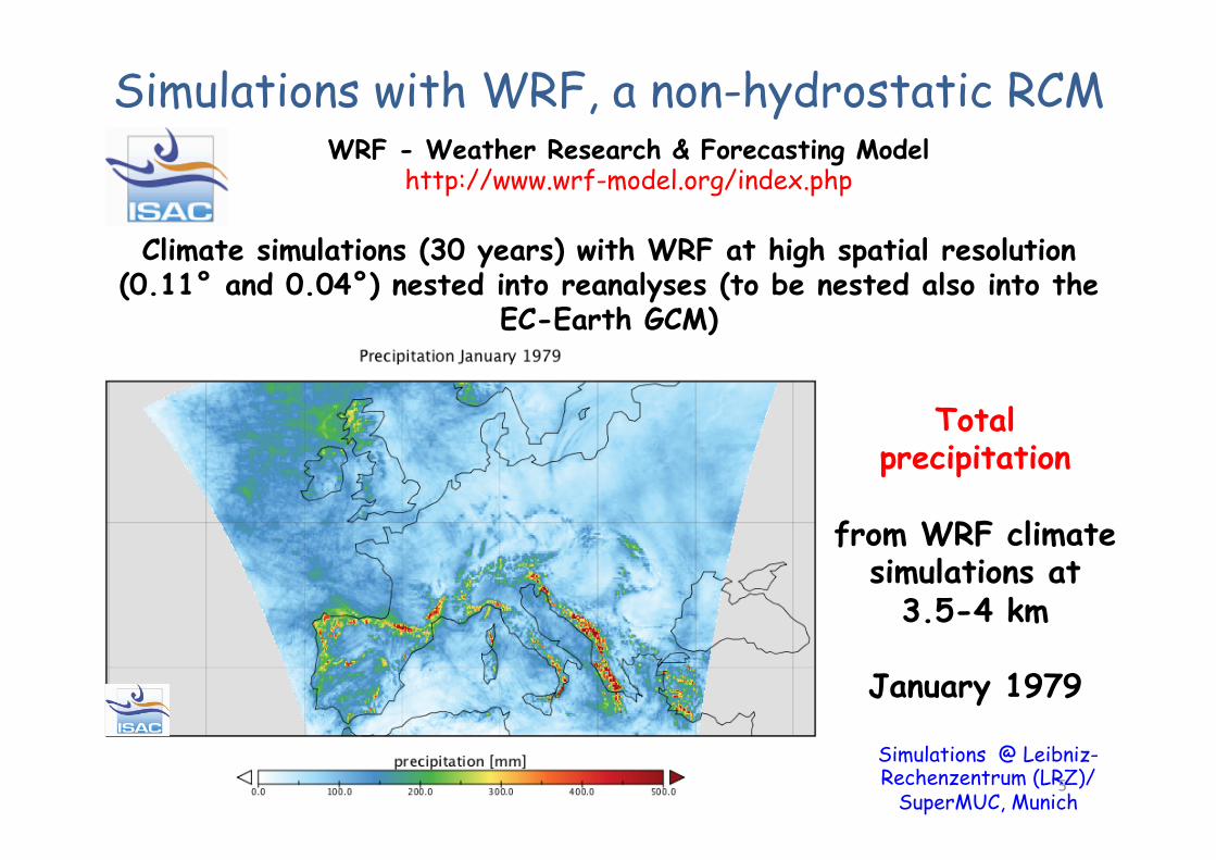
Climate simulations (30 years) with WRF at high spatial resolution (0.11° and 0.04°) nested into reanalyses (to be nested also into the
EC-Earth GCM)
Total precipitation
from WRF climate
simulations at 3.5-4 km
January 1979
Simulations @ Leibniz-Rechenzentrum (LRZ)/
SuperMUC, Munich
Simulations with WRF, a non-hydrostatic RCM WRF - Weather Research & Forecasting Model
http://www.wrf-model.org/index.php
5
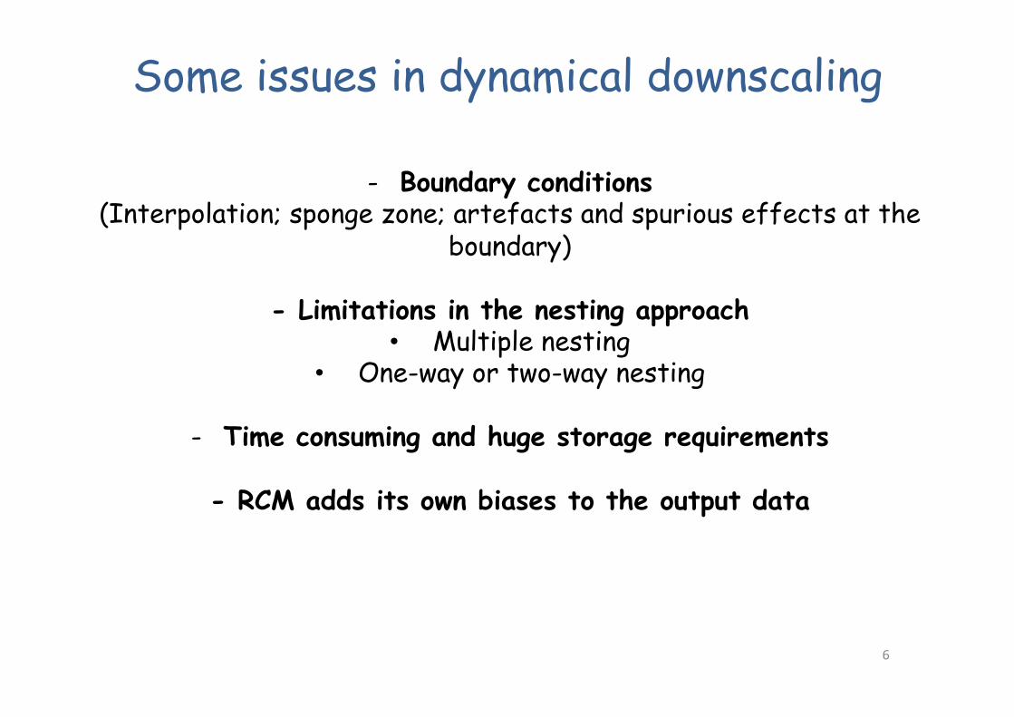
Some issues in dynamical downscaling
- Boundary conditions (Interpolation; sponge zone; artefacts and spurious effects at the
boundary)
- Limitations in the nesting approach • Multiple nesting
• One-way or two-way nesting
- Time consuming and huge storage requirements
- RCM adds its own biases to the output data
6
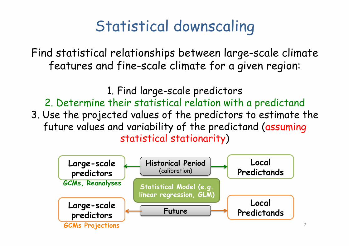
Statistical downscaling Find statistical relationships between large-scale climate
features and fine-scale climate for a given region:
1. Find large-scale predictors 2. Determine their statistical relation with a predictand
3. Use the projected values of the predictors to estimate the future values and variability of the predictand (assuming
statistical stationarity)
Statistical Model (e.g. linear regression, GLM)
Large-scale predictors
Large-scale predictors
GCMs, Reanalyses
GCMs Projections
Historical Period (calibration)
Local Predictands
Local Predictands Future
7

Statistical downscaling - GLM
Observed: SPAIN02 & APGD_v1.2 (Alpine precipitation grid dataset) Models: GCM (ERA-Interim); statistical model (GLM, Turco et al. in preparation) 8
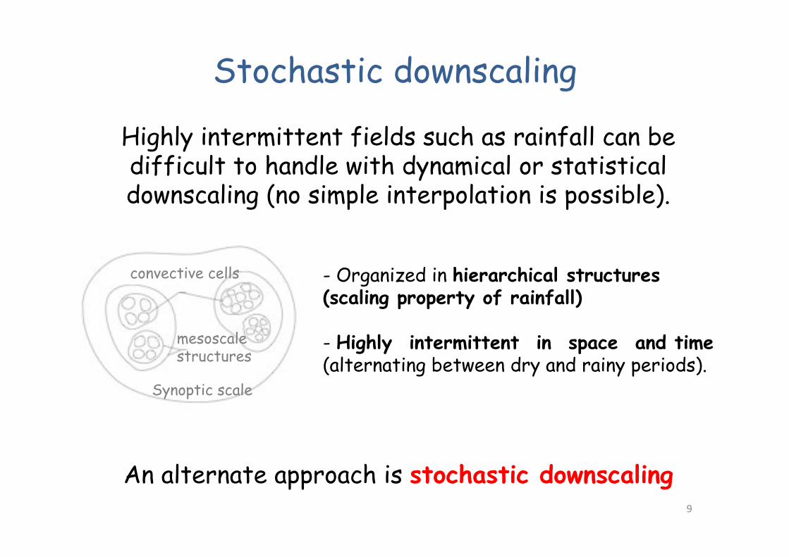
Highly intermittent fields such as rainfall can be difficult to handle with dynamical or statistical downscaling (no simple interpolation is possible).
Stochastic downscaling
An alternate approach is stochastic downscaling
convective cells
Synoptic scale
mesoscale structures
- Organized in hierarchical structures (scaling property of rainfall) - Highly intermittent in space and time (alternating between dry and rainy periods).
9
α Slope derived from P and propagated to smaller scales
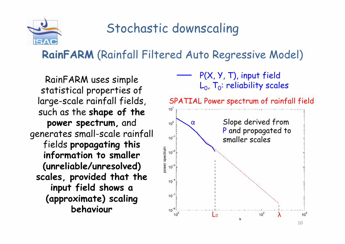
RainFARM uses simple statistical properties of
large-scale rainfall fields, such as the shape of the
power spectrum, and generates small-scale rainfall
fields propagating this information to smaller (unreliable/unresolved)
scales, provided that the input field shows a
(approximate) scaling behaviour
SPATIAL Power spectrum of rainfall field
P(X, Y, T), input field L0, T0: reliability scales
10
Stochastic downscaling
RainFARM (Rainfall Filtered Auto Regressive Model)

Stochastic downscaling RainFARM (Rainfall Filtered Auto Regressive Model)
² Efficient method for generating ensembles of small scale precipitation fields, with the correct statistical properties, from long-term climate simulations.
² The small-scale statistical properties of rainfall are
determined only by the behaviour of the model at large scale (no calibration).
² This method can be easily applied to climate scenarios for impact studies, provided that the models produce precipitation fields with the correct large-scale behaviour, without requiring extrapolation of current conditions to future situations 11
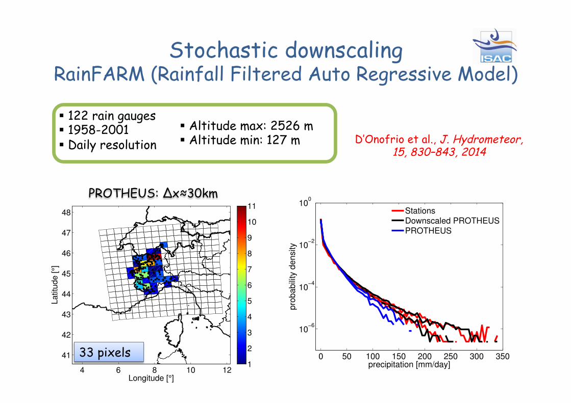
§ 122 rain gauges § 1958-2001 § Daily resolution
PROTHEUS: Δx≈30km
4 6 8 10 12
41
42
43
44
45
46
47
48
Longitude [°]
Latit
ude [
°]
1
2
3
4
5
6
7
8
9
10
11
§ Altitude max: 2526 m § Altitude min: 127 m
33 pixels
D’Onofrio et al., J. Hydrometeor, 15, 830–843, 2014
Stochastic downscaling RainFARM (Rainfall Filtered Auto Regressive Model)
0 50 100 150 200 250 300 350
10−6
10−4
10−2
100
precipitation [mm/day]
pro
babili
ty d
ensi
ty
StationsDownscaled PROTHEUSPROTHEUS
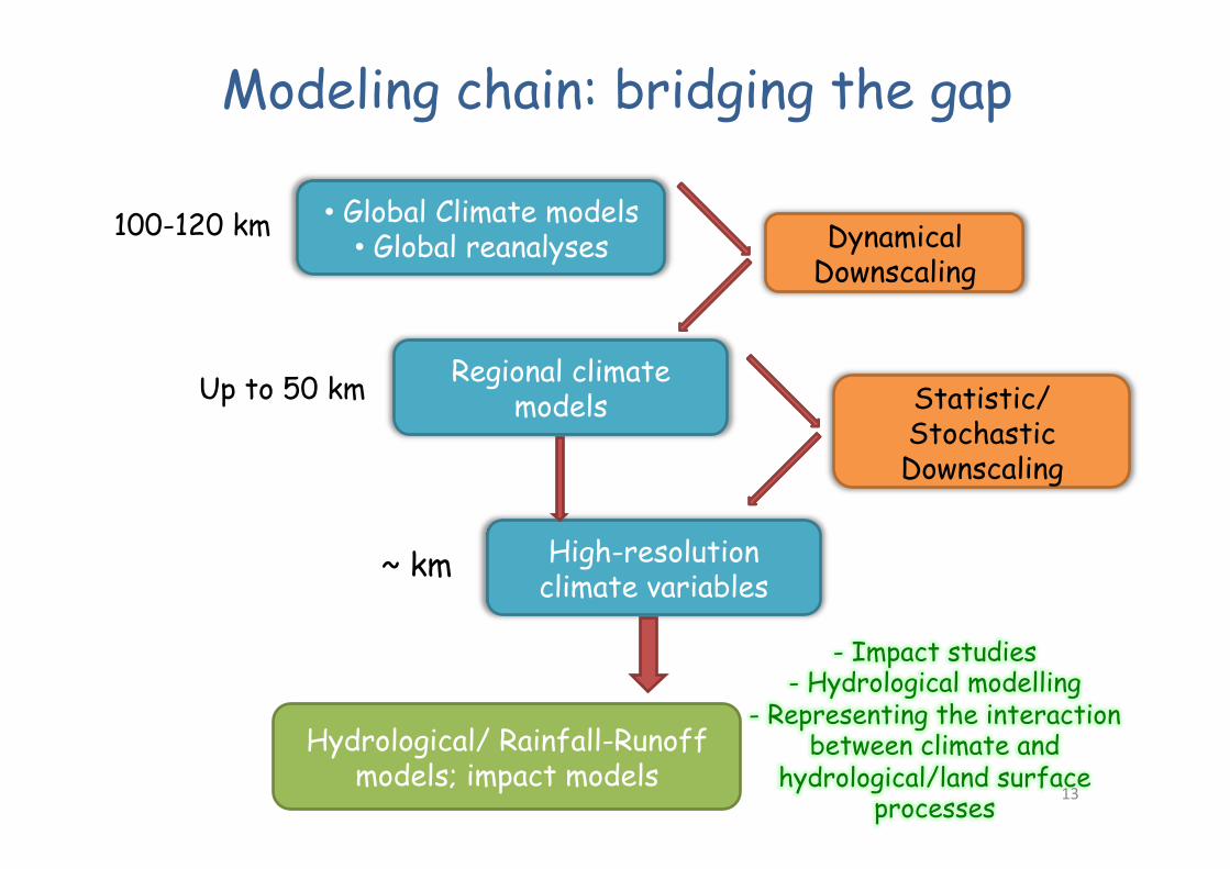
• Global Climate models • Global reanalyses
Regional climate models
High-resolution climate variables
Dynamical Downscaling
Statistic/Stochastic Downscaling
Hydrological/ Rainfall-Runoff models; impact models
~ km
Up to 50 km
100-120 km
Modeling chain: bridging the gap
- Impact studies - Hydrological modelling
- Representing the interaction between climate and
hydrological/land surface processes 13

Some initiatives & projects
http://www.earthobservations.org/
http://www.nextdataproject.it/
http://www.ecra-climate.eu/ Collaborative programme:
Changes in the hydrological cycle
GEO/GEOSS Task: ecosystems
A national system for the retrieval, storage, access
and diffusion of environmental and climate data from mountain and
marine areas
Group on Earth Observations à seeks to strengthen ecosystem monitoring through the
Global Earth Observation System of Systems.
14
Proge&o PRIN MIUR Bando 2010-‐2011
Innova've methods for water resources management under hydro-‐clima'c uncertainty
scenarios
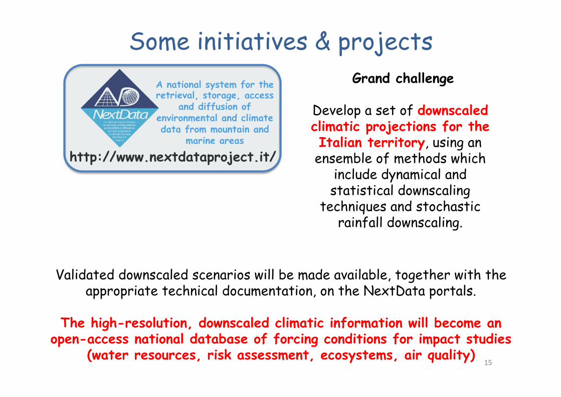
Some initiatives & projects Grand challenge
Develop a set of downscaled climatic projections for the Italian territory, using an
ensemble of methods which include dynamical and statistical downscaling
techniques and stochastic rainfall downscaling.
Validated downscaled scenarios will be made available, together with the appropriate technical documentation, on the NextData portals.
The high-resolution, downscaled climatic information will become an
open-access national database of forcing conditions for impact studies (water resources, risk assessment, ecosystems, air quality)
15
http://www.nextdataproject.it/
A national system for the retrieval, storage, access
and diffusion of environmental and climate data from mountain and
marine areas
