further information route 4: wem route 4...this leaflet/map should be used solely on this...
TRANSCRIPT

Cycling with care♦ Watch out for other vehicles especially tractors♦ Always wear a helmet and high visibility clothing♦ Ride in single file when the road is narrow♦ Follow the Highway Code and take extra care at road junctions
Further informationTourist informationWhitchurch Tourist Information Centre: 01948 664577 E-mail: [email protected]
Cycle shop Jack Davies Cycles: 58 High Street, Wem, SY4 5DW 01939 235485
Travel informationMainline railway stations are at Shrewsbury, Wem and Whitchurch. Visit www.nationalrail.co.uk or phone 08457 484950. Trains carry 2 bikes per train (reservations are essential). Information on all bus, coach and train services in Shropshire area call Traveline: 0871 200 2233 • www.travelshropshire.co.uk
Web linksShropshire Cycle Routes: www.travelshropshire.co.uk/cycleNorth Shropshire Tourism: www.northshropshire.co.uk Wem Town website: www.wem.gov.uk Meres and Mosses: www.themeresandmosses.co.ukSustrans: www.sustrans.org.uk National cyclists organisation: www.ctc.org.uk
Discover Shropshire by bikeIt’s great to get out and about on a bike in Shropshire. Discover hundreds of miles of National Cycle Network routes along quiet lanes, explore traffic-free trails along old railways and waterways, follow the cycle rides from historic towns and get muddy on mountain bike tracks in woods and forests.
Other Publicationswww.shropshire.gov.uk/cycling.nsfShropshire Council 01743 253008
Route 4: To Harmer Hill through Clive and Lee BrockhurstTotal distance 22 miles (35.4 km)Suitable for more experienced cyclists; this is a longer route with some steep gradients and crosses the busy A49 at 2 points. However, it is well worth the effort, it takes in a number of pretty villages and fine hostelries as well as passing the impressive remains of the Moreton Corbet Castle.
1 Leave Wem along Mill Street and turn right just before the railway bridge. Follow the road through Tilley and past the Raven pub on the right.
2 Turn first left for Brandwood. Continue to the A528.
3 Turn left towards Harmer Hill and then first right into Myddle village (take care!). Turn left at the T-junction and continue up the hill. At the top of the hill turn sharp right just before you reach the main road. Continue along this road into Harmer Hill.
4 Go straight over at the crossroads, up The Hollow to the next crossroads and turn left onto the B5476. Turn first right, signposted Yorton Heath. Follow this road to a T-junction in Yorton.
Yorton SΩ≠ The Railway Inn The Railway Inn pub is renowned for great real ales and has been in the same family for over 60 years.
5 Turn right, signposted Clive. Continue through Clive until you meet the A49 at Preston Brockhurst.
Clive P•xClive is the birthplace of William Wycherley, a Restoration dramatist of some repute. Clive Church stands on the slopes of the hill above the village and is a landmark for many miles.
Corbet Wood Ω~Corbet Wood is situated on the slopes of the Grinshill sandstone ridge that lies south of Clive village. Cart tracks, remnants of the former sandstone quarry, now provide easy access to a pleasantly varied woodland scene and lead to several excellent viewing points. To enter Corbet Wood turn right after leaving Clive village, following green signposts.
6 Turn right onto the A49 and first left by a black and white house (take great care). Continue to a T-junction and turn right on to the B5063.
Route 5: To Hodnet and WollertonTotal distance 24 miles (38.6 km)This is the longest route with some cycling along main roads and therefore suitable for more experienced cyclists. The route takes in some of North Shropshire’s most amazing scenery, including wooded heaths and views of sandstone hills. This route meets up with the Market Drayton cycle route in the beautiful village of Hodnet.
1 Leave Wem along Aston Street, over the level crossing and turn immediate right for Aston. Go through Aston and into Lee Brockhurst.
2 Turn left on to the A49 towards Whitchurch and first right towards Booley and Stanton (take great care). Continue towards Hodnet until you reach the A53. Turn left for Newcastle (take care) and left at the roundabout into Hodnet.
Hodnet —3P•≠The Bear Hotel Hodnet’s centrepiece is its Hall and Gardens which were started in 1921 by Brigadier A.G.W. Heber-Percy. Now you can enjoy the 60+ acres of beautiful landscaped gardens within a natural valley setting. There are also woodland walks and an ornamental water garden. Afternoon tea can be taken in the tearooms and there is also a gift shop. www.hodnethallgardens.org
3 Follow the road through Hodnet towards Market Drayton and into Wollerton.
Wollerton —Ü≠The Squirrel Wollerton Old Hall Gardens is a 3-acre, formal garden developed around a 16th century house with a tearoom. Open Easter to end of August, Fridays and Sundays (12-5pm) www.wollertonoldhallgarden.com
4 After the Squirrel Inn turn first left into Wood Lane, signposted to Fauls Green. Continue to a T-junction and turn left.
5 At the next T-junction with the A442 turn right for Whitchurch and Cycle Route 45 (take care). Turn first left at the next crossroads and into Prees.
Prees SPxPrees is an ancient village with evidence of Roman use. The church of St. Chad is 14th century but the tower is 1758. A handsome monument to Sir John Hill, father of the famous Lord Hill, Wellington’s second in command at Waterloo, is housed within.
6 Continue through the village and under the A49. Go straight over at the crossroads along Mill Street towards Whixall. Continue along this road, over the level crossing and past Prees Railway Station. Continue to the next T-junction.
7 Turn left onto the B5476, first right and then first left following Cycle Route 45 (take care). At the first T-junction turn left and then left again at the next. At the next T-junction turn right, signposted to Bostock Hall. Continue along this road into Whixall.
8 After Whixall Social Centre take the first left towards Braynes Hall. Continue to the next T-junction and turn left to Edstaston. Continue to the next T-junction.
9 Turn left towards Edstaston and right at the next T-junction.
! Continue to the next T-junction and turn right on to the B5476 and back into Wem town centre along New Street.
WEM WEM Aston
Lee Brockhurst
Moston
Weston
HAWKSTONE PARK
Hodnet
Prees
Tilley
Tilley Green
Booley
Kenstone Hodnet Hall
Gardens
Wollerton Gardens Marchamley
Wollerton
Lostford
Fauls
Darliston
Prees Wood
Prees Green
Coton
Whixall
Waterloo
Paddolgreen Edstaston
Quina Brook Abbey Green
Old Coppice
Top Moss Preston Springs
Hopley Coppice
B5063
B5476
B5476
B5476
B5063
B5065
B5065A442
A442
A442A49
A49A53
A53
A49
A41
NATIONAL CYCLE ROUTE 45
MARKET DRAYTON CYCLE ROUTE
NATIONAL CYCLE ROUTE 45
WEMWEMAston
Lee Brockhurst
Moston
Weston
Stanton uponHine Heath
Moreton Corbet
ShawburyAir�eld
SleapAir�eld
Acton Reynald
PrestonBrockhurst
Grinshill
CliveYorton
CORBET WOOD
Harmer Hill
Webscott
Myddle
BurltonBrandwood
Sleap
NoneleyCommonwood
Ruewood Tilley
≠
≠
Tilley Green
Besford
Booley
Old CoppiceLeeBrockhurst
Hill (NT)
Top MossPrestonSprings
B4397
B5063
B5476
B5476
B5063
B5063
A528
A49
A49
A53
NATIONAL CYCLE ROUTE 45
7 Take the 2nd left, signposted to Stanton and Booley. For Moreton Corbet Castle turn first right. Otherwise continue over the River Roden and into Stanton upon Hine Heath.
Moreton Corbet 9xMoreton Corbet Castle is a magnificent and unusual ornate ruin. It was built by Bartholomew Torret following the Norman conquest in 1066. In approximately 1239 the Corbet family acquired Moreton Toret and built a stone castle on the site. For more information visit: http://www.english-heritage.org.uk/daysout/properties/moreton-corbet-castle/
Stanton upon Hine Heath ≠ The Stanton ArmsHome to novelist Mary Webb from 1896 to 1902.
8 Turn first left after the Stanton Arms into Booley Lane. Follow the road to the next T-junction and turn left, signposted Moston. Continue to the A49, turn left and then first right into Lee Brockhurst (take great care).
Lee BrockhurstA charming farming hamlet mentioned in the Domesday Book. The bridge over the River Roden was built in Thomas Telford’s design in 1800. Near this is the small village green from where access is available to the National Trust’s protected area of Lee Hills.
9 Cycle up a steep bank, continue downhill and then up a steep bank to 100 Steps, through Aston and back into Wem.
! At the T-junction turn left over the level crossing and return to Wem town centre along Aston Street
Five cycle routes following quiet lanes and country roads around Wem
From 71⁄2 – 24 miles (12.4 – 38km) www.travelshropshire.co.uk
Route 4
Route 5
© Crown copyright and database rights 2014 Ordnance Survey 1000490494.
© Crown copyright and database rights2014 Ordnance Survey 1000490494.A
rtw
ork
by M
A C
reat
ive
• ww
w.m
acre
ativ
e.co
.uk
Please note that, while the publishers take every care to be accurate, no liability or responsibility will be accepted in any circumstances whatsoever, should anyone experience any inaccuracies, loss, damage or injury. This leaflet/map should be used solely on this understanding. Edition#5 Nov 2014
WemCycle Rides
FREE
Wem Cycle Leaflet#2.indd 1-2 23/08/2010 14:24
About the cycle ridesCycling is one of the best ways to soak up the unspoilt landscapes and experience the unique features of the environment and villages of North Shropshire. It is ideal cycling terrain: quiet lanes and country roads, easy gradients and yet amazing views. These cycle routes have been chosen to suit a range of interests and abilities, the shortest route being 71⁄2 miles and the longest 24 miles. Cycled over a day, with a picnic lunch or a stop at a local pub, this really is a great way to explore the area.
Where to startAll the cycle routes start from Wem. Safe, long stay parking can be found in the town centre next to the supermarket (see map below).
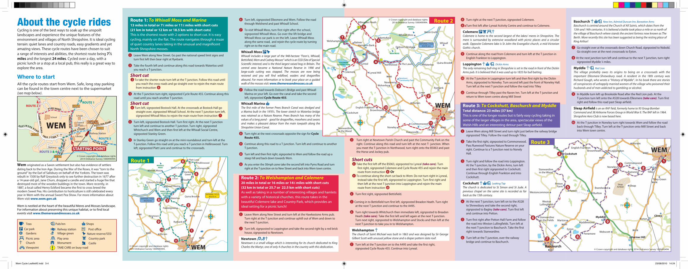
6 Turn left, signposted Ellesmere and Wem. Follow the road through Welshend and past Whixall School.
7 To visit Whixall Moss, turn first right after the school, signposted Whixall Moss. Go over the lift bridge and Whixall Moss car park is on the left. Leave Whixall Moss along the same road, and rejoin the cycle route by turning right on to the main road.
Whixall Moss Ω∏Whixall includes a large part of the 948-hectare “Fenn’s, Whixall, Bettisfield, Wem and Cadney Mosses” which is an SSSI (Site of Special Scientific Interest) and is the third largest raised bog in Britain. The central area became a National Nature Reserve in 1990 and large-scale cutting was stopped. The mosses are now being restored and you will find wildfowl, waders and dragonflies abound. For more information or to book your place on a guided walk of the mosses visit: www.themeresandmosses.co.uk
7 Follow the road towards Dobson’s Bridge and past Whixall Marina on your left. Go over the canal and take the second left, signposted Cycle Route 455.
Whixall Marina PThe first mile of the former Prees Branch Canal was dredged and a Marina built in the 1970’s. The lower stretch to Waterloo bridge was retained as a Nature Reserve. Prees Branch has many of the values of a long pond - good for dragonflies, moorhens and swans and makes a pleasant detour from the main towpath along the Shropshire Union Canal.
8 Turn right at the next crossroads opposite the sign for Cycle Route 455.
9 Continue along this road to a T-junction. Turn left and continue to another T-junction.
! Turn left and then first right, signposted to Wem and follow the road up a steep hill and back down towards Wem.
# As you enter the 30mph zone take the second left into Pyms Road and turn right at the T-junction on to New Street and back into Wem town centre.
Route 2: To Welshampton and Colemere20 miles in total or 16 miles or 141⁄2 miles with short cuts(32 km in total or 25.7 or 22.5 km with short cuts)As well as taking in a number of interesting villages and hamlets with a variety of historical churches, this route takes in the beautiful Colemere lake and Country Park, which provides an ideal setting for a picnic lunch!
1 Leave Wem along New Street and turn left at the Hawkestone Arms pub. Turn right at the T-junction and continue uphill out of Wem and down to the next T-junction.
2 Turn left, signposted to Loppington and take the second right by a red brick house, signposted to Newtown.
Newtown ?◊xNewtown is a small village which is interesting for its church dedicated to King Charles the Martyr, one of only 4 churches in the country with this dedication.
◊
WEM WEM
COLEMERE COUNTRY PARK
Stanwardine in the Wood
Noneley Commonwood
Ruewood
Cockshutt
English Frankton Brownheath Loppington
Horton
Tilley
Welsh End
Whixall Dobson’s Bridge
Whixall Moss Bettis�eld
Hampton Bank Balmer
Breaden Heath
Welshampton
Colemere
Lyneal
Lyneal Mill
Northwood The Lawn
Newtown
Newtown Community Park
Wolverley
Waterloo Quina Brook
WHIXALL MOSS
Lowe
RyebankWhattal
Moss
WEM MOSS
A495
A528
B4397
B5063
B5063
B5476
B5476
B5063
B5065
B5063
NATiONAL CYCLE ROUTE 455
ROUTE 1
ROUTE 5
ROUTE 2
ROUTE 3 & 4
Railway Station
WEMLibrary
SupermarketSupermarket
SOULTON ROADCouncilOffices
NEW
ST
REE
T
PYMS ROAD
ASTON S TREET
ASTO N R OAD
MIL
L S
TREE
T
HIG H S T R EE T
ELLE S M E R E R OAD
LOW
E H
ILL
RO
AD
SchoolSchool
B5476
B5476
B5063
B5065
STARTING POINTPolice
DEDICATEDCYCLE PATHDEDICATEDCYCLE PATH
Route 1: To Whixall Moss and Marina13 miles in total or 71⁄2 miles or 111⁄2 miles with short cuts(21 km in total or 12 km or 18.5 km with short cuts) This is the shortest route with 2 options to short cut. It is easy cycling, mainly on the flat. The route navigates through a maze of quiet country lanes taking in the unusual and magnificent North Shropshire mosses.
1 Leave Wem along New Street. Go past the national speed limit signs and turn first left then bear right at Ryebank.
2 Take the fourth left and continue along this road towards Waterloo until you reach a T-junction.
Short cut 3 To take the shorter route turn left at the T-junction. Follow this road until
you reach the cross roads and go straight over to rejoin the main route from instruction 8
3 At the T-junction turn right, signposted Cycle Route 455. Continue along this road until you reach another T-junction.
Short cut 4 Turn left, signposted Bostock Hall. At the crossroads at Bostock Hall go
straight over, signposted Whixall School. At the next T-junction turn left, signposted Whixall Moss to rejoin the main route from instruction 7
4 Turn left, signposted Bostock Hall. Turn first right. At the next T-junction turn left and continue to another T-junction. Turn right, signposted Whitchurch and Wem and then first left at the Whixall Social Centre, signposted Stanley Green.
5 In Stanley Green go straight on at the mini roundabout and turn left at the T-junction. Follow this road until you reach a T-junction in Hollinswood. Turn left, signposted Platt Lane and continue to the crossroads.
WEM WEM
Horton
Coton
Cotonwood
Hollinwood Platt Lane
Welsh End
Whixall Dobson’s Bridge
Whixall Marina
Whixall Moss
Newtown
Waterloo
Paddolgreen Edstaston
Quina Brook
WHIXALL MOSS
School
Stanley Green
Ryebank
WEM MOSS
PREES CANAL Local Nature
Reserve
B5063
B5063
B5476
B5065
B4397
NATIONAL CYCLE ROUTE 45
NATIONAL CYCLE ROUTE 455
Baschurch xP ≠ New Inn, Admiral Duncan Inn, Boreatton ArmsBaschurch is centred around the Church of All Saints, which dates from the 13th and 14th centuries. It is believed a battle took place a mile or so north of the village of Baschurch where stands the ancient fortress now known as The Berth. More recently this site has been suggested as being the resting place of King Arthur!
7 Go straight over at the crossroads down Church Road, signposted to Nobold. Go straight over at the next crossroads to Eyton.
8 At the next junction turn left and continue to the next T-junction, turn right signposted Myddle 3⁄4 miles.
Myddle x≠ Red Lion The village probably owes its origins to being on a crossroads with the important Ellesmere-Shrewsbury road. A resident in the 18th century was Richard Gough, who wrote a “History of Myddle”. In his book there are stories of conspiracies of unhappily married women of the village who poisoned their husbands and of men addicted to gambling or alcohol.
9 In Myddle turn left up Brookside Road after the Red Lion pub. At the T-junction turn left onto the A528 towards Ellesmere (take care). Turn first right and follow this road past Sleap airfield.
Sleap Airfield is an ex-RAF field, formerly home to 93 Group Bomber Command and 38 Airborne Forces Group in World War II. The RAF left in 1964. Shropshire Aero Club is now based here.
! At the T-junction in Noneley turn right towards Wem and follow the road back through Tilley. Turn left at the T-junction onto Mill Street and back into Wem town centre.
Ü Teas Ω Car park
≠ Pub/inn P Shops
S Railway station • Post office — Gardens ◊ Village green ∏ Nature reserve/SSSI
¢ Picnic area ? Play area x Church 3 Monument
N Country park
9 Castle ~ Viewpoint TAKE CARE on busy road!
8 Turn right at the next T-junction, signposted Colemere.
8a Turn first left after Lyneal Activity Centre and continue to Colemere.
Colemere ΩN¢xColemere is home to the second largest of the lakes/ meres in Shropshire. The mere is surrounded by extensive woodland with picnic places and a circular walk. Opposite Colemere lake is St John the Evangelist church, a mid-Victorian Gothic church.
9 Continue along the road from Colemere and turn left at the T-junction in English Frankton to Loppington.
Loppington xP ≠ Dickin Arms The only remaining bull-ring in Shropshire is set in the road in front of the Dickin Arms pub. It is believed that it was used up to 1835 for bull baiting.
! At the T-junction in Loppington turn left and then first right by the Dickin Arms, signposted to Noneley. Turn second left past the front of Noneley Hall. Turn left at the next T-junction and follow the road into Tilley
# Continue through Tilley past the Raven Inn. Turn left at the T-junction and return to Wem town centre along Mill Street
Route 3: To Cockshutt, Baschurch and MyddleTotal distance: 23 miles (37 km)This is one of the longer routes but is fairly easy cycling taking in some of the larger villages in the area, spectacular views of the Welsh Hills and an interesting detour past Sleap airfield.
1 Leave Wem along Mill Street and turn right just before the railway bridge signposted Tilley. Follow the road through Tilley.
2 Take the first right, signposted to Commonwood. Pass Ruewood Pastures Nature Reserve on your right. Continue to a T-junction next to Nonely Hall.
3 Turn right and follow the road into Loppington. At the T-junction, by the Dickin Arms, turn left and then first right signposted to Cockshutt. Continue through English Frankton and into Cockshutt.
Cockshutt xP ≠ Leaking Tap The church is dedicated to St Simon and St Jude. A previous chapel on the same site is recorded as far back as the 15th century.
4 At the next T-junction, turn left on to the A528 to Shrewsbury and take the second right, signposted to Bagley (take care). Turn first left and continue into Petton.
5 Turn first right after Petton Hall Farm and follow the road into Weston Lullingfields. Turn left at the next T-junction to Baschurch. Take the first right towards Stanwardine.
6 Turn left at the T-junction, over the railway bridge and continue to Baschurch.
WEM WEM
SleapAir�eld
Clive Yorton
Harmer Hill
Webscott
Myddle
Myddlewood Marton
Stanwardine in the Fields
Baschurch
WestonLulling�elds
Westoncommon
PettonFarm
Stanwardine in the Wood
Burlton
Brandwood Sleap
Noneley Commonwood
Ruewood
Cockshutt
English Frankton Brownheath Loppington
Horton
Tilley
≠
≠
Tilley Green
Petton
Fenemere
Eyton
A528
B4397
B4397
B4397
B5063
B5476
B5476
B4397
B5067
A528
Route 1
Route 2
Route 33 Turn right at Newtown Parish Church and past the Community Park on the right. Continue along this road and turn left at the next T- junction. When you meet the T-junction in Northwood, turn right onto the B5063 and past the Horse and Jockey pub.
Short cuts4 Take the first left off the B5063, signposted to Lyneal (take care). Turn
first right, signposted Colemere and Cycle Route 455 and rejoin the main route from instruction 8 Or
4 To continue along the short cut back to Wem: Do not turn right in Lyneal, instead take the first left, signposted to Loppington. Turn first right and then left at the next T-junction into Loppington and rejoin the main route from instruction !
4 Turn first right, signposted Bettisfield.
5 Coming in to Bettisfield turn first left, signposted Breadon Heath. Turn right at the next T-junction and continue to the A495.
6 Turn right towards Whitchurch then immediate left, signposted to Breadon Heath (take care). Take the first left and left again at the next T-junction. Turn next right, signposted to Welshampton and Stocks and then left at the next T-junction to take you in to Welshampton.
Welshampton xThe church of Saint Michael was built in 1863 and was designed by Sir George Gilbert Scott with unusual yellow stone and a diaper pattern slate roof.
7 Turn left at the T-junction on to the A495 and take the first right, signposted Cycle Route 455. Continue into Lyneal.
© Crown copyright and database rights2014 Ordnance Survey 1000490494.
© Crown copyright and database rights 2014 Ordnance Survey 1000490494.© Crown copyright and database rights 2014 Ordnance Survey 1000490494.
Wem originated as a Saxon settlement but also has evidence of settlers dating back to the Iron Age. During the War of the Roses, it was “torn to the ground” by the Earl of Salisbury on behalf of the Yorkists. The town was rebuilt in 1500 by Ralf Greystock only to see further destruction in 1677 after a 14-year-old girl, Jane Churn, dropped a candle and started a huge fire that destroyed most of the wooden buildings in the town. More recently, in 1887, a local called Henry Eckford became the first to cross breed the modern Sweet Pea. His contribution to horticulture is still celebrated every year in Wem with the annual Sweet Pea Show. For more information about Wem visit www.wem.gov.uk
Wem is nestled at the heart of the beautiful Meres and Mosses landscape. For information about preserving this unique habitat, or to find local events visit www.themeresandmosses.co.uk
© Crown copyright and database rights2014 Ordnance Survey 1000490494.
Wem Cycle Leaflet#2.indd 3-4 23/08/2010 14:24