floristic variability, distribution and an extension of
TRANSCRIPT
Cunninghamia: a journal of plant ecology for eastern Australia © 2012 Botanic Gardens Trustwww.rbgsyd.nsw.gov.au/science/Scientific_publications/cunninghamia
Floristic variability, distribution and an extension of range for the endangered Pittwater Spotted Gum Forest,
Central Coast, New South Wales
Stephen A.J. Bell and 1Mark Stables
Eastcoast Flora Survey PO Box 216 Kotara Fair, NSW 2289 AUSTRALIA Email: [email protected]; 1Gosford City Council PO Box 21 Gosford, NSW 2250 AUSTRALIA Email: [email protected]
Abstract: Multivariate analysis and non-metric multidimensional scaling have been used to compare the floristic composition of vegetation dominated by Spotted Gum, Corymbia maculata, and Grey Ironbark, Eucalyptus paniculata, from the Pittwater and Gosford local government areas, and elsewhere on the Central Coast of New South Wales. When placed within a regional context, vegetation from both local government areas is strongly related, and is sufficiently distinct (at 30% similarity) from other areas of Spotted Gum-Ironbark vegetation within the region to warrant their collective consideration as Pittwater Spotted Gum Forest (PSGF), an Endangered Ecological Community in New South Wales. Within Pittwater local government area, two forms of PSGF are present: a dryer, more widespread form present on ridges and slopes, and a moister form with strong littoral rainforest affinities confined to gullies. Gosford local government area supports only the dryer form. Extant and pre-1750 mapping of PSGF from both local government areas (excluding Ku-ring-gai Chase National Park) shows a total extant distribution of 227 ha, and since 1750 an estimated loss of 727 ha (76%) from the original 954 ha. PSGF is present in two secure conservation reserves: Ku-ring-gai Chase National Park (~40 ha, Thomas & Benson 1985) and Bouddi National Park (~30 ha, Bell 2009), totaling ~ 70 ha. Despite this, much of the extant distribution lies at the reserve-urban interface, and is subject to ongoing threats of regular low-intensity fire, unmitigated clearing and weed invasion.
Key words: threatened community, Pittwater Spotted Gum Forest, classification, mapping
Cunninghamia (2012) 12(2): 143–152
Introduction
Within New South Wales, forests and woodlands dominated by Spotted Gum (Corymbia maculata, Corymbia variegata, Corymbia henryi) and various ironbark eucalypts (eg: Eucalyptus paniculata, Eucalyptus siderophloia, Eucalyptus fibrosa, Eucalyptus crebra) are widespread. Indeed, in his overview of the native vegetation of New South Wales, Keith (2004) outlined four classes of vegetation where such a combination of canopy species is characteristic (Southern Lowland Wet Sclerophyll Forests, Coastal Valley Grassy Woodlands, Clarence Dry Sclerophyll Forests, Hunter-Macleay Dry Sclerophyll Forests), encompassing almost the entire coastal strip. Spotted Gum is also a commercially important tree species, having a long history of timber production (FCNSW 1989; Boland et al 2006; Wrigley & Fagg 2010) and in the production of honey (Clemson 1985; Law & Chidel 2008).
Along much of the coastline of New South Wales, Eucalyptus paniculata (Grey Ironbark) is the most widespread ironbark species, ranging from Coffs Harbour to Bega, and rarely extending more than 80km inland (Boland et al. 2006). Together with Spotted Gum, both species are characteristic of coastal forests in the South, Central and North Coast botanical subdivisions, as evidenced by their prominence in vegetation classifications for these areas (eg: NSW NPWS 2000; Gellie 2005; Somerville 2009). Pidgeon (1937), in her seminal work on the vegetation of the New South Wales Central Coast (Hunter Valley to the Lower Shoalhaven Valley), described an ‘Eucalyptus maculata–Eucalyptus paniculata Association’ extending sporadically from Lake Macquarie south to Batemans Bay. However, there has been little investigation to date regarding how geographically isolated stands of vegetation co-dominated by Corymbia maculata and Eucalyptus paniculata may differ, or indeed whether or not the same association of co-occurring species is present.
144 Cunninghamia 12(2): 2012 Bell & Stables, Endangered Pittwater Spotted Gum Forest
Pittwater Spotted Gum Forest (PSGF) was first named and described for parts of northern Sydney by Benson and Howell (1990a, 1994). It was subsequently listed as an Endangered Ecological Community in New South Wales under the Threatened Species Conservation Act 1995, where it was described as occurring on shale-derived soils in high rainfall areas, on lower hillslopes of the Newport formation along Barrenjoey Peninsula and on the western shores of Pittwater (NSW Scientific Committee 1999). Benson and Howell (1994) delineated two forms of the forest, but both were dominated by a canopy of Corymbia maculata. On dryer sites, Allocasuarina littoralis, Dodonaea triquetra, Platylobium formosum, Macrozamia communis and Pultenaea flexilis comprised the sparse small tree and shrub layer, over an open ground cover of herbs and graminoids. In the more sheltered aspects, the small tree layer included Elaeocarpus reticulata and Pittosporum undulatum, with a mesic understorey of Diospyros australis, Synoum glandulosum, Cassine australis var. australis, Melicope micrococca, Commersonia fraseri, Alphitonia excelsa and Livistona australis. Ferns (Doodia aspera, Adiantum aethiopicum) and vines (Cissus hypoglauca, Pandorea pandorana, Cayratia clematidea, Geitonoplesium cymosum, Eustrephus latifolius) were also common.
Holden (2001) later undertook an investigation into aspects of the PSGF as part of an Honours degree at the University of New South Wales. He found that at that time only 51 ha of remnant PSGF remained. Increases in soil nutrients as a result of urban expansion was suggested by Holden (2001) as the main cause behind the higher abundance of the mesomorphic species Pittosporum undulatum, Glochidion ferdinandi and Elaeocarpus reticulatus within the former open forests. Other threats, such as infrequent and low intensity fire, and increasing urban development were also discussed in the context of future management.
Recent vegetation survey and classification projects undertaken on behalf of local government have gathered a considerable amount of additional data on known and potential PSGF (hereafter termed candidate-PSGF). A numerical classification of the native vegetation of the Gosford local government area identified patches of vegetation around the northern foreshores of Broken Bay which supported many of the features of PSGF (Bell 2009). A similar project was undertaken within the Pittwater local government area (Bangalay & Eastcoast Flora Survey 2011), and it is appropriate that a review of the community and its conservation status now be made.
This paper examines the relationship between areas supporting forests dominated by Corymbia maculata and Eucalyptus paniculata, from both the Pittwater and Gosford local government areas. It forms part of a broader study being undertaken on Spotted Gum-Ironbark forests within the Central Coast and Hunter Valley region of New South Wales. In part, this study attempts to answer recent questions over
the significance of vegetation considered as candidate-PSGF within the Gosford LGA, but also raises new questions on the relationships of other more geographically distinct stands of vegetation elsewhere in the State.
Study Area
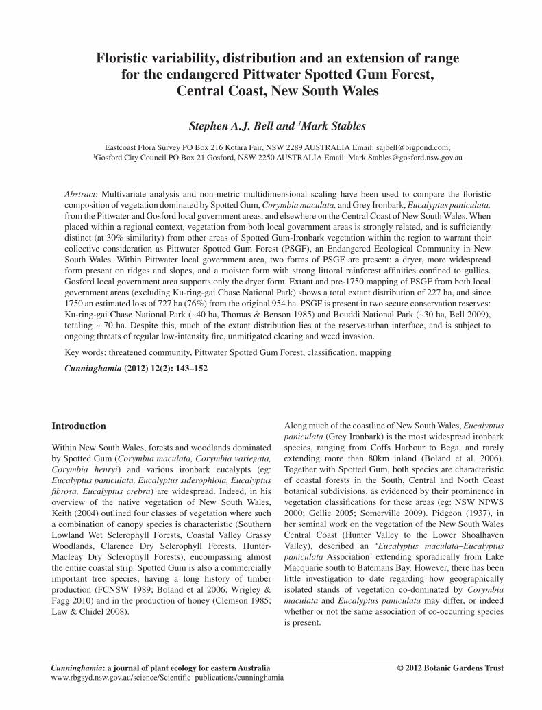
The Pittwater (excluding Ku-ring-gai Chase National Park) and Gosford local government areas (LGAs) north of Sydney, New South Wales, form the core area for this study (Figure 1). Floristic regional data have also been drawn from the Hunter Valley and Central Coast (Hunter-Central Rivers Catchment Management Area: CMA) for comparative analysis. Both Pittwater and Gosford LGAs fall within a warm temperate climatic zone, with a maritime influence near the coast, and experience warm wet summers and cool dry winters. The majority of Pittwater LGA and the eastern parts of Gosford LGA occur within the 1,100 to 1,300 isohyet range. Rainfall occurs throughout the year, although is generally higher in summer and autumn, largely due to onshore winds, and with a mean annual rainfall of 1212 mm at Observatory Hill (Bureau of Meteorology 2010).
Geologically, Pittwater and Gosford LGAs occur on Triassic sediments of the Sydney Basin, an extensive geological feature comprising horizontal beds of sandstones and shales, and covering 36 000 km2 of land from Batemans Bay in the south to the Hunter River in the north (Bembrick et al 1980). The two LGAs are separated only by an expanse of ocean known as Broken Bay. Soil landscapes in both areas have been studied in some detail (Chapman & Murphy 1989; Murphy 1993), and span coluvial, residual, erosional, fluvial, aeolian, marine, estuarine, swamp and disturbed landscapes. In general, soils derived from the younger Triassic Hawkesbury Sandstone overlie those derived from the Triassic Narrabeen Series.
Fig. 1. Pittwater and Gosford local government areas, and the Hunter-Central Rivers CMA region.
Cunninghamia 12(2): 2012 Bell & Stables, Endangered Pittwater Spotted Gum Forest 145
A number of vegetation classifications have been developed for both Pittwater and Gosford LGAs over recent decades. Among these are the sub-regional studies of Benson and Howell (1994), NSWNPWS (2000), McCauley et al. (2006), Somerville (2009) and NSWDECCW (2010), and the recent LGA-focused studies of Bell (2009) and Bangalay & Eastcoast Flora Survey (2011). All provide good overviews of the diversity of vegetation present within the study area.
Methods
Sampling
Existing data collected by the authors and adhering to the New South Wales standard (Sivertsen 2010) were extracted to form a base analysis dataset. New data was collected to augment existing data and to target poorly sampled locations. Areas supporting stands of Corymbia maculata as a dominant or co-dominant species in the canopy (with or without Eucalyptus paniculata) were preferentially selected for detailed survey in both the Gosford and Pittwater LGAs. Reference was made to the mapping of Holden (2001) for Pittwater LGA and Bell (2009) for Gosford LGA as a guide to site selection. Given constraints imposed by private land ownership, the majority of locations sampled were Council-owned reserves. No new sampling was completed within Ku-ring-gai Chase National Park. All sample plots were of 0.04ha (20 x 20m) and located within locally homogeneous stands of vegetation. Modified (1–6 scale) Braun-Blanquet cover abundance scores (Braun Blanquet 1928) were applied to all vascular plant species recorded within each plot. Plant nomenclature followed Harden (1990–1993) and revisions subsequently accepted by the National Herbarium of New South Wales.
Classification and analysis
Numerical classification (UPGMA cluster analysis & nMDS ordination) on collected data was performed using Primer V6 (Clarke & Gorley 2006), utilizing the group averaging strategy, the Bray-Curtis association measure and a Beta value of –0.1. Data were analysed initially within a larger regional dataset (Hunter-Central Rivers CMA) of sample plots dominated by Corymbia maculata and various ironbark species, to identify those samples where candidate-PSGF may potentially occur. Newly collected data was analysed to provide a regional context to the PSGF dataset. The SIMPER routine in Primer was used to generate diagnostic species lists for each defined floristic group.
Mapping
Mapping the distribution of candidate-PSGF combined interpretation of digital orthorectified imagery and on-screen digitising of vegetation boundaries with extensive ground truthing. In both LGAs, exhaustive vehicle and foot
traverses were undertaken (excluding some private lands), and data on dominant plant species within each major strata (canopy, shrub, ground) recorded at regular locations with a hand-held GPS unit. Collected data was imported into a GIS system and used to inform and classify map polygons, using dominant species as indicators for vegetation communities. Nomenclature for communities followed Bell (2009) for Gosford LGA, and Bangalay & Eastcoast Flora Survey (2011) for Pittwater LGA. Candidate-PSGF included Wagstaff Spotted Gum Forest (Unit 15b) in Gosford, and Coastal Moist Spotted Gum Forest (Unit S_WSF11) and Coastal Dry Spotted Gum Forest (Unit S_DSF25) in Pittwater. To estimate the pre-1750 distribution of candidate-PSGF, the same data collection techniques were used across cleared and urban landscapes to record remnant canopy species, which were later allocated to vegetation communities. Within the GIS, this data was used in combination with elevation and soils data layers to interpolate likely pre-disturbance boundaries. Further details on this process can be found in Bell (2009) and Bangalay & Eastcoast Flora Survey (2011).
Results
Classification
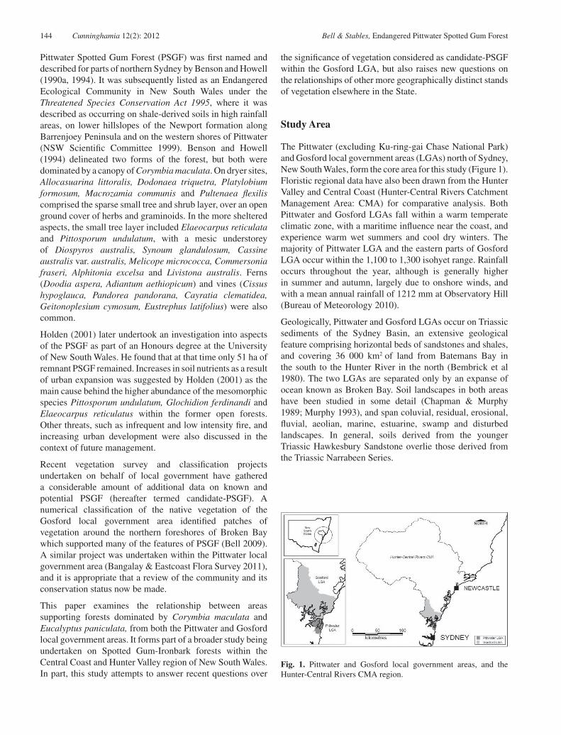
A total of 23 plots were sampled in Gosford and Pittwater LGAs, within known and candidate-PSGF. Within the regional dataset of nearly 500 samples, these plots grouped together to form two coherent clusters, at ~30% similarity (Figure 2). These 23 samples of candidate-PSGF were extracted from the main database to form a subset of sites for further investigation.
Fig. 2. Site dendrogram (partially collapsed at 30% similarity) showing the position of candidate-PSGF plots (2 groups, with LGA labels) within a regional dataset of 489 Spotted Gum samples (Bray-Curtis association measure). Floristic groups defined at 30% similarity (horizontal dotted line).
146 Cunninghamia 12(2): 2012 Bell & Stables, Endangered Pittwater Spotted Gum Forest
Group A – Average similarity: 43.58Species Av.Abund Av.Sim Sim/SD Contrib% Cum.%
Corymbia maculata 3.67 4.61 4.82 10.59 10.59Entolasia stricta 1.94 2.29 2.98 5.26 15.85Pteridium esculentum 2.11 1.90 1.15 4.35 20.20Dianella caerulea 1.61 1.80 2.99 4.13 24.33Pandorea pandorana 1.78 1.75 1.92 4.01 28.34Lomandra longifolia 1.50 1.58 2.99 3.63 31.97Themeda australis 1.61 1.52 1.78 3.48 35.44Eustrephus latifolius 1.44 1.48 2.09 3.40 38.84Eucalyptus paniculata subsp. paniculata 1.67 1.40 1.00 3.21 42.05Pratia purpurascens 1.39 1.32 1.51 3.04 45.09Macrozamia communis 1.61 1.23 0.84 2.83 47.92Imperata cylindrica var. major 1.56 1.21 1.07 2.77 50.69Notelaea longifolia forma longifolia 1.33 0.96 1.06 2.21 52.90Entolasia marginata 1.17 0.84 0.93 1.94 54.84Elaeocarpus reticulatus 1.22 0.84 0.91 1.94 56.78Pultenaea flexilis 1.44 0.83 0.50 1.91 58.68Geitonoplesium cymosum 1.11 0.80 0.93 1.84 60.52Persoonia linearis 0.83 0.80 1.18 1.83 62.35Smilax glyciphylla 1.22 0.80 0.77 1.83 64.18Lomandra multiflora subsp. multiflora 1.06 0.78 0.89 1.79 65.97Pseuderanthemum variabile 1.00 0.75 0.93 1.73 67.71Glochidion ferdinandi var. ferdinandi 1.00 0.75 0.94 1.71 69.42Pittosporum undulatum 1.06 0.72 0.78 1.66 71.08Panicum simile 0.89 0.71 0.99 1.62 72.71Pomax umbellata 0.83 0.69 1.00 1.57 74.28Billardieria scandens 0.78 0.61 0.84 1.39 75.67Acacia ulicifolia 0.94 0.60 0.67 1.39 77.06Caesia parviflora 0.72 0.57 0.86 1.32 78.37Allocasuarina littoralis 1.06 0.56 0.46 1.29 79.66Hardenbergia violacea 0.89 0.56 0.72 1.28 80.94Glycine clandestina 0.89 0.52 0.70 1.18 82.12Allocasuarina torulosa 1.06 0.45 0.42 1.04 83.16Digitaria parviflora 0.61 0.30 0.54 0.68 83.84Breynia oblongifolia 0.50 0.29 0.55 0.67 84.51Desmodium rhytidophyllum 0.56 0.29 0.55 0.67 85.17Phyllanthus hirtellus 0.56 0.27 0.46 0.62 85.80Lomandra filiformis subsp. filiformis 0.56 0.26 0.47 0.59 86.38Persoonia levis 0.50 0.26 0.47 0.59 86.97Lomandra confertifolia subsp. pallida 0.67 0.25 0.31 0.57 87.54Microlaena stipoides var. stipoides 0.61 0.25 0.45 0.57 88.11Myrsine variabilis 0.56 0.24 0.46 0.56 88.66Eucalyptus umbra 0.78 0.22 0.31 0.51 89.17Acacia implexa 0.56 0.22 0.37 0.50 89.67Cassytha pubescens 0.56 0.19 0.38 0.45 90.12
Group B – Average similarity: 45.18Species Av.Abund Av.Sim Sim/SD Contrib% Cum.%
Pittosporum undulatum 2.80 3.55 4.37 7.85 7.85Geitonoplesium cymosum 2.00 3.11 5.56 6.89 14.74Morinda jasminoides 2.40 3.11 5.56 6.89 21.63Corymbia maculata 2.80 2.93 1.05 6.48 28.11Livistona australis 2.60 2.84 1.23 6.29 34.40Sarcopetalum harveyanum 1.80 2.00 2.68 4.44 38.84Eustrephus latifolius 1.60 1.91 1.12 4.23 43.07Smilax glycinoides 1.40 1.71 3.19 3.78 46.85Wilkea huegeliana 1.60 1.45 1.07 3.20 50.05Cissus hypoglauca 1.80 1.34 0.62 2.98 53.03Notelaea longifolia forma longifolia 1.40 1.33 0.98 2.95 55.98Calochlaena dubia 2.40 1.30 0.52 2.87 58.85Oplismenus imbecillus 1.60 1.23 1.09 2.71 61.56Ficus coronata 1.40 1.21 0.90 2.69 64.25Synoum glandulosum subsp. glandulosum 1.20 1.15 1.05 2.55 66.80Glochidion ferdinandi var. ferdinandi 1.60 1.09 0.95 2.41 69.20Gymnostachys anceps 1.00 1.00 1.13 2.21 71.41Pittosporum revolutum 0.80 1.00 1.13 2.21 73.63Pandorea pandorana 1.20 1.00 1.07 2.21 75.84Commelina cyanea 1.40 1.00 1.00 2.21 78.05Macrozamia communis 0.80 0.96 1.12 2.11 80.16Cayratia clematidea 1.40 0.76 0.62 1.68 81.84Microlaena stipoides var. stipoides 1.40 0.76 0.62 1.68 83.52Lomandra longifolia 1.00 0.62 0.56 1.38 84.90Stephania japonica var. discolor 1.00 0.59 0.55 1.31 86.21Eucalyptus paniculata subsp. paniculata 1.20 0.58 0.60 1.28 87.49Adianthum aethiopicum 0.80 0.56 0.61 1.24 88.73Brachychiton acerifolius 0.60 0.53 0.61 1.17 89.90Passiflora herbertiana var. herbertiana 0.80 0.53 0.61 1.17 91.06
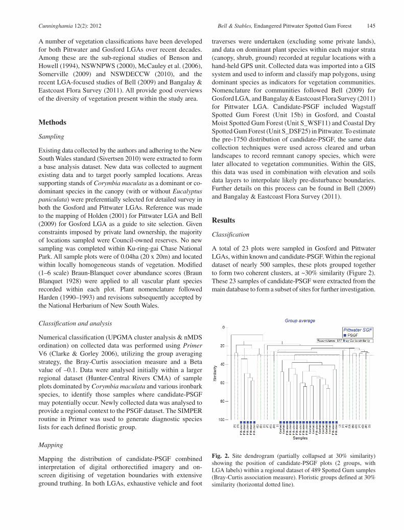
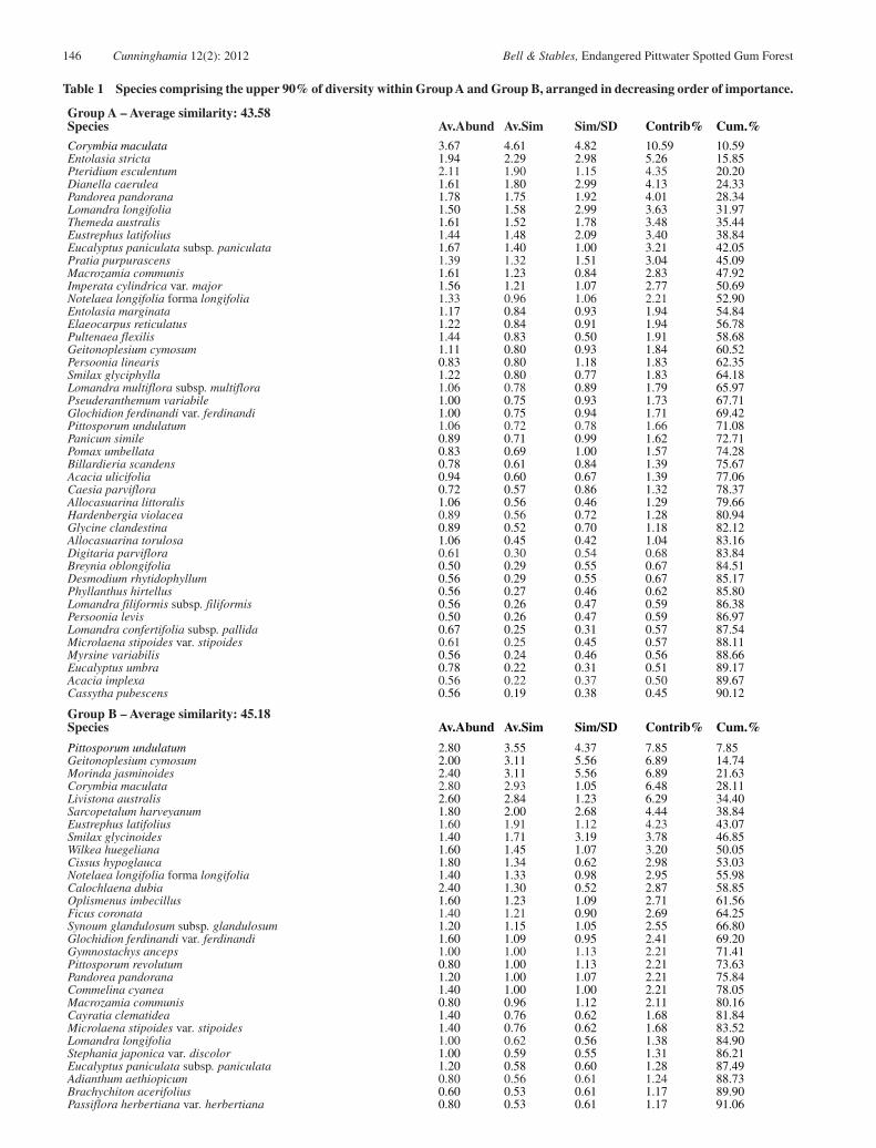
Table 1 Species comprising the upper 90% of diversity within Group A and Group B, arranged in decreasing order of importance.
Cunninghamia 12(2): 2012 Bell & Stables, Endangered Pittwater Spotted Gum Forest 147
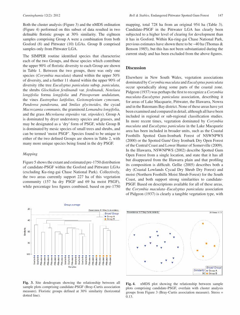
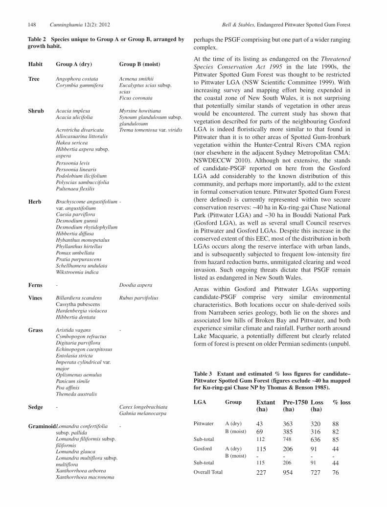
Both the cluster analysis (Figure 3) and the nMDS ordination (Figure 4) performed on this subset of data resulted in two definable floristic groups at 30% similarity. The eighteen samples comprising Group A were a combination from both Gosford (8) and Pittwater (10) LGAs. Group B comprised samples only from Pittwater LGA.
The SIMPER routine identified species that characterise each of the two Groups, and those species which contribute the upper 90% of floristic diversity to each Group are shown in Table 1. Between the two groups, there was only one species (Corymbia maculata) shared within the upper 50% of diversity, and a further 11 shared within the upper 90% of diversity (the tree Eucalyptus paniculata subsp. paniculata, the shrubs Glochidion ferdinandi var. ferdinandi, Notelaea longifolia forma longifolia and Pittosporum undulatum, the vines Eustrephus latifolius, Geitonoplesium cymosum, Pandorea pandorana, and Smilax glycinoides, the cycad Macrozamia communis, the graminoid Lomandra longifolia, and the grass Microlaena stipoides var. stipoides). Group A is dominated by dryer understorey species and grasses, and may be designated as a ‘dry’ form of PSGF, while Group B is dominated by mesic species of small trees and shrubs, and can be termed ‘moist PSGF’. Species found to be unique to either of the two defined Groups are shown in Table 2, with many more unique species being found in the dry PSGF.
Mapping
Figure 5 shows the extant and estimated pre-1750 distribution of candidate-PSGF within the Gosford and Pittwater LGAs (excluding Ku-ring-gai Chase National Park). Collectively, the two areas currently support 227 ha of this vegetation community (157 ha dry PSGF and 69 ha moist PSGF), while percentage loss figures combined, based on pre-1750
mapping, total 728 ha from an original 954 ha (Table 3). Candidate-PSGF in the Pittwater LGA has clearly been subjected to a higher level of clearing for development than it has in Gosford. Within Ku-ring-gai Chase National Park, previous estimates have shown there to be ~40 ha (Thomas & Benson 1985), but this has not been substantiated during the current study and has been excluded from the above figures.
Discussion
Elsewhere in New South Wales, vegetation associations dominated by Corymbia maculata and Eucalyptus paniculata occur sporadically along some parts of the coastal zone. Pidgeon (1937) was perhaps the first to recognize a Corymbia maculata-Eucalyptus paniculata association, describing it for areas of Lake Macquarie, Pittwater, the Illawarra, Nowra and in the Batemans Bay district. None of these areas have yet been examined and compared in detail, although all have been included in regional or sub-regional classification studies. In more recent times, vegetation dominated by Corymbia maculata and Eucalyptus paniculata in the Lake Macquarie area has been included in broader units, such as the Coastal Foothills Spotted Gum-Ironbark Forest of NSWNPWS (2000) or the Spotted Gum/ Grey Ironbark Dry Open Forest of the Central Coast and Lower Hunter of Somerville (2009). In the Illawarra, NSWNPWS (2002) describe Spotted Gum Open Forest from a single location, and state that it has all but disappeared from the Illawarra plain and that profiling its composition is difficult. Gellie (2005) describes both a dry (Coastal Lowlands Cycad Dry Shrub Dry Forest) and moist (Northern Foothills Moist Shrub Forest) for the South Coast, and both support strong similarities to candidate-PSGF. Based on descriptions available for all of these areas, the Corymbia maculata–Eucalyptus paniculata association of Pidgeon (1937) is clearly a tangible vegetation type, with
Fig. 3. Site dendrogram showing the relationship between all sample plots comprising candidate-PSGF (Bray-Curtis association measure). Floristic groups defined at 30% similarity (horizontal dotted line).
Fig. 4. nMDS plot showing the relationship between sample plots comprising candidate-PSGF, overlain with cluster analysis groups from Figure 3 (Bray-Curtis association measure). Stress = 0.13.
148 Cunninghamia 12(2): 2012 Bell & Stables, Endangered Pittwater Spotted Gum Forest
perhaps the PSGF comprising but one part of a wider ranging complex.
At the time of its listing as endangered on the Threatened Species Conservation Act 1995 in the late 1990s, the Pittwater Spotted Gum Forest was thought to be restricted to Pittwater LGA (NSW Scientific Committee 1999). With increasing survey and mapping effort being expended in the coastal zone of New South Wales, it is not surprising that potentially similar stands of vegetation in other areas would be encountered. The current study has shown that vegetation described for parts of the neighbouring Gosford LGA is indeed floristically more similar to that found in Pittwater than it is to other areas of Spotted Gum-Ironbark vegetation within the Hunter-Central Rivers CMA region (nor elsewhere in the adjacent Sydney Metropolitan CMA: NSWDECCW 2010). Although not extensive, the stands of candidate-PSGF reported on here from the Gosford LGA add considerably to the known distribution of this community, and perhaps more importantly, add to the extent in formal conservation tenure. Pittwater Spotted Gum Forest (here defined) is currently represented within two secure conservation reserves: ~40 ha in Ku-ring-gai Chase National Park (Pittwater LGA) and ~30 ha in Bouddi National Park (Gosford LGA), as well as several small Council reserves in Pittwater and Gosford LGAs. Despite this increase in the conserved extent of this EEC, most of the distribution in both LGAs occurs along the reserve interface with urban lands, and is subsequently subjected to frequent low-intensity fire from hazard reduction burns, unmitigated clearing and weed invasion. Such ongoing threats dictate that PSGF remain listed as endangered in New South Wales.
Areas within Gosford and Pittwater LGAs supporting candidate-PSGF comprise very similar environmental characteristics. Both locations occur on shale-derived soils from Narrabeen series geology, both lie on the shores and associated low hills of Broken Bay and Pittwater, and both experience similar climate and rainfall. Further north around Lake Macquarie, a potentially different but clearly related form of forest is present on older Permian sediments (unpubl.
Habit Group A (dry) Group B (moist)
Tree Angophora costata Acmena smithiiCorymbia gummifera Eucalyptus scias subsp.
sciasFicus coronata
Shrub Acacia implexa Myrsine howitianaAcacia ulicifolia Synoum glandulosum subsp.
glandulosumAcrotricha divaricata Trema tomentosa var. viridisAllocasuarina littoralisHakea sericeaHibbertia aspera subsp. asperaPersoonia levisPersoonia linearisPodolobium ilicifoliumPolyscias sambuccifoliaPultenaea flexilis
Herb Brachyscome angustifolium var. angustifolium
-
Caesia parvifloraDesmodium gunniiDesmodium rhytidophyllumHibbertia diffusaHybanthus monopetalusPhyllanthus hirtellusPomax umbellataPratia purpurascensSchellhamera undulataWikstroemia indica
Ferns - Doodia aspera
Vines Billardiera scandens Rubus parvifoliusCassytha pubescensHardenbergia violaceaHibbertia dentata
Grass Aristida vagans -Cymbopogon refractusDigitaria parvifloraEchinopogon caespitosusEntolasia strictaImperata cylindrical var. majorOplismenus aemulusPanicum similePoa affinisThemeda australis
Sedge - Carex longebrachiataGahnia melanocarpa
GraminoidLomandra confertifolia subsp. pallida
-
Lomandra filiformis subsp. filiformisLomandra glaucaLomandra multiflora subsp. multifloraXanthorrhoea arboreaXanthorrhoea macronema
Table 2 Species unique to Group A or Group B, arranged by growth habit.
Table 3 Extant and estimated % loss figures for candidate–Pittwater Spotted Gum Forest (figures exclude ~40 ha mapped for Ku-ring-gai Chase NP by Thomas & Benson 1985).
LGA Group Extant (ha)
Pre-1750 (ha)
Loss (ha)
% loss
Pittwater A (dry) 43 363 320 88B (moist) 69 385 316 82
Sub-total 112 748 636 85Gosford A (dry) 115 206 91 44
B (moist) - - - -Sub-total 115 206 91 44Overall Total 227 954 727 76

Cunninghamia 12(2): 2012 Bell & Stables, Endangered Pittwater Spotted Gum Forest 149
Fig. 5. Extant and pre-1750 distribution of candidate-Pittwater Spotted Gum Forest, here defined (excludes ~40 ha mapped for Ku-ring-gai Chase NP by Thomas & Benson 1985). Note that under the current determination, both extant and pre-1750 stands of PSGF within Pittwater LGA are considered part of the EEC.
150 Cunninghamia 12(2): 2012 Bell & Stables, Endangered Pittwater Spotted Gum Forest
data). To the south, as geology changes from Narrabeen to Hawkesbury outcropping south from Sydney, further stands of related vegetation do not reappear until the Nowra district where Narrabeen sediments again outcrop. Indeed, NSWDECCW (2010) did not define any communities dominated by Corymbia maculata along the coastline of the Sydney metropolitan area, but they were included in the work of Gellie (2005) for the southern forests.
Floristic variation within candidate-PSGF appears driven by aspect and associated soil moisture, and fire. All sites sampled within the Gosford LGA comprised the dry form of this community, while data from Pittwater LGA aligned
with either the dry or moist form. Confounding the issue in the Pittwater LGA are extensive areas of littoral rainforest vegetation which, floristically, share many species with the moist form of PSGF (Bangalay & Eastcoast Flora Survey 2011). These linear patches of rainforest occur in the most protected gullies on sheltered aspects, and in many areas it is difficult to ascertain where the boundary between PSGF and littoral rainforest occurs. Absence of regular fire may be exacerbating this issue, allowing mesic species (eg: Pittosporum undulatum, Glochidion ferdinandi) to become established across a wider area (Rose & Fairweather 1997; Howell 2003).
In an earlier study of Pittwater Spotted Gum Forest, Holden (2001) estimated there to be 51 ha from an original 345 ha of PSGF remaining within the Pittwater LGA, representing an 85% loss. Mapping completed to a higher resolution in the present study shows over double the extant and pre-1750 figures for the LGA, but retaining an 85% loss figure for Pittwater. For Gosford LGA, 44% of the original 206 ha has been lost to development, and combined the two LGAs show an overall loss of 76% of the original 954 ha. The principle reason for such a dramatic loss in PSGF has been clearing associated with rural and urban development, as the city of Sydney has expanded to accommodate an increasing population, particularly since the 1950s. Smith and Smith (1990) examined historical aerial photographs of the Barrenjoey Peninsula in Pittwater LGA, and concluded that between 1946 and 1986 forested lands declined from 47% to 8%, coinciding with increasing suburban development. Much of the cleared lands would have once supported PSGF. It is inevitable that native vegetation is deleteriously affected through population growth, as has occurred elsewhere in New South Wales (Benson 1987; Benson & Howell 1990b). Additionally, at most remaining stands, weed invasion (eg: Lantana camara, Ligustrum sinense) and fire exclusion are seen as the major threats to the ongoing survival of this community.
The existing determination for PSGF details 44 species which characterize the community (NSW Scientific Committee 1999). Using data from the present study, it is evident that 84% of the listed species are present within the dry form (Group A) of PSGF defined in this study, but only 48% of these occur in the moist form (Group B). This may be explained by the fact that the original determination presented a composite list of species for the community as a whole, rather than one tailoring the two forms. A revision of the determination may be warranted with this new information on the dry and moist forms of the community. In addition, clarification of the differences between the moist form of PSGF and areas of Littoral Rainforest EEC in the Pittwater LGA would be beneficial.
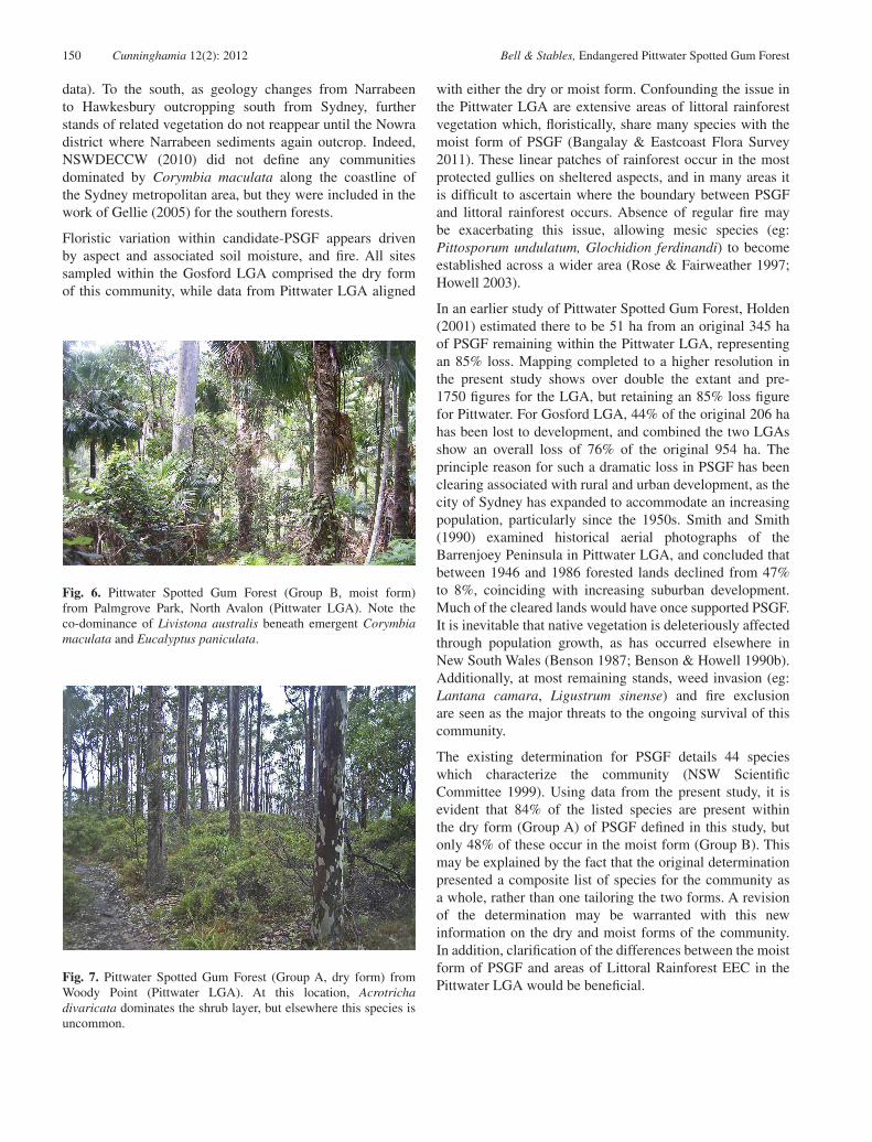
Fig. 6. Pittwater Spotted Gum Forest (Group B, moist form) from Palmgrove Park, North Avalon (Pittwater LGA). Note the co-dominance of Livistona australis beneath emergent Corymbia maculata and Eucalyptus paniculata.
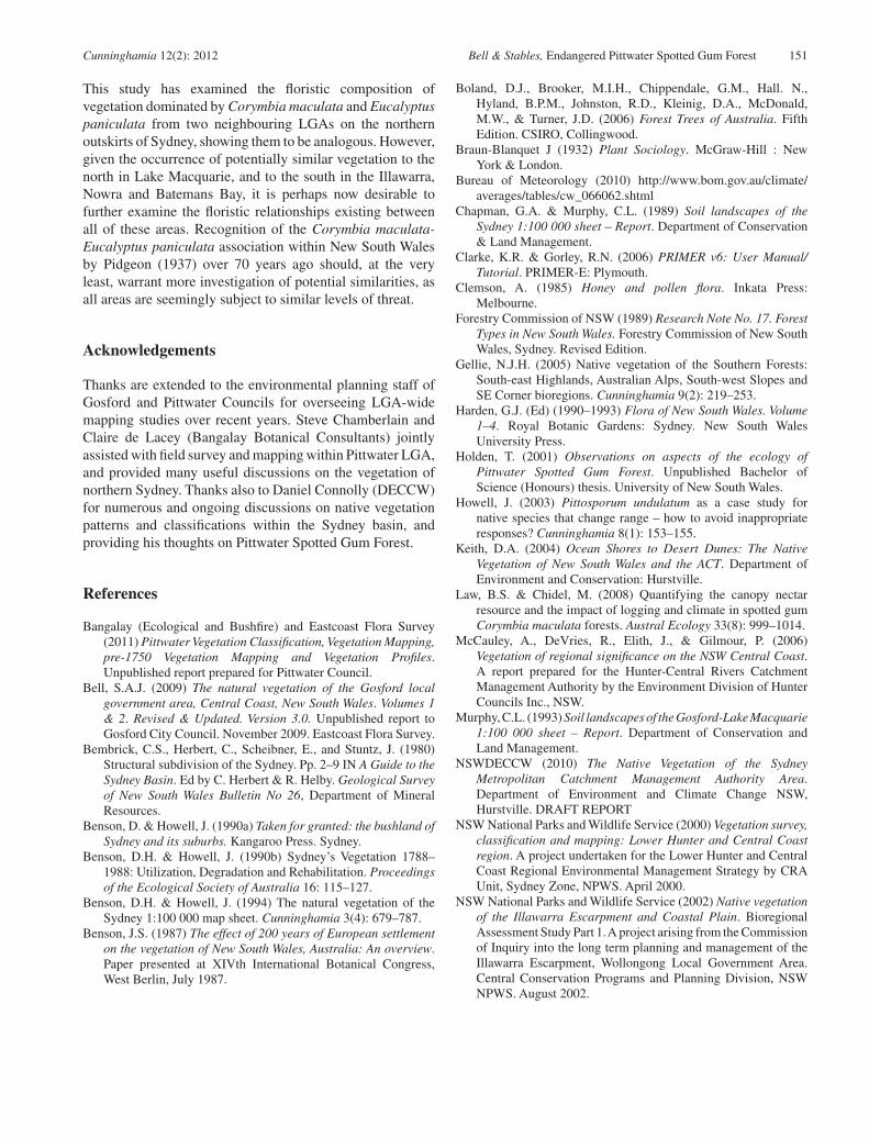
Fig. 7. Pittwater Spotted Gum Forest (Group A, dry form) from Woody Point (Pittwater LGA). At this location, Acrotricha divaricata dominates the shrub layer, but elsewhere this species is uncommon.
Cunninghamia 12(2): 2012 Bell & Stables, Endangered Pittwater Spotted Gum Forest 151
This study has examined the floristic composition of vegetation dominated by Corymbia maculata and Eucalyptus paniculata from two neighbouring LGAs on the northern outskirts of Sydney, showing them to be analogous. However, given the occurrence of potentially similar vegetation to the north in Lake Macquarie, and to the south in the Illawarra, Nowra and Batemans Bay, it is perhaps now desirable to further examine the floristic relationships existing between all of these areas. Recognition of the Corymbia maculata-Eucalyptus paniculata association within New South Wales by Pidgeon (1937) over 70 years ago should, at the very least, warrant more investigation of potential similarities, as all areas are seemingly subject to similar levels of threat.
Acknowledgements
Thanks are extended to the environmental planning staff of Gosford and Pittwater Councils for overseeing LGA-wide mapping studies over recent years. Steve Chamberlain and Claire de Lacey (Bangalay Botanical Consultants) jointly assisted with field survey and mapping within Pittwater LGA, and provided many useful discussions on the vegetation of northern Sydney. Thanks also to Daniel Connolly (DECCW) for numerous and ongoing discussions on native vegetation patterns and classifications within the Sydney basin, and providing his thoughts on Pittwater Spotted Gum Forest.
References
Bangalay (Ecological and Bushfire) and Eastcoast Flora Survey (2011) Pittwater Vegetation Classification, Vegetation Mapping, pre-1750 Vegetation Mapping and Vegetation Profiles. Unpublished report prepared for Pittwater Council.
Bell, S.A.J. (2009) The natural vegetation of the Gosford local government area, Central Coast, New South Wales. Volumes 1 & 2. Revised & Updated. Version 3.0. Unpublished report to Gosford City Council. November 2009. Eastcoast Flora Survey.
Bembrick, C.S., Herbert, C., Scheibner, E., and Stuntz, J. (1980) Structural subdivision of the Sydney. Pp. 2–9 IN A Guide to the Sydney Basin. Ed by C. Herbert & R. Helby. Geological Survey of New South Wales Bulletin No 26, Department of Mineral Resources.
Benson, D. & Howell, J. (1990a) Taken for granted: the bushland of Sydney and its suburbs. Kangaroo Press. Sydney.
Benson, D.H. & Howell, J. (1990b) Sydney’s Vegetation 1788–1988: Utilization, Degradation and Rehabilitation. Proceedings of the Ecological Society of Australia 16: 115–127.
Benson, D.H. & Howell, J. (1994) The natural vegetation of the Sydney 1:100 000 map sheet. Cunninghamia 3(4): 679–787.
Benson, J.S. (1987) The effect of 200 years of European settlement on the vegetation of New South Wales, Australia: An overview. Paper presented at XIVth International Botanical Congress, West Berlin, July 1987.
Boland, D.J., Brooker, M.I.H., Chippendale, G.M., Hall. N., Hyland, B.P.M., Johnston, R.D., Kleinig, D.A., McDonald, M.W., & Turner, J.D. (2006) Forest Trees of Australia. Fifth Edition. CSIRO, Collingwood.
Braun-Blanquet J (1932) Plant Sociology. McGraw-Hill : New York & London.
Bureau of Meteorology (2010) http://www.bom.gov.au/climate/averages/tables/cw_066062.shtml
Chapman, G.A. & Murphy, C.L. (1989) Soil landscapes of the Sydney 1:100 000 sheet – Report. Department of Conservation & Land Management.
Clarke, K.R. & Gorley, R.N. (2006) PRIMER v6: User Manual/ Tutorial. PRIMER-E: Plymouth.
Clemson, A. (1985) Honey and pollen flora. Inkata Press: Melbourne.
Forestry Commission of NSW (1989) Research Note No. 17. Forest Types in New South Wales. Forestry Commission of New South Wales, Sydney. Revised Edition.
Gellie, N.J.H. (2005) Native vegetation of the Southern Forests: South-east Highlands, Australian Alps, South-west Slopes and SE Corner bioregions. Cunninghamia 9(2): 219–253.
Harden, G.J. (Ed) (1990–1993) Flora of New South Wales. Volume 1–4. Royal Botanic Gardens: Sydney. New South Wales University Press.
Holden, T. (2001) Observations on aspects of the ecology of Pittwater Spotted Gum Forest. Unpublished Bachelor of Science (Honours) thesis. University of New South Wales.
Howell, J. (2003) Pittosporum undulatum as a case study for native species that change range – how to avoid inappropriate responses? Cunninghamia 8(1): 153–155.
Keith, D.A. (2004) Ocean Shores to Desert Dunes: The Native Vegetation of New South Wales and the ACT. Department of Environment and Conservation: Hurstville.
Law, B.S. & Chidel, M. (2008) Quantifying the canopy nectar resource and the impact of logging and climate in spotted gum Corymbia maculata forests. Austral Ecology 33(8): 999–1014.
McCauley, A., DeVries, R., Elith, J., & Gilmour, P. (2006) Vegetation of regional significance on the NSW Central Coast. A report prepared for the Hunter-Central Rivers Catchment Management Authority by the Environment Division of Hunter Councils Inc., NSW.
Murphy, C.L. (1993) Soil landscapes of the Gosford-Lake Macquarie 1:100 000 sheet – Report. Department of Conservation and Land Management.
NSWDECCW (2010) The Native Vegetation of the Sydney Metropolitan Catchment Management Authority Area. Department of Environment and Climate Change NSW, Hurstville. DRAFT REPORT
NSW National Parks and Wildlife Service (2000) Vegetation survey, classification and mapping: Lower Hunter and Central Coast region. A project undertaken for the Lower Hunter and Central Coast Regional Environmental Management Strategy by CRA Unit, Sydney Zone, NPWS. April 2000.
NSW National Parks and Wildlife Service (2002) Native vegetation of the Illawarra Escarpment and Coastal Plain. Bioregional Assessment Study Part 1. A project arising from the Commission of Inquiry into the long term planning and management of the Illawarra Escarpment, Wollongong Local Government Area. Central Conservation Programs and Planning Division, NSW NPWS. August 2002.
152 Cunninghamia 12(2): 2012 Bell & Stables, Endangered Pittwater Spotted Gum Forest
NSW Scientific Committee (1999) Final Determination of Pittwater Spotted Gum Forest Endangered Ecological Community, NSW Scientific Committee.
Pidgeon, I.M. (1937) The ecology of the Central Coastal area of New South Wales. l: The environment and general features of the vegetation. Proceedings of the Linnean Society of NSW 62: 315–340.
Rose, S. & Fairweather, P.G. (1997) Changes in floristic composition of urban bushland invaded by Pittosporum undulatum in northern Sydney, Australia. Australian Journal of Botany 45(1): 123–149.
Sivertsen, D (2010) Native Vegetation Interim Type Standard, Department of Environment, Climate Change and Water NSW, Sydney.
Smith, P. & Smith, J. (1990) Decline of the urban Koala (Phascolarctos cinereus) population in Warringah Shire, Sydney. Australian Zoologist 26: 109–129.
Somerville, M. (2009) Hunter, Central & Lower North Coast Vegetation Classification & Mapping Project Volume 2: Vegetation Community Profiles. Report prepared by HCCREMS/Hunter Councils Environment Division for Hunter-Central Rivers Catchment Management Authority, Tocal, NSW.
Thomas, J. & Benson, D.H. (1985) Vegetation Survey of Ku-ring-gai Chase National Park. Royal Botanic Gardens, Sydney.
Wrigley, J. & Fagg, M. (2010) Eucalypts, A Celebration. Allen & Unwin: Crows Nest.
Manuscript accepted 6 February 2012