final environmental assessment east sabine …1.pdf · 2013-01-28 · final environmental...
TRANSCRIPT
FINAL
ENVIRONMENTAL ASSESSMENT
EAST SABINE LAKE HYDROLOGIC RESTORATIONPROJECT CONSTRUCTION UNIT 1
(CS-32)
CAMERON PARISH, LOUISIANA
U.S. FISH AND WILDLIFE SERVICE
ECOLOGICAL SERVICES
LAFAYETTE, LOUISIANA
November 2004
FINAL
ENVIRONMENTAL ASSESSMENT
EAST SABINE LAKE HYDROLOGIC RESTORATIONPROJECT CONSTRUCTION UNIT 1
(CS-32)
Cameron Parish, Louisiana
Prepared by:Darryl Clark
Senior Fish and Wildlife Biologistand
Joyce MazourekFish and Wildlife Biologist
U.S. Fish and Wildlife ServiceEcological Services
646 Cajundome Blvd.Suite 400
Lafayette, Louisiana 70506
Phone: (337) 291-3100Fax: (337) 291-3139
November 2004
iii
TABLE OF CONTENTS
SECTION 1.0 PURPOSE AND NEED FOR PROPOSED ACTION . . . . . . . . . . . . . . . . . 1SECTION 1.1 INTRODUCTION . . . . . . . . . . . . . . . . . . . . . . . . . . . . . . . . . . . . . . . . . 1SECTION 1.2 PROJECT AREA . . . . . . . . . . . . . . . . . . . . . . . . . . . . . . . . . . . . . . . . . . 1SECTION 1.3 PURPOSE OF PROPOSED ACTION . . . . . . . . . . . . . . . . . . . . . . . . . . 3SECTION 1.4 NEED FOR PROPOSED ACTION . . . . . . . . . . . . . . . . . . . . . . . . . . . . 3SECTION 1.5 REQUIRED DECISIONS . . . . . . . . . . . . . . . . . . . . . . . . . . . . . . . . . . . . 5SECTION 1.6 COORDINATION AND CONSULTATION . . . . . . . . . . . . . . . . . . . . . 5
SECTION 2.0 ALTERNATIVES INCLUDING THE PROPOSED ACTION . . . . . . . . . . 7SECTION 2.1 ALTERNATIVE 1 - NO ACTION . . . . . . . . . . . . . . . . . . . . . . . . . . . . . 7SECTION 2.2 ALTERNATIVE 2 - PREFERRED ALTERNATIVE . . . . . . . . . . . . . . 7SECTION 2.3 OTHER ALTERNATIVES CONSIDERED . . . . . . . . . . . . . . . . . . . . . 8
SECTION 3.0 AFFECTED ENVIRONMENT . . . . . . . . . . . . . . . . . . . . . . . . . . . . . . . . . . . 9SECTION 3.1 PHYSICAL ENVIRONMENT . . . . . . . . . . . . . . . . . . . . . . . . . . . . . . . . 9
A. Regional Hydrology . . . . . . . . . . . . . . . . . . . . . . . . . . . . . . . . . . . . . . . . . . . 9B. Water Quality . . . . . . . . . . . . . . . . . . . . . . . . . . . . . . . . . . . . . . . . . . . . . . . 10C. Wetland Loss . . . . . . . . . . . . . . . . . . . . . . . . . . . . . . . . . . . . . . . . . . . . . . . . 11
SECTION 3.2 BIOLOGICAL RESOURCES . . . . . . . . . . . . . . . . . . . . . . . . . . . . . . . . 12A. Plant Communities . . . . . . . . . . . . . . . . . . . . . . . . . . . . . . . . . . . . . . . . . . . . 12B. Fish and Shellfish Habitat . . . . . . . . . . . . . . . . . . . . . . . . . . . . . . . . . . . . . . 14C. Essential Fish Habitat . . . . . . . . . . . . . . . . . . . . . . . . . . . . . . . . . . . . . . . . . 15D. Wildlife Habitat . . . . . . . . . . . . . . . . . . . . . . . . . . . . . . . . . . . . . . . . . . . . . 16E. Threatened and Endangered Species . . . . . . . . . . . . . . . . . . . . . . . . . . . . . . 16
SECTION 3.3 CULTURAL AND RECREATIONAL RESOURCES . . . . . . . . . . . . 17SECTION 3.4 ECONOMIC RESOURCES . . . . . . . . . . . . . . . . . . . . . . . . . . . . . . . . . 17
A. Commercial Fish and Wildlife Resources and Related LandUse/Management . . . . . . . . . . . . . . . . . . . . . . . . . . . . . . . . . . . . . . . . . 17
B. Oil and Gas Activity . . . . . . . . . . . . . . . . . . . . . . . . . . . . . . . . . . . . . . . . . . 17
SECTION 4.0 ENVIRONMENTAL CONSEQUENCES . . . . . . . . . . . . . . . . . . . . . . . . . . 18SECTION 4.1 ALTERNATIVE 1 - NO ACTION . . . . . . . . . . . . . . . . . . . . . . . . . . . . 18
A. Physical Environment . . . . . . . . . . . . . . . . . . . . . . . . . . . . . . . . . . . . . . . . . 18B. Biological Resources . . . . . . . . . . . . . . . . . . . . . . . . . . . . . . . . . . . . . . . . . . 18
1. Plant Communities . . . . . . . . . . . . . . . . . . . . . . . . . . . . . . . . . . . . . . 182. Fisheries . . . . . . . . . . . . . . . . . . . . . . . . . . . . . . . . . . . . . . . . . . . . . . 183. Essential Fish Habitat . . . . . . . . . . . . . . . . . . . . . . . . . . . . . . . . . . . 194. Wildlife . . . . . . . . . . . . . . . . . . . . . . . . . . . . . . . . . . . . . . . . . . . . . . 195. Threatened and Endangered Species . . . . . . . . . . . . . . . . . . . . . . . . 19
C. Cultural and Recreational Resources . . . . . . . . . . . . . . . . . . . . . . . . . . . . . 19D. Economic Resources . . . . . . . . . . . . . . . . . . . . . . . . . . . . . . . . . . . . . . . . . . 19
SECTION 4.2 ALTERNATIVE 2 - PREFERRED ALTERNATIVE . . . . . . . . . . . . 19A. Physical Environment . . . . . . . . . . . . . . . . . . . . . . . . . . . . . . . . . . . . . . . . . 19
iv
B. Biological Resources . . . . . . . . . . . . . . . . . . . . . . . . . . . . . . . . . . . . . . . . . . 221. Plant Communities . . . . . . . . . . . . . . . . . . . . . . . . . . . . . . . . . . . . . . 222. Fisheries . . . . . . . . . . . . . . . . . . . . . . . . . . . . . . . . . . . . . . . . . . . . . . 223. Essential Fish Habitat . . . . . . . . . . . . . . . . . . . . . . . . . . . . . . . . . . . 234. Wildlife . . . . . . . . . . . . . . . . . . . . . . . . . . . . . . . . . . . . . . . . . . . . . . . 245. Threatened and Endangered Species . . . . . . . . . . . . . . . . . . . . . . . . 25
C. Cultural and Recreational Resources . . . . . . . . . . . . . . . . . . . . . . . . . . . . . 25D. Economic Resources . . . . . . . . . . . . . . . . . . . . . . . . . . . . . . . . . . . . . . . . . . 26
SECTION 5.0 DISCUSSION OF ALTERNATIVES . . . . . . . . . . . . . . . . . . . . . . . . . . . . . 26
SECTION 6.0 RATIONALE FOR SELECTING THE PREFERRED ALTERNATIVE . . . . . . . . . . . . . . . . . . . . . . . . . . . . . . . . . . . . . . . . . . . . . . . 28
SECTION 7.0 COMPATIBILITY WITH COASTAL WETLANDS PLANNING PROTECTION AND RESTORATION ACT AND COMMUNITY OBJECTIVES . . . . . . . . . . . . . . . . . . . . . . . . . . . . . . . 28
SECTION 8.0 COMPLIANCE WITH LAWS, REGULATIONS AND POLICIES . . . . 28
SECTION 9.0 PREPARERS . . . . . . . . . . . . . . . . . . . . . . . . . . . . . . . . . . . . . . . . . . . . . . . . . . 29
SECTION 10.0 LITERATURE CITED . . . . . . . . . . . . . . . . . . . . . . . . . . . . . . . . . . . . . . . . . 30
Appendix A - East Sabine Lake Project Habitat and Vegetation Analysis . . . . . . . . . . . A-1Table A.1: East Sabine Lake Hydrologic Restoration Project Area 1988-1990
Habitat Analysis . . . . . . . . . . . . . . . . . . . . . . . . . . . . . . . . . . . . . . . . . . . . . . . . A-2Table A.2. East Sabine Lake Hydrologic Restoration Project Vegetative Species
Percent Cover . . . . . . . . . . . . . . . . . . . . . . . . . . . . . . . . . . . . . . . . . . . . . . . . . A-3Table A.3. Comparison of East Sabine Lake Dominant Vegetation by
Marsh Type . . . . . . . . . . . . . . . . . . . . . . . . . . . . . . . . . . . . . . . . . . . . . . . . . . . A-6Figure A.1. East Sabine Lake Hydrologic Restoration Project 1968 Habitat Map . . A-7Figure A.2. East Sabine Lake Hydrologic Restoration Project 1997 Habitat Map . . A-8Figure A.3. East Sabine Lake Hydrologic Restoration Project 2001 Habitat Map . . A-9
Appendix B - Preferred Alternative Project Features . . . . . . . . . . . . . . . . . . . . . . . . . . . . B-1Figure B.1. East Sabine Lake Hydrologic Restoration Project Pines Ridge Weir . . . B-2Figure B.2. East Sabine Lake Hydrologic Restoration Project Bridge Bayou
Structure . . . . . . . . . . . . . . . . . . . . . . . . . . . . . . . . . . . . . . . . . . . . . . . . . . . . . . B-3Figure B.3. East Sabine Lake Hydrologic Restoration Project Rock Plug Sections . B-4Figure B.4. East Sabine Lake Hydrologic Restoration Project Rock Dike Sections . B-5Figure B.5. East Sabine Lake Hydrologic Restoration Project Typical Terrace
Sections . . . . . . . . . . . . . . . . . . . . . . . . . . . . . . . . . . . . . . . . . . . . . . . . . . . . . . B-6
Appendix C - Letters of Comment . . . . . . . . . . . . . . . . . . . . . . . . . . . . . . . . . . . . . . . . . . . . C-1

v
FIGURES
Figure 1. Calcasieu-Sabine Basin Including the Project Area . . . . . . . . . . . . . . . . . . . . . . . . . . 2Figure 2. General Features of the East Sabine Lake Hydrologic Restoration Project . . . . . . . . 6
TABLES
Table 1: Sabine Subbasin Marsh Loss Rates from 1932 to 1990 . . . . . . . . . . . . . . . . . . . . . . . . 4Table 2: East Sabine Hydrologic Restoration Project Area Marsh Loss from
1932 to 2050 . . . . . . . . . . . . . . . . . . . . . . . . . . . . . . . . . . . . . . . . . . . . . . . . . . . . 5Table 3. Parameters Monitored for LDEQ’s Monthly Ambient Surface
Water Quality Network . . . . . . . . . . . . . . . . . . . . . . . . . . . . . . . . . . . . . . . . . . . 11Table 4. Habitat Trends from 1949 to 2001 within the East Sabine Lake Project Area . . . . . 12Table 5. East Sabine Lake Project Construction Unit 1 Dominant Vegetation . . . . . . . . . . . . 13Table 6. Essential Fish Habitat for Federally Managed Species in the Project Area . . . . . . . 15Table 7. Comparison of Preferred Alternative Shallow Water Impacts and Overall
Wetland Benefits . . . . . . . . . . . . . . . . . . . . . . . . . . . . . . . . . . . . . . . . . . . . . . . . 21

1
EAST SABINE LAKE HYDROLOGIC RESTORATION PROJECT CONSTRUCTIONUNIT 1 (CS-32)
Cameron Parish, Louisiana
SECTION 1.0 PURPOSE AND NEED FOR PROPOSED ACTION
The purpose of the proposed action is to protect a major portion of the brackish andintermediate marshes east of Sabine Lake, on the Sabine National Wildlife Refuge (NWR),from deterioration and conversion to open water caused by altered hydrology, saltwaterintrusion, subsidence and wave action. The proposed project is being funded through theCoastal Wetlands Planning, Protection and Restoration Act (CWPPRA) as part of the 10th
Priority Project List, and was authorized on January 10, 2001, for detailed engineering anddesign by the Louisiana Coastal Wetlands Conservation and Restoration Task Force.
SECTION 1.1 INTRODUCTION
The rapid conversion of Louisiana’s coastal marshes to open water has been reported byGagliano et al. (1981), Gosselink (1984), Turner and Cahoon (1987), Britsch and Kemp (1990),Dunbar et al. (1992), and others. Since the 1950s, the average loss rate for those wetlands hasbeen 25 to 35 square miles (16,000 to 22,400 acres) per year. That loss is of national concern;an estimated 69 percent of the coastal marshes adjacent to the Gulf of Mexico occur inLouisiana (West 1977).
Coastal Louisiana includes nine hydrologic basins (Louisiana Coastal Wetlands Conservationand Restoration Task Force 1993a); two of those basins (i.e., the Calcasieu-Sabine Basin andthe Mermentau Basin) comprise the Louisiana portion of the Chenier Plain. The Calcasieu-Sabine Basin (Figure 1), located in southwestern Louisiana, consists of two interconnectedhydrologic units (i.e., the Calcasieu Subbasin and the Sabine Subbasin), and extends fromSabine Lake eastward to Louisiana Highway 27 east of Calcasieu Lake. The major sources offreshwater inflow occur along a north-south gradient through the Calcasieu and Sabine riversand from the northwest via the Neches River into Sabine Lake. Construction of the GulfIntracoastal Waterway (GIWW) and interior marsh canals provided an east-west connectionbetween the Calcasieu and Sabine river systems (Louisiana Coastal Wetlands Conservation andRestoration Task Force 1993a).
SECTION 1.2 PROJECT AREA
The project area is located in the western portion of the Sabine Subbasin on the Sabine NWR. The Burton Sutton Canal and the Sabine NWR Pool 3 comprise the eastern project areaboundary; it is bounded on the south by the Starks South Canal, on the west by the easternshoreline of Sabine Lake and on the north by roughly the Sabine NWR northern boundary. The


3
project area is approximately 14 miles east of Port Arthur, Texas, and lies entirely withinCameron Parish, Louisiana (Figure 1). The total project area (CUs 1 and 2) encompasses36,272 acres, consisting of 17,415 acres, 3,850 acres, and 15,355 acres of intermediate marsh,brackish marsh and open water, respectively. The area also consists of small amounts ofbottomland forest (13 acres), upland forest (15 acres), bottomland shrub/scrub (3 acres), uplandshrub/scrub (48 acres) and agriculture pasture (69 acres) habitats (USGS 2000, Appendix TableA.1). Construction Unit 1 consists of 2,094 acres, 52 acres and 4224 acres of intermediatemarsh, brackish marsh and open water respectively (Clark 2004).
SECTION 1.3 PURPOSE OF PROPOSED ACTION
This Environmental Assessment (EA) evaluates alternatives to address the conversion of marshto open water along the eastern shoreline of Sabine Lake and within the interior marshesbetween Sabine Lake and Pool 3 of the Sabine NWR, especially in the Greens Bayou area. Theproject goals are to reduce shoreline and interior marsh erosion, to restore marsh and associatedsubmerged aquatic vegetation previously converted to open water, and to partially restorealtered wetland hydrology. As shown in Figure 2, the project is designed to: 1) restoreemergent wetlands; 2) restore altered hydrology in three specific areas (Pines Ridge Bayou,Bridge Bayou and Section 16); 3) reduce some elevated salinities within intermediate marshes;4) reduce marsh loss, and; 5) encourage the growth of submerged aquatic vegetation.
SECTION 1.4 NEED FOR PROPOSED ACTION
The conversion of marsh to open water habitat is detrimental to commercially, recreationally,and legislatively important species and biologic communities. Major hydrological changes inthe Sabine Subbasin occurred with the construction of the Sabine-Neches Waterway (SNWW)and the Toledo Bend Reservoir. Historically, all of the inflow from the Sabine and Nechesrivers entered Sabine Lake. Construction of the SNWW and deepening of the Sabine andNeches Rivers caused saltwater intrusion into the historically low-salinity Sabine Lake estuary,accelerated freshwater flows to the Gulf (thus reducing inflows into adjacent marshes), andincreased tidal amplitude. Additionally, freshwater is retained in Toledo Bend Reservoirduring the spring when freshwater inflows are highest, and released in the summer forgeneration of electricity and for municipal, industrial and agricultural uses.
Elevated salinities are thought to be the leading cause of wetland loss in the Sabine Subbasin. Three potential hydrologic changes threaten to increase salinity levels in Sabine Lake andadjacent marshes, and allow saltwater intrusion to penetrate further northward in the estuary. Those threats include the Texas Water Plan (Senate Bill 1), the proposed Sabine-NechesWaterway Enlargement Project, and the recently constructed Neches River Saltwater Barrier. The Texas Water Plan could reduce Sabine River flows to that estuary by as much as 50percent. The Sabine-Neches Waterway Enlargement Project could elevate salinities via theproposed deepening and widening of that channel. The recently constructed Neches RiverSaltwater Barrier could reduce freshwater inflows to Sabine Lake and facilitate upstream

4
withdrawals for municipal, industrial and agricultural uses.
Historically, the Calcasieu-Sabine Basin and project area have experienced coastal wetlandlosses of over 30 percent from 1932 to 1990; thus there is a need to reduce the ongoingconversion of marsh to open water that has resulted from human hydrologic alterations andnatural causes (i.e., wave action and subsidence). The 630,000-acre Calcasieu-Sabine Basincontained 435,600 acres of coastal wetlands in 1932 (Louisiana Coastal Wetlands Conservationand Restoration Task Force 1993b). Since then, that basin has experienced a loss of over122,000 acres (28 percent) of marsh (Dunbar et al. 1992). The 318,000-acre Sabine Subbasinlost over 84,000 acres of marsh (38.5 percent) since 1932 due to human-induced (i.e.,channelization) and natural causes. Another 38,400 acres of Sabine Subbasin marsh (12.1 percent) are projected to be lost by 2050, for a total projected loss of 160,382 acres from 1932to 2050 (Louisiana Coastal Wetlands Conservation and Restoration Task Force and theWetlands Conservation and Restoration Authority 1998). The existing and predicted lossrepresents losses of over 50 percent of the original 220,000-acre Sabine Subbasin marshes.
Within the 39,539-acre East Sabine Project area, marsh losses were 42.6, 5.0, and 1.4 percentfor the periods 1956 to 1974, 1974 to 1983, and 1983 to 1990, respectively, for a total of 49 percent wetland loss within that area from 1932 to 1990 (Table 2; Appendix A). Project-area1983 to 1990 land loss rates were 0.2 percent/year (Dunbar et al. 1992). If this modest rate isprojected to the year 2050, another 2,552 acres (12 percent) could be lost from the project area(a 61 percent loss from 1932 to 2050; Table 2). Sabine Lake shoreline erosion rates areestimated to be 10 feet per year (Midkiff 2000).
Table 1: Sabine Subbasin Marsh Loss Rates from 1932 to 1990____________________________________________________________________________
Period Acres Lost Period Percent Loss Annual Percent Loss
1932-1955 1,498 0.66 0.03
1955-1974 73,260 31.5 1.7
1974-1983 7,780 4.9 0.54
1983-1990 2,206 1.5 0.21
Total (1932-1990) 84,744 38.53 0.68Note : The Sabine subbasin totals 318,000 acres; Sabine subbasin marsh area totaled 135,199 acres in 1990.(modified from Dunbar et al. 1992)____________________________________________________________________________

5
Table 2: East Sabine Hydrologic Restoration Project Area Marsh Loss from 1932 to 2050____________________________________________________________________________
Category/YearPeriod
1932-1956
1956-1974
1974-1983 1983-1990
Total1932-1990
1990-2050
Marsh (acres) *39,539 22,710(1974)
21,560 (1983) 21,265(1990)
18,713(2050)
Marsh Loss (acres)
0 16,829 1,150 295 18,274 2,552
Percent Loss 0 42.6 5.0 1.4 49 12
Annual PercentLoss
0 2.4 0.56 0.2 0.80 0.2
____________________________________________________________________________(*Modified from Dunbar et al. 1992. Note the total marsh area is different from USGS 2000data.)
SECTION 1.5 REQUIRED DECISIONS
The lead Federal project sponsor, the U.S. Fish and Wildlife Service, in coordination with theNatural Resources Conservation Service and Louisiana Department of Natural Resources co-sponsors, has ensured that the final preferred alternative selection was made after a thoroughpublic review of the project design and Section 404 Clean Water Act permit application, andafter fully considering all comments on the draft Environmental Assessment.
SECTION 1.6 COORDINATION AND CONSULTATION
This project was coordinated with the Louisiana Coastal Wetlands Conservation andRestoration Task Force (Task Force) agencies, the Louisiana Department of NaturalResources, the Cameron Parish government, and affected landowners. Project implementationwould partially fulfill a regional strategy (salinity control along the eastern shoreline of SabineLake) recommended for the Calcasieu-Sabine Basin in the Coast 2050 Plan, which wasdeveloped by the Task Force and the Wetlands Conservation and Restoration Authority(Louisiana Coastal Wetlands Conservation and Restoration Task Force and the WetlandsConservation and Restoration Authority 1998).


7
SECTION 2.0 ALTERNATIVES INCLUDING THE PROPOSED ACTION
SECTION 2.1 ALTERNATIVE 1 - NO ACTION
Under this alternative, no action would be taken to reduce elevated salinities and shoreline andinterior marsh erosion other than the current Sabine NWR management and mitigationactivities.
SECTION 2.2 ALTERNATIVE 2 - PREFERRED ALTERNATIVE
The preferred alternative for the East Sabine Lake Hydrologic Restoration Construction Unit 1Project would reduce shoreline erosion, slow interior marsh loss and restore/create marsh inthe western portion of the Sabine NWR and restore hydrology to marshes north of Pines Ridge.The preferred alternative for Construction Unit 1 would include the installation andmaintenance of the following features as shown on Figure 2.
1. Install a 40-foot-wide rock weir at Pines Ridge Bayou at the intersection of thatbayou and the northern spoil bank of an east-west oil and gas canal (weir height 1 footbelow average water level; Appendix B-2).
2. Install an active water control structure (3, 24-inch-diameter culverts with stop logsand flapgates) at the intersection of Bridge Bayou, the cattle walkway and Gray’s Ditch(Appendix B-3). Dredged material has been placed across Bridge Bayou to install theexisting cattle walkway and an existing 24 inch-diameter open culvert.
3. Install a rock plug, with a crown elevation set at 2.0 feet above marsh elevation[+3.0 feet North American Vertical Datum 1988 (NAVD (88)], at the levee break nearDouble Island Gully at the southeastern portion of Section 16 and the Starks SouthCanal (Appendix B-4).
4. Excavate a 6.0-foot-deep by 70-to-80-foot-wide barge access canal 40 to 50 feetlakeward of and parallel to, the foreshore dike described below. Dredged material foraccess channel construction will be used to restore approximately 3.4 acres of marshalong 3,000 feet of the shoreline between the rock foreshore dike and the existingshoreline (Appendix B-5).
5. Install a 3,000 linear foot rock foreshore dike at the Sabine Lake shoreline from themouth of Willow Bayou northward (Appendix B-5).
6. Install approximately 32.4 miles (171,000 linear feet) of “duck wing” vegetatedearthen terraces to restore 98 acres of shallow open water areas in the Greens Lake areaon the Sabine NWR (Appendix B-6). Those terraces would be 40-feet-wide at theirbases, crown widths would be 15 feet, and the settled crown elevation would be atmarsh level [1.3 feet NAVD (88)]. One row of smooth cordgrass (Spartinaalterniflora) bare-root plugs would be planted on 2.5-foot centers on each side slope

8
(approximately 142,500 plants).
SECTION 2.3 OTHER ALTERNATIVES CONSIDERED
Control Structures
1. One alternative to the proposed Pines Ridge Bayou rock weir was a rock plug. A fieldinvestigation and inspection of USGS quadrangle maps and historic aerial photographsindicated that Pines Ridge Bayou historically continued southward of the east-westPines Ridge canal and entered Sabine Lake. Placement of a rock plug at Pines RidgeBayou would stop all water flow from Pines Ridge Bayou to Sabine Lake, and wouldreduce estuarine fisheries and shellfish access to viable brackish marshes north of PinesRidge from the south. There is also existing limited access to Pines Ridge marshesfrom Black Bayou to the north.
2. An alternative to the Bridge Bayou structure considered involved placing 2, 36-inch-diameter culverts instead of 3, 24-inch-diameter culverts. The preferred alternative wasrecommended because the existing bayou depths are 1.0 foot deep or less at theintersection of the bayou and cattle walkway. The structure’s purpose is to restoreBridge Bayou hydrology impacted by that bayou being plugged by the cattle walkway.
3. The alternatives considered for the Section 16 Sabine NWR levee break repair includeda rock weir at marsh elevation, or a rock plug. The rock plug was selected by theproject management team, due to engineering considerations and the fact that fisheriesaccess into the area was not significant. The existing levee break is less than 20 feet-wide by 4-feet-deep.
Sabine Lake Shoreline Stabilization
1. 11 miles (58,000 linear feet) of shoreline plantings of smooth cordgrass (Spartinaalterniflora) along the eastern Sabine Lake shoreline was included as a projectcomponent beginning 1,000 feet north of Johnston’s Bayou to near the mouth of theSabine River north of Pines Ridge. This component was eliminated due to poor growthand survival results from the 7,500 linear foot shoreline test planting conducted by theState Soil and Water Conservation District in May 2004. Steyer (2004) recommended,in a report of that test planting, that the shoreline vegetative plantings be removed as aproject component.
2. An 11-mile-long rock foreshore dike was considered as an alternative to vegetativeshoreline plantings. That alternative was not recommended due to its relatively highcost compared to the moderate shoreline erosion rates. Vegetative shoreline plantingswere recommended because they were substantially more cost effective than rockstabilization.

9
3. An alternative to the 3,000 foot Willow Bayou foreshore dike was a shorter, 1,500linear foot dike; however, the benefits of increasing the original length of rockprotection in this area substantially outweighed the additional costs. The WillowBayou shoreline is about 20 to 25 feet (8 m) from the Sabine Lake shoreline in this areaand vegetative shoreline plantings would not be sufficient to prevent Sabine Lake fromeroding into Willow Bayou there.
Earthen Terraces
Several terrace designs were evaluated, including straight linear rows orientated east to west, amodified “V” or “duck-wing,” and checkerboard configurations. The “duck wing” or “V-shaped” terrace design was used successfully in restoring marsh in a recent terracing projectinstalled east of Calcasieu Lake by Ducks Unlimited, the Service, DNR, Miami Corporationand others. The existing Sabine NWR terraces located east of Deep Bayou Canal and south ofthe Willow Bayou Canal (within the boundary of the East Sabine Lake Project) are also of thesuccessful “duck-wing” design. Alternative terrace dimensions are possible that include topwidths ranging from 4-feet to 15-feet; terrace heights ranging from settled marsh level height[1.3 feet NAVD (88)] to 2.2 feet above marsh level [2.5 feet NAVD (88)]. The 15-foot-widetop width was recommended because it is less likely to erode, provides a greater marshplatform, and has been implemented successfully. The preferred marsh level settled terraceheight was also selected because the design has been used successfully by Sabine NWR, and itprovides a lower wetland elevation for better fish and wildlife access and increasedproductivity.
SECTION 3.0 AFFECTED ENVIRONMENT
SECTION 3.1 PHYSICAL ENVIRONMENT
A. Regional Hydrology
Construction of navigation channels in the late 1800s and early 1900s significantly altered thehydrology of the Calcasieu-Sabine Basin. Historically, the Calcasieu and Sabine Subbasinswere separated by the Gum Cove Ridge and little water exchange between the basins occurred. Drainage was predominantly in a north-south direction through the Sabine and CalcasieuRivers, and the Neches River drained into Sabine Lake from the northwest. The constructionand gradual deepening and expansion of the Calcasieu Ship Channel and SNWW permittedsaltwater intrusion into the historically low-salinity estuaries; funneled freshwater flowsdirectly to the Gulf, bypassing adjacent marshes; and increased tidal amplitude.
Construction of the east-west GIWW bisected the Gum Cove Ridge and connected the riverbasins by linking the Calcasieu Ship Channel to the SNWW. That connection reduced bothhistoric over-marsh sheet flows and the north-south flows of natural bayous; thus, thatconnection diverted freshwater east and west, partially bypassing the marshes. Waterflow and

10
salinity patterns in one basin now affect those in the other to some extent.
Another important hydrologic influence in the Sabine Subbasin is the Toledo Bend Reservoir,located 90 miles north of Sabine Lake. Historically, all of the water from the Sabine andNeches Rivers drained directly into Sabine Lake. Operation of Toledo Bend reservoir forindustrial and agricultural uses has altered the timing of freshwater flows. Water is nowretained in the reservoir during the spring when freshwater inflows are traditionally highest,and released in the summer when inflow is low and electric generation needs are greatest. Canals and levees constructed for flood control, agriculture, and oil and gas explorationactivities have also disrupted the natural basin hydrology.
Current project-area hydrologic conditions are influenced by Sabine NWR water managementefforts. That 195-square mile (124,511-acre) NWR is comprised of 7 management unitscontaining fresh, intermediate, brackish, and saline marsh. Refuge hydrologic management isfocused primarily on controlling salinity and minimizing tidal fluctuations through theconstruction and operation of levees, weirs, and gated structures. Managers strive to achieve abalance between reducing wetland plant waterlogging and saltwater intrusion stresses, andproviding access for estuarine fish and shellfish organisms to interior marshes during criticallife-cycle events.
B. Water Quality
As part of its surface water quality monitoring program, the Louisiana Department ofEnvironmental Quality (LDEQ) routinely monitors several parameters (Table 3) on a monthlybasis at numerous sites. Although there are several long-term sites on larger water bodiesthroughout the State, sites are currently monitored intensively for 1 and 5-year cycles (LDEQ2002). Based upon those data and fish tissue contaminants data, complaint investigations, andspill reports, etc., LDEQ has assessed water quality fitness for the following uses: agriculture,primary contact recreation (swimming), secondary contact recreation (boating and fishing),fish and wildlife propagation, and drinking water supply (LDEQ 2002). Based on existing dataand more subjective information, water quality is determined to either fully, partially, or notsupport those uses. Water quality in the Sabine River from the Toledo Bend Dam to SabineLake is considered by the LDEQ to fully support primary and secondary contact recreation, butdoes not support fish and wildlife propagation (LDEQ 2002). No data exist to assess the waterquality of the river from Sabine Lake to the Gulf of Mexico or the associated estuary.
11
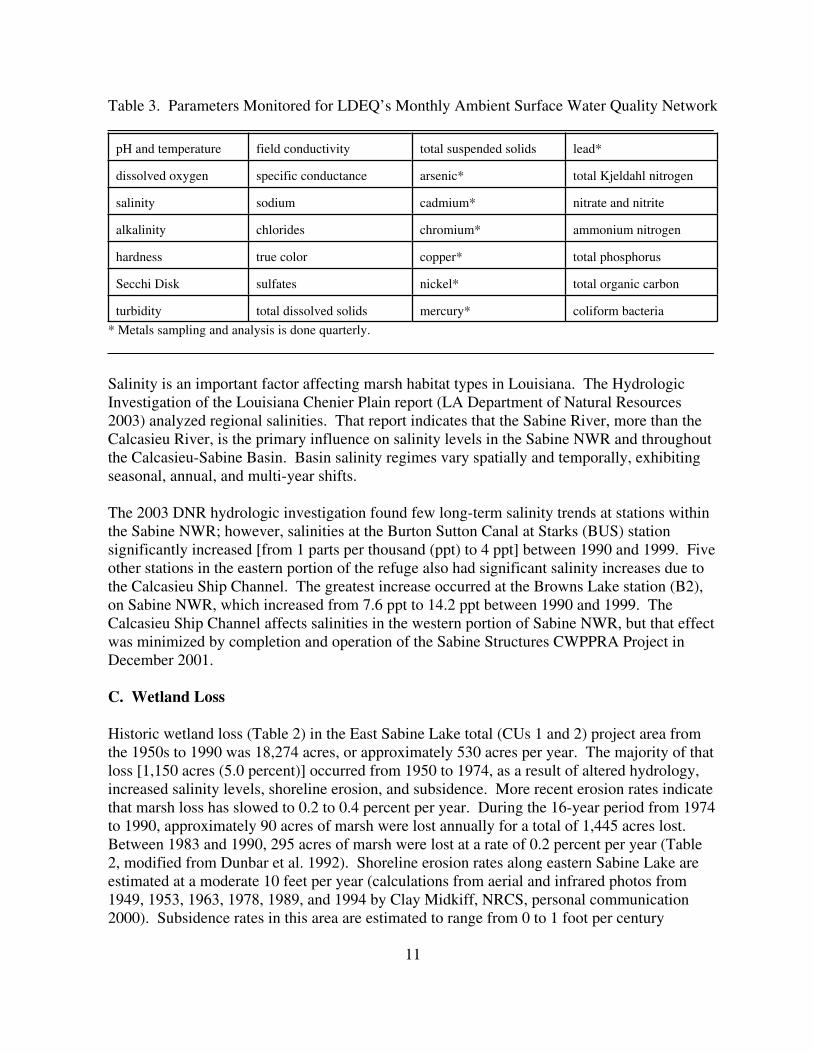
Table 3. Parameters Monitored for LDEQ’s Monthly Ambient Surface Water Quality Network____________________________________________________________________________
pH and temperature field conductivity total suspended solids lead*
dissolved oxygen specific conductance arsenic* total Kjeldahl nitrogen
salinity sodium cadmium* nitrate and nitrite
alkalinity chlorides chromium* ammonium nitrogen
hardness true color copper* total phosphorus
Secchi Disk sulfates nickel* total organic carbon
turbidity total dissolved solids mercury* coliform bacteria
* Metals sampling and analysis is done quarterly.____________________________________________________________________________
Salinity is an important factor affecting marsh habitat types in Louisiana. The HydrologicInvestigation of the Louisiana Chenier Plain report (LA Department of Natural Resources2003) analyzed regional salinities. That report indicates that the Sabine River, more than theCalcasieu River, is the primary influence on salinity levels in the Sabine NWR and throughoutthe Calcasieu-Sabine Basin. Basin salinity regimes vary spatially and temporally, exhibitingseasonal, annual, and multi-year shifts.
The 2003 DNR hydrologic investigation found few long-term salinity trends at stations withinthe Sabine NWR; however, salinities at the Burton Sutton Canal at Starks (BUS) stationsignificantly increased [from 1 parts per thousand (ppt) to 4 ppt] between 1990 and 1999. Fiveother stations in the eastern portion of the refuge also had significant salinity increases due tothe Calcasieu Ship Channel. The greatest increase occurred at the Browns Lake station (B2),on Sabine NWR, which increased from 7.6 ppt to 14.2 ppt between 1990 and 1999. TheCalcasieu Ship Channel affects salinities in the western portion of Sabine NWR, but that effectwas minimized by completion and operation of the Sabine Structures CWPPRA Project inDecember 2001.
C. Wetland Loss
Historic wetland loss (Table 2) in the East Sabine Lake total (CUs 1 and 2) project area fromthe 1950s to 1990 was 18,274 acres, or approximately 530 acres per year. The majority of thatloss [1,150 acres (5.0 percent)] occurred from 1950 to 1974, as a result of altered hydrology,increased salinity levels, shoreline erosion, and subsidence. More recent erosion rates indicatethat marsh loss has slowed to 0.2 to 0.4 percent per year. During the 16-year period from 1974to 1990, approximately 90 acres of marsh were lost annually for a total of 1,445 acres lost. Between 1983 and 1990, 295 acres of marsh were lost at a rate of 0.2 percent per year (Table2, modified from Dunbar et al. 1992). Shoreline erosion rates along eastern Sabine Lake areestimated at a moderate 10 feet per year (calculations from aerial and infrared photos from1949, 1953, 1963, 1978, 1989, and 1994 by Clay Midkiff, NRCS, personal communication2000). Subsidence rates in this area are estimated to range from 0 to 1 foot per century

12
(averaging 0.12 inches per year) (Louisiana Coastal Wetlands Conservation and RestorationTask Force and the Wetlands Conservation and Restoration Authority 1999).
SECTION 3.2 BIOLOGICAL RESOURCES
A. Plant Communities
Salinity is an important factor affecting historic trends in marsh habitat types within the projectarea over time. Project-area marsh type shifts occurred as salinity regimes varied spatially andtemporally. Since 1949, East Sabine Lake Project area habitats have shifted between brackishand intermediate marsh types with prevailing salinity levels (Table 4; Appendix A). Intermediate marshes begin to convert to brackish marshes as the average annual salinity levelincreases to 4 to 5 ppt (Louisiana Coastal Wetlands Conservation and Restoration Task Forceand the Wetlands Conservation and Restoration Authority 1998). These habitat shifts weredue to human and natural changes in salinity regimes. Natural salinity changes occurred due torainfall and river discharge fluctuations. Human salinity changes were due to hydrologicalterations within the Sabine Basin and in southeastern Texas, consisting of the Sabine-NechesWaterway, other navigation channels, levees, the Neches River saltwater barrier, andfreshwater withdrawals from the Sabine and Neches rivers.
Table 4: Habitat Trends from 1949 to 2001 within the East Sabine Lake Project Area____________________________________________________________________________
Year Habitat Description
1949 Intermediate marsh area is greater than that of brackish marshes. Brackish marshes occur along the Sabine Lake shore (O’Neil 1949).
1968 More Saline Period - Brackish marshes “advance” eastward to and south of Pool 3; only “islands” of intermediate marsh occurs between Pool 3and Sabine Lake (Chabreck et al. 1968).
1978 Freshening Period - Slight brackish marsh retreat and intermediate marshadvance toward Sabine Lake. Brackish marsh zone south of Pool 3 retreats westward with intermediate marshes occurring south and north ofPool 3 (Chabreck and Linscombe 1978).
1988 More Saline Period - Brackish marsh advance eastward to Pool 3. Intermediate marsh remains north and south of Pool 3 (Chabreck andLinscombe 1988).
Year Habitat Description

13
1997 Freshening Period - Brackish marshes retreat to Sabine Lake occupying only the southwestern portion of the project area adjacent to Gray’s Ditch and Stark’s South Canal, about 1 to 2 miles east of Sabine Lake shoreline(Chabreck and Linscombe 1997). 1997 represents the freshest habitat types since 1949.
2001 Stable Period - Brackish marsh is present only in the area between the Sabine Lake shoreline and Gray’s ditch extending north of Pines Ridge and in the vicinity of Right Prong Black Bayou at the northeastern part of the project area (Chabreck and Linscombe 2001).
____________________________________________________________________________
Existing project-area vegetative communities consist of fresh, intermediate, and brackishmarshes and open water. The CU 1 project area is divided into two subareas, Area A(predominantly intermediate marsh) and Area B (predominantly brackish marsh), containing6,313 acres and 57 acres respectively, for a total of 6,370 acres. Area A is located in thecentral and eastern part of the project area, and is comprised of intermediate marsh (2,143acres), bottomland forest (15 acres), and open-water habitats (4,155 acres). Area B, located inthe western portion of the project area adjacent to the Sabine Lake shoreline, is comprised ofbrackish marsh (52 acres) and open-water habitats (5 acres). The open-water habitats average1.5 feet deep or less, except for deeper canals and historic lakes.
Both subareas are dominated by marshhay cordgrass (Spartina patens), Olney’s three square(Scirpus olneyi), and leafy three square (Scirpus maritimus). Tables 5 and A2 (Appendix A)list the percent coverage of dominant vegetation observed in the East Sabine Lake project areaduring field trips held in June and July 2000. Those percent coverages were grouped todetermine dominant species within the respective marsh types. Table A3 (Appendix A)compares vegetation listed for the intermediate and brackish portion of the project area withChabreck’s (1972) percent composition for those marsh types.
Table 5. Dominant Vegetation Within the East Sabine Lake CU 1 Project Area___________________________________________________________________________
Intermediate Marsh (Area A) Dominant Vegetation
Species Percent Cover
Marshhay Cordgrass (Spartina patens) 43.0
Olney’s Three Square (Scirpus olneyi) 32.0
Species Percent Cover
Leafy Three Square (Scirpus maritimus) 7.5
Roseau Cane (Phragmites australis) 5.3

14
Cattail (Typha spp.) 3.0
Total Intermediate Marsh Dominant Species 90.5
Brackish Marsh (Area B) Dominant Vegetation
Species Percent Cover
Marshhay Cordgrass (Spartina patens) 29.0
Olney’s Three Square (Scirpus olneyi) 26.0
Roseau Cane (Phragmites australis) 11.0
Leafy Three-Square (Scirpus maritimus) 10.0
Black Needlerush (Juncus roemerianus) 10.0
Hogcane (Spartina cynosuroides) 3.0
Cattail (Typha spp.) 2.0
Saltmarsh Grass (Distichlis spicata) 2.0
Bullwhip (Scirpus californicus) 0.5
Total Brackish Marsh Dominant Species 93.5___________________________________________________________________________
B. Fish and Shellfish Habitat
Project-area marshes and associated open-water habitats provide important habitat (i.e.,nursery, escape cover, feeding grounds) for a variety of freshwater and estuarine-dependentfish and shellfish. Most of the economically important saltwater fishes and crustaceansharvested in Louisiana spawn offshore, and then use estuarine areas for nursery habitat (Herke1995). Nekton use of estuaries is largely governed by the seasons (Day et al. 1989). Differentspecies use the same locations in different seasons, and different life stages of the same speciesuse different locations. Aquatic species diversity peaks in the spring and summer, and istypically low in the winter. Some marine species which use estuaries as nursery habitat alsohave estuarine-dependent life stages, typically larvae and juveniles. Larvae or juvenilesimmigrate into the project area during incoming tides and take advantage of the highproductivity of the estuary.
Species typical of low-salinity areas include largemouth bass, crappie, bluegill, gar, and bluecatfish. Species found in higher salinity areas, such as the project area, include Atlanticcroaker, spot, Gulf menhaden, bay anchovy, red drum, black drum, southern flounder, bluecrab, Gulf stone crab, brown shrimp, and white shrimp (Louisiana Coastal WetlandsConservation and Restoration Task Force and the Wetlands Conservation and RestorationAuthority 1999).

15
C. Essential Fish Habitat
The proposed project is located within an area identified as Essential Fish Habitat (EFH) forpostlarval, juvenile, and sub-adult life stages of white shrimp, brown shrimp, and red drum. The project area contains quality EFH habitats that are accessible to the above referencedfisheries species. EFH requirements vary depending upon species and life stage (Table 6). Categories of EFH in the project area include estuarine emergent wetlands, marsh edge,estuarine water column, tidal creeks, ponds, submerged aquatic vegetation, and estuarinewater bottoms. Detailed information on Federally managed fisheries and their EFH isprovided in the 1998 generic amendment of the Fishery Management Plans for the Gulf ofMexico prepared by the Gulf of Mexico Fishery Management Council (GMFMC). Thatgeneric amendment was prepared as required by the Magnuson-Stevens Fishery Conservationand Management Act (MSFCMA).
Table 6. Essential Fish Habitat for Federally Managed Species in the Project Area______________________________________________________________________________
Species Life Stage EFH
brown shrimp post larval/juvenile marsh edge, submerged aquaticvegetation, tidal creeks, inner marsh
subadult same as post larval/juvenile
white shrimp post larval/juvenile marsh edge and ponds, submergedaquatic vegetation, inner marsh
subadult same as post larval/juvenile
red drum post larval/juvenile submerged aquatic vegetation, estuarinemud bottoms, marsh/water interface
subadult mud bottoms, oyster reefs
______________________________________________________________________________
In addition to being designated as EFH for white shrimp, brown shrimp, and red drum, aquatichabitats to be affected by this project provide valuable nursery and foraging habitats for othereconomically important fishery species including Atlantic croaker, striped mullet, Gulfmenhaden, and blue crab. Those estuarine-dependent species serve as prey for other speciesmanaged under the MSFCMA by the GMFMC (e.g., red drum, mackerels, snappers andgroupers) and highly migratory species (e.g., billfishes and sharks) managed by the NationalMarine Fisheries Service (NMFS).
D. Wildlife Habitat
The majority of the project area occurs on the Sabine NWR. That refuge is the largest on the

16
Gulf coast (124,511 acres, 195 square miles) and was established in 1937 to provide habitat formigratory birds and other wildlife, including Federally listed threatened and endangeredspecies. The Sabine NWR provides habitat for more than 250 species of birds, 132 fishes, 36reptiles and amphibians, and 28 kinds of mammals (Walter 1999).
The refuge (and the project-area marshes) are located at the termini of the Mississippi andCentral Flyways, and provide wintering habitat for 26 species of waterfowl. Dabbling ducks,such as mallard, gadwall, American widgeon, pintail, northern shoveler, green-winged teal, andblue-winged teal, utilize marsh and shallow-water habitats within the project area. Divingducks such as lesser scaup, ring-necked duck, and several species of mergansers, utilize largerponds and open-water areas. Large populations of wintering white-fronted and snow geese(with occasional Canada and Ross’ geese) seasonally inhabit the refuge and surroundingmarshes. The Sabine NWR also provides breeding and brood-rearing habitat for residentmottled ducks and blue-winged teal.
The project area also provides feeding and nesting habitat for numerous other migratory birdssuch as American coots, rails, gallinules, bitterns, little blue heron, great blue heron, green-backed heron, yellow-crowned night heron, black-crowned night heron, great egret, snowyegret, white-faced ibis and white ibis. Other nongame birds such as the boat-tailed grackle, red-winged blackbird, eastern kingbird, cormorants, anhinga, northern harrier, belted kingfisher andwhite pelican also use the project-area marshes.
Reptiles and amphibian species found in the project area include American alligator, westerncottonmouth, red-eared turtle, common snapping turtle, softshell turtle, treefrogs, bullfrog andpig frog.
Mammals that inhabit project-area habitats include nutria, muskrat, raccoon, river otter, mink,swamp rabbit, coyote, and white-tailed deer.
E. Threatened and Endangered Species
The endangered brown pelican (Pelecanus occidentalis) occurs within or adjacent to theproposed project area, however that species is not known to nest within the project area. Theclosest known pelican nesting colony is on Rabbit Island in southwestern Calcasieu Lake, 16miles east of the project area. Pelicans feed in shallow estuarine waters in coastal Louisianaand may use the project area for feeding and/or loafing. Major threats to this species includechemical pollutants, colony site erosion, disease, and human disturbance.
SECTION 3.3 CULTURAL AND RECREATIONAL RESOURCES
Various cultural resources, including both prehistoric and historic sites, occur throughout theLouisiana coastal zone. The Louisiana Department of Culture, Recreation and Tourismmaintains catalogues of numerous cultural resource sites, but many areas remain unsurveyed, sotheir significance or eligibility for inclusion if the National Register of Historic Places has not

17
been determined. The Service requested the Louisiana Office of Cultural Development,Division of Archeology to perform a Section 106 cultural resources evaluation of the projectfeatures on August 18, 2003, and received no response. The Galveston District Corps ofEngineers, during the Clean Water Act, Section 404 permit review, noted that the LouisianaState Historic Preservation Officer did not require an inventory for the presence of eligiblehistoric properties, nor did the Galveston District staff archeologist detect any historic culturalresources information within the project area (Bennett 2004). The Service therefore concludesthat there are no cultural resources within the project scope of work.
SECTION 3.4 ECONOMIC RESOURCES
A. Commercial Fish and Wildlife Resources, and Related Land Use/Management
Sabine Lake and its associated water bodies and marshes support a significant commercialharvest of catfish, brown and white shrimp, and blue crab. The marshes of the Calcasieu-Sabine Basin also provide high-quality wintering habitat for an abundance of migratorywaterfowl important to sport hunters and the hunting-related economy of the region. Alligatorand furbearer harvests are also extensive in that basin. Numerous private landowners andleaseholders have made substantial investments to implement plans to maintain and enhancewaterfowl habitat values, and landowners obtain substantial revenues from hunting and fishingleases.
B. Oil and Gas Activity
The marshes within and adjacent to the project area contain more than 300 active oil and naturalgas production facilities (Louisiana Coastal Wetlands Conservation and Restoration Task Forceand the Wetlands Conservation and Restoration Authority 1999) and over 30 miles of oil andgas pipelines. Oil and gas production plays a substantial part in the local economy. Theproject-area marshes provide important protection of these facilities from storm-associatedwind and wave energy.

18
SECTION 4.0 ENVIRONMENTAL CONSEQUENCES
SECTION 4.1 ALTERNATIVE 1 - NO ACTION
A. Physical Environment
Under the No Action scenario, shoreline erosion, interior marsh loss, salt-water intrusion andtidal amplitude would continue and/or increase. At current loss rates (0.2 percent/year), another2,552 acres of wetland loss would occur in the total project area by 2050 (Table 2); the CU 1project area would loose 97 acres over the next 20 years (Clark 2004). Sabine Lake shorelineswould continue to erode from wind and wave action. With continued shoreline retreat, theinterior marshes would be exposed to greater wave energies and erosive forces, acceleratingtheir deterioration. Saltwater intrusion would increase with approval and implementation of theTexas Water Plan, the Sabine-Neches Waterway Enlargement Project, and the Neches Riversaltwater barrier. The Texas Water Plan could reduce the freshwater flow of the Sabine Riverby as much as 50 percent; the Sabine-Neches Waterway Enlargement Project could result inincreased salinities due to the deepening and widening of that channel; and, the Neches RiverSaltwater Barrier could limit freshwater flows into Sabine Lake. Any increases in salinitylevels will result in accelerated deterioration and loss of coastal marsh.
B. Biological Resources
Plant CommunitiesShoreline erosion and interior marsh loss from saltwater intrusion and wave energy wouldcontinue and probably increase within the project area, especially if the Texas Water Plan andSNWW Enlargement project are implemented in the future. Approximately 97 acres of CU 1project-area marshes are projected to be lost over the next 20 years (Clark 2004), and thusacreage of shallow open water would increase without the two proposed Texas projects. Increased salinity and turbidity levels, due to increased wind fetch and wave action, wouldinhibit growth of submerged aquatic vegetation. Existing fresh and intermediate marshvegetative communities may become dominated by brackish marsh species.
FisheriesWith the No-Action scenario (without the proposed Texas projects), 97 acres of existing marshwould be transformed to shallow unvegetated lake bottom within 20 years (Clark 2004). Although shallow unvegetated open water areas can function as nursery habitat for freshwaterand estuarine-dependent fish species, the productivity of those waters is substantially less thanmarsh ponds or marsh. Increasing salinity levels and turbidity would reduce the growth ofsubmerged aquatic vegetation and reduce overall project-area fishery habitat values and aquaticproduction.
Essential Fish HabitatUnder the No Action alternative, shoreline erosion and marsh loss would continue. As existingmarsh becomes more fragmented, increased marsh edge would temporarily maintain managed

19
fish species (i.e., post larval/juvenile and subadult brown and white shrimp and postlarval/juvenile red drum). An eventual decline in those species/life stages, however, is expectedto occur with no action as approximately 97 acres of CU 1 project-area marshes continue toconvert to estuarine open water which is a less productive habitat. The prey base supportingmanaged fish species would also decline with habitat productivity, and reduce fish populations.
WildlifeWith the No-Action alternative, the continued loss of marsh would reduce habitat values for avariety of wildlife species. The migratory and resident ducks and other wetland-associatedbirds that currently utilize the marsh and shallow-water habitats for food and cover would benegatively impacted, as would game mammals, fur animals, reptiles and amphibians. This lossis viewed as especially significant from the standpoint of waterfowl wintering habitat, in lightof the major importance of the project area marshes to ducks and geese, especially because theSabine NWR was expressly established as a wintering waterfowl preserve.
Threatened and Endangered SpeciesUnder the No-Action alternative, continued loss of marsh would reduce the value of the area asforaging habitat for the endangered brown pelican.
C. Cultural and Recreational Resources
Existing archeological sites and shell deposits (possibly middens) located along the easternshoreline of Sabine Lake and interior marshes would face continued erosion threats under theNo-Action alternative, because existing shoreline and interior marsh erosion rates wouldcontinue or increase.
D. Economic Resources
The continued loss of emergent vegetation in the project area would contribute to the decline ofrecreational hunting and fishing activities, as well as trapping, alligator harvest and commercialfish and shellfish production that currently occur in the project area. Protection of oil and gasfacilities from storm-associated wind and wave energy would also be reduced as marshesdeteriorate.
SECTION 4.2 ALTERNATIVE 2 - PREFERRED ALTERNATIVE
A. Physical Environment
Under the Preferred Alternative, sedentary benthic organisms that may be in the immediatevicinity of the rock and dredged material dredging and deposition areas would be impacted. There will also be a temporary, localized increase in turbidity associated with dredging; thatincrease will have minimal effect on emergent marsh and submerged aquatic vegetation.
The installation of the foreshore dike, along with the associated dredged material deposition,

20
will stop erosion along the southeastern Sabine Lake shoreline by dampening wind-inducedwaves and trapping some sediment. The placement of dredged material to construct the rockdike access channel will initially restore approximately 3.4 acres of marsh and will aid in theaccretion of a moderate amount of additional marsh over time (Table 7).
Implementation of the Preferred Alternative is expected to convert 101.4 acres of shallow waterto marsh via terraces and shoreline marsh creation, convert 1.4 acres of shallow water toaerially exposed rock foreshore dike, convert 1.4 acres of shallow water to submerged rockforeshore dike, and create 39 acres of shallower water via terrace construction (Table 7). Theforeshore dike will cover 2.8 acres of shallow water bottoms, but 1.4 acres of that dike will besubmerged. The submerged rock will provide habitat and attachment sites for brackish waterestuarine (moderate salinity-tolerant) aquatic organisms (i.e., algae, bryozoans, mussels, otherinvertebrates, and fishes). Hard substrates are not common in Louisiana’s freshwater and low-salinity lakes. The Preferred Alternative is also expected to deepen an additional 5.5 acres ofshallow water to a depth of 6 feet for Sabine Lake foreshore dike access channel construction. With project implementation, an additional 157 acres of shallow water would be deepened 4.5to 5.0 feet via terrace construction. A total of 163 acres of shallow water would be significantlydeepened by the project.
In contrast, the Preferred Alternative will protect approximately 26 acres of intermediate andbrackish marsh, and will restore 101.4 acres of intermediate and brackish marsh by depositingdredged material in shallow water to construct earthen terraces and shoreline marsh restoration. Those actions would also facilitate sediment accretion. A total of 127.4 acres of wetlandswould be protected and restored by the proposed project. The Preferred Alternative is,therefore, self-mitigating; the benefits of protecting and restoring 127.4 acres of intermediate tobrackish marsh far outweigh the impacts of converting 101.4 acres of shallow open water tomarsh, filling 1.4 acres via the rock foreshore dike, and of deepening 163 acres of open waterareas (total 265.8 acres) (Table 7). The preferred alternative will not impact emergent marsh. The emergent marsh protected and restored by the project is a higher quality habitat for fish andwildlife than shallow open water. Most of the areas where marsh is to be either created oraccreted in shallow water was intermediate to brackish marsh 15 to 20 years ago, but thosehabitats were lost to wave erosion, saltwater intrusion and subsidence. Thousands of acres ofemergent marsh in the Louisiana coastal zone are converting to shallow open water at the rateof 24 square miles per year (15,360 acres/year) (Louisiana Coastal Wetlands Conservation andRestoration Task Force and the Wetlands Conservation and Restoration Authority 1998).Temporary and long term impacts will occur to benthic habitats by filling and deepening 265.8acres of shallow open water. Shallow water habitats deepened by the project features willpartially fill with sediment and be re-colonized by benthic organisms shortly after construction. The 101.4 acres of shallow water filled for marsh creation will be converted to emergent marsh,a higher quality habitat.
Table 7. Comparison of Preferred Alternative Shallow Water Impacts and Overall WetlandBenefits___________________________________________________________________________

21
Project Component Impacts to Shallow WaterHabitats
Project Wetland Benefits
East Sabine Lake Shoreline 3.4 acres filled by spoil for marshcreation
0.8 acres filled by subaqueousforeshore rock dike
0.6 acres filled by dike butsubmerged
Subtotal = 4.8 acres of shallowwater filled
14 wetland acres protected
3.4 acres marsh creation
Subtotal = 17.4 wetland acresprotected or restored
Water Control Structures Pines Ridge Weir, plug, and BridgeBayou structure
Subtotal = 12 acres protected
Greens Lake Area Terraces 98 acres filled for marsh creationvia terraces
39 acres of shallower water created
Subtotal = 137 acres of shallowwater to marsh or shallower
water
98 acres marsh creation
Subtotal = 98 wetland acresrestored
Total Shallow Water Deepened 5.5 acres deepened in Sabine Lake(via access channel)
157 acres deepened in Greens LakeArea (via terrace borrow)
Subtotal = 163 acres deepened
Total Protected 26 wetland acres
Total Created/Restored 101.4 wetland acres
Project Component Impacts to Shallow WaterHabitats
Project Benefits
Table 7. (Continued)

22
Total Effects/Benefits 101.4 acres converted fromshallow water to marsh
1.4 acres filled by rock dike163 acres of shallow water
deepened
Total = 265.8 acres shallow waterfilled or deepened
127.4 wetland acres protectedand restored
___________________________________________________________________________
B. Biological Resources
Plant CommunitiesIf implemented, the Preferred Alternative would stop shoreline erosion along 3,000 feet of thesoutheastern shoreline of Sabine Lake and 14 acres of brackish marsh along the Sabine Lakeshoreline would be protected. An additional 98 acres of intermediate to brackish marsh wouldbe created or restored due to the terrace construction and subsequent sediment accretionbetween the terrace rows. In all, a net increase of 127.4 acres of intermediate and brackishmarsh would result from reduced erosion and marsh establishment over the 20-year project life,compared with the No-Action alternative. Submerged and floating-leaved aquatic vegetationcoverage is expected to increase from 25 percent to 40 percent (a 60 percent increase) duringthe project life, due to decreased turbidity in the shallow waters between the restored andexisting marshes (Clark et al. 2000).
Vegetative plantings on the slopes of the proposed Greens Lake-area terraces would helpstabilize terrace material and accelerate marsh establishment. Those terraces would reducewave energy; thus, they will protect the surrounding edges of interior fringing fresh marsh, andwould facilitate additional marsh establishment by enhancing accretion of sediments. Becauseexisting turbidity levels will be reduced in the areas protected by the terraces, growth ofsubmerged aquatic vegetation in adjacent shallow open-water areas would also increase.
FisheriesBecause vegetated habitats contain higher densities of fish and crustaceans than unvegetatedhabitats (Castellanos and Rozas 2001), fisheries production would benefit from the netprotection associated with the projected increase of intermediate and brackish marsh (127.4acres) compared to taking no action. Terrace construction on the Sabine NWF has increasedsediment deposition, reduced turbidity, increased marsh-edge habitat, increased overall primaryand secondary productivity, while not decreasing fish and shellfish access to area marshes(Underwood et al. 1991, LDNR 1993). Areas with similar constructed terraces have beenshown to support higher standing crops of most fishery species compared to shallow marshponds of similar size (Rozas and Minello 2001). Sabine Lake access channel constructionwould deepen the bottom elevation by 2 to 3 feet over an 80-foot wide area (5.5 acres), andborrow excavation for Greens Lake terrace construction will deepen the bottom elevation by 3to 4 feet within an area 40 feet wide (157 acres). We do not anticipate that these excavatedareas would either become anoxic, or produce significantly reduced dissolved oxygen levels

23
than surrounding areas because: 1) Sabine Lake and the Greens Lake area are well-mixed due towave action and shallow depths; 2) salinity-related stratification of the borrow areas is unlikely,3) the decrease in bottom-elevation would be relatively small (less than 4 feet); and, 4) theborrow areas would fill with sediment from the water column and erosion of the borrow areaside slopes.
The preferred alternative will not impact emergent marsh. The emergent marsh protected andrestored by project features is a higher quality habitat for fisheries than shallow open waterhabitats if that habitat remains accessible to fisheries. The areas where marsh is to be restoredin shallow water was intermediate to brackish marsh 15 to 20 years ago, but those habitats werelost to wave erosion, saltwater intrusion and subsidence. Thousands of acres of emergent marshin the Louisiana coastal zone are converting to shallow open water at the rate of 24 square milesper year (15,360 acres/year) (Louisiana Coastal Wetlands Conservation and Restoration TaskForce and the Wetlands Conservation and Restoration Authority 1998). Shallow water habitatsdeepened by the project features will partially fill with sediment and be re-colonized by benthicorganisms shortly after construction.
Essential Fish HabitatUnder the Preferred Alternative, a net increase in high quality fish and shellfish nursery habitatswould result from shoreline protection and marsh restoration. The preferred alternative isexpected to slow or stop the loss of emergent marsh due to shoreline erosion and interior marshloss, while maintaining fish and shellfish access to shoreline and interior marshes. Some waterbottom and estuarine water column would be replaced with more productive essential fishhabitat (i.e., 101.4 acres of restored emergent marsh). Further impacts to the estuarine watercolumn include temporary increases in turbidity during construction activities. Some waterbottoms would be deepened during dredging of flotation canals and borrow material. In all, thePreferred Alternative would protect and restore a net 127 acres of emergent marsh over the 20-year project life. The acreage of submerged aquatic vegetation in the Greens Lake area wouldincrease by 60 percent as a result of reduced wave energy and turbidity with the project. Thepreferred alternative would provide long-term benefits to managed fish species (i.e., postlarval/juvenile and subadult brown and white shrimp and post larval/juvenile/subadult reddrum) that use emergent marsh, submerged aquatic vegetation, and associated habitats,including marsh edge, tidal creeks, inner marsh, and marsh/water interface.
The project features are not expected to adversely impact existing marsh or submerged aquaticvegetation, however it will adversely impact some shallow open water and benthic habitats. Shallow water habitats deepened by the project features will partially fill with sediment and bere-colonized by benthic organisms shortly after construction. The 101.4 acres of shallow waterfilled for marsh creation will be converted to emergent marsh, a higher quality EFH habitat. The installation of three additional 24 inch-diameter flapgated culverts at the Bridge Bayouwater control structure would result in a net increase in cross sectional area open for fish andshellfish access to protected marsh and shallow waters. That structure would be open at alltimes except when the salinity target level of 10 ppt is exceeded. At that target level, the BridgeBayou structure flap gates would be closed to prevent higher salinity water from entering themarshes east of the cattle walkway. The existing 24-inch open culvert at Bridge Bayou would
24
remain in place and in the open position at all times with the preferred alternative.
Discrete salinity data taken every two weeks at Three Bayou, located north of Bridge Bayou,from January 1999 to August 2000 (a drought year), had a mean salinity of 7.5 ppt and a rangeof 0.6 ppt to 15.4 ppt. Salinities exceeded 10 ppt 36 percent of the time during that droughtperiod. In 1999 alone, the beginning of the drought, salinities exceeded 10 ppt 20 percent of thetime. During normal rainfall years, based on existing salinity data, it is estimated that theBridge Bayou structure would be in the open position 100 percent of the time (U.S. Fish andWildlife Service 2000).
The Pines Ridge Bayou weir sill height would be set to 1.0 foot lower than average waterelevations resulting in a net decrease in cross sectional area that likely would reduce fisheryaccess into the Pines Ridge area. However, additional tidal exchange off of Black Bayou wouldnot be affected with project implementation. Historically, little to no tidal connection occurredfrom Johnsons Bayou across the refuge boundary at Section 16. Since the early 1990s, marsherosion and plug deterioration has increasingly allowed tidal connection and estuarine fisheryaccess in this area. Installation of a plug at that location would eliminate localized access, but isnot expected to have a net adverse impact on fishery productivity. Finally, the earthen terracesare designed with 100 foot-wide gaps between each terrace segment and 500 foot-wide spacingsbetween terrace rows, and additional gaps would be constructed where terrace segments areclose to existing marsh. Terrace construction would convert/restore 98 acres of existing waterbottom and estuarine water column to higher quality estuarine marsh. Fisheries access wouldbe maintained via earthen terrace construction.
Additionally, 2.8 acres of water bottom and estuarine water column would be filled by theforeshore rock dike along the Sabine Lake shoreline and another 3.4 acres would be filled withdredged material to restore marsh between that dike and shoreline. The net loss of waterbottom available to subadult red drum in Sabine Lake would be small and would notsignificantly impact that population. Construction of the dike would protect higher qualityestuarine marsh used by other managed species/life stages (i.e., post larval/juvenile andsubadult brown and white shrimp and post larval/juvenile/subadult red drum) from wind andwave induced erosion, and the marsh restoration would those other species/life stages.
Wildlife
Implementing the Preferred Alternative will result in a net improvement in habitat for numerousspecies of wildlife, including migratory and resident waterfowl, wading birds, alligators, gamemammals, and furbearers. As noted above, implementing that alternative will lead to a netincrease of 127.4 acres of intermediate to brackish marsh, and submerged aquatic vegetation isexpected to increase by 60 percent. Migratory waterfowl will benefit from a greater foodsupply from restored marsh and increased submerged aquatic vegetation. The seeds and tubersof marsh plants provide important foods for puddle ducks including mottled duck, mallard,pintail, blue-winged teal, and green-winged teal. The Preferred Alternative is also expected toincrease preferred waterfowl food plants such as Walter’s millet, fall panicum, and various
25
species of sedges and rushes. Submerged aquatic vegetation expected to increase due to theproject are important food sources for gadwall, American wigeon and northern shoveler(Chabreck et al. 1989). The terraces will provide from 98 acres of additional mottled ducknesting and brood-rearing habitat within protected shallow water and submerged vegetationbetween the terraces and the shoreline.
Protected shallow water and increased marsh edge habitats will provide increased foragingopportunities for wading birds and, shore birds, but there will be less shallow water areaavailable due to filling and deepening 265.8 acres of that habitat (Table 7). The PreferredAlternative will increase marsh edge habitat by 360,000 linear feet (68 miles). Marsh edge andsubmerged aquatic vegetation support greater densities of prey items for wading birds such asthe great blue heron, little blue heron, roseate spoonbill, great egret, black-crowned night heron,great egret and snowy egret. Mixed open water and vegetated habitats contain higher densitiesof fish and crustaceans, important as prey for wading birds, than do unvegetated open waterhabitats (Castellanos and Rozas 2001).
Furbearers such as muskrat, which feed on wetland vegetation, will benefit from the netincrease in intermediate and brackish marsh. Mink, muskrat, river otter, and raccoon have adiverse diet and feed on a variety of fishes and crustaceans. They feed along vegetatedshorelines that provide cover for many prey species. American alligators will likewise benefitfrom the net increase in intermediate and brackish marsh and shallow protected open waterhabitats behind the terrace and shoreline protection features, where prey species will be moreabundant.
Threatened and Endangered SpeciesBrown pelican populations are expected to benefit from the additional marsh and associatedshallow water habitat acreage that will provide increased fisheries populations upon which thisspecies depends for food. The Service completed an intra-service Section 7 EndangeredSpecies Act consultation prior to issuing the FONSI and Final EA and determined that theproject would not adversely affect any threatened or endangered species within or adjacent tothe project area.
C. Cultural and Recreational Resources
The project would provide wave protection to the Sabine Lake archeological sites and othersites within the project area should they exist; however those sites would continue to experiencemoderate shoreline and interior marsh erosion. The Service requested the Louisiana Office ofCultural Development, Division of Archeology to perform a Section 106 cultural resourcesevaluation of the project features on August 18, 2003, and received no response. The GalvestonDistrict Corps of Engineers, during the Clean Water Act, Section 404 permit review, noted thatthe Louisiana State Historic Preservation Officer did not require an inventory for the presenceof eligible historic properties, nor did the Galveston District staff archeologist detect anyhistoric cultural resources information within the project area (Bennett 2004). The Servicetherefore concludes that there are no cultural resources within the project scope of work.

26
Recreational activities within the project area, such as fishing and hunting, should increase dueto the project, because of marsh establishment and reduced turbidity between the terraces andexisting marsh shoreline. The increased acreage of marsh and lower-turbidity, shallow openwater will sustain greater fish and wildlife use of the area, thereby increasing opportunities forrelated recreational activities.
D. Economic Resources
Implementation of the Preferred Alternative will help to maintain and, perhaps, increase theeconomically important recreational and commercial activities dependent on fish and wildliferesources. The net project-related increase in fish and wildlife habitat should enable marshes inthe area to continue to support existing hunting and fishing activities, and waterfowl huntingand freshwater fishing opportunities should experience net increases. The protected and newlyestablished intermediate and brackish marshes will also help to buffer and protect hunting andfishing camps, and oil and gas infrastructure from storm-driven waves. There are no landreclamation issues with the preferred alternative because all land rights documents have beencompleted, including an agreement with the Louisiana Office of State Lands that administersState-owned lands.
SECTION 5.0 DISCUSSION OF ALTERNATIVES
The project management team considered as alternatives two types of control structures for theproposed Pines Ridge Bayou structure: a plug and a weir. Some engineers recommendplacement of a plug at least 2 feet above marsh level at that location. Since Pines Ridge Bayouwas historically connected to Sabine Lake and that it is currently connected to Black Bayou, aweir was preferred over a plug to maintain fish and shellfish access.
An alternative considered for the Bridge Bayou control structure at the cattle walkway was toconstruct two 36 inch-diameter culverts versus the preferred three 24 inch-diameter culvertsalternative. The Preferred Alternative more closely matches the shallowness of Bridge Bayounear the proposed structure location (0.5 to 1.0 foot). Bridge Bayou is 30 feet wide and 1.0 footdeep or less at its intersection with the cattle walkway, and historically provided an avenue forestuarine fish and shellfish organism movement into and out of western Sabine NWR marshesprior to cattle walkway construction. A structure in the bayou at its intersection with the cattlewalkway would help to return normal hydrology to western refuge marshes east of the cattlewalkway.
An alternative for the Section 16 levee break plug was a weir set at marsh elevation [1.3 feetNAVD (88)] across a minor (less than 20 feet wide) opening in the southeastern portion of theSection 16 levee. There was no historic hydrologic connection between Sabine NWR marshesand Double Island Gully at that location, which is consistent with a plug design. Double IslandGully, south of this levee break, is hydrologically connected to Deep Bayou which in turnconnects to Johnsons Bayou to the south where it enters Section 16. There may be a danger ofhigher salinity waters from Johnsons Bayou penetrating Sabine NWR at this break. Therefore acomponent to repair this opening is part of the preferred alternative.

27
The original foreshore dike alternative was to construct a 1,500 linear foot foreshore dike, withno marsh restoration, along the Sabine Lake shoreline near Willow Bayou. The PreferredAlternative includes 3,000 linear feet of foreshore dike and 3.4 acres of marsh restorationbetween the dike and the existing shoreline with material dredged from access channelconstruction.
Planting 58,000 linear feet of eastern Sabine Lake shoreline with smooth cordgrass to reduceshoreline erosion was originally part of the preferred alternative. Planting smooth cordgrass, ifsuccessful, could help stabilize the shoreline and would increase this species range northward sothat, if salinities rise in the future, salt tolerant shoreline vegetation will be in place to withstandthese salinity increases. However, a 7,500 linear-foot test planting on northeastern Sabine Lakeshoreline was conducted by the State Department of Agriculture Soil and Water ConservationCommittee in June of 2003. Results of a May 2004 field inspection of the test plantingsindicated that those plantings were not successful. Two out of the three test sections weredevoid of plants, and growth in the third section was much lower than expected (Steyer 2004). The shoreline planting component was eliminated from the project features as a result of theseinvestigations.
Some agency engineers expressed concern about the suitability of the existing bottom sedimentsin Sabine Lake for supporting the foreshore dike and terrace construction. NRCS designengineers stated that existing soils are mineral to plastic clays with a possibility of 1 to 1.5 feetof settlement. The NRCS has completed soil boring analyses and included soil profiles in therevised project plans. NRCS engineering experience with Chenier Plain rock foreshore dikessuggests that post-construction subsidence is minimal. The NRCS design engineers determinedthat geotechnical investigations would be unnecessary for the Greens Lake terrace constructionbecause of past experience construction terraces in the Louisiana Chenier Plain.
Various terrace designs (e. g., square, linear, duck-wing), top widths and heights were alsoconsidered. Top widths of 4 feet to 20 feet-wide were proposed by the project team. Terraceheights of marsh level [1.3 feet NAVD (88)] to 1.5 feet above marsh level [2.8 feet NAVD(88)] were also proposed. The preferred alternative design (i.e., “V” shaped or “duck-wing”shaped) placed in east-west rows with 15 foot-wide top widths at a settled marsh level elevationis considered the most sound, and Sabine NWR prefers, and is experienced, with that design.
SECTION 6.0 RATIONALE FOR SELECTING THE PREFERRED ALTERNATIVE
The Preferred Alternative would protect and restore 127 acres of intermediate to brackish marshover the 20-year project life, and would increase the coverage of submerged aquatic vegetationby 60 percent. That alternative would substantially address the threats of Sabine Lake erodinginto Willow Bayou, and marsh loss in interior marshes east of that lake.
The preferred alternative is supported by several local entities, including the Cameron ParishPolice Jury, Cameron Parish Wetlands Advisory Committee, Sabine NWR, and several privatelandowners within the project area. Support of this project has also been received from several
28
natural resource agencies, including project co-sponsors, the LDNR and the Natural ResourceConservation Service, and the Louisiana Coastal Wetlands Conservation and Restoration TaskForce.
SECTION 7.0 COMPATIBILITY WITH COASTAL WETLANDS PLANNINGPROTECTION AND RESTORATION ACT AND COMMUNITY OBJECTIVES
The Louisiana Coastal Wetlands Conservation and Restoration Task Force authorized projectconstruction in November 2003. Implementing the proposed action would help to achieveCWPPRA objectives for protection and restoration of Louisiana’s coastal wetlands. Salinitycontrol on the east shoreline of Sabine Lake was identified by the Coast 2050 Plan as a regionalecosystem strategy (Louisiana Coastal Wetlands Conservation and Restoration Task Force andthe Wetlands Conservation and Restoration Authority 1998). Community and socioeconomicobjectives would likely be enhanced by implementing the proposed project, because it wouldhelp sustain fishing, crabbing, and hunting opportunities important to the region’s economy andculture. The general public also supports wetland restoration and conservation of fish andwildlife habitat, and for recreational, esthetic, and other consumptive and nonconsumptive usessustained by coastal wetlands.
SECTION 8.0 COMPLIANCE WITH LAWS, REGULATIONS AND POLICIES
This Environmental Assessment was prepared in accordance with the National EnvironmentalPolicy Act of 1969. It is consistent with the policy contained in the Service’s manual (550 FW3), and employs a systematic, interdisciplinary approach. The proposed action involvesdisposal of fill material into waters of the United States; therefore, authorization is required bySection 404 of the Clean Water Act of 1977, as amended, as is a State water qualitycertification under Section 401 of that Act. The Section 404 permit was received from theGalveston District Corps of Engineers on March 4, 2004 (No. 23200). The state water qualitycertification (No. CER20030001) was received on December 11, 2003, from the LouisianaDepartment of Environmental Quality.
Under the MSFCMA, the Service has evaluated project-related impacts to essential fish habitat.The proposed action would have minor adverse impacts to some essential fish habitat, but suchimpacts will be adequately offset by restoration and protection of estuarine emergent wetlands. A concurrence letter from NOAA Fisheries is included in Appendix C.
The proposed action is located within the Louisiana Coastal Zone, but involves no constructionactivities that would result in significant direct, indirect, or cumulative adverse impacts tocoastal waters or wetlands. The Service received a Coastal Zone Consistency Determinationfrom the LDNR on December 11, 2003 (No. C20030513). The Service considers the proposedaction to be consistent, to the maximum extent practicable, with Louisiana’s Coastal ResourcesProgram and the Federal Coastal Zone Management Act.
Other Federal and state issues reviewed for compliance for the proposed action include, but arenot limited to, the Endangered Species Act of 1973, as amended; Archeological and Historic

29
Preservation Act of 1974; National Historic Preservation Act of 1966, as amended; ExecutiveOrder 11988 (Floodplain Management); and Executive Order 11990 (Protection of Wetlands). Pursuant to Executive Order 12898 (Environmental Justice for Minority Populations), theService has determined that the Preferred Alternative will not result in disproportionately highand adverse human health or environmental impacts on minority and low-income populations.
Full compliance with relevant laws and regulations has been achieved upon review of the DraftEnvironmental Assessment by appropriate agencies and interested parties, and the signing of aFinding of No Significant Impact and Environmental Action Statement.
SECTION 9.0 PREPARERS
This Environmental Assessment was prepared by Darryl Clark, Senior Fish and WildlifeBiologist and Joyce Mazourek, Fish and Wildlife Biologist, of the Service’s Louisiana FieldOffice.

30
SECTION 10.0 LITERATURE CITED
Britsch, L.D., and E.B. Kemp. 1990. Land loss rates: Mississippi River deltaic plain. U.S.Army Corps of Engineers, New Orleans, Louisiana, Technical Report GL-90-2.
Bennett, B.H. 2004. Environmental assessment and statement of findings for the East Sabinehydrologic restoration project CU 1 permit application (No. 23200). U. S. Army Corpsof Engineers, Galveston, Texas. 10 pp.
Castellanos, D.L., and L.P. Rozas. 2001. Nekton use of submerged aquatic vegetation, marsh,and shallow unvegetated bottom in the Atchafalaya River delta, a Louisiana tidal freshwater
ecosystem. Estuaries 24(2):184-197.
Chabreck, R.H. 1972. Vegetation, water and soil characteristics of the Louisiana coastalregion.
LSU Agriculture Experiment Station Bulletin 664, Louisiana State University. BatonRouge, LA.
Chabreck, R.H., T. Joanen, and A. Palmisano. 1968. Vegetative type map of Louisiana coastalmarshes. Louisiana Wildlife and Fisheries Commission, New Orleans, Louisiana.
Chabreck, R.H., T. Joanen, and S.L. Paulus. 1989. Southern coastal marshes and lakes. Pages249-
277 in L.M. Smith, R.L. Petersen and R.M. Kaminski (eds.). Habitat Management forMigrating and Wintering Waterfowl in North America. Texas Tech University Press,Lubbock, Texas.
Chabreck, R.H., and G. Linscombe. 1978. Vegetative type map of Louisiana coastal marshes. Louisiana Department of Wildlife and Fisheries, Baton Rouge, Louisiana.
Chabreck, R.H., and G. Linscombe. 1988. Vegetative type map of Louisiana coastal marshes. Louisiana Department of Wildlife and Fisheries, Baton Rouge, Louisiana.
Chabreck, R.H., and G. Linscombe. 1997. Vegetative type map of Louisiana coastal marshes. Louisiana Department of Wildlife and Fisheries, Baton Rouge, Louisiana.
Chabreck, R.H., and G. Linscombe. 2001. Vegetative type map of Louisiana coastal marshes. Louisiana Department of Wildlife and Fisheries, Baton Rouge, Louisiana.
Clark, D.R.., J. Mazourek, and K. Roy. 2000. East Sabine Lake hydrologic restoration projectwetland value assessment, U. S. Fish and Wildlife Service, Lafayette, Louisiana. 31 pp.
Clark, D.R.. 2004. Revised East Sabine Lake hydrologic restoration project CU 1 wetlandvalue
assessment, U. S. Fish and Wildlife Service, Lafayette, Louisiana. 17 pp.

31
Day, J.W., C. A. S. Hall, W. M. Kemp, and A. Yanez-Arancibia. 1989. Estuarine ecology. John Wiley & Sons, New York. 558 pp.
Dunbar, J.B., L.D. Britsch, and E.R. Kemp III. 1992. Land loss rates. Report 3, Louisianacoastal plain. U.S. Amy Engineer District, New Orleans, Louisiana.
Gagliano, S.M., D.J. Meyer-Arendt, and K.M. Wicker. 1981. Land loss in the MississippiRiver deltaic plain. Transactions of the Gulf Coast Association of Geological Societies
31:295-300.
Gosselink, J.G. 1984. The ecology of delta marshes of coastal Louisiana: A communityprofile.
U.S. Fish and Wildlife Service. FWS/OBS-84/09. U.S.A. 134 pp.
Herke, W.H. 1995. Natural fisheries, marsh management, and mariculture: complexity andconflict
in Louisiana. Estuaries 18:10-17.
Louisiana Coastal Wetlands Conservation and Restoration Task Force. 1993a. Louisianacoastal wetlands restoration plan, main report and environmental impact statement. 308
pp.
Louisiana Coastal Wetlands Conservation and Restoration Task Force. 1993b. Louisianacoastal wetlands restoration plan. Calcasieu-Sabine Basin, Appendix I. 236 pp.
Louisiana Coastal Wetlands Conservation and Restoration Task Force and the WetlandsConservation and Restoration Authority. 1998. Coast 2050: toward a sustainablecoastal Louisiana. Louisiana Department of Natural Resources. Baton Rouge,Louisiana. 161 pp.
Louisiana Coastal Wetlands Conservation and Restoration Task Force and the WetlandsConservation and Restoration Authority. 1999. Coast 2050: toward a sustainablecoastal Louisiana, the appendices. Appendix F - Region 4 supplemental information. Louisiana Department of Natural Resources. Baton Rouge, Louisiana. 226 pp.
Louisiana Department of Environmental Quality. 2002. 2002 water quality inventory, Section305(b) Report. Louisiana Department of Environmental Quality, Baton Rouge,Louisiana. (www.deq.state.La.us/planning/305b/2002.htm) 136 pp.
Louisiana Department of Natural Resources. 1993. Sabine terracing project final report. Coastal Restoration Division, Louisiana Department of Natural Resources, Baton Rouge,
Louisiana. DNR Project No. 4351089.
Louisiana Department of Natural Resources. 2003. Hydrologic investigation of the LouisianaChenier Plain. Prepared for the Coastal Wetlands Conservation and Restoration Task

32
Force. Unpublished. Baton Rouge, Louisiana. 106 pp + appendices.
Midkiff, C. 2000. Personnel communication. U. S. Department of Agriculture, NaturalResource Conservation Service, Lake Charles, Louisiana.
O’Neil, T. 1949. Vegetative type map of Louisiana coastal marshes. Louisiana Department ofWildlife and Fisheries Commission, New Orleans, Louisiana.
Rozas, L.P., and T.J. Minello. 2001. Marsh terracing as a wetland restoration tool for creatingfishery habitat. Wetlands 21(3):327-341.
Steyer, C. 2004. CS-32 East Sabine project lake shoreline planting component report. U. S.Department of Agriculture, Natural Resources Conservation Service, Baton Rouge,Louisiana. 3 pp.
Turner, R.E., and D.R. Cahoon, eds. 1987. Causes of wetland loss in the coastal central Gulf ofMexico. Volume 1, Executive Summary. Final Report submitted to MineralsManagement Service, New Orleans, Louisiana. Contract Number 14-12-0001-30252. Outer Continental Shelf Study/MMS 87-0119. 32 pp.
Underwood, S.G., G.D. Steyer, B. Good, and D. Chambers. 1991. Bay bottom terracing andvegetative planting: an innovative approach for habitat and water quality enhancement.Pages 167-173 in F.J. Webb, Jr. (ed.). Annual Conference on Wetlands Restoration andCreation. Hillsborough Community College, Tampa, Florida.
U. S. Fish and Wildlife Service. 2000. Sabine National Wildlife Refuge discrete salinity data,1964
to 2004. U. S. Fish and Wildlife Service, Sabine NWR, Hackberry, Louisiana.
U. S. Geological Survey. 2000. East Sabine Lake hydrologic restoration project 1997 habitatstatistics. USGS, National Wetland Research Center, Coastal Restoration Field Station,and Louisiana Department of Natural Resources, Baton Rouge, Louisiana. Map No.2000-4-538.
Walter, R. 1999. Final environmental assessment for replacement of water controlstructures at Hog Island Gully, West Cove Canal, and Headquarters’ Canal, SabineNational Wildlife Refuge, Cameron Parish, Louisiana. U.S. Fish and Wildlife Service.75 pp.
West, R.C. 1977. Tidal salt-marsh and mangal formations of Middle and South America. Pages
193-213 in Chapman, T.J., (ed.). Ecosystems of the World. I. Wet CoastalEcosystems. Elsevier Scientific Publ., New York.

Appendix A
East Sabine Lake Project Habitat and Vegetation Analysis
A-1

Tab
le A
1: E
ast S
abin
e L
ake
Hyd
rolo
gic
Res
tora
tion
Proj
ect A
rea
1988
-199
0 H
abita
t Ana
lysi
s
Hab
itat T
ype
Acr
esH
ecta
res
Perc
ent
Wat
er14
,875
6,02
240
Inte
rmed
iate
Mar
sh17
,435
7,05
948
Bra
ckis
h M
arsh
3,81
41,
544
10
Bot
tom
land
For
est
135
< 1
Upl
and
Fore
st15
6<
1
Bot
tom
land
Shr
ub/S
crub
31
< 1
Upl
and
Shru
b/Sc
rub
4820
< 1
Agr
icul
ture
/Pas
ture
6928
< 1
Tot
al36
,272
14,6
8510
0
A-2


A-4
Tab
le A
2: C
onti
nued
Spec
ies/
Stat
ions
1a1b
1c2a
2b9a
9b12
Avg
Inte
rme
diat
e
34
56
7a7b
89c
1011
Avg
Bra
cki
sh
Avg
All
Sta
Saw
gras
s (C
ladi
umja
mai
cens
e)p
pp
pp
0p
Hog
cane
(Sp
arti
nacy
nosu
roid
es)
pp
pp
10p
10p
pp
pp
31
Smoo
th C
ordg
rass
(Spa
rtin
a al
tern
iflo
ra)
0p
p5
51
p
Gul
f C
ordg
rass
(Spa
rtin
a sp
arti
nae)
pp
pp
Bla
ck N
eedl
erus
h(J
uncu
s ro
emer
ianu
s)p
p35
525
1025
106
Sea
Ox-
eye
Dai
sy(B
orri
chia
frut
esce
ns)
pp
pp
Mor
ning
Glo
ry(I
pom
ea s
agit
tata
)p
pp
pp
pp
pp
pp
pp
Dee
r Pe
a (V
igna
lute
ola)
pp
p0
p
Saltm
arsh
Gra
ss(D
isti
chli
s sp
icat
a)0
1010
21
(Not
e: n
umbe
rs a
re p
erce
ntag
es; “
p” d
enot
es p
rese
nce.
)

A-5
Table A2 (Continued): East Sabine Lake Hydrologic Restoration Project Vegetative Species Percent Cover
Notes and Station Descriptions
Note: Observations made on June 20 and July 18, 2000.
Stations Station Locations/Descriptions
1a. Central Canal Area south of Pool 3 to the SE of project area1b. Burton Sutton Canal from Stark’s South Canal to north of Central Canal1c. Right Prong Black Bayou at Sabine NWR boundary and at Black Bayou.2a. Greens Bayou at Black Bayou.2b. Northern shore of Black Bayou at Greens Bayou3. Bayou north of Location Canal at Pines Ridge.4. Three Bayou; marshes to west of Gray’s Ditch and at mouth of Three Bayou at Sabine Lake.5. Plug location in Gray’s Ditch south of Three Bayou.6. Bridge Bayou at Gray’s Ditch7a. Willow Bayou at Gray’s Ditch; marshes west of ditch.7b. Willow Bayou at Gray’s Ditch; marsh east of ditch.8. Sabine Lake narrow shore section at Willow Bayou9a. Northern portion of School Board Section 16.9b. North of School Board Section 16 on Refuge9c. Stark’s South Canal west of Sect. 1610. East of Gray’s Ditch south of Willow Bayou11. Sabine Lake Shoreline from Willow Bayou north.12. North and south of Willow Bayou Canal.
_____________________________________________________________________________________

A-6
Table A3: Comparison of East Sabine Lake Dominant Vegetation by Marsh Type
Species IntermediateObserved1
(%)
IntermediateChabreck2
(1972)(%)
BrackishObserved1
(%)
BrackishChabreck2
(1972) (%)
SalinityRange2
(ppt)
Marshhay Cordgrass(Spartina patens)
43 34.01 29 55.22 2.2-14.9
Three Square(Scirpus maritimus)
7.5 0.68 10 1.76 3.6-14.2
Olney’s Three Square(Scirpus olneyi)
32 3.26 26 4.97 2.1-12.3
Roseau Cane(Phragmites australis)
5.3 2.5 11.2 6.6 0-7.3
Cattail (Thypha spp.) 3 2.2 0-8
Black Needlerush(Juncus roemerianus)
p 0.72 10 3.9 5.6-22.2
Hogcane (Spartinacynosuroides)
p 1.19 2.6 0.89 3.8-13.7
Sawgrass (Cladiumjamaicense)
p 0 0 0 1.4-6.5
Saltmarsh Grass(Distichlis spicata)
0 0.36 2 13.3 6.6-20
Bullwhip (Scirpuscalifornicus)
p 1.83 0.5 0 0.4-2.9
Smooth Cordgrass(Spartina alterniflora)
0 0.86 1.2 4.77 7.4-23
Deer Pea (Vignaluteola)
p 3.84 0 1.2 0-8
Morning Glory(Ipomea sagittata)
p 0.84 p 0.13 0.2-9.62
_____1 Note: Data from:
1 Clark, D. R., J. Mazourek, and K. Roy. 2000. East Sabine Lake hydrologic restoration project wetland value assessment, U. S. Fish and Wildlife Service, Lafayette, Louisiana. 31 pp.
2 Chabreck, R. H. 1972. Vegetation, water and soil characteristics of the Louisiana coastal region. LSUAgriculture Experiment Station Bulletin 664, Louisiana State University. Baton Rouge, LA.