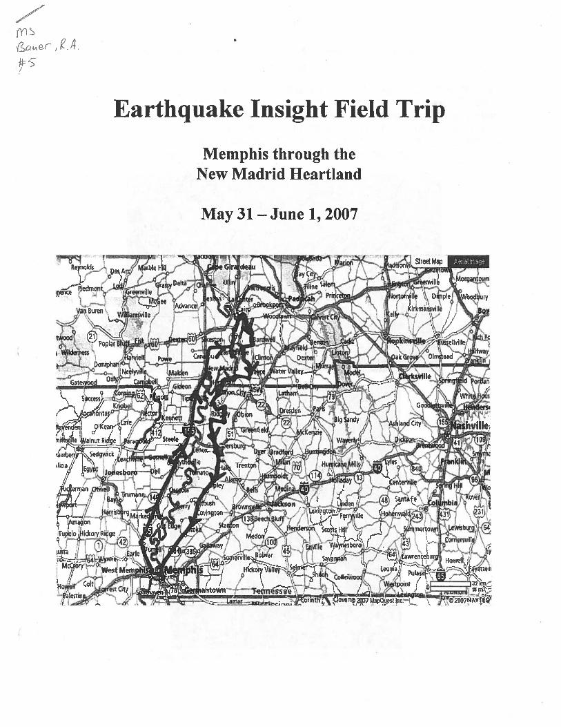
field trip 5-28-2007-bauer section
TRANSCRIPT

Bauer is the only presenter on this field trip with a bound section presented during the field trip. Schedule of stops and presenters is enclosed along with the field guide section through Cairo presented by Robert Bauer (ISGS).

Program Schedule
2007 Earthquake Insight Field Trip Presenters: Bob Bauer Mimi Garstang Mike Griffin Marion Haynes Greg Hempen Arleen Hill Rick Howe John Kiefer Buddy Schweig Phyllis Steckel Roy Van Arsdale Jim Wilkinson Blue Crew: Rick Schwentker Katie Steckel Nick Main Thursday; May 31, 2007 10:00 am “Welcome Desk” opens at Center for Earthquake Research & Information (CERI) on the campus of the University of Memphis Blue Crew Greet arriving participants & presenters; hand out guidebooks, name tags, etc. Show participants & presenters where to put overnight bags in staging area Show participants static displays at CERI Verify that each participant & each presenter signed the Release Form Get ice for soft drinks & water 11:00 am Opening Remarks Phyllis Steckel Welcome, general plan, mission, and logistics 11:15 am Introductions All Participants 11:20 am Introductions All Presenters & Blue Crew 12:00 noon Buffet LUNCHEON (at CERI) 12:30 pm “Setting the Stage” (at CERI) Regional geology; New Madrid FZ, Wabash Valley FZ, Southern Illinois FZ; Mississippi Embayment, continental uplands Roy Van Arsdale Expected site responses: floodplains, loess, bedrock, Crowley’s Ridge Memphis Area Earthquake Hazards Mapping Project. Buddy Schweig Regional building stock: URMs; seismic new design; seismic retrofits; ‘engineering culture’ of Memphis, St. Louis, and in-between Rick Howe Economic: levees, river transportation, overnight delivery hubs, steel industry, pipelines, railroads, airport, pharmaceuticals, etc. Arleen Hill 1:30 pm Bus arrives

Meet motor coach driver Blue Crew Dismantle & load welcome desk materials into baggage compartment Load soft drinks & snacks into baggage compartments Load exhibit boards into baggage compartments Load bottled water, bullhorn, first aid, etc, into front seat of motor coach Load escort vehicle 1:40 pm Dismiss and prepare for departure Phyllis Steckel Remind participants to load their own overnight bags Final restroom call Load motor coach 2:00 pm Depart Memphis, Tenn., via motor coach – En route “Memphis: the Nation’s Storeroom’ Arleen Hill I-40 retrofit project Rick Howe Downtown Memphis redevelopment Mike Griffin Mud Island Buddy Schweig I-40 elevated approaches Greg Hempen West Memphis multi-modal hubs Arleen Hill Account of 1811-12 earthquakes Buddy Schweig Evidence of past liquefaction (1811 and pre-1811) Roy Van Arsdale Corporate agriculture Arleen Hill Marion, Ark., rail yard & Mississippi County steel industry Arleen Hill 4:00 pm Arrive at buried stumps west of Yarbro, Ark. [STOP 1] (about 90 miles) What happened here, how we know, and why it’s important Buddy Schweig Roy Van Arsdale Greg Hempen Marion Haynes Offer beverages, snacks, take photos, help with exhibit boards, etc. Blue Crew 5:00 pm Depart buried stumps 5:30 pm Arrive at Holiday Inn; Blytheville, Ark. [STOP 2] (about 10 miles) 6:30 pm Buffet DINNER All Take photos Blue Crew 7:00 pm Announce after-dinner presentations, suggest 10-minute break Phyllis Steckel 7:15 pm Challenges of Multi-State Disaster Planning (PowerPoint) Jim Wilkinson 7:40 pm Political Realities of the Central US Earthquake Issue (PowerPoint) Mimi Garstang 8:05 pm Paradigm Shift: Earthquake-Resistant Design Adds VALUE – Not Cost! (PowerPoint) Mike Griffin 8:30 pm Questions and discussion All Presenters 8:45 pm Reminders for tomorrow morning & adjourn Phyllis Steckel

Friday; June 1, 2007 7:00 am Buffet BREAKFAST All 7:30 am Bus arrives; prepare for departure Help participants load their own overnight bags Blue Crew Get ice for ice chests Final restroom call Load bottled water, bullhorn, first aid, etc, into front seat of motor coach Load escort vehicle 8:00 am Depart Holiday Inn; Blytheville, Ark. – En route Pipelines (products, ownership, customer base, market dependency) Jim Wilkinson Levees (engineering, ownership, drainage-district history) Greg Hempen Commodity transport (riverside transfer facilities, barges, products, markets) Arleen Hill Local accounts of 1811-12 earthquakes Buddy Schweig Historical earthquake impacts to regional development (ca. 1811-12) Mimi Garstang Evidence of past liquefaction (1811 and pre-1811) Roy Van Arsdale Local industries (power plant, aluminum processing) Arleen Hill 9:00 am Arrive New Madrid [STOP 3] (~55 miles) Visit museum, watch video Mississippi River Overlook Greg Hempen Sikeston Ridge Buddy Schweig Retrofitted telephone building Rick Howe Retrofitted school Mike Griffin Offer beverages, snacks, take photos, help with exhibit boards, etc. Blue Crew 10:00 am Depart New Madrid Pick up BOX LUNCHES (TBD) & prepare picnic site Blue Crew 10:45 am Arrive at Towosahgy State Park [STOP 4] (~35 miles) What happened here, how we know, and why it’s important Buddy Schweig (results of paleoseismic trenching studies) Roy Van Arsdale Mimi Garstang Offer beverages, snacks, take photos, help with exhibit boards, etc. Blue Crew (May have to split up: two may need to pick up lunches.) 11:30 am Depart Towosahgy State Park 12:00 noon Arrive Ohio-Mississippi Confluence [STOP 5] (~20 miles) – BOX LUNCH Old course of Ohio River, I-57 retrofit (?), Iron Clad manufacturing site, etc Bob Bauer 1895 earthquake, damage, liquefaction, etc Buddy Schweig Thick river sediments, Mississippi Embayment Roy Van Arsdale Levees and flood protection for city of Cairo Greg Hempen Set up lunch picnic site, offer beverages, take photos, clean-up, etc. Blue Crew 1:00 pm Depart Ohio-Mississippi Confluence – En route

Drive through Cairo, Ill. (‘oversized’ public buildings, high-rise, flood gates, etc.)Bob Bauer Commodity transport, railroads, forest products industry, pipelines, etc. Arleen Hill 2:30 pm Arrive at Hickman landslide [STOP 6] (~50 miles) Hickman landslide history & repair John Kiefer Earthquake-induced landslide hazards along the floodplain margins John Kiefer Economic impact Arleen Hill Offer beverages, snacks, take photos, help with exhibit boards, etc. Blue Crew 3:00 pm Depart Hickman landslide 3:30 pm Arrive at New Madrid scarp [stay on board – STOP 7 – do not disembark) (~25 miles) What happened here, how we know, and why it’s important Buddy Schweig Roy Van Arsdale John Kiefer 3:35 pm Depart New Madrid scarp – En route Reelfoot Lake What happened here, how we know, and why it’s important Buddy Schweig Roy Van Arsdale John Kiefer 4:00 pm Arrive at Paw Paw Creek [STOP 8] (~15 miles) What happened here, how we know, and why it’s important Buddy Schweig Roy Van Arsdale John Kiefer Offer beverages, snacks, take photos, help with exhibit boards, etc. Blue Crew 5:00 pm Depart Paw Paw Creek exposure ~ 15 minutes before arrival: Ask for critique sheets Phyllis Steckel 7:00 pm Arrive in Memphis

1
Confluence of Ohio and Mississippi Rivers Robert A. Bauer, Illinois State Geological Survey
The town of Cairo, Illinois is located at the confluence of the Mississippi and Ohio Rivers and rests on about 150 feet of sand & clay sediments deposited by these rivers. These thick, saturated sands are liquefiable when subjected to large shaking. Below these river sediments is about 500 feet of poorly lithified (not stiff bedrock) Mississippi Embayment sands, gravels and clays of the Clayborne, Wilcox, Porters Creek and Clayton Formations. The Ohio River was diverted to its current course about 8,200 years ago.
Diagram showing trip route & setting of Cairo & its bridges.

2
In 1673, Louis Jolliet and Father Jacques Marquette explored the Illinois country for France. This area passed to England, by the 1763 treaty ending the French and Indian Wars. During the American Revolution, George Rogers Clark's men captured it for the Commonwealth of Virginia and later it was governed as part of the Northwest Territory, Indiana Territory, and the Illinois Territory. Permanent American settlers began arriving at the state's southwestern tip in 1805 and many came in 1812 and 1813 as refugees of the 1811-1812 New Madrid earthquakes, in search of new home sites. The Mound City area just north of Cairo was occupied by Tennesseans escaping the earthquake country. When the Civil War began, both Northern and Southern strategists recognized the military importance of Cairo. Ten days after the bombardment of Fort Sumter, troops arrived to hold Cairo for the Union at a hastily constructed Fort Prentiss on the land south of Cairo. Cairo quickly became a huge military camp and supply center for the Army of General Ulysses S. Grant. General Grant built Fort Prentiss into the massive Fort Defiance, which served as a staging area for forays into Missouri, Kentucky, and Mississippi. Troops and gunboats from Cairo moved up the Tennessee and Cumberland Rivers in Kentucky, taking Forts Donelson and Henry from Confederates (the North’s first major victories of the war) and later down the Mississippi taking Memphis and Vicksburg, Mississippi.
Early picture of Fort Prentiss/Defiance with railroad Fort Defiance during the Civil War tracks on levee and barracks against levee.
The troops at Cairo surrounded the fort with a fifteen-foot high levee, which kept back the waters of the Ohio and Mississippi Rivers. The Ohio River side of Cairo became the home of a US Navy base, which hosted both commercial wharf boats carrying supplies and gunboats. Ironclads soon became the most effective warships of the Civil War, and foundry workers in nearby Mound City busily converted steamboats into gunboats by covering them with iron plate. Once so outfitted, these craft proceeded down the Ohio to Cairo, where they took on crews, ordnance and provisions.

3
Cairo, Illinois – Illinois Central Railroad Bridge By 1900 there were seven railroad lines branching to and from Cairo. Until 1889, there was no railroad bridge crossing either the Ohio or the Mississippi Rivers at or near Cairo. Therefore, the ferry was very important in getting goods and people across the rivers. Nearly 260,000 railroad cars were ferried across the rivers in the first six months of 1887. The ferry business began to decrease after the Illinois Central Railroad bridge was completed in 1889.
Old postcard showing IC RR Bridge and barges ferrying trains across the Ohio and Mississippi Rivers.
Note railroad tracks going down to the rivers with barges at or near the end of the tracks.
On July 1, 1887 construction began on the first foundation of the ICRR bridge piers which was founded at a depth of 77 feet (23.5 m). The last pier was completed on February 19, 1889 and the first train crossed the bridge from Illinois to Kentucky on October 29, 1889. Total cost of the structure exceeded $2.6 million, with nearly $1.2 million for the substructure alone. In order to comply with regulations meant to allow steam boat travel on the Ohio, the bridge was required to be 53 feet (16.2 m) above the river's high water mark. This resulted in the structure extending nearly 250 feet (76.2 m) from the bottom of the deepest foundation to the top of the highest iron work. The largest pier weighs 22 million pounds. At the time, the bridge was the largest and most expensive ever undertaken in the United States. At 10,580 feet (3,224.8 m), it was also the longest metallic structure in the world. Its construction completed the first rail link between Chicago and New Orleans and revolutionized north-south rail travel along the Mississippi River. One bridge pier was damaged by the Oct. 31, 1895 Charleston, Missouri earthquake. Repair was made by placing steel bands around the damaged pier. The steel bridges were rebuilt in 1951 using the existing piers.

4
Cairo Illinois Central RR Bridge 1893 Low water 1890
Damage in Cairo, Illinois from various Earthquakes
1883 Apr 12 08:36 Intensity VI to VII - Cairo, Illinois A strong local earthquake rattled windows for 30 seconds and awakened everyone in Cairo. People were injured slightly in the collapse of an old frame house – the only record of injury in the State due to earthquakes.
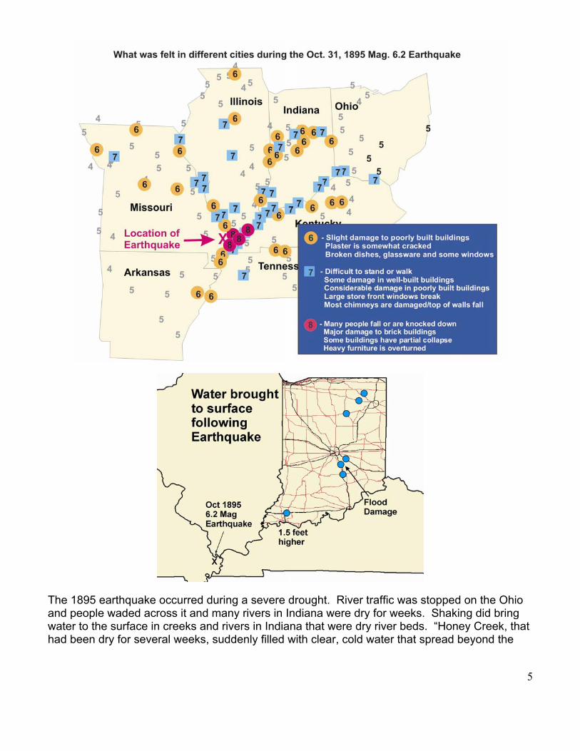
Halloween 1895 - Magnitude 6.2 - Intensity VIII - Charleston, Missouri This is the largest earthquake to occur in the central Mississippi River valley since the 1811-1812 New Madrid events. Structural damage and liquefaction were reported along a line from Bertrand, Missouri, in the west to Cairo, Illinois, in the east. Many sand blows were observed in an area southwest of Charleston, Missouri, and south of Bertrand, Missouri. Isolated occurrences of sand blows also were reported north and south of Charleston.
The most severe damage occurred in Charleston, Puxico, and Taylor, Missouri; Alton, and Cairo, Illinois; Princeton, Indiana; and Paducah, Kentucky. The earthquake caused extensive damage (including downed chimneys, cracked walls, shattered windows, and broken plaster) to school buildings, churches, private houses, and to almost all the buildings in the commercial section of Charleston. At Cairo, Illinois, few buildings escaped at least the loss of a chimney or a broken window. The courthouse, library, and a church at Cairo sustained extensive damage, and the brick walls of many buildings in the downtown section were cracked badly. Other damage include a cracked pier on the Illinois Central Railroad bridge over the Ohio River and downed chimneys at Gadsden, Alabama; Evansville and New Waverly, Indiana; Covington, Spottsville Depot, and Uniontown, Kentucky; St. Louis, Missouri; and Memphis, Tennessee.
5
The 1895 earthquake occurred during a severe drought. River traffic was stopped on the Ohio and people waded across it and many rivers in Indiana were dry for weeks. Shaking did bring water to the surface in creeks and rivers in Indiana that were dry river beds. “Honey Creek, that had been dry for several weeks, suddenly filled with clear, cold water that spread beyond the
6
banks, sweeping away fences and doing considerable damage to crops.” (The Courier Journal Louisville, Nov. 1, 1895).
November 4, 1905 - Missouri Aftershocks were felt over 100,000 square miles in nine states. In Illinois, it cracked the wall of the new education building in Cairo and a wall in Carbondale.
August 19, 1934 - Rodney, Missouri The small railroad town of Rodney, Missouri (between Charleston, MO and Cairo, IL) experienced a strong earthquake on August 19, 1934. At Charleston, Missouri; Cairo, Illinois; and at Wickliff, Kentucky, windows were broken, chimneys were overthrown or damaged, and articles were knocked from shelves. The area of destructive intensity included more than 230 square miles.
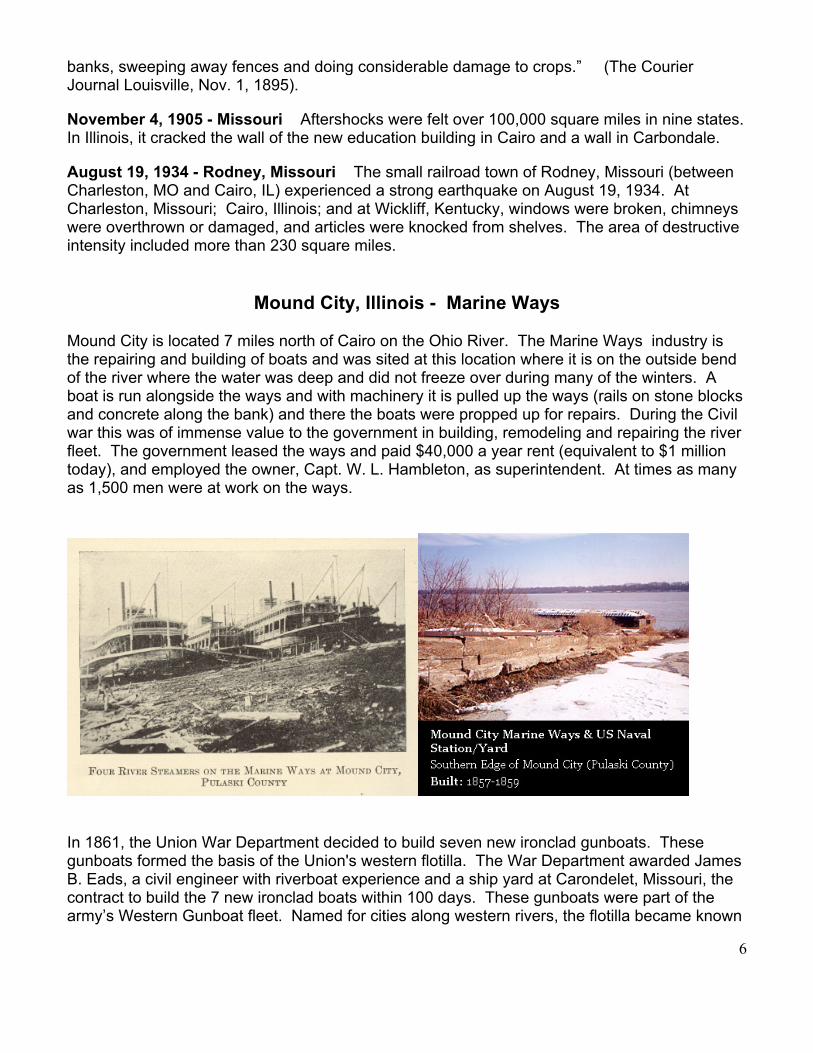
Mound City, Illinois - Marine Ways
Mound City is located 7 miles north of Cairo on the Ohio River. The Marine Ways industry is the repairing and building of boats and was sited at this location where it is on the outside bend of the river where the water was deep and did not freeze over during many of the winters. A boat is run alongside the ways and with machinery it is pulled up the ways (rails on stone blocks and concrete along the bank) and there the boats were propped up for repairs. During the Civil war this was of immense value to the government in building, remodeling and repairing the river fleet. The government leased the ways and paid $40,000 a year rent (equivalent to $1 million today), and employed the owner, Capt. W. L. Hambleton, as superintendent. At times as many as 1,500 men were at work on the ways.
In 1861, the Union War Department decided to build seven new ironclad gunboats. These gunboats formed the basis of the Union's western flotilla. The War Department awarded James B. Eads, a civil engineer with riverboat experience and a ship yard at Carondelet, Missouri, the contract to build the 7 new ironclad boats within 100 days. These gunboats were part of the army’s Western Gunboat fleet. Named for cities along western rivers, the flotilla became known

7
as the City Series. Eads had the Mound City, Cincinnati, and Cairo gunboats built at Mound City, Illinois, and the St. Louis (renamed Baron De Kalb), Carondelet, Louisville, and Pittsburg built at his works in Carondelet, Missouri (Eads boat works used coal from the Dog Town mines in St. Louis). Two-and-one-half inches of iron protected the 24-inch-thick oak sides of the boats. Each boat carried thirteen heavy cannons. The steam-powered boats used coal for fuel and each measured 175 feet long and 51 feet, 2 inches wide. Seventeen officers, twenty-seven petty officers, and 131 sailors crewed each gunboat. The boats had flat bottoms and Eads designed them especially for river travel; each needed only a six-foot draft. The boats' design protected the paddlewheel from enemy fire and placed the boilers below the water line to shield them from damage.
8
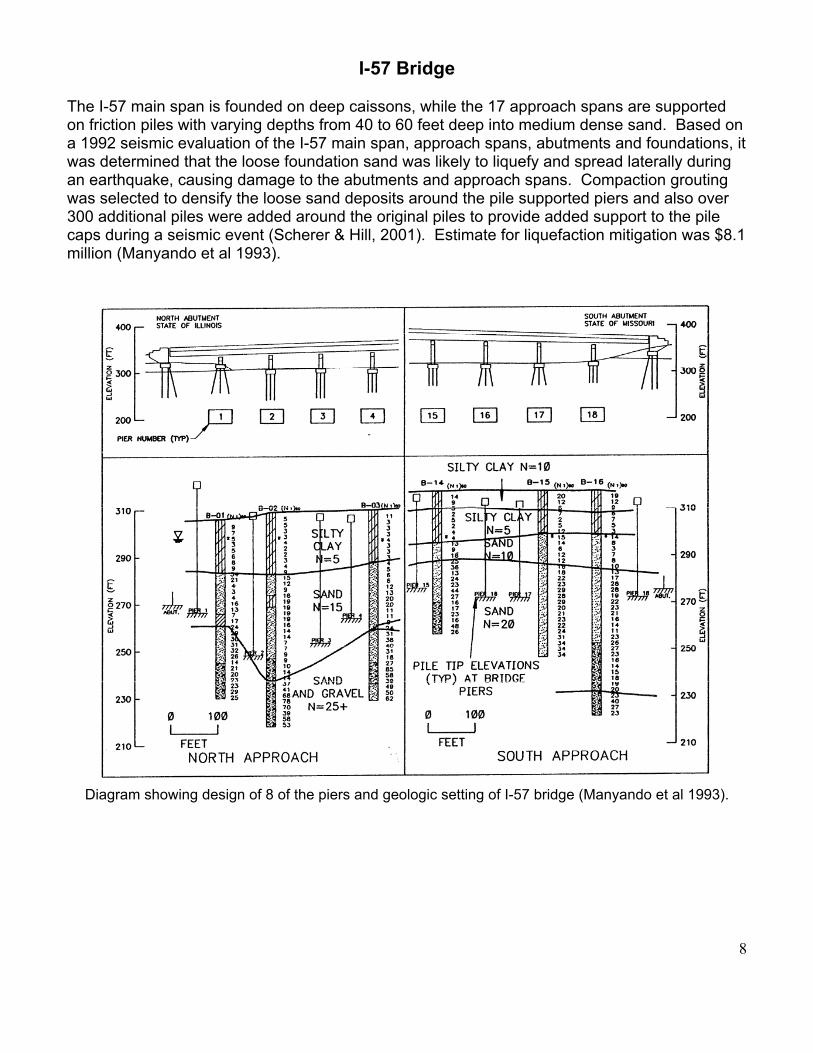
I-57 Bridge The I-57 main span is founded on deep caissons, while the 17 approach spans are supported on friction piles with varying depths from 40 to 60 feet deep into medium dense sand. Based on a 1992 seismic evaluation of the I-57 main span, approach spans, abutments and foundations, it was determined that the loose foundation sand was likely to liquefy and spread laterally during an earthquake, causing damage to the abutments and approach spans. Compaction grouting was selected to densify the loose sand deposits around the pile supported piers and also over 300 additional piles were added around the original piles to provide added support to the pile caps during a seismic event (Scherer & Hill, 2001). Estimate for liquefaction mitigation was $8.1 million (Manyando et al 1993).
Diagram showing design of 8 of the piers and geologic setting of I-57 bridge (Manyando et al 1993).
9
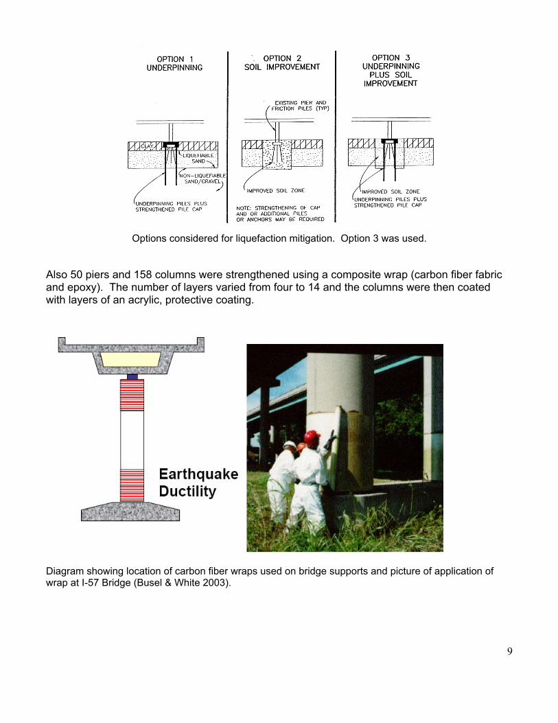
Options considered for liquefaction mitigation. Option 3 was used.
Also 50 piers and 158 columns were strengthened using a composite wrap (carbon fiber fabric and epoxy). The number of layers varied from four to 14 and the columns were then coated with layers of an acrylic, protective coating.
Diagram showing location of carbon fiber wraps used on bridge supports and picture of application of wrap at I-57 Bridge (Busel & White 2003).

10
Diagrams showing seismic activity of New Madrid and faults near Olmsted, Illinois which are part of New Madrid Seismic Zone (Bexfield et al 2005).

11
References/Sources
Bexfield, C.E., J.H. McBride, A.J.M. Pugin, W.J. Nelson, T.H.Larson, and S.L. Sargent, 2005, The Olmsted Fault Zone, Southernmost Illinois: A Key to Understanding Seismic Hazard in the Northern New Madrid Seismic Zone. Engineering Geology, Vol. 81, pp. 179-201.
Busel, John and David White, 2003, CFRP & GFRP Composite Applications for Infrastructure Rehabilitation and Repairs. NASTO 2003 Conference, Saratoga Springs, NY, PowerPoint Presentation.
Gough, Steve, 2005, Historic and PreHistoric Hydrology of the Cache River, Illinois. www.emriver.com, 29 pp.
Manyando, G.M.S., T.L. Cooling, W.L. Durbin and R.E. Anderson, 1993, Liquefaction Mitigation Design, I-57 Mississippi River Bridge, Cairo, Illinois. 1993 National Earthquake Conference, Vol. II, pp. 659-668.
Scherer, Steven D. and Jeffrey R. Hill, 2001, Minipiles and Compaction Grouting for Seismic Retrofit of Transportation Structures in the New Madrid Fault Zone, Proceedings of the 26th Annual Members' Conference, 2001, St. Louis, MO "Designing Deep ~ Building Deep", Deep Foundation Institute.
Stover, Carl W. and Jerry L. Coffman, 1993, Seismicity of the United States, 1568-1989 (Revised), U.S. Geological Survey Professional Paper 1527, United States Government Printing Office, Washington.
Wikipedia – Free Internet encyclopedia.

12

13
Central U.S. Infrastructure – Potential National Disruption!
Products shipped on the river are: agricultural fertilizers, coal, petroleum products, construction
materials, steel, and industrial chemicals to river ports throughout the Midwest. Barge Industry
transports 20% of America’s coal or enough to produce 10% of all electricity in U.S. and moves 60% of
U.S. grain exports.
Graph from American Waterways Operators.
Accounts of the 1811-1812 New Madrid Earthquake Effects on the Rivers and Banks
http://www.eas.slu.edu/Earthquake_Center/SEISMICITY/Nuttli.1973/nuttli-73-app.html
“The bank of the river gave way in all directions, and came tumbling into the water; the trees were more agitated than I ever before saw them in the severest storms, and many of them from the shock they received broke off near the ground, as well as many more torn up by the roots.” “the face of the river is wholly changed, particularly from Island No. 30, to island No. 40; this part of the river burst and shook up hundreds of great trees from the bottom, and what is more singular they are all turned roots upwards and standing upstream in the best channel and swiftest water,” “we were affrightened with the appearance of a dreadful rapid of falls in the river just below us” “On my return by land up the right side of the river, I found the surface of the earth for 10 or 12 miles cracked in numberless places, running in different directions - some of which were bridged and some filled with logs to make them passable - others were so wide that they were obliged to be surrounded.” (Lateral spreading – movement of the banks toward the river). “At the dawn of day I went on shore to examine the effects of the shocks; the earth about 20 feet from the waters edge was deeply cracked” (More observations of Lateral spreading) “Large trees, which had lain for ages at the bottom of the river, were shot up in thousands of instances, some with their roots uppermost and their tops planted; others were hurled into the air; many again were only loosened, and floated upon the surface.”

14
“many were torn from their native soil, and hurled with tremendous force into the river; one of these whose huge trunk (at least 3 feet in diameter) had been much shattered, was thrown better than an hundred yards from the bank,” “now subterranean forests have been ushered into existence, and raise their heads, hard and black as ebony, above the surface of the water” “At the Devil's Race ground, 193 miles, an immense number of very large trees have been thrown up, and the river is nearly impassible.” “during the late convulsions the current of the river was almost instantaneously and rapidly increased. This current was increased for two days,” (shaking bringing water to the surface)
Interstate Energy Transport (1974)

15
Resources for Homeowners, Business & Industry
FEMA Documents: http://www.fema.gov/plan/prevent/earthquake/publications.shtm Reducing the Risks of Nonstructural Earthquake Damage: A Practical Guide. Third Edition (FEMA 74) (PDF 12MB, TXT 234KB) This well-illustrated publication describes the sources of nonstructural earthquake damage and provides information on effective methods of reducing potential risks from such damage. The guide assists in identifying potential hazards and provides specific guidance on upgrades that readers can do themselves. The target audiences for the guide are building owners, facility managers, maintenance personnel, homeowners, store or office managers, business proprietors, organizational department heads, and others concerned with building safety and the continuation of business. Earthquake Safety Guide for Homeowners (FEMA 530) (PDF 4.2MB, TXT 50KB) This updated safety guide, which was originally developed and published by the California Seismic Safety Commission, provides homeowners with a good start to strengthening their homes against earthquake damage. The guide also illustrates the relative cost of prevention versus repair or replacement. Homebuilders' Guide to Earthquake-Resistant Design and Construction (FEMA 232) This illustrated guide replaces the Home Builder's Guide to Seismic Resistant Construction published in August 1998 as well as all earlier versions of FEMA 232. It presents seismic design and construction guidance for one- and two-family light frame residential structures that can be utilized by homebuilders, knowledgeable homeowners, and other non-engineers, and provides supplemental information to the 2003 edition of the International Residential Code. FEMA 366/February 2001: HAZUS99 Estimated Annualized Earthquake Loss for the United States The HAZUS99 Estimated Annualized Earthquake Loss for the United States report outlines the steps for analyzing earthquake risk, the results of the analysis, including interpretations and applications of the study. This report also includes a brief overview of HAZUS and a short summary on preparing probabilistic hazard data and annualized earthquake loss computation. Earthquake Resistant Construction of Electric Transmission and Telecommunication Facilities Serving the Federal Government (FEMA 202) (PDF 2.7MB) This report summarizes a National Institute of Standards and Technology study that reviewed measures implemented by federal agencies to protect electric power transmission and telecommunication lifelines against seismic hazards. The report examines the seismic vulnerability of these lifelines and discusses current standards and design criteria. Seismic retrofitting techniques for components and systems are reviewed, including the benefits of retrofitting versus gradual replacement. Seismic Vulnerability and Impact of Disruption of Lifelines in the Conterminous United States (FEMA 224) (PDF 17.7MB) This report provides a national overview of lifeline seismic vulnerability and the impact of disruption. Both site specific lifelines and extended lifeline networks are examined. Included is a review of electric, water, transportation, and emergency service systems. The vulnerability estimates and impacts are presented in terms of estimated direct damage losses and indirect economic losses. The report also presents hazard mitigation measures and their expected benefits and recommendations for future work. Earthquake Resistant Construction of Gas and Liquid Fuel Pipeline Systems Serving or Regulated by the Federal Government (FEMA 233) (PDF 5MB) This report summarizes the vulnerability of gas and liquid fuel pipeline systems to damage in past earthquakes. The
16
report lists the available standards and technologies that can protect such facilities against earthquake damage. An overview of measures taken by various federal agencies to protect pipeline systems is presented. Plan for Developing and Adopting Seismic Design Guidelines and Standards for Lifelines (FEMA 271) (PDF 6.3MB) This document outlines a plan for developing and adopting design and construction standards for lifelines. The plan 1) establishes performance criteria for the construction, maintenance, and operation of new and existing lifeline systems, equipment, and materials for selected levels of seismic risk; 2) provides a basis for technical specifications for use by buyers and sellers of lifeline products and services to reduce the vulnerability of lifeline systems to earthquakes; and 3) provides a reliable basis for regulations to protect public health, safety, and welfare. Five types of lifeline systems are presented: electric, gas and liquid fuel, telecommunications, transportation, and water systems. Seattle Scenario Documents on the Earthquake Engineering Research Institute Website http://seattlescenario.eeri.org/documents.php Minimizing Earthquake Damage: A Guide for Water Utilities – Member $28 American Water Works Association, 6666 W. Quincy Ave., Denver, CO 80235-3098 www.awwa.org 800-926-7337
U.S. Geological Survey Website for their main directory for many topics related to earthquakes: fact sheets, publications, preparedness, photo collection, earthquakes for Kids, Teachers, Students, etc. http://earthquake.usgs.gov/learning/ or http://earthquake.usgs.gov/resources/ Earthquake Hazard in the Heart of the Homeland - U.S. Geological Survey Fact Sheet 131-02 http://pubs.usgs.gov/fs/fs-131-02/fs-131-02.pdf Poster - Earthquakes in the Central United States—1699–2002 http://pubs.usgs.gov/imap/i-2812/ USGS - Seismic Hazard Probability Maps - http://earthquake.usgs.gov/research/hazmaps/products_data/48_States/index.php The Memphis, Shelby County, Tennessee, Seismic Hazard Maps - http://earthquake.usgs.gov/regional/ceus/urban_map/memphis/NonTechnicalDoc.html IBHS – Institute for Business and Home Safety. Open for Business – various materials for Small Businesses to plan for disasters and insure better business continuity. http://www.ibhs.org/ IBHS – Is Your Home Protected from Earthquake Disasters? http://www.ibhs.net/natural_disasters/downloads/earthquake.pdf

17
American Lifelines Alliance: http://www.americanlifelinesalliance.org/ Guidelines for Utility Performance Assessment The ALA has developed three new guidelines to provide utility system owners and operators with guidance on defining the scope of actions necessary to assess system performance during and after hazard events to support risk management decisions. The three draft guidelines that are posted for review and comments are: Electric Power Systems; Oil and Natural Gas Pipeline Systems; Wastewater Systems Their scope includes both natural hazards (e.g., earthquakes, flood, hurricane, tornado, windstorm, icing, and ground displacements caused by landslides, frost heave and settlement) and man-made hazards (biological, chemical, radiological, blast, and cyber incidents). Each guideline consists of a two-volume report with concise guidance provided in one volume and commentary and references provided in a separate volume.
Guideline for the Seismic Design and Retrofit of Piping Systems, 2002 This guideline addresses new and existing aboveground piping systems that comply with the non-seismic provisions of the ASME B31 pressure piping codes for materials, design, fabrication, examination, and testing. It provides comprehensive but easy to follow guidance for the seismic design of piping systems in essential facilities such as power plants, chemical process facilities, oil and gas pipelines and terminals, and post-earthquake critical institutions such as hospitals. The guideline also presents a compilation of the steps and techniques necessary for the seismic qualification of new or existing above ground piping systems based on current analytical and dynamic testing technology as well as experience from the behavior of piping systems in actual earthquakes.
Seismic Fragility Formulations for Water Systems (2 parts), 2001 This guideline presents procedures that can be used to evaluate the probability of earthquake damage to water transmission systems. This document was developed to address the lack of a consistent assessment methodology within industry, consulting, and academic communities. The lack of consistency prevents direct comparison of damage estimates for prioritizing where resources can best be allocated to mitigate damage. The raw damage data supporting the fragility relationships are included with the guidelines to facilitate the addition of new information from future earthquakes. Use of these fragility data will allow water system owners to estimate the vulnerability of their systems and to make informed decisions to mitigate risks.
Seismic Fragility Formulations for Water Systems: Part 1 - Guideline (104 pages)
Seismic Fragility Formulations for Water Systems: Part 2 - Appendices (239 pages)
Evaluation Guide for the Seismic Operability of Active Mechanical Equipment - 2004 Many lifeline system mechanical components perform critical functions during and after earthquakes (e.g., a pump that must start to provide fire suppression water or a valve that must close to isolate a toxic or flammable spill). The earthquake performance of these components is assessed by various entities using a combination of analysis, shake-table testing, operational experience, and informed judgment. To provide a single information source, the ALA developed a guide that encompasses the available performance data for six classes of mechanical components: valves, valve operators, pumps, compressors, fans, and packaged air handling units. For each component class, the guide identifies seismic failure modes and the primary contributors to each failure mode. Checklists are included to facilitate the evaluation of components for new and existing applications in both commercial and industrial facilities.
DAMAGE EXPERIENCED FOR MERCALLI INTENSITY (MMI) Scale

18
(Scale is from I to XII) Combined Mercalli Intensity Scale and Some of the Proposed Rural Intensity Descriptions
I Not felt II Earthquake is felt indoors by a few, especially on upper floors. Sometimes hanging objects swing. III Earthquake is felt indoors by several. Vibration are like that of a passing light truck. Hanging
objects may swing slightly. Standing cars rock slightly. IV Earthquake is felt indoors by many, outdoors by few. A few people asleep are awakened
especially light sleepers. No one is frightened. Vibration are like that of a passing heavy truck. Sensation is like a heavy body striking the building or fall of a heavy object inside the building. Dishes, windows, doors rattle and glassware and crockery clink or clash. Walls and frame of house creaks. Standing cars rock noticeable.
V. Earthquake is felt Indoors by practically all people and outdoors by many or most of the people.
Many or most of the people asleep are awakened. A few people are frightened and a few ran outdoors. Buildings trembled throughout the area. Some dishes and glassware are broken. In some cases windows are broken, but not many in general. Small or unstable objects are overturned, in many instances, and a few fall off shelves. Hanging objects, doors, swing. Pictures knocked against walls, or swung out of place. Doors and shutters open or close abruptly. Pendulum clocks stopped, started or ran fast, or slow. Small objects, furnishings, moved slightly out of place. There is small amounts of spilled liquids from well-filled open containers. Trees and bushes shake slightly.
VI. Earthquake is felt by all, indoors and outdoors. Many are frightened. There is general excitement
and some alarm, many people ran outdoors. It awakened all. People walking were unsteady. Trees and bushes shaken slightly to moderately. Liquid is set in strong motion. Small bells rang--church, chapel, school, etc. Damage is slight in poorly built buildings. There is fall of plaster in small amounts. Plaster is somewhat cracked, especially fine cracks in chimneys in some instances. There is a considerable quantity of broken dishes, glassware, and also some windows. Knickknacks, books, and pictures have fallen. Furniture is overturned in many instances. Furnishings of moderately heavy weight are moved.
VII. All people are frightened and there is general alarm. All take some action: may panic and run outdoors, may duck and cover. Some, or many, found it difficult to stand or walk. Event is noticed by persons driving motor cars or heavy equipment. Trees and bushes are shaken moderately to strongly, frequently have fall of limbs and tree tops in heavily wooded areas. There are waves generated on ponds, lakes, and running water and the water is turbid from mud stirred up. There is incaving to some extent of sand or gravel stream banks. Large church bells are rung. Suspended objects quiver. Damage is negligible in buildings of good design and construction, but there is slight to moderate damage in well-built ordinary buildings and considerable damage in poorly built or badly designed buildings, adobe houses, old walls (especially where laid up without mortar), spires, etc. Chimneys are cracked to a considerable extent, walls to some extent. There

19
is a considerable to large amount of plaster fallen, also some stucco. Numerous large store windows are broken, but window damage is rare in well-built wood-frame single family homes. Loosened brickwork and tiles are shaken down. Most unreinforced-masonry chimneys are damaged and some are broken at the roof-line and knocked down (sometimes damaging roofs). Cornices from towers and high buildings fall. Buildings have dislodged bricks and stones. There are many reports of foundation damage to poor structures. Heavy furniture is overturned and damaged. All report many items tipped over and off shelves, many report closed cupboards and refrigerators thrown open and items thrown out.
VIII. Alarm approaches panic. All report difficulty in standing, many reports of people falling
and being knocked down. Persons driving motor cars find it difficult to drive. Trees are shaken strongly--branches and trunks are broken off. Sand and mud are ejected in small amounts. There are temporary or permanent changes in: flow of springs and wells; dry wells renewed flow; in temperature of spring and well waters. Damage is slight in structures (brick) built especially to withstand earthquakes but major damage to unreinforced masonry structures. There is considerable damage in ordinary substantial buildings, partial collapse, racked, tumbled down, wooden houses have damage in some cases with thrown out panel walls in frame structures, decayed piles are broken off. There are fallen walls, cracked, broken, solid stone walls are seriously damaged. Damage in wet ground to some extent and in ground on steep slopes. There is twisting and fall of chimneys, columns, monuments, also factory stacks and towers. Very heavy furniture is moved conspicuously and overturned. Virtually all cupboard and cabinet doors are thrown open and items forcibly ejected. Some heavy items (boulders, tree trunks) may show signs of being thrown into the air. Open cracks and broad wavy folds may develop in asphalt road surfaces.
IX. There is general Panic. The ground is cracked. Sand and mud are ejected from the
ground in moderate amounts. Damage is considerable in (masonry) buildings, some have collapsed. Frame buildings are wholly shifted off their foundations, others have racked frames. There is serious damage to reservoirs. Underground pipes of all kinds may be broken. You probably have no water, telephones or electricity in the area. There is considerable non structural damage inside buildings with furniture overturned everywhere and items are thrown off shelves and out of closed cupboards and cabinets.

X. There is general panic. There is cracked ground up to widths of several inches especially where the soil is loose and wet. There are fissures up to a yard in width which run parallel to canal and stream banks. There are a considerable number of landslides along river banks and steep coasts. Sand and mud are shifted horizontally on beaches and flat land. Water levels changed in wells. Water is thrown up on the banks of canals, lakes, rivers, etc. There is serious damage to dams, dikes, and embankments. Well-built wooden structures and bridges are severely damaged and some collapse. Most masonry and wood-framed structures and their foundations are destroyed. Railroad rails are slightly bent. Buried pipelines tear apart or are crushed endwise. The event has produced open cracks and broad wavy folds in cement pavements and asphalt road surfaces.
XI. Few buildings survive. XII. Total Destruction.
Intensity Experience in Central U.S.
New Madrid Dec. 16, 1811 Event.