-- field trip guidebook
TRANSCRIPT

I
27th Annual Meeting North-Central Section--The Geological Society of America
Field Trip No. 6: Rapakivi Granites and Related Rocks
in the St. Francois Mountains Southeast Missouri
Sponsored by The International Geological Correlation Programme
Project 315 Correlation of Rapakivi Granites and Related Rocks on a Global Scale
"--
u 1993 MISSOURI
s 0
A 0 L L A
Field Trip Guidebook Special Publication No. 10
Guidebook No. 24
Eva B. Kisvarsanyi and Arthur W. Hebrank, leaders
Rolla - Potosi - Ironton - St. Louis March 30-April· 2, 1993
MISSOURI DEPARTMENT OF NATURAL RESOURCES Division of Geology and Land Survey
Rolla, Missouri United States of America

n
I
Source: 28th International Geological Congress, Field Trip Guidebook Tl47:37-50, American Geophysical Union, Washington, D.C., 1989
Precambrian Rocks and Ore Deposits in the St. Francois Mountains, Southeast Missouri--A Middle Proterozoic Terrane of Granite Ring Complexes and Associated Rhyolites
Eva B. Kisvarsanyi, Missouri Geological Survey, Rolla, Missouri 65401
INTRODUCTION
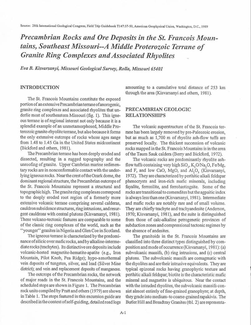
The St. Francois Mountains constitute the exposed portion of an extensive Precambrian terrane ofanorogenic, granite ring complexes and associated rhyolites that underlie most of southeastern Missouri (fig. 1). This igneous terrane is of regional interest not only because it is a splendid example of an urunetamorphosed, Middle Proterozoic granite-rhyolite terrane, but also because it forms the only extensive outcrops of rocks whose ages range from 1.48 to 1.45 Ga in the United States midcontinent (Bickford and others, 1981).
The Precambrian terrane has been deeply eroded and dissected, resulting in a rugged topography and the unroofing of granite. Upper Cambrian marine sedimentary rocks are in nonconformable contact with the underlying igneous rocks. Near the crest of the Ozark dome, the dominant regional structure, the Precambrian outcrops of the St. Francois Mountains represent a structural and topographic high. The granite ring complexes correspond to the deeply eroded root region of a formerly more extensive volcanic terrane comprising several calderas, cauldron subsidence structures, ring intrusions, and resurgent cauldrons with central plutons (K.isvarsanyi, 1981). These volcano-tectonic features are comparable to some of the classic ring complexes of the world, such as the "younger'' granites in Nigeria and Glen Coe in Scotland.
The igneous terrane is characterized by the predominance of silicic over mafic rocks, and by alkaline-intermediate rocks (trachytes ). Its distinctive ore deposits include volcanic-hosted magnetite-hematite-apatite ( e.g., Iron Mountain, Pilot Knob, Pea Ridge); hypo-xenothermal vein deposits of tungsten, silver, and lead (Silver Mine district); and vein and replacement deposits of manganese.
The outcrops of the Precambrian rocks, the network of major roads in the St. Francois Mountains, and the scheduled stops are shown in Figure 1. The Precambrian rock units compiled by Pratt and others (1979) are shown in Tab le 1. The stops featured in this excursion guide are described in the context of self-guiding, detailed road logs
amounting to a cumulative total distance of 253 km through the area (K.isvarsanyi and others, 1981).
PRECAMBRIAN GEOLOGIC RELATIONSIIlPS
The volcanic superstructure of the St. Francois terrane has been largely removed by pre-Paleozoic erosion, but as much as 1,700 m of rhyolite ash-flow tuffs are preserved locally. The thickest succession of volcanic rocks mapped in the St. Francois Mountains is in the area of the Taum Sauk caldera (Berry and Bickford, 1972).
The volcanic rocks are predominantly rhyolite ashflow tuffs containing very high Si 02, Ki O/Na2 0, Fe/Mg, and F, and low CaO, MgO, and A~0
3 (Kisvarsanyi,
1972). They are characterized by perthitic alkali feldspar phenocrysts and iron-rich mafic minerals, including fayalite, ferrosilite, and ferrohastingsite. Some of the rocks are transitional to comendites but the agpaitic index is always less than one (Kisvarsanyi, 1981 ). Intermediate and mafic rocks are notably rare and of small volume. They are chiefly trachyte and trachyandesite (Anderson, 1970; Kisvarsanyi, 1981), and the suite is distinguished from those of calc-alkaline petrogenetic provinces of subduction zones and compressional tectonic regimes by the absence of andesites.
The granitoids in the St. Francois Mountains are classified into three distinct types distinguished by composition and mode of occurrence (Kisvarsanyi, 1981 ): (a) subvolcanic massifs, (b) ring intrusions, and (c) central plutons. The subvolcanic massifs are comagmatic with the rhyolites and are their intrusive equivalents. They are typical epizonal rocks having granophyric texture and perthitic alkali feldspar; biotite is the characteristic mafic mineral and magnetite is ubiquitous. Near the contact with the intruded rhyolites, the subvolcanic massifs consist almost entirely of fine-grained granophyre; at depth, they grade into medium-to coarse-grained rapakivis. The Butler Hill and Breadtray Granites (tbl. 2) are representa-
A-1
LOCATION MAP
. Viburnum
LEGEND
Outcrop of Precambrian Rocks
Excursion Stops
91°
\%
·~~~
l N
~
J~iii[;;tr t~~, ~.i
0 10 20
SCALE IN KILOMETERS
Figure 1. Outcrops of Precambrian rocks in the St. Francois Mountains showing the major roads through the area. The daily stops are indicated by arrows and indentified by two numbers: the first for the day, the second for the stop.
A-2
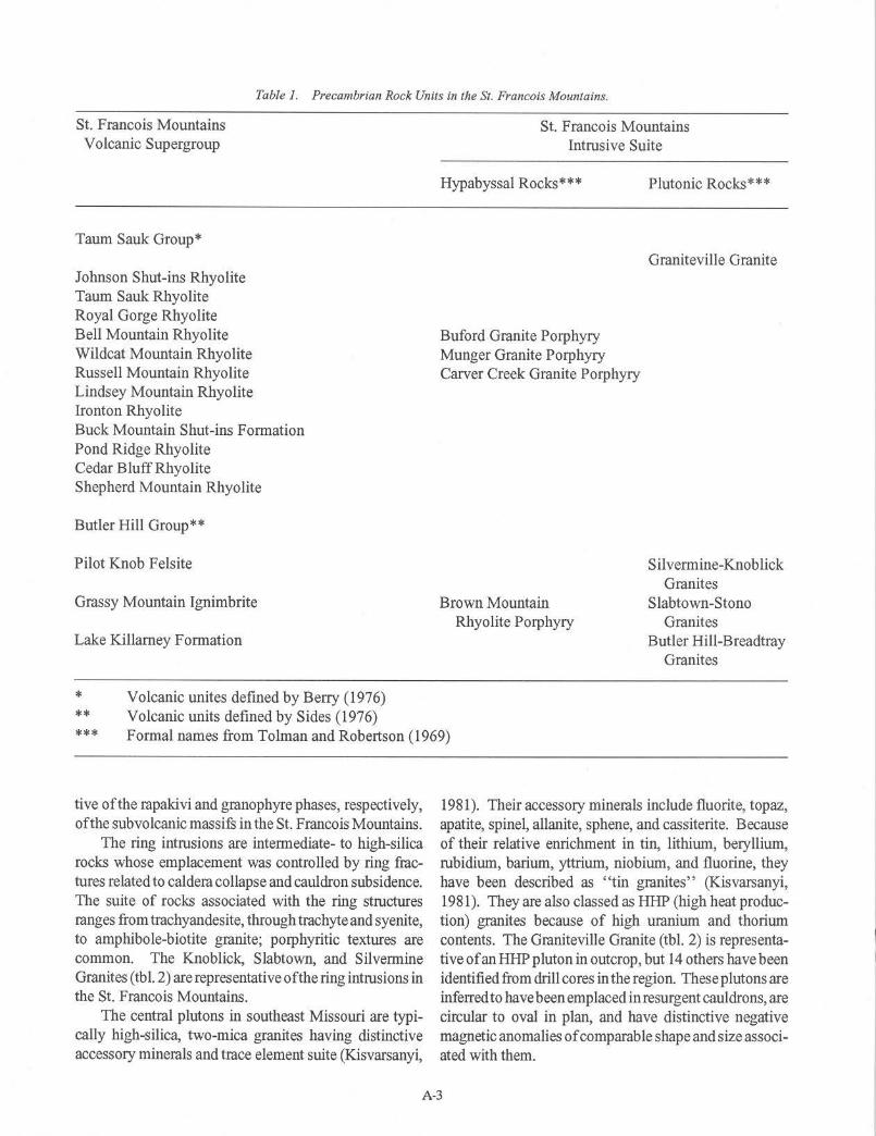
Table J. Precambrian Rock Units in the St. Francois Mountains.
St. Francois Mountains St. Francois Mountains Volcanic Supergroup Intrusive Suite
Taum Sauk Group*
Johnson Shut-ins Rhyolite Taum Sauk Rhyolite Royal Gorge Rhyolite Bell Mountain Rhyolite Wildcat Mountain Rhyolite Russell Mountain Rhyolite Lindsey Mountain Rhyolite Ironton Rhyolite Buck Mountain Shut-ins Formation Pond Ridge Rhyolite Cedar BluffRhyolite Shepherd Mountain Rhyolite
Butler Hill Group**
Pilot Knob Felsite
Grassy Mountain Ignimbrite
Lake Killarney Formation
Volcanic unites defined by Berry (1976) Volcanic units defined by Sides (1976)
Hypabyssal Rocks***
Buford Granite Porphyry Munger Granite Porphyry Carver Creek Granite Porphyry
Brown Mountain Rhyolite Porphyry
Plutonic Rocks***
Graniteville Granite
Silvermine-Knoblick Granites
Slabtown-Stono Granites
Butler Hill-Breadtray Granites
* ** *** Formal names from Tolman and Robertson (1969)
tive of the rapakivi and granophyre phases, respectively, of the subvolcanic massifs in the St. Francois Mountains.
The ring intrusions are intermediate- to high-silica rocks whose emplacement was controlled by ring fractures related to caldera collapse and cauldron subsidence. The suite of rocks associated with the ring structures ranges from trachyandesite, through trachyteand syenite, to amphibole-biotite granite; porphyritic textures are common. The Knoblick, Slabtown, and Silvermine Granites (tbl. 2) are representative of the ring intrusions in the St. Francois Mountains.
The central plutons in southeast Missouri are typically high-silica, two-mica granites having distinctive accessory minerals and trace element suite (Kisvarsanyi,
1981 ). Their accessory minerals include fluorite, topaz, apatite, spinel, allanite, sphene, and cassiterite. Because of their relative enrichment in tin, lithium, beryllium, rubidium, barium, yttrium, niobium, and fluorine, they have been described as "tin granites" (Kisvarsanyi, 1981). They are also classed as HHP (high heat production) granites because of high uranium and thorium contents. The Graniteville Granite (tbl. 2) is representative of an HHP pluton in outcrop, but 14 others have been identified from drill cores in the region. These plutons are inferred to have been em placed in resurgent cauldrons, are circular to oval in plan, and have distinctive negative magnetic anomalies of comparable shape and size associated with them.
A-3
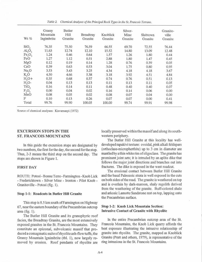
Table 2. Chemical Analyses of the Principal Rock Types in the St. Francois Terrane.
Grassy Butler Mountain Hill
Wt% Ingimbrite Granite
Si02 76.35 75.50 Al203 11.63 12.74 Fe20 3 1.24 0.46 FeO 1.27 1.12 MgO 0.12 0.19 CaO 0.39 0.63 Nap 3.53 3.43 KzO 4.50 4.66 HzO+ 0.35 0.68 Hp- 0.04 0.13 Ti02 0.16 0.14
PPs 0.00 0.04 MnO 0.08 0.05 F 0.10 0.13 Total 99.76 99.90
Source of chemical analyses: K.isvarsanyi (1972)
EXCURSION STOPS IN THE ST. FRANCOIS MOUNTAINS
Bread tray Granite
76.59 12.10 0.64 0.51 0.14 0.53 3.25 5.38 0.37 0.13 0.11 0.02 0.02 0.26
100.05
In this guide the excursion stops are designated by two numbers, the first for the day, the second for the stop. Thus, 2-3 means the third stop on the second day. The stops are shown in Figure 1.
FIRST DAY
ROUTE: Potosi-Bonne Terre-Farmington-Knob Lick - Fredericktown - Silver Mine - Ironton - Pilot Knob -Graniteville - Potosi (fig. 1).
Stop 1-1: Roadcuts in Butler HiU Granite
This stop is 8.5 km south ofFarmington on Highway 67, near the eastern boundary of the Precambrian outcrop area ( fig. 1 ).
The Butler Hill Granite and its granophyric roof facies, the Breadtray Granite, are the most extensively exposed granites in the St. Francois Mountains. They constitute an epizonal, subvolcanic massif that produced a co magmatic suite ofrhyolite ash-flow tuffs, the Grassy Mountain Ignimbrite (tbl. 1 ), now largely removed by erosion. Roof pendants of rhyolite are
Silver- Granite-Knoblick Mine Slabtown ville Granite Granite Granite Granite
66.55 69.70 72.55 76.44 15.52 14.80 13.09 12.48
1.57 1.26 1.80 0.44 2.88 1.80 1.47 0.45 1.28 0.76 0.39 0.05 3.04 1.75 0.80 0.95 4.34 4.18 4.18 3.67 3.18 3.92 4.51 4.84 0.74 0.76 0.51 0.13 0.11 0.13 0.11 0.05 0.48 0.40 0.40 0.07 0.16 0.14 0.06 0.00 0.08 0.07 0.04 0.00 0.07 0.07 0.00 0.41
100.00 99.74 99.91 99.98
locally preserved within the massif and along its southwestern periphery.
The Butler Hill Granite at this locality bas welldeveloped rapakivi texture: ovoidal, pink alkali feldspars ( orthoclase-micropherthite) up to 3 cm in diameter are mantled by a thin white rim ofoligoclase. The granite has prominent joint sets; it is intruded by an aplite dike that follows the major joint directions and branches out into fractures. The dike is exposed in the west roadcut.
The erosional contact between Butler Hill Granite and the basal Paleozoic strata is well exposed in the cuts on both sides of the road. The granite is weathered on top and is overlain by dark-maroon, shaly regolith derived from the weathering of the granite. Buff-colored shale and arkosic Lamotte Sandstone rest on top, lapping onto the Precambrian surface.
Stop 1-2: Knob Lick Mountain Section: Intrusive Contact of Granite with Rhyolite
In the entire Precambrian outcrop area of the St. Francois Mountains, the Knob Lick quarry affords the best exposure illustrating the intrusive relationship of granite into rhyolite. The granite, mapped as K.noblick Granite (Pratt and others, 1979), is representative of the ring intrusions in the St. Francois Mountains.
A-4
AG E Figure 2b. ( -+
Figure 2o. -w 365 ... ,."
T. 35N. 33~ Mtttrt T. 34N.
30~ ..... ,.
Figure 2c. N -+
36~ Metera
335 ..... ,,
10
~ Alluvlum
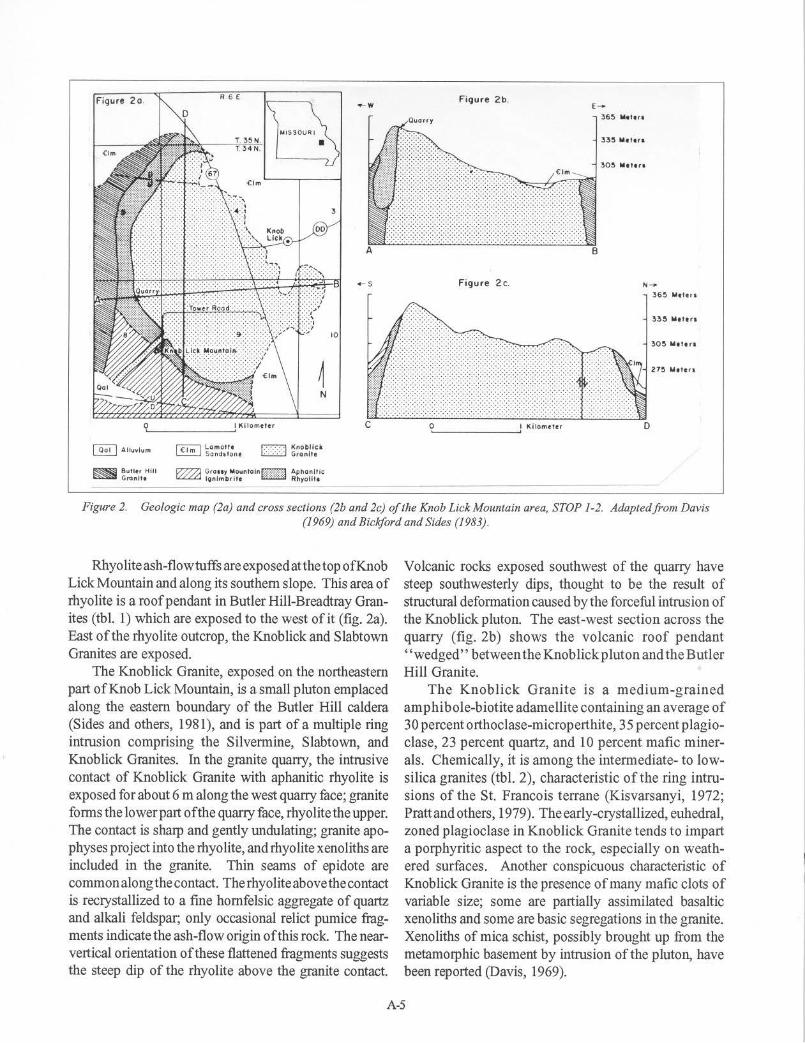
Figure 2. Geologic map (2a) and cross sections (2b and 2c) of the Knob Lick Mountain area, STOP 1-2. Adapted from Davis (1969) and Bickford and Sides (1983).
Rhyoliteash-flowtuffsareexposedatthetopofKnob Lick Mountain and along its southern slope. This area of rhyolite is a roof pendant in Butler Hill-Breadtray Granites (tbl. 1) which are exposed to the west of it (fig. 2a). East of the rhyolite outcrop, the Knob lick and Slabtown Granites are exposed.
The Knoblick Granite, exposed on the northeastern part of Knob Lick Mountain, is a small pluton emplaced along the eastern boundary of the Butler Hill caldera (Sides and others, 1981), and is part of a multiple ring intrusion comprising the Silvermine, Slabtown, and Knoblick Granites. In the granite quarry, the intrusive contact of Knoblick Granite with aphanitic rhyolite is exposed for about 6 m along the west quarry face; granite fonns the lower part of the quarry face, rhyolitethe upper. The contact is sharp and gently undulating; granite apophyses project into therhyolite, andrhyolite xenoliths are included in the granite. Thin seams of epidote are commonalongthecontact. Therhyoliteabovethecontact is recrystallized to a fine hornfelsic aggregate of quartz and alkali feldspar; only occasional relict pumice fragments indicate the ash-flow origin of this rock. The nearvertical orientation of these flattened fragments suggests the steep dip of the rhyolite above the granite contact.
Volcanic rocks exposed southwest of the quarry have steep southwesterly dips, thought to be the result of structural defonnation caused by the forceful intrusion of the Knoblick pluton. The east-west section across the quarry (fig. 2b) shows the volcanic roof pendant ''wedged'' between the Knob lick p luton and the Butler Hill Granite.
The Knoblick Granite is a medium-grained amphibole-biotite adamellite containing an average of 30 percent orthoclase-microperthite, 35 percent plagioclase, 23 percent quartz, and 10 percent mafic minerals. Chemically, it is among the intermediate- to lowsilica granites (tbl. 2), characteristic of the ring intrusions of the St. Francois terrane (Kisvarsanyi, 1972; Pratt and others, 1979). The early-crystallized, euhedral, zoned plagioclase in Knoblick Granite tends to impart a porphyritic aspect to the rock, especially on weathered surfaces. Another conspicuous characteristic of Knob lick Granite is the presence of many mafic clots of variable size; some are partially assimilated basaltic xenoliths and some are basic segregations in the granite. Xenoliths of mica schist, possibly brought up from the metamorphic basement by intrusion of the pluton, have been reported (Davis, 1969).
A-5
The dense, aphanitic rhyolite in the quarry is overlain by a porphyritic unit, the Grassy Mountain Ignimbrite, forming most of the prominent outcrops on the southern slope of Knob Lick Mountain. The somewhat bleached and recrystallized ignimbrite suggests that the intrusive contact of Knob lick Granite may not be fur below. A northsouth section across Knob Lick Mountain shows the relationship of these volcanic units and the granite (fig. 2c). Both aphanitic and porphyritic rhyolites are intruded by a 3- to6-m widedikeofporphyriticKnoblickGranite(fig. 2a).
The different weathering characteristics of granite and rhyolite, resulting in strikingly different topographic expressions, are displayed in a panoramic view from the upper southern slope of Knob Lick Mountain, immediately south of the lookout tower and parking area The large area of relatively low topographic relief to the southwest, called The Flatwoods, is underlain by Butler Hill and Breadtray Granites; hills and knobs in the distance are formed by rhyolite. Granite areas in the St. Francois Mountains tend to be gently rolling, whereas erosion-resistant volcanic rocks are commonly expressed as knobs or areas of dramatic high relief. The highest point in the State of Missouri, 532-m Taum Sauk Mountain, is within the most extensive outcrop and thickest section of volcanic rocks in the St. Francois Mountains.
Stop 1-3: Roadcuts in Slabtown Granite
Slabtown Granite is exposed in the large cuts on both sidesofHighway67 (fig. 1). TheSlabtownGraniteforms numerous small outcrops overlapped by Lamotte Sandstone, in the southeastern part of the igneous outcrop area. Drillholes between the isolated outcrops encountered Slabtown Granite at depths ofless than 30 m to over 90 m, suggesting moderate topographic relief on its erosional surface. The Slabtown Granite is part of a multiple ring intrusion, formed bytheKnoblick, Slabtown, and Silvermine Granites, along the eastern boundary of the Butler Hill caldera(Prattand others, 1979; Kisvarsanyi, 1981; Sides and others, 1981). The roadcuts at this locality expose typical Slabtown Granite: fine-grained amphibole granite consisting of about 55 percent orthoclase-microperthite, 12 percent albite-oligoclase, 20 percent quartz, 10 percent fibrous, blue-green amphibole mostly altered to chlorite, and 3 percent magnetite. Slabtown Granite commonly exhibits granophyrictexture. A chemical analysis of Slabtown Granite is shown in Table 2.
In these cuts, Slabtown Granite is intruded by small mafic dikes. Near the north end of the cut) a dike swarm is exposed on both sides of the road. Thirty or more nearly vertical basalt dikes, most of them less than 8 cm wide,
have intrudedjointsandfractures ofa 7.5-m wide, sheared interval of granite.
Enroute to Stop 4, Highway 67 passes through the western part of the historic Mine La Motte-Fredericktown subdistrict of the Southeast Missouri Lead district. The subdistrict includes some of the oldest lead-mining areas in Missouri, and was responsible for the district's only important cobalt-nickel production. Surface lead was discovered at Mine La Motte in 1720 and first mined in 1723. The Catherine Mines, located just west of Highway 67, opened in the late 1860's and operated intermittently fornearly 90 years. This tract produced an estimated 55,000 tons oflead from the sandy dolomites in the lower part of the Bonneterre Formation.
Stop 1-4: Roadcuts in Grassy Mountain Ignimbrite
At Stop 4, along Highway 72 (fig. 1), the Grassy Mountain Ignimbrite, a massive Precambrian rhyolite porphyry with well-developed joint sets is exposed on both sides of the road. A 1.2- to 1.5-m wide diabase dike has intruded the rhyolite along one of the prominent northeast-trending (N 15° E) joints and is exposed on both sides of the road. On the south side the dike is terminated at the Precambrian surface and is truncated by the overlying basal boulder conglomerate; on the north side the boulder bed is absent and the dike is exposed at the surface, on top of the roadcut. The dike is deeply weathered in the southern cut and in the upper portion of the northern cut, but is relatively fresh near the road level in the northern cut. The dike contacts are sharp, but fractured and sheared, with calcite and quartz filling narrow fractures along the sheared contact with the rhyolite. Near the west end of the cut, on the south side, a similar but much smaller dike, about 0.3 m wide, has intruded the rhyolite.
On the south side of the road, the basal Paleozoic strata lap onto the Precambrian erosional surface from the east. This cut is one of many displaying the PrecambrianPaleozoic nonconformity in the St. Francois Mountains region. The uneven, weathered surface of the rhyolite is overlain by a 1.8 m section of coarse boulder conglomerate; most of the boulders are weathered Precambrian rhyolite porphyry. Coarse sandy dolomite and dolomite of the Bonneterre Formation overlie the boulder bed
The large cuts on both sides of Highway 72 for a distance of about 3 km west of Stop 4 are in massive Grassy Mountain Ignimbrite, the major ash flow produced by the collapse of the Butler Hill caldera (Sides and others, 1981). Relicts of collapsed pumice indicate an ash-flow origin for the massive rhyolite, although devit-
A-6
rification and recrystallization of the groundmass all but completely obliterated textural features characteristic of welded ash-flow tuffs. The massive ignimbrite displays spectacular joint sets and shear planes. Two prominent shear planes on the north side of the road are parallel with a northeasterly striking, nearly vertical joint set; some displacement along these planes is indicated. Near the west end of the roadcut, on the north side, two nearly vertical, weathered diabase dikes parallel the major joint set, while a third intrusive body of diabase is in nearly horizontal contact with the rhyolite above.
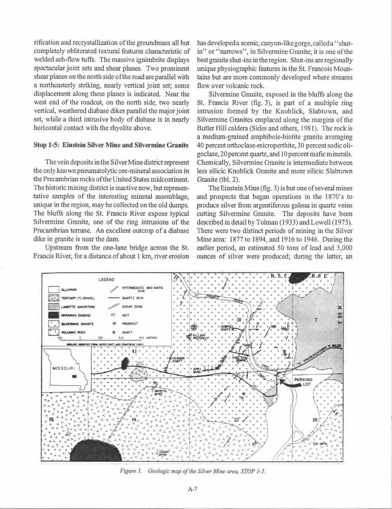
Stop 1-5: Einstein Silver Mine and Silvermine Granite
The vein deposits in the Silver Mine district represent the only known pneumatolytic ore-mineral association in the Precambrian rocks of the United States midcontinent. The historic mining district is inactive now, but representative samples of the interesting mineral assemblage, unique in the region, may be collected on the old dumps. The bluffs along the St. Francis River expose typical Silvermine Granite, one of the ring intrusions of the Precambrian terrane. An excellent outcrop of a diabase dike in granite is near the darn.
Upstream from the one-lane bridge across the St. Francis River, for a distance of about 1 km, river erosion
D Al.LlMUM
t~:f.~l TERTIARY (!) GJIAVEl
wm@j LAMOTTE SAHOSTOHE
--DIA8AS£
LEGEND
..•. ··• INTERMEO<ATE AHO MAFIC DIKE
-- QUARTZ VEIN
~//' SHEAR ZONE
=:: AOIT
D IIU/[IWINE GIIANITE ,t PROSPECT
(:J IO.CANIC IIOCK I! SHAFT )()$ 0 305 610 91 5 METER$
MJSSOUR l
•
has developed a scenic, canyon-like gorge, called a "shutin" or "narrows", in Silvermine Granite; it is one of the best granite shut-ins in the region. Shut-ins are regionally unique physiographic features in the St. Francois Mountains but are more commonly developed where streams flow over volcanic rock
Silvermine Granite, exposed in the bluffs along the St. Francis River (fig. 3), is part of a multiple ring intrusion formed by the Knoblick, Slabtown, and Silvermine Granites em placed along the margins of the Butler Hill caldera (Sides and others, 1981 ). The rock is a medium-grained amphibole-biotite granite averaging 40 percent orthoclase-microperthite, 30 percent sodic oligoclase, 20 percent quartz, and 10 percent mafic minerals. Chemically, Silvermine Granite is intermediate between less silicic Knoblick Granite and more silicic Slabtown Granite (tbl. 2).
The Einstein Mine (fig. 3) is but one of several mines and prospects that began operations in the 1870's to produce silver from argentiferous galena in quartz veins cutting Silvermine Granite. The deposits have been described in detail by Tolman (1933) and Lowell (1975). There were two distinct periods of mining in the Silver Mine area: 1877 to 1894, and 1916 to 1946. During the earlier period, an estimated 50 tons of lead and 3,000 ounces of silver were produced; during the latter, an
Figure 3. Geologic map of the Silver Mine area, STOP 1-5.
A-7

estimated 120 short tons of tungsten concentrates were produced, largely by high-grading the old dumps, and from shallow surface diggings. The remains of the dam, constructed in 1879, can be seen upstream from the mine dumps. Foundation remnants on the west hillslope south of the dam are all that remain of the large mill constructed during the silver- and tungsten-mining periods.
Of the several quartz veins mined and prospected in the area, vein no. 1, the Einstein, was the most productive; it accounted for the bulk of the early silver and lead production. It was entered by the River Tunnel, the entrance to which is about 15 m above the river. (Caution: ~ through this cl.dm is. dangerous and should nQ! .M attempted!) The vein strikes N 80° E and dips 35° S; it pinches and swells, having a maximum width ofnot over 2 m and an ore zone as much as 65 cm wide (Tolman, 1933). A pinched outcrop of the vein, where it is less than 5 cm wide, is visible above a small mine opening in the hillside, about 15 m uphill from the River Tunnel. Near the contacts the intruded granite is intensely greisenized.
The high-temperature, pneumatolytic mineral assemblage at Silver Mine includes argentiferous galena, wo lframite, arsenopyrite, sphalerite, cassiterite, chalcopyrite, covellite, hematite, stolzite, and scheelite. Quartz, topaz, sericite, fluorite, zinnwaldite, chlorite, and garnet are among the gangue minerals. Persistent search on the dump downhill from the mine may turn up good specimens. Hagni (1984) identified argentiferous tennantite, antimonpearcite, and berryite among the sulfides.
Numerous intermediate to mafic dikes older than the quartz veins have been mapped in the Silver Mine area One of these is well exposed on the east side of the St. Francis River, just below the dam. The dike is about 1.5 m wide, strikes N 65° E, and is nearly vertical. Its borders against Silvermine Granite are chilled, but its central part is coarser grained. The rock contains a few small plagioclase phenocrysts in a groundmass of andesine and augite with intergranulartexture. Euhedral magnetite and pyrite are abundantly disseminated through the groundmass, and there is a small amount of interstitial quartz.
Stop 1-6: Stouts Creek Shut-ins
Beginning about 3.2 km east oflronton on Highway 72 ( fig. 1 ), massive rhyolite ash-flow tuffs are extensively exposed. The road passes through Stouts Creek Shut-ins, one of the better known geomorphic features developed in volcanic rocks in the St. Francois Mountains region. Below the shut-ins and immediately south of the road, LakeKillamey is one of Missouri's older impoundments and a favorite vacation spot.
At the upper end of the shut-ins, immediately northwest of the bridge across Stouts Creek, is the site oftheTong-Ashebran furnace. Built in 1816, this was the first iron furnace in Missouri and produced charcoal iron from hematite ore mined nearby and on Shepherd Mountain, 5. 6 km northwest. Production ceased about 1819.
For a distance of about 1.8 km, the roadcuts and massivecliffsonthenorthsideoftheroadexposetheLake Killarney composite ash-flow tuff and the Grassy Mountain Ignimbrite, as mapped by Sides (197 6). The contact between the Lake Killarney and the overlying Grassy Mountain units is not exposed, but a coarse breccia of the Lake Killamey, containing diverse lithic clasts in a finegrained groundmass showing faint flow lines, is well exposed near the Lake Killarney sign. Farther east, most of the cuts expose Grassy Mountain Ignimbrite.
The Grassy Mountain Ignimbrite, a widespread and uniform volcanic unit in the St. Francois Mountains (Sides, 1976; Pratt and others, 1979), is characterized by abundant quartz phenocrysts, and collapsed pumice fragments that produce striking compaction foliation, manifested as prominent, discontinuous banding. It is considered to be the major collapse ash flow of the Butler Hill caldera (Sides and others, 1981 ). In these cuts, compaction foliation is nearly vertical and dips steeply to the west-southwest. ThechemicalsimilarityofGrassy Mountain Ignimbrite and the Butler Hill and Breadtray Granites is illustrated in Table 2. They represent compositions corresponding to alkali rhyolites and alkali granites, respectively.
Stop 1-7: Elephant Rocks: A Granite Tor in Graniteville Granite
This site is a classic example of a granite tor. It displays giant boulders, or core-stones, that resemble a herd of sitting elephants. The boulders are of Graniteville Granite, representative of the HHP plutons, and one of three principal granite types recognized in the St. Fran co is terrane (Kisvarsanyi, 1981 ). The granite is exposed on the margin of one of the resurgent cauldron subsidence structures in the region. The site was designated a State of Missouri Geologic Natural Area in 1978.
The prime scenic and geologic attractions of the park are the giant, picturesque residual boulders ("elephant rocks") of Graniteville Granite. The boulders are the result of a two-stage process: spheroidal weathering of block-jointed granite by circulating groundwater, followed by erosional stripping of the weathered fines.
A-8
The outcrop of Graniteville Granite is restricted to three small areas along the eastern and southeastern boundaries ofasediment-filled depression, the Belleview Valley (fig. 1). Morphologically the valley is square, bounded by straight topographic escarpments, which are especially pronounced along its northwestern and northeastern sides. Belleview Valley is considered to be afaultbounded, down-dropped Precambrian structural block; the topographic escarpments are the results of erosion along nearly vertical faults. The square-shaped Belleview Valley is a prominent feature on satellite imagery of the region (Kisvarsanyi and Kisvarsanyi, 1976).
Lookingnorthwestfromthelookoutpointinthepark, Belleview Valley appears to be a gently rolling, bowlshaped depression surrounded on the horizon by higher hills of rhyolite. Drillholes indicate that Graniteville Granite underlies the sedimentary rocks in Belleview Valley (Kisvarsanyi, 1981). Aeromagnetic maps show the pluton as an oval magnetic low coincident with Belleview Valley (Cordell, 1979).
The Graniteville Granite is a medium- to coarse-grained, muscovite-biotite alkali granite averaging 55 percent alkali feldspar, 40 peICent quartz, and less than 5 percent mafic minerals. In this rock, the common alkali feldspar is typically microcline-microperthite, but albite and orthoclasemicroperthite are also present. Both primary and secondary muscovite (sericite) occur. The rock contains a varied suite of accessory minerals, including abundant fluorite, zircon, and magnetite; cassiterite and molybdenite are less common. Locally, the granite contains complex pegmatites with topaz, beryl, muscovite, fluorite, rutile, cassiterite, and sulfide minerals. Anomalously high levels of Sn, Be, Y, Nb, and F in Graniteville Granite led to its identification as a tin-granite pluton, the only one exposed, in the St. Francois terrane (Kisvarsanyi, 1981). The granite is classified as an HHP pluton because of abnormally high uranium and thorium contents. A chemical analysis of Graniteville Granite is shown in Table 2.
GranitevilleGranite,knowncommerciallyas''Missouri Red," has been quarried in the area since 1869. By the tum of the century, building-, paving- and monumental-stone were being produced from several quarries. Blocks of Graniteville Granite were used as paving and cwbing stone in St. Louis city streets. Buildings and monuments from San Francisco, California to Pittsfield, Massachusetts bear witness to the popularity and widespread use of this beautiful rock as a construction and monumental stone. Many older homes and commercial buildings in the area are also constructed from Graniteville Granite. Today only one quarry, 0.8kmnortheastofElephantRocksStateParksurvivesasan intermittent producer of monumental stone.
SECOND DAY
ROUTE: Potosi - Graniteville - Iron Mountain - Pilot Knob - Taum Sauk Power Plant - Johnson Shut-ins -Graniteville - Potosi (fig. 1)
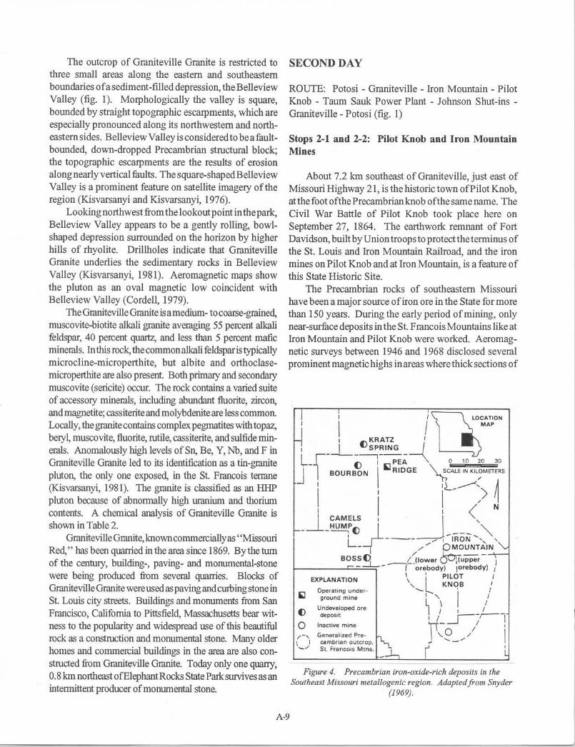
Stops 2-1 and 2-2: Pilot Knob and Iron Mountain Mines
About 7.2 km southeast of Graniteville, just east of Missouri Highway 21, is the historic town of Pilot Knob, at the foot of the Precambrian knob of the same name. The Civil War Battle of Pilot Knob took place here on September 27, 1864. The earthwork remnant of Fort Davidson, built by Union troops to protect the terminus of the St. Louis and Iron Mountain Railroad, and the iron mines on Pilot Knob and at Iron Mountain, is a feature of this State Historic Site.
The Precambrian rocks of southeastern Missouri have been a major source of iron ore in the State for more than 150 years. During the early period of mining, only near-surface deposits in the St. Francois Mountains like at Iron Mountain and Pilot Knob were worked. Aeromagnetic surveys between 1946 and 1968 disclosed several prominent magnetic highs in areas where thick sections of
I ; uO~A:~ON 1 KRATZ 1
1 j__ () SPRING /
L f"- ()--:-PE;-\.. o 10 20 30
1 -
1 BOURBON I '1 RIDGE ~CALE IN KIL~METERS
- l ' iL,.....---":) ~ I I I < N
J_ CAMELS 1 · _J , - -~() _; --- "" IL ---- / I -,RON ',, '
- // PMOUNTAIN
BOSS~ _,c_Jlower ()O\(upper - ) 1-------'-----, - 1 orebody) 1orebody) I
EXPLANATION \ 'L PILOT / , KNOB t
~ Operating under· '- •
1
I ground m ine L \ /
() Undeveloped ore J / 1 _j___ deposit 'r/ _ ~ / I 0 Inactive mine
1 ,
/-, Generalized Pre· ~ '-9 _ .,- / l \ I cambrian outcrop, -~/ St. Francois Mtns.
Figure 4. Precambrian iron-oxide-rich deposits in the Southeast Missouri metallogenic region. Adapted from Snyder
(1969).
A-9

Paleozoic sedimentary rocks cover the Precambrian basement. Subsequent drilling has delineated several magnetic ore bodies at depth; the Pea Ridge, Bourbon, Kratz Spring, Camels Hump, Boss, and Pilot Knob (lower) deposits were discovered by drilling (fig. 4). The Boss deposit is of particular interest, because it is a copper-iron ore body.
The magnetite-hematite deposits ofsoutheastMissouri constitute a Precambrian iron metallogenic province (Kisvarsanyi and Proctor, 1967) and are classified as Kiruna-type deposits on the basis of their association with acid and intermediate volcanic rocks, low titanium content of the ores, and the ubiquitous presence of apatite and, in some cases, monazite as gangue minerals. The deposits are believed to be derived from iron- and alkali-enriched fluids alternately emplaced as magmatic injections and late-stage magmatic differentiates with pegmatitic and hydrothermal end phases. The deposits display a wide variety of features ranging from magmatic injection through hydrothermal veins and disseminations, contact metasomatic replacements to volcanic exhalative impregnations. Because of the wide range of features, various theories have been advocated for the genesis of the ore bodies(seeSnyder, 1969,andRyan, 1981,forareviewof some of the theories).
The discovery in 1975 of the giant Olympic Dam deposit in South Australia (Roberts and Hudson, 1983) inspired the development of new exploration concepts pertaining to the iron-oxide-rich Middle Proterozoic ore deposits of Southeast Missouri. Hauck and Kendall (1984) developed an exploration model for an Olympic Dam-type deposit in the region and suggested the genetic similarity between the Precambrian iron ores of the Kiruna district, Southeast Missouri, and South Australia. Sims and others (1987) noted many analogies between the regional geologic settings of the metallogenic regions of southeast Missouri and south Australia, and concluded that the St. Francois terrane is generally favorable for hosting Olympic Dam-type copper-uranium-gold deposits. The discovery of gold and tellurides in the Boss deposit (Hagni and Brandom, 1988) enhances the similarities between the respective mineralizations. Similar results are indicated by current research at the Pea Ridge mine. As a result of the new developments, the U.S. Geological Survey and the Missouri Geological Survey are collaborating in a comprehensive, 5-year research to study in detail all the known Precambrian ore bodies in the region.
The Pilot Knob deposits (upper and lower ore bodies) and the Iron Mountain deposit are part of the Precambrian iron metallogenic province. Near-surface deposits in this
immediate area-the Iron Mountain, Pilot Knob (upper ore body), and numerous smaller deposits--yielded magnetite and hematite ores amounting to nearly 11 million tons. Most productive of these early mines was Iron Mountain which yielded about 9 million tons of ore between 1843 and 1966 and was operated more or less continuously for 123 years.
The upper ore body at Pilot Knob consisted entirely ofhematite in porous and permeable Precambrian bedded tuffs. Many authorities support a hydrothermal-replacement origin for the deposit; others favor a syngenetic hypothesis. The deposit was worked intermittently between 1835 and the 1920's, and yielded a total of 1.6 million tons of ore. The big cut at the top of the mountain, a memento of the early open-pit operations, is clearly visible as a "notch" from the highway. The geology and history of the Pilot Knob hematite deposit are described in detail by Ryan (1981).
The lower ore body at Pilot Knob was discovered by drilling a magnetic high in the valley just west of Pilot Knob Mountain. The ore body is a roughly tabular mass of magnetite concordant with the enclosing rhyolite ash-flowtuffs. Matrix and disseminated magnetite were emplaced by injection and hydrothermal replacement, respectively (Wracher, 1976). Ore depth ranged from 122 meters to 457 meters below the surface. The mine was permanently shut down in 1980 after yielding more than 19 million tons of ore in 12 years of operation. Remnants of the intergrated mine, mill, and pellet plant are still to be seen east of the highway, at the foot of Pilot Knob.
The historic Iron Mountain mine is about 8 km north of Pilot Knob (fig. 1). Three types oforeoccurredatlron Mountain: boulder ore, vein ore, and conglomerate ore. The boulder ore, the firsttype to be discovered and mined, consisted of hematite boulders embedded in surface residual clays. The vein ore occurred as several massive veins in Precambrian volcanic rocks, and was mined at first by open-pit methods from the Big Cut and Hayes Cut. Later, when magnetic surveys and exploratory drilling disclosed the deeper, vein-type ore bodies (Main Ore Body, Northwest Ore Body), underground methods were also employed. The conglomerate ore, worked mostly by underground methods, occurred in the basal conglomerate between the Precambrian rocks and the overlying Upper Cambrian sediments. By far the greatest production was from the vein deposits. Both the boulder ore and the conglomerate ore were derived from erosion of a primary, vein-type ore body. The geology of the Iron Mountain deposit is described in detail by Murphy and Ohle (1968).
A-10

Stop 2-3: Taum Sauk Mountain Section
One of the most spectacular geologic sites in the state, the three-dimensional cut around Union Electric Company's power plant displays the erosional unconformity between Precambrian rhyolite and overlying Upper Cambrian sedimentary rocks. Both a buried rhyolite knob and a partially exhumed rhyolite knob can be observed in the 33-m-high cut. The site is within the thickest section of volcanic rocks in the St. Francois Mountains, and is part of the Taum Sauk caldera (Berry and Bickford, 1972).
The U-shaped cut at the power station exposes massive Precambrian ash-flow tuff, the Taum Sauk Rhyolite (tbl. 1) overlain by Upper Cambrian sedimentary rocks. The Taum Sauk Rhyolite is considered to be the major collapse ash-flow of the Taum Sauk caldera (Sides and others, 1981). Thecutstandssome33mabovethetailrace and reveals a spectacular three-dimensional cross section of the Precambrian-Paleozoic erosional unconformity. Weathering has produced a few tens offeet ofrelief on the rhyolite surface. In the north face of the cut, the rhyolite knob is exposed at the ground surface, the overlying sediments having been removed by erosion. In the east and south faces of the cut, the knob is still buried by sediments.
The rhyolite is overlain by beds of shaly and arkosic dolomite, a sequence of alternating stromatolitic and burrowed carbonate muds assigned by Howe ( 1968) to the upper Davis Formation and the Derby-Doerun Dolomite. The dolomite laps onto the Precambrian surface from the west and has a maximum dip of 25 degrees. The steep dips are attributed to differential compaction of unconsolidated sediments deposited over the uneven rhyolite surface. The combined effects of carbonate solution, dolomitization, and compaction of argillaceous layers caused a loss of volume in the sedimentary beds; some relative movement of the sediments with respect to the rhyolite knob may have occurred.
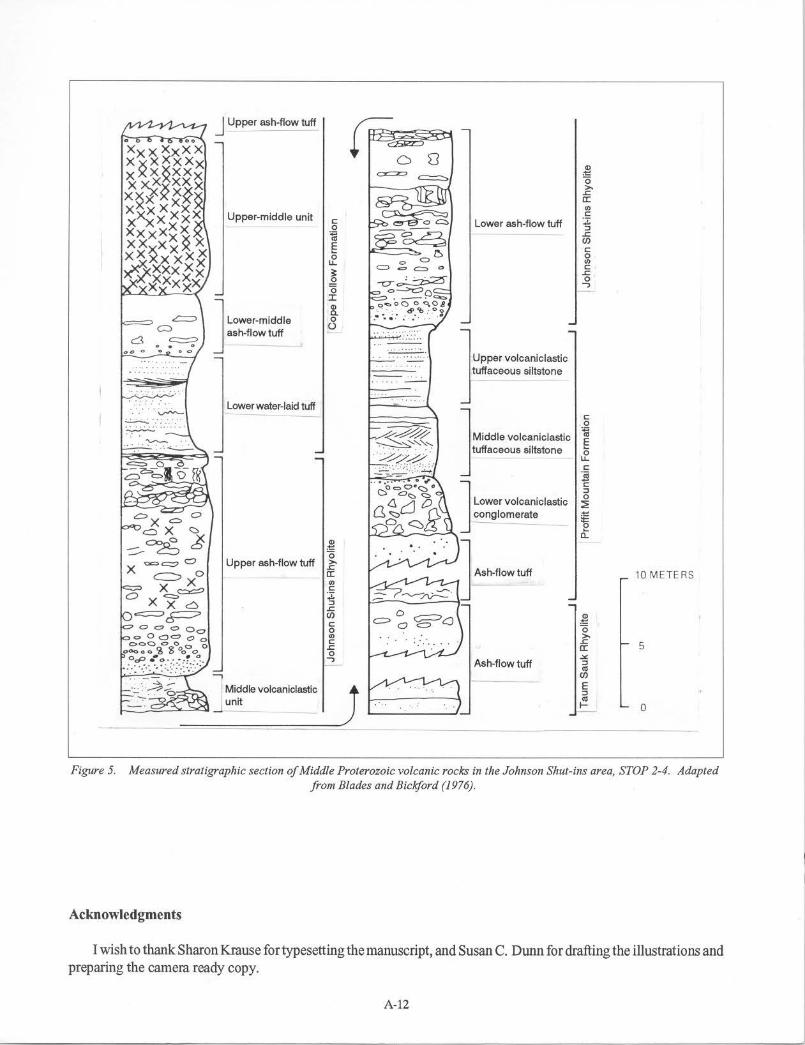
Stop2-4: JohnsonShut-insSequenceofRhyoliteAshFlow Tuffs
Johnson Shut-ins is an excellent example of the regionally unique geomorphic features called shut-ins. Shut-ins are narrow, constricted gorges and valleys where a stream has cut through resistant igneous rocks. Upstream and downstream from a shut-in, a relatively wide and open valley is developed on less resistant sedimentary rocks.
At Johnson Shut-ins State Park a 1.6-km-long segment of the East Fork of the Black River cuts through a thick sequence of Precambrian rhyolites. Stream erosion in the shut-ins is controlled by three important vertical joint sets in the rhyolites: northeast, southeast, and east. These are the principal directions of joint sets characteristic of all Precambrian outcrops in the region.
A 650-m thick sequence of rhyolitic ignimbrites and intercalated volcaniclastic sediments is well exposed in the shut-ins; the rocks display well-preserved volcanic-rock textures and constitute the best easily accessible section of such rocks in the St. Francois Mountains.
The Johnson Shut-Ins Rhyolite (tbl. 1 ), a composite series of ash-flow tuffs and water-laid tuffs (fig. 5), is well exposed in the shut-ins (Blades and Bickford, 1976). The ash-flow tuffs are dark gray to red in color and display fiamme, pisolites, and lithic fragments indicative of pyroclastic origin. Lithophysal units in the sequence have quartz-, feldspar-, and calcite-filled lithophysae.
Several volcaniclastic sedimentary units are interbedded with the ash-flow tuffs (fig. 5). A uniform, gray, fine-grained water-laid tuff with ripple marks, cross-bedding, and finely graded bedding is exposed directly across the river from the observation platform.
A-11
J Upper ash-flow tuff w~8 0 oo
Xxx XxXX x~x~xxx -~ X X XXx x~*xxx 0
>,
X~x ~* .s:; a: "' x~xxxx Upper-middle unit C
X XXX C: Lower ash-flow tuff z 0 :, xxxxxx ~ .s:;
xx*xx~ x E (/)
C:
XX ~xXQ 0 0 u. "' 4 xx~x C: . ~ .s:; .Q -0-~
0 .f-Xxxx .., 0 o->c:::>o I • -· <a,::, G> o""OC) 0 Q,08 a. -.~ ~--~ .· · .. ~-~.:_.o.~ J L-•·mlddlo 0
ash-flow tuff 0
c::3 oo 0 ·..:..:..:...:...
] Upp,, volcao;,1.,,;, - - ... . tuffaceous siltstone
. . . . . . . Lower water-laid tuff C:
. 0 J M;ddl• volcM;,1,•;, ~ E tuffaceous siltstone 0 u.
C: s C: :, J t.ow., volca,;,1a•;, 0 ~
c:,x = conglomerate ~ ----c::> X <:::. ct ::::-C)o6 8 G>
}h-flowtuff
·"' 0 ==o Upper ash-flow tuff >,
X c=:, o .s:; a: 10 METERS
X X "' C 0 =er;::> -;1:
Xxc :, .s:;
c::::::=:::>~ (/) 0 -~ C c::::, C) ~ CJ
0 0 "' >, C: .s:;
5 .s:; a: 0 .::.:. ..,
Ash-flow tuff :, <II
(/)
J E :, <II I- 0
Figure 5. Measured stratigraphic section of Middle Proterozoic volcanic rocks in the Johnson Shut-ins area, STOP 2-4. Adapted from Blades and Bickford (1976) .
Acknowledgments
I wish to thank Sharon Krause for typesetting the manuscript, and Susan C. Dunn for drafting the illustrations and preparing the camera ready copy.
A-12

REFERENCES
Anderson, R.E., 1970,Ash-jlow tuffe of Precambrian age in southeast Missouri (Contribution to Precambrian Geology No. 2): Missouri Geological Survey and Water Resources, Report of Investigations 46, 50 p.
Berry, A.W., 1976, Proposed stratigraphic column for Precambrian volcanic rocks, western St. Francois Mountains, Missouri, in Kisvarsanyi, E.B., ed., Studies in Precambrian Geology of Missouri (Contribution to Precambrian Geology No. 6): Missouri Department of Natural Resources, Division of Geology and Land Survey, Report of Investigations 61, p. 81-90.
Berry, A.W., and Bickford, M.E., 1972, Precambrian volcanics associated with the Taum Sauk caldera, St. Francois Mountains, Missouri, USA. : Bulletin Volcanologique, v. 36-2, p. 303-318.
Bickford, M.E., Harrower, K.L., Hoppe, W.J., Nelson, B.K., Nusbaum, R.L., and Thomas, J.J., 1981, Rb-Sr and U-Pb geochronology and distribution of rock types in the Precambrian basement of Missouri and Kansas: Geological Society of America Bulletin, Part I, V. 92, p. 323-341.
Bickford, M.E., and Sides, J.R., 1983, Geologic map of exposed Precambrian rocks in the Wachita Mountain (Fredericktown NWI/4) quadrangle, Missouri (Contribution to Precambrian Geology No. 11 ): Missouri Department of Natural Resources, Division of Geology and Land Survey Open-File Map OFM-83-161-MR, scale 1:24,000.
Blades, E.L., and Bickford, M.E., 1976, Rhyolitic ashflow tuffe and intercalated volcaniclastic tuffaceous sedimentary rocks at Johnson Shut-ins, Reynolds County, Missouri, in Kisvarsanyi, E.B., ed., Studies in Precambrian Geology of Missouri (Contribution to PrecambrianGeologyNo. 6): MissouriDepartmentof Natural Resources, Division of Geology and Land Survey, Report of Investigations 61, p. 91-104.
Cordell, L., 1979, Gravity and aeromagnetic anomalies over basement structure in the Rolla quadrangle and the southeast Missouri lead district: Economic Geology, V. 74,p. 1383-1394.
Davis, J.W., 1969, Petrogenesis and structure of the Knoblick Granite (Masters thesis): St. Louis University, St. Louis.
Hagni, R.D ., 1984, Ore microscopy of the silver minerals in the epigenetic Ag-W-Sn deposits in the Silver Mine district, southeastern Missouri, US.A., in Wauschkuhn, A., and others, eds., Syngenesis and Epigenesis in the Formation of Mineral Deposits: Berlin, SpringerVerlag, p. 52-61.
Hagni, R.D., and Brandom, R.T., 1988, Comparison of the Boss-Bixby, Missouri and Olympic Dam, South Australia ore deposits, and the potential for these deposits in the mid-continent region in Kisvarsanyi, G. and Grant, S.K., eds., North American Conference on Tectonic Control of Ore Deposits, Proceedings Volume: Rolla, Missouri, University of Missouri at Rolla, p. 333-345.
Hauck, S.A., and Kendall, E.W., 1984, Comparison of Middle Proterozoic iron oxide rich ore deposits, Midcontinent US.A., South Australia, Sweden, and the Peoples Republic of China: Thirtieth Annual Institute on Lake Superior Geology, Abstracts, p. 17-18.
Hayes, W.C., 1947, Geology of the Ozark-Martin mine area, Madison County, Missouri (Masters thesis): Rolla, Missouri School of Mines and Metallurgy.
Howe, W.B., 1968, Planar stromatolite and burrowed carbonate mud facies in Cambrian strata of the St. Francois Mountain area: Missouri Geological Survey and Water Resources, Report of Investigations 41, 113 p.
Kisvarsanyi, E.B., 1972, Petrochemistry of a Precambrian igneous province, St. Francois Mountains, Missouri (Contribution to Precambrian Geology No. 4): Missouri Geological Survey and Water Resources, Report of Investigations 51, 103 p.
___ , 1981, Geology of the Precambrian St. Francois terrane, Southeastern Missouri (Contribution to Precambrian Geology No. 8): Missouri Department of Natural Resources, Division of Geology and Land Survey, Report of Investigations 64, 60 p.
Kisvarsanyi,E.B.,Hebrank,A.W.,andRyan, R.F., 1981, Guidebook to the geology and ore deposits of the St. Francois Mountains, Missouri (Contribution to PrecambrianGeologyNo. 9): MissouriDepartmentof Natural Resources, Division of Geology and Land Survey, Report of Investigations 67, 119 p.
A-13
Kisvarsanyi, Geza, and Kisvarsanyi, E.B., 1976, Orthopolygonal tectonic patterns in the exposed and buried Precambrian basement of southeast Missouri, in Hodgson, R.A., Gay, S.P., and Benjamins, J.Y., eds., Proceedings of the First International Conference on the New Basement Tectonics: Salt Lake City, Utah Geological Association Publication n. 5, p. 169-182.
Kisvarsanyi, Geza, and Proctor, P.D., 1967, Trace element content of magnetites and hematites, Southeast Missouri Iron Metallogenic Province, U.S.A.: Economic Geology, v. 62, p.449-471.
Lowell, G.R, 1975, Precambrian geology and ore deposits of the Silver Mine area, southeast Missouri: A review in Lowell, G.R., ed., A Fieldguide to the Precambrian Geology of the St. Francois Mountains, Missouri: Cape Girardeau, Southeast Missouri State University, p. 81-88.
Murphy, J.E., and Ohle, E.L., 1968, The Iron Mountain Mine, Iron Mountain, Missouri, in Ridge, J.D., ed., Ore Deposits of the United States, 1933-1967 (The Graton-Sales volume): American Institute of Mining, Metallurgical, and Petroleum Engineers, v. 1, p. 287-302.
Pomerene, J.B., 1947, Geology of the Einstein-Apex tungsten mine area (Masters thesis): Rolla, Missouri School of Mines and Metallurgy.
Pratt, W.P., Anderson, R.E., Berry, A.W., Jr., Bickford, M.E., Kisvarsanyi, E.B., and Sides, J.R., 1979, Geologic map of exposed Precambrian rocks, Rolla J0x2° quadrangle, Missouri: U.S. Geological Survey Miscellaneous Investigation Series Map 1-1161, scale 1:125,000.
Roberts, D.E., and Hudson, G.R.T., 1983, The Olympic Dam copper-uranium-gold deposit, Roxby Downs, South Australia: Economic Geology, v. 78, p. 799-822.
Ryan, R.F., 1981, The Pilot Knob hematite deposit in Kisvarsanyi, E.B., Hebrank, A.W., and Ryan, R.F.,
Guidebook to the Geology and Ore Deposits of the St. Francois Mountains, Missouri: Missouri Department of Natural Resources, Division of Geology and Land Survey, Report of Investigations 67, p. 111-119.
Sides, J.R., 1976, Stratigraphy of volcanic rocks in the Lake Killamey quadrangle, Iron and Madison Counties, Missouri, in Kisvarsanyi, E.B., ed., Studies in Precambrian Geology of Missouri (Contribution to PrecambrianGeologyNo. 6): MissouriDepartmentof Natural Resources, Division of Geology and Land Survey, Report of Investigations 61, p. 105-113.
Sides, J.R., Bickford, M.E., Shuster, R.D., and Nusbaum, R.L., 1981, Calderas inthePrecambrian terraneofthe St. Francois Mountains, southeastern Missouri: Journal of Geophysical Research, v. 86, p. 10349-10364.
Sims, P.K., Kisvarsanyi, E.B., and Morey, G.B., 1987, Geology and metallogeny of Archaen and Proterozoic basement terranes in the northern midcontinent, U. SA. --An overview: U.S. Geological Survey Bulletin 1815, 51 p.
Snyder,F.G., 1969,PrecambrianirondepositsinMissouri, in Wilson, H.D.B., ed., Magmatic Ore Deposits -A Symposium: Economic Geology Monograph 4, p. 231-238.
Tolman, C., 1933, The geology of the Silver Mine area, Madison County, Missouri: Missouri Bureau of Geology and Mines, 57th Biennial Report of the State Geologist, 1931-1932, Appendix 1, 39 p.
Tolman, C., and Robertson, F., 1969, Exposed Precambrian rocks in southeast Missouri (Contribution to Precambrian Geology No. 1): Missouri Geological Survey and Water Resources, Report of Investigations 44, 68 p.
Wracher, D.A., 1976, GeologyofthePilotKnob magnetite deposit, southeast Missouri, in Kisvarsanyi, E.B., ed., Studies in Precambrian Geology of Missouri: Missouri Division of Geology and Land Survey, Report of Investigations 61, p. 155-163.
A-14
IGCP Project-31S--Pield Trip to the Rapakivi GranitC$ and Related Rocks in the SL Francois Mountains, 1993
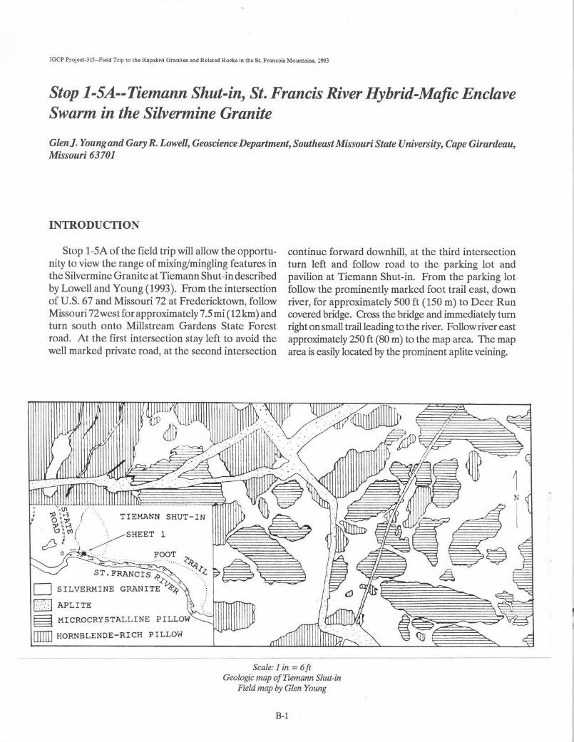
Stop 1-SA--Tiemann Shut-in, St. Francis River Hybrid-Ma.fie Enclave Swarm in the Silvermine Granite
Glen]. Young and Gary R. Lowell, Geoscience Department, Southeast Missouri State University, Cape Girardeau, Missouri 63701
INTRODUCTION
Stop 1-5A of the field trip will allow the opportu- continue forward downhill, at the third intersection nity to view the range of mixing/mingling features in turn left and follow road to the parking lot and theSilvermineGraniteat Tiemann Shut-in described pavilion at Tiemann Shut-in. From the parking lot by Lowell and Young (1993). From the intersection follow the prominently marked foot trail east, down of U.S. 67 and Missouri 72 at Fredericktown, follow river, for approximately 500 ft (150 m) to Deer Run Missouri 72westfor approximately7.5 mi (12km) and covered bridge. Cross the bridge and immediately turn turn south onto Millstream Gardens State Forest right on small trail leading to the river. Follow river east road. At the first intersection stay left to avoid the approximately 250 ft (80 m) to the map area. The map well marked private road, at the second intersection area is easily located by the prominent aplite veining.
Scale: 1 in = 6 ft Geologic map of Tiemann Shut-in
Field map by Glen Young
B-1

HOST ROCK
The Sivermine Granite is a medium-grained (1.5 mm average), hypidiomorphic-granular rock composed of sodic plagioclase, microperthitic orthoclase, and quartz accompanied by about 4 percent biotite and 2-3 percent hornblende. Biotite and hornblende are generally corroded and partly chloritized. Apatite, magnetite, calcite, zircon, and sphene are the accessory phases, the latter forming subhedra as large as 1.5 mm. Sericitic alteration of both feldspar phases is pervasive and is particularly intense in the cores of zoned plagioclase (Lowell, 1991).
HORNBLENDE RICH PILLOWS
Hornblende-rich pillows comprise approximately 50 percent of the enclave population and are finemedium seriate rocks composed of plagioclase, microperthi te, and quartz accompanied by 10-15 percent acicular, partially corroded and chloritized, hornblende. Apatite, biotite, magnetite, and zircon are accessory minerals. Slender apatite crystals with axial ratios as high as 31:1 are indicative of rapid crystallization (Wyllie and others, 1962; Frost and Mahood, 1987). Pillows range in size from centimeters to meters and contain sporadic rounded xenocrysts of mantled K-feldspar and quartz ocelli ( amphibolemantled quartz grains) which point to hybridation (Lindberg and Eklund, 1988). Gradations exist between isolated xenocrysts and partially digested granite. Within individual enclaves, boundaries range from sharp to gradational. The hornblende-rich pillows sometimes host smaller microgranular hybrid enclaves.
REFERENCES
Frost, T.P., and Mahood, G.A, 1987,Field, chemical, and physical constraints on mafic-felsic magma interaction in the Lamarck Granodiorite, Sierra Nevada, California: Geological Society of America Bulletin, v. 99, p. 272-291.
Lindberg, B., and Eklund, 0., 1988, Interactions between basaltic and granitic magmas ina Svecofennian postorogenic granitoid intrusion, Aland, southwest Finland: Lithos, v. 22, p. 13-23.
MICROCRYSTALLINE PILLOWS
Dark microcrystalline pillows comprise approximately 50 percent of the enclave population and are composed of quartz, plagioclase, hornblende, and biotite with a biotite:hornblende ratio of > 1 and apatite, magnetite, and zircon as accessory phases. Xenocryst phases and quenched apatite morphologies are the same as in the hornblende-rich pillows. However, thexenocrysts are more evenly distributed in these enclaves. These pillows also range in size from centimeters to meters and exhibit the same variable contacts as the hornblende-rich pillows. However, some of these pillows are intensely netveined suggesting pillow fragmentation while the granitic host was still mobile.
APLITE VEINS
Numerous moderately controlled aplite veins crosscut the granite and hybrid-mafic pillows. The aplite veins have quenched margins (megascopically granophyric in places) and contain small inclusions of the pillows and granite.
MAFICDIKES
Several strongly controlled, northeast trending, fine-grained mafic dikes post-date the hybrid-rnafic pillows, the granite, and theapliteveins in the shut-in area. The dikes themselves are cut by a later, northwest trending shear zone.
Lowell, G.R., 1991, The Butler Hill Caldera: a midProterozoic ignimbrite-granite complex: Precambrian Research, v. 51, p. 245-263.
Lowell, G.R., and Young, G.J., In press, Coexisting mafic-felsic magmas in the St. Francois Terrane of southeastern Missouri: Field and chemical evidence from the Silvennine Granite ( abstract): Geological Society of America, Abstracts with Program, v. 25.
Wyllie, P.J., Cox, KG., and Biggar, G.M., 1962, The habit of apatite in synthetic systems and igneous rocks: Journal of Petrology, v. 3, p. 238-243.
B-2
Source: Report of Investigations 61, Studies in Precambrian Geology of Missouri with a guidebook to Parts of the St. Francois Mountains, p. 140-148, 1976.
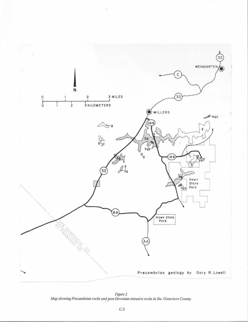
Petrography of Precambrian Rocks in the Hawn State Park Area, Ste. Genevieve County, Missouri
Gary R. Lowell, Earth Science Department, Southeast Missouri State University, Cape Girardeau, Missouri 63701
INTRODUCTION
The crystalline rocks which are the subject of this report are exposed in the drainages of Jonca and Pickle Creeks in the vicinity of Hawn State Park (T. 36 N., R. 7 E.) in Ste. Genevieve County, Missouri. These exposures of Precambrian rock are structurally situated along the axis of the NW-SE-trending Farmington anticline (McCracken, 1971 ), which locally coincides with a drainage divide in the area.
The first published map to show the general distribution of Precambrian rock types in Ste. Genevieve County wasthatofHaworth(l895). WellerandSt. Clair(1928) published very generalized descriptions of the Precambrian rocks of Ste. Genevieve County and indicated their distribution on an accompanying map. The unpublished thesis by Kidwell (1942) provided the best description, by far, of these Precambrian rocks.
GEOLOGIC RELATIONSHIPS
The Precambrian rocks in the Hawn State Park area are the northeasternmost exposure of the St. Francois Mountains igneous province. They are of particular petrologic interest because of recent suggestions that they may represent the deepest exposed level of a wellpreserved volcanic-plutonic complex which has been tilted to the west or southwest (Lowell, in press; Bickford and Mose, 1975).
Wheeler (1965) also discussed these rocks, in connection with his overthrust hypothesis, as representing the true (autochthonous) structural apex of the Ozark Dome. Whatever the tectonic interpretation, the crystalline rocks of the Hawn State Park area display a compositional and textural diversity not encountered elsewhere in the surface exposures of the Missouri Precambrian terrane. What follows is a general petrographic description of the major rock types exposed in the Hawn State Park vicinity. Mineral-composition data, majorelement chemistry, and selected-trace-element data will appear in a subsequent paper (Lowell, Bickford, and Sides, in prep.).
METAMORPIDCROCKSANDASSOCIATED DIKES
GRANODIORITE GNEISS The oldest rock exposed in the Hawn State Park area
occurs along the footpath which follows Pickle Creek north from the park picnic grounds (NWY<i sec. 14, T. 36 N., R. 7 E.). Weller and St. Clair (1928) reported that "gray granite" is younger than "red granite" in this location, but this is not correct. In spite of very limited outcrop area and obscured contacts, it is easily shown that the opposite is true. Evidence for this contention consists of: (a) numerous inclusions of gray, foliated granodiorite in blocks ranging up to 5 ft in diameter which are enveloped by pink granite along Pickle Creek; (b) veinlets of posttectonic granitic material which cut across the foliation of the gray gneiss in boulders along Pickle Creek; and ( c) float from a prospect pit along the inferred contact between the granite and the granodiorite gneiss which includes fragments of sericitized and epidotized granodiorite gneiss ( epidote replacement zones cut foliation). Some confusion no doubt resulted from the convention of mapping all gray, acidic rocks in the area as "granite" (Kidwell, 1942). In the context of this paper that designation would include both the granodiorite geniss (pre-granite age) in Pickle Creek and small, isolated intrusions of biotite-granodiorite porphyry (possibly of post-granite age) found along Jonca Creek and the upper reaches of Pickle Creek (fig. 1).
The granodiorite gneiss possesses a penetrative foliation which ranges from gneissic in coarse-grained samples to nearly schistose in fine-grained samples. Mafic schlieren are numerous; some tend to parallel the foliation, others tend to disrupt it. Thin, pre-tectonic, aplitic veinlets are cut by the foliation. Microscopically, the general texture is decussate-granoblastic, and the average modal composition is about 60 percent plagioclase, 15 percent quartz, 15 percent hornblende and biotite, and 10 percent mesoperthite. Apatite, zircon, sphene, and opaques are the typical accessory minerals. Locally, the biotite-hornblende content may approach 40 percent.
C-1
The plagioclase appears to be of two generations. The pre-tectonic grains of plagioclase are larger and more altered than the syntectonic grains and display concentric zoning, twin-lamellae deformation, and some mortar structure. The less-abundant, syntectonic plagioclase appears mainly as rounded grains, with both Carlsbad and albite twinning, often poikiloblastically enclosed by hornblende or biotite. The plagioclase composition is in the range of calcic oligoclase to sodic andesine. Quartz is present as unaltered, rounded, interstitial grains with undulatory extinction, and as poikiloblastic inclusions in biotiteandhomblende. Both brown (pre-tectonic?) and green (syntectonic?) biotite are present as ragged, kinked grains often displaying polysynthetic twinning. In some sections the boitite is riddled with inclusions ofapatite, sphene, zircon, quartz, plagioclase, and opaque grains. The hornblende is frequently kinked and twinned, sometimes shows mortar structure, and contains inclusions of quartz and plagioclase. Microcline is present in small amounts as patch wise replacements of quartz and plagioclase which produce ''ice calce'' texture. Minor pale-green muscovite was noted in a few sections. Myrmekite occurs along some microcline-plagioclase grain boundaries. Mesoperthite, showing excellent braid-and-ribbon texture, is present in small amounts.
Microscopic examination of the mafic schlieren indicates an assemblage of hornblende, green biotite, quartz, later plagioclase, and opaque grains with a granoblastic-elongate texture. Only a few remnant early-plagioclase grains persist in the schlieren and these possess distinct mortar structure.
Field and petrographic evidence suggest that the granodiorite gneiss is a piece of older basement crust which was transported surfaceward as xenolith. U-Pb measurements on zircon separates, however, yield a probablecrystallizationageofl,500+-30m.y.(Bickford and Mose, 1975), which appears incompatible with the interpretation that the gneiss is older, unless the zircons have been completely reset.
BIOTITE-GRANITE PEGMA TITE The granodiorite gneiss contains a poorly exposed
dike(?) of very coarse-grained biotite-granite pegmatite just off the footpath along Pickle Creek and north of the picnic grounds of Hawn State Park. According to Weller and St. Clair (1928), this deposit was once worked commercially for feldspar under the name ''Niedringhaus Pegmatite Pit.''
The rock is pink to red in color, has well-developed graphic texture, and contains books ofbronzy, euhedral
C-2
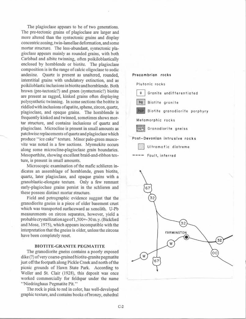
Precambrian rocks
Plutonic rocks
[!J Granite undifferentiated
~ Biotite granite
II Biotite granodiorite porphyry
Metamorphic rocks
e Granodiorite gneiss
Post-Oevon·lan Intrusive rocks
~ Ultramafic diatreme
Fault, inferred
0
I 0
I 2
N
I
2 I
3 MI LES I
3 KILO METERS
Figure 1
Pre cambr ia n ge o lo g y b y Ga r y R. Lowell
Map showing Precambrian rocks an~ post-Devonian intrusive rocks in Ste. Genevieve County.
C-3
biotite up to 5 inches in length. The major components of the rock are very large ( over 1 inch) crystals of pink microcline-micorperthite (string perthite) with faint gridiron twinning, kink banding, and mortar structure along grain boundaries. Quartz is present as optically continuous, graphic intergrowths in microcline hosts and as ragged anhedra riddled with trains of fluid inclusions. It has undulatory extinction. A small amount of strongly sericitized euhedral to subhedral sodic plagioclase is present. Giant crystals ofbronzy to green biotite replace both plagioclase and microcline-microperthite and exhibit abundant opaque grains (magnetite?) along cleavages. Quartz replaces plagioclase, fills the sheared grain boundaries around microcline, and partially envelopes biotite. Paragenetic relationships between quartz and biotite are not clear from the sections studied. Accessory minerals consist of zircon inclusions in microcline, plagioclase, and biotite, and apatite inclusions in plagioclase. The modal composition of the pegmatite is that of granite. To the author's knowledge, this type of pegmatite is unknown elsewhere in the St. Francois Mountains. Since it is apparently restricted to the granodiorite gneiss, it further contributes to the unique aspects of that body.
PLUTONICROCKSAND ASSOCIATED DIKES
A large number of textural variants of plutonic rocks can be mapped from the outcrops of igneous rock in the Hawn State Park area. However, the lack of a suitable base map for the western portion of the Weingarten 15-minute quadrangle (1907) and the absence of detailed chemical and isotopic data necessitate, for the present at least, rather broad groupings for these rocks. Accordingly, the following informal field designations are adopted for descriptive purposes in this paper. The order of presentation does not imply relative age relationships among the units. The dikes, of course, are younger than their hosts, but no other age relationships are known with certainty at present.
BIOTITE-GRANODIORITE PORPHYRY Several small, isolated outcrops of biotite
granodiortie porphyry are found in the Hawn Park vicinity (fig. 1). The best-exposed of these is found in NWI/4 sec. 22, T. 36 N., R. 7 E., where the rock weathers to prominent spheroidal boulders. Typically, the fresh rock is medium-grained, pinkish-gray, phaneritic-seriate to phanerophyric, and possesses numerous small clots of fresh, equant biotite grains. Microscopically, the texture is hypidiomorphic-granular;
euhedral and subhedral grains are very sparse, however. The modal composition is estimated as 30 percent intermediate plagioclase, 25 percent quartz, 25 percent biotite, 15 percent microcline-microperthite, and 3 percent hornblende. Zircon, apatite, and opaque grains are present as accessory materials, and muscovite, hematite, and clay are found as secondary minerals. At the locality along Jonca Creek (sec. 9) miarolitic cavities containing fluorite, quartz, and pyrite were observed in float samples.
The plagioclase phenocrysts are zoned, rounded, partially altered to clay, and twinned by both the Carlsbad and albite laws. Anhedral, microperthitic microcline commonly replaces and rims the corroded plagioclase phenocrysts, forming "anti-rapakivi" texture. Neither granophyric intergrowths nor myrmekite were present in any of the sections examined. Brown and green varieties of biotite are each present as subhedral grains; the green biotite contains inclusions of brown biotite. Biotite replaces twinned hornblende along its cleavages and embays it along grain boundaries. A few inclusions of feldspar and pyroxene(?) were observed in the hornblende. Anhedral quartz fills interstices and replaces plagioclase, biotite, and microcline. Only one generation of quartz is present, and this is fresh, free of mineral inclusions, and has undulatory extinction. The mineralogy and texture of the rock is that ofbiotite granodiorite, and the striking resemblance between this unit and the Knob lick Granite ( chemically and petrographically also granodiorite) suggests a possible correlation. Chemical and isotopic data are being obtained to test this hypothesis.
BIOTITE GRANITE Biotite granite occurs in the Hawn Park area as
widespread, low, rounded outcrops which are typical of granite exposures in the St. Francois Mountains. The rock weathers to brownish-red, but is pinkish-gray when fresh. The texture is coarse to medium in grain size, hypidiomorphic-granular, and seriate. Locally, rapakivi texture can be recognized both in thin section and outcrop (particularly on weathered surfaces). Estimates of modal composition for a typical specimen are 20 percent sodic plagioclase, 10 percent to 30 percent microcline-microperthite, 10 percent to 30 percent orthoclase-microperthite, 30 percent quartz, 5 percent to 15 percent biotite, and O to 5 percent hornblende. Accessory minerals include apatite, zircon, pyrite, fluorite, and opaque minerals other than pyrite. The most distinctive feature of this rock is the presence of fresh, black biotite plates which exhibit a glomeroporphyritic tendency in some outcrops.
C-4

In thin section, subhedral plagioclase is concentrically zoned, with the grain cores invariably replaced by clay; the grains are twinned by both the Carlsbad and albite laws. Microcline, which may form very large grains, appears to replace orthoclase in all of the sections examined. Brown biotite, exhibiting kink bands and undulatory extinction, is slightly altered to chlorite in some sections, and may be replaced along its cleavages by quartz. Quartz is present as fractured grains which are replaced by microcline-orthoclase grains and have undulatory extinction, and as clear anhedra which replace all other mineral phases (two generations). Twinned hornblende was present in small quantities in some of the sections examined and absent in others. One very ragged pyroxene inclusion in a quartz grain was observed in a section of biotite granite from Jonca Creek (NWI/4 sec. 10). It is probable that detailed mapping of the bodies designated as biotite granite would permit division of this unit into facies which (a) do or do not possess hornblende and (b) do or do not exhibit rapakivi texture. Except for the abundance of fresh biotite, the biotite granites of Hawn Park closely resemble the Butler Hill rapakivi granites described by Lowell and Sides (1973).
GRANITE UNDIFFERENTIATED This designation includes those granitic bodies which
have not yet been studied in detail. For the most part, these rocks are medium- to coarse-grained, pink leucogranites and leucocratic rapakivi granites (lacking hornblende and containing less than 5 percent biotite). Locally, they may contain swarms of xenoliths; some of these appear to be volcanic material. These bodies closely resemble the Butler Hill Granite, which is exposed approximately 15 mi southwest of the Hawn Park region (Tolman and Robertson, 1969). Efforts to determine whether these rocks are correlative with the Butler Hill Granite are currently underway; the results of these studies will be reported in a subsequent paper.
RAP AKIVI-PORPHYRY DIKES An extremely interesting dike rock is well exposed in
the valley of Pickle Creek (NWY.. sec. 14, T. 36 N., R. 7 E.), just beyond the Niedringhaus Pegmatite Pit (fig. 1). The dike is vertical, strikes N 30° E, and cuts both granodiorite gneiss and undifferentiated granite. It is unconformably overlain, as are all the crystalline rocks of the area, by the Lamotte Sandstone. Weathered surfaces of the rock are dark-brown, while fresh exposures are distinctly pink. Kidwell (1942) described the rock as rhyolite porphyry.
The dike is cut by veinlets of quartz and black; finegrained, opaque material and is distinctly aphanophyric. Phenocrysts of microperthite (up to 1 inch), sodic plagioclase, quartz, and biotite compose 50 percent of the rock; they are set in a matrix consisting mainly of granophyre and myrmekite. Pink ovoidal orthoclase phenocrysts contain inclusions of quartz, plagioclase, and hornblende and are zonally replaced by microcline; twinning in the orthoclase-microperthite ovoids is by the Carlsbad and Baveno laws. Highly altered, multigranular mantles of sodic plagioclase envelope and replace many of the ovoid orthoclase phenocrysts, producing rapakivi texture. The growth of the plagioclase mantles appears to have been controlled by the orthoclase cleavage. Large, em bayed quartz phenocrysts indicate active resorption. The quartz grains have undulatory extinction, are shattered, and enclose biotite inclusions; fluid inclusions are very abundant along fractures. A small number of extremely ragged, green biotite grains are present as phenocrysts; these grains show kinked cleavage and are replaced by matrix material. Subhedral insets of kink-banded and altered sodic plagioclase are also present in small amounts.
Matrix material, mainly granophyre, with lesser amounts of myrmekite, replaces all of the phenocryst materials and composes about 50 percent of the rock. Small, remnant grains of phenocrystic material are scattered throughout the matrix. Zircon, apatite, and opaque minerals are present in accessory amounts. Calcite, clay, and sericite-muscovite are present as secondary minerals replacing phenocrysts.
The rock described above is a granophyre in the classic sense (Johannsen, 1931 ), but the mantled ovoids of orthoclase suggest kinship to the rapakivi porphyries of Finland described by Marmo (1971 ), hence the selection of the name given. The dike clearly carries an imprint of mechanical deformation. At one outcrop, orthoclase and quartz phenocrysts are definitely strung out into lensoidal pods defining a foliation somewhat divergent from the strike of the dike itself. Scattered float of this distinctive rock has been observed upstream from the dike exposure along Pickle Creek, but no other outcrop has been found. ·
GRANOPHYRE AND APLITE DIKES A dike which cuts biotite granite about 400 ft north
of Jonca Creek bridge (NWY.. sec. 9, T. 36 N., R. 7 E.) is a red granophyre. This dike is about 20 ft wide and is poorly exposed on the west side of the road; it was described by Kidwell (1942) as red granite porphyry. The fresh rock is pink, with weathered surfaces of
C-5
mottled brown, and its texture is aphanophyric. Phenocrysts of orthoclase-microperthite, plagioclase, and quartz compose 50 percent of the rock and are enveloped and corroded by a matrix composed largely of granophyric intergrowths of quartz and feldspars. No ferromagnesian minerals are present. Quartz phenocrysts form about 25 percent of the rock; they are rounded, clear, fractured, have undulatory extinction, and are replaced along the fractures by the groundmass. Large, euhedral phenocrysts of orthoclase-microperthite compose about 22 percent of the rock; microcline was not present in the sections studied from this locality. A small number of sodic-plagioclase phenocrysts, amounting to perhaps 5 percent of the total rock, are present; these show some vermicular intergrowths of quartz along grain boundaries and are sericitized and replaced by matrix granophyre. Zircon and opaque minerals are the only accessory minerals. The granophyric matrix contains a very small amount (2 percent) of pale-green muscovite.
Aplites are relatively rare in the exposures of plutonic rock in the Hawn Park area The best-exposed aplite is in an abandoned quarry east of Highway 32 (C, SEY.. sec. 7, T. 36 N., R. 7 E.). A single dike (about 5 inches wide) can be traced over a distance of 60 ft. The aplite is hosted by biotite rapakivi granite which is represented by the only existing chemical analysis in the area (E.B. Kisvarsanyi, 1972, MGS No. 64).
MAFICDIKES
Plutonism in the Hawn Park vicinity was succeeded by the emplacement of mafic dikes. Presumably, the latter event was part of a period of basic hypabyssal activity which affected both exposed and unexposed portions of the St. Francois Mountains igneous terrane (Tolman and Robertson, 1969; Amos and Desborough, 1970; E.B. Kisvarsanyi, 1974). The mafic rocks in the Hawn State Park area are very poorly exposed and are represented, for the most part, by scattered float boulders. Kidwell (1942) reported seeing a mafic dike in place in a tributary to Jonca Creek (NWY.. sec. 9, T. 36 N.,R. 7E.), and Weller and St. Clair(1928) reported one at Jonca Falls (Sec. 2, T. 36 N., R. 7 E.); the writer was unable to find either of these exposures. The writer did find a mafic dike cutting biotite granite in the roadcut of Highway 144 about 400 ft north of Jonca Creek. This dike is adjacent and parallel(?) to the dike of granophyre described above. The dike is about 25 ft wide, and
weathers to a buff to brown color. The fresh rock is black, aphanophyric, and carries distinctive, ragged clots of pyrite. In thin section the texture is subophitic.
Euhedral phenocrysts of zoned and altered plagioclase compose about 5 percent of the rock. A single quartz grain, very ragged and em bayed, and possessing a reaction corona of fibrous muscovite(?) was observed. The matrix is composed mainly of unzoned plagioclase laths (50 percent) and pyroxene (35 percent) which is partially interstitial to, and partially enveloping, the plagioclase. Opaque minerals, mainly pyrite, form an impressive 10 percent of the rock. Apatite is very abundant as an accessory (1 percent) and forms extremely long, slender crystals. Secondary clay replaces the pryoxene and plagioclase; the former replacement is very extensive.
Kidwell ( 1942) reported mafic float in NWY.. sec. 22, T. 36 N., R. 7 E. which the author was able to find and examine. The float was a linear distribution (N 40° E) which may be indicative of the trend of the dike. The writer's location of this material is topographically lower than that shown by Kidwell (1942) and is along the boundary between Sec. 15 and Sec. 22. The rock is buff to yellowish-brown on weathered surfaces and has a distinctive, "knotty" appearance which results from its glomeroporphyritic texture. Phenocrysts of altered euhedral plagioclase form clots composing 5 to 10 percent of the rock. The aphanitic matrix has an intergranular texture, with plagioclase interstices filled by altered pyroxene and opaque minerals. A small amount (less than I percent) of quartz is present in this rock also, but it is fresh, equant, and lacks a reaction corona. The groundmass is composed of fresh, zoned, sharply twinned plagioclase laths which amount to about 60 percent of the rock volume. Matrix pyroxene forms an estimated 20 percent of the rock. Cubes of pyrite are very abundant (7 percent); criss-crossing opaque laths (ilmenite?) compose an additional 1 percent. Apatite is present mainly as inclusions in matrix plagioclase. The plagioclase phenocrysts are altered to clay and carbonate; the pyroxene is partially replaced by clay and chlorite.
Kidwell (1942) studiedmafic dike rocks from localities different than those described above and noted that epidote was abundant and pyroxene lacking in all sections examined. The only extensive epidote mineralization noted by the present writer is along the contact between the granodiorite gneiss and granite above Pickle Creek, but no mafic dikes are present at that locality.
C-6
REFERENCES
Amos, D.H., and G.A. Desborough, 1970, Majic intrusive rocks of Precambrian age in southeast Missouri (Contribution to Precambrian Geology No. 3): Mo. Geol. Survey and Water Resources, Rept. Inv. 47, 22 p.
Bickford, M.E., and D.G. Mose, 1975, Geochronology of Precambrian rocks in the St. Francois Mountains, southeastern Missouri: Geol. Soc. America, Spec. Paper 165, 48 p.
Haworth, E., 1895, Crystalline rocks of Missouri: Mo. Geol. Survey, v. 8, p. 80-222.
Johannsen, Albert, 1931, A descriptive petrography of the igneous rocks: U. Chicago Press, v. 1,318 p.
Kidwell, A.L., 1942, The igneous geology of Ste. Genevieve County Missouri: Unpubl. Masters thesis, Washington U., St. Louis, MO.
Kisvarsanyi, E.B., 1972, Petrochemistry of a Precambrian igneous province, St. Francois Mountains, Missouri (Contribution to Precambrian Geology No. 4): Mo. Geol. Survey and Water Resources, Rept. Inv. 51, 96 p.
____ , 1974, Operation Basement: buried Precambrian rocks of Missouri -- their petrography and structure: Am. Assoc. Petroleum Geologists Bull., v. 58, p. 674-684.
Lowell, G.R., (in press), Chemical variation of the St. Francois Mountains batholith of southeast Missouri: Geol. Soc. America Bull.
Lowell, G.R., andJ.R. Sides, 1973, The occurrence and origin of rapakivi granite in the St. Francois Mountains batholith of southeast Missouri (abs.): Geol. Soc. America, Abs. with Programs, v. 5, n. 4, p. 332-333.
Marmo, V., 1971, Granite petrology and the granite problem: Elsevier Publ. Co., New York, 244 p.
McCracken, M.H., 1971, Structuralf eatures of Missouri: Mo. Geol. Survey and Water Resources, Rept. Inv. 49, 99 p.
Tolman, C., and F. Robertson, 1969, Exposed Precambrian rocks in southeast Missouri (Contribution to Precambrian Geology No. 1): Mo. Geol. Survey and Water Resources, Rept. Inv. 44, 68 p.
Weller, S., and S. St. Clair, 1928, Geology of Ste. Genevieve County, Missouri: Mo. Geol. Survey, v. 22, 2nd ser., 352 p.
Wheeler, H.E., 1965, Ozark pre-Cambrian-Paleozoic relations: Am Assoc. Petroleum Geologists Bull., v. 49, p. 1647-1665.
C-7

Geological Society of America Centennial Field G11ide-North-Central Section, 1987 • Knob Lick Mountain section: Intrusive contact of Precambrian granite with rhyolite in the St. Francois Mountains, Missouri
Eva B. Kisvarsanyi and Arthur W. Hebrank, Missouri Geological Survey, Rolla, Missouri 65401
LOCATION
Knob Lick Mountain, in the eastern part of the St. Francois Mountains, is about 9.5 mi (15.2 km) south of Farmington, in St. Francois County, Missouri (Wachita Mountain 7h-minute Quadrangle). Rising to a gentle elevation of 1,333 ft (400 m) above sea level, Knob Lick Mountain may be reached by following Knob Lick Tower Road for l.1 mi (1.75 km) west of its junction with U.S. 67,just south of the village of Knob Lick (Fig. la), to the parking lot by the lookout tower atop Knob Lick Mountain (NE1ANE1ASE1A,Sec.8,T.34N.,R.6E.). A panoramic view of the St. Francois Mountains is afforded from the bald, I 00 ft (30 m) south of the lookout tower. The intrusive contact of granite with rhyolite is exposed in an abandoned granite quarry, marked on Figure la (SW1ANBl.iNE1A,Sec.8,T.34N.,R.6E.), about 2,000 ft (600 m) northwest from the lookout tower. Ac~
Figure lo.
0
~ Alluvium
~ Butler HIii ~ Granite
R.6 E
MISSOURI T. 35N. T. 34N.
-Cim
I Mlle
~ Lamotte ~ Knobllck L.:..:.!!:...J Sandstone ~ Granite
177771 Grassy Mountainf:::·:~:::::::;;} Aphanltic rLLLLJ lonlmbrite ... ~ ........ · Rhyollle
--w
10
C
to the quarry is provided by the old ridge road; walk 2,000 ft (600 m) due northwest from the lookout tower on old ridge road, then 200 ft (60 m) due east through the woods to the quarry. Visit of this site involves about a 1.5-hour hike. The site is on public land.
SIGNIFICANCE
The St. Francois Mountains constitute the exposed portion of an extensive Precambrian terrane of anorogenic, granitic ring complexes and a8$0Ciated rhyolites that underlie most of southeastern Missouri (Kisvarsanyi, 1981). This igneous terrane is of regional interest not only because it is a splendid example of an unmetamorphosed, Proterozoic granite-rhyolite terrane, but also because it forms the only extensive outcrops of rocks whose ages range from 1.48 to 1.45 Ga in the southern mid-continent region
Figure I b.
Figure le.
0 I Mlle ~--------~
E-1200 Feet
IIOOFeel
IOOOFeet
B
N-+ 1200Feet
IIOOFeel
IOOO Feet
900Feet
D
Figure 1. Geologic map and cross sections of the Knob Lick Mountain area. Map la is modified from Davis (1969), and Bickford and Sides (1983). East-west (lb) and north-south (le) cross sections are from Davis (1969).
155

156 E. B. Kisvarsanyi and A. W. Hebrank
TABLE 1. PRECAMBRIAN ROCK UNITS IN THE ST. FRANCOIS MOUNTAINS
St. Francois Mountains St. Francois Mountains Volcanic Supergroup Int rus ive Suite
Hypabyssal Rocks3 Plutonic Rocks3
Taum Sauk Groupl
Johnson Shut-ins Rhyolite Taum Sauk Rhyolite Royal Gorge Rhyolite
Graniteville Granite
Bell Mountain Rhyolite Wildcat Mountain Rhyolite Russell Mountain Rhyol ite Lindsey Mountain Rhyolite Ironton Rhyolite
Buford Granite Porphyry Munger Granite Porphyry Carver Creek Granite Porphyry
Buck Mountain Shut- ins Formation Pond Ridge Rhyolite Cedar Bluff Rhyolite Shepherd Mountain Rhyolite
Butler Bill Group2
Pilot Knob Felsite Grassy Mountain Ignimbrite Lake Killarney Formation
Brown Mounta i n Rhyolite Porphyry Silvermine-Knoblick Granites Slabtown-Stono Granites Butler Hill-Breadtray Granites
lvolcanic units defined by Berry (1976). 2volcanic units defined by Sides (1976). 3Formal names from Tolman and Robertson (1969).
(Bickford and others, 1981 ). The Precambrian terrane has been deeply eroded and dissected, resulting in a rugged topography and the unroofing of granite. Upper Cambrian marine sedimentary rocks are in nonconformable contact with the underlying igneous rocks. Near the crest of the Ozark dome, the dominant regional structure, the Precambrian outcrops of the St. Francois Mountains represent a structural and topographic high. The granitic ring complexes correspond to the deeply eroded root region of a formerly more extensive volcanic terrane comprising several calderas, cauldron subsidence structures, ring intrusions, and resurgent cauldrons with central plutons.
In the entire Precambrian outcrop area of the St. Francois Mountains, the Knob Lick Mountain quarry affords the best exposure illustrating the intrusive relationship of granite into rhyolite. The granite, mapped as Knoblick Granite (Tolman and Robertson, 1969; Pratt and others, 1979), is one of three principal types recognized in the Precambrian terrane, and is representative of the ring intrusions in the St. Francois Mountains. The view from the lookout tower illustrates the strikingly different topographic expressions of granite and volcanic-rock terrains in the St. Francois Mountains.
DESCRIPTION
Rhyolitic ash-flow tuffs are exposed at the top of Knob Lick Mountain, along its southern slope, and in a narrow belt for about 10 mi (16 km) southward. This area of rhyolite, mapped as Grassy Mountain lgnimbrite (Bickford and Sides, 1983), is a roof
pendant in Butler Hill-Breadtray Granites (Table 1), which are exposed to the west of it (Fig. la). East of the rhyolite outcrop, the Knoblick and Slabtown Granites are exposed.
The Knoblick Granite, exposed on the northeastern part of Knob Lick Mountain (Fig. la), is a small pluton emplaced along the eastern boundary of the Butler Hill caldera (Sides and others, 1981 ), and is part of a multiple ring intrusion comprising the Silverrnine, Slabtown, and Knoblick Granites. In the granite quarry, the intrusive contact of Knoblick Granite with aphanitic rhyolite is exposed for about 20 ft (6 m) along the west quarry face; granite forms the lower 6 ft (2 m) of the quarry face, rhyolite the upper few feet (Fig. 2). The contact is sharp and gently undulating; granite apophyses project into the rhyolite, and rhyolite xenoliths are included in the granite. Thin seams of epidote are common along the contact. The rhyolite above the contact is recrystallized to a fine hornfelsic aggregate of quartz and alkali feldspar; only occasional relict pumice fragments indicate the ash-flow origin of this rock. The near-vertical orientation of these flattened fragments suggests the steep dip of the rhyolite above the granite contact. Volcanic rocks exposed southwest of the quarry have steep southwesterly dips, the result of structural deformation caused by the forceful intrusion of the Knoblick pluton (Davis, 1969). The east-west section across the quarry (Fig. 1 b) shows the volcanic roof pendant "wedged" between the Knoblick pluton and the Butler Hill Granite.
The Knoblick Granite is a medium-grained amphibolebiotite adamellite containing an average of 30 percent orthoclasemicroperthite, 35 percent plagioclase, 23 percent quartz, and 10
Knob Lick Mountain section, St. Francois Mountains, Missouri 157
Figure 2. Distant and close-up views of intrusive contact between Knoblick Granite (below) and rhyolite (above). Note prominent rhyolite xenolith near point of hammer in distant view. Photos by Art Hebrank.
percent mafic minerals. Chemically, it is among the intermediateto low-silica granites, characteristic of the ring intrusions of the St. Francois terrane (Kisvarsanyi, 1972; Pratt and others, 1979). The early-crystallized, euhedral, zoned plagioclase in Knoblick Granite tends to impart a porphyritic aspect to the rock, especially on weathered surfaces. Another conspicuous characteristic of Knoblick Granite is the presence of many mafic clots of variable size; some are partially assimilated basaltic xenoliths and some are basic segregations in the granite. Xenoliths of mica schist, possibly brought up from the metamorphic basement by intrusion of the pluton, have been reported (Davis, 1969).
The dense, aphanitic rhyolite in the quarry is overlain by a porphyritic unit, the Grassy Mountain lgnimbrite, forming most of the prominent outcrops on the southern slope of Knob Lick Mountain (Fig. la). The somewhat bleached and recrystallized ignimbrite suggests that the intrusive contact of Knoblick Granite may not be far below. A north-south section across Knob Lick Mountain shows the relationship of these volcanic units and the granite (Fig. le). Both aphanitic and porphyritic rhyolites are intruded by a IO- to 20-ft-(3- to 6-m) wide dike of porphyritic Knoblick Granite (Fig. la), well exposed in small prospect pits on the barren southern slope of the mountain, just below the lookout tower. The dike strikes N 40° E and has been mapped for 3,000 ft (900 m) down the mountain slope by Bickford and Sides (1983).
The different weathering characteristics of granite and rhyolite, resulting in strikingly different topographic expressions, are displayed in a panoramic view from the upper southern slope of
Knob Lick Mountain, immediately south of the lookout tower and parking area (Fig. 3). The large area of relatively low topographic relief to the southwest, called The Flatwoods, is underlain by Butler Hill and Breadtray Granites; hills and knobs in the distance are formed by rhyolite. Granite areas in the St. Francois Mountains tend to be gently rolling, whereas erosion-resistant volcanic rocks are commonly expressed as knobs or areas of dramatic high relief. The highest point in the State of Missouri, 1,772-ft (532-m) Taum Sauk Mountain, is within the most extensive outcrop and thickest section of volcanic rocks in the St. Francois Mountains (Kisvarsanyi, Hebrank, and Ryan, 1981).
158 E. B. Kisvarsanyi and A. W. Hebrank
Figure 3. View of "The Flatwoods," an area of relatively low topographic relief, looking southwest from the top of Knob Lick Mountain. The Flatwoods is underlain by Butler Hill and Breadtray Granites; hills along the distant horiron are volcanic rocks more resistant to weathering. Outcrops in the foreground are Grassy Mountain lgnimbrite. Photo by Jerry Vineyard.
REFERENCES
Berry, A. W., 1976, Proposed stratigraphic column for Precambrian volcanic rocks, western St. Francois Mountains, Missouri, in Kisvarsanyi, E. B., ed., Studies in Precambrian Geology of Missouri (Contribution to Precambrian Geology No. 6): Missouri Department of Natural Resources, Geological Survey, Report of Investigations 61, p. 81-90.
Bickford, M. E., Harrower, K. L., Hoppe, W. J., Nelson, B. K., Nusbaum, R. L., and Thomas, J. J., 1981, Rb-Sr and U-Pb geochronology and distribution of rock types in the Precambrian basement of Missouri and Kansas: Geological Society of America Bulletin, Part I, v. 92, p. 323-34 l.
Bickford, M. E., and Sides, J. R., 1983, Geologic map of exposed Precambrian rocks in the Wachita Mountain (Fredericktown NW l/4) quadrangle, Missouri (Contribution to Precambrian Geology No. l l ): Missouri Department ofNatural Resources, Geological Survey Open-File Map OFM-83-161-MR, scale 1 :24,000.
Davis, J. W., 1969, Petrogenesis and structure of the Knoblick Granite [Masters thesis]: St. Louis, St. Louis University.
Kisvarsanyi, E. B., 1972, Petrochemistry of a Precambrian igneous province, St. Francois Mountains, Missouri (Contribution to Precambrian Geology No. 4): Missouri Geological Survey and Water Resources, Report of Investigations 51, l 03 p.
-1981, Geology of the Precambrian St. Francois terrane, southeastern Mis-
souri (Contribution to Precambrian Geology No. 8): Missouri Department of Natural Resources, Geological Survey, Report of Investigations 64, 60 p.
Kisvarsanyi, E. B., Hebrank, A. W., and Ryan, R. F., 1981, Guidebook to the geology and ore deposits of the St. Francois Mountains, Missouri (Contribution to Precambrian Geology No. 9): Missouri Department of Natural Resources, Geological Survey, Report of Investigations 67, 119 p.
Pratt, W. P., Anderson, R. E., Berry, A. W., Jr., Bickford, M. E., Kisvarsanyi, E. B., and Sides, J. R., 1979, Geologic map of exposed Precambrian rocks, Rolla l"x2° quadrangle, Missouri: U.S. Geological Survey, Miscellaneous Investigations Series, I-1161, scale 1:125,000.
Sides, J. R., 1976, Stratigraphy of volcanic rocks in the Lake Killarney quadrangle, Iron and Madison Counties, Missouri, in Kisvarsanyi, E. B., ed., Studies in Precambrian Geology of Missouri (Contribution to Precambrian Geology No. 6): Missouri Department of Natural Resources, Geological Survey, Report oflnvestigations 61, p. 105- 113.
Sides, J. R., Bickford, M. E., Shuster, R. D., and Nusbaum, R. L., 1981, Calderas in the Precambrian terrane of the St. Francois Mountains, southeastern Missouri: Journal of Geophysical Research, v. 86, p. 10349-10364.
Tolman, C., and Robertson, F., 1969, Exposed Precambrian rocks in southeast Missouri (Contribution to Precambrian Geology No. 1): Missouri Geological Survey and Water Resources, Report of Investigations 44, 68 p.

Geological Society of America Centennial Field Guide- North-Central Section, 1987 • Elephant Rocks: A granite tor in Precambrian Graniteville Granit"1, the St. Francois Mountains, Missouri
Eva B. Kisvarsanyi and Arthur W. Hebrank, Missouri Geological Survey, Rolla, Missouri 64501
LOCATION
SE1/.iSE4NE1ASec.15,T.34N.,R.3E., Elephant Rocks State Park, Iron County, Missouri; Graniteville 7~-minute Quadrangle. Entrance to the park is from Missouri RA, 0.7 mi (1.2 km) west of its junction with Missouri 21 (Fig. 1). From the parking lot, follow marked trail to the lookout point near the top of the hill. The site is on public land.
SIGNIFICANCE
This site is a classic example of a granite tor. It displays giant boulders, or core-stones, that resemble a herd of sitting elephants (Fig. 2). The boulders are of Graniteville Granite, representative of tin-granite central plutons, and one of three principal granite types recognized in the Precambrian St. Francois terrane (Kisvarsanyi, 1981 ). The granite is exposed on the margin of one of the resurgent cauldron subsidence structures in the region. The site was designated a State of Missouri Geologic Natural Area in 1978.
DESCRIPTION
10
15
~ Quarries
.
1
Elephant
Rocks . ~
I State Ou rry .
· Pork j Parki g lot .
.J uorry
0
0 0.5KM
M ISSOURI
•
0.5MI
The prime scenic and geologic attraction of the park are the giant, picturesque residual boulders ("elephant rocks") of Graniteville Granite. The boulders are the result of a two-stage proc-
Figure I. Location map of Elephant Rocks State Park, Iron County, Missouri .
.... --·-...... ---Figure 2. "Elephant Rocks": spheroidally weathered giant boulders of Graniteville Granite in Elephant Rocks State Park. In this view to the northeast, the largest "elephant" atop the granite bald is 25 ft (7.5 m) high. Photo by Art Hebrank.
159
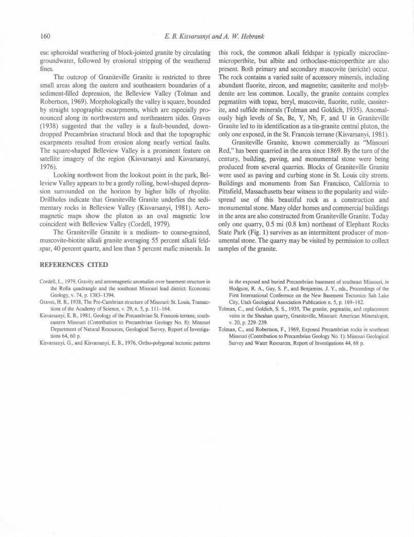
160 E B. Kisvarsanyi and A. W Hebrank
ess: spheroidal weathering of block-jointed granite by circulating groundwater, followed by erosional stripping of the weathered fines.
The outcrop of Graniteville Granite is restricted to three small areas along the eastern and southeastern boundaries of a sediment-filled depression, the Belleview Valley (Tolman and Robertson, 1969). Morphologically the valley is square, bounded by straight topographic escarpments, which are especially pronounced along its northwestern and northeastern sides. Graves (1938) suggested that the valley is a fault-bounded, downdropped Precambrian structural block and that the topographic escarpments resulted from erosion along nearly vertical faults. The square-shaped Belleview Valley is a prominent feature on satellite imagery of the region (Kisvarsanyi and Kisvarsanyi, 1976).
Looking northwest from the lookout point in the park, Belleview Valley appears to be a gently rolling, bowl-shaped depression surrounded on the horizon by higher hills of rhyolite. Drillholes indicate that Graniteville Granite underlies the sedimentary rocks in Belleview Valley (Kisvarsanyi, 1981). Aeromagnetic maps show the pluton as an oval magnetic low coincident with Belleview Valley (Cordell, 1979).
The Graniteville Granite is a medium- to coarse-grained, muscovite-biotite alkali granite averaging 55 percent alkali feldspar, 40 percent quartz, and less than 5 percent mafic minerals. In
REFERENCES CITED
Cordell, L., 1979, Gravity and aeromagnetic anomalies over basement structure in the Rolla quadrangle and the southeast Missouri lead district: Economic Geology, v. 74, p. 1383- 1394.
Graves, H.B., 1938, The Pre-Cambrian structure of Missouri: St. Louis, Transactions of the Academy of Science, v. 29, n. 5, p. 111-164.
Kisvarsanyi, E. B., 1981, Geology of the Precambrian St. Francois terrane, southeastern Missouri (Contribution to Precambrian Geology No. 8): Missouri Department of Natural Resources, Geological Survey, Report of Investigations 64, 60 p.
Kisvarsanyi, G., and Kisvarsanyi, E. B., 1976, Ortho-polygonal tectonic patterns
this rock, the common alkali feldspar is typically rnicroclinemicroperthite, but albite and orthoclase-microperthite are also present. Both primary and secondary muscovite (sericite) occur. The rock contains a varied suite of accessory minerals, including abundant fluorite, zircon, and magnetite; cassiterite and molybdenite are less common. Locally, the granite contains complex pegmatites with topaz, beryl, muscovite, fluorite, rutile, cassiterite, and sulfide minerals (Tolman and Goldich, 1935). Anomalously high levels of Sn, Be, Y, Nb, F, and U in Graniteville Granite led to its identification as a tin-granite central pluton, the only one exposed, in the St. Francois terrane (Kisvarsanyi, 1981).
Graniteville Granite, known commercially as "Missouri Red," has been quarried in the area since 1869. By the turn of the century, building, paving, and monumental stone were being produced from several quarries. Blocks of Graniteville Granite were used as paving and curbing stone in St. Louis city streets. Buildings and monuments from San Francisco, California to Pittsfield, Massachusetts bear witness to the popularity and widespread use of this beautiful rock as a construction and monumental stone. Many older homes and commercial buildings in the area are also constructed from Graniteville Granite. Today only one quarry, 0.5 mi (0.8 km) northeast of Elephant Rocks State Park (Fig. 1) survives as an intermittent producer of monumental stone. The quarry may be visited by permission to collect samples of the granite.
in the exposed and buried Precambrian basement of southeast Missouri, in Hodgson, R. A., Gay, S. P., and Benjamins, J. Y., eds., Proceedings of the First International Conference on the New Basement Tectonics: Salt Lake City, Utah Geological Association Publication n. 5, p. 169-182.
Tolman, C., and Goldich, S.S., 1935, The granite, pegmatite, and replacement veins in the Sheahan quarry, Graniteville, Missouri: American Mineralogist, V. 20, p. 229-239.
Tolman, C., and Robertson, F., 1969, Exposed Precambrian rocks in southeast Missouri (Contribution to Precambrian Geology No. I): Missouri Geological Survey and Water Resources, Report of Investigations 44, 68 p.
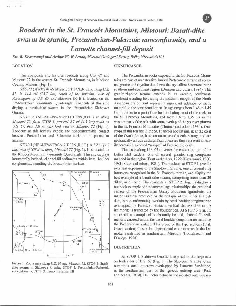
..
Geological Society of America Centennial Field Guide-North-Central Section, 1987 • Roadcuts in the St. Francois Mountains, Missouri: Basalt-dike swarm in granite, Precambrian-Paleozoic nonconformity, and a
Lamotte channel-fill deposit Eva B. Kisvarsanyi and Arthur W. Hebrank, Missouri Geological Survey, Rolla, Missouri 64501
LOCATION
This composite site features roadcuts along U.S. 67 and Missouri 72 in the eastern St. Francois Mountains, in Madison County, Missouri (Fig. 1).
STOP 1 (NW1/.iSW1/.iNE1/.iSec.35,T.34N.,R.6E.), along U.S. 67, is 14.8 mi (23. 7 km) south of the junction, west of Farmington, of U.S. 67 and Missouri W It is located on the Fredericktown 71h-minute Quadrangle. Roadcuts at this stop display a basalt-dike swarm in the Precambrian Slabtown Granite.
STOP 2 (NE'ASE1/.iNWl/.iSec.l l,T.33N.,R.6E.) is along Missouri 72; from STOP 1, proceed 2. 7 mi ( 4.3 km) south on U.S. 67, then 1.8 mi (2.9 km) west on Missouri 72 (Fig. 1). Roadcuts at this locality expose the nonconformable contact between Precambrian and Paleozoic rocks in a spectacular manner.
STOP 3 (NE1/.iNEl/.iNEl/.iSec.9,T.33N.,R.6E.) is 1. 7 mi (2. 7 km) west of STOP 2, along Missouri 72 (Fig. 1). It is located on the Rhodes Mountain 71h-minute Quadrangle. This site displays horizontally bedded, channel-fill sediments within basal boulder conglomerate mantling the Precambrian surface.
MISSOUR I
• 34 36
T. 34 N. T. 33 N. W W
~ <D I'-
i' a: a:: .....
·" o' ~ Oj
5 4 3 2 6
9 10
,Ito Silver Mine e 33miles
0 I MILE
Figure l. Route map along U.S. 67 and Missouri 72. STOP 1: Basaltdike swarm in Slabtown Granite; STOP 2: Precambrian-Paleowic nonconformity; STOP 3: Lamotte cbannel fill.
161
SIGNIFICANCE
The Precambrian rocks exposed in the St. Francois Mountains are part of an extensive, buried Proterozoic terrane of epizonal granite and rhyolite that forms the crystalline basement in the southern mid-continent region (Denison and others, 1984). This granite-rhyolite terrane extends in an arcuate, southwestnortheast-trending belt along the southern margin of the North American craton and represents significant addition of sialic material to the continental crust. Its age ranges from 1.48 to 1.45 Ga in the eastern part of the belt, including most of the rocks in the St. Francois Mountains, and from 1.4 to 1.35 Ga in the western part of the belt with some overlap of the younger plutons in the St. Francois Mountains (Thomas and others, 1984). Outcrops of this terrane in the St. Francois Mountains, near the crest of the Ozark dome, have an unsurpassed scenic beauty, and are geologically unique and significant because they represent an easily accessible, exposed "sample" of Proterozoic crust.
The route along U.S. 67 traverses the eastern margin of the Butler Hill caldera, one of several granitic ring complexes mapped in the region (Pratt and others, 1979; Kisvarsanyi, 1980, 1981; Sides and others, 1981). The roadcuts at STOP 1 provide excellent exposures of the Slabtown Granite, one of several ring intrusions recognized in the St. Francois terrane, and display the best example of a basalt-dike swarm, comprising more than 30 dikes, in outcrop. The roadcuts at STOP 2 (Fig. 1) display a textbook example of fundamental age relationships: the erosional surface of the Precambrian Grassy Mountain Ignimbrite, the major ash flow produced by the collapse of the Butler Hill caldera, is nonconformably overlain by basal boulder conglomerate overlapped by Paleozoic strata; a vertical diabase dike in the ignimbrite is truncated by the boulder bed. At STOP 3 (Fig. 1), an excellent example of horizontally bedded, channel-fill sediments is exposed within the basal boulder conglomerate mantling the Precambrian surface. This is one of the type sections (Oak Grove section) illustrating depositional environments in the Lamotte Sandstone in southeastern Missouri (Houseknecht and Ethridge, 1978).
DESCRIPTION
At STOP 1, Slabtown Granite is exposed in the large cuts on both sides of U.S. 67 (Fig. 1). The Slabtown Granite forms numerous small outcrops overlapped by Lamotte Sandstone, in the southeastern part of the igneous outcrop area (Pratt and others, 1979). Drillholes between the isolated outcrops en-
162 E. B. Kisvarsanyi and A. W Hebrank
Figure 2. Part of a basalt-dike swarm intruded along joints and fractures in Slabtown Granite. East side of U.S. 67, STOP 1. Photo by Art Hebrank.
countered Slabtown Granite at depths of les.s than 100 ft (30 m) to more than 300 ft (90 m), suggesting moderate topographic relief on its erosional surface. The Slabtown Granite is part of a multiple ring intrusion, formed by the Knoblick, Slabtown, and Sil vermine Granites, along the eastern boundary of the Butler Hill caldera (Pratt and others, 1979; Kisvarsanyi, 1981; Sides and others, 1981). The roadcuts at this locality expose typical Slabtown Granite: fine-grained amphibole granite consisting of about 55 percent orthoclase-microperthite, 12 percent albite-oligoclase, 20 percent quartz, 10 percent fibrous, blue-green amphibole mostly altered to chlorite, and 3 percent magnetite. Slabtown Granite commonly exhibits granophyric texture. In these cuts, Slabtown Granite is intruded by small mafic dikes. Near the north end of the cut, a dike swarm is exposed on both sides of the road. Thirty or more nearly vertical basalt dikes, most of them les.s than 3 in (8 cm) wide, have intruded joints and fractures of a 25-ft- (7.5-m)-wide, sheared interval of granite (Fig. 2). Skrainka
Hill, the type locality of the Skrainka Diabase (Tolman and Robertson, 1969), is just 1.5 mi (2.4 km) southwest of this roadcut; the dike swarm is believed to be an offshoot of the large gabbro sill exposed there.
Enroute to STOP 2, U.S. 67 pas.ses through the western part of the historic Mine La Motte-Fredericktown subdistrict of the Southeast Missouri Lead district. The subdistrict, located mostly in T. 33 and 34 N., R. 6 and 7 E. (Fig. 1), includes some of the oldest lead-mining areas in Missouri, and was responsible for the district's only important cobalt-nickel production. Surface lead was discovered at Mine La Motte in 1720 and first mined in 1723. The Catherine Mines, located just west of the junction of U.S. 67 and Missouri H (Fig. 1), opened in the late 1860s and operated intermittently for nearly 90 years. This tract produced an estimated 55,000 tons of lead from the sandy dolomites in the lower part of the Bonneterre Formation.
At STOP 2, along U.S. 72 (Fig. 1), the Grassy Mountain Ignimbrite, a massive Precambrian rhyolite porphyry with welldeveloped joint sets, is exposed on both sides of the road. A 4- to 5-ft- (l.2- to 1.5-m)-wide diabase dike has intruded the rhyolite along one of the prominent northeast-trending (N 15° E) joints and is exposed on both sides of the road. On the south side the dike is terminated at the Precambrian surface and is truncated by the overlying basal boulder conglomerate (Fig. 3); on the north side the boulder bed is absent and the dike is exposed at the surface, on top of the roadcut (Fig. 4). The dike is deeply weathered in the southern cut and in the upper portion of the northern cut, but is relatively fresh near the road level in the northern cut. The dike contacts are sharp, but fractured and sheared, with calcite and quartz filling narrow fractures along the sheared contact with the rhyolite. Near the west end of the cut, on the south side, a similar but much smaller dike, about 1 ft (0.3 m) wide, has intruded the rhyolite.
On the south side of the road, the basal Paleozoic strata lap onto the Precambrian erosional surface from the east (Fig. 3). This cut is one of many displaying the Precambrian-Paleozoic
E
Precombrion
(.2Joiobose
f~,:f;j Rhyollt1
~ Bonneterre Formation
~ Bosol Conolomerote
w
Figure 3. Mafic dike in Grassy Mountain lgnimbrite truncated by overlying basal boulder conglomerate. The conglomerate is overlapped from the east by sandy Bonneterre dolomite. South side of Mis.souri 72, STOP 2.
..

Precambrian-Paleozoic nonconformity, St. Francois Mountains, Missouri 163
Figure 4. Mafic dike in Grassy Mountain lgnimbrite, north side of Missouri 72, STOP 2. This is the same dike shown in Figure 3, but here the overlying boulder conglomerate has been removed by erosion, and the dike is exposed at the top of the cut. Photo by Art Hebrank.
nonconformity in the St. Francois Mountains region. The uneven, weathered surface of the rhyolite is overlain by a 6 ft (1.8 m) section of coarse boulder conglomerate; most of the boulders are weathered Precambrian rhyolite porphyry. Coarse sandy dolomite and dolomite of the Bonneterre Formation overlie the boulder bed.
About 0.3 mi (0.5 km) east of STOP 3 (Fig. 1), the large cuts on both sides of Missouri 72 are in massive Grassy Mountain lgnimbrite, the major ash flow produced by the collapse of the Butler Hill caldera (Sides and others, 1981). Relicts of collapsed pumice indicate an ash-flow origin for the massive rhyolite, although devitrification and recrystallization of the groundmass all but completely obliterated textural features characteristic of welded ash-flow tuffs. The massive ignimbrite displays spectacular joint sets and shear planes. Two prominent shear planes
on the north side of the road are parallel, with a northeasterly striking, nearly vertical joint set; some displacement along these planes is indicated. Near the west end of the roadcut, on the north side, two nearly vertical, weathered diabase dikes parallel the major joint set, while a third intrusive body of diabase is in nearly horiwntal contact with the rhyolite above. The lower contact of the third intrusive is obscured, but the diabase may be part of a sill or stock. This roadcut is directly south of Skrainka Hill, the type locality of the Skrainka Diabase (Tolman and Robertson, 1969).
At STOP 3 (Fig. l), the roadcuts expose 45 ft (14 m) of coarse boulder conglomerate mantling a Precambrian diabase knob. The diabase exposed at the east end of the cut, on the south side of the road, is deeply weathered; in situ masses of exfoliated diabase, up to 10 ft (3 m) in diameter, are surrounded by disintegrated diabase. The basal boulder conglomerate is exposed in the western part of the cut on both sides of the road. Many boulders are weathered red granite; some are exfoliated. The center of the cut, on the south side of the road, is dominated by a large angular block 20 ft (6 m) wide and 5 ft (1.5 m) high of pale pink, partly recrystallized, porphyritic amphibole granite. This block and similar, smaller blocks exposed on the north side of the road appear to be wall-rock remnants of the country rock intruded by the diabase.
On the north side of the highway, 10 to 12 ft (3 to 3.5 m) of coarse boulder conglomerate are exposed in the upper face of the graded roadcut. Near the western end of the lower cut, part of the boulder bed is underlain by a water-deposited sedimentary sequence, 4 ft (1.2 m) thick in maximum exposure, consisting of very thin-bedded siltstone and silty shale (Fig. 5); the irregular contacts of this sequence with the boulder bed suggest that this material is a channel fill. Similar lithologies occur in the Lamotte Sandstone exposed in the drainage ditch immediately northwest of and below this roadcut, and in better exposed Lamotte sequences to the west (Oak Grove area). Houseknecht and Ethridge
Figure S. Thin-bedded siltstone and silty shale filling a channel in coarse boulder conglomerate (STOP 3). Photo by Art Hebrank.
164 E B. Kisvarsanyi and A. W Hebrank
( 1978) attribute the deposition of the conglomerate to a series of high-viscosity debris flows that formed an alluvial fan in a paleotopographic valley. The lenses of horizontally bedded, finegrained sediments within a conglomerate (Fig. 5) represent channel-fill or overbank sediment deposited by fluvial systems on the surface of the fan.
REFERENCES
Denison, R. E., Lidiak, E. G., Bickford, M. E., and Kisvarsanyi, E. B., 1984, Geology and geochronology of Precambrian rocks in the central interior region of the United States: U.S. Geological Survey Professional Paper 1241-C, 20 p.
Houseknecht, D. W., and Ethridge, F. G., 1978, Depositional history of the Lamotte Sandstone of southeastern Missouri: Journal of Sedimentary Petrology, v. 48, p. 575-586.
Kisvarsanyi, E. B., 1980, Granitic ring complexes and Precambrian hot-spot
activity in the St. Francois terrane, Midcontinent region, United States: Geology, v. 8, p. 43-47.
-1981, Geology of the Precambrian St. Francois terrane, southeastern Missouri (Contribution to Precambrian Geology No. 8): Missouri Department of Natural Resources, Geological Survey, Report of Investigations 64, 60 p.
Pratt, W. P., Anderson, R. E., Berry, A. W., Jr., Bickford, M. E., Kisvarsanyi, E. B., and Sides, J. R., 1979, Geologic map of exposed Precambrian rocks, Rolla IO x 2° quadrangle, Missouri: U.S. Geological Survey, Miscellaneous Investigation Series I-1161, 1:125,000 scale.
Sides, J. R., Bickford, M. E., Shuster, R. D., and Nusbaum, R. L., 1981, Calderas in the Precambrian terrane of the St. Francois Mountains, southeastern Missouri: Journal of Geophysical Research, v. 86, p. 10349- 10364.
Thomas, J. J., Shuster, R. D., and Bickford, M. E., 1984, A terrane of 1,350- to 1,400-m.y.-old silicic volcanic and plutonic rocks in the buried Proterozoic of the mid-continent and in the Wet Mountains, Colorado: Geological Society of America Bulletin, v. 95, p. 1150-1157.
Tolman, C., and Robertson, F., 1969, Exposed Precambrian rocks in southeast Missouri (Contribution to Precambrian Geology No.!): Missouri Geological Survey and Water Resources, Report of Investigations 44, 68 p.
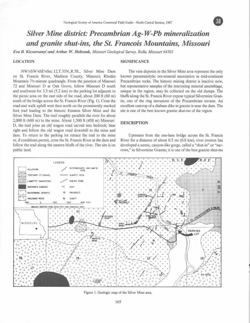
Geological Society of America Centennial Field Guide- North-Central Section, 1987 • Silver Mine district: Precambrian Ag-W-Pb mineralization and granite shut-ins, the St. Francois Mountains, Missouri
Eva B. Kisvarsanyi and Arthur W. Hebrank, Missouri Geological Survey, Rolla, Missouri 64501
LOCATION
NWV..SWV..SEV..Sec.12,T.33N.,R.5E., Silver Mine Dam on St. Francis River, Madison County, Missouri; Rhodes Mountain 7lh-minute quadrangle. From the junction of Missouri 72 and Missouri D at Oak Grove, follow Missouri D south and southwest for 3.3 mi (5.2 km) to the parking lot adjacent to the picnic area on the east side of the road, about 200 ft (60 m) south of the bridge across the St. Francis River (Fig. 1 ). Cross the road and walk uphill west then north on the prominently marked foot trail leading to the historic Einstein Silver Mine and the Silver Mine Dam. The trail roughly parallels the river for about 2,000 ft (600 m) to the mine. About 1,500 ft (450 m) Missouri D, the trail joins an old wagon road carved into bedrock; bear right and follow the old wagon road downhill to the mine and dam. To return to the parking lot retrace the trail to the mine or, if conditions permit, cross the St. Francis River at the dam and follow the trail along the eastern bluffs of the river. The site is on public land.
D ALLUVIUM
eJE~ TERTIARY ( !) GRAVEL
~~@di LAMOTTE SANDSTONE
- SKRAINKA DIABASE
Q SILVERMINE GRANITE
D 'IOU:ANIC ROCK
MISSO UR I
•
LEGEND
.,•" INTERMEDIATE ANO MAFIC .•• DIKE
-- QUARTZ VEIN
::::: AOIT
~ PROSPECT
I! SHAFT
SIGNIFICANCE
The vein deposits in the Silver Mine area represent the only known pneumatolytic ore-mineral association in mid-continent Precambrian rocks. The historic mining district is inactive now, but representative samples of the interesting mineral assemblage, unique in the region, may be collected on the old dumps. The bluffs along the St. Francis River expose typical Silvermine Granite, one of the ring intrusions of the Precambrian terrane. An excellent outcrop of a diabase dike in granite is near the dam. The site is one of the best known granite shut-ins of the region.
DESCRIPTION
Upstream from the one-lane bridge across the St. Francis River for a distance of about 0.5 mi (0.8 km), river erosion has developed a scenic, canyon-like gorge, called a "shut-in" or "narrows," in Silvermine Granite; it is one of the best granite shut-ins
Figure l. Geologic map of the Silver Mine area.
165

166 E. B. Kisvarsanyi and A. W. Hebrank
Figure 2. Outcrop of the "Big Dike," on the east bank of the St. Francis River, just downstream from the Silver Mine dam. This near-vertical, 4-ft- ( 1.2 m-) wide basalt dike intrudes Silvermine Granite. Photo by Art Hebrank.
in the region. Shut-ins are regionally unique physiographic features in the St. Francois Mountains but are more commonly developed where streams flow over volcanic rock.
Silvermine Granite, exposed in the bluffs along the St. Francis River (Tolman and Robertson, 1969), is part of a multiple ring intrusion formed by the Knoblick, Slabtown, and Silvermine Granites emplaced along the margins of the Butler Hill caldera (Sides and others, 1981 ). The rock is a medium-grained amphibole-biotite granite averaging 40 percent orthoclasemicroperthite, 30 percent sodic oligoclase, 20 percent quartz, and 10 percent mafic minerals. Chemically, Silvermine Granite is intermediate between less silicic Knoblick Granite and more silicic Slabtown Granite (Kisvarsanyi, 1972).
The Einstein Mine (Fig. l) is but one of several mines and prospects that began operations in the 1870s to produce silver from argentiferous galena in quartz veins cutting Silvermine
REFERENCES
Hayes, W. C., 1947, Geology of the Ozark-Martin mine area, Madison County, Missouri [Masters thesis): Rolla, Missouri School of Mines and Metallurgy.
Kisvarsanyi, E. B., 1972, Petrochemistry of a Precambrian igneous province, St. Francois Mountains, Missouri (Contribution to Precambrian Geology No. 4): Missouri Geological Survey and Water Resources, Report of Investigations 51, 103 p.
Lowell, G. R., 1975, Precambrian geology and ore deposits of the Silver Mine area, southeast Missouri: A review, in Lowell, G. R., ed., A fieldguide to the Precambrian geology of the St. Francois Mountains, Missouri: Cape Girardeau, Southeast Missouri State University, p. 81-88.
Granite. The deposits have been described in detail by Tolman (1933) and Lowell (1975). There were two distinct periods of mining in the Silver Mine area: 1877 to 1894 and 1916 to 1946. During the earlier period, an estimated 50 tons ( 4 5 t) of lead and 3000 oz (84 kg) of silver were produced; during the later, an estimated 120 short tons (108 t) of tungsten concentrates were produced, largely by high-grading the old dumps and from shallow surface diggings. The remains of the dam, constructed in 1879, can be seen upstream from the mine dumps. Foundation remnants on the west hillslope south of the dam are all that remain of the large mill constructed during the silver- and tungsten-mining periods.
Of the several quartz veins mined and prospected in the area, vein no. I, the Einstein, was the most productive; it accounted for the bulk of the early silver and lead production. It was entered by the River Tunnel, the entrance to which is about 50 ft (15 m) above the river. (Caution: Entry through this old adit is dangerous and should not be attempted!) The vein strikes N 80° E and dips 35° S; it pinches and swells, having a maximum width of not over 7 ft (2 m) and an ore wne as much as 2 ft (0.6 m) wide (Tolman, 1933). A pinched outcrop of the vein, where it is less than 2 in (5 cm) wide, is visible above a small mine opening in the hillside, about SO ft (15 m) uphill from the River Tunnel. Near the contacts the intruded granite is intensely greisenized.
The high-temperature, pneumatolytic mineral assemblage at Silver Mine includes argentiferous galena, wolframite, arsenopyrite, sphalerite, cassiterite, chalcopyrite, covellite, hematite, stolzite, and scheelite. Quartz, topaz, sericite, fluorite, zinnwaldite, chlorite, and garnet are among the gangue minerals. Persistent search on the dump downhill from the mine may turn up good specimens.
Numerous intermediate to mafic dikes older than the quartz veins have been mapped in the Silver Mine area (Fig. 1). One of these is well exposed on the east side of the St. Francis River, just below the dam (Fig. 2). The dike is about 4 ft (1.2 m) wide, strikes N 65° E, and is nearly vertical. Its borders against Silvermine Granite are chilled, but its central part is coarser grained. The rock contains a few small plagioclase phenocrysts in a groundmass of andesine and augite with intergranular texture. Euhedral magnetite and pyrite are abundantly disseminated through the groundmass, and there is a small amount of interstitial quartz.
Pomerene, J. B., 1947, Geology of the Einstein-Apex tungsten mine area [Masters thesis): Rolla, Missouri School of Mines and Metallurgy, 39 p.
Sides, J. R., Bickford, M. E., Shuster, R. D., and Nusbaum, R. L., 1981, Calderas in the Precambrian terrane of the St. Francois Mountains, southeastern Missouri: Journal of Geophysical Research, v. 86, p. 10349-10364.
Tolman, C., 1933, The geology of the Silver Mine area, Madison County, Missouri: Missouri Bureau of Geology and Mines, 57th Biennial Report of the State Geologist, 1931-1932, Appendix I, 39 p.
Tolman, C., and Robertson, F., 1969, Exposed Precambrian rocks in southeast Missouri (Contribution to Precambrian Geology No. I): Missouri Geological Survey and Water Resources, Report of Investigations 44, 68 p.
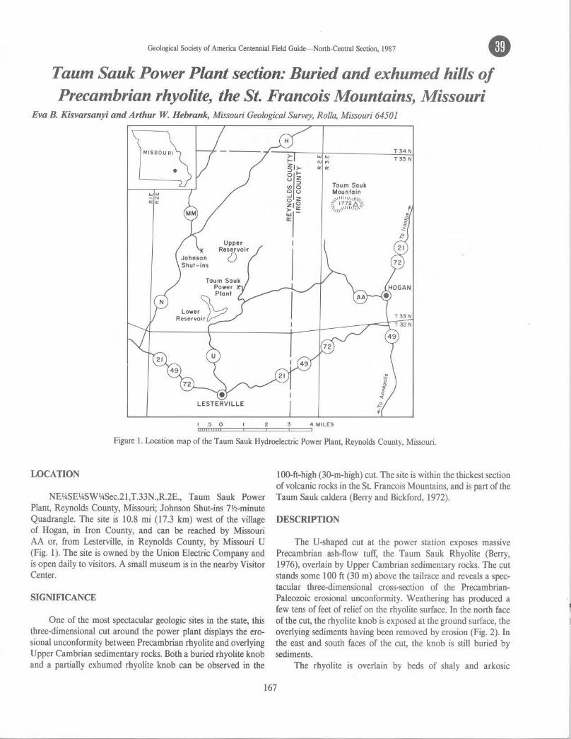
Geological Society of America Centennial Field Guide- North-Central Section, 1987 • Taum Sauk Power Plant section: Buried and exhumed hills of Precambrian rhyolite, the St. Francois Mountains, Missouri
Eva B. Kisvarsanyi and Arthur W. Hebrank, Missouri Geological Survey, Rolla, Missouri 64501
MISSOURI
LESTERVILLE
>.....
gll~ u z =>
V> 0 ou 5z z1° ~(
I
WW
"'"' a: a:
Taum Sauk Mountain
~,\:~~~'f"~ ~,/\,,,H1,,,\,-
T 34N T 33 N
I CD Cll.II5 cm:0====2==3==4 MILES
Figure l. Location map of the Taum Sauk Hydroelectric Power Plant, Reynolds County, Missouri.
LOCATION
NE14SE1ASW14Sec.21,T.33N.,R.2E., Taum Sauk Power Plant, Reynolds County, Mis.5ouri; Johnson Shut-ins 71h-minute Quadrangle. The site is 10.8 mi (17.3 km) west of the village of Hogan, in Iron County, and can be reached by Mis.5ouri AA or, from Lesterville, in Reynolds County, by Missouri U (Fig. 1). The site is owned by the Union Electric Company and is open daily to visitors. A small museum is in the nearby Visitor Center.
SIGNIFICANCE
One of the most spectacular geologic sites in the state, this three-dimensional cut around the power plant displays the erosional unconformity between Precambrian rhyolite and overlying Upper Cambrian sedimentary rocks. Both a buried rhyolite knob and a partially exhumed rhyolite knob can be observed in the
100-ft-high (30-m-high) cut. The site is within the thickest section of volcanic rocks in the St. Francois Mountains, and is part of the Taum Sauk caldera (Berry and Bickford, 1972).
DESCRIPTION
The U-shaped cut at the power station exposes massive Precambrian ash-flow tuff, the Taum Sauk Rhyolite (Berry, 1976), overlain by Upper Cambrian sedimentary rocks. The cut stands some 100 ft (30 m) above the tailrace and reveals a spectacular three-dimensional cross-section of the PrecambrianPaleozoic erosional unconformity. Weathering has produced a few tens of feet of relief on the rhyolite surface. In the north face of the cut, the rhyolite knob is exposed at the ground surface, the overlying sediments having been removed by erosion (Fig. 2). In the east and south faces of the cut, the knob is still buried by sediments.
The rhyolite is overlain by beds of shaly and arkosic
167
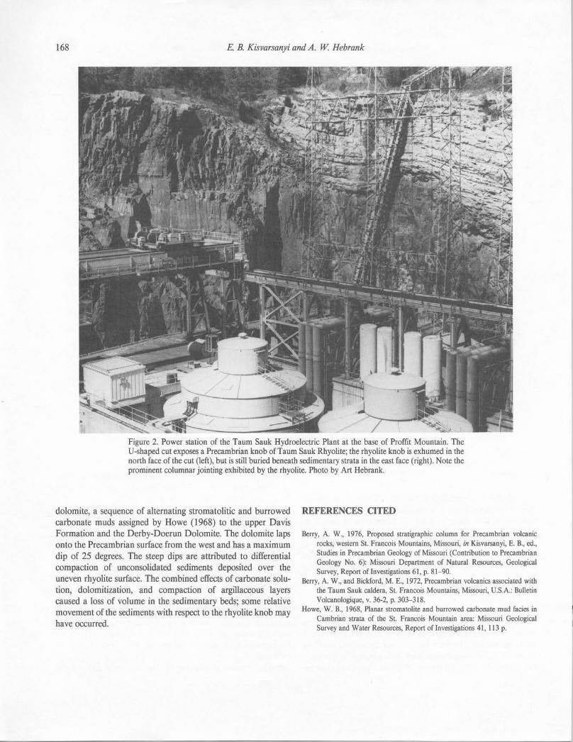
168 E B. Kisvarsanyi and A. W Hebrank
dolomite, a sequence of alternating stromatolitic and burrowed carbonate muds assigned by Howe (1968) to the upper Davis Formation and the Derby-Doerun Dolomite. The dolomite laps onto the Precambrian surface from the west and has a maximum dip of 25 degrees. The steep dips are attributed to differential compaction of unconsolidated sediments deposited over the uneven rhyolite surface. The combined effects of carbonate solution, dolomitization, and compaction of argillaceous layers caused a loss of volume in the sedimentary beds; some relative movement of the sediments with respect to the rhyolite knob may have occurred.
REFERENCES CITED
Berry, A. W., 1976, Proposed stratigraphic column for Precambrian volcanic rocks, western St. Francois Mountains, Missouri, in Kisvarsanyi, E. B., ed., Studies in Precambrian Geology of Missouri (Contribution to Precambrian Geology No. 6): Missouri Department of Natural Resources, Geological Survey, Report of Investigations 61, p. 81-90.
Berry, A. W., and Bickford, M. E., 1972, Precambrian volcanics associated with the Taum Sauk caldera, St. Francois Mountains, Missouri, U.S.A.: Bulletin Volcanologique, v. 36-2, p. 303-318.
Howe, W. B., 1968, Planar stromatolite and burrowed carbonate mud facies in Cambrian strata of the St. Francois Mountain area: Missouri Geological Survey and Water Resources, Report of Investigations 41, 113 p.
"'--,;..•
Geological Society of America Centennial Field Guide-North-Central Section, 1987 • Johnson Shut-ins: A shut-in canyon exposing a sequence of Precambrian ash-flow tujjs, the St. Francois Mountains, Missouri
Arthur W. Hebrank and Eva B. Kisvarsanyi, Missouri Geol.ogica/ Survey, Rolla, Missouri 64501
To Missouri Highway 21
7 8 9
18 17 16
SHUT - INS
STATE PARK
19
To Missouri Highways 21-72-49
0
0
20
0.5 KM
0.5 MI
MI SS OUR I
•
Figure 1. Location map of Johnson Shut-ins State Park, Reynolds County, Missouri.
LOCATION
Johnson Shut-ins State Park, W~Sec.16 and NW1ASec.21, T.33N.,R.2E., Reynolds County, Missouri; Johnson Shut-ins 7~-minute Quadrangle. Entrance to the park is from Missouri N (Fig. 1), J 3.2 mi (21 km) southwest of its junction with Missouri 21, north of Ironton, Missouri, and 6.2 mi (10 km) northeast of its junction with Missouri 21-49-72, west of Lesterville, Missouri. From the parking lot, walk east on well-marked (paved) trail about 1800 ft (540 m) to the shut-ins overlook (Fig. 2). The site is on public land. Note: State park rules prohibit defacing or collecting rocks.
SIGNIFICANCE
Johnson Shut-ins, one of the most picturesque volcanic-rock gorges in Missouri's St. Francois Mountains, is an excellent example of the regionally unique geomorphic features called shutins, and dramatically displays a variety of stream-erosion features, including cascades, potholes, plunge pools, and joint-determined channelways and chutes. A 2100 ft (650 m) thick sequence of Precambrian rhyolitic ignimbrites and intercalated volcaniclastic sediments is well exposed in the shut-ins; the rocks display wellpreserved volcanic-rock textures and constitute the best easily accessible and well-described section of such rocks in the St.
169
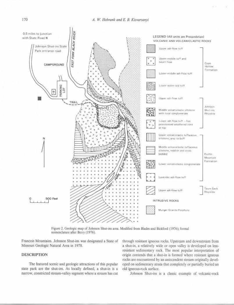
170 A. W. Hebrank and E. B. Kisvarsanyi
0.5 miles to junction with State Road N
Johnson Shut-ins State
Park entrance road
CAMPGROUND
•
N
X X )( )( ,c X
••• )( )( )C
LEGEND (All units are Precambrian) VOLCANIC AND VOLCANICLASTIC ROCKS
[mill Upper ash -f low tuft
Upper-middle tuff and
basalt flow
willill!J Lower-middle ash-flow tulf
E:I Lower water-laid tuft
~ Upper ash-flow tuft
•••• Middle volcaniclastic siltstone :•: with local conglomerate
Lower ash-flow tuff - has pronounced weathered zone at top
Upper volcaniclastic tuffaceous siltstone, gray to buff
M idd le volcan iclastic tu ffaceous siltstone, redd ish and cross
bedded
Lower volcaniclastic conglomerate
D Lavender ash -flow tuft
Cope Hollow
Formation
Johnson Shut-ins
Rhyolite
Proffit
Mountain Formation
• )C ••••• ~ Upper ash-flow tuft J Taum Sauk
Rhyolite )( )C )( )C )( • . )( ... 0 I
500 Feet I I
IC X X X ,c ,c X INTRUSIVE ROCKS •• )( •• )C
Fl Munger Gran,te Porphyry LJ
Figure 2. Geologic map of Johnson Shut-ins area. Modified from Blades and Bickford (1976); formal nomenclature after Berry (1976).
Francois Mountains. Johnson Shut-ins was designated a State of Missouri Geologic Natural Area in 1978.
DESCRIPTION
The featured scenic and geologic attractions of this popular state park are the shut-ins. As locally defined, a shut-in is a narrow, constricted stream-valley segment where a stream has cut
through resistant igneous rocks. Upstream and downstream from a shut-in, a relatively wide or open valley is developed on lessresistant sedimentary rock. The most popular interpretation of origin contends that a shut-in is formed where resistant igneous rocks are encountered by an antecendent stream originally developed on sedimentary strata that completely or partially buried an old igneous-rock surface.
Johnson Shut-ins is a classic example of volcanic-rock
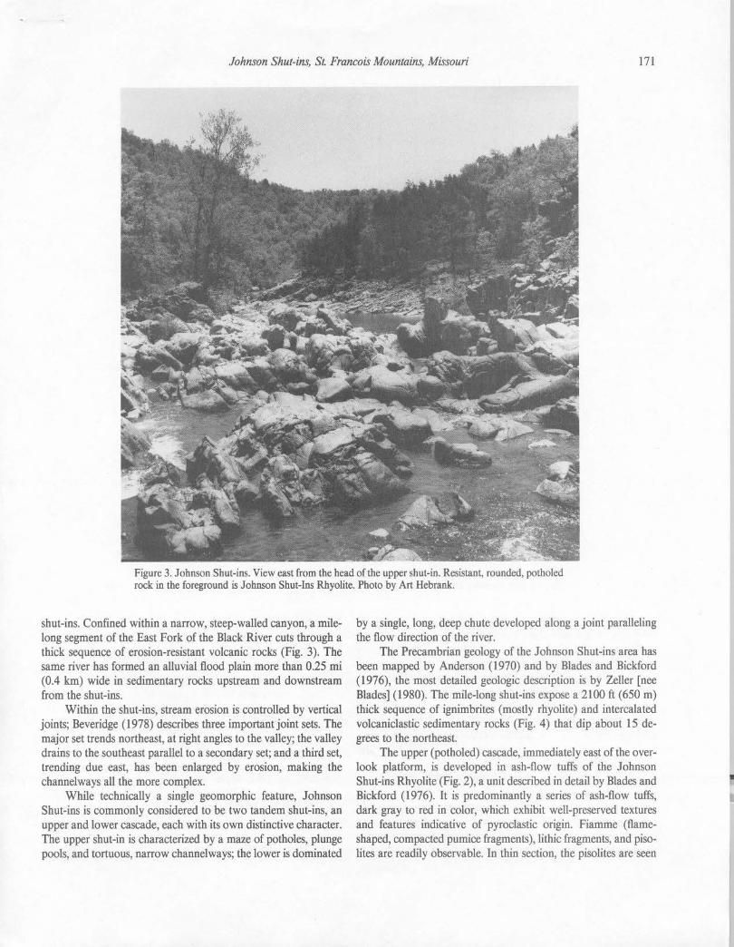
Johnson Shut-ins, St. Francois Mountains, Missouri 171
Figure 3. Johnson Shut-ins. View east from the head of the upper shut-in. Resistant, rounded, potholed rock in the foreground is Johnson Shut-Ins Rhyolite. Photo by Art Hebrank.
shut-ins. Confined within a narrow, steep-walled canyon, a milelong segment of the East Fork of the Black River cuts through a thick sequence of erosion-resistant volcanic rocks (Fig. 3). The same river has formed an alluvial flood plain more than 0.25 mi (0.4 km) wide in sedimentary rocks upstream and downstream from the shut-ins.
Within the shut-ins, stream erosion is controlled by vertical joints; Beveridge ( 1978) describes three important joint sets. The major set trends northeast, at right angles to the valley; the valley drains to the southeast parallel to a secondary set; and a third set, trending due east, has been enlarged by erosion, making the channelways all the more complex.
While technically a single geomorphic feature, Johnson Shut-ins is commonly considered to be two tandem shut-ins, an upper and lower cascade, each with its own distinctive character. The upper shut-in is characterized by a maze of potholes, plunge pools, and tortuous, narrow channelways; the lower is dominated
by a single, long, deep chute developed along a joint paralleling the flow direction of the river.
The Precambrian geology of the Johnson Shut-ins area has been mapped by Anderson (1970) and by Blades and Bickford (1976), the most detailed geologic description is by Zeller [nee Blades] (1980). The mile-long shut-ins expose a 2100 ft (650 m) thick sequence of ignimbrites (mostly rhyolite) and intercalated volcaniclastic sedimentary rocks (Fig. 4) that dip about 15 degrees to the northeast.
The upper (potholed) cascade, immediately east of the overlook platform, is developed in ash-flow tuffs of the Johnson Shut-ins Rhyolite (Fig. 2), a unit described in detail by Blades and Bickford (1976). It is predominantly a series of ash-flow tuffs, dark gray to red in color, which exhibit well-preserved textures and features indicative of pyroclastic origin. Fiamme (flameshaped, compacted pumice fragments), lithic fragments, and pisolites are readily observable. In thin section, the pisolites are seen
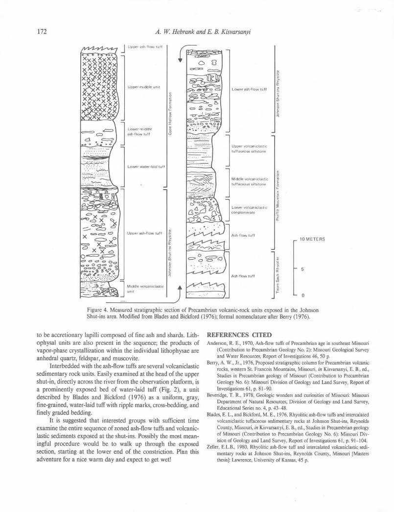
172 A. W. Hebrank and E. B. Kisvarsanyi
.... .........
·.·.·· ·~
Upper-midd le unit
J Lower-moddle as.h -flow tuft
Lower water-laid tuff
Upper ash-flow tuff
C 0
·~
0 u. ~ E 0 r ! 8
0 > .c a:
.~ ; .c rn C
~ C .c -'l
.~ 0 > .c a:
Lower ash-flow tuff .; ; .c rn C
~ C .c -'l
J "·- '"''°''"'" tuff aceous siltstone
C 0 ·;:. J M •• " ' """""" ;, E
tuffaceous siltstone 0 u. C ·.; c :, 0 J ,-, ~'-'""'"' ::;
conglomerate e 0.
10 METERS
" 0 > .c 5 a:
Ash-flow tuff .,,_ ~ rn E :,
/! 0
Figure 4. Measured stratigraphic section of Precambrian volcanic-rock units exposed in the Johnson Shut-ins area. Modified from Blades and Bickford (1976); formal nomenclature after Berry (1976).
to be accretionary lapilli composed of fine ash and shards. Lithophysal units are also present in the sequence; the products of vapor-phase crystallization within the individual lithophysae are anhedral quartz, feldspar, and muscovite.
Interbedded with the ash-flow tuffs are several volcaniclastic sedimentary rock units. Easily examined at the head of the upper shut-in, directly across the river from the observation platform, is a prominently exposed bed of water-laid tuff (Fig. 2), a unit described by Blades and Bickford (1976) as a uniform, gray, fine-grained, water-laid tuff with ripple marks, cross-bedding, and finely graded bedding.
It is suggested that interested groups with sufficient time examine the entire sequence of zoned ash-flow tuffs and volcanicIastic sediments exposed at the shut-ins. Possibly the most meaningful procedure would be to walk up through the exposed section, starting at the lower end of the constriction. Plan this adventure for a nice warm day and expect to get wet!
REFERENCES CITED Anderson, R. E., 1970, Ash-flow tuffs of Precambrian age in southeast Missouri
(Contribution to Precambrian Geology No. 2): Missouri Geological Survey and Water Resources, Report of Investigations 46, 50 p.
Berry, A. W., Jr., 1976, Proposed stratigraphic column for Precambrian volcanic rocks, western St. Francois Mountains, Missouri, in Kisvarsanyi, E. B., ed., Studies in Precambrian geology of Missouri (Contribution to Precambrian Geology No. 6): Missouri Division of Geology and Land Survey, Report of Investigations 61, p. 81- 90.
Beveridge, T. R., 1978, Geologic wonders and curiosities of Missouri: Missouri Department of Natural Resources, Division of Geology and Land Survey, Educational Series no. 4, p. 43-48.
Blades, E. L., and Bickford, M. E., 1976, Rhyolitic ash-flow tuft's and intercalated volcaoiclastic tuffaceous sedimentary rocks at Johnson Shut-ins, Reynolds County, Missouri, in Kisvarsanyi, E. B., ed., Studies in Precambrian geology of Missouri (Contribution to Precambrian Geology No. 6): Missouri Division of Geology and Land Survey, Report of Investigations 61, p. 91-104.
Zeller, E.L.B., 1980, Rhyolitic ash-flow tuff and intercalated volcaniclastic sedimentary rocks at Johnson Shut-ins, Reynolds County, Missouri [Masters thesis]: Lawrence, University of Kansas, 45 p.