factual letter report soils barangaroo 2010 · interpretations or conclusions from review by others...
TRANSCRIPT

Douglas Partners Pty Ltd ABN 75 053 980 117
www.douglaspartners.com.au 96 Hermitage Road
West Ryde NSW 2114 PO Box 472
West Ryde NSW 1685 Phone (02) 9809 0666
Fax (02) 9809 4095
Brisbane • Cairns • Campbelltown • Canberra • Darwin • Gold Coast • Melbourne • Newcastle • Perth • Sunshine Coast • Sydney • Townsville • Wollongong • Wyong
Project 71723.08Barangaroo Delivery Authority 17 December 2010Level 6, 66 Harrington Street CF:jlbTHE ROCKS NSW 2000 Attention: Mr Brian ten Brinke Email: [email protected] Dear Sirs Factual Report – Pre Early Works Additional Environmental Assessment - Soils Barangaroo Headland Park 1. Introduction Douglas Partners Pty Ltd (DP) was engaged by the Barangaroo Delivery Authority to undertake additional environmental investigations, as required, at the proposed Headland Park site, located in the northern portion of the Barangaroo Redevelopment site. This factual report presents the findings of additional investigations requested by JBS Environmental Pty Ltd (JBS), in their Sampling, Analysis and Quality Plan – Pre-Early Works Additional Environmental Assessment document dated October 2010, report reference JBS41181-15745, Revision C (JBS SAQP). It is understood that no field or analytical result interpretation or analysis is required from DP. 2. Scope of Works The scope of works of the additional investigation, addressing the requirements of the JBS SAQP, was as follows:
• Obtaining services drawings for the site;
• Field location of underground services prior to drilling;
• Drilling at 31 locations specified by JBS, denoted as boreholes JBS300 to JBS330 (see attached Drawing 1);
• Boreholes were augered through fill materials and natural soils / bedrock and terminated in interpreted natural materials (soils or bedrock) as specified by JBS at each of the locations. Auger refusal was encountered within the filling during the drilling of several of the bores, usually on crushed sandstone boulders, ballast gravel, or anthropogenic material such as steel or

Page 2 of 5
Factual Report – Pre Early Works Additional Environmental Assessment Project 71723.08Barangaroo Headland Park December 2010
concrete. The bores were first moved (generally within one metre of the designated location) in an attempt to avoid the filling on which the refusal occurred. Where this was unsuccessful, alternative drilling techniques were employed, including rotary or casing advancer (using fresh water) and air hammer (ODEX) drilling. The relocated bores are also indicated on Drawing 1;
• Samples were collected at generally 1 m depth intervals (where possible) at each of the boreholes, as well as additional depths specified by JBS in accordance with Table 6.1 of the JBS SAQP;
• Field quality assurance and quality control procedures were carried out in accordance with the programme detailed in Table 6.2 of the JBS SAQP;
• Screening of all recovered samples using a field portable photo-ionisation detector (PID). It is noted that due to limited sample retrieved in several locations (generally below the water table), some samples were not screened;
• Dispatch of selected samples to NATA accredited laboratories for quantitative analysis for the analytes as detailed in Table 6.1 of the JBS SAQP;
• Store remaining soil samples not analysed at the laboratory for potential future analysis; and
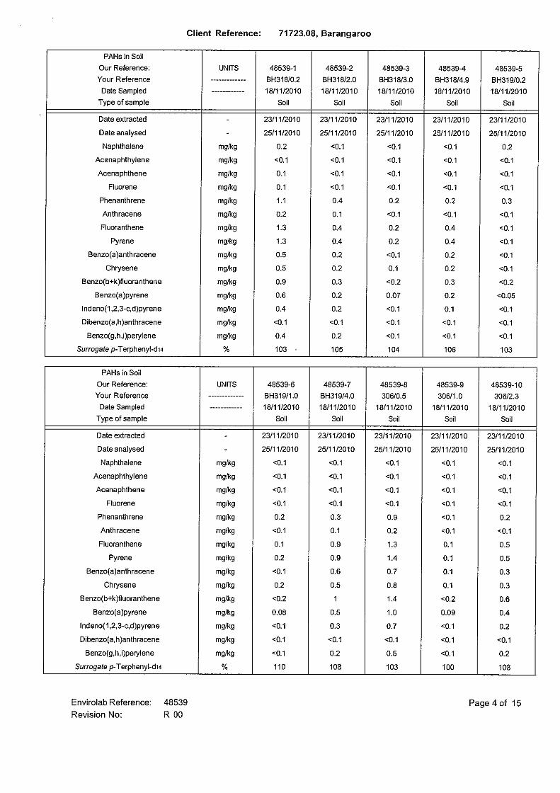
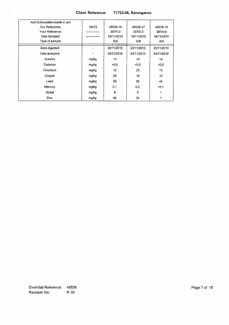
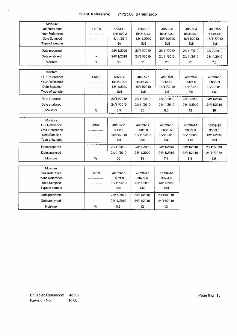
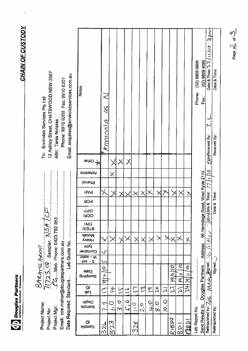
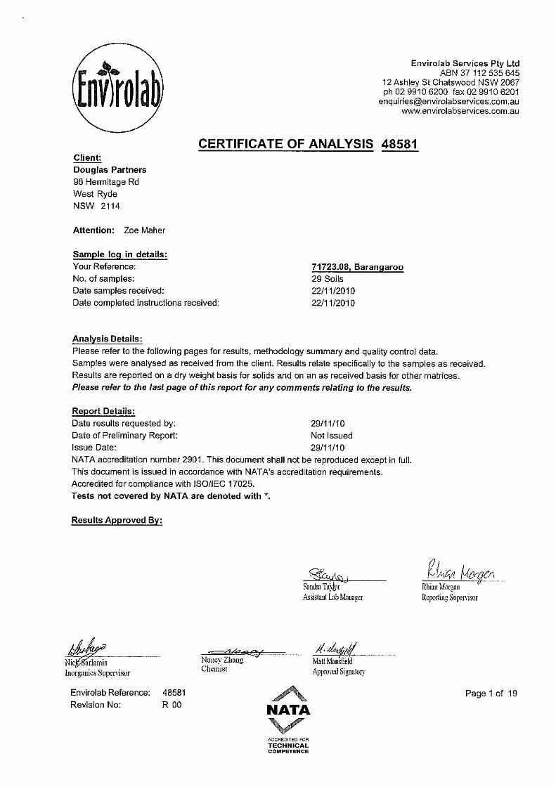
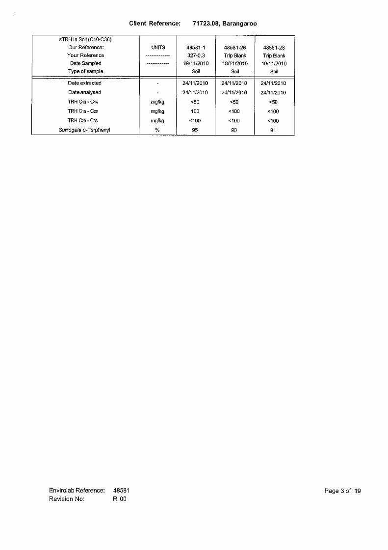
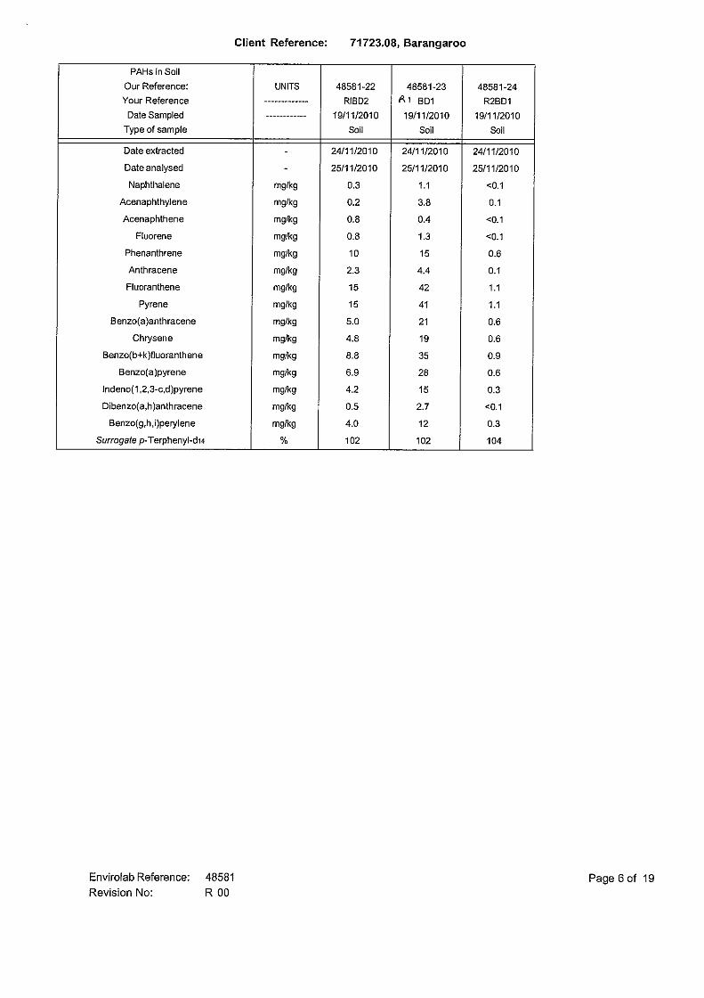
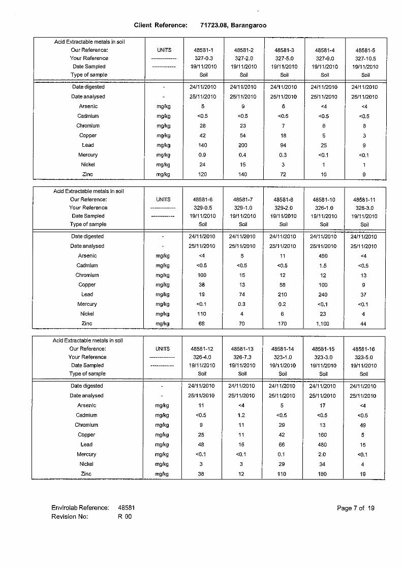
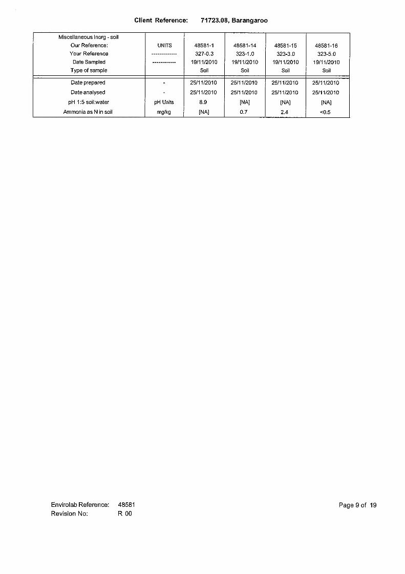
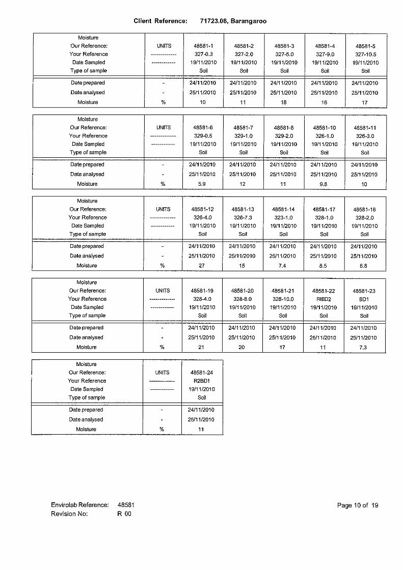
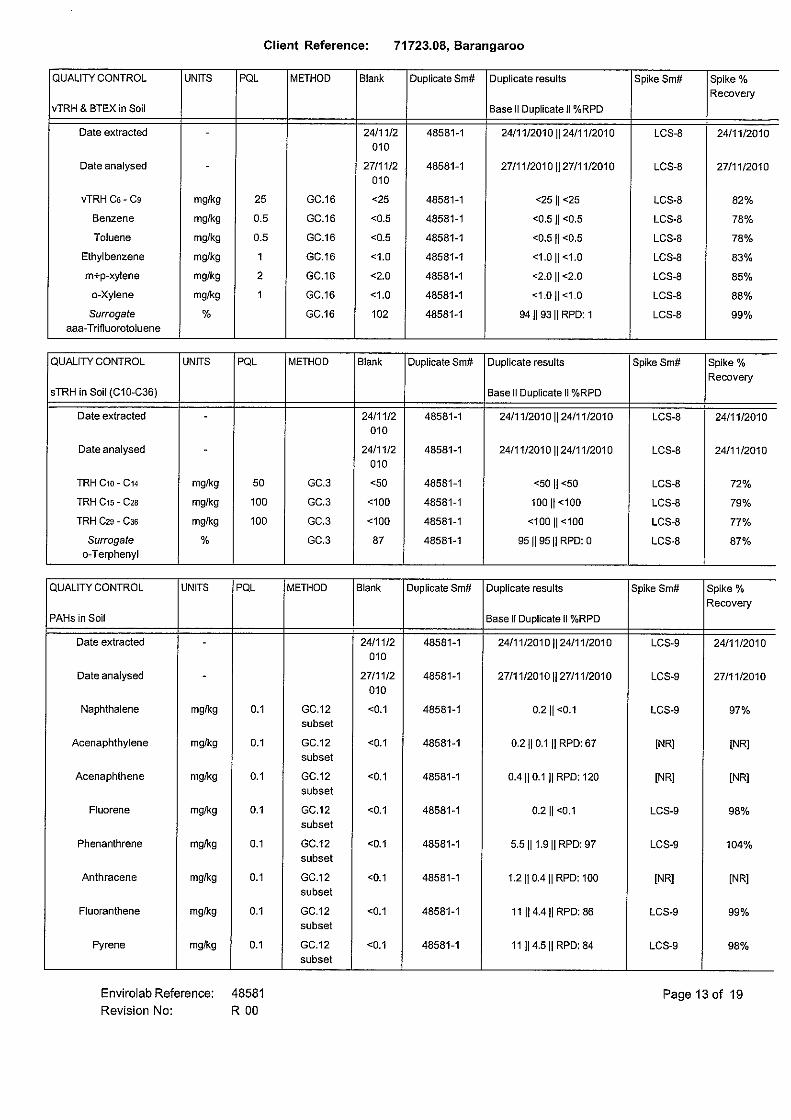
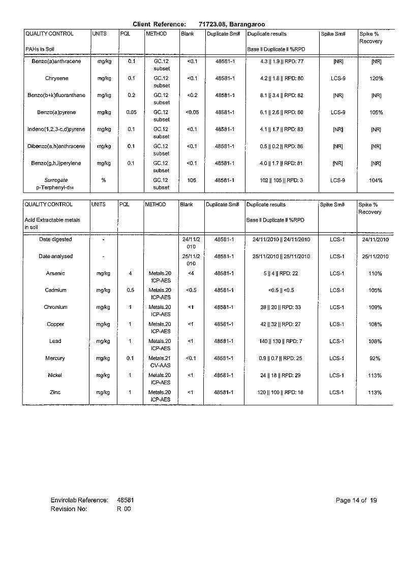
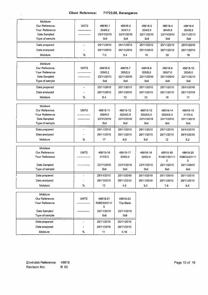
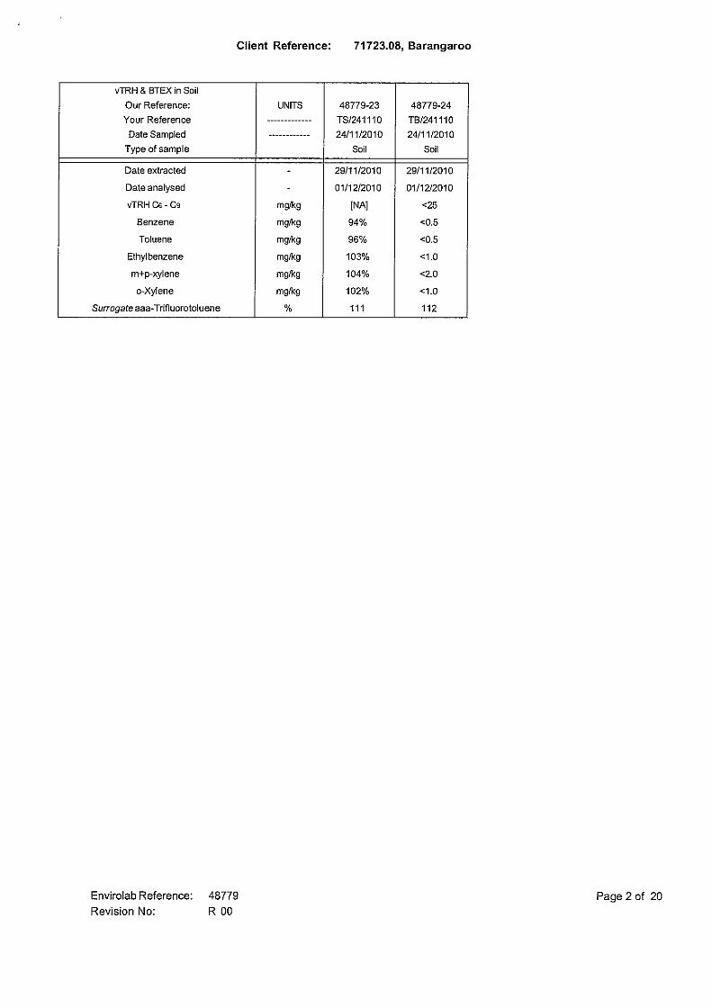
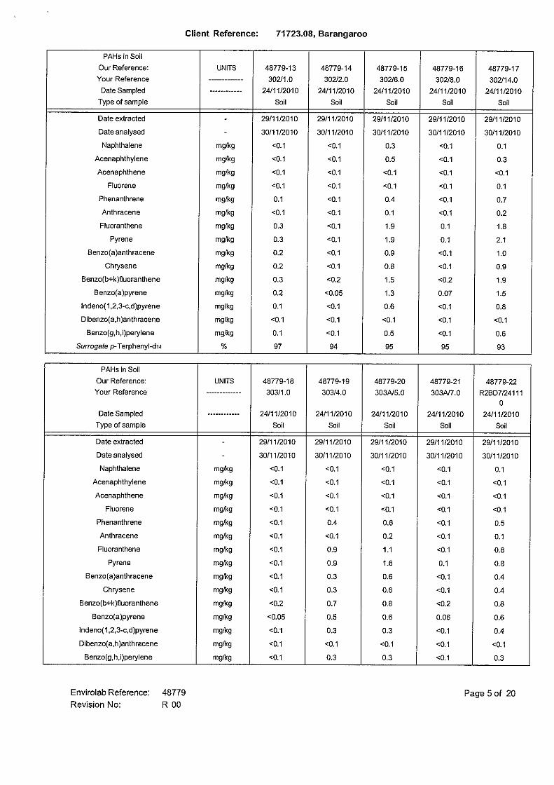
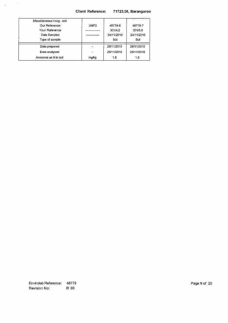
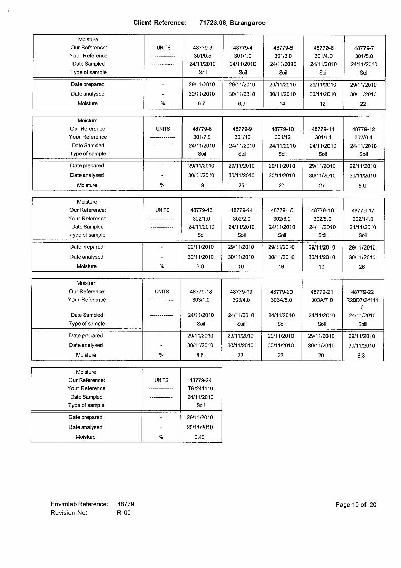
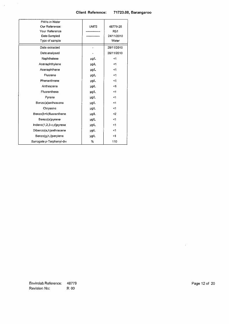
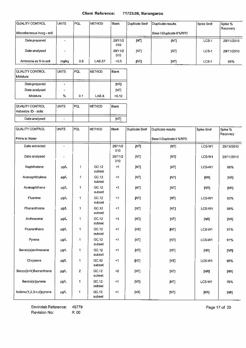
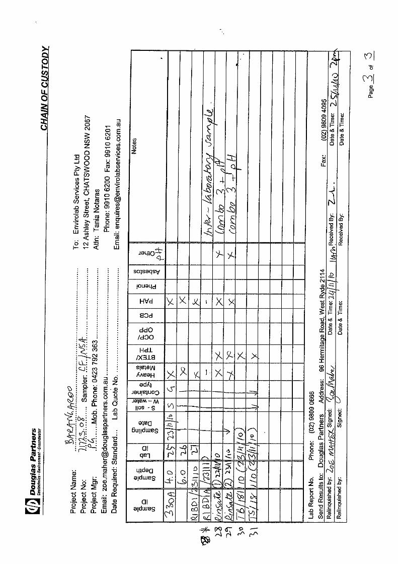
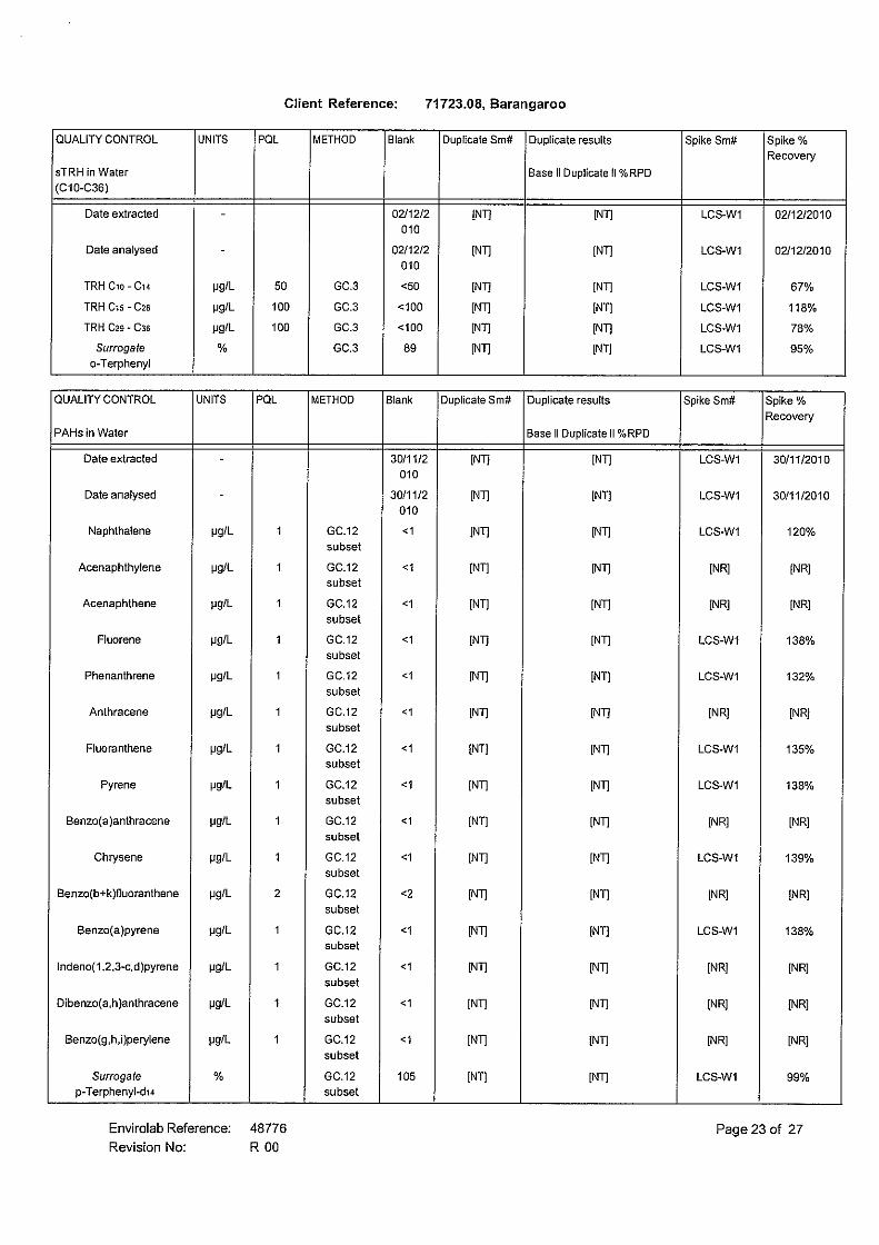
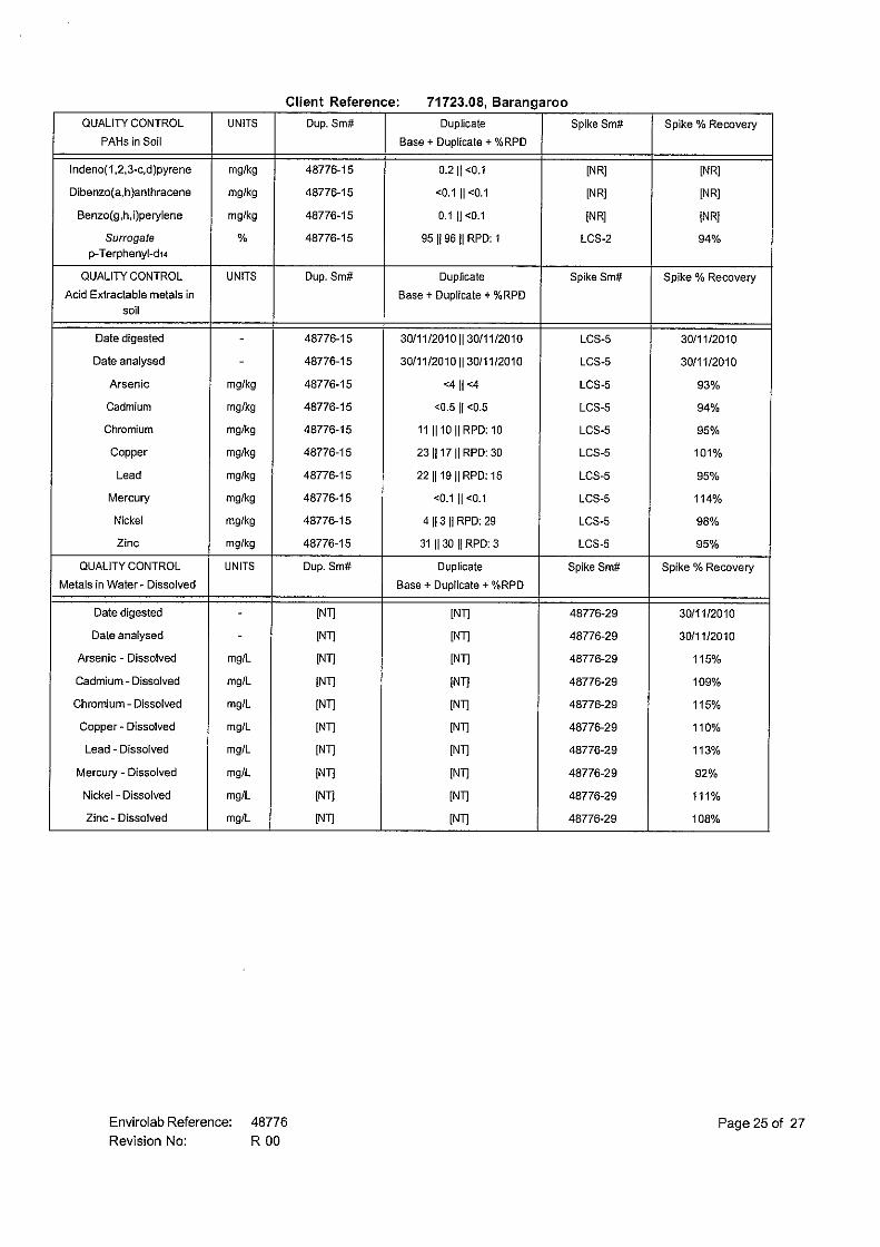
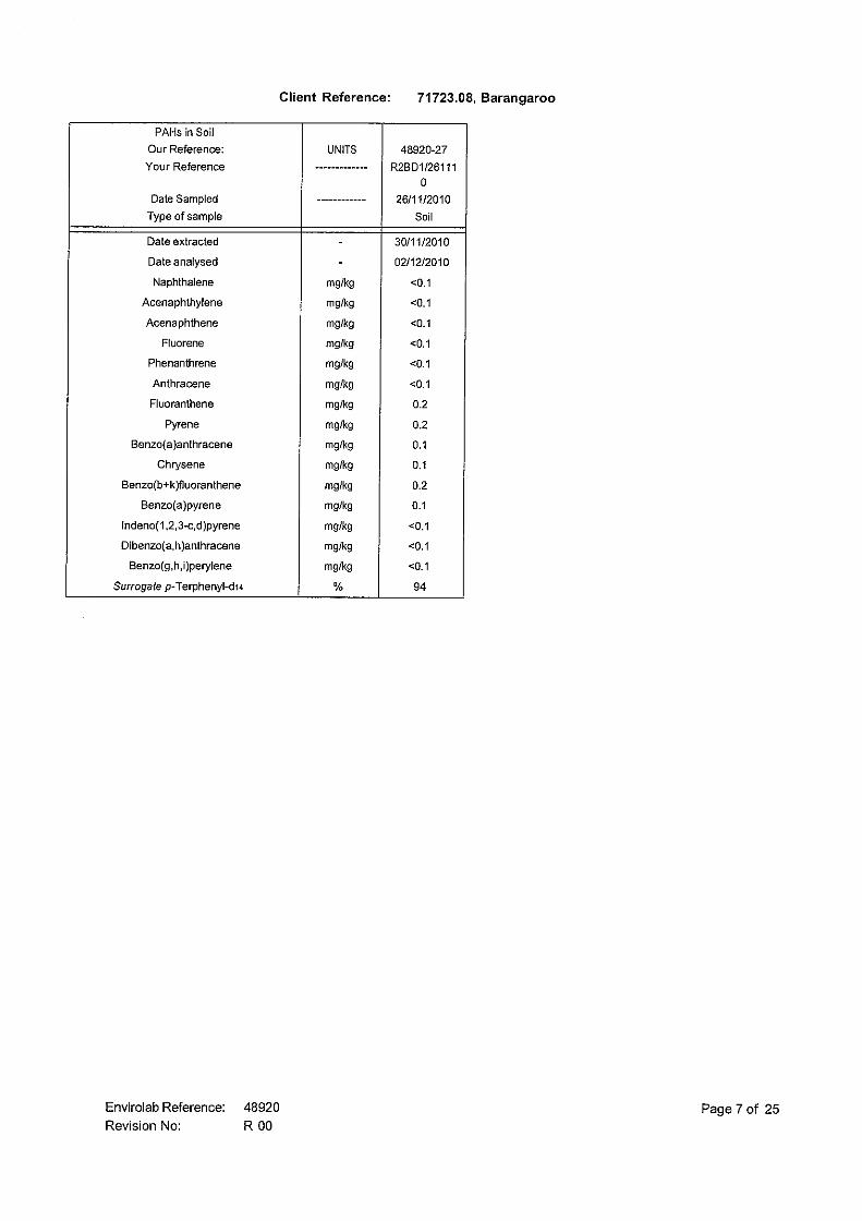
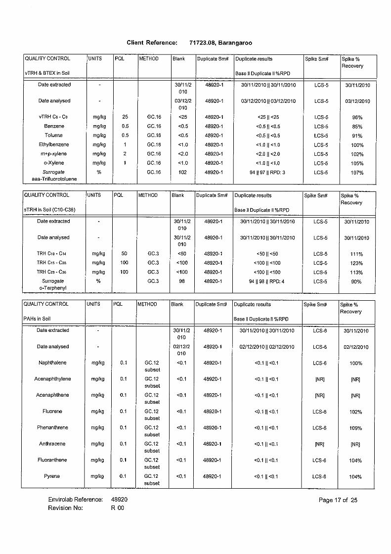
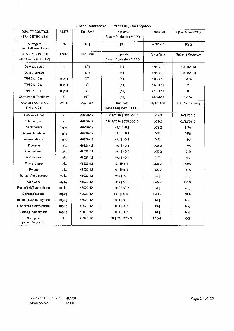
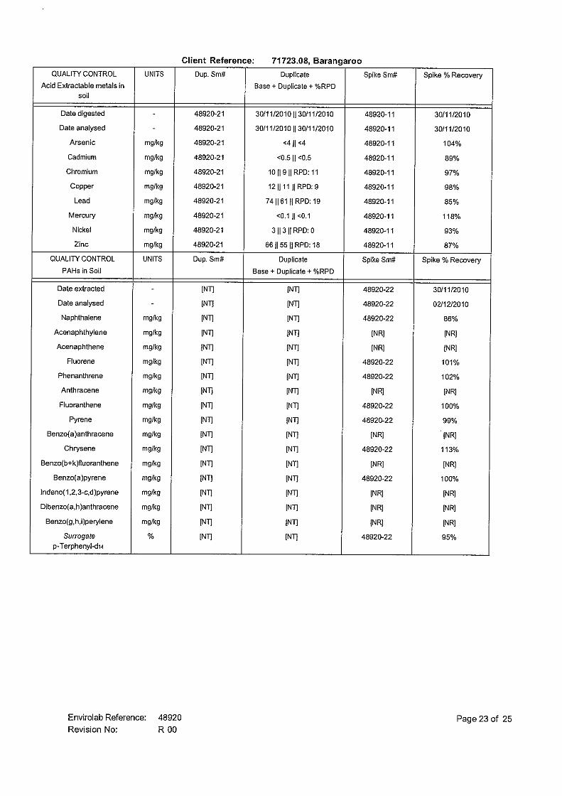
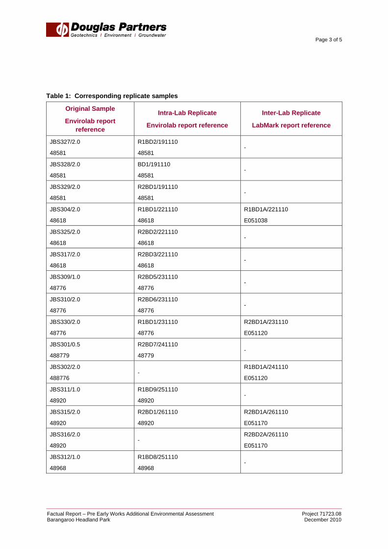
• Preparation of this Factual Report. 3. Site Observations Drilling was undertaken between 18 November to 2 December 2010 using various truck-mounted and bobcat-mounted drill rigs. Details of the sub-surface conditions encountered during the course of the investigation are included in the attached borehole logs (JBS300 to JBS330, and relocated bores labelled “A”, “B” and “C”). The bore locations are shown on Drawing 1. Signs of visual and/or olfactory contamination as well as groundwater strike were noted in the borehole logs. Two additional groundwater monitoring wells were installed as part of this investigation at bores JBS322A and JBS328, as per the SAQP. Groundwater sampling and analysis of these wells and several existing wells (as required under the SAQP) was also carried out and is reported separately. 4. Analytical Results Soil samples were submitted to the primary laboratory (Envirolab) after completion of drilling works. Inter-laboratory samples (duplicated for QA/QC purposes) were separately submitted to the secondary laboratory (LabMark). Table 1 below shows the replicate samples corresponding to their original samples.
Page 3 of 5
Factual Report – Pre Early Works Additional Environmental Assessment Project 71723.08Barangaroo Headland Park December 2010
Table 1: Corresponding replicate samples
Original Sample
Envirolab report reference
Intra-Lab Replicate
Envirolab report reference
Inter-Lab Replicate
LabMark report reference
JBS327/2.0
48581
R1BD2/191110
48581 -
JBS328/2.0
48581
BD1/191110
48581 -
JBS329/2.0
48581
R2BD1/191110
48581 -
JBS304/2.0
48618
R1BD1/221110
48618
R1BD1A/221110
E051038
JBS325/2.0
48618
R2BD2/221110
48618 -
JBS317/2.0
48618
R2BD3/221110
48618 -
JBS309/1.0
48776
R2BD5/231110
48776 -
JBS310/2.0
48776
R2BD6/231110
48776 -
JBS330/2.0
48776
R1BD1/231110
48776
R2BD1A/231110
E051120
JBS301/0.5
488779
R2BD7/241110
48779 -
JBS302/2.0
488776 -
R1BD1A/241110
E051120
JBS311/1.0
48920
R1BD9/251110
48920 -
JBS315/2.0
48920
R2BD1/261110
48920
R2BD1A/261110
E051170
JBS316/2.0
48920 -
R2BD2A/261110
E051170
JBS312/1.0
48968
R1BD8/251110
48968 -

Page 4 of 5
Factual Report – Pre Early Works Additional Environmental Assessment Project 71723.08Barangaroo Headland Park December 2010
Original Sample
Envirolab report reference
Intra-Lab Replicate
Envirolab report reference
Inter-Lab Replicate
LabMark report reference
JBS313/2.0
48968
R1BD10/261110
48968 -
JBS321/2.0
48968
R1BD1/291110
48968
R1BD1A/291110
E051199
JBS322/2.0
49066 -
R1BD1A301110
E051288
JBS300/2.0
49199
R2BD11/021210
49199
R2BD11A/021210
E051265
JBS314/2.0
49249
R1BD1/031210
49249
R1BD1A/031210
E051288
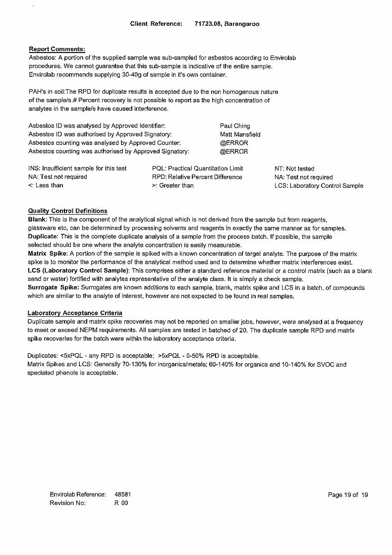
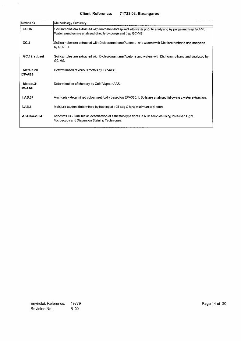
Copies of certified laboratory results are provided in the attachment. 5. Limitations Douglas Partners (DP) has prepared this letter report for this project at the Headland Park Site, Barangaroo, in accordance with DP’s proposal dated 29 October 2010 and acceptance received from the Barangaroo Delivery Authority dated 12 November 2010. The work was carried out under DP Conditions of Engagement. This letter report is provided for the exclusive use of the Barangaroo Delivery Authority, and JBS Environmental for the specific project and purpose as described in the report. It should not be used by or relied upon for other projects or purposes on the same or other site or by a third party. The results provided in the report are considered to be indicative of field observations on the site only, and only at the time the work was carried out. DP’s advice may be based on observations, measurements, tests or derived interpretations. The accuracy of the advice provided by DP in this letter report is limited by unobserved features and variations in ground conditions across the site in areas between test locations and beyond the site boundaries or by variations with time. The advice may be limited by the amount of data that could be collected given the project and site constraints. Actual ground conditions observed may differ from those which may be encountered elsewhere on the site. Should variations in site conditions be observed, then additional advice should be sought from DP and, if required, amendments made. This report must be read in conjunction with the attached explanatory notes and should be kept in its entirety without separation of individual pages or sections. DP cannot be held responsible for interpretations or conclusions from review by others of this letter report or test data, which are not


LOC
ALITY PLA
N
LEGEN
D
SIT
EDR
AW
ING
No:
PR
OJE
CT N
o:71723.08
RE
VIS
ION
:A
17.12.2010
CLIE
NT:
DR
AW
N B
Y:
AP
PR
OV
ED
BY
:
SC
ALE
:
DA
TE:
OFFIC
E:
Sydney
JES
As show
n
BA
RA
NG
AR
OO
DE
LIVE
RY
AU
THO
RITY
TITLE:
Location of Test Bores
Pre Early Works A
dditional Environmental A
ssessment
Bangaroo H
eadland Park1
P. G
OR
MA
N
300
301
302
303
304
305306
307308
309
310
312
313314
316
318
319
320
321
322
323
324325
326327328329
330
303A303C
304A
312A
313A
317A
320A322A
325B
329A
330A311
317
315
303B
S:\JS\barangaroo\Copy of test pit locations.dwg, 17/12/2010 2:37:51 PM, DWG To PDF.pc3

July 2010
Introduction These notes summarise abbreviations commonly used on borehole logs and test pit reports. Drilling or Excavation Methods C Core Drilling R Rotary drilling SFA Spiral flight augers NMLC Diamond core - 52 mm dia NQ Diamond core - 47 mm dia HQ Diamond core - 63 mm dia PQ Diamond core - 81 mm dia Water
Water seep Water level
Sampling and Testing A Auger sample B Bulk sample D Disturbed sample E Environmental sample U50 Undisturbed tube sample (50mm) W Water sample pp pocket penetrometer (kPa) PID Photo ionisation detector PL Point load strength Is(50) MPa S Standard Penetration Test V Shear vane (kPa) Description of Defects in Rock The abbreviated descriptions of the defects should be in the following order: Depth, Type, Orientation, Coating, Shape, Roughness and Other. Drilling and handling breaks are not usually included on the logs. Defect Type B Bedding plane Cs Clay seam Cv Cleavage Cz Crushed zone Ds Decomposed seam F Fault J Joint Lam lamination Pt Parting Sz Sheared Zone V Vein
Orientation The inclination of defects is always measured from the perpendicular to the core axis. h horizontal v vertical sh sub-horizontal sv sub-vertical Coating or Infilling Term cln clean co coating he healed inf infilled stn stained ti tight vn veneer Coating Descriptor ca calcite cbs carbonaceous cly clay fe iron oxide mn manganese slt silty Shape cu curved ir irregular pl planar st stepped un undulating Roughness po polished ro rough sl slickensided sm smooth vr very rough Other fg fragmented bnd band qtz quartz
July 2010
Graphic Symbols for Soil and Rock General
Soils
Sedimentary Rocks
Metamorphic Rocks
Igneous Rocks
Road base
Filling
Concrete
Asphalt
Topsoil
Peat
Clay
Conglomeratic sandstone
Conglomerate
Boulder conglomerate
Sandstone
Slate, phyllite, schist
Siltstone
Mudstone, claystone, shale
Coal
Limestone
Porphyry
Cobbles, boulders
Sandy gravel
Laminite
Silty sand
Clayey sand
Silty clay
Sandy clay
Gravelly clay
Shaly clay
Silt
Clayey silt
Sandy silt
Sand
Gravel
Talus
Gneiss
Quartzite
Dolerite, basalt, andesite
Granite
Tuff, breccia
Dacite, epidote
0.01
1.0
1.5
6.5
7.1
ASPHALT
ROADBASE - brown gravelly silt filling
- concrete rubble at 0.6m
FILLING - white to red, crushed sandstone filling
FILLING - brown silty sand and crushed sandstone fillingwith ballast gravel
- brick, glass and steel inclusions from 4.0m
- charcoal at 6.0m - sandstone boulder from 6.1m to 6.4m
FILLING - dark grey to black, silty clay filling with somecrushed sandstone
FILLING - brown silty sand with brick, glass, concrete andcrushed sandstone inclusions
Typ
e
21
0-1
-2-3
-4-5
-6-7
Depth(m)
1
2
3
4
5
6
7
8
9
RL
Wat
er
Dep
th
Sam
ple
Description
of
Strata Gra
phic
Log
Results &Comments
Sampling & In Situ Testing
1
2
3
4
5
6
7
8
9
BOREHOLE LOG BOREHOLE LOG BOREHOLE LOG BOREHOLE LOG BOREHOLE LOG BOREHOLE LOG BOREHOLE LOG CLIENT:PROJECT:LOCATION:
Barangaroo Delivery AuthorityProposed Headland ParkBarangaroo
SAMPLING & IN SITU TESTING LEGENDA Auger sample G Gas sample PID Photo ionisation detector (ppm)B Bulk sample P Piston sample PL(A) Point load axial test Is(50) (MPa)BLK Block sample Ux Tube sample (x mm dia.) PL(D) Point load diametral test Is(50) (MPa)C Core drilling W Water sample pp Pocket penetrometer (kPa)D Disturbed sample Water seep S Standard penetration testE Environmental sample Water level V Shear vane (kPa)
SURFACE LEVEL: 2.3 AHDEASTING: 333539NORTHING: 6251927DIP/AZIMUTH: 90°/--
BORE No: JBS300PROJECT No: 71723.08DATE: 2/12/2010SHEET 1 OF 2
WATER OBSERVATIONS: Free groundwater observed at 2.8m
TYPE OF BORING: Solid flight auger to 10.5m; Casing advancer to 17.5m. ( ) denotes no recovery
RIG: Scout DRILLER: Terra Test
REMARKS:SURVEY DATUM: MGA94 Zone 56
CASING: to 17.5mLOGGED: CF
*Denotes field replicate samples R2BDI1/021210 & RRBDI1A/021210 collected
Well
Construction
Details
A
S
A*
S
S
A
A
A
PID=2
20,37,20N = 57PID=1
PID=2limited sample
20,42/50mmrefusalPID=1
3,3,8N = 11PID=2
limited sample
PID=3limited sample
PID=3
PID=3limited sample
no sample (2 attemptswith auger & SPT) - cave
in to 3.0m
0.5
1.0
2.0
3.0
5.0
6.0
7.0
8.0
9.0

14.4
15.0
15.8
17.5
FILLING - brown silty sand with brick, glass, concrete andcrushed sandstone inclusions (continued)
FILLING - black sandy clay filling with wood inclusions
CLAY - dark grey marine clay
SANDSTONE - yellow to white sandstone
Bore discontinued at 17.5m - target depth
Typ
e
-8-9
-10
-11
-12
-13
-14
-15
-16
-17
Depth(m)
11
12
13
14
15
16
17
18
19
RL
Wat
er
Dep
th
Sam
ple
Description
of
Strata Gra
phic
Log
Results &Comments
Sampling & In Situ Testing
11
12
13
14
15
16
17
18
19
BOREHOLE LOG BOREHOLE LOG BOREHOLE LOG BOREHOLE LOG BOREHOLE LOG BOREHOLE LOG BOREHOLE LOG CLIENT:PROJECT:LOCATION:
Barangaroo Delivery AuthorityProposed Headland ParkBarangaroo
SAMPLING & IN SITU TESTING LEGENDA Auger sample G Gas sample PID Photo ionisation detector (ppm)B Bulk sample P Piston sample PL(A) Point load axial test Is(50) (MPa)BLK Block sample Ux Tube sample (x mm dia.) PL(D) Point load diametral test Is(50) (MPa)C Core drilling W Water sample pp Pocket penetrometer (kPa)D Disturbed sample Water seep S Standard penetration testE Environmental sample Water level V Shear vane (kPa)
SURFACE LEVEL: 2.3 AHDEASTING: 333539NORTHING: 6251927DIP/AZIMUTH: 90°/--
BORE No: JBS300PROJECT No: 71723.08DATE: 2/12/2010SHEET 2 OF 2
WATER OBSERVATIONS: Free groundwater observed at 2.8m
TYPE OF BORING: Solid flight auger to 10.5m; Casing advancer to 17.5m. ( ) denotes no recovery
RIG: Scout DRILLER: Terra Test
REMARKS:SURVEY DATUM: MGA94 Zone 56
CASING: to 17.5mLOGGED: CF
*Denotes field replicate samples R2BDI1/021210 & RRBDI1A/021210 collected
Well
Construction
Details
S
S
S
S
S
S
no sample (2 attemptswith auger)
3,7,5N = 12PID=3
3 attempts - limitedsample
3,5,6N = 11PID<1
2 attempts - limitedsample
4,5,5N = 10PID<1
3 attempts - very limitedsample
8,6,8N = 14PID=4
3 attempts
4,5,8N = 13PID=2
3 attempts - limitedsample
1,25,21N = 46PID=2
2 attempts - very limitedsample
10.0
10.5
11.5
12.5
13.5
14.5
15.8

0.1
1.5
9.5
ASPHALT
FILLING - yellow to brown, crushed sandstone filling withtrace gravel (0.15-1.0m)
FILLING - red brown, crushed sandstone filling
- moist at 3.0m
- slight odour at 4.6m (possibly ammonia)
FILLING - yellow brown, crushed sandstone filling
Typ
e
21
0-1
-2-3
-4-5
-6-7
Depth(m)
1
2
3
4
5
6
7
8
9
RL
Wat
er
Dep
th
Sam
ple
Description
of
Strata Gra
phic
Log
Results &Comments
Sampling & In Situ Testing
1
2
3
4
5
6
7
8
9
BOREHOLE LOG BOREHOLE LOG BOREHOLE LOG BOREHOLE LOG BOREHOLE LOG BOREHOLE LOG BOREHOLE LOG CLIENT:PROJECT:LOCATION:
Barangaroo Delivery AuthorityProposed Headland ParkBarangaroo
SAMPLING & IN SITU TESTING LEGENDA Auger sample G Gas sample PID Photo ionisation detector (ppm)B Bulk sample P Piston sample PL(A) Point load axial test Is(50) (MPa)BLK Block sample Ux Tube sample (x mm dia.) PL(D) Point load diametral test Is(50) (MPa)C Core drilling W Water sample pp Pocket penetrometer (kPa)D Disturbed sample Water seep S Standard penetration testE Environmental sample Water level V Shear vane (kPa)
SURFACE LEVEL: 2.4 AHDEASTING: 333574NORTHING: 6251976DIP/AZIMUTH: 90°/--
BORE No: JBS301PROJECT No: 71723.08DATE: 24/11/2010SHEET 1 OF 2
WATER OBSERVATIONS: Free groundwater observed at 4.5m
TYPE OF BORING: Solid flight auger
RIG: Edson 3000 DRILLER: Terra Test
REMARKS:SURVEY DATUM: MGA94 Zone 56
CASING: UncasedLOGGED: CF
*Denotes field replicate samples R2BD7/24110 collected
Well
Construction
Details
A*
S
S
S
S
A
A
A
A
A
PID<1
21,38/140mmrefusalPID<1
4,4,5N = 9PID<1
2,1,3N = 4PID<1
2,9,20/75mmrefusalPID<1
PID<1
PID<1
PID<1
PID<1
PID<1
0.5
1.0
2.0
3.0
4.0
5.0
6.0
7.0
8.0
9.0
13.8
14.2
15.0
FILLING - yellow brown, crushed sandstone filling(continued)
CLAY - black marine clay
SANDSTONE - light brown and grey sandstone
Bore discontinued at 15.0m - target depth
Typ
e
-8-9
-10
-11
-12
-13
-14
-15
-16
-17
Depth(m)
11
12
13
14
15
16
17
18
19
RL
Wat
er
Dep
th
Sam
ple
Description
of
Strata Gra
phic
Log
Results &Comments
Sampling & In Situ Testing
11
12
13
14
15
16
17
18
19
BOREHOLE LOG BOREHOLE LOG BOREHOLE LOG BOREHOLE LOG BOREHOLE LOG BOREHOLE LOG BOREHOLE LOG CLIENT:PROJECT:LOCATION:
Barangaroo Delivery AuthorityProposed Headland ParkBarangaroo
SAMPLING & IN SITU TESTING LEGENDA Auger sample G Gas sample PID Photo ionisation detector (ppm)B Bulk sample P Piston sample PL(A) Point load axial test Is(50) (MPa)BLK Block sample Ux Tube sample (x mm dia.) PL(D) Point load diametral test Is(50) (MPa)C Core drilling W Water sample pp Pocket penetrometer (kPa)D Disturbed sample Water seep S Standard penetration testE Environmental sample Water level V Shear vane (kPa)
SURFACE LEVEL: 2.4 AHDEASTING: 333574NORTHING: 6251976DIP/AZIMUTH: 90°/--
BORE No: JBS301PROJECT No: 71723.08DATE: 24/11/2010SHEET 2 OF 2
WATER OBSERVATIONS: Free groundwater observed at 4.5m
TYPE OF BORING: Solid flight auger
RIG: Edson 3000 DRILLER: Terra Test
REMARKS:SURVEY DATUM: MGA94 Zone 56
CASING: UncasedLOGGED: CF
*Denotes field replicate samples R2BD7/24110 collected
Well
Construction
DetailsA
A
A
A
PID<1
PID<1
PID<1
PID<1
10.0
12.0
14.0
15.0
0.1
0.3
0.7
0.9
1.6
5.9
8.7
9.9
ASPHALT
ROADBASE
FILLING - brown mottled red, crushed sandstone fillingwith trace gravel
FILLING - brown silty clayey sand filling with some gravel
FILLING - red mottled brown, crushed sandstone fillingwith sandstone fragments
FILLING - brown crushed sandstone filling with traceironstone fragments
FILLING - grey sandstone boulder and crushed sandstonefilling - black staining at 6.0m to 6.2m
- boulders between 7.4 and 7.9m
FILLING - brown crushed sandstone filling
Typ
e
21
0-1
-2-3
-4-5
-6-7
Depth(m)
1
2
3
4
5
6
7
8
9
RL
Wat
er
Dep
th
Sam
ple
Description
of
Strata Gra
phic
Log
Results &Comments
Sampling & In Situ Testing
1
2
3
4
5
6
7
8
9
BOREHOLE LOG BOREHOLE LOG BOREHOLE LOG BOREHOLE LOG BOREHOLE LOG BOREHOLE LOG BOREHOLE LOG CLIENT:PROJECT:LOCATION:
Barangaroo Delivery AuthorityProposed Headland ParkBarangaroo
SAMPLING & IN SITU TESTING LEGENDA Auger sample G Gas sample PID Photo ionisation detector (ppm)B Bulk sample P Piston sample PL(A) Point load axial test Is(50) (MPa)BLK Block sample Ux Tube sample (x mm dia.) PL(D) Point load diametral test Is(50) (MPa)C Core drilling W Water sample pp Pocket penetrometer (kPa)D Disturbed sample Water seep S Standard penetration testE Environmental sample Water level V Shear vane (kPa)
SURFACE LEVEL: 2.5 AHDEASTING: 333590NORTHING: 6251977DIP/AZIMUTH: 90°/--
BORE No: JBS302PROJECT No: 71723.08DATE: 24/11/2010SHEET 1 OF 2
WATER OBSERVATIONS: Free groundwater observed at 3.0m
TYPE OF BORING: Solid flight auger
RIG: Scout DRILLER: LC
REMARKS:SURVEY DATUM: MGA94 Zone 56
CASING: UncasedLOGGED: NSA
*Denotes field replicate samples RIBD1/241110 and RIBDIA/241110 collected
Well
Construction
Details
A
A
A*
S
A
A
S
A
A
A
PID=1
PID=1
PID=1
4,4,6N = 10PID<1
PID<1
PID<1
11,11,23N = 34PID<1
PID<1
PID<1
PID<1
0.4
1.0
2.0
3.0
4.0
5.0
6.0
7.0
8.0
9.0

13.8
14.8
15.2
FILLING - grey crushed sandstone filling with somesandstone boulders (continued)
- sandstone boulder between 11.4m and 11.6m
CLAY - black marine clay with faint decomposing organicodour
SANDSTONE - grey mottled brown sandstone
Bore discontinued at 15.2m - target depth
Typ
e
-8-9
-10
-11
-12
-13
-14
-15
-16
-17
Depth(m)
11
12
13
14
15
16
17
18
19
RL
Wat
er
Dep
th
Sam
ple
Description
of
Strata Gra
phic
Log
Results &Comments
Sampling & In Situ Testing
11
12
13
14
15
16
17
18
19
BOREHOLE LOG BOREHOLE LOG BOREHOLE LOG BOREHOLE LOG BOREHOLE LOG BOREHOLE LOG BOREHOLE LOG CLIENT:PROJECT:LOCATION:
Barangaroo Delivery AuthorityProposed Headland ParkBarangaroo
SAMPLING & IN SITU TESTING LEGENDA Auger sample G Gas sample PID Photo ionisation detector (ppm)B Bulk sample P Piston sample PL(A) Point load axial test Is(50) (MPa)BLK Block sample Ux Tube sample (x mm dia.) PL(D) Point load diametral test Is(50) (MPa)C Core drilling W Water sample pp Pocket penetrometer (kPa)D Disturbed sample Water seep S Standard penetration testE Environmental sample Water level V Shear vane (kPa)
SURFACE LEVEL: 2.5 AHDEASTING: 333590NORTHING: 6251977DIP/AZIMUTH: 90°/--
BORE No: JBS302PROJECT No: 71723.08DATE: 24/11/2010SHEET 2 OF 2
WATER OBSERVATIONS: Free groundwater observed at 3.0m
TYPE OF BORING: Solid flight auger
RIG: Scout DRILLER: LC
REMARKS:SURVEY DATUM: MGA94 Zone 56
CASING: UncasedLOGGED: NSA
*Denotes field replicate samples RIBD1/241110 and RIBDIA/241110 collected
Well
Construction
Details
A
A
A
A
A
A
PID<1
PID<1
10.6
11.0
12.0
14.0
14.6
15.0

0.1
0.4
4.1
ASPHALT
ROADBASE
FILLING - brown crushed sandstone filling with tracegravel
- sandstone boulder from 3.1m to 3.7m - charcoal at 4.0m
Bore discontinued at 4.1m - refusal on concrete - relocated to bore 303A
Typ
e
21
0-1
-2-3
-4-5
-6-7
Depth(m)
1
2
3
4
5
6
7
8
9
RL
Wat
er
Dep
th
Sam
ple
Description
of
Strata Gra
phic
Log
Results &Comments
Sampling & In Situ Testing
1
2
3
4
5
6
7
8
9
BOREHOLE LOG BOREHOLE LOG BOREHOLE LOG BOREHOLE LOG BOREHOLE LOG BOREHOLE LOG BOREHOLE LOG CLIENT:PROJECT:LOCATION:
Barangaroo Delivery AuthorityProposed Headland ParkBarangaroo
SAMPLING & IN SITU TESTING LEGENDA Auger sample G Gas sample PID Photo ionisation detector (ppm)B Bulk sample P Piston sample PL(A) Point load axial test Is(50) (MPa)BLK Block sample Ux Tube sample (x mm dia.) PL(D) Point load diametral test Is(50) (MPa)C Core drilling W Water sample pp Pocket penetrometer (kPa)D Disturbed sample Water seep S Standard penetration testE Environmental sample Water level V Shear vane (kPa)
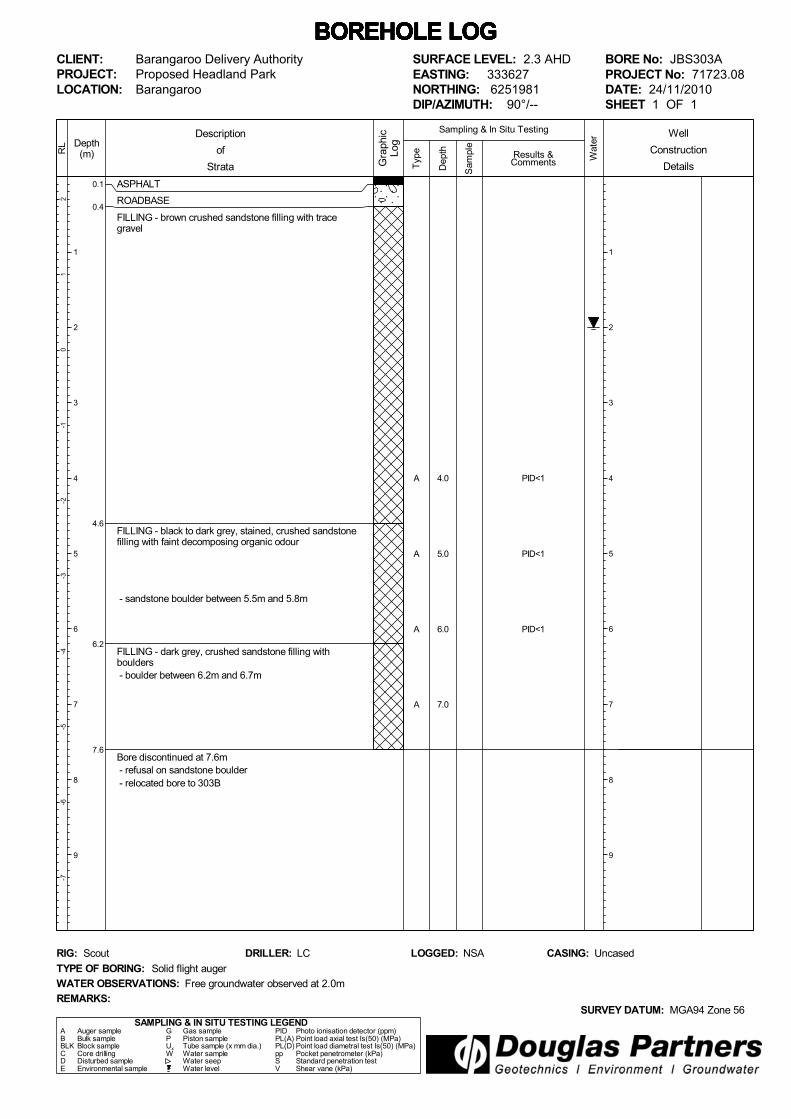
SURFACE LEVEL: 2.3 AHDEASTING: 333629NORTHING: 6251981DIP/AZIMUTH: 90°/--
BORE No: JBS303PROJECT No: 71723.08DATE: 24/11/2010SHEET 1 OF 1
WATER OBSERVATIONS: Free groundwater observed at 2.0m
TYPE OF BORING: Solid flight auger
RIG: Scout DRILLER: LC
REMARKS:SURVEY DATUM: MGA94 Zone 56
CASING: UncasedLOGGED: NSA
Well
Construction
Details
A
S
A
S
S
PID<1
10,13,13N = 26PID<1
PID<1
PID<1
40/50mmrefusalPID<1
0.2
1.0
2.0
3.0
4.0
0.1
0.4
4.6
6.2
7.6
ASPHALT
ROADBASE
FILLING - brown crushed sandstone filling with tracegravel
FILLING - black to dark grey, stained, crushed sandstonefilling with faint decomposing organic odour
- sandstone boulder between 5.5m and 5.8m
FILLING - dark grey, crushed sandstone filling withboulders - boulder between 6.2m and 6.7m
Bore discontinued at 7.6m - refusal on sandstone boulder - relocated bore to 303B
Typ
e
21
0-1
-2-3
-4-5
-6-7
Depth(m)
1
2
3
4
5
6
7
8
9
RL
Wat
er
Dep
th
Sam
ple
Description
of
Strata Gra
phic
Log
Results &Comments
Sampling & In Situ Testing
1
2
3
4
5
6
7
8
9
BOREHOLE LOG BOREHOLE LOG BOREHOLE LOG BOREHOLE LOG BOREHOLE LOG BOREHOLE LOG BOREHOLE LOG CLIENT:PROJECT:LOCATION:
Barangaroo Delivery AuthorityProposed Headland ParkBarangaroo
SAMPLING & IN SITU TESTING LEGENDA Auger sample G Gas sample PID Photo ionisation detector (ppm)B Bulk sample P Piston sample PL(A) Point load axial test Is(50) (MPa)BLK Block sample Ux Tube sample (x mm dia.) PL(D) Point load diametral test Is(50) (MPa)C Core drilling W Water sample pp Pocket penetrometer (kPa)D Disturbed sample Water seep S Standard penetration testE Environmental sample Water level V Shear vane (kPa)
SURFACE LEVEL: 2.3 AHDEASTING: 333627NORTHING: 6251981DIP/AZIMUTH: 90°/--
BORE No: JBS303APROJECT No: 71723.08DATE: 24/11/2010SHEET 1 OF 1
WATER OBSERVATIONS: Free groundwater observed at 2.0m
TYPE OF BORING: Solid flight auger
RIG: Scout DRILLER: LC
REMARKS:SURVEY DATUM: MGA94 Zone 56
CASING: UncasedLOGGED: NSA
Well
Construction
Details
A
A
A
A
PID<1
PID<1
PID<1
4.0
5.0
6.0
7.0

0.1
0.4
4.6
6.2
8.0
ASPHALT
ROADBASE
FILLING - brown crushed sandstone filling with tracegravel
FILLING - black to dark grey, stained, crushed sandstonefilling with faint organic odour
FILLING - dark grey, sandstone boulder filling
Bore discontinued at 8.0m - auger damaged and lostdown hole - relocated to Bore JBS303C
Typ
e
21
0-1
-2-3
-4-5
-6-7
Depth(m)
1
2
3
4
5
6
7
8
9
RL
Wat
er
Dep
th
Sam
ple
Description
of
Strata Gra
phic
Log
Results &Comments
Sampling & In Situ Testing
1
2
3
4
5
6
7
8
9
BOREHOLE LOG BOREHOLE LOG BOREHOLE LOG BOREHOLE LOG BOREHOLE LOG BOREHOLE LOG BOREHOLE LOG CLIENT:PROJECT:LOCATION:
Barangaroo Delivery AuthorityProposed Headland ParkBarangaroo
SAMPLING & IN SITU TESTING LEGENDA Auger sample G Gas sample PID Photo ionisation detector (ppm)B Bulk sample P Piston sample PL(A) Point load axial test Is(50) (MPa)BLK Block sample Ux Tube sample (x mm dia.) PL(D) Point load diametral test Is(50) (MPa)C Core drilling W Water sample pp Pocket penetrometer (kPa)D Disturbed sample Water seep S Standard penetration testE Environmental sample Water level V Shear vane (kPa)
SURFACE LEVEL: 2.3 AHDEASTING: 333629NORTHING: 6251984DIP/AZIMUTH: 90°/--
BORE No: JBS303BPROJECT No: 71723.08DATE: 24/11/2010SHEET 1 OF 1
WATER OBSERVATIONS: Free groundwater observed at 2.0m
TYPE OF BORING: Solid flight auger
RIG: Scout DRILLER: LC
REMARKS:SURVEY DATUM: MGA94 Zone 56
CASING: UncasedLOGGED: NSA
Well
Construction
Details

0.1
0.4
4.1
7.9
8.9
ASPHALT
ROADBASE
FILLING - brown crushed sandstone filling with tracegravel
- sandstone boulder from 3.1m to 3.7m - charcoal at 4.0m
FILLING - crushed sandstone, sandstone boulder andconcrete (assumed based on drilling conditions only, nosamples collected)
6.5m: concrete
- possible concrete at 7.2m
FILLING - dark grey, crushed sandstone filling with somegravel and sandstone boulders
- trace timber at 8.5m
FILLING - grey sand filling with sandstone boulders
Typ
e
21
0-1
-2-3
-4-5
-6-7
Depth(m)
1
2
3
4
5
6
7
8
9
RL
Wat
er
Dep
th
Sam
ple
Description
of
Strata Gra
phic
Log
Results &Comments
Sampling & In Situ Testing
1
2
3
4
5
6
7
8
9
BOREHOLE LOG BOREHOLE LOG BOREHOLE LOG BOREHOLE LOG BOREHOLE LOG BOREHOLE LOG BOREHOLE LOG CLIENT:PROJECT:LOCATION:
Barangaroo Delivery AuthorityProposed Headland ParkBarangaroo
SAMPLING & IN SITU TESTING LEGENDA Auger sample G Gas sample PID Photo ionisation detector (ppm)B Bulk sample P Piston sample PL(A) Point load axial test Is(50) (MPa)BLK Block sample Ux Tube sample (x mm dia.) PL(D) Point load diametral test Is(50) (MPa)C Core drilling W Water sample pp Pocket penetrometer (kPa)D Disturbed sample Water seep S Standard penetration testE Environmental sample Water level V Shear vane (kPa)
SURFACE LEVEL: 2.3 AHDEASTING: 333629NORTHING: 6251981DIP/AZIMUTH: 90°/--
BORE No: JBS303CPROJECT No: 71723.08DATE: 2/12/2010SHEET 1 OF 2
WATER OBSERVATIONS: Free groundwater observed at 2.5m
TYPE OF BORING: ODEX to 13.5m
RIG: Scout DRILLER: LC
REMARKS:SURVEY DATUM: MGA94 Zone 56
CASING: to 13.5mLOGGED: NSA
JBS303C repositioned at JBS303 then continued with ODEX below previous refusal depth
Well
Construction
Details
S
S
40,30/50mmrefusalPID=1
10,9,8N = 17PID=1
4,5,8
8.0
9.0
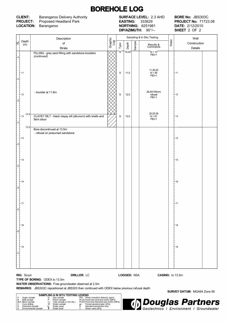
12.9
13.5
FILLING - grey sand filling with sandstone boulders(continued)
- boulder at 11.8m
CLAYEY SILT - black clayey silt (alluvium) with shells andfaint odour
Bore discontinued at 13.5m - refusal on presumed sandstone
Typ
e
-8-9
-10
-11
-12
-13
-14
-15
-16
-17
Depth(m)
11
12
13
14
15
16
17
18
19
RL
Wat
er
Dep
th
Sam
ple
Description
of
Strata Gra
phic
Log
Results &Comments
Sampling & In Situ Testing
11
12
13
14
15
16
17
18
19
BOREHOLE LOG BOREHOLE LOG BOREHOLE LOG BOREHOLE LOG BOREHOLE LOG BOREHOLE LOG BOREHOLE LOG CLIENT:PROJECT:LOCATION:
Barangaroo Delivery AuthorityProposed Headland ParkBarangaroo
SAMPLING & IN SITU TESTING LEGENDA Auger sample G Gas sample PID Photo ionisation detector (ppm)B Bulk sample P Piston sample PL(A) Point load axial test Is(50) (MPa)BLK Block sample Ux Tube sample (x mm dia.) PL(D) Point load diametral test Is(50) (MPa)C Core drilling W Water sample pp Pocket penetrometer (kPa)D Disturbed sample Water seep S Standard penetration testE Environmental sample Water level V Shear vane (kPa)
SURFACE LEVEL: 2.3 AHDEASTING: 333629NORTHING: 6251981DIP/AZIMUTH: 90°/--
BORE No: JBS303CPROJECT No: 71723.08DATE: 2/12/2010SHEET 2 OF 2
WATER OBSERVATIONS: Free groundwater observed at 2.5m
TYPE OF BORING: ODEX to 13.5m
RIG: Scout DRILLER: LC
REMARKS:SURVEY DATUM: MGA94 Zone 56
CASING: to 13.5mLOGGED: NSA
JBS303C repositioned at JBS303 then continued with ODEX below previous refusal depth
Well
Construction
DetailsS
S
S
S
N = 13PID=1
11,26,20N = 46PID=1
26,40/100mmrefusalPID=1
20,25,36N = 61PID=1
10.03
11.0
12.0
13.0

0.1
0.7
1.4
2.0
2.3
2.6
2.82.9
3.8
4.9
5.8
7.9
9.2
ASPHALT
ROADBASE
FILLING - grey mottled red, crushed sandstone filling withtrace slag and gravel
FILLING - brown clay filling with some gravel and tracesandstone fragments
FILLING - concrete slab
FILLING - brown clay filling with trace gravel and crushedsandstone
FILLING - gravel filling with trace clay
FILLING - brown clayey sand filling with some gravel
FILLING - black sand/sandstone filling with ash and tracegravel
FILLING - dark grey to black, sand filling with some graveland crushed sandstone
FILLING - dark grey, sand filling with some sandstonefragments and trace sandstone boulders and traceconcrete fragments
FILLING - grey clay filling with trace sand and traceironstone and gravel
FILLING - grey, low strength sandstone boulder
Bore discontinued at 9.2m - refusal on concrete (possibly sandstone) - relocated bore to JBS304A
Typ
e
21
0-1
-2-3
-4-5
-6-7
Depth(m)
1
2
3
4
5
6
7
8
9
RL
Wat
er
Dep
th
Sam
ple
Description
of
Strata Gra
phic
Log
Results &Comments
Sampling & In Situ Testing
1
2
3
4
5
6
7
8
9
BOREHOLE LOG BOREHOLE LOG BOREHOLE LOG BOREHOLE LOG BOREHOLE LOG BOREHOLE LOG BOREHOLE LOG CLIENT:PROJECT:LOCATION:
Barangaroo Delivery AuthorityProposed Headland ParkBarangaroo
SAMPLING & IN SITU TESTING LEGENDA Auger sample G Gas sample PID Photo ionisation detector (ppm)B Bulk sample P Piston sample PL(A) Point load axial test Is(50) (MPa)BLK Block sample Ux Tube sample (x mm dia.) PL(D) Point load diametral test Is(50) (MPa)C Core drilling W Water sample pp Pocket penetrometer (kPa)D Disturbed sample Water seep S Standard penetration testE Environmental sample Water level V Shear vane (kPa)
SURFACE LEVEL: 2.7 AHDEASTING: 333662NORTHING: 6251985DIP/AZIMUTH: 90°/--
BORE No: JBS304PROJECT No: 71723.08DATE: 22/11/2010SHEET 1 OF 1
WATER OBSERVATIONS: Free groundwater observed at 2.7m
TYPE OF BORING: Solid flight auger
RIG: Scout DRILLER: LC
REMARKS:SURVEY DATUM: MGA94 Zone 56
CASING: UncasedLOGGED: NSA
*Denotes field replicate samples RIBD1/221110 & RIBDIA/221110 collected
Well
Construction
Details
S
S
A*
S
A
S
A
A
A
A
38,35,38N = 73PID<1
8,8,16N = 24PID<1
PID<1
4,4,12N = 16PID<1
PID<1
4,5,1N = 6PID<1
PID<1hole collapse - limited
sample
PID<1
PID<1
PID<1
0.2
1.0
1.9
3.0
4.0
5.0
6.0
7.2
8.0
9.0
0.1
0.7
1.4
3.8
4.9
5.8
7.9
9.5
ASPHALT
ROADBASE
FILLING - grey mottled red, crushed sandstone filling withtrace slag and gravel
FILLING - brown clay filling with some gravel and tracesandstone fragments
FILLING - dark grey to black, sand filling with some graveland crushed sandstone
FILLING - dark grey, sand filling with some sandstonefragments and trace sandstone boulders and traceconcrete fragments
FILLING - grey clay filling with trace sand and traceironstone and gravel
FILLING - low strength, grey sandstone boulder
FILLING - grey crushed sandstone filling with trace gravel
Typ
e
21
0-1
-2-3
-4-5
-6-7
Depth(m)
1
2
3
4
5
6
7
8
9
RL
Wat
er
Dep
th
Sam
ple
Description
of
Strata Gra
phic
Log
Results &Comments
Sampling & In Situ Testing
1
2
3
4
5
6
7
8
9
BOREHOLE LOG BOREHOLE LOG BOREHOLE LOG BOREHOLE LOG BOREHOLE LOG BOREHOLE LOG BOREHOLE LOG CLIENT:PROJECT:LOCATION:
Barangaroo Delivery AuthorityProposed Headland ParkBarangaroo
SAMPLING & IN SITU TESTING LEGENDA Auger sample G Gas sample PID Photo ionisation detector (ppm)B Bulk sample P Piston sample PL(A) Point load axial test Is(50) (MPa)BLK Block sample Ux Tube sample (x mm dia.) PL(D) Point load diametral test Is(50) (MPa)C Core drilling W Water sample pp Pocket penetrometer (kPa)D Disturbed sample Water seep S Standard penetration testE Environmental sample Water level V Shear vane (kPa)
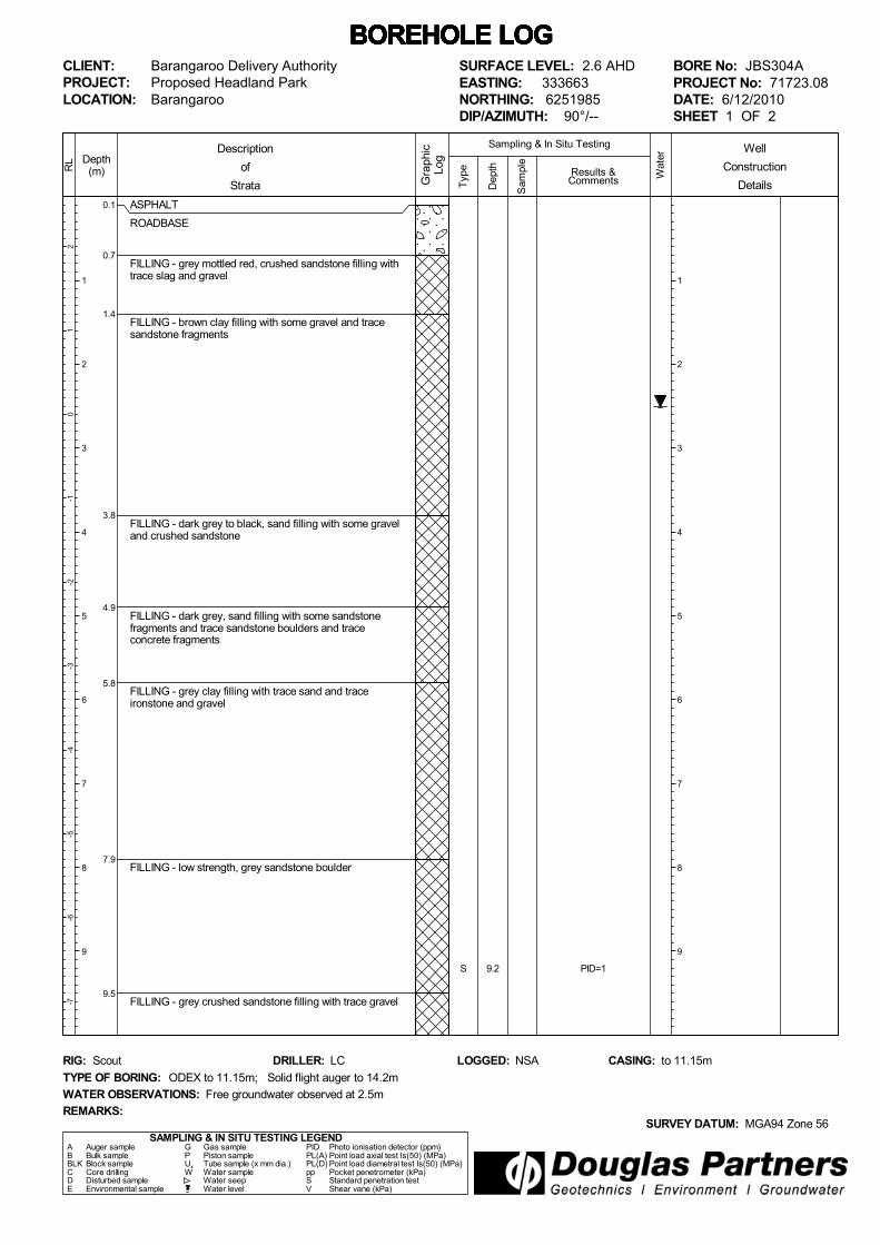
SURFACE LEVEL: 2.6 AHDEASTING: 333663NORTHING: 6251985DIP/AZIMUTH: 90°/--
BORE No: JBS304APROJECT No: 71723.08DATE: 6/12/2010SHEET 1 OF 2
WATER OBSERVATIONS: Free groundwater observed at 2.5m
TYPE OF BORING: ODEX to 11.15m; Solid flight auger to 14.2m
RIG: Scout DRILLER: LC
REMARKS:SURVEY DATUM: MGA94 Zone 56
CASING: to 11.15mLOGGED: NSA
Well
Construction
Details
S PID=19.2
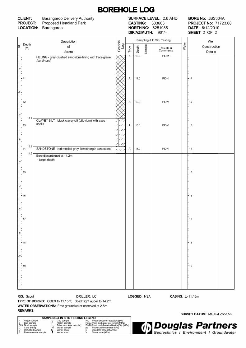
12.7
13.9
14.2
FILLING - grey crushed sandstone filling with trace gravel(continued)
CLAYEY SILT - black clayey silt (alluvium) with traceshells
SANDSTONE - red mottled grey, low strength sandstone
Bore discontinued at 14.2m - target depth
Typ
e
-8-9
-10
-11
-12
-13
-14
-15
-16
-17
Depth(m)
11
12
13
14
15
16
17
18
19
RL
Wat
er
Dep
th
Sam
ple
Description
of
Strata Gra
phic
Log
Results &Comments
Sampling & In Situ Testing
11
12
13
14
15
16
17
18
19
BOREHOLE LOG BOREHOLE LOG BOREHOLE LOG BOREHOLE LOG BOREHOLE LOG BOREHOLE LOG BOREHOLE LOG CLIENT:PROJECT:LOCATION:
Barangaroo Delivery AuthorityProposed Headland ParkBarangaroo
SAMPLING & IN SITU TESTING LEGENDA Auger sample G Gas sample PID Photo ionisation detector (ppm)B Bulk sample P Piston sample PL(A) Point load axial test Is(50) (MPa)BLK Block sample Ux Tube sample (x mm dia.) PL(D) Point load diametral test Is(50) (MPa)C Core drilling W Water sample pp Pocket penetrometer (kPa)D Disturbed sample Water seep S Standard penetration testE Environmental sample Water level V Shear vane (kPa)
SURFACE LEVEL: 2.6 AHDEASTING: 333663NORTHING: 6251985DIP/AZIMUTH: 90°/--
BORE No: JBS304APROJECT No: 71723.08DATE: 6/12/2010SHEET 2 OF 2
WATER OBSERVATIONS: Free groundwater observed at 2.5m
TYPE OF BORING: ODEX to 11.15m; Solid flight auger to 14.2m
RIG: Scout DRILLER: LC
REMARKS:SURVEY DATUM: MGA94 Zone 56
CASING: to 11.15mLOGGED: NSA
Well
Construction
DetailsA
A
A
A
A
PID=1
PID=1
PID=1
PID=1
PID=1
10.0
11.0
12.0
13.0
14.0

0.10.15
0.7
4.9
6.7
7.9
9.3
ASPHALT
ROADBASE
FILLING - grey crushed sandstone filling with some graveland sandstone fragments
FILLING - brown clayey sand with crushed sandstonefilling with trace gravel and grey sandstone boulders
- trace glass pieces at 3.0m
- grey crushed sandstone at 3.5m
FILLING - dark grey, sand filling with trace shell fragments
FILLING - dark grey, sand filling with sandstone boulders
SANDSTONE - grey mottled yellow, low strengthsandstone
Bore discontinued at 9.3m - target depth
Typ
e
21
0-1
-2-3
-4-5
-6-7
Depth(m)
1
2
3
4
5
6
7
8
9
RL
Wat
er
Dep
th
Sam
ple
Description
of
Strata Gra
phic
Log
Results &Comments
Sampling & In Situ Testing
1
2
3
4
5
6
7
8
9
BOREHOLE LOG BOREHOLE LOG BOREHOLE LOG BOREHOLE LOG BOREHOLE LOG BOREHOLE LOG BOREHOLE LOG CLIENT:PROJECT:LOCATION:
Barangaroo Delivery AuthorityProposed Headland ParkBarangaroo
SAMPLING & IN SITU TESTING LEGENDA Auger sample G Gas sample PID Photo ionisation detector (ppm)B Bulk sample P Piston sample PL(A) Point load axial test Is(50) (MPa)BLK Block sample Ux Tube sample (x mm dia.) PL(D) Point load diametral test Is(50) (MPa)C Core drilling W Water sample pp Pocket penetrometer (kPa)D Disturbed sample Water seep S Standard penetration testE Environmental sample Water level V Shear vane (kPa)
SURFACE LEVEL: 2.2 AHDEASTING: 333679NORTHING: 6252019DIP/AZIMUTH: 90°/--
BORE No: JBS305PROJECT No: 71723.08DATE: 22/11/2010SHEET 1 OF 1
WATER OBSERVATIONS: Free groundwater observed at 2.2m
TYPE OF BORING: Solid flight auger
RIG: Scout DRILLER: LC
REMARKS:SURVEY DATUM: MGA94 Zone 56
CASING: UncasedLOGGED: NSA
Well
Construction
Details
S
A
A
S
A
A
A
A
A
A
40,36,60/90mmrefusalPID<1
PID<1
PID<1
5,5,5N = 10PID<1
PID<1
PID<1
PID<1
PID<1
PID<1
PID<1
0.2
1.0
2.0
3.0
4.0
5.0
6.0
7.0
8.0
9.0
0.15
0.7
2.3
2.5
2.7
4.8
5.35.45
ASPHALT
ROADBASE - brown silty sand with some gravel andcrushed sandstone - charcoal at 0.5m - rubbish at 0.6m
FILLING - brown clayey silty sand with some charcoal andcrushed sandstone
2.0-2.3m: coarse gravel
FILLING - dark brown to black, silty sandy clay filling,slight chemical odour
FILLING - yellow orange crushed sandstone
FILLING - brown silty sand filling, organic odour
- shells at 4.2m (possibly natural)
CLAYEY SAND - green yellow, clayey sand
SANDSTONE - yellow orange sandstone
Bore discontinued at 5.45m - target depth
Typ
e
21
0-1
-2-3
-4-5
-6-7
Depth(m)
1
2
3
4
5
6
7
8
9
RL
Wat
er
Dep
th
Sam
ple
Description
of
Strata Gra
phic
Log
Results &Comments
Sampling & In Situ Testing
1
2
3
4
5
6
7
8
9
BOREHOLE LOG BOREHOLE LOG BOREHOLE LOG BOREHOLE LOG BOREHOLE LOG BOREHOLE LOG BOREHOLE LOG CLIENT:PROJECT:LOCATION:
Barangaroo Delivery AuthorityProposed Headland ParkBarangaroo
SAMPLING & IN SITU TESTING LEGENDA Auger sample G Gas sample PID Photo ionisation detector (ppm)B Bulk sample P Piston sample PL(A) Point load axial test Is(50) (MPa)BLK Block sample Ux Tube sample (x mm dia.) PL(D) Point load diametral test Is(50) (MPa)C Core drilling W Water sample pp Pocket penetrometer (kPa)D Disturbed sample Water seep S Standard penetration testE Environmental sample Water level V Shear vane (kPa)
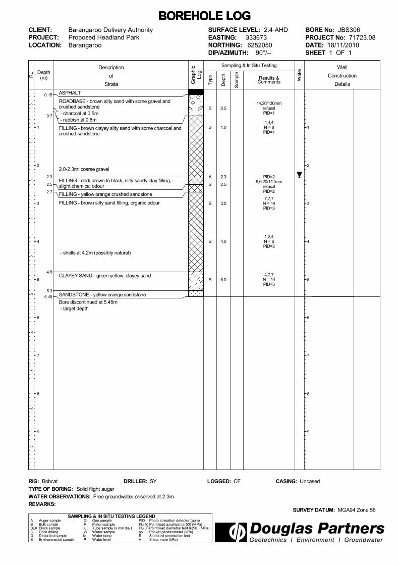
SURFACE LEVEL: 2.4 AHDEASTING: 333673NORTHING: 6252050DIP/AZIMUTH: 90°/--
BORE No: JBS306PROJECT No: 71723.08DATE: 18/11/2010SHEET 1 OF 1
WATER OBSERVATIONS: Free groundwater observed at 2.3m
TYPE OF BORING: Solid flight auger
RIG: Bobcat DRILLER: SY
REMARKS:SURVEY DATUM: MGA94 Zone 56
CASING: UncasedLOGGED: CF
Well
Construction
Details
S
S
A
S
S
S
S
14,20/130mmrefusalPID=1
4,4,4N = 8PID=1
PID=29,6,20/111mm
refusalPID=2
7,7,7N = 14PID=3
1,2,4N = 6PID=3
4,7,7N = 14PID=3
0.5
1.0
2.3
2.5
3.0
4.0
5.0

0.15
0.7
2.0
3.0
4.0
4.45
ASPHALT
ROADBASE - dark brown, sandy silt filling
FILLING - yellow to brown, clayey sand and sandstonefilling with some black staining - slight chemical odour
FILLING - white sandy clay filling
SILTY CLAY - dark grey, silty clay
SANDSTONE - yellow brown sandstone
Bore discontinued at 4.45m - target depth
Typ
e
21
0-1
-2-3
-4-5
-6-7
Depth(m)
1
2
3
4
5
6
7
8
9
RL
Wat
er
Dep
th
Sam
ple
Description
of
Strata Gra
phic
Log
Results &Comments
Sampling & In Situ Testing
1
2
3
4
5
6
7
8
9
BOREHOLE LOG BOREHOLE LOG BOREHOLE LOG BOREHOLE LOG BOREHOLE LOG BOREHOLE LOG BOREHOLE LOG CLIENT:PROJECT:LOCATION:
Barangaroo Delivery AuthorityProposed Headland ParkBarangaroo
SAMPLING & IN SITU TESTING LEGENDA Auger sample G Gas sample PID Photo ionisation detector (ppm)B Bulk sample P Piston sample PL(A) Point load axial test Is(50) (MPa)BLK Block sample Ux Tube sample (x mm dia.) PL(D) Point load diametral test Is(50) (MPa)C Core drilling W Water sample pp Pocket penetrometer (kPa)D Disturbed sample Water seep S Standard penetration testE Environmental sample Water level V Shear vane (kPa)
SURFACE LEVEL: 2.4 AHDEASTING: 333670NORTHING: 6252078DIP/AZIMUTH: 90°/--
BORE No: JBS307PROJECT No: 71723.08DATE: 18/11/2010SHEET 1 OF 1
WATER OBSERVATIONS: Free groundwater observed at 3.0m
TYPE OF BORING: Solid flight auger
RIG: Bobcat DRILLER: SY
REMARKS:SURVEY DATUM: MGA94 Zone 56
CASING: UncasedLOGGED: CF
Well
Construction
Details
S
S
S
S
S
15,18,17N = 35PID=2
14,7,7N = 14PID=2
2,4,2N = 6PID=2
6,4,8N = 12PID=4
8,20/130mmrefusal
0.5
1.0
2.0
3.0
4.0
0.15
0.5
2.7
3.15
ASPHALT
ROADBASE - brown silty sand filling with some crushedsandstone
FILLING - brown, gravelly silty clayey sand filling withsome crushed sandstone
- coarse gravel from 1.5m to 2.0m
SANDSTONE - low strength sandstone
Bore discontinued at 3.15m - refusal in low to medium strength sandstone
Typ
e
21
0-1
-2-3
-4-5
-6-7
Depth(m)
1
2
3
4
5
6
7
8
9
RL
Wat
er
Dep
th
Sam
ple
Description
of
Strata Gra
phic
Log
Results &Comments
Sampling & In Situ Testing
1
2
3
4
5
6
7
8
9
BOREHOLE LOG BOREHOLE LOG BOREHOLE LOG BOREHOLE LOG BOREHOLE LOG BOREHOLE LOG BOREHOLE LOG CLIENT:PROJECT:LOCATION:
Barangaroo Delivery AuthorityProposed Headland ParkBarangaroo
SAMPLING & IN SITU TESTING LEGENDA Auger sample G Gas sample PID Photo ionisation detector (ppm)B Bulk sample P Piston sample PL(A) Point load axial test Is(50) (MPa)BLK Block sample Ux Tube sample (x mm dia.) PL(D) Point load diametral test Is(50) (MPa)C Core drilling W Water sample pp Pocket penetrometer (kPa)D Disturbed sample Water seep S Standard penetration testE Environmental sample Water level V Shear vane (kPa)
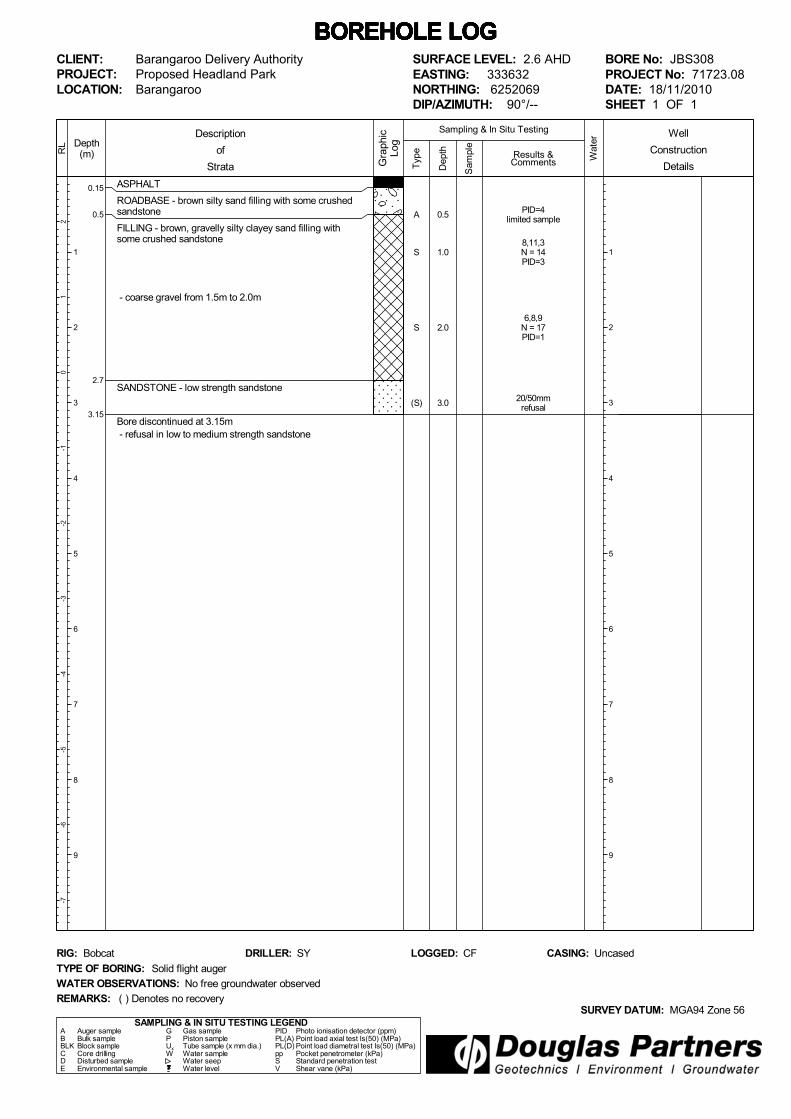
SURFACE LEVEL: 2.6 AHDEASTING: 333632NORTHING: 6252069DIP/AZIMUTH: 90°/--
BORE No: JBS308PROJECT No: 71723.08DATE: 18/11/2010SHEET 1 OF 1
WATER OBSERVATIONS: No free groundwater observed
TYPE OF BORING: Solid flight auger
RIG: Bobcat DRILLER: SY
REMARKS:SURVEY DATUM: MGA94 Zone 56
CASING: UncasedLOGGED: CF
( ) Denotes no recovery
Well
Construction
Details
A
S
S
(S)
PID=4limited sample
8,11,3N = 14PID=3
6,8,9N = 17PID=1
20/50mmrefusal
0.5
1.0
2.0
3.0

0.015
0.3
0.5
4.5
5.5
7.9
9.0
ASPHALT
ROADBASE - dark grey, gravelly silt filling
FILLING - brown gravelly sand filling
FILLING - yellow crushed sandstone filling with someballast gravel above 1.5m
FILLING - brown crushed sandstone filling
SILTY CLAY - red brown to brown, silty clay (possiblefilling)
SANDSTONE - yellow to orange sandstone
Bore discontinued at 9.0m - target depth
Typ
e
21
0-1
-2-3
-4-5
-6-7
Depth(m)
1
2
3
4
5
6
7
8
9
RL
Wat
er
Dep
th
Sam
ple
Description
of
Strata Gra
phic
Log
Results &Comments
Sampling & In Situ Testing
1
2
3
4
5
6
7
8
9
BOREHOLE LOG BOREHOLE LOG BOREHOLE LOG BOREHOLE LOG BOREHOLE LOG BOREHOLE LOG BOREHOLE LOG CLIENT:PROJECT:LOCATION:
Barangaroo Delivery AuthorityProposed Headland ParkBarangaroo
SAMPLING & IN SITU TESTING LEGENDA Auger sample G Gas sample PID Photo ionisation detector (ppm)B Bulk sample P Piston sample PL(A) Point load axial test Is(50) (MPa)BLK Block sample Ux Tube sample (x mm dia.) PL(D) Point load diametral test Is(50) (MPa)C Core drilling W Water sample pp Pocket penetrometer (kPa)D Disturbed sample Water seep S Standard penetration testE Environmental sample Water level V Shear vane (kPa)
SURFACE LEVEL: 2.2 AHDEASTING: 333599NORTHING: 6252053DIP/AZIMUTH: 90°/--
BORE No: JBS309PROJECT No: 71723.08DATE: 23/11/2010SHEET 1 OF 1
WATER OBSERVATIONS: Free groundwater observed at 2.2m
TYPE OF BORING: Solid flight auger
RIG: Scout DRILLER: JS
REMARKS:SURVEY DATUM: MGA94 Zone 56
CASING: UncasedLOGGED: CF
*Denotes field replicate sample R2BD5/231110 collected
Well
Construction
Details
A
A*
A
S
A
A
A
A
A
A
PID=1
PID=1
PID=1
3,5,3N = 8PID=1
PID=1
PID=1
PID=1
PID=1
PID=1
PID=1
0.5
1.0
2.0
3.0
4.0
5.0
6.0
7.0
8.0
9.0

0.02
0.5
2.0
7.8
10.0
ASPHALT
ROADBASE - grey gravelly sand filling
FILLING - dark brown, sandy silt and yellow crushedsandstone filling with some ballast gravel
FILLING - brown crushed sandstone filling with traceballast gravel
SANDSTONE - white to grey and brown sandstone
Bore discontinued at 10.0m - target depth
Typ
e
21
0-1
-2-3
-4-5
-6-7
Depth(m)
1
2
3
4
5
6
7
8
9
10
RL
Wat
er
Dep
th
Sam
ple
Description
of
Strata Gra
phic
Log
Results &Comments
Sampling & In Situ Testing
1
2
3
4
5
6
7
8
9
10
BOREHOLE LOG BOREHOLE LOG BOREHOLE LOG BOREHOLE LOG BOREHOLE LOG BOREHOLE LOG BOREHOLE LOG CLIENT:PROJECT:LOCATION:
Barangaroo Delivery AuthorityProposed Headland ParkBarangaroo
SAMPLING & IN SITU TESTING LEGENDA Auger sample G Gas sample PID Photo ionisation detector (ppm)B Bulk sample P Piston sample PL(A) Point load axial test Is(50) (MPa)BLK Block sample Ux Tube sample (x mm dia.) PL(D) Point load diametral test Is(50) (MPa)C Core drilling W Water sample pp Pocket penetrometer (kPa)D Disturbed sample Water seep S Standard penetration testE Environmental sample Water level V Shear vane (kPa)
SURFACE LEVEL: 2.7 AHDEASTING: 333573NORTHING: 6252061DIP/AZIMUTH: 90°/--
BORE No: JBS310PROJECT No: 71723.08DATE: 23/11/2010SHEET 1 OF 1
WATER OBSERVATIONS: Free groundwater observed at 2.5m
TYPE OF BORING: Solid flight auger
RIG: Scout DRILLER: JS
REMARKS:SURVEY DATUM: MGA94 Zone 56
CASING: UncasedLOGGED: CF
*Denotes field replicate sample R2BD6/231110 collected
Well
Construction
Details
A
S
A*
S
A
A
A
A
A
A
PID<1
3,2,4N = 6PID<1
PID<1
2,7,7N = 14PID<1
PID<1
PID<1
PID=1
PID<1
PID<1
PID<1
0.5
1.0
2.0
3.0
4.0
5.0
6.0
7.0
8.0
10.0

0.12
0.3
3.5
3.8
4.8
7.1
7.3
ASPHALT
ROADBASE - grey gravelly silt filling
FILLING - brown silty sand and crushed sandstone fillingwith some ballast gravel
- reo at 1.7m
FILLING - red crushed sandstone filling
FILLING - crushed sandstone and coarse gravel filling
- concrete at 4.4m
FILLING - crushed sandstone/sand and fine gravel fillingwith trace glass, concrete and brick inclusions
SANDSTONE - yellow sandstone
Bore discontinued at 7.3m - refusal in sandstone
Typ
e
21
0-1
-2-3
-4-5
-6-7
Depth(m)
1
2
3
4
5
6
7
8
9
RL
Wat
er
Dep
th
Sam
ple
Description
of
Strata Gra
phic
Log
Results &Comments
Sampling & In Situ Testing
1
2
3
4
5
6
7
8
9
BOREHOLE LOG BOREHOLE LOG BOREHOLE LOG BOREHOLE LOG BOREHOLE LOG BOREHOLE LOG BOREHOLE LOG CLIENT:PROJECT:LOCATION:
Barangaroo Delivery AuthorityProposed Headland ParkBarangaroo
SAMPLING & IN SITU TESTING LEGENDA Auger sample G Gas sample PID Photo ionisation detector (ppm)B Bulk sample P Piston sample PL(A) Point load axial test Is(50) (MPa)BLK Block sample Ux Tube sample (x mm dia.) PL(D) Point load diametral test Is(50) (MPa)C Core drilling W Water sample pp Pocket penetrometer (kPa)D Disturbed sample Water seep S Standard penetration testE Environmental sample Water level V Shear vane (kPa)
SURFACE LEVEL: 2.4 AHDEASTING: 333524NORTHING: 6252081DIP/AZIMUTH: 90°/--
BORE No: JBS311PROJECT No: 71723.08DATE: 25 - 26/11/2010SHEET 1 OF 1
WATER OBSERVATIONS: Free groundwater observed at 2.0m
TYPE OF BORING: Solid flight auger to 4.4m; ODEX to 7.3m
RIG: Scout DRILLER: LC
REMARKS:SURVEY DATUM: MGA94 Zone 56
CASING: UncasedLOGGED: CF
*Denotes field replicate sample RIBD9/251110 collected. ( ) Denotes no recovery
Well
Construction
Details
S
A
A
A
S
(S)
(S)
(S)
D
34,30/40mmrefusalPID<1
PID=1
PID<1
PID<1
50,18,32N = 50PID=1
1,9,4N = 13PID=1
No sample. Wash sampletaken
24,12,5N = 17PID=1
2 attempts-no sample.Wash sample taken
7,6,13N = 19PID=1
no sample. Wash sampletakenPID=1
very limited sample
0.2
1.0
2.0
3.0
4.0
5.0
6.0
7.0
7.25
0.015
0.9
1.4
ASPHALT
ROADBASE - brown silty sand and crushed sandstonefilling with some ballast gravel
FILLING - brown silty sand and crushed sandstone filling
- ballast cobbles from 1.3m
Bore discontinued at 1.4m - refusal (possibly on concrete or ballast) - relocated bore to JBS312A
Typ
e
21
0-1
-2-3
-4-5
-6-7
Depth(m)
1
2
3
4
5
6
7
8
9
RL
Wat
er
Dep
th
Sam
ple
Description
of
Strata Gra
phic
Log
Results &Comments
Sampling & In Situ Testing
1
2
3
4
5
6
7
8
9
BOREHOLE LOG BOREHOLE LOG BOREHOLE LOG BOREHOLE LOG BOREHOLE LOG BOREHOLE LOG BOREHOLE LOG CLIENT:PROJECT:LOCATION:
Barangaroo Delivery AuthorityProposed Headland ParkBarangaroo
SAMPLING & IN SITU TESTING LEGENDA Auger sample G Gas sample PID Photo ionisation detector (ppm)B Bulk sample P Piston sample PL(A) Point load axial test Is(50) (MPa)BLK Block sample Ux Tube sample (x mm dia.) PL(D) Point load diametral test Is(50) (MPa)C Core drilling W Water sample pp Pocket penetrometer (kPa)D Disturbed sample Water seep S Standard penetration testE Environmental sample Water level V Shear vane (kPa)
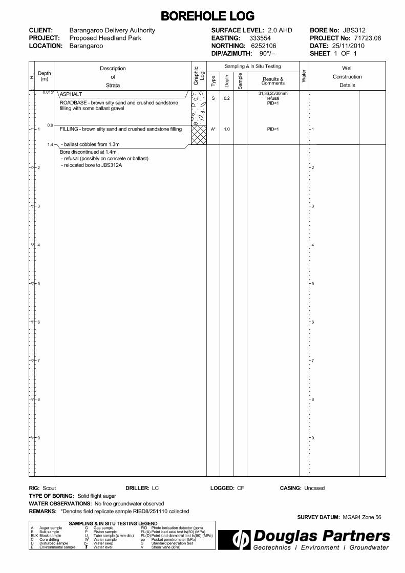
SURFACE LEVEL: 2.0 AHDEASTING: 333554NORTHING: 6252106DIP/AZIMUTH: 90°/--
BORE No: JBS312PROJECT No: 71723.08DATE: 25/11/2010SHEET 1 OF 1
WATER OBSERVATIONS: No free groundwater observed
TYPE OF BORING: Solid flight auger
RIG: Scout DRILLER: LC
REMARKS:SURVEY DATUM: MGA94 Zone 56
CASING: UncasedLOGGED: CF
*Denotes field replicate sample RIBD8/251110 collected
Well
Construction
Details
S
A*
31,36,25/30mmrefusalPID<1
PID<1
0.2
1.0

0.015
0.9
1.8
3.0
3.94.0
4.64.7
6.0
ASPHALT
ROADBASE - brown silty sand and crushed sandstonefilling with some ballast gravel
FILLING - brown silty sand and crushed sandstone filling
FILLING - yellow to brown, crushed sandstone filling
- sandstone boulder 2.9 to 3.4m
- auger refusal (sandstone boulder) Start ODEX
SILTY CLAY - dark grey, silty clay (possible filling)
SANDSTONE - yellow to orange sandstone (possiblecrushed sandstone boulder)
SILTY CLAY - dark grey, silty clay
SANDSTONE - red brown sandstone with trace ironstone - grades to light grey
Bore discontinued at 6.0m - target depth
Typ
e
32
10
-1-2
-3-4
-5-6
Depth(m)
1
2
3
4
5
6
7
8
9
RL
Wat
er
Dep
th
Sam
ple
Description
of
Strata Gra
phic
Log
Results &Comments
Sampling & In Situ Testing
1
2
3
4
5
6
7
8
9
BOREHOLE LOG BOREHOLE LOG BOREHOLE LOG BOREHOLE LOG BOREHOLE LOG BOREHOLE LOG BOREHOLE LOG CLIENT:PROJECT:LOCATION:
Barangaroo Delivery AuthorityProposed Headland ParkBarangaroo
SAMPLING & IN SITU TESTING LEGENDA Auger sample G Gas sample PID Photo ionisation detector (ppm)B Bulk sample P Piston sample PL(A) Point load axial test Is(50) (MPa)BLK Block sample Ux Tube sample (x mm dia.) PL(D) Point load diametral test Is(50) (MPa)C Core drilling W Water sample pp Pocket penetrometer (kPa)D Disturbed sample Water seep S Standard penetration testE Environmental sample Water level V Shear vane (kPa)
SURFACE LEVEL: 3.0 AHDEASTING: 333555NORTHING: 6252108DIP/AZIMUTH: 90°/--
BORE No: JBS312APROJECT No: 71723.08DATE: 25/11/2010SHEET 1 OF 1
WATER OBSERVATIONS: Free groundwater observed at 3.9m
TYPE OF BORING: Solid flight auger to 3.2m; ODEX to 6.0m
RIG: Scout DRILLER: LC
REMARKS:SURVEY DATUM: MGA94 Zone 56
CASING: UncasedLOGGED: CF
Well
Construction
Details
A
A
S
D/(S)
D/(S)
PID<1
PID<1
30/100mmrefusalPID<1
Limited sample
30/70mmrefusalPID<1
30/70mmrefusalPID<1
2 attempts
2.0
3.0
4.0
4.5
5.0
0.1
0.5
0.8
2.5
5.4
ASPHALT
ROADBASE - grey gravelly silt filling with trace brick
FILLING - brown silty sand filling
FILLING - yellow brown, sand and crushed sandstonefilling
FILLING - dark grey, clayey sand filling with some gravel - slight hydrocarbon odour from 2.5 to 3.0m and blackstaining
- crushed sandstone from 4.5m
Bore discontinued at 5.4m - refusal - relocated bore to JBS313A
Typ
e
21
0-1
-2-3
-4-5
-6-7
Depth(m)
1
2
3
4
5
6
7
8
9
RL
Wat
er
Dep
th
Sam
ple
Description
of
Strata Gra
phic
Log
Results &Comments
Sampling & In Situ Testing
1
2
3
4
5
6
7
8
9
BOREHOLE LOG BOREHOLE LOG BOREHOLE LOG BOREHOLE LOG BOREHOLE LOG BOREHOLE LOG BOREHOLE LOG CLIENT:PROJECT:LOCATION:
Barangaroo Delivery AuthorityProposed Headland ParkBarangaroo
SAMPLING & IN SITU TESTING LEGENDA Auger sample G Gas sample PID Photo ionisation detector (ppm)B Bulk sample P Piston sample PL(A) Point load axial test Is(50) (MPa)BLK Block sample Ux Tube sample (x mm dia.) PL(D) Point load diametral test Is(50) (MPa)C Core drilling W Water sample pp Pocket penetrometer (kPa)D Disturbed sample Water seep S Standard penetration testE Environmental sample Water level V Shear vane (kPa)
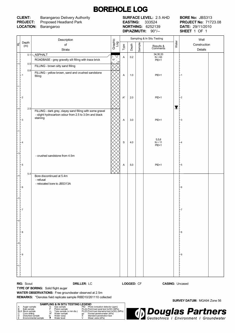
SURFACE LEVEL: 2.5 AHDEASTING: 333524NORTHING: 6252139DIP/AZIMUTH: 90°/--
BORE No: JBS313PROJECT No: 71723.08DATE: 29/11/2010SHEET 1 OF 1
WATER OBSERVATIONS: Free groundwater observed at 2.5m
TYPE OF BORING: Solid flight auger
RIG: Scout DRILLER: LC
REMARKS:SURVEY DATUM: MGA94 Zone 56
CASING: UncasedLOGGED: CF
*Denotes field replicate sample RIBD10/261110 collected
Well
Construction
Details
A
A
A*
A
S
A
34,30,33N = 63PID<1
PID<1
PID<1
PID<1
5,5,6N = 11PID<1
PID<1
0.2
1.0
2.0
3.0
4.0
5.0

0.1
0.5
0.8
2.5
5.5
7.6
8.0
ASPHALT
ROADBASE - grey gravelly silt filling with trace brick
FILLING - brown silty sand filling
FILLING - yellow brown, sand and crushed sandstonefilling
FILLING - dark grey, clayey sand filling with some gravel-slight hydrocarbon odour from 2.5 to 3.0m and blackstaining
FILLING - grey to black, sand and gravel filling with brick,concrete and tile inclusions
FILLING - black silty clay filling with some gravel andwood inclusions
FILLING - black to dark grey, sand filling with sandstoneboulders
Typ
e
21
0-1
-2-3
-4-5
-6-7
Depth(m)
1
2
3
4
5
6
7
8
9
RL
Wat
er
Dep
th
Sam
ple
Description
of
Strata Gra
phic
Log
Results &Comments
Sampling & In Situ Testing
1
2
3
4
5
6
7
8
9
BOREHOLE LOG BOREHOLE LOG BOREHOLE LOG BOREHOLE LOG BOREHOLE LOG BOREHOLE LOG BOREHOLE LOG CLIENT:PROJECT:LOCATION:
Barangaroo Delivery AuthorityProposed Headland ParkBarangaroo
SAMPLING & IN SITU TESTING LEGENDA Auger sample G Gas sample PID Photo ionisation detector (ppm)B Bulk sample P Piston sample PL(A) Point load axial test Is(50) (MPa)BLK Block sample Ux Tube sample (x mm dia.) PL(D) Point load diametral test Is(50) (MPa)C Core drilling W Water sample pp Pocket penetrometer (kPa)D Disturbed sample Water seep S Standard penetration testE Environmental sample Water level V Shear vane (kPa)
SURFACE LEVEL: 2.5 AHDEASTING: 333524NORTHING: 6252139DIP/AZIMUTH: 90°/--
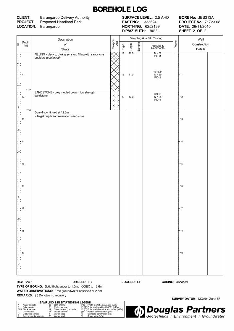
BORE No: JBS313APROJECT No: 71723.08DATE: 29/11/2010SHEET 1 OF 2
WATER OBSERVATIONS: Free groundwater observed at 2.5m
TYPE OF BORING: Solid flight auger to 1.5m; ODEX to 12.6m
RIG: Scout DRILLER: LC
REMARKS:SURVEY DATUM: MGA94 Zone 56
CASING: UncasedLOGGED: CF
( ) Denotes no recovery
Well
Construction
Details
S
D/(S)(S)
S
S
7,8,10N = 18PID<1
limited sample
5,2,2N = 43,5,3N = 8PID<1
2 attempts. Wash sampletaken
38,25,19N = 44PID<1
5,4,16N = 20PID<1
6,10,22
6.0
7.0
8.0
9.0
11.7
12.6
FILLING - black to dark grey, sand filling with sandstoneboulders (continued)
SANDSTONE - grey mottled brown, low strengthsandstone
Bore discontinued at 12.6m - target depth and refusal on sandstone
Typ
e
-8-9
-10
-11
-12
-13
-14
-15
-16
-17
Depth(m)
11
12
13
14
15
16
17
18
19
RL
Wat
er
Dep
th
Sam
ple
Description
of
Strata Gra
phic
Log
Results &Comments
Sampling & In Situ Testing
11
12
13
14
15
16
17
18
19
BOREHOLE LOG BOREHOLE LOG BOREHOLE LOG BOREHOLE LOG BOREHOLE LOG BOREHOLE LOG BOREHOLE LOG CLIENT:PROJECT:LOCATION:
Barangaroo Delivery AuthorityProposed Headland ParkBarangaroo
SAMPLING & IN SITU TESTING LEGENDA Auger sample G Gas sample PID Photo ionisation detector (ppm)B Bulk sample P Piston sample PL(A) Point load axial test Is(50) (MPa)BLK Block sample Ux Tube sample (x mm dia.) PL(D) Point load diametral test Is(50) (MPa)C Core drilling W Water sample pp Pocket penetrometer (kPa)D Disturbed sample Water seep S Standard penetration testE Environmental sample Water level V Shear vane (kPa)
SURFACE LEVEL: 2.5 AHDEASTING: 333524NORTHING: 6252139DIP/AZIMUTH: 90°/--
BORE No: JBS313APROJECT No: 71723.08DATE: 29/11/2010SHEET 2 OF 2
WATER OBSERVATIONS: Free groundwater observed at 2.5m
TYPE OF BORING: Solid flight auger to 1.5m; ODEX to 12.6m
RIG: Scout DRILLER: LC
REMARKS:SURVEY DATUM: MGA94 Zone 56
CASING: UncasedLOGGED: CF
( ) Denotes no recovery
Well
Construction
DetailsS
S
S
N = 32PID<1
15,15,14N = 29PID<1
6,9,16N = 25PID<1
10.0
11.0
12.0
0.1
0.5
4.7
5.6
6.7
7.5
8.9
9.6
ASPHALT
ROADBASE
FILLING - brown, crushed sandstone filling with somegravel
- trace ballast, gravel and slag at 4.0m
FILLING - yellow crushed sandstone filling
- saturated at 4.7m
FILLING - brown and grey, crushed sandstone filling
FILLING - grey sandstone filling
- trace slag at 7.0m
FILLING - brown, crushed sandstone filling withsandstone boulders and trace slag
FILLING - black silty clay
FILLING - brown mottled grey, crushed sandstone filling
Typ
e
21
0-1
-2-3
-4-5
-6-7
Depth(m)
1
2
3
4
5
6
7
8
9
RL
Wat
er
Dep
th
Sam
ple
Description
of
Strata Gra
phic
Log
Results &Comments
Sampling & In Situ Testing
1
2
3
4
5
6
7
8
9
BOREHOLE LOG BOREHOLE LOG BOREHOLE LOG BOREHOLE LOG BOREHOLE LOG BOREHOLE LOG BOREHOLE LOG CLIENT:PROJECT:LOCATION:
Barangaroo Delivery AuthorityProposed Headland ParkBarangaroo
SAMPLING & IN SITU TESTING LEGENDA Auger sample G Gas sample PID Photo ionisation detector (ppm)B Bulk sample P Piston sample PL(A) Point load axial test Is(50) (MPa)BLK Block sample Ux Tube sample (x mm dia.) PL(D) Point load diametral test Is(50) (MPa)C Core drilling W Water sample pp Pocket penetrometer (kPa)D Disturbed sample Water seep S Standard penetration testE Environmental sample Water level V Shear vane (kPa)
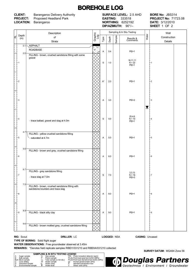
SURFACE LEVEL: 2.5 AHDEASTING: 333518NORTHING: 6252192DIP/AZIMUTH: 90°/--
BORE No: JBS314PROJECT No: 71723.08DATE: 3/12/2010SHEET 1 OF 2
WATER OBSERVATIONS: Free groundwater observed at 3.45m
TYPE OF BORING: Solid flight auger
RIG: Scout DRILLER: LC
REMARKS:SURVEY DATUM: MGA94 Zone 56
CASING: UncasedLOGGED: NSA
*Denotes field replicate samples RIBD1/031210 and RIBDIA/031210 collected
Well
Construction
Details
A
S
A*
A
S
A
A
S
A
A
PID=1
16,11,11N = 22PID<1
PID<1
PID=2
25,4,6N = 10PID=1
PID=1
PID<1
3,3,13N = 16PID=3
PID=1
PID=1
0.4
1.0
2.0
3.0
4.0
5.0
6.0
7.0
8.0
9.0

10.9
11.8
12.7
13.2
FILLING - brown mottled grey, crushed sandstone filling(continued)
CLAYEY SILT - black clayey silt (alluvium)
SANDSTONE - brown mottled red, low strengthsandstone
SANDSTONE - brown sandstone
Bore discontinued at 13.2m - target depth
Typ
e
-8-9
-10
-11
-12
-13
-14
-15
-16
-17
Depth(m)
11
12
13
14
15
16
17
18
19
RL
Wat
er
Dep
th
Sam
ple
Description
of
Strata Gra
phic
Log
Results &Comments
Sampling & In Situ Testing
11
12
13
14
15
16
17
18
19
BOREHOLE LOG BOREHOLE LOG BOREHOLE LOG BOREHOLE LOG BOREHOLE LOG BOREHOLE LOG BOREHOLE LOG CLIENT:PROJECT:LOCATION:
Barangaroo Delivery AuthorityProposed Headland ParkBarangaroo
SAMPLING & IN SITU TESTING LEGENDA Auger sample G Gas sample PID Photo ionisation detector (ppm)B Bulk sample P Piston sample PL(A) Point load axial test Is(50) (MPa)BLK Block sample Ux Tube sample (x mm dia.) PL(D) Point load diametral test Is(50) (MPa)C Core drilling W Water sample pp Pocket penetrometer (kPa)D Disturbed sample Water seep S Standard penetration testE Environmental sample Water level V Shear vane (kPa)
SURFACE LEVEL: 2.5 AHDEASTING: 333518NORTHING: 6252192DIP/AZIMUTH: 90°/--
BORE No: JBS314PROJECT No: 71723.08DATE: 3/12/2010SHEET 2 OF 2
WATER OBSERVATIONS: Free groundwater observed at 3.45m
TYPE OF BORING: Solid flight auger
RIG: Scout DRILLER: LC
REMARKS:SURVEY DATUM: MGA94 Zone 56
CASING: UncasedLOGGED: NSA
*Denotes field replicate samples RIBD1/031210 and RIBDIA/031210 collected
Well
Construction
DetailsA
A
A
A
PID<1
PID<1
PID<1
PID<1
10.0
11.0
12.0
13.0

0.1
0.4
1.8
2.7
4.7
6.56.6
ASPHALT
ROADBASE
FILLING - brown mottled red, crushed sandstone fillingwith trace gravel
- trace charcoal at 1.0m
FILLING - dark brown, silty clay and crushed sandstonefilling with trace charcoal and gravel
FILLING - light brown, sandy clay filling with somecrushed sandstone, sandstone boulders and trace ballast - saturated at 2.8m
SANDY CLAY - dark grey to black, sandy clay (alluvium)with trace gravel, shells,
- organic/decaying odour from 5.7m
- trace timber at 6.0m
SANDSTONE - grey, medium to high strength sandstone
Bore discontinued at 6.6m - target depth
Typ
e
21
0-1
-2-3
-4-5
-6-7
Depth(m)
1
2
3
4
5
6
7
8
9
RL
Wat
er
Dep
th
Sam
ple
Description
of
Strata Gra
phic
Log
Results &Comments
Sampling & In Situ Testing
1
2
3
4
5
6
7
8
9
BOREHOLE LOG BOREHOLE LOG BOREHOLE LOG BOREHOLE LOG BOREHOLE LOG BOREHOLE LOG BOREHOLE LOG CLIENT:PROJECT:LOCATION:
Barangaroo Delivery AuthorityProposed Headland ParkBarangaroo
SAMPLING & IN SITU TESTING LEGENDA Auger sample G Gas sample PID Photo ionisation detector (ppm)B Bulk sample P Piston sample PL(A) Point load axial test Is(50) (MPa)BLK Block sample Ux Tube sample (x mm dia.) PL(D) Point load diametral test Is(50) (MPa)C Core drilling W Water sample pp Pocket penetrometer (kPa)D Disturbed sample Water seep S Standard penetration testE Environmental sample Water level V Shear vane (kPa)
SURFACE LEVEL: 2.3 AHDEASTING: 333539NORTHING: 6252204DIP/AZIMUTH: 90°/--
BORE No: JBS315PROJECT No: 71723.08DATE: 26/11/2010SHEET 1 OF 1
WATER OBSERVATIONS: Free groundwater observed at 2.8m
TYPE OF BORING: Solid flight auger
RIG: Hydropower DRILLER: RKE
REMARKS:SURVEY DATUM: MGA94 Zone 56
CASING: UncasedLOGGED: NSA
*Denotes field replicate samples R2BD1/261110 & R2BD1A/261110 collected
Well
Construction
Details
A
A
S
A*
S
S
A
S
A
PID=2
PID=1
9,4,5N = 9PID=1
PID=2
1,10,3N = 13PID=1
PID=1
PID=1
2,2,3N = 5PID<1
PID<1
0.2
0.5
1.0
2.0
3.0
4.0
5.0
6.0
6.5

0.1
0.3
4.8
5.9
7.8
9.2
ASPHALT
ROADBASE
FILLING - red crushed sandstone filling with trace gravel,sandstone fragments and boulders
- trace slag at 1.0m
- glass piece at 4.0m
FILLING - grey mottled red, sandstone filling
CLAYEY SILT - dark grey to black, clayey silt (alluvium)with shell fragments and trace timber
SANDSTONE - brown mottled red sandstone
Bore discontinued at 9.2m - target depth
Typ
e
21
0-1
-2-3
-4-5
-6-7
Depth(m)
1
2
3
4
5
6
7
8
9
RL
Wat
er
Dep
th
Sam
ple
Description
of
Strata Gra
phic
Log
Results &Comments
Sampling & In Situ Testing
1
2
3
4
5
6
7
8
9
BOREHOLE LOG BOREHOLE LOG BOREHOLE LOG BOREHOLE LOG BOREHOLE LOG BOREHOLE LOG BOREHOLE LOG CLIENT:PROJECT:LOCATION:
Barangaroo Delivery AuthorityProposed Headland ParkBarangaroo
SAMPLING & IN SITU TESTING LEGENDA Auger sample G Gas sample PID Photo ionisation detector (ppm)B Bulk sample P Piston sample PL(A) Point load axial test Is(50) (MPa)BLK Block sample Ux Tube sample (x mm dia.) PL(D) Point load diametral test Is(50) (MPa)C Core drilling W Water sample pp Pocket penetrometer (kPa)D Disturbed sample Water seep S Standard penetration testE Environmental sample Water level V Shear vane (kPa)
SURFACE LEVEL: 2.5 AHDEASTING: 333536NORTHING: 6252262DIP/AZIMUTH: 90°/--
BORE No: JBS316PROJECT No: 71723.08DATE: 26/11/2010SHEET 1 OF 1
WATER OBSERVATIONS: Free groundwater observed at 2.9m
TYPE OF BORING: Solid flight auger
RIG: Hydropower DRILLER: RKE
REMARKS:SURVEY DATUM: MGA94 Zone 56
CASING: UncasedLOGGED: NSA
*Denotes field replicate samples R2BD2/261110 & R2BD2A/261110 collected
Well
Construction
Details
A
A
S
A*
S
A
A
S
A
A
PID=1
PID<1
18,13,9N = 22PID<1
PID<1
5,4,1N = 5PID<1
PID<1
PID<1
1,1,1N = 2
PID=11
PID<1
0.2
0.5
1.0
2.0
3.0
4.0
5.0
6.0
7.0
9.0

0.015
0.4
1.5
2.3
ASPHALT
ROADBASE - grey brown, gravelly silt filling
FILLING - brown clayey silt and crushed sandstone filling - wood chip at 0.6m
SANDSTONE - grey sandstone
Bore discontinued at 2.3m - refusal in sandstone (possible boulder) - relocated bore to JBS317A
Typ
e
21
0-1
-2-3
-4-5
-6-7
Depth(m)
1
2
3
4
5
6
7
8
9
RL
Wat
er
Dep
th
Sam
ple
Description
of
Strata Gra
phic
Log
Results &Comments
Sampling & In Situ Testing
1
2
3
4
5
6
7
8
9
BOREHOLE LOG BOREHOLE LOG BOREHOLE LOG BOREHOLE LOG BOREHOLE LOG BOREHOLE LOG BOREHOLE LOG CLIENT:PROJECT:LOCATION:
Barangaroo Delivery AuthorityProposed Headland ParkBarangaroo
SAMPLING & IN SITU TESTING LEGENDA Auger sample G Gas sample PID Photo ionisation detector (ppm)B Bulk sample P Piston sample PL(A) Point load axial test Is(50) (MPa)BLK Block sample Ux Tube sample (x mm dia.) PL(D) Point load diametral test Is(50) (MPa)C Core drilling W Water sample pp Pocket penetrometer (kPa)D Disturbed sample Water seep S Standard penetration testE Environmental sample Water level V Shear vane (kPa)
SURFACE LEVEL: 2.7 AHDEASTING: 333570NORTHING: 6252270DIP/AZIMUTH: 90°/--
BORE No: JBS317PROJECT No: 71723.08DATE: 22/11/2010SHEET 1 OF 1
WATER OBSERVATIONS: No free groundwater observed
TYPE OF BORING: Solid flight auger
RIG: Bobcat DRILLER: SY
REMARKS:SURVEY DATUM: MGA94 Zone 56
CASING: UncasedLOGGED: CF
*Denotes field replicate sample R2BD3/221110 collected
Well
Construction
Details
A
S
A*
PID<1
25/120mmrefusalPID<1
PID=1
0.5
1.0
2.0

0.015
0.4
1.5
2.3
ASPHALT
ROADBASE - grey brown, gravelly silt filling
FILLING - brown clayey silt and crushed sandstone filling - wood chip at 0.6m
SANDSTONE - grey sandstone
Bore discontinued at 2.3m - refusal in sandstone
Typ
e
21
0-1
-2-3
-4-5
-6-7
Depth(m)
1
2
3
4
5
6
7
8
9
RL
Wat
er
Dep
th
Sam
ple
Description
of
Strata Gra
phic
Log
Results &Comments
Sampling & In Situ Testing
1
2
3
4
5
6
7
8
9
BOREHOLE LOG BOREHOLE LOG BOREHOLE LOG BOREHOLE LOG BOREHOLE LOG BOREHOLE LOG BOREHOLE LOG CLIENT:PROJECT:LOCATION:
Barangaroo Delivery AuthorityProposed Headland ParkBarangaroo
SAMPLING & IN SITU TESTING LEGENDA Auger sample G Gas sample PID Photo ionisation detector (ppm)B Bulk sample P Piston sample PL(A) Point load axial test Is(50) (MPa)BLK Block sample Ux Tube sample (x mm dia.) PL(D) Point load diametral test Is(50) (MPa)C Core drilling W Water sample pp Pocket penetrometer (kPa)D Disturbed sample Water seep S Standard penetration testE Environmental sample Water level V Shear vane (kPa)
SURFACE LEVEL: 2.7 AHDEASTING: 333570NORTHING: 6252272DIP/AZIMUTH: 90°/--
BORE No: JBS317APROJECT No: 71723.08DATE: 22/11/2010SHEET 1 OF 1
WATER OBSERVATIONS: No free groundwater observed
TYPE OF BORING: Solid flight auger
RIG: Bobcat DRILLER: SY
REMARKS:SURVEY DATUM: MGA94 Zone 56
CASING: UncasedLOGGED: CF
*Denotes field replicate sample R2BD3/221110 collected
Well
Construction
Details
A
S
A*
25/120mmrefusal
0.5
1.0
1.45
2.0

0.06
0.30.4
4.9
6.9
9.9
ASPHALT
FILLING - brown roadbase and crushed sandstone filling - increased sandstone at 0.1m
ROADBASE
FILLING - brown red and grey, crushed sandstone fillingwith trace slag - sandstone boulder at 0.7m1.4-1.6m: ballast
- wet at 2.3m
CLAYEY SAND - brown clayey sand (alluvium) with someshell fragments
SANDSTONE - red mottled grey brown sandstone
Bore discontinued at 9.9m - refusal in sandstone
Typ
e
21
0-1
-2-3
-4-5
-6-7
Depth(m)
1
2
3
4
5
6
7
8
9
RL
Wat
er
Dep
th
Sam
ple
Description
of
Strata Gra
phic
Log
Results &Comments
Sampling & In Situ Testing
1
2
3
4
5
6
7
8
9
BOREHOLE LOG BOREHOLE LOG BOREHOLE LOG BOREHOLE LOG BOREHOLE LOG BOREHOLE LOG BOREHOLE LOG CLIENT:PROJECT:LOCATION:
Barangaroo Delivery AuthorityProposed Headland ParkBarangaroo
SAMPLING & IN SITU TESTING LEGENDA Auger sample G Gas sample PID Photo ionisation detector (ppm)B Bulk sample P Piston sample PL(A) Point load axial test Is(50) (MPa)BLK Block sample Ux Tube sample (x mm dia.) PL(D) Point load diametral test Is(50) (MPa)C Core drilling W Water sample pp Pocket penetrometer (kPa)D Disturbed sample Water seep S Standard penetration testE Environmental sample Water level V Shear vane (kPa)
SURFACE LEVEL: 2.3 AHDEASTING: 333517NORTHING: 6252306DIP/AZIMUTH: 90°/--
BORE No: JBS318PROJECT No: 71723.08DATE: 18/11/2010SHEET 1 OF 1
WATER OBSERVATIONS: Free groundwater observed at 2.3m
TYPE OF BORING: Solid flight auger
RIG: Scout DRILLER: LC
REMARKS:SURVEY DATUM: MGA94 Zone 56
CASING: UncasedLOGGED: NSA
*Denotes field replicate sample BD1/181110 collected
Well
Construction
Details
A
S*
S
S
S
S
A
A
A
PID=6
19,15,60N = 75PID=6
13,6,4N = 10PID=4
9,7,10N = 17PID=3
6,12,8N = 20PID=4
7,9,4N = 13PID=4
PID=4
PID=5
120/110mmrefusalPID=5
0.2
1.0
2.0
3.0
4.0
5.0
6.0
7.0
9.0
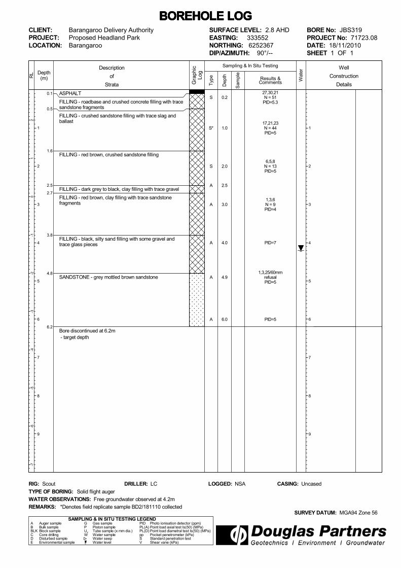
0.1
0.5
1.6
2.5
2.7
3.8
4.8
6.2
ASPHALT
FILLING - roadbase and crushed concrete filling with tracesandstone fragments
FILLING - crushed sandstone filling with trace slag andballast
FILLING - red brown, crushed sandstone filling
FILLING - dark grey to black, clay filling with trace gravel
FILLING - red brown, clay filling with trace sandstonefragments
FILLING - black, silty sand filling with some gravel andtrace glass pieces
SANDSTONE - grey mottled brown sandstone
Bore discontinued at 6.2m - target depth
Typ
e
21
0-1
-2-3
-4-5
-6-7
Depth(m)
1
2
3
4
5
6
7
8
9
RL
Wat
er
Dep
th
Sam
ple
Description
of
Strata Gra
phic
Log
Results &Comments
Sampling & In Situ Testing
1
2
3
4
5
6
7
8
9
BOREHOLE LOG BOREHOLE LOG BOREHOLE LOG BOREHOLE LOG BOREHOLE LOG BOREHOLE LOG BOREHOLE LOG CLIENT:PROJECT:LOCATION:
Barangaroo Delivery AuthorityProposed Headland ParkBarangaroo
SAMPLING & IN SITU TESTING LEGENDA Auger sample G Gas sample PID Photo ionisation detector (ppm)B Bulk sample P Piston sample PL(A) Point load axial test Is(50) (MPa)BLK Block sample Ux Tube sample (x mm dia.) PL(D) Point load diametral test Is(50) (MPa)C Core drilling W Water sample pp Pocket penetrometer (kPa)D Disturbed sample Water seep S Standard penetration testE Environmental sample Water level V Shear vane (kPa)
SURFACE LEVEL: 2.8 AHDEASTING: 333552NORTHING: 6252367DIP/AZIMUTH: 90°/--
BORE No: JBS319PROJECT No: 71723.08DATE: 18/11/2010SHEET 1 OF 1
WATER OBSERVATIONS: Free groundwater observed at 4.2m
TYPE OF BORING: Solid flight auger
RIG: Scout DRILLER: LC
REMARKS:SURVEY DATUM: MGA94 Zone 56
CASING: UncasedLOGGED: NSA
*Denotes field replicate sample BD2/181110 collected
Well
Construction
Details
S
S*
S
A
A
A
A
A
27,30,21N = 51
PID=5.3
17,21,23N = 44PID=5
6,5,8N = 13PID=5
1,3,6N = 9PID=4
PID=7
1,3,25/60mmrefusalPID=5
PID=5
0.2
1.0
2.0
2.5
3.0
4.0
4.9
6.0

0.15
0.8
1.5
ASPHALT
ROADBASE - grey brown, gravelly clayey silt filling
FILLING - red brown, clayey sand filling and crushedsandstone - charcoal at 1.0m
- scrap metal at 1.5mBore discontinued at 1.5m - refusal on ballast gravel and scrap metal - relocated bore to JBS320A
Typ
e
21
0-1
-2-3
-4-5
-6-7
Depth(m)
1
2
3
4
5
6
7
8
9
RL
Wat
er
Dep
th
Sam
ple
Description
of
Strata Gra
phic
Log
Results &Comments
Sampling & In Situ Testing
1
2
3
4
5
6
7
8
9
BOREHOLE LOG BOREHOLE LOG BOREHOLE LOG BOREHOLE LOG BOREHOLE LOG BOREHOLE LOG BOREHOLE LOG CLIENT:PROJECT:LOCATION:
Barangaroo Delivery AuthorityProposed Headland ParkBarangaroo
SAMPLING & IN SITU TESTING LEGENDA Auger sample G Gas sample PID Photo ionisation detector (ppm)B Bulk sample P Piston sample PL(A) Point load axial test Is(50) (MPa)BLK Block sample Ux Tube sample (x mm dia.) PL(D) Point load diametral test Is(50) (MPa)C Core drilling W Water sample pp Pocket penetrometer (kPa)D Disturbed sample Water seep S Standard penetration testE Environmental sample Water level V Shear vane (kPa)
SURFACE LEVEL: 2.9 AHDEASTING: 333643NORTHING: 6252370DIP/AZIMUTH: 90°/--
BORE No: JBS320PROJECT No: 71723.08DATE: 22/11/2010SHEET 1 OF 1
WATER OBSERVATIONS: No free groundwater observed
TYPE OF BORING: Solid flight auger
RIG: Bobcat DRILLER: SY
REMARKS:SURVEY DATUM: MGA94 Zone 56
CASING: UncasedLOGGED: CF
Well
Construction
Details
A
S
PID<1
20,20/100mmrefusalPID<1
0.5
1.0
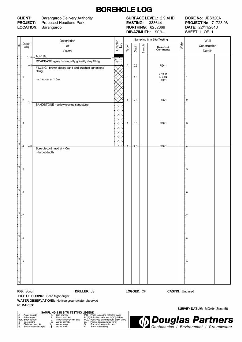
0.15
0.5
2.1
4.0
ASPHALT
ROADBASE - grey brown, silty gravelly clay filling
FILLING - brown clayey sand and crushed sandstonefilling
- charcoal at 1.0m
SANDSTONE - yellow orange sandstone
Bore discontinued at 4.0m - target depth
Typ
e
21
0-1
-2-3
-4-5
-6-7
Depth(m)
1
2
3
4
5
6
7
8
9
RL
Wat
er
Dep
th
Sam
ple
Description
of
Strata Gra
phic
Log
Results &Comments
Sampling & In Situ Testing
1
2
3
4
5
6
7
8
9
BOREHOLE LOG BOREHOLE LOG BOREHOLE LOG BOREHOLE LOG BOREHOLE LOG BOREHOLE LOG BOREHOLE LOG CLIENT:PROJECT:LOCATION:
Barangaroo Delivery AuthorityProposed Headland ParkBarangaroo
SAMPLING & IN SITU TESTING LEGENDA Auger sample G Gas sample PID Photo ionisation detector (ppm)B Bulk sample P Piston sample PL(A) Point load axial test Is(50) (MPa)BLK Block sample Ux Tube sample (x mm dia.) PL(D) Point load diametral test Is(50) (MPa)C Core drilling W Water sample pp Pocket penetrometer (kPa)D Disturbed sample Water seep S Standard penetration testE Environmental sample Water level V Shear vane (kPa)
SURFACE LEVEL: 2.9 AHDEASTING: 333644NORTHING: 6252369DIP/AZIMUTH: 90°/--
BORE No: JBS320APROJECT No: 71723.08DATE: 22/11/2010SHEET 1 OF 1
WATER OBSERVATIONS: No free groundwater observed
TYPE OF BORING: Solid flight auger
RIG: Scout DRILLER: JS
REMARKS:SURVEY DATUM: MGA94 Zone 56
CASING: UncasedLOGGED: CF
Well
Construction
Details
A
S
A
A
A
PID=1
7,13,11N = 24PID<1
PID=1
PID=1
PID=1
0.5
1.0
2.0
3.0
4.0

0.1
0.3
0.9
1.6
2.6
ASPHALT
ROADBASE
FILLING - grey and ballast filling with faint phenolic odour
FILLING - brown sand filling with trace gravel - faint phenolic odour
- sandstone boulder from 1.2 to 1.5m
SANDSTONE - white mottled red sandstone
Bore discontinued at 2.6m - refusal on sandstone and target depth reached
Typ
e
54
32
10
-1-2
-3-4
Depth(m)
1
2
3
4
5
6
7
8
9
RL
Wat
er
Dep
th
Sam
ple
Description
of
Strata Gra
phic
Log
Results &Comments
Sampling & In Situ Testing
1
2
3
4
5
6
7
8
9
BOREHOLE LOG BOREHOLE LOG BOREHOLE LOG BOREHOLE LOG BOREHOLE LOG BOREHOLE LOG BOREHOLE LOG CLIENT:PROJECT:LOCATION:
Barangaroo Delivery AuthorityProposed Headland ParkBarangaroo
SAMPLING & IN SITU TESTING LEGENDA Auger sample G Gas sample PID Photo ionisation detector (ppm)B Bulk sample P Piston sample PL(A) Point load axial test Is(50) (MPa)BLK Block sample Ux Tube sample (x mm dia.) PL(D) Point load diametral test Is(50) (MPa)C Core drilling W Water sample pp Pocket penetrometer (kPa)D Disturbed sample Water seep S Standard penetration testE Environmental sample Water level V Shear vane (kPa)
SURFACE LEVEL: 5.3 AHDEASTING: 333694NORTHING: 6252335DIP/AZIMUTH: 90°/--
BORE No: JBS321PROJECT No: 71723.08DATE: 29/11/2010SHEET 1 OF 1
WATER OBSERVATIONS: No free groundwater observed
TYPE OF BORING: Solid flight auger
RIG: Scout DRILLER: LC
REMARKS:SURVEY DATUM: MGA94 Zone 56
CASING: UncasedLOGGED: NSA
*Denotes field replicate samples RIBD1/291110 & RIBD1A/291110 collected
Well
Construction
Details
A
A
A*
A
PID<1
PID<1
PID=1
PID=1
0.2
1.0
2.0
2.6
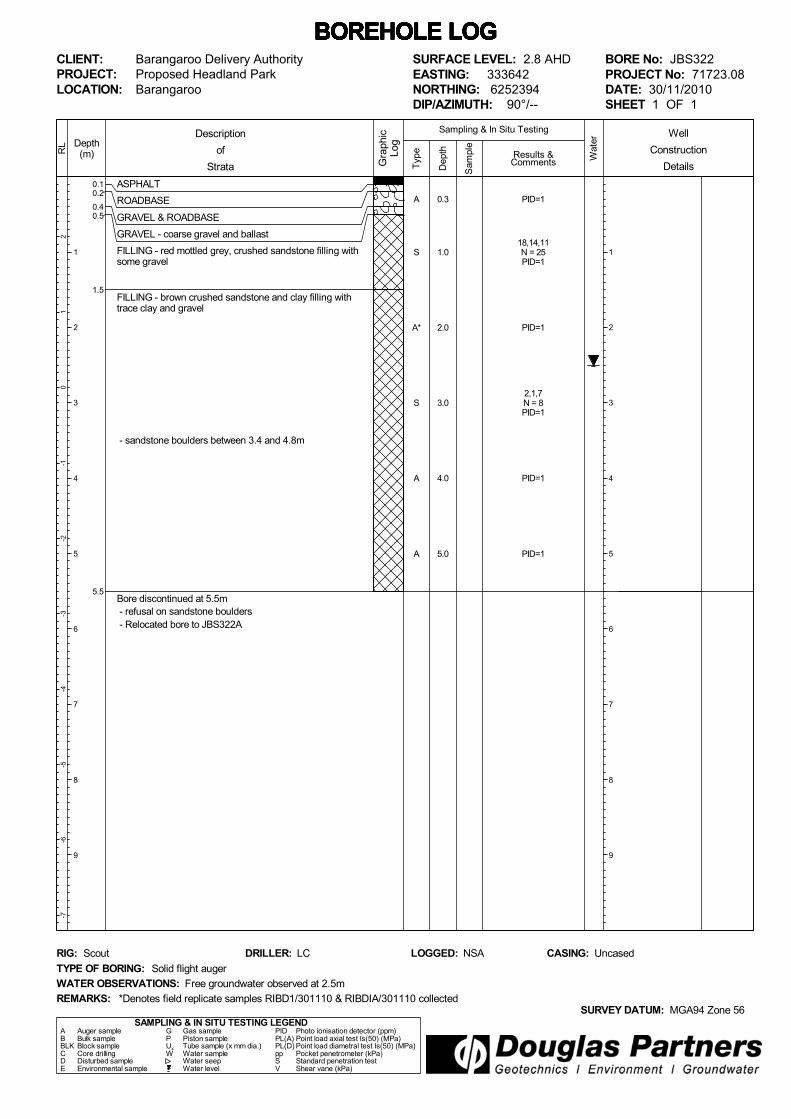
0.10.2
0.40.5
1.5
5.5
ASPHALT
ROADBASE
GRAVEL & ROADBASE
GRAVEL - coarse gravel and ballast
FILLING - red mottled grey, crushed sandstone filling withsome gravel
FILLING - brown crushed sandstone and clay filling withtrace clay and gravel
- sandstone boulders between 3.4 and 4.8m
Bore discontinued at 5.5m - refusal on sandstone boulders - Relocated bore to JBS322A
Typ
e
21
0-1
-2-3
-4-5
-6-7
Depth(m)
1
2
3
4
5
6
7
8
9
RL
Wat
er
Dep
th
Sam
ple
Description
of
Strata Gra
phic
Log
Results &Comments
Sampling & In Situ Testing
1
2
3
4
5
6
7
8
9
BOREHOLE LOG BOREHOLE LOG BOREHOLE LOG BOREHOLE LOG BOREHOLE LOG BOREHOLE LOG BOREHOLE LOG CLIENT:PROJECT:LOCATION:
Barangaroo Delivery AuthorityProposed Headland ParkBarangaroo
SAMPLING & IN SITU TESTING LEGENDA Auger sample G Gas sample PID Photo ionisation detector (ppm)B Bulk sample P Piston sample PL(A) Point load axial test Is(50) (MPa)BLK Block sample Ux Tube sample (x mm dia.) PL(D) Point load diametral test Is(50) (MPa)C Core drilling W Water sample pp Pocket penetrometer (kPa)D Disturbed sample Water seep S Standard penetration testE Environmental sample Water level V Shear vane (kPa)
SURFACE LEVEL: 2.8 AHDEASTING: 333642NORTHING: 6252394DIP/AZIMUTH: 90°/--
BORE No: JBS322PROJECT No: 71723.08DATE: 30/11/2010SHEET 1 OF 1
WATER OBSERVATIONS: Free groundwater observed at 2.5m
TYPE OF BORING: Solid flight auger
RIG: Scout DRILLER: LC
REMARKS:SURVEY DATUM: MGA94 Zone 56
CASING: UncasedLOGGED: NSA
*Denotes field replicate samples RIBD1/301110 & RIBDIA/301110 collected
Well
Construction
Details
A
S
A*
S
A
A
PID=1
18,14,11N = 25PID=1
PID=1
2,1,7N = 8PID=1
PID=1
PID=1
0.3
1.0
2.0
3.0
4.0
5.0

0.10.2
0.40.5
1.5
3.0
5.3
6.8
7.9
8.9
ASPHALT
ROADBASE
GRAVEL & ROADBASE
GRAVEL - coarse gravel and ballast
FILLING - red mottled grey, crushed sandstone filling withsome gravel
FILLING - brown crushed sandstone and clay filling withtrace clay and gravel
FILLING - grey crushed sandstone filling
FILLING - red mottled grey, sandstone boulder filling
CLAYEY SILT - dark grey, clayey silt (alluvium) with traceshell fragments
CLAYEY SILT - black clayey silt (alluvium) with trace shellfragments and trace plant material
SANDY SILT - grey sandy silt (alluvium) with increasedshell fragments
Gatic cover
Bentonite
Backfilled withgravel
Machine slottedPVC screen
End cap
Typ
e
21
0-1
-2-3
-4-5
-6-7
Depth(m)
1
2
3
4
5
6
7
8
9
RL
Wat
er
Dep
th
Sam
ple
Description
of
Strata Gra
phic
Log
Results &Comments
Sampling & In Situ Testing
1
2
3
4
5
6
7
8
9
BOREHOLE LOG BOREHOLE LOG BOREHOLE LOG BOREHOLE LOG BOREHOLE LOG BOREHOLE LOG BOREHOLE LOG CLIENT:PROJECT:LOCATION:
Barangaroo Delivery AuthorityProposed Headland ParkBarangaroo
SAMPLING & IN SITU TESTING LEGENDA Auger sample G Gas sample PID Photo ionisation detector (ppm)B Bulk sample P Piston sample PL(A) Point load axial test Is(50) (MPa)BLK Block sample Ux Tube sample (x mm dia.) PL(D) Point load diametral test Is(50) (MPa)C Core drilling W Water sample pp Pocket penetrometer (kPa)D Disturbed sample Water seep S Standard penetration testE Environmental sample Water level V Shear vane (kPa)
SURFACE LEVEL: 2.8 AHDEASTING: 333643NORTHING: 6252392DIP/AZIMUTH: 90°/--
BORE No: JBS322APROJECT No: 71723.08DATE: 30/11/2010SHEET 1 OF 2
WATER OBSERVATIONS: Free groundwater observed at 2.5m
TYPE OF BORING: Solid flight auger
RIG: Scout DRILLER: LC
REMARKS:SURVEY DATUM: MGA94 Zone 56
CASING: UncasedLOGGED: NSA
Well
Construction
Details
A
A
A
A
PID=1
PID=1
PID=1
PID=1
6.0
7.0
8.0
9.0

10.2SANDY SILT - continued
Bore discontinued at 10.2m target depth and refusal on inferred sandstone bedrock
Typ
e
-8-9
-10
-11
-12
-13
-14
-15
-16
-17
Depth(m)
11
12
13
14
15
16
17
18
19
RL
Wat
er
Dep
th
Sam
ple
Description
of
Strata Gra
phic
Log
Results &Comments
Sampling & In Situ Testing
11
12
13
14
15
16
17
18
19
BOREHOLE LOG BOREHOLE LOG BOREHOLE LOG BOREHOLE LOG BOREHOLE LOG BOREHOLE LOG BOREHOLE LOG CLIENT:PROJECT:LOCATION:
Barangaroo Delivery AuthorityProposed Headland ParkBarangaroo
SAMPLING & IN SITU TESTING LEGENDA Auger sample G Gas sample PID Photo ionisation detector (ppm)B Bulk sample P Piston sample PL(A) Point load axial test Is(50) (MPa)BLK Block sample Ux Tube sample (x mm dia.) PL(D) Point load diametral test Is(50) (MPa)C Core drilling W Water sample pp Pocket penetrometer (kPa)D Disturbed sample Water seep S Standard penetration testE Environmental sample Water level V Shear vane (kPa)
SURFACE LEVEL: 2.8 AHDEASTING: 333643NORTHING: 6252392DIP/AZIMUTH: 90°/--
BORE No: JBS322APROJECT No: 71723.08DATE: 30/11/2010SHEET 2 OF 2
WATER OBSERVATIONS: Free groundwater observed at 2.5m
TYPE OF BORING: Solid flight auger
RIG: Scout DRILLER: LC
REMARKS:SURVEY DATUM: MGA94 Zone 56
CASING: UncasedLOGGED: NSA
Well
Construction
DetailsA PID<110.0
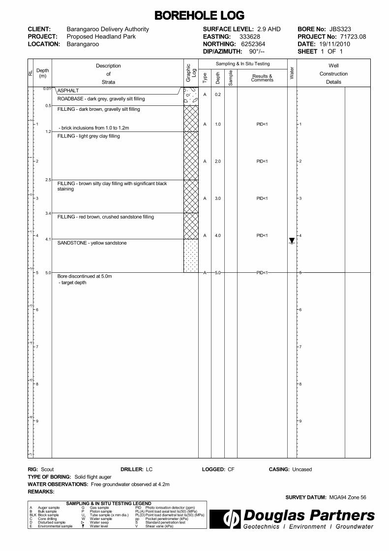
0.01
0.5
1.2
2.5
3.4
4.1
5.0
ASPHALT
ROADBASE - dark grey, gravelly silt filling
FILLING - dark brown, gravelly silt filling
- brick inclusions from 1.0 to 1.2m
FILLING - light grey clay filling
FILLING - brown silty clay filling with significant blackstaining
FILLING - red brown, crushed sandstone filling
SANDSTONE - yellow sandstone
Bore discontinued at 5.0m - target depth
Typ
e
21
0-1
-2-3
-4-5
-6-7
Depth(m)
1
2
3
4
5
6
7
8
9
RL
Wat
er
Dep
th
Sam
ple
Description
of
Strata Gra
phic
Log
Results &Comments
Sampling & In Situ Testing
1
2
3
4
5
6
7
8
9
BOREHOLE LOG BOREHOLE LOG BOREHOLE LOG BOREHOLE LOG BOREHOLE LOG BOREHOLE LOG BOREHOLE LOG CLIENT:PROJECT:LOCATION:
Barangaroo Delivery AuthorityProposed Headland ParkBarangaroo
SAMPLING & IN SITU TESTING LEGENDA Auger sample G Gas sample PID Photo ionisation detector (ppm)B Bulk sample P Piston sample PL(A) Point load axial test Is(50) (MPa)BLK Block sample Ux Tube sample (x mm dia.) PL(D) Point load diametral test Is(50) (MPa)C Core drilling W Water sample pp Pocket penetrometer (kPa)D Disturbed sample Water seep S Standard penetration testE Environmental sample Water level V Shear vane (kPa)
SURFACE LEVEL: 2.9 AHDEASTING: 333628NORTHING: 6252364DIP/AZIMUTH: 90°/--
BORE No: JBS323PROJECT No: 71723.08DATE: 19/11/2010SHEET 1 OF 1
WATER OBSERVATIONS: Free groundwater observed at 4.2m
TYPE OF BORING: Solid flight auger
RIG: Scout DRILLER: LC
REMARKS:SURVEY DATUM: MGA94 Zone 56
CASING: UncasedLOGGED: CF
Well
Construction
Details
A
A
A
A
A
A
PID<1
PID<1
PID<1
PID<1
PID<1
0.2
1.0
2.0
3.0
4.0
5.0
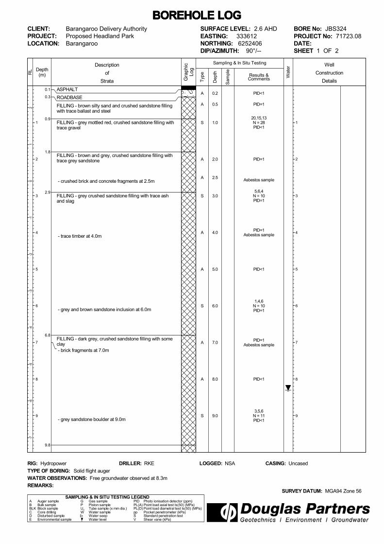
0.1
0.3
0.9
1.8
2.9
6.8
9.8
ASPHALT
ROADBASE
FILLING - brown silty sand and crushed sandstone fillingwith trace ballast and steel
FILLING - grey mottled red, crushed sandstone filling withtrace gravel
FILLING - brown and grey, crushed sandstone filling withtrace grey sandstone
- crushed brick and concrete fragments at 2.5m
FILLING - grey crushed sandstone filling with trace ashand slag
- trace timber at 4.0m
- grey and brown sandstone inclusion at 6.0m
FILLING - dark grey, crushed sandstone filling with someclay - brick fragments at 7.0m
- grey sandstone boulder at 9.0m
Typ
e
21
0-1
-2-3
-4-5
-6-7
Depth(m)
1
2
3
4
5
6
7
8
9
RL
Wat
er
Dep
th
Sam
ple
Description
of
Strata Gra
phic
Log
Results &Comments
Sampling & In Situ Testing
1
2
3
4
5
6
7
8
9
BOREHOLE LOG BOREHOLE LOG BOREHOLE LOG BOREHOLE LOG BOREHOLE LOG BOREHOLE LOG BOREHOLE LOG CLIENT:PROJECT:LOCATION:
Barangaroo Delivery AuthorityProposed Headland ParkBarangaroo
SAMPLING & IN SITU TESTING LEGENDA Auger sample G Gas sample PID Photo ionisation detector (ppm)B Bulk sample P Piston sample PL(A) Point load axial test Is(50) (MPa)BLK Block sample Ux Tube sample (x mm dia.) PL(D) Point load diametral test Is(50) (MPa)C Core drilling W Water sample pp Pocket penetrometer (kPa)D Disturbed sample Water seep S Standard penetration testE Environmental sample Water level V Shear vane (kPa)
SURFACE LEVEL: 2.6 AHDEASTING: 333612NORTHING: 6252406DIP/AZIMUTH: 90°/--
BORE No: JBS324PROJECT No: 71723.08DATE:SHEET 1 OF 2
WATER OBSERVATIONS: Free groundwater observed at 8.3m
TYPE OF BORING: Solid flight auger
RIG: Hydropower DRILLER: RKE
REMARKS:SURVEY DATUM: MGA94 Zone 56
CASING: UncasedLOGGED: NSA
Well
Construction
Details
A
A
S
A
A
S
A
A
S
A
A
S
PID<1
PID=1
20,15,13N = 28PID<1
PID=1
Asbestos sample
5,6,4N = 10PID=1
PID=1Asbestos sample
PID<1
1,4,6N = 10PID=1
PID=1Asbestos sample
PID<1
3,5,6N = 11PID<1
0.2
0.5
1.0
2.0
2.5
3.0
4.0
5.0
6.0
7.0
8.0
9.0

10.7
12.9
13.2
FILLING - light brown/grey, crushed sandstone filling withtrace gravel (continued)
SILTY CLAY - dark grey to black, fine silty clay
SANDSTONE - low strength, brown sandstone
Bore discontinued at 13.2m - refusal on sandstone and target depth
Typ
e
-8-9
-10
-11
-12
-13
-14
-15
-16
-17
Depth(m)
11
12
13
14
15
16
17
18
19
RL
Wat
er
Dep
th
Sam
ple
Description
of
Strata Gra
phic
Log
Results &Comments
Sampling & In Situ Testing
11
12
13
14
15
16
17
18
19
BOREHOLE LOG BOREHOLE LOG BOREHOLE LOG BOREHOLE LOG BOREHOLE LOG BOREHOLE LOG BOREHOLE LOG CLIENT:PROJECT:LOCATION:
Barangaroo Delivery AuthorityProposed Headland ParkBarangaroo
SAMPLING & IN SITU TESTING LEGENDA Auger sample G Gas sample PID Photo ionisation detector (ppm)B Bulk sample P Piston sample PL(A) Point load axial test Is(50) (MPa)BLK Block sample Ux Tube sample (x mm dia.) PL(D) Point load diametral test Is(50) (MPa)C Core drilling W Water sample pp Pocket penetrometer (kPa)D Disturbed sample Water seep S Standard penetration testE Environmental sample Water level V Shear vane (kPa)
SURFACE LEVEL: 2.6 AHDEASTING: 333612NORTHING: 6252406DIP/AZIMUTH: 90°/--
BORE No: JBS324PROJECT No: 71723.08DATE:SHEET 2 OF 2
WATER OBSERVATIONS: Free groundwater observed at 8.3m
TYPE OF BORING: Solid flight auger
RIG: Hydropower DRILLER: RKE
REMARKS:SURVEY DATUM: MGA94 Zone 56
CASING: UncasedLOGGED: NSA
Well
Construction
DetailsA
A
AA
A
PID<1
PID<1
PID<1PID<1
PID<1
10.0
11.0
12.012.1
13.0

0.015
0.7
0.9
2.1
ASPHALT
ROADBASE - grey brown, gravelly silt filling
FILLING - brown gravelly silt filling
FILLING - brown silty clay and yellow orange crushedsandstone filling with trace ballast gravel - charcoal at 1.0m
Bore discontinued at 2.1m - refusal on crushed sandstone ballast gravel - relocated bore to JBS325B
Typ
e
32
10
-1-2
-3-4
-5-6
Depth(m)
1
2
3
4
5
6
7
8
9
RL
Wat
er
Dep
th
Sam
ple
Description
of
Strata Gra
phic
Log
Results &Comments
Sampling & In Situ Testing
1
2
3
4
5
6
7
8
9
BOREHOLE LOG BOREHOLE LOG BOREHOLE LOG BOREHOLE LOG BOREHOLE LOG BOREHOLE LOG BOREHOLE LOG CLIENT:PROJECT:LOCATION:
Barangaroo Delivery AuthorityProposed Headland ParkBarangaroo
SAMPLING & IN SITU TESTING LEGENDA Auger sample G Gas sample PID Photo ionisation detector (ppm)B Bulk sample P Piston sample PL(A) Point load axial test Is(50) (MPa)BLK Block sample Ux Tube sample (x mm dia.) PL(D) Point load diametral test Is(50) (MPa)C Core drilling W Water sample pp Pocket penetrometer (kPa)D Disturbed sample Water seep S Standard penetration testE Environmental sample Water level V Shear vane (kPa)
SURFACE LEVEL: 3.0 AHDEASTING: 333617NORTHING: 6252378DIP/AZIMUTH: 90°/--
BORE No: JBS325PROJECT No: 71723.08DATE: 22/11/2010SHEET 1 OF 1
WATER OBSERVATIONS: No free groundwater observed
TYPE OF BORING: Solid flight auger
RIG: Bobcat DRILLER: SY
REMARKS:SURVEY DATUM: MGA94 Zone 56
CASING: UncasedLOGGED: CF
*Denotes field replicate sample R2BD2/251110 collected
Well
Construction
Details
A
S
A*
PID=1
12,13,10N = 23PID=1
PID<1
0.5
1.0
2.0

0.1
1.0
2.5
ASPHALT
ROADBASE - grey brown, gravelly clay filling
FILLING - dark grey ballast filling
Bore discontinued at 2.5m - refusal on steel - relocated bore to JBS325C
Typ
e
32
10
-1-2
-3-4
-5-6
Depth(m)
1
2
3
4
5
6
7
8
9
RL
Wat
er
Dep
th
Sam
ple
Description
of
Strata Gra
phic
Log
Results &Comments
Sampling & In Situ Testing
1
2
3
4
5
6
7
8
9
BOREHOLE LOG BOREHOLE LOG BOREHOLE LOG BOREHOLE LOG BOREHOLE LOG BOREHOLE LOG BOREHOLE LOG CLIENT:PROJECT:LOCATION:
Barangaroo Delivery AuthorityProposed Headland ParkBarangaroo
SAMPLING & IN SITU TESTING LEGENDA Auger sample G Gas sample PID Photo ionisation detector (ppm)B Bulk sample P Piston sample PL(A) Point load axial test Is(50) (MPa)BLK Block sample Ux Tube sample (x mm dia.) PL(D) Point load diametral test Is(50) (MPa)C Core drilling W Water sample pp Pocket penetrometer (kPa)D Disturbed sample Water seep S Standard penetration testE Environmental sample Water level V Shear vane (kPa)
SURFACE LEVEL: 3.0 AHDEASTING: 333616NORTHING: 6252378DIP/AZIMUTH: 90°/--
BORE No: JBS325BPROJECT No: 71723.08DATE: 23/11/2010SHEET 1 OF 1
WATER OBSERVATIONS: No free groundwater observed
TYPE OF BORING: Solid flight auger
RIG: Scout DRILLER: LC
REMARKS:SURVEY DATUM: MGA94 Zone 56
CASING: UncasedLOGGED: NSA
Well
Construction
Details
A
A
PID<1
PID<1
1.0
2.0

0.15
2.3
3.9
4.8
6.2
ASPHALT
ROADBASE - grey brown, gravelly clayey silt filling
FILLING - dark grey sandy clay filling
- saturated at 2.5m
FILLING - grey sand filling with trace timber fragments(possible alluvium)
SANDY SILT - grey sandy silt (alluvium) with some shellfragments
Bore discontinued at 6.2m - target depth
Typ
e
32
10
-1-2
-3-4
-5-6
Depth(m)
1
2
3
4
5
6
7
8
9
RL
Wat
er
Dep
th
Sam
ple
Description
of
Strata Gra
phic
Log
Results &Comments
Sampling & In Situ Testing
1
2
3
4
5
6
7
8
9
BOREHOLE LOG BOREHOLE LOG BOREHOLE LOG BOREHOLE LOG BOREHOLE LOG BOREHOLE LOG BOREHOLE LOG CLIENT:PROJECT:LOCATION:
Barangaroo Delivery AuthorityProposed Headland ParkBarangaroo
SAMPLING & IN SITU TESTING LEGENDA Auger sample G Gas sample PID Photo ionisation detector (ppm)B Bulk sample P Piston sample PL(A) Point load axial test Is(50) (MPa)BLK Block sample Ux Tube sample (x mm dia.) PL(D) Point load diametral test Is(50) (MPa)C Core drilling W Water sample pp Pocket penetrometer (kPa)D Disturbed sample Water seep S Standard penetration testE Environmental sample Water level V Shear vane (kPa)
SURFACE LEVEL: 3.0 AHDEASTING: 333615NORTHING: 6252383DIP/AZIMUTH: 90°/--
BORE No: JBS325CPROJECT No: 71723.08DATE: 23/11/2010SHEET 1 OF 1
WATER OBSERVATIONS: Free groundwater observed at 2.5m
TYPE OF BORING: Solid flight auger
RIG: Scout DRILLER: LC
REMARKS:SURVEY DATUM: MGA94 Zone 56
CASING: UncasedLOGGED: NSA
Well
Construction
Details
S
S
S
S
PID=1
PID=5
PID=1
3.0
4.0
5.0
6.0
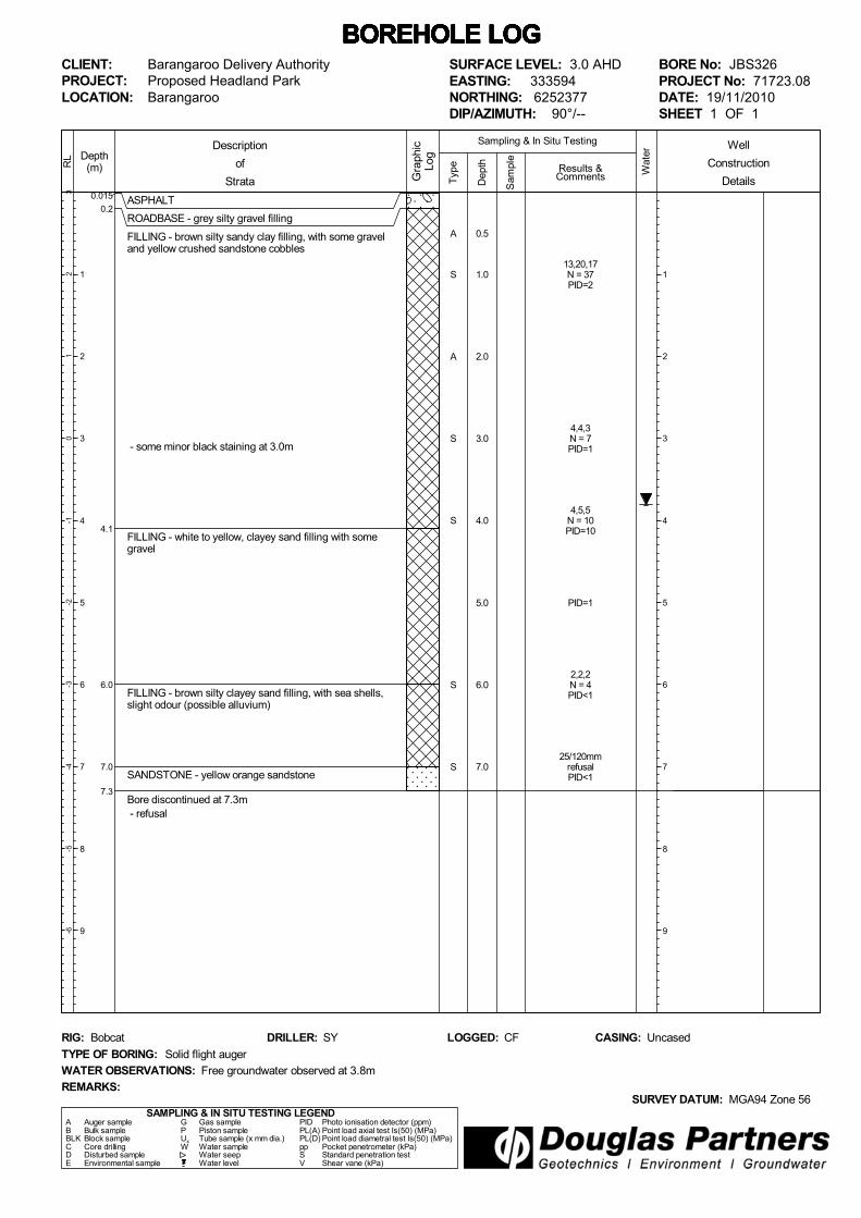
0.015
0.2
4.1
6.0
7.0
7.3
ASPHALT
ROADBASE - grey silty gravel filling
FILLING - brown silty sandy clay filling, with some graveland yellow crushed sandstone cobbles
- some minor black staining at 3.0m
FILLING - white to yellow, clayey sand filling with somegravel
FILLING - brown silty clayey sand filling, with sea shells,slight odour (possible alluvium)
SANDSTONE - yellow orange sandstone
Bore discontinued at 7.3m - refusal
Typ
e
32
10
-1-2
-3-4
-5-6
Depth(m)
1
2
3
4
5
6
7
8
9
RL
Wat
er
Dep
th
Sam
ple
Description
of
Strata Gra
phic
Log
Results &Comments
Sampling & In Situ Testing
1
2
3
4
5
6
7
8
9
BOREHOLE LOG BOREHOLE LOG BOREHOLE LOG BOREHOLE LOG BOREHOLE LOG BOREHOLE LOG BOREHOLE LOG CLIENT:PROJECT:LOCATION:
Barangaroo Delivery AuthorityProposed Headland ParkBarangaroo
SAMPLING & IN SITU TESTING LEGENDA Auger sample G Gas sample PID Photo ionisation detector (ppm)B Bulk sample P Piston sample PL(A) Point load axial test Is(50) (MPa)BLK Block sample Ux Tube sample (x mm dia.) PL(D) Point load diametral test Is(50) (MPa)C Core drilling W Water sample pp Pocket penetrometer (kPa)D Disturbed sample Water seep S Standard penetration testE Environmental sample Water level V Shear vane (kPa)
SURFACE LEVEL: 3.0 AHDEASTING: 333594NORTHING: 6252377DIP/AZIMUTH: 90°/--
BORE No: JBS326PROJECT No: 71723.08DATE: 19/11/2010SHEET 1 OF 1
WATER OBSERVATIONS: Free groundwater observed at 3.8m
TYPE OF BORING: Solid flight auger
RIG: Bobcat DRILLER: SY
REMARKS:SURVEY DATUM: MGA94 Zone 56
CASING: UncasedLOGGED: CF
Well
Construction
Details
A
S
A
S
S
S
S
13,20,17N = 37PID=2
4,4,3N = 7PID=1
4,5,5N = 10PID=10
PID=1
2,2,2N = 4PID<1
25/120mmrefusalPID<1
0.5
1.0
2.0
3.0
4.0
5.0
6.0
7.0

0.10.2
1.7
2.8
4.7
5.9
7.8
ASPHALT
ROADBASE
FILLING - red mottled grey, crushed sandstone filling withtrace slag, ash and trace brick - trace fibre cement fragments (possible asbestos)
FILLING - dark brown, clay filling with some gravel,crushed sandstone and trace ash and slag
FILLING - dark brown to black, clay filling with sandstoneboulders
3.5m: sandstone boulder to 3.9m
FILLING - brown sand filling with trace gravel andsandstone boulders
FILLING - brown sandstone filling with some low strengthsandstone fragments
7.11-7.20m: sandstone boulder
FILLING - grey to black, silty sand filling with some shelland trace timber and some organic matter (possiblynatural marine sediments)
Typ
e
21
0-1
-2-3
-4-5
-6-7
Depth(m)
1
2
3
4
5
6
7
8
9
RL
Wat
er
Dep
th
Sam
ple
Description
of
Strata Gra
phic
Log
Results &Comments
Sampling & In Situ Testing
1
2
3
4
5
6
7
8
9
BOREHOLE LOG BOREHOLE LOG BOREHOLE LOG BOREHOLE LOG BOREHOLE LOG BOREHOLE LOG BOREHOLE LOG CLIENT:PROJECT:LOCATION:
Barangaroo Delivery AuthorityProposed Headland ParkBarangaroo
SAMPLING & IN SITU TESTING LEGENDA Auger sample G Gas sample PID Photo ionisation detector (ppm)B Bulk sample P Piston sample PL(A) Point load axial test Is(50) (MPa)BLK Block sample Ux Tube sample (x mm dia.) PL(D) Point load diametral test Is(50) (MPa)C Core drilling W Water sample pp Pocket penetrometer (kPa)D Disturbed sample Water seep S Standard penetration testE Environmental sample Water level V Shear vane (kPa)
SURFACE LEVEL: 2.8 AHDEASTING: 333590NORTHING: 6252391DIP/AZIMUTH: 90°/--
BORE No: JBS327PROJECT No: 71723.08DATE: 19/11/2010SHEET 1 OF 2
WATER OBSERVATIONS: Free groundwater observed at 3.0m
TYPE OF BORING: Solid flight auger
RIG: Scout DRILLER: LC
REMARKS:SURVEY DATUM: MGA94 Zone 56
CASING: UncasedLOGGED: NSA
*Denotes field replicate sample RIBD2/191110 collected
Well
Construction
Details
A
A
A*
S
A
S
A
S
A
S
PID<122,19,27N = 46PID<1
29,32,34N = 66PID<1
PID<1
2,3,2N = 5PID<1
PID<1
17,16,9N = 25PID<1
PID<1
7,30/50mmrefusalPID<1
PID<1
11,10,9N = 19
0.20.3
1.0
2.0
3.0
4.0
5.0
6.0
7.0
8.0
9.0
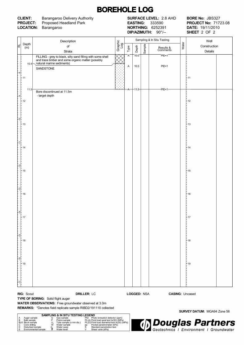
10.4
11.5
FILLING - grey to black, silty sand filling with some shelland trace timber and some organic matter (possiblynatural marine sediments)
SANDSTONE
Bore discontinued at 11.5m - target depth
Typ
e
-8-9
-10
-11
-12
-13
-14
-15
-16
-17
Depth(m)
11
12
13
14
15
16
17
18
19
RL
Wat
er
Dep
th
Sam
ple
Description
of
Strata Gra
phic
Log
Results &Comments
Sampling & In Situ Testing
11
12
13
14
15
16
17
18
19
BOREHOLE LOG BOREHOLE LOG BOREHOLE LOG BOREHOLE LOG BOREHOLE LOG BOREHOLE LOG BOREHOLE LOG CLIENT:PROJECT:LOCATION:
Barangaroo Delivery AuthorityProposed Headland ParkBarangaroo
SAMPLING & IN SITU TESTING LEGENDA Auger sample G Gas sample PID Photo ionisation detector (ppm)B Bulk sample P Piston sample PL(A) Point load axial test Is(50) (MPa)BLK Block sample Ux Tube sample (x mm dia.) PL(D) Point load diametral test Is(50) (MPa)C Core drilling W Water sample pp Pocket penetrometer (kPa)D Disturbed sample Water seep S Standard penetration testE Environmental sample Water level V Shear vane (kPa)
SURFACE LEVEL: 2.8 AHDEASTING: 333590NORTHING: 6252391DIP/AZIMUTH: 90°/--
BORE No: JBS327PROJECT No: 71723.08DATE: 19/11/2010SHEET 2 OF 2
WATER OBSERVATIONS: Free groundwater observed at 3.0m
TYPE OF BORING: Solid flight auger
RIG: Scout DRILLER: LC
REMARKS:SURVEY DATUM: MGA94 Zone 56
CASING: UncasedLOGGED: NSA
*Denotes field replicate sample RIBD2/191110 collected
Well
Construction
DetailsA
A
A
PID<1
PID<1
PID<1
10.0
10.5
11.5
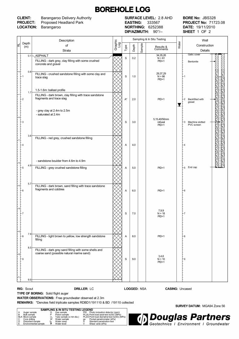
0.1
0.8
1.7
3.6
4.9
5.7
7.9
8.5
9.9
ASPHALT
FILLING - dark grey, clay filling with some crushedconcrete and gravel
FILLING - crushed sandstone filling with some clay andtrace slag
1.5-1.6m: ballast profile
FILLING - dark brown, clay filling with trace sandstonefragments and trace slag
- grey clay at 2.4m to 2.5m - saturated at 2.4m
FILLING - red grey, crushed sandstone filling
- sandstone boulder from 4.6m to 4.9m
FILLING - grey crushed sandstone filling
FILLING - dark brown, sand filling with trace sandstonefragments and cobbles
FILLING - light brown to yellow, low strength sandstonefilling
FILLING - dark grey sand filling with some shells andcoarse sand (possible natural marine sand)
Gatic cover
Bentonite
Backfilled withgravel
Machine slottedPVC screen
End cap
Typ
e
21
0-1
-2-3
-4-5
-6-7
Depth(m)
1
2
3
4
5
6
7
8
9
RL
Wat
er
Dep
th
Sam
ple
Description
of
Strata Gra
phic
Log
Results &Comments
Sampling & In Situ Testing
1
2
3
4
5
6
7
8
9
BOREHOLE LOG BOREHOLE LOG BOREHOLE LOG BOREHOLE LOG BOREHOLE LOG BOREHOLE LOG BOREHOLE LOG CLIENT:PROJECT:LOCATION:
Barangaroo Delivery AuthorityProposed Headland ParkBarangaroo
SAMPLING & IN SITU TESTING LEGENDA Auger sample G Gas sample PID Photo ionisation detector (ppm)B Bulk sample P Piston sample PL(A) Point load axial test Is(50) (MPa)BLK Block sample Ux Tube sample (x mm dia.) PL(D) Point load diametral test Is(50) (MPa)C Core drilling W Water sample pp Pocket penetrometer (kPa)D Disturbed sample Water seep S Standard penetration testE Environmental sample Water level V Shear vane (kPa)
SURFACE LEVEL: 2.8 AHDEASTING: 333567NORTHING: 6252388DIP/AZIMUTH: 90°/--
BORE No: JBS328PROJECT No: 71723.08DATE: 19/11/2010SHEET 1 OF 2
WATER OBSERVATIONS: Free groundwater observed at 2.3m
TYPE OF BORING: Solid flight auger
RIG: Scout DRILLER: LC
REMARKS:SURVEY DATUM: MGA94 Zone 56
CASING: UncasedLOGGED: NSA
*Denotes field triplicate samples RDBD1/191110 & BD /19110 collected
Well
Construction
Details
S
S
A*
S
A
A
A
S
A
S
34,35,26N = 61PID=1
29,37,29N = 66PID=1
PID<1
5,15,40/50mmrefusalPID<1
PID<1
PID<1
7,9,9N = 18PID<1
PID<1
3,4,6N = 10PID<1
0.2
1.0
2.0
3.0
4.0
5.0
6.0
7.0
8.0
9.0

11.3
SANDSTONE - brown and grey, low strength sandstone(continued)
Bore discontinued at 11.3m - target depth
Typ
e
-8-9
-10
-11
-12
-13
-14
-15
-16
-17
Depth(m)
11
12
13
14
15
16
17
18
19
RL
Wat
er
Dep
th
Sam
ple
Description
of
Strata Gra
phic
Log
Results &Comments
Sampling & In Situ Testing
11
12
13
14
15
16
17
18
19
BOREHOLE LOG BOREHOLE LOG BOREHOLE LOG BOREHOLE LOG BOREHOLE LOG BOREHOLE LOG BOREHOLE LOG CLIENT:PROJECT:LOCATION:
Barangaroo Delivery AuthorityProposed Headland ParkBarangaroo
SAMPLING & IN SITU TESTING LEGENDA Auger sample G Gas sample PID Photo ionisation detector (ppm)B Bulk sample P Piston sample PL(A) Point load axial test Is(50) (MPa)BLK Block sample Ux Tube sample (x mm dia.) PL(D) Point load diametral test Is(50) (MPa)C Core drilling W Water sample pp Pocket penetrometer (kPa)D Disturbed sample Water seep S Standard penetration testE Environmental sample Water level V Shear vane (kPa)
SURFACE LEVEL: 2.8 AHDEASTING: 333567NORTHING: 6252388DIP/AZIMUTH: 90°/--
BORE No: JBS328PROJECT No: 71723.08DATE: 19/11/2010SHEET 2 OF 2
WATER OBSERVATIONS: Free groundwater observed at 2.3m
TYPE OF BORING: Solid flight auger
RIG: Scout DRILLER: LC
REMARKS:SURVEY DATUM: MGA94 Zone 56
CASING: UncasedLOGGED: NSA
*Denotes field triplicate samples RDBD1/191110 & BD /19110 collected
Well
Construction
DetailsA
A
PID<1
PID<1
10.0
11.0

0.15
0.5
0.7
3.3
5.1
ASPHALT
ROADBASE - black, gravelly clayey silt filling
FILLING - brown clayey silt filling
FILLING - yellow crushed sandstone and red brown sandyclay/clayey sand filling with trace gravel
- coal at 2.0m
FILLING - yellow brown, clayey sand filling with somecrushed sandstone
Bore discontinued at 5.1m - refusal on sandstone boulder - relocated bore to JBS329A
Typ
e
21
0-1
-2-3
-4-5
-6-7
Depth(m)
1
2
3
4
5
6
7
8
9
RL
Wat
er
Dep
th
Sam
ple
Description
of
Strata Gra
phic
Log
Results &Comments
Sampling & In Situ Testing
1
2
3
4
5
6
7
8
9
BOREHOLE LOG BOREHOLE LOG BOREHOLE LOG BOREHOLE LOG BOREHOLE LOG BOREHOLE LOG BOREHOLE LOG CLIENT:PROJECT:LOCATION:
Barangaroo Delivery AuthorityProposed Headland ParkBarangaroo
SAMPLING & IN SITU TESTING LEGENDA Auger sample G Gas sample PID Photo ionisation detector (ppm)B Bulk sample P Piston sample PL(A) Point load axial test Is(50) (MPa)BLK Block sample Ux Tube sample (x mm dia.) PL(D) Point load diametral test Is(50) (MPa)C Core drilling W Water sample pp Pocket penetrometer (kPa)D Disturbed sample Water seep S Standard penetration testE Environmental sample Water level V Shear vane (kPa)
SURFACE LEVEL: 2.8 AHDEASTING: 333547NORTHING: 6252382DIP/AZIMUTH: 90°/--
BORE No: JBS329PROJECT No: 71723.08DATE: 19/11/2010SHEET 1 OF 1
WATER OBSERVATIONS: Free groundwater observed at 2.5m
TYPE OF BORING: Solid flight auger
RIG: Bobcat DRILLER: SY
REMARKS:SURVEY DATUM: MGA94 Zone 56
CASING: UncasedLOGGED: CF
*Denotes field replicate sample BD1/191110 collected
Well
Construction
Details
A
S
A*
S
A
S
PID=1
6,7,6N = 13PID=1
PID=1
3,3,6N = 9PID=1
PID=1
15/60mmrefusalPID=1
0.5
1.0
2.0
3.0
4.0
5.0

0.15
0.5
0.7
3.3
6.5
7.2
8.9
10.0
ASPHALT
ROADBASE - black, gravelly clayey silt filling
FILLING - brown clayey silt filling
FILLING - yellow crushed sandstone and red brown sandyclay/clayey sand filling with trace gravel
- coal at 2.0m
FILLING - yellow brown, clayey sand filling with somecrushed sandstone
FILLING - grey and brown, gravelly clay filling
FILLING - brown to dark grey, gravelly sand filling
- wire at 8.0m
SANDSTONE - red brown and grey sandstone
Bore discontinued at 10.0m
Typ
e
21
0-1
-2-3
-4-5
-6-7
Depth(m)
1
2
3
4
5
6
7
8
9
10
RL
Wat
er
Dep
th
Sam
ple
Description
of
Strata Gra
phic
Log
Results &Comments
Sampling & In Situ Testing
1
2
3
4
5
6
7
8
9
10
BOREHOLE LOG BOREHOLE LOG BOREHOLE LOG BOREHOLE LOG BOREHOLE LOG BOREHOLE LOG BOREHOLE LOG CLIENT:PROJECT:LOCATION:
Barangaroo Delivery AuthorityProposed Headland ParkBarangaroo
SAMPLING & IN SITU TESTING LEGENDA Auger sample G Gas sample PID Photo ionisation detector (ppm)B Bulk sample P Piston sample PL(A) Point load axial test Is(50) (MPa)BLK Block sample Ux Tube sample (x mm dia.) PL(D) Point load diametral test Is(50) (MPa)C Core drilling W Water sample pp Pocket penetrometer (kPa)D Disturbed sample Water seep S Standard penetration testE Environmental sample Water level V Shear vane (kPa)
SURFACE LEVEL: 2.8 AHDEASTING: 333544NORTHING: 6252383DIP/AZIMUTH: 90°/--
BORE No: JBS329APROJECT No: 71723.08DATE: 3/12/2010SHEET 1 OF 1
WATER OBSERVATIONS: Free groundwater observed at 2.5m
TYPE OF BORING: Solid flight auger
RIG: Scout DRILLER: Terra Test
REMARKS:SURVEY DATUM: MGA94 Zone 56
CASING: UncasedLOGGED: CF
Well
Construction
Details
A
A
A
A
A
PID=2bore collapse to 5.0m
PID=2
PID=3
PID=3
PID=3
6.0
7.0
8.0
9.0
10.0

0.080.1
0.4
0.7
0.9
2.8
3.1
ASPHALT
ROADBASE
FILLING - brown mottled red, crushed sandstone fillingwith some sandstone boulders and some ballast
FILLING - dark brown, silty clayey sand with some gravel
FILLING - grey sandstone boulder filling
FILLING - dark brown, silty clayey sand filling with somegravel1.4-1.6m: gravel and trace concrete
- crushed sandstone at 2.2m
2.4-2.6m: sandstone boulder
FILLING - brown clayey sand filling - saturated at 2.9m
Bore discontinued at 3.1m - refusal on steel - relocated bore to JBS330A
Typ
e
21
0-1
-2-3
-4-5
-6-7
Depth(m)
1
2
3
4
5
6
7
8
9
RL
Wat
er
Dep
th
Sam
ple
Description
of
Strata Gra
phic
Log
Results &Comments
Sampling & In Situ Testing
1
2
3
4
5
6
7
8
9
BOREHOLE LOG BOREHOLE LOG BOREHOLE LOG BOREHOLE LOG BOREHOLE LOG BOREHOLE LOG BOREHOLE LOG CLIENT:PROJECT:LOCATION:
Barangaroo Delivery AuthorityProposed Headland ParkBarangaroo
SAMPLING & IN SITU TESTING LEGENDA Auger sample G Gas sample PID Photo ionisation detector (ppm)B Bulk sample P Piston sample PL(A) Point load axial test Is(50) (MPa)BLK Block sample Ux Tube sample (x mm dia.) PL(D) Point load diametral test Is(50) (MPa)C Core drilling W Water sample pp Pocket penetrometer (kPa)D Disturbed sample Water seep S Standard penetration testE Environmental sample Water level V Shear vane (kPa)
SURFACE LEVEL: 2.8 AHDEASTING: 333533NORTHING: 6252162DIP/AZIMUTH: 90°/--
BORE No: JBS330PROJECT No: 71723.08DATE: 23/11/2010SHEET 1 OF 1
WATER OBSERVATIONS: Free groundwater observed at 2.9m
TYPE OF BORING: Solid flight auger
RIG: Scout DRILLER: LC
REMARKS:SURVEY DATUM: MGA94 Zone 56
CASING: UncasedLOGGED: NSA
*Denotes field replicate samples RIBD1/231110 and RIBDIA/231110 collected
Well
Construction
Details
S
A
A
A*
A
13,30refusalPID<1
PID=1
asbestos sample
PID=1
PID<1asbestos sample
0.2
1.0
1.5
2.0
3.0

0.080.1
0.4
0.7
0.9
3.1
5.8
6.0
7.8
8.8
9.5
ASPHALT
ROADBASE
FILLING - brown mottled red, crushed sandstone fillingwith some sandstone boulders and some ballast
FILLING - dark brown, silty clayey sand with some gravel
FILLING - grey sandstone boulder filling
FILLING - dark brown, silty clayey sand filling with somegravel
- saturated at 2.9m
FILLING - red brown, crushed sandstone filling with somegravel
FILLING - grey sand with some shell fragments
FILLING - grey crushed sandstone filling - redrill using auger on 30/11/10 - ODEX damage at 6.0m
CLAYEY SILT - black clayey silt (alluvium) with sometimber (possible filling)
CLAY - brown mottled grey clay
Bore discontinued at 9.5m - target depth and refusal on sandstone
Typ
e
21
0-1
-2-3
-4-5
-6-7
Depth(m)
1
2
3
4
5
6
7
8
9
RL
Wat
er
Dep
th
Sam
ple
Description
of
Strata Gra
phic
Log
Results &Comments
Sampling & In Situ Testing
1
2
3
4
5
6
7
8
9
BOREHOLE LOG BOREHOLE LOG BOREHOLE LOG BOREHOLE LOG BOREHOLE LOG BOREHOLE LOG BOREHOLE LOG CLIENT:PROJECT:LOCATION:
Barangaroo Delivery AuthorityProposed Headland ParkBarangaroo
SAMPLING & IN SITU TESTING LEGENDA Auger sample G Gas sample PID Photo ionisation detector (ppm)B Bulk sample P Piston sample PL(A) Point load axial test Is(50) (MPa)BLK Block sample Ux Tube sample (x mm dia.) PL(D) Point load diametral test Is(50) (MPa)C Core drilling W Water sample pp Pocket penetrometer (kPa)D Disturbed sample Water seep S Standard penetration testE Environmental sample Water level V Shear vane (kPa)
SURFACE LEVEL: 2.8 AHDEASTING: 333533NORTHING: 6252162DIP/AZIMUTH: 90°/--
BORE No: JBS330APROJECT No: 71723.08DATE: 23 - 30/11/2010SHEET 1 OF 1
WATER OBSERVATIONS: Free groundwater observed at 2.9m
TYPE OF BORING: ODEX to 6.0m; Solid flight auger to 9.5m
RIG: Scout DRILLER: LC
REMARKS:SURVEY DATUM: MGA94 Zone 56
CASING: UncasedLOGGED: NSA
ODEX damaged at 6.0m
Well
Construction
Details
S
A
S
A
A
A
2,4,8N = 12
8,7,6N = 13
PID<1
PID<1
PID<1
4.0
5.0
6.0
7.0
8.0
9.0
July 2010
Introduction These notes have been provided to amplify DP's report in regard to classification methods, field procedures and the comments section. Not all are necessarily relevant to all reports. DP's reports are based on information gained from limited subsurface excavations and sampling, supplemented by knowledge of local geology and experience. For this reason, they must be regarded as interpretive rather than factual documents, limited to some extent by the scope of information on which they rely. Copyright This report is the property of Douglas Partners Pty Ltd. The report may only be used for the purpose for which it was commissioned and in accordance with the Conditions of Engagement for the commission supplied at the time of proposal. Unauthorised use of this report in any form whatsoever is prohibited. Borehole and Test Pit Logs The borehole and test pit logs presented in this report are an engineering and/or geological interpretation of the subsurface conditions, and their reliability will depend to some extent on frequency of sampling and the method of drilling or excavation. Ideally, continuous undisturbed sampling or core drilling will provide the most reliable assessment, but this is not always practicable or possible to justify on economic grounds. In any case the boreholes and test pits represent only a very small sample of the total subsurface profile. Interpretation of the information and its application to design and construction should therefore take into account the spacing of boreholes or pits, the frequency of sampling, and the possibility of other than 'straight line' variations between the test locations. Groundwater Where groundwater levels are measured in boreholes there are several potential problems, namely: • In low permeability soils groundwater may
enter the hole very slowly or perhaps not at all during the time the hole is left open;
• A localised, perched water table may lead to an erroneous indication of the true water table;
• Water table levels will vary from time to time with seasons or recent weather changes. They may not be the same at the time of construction as are indicated in the report; and
• The use of water or mud as a drilling fluid will mask any groundwater inflow. Water has to be blown out of the hole and drilling mud must first be washed out of the hole if water measurements are to be made.
More reliable measurements can be made by installing standpipes which are read at intervals over several days, or perhaps weeks for low permeability soils. Piezometers, sealed in a particular stratum, may be advisable in low permeability soils or where there may be interference from a perched water table. Reports The report has been prepared by qualified personnel, is based on the information obtained from field and laboratory testing, and has been undertaken to current engineering standards of interpretation and analysis. Where the report has been prepared for a specific design proposal, the information and interpretation may not be relevant if the design proposal is changed. If this happens, DP will be pleased to review the report and the sufficiency of the investigation work. Every care is taken with the report as it relates to interpretation of subsurface conditions, discussion of geotechnical and environmental aspects, and recommendations or suggestions for design and construction. However, DP cannot always anticipate or assume responsibility for: • Unexpected variations in ground conditions.
The potential for this will depend partly on borehole or pit spacing and sampling frequency;
• Changes in policy or interpretations of policy by statutory authorities; or
• The actions of contractors responding to commercial pressures.
If these occur, DP will be pleased to assist with investigations or advice to resolve the matter.
July 2010
Site Anomalies In the event that conditions encountered on site during construction appear to vary from those which were expected from the information contained in the report, DP requests that it be immediately notified. Most problems are much more readily resolved when conditions are exposed rather than at some later stage, well after the event. Information for Contractual Purposes Where information obtained from this report is provided for tendering purposes, it is recommended that all information, including the written report and discussion, be made available. In circumstances where the discussion or comments section is not relevant to the contractual situation, it may be appropriate to prepare a specially edited document. DP would be pleased to assist in this regard and/or to make additional report copies available for contract purposes at a nominal charge. Site Inspection The company will always be pleased to provide engineering inspection services for geotechnical and environmental aspects of work to which this report is related. This could range from a site visit to confirm that conditions exposed are as expected, to full time engineering presence on site.