facilities gis - appa › training › appa2017 › documents › facilities… ·...
TRANSCRIPT

7/28/2017
1
Esri-PenBay SolutionsAPPA 2017
Facilities GIS: Use Location to Plan, Operate & Protect
Our presenters
George Dailey
is the Education Administration/Operations Manager for Esri, the world leader in GIS.
Richard Koochagian
is the COO and Education Practice Lead for PenBaySolutions, the leader in facilities GIS.

7/28/2017
2
Esri – World’s leading GIS company
Our Purpose• Serve Users• Advance Spatial Literacy• Contribute to Society
Our Status• Growing &
Financially Strong for Nearly 50 Years
• Strong Relationships• 9,000+ Employees• 300,000+ Customer
Organizations• 42 Offices • Global – 200+ Countries• 1000s of Partners
Our Work• GIS Software• Geographic
Content• Technical
Support• Education
Services• Professional
Services
PenBay Solutions – Leading facilities GIS company

7/28/2017
3
Session learning objectives
1. Understand why location can & should be used as the organizing principle for complex FM related information/data
2. Examine the unique ways a location-based technology approach solves challenges in FM/operations and safety & security
3. Compare facilities GIS implementation approaches that bring together data, systems, and departments
4. Discover facilities GIS technology ROI through real-world case studies
Facilities are mission critical
Financial Asset,Cost, Revenue,
Budgeting
Planning, Lifecycle, Utilization –
Staff, Students, Visitors
Operations, Assets, Utilities,Intellectual Property
Risk, Vulnerability,Life Safety

7/28/2017
4
Managing facilities is complicated
Portfolio Analysis & Mgt.Portfolio Analysis & Mgt. Public CommunicationsPublic Communications Lease ManagementLease Management
Space ManagementSpace Management Asset ManagementAsset Management Utilities & Infrastructure Mgt.Utilities & Infrastructure Mgt.
Move ManagementMove Management Capital PlanningCapital Planning Ops & MaintenanceOps & Maintenance
Indirect Cost RecoveryIndirect Cost Recovery Safety/SecuritySafety/Security Emergency PreparednessEmergency Preparedness
Facilities management business clusters
Portfolio & Planning
Protecting Property and People, Mitigating Risk, Being Compliant
Meeting Demand, Capturing Requirements, Boosting Productivity
Operations & Maintenance
Safety & Security
Selecting Sites, Tracking Demand and Performance, Balancing Resources

7/28/2017
5
Portfolio and planning activities
Indoor space & amenity site selection
Real-time portfolio key performance indicator mapping
Site selection & demographic analysis for property acquisition & disposal
Building performance mapping & monitoring
Space allocation & utilization
Operations and maintenance activities
Active, high priority work orders
Hot spots of increased service requests & work orders
Real-time indoor environment sensors, monitoring & alerts
Person, place, amenity locator, search/find “show me the path”
Optimized work scheduling, navigation, routing, wayfinding

7/28/2017
6
Public safety and security activities
Natural hazard & continuity of operations
Risk assessment & planning
Event planning, safety, and security
Live camera feeds & view sheds
ADA compliance & emergency evacuation routes
GIS provides a system of engagement
Through maps, apps, and
geographic content, GIS is:
• Visual
• Quantitative
• Analytical
• Communicative
• Integrative
Through maps, apps, and
geographic content, GIS is:
• Visual
• Quantitative
• Analytical
• Communicative
• Integrative

7/28/2017
7
GIS | Integration across all scales
…seamless indoors and out
PORTFOLIO
COMMUNITY
CAMPUS
BUILDING
FLOOR
SPACES
ROOM
ASSET
Why facilities GIS for FM?Location: Creates order out of disorder
• Correlate diverse data using location as the “universal” index
• Improve data accuracy
• Enhance analysis/understanding
- Visualizing information
- Identifying patterns
- Finding relationships
- Detecting trends
• Enable efficient/effective workflows
• Report against data from multiple systems of record

7/28/2017
8
Why facilities GIS for FM?Location: Provides added value
Increase worth of existing data / system / process investments
– Allow existing information to support more than one purpose
Provide holistic views and reports – Better decision making
Improve teamwork / communications – Collaboration, transparency, productivity
Mitigate risk– Planning for/awareness of emergency and health
situations
Save time and money– Immediate access to necessary information
Facilities GIS = Location + your data + your systems of record
7/28/2017
9
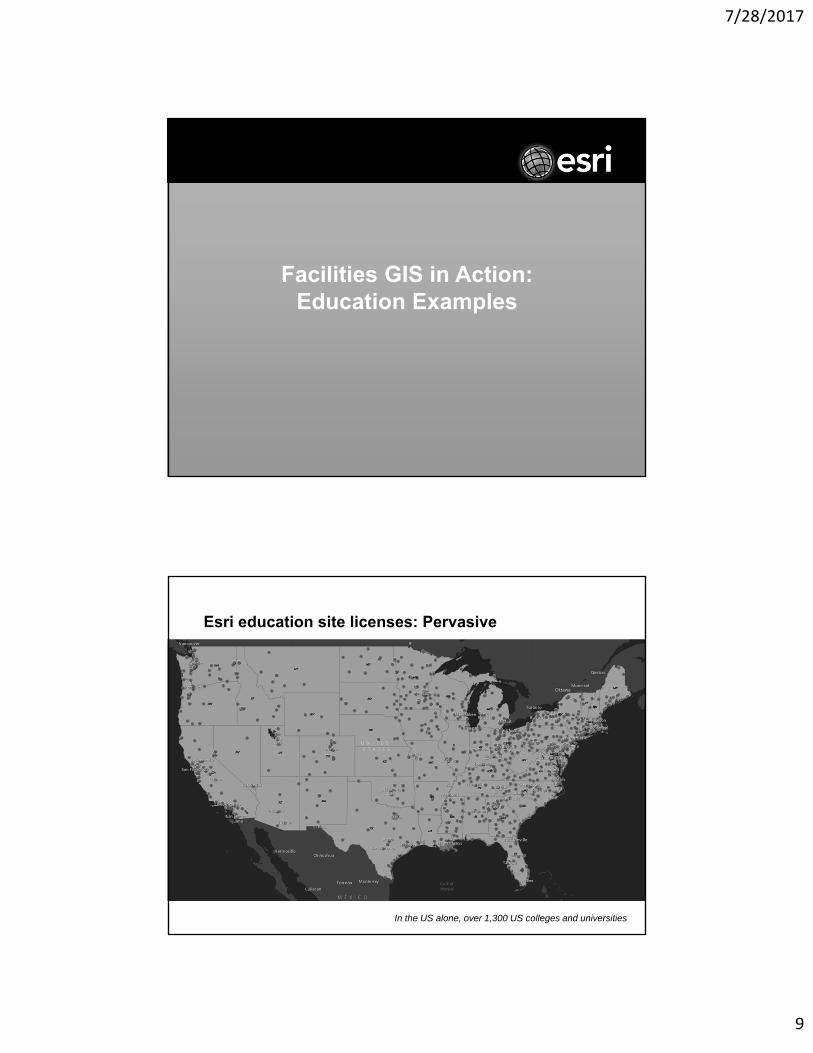
Facilities GIS in Action:Education Examples
Esri education site licenses: Pervasive
In the US alone, over 1,300 US colleges and universities
7/28/2017
10
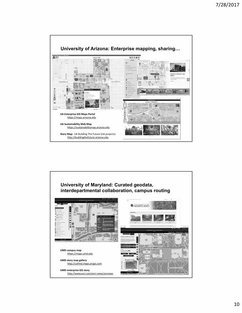
University of Arizona: Enterprise mapping, sharing…
UA Enterprise GIS Maps Portalhttps://maps.arizona.edu
UA Sustainability Web Maphttps://sustainabilitymap.arizona.edu
Story Map: UA Building The Future (UA projects)http://buildingthefuture.arizona.edu
University of Maryland: Curated geodata, interdepartmental collaboration, campus routing
UMD campus maphttps://maps.umd.edu
UMD story map galleryhttp://uofmd.maps.arcgis.com
UMD enterprise GIS storyhttp://www.esri.com/esri-news/arcnews

7/28/2017
11
University of Maryland: Curated geodata, interdepartmental collaboration, campus routing
UMD campus maphttps://maps.umd.edu
UMD story map galleryhttp://uofmd.maps.arcgis.com
UMD enterprise GIS storyhttp://www.esri.com/esri-news/arcnews
UMass-Amherst: Campus master planning, crowdsourcing, energy monitoring
UMass-Amherst master plan explorerhttps://www.umass.edu/cp/master-plan-explorer
UMass-Amherst campus projectshttps://www.umass.edu/cp/decade-renewal
UMass-Amherst building energy explorerhttps://www.umass.edu/cp/green-campus-resources

7/28/2017
12
UMass-Lowell: Commencement, mechanical data collection, bike rack inspections
UMass-Lowell commencementhttp://esriurl.com/UMLcommencement
UMass-Lowell mechanical data collectionhttp://esriurl.com/UMLmechanical
UMass-Lowell bike rack inspectionshttp://esriurl.com/UMLinspections
University of Minnesota: Trees, infrastructure, beyond
http://video.esri.com > search = Minnesota

7/28/2017
13
Michigan State: Streamlining field operations
http://www.cfta.org/online-webinars
Curtin University: Campus, spaces, integration

7/28/2017
14
University of Alabama-Birmingham: Connecting disparate data, indoor/outdoor awareness
Puyallup School District: Locational intel, space awareness, building insight and action

7/28/2017
15
Location, Location, Location
There is immeasurable value in using location as the organizing principle for Facilities data -
• Location can and should be used as the organizing principle for complex FM related information/data
• Location-based technology approaches solve challenges for FM/operations and safety & security
• Location focused solutions bring together data, systems, departments, and people
• Facilities GIS technology provides ROI as seen through real-world case studies
Thank you
George Dailey
Richard Koochagian