environmental assessment for remote video surveillance system
TRANSCRIPT
DRAFT
ENVIRONMENTAL ASSESSMENT
FOR
REMOTE VIDEO SURVEILLANCE SYSTEM TOWER UPGRADE
RIO GRANDE CITY, McALLEN, AND WESLACO STATIONS’
AREAS OF RESPONSIBILITY
U.S. BORDER PATROL, RIO GRANDE VALLEY SECTOR, TEXAS
U.S. CUSTOMS AND BORDER PROTECTION
DEPARTMENT OF HOMELAND SECURITY
WASHINGTON, D.C.
October 2016
Project Proponent: Department of Homeland Security
U.S. Customs & Border Protection
Office of Technology Innovation and Acquisition
1901 S. Bell Street, Room 7-007
Arlington, VA 20598
Points of Contact: Mr. Joseph Zidron
U.S. Customs and Border Protection
Border Patrol Facilities and Tactical Infrastructure
Program Management Office
24000 Avila Road, Suite 5020
Laguna Niguel, CA 92677
DRAFT
FINDING OF NO SIGNIFICANT IMPACT
FOR
REMOTE VIDEO SURVEILLANCE SYSTEM TOWER UPGRADE
RIO GRANDE CITY, McALLEN, AND WESLACO STATIONS’
AREAS OF RESPONSIBILITY
U.S. BORDER PATROL, RIO GRANDE VALLEY SECTOR, TEXAS
U.S. CUSTOMS AND BORDER PROTECTION
DEPARTMENT OF HOMELAND SECURITY
WASHINGTON, D.C.
INTRODUCTION: The Border Patrol Facilities and Tactical Infrastructure (BPFTI) Program
Management Office (PMO), within Department of Homeland Security’s (DHS) U.S. Customs
and Border Protection (CBP), is preparing an Environmental Assessment (EA) addressing the
proposed upgrade of its Remote Video Surveillance System (RVSS) program within the U.S.
Border Patrol’s (USBP) Rio Grande City (RGC), McAllen (MCS), and Weslaco (WSL) Stations’
Areas of Responsibility (AORs). BPFTI has prepared an EA on behalf of USBP Headquarters.
USBP is the mobile uniformed law enforcement subcomponent of CBP responsible for patrolling
and securing America’s border between the Ports of Entry. As directed by DHS Analysis of
Alternatives (AoA), CBP is investing in the USBP border security technology plan for the Rio
Grande Valley (RGV) Sector. Accordingly, the new plan incorporates both the quantitative
analysis of science and engineering experts and the real-world operational assessment of USBP
on the ground. This plan includes the utilization of RVSS to provide long-range, persistent
surveillance, enabling USBP personnel to detect, track, identify, and classify illegal entries
through a series of integrated sensors and tower-based surveillance equipment.
The proposed RVSS Upgrade Program includes the construction of new RVSS towers for
improved border surveillance coverage throughout the RGC, MCS, and WSL Station’s AORs.
The RVSS upgrade proposed for the RGC, MCS, and WSL Stations’ AORs includes:
Construction and maintenance of 40 new RVSS towers and three relay towers
Construction and maintenance of utilities and utility corridors
Construction, improvement, and maintenance of access roads and approach drives
PROJECT LOCATION: The proposed new tactical infrastructure (TI) is located near the Rio
Grande within Starr and Hidalgo Counties, Texas. The project would serve the USBP RGV
Sector's RGC, MCS, and WSL Stations’ AORs. There would be a total of 18 new RVSS towers
and associated infrastructure in the RGC AOR, 12 new RVSS towers and associated
infrastructure in the MCS AOR, and 10 new RVSS towers and associated infrastructure in the
WSL AOR. Three relay towers, one per AOR, would also be constructed. These towers are
located on Federal, private, and state lands.
PURPOSE AND NEED: The purpose of the Proposed Action is to provide improved
surveillance and detection capabilities that facilitate rapid response to areas of greatest risk for
illegal cross-border threats in the USBP RGC, MCS, and WSL Stations’ AORs. Meeting this
FONSI-2
purpose would provide more efficient and effective interdiction while reducing the potential for
adverse impacts from illegal cross-border activities on the natural and cultural environments in
the RGC, MCS, and WSL Stations’ AORs.
A lack of infrastructure, high volume of illicit activity, and difficult terrain (e.g., creeks, steep
cliffs/slopes, riparian areas, and dense south Texas brush) within the RGV Sector affect response
time and enforcement operations, thereby creating a need for a year-round, continuous,
technology-based surveillance capability that can effectively collect, process and distribute
information among Border Patrol Agents (BPAs). With the RVSS upgrade, BPAs would be able
to maintain surveillance over large areas, contributing to BPA safety and increasing operational
effectiveness as they detect, identify, and classify incursions/illicit activity at the border and
resolve the incursions with the appropriate law enforcement response.
ALTERNATIVES: CBP analyzed two alternatives in the Environmental Assessment (EA).
Alternative 1 is the No Action Alternative. Under the No Action Alternative, the proposed
RVSS Upgrade Program would not be constructed in USBP’s Rio Grande City (RGC), McAllen
(MCS), or Weslaco (WSL) Stations’ AORs. USBP’s ability to detect and interdict cross-border
violators would not be enhanced; thus, operational effectiveness would not be improved in the
project area. The No Action Alternative does not meet the purpose and need for this project.
Alternative 2 is the Proposed Action. The Proposed Action includes the construction, operation,
and maintenance of 40 RVSS and three relay tower sites to provide long-term, permanent
surveillance in the USBP’s RGC, WSL, and MCS Stations’ AORs. The RVSS system provides
radar or video data feeds to the command and control (C2) modular facilities. The C2 facilities
integrate and display data from all their respective RVSS and relay towers deployed within the
USBP’s RGC, WSL, and MCS Stations’ AORs. Each RVSS tower consists of a tower equipped
with a suite of sensors and/or communications equipment.
The Proposed Action also includes the construction and maintenance of access drives, totaling
0.5 mile, and the maintenance and repair of access roads, totaling 25 miles. Access road
maintenance and repairs include reconstruction, widening, or straightening of the existing road,
and installation of drainage structures, and would require a 30- or 60-foot-wide temporary
construction disturbance area. Drainage structures may include but are not limited to ditches,
culverts, and low-water crossings.
ENVIRONMENTAL CONSEQUENCES: The Proposed Action would have permanent,
negligible impacts on land use. Approximately 7.75 acres would be permanently converted from
undeveloped land to law enforcement facilities, and 23.25 acres would be temporarily impacted.
The new access drives would permanently impact less than 1 acre and temporarily impact 2 acres
during construction. Four acres would be permanently impacted while 100 acres would be
temporarily impacted from repair and maintenance activities associated with the existing access
roads. Temporary, minor impacts would be expected on surface water quality during
construction. The withdrawal of water for construction purposes could have a temporary, minor
impact on surface water resources. Long-term, permanent impacts would occur on
approximately 1 acre of potentially jurisdictional wetlands; however, these impacts would be
addressed during the permitting process. Best management practices (BMPs) and standard
FONSI-3
construction procedures will be implemented to minimize the potential for erosion and
sedimentation during construction.
Minor impacts on soils and vegetative habitat and negligible impacts on wildlife would occur as
a result of disturbing 8.25 acres for the construction of RVSS and relay towers and access road
maintenance and repairs. Areas with highly erodible soils would be given special consideration
when designing the Proposed Action to ensure incorporation of various BMPs, such as straw
bales, aggregate materials, and wetting compounds to decrease erosion. A Stormwater Pollution
Prevention Plan (SWPPP) would be prepared prior to construction activities and will include pre-
and post-construction measures.
Three Federally listed species and one candidate species have the potential to occur within the
project area: northern aplomado falcon (Falco femoralis septentrionalis), ocelot (Leopardus
pardalis), and Gulf Coast jaguarundi (Herpailusrus yagouaroundi cacomitli). The Proposed
Action may affect, but is not likely to adversely affect, any of the Federally listed species. No
designated critical habitat occurs within the construction footprint. Endangered Species Act,
Section 7 consultation with U.S. Fish and Wildlife Service (USFWS) is ongoing for this project.
A total of 17 archaeological sites would be directly affected by implementation of the Proposed
Action. Six of the 17 archaeological sites are not considered eligible for listing in the National
Register of Historic Places (NRHP) and are not considered significant archaeological resources.
The remaining 11 archaeological resources are considered to have an undetermined eligibility for
the NRHP. CBP will attempt to avoid these 11 sites. If avoidance is not possible the effects on
these 11 archaeological resources, prior to their assessment for the NRHP, would be considered
adverse and significant. Mitigation measures would be developed in consultation with the Texas
State Historic Preservation Officer, as well as other interested parties, to reduce the effects to less
than significant levels. The mitigation measures would be outlined in a Historic Properties
Treatment Plan (HPTP) and would be implemented prior to the initiation of construction. The
implementation and completion of the HPTP would reduce the project effects to non-significant
levels.
Temporary and minor increases in air emissions would occur during construction of the RVSS
and relay towers, access drive construction, and access road maintenance and repairs. Air
emissions would be below the Federal de minimis thresholds for construction, operation,
maintenance, and repair activities. Noise level increases associated with tower and access drive
construction and maintenance and repair of access roads would result in temporary, negligible
impacts on wildlife and the Lower Rio Grande Valley National Wildlife Refuge. Noise levels
associated with the operation and maintenance of the towers would have permanent, negligible
impacts on nearby resources.
Negligible demands on utilities would be required as a result of the Proposed Action.
Communications equipment on the proposed towers would emit electromagnetic radiation (i.e.,
radio waves and microwaves), and a potential for impacts could occur depending on the location;
however, any adverse effects on human health or wildlife would be negligible due to the minimal
exposure risk and the elevated locations in which the communications equipment would be
FONSI-4
positioned. CBP will coordinate with National Telecommunications and Information
Administration (NTIA) regarding radio spectrum and frequency assignment.
Construction of the towers, access drives, and access roads would create a temporary, minor
impact on roadways and traffic within the region. The increase of vehicular traffic near each
RVSS and relay tower site would occur to transport materials and work crews at each for a short
period of time. Tower maintenance would also require vehicle travel to each site for fuel
delivery and maintenance and operation of the proposed towers. The limited amount of
anticipated vehicle trips for tower maintenance and refueling would have a long-term, negligible
impact on roadways and traffic. Construction vehicles and equipment would use established roads
with proper flagging and safety precautions.
The Proposed Action would have a long-term, moderate impact on aesthetic qualities within 5
miles or less of each tower. The Proposed Action would not result in exposure of the
environment or public to any hazardous materials. Although several of the towers are located
near residential areas, all construction activities would strictly adhere to Occupational Safety and
Health Administration (OSHA) and NTIA guidelines. Proper fencing would be installed around
the construction site to prevent children or others from entering the construction site. By
implementing OSHA and NTIA guidelines and practicing safe construction habits, no adverse
effect relative to environmental justice or protection of children issues would occur.
BEST MANAGEMENT PRACTICES: Best Management Practices (BMPs) were identified
for each resource category that could be potentially affected. Many of these measures have been
incorporated as standard operating procedures by CBP in similar past projects. The BMPs were
also identified in the EA in Section 5.
FINDING: On the basis of the findings of the EA, which is incorporated by reference, and
which has been conducted in accordance with the National Environmental Policy Act, the
Council on Environmental Quality regulations, and Department of Homeland Security
Management Directive, 023-01 and after careful review of the potential environmental impacts
of implementing the proposal, we find there would be no significant impact on the quality of the
human or natural environments, either individually or cumulatively; therefore, there is no
requirement to develop an Environmental Impact Statement. Further, we commit to implement
BMPs and environmental design measures identified in the EA and supporting documents.
Francis Dutch Date
Director
Facilities Management and Engineering
U.S. Customs and Border Protection
Justin A. Bristow Date
Acting Chief
Strategic Planning and Analysis Directorate
RVSS Upgrade Program RGV ES-1 Draft EA
RGC, MCS, WSL AORs October 2016
EXECUTIVE SUMMARY
INTRODUCTION: U.S. Customs and Border Protection (CBP) is the law enforcement
component of the Department of Homeland Security (DHS) responsible for securing the border
and facilitating lawful international trade and travel. U.S. Border Patrol (USBP) is the
uniformed law enforcement component within CBP responsible for securing the Nation’s
borders against the illegal entry of people and goods between Ports of Entry.
CBP is proposing to upgrade the current Remote Video Surveillance Systems (RVSS) as part of
the technology deployment plan for Rio Grande Valley (RGV) Sector. The RVSS upgrade
would provide long-range, persistent surveillance, enabling USBP personnel to detect, track,
identify, and classify illegal entries through a series of integrated sensors and tower-based
surveillance equipment. The proposed RVSS Upgrade Program represents a technology solution
for the distinct terrain within RGV Sector.
STUDY LOCATION: The Proposed Action would take place in the USBP Rio Grande City
(RGC), McAllen (MCS), and Weslaco (WSL) Stations’ Areas of Responsibility (AORs), RGV
Sector, Texas. More specifically, the proposed RVSS tower sites are located in Starr and
Hidalgo counties, Texas.
PURPOSE AND NEED: The purpose of the Proposed Action is to provide improved
surveillance and detection capabilities that facilitate rapid response to areas of greatest risk for
illegal cross-border threats along approximately 120 miles of the United States/Mexico border in
the USBP RGC, MCS, and WSL Stations’ AORs.
The project is needed to:
1) provide more efficient and effective means of assessing cross-border activities
2) provide rapid detection and accurate characterization of potential threats
3) provide coordinated deployment of resources in the apprehension of cross-border
violators
4) increase surveillance and interdiction efficiency
5) enhance the deterrence of illegal cross-border activity
6) enhance agent safety 7) enhance safety to border communities
PROPOSED ACTION AND ALTERNATIVES CONSIDERED: CBP analyzed two
alternatives in this Environmental Assessment (EA). Under the No Action Alternative
(Alternative 1), the proposed RVSS Upgrade Program would not be constructed in USBP’s
RGC, MCS, and WSL Stations’ AORs. Maintenance and repair of existing access roads would
not be conducted. The No Action Alternative reflects conditions within the project area should
the Proposed Action not be implemented. USBP’s ability to detect and interdict cross-border
violators would not be enhanced; thus, operational efficiency and effectiveness would not be
improved within the area covered by the proposed towers. USBP would continue to rely solely
on traditional detection methodology that includes traditional sign detection, which requires both
RVSS Upgrade Program RGV ES-2 Draft EA
RGC, MCS, WSL AORs October 2016
patrolling and dragging of roads. The No Action Alternative does not meet the purpose of and
need for this project.
Alternative 2 is the Proposed Action. The Proposed Action includes the construction, operation,
and maintenance of 40 RVSS and three relay tower sites to provide long-term, permanent
surveillance in the USBP’s RGC, WSL, and MCS Stations’ AORs. The RVSS system provides
radar or video data feeds to the command and control (C2) facilities. The C2 facilities integrate
and display data from all their respective RVSS and relay towers deployed within the USBP’s
RGC, WSL, and MCS Stations’ AORs. Each RVSS tower consists of a tower equipped with a
suite of sensors and/or communications equipment, which would allow the RVSS towers to
communicate with the C2 facilities.
The Proposed Action also includes the construction and maintenance of access drives, totaling
0.5 mile, and the maintenance and repair of access roads, totaling 25 miles. Access road
maintenance and repairs include reconstruction, widening, or straightening of the existing road,
and installation of drainage structures, and would require a 30- or 60-foot-wide temporary
construction disturbance area. Drainage structures may include but are not limited to ditches,
culverts, and low-water crossings.
Other border surveillance approaches, strategies, and technologies or combination of activities
were considered as alternatives. These alternatives included unmanned aircraft systems, remote
sensing satellites, unattended ground sensors, increased CBP workforce, and increased aerial
reconnaissance/operations. Although these alternatives or a combination of these alternatives
can be valuable tools that CBP may employ in other areas or circumstances of border incursion,
they were eliminated because of logistical restrictions, environmental considerations, or
functional deficiencies that fail to meet the purpose of this project.
AFFECTED ENVIRONMENT AND CONSEQUENCES: The Proposed Action would have
permanent, negligible impacts on land use. Approximately 7.75 acres would be permanently
converted from undeveloped land to law enforcement facilities, and 23.25 acres would be
temporarily impacted. The new access drives would permanently impact less than 1 acre and
temporarily impact 2 acres during construction. Four acres would be permanently impacted
while 100 acres would be temporarily impacted from repair and maintenance activities
associated with the existing access roads. Temporary, minor impacts would be expected on
surface water quality during construction. The withdrawal of water through municipal water
sources for construction purposes could have a temporary, minor impact on surface water
resources. Long-term, permanent impacts would occur to approximately 1 acre of potentially
jurisdictional wetlands; however, these impacts would be addressed during the permitting
process. Best management practices (BMPs) and standard construction procedures will be
implemented to minimize the potential for erosion and sedimentation during construction.
Minor impacts on soils and vegetative habitat and negligible impacts on wildlife would occur as
a result of disturbing 8.25 acres for the construction of RVSS and relay towers and access road
maintenance and repairs. Areas with highly erodible soils would be given special consideration
when designing the Proposed Action to ensure incorporation of various BMPs, such as straw
bales, aggregate materials, and wetting compounds to decrease erosion. A Stormwater Pollution
RVSS Upgrade Program RGV ES-3 Draft EA
RGC, MCS, WSL AORs October 2016
Prevention Plan (SWPPP) would be prepared prior to construction activities and would include
pre- and post-construction measures.
Three Federally listed species northern aplomado falcon (Falco femoralis septentrionalis), ocelot
(Leopardus pardalis), and Gulf Coast jaguarundi (Puma yagouaroundi) and one candidate
species red-crowned parrot (Amazona viridigenalis) have the potential to occur within the project
area. The Proposed Action may affect, but is not likely to adversely affect, any of the Federally
listed species. No designated critical habitat occurs within the construction footprint.
Endangered Species Act, Section 7, consultation with United States Fish and Wildlife Service
(USFWS) is ongoing for this project.
A total of 17 archaeological sites would be directly affected by implementation of the Proposed
Action; however, six of the sites are not considered eligible for listing in the National Register of
Historic Places (NRHP) and are not considered significant archaeological resources. The
remaining 11 archaeological sites are considered to have an undetermined eligibility for the
NRHP. CBP will attempt to avoid these 11 sites. If avoidance is not possible, the effects on
these 11 archaeological resources, prior to their assessment for the NRHP, would be considered
adverse and significant. Mitigation measures would be developed in consultation with the Texas
State Historic Preservation Officer, as well as other interested parties, to reduce the effects to less
than significant levels. The mitigation measures would be outlined in a Historic Properties
Treatment Plan (HPTP) and would be implemented prior to the initiation of construction. The
implementation and completion of the HPTP would reduce the project effects to non-significant
levels.
Temporary and minor increases in air emissions would occur during construction of the RVSS
and relay towers, access drive construction, and access road maintenance and repairs. Air
emissions would be below the Federal de minimis thresholds for construction, operation,
maintenance, and repair activities. Noise level increases associated with tower and access drive
construction and maintenance and repair of access roads would result in temporary, negligible
impacts on wildlife and the Lower Rio Grande Valley National Wildlife Refuge. Noise levels
associated with the operation and maintenance of the towers would have permanent, negligible
impacts on nearby resources.
Negligible demands on utilities would be required as a result of the Proposed Action.
Communications equipment on the proposed towers would emit electromagnetic radiation (i.e.,
radio waves and microwaves), and a potential for impacts could occur depending on the location;
however, any adverse effects on human health or wildlife would be negligible due to the minimal
exposure risk and the elevated locations in which the communications equipment would be
positioned. CBP will coordinate with National Telecommunications and Information
Administration (NTIA) regarding radio spectrum and frequency assignment.
Construction of the towers, access drives, and access roads would create a temporary, minor
impact on roadways and traffic within the region. The increase of vehicular traffic near each
RVSS and relay tower site would occur to transport materials and work crews at each for a short
period of time. Tower maintenance would also require vehicle travel to each site for fuel
delivery and maintenance and operation of the proposed towers. The limited amount of
RVSS Upgrade Program RGV ES-4 Draft EA
RGC, MCS, WSL AORs October 2016
anticipated vehicle trips for tower maintenance and refueling would have a long-term, negligible
impact on roadways and traffic. Construction vehicles and equipment would use established roads
with proper flagging and safety precautions.
The Proposed Action would have a long-term, moderate impact on aesthetic qualities within 5
miles or less of each tower. The Proposed Action would not result in exposure of the
environment or public to any hazardous materials. Although several of the towers are located
near residential areas, all construction activities would strictly adhere to Occupational Safety and
Health Administration (OSHA) and NTIA guidelines. Access would be limited to the
construction site to prevent children or others from entering the construction site. By
implementing OSHA and NTIA guidelines and practicing safe construction habits, no effect
relative to environmental justice or protection of children issues would occur.
FINDINGS AND CONCLUSIONS: Based upon the analyses of the Environmental Assessment
and the BMPs to be implemented, the Proposed Action would not have a significant adverse
effect on the environment. Therefore, no further analysis or documentation (i.e., Environmental
Impact Statement) is warranted. CBP, in implementing this decision, would employ all practical
means to minimize the potential for adverse impacts on the human and natural environments.
RVSS Upgrade Program RGV i Draft EA
RGC, MCS, WSL AORs October 2016
TABLE OF CONTENTS
EXECUTIVE SUMMARY .................................................................................................... ES-1
1.0 PURPOSE OF AND NEED FOR THE PROPOSED ACTION ................................ 1-1
1.1 INTRODUCTION ............................................................................................... 1-1 1.2 PROJECT LOCATION ....................................................................................... 1-1 1.3 PURPOSE OF THE PROPOSED ACTION ....................................................... 1-3
1.4 NEED FOR THE PROPOSED ACTION ............................................................ 1-3 1.5 SCOPE OF ENVIRONMENTAL ANALYSIS AND DECISIONS TO BE
MADE .................................................................................................................. 1-3 1.6 ENVIRONMENTAL REVIEW AND CONSULTATION REQUIREMENTS . 1-4
1.7 PUBLIC INVOLVEMENT ................................................................................. 1-5
2.0 PROPOSED ACTION AND ALTERNATIVES ........................................................ 2-1
2.1 CRITERIA FOR SITE SELECTION .................................................................. 2-1 2.2 PROPOSED ACTION ......................................................................................... 2-2
2.2.1 Tower Characteristics .............................................................................. 2-2 2.2.2 Construction of RVSS Towers............................................................... 2-11 2.2.3 Operation and Maintenance of RVSS Towers ....................................... 2-13 2.2.4 Access Drive and Access Road Construction, Maintenance, and
Repair ..................................................................................................... 2-14 2.2.5 Summary Table ...................................................................................... 2-14
2.3 NO ACTION ALTERNATIVE ......................................................................... 2-14
2.4 ALTERNATIVES CONSIDERED BUT ELIMINATED FROM FURTHER
CONSIDERATION ........................................................................................... 2-19 2.5 ALTERNATIVES SUMMARY ........................................................................ 2-19
3.0 AFFECTED ENVIRONMENT AND CONSEQUENCES ........................................ 3-1
3.1 PRELIMINARY IMPACT SCOPING ................................................................ 3-1
3.2 LAND USE .......................................................................................................... 3-3 3.2.1 Alternative 1: No Action Alternative ....................................................... 3-5 3.2.2 Alternative 2: Proposed Action ................................................................ 3-5
3.3 SOILS AND PRIME FARMLAND .................................................................... 3-6 3.3.1 Alternative 1: No Action Alternative ..................................................... 3-12
3.3.2 Alternative 2: Proposed Action .............................................................. 3-13
3.4 VEGETATIVE HABITAT ................................................................................ 3-13
3.4.1 Alternative 1: No Action Alternative ..................................................... 3-16 3.4.2 Alternative 2: Proposed Action .............................................................. 3-21
3.5 WILDLIFE RESOURCES................................................................................. 3-21 3.5.1 Alternative 1: No Action Alternative ..................................................... 3-23 3.5.2 Alternative 2: Proposed Action .............................................................. 3-23
3.6 THREATENED AND ENDANGERED SPECIES .......................................... 3-25 3.6.1 Alternative 1: No Action Alternative ..................................................... 3-32 3.6.2 Alternative 2: Proposed Action .............................................................. 3-32
3.7 GROUNDWATER ............................................................................................ 3-34
RVSS Upgrade Program RGV ii Draft EA
RGC, MCS, WSL AORs October 2016
3.7.1 Alternative 1: No Action Alternative ..................................................... 3-35
3.7.2 Alternative 2: Proposed Action .............................................................. 3-35 3.8 SURFACE WATER AND WATERS OF THE U.S. ........................................ 3-35
3.8.1 Alternative 1: No Action Alternative ..................................................... 3-36
3.8.2 Alternative 2: Proposed Action .............................................................. 3-37 3.9 FLOODPLAINS ................................................................................................ 3-37
3.9.1 Alternative 1: No Action Alternative ..................................................... 3-38 3.9.2 Alternative 2: Proposed Action .............................................................. 3-38
3.10 AIR QUALITY .................................................................................................. 3-38
3.10.1 Alternative 1: No Action Alternative ..................................................... 3-41 3.10.2 Alternative 2: Proposed Action .............................................................. 3-41
3.11 NOISE ................................................................................................................ 3-42 3.11.1 Alternative 1: No Action Alternative ..................................................... 3-44
3.11.2 Alternative 2: Proposed Action .............................................................. 3-44 3.12 CULTURAL, HISTORICAL, AND ARCHAEOLOGICAL RESOURCES .... 3-46
3.12.1 Alternative 1: No Action Alternative ..................................................... 3-56 3.12.2 Alternative 2: Proposed Action .............................................................. 3-56
3.13 UTILITIES AND INFRASTRUCTURE ........................................................... 3-56 3.13.1 Alternative 1: No Action Alternative ..................................................... 3-56 3.13.2 Alternative 2: Proposed Action .............................................................. 3-56
3.14 ROADWAYS AND TRAFFIC ......................................................................... 3-57 3.14.1 Alternative 1: No Action Alternative ..................................................... 3-57
3.14.2 Alternative 2: Proposed Action .............................................................. 3-57 3.15 AESTHETIC AND VISUAL RESOURCES .................................................... 3-57
3.15.1 Alternative 1: No Action Alternative ..................................................... 3-58
3.15.2 Alternative 2: Proposed Action .............................................................. 3-58
3.16 HAZARDOUS MATERIALS ........................................................................... 3-58 3.16.1 Alternative 1: No Action Alternative ..................................................... 3-59 3.16.2 Alternative 2: Proposed Action .............................................................. 3-59
3.17 RADIO FREQUENCY ENVIRONMENT........................................................ 3-60 3.17.1 Alternative 1: No Action Alternative ..................................................... 3-61
3.17.2 Alternative 2: Proposed Action .............................................................. 3-61 3.18 SOCIOECONOMICS ........................................................................................ 3-62
3.18.1 Alternative 1: No Action Alternative ..................................................... 3-63 3.18.2 Alternative 2: Proposed Action ............................................................. 3-63
3.19 ENVIRONMENTAL JUSTICE AND PROTECTION OF CHILDREN ......... 3-63 3.19.1 Alternative 1: No Action Alternative ..................................................... 3-64
3.19.2 Alternative 2: Proposed Action ............................................................. 3-64 3.20 SUMMARY OF IMPACTS .............................................................................. 3-65
4.0 CUMULATIVE IMPACTS .......................................................................................... 4-1
4.1 DEFINITION OF CUMULATIVE IMPACTS ................................................... 4-1 4.2 PAST IMPACTS WITHIN THE REGION OF INFLUENCE............................ 4-1 4.3 CURRENT AND REASONABLY FORESEEABLE CBP PROJECTS WITHIN
AND NEAR THE REGION OF INFLUENCE ................................................... 4-1 4.4 ANALYSIS OF CUMULATIVE IMPACTS ...................................................... 4-3
4.4.1 Land Use .................................................................................................. 4-3
RVSS Upgrade Program RGV iii Draft EA
RGC, MCS, WSL AORs October 2016
4.4.2 Soils.......................................................................................................... 4-3
4.4.3 Vegetative Habitat ................................................................................... 4-4 4.4.4 Wildlife Resources ................................................................................... 4-4 4.4.5 Threatened and Endangered Species ....................................................... 4-4
4.4.6 Groundwater, Surface Water, Waters of the U.S., and Floodplains ........ 4-5 4.4.7 Air Quality ............................................................................................... 4-5 4.4.8 Noise ........................................................................................................ 4-5 4.4.9 Cultural Resources ................................................................................... 4-6 4.4.10 Utilities and Infrastructure ....................................................................... 4-6
4.4.11 Roadways and Traffic .............................................................................. 4-6 4.4.12 Aesthetics and Visual Resources ............................................................. 4-7 4.4.13 Hazardous Materials ................................................................................ 4-7 4.4.14 Radio Frequency (RF) Environment ........................................................ 4-7
4.4.15 Socioeconomics and Environmental Justice ............................................ 4-7
5.0 BEST MANAGEMENT PRACTICES ........................................................................ 5-1
5.1 GENERAL PROJECT PLANNING CONSIDERATIONS ................................ 5-1 5.2 SOILS .................................................................................................................. 5-2
5.3 BIOLOGICAL RESOURCES ............................................................................. 5-2 5.4 PROTECTED SPECIES ...................................................................................... 5-4 5.5 CULTURAL RESOURCES ................................................................................ 5-4
5.6 AIR QUALITY .................................................................................................... 5-4 5.7 WATER RESOURCES ....................................................................................... 5-5
5.8 NOISE .................................................................................................................. 5-6 5.9 SOLID AND HAZARDOUS WASTES ............................................................. 5-6
5.10 ROADWAYS AND TRAFFIC ........................................................................... 5-7
6.0 IRRETRIEVABLE AND IRREVERSIBLE COMMITMENT OF RESOURCES 6-1
7.0 REFERENCES ............................................................................................................... 7-1
8.0 ACRONYMS/ABBREVIATIONS ............................................................................... 8-1
9.0 LIST OF PREPARERS ................................................................................................. 9-1
LIST OF FIGURES
Figure 1-1. Project Vicinity Map ............................................................................................ 1-2
Figure 2-1. Proposed Action in Rio Grande City Station’s AOR........................................... 2-3 Figure 2-2. Proposed Action in McAllen Station’s AOR ....................................................... 2-4
Figure 2-3. Proposed Action in Weslaco Station’s AOR ....................................................... 2-5 Figure 2-4. Typical Profile of SST Tower .............................................................................. 2-6 Figure 2-5. Typical Monopole Tower Profile ......................................................................... 2-7 Figure 2-6. Proposed RVSS Elements .................................................................................... 2-9 Figure 2-7. Tower Construction Footprint Schematic .......................................................... 2-12
RVSS Upgrade Program RGV iv Draft EA
RGC, MCS, WSL AORs October 2016
LIST OF TABLES
Table 2-1. Summary of the Proposed Action RVSS Sites .................................................. 2-16 Table 2-2. Other Alternatives Considered but Eliminated .................................................. 2-19
Table 2-3. Alternatives Matrix of Purpose of and Need for Alternatives ........................... 2-20 Table 3-1. Resources Analyzed in the Environmental Impact Analysis Process .................. 3-1 Table 3-2. Temporary and Permanent Impacts Resulting from the Alternatives .................. 3-3 Table 3-3. Tower Site Land Ownership and Land Use ......................................................... 3-4 Table 3-4. Soil Types ............................................................................................................ 3-6
Table 3-5. Observed Flora species ...................................................................................... 3-14 Table 3-6. Tower Site Vegetative Communities ................................................................. 3-17 Table 3-7. Observed Wildlife Species ................................................................................. 3-22 Table 3-8. Federally Listed Species for Hidalgo and Star Counties, Texas ........................ 3-27
Table 3-9. Impaired Waterbodies ........................................................................................ 3-36 Table 3-10. RVSS Tower Sites Located Within the 100-Year Floodplain ........................... 3-37
Table 3-11. National Ambient Air Quality Standards ........................................................... 3-39 Table 3-12. Proposed Towers in or within 1,138 feet of the LRGVNWR............................ 3-43
Table 3-13. A-Weighted (dBA) Sound Levels of Construction Equipment and Modeled
Attenuation at Various Distances....................................................................... 3-44 Table 3-14. Summary of previously recorded archaeological and historic resources within the
Tower and Associated Access and Utility Road corridors and within the 0.5 mile
visual APE, respectively .................................................................................... 3-53
Table 3-15. Summary of Newly Recorded Archaeological and Historic Resources by
tower .................................................................................................................. 3-55 Table 3-16. Population, Income, Labor Force, and Unemployment ..................................... 3-62
Table 3-17. Minority and Poverty ......................................................................................... 3-64
Table 3-18. Summary Matrix of Potential Impacts ............................................................... 3-66
LIST OF PHOTOGRAPHS
Photograph 3-1. Northern Aplomado Falcon ............................................................................ 3-26
Photograph 3-2. Ocelot ............................................................................................................. 3-29 Photograph 3-3. Gulf Coast Jaguarundi .................................................................................... 3-31
LIST OF APPENDICES
Appendix A. Correspondence
Appendix B. Rio Grande City, McAllen, and Weslaco Stations’ Site and Road Maps
Appendix C. State Listed Species
RVSS Upgrade Program RGV 1-1 Draft EA
RGC, MCS, WSL AORs October 2016
1.0 PURPOSE OF AND NEED FOR THE PROPOSED ACTION
1.1 INTRODUCTION
The Border Patrol Facilities and Tactical Infrastructure (BPFTI) Program Management Office
(PMO), within Department of Homeland Security’s (DHS) U.S. Customs and Border Protection
(CBP) is preparing an Environmental Assessment (EA) addressing the proposed upgrade of its
Remote Video Surveillance System (RVSS) program within the U.S. Border Patrol’s (USBP)
Rio Grande City (RGC), McAllen (MCS), and Weslaco (WSL) Stations’ Areas of Responsibility
(AORs) (Figure 1-1). BPFTI is preparing this EA on behalf of the USBP Headquarters.
USBP is the mobile uniformed law enforcement subcomponent of CBP responsible for patrolling
and securing America’s border between the Ports of Entry. As directed by DHS Analysis of
Alternatives (AoA), CBP is investing in the USBP border security technology plan for the Rio
Grande Valley (RGV) Sector. Accordingly, the new plan incorporates both the quantitative
analysis of science and engineering experts and the real-world operational assessment of USBP
on the ground (DHS 2011). This plan includes the utilization of RVSS to provide long-range,
persistent surveillance, enabling USBP personnel to detect, track, identify, and classify illegal
entries through a series of integrated sensors and tower-based surveillance equipment.
The proposed RVSS Upgrade Program includes the construction of new RVSS towers for
improved border surveillance coverage throughout the RGC, MCS, and WSL Station’s AORs.
The RVSS upgrade proposed for the RGC, MCS, and WSL Stations’ AORs includes:
Construction and maintenance of 40 new RVSS towers and three relay towers
Construction and maintenance of utilities and utility corridors
Construction, improvement, and maintenance of access roads and approach drives
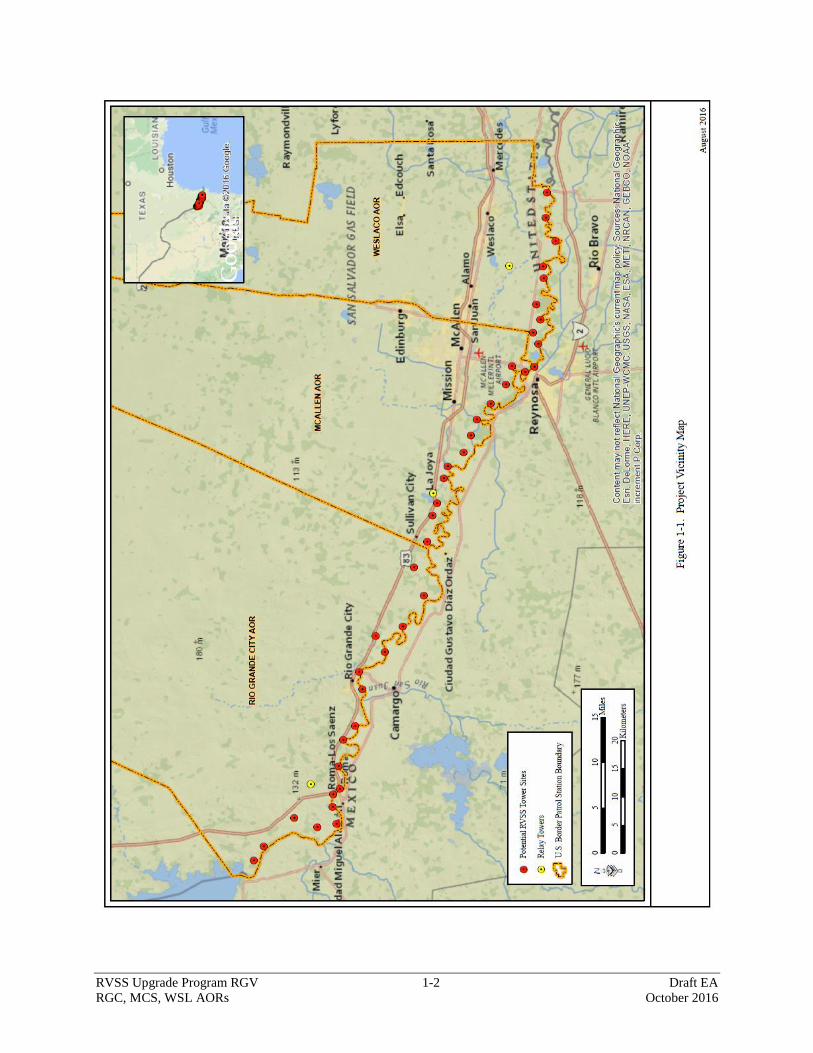
1.2 PROJECT LOCATION
The proposed new tactical infrastructure (TI) is located near the Rio Grande within Starr and
Hidalgo counties, Texas. The project would serve the USBP RGV Sector's RGC, MCS, and
WSL Stations’ AORs (see Figure 1-1). There would be a total of 18 new RVSS towers and
associated infrastructure in the RGC AOR, 12 new RVSS towers and associated infrastructure in
the MCS AOR, and 10 new RVSS towers and associated infrastructure in the WSL AOR. Three
relay towers, one per AOR, would also be constructed. These towers are located on Federal,
private, and state lands.
RVSS Upgrade Program RGV 1-2 Draft EA
RGC, MCS, WSL AORs October 2016
Figure 1-1. Project Vicinity Map
RVSS Upgrade Program RGV 1-3 Draft EA
RGC, MCS, WSL AORs October 2016
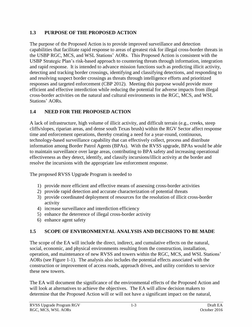
1.3 PURPOSE OF THE PROPOSED ACTION
The purpose of the Proposed Action is to provide improved surveillance and detection
capabilities that facilitate rapid response to areas of greatest risk for illegal cross-border threats in
the USBP RGC, MCS, and WSL Stations’ AORs. This Proposed Action is consistent with the
USBP Strategic Plan’s risk-based approach to countering threats through information, integration
and rapid response. It is intended to advance mission functions such as predicting illicit activity,
detecting and tracking border crossings, identifying and classifying detections, and responding to
and resolving suspect border crossings as threats through intelligence efforts and prioritized
responses and targeted enforcement (CBP 2012). Meeting this purpose would provide more
efficient and effective interdiction while reducing the potential for adverse impacts from illegal
cross-border activities on the natural and cultural environments in the RGC, MCS, and WSL
Stations’ AORs.
1.4 NEED FOR THE PROPOSED ACTION
A lack of infrastructure, high volume of illicit activity, and difficult terrain (e.g., creeks, steep
cliffs/slopes, riparian areas, and dense south Texas brush) within the RGV Sector affect response
time and enforcement operations, thereby creating a need for a year-round, continuous,
technology-based surveillance capability that can effectively collect, process and distribute
information among Border Patrol Agents (BPAs). With the RVSS upgrade, BPAs would be able
to maintain surveillance over large areas, contributing to BPA safety and increasing operational
effectiveness as they detect, identify, and classify incursions/illicit activity at the border and
resolve the incursions with the appropriate law enforcement response.
The proposed RVSS Upgrade Program is needed to
1) provide more efficient and effective means of assessing cross-border activities
2) provide rapid detection and accurate characterization of potential threats
3) provide coordinated deployment of resources for the resolution of illicit cross-border
activity
4) increase surveillance and interdiction efficiency
5) enhance the deterrence of illegal cross-border activity
6) enhance agent safety
1.5 SCOPE OF ENVIRONMENTAL ANALYSIS AND DECISIONS TO BE MADE
The scope of the EA will include the direct, indirect, and cumulative effects on the natural,
social, economic, and physical environments resulting from the construction, installation,
operation, and maintenance of new RVSS and towers within the RGC, MCS, and WSL Stations’
AORs (see Figure 1-1). The analysis also includes the potential effects associated with the
construction or improvement of access roads, approach drives, and utility corridors to service
these new towers.
The EA will document the significance of the environmental effects of the Proposed Action and
will look at alternatives to achieve the objectives. The EA will allow decision makers to
determine that the Proposed Action will or will not have a significant impact on the natural,

RVSS Upgrade Program RGV 1-4 Draft EA
RGC, MCS, WSL AORs October 2016
social, economic, and physical environments, as well as whether the action can proceed to the
next phase of project development or if an Environmental Impact Statement (EIS) is required.
The process for developing the EA also allows for input and comments on the Proposed Action
from the concerned public and interested government agencies to inform agency decision
making. The EA will be prepared as follows:
1. Conduct interagency and intergovernmental coordination for environmental planning.
The first step in the National Environmental Policy Act (NEPA) process is to solicit
comments from Federal, state, and local agencies and Federally recognized tribes about
the proposed project to ensure that their concerns are included in the analysis.
2. Prepare a draft EA. CBP will review and address relevant comments and concerns
received from any Federal, state, and local agencies or Federally recognized tribes during
preparation of the draft EA.
3. Announce that the draft EA has been prepared. A Notice of Availability (NOA) will be
published in the Laredo Morning Times, The Monitor, Brownsville Herald, and El
Periodico USA to announce the public comment period and the availability of the draft
EA and Finding of No Significant Impact (FONSI).
4. Provide a public comment period. A public comment period allows for all interested
parties to review the analysis presented in the draft EA and provide feedback. The draft
EA will be available to the public for a 30-day review at the Rio Grande City Public
Library in Rio Grande City, the McAllen Public Library in McAllen, and the Weslaco
Public Library in Weslaco. The draft EA will also be available for download from the
CBP internet web page at the following URL address:
http://www.cbp.gov/about/environmental-cultural-stewardship/nepa-documents/docs-
review.
5. Prepare a final EA. A final EA will be prepared following the public comment period.
The final EA will incorporate relevant comments and concerns received from all
interested parties during the public comment period.
6. Issue a FONSI. The final step in the NEPA process is the signature of a FONSI, if the
environmental analysis supports the conclusion that impacts on the quality of the human
and natural environments from implementing the Proposed Action will not be significant.
In this case, no EIS would be prepared.
1.6 ENVIRONMENTAL REVIEW AND CONSULTATION REQUIREMENTS
CBP will follow applicable Federal laws and regulations. The EA is developed in accordance
with the requirements of NEPA, regulations issued by the Council on Environmental Quality
(CEQ) published in 40 Code of Federal Regulations (CFR) Parts 1500-1508, and DHS Directive
Number 023-01, Rev. 01, and Instruction Manual 023-01-001-01, Rev. 01; Environmental
Planning Program and other pertinent environmental statutes, regulations, and compliance
requirements. The EA will be the vehicle for verifying compliance with all applicable
RVSS Upgrade Program RGV 1-5 Draft EA
RGC, MCS, WSL AORs October 2016
environmental statutes, such as the Endangered Species Act (ESA) of 1973, 16 United States
Code (U.S.C.) Part §1531 et seq., as amended, the National Historic Preservation Act (NHPA) of
1966, 16 U.S.C. §470a et seq., as amended.
1.7 PUBLIC INVOLVEMENT
In accordance with 40 CFR §1501.7, 1503, and 1506.6, BPFTI initiated public involvement and
agency scoping activities to identify significant issues related to the Proposed Action. BPFTI is
consulting, and will continue to consult, with appropriate local, state, and Federal government
agencies, as well as Federally recognized tribes, throughout the EA process. BPFTI has
coordinated with the following agencies and Federally recognized tribes (Appendix A):
Federal Agencies:
U.S. Fish and Wildlife Service (USFWS)
U.S. Environmental Protection Agency (USEPA)
U.S. Army Corps of Engineers (USACE)
International Boundary and Water Commission, U.S. Section (USIBWC)
Federal Aviation Administration (FAA)
National Telecommunications and Information Administration (NTIA)
State Agencies:
Texas Parks and Wildlife Department (TPWD)
Texas State Historic Preservation Officer (SHPO)
Texas Historical Commission (THC)
Texas Department of Transportation (TxDOT)
Texas Commission on Environmental Quality (TCEQ)
Native American Tribes:
Alabama-Coushatta Tribe of Texas
The Comanche Nation
The Osage Nation
Mescalero Apache Tribe
Kiowa Indian Tribe of Oklahoma
Pawnee Nation of Oklahoma
Tonkawa Tribe of Indians of Oklahoma
Fort Sill Apache Tribe of Oklahoma
White Mountain Apache Tribe
Alabama-Quassarte Tribal Town
Apache Tribe of Oklahoma
Cherokee Nation
Coushatta Tribe of Louisiana
Kialegee Tribal Town
RVSS Upgrade Program RGV 1-6 Draft EA
RGC, MCS, WSL AORs October 2016
Poarch Bank of Creeks
The Quapaw Tribe of Indians
The Seminole Nation of Oklahoma
Thlopthlocco Tribal Town
Tunica-Biloxi Indian Tribe
Wichita and Affiliated Tribes
County:
Starr County
Hidalgo County
RVSS Upgrade Program RGV 2-1 Draft EA
RGC, MCS, WSL AORs October 2016
2.0 PROPOSED ACTION AND ALTERNATIVES
The Proposed Action and one alternative (No Action Alternative) were identified and considered
during the planning stages of the proposed project. The Proposed Action consists of the
construction of a sufficient number of RVSS towers within the RGC, MCS, and WSL Stations’
AORs that meet the purpose of and need for the project. As required by NEPA and CEQ
regulations, the No Action Alternative reflects conditions within the project area should the
Proposed Action not be implemented. The following paragraphs describe the tower site selection
process.
2.1 CRITERIA FOR SITE SELECTION
Technology considered in the project includes sensors and other surveillance assets, as well as
communications and Command and Control (C2) systems along the border. This technology
would communicate with the RGC, MCS, and WSL Stations’ C2 facilities and would provide an
overall network system of communications and surveillance along approximately 120 miles of
border. Infrastructure to be considered within USBP’s plan includes roadways to and from
RVSS towers, as well as support utilities. The RVSS upgrade would provide long-range
persistent surveillance capability and was identified in the new border security technology plan
as the most effective technology-based solution for the RGC, MCS, and WSL Stations’ AORs.
The RVSS Upgrade Program is expected to allow BPAs to spend less time locating illegal
entries and focus efforts on interdiction of those involved in illegal cross-border activities,
thereby enhancing rapid response capability through a dynamic enforcement posture.
The Proposed Action consists of the construction, operation, and maintenance of RVSS towers
that provide sufficient coverage to provide improved surveillance and detection capabilities
within the RGV Sector’s RGC, MCS, and WSL Stations’ AORs (see Figure 1-1). The RVSS
tower site selection process begins with the identification of proposed tower site locations based
on an initial operational requirements and assessment of BPAs in the RGC, MCS, and WSL
Stations’ AORs. Operationally preferred site locations were selected based on knowledge of the
terrain, environment, land ownership, and operational requirements. This review process
resulted in multiple conceptual field laydowns. Mapping programs, modeling, and analysis
processes were also utilized to develop a laydown that achieved both optimal surveillance and
communications capabilities with the minimum number of tower sites. Over time, operational
requirements change in order to mitigate emerging threats or strengthen vulnerabilities. In order
to adapt to changes in operational requirements, the site selection process was iterated in 2016.
Potential tower site locations were visited as part of the conceptual field laydown from March
2015 through May 2016. During the site visits, project team personnel, including CBP Office of
Administration Facilities Management and Engineering personnel and USBP, evaluated each of
the locations based on accessibility, constructability, operability, and environmental
considerations. Evaluation considerations included, but were not limited to, the following:
Proximity to existing roads and the potential need for new access roads or improvements
to existing roads, as well as proximity to a power source
RVSS Upgrade Program RGV 2-2 Draft EA
RGC, MCS, WSL AORs October 2016
Basic site conditions such as the terrain, soil type, drainage, available space, and slope of
the site
Tower viewsheds and line of sight available at varying tower heights
Proximity to sensitive biological and cultural resources, waters of the United States,
floodplains, and wetlands
Impacts on the surrounding viewshed or visual resources
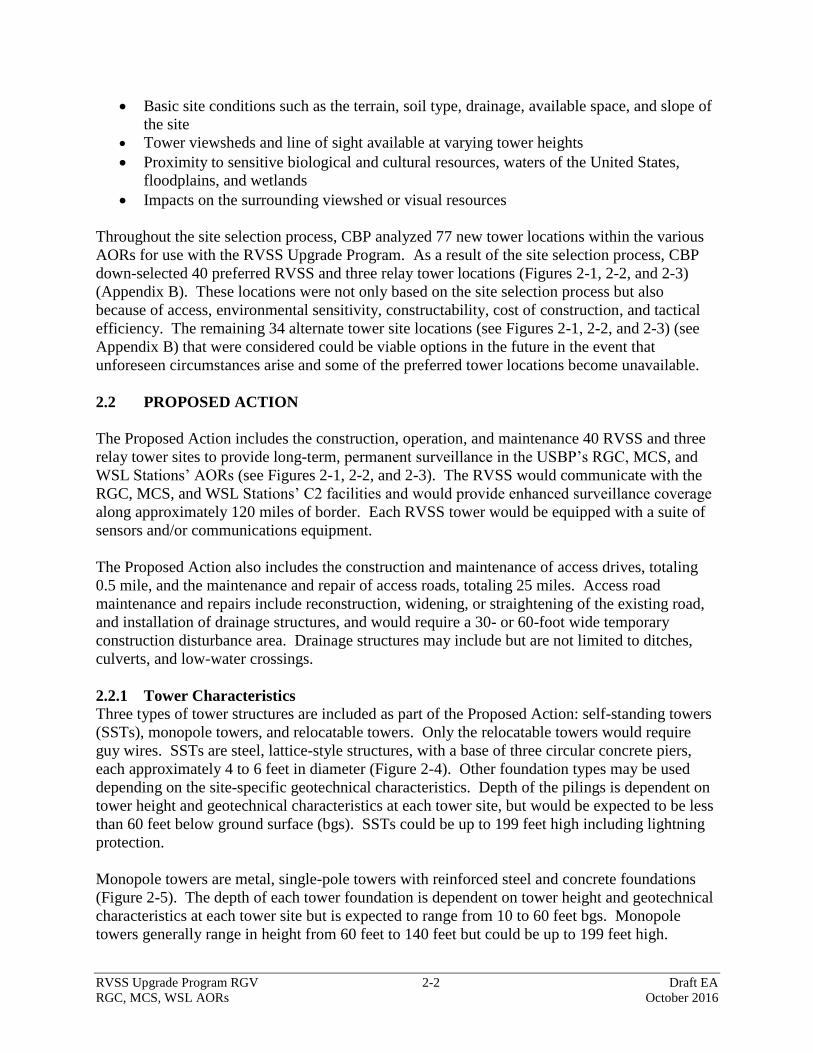
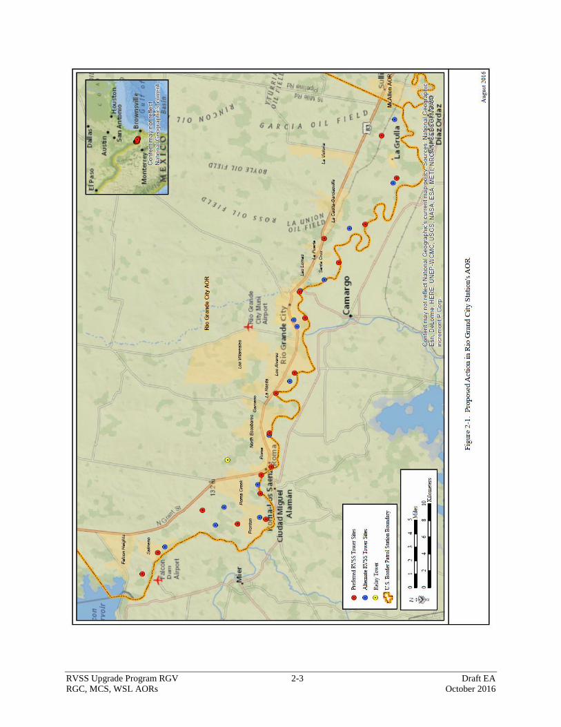
Throughout the site selection process, CBP analyzed 77 new tower locations within the various
AORs for use with the RVSS Upgrade Program. As a result of the site selection process, CBP
down-selected 40 preferred RVSS and three relay tower locations (Figures 2-1, 2-2, and 2-3)
(Appendix B). These locations were not only based on the site selection process but also
because of access, environmental sensitivity, constructability, cost of construction, and tactical
efficiency. The remaining 34 alternate tower site locations (see Figures 2-1, 2-2, and 2-3) (see
Appendix B) that were considered could be viable options in the future in the event that
unforeseen circumstances arise and some of the preferred tower locations become unavailable.
2.2 PROPOSED ACTION
The Proposed Action includes the construction, operation, and maintenance 40 RVSS and three
relay tower sites to provide long-term, permanent surveillance in the USBP’s RGC, MCS, and
WSL Stations’ AORs (see Figures 2-1, 2-2, and 2-3). The RVSS would communicate with the
RGC, MCS, and WSL Stations’ C2 facilities and would provide enhanced surveillance coverage
along approximately 120 miles of border. Each RVSS tower would be equipped with a suite of
sensors and/or communications equipment.
The Proposed Action also includes the construction and maintenance of access drives, totaling
0.5 mile, and the maintenance and repair of access roads, totaling 25 miles. Access road
maintenance and repairs include reconstruction, widening, or straightening of the existing road,
and installation of drainage structures, and would require a 30- or 60-foot wide temporary
construction disturbance area. Drainage structures may include but are not limited to ditches,
culverts, and low-water crossings.
2.2.1 Tower Characteristics
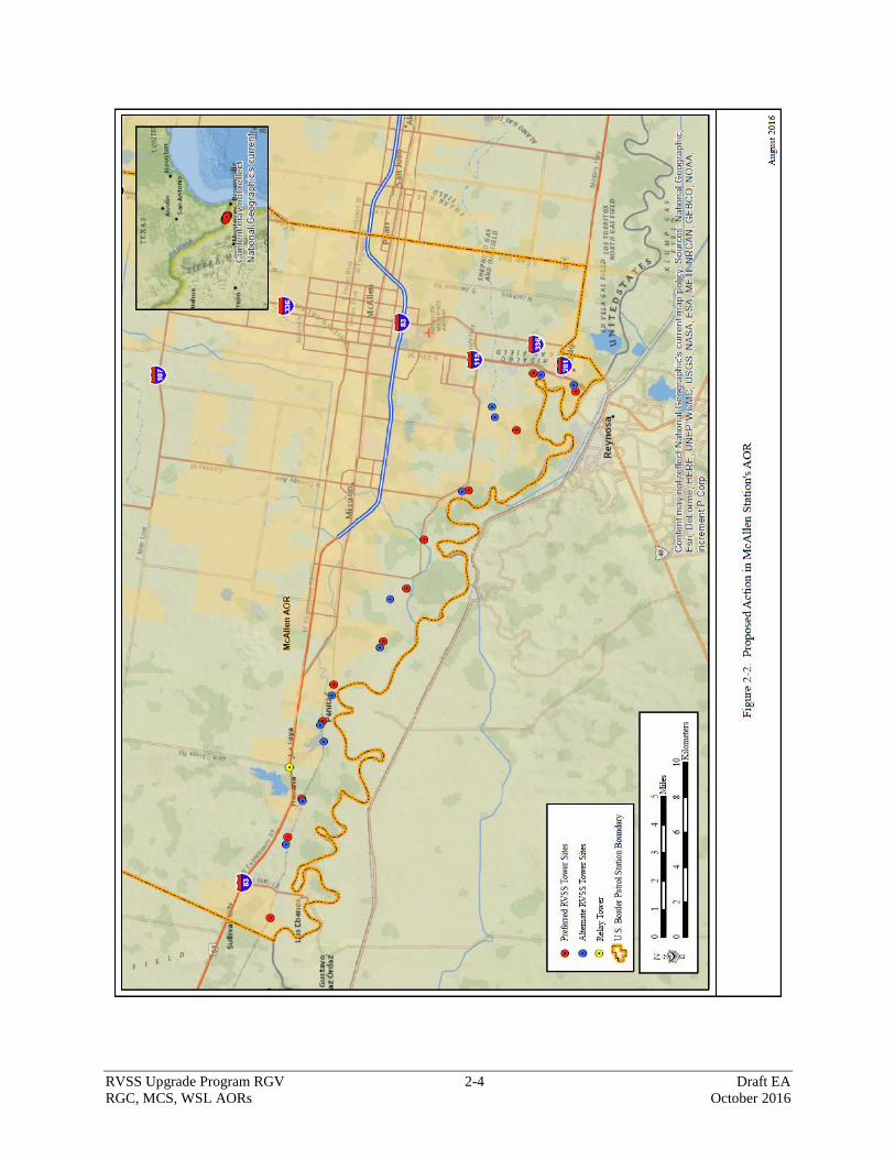
Three types of tower structures are included as part of the Proposed Action: self-standing towers
(SSTs), monopole towers, and relocatable towers. Only the relocatable towers would require
guy wires. SSTs are steel, lattice-style structures, with a base of three circular concrete piers,
each approximately 4 to 6 feet in diameter (Figure 2-4). Other foundation types may be used
depending on the site-specific geotechnical characteristics. Depth of the pilings is dependent on
tower height and geotechnical characteristics at each tower site, but would be expected to be less
than 60 feet below ground surface (bgs). SSTs could be up to 199 feet high including lightning
protection.
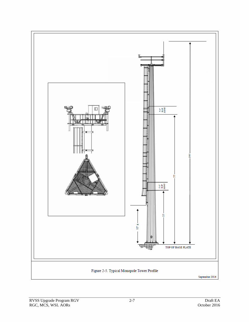
Monopole towers are metal, single-pole towers with reinforced steel and concrete foundations
(Figure 2-5). The depth of each tower foundation is dependent on tower height and geotechnical
characteristics at each tower site but is expected to range from 10 to 60 feet bgs. Monopole
towers generally range in height from 60 feet to 140 feet but could be up to 199 feet high.
RVSS Upgrade Program RGV 2-3 Draft EA
RGC, MCS, WSL AORs October 2016
Figure 2-1. Proposed Action in Rio Grande City Station’s AOR
RVSS Upgrade Program RGV 2-4 Draft EA
RGC, MCS, WSL AORs October 2016
Figure 2-2. Proposed Action in McAllen Station’s AOR

RVSS Upgrade Program RGV 2-5 Draft EA
RGC, MCS, WSL AORs October 2016
Figure 2-3. Proposed Action in Weslaco Station’s AOR
RVSS Upgrade Program RGV 2-6 Draft EA
RGC, MCS, WSL AORs October 2016
Figure 2-4. Typical Profile of SST Tower
RVSS Upgrade Program RGV 2-7 Draft EA
RGC, MCS, WSL AORs October 2016
Figure 2-5. Typical Monopole Tower Profile
RVSS Upgrade Program RGV 2-8 Draft EA
RGC, MCS, WSL AORs October 2016
Relocatable towers are towed in place on a trailer and placed on a level ground. The guy wires
will attach to the relocatable tower trailer outrigger infrastructure to stabilize the tower when
extended. If necessary, the guy wires can attach to concrete barriers or other anchors to increase
the tower stability as required. When fully extended these towers can reach a height of up to 120
feet.
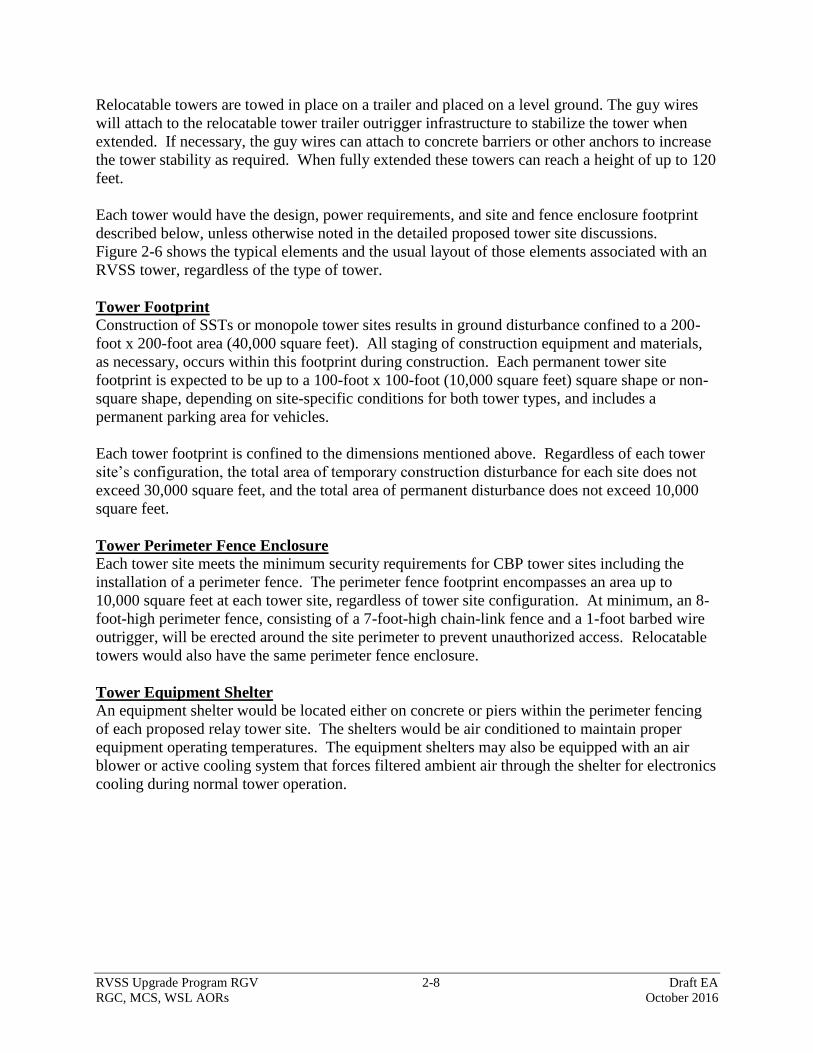
Each tower would have the design, power requirements, and site and fence enclosure footprint
described below, unless otherwise noted in the detailed proposed tower site discussions.
Figure 2-6 shows the typical elements and the usual layout of those elements associated with an
RVSS tower, regardless of the type of tower.
Tower Footprint
Construction of SSTs or monopole tower sites results in ground disturbance confined to a 200-
foot x 200-foot area (40,000 square feet). All staging of construction equipment and materials,
as necessary, occurs within this footprint during construction. Each permanent tower site
footprint is expected to be up to a 100-foot x 100-foot (10,000 square feet) square shape or non-
square shape, depending on site-specific conditions for both tower types, and includes a
permanent parking area for vehicles.
Each tower footprint is confined to the dimensions mentioned above. Regardless of each tower
site’s configuration, the total area of temporary construction disturbance for each site does not
exceed 30,000 square feet, and the total area of permanent disturbance does not exceed 10,000
square feet.
Tower Perimeter Fence Enclosure
Each tower site meets the minimum security requirements for CBP tower sites including the
installation of a perimeter fence. The perimeter fence footprint encompasses an area up to
10,000 square feet at each tower site, regardless of tower site configuration. At minimum, an 8-
foot-high perimeter fence, consisting of a 7-foot-high chain-link fence and a 1-foot barbed wire
outrigger, will be erected around the site perimeter to prevent unauthorized access. Relocatable
towers would also have the same perimeter fence enclosure.
Tower Equipment Shelter
An equipment shelter would be located either on concrete or piers within the perimeter fencing
of each proposed relay tower site. The shelters would be air conditioned to maintain proper
equipment operating temperatures. The equipment shelters may also be equipped with an air
blower or active cooling system that forces filtered ambient air through the shelter for electronics
cooling during normal tower operation.
RVSS Upgrade Program RGV 2-9 Draft EA
RGC, MCS, WSL AORs October 2016
Figure 2-6. Proposed RVSS Elements
RVSS Upgrade Program RGV 2-10 Draft EA
RGC, MCS, WSL AORs October 2016
Tower Power Sources
Each RVSS tower will be powered by commercial grid power. It is also possible that RVSS
towers may be primarily powered by solar power with grid or applicable redundant system for
backup. The grid power design would be site-specific; however, commercial grid power would
be overhead of the permanent disturbed area and then underground where it enters the 100- x
100-foot fenced tower site. Overhead or buried lines outside of the permanent disturbance area
would be placed within access road construction buffer areas, to the extent possible, all of which
would be verified to identify potential impacts on biological and cultural resources along access
roads. Backup power sources may include solar panels, uninterrupted power supply (UPS)
(batteries), hydrogen fuel cells, and/or a propane generator. A 1,000-gallon or smaller propane
tank would be installed if a propane-fueled generator were used as a backup power source.
Generators would be housed within an enclosure and would have a spill containment basin of
sufficient size to contain the total volume of engine fluids. Backup power would be designed to
provide a minimum 3-day supply of power in the event of primary power failure.
Sensor, Communications, and Optional Equipment
Typical designs for the RVSS towers would consist of sensor, communications, an optional
equipment (e.g., spotlight). Suites of sensors would include multiple cameras (daylight, infrared
[or both] and video cameras). The RVSS towers would be equipped with short-range high
definition, short/medium-range, long-range, or wide-angle cameras, or a combination of each,
depending on the geographical area. Communications equipment could consist of microwave
antennas to transmit data to the C2 facility.
Combination sensor and communications towers include equipment associated with both sensor
and communications towers. The exact number and type of equipment depend on the number
and types of cameras used, the area to be monitored, and other design variables. Components
would be mounted on each tower between 20 and 180 feet above ground level, depending on the
local terrain. The overall tower height would not exceed 199 feet above ground, which includes
all elements of the tower, including the lighting protection rod, which is the highest aspect of the
tower. Cameras, antennas, and parabolic antennas would be installed at heights that will ensure
satisfactory line of sight and provide clear pathways for transmission of information to
communications towers and the RGC, MCS, and WSL Stations. Towers generally require line-
of-sight to ensure unobstructed microwave transmission signals from tower to tower. All
transmit frequencies used as part of the Proposed Action will be coordinated with the National
Telecommunications and Information Administration (NTIA). As part of the overall spectrum
management process, the NTIA and the Federal Communications Commission (FCC) have
developed radio regulations to help ensure that the various radio services operate compatibly in
the same environment without unacceptable levels of radio frequency interference and emissions.
While the communications systems and the frequencies in which they are operated are
considered law enforcement-sensitive and cannot be provided to the public, compliance with
FCC and NTIA regulations is required and ensures that recognized safety guidelines are not
exceeded.
Support equipment consists of illumination equipment (lasers and spotlights) and a loud hailer.
Camera systems on the RVSS towers may incorporate an eye-safe laser illuminator. The eye-
safe laser illuminator would be used to direct agents or officers in the field and in the air to items
RVSS Upgrade Program RGV 2-11 Draft EA
RGC, MCS, WSL AORs October 2016
of interest (IoI) being viewed by the sensor operator. Agents or officers equipped with night
vision goggles (NVG) are able to readily locate the beam and locate IoIs. The laser is eye-safe at
any distance and is an agent and officer safety device that enhances visibility and the ability to
locate IoIs at night. The proposed spotlight will be remotely controlled with a beam width
ranging from 1 to 30 degrees and provide a minimum of 20 lux and a maximum of 53 lux on an
IoI at 900 feet (300 yards). Currently, it is anticipated that the spotlights would be used twice a
night for a period of approximately 5 minutes for each use. Loud hailers, which would serve as a
deterrent, could be mounted to the towers. The loud hailers would be used to communicate with
illegal cross-border violators, as necessary. The loud hailers would be able to broadcast both live
and manually activated prerecorded voice messages to IoIs located within 900 feet (300 yards) of
the device. The loud hailer would be a directional loadspeaker adjustable from 40 to 85 decibels
(dB) at 300 feet (100 yards) from the device.
USFWS (2000) Service Guidance on the Siting, Construction, Operation and Decommissioning
of Communications Towers and USFWS (2013) Revised Voluntary Guidelines for
Communication Tower Design, Siting, Construction, Operation, Retrofitting, and
Decommissioning would be implemented to include actions to reduce nighttime atmospheric
lighting and the potential adverse effects of nighttime lighting on migratory bird and nocturnal
flying species. The proposed tower sites may be lighted for security purposes. Security lighting
may consist of a “porch light” on the tower shelter and would be controlled by a motion detector.
When so equipped, the light would be shielded to avoid illumination outside the footprint of the
tower site. The proposed RVSS may have infrared lighting installed for aviation safety and, if
installed, any such lighting would be compatible with NVG usage. The heights of the towers
will also be limited to no more than 199 feet above ground level as described in the USFWS
guidance.
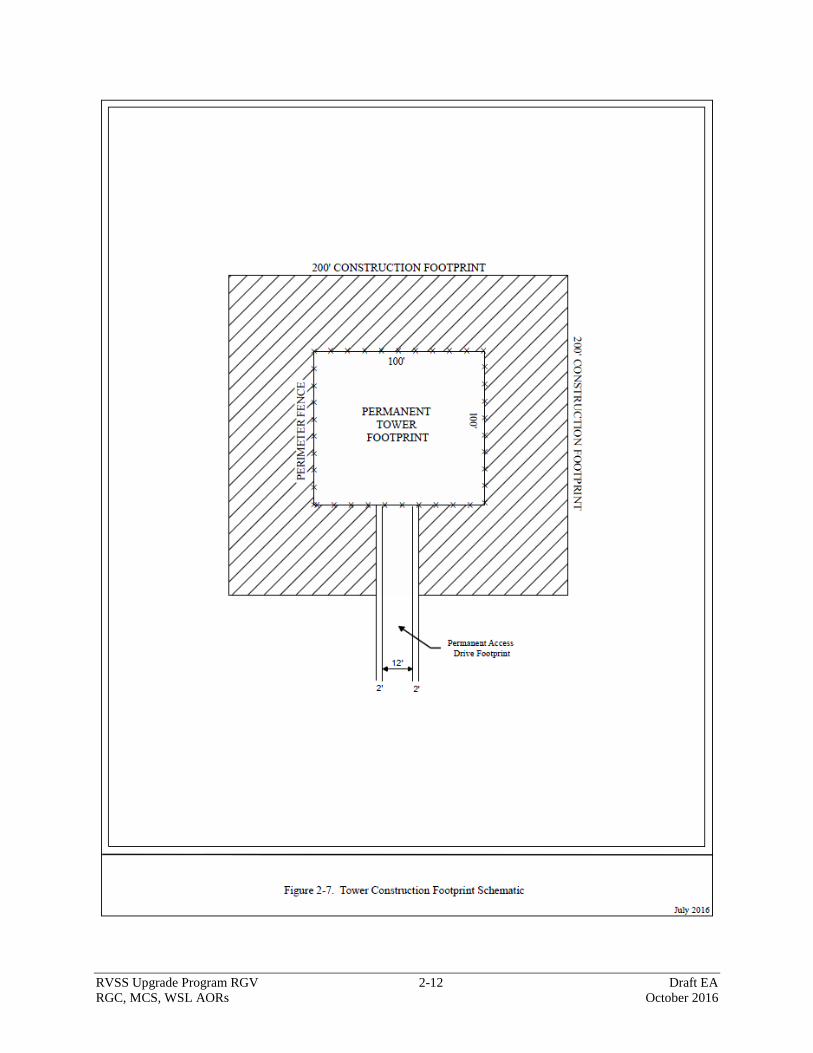
2.2.2 Construction of RVSS Towers
The permanent footprints of 10,000 square feet or less would be mechanically cleared of
vegetation and graded for the construction of RVSS tower sites, regardless of tower type.
Concrete pads would be installed as foundations for the equipment shelter, 1,000-gallon
generator fuel tank and generator (Figure 2-7). A 30,000-square-foot temporary construction
area around the permanent tower footprint (10,000 square feet) would be used to stage
construction equipment and materials during construction activities (Figure 2-7). The shape of
the permanent tower footprint may vary depending on sensitive resources within the area, but the
total area will not exceed 10,000 square feet. Parking for construction vehicles and equipment
will be within the 30,000-square-foot temporary construction area during construction. The
temporary construction area may be cleared but would not be graded. Following construction
activities, any temporary impact areas will be revegetated with a mixture nursery plantings or a
mixture of native plant seeds (or both).
RVSS Upgrade Program RGV 2-12 Draft EA
RGC, MCS, WSL AORs October 2016
Figure 2-7. Tower Construction Footprint Schematic
RVSS Upgrade Program RGV 2-13 Draft EA
RGC, MCS, WSL AORs October 2016
The following is a list of heavy equipment and vehicles expected to be used during each phase of
RVSS site construction:
Front-end loader or equivalent
Drill rig
Excavator
Post hole digger
Water truck
Crane
Bulldozer
Concrete trucks
Dump trucks
Flatbed delivery truck
Crew trucks
The total time for all phases of construction, including inspection and operational testing of
equipment, for each proposed RVSS tower site is expected to be approximately 30 to 60 days.
The installation of the suite of sensors would require approximately 30 days per RVSS tower
site. All construction would be restricted to daylight hours to the greatest extent practicable.
The installation of the sensor payload requires approximately 2 days per tower site and includes
up to 12 people, including delivery trucks and personnel vehicles. Following the completion of
the sensor payload installation, equipment testing and system acceptance testing would be
conducted as part of construction activities to check the operability of the systems. The exact
details of the system acceptance testing plan are not currently known. However, based on past
equipment testing and acceptance testing experience, it is anticipated that system acceptance
testing may require personnel walking multiple routes near different RVSS towers for 2- to 3-
hour periods individually and as a group. Sensor equipment needs to be tested. System
acceptance testing would occur during an approximately 28-day period for all sites. Testing
personnel travel by vehicles on existing roads to the test walk routes identified by CBP.
2.2.3 Operation and Maintenance of RVSS Towers
Each RVSS tower’s generator subset is expected to operate a total of 1 to 5 hours twice per
month for maintenance purposes. System conditioning would occur during off-grid operational
schedules or if grid power is interrupted, and the generator would be operated temporarily, as
needed, until grid power is again available.
Tower site maintenance includes scheduled and unscheduled maintenance. Unscheduled
maintenance includes removing and replacing failed tower sensor systems or shelter components,
electrical failures, structural repairs, and damage caused by storms or vandalism. Scheduled
maintenance includes any planned preventive maintenance, including refueling generator tanks
(i.e., propane), changing oil, other required lubricants, filters and any shelf-life item of the
system. Scheduled maintenance also includes rust removal remediation, vegetation control, and
general upkeep of the permanent footprint. Both scheduled and unscheduled tower maintenance
require maintenance vehicles to travel to and from the RVSS sites. Currently, it is estimated
RVSS Upgrade Program RGV 2-14 Draft EA
RGC, MCS, WSL AORs October 2016
that one maintenance trip per month would be required at each of the proposed RVSS towers.
This trip would include maintenance and refueling efforts.
2.2.4 Access Drive and Access Road Construction, Maintenance, and Repair
Access drive construction and access road maintenance and repairs are required to move
construction equipment, materials, and personnel to and from the proposed tower sites during
construction. Access drive construction is required to provide access from established public or
private access roads to the proposed tower sites. Maps depicting new access roads and road
improvements at each proposed tower site are provided in Appendix B.
Access Drive Construction
Access drives would be constructed to provide access to RVSS sites from established public or
private roads. The access drives would be constructed to provide a 12-foot-wide driving surface
with 2-foot shoulders on each side. The total width of new access drives would be 16 feet.
Access drives would be constructed by mechanically removing vegetation and grading native
soils. Following construction activities, any temporary impact areas would be revegetated with a
mixture nursery plantings or a mixture of native plant seeds (or both), as described previously.
Access Road Maintenance and Repair
Access roads to proposed RVSS sites would require approximately 25 miles of maintenance and
repairs to existing roadways. Road maintenance and repairs include reconstruction, widening, or
straightening of the existing road, and installation of drainage structures, and could require either
a 30-foot-wide or a 60-foot-wide temporary construction disturbance area. Drainage structures
may include but are not limited to ditches, culverts, and low-water crossings.
The access roads would be maintained and repaired to the design standard for FC-3 Graded-
Earth Road. All access roads would have a driving surface of 12 feet with a 2-foot shoulder on
each side of the road (16 feet total) along with improvements such as ditches, low-water
crossings, turnouts, and necessary erosion protection such as riprap and gabion headwalls.
Post-construction Road Maintenance and Repair
Access road and drive maintenance would be performed to ensure full-time access to the towers
and other TI. It is anticipated that road maintenance may occur up to six times per year, as
necessary.
2.2.5 Summary Table
The following table (Table 2-1) is a summary of each of the potential RVSS sites that could be
used as part of the Proposed Action. Aerial photography maps for each of the proposed RVSS
sites are provided in Appendix B.
2.3 NO ACTION ALTERNATIVE
The No Action Alternative serves as a basis of comparison to the anticipated effects of the other
action alternatives, and its inclusion in the EA is required by NEPA regulations (40 CFR
1502.14(d)). Under the No Action Alternative, the proposed RVSS Upgrade Program would not
take place. In the absence of the proposed RVSS Upgrade Program and its technological

RVSS Upgrade Program RGV 2-15 Draft EA
RGC, MCS, WSL AORs October 2016
capabilities, BPAs would continue to rely solely on traditional detection methodology that
includes traditional sign detection. Currently, identification, classification, response, and
resolution actions require that BPAs respond to evidence of illegal entry gained through the
previously mentioned tools and techniques, as well as through direct observation. BPAs, in most
cases, follow physical evidence and indicators of the presence of IoIs. Under the No Action
Alternative, USBP’s ability to detect and interdict illicit cross-border activity would not be
enhanced; thus, operational efficiency and effectiveness would not be improved within the area
covered by the proposed towers.
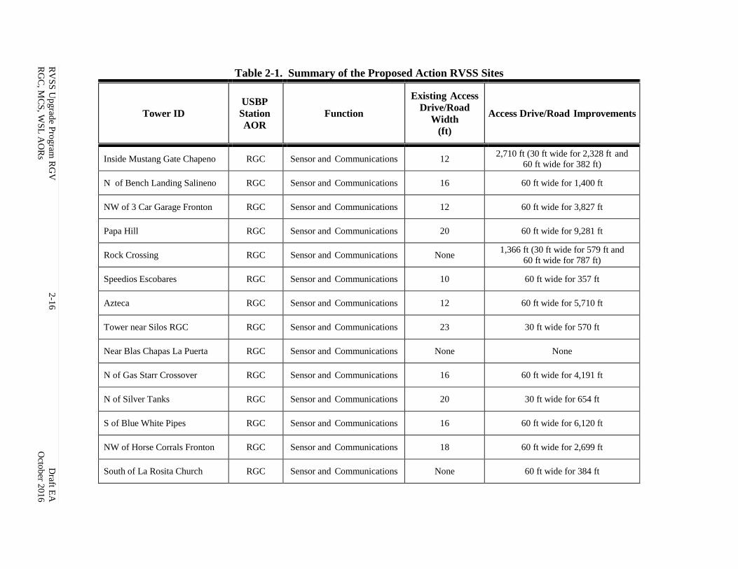
RV
SS
Up
grad
e Pro
gram
RG
V
2-1
6
Draft E
A
RG
C, M
CS
, WS
L A
OR
s
Octo
ber 2
01
6
Table 2-1. Summary of the Proposed Action RVSS Sites
Tower ID
USBP
Station
AOR
Function
Existing Access
Drive/Road
Width
(ft)
Access Drive/Road Improvements
Inside Mustang Gate Chapeno RGC Sensor and Communications 12 2,710 ft (30 ft wide for 2,328 ft and
60 ft wide for 382 ft)
N of Bench Landing Salineno RGC Sensor and Communications 16 60 ft wide for 1,400 ft
NW of 3 Car Garage Fronton RGC Sensor and Communications 12 60 ft wide for 3,827 ft
Papa Hill RGC Sensor and Communications 20 60 ft wide for 9,281 ft
Rock Crossing RGC Sensor and Communications None 1,366 ft (30 ft wide for 579 ft and
60 ft wide for 787 ft)
Speedios Escobares RGC Sensor and Communications 10 60 ft wide for 357 ft
Azteca RGC Sensor and Communications 12 60 ft wide for 5,710 ft
Tower near Silos RGC RGC Sensor and Communications 23 30 ft wide for 570 ft
Near Blas Chapas La Puerta RGC Sensor and Communications None None
N of Gas Starr Crossover RGC Sensor and Communications 16 60 ft wide for 4,191 ft
N of Silver Tanks RGC Sensor and Communications 20 30 ft wide for 654 ft
S of Blue White Pipes RGC Sensor and Communications 16 60 ft wide for 6,120 ft
NW of Horse Corrals Fronton RGC Sensor and Communications 18 60 ft wide for 2,699 ft
South of La Rosita Church RGC Sensor and Communications None 60 ft wide for 384 ft

RV
SS
Up
grad
e Pro
gram
RG
V
2-1
7
Draft E
A
RG
C, M
CS
, WS
L A
OR
s
Octo
ber 2
01
6
Tower ID
USBP
Station
AOR
Function
Existing Access
Drive/Road
Width
(ft)
Access Drive/Road Improvements
Los Velas RGC Sensor and Communications 20 30 ft wide for 7,352 ft
N of Dairy Pump RGC Sensor and Communications 16 2,177 ft (60 ft wide for 1,945 ft and
30 ft wide for 232 ft)
La Casita Main RGC Sensor and Communications 16 60 ft wide for 10,203 ft
Igloo House RGC Sensor and Communications None None
RGC Relay Tower RGC Communications 16 60 ft wide for 9,150 ft
Penitas Pump MCS Sensor and Communications None None
Floodway MCS Sensor and Communications 18 30 ft wide for 3,516 ft
Inspiration Canal MCS Sensor and Communications 18 30 ft wide for 534 ft
Mac Pump MCS Sensor and Communications None 60 ft wide for 927 ft
Banworth Canal MCS Sensor and Communications None None
South Sam Fordyce MCS Sensor and Communications 28 60 ft wide for 1,498 ft
Twin Bridges MCS Sensor and Communications 8 60 ft wide for 1,896 ft
Hidalgo POE MCS Sensor and Communications None None
HC Irrigation District #6 MCS Sensor and Communications None None
Madero MCS Sensor and Communications 18 1,362 ft (60 ft wide for 1,227 and
30 ft wide for 135 ft)
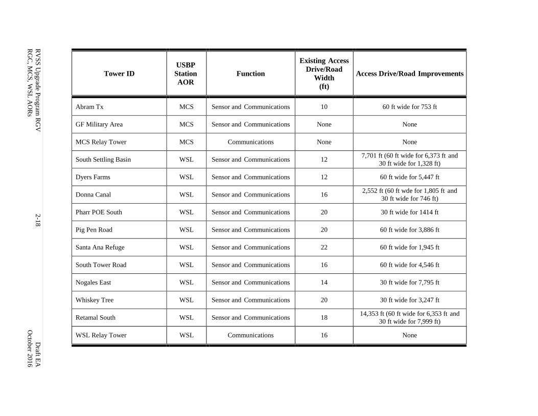
RV
SS
Up
grad
e Pro
gram
RG
V
2-1
8
Draft E
A
RG
C, M
CS
, WS
L A
OR
s
Octo
ber 2
01
6
Tower ID
USBP
Station
AOR
Function
Existing Access
Drive/Road
Width
(ft)
Access Drive/Road Improvements
Abram Tx MCS Sensor and Communications 10 60 ft wide for 753 ft
GF Military Area MCS Sensor and Communications None None
MCS Relay Tower MCS Communications None None
South Settling Basin WSL Sensor and Communications 12 7,701 ft (60 ft wide for 6,373 ft and
30 ft wide for 1,328 ft)
Dyers Farms WSL Sensor and Communications 12 60 ft wide for 5,447 ft
Donna Canal WSL Sensor and Communications 16 2,552 ft (60 ft wde for 1,805 ft and
30 ft wide for 746 ft)
Pharr POE South WSL Sensor and Communications 20 30 ft wide for 1414 ft
Pig Pen Road WSL Sensor and Communications 20 60 ft wide for 3,886 ft
Santa Ana Refuge WSL Sensor and Communications 22 60 ft wide for 1,945 ft
South Tower Road WSL Sensor and Communications 16 60 ft wide for 4,546 ft
Nogales East WSL Sensor and Communications 14 30 ft wide for 7,795 ft
Whiskey Tree WSL Sensor and Communications 20 30 ft wide for 3,247 ft
Retamal South WSL Sensor and Communications 18 14,353 ft (60 ft wide for 6,353 ft and
30 ft wide for 7,999 ft)
WSL Relay Tower WSL Communications 16 None
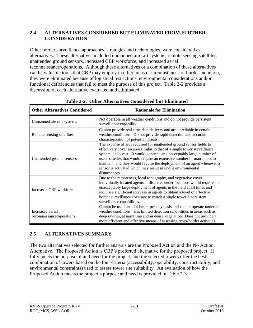
RVSS Upgrade Program RGV 2-19 Draft EA
RGC, MCS, WSL AORs October 2016
2.4 ALTERNATIVES CONSIDERED BUT ELIMINATED FROM FURTHER
CONSIDERATION
Other border surveillance approaches, strategies and technologies, were considered as
alternatives. These alternatives included unmanned aircraft systems, remote sensing satellites,
unattended ground sensors, increased CBP workforce, and increased aerial
reconnaissance/operations. Although these alternatives or a combination of these alternatives
can be valuable tools that CBP may employ in other areas or circumstances of border incursion,
they were eliminated because of logistical restrictions, environmental considerations and/or
functional deficiencies that fail to meet the purpose of this project. Table 2-2 provides a
discussion of each alternative evaluated and eliminated.
Table 2-2. Other Alternatives Considered but Eliminated
Other Alternatives Considered Rationale for Elimination
Unmanned aircraft systems Not operable in all weather conditions and do not provide persistent
surveillance capability
Remote sensing satellites
Cannot provide real-time data delivery and are unreliable in certain
weather conditions. Do not provide rapid detection and accurate
characterization of potential threats.
Unattended ground sensors
The expanse of area required for unattended ground sensor fields to
effectively cover an area similar to that of a single tower surveillance
system is too vast. It would generate an unacceptably large number of
used batteries that would require an extensive number of man-hours to
maintain, and they would require the deployment of an agent whenever a
sensor is activated which may result in undue environmental
disturbances.
Increased CBP workforce
Due to the remoteness, local topography, and vegetative cover
individually located agents at discrete border locations would require an
unacceptably large deployment of agents in the field at all times and
require a significant increase in agents to obtain a level of effective
border surveillance coverage to match a single tower’s persistent
surveillance capabilities.
Increased aerial
reconnaissance/operations
Cannot be used on a 24-hours-per-day basis and cannot operate under all
weather conditions. Has limited detection capabilities in areas such as
deep ravines, at nighttime and in dense vegetation. Does not provide a
more efficient and effective means of assessing cross-border activities.
2.5 ALTERNATIVES SUMMARY
The two alternatives selected for further analysis are the Proposed Action and the No Action
Alternative. The Proposed Action is CBP’s preferred alternative for the proposed project. It
fully meets the purpose of and need for the project, and the selected towers offer the best
combination of towers based on the four criteria (accessibility, operability, constructability, and
environmental constraints) used to assess tower site suitability. An evaluation of how the
Proposed Action meets the project’s purpose and need is provided in Table 2-3.

RVSS Upgrade Program RGV 2-20 Draft EA
RGC, MCS, WSL AORs October 2016
Table 2-3. Alternatives Matrix of Purpose of and Need for Alternatives
Purpose and Need Proposed
Action
No Action
Alternative
Provide improved surveillance and detection capabilities that facilitate rapid
response Yes No
Provide more efficient and effective means of assessing cross-border activities Yes No
Provide rapid detection and accurate characterization of potential threats Yes No
Provide coordinated deployment of resources in the apprehension of illegal aliens Yes No
Increase surveillance and interdiction efficiency Yes No
Enhance the deterrence of illegal cross-border activity Yes No
Enhance agent safety Yes No
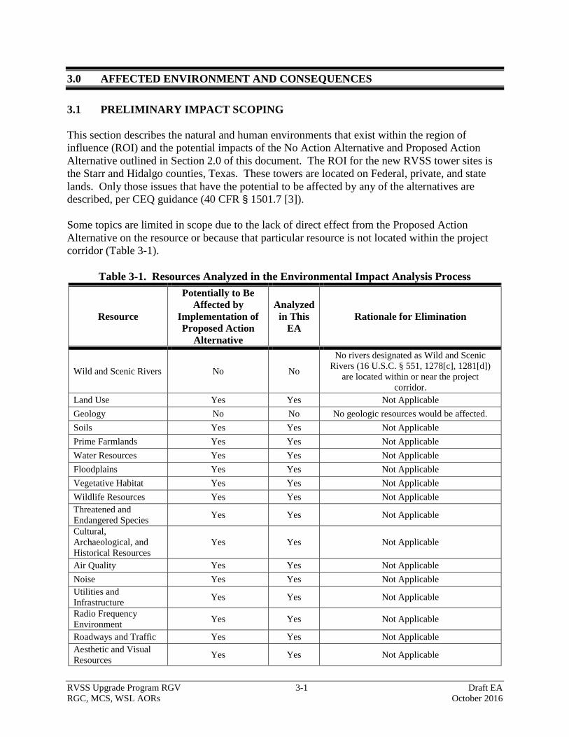
RVSS Upgrade Program RGV 3-1 Draft EA
RGC, MCS, WSL AORs October 2016
3.0 AFFECTED ENVIRONMENT AND CONSEQUENCES
3.1 PRELIMINARY IMPACT SCOPING
This section describes the natural and human environments that exist within the region of
influence (ROI) and the potential impacts of the No Action Alternative and Proposed Action
Alternative outlined in Section 2.0 of this document. The ROI for the new RVSS tower sites is
the Starr and Hidalgo counties, Texas. These towers are located on Federal, private, and state
lands. Only those issues that have the potential to be affected by any of the alternatives are
described, per CEQ guidance (40 CFR § 1501.7 [3]).
Some topics are limited in scope due to the lack of direct effect from the Proposed Action
Alternative on the resource or because that particular resource is not located within the project
corridor (Table 3-1).
Table 3-1. Resources Analyzed in the Environmental Impact Analysis Process
Resource
Potentially to Be
Affected by
Implementation of
Proposed Action
Alternative
Analyzed
in This
EA
Rationale for Elimination
Wild and Scenic Rivers No No
No rivers designated as Wild and Scenic
Rivers (16 U.S.C. § 551, 1278[c], 1281[d])
are located within or near the project
corridor.
Land Use Yes Yes Not Applicable
Geology No No No geologic resources would be affected.
Soils Yes Yes Not Applicable
Prime Farmlands Yes Yes Not Applicable
Water Resources Yes Yes Not Applicable
Floodplains Yes Yes Not Applicable
Vegetative Habitat Yes Yes Not Applicable
Wildlife Resources Yes Yes Not Applicable
Threatened and
Endangered Species Yes Yes Not Applicable
Cultural,
Archaeological, and
Historical Resources
Yes Yes Not Applicable
Air Quality Yes Yes Not Applicable
Noise Yes Yes Not Applicable
Utilities and
Infrastructure Yes Yes Not Applicable
Radio Frequency
Environment Yes Yes Not Applicable
Roadways and Traffic Yes Yes Not Applicable
Aesthetic and Visual
Resources Yes Yes Not Applicable
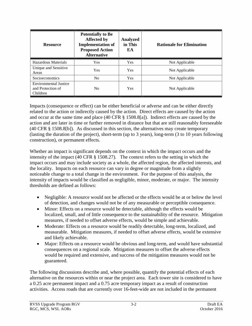
RVSS Upgrade Program RGV 3-2 Draft EA
RGC, MCS, WSL AORs October 2016
Resource
Potentially to Be
Affected by
Implementation of
Proposed Action
Alternative
Analyzed
in This
EA
Rationale for Elimination
Hazardous Materials Yes Yes Not Applicable
Unique and Sensitive
Areas Yes Yes Not Applicable
Socioeconomics No Yes Not Applicable
Environmental Justice
and Protection of
Children
No Yes Not Applicable
Impacts (consequence or effect) can be either beneficial or adverse and can be either directly
related to the action or indirectly caused by the action. Direct effects are caused by the action
and occur at the same time and place (40 CFR § 1508.8[a]). Indirect effects are caused by the
action and are later in time or further removed in distance but that are still reasonably foreseeable
(40 CFR § 1508.8[b]). As discussed in this section, the alternatives may create temporary
(lasting the duration of the project), short-term (up to 3 years), long-term (3 to 10 years following
construction), or permanent effects.
Whether an impact is significant depends on the context in which the impact occurs and the
intensity of the impact (40 CFR § 1508.27). The context refers to the setting in which the
impact occurs and may include society as a whole, the affected region, the affected interests, and
the locality. Impacts on each resource can vary in degree or magnitude from a slightly
noticeable change to a total change in the environment. For the purpose of this analysis, the
intensity of impacts would be classified as negligible, minor, moderate, or major. The intensity
thresholds are defined as follows:
Negligible: A resource would not be affected or the effects would be at or below the level
of detection, and changes would not be of any measurable or perceptible consequence.
Minor: Effects on a resource would be detectable, although the effects would be
localized, small, and of little consequence to the sustainability of the resource. Mitigation
measures, if needed to offset adverse effects, would be simple and achievable.
Moderate: Effects on a resource would be readily detectable, long-term, localized, and
measurable. Mitigation measures, if needed to offset adverse effects, would be extensive
and likely achievable.
Major: Effects on a resource would be obvious and long-term, and would have substantial
consequences on a regional scale. Mitigation measures to offset the adverse effects
would be required and extensive, and success of the mitigation measures would not be
guaranteed.
The following discussions describe and, where possible, quantify the potential effects of each
alternative on the resources within or near the project area. Each tower site is considered to have
a 0.25 acre permanent impact and a 0.75 acre temporary impact as a result of construction
activities. Access roads that are currently over 16-feet-wide are not included in the permanent
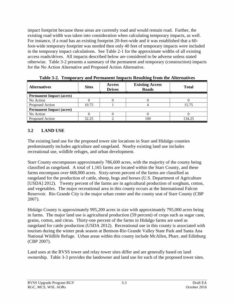
RVSS Upgrade Program RGV 3-3 Draft EA
RGC, MCS, WSL AORs October 2016
impact footprint because these areas are currently road and would remain road. Further, the
existing road width was taken into consideration when calculating temporary impacts, as well.
For instance, if a road has an existing footprint 20-feet-wide and it was established that a 60-
foot-wide temporary footprint was needed then only 40 feet of temporary impacts were included
in the temporary impact calculations. See Table 2-1 for the approximate widths of all existing
access roads/drives. All impacts described below are considered to be adverse unless stated
otherwise. Table 3-2 presents a summary of the permanent and temporary (construction) impacts
for the No Action Alternative and Proposed Action Alternative.
Table 3-2. Temporary and Permanent Impacts Resulting from the Alternatives
Alternatives Sites Access
Drives
Existing Access
Roads Total
Permanent Impact (acres)
No Action 0 0 0 0
Proposed Action 10.75 1 4 15.75
Permanent Impact (acres)
No Action 0 0 0 0
Proposed Action 32.25 2 100 134.25
3.2 LAND USE
The existing land use for the proposed tower site locations in Starr and Hidalgo counties
predominantly includes agriculture and rangeland. Nearby existing land use includes
recreational use, wildlife refuges, and urban development.
Starr County encompasses approximately 786,600 acres, with the majority of the county being
classified as rangeland. A total of 1,165 farms are located within the Starr County, and these
farms encompass over 668,000 acres. Sixty-seven percent of the farms are classified as
rangeland for the production of cattle, sheep, hogs and horses (U.S. Department of Agriculture
[USDA] 2012). Twenty percent of the farms are in agricultural production of sorghum, cotton,
and vegetables. The major recreational area in this county occurs at the International Falcon
Reservoir. Rio Grande City is the major urban center and the county seat of Starr County (CBP
2007).
Hidalgo County is approximately 995,200 acres in size with approximately 795,000 acres being
in farms. The major land use is agricultural production (59 percent) of crops such as sugar cane,
grains, cotton, and citrus. Thirty-one percent of the farms in Hidalgo farms are used as
rangeland for cattle production (USDA 2012). Recreational use in this county is associated with
tourism during the winter peak season at Bentson-Rio Grande Valley State Park and Santa Ana
National Wildlife Refuge. Urban areas within this county include McAllen, Pharr, and Edinburg
(CBP 2007).
Land uses at the RVSS tower and relay tower sites differ and are generally based on land
ownership. Table 3-3 provides the landowner and land use for each of the proposed tower sites.
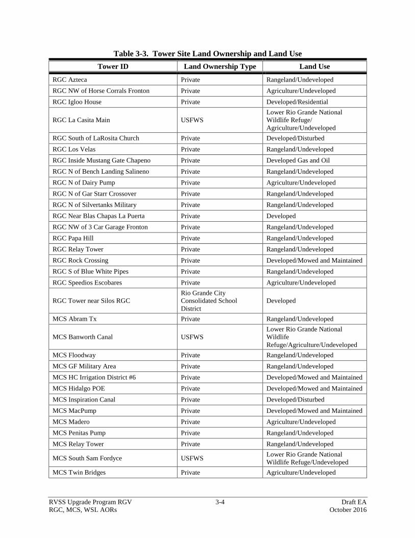
RVSS Upgrade Program RGV 3-4 Draft EA
RGC, MCS, WSL AORs October 2016
Table 3-3. Tower Site Land Ownership and Land Use
Tower ID Land Ownership Type Land Use
RGC Azteca Private Rangeland/Undeveloped
RGC NW of Horse Corrals Fronton Private Agriculture/Undeveloped
RGC Igloo House Private Developed/Residential
RGC La Casita Main USFWS
Lower Rio Grande National
Wildlife Refuge/
Agriculture/Undeveloped
RGC South of LaRosita Church Private Developed/Disturbed
RGC Los Velas Private Rangeland/Undeveloped
RGC Inside Mustang Gate Chapeno Private Developed Gas and Oil
RGC N of Bench Landing Salineno Private Rangeland/Undeveloped
RGC N of Dairy Pump Private Agriculture/Undeveloped
RGC N of Gar Starr Crossover Private Rangeland/Undeveloped
RGC N of Silvertanks Military Private Rangeland/Undeveloped
RGC Near Blas Chapas La Puerta Private Developed
RGC NW of 3 Car Garage Fronton Private Rangeland/Undeveloped
RGC Papa Hill Private Rangeland/Undeveloped
RGC Relay Tower Private Rangeland/Undeveloped
RGC Rock Crossing Private Developed/Mowed and Maintained
RGC S of Blue White Pipes Private Rangeland/Undeveloped
RGC Speedios Escobares Private Agriculture/Undeveloped
RGC Tower near Silos RGC
Rio Grande City
Consolidated School
District
Developed
MCS Abram Tx Private Rangeland/Undeveloped
MCS Banworth Canal USFWS
Lower Rio Grande National
Wildlife
Refuge/Agriculture/Undeveloped
MCS Floodway Private Rangeland/Undeveloped
MCS GF Military Area Private Rangeland/Undeveloped
MCS HC Irrigation District #6 Private Developed/Mowed and Maintained
MCS Hidalgo POE Private Developed/Mowed and Maintained
MCS Inspiration Canal Private Developed/Disturbed
MCS MacPump Private Developed/Mowed and Maintained
MCS Madero Private Agriculture/Undeveloped
MCS Penitas Pump Private Rangeland/Undeveloped
MCS Relay Tower Private Rangeland/Undeveloped
MCS South Sam Fordyce USFWS Lower Rio Grande National
Wildlife Refuge/Undeveloped
MCS Twin Bridges Private Agriculture/Undeveloped
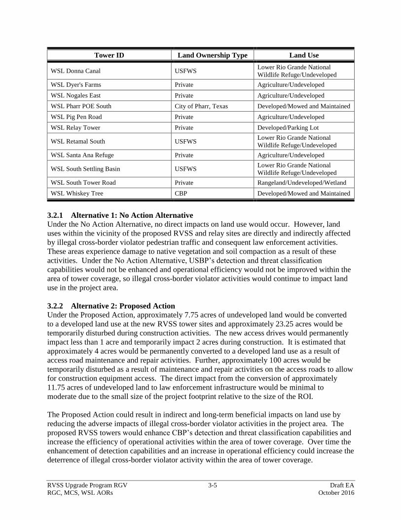
RVSS Upgrade Program RGV 3-5 Draft EA
RGC, MCS, WSL AORs October 2016
Tower ID Land Ownership Type Land Use
WSL Donna Canal USFWS Lower Rio Grande National
Wildlife Refuge/Undeveloped
WSL Dyer's Farms Private Agriculture/Undeveloped
WSL Nogales East Private Agriculture/Undeveloped
WSL Pharr POE South City of Pharr, Texas Developed/Mowed and Maintained
WSL Pig Pen Road Private Agriculture/Undeveloped
WSL Relay Tower Private Developed/Parking Lot
WSL Retamal South USFWS Lower Rio Grande National
Wildlife Refuge/Undeveloped
WSL Santa Ana Refuge Private Agriculture/Undeveloped
WSL South Settling Basin USFWS Lower Rio Grande National
Wildlife Refuge/Undeveloped
WSL South Tower Road Private Rangeland/Undeveloped/Wetland
WSL Whiskey Tree CBP Developed/Mowed and Maintained
3.2.1 Alternative 1: No Action Alternative
Under the No Action Alternative, no direct impacts on land use would occur. However, land
uses within the vicinity of the proposed RVSS and relay sites are directly and indirectly affected
by illegal cross-border violator pedestrian traffic and consequent law enforcement activities.
These areas experience damage to native vegetation and soil compaction as a result of these
activities. Under the No Action Alternative, USBP’s detection and threat classification
capabilities would not be enhanced and operational efficiency would not be improved within the
area of tower coverage, so illegal cross-border violator activities would continue to impact land
use in the project area.
3.2.2 Alternative 2: Proposed Action
Under the Proposed Action, approximately 7.75 acres of undeveloped land would be converted
to a developed land use at the new RVSS tower sites and approximately 23.25 acres would be
temporarily disturbed during construction activities. The new access drives would permanently
impact less than 1 acre and temporarily impact 2 acres during construction. It is estimated that
approximately 4 acres would be permanently converted to a developed land use as a result of
access road maintenance and repair activities. Further, approximately 100 acres would be
temporarily disturbed as a result of maintenance and repair activities on the access roads to allow
for construction equipment access. The direct impact from the conversion of approximately
11.75 acres of undeveloped land to law enforcement infrastructure would be minimal to
moderate due to the small size of the project footprint relative to the size of the ROI.
The Proposed Action could result in indirect and long-term beneficial impacts on land use by
reducing the adverse impacts of illegal cross-border violator activities in the project area. The
proposed RVSS towers would enhance CBP’s detection and threat classification capabilities and
increase the efficiency of operational activities within the area of tower coverage. Over time the
enhancement of detection capabilities and an increase in operational efficiency could increase the
deterrence of illegal cross-border violator activity within the area of tower coverage.
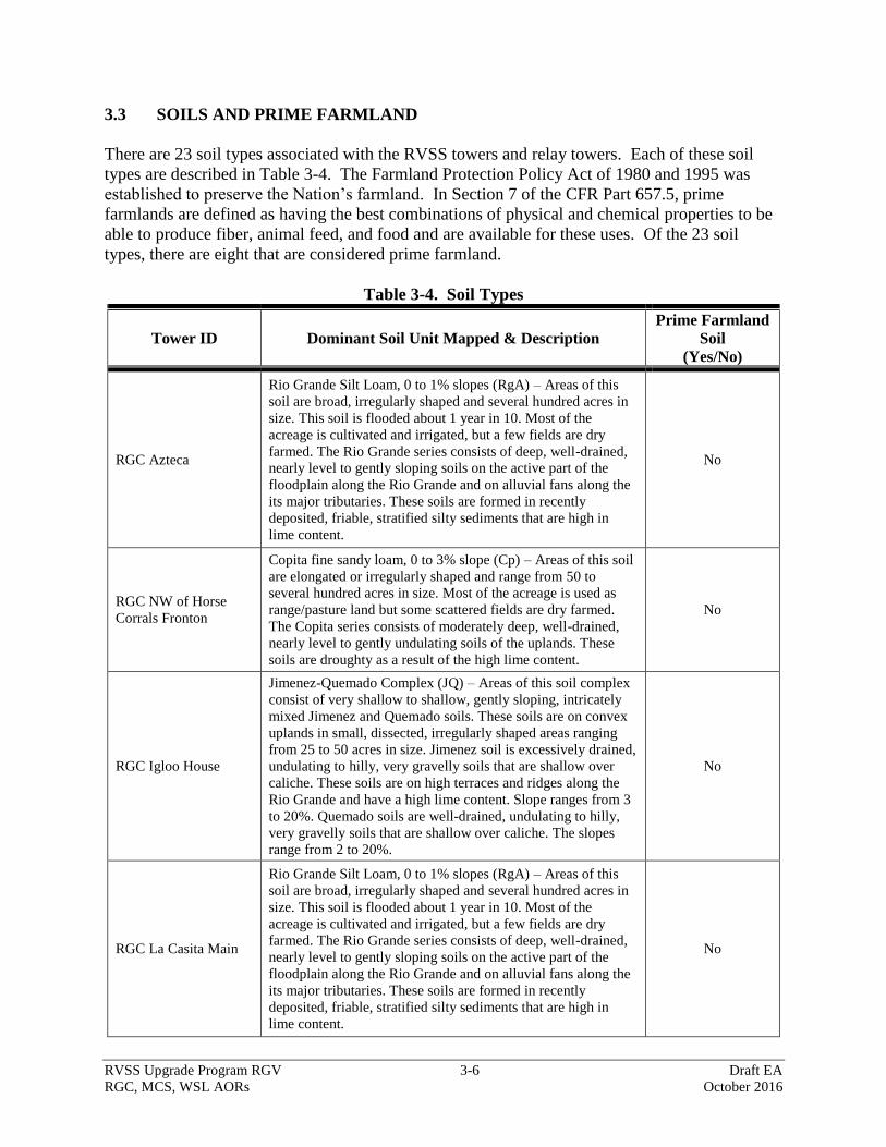
RVSS Upgrade Program RGV 3-6 Draft EA
RGC, MCS, WSL AORs October 2016
3.3 SOILS AND PRIME FARMLAND
There are 23 soil types associated with the RVSS towers and relay towers. Each of these soil
types are described in Table 3-4. The Farmland Protection Policy Act of 1980 and 1995 was
established to preserve the Nation’s farmland. In Section 7 of the CFR Part 657.5, prime
farmlands are defined as having the best combinations of physical and chemical properties to be
able to produce fiber, animal feed, and food and are available for these uses. Of the 23 soil
types, there are eight that are considered prime farmland.
Table 3-4. Soil Types
Tower ID Dominant Soil Unit Mapped & Description
Prime Farmland
Soil
(Yes/No)
RGC Azteca
Rio Grande Silt Loam, 0 to 1% slopes (RgA) – Areas of this
soil are broad, irregularly shaped and several hundred acres in
size. This soil is flooded about 1 year in 10. Most of the
acreage is cultivated and irrigated, but a few fields are dry
farmed. The Rio Grande series consists of deep, well-drained,
nearly level to gently sloping soils on the active part of the
floodplain along the Rio Grande and on alluvial fans along the
its major tributaries. These soils are formed in recently
deposited, friable, stratified silty sediments that are high in
lime content.
No
RGC NW of Horse
Corrals Fronton
Copita fine sandy loam, 0 to 3% slope (Cp) – Areas of this soil
are elongated or irregularly shaped and range from 50 to
several hundred acres in size. Most of the acreage is used as
range/pasture land but some scattered fields are dry farmed.
The Copita series consists of moderately deep, well-drained,
nearly level to gently undulating soils of the uplands. These
soils are droughty as a result of the high lime content.
No
RGC Igloo House
Jimenez-Quemado Complex (JQ) – Areas of this soil complex
consist of very shallow to shallow, gently sloping, intricately
mixed Jimenez and Quemado soils. These soils are on convex
uplands in small, dissected, irregularly shaped areas ranging
from 25 to 50 acres in size. Jimenez soil is excessively drained,
undulating to hilly, very gravelly soils that are shallow over
caliche. These soils are on high terraces and ridges along the
Rio Grande and have a high lime content. Slope ranges from 3
to 20%. Quemado soils are well-drained, undulating to hilly,
very gravelly soils that are shallow over caliche. The slopes
range from 2 to 20%.
No
RGC La Casita Main
Rio Grande Silt Loam, 0 to 1% slopes (RgA) – Areas of this
soil are broad, irregularly shaped and several hundred acres in
size. This soil is flooded about 1 year in 10. Most of the
acreage is cultivated and irrigated, but a few fields are dry
farmed. The Rio Grande series consists of deep, well-drained,
nearly level to gently sloping soils on the active part of the
floodplain along the Rio Grande and on alluvial fans along the
its major tributaries. These soils are formed in recently
deposited, friable, stratified silty sediments that are high in
lime content.
No
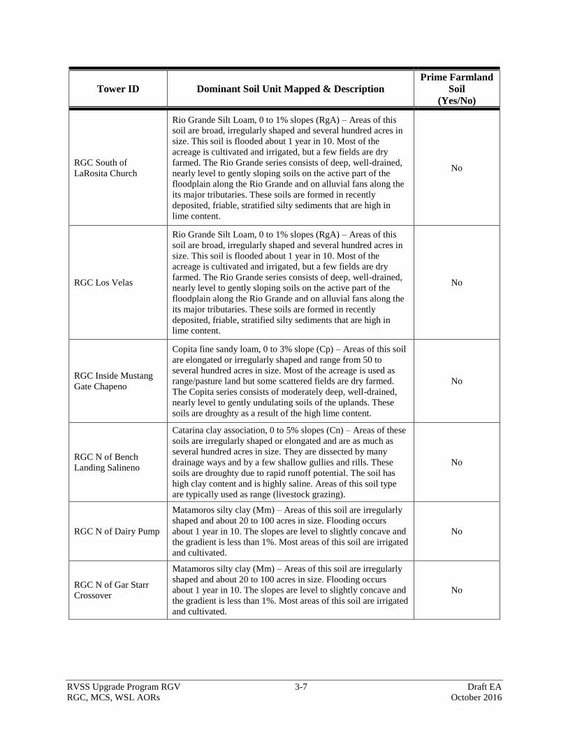
RVSS Upgrade Program RGV 3-7 Draft EA
RGC, MCS, WSL AORs October 2016
Tower ID Dominant Soil Unit Mapped & Description
Prime Farmland
Soil
(Yes/No)
RGC South of
LaRosita Church
Rio Grande Silt Loam, 0 to 1% slopes (RgA) – Areas of this
soil are broad, irregularly shaped and several hundred acres in
size. This soil is flooded about 1 year in 10. Most of the
acreage is cultivated and irrigated, but a few fields are dry
farmed. The Rio Grande series consists of deep, well-drained,
nearly level to gently sloping soils on the active part of the
floodplain along the Rio Grande and on alluvial fans along the
its major tributaries. These soils are formed in recently
deposited, friable, stratified silty sediments that are high in
lime content.
No
RGC Los Velas
Rio Grande Silt Loam, 0 to 1% slopes (RgA) – Areas of this
soil are broad, irregularly shaped and several hundred acres in
size. This soil is flooded about 1 year in 10. Most of the
acreage is cultivated and irrigated, but a few fields are dry
farmed. The Rio Grande series consists of deep, well-drained,
nearly level to gently sloping soils on the active part of the
floodplain along the Rio Grande and on alluvial fans along the
its major tributaries. These soils are formed in recently
deposited, friable, stratified silty sediments that are high in
lime content.
No
RGC Inside Mustang
Gate Chapeno
Copita fine sandy loam, 0 to 3% slope (Cp) – Areas of this soil
are elongated or irregularly shaped and range from 50 to
several hundred acres in size. Most of the acreage is used as
range/pasture land but some scattered fields are dry farmed.
The Copita series consists of moderately deep, well-drained,
nearly level to gently undulating soils of the uplands. These
soils are droughty as a result of the high lime content.
No
RGC N of Bench
Landing Salineno
Catarina clay association, 0 to 5% slopes (Cn) – Areas of these
soils are irregularly shaped or elongated and are as much as
several hundred acres in size. They are dissected by many
drainage ways and by a few shallow gullies and rills. These
soils are droughty due to rapid runoff potential. The soil has
high clay content and is highly saline. Areas of this soil type
are typically used as range (livestock grazing).
No
RGC N of Dairy Pump
Matamoros silty clay (Mm) – Areas of this soil are irregularly
shaped and about 20 to 100 acres in size. Flooding occurs
about 1 year in 10. The slopes are level to slightly concave and
the gradient is less than 1%. Most areas of this soil are irrigated
and cultivated.
No
RGC N of Gar Starr
Crossover
Matamoros silty clay (Mm) – Areas of this soil are irregularly
shaped and about 20 to 100 acres in size. Flooding occurs
about 1 year in 10. The slopes are level to slightly concave and
the gradient is less than 1%. Most areas of this soil are irrigated
and cultivated.
No

RVSS Upgrade Program RGV 3-8 Draft EA
RGC, MCS, WSL AORs October 2016
Tower ID Dominant Soil Unit Mapped & Description
Prime Farmland
Soil
(Yes/No)
RGC N of Silvertanks
Military
Reynosa silty clay loams (Re) – Areas of this soil are broad,
irregularly shaped, and generally several hundred acres in size.
The slope is predominantly less than 1%, but is as much as 2%
in places. Most of the acreage is irrigated and cultivated.
Yes
RGC Near Blas Chapas
La Puerta
McAllen fine sandy loam (Mc) – Areas of this soil are broad,
irregularly shaped, and as much as several hundred acres in
size. The slope is predominantly less than 1%, but the slope
range is 0 to 3%. Most of the acreage is used for range, but a
few areas are dry farmed. This soil is suited to irrigation, and
can be revegetated to native grassland.
No
RGC NW of 3 Car
Garage Fronton
Copita fine sandy loam, 0 to 3% slope (Cp) – Areas of this soil
are elongated or irregularly shaped and range from 50 to
several hundred acres in size. Most of the acreage is used as
range/pasture land but some scattered fields are dry farmed.
The Copita series consists of moderately deep, well-drained,
nearly level to gently undulating soils of the uplands. These
soils are droughty as a result of the high lime content.
No
RGC Papa Hill
Jimenez-Quemado Complex (JQ) – Areas of this soil complex
consist of very shallow to shallow, gently sloping, intricately
mixed Jimenez and Quemado soils. These soils are on convex
uplands in small, dissected, irregularly shaped areas ranging
from 25 to 50 acres in size. Jimenez soil is excessively drained,
undulating to hilly, very gravelly soils that are shallow over
caliche. These soils are on high terraces and ridges along the
Rio Grande and have a high lime content. Slope ranges from 3
to 20%. Quemado soils are well-drained, undulating to hilly,
very gravelly soils that are shallow over caliche. The slopes
range from 2 to 20%.
No
RGC Relay Tower
Jimenez-Quemado Complex (JQ) – Areas of this soil complex
consist of very shallow to shallow, gently sloping, intricately
mixed Jimenez and Quemado soils. These soils are on convex
uplands in small, dissected, irregularly shaped areas ranging
from 25 to 50 acres in size. Jimenez soil is excessively drained,
undulating to hilly, very gravelly soils that are shallow over
caliche. These soils are on high terraces and ridges along the
Rio Grande and have high lime content. Slope ranges from 3 to
20%. Quemado soils are well-drained, undulating to hilly, very
gravelly soils that are shallow over caliche. The slopes range
from 2 to 20%.
No
RGC Rock Crossing
Rio Grande Silt Loam, 1 to 3% slopes (RgB) – Areas of this
soil are broad, irregularly shaped and several hundred acres in
size. This soil is flooded about 1 year in 10. Most of the
acreage is cultivated and irrigated, but a few fields are dry
farmed. The Rio Grande series consists of deep, well-drained,
nearly level to gently sloping soils on the active part of the
floodplain along the Rio Grande and on alluvial fans along the
its major tributaries. These soils are formed in recently
deposited, friable, stratified silty sediments that are high in
lime content.
No
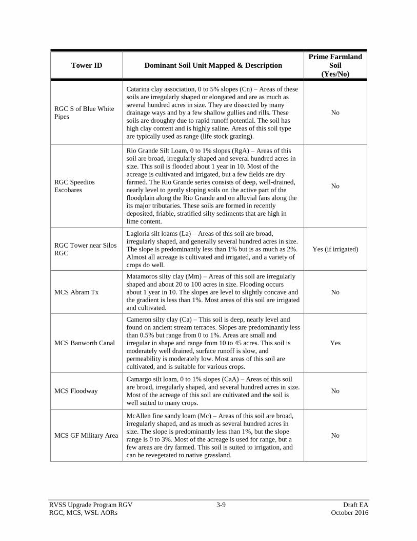
RVSS Upgrade Program RGV 3-9 Draft EA
RGC, MCS, WSL AORs October 2016
Tower ID Dominant Soil Unit Mapped & Description
Prime Farmland
Soil
(Yes/No)
RGC S of Blue White
Pipes
Catarina clay association, 0 to 5% slopes (Cn) – Areas of these
soils are irregularly shaped or elongated and are as much as
several hundred acres in size. They are dissected by many
drainage ways and by a few shallow gullies and rills. These
soils are droughty due to rapid runoff potential. The soil has
high clay content and is highly saline. Areas of this soil type
are typically used as range (life stock grazing).
No
RGC Speedios
Escobares
Rio Grande Silt Loam, 0 to 1% slopes (RgA) – Areas of this
soil are broad, irregularly shaped and several hundred acres in
size. This soil is flooded about 1 year in 10. Most of the
acreage is cultivated and irrigated, but a few fields are dry
farmed. The Rio Grande series consists of deep, well-drained,
nearly level to gently sloping soils on the active part of the
floodplain along the Rio Grande and on alluvial fans along the
its major tributaries. These soils are formed in recently
deposited, friable, stratified silty sediments that are high in
lime content.
No
RGC Tower near Silos
RGC
Lagloria silt loams (La) – Areas of this soil are broad,
irregularly shaped, and generally several hundred acres in size.
The slope is predominantly less than 1% but is as much as 2%.
Almost all acreage is cultivated and irrigated, and a variety of
crops do well.
Yes (if irrigated)
MCS Abram Tx
Matamoros silty clay (Mm) – Areas of this soil are irregularly
shaped and about 20 to 100 acres in size. Flooding occurs
about 1 year in 10. The slopes are level to slightly concave and
the gradient is less than 1%. Most areas of this soil are irrigated
and cultivated.
No
MCS Banworth Canal
Cameron silty clay (Ca) – This soil is deep, nearly level and
found on ancient stream terraces. Slopes are predominantly less
than 0.5% but range from 0 to 1%. Areas are small and
irregular in shape and range from 10 to 45 acres. This soil is
moderately well drained, surface runoff is slow, and
permeability is moderately low. Most areas of this soil are
cultivated, and is suitable for various crops.
Yes
MCS Floodway
Camargo silt loam, 0 to 1% slopes (CaA) – Areas of this soil
are broad, irregularly shaped, and several hundred acres in size.
Most of the acreage of this soil are cultivated and the soil is
well suited to many crops.
No
MCS GF Military Area
McAllen fine sandy loam (Mc) – Areas of this soil are broad,
irregularly shaped, and as much as several hundred acres in
size. The slope is predominantly less than 1%, but the slope
range is 0 to 3%. Most of the acreage is used for range, but a
few areas are dry farmed. This soil is suited to irrigation, and
can be revegetated to native grassland.
No
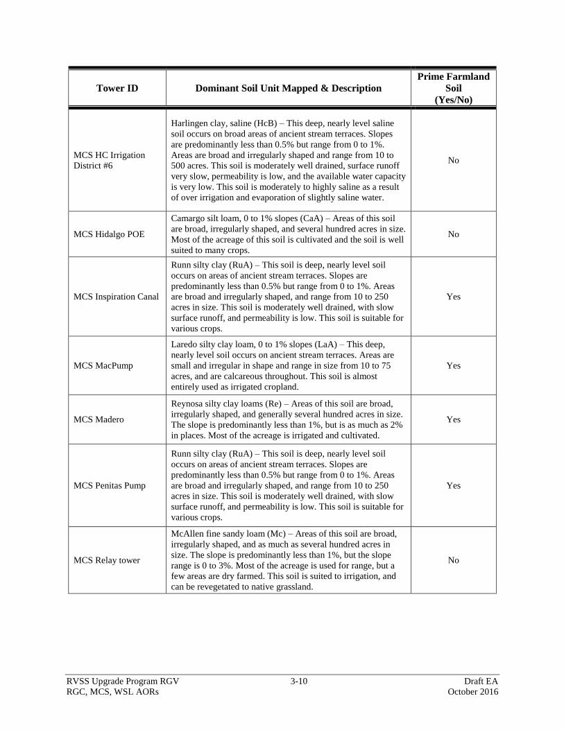
RVSS Upgrade Program RGV 3-10 Draft EA
RGC, MCS, WSL AORs October 2016
Tower ID Dominant Soil Unit Mapped & Description
Prime Farmland
Soil
(Yes/No)
MCS HC Irrigation
District #6
Harlingen clay, saline (HcB) – This deep, nearly level saline
soil occurs on broad areas of ancient stream terraces. Slopes
are predominantly less than 0.5% but range from 0 to 1%.
Areas are broad and irregularly shaped and range from 10 to
500 acres. This soil is moderately well drained, surface runoff
very slow, permeability is low, and the available water capacity
is very low. This soil is moderately to highly saline as a result
of over irrigation and evaporation of slightly saline water.
No
MCS Hidalgo POE
Camargo silt loam, 0 to 1% slopes (CaA) – Areas of this soil
are broad, irregularly shaped, and several hundred acres in size.
Most of the acreage of this soil is cultivated and the soil is well
suited to many crops.
No
MCS Inspiration Canal
Runn silty clay (RuA) – This soil is deep, nearly level soil
occurs on areas of ancient stream terraces. Slopes are
predominantly less than 0.5% but range from 0 to 1%. Areas
are broad and irregularly shaped, and range from 10 to 250
acres in size. This soil is moderately well drained, with slow
surface runoff, and permeability is low. This soil is suitable for
various crops.
Yes
MCS MacPump
Laredo silty clay loam, 0 to 1% slopes (LaA) – This deep,
nearly level soil occurs on ancient stream terraces. Areas are
small and irregular in shape and range in size from 10 to 75
acres, and are calcareous throughout. This soil is almost
entirely used as irrigated cropland.
Yes
MCS Madero
Reynosa silty clay loams (Re) – Areas of this soil are broad,
irregularly shaped, and generally several hundred acres in size.
The slope is predominantly less than 1%, but is as much as 2%
in places. Most of the acreage is irrigated and cultivated.
Yes
MCS Penitas Pump
Runn silty clay (RuA) – This soil is deep, nearly level soil
occurs on areas of ancient stream terraces. Slopes are
predominantly less than 0.5% but range from 0 to 1%. Areas
are broad and irregularly shaped, and range from 10 to 250
acres in size. This soil is moderately well drained, with slow
surface runoff, and permeability is low. This soil is suitable for
various crops.
Yes
MCS Relay tower
McAllen fine sandy loam (Mc) – Areas of this soil are broad,
irregularly shaped, and as much as several hundred acres in
size. The slope is predominantly less than 1%, but the slope
range is 0 to 3%. Most of the acreage is used for range, but a
few areas are dry farmed. This soil is suited to irrigation, and
can be revegetated to native grassland.
No
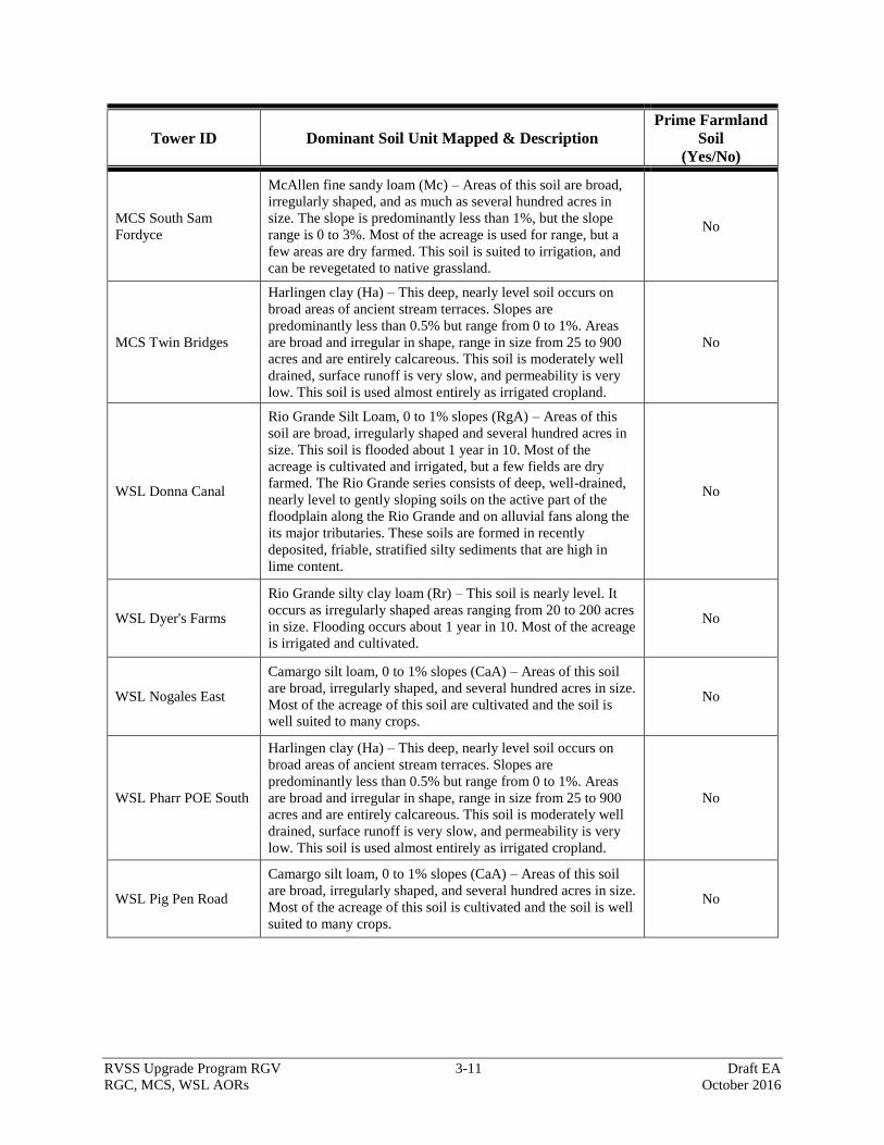
RVSS Upgrade Program RGV 3-11 Draft EA
RGC, MCS, WSL AORs October 2016
Tower ID Dominant Soil Unit Mapped & Description
Prime Farmland
Soil
(Yes/No)
MCS South Sam
Fordyce
McAllen fine sandy loam (Mc) – Areas of this soil are broad,
irregularly shaped, and as much as several hundred acres in
size. The slope is predominantly less than 1%, but the slope
range is 0 to 3%. Most of the acreage is used for range, but a
few areas are dry farmed. This soil is suited to irrigation, and
can be revegetated to native grassland.
No
MCS Twin Bridges
Harlingen clay (Ha) – This deep, nearly level soil occurs on
broad areas of ancient stream terraces. Slopes are
predominantly less than 0.5% but range from 0 to 1%. Areas
are broad and irregular in shape, range in size from 25 to 900
acres and are entirely calcareous. This soil is moderately well
drained, surface runoff is very slow, and permeability is very
low. This soil is used almost entirely as irrigated cropland.
No
WSL Donna Canal
Rio Grande Silt Loam, 0 to 1% slopes (RgA) – Areas of this
soil are broad, irregularly shaped and several hundred acres in
size. This soil is flooded about 1 year in 10. Most of the
acreage is cultivated and irrigated, but a few fields are dry
farmed. The Rio Grande series consists of deep, well-drained,
nearly level to gently sloping soils on the active part of the
floodplain along the Rio Grande and on alluvial fans along the
its major tributaries. These soils are formed in recently
deposited, friable, stratified silty sediments that are high in
lime content.
No
WSL Dyer's Farms
Rio Grande silty clay loam (Rr) – This soil is nearly level. It
occurs as irregularly shaped areas ranging from 20 to 200 acres
in size. Flooding occurs about 1 year in 10. Most of the acreage
is irrigated and cultivated.
No
WSL Nogales East
Camargo silt loam, 0 to 1% slopes (CaA) – Areas of this soil
are broad, irregularly shaped, and several hundred acres in size.
Most of the acreage of this soil are cultivated and the soil is
well suited to many crops.
No
WSL Pharr POE South
Harlingen clay (Ha) – This deep, nearly level soil occurs on
broad areas of ancient stream terraces. Slopes are
predominantly less than 0.5% but range from 0 to 1%. Areas
are broad and irregular in shape, range in size from 25 to 900
acres and are entirely calcareous. This soil is moderately well
drained, surface runoff is very slow, and permeability is very
low. This soil is used almost entirely as irrigated cropland.
No
WSL Pig Pen Road
Camargo silt loam, 0 to 1% slopes (CaA) – Areas of this soil
are broad, irregularly shaped, and several hundred acres in size.
Most of the acreage of this soil is cultivated and the soil is well
suited to many crops.
No
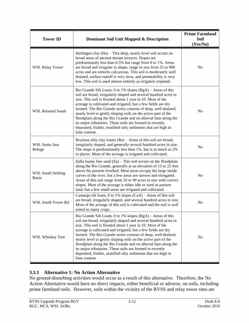
RVSS Upgrade Program RGV 3-12 Draft EA
RGC, MCS, WSL AORs October 2016
Tower ID Dominant Soil Unit Mapped & Description
Prime Farmland
Soil
(Yes/No)
WSL Relay Tower
Harlingen clay (Ha) – This deep, nearly level soil occurs on
broad areas of ancient stream terraces. Slopes are
predominantly less than 0.5% but range from 0 to 1%. Areas
are broad and irregular in shape, range in size from 25 to 900
acres and are entirely calcareous. This soil is moderately well
drained, surface runoff is very slow, and permeability is very
low. This soil is used almost entirely as irrigated cropland.
No
WSL Retamal South
Rio Grande Silt Loam, 0 to 1% slopes (RgA) – Areas of this
soil are broad, irregularly shaped and several hundred acres in
size. This soil is flooded about 1 year in 10. Most of the
acreage is cultivated and irrigated, but a few fields are dry
farmed. The Rio Grande series consists of deep, well-drained,
nearly level to gently sloping soils on the active part of the
floodplain along the Rio Grande and on alluvial fans along the
its major tributaries. These soils are formed in recently
deposited, friable, stratified silty sediments that are high in
lime content.
No
WSL Santa Ana
Refuge
Reynosa silty clay loams (Re) – Areas of this soil are broad,
irregularly shaped, and generally several hundred acres in size.
The slope is predominantly less than 1%, but is as much as 2%
in places. Most of the acreage is irrigated and cultivated.
No
WSL South Settling
Basin
Zalla loamy fine sand (Za) – This soil occurs on the floodplain
along the Rio Grande, generally at an elevation of 15 to 25 feet
above the present riverbed. Most areas occupy the large inside
curves of the river, but a few areas are narrow and elongated.
Areas of this soil range from 10 to 90 acres in size with convex
slopes. Most of the acreage is either idle or used as pasture
land, but a few small areas are irrigated and cultivated.
No
WSL South Tower Rd
Camargo silt loam, 0 to 1% slopes (CaA) – Areas of this soil
are broad, irregularly shaped, and several hundred acres in size.
Most of the acreage of this soil is cultivated and the soil is well
suited to many crops.
No
WSL Whiskey Tree
Rio Grande Silt Loam, 0 to 1% slopes (RgA) – Areas of this
soil are broad, irregularly shaped and several hundred acres in
size. This soil is flooded about 1 year in 10. Most of the
acreage is cultivated and irrigated, but a few fields are dry
farmed. The Rio Grande series consists of deep, well-drained,
nearly level to gently sloping soils on the active part of the
floodplain along the Rio Grande and on alluvial fans along the
its major tributaries. These soils are formed in recently
deposited, friable, stratified silty sediments that are high in
lime content.
No
3.3.1 Alternative 1: No Action Alternative
No ground-disturbing activities would occur as a result of this alternative. Therefore, the No
Action Alternative would have no direct impacts, either beneficial or adverse, on soils, including
prime farmland soils. However, soils within the vicinity of the RVSS and relay tower sites are
RVSS Upgrade Program RGV 3-13 Draft EA
RGC, MCS, WSL AORs October 2016
directly and indirectly affected by illegal cross-border violator pedestrian traffic and consequent
law enforcement activities. Under the No Action Alternative, USBP’s detection and threat
classification capabilities would not be enhanced and operational efficiency would not be
improved within the area of tower coverage, so illegal cross-border violator activities would
continue to impact soils in the project area. Potential indirect benefits associated with the
Proposed Action would not be realized under the No Action Alternative.
3.3.2 Alternative 2: Proposed Action
Under the Proposed Action, approximately 10.75 acres of soils (of which 1.75 acres are
considered prime farmland soils) would be permanently disturbed or removed from biological
production at the new RVSS tower sites and approximately 32.25 acres (of which 5.25 acres are
prime farmlands) would be temporarily disturbed during construction activities. It is estimated
that approximately 5 acres of soils would be permanently disturbed as a result of access drive
construction and access road maintenance and repair activities. Further, approximately 100 acres
would be temporarily disturbed as a result of maintenance and repair activities on existing access
roads to allow for construction equipment access. The direct impact from the disturbance and
removal from biological production of approximately 15.75 acres of soil (of which 1.75 acres are
prime farmland soils) would be negligible due to the small size of the project footprint relative to
the amount of the same soils throughout the ROI. Upon completion of construction, all
temporary disturbance areas would be revegetated with a mixture of native plant seeds or nursery
plantings or allowed to revegetate naturally.
The Proposed Action could result in indirect and long-term beneficial impacts on soils within the
ROI by reducing the adverse impacts of illegal cross-border violator activities in the project area.
The proposed RVSS towers would enhance CBP’s detection and threat classification capabilities
and increase the efficiency of operational activities within the area of tower coverage. Over time
the enhancement of detection capabilities and an increase in operational efficiency could increase
the deterrence of illegal cross-border violator activity within the area of tower coverage.
3.4 VEGETATIVE HABITAT
The project corridor is located in the South Texas Brush Ecoregion as characterized by the Texas
Parks and Wildlife Department (TPWD) (TPWD 2015). This ecoregion exists from east of the
Rio Grande and south of the Balcones Escarpment. The average temperature is 73 degrees
Fahrenheit, with an average annual rainfall ranging from 16 inches in the east to 30 inches in the
west. The South Texas Brush Country Ecoregion is a diverse ecoregion because it has elements
of three converging vegetative communities, Chihuahuan Desert to the west, Tamaulipan
thornscrub and subtropical woodlands along the Rio Grande, and coastal grasslands to the east.
It is transected by numerous arroyos and streams and is generally covered in low-growing thorny
vegetation (TPWD 2015).
Common tree species for the area includes pecan (Carya illinoiensis), sugarberry tree (Celtis
laevigata), anacua tree (Ehretia anacua), Texas ebony tree (Pithecellobium flexicaule), sabal
palm (Sabal palmetto), black willow (Salix nigra), Texas persimmon (Diospyros texana), honey
mesquite (Prosopis glandulosa var. glandulosa), lotebush (Ziziphus obtusifolia), huisache
(Acacia farnesiana), and Texas wild olive (Cordia boissieri). Shrubs that are most common in
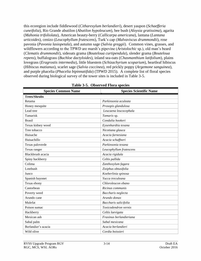
RVSS Upgrade Program RGV 3-14 Draft EA
RGC, MCS, WSL AORs October 2016
this ecoregion include fiddlewood (Citharexylum berlandieri), desert yaupon (Schaefferia
cuneifolia), Rio Grande abutilon (Abutilon hypoleucum), bee bush (Aloysia gratissima), agarita
(Mahonia trifoliolata), American beauty-berry (Callicarpa americana), lantana (Lantana
urticoides), cenizo (Leucophyllum frutescens), Turk’s cap (Malvaviscus drummondii), rose
pavonia (Pavonia lasiopetala), and autumn sage (Salvia greggii). Common vines, grasses, and
wildflowers according to the TPWD are marsh’s pipevine (Aristolochic sp.), old man’s beard
(Clematis drummondii), sideoats grama (Bouteloua curtipendula), slender grama (Bouteloua
repens), buffalograss (Buchloe dactyloides), inland sea-oats (Chasmanthium latifolium), plains
lovegrass (Eragrostis intermedia), little bluestem (Schizachyrium scoparium), heartleaf hibiscus
(Hibiscus matianus), scarlet sage (Salvia coccinea), red prickly poppy (Argemone sanguinea),
and purple phacelia (Phacelia bipinnatifida) (TPWD 2015). A complete list of floral species
observed during biological survey of the tower sites is included in Table 3-5.
Table 3-5. Observed Flora species
Species Common Name Species Scientific Name
Trees/Shrubs
Retama Parkinsonia aculeata
Honey mesquite Prosopis glandulosa
Lead tree Leucaena leucocephala
Tamarisk Tamarix sp.
Brasil Condalia hookeri
Texas kidney wood Eysenhardtia texana
Tree tobacco Nicotiana glauca
Huisache Acacia farnesiana
Huisachillo Acacia schaffneri
Texas paloverde Parkinsonia texana
Texas ranger Leucophyllum frutescens
Blackbrush acacia Acacia rigidula
Spiny hackberry Celtis pallida
Colima Zanthoxylum fagara
Lotebush Ziziphus obtusifolia
Junco Koeberlinia spinosa
Spanish bayonet Yucca treculeana
Texas ebony Chloroleucon ebano
Castorbean Ricinus communis
Poverty weed Baccharis neglecta
Arundo cane Arundo donax
Mulefat Baccharis salicifolia
Poison sumac Toxicodendron vernix
Hackberry Celtis laevigata
Mexican ash Fraxinus berlandieriana
Sabal palm Sabal mexicana
Berlandier’s acacia Acacia berlandieri
Wild olive Cordia boissieri
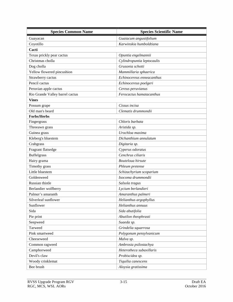
RVSS Upgrade Program RGV 3-15 Draft EA
RGC, MCS, WSL AORs October 2016
Species Common Name Species Scientific Name
Guayacan Guaiacum angustifolium
Coyotillo Karwinskia humboldtiana
Cacti
Texas prickly pear cactus Opuntia engelmannii
Christmas cholla Cylindropuntia leptocaulis
Dog cholla Grusonia schotti
Yellow flowered pincushion Mammillaria sphaerica
Strawberry cactus Echinocereus enneacanthus
Pencil cactus Echinocereus poelgeri
Peruvian apple cactus Cereus peruvianus
Rio Grande Valley barrel cactus Ferocactus hamatacanthus
Vines
Possum grape Cissus incisa
Old man's beard Clematis drummondii
Forbs/Herbs
Fingergrass Chloris barbata
Threeawn grass Aristida sp.
Guinea grass Urochloa maxima
Kleberg's bluestem Dichanthium annulatum
Crabgrass Digitaria sp.
Fragrant flatsedge Cyperus odoratus
Buffelgrass Cenchrus ciliaris
Hairy grama Bouteloua hirsute
Timothy grass Phleum pretense
Little bluestem Schizachyrium scoparium
Goldenweed Isocoma drummondii
Russian thistle Salsola tragus
Berlandier wolfberry Lycium berlandieri
Palmer’s amaranth Amaranthus palmeri
Silverleaf sunflower Helianthus argophyllus
Sunflower Helianthus annuus
Sida Sida abutifolia
Pie print Abutilon theophrasti
Seepweed Suaeda sp.
Tarweed Grindelia squarrosa
Pink smartweed Polygonum pensylvanicum
Cheeseweed Malva sp.
Common ragweed Ambrosia psilostachya
Camphorweed Heterotheca subaxillaris
Devil's claw Probiscidea sp.
Woody crinklemat Tiquilia canescens
Bee brush Aloysia gratissima
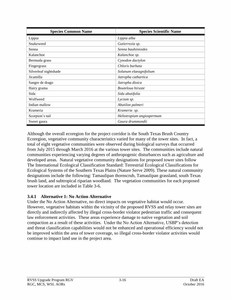
RVSS Upgrade Program RGV 3-16 Draft EA
RGC, MCS, WSL AORs October 2016
Species Common Name Species Scientific Name
Lippia Lippia alba
Snakeweed Gutierrezia sp.
Senna Senna bauhinioides
Kalanchoe Kalanchoe sp.
Bermuda grass Cynodon dactylon
Fingergrass Chloris barbata
Silverleaf nightshade Solanum elaeagnifolium
Jicamilla Jatropha cathartica
Sangre de drago Jatropha dioica
Hairy grama Bouteloua hiruste
Sida Sida abutifolia
Wolfweed Lycium sp.
Indian mallow Abutilon palmeri
Krameria Krameria sp.
Scorpion’s tail Heliotropium angiospermum
Sweet gaura Gaura drummondii
Although the overall ecoregion for the project corridor is the South Texas Brush Country
Ecoregion, vegetative community characteristics varied for many of the tower sites. In fact, a
total of eight vegetative communities were observed during biological surveys that occurred
from July 2015 through March 2016 at the various tower sites. The communities include natural
communities experiencing varying degrees of anthropogenic disturbances such as agriculture and
developed areas. Natural vegetative community designations for proposed tower sites follow
The International Ecological Classification Standard: Terrestrial Ecological Classifications for
Ecological Systems of the Southern Texas Plains (Nature Serve 2009). These natural community
designations include the following: Tamaulipan thornscrub, Tamaulipan grassland, south Texas
brush land, and subtropical riparian woodland. The vegetation communities for each proposed
tower location are included in Table 3-6.
3.4.1 Alternative 1: No Action Alternative
Under the No Action Alternative, no direct impacts on vegetative habitat would occur.
However, vegetative habitats within the vicinity of the proposed RVSS and relay tower sites are
directly and indirectly affected by illegal cross-border violator pedestrian traffic and consequent
law enforcement activities. These areas experience damage to native vegetation and soil
compaction as a result of these activities. Under the No Action Alternative, USBP’s detection
and threat classification capabilities would not be enhanced and operational efficiency would not
be improved within the area of tower coverage, so illegal cross-border violator activities would
continue to impact land use in the project area.
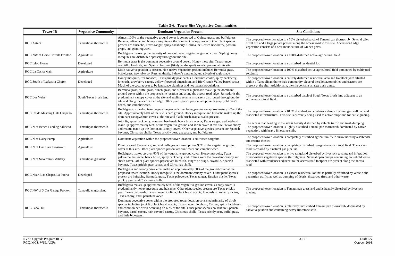
RVSS Upgrade Program RGV 3-17 Draft EA
RGC, MCS, WSL AORs October 2016
Table 3-6. Tower Site Vegetative Communities
Tower ID Vegetative Community Dominant Vegetation Present Site Conditions
RGC Azteca Tamaulipan thornscrub
Almost 100% of the vegetative ground cover is composed of Guinea grass, and buffelgrass.
Retama, saltcedar and honey mesquite are the dominant canopy cover. Other plant species
present are huisache, Texas ranger, spiny hackberry, Colima, net-leafed hackberry, possum
grape, and giant ragweed.
The proposed tower location is a 60% disturbed patch of Tamaulipan thornscrub. Several piles
of fill dirt and a large pit are present along the access road to this site. Access road edge
vegetation consists of a near monoculture of Guinea grass.
RGC NW of Horse Corrals Fronton Agriculture Buffelgrass makes up the majority of non-cultivated vegetative ground cover. Sapling honey
mesquites are distributed sparsely throughout the site. The proposed tower location is a 100% disturbed active agricultural field.
RGC Igloo House Developed Bermuda grass is the dominant vegetative ground cover. Honey mesquite, Texas ranger,
coyotillo, lotebush, and Spanish bayonet (likely landscaped) are also present at this site. The proposed tower location is a disturbed residential lot.
RGC La Casita Main Agriculture Little native vegetation is present. Non-native vegetation present includes Bermuda grass,
buffelgrass, tree tobacco, Russian thistle, Palmer’s amaranth, and silverleaf nightshade
The proposed tower location is 100% disturbed active agricultural field dominated by cultivated
sorghum.
RGC South of LaRosita Church Developed
Honey mesquite, tree tobacco, Texas prickly pear cactus, Christmas cholla, spiny hackberry,
lotebush, strawberry cactus, yellow flowered pincushion, and Rio Grande Valley barrel cactus.
Much of the cacti appear to be landscape plantings and not natural populations.
The proposed tower location is entirely disturbed residential area and livestock yard situated
within a Tamaulipan thornscrub community. Several derelict automobiles and tractors are
present at the site. Additionally, the site contains a large trash dump.
RGC Los Velas South Texas brush land
Bermuda grass, buffelgrass, bunch grass, and silverleaf nightshade make up the dominant
ground cover within the proposed site location and along the access road edge. Saltcedar is the
predominant canopy cover at the site and sapling retama is sparsely distributed throughout the
site and along the access road edge. Other plant species present are possum grape, old man’s
beard, and camphorweed.
The proposed tower location is a disturbed patch of South Texas brush land adjacent to an
active agricultural field.
RGC Inside Mustang Gate Chapeno Tamaulipan thornscrub
Buffelgrass is the dominant vegetative ground cover being present on approximately 40% of the
site. Approximately 60% of the site is bare ground. Honey mesquite and huisache makes up the
dominant canopy/shrub cover at the site and black brush acacia is also present.
The proposed tower location is 100% disturbed and contains a derelict natural gas well pad and
associated infrastructure. This site is currently being used as active rangeland for cattle grazing.
RGC N of Bench Landing Salineno Tamaulipan thornscrub
Joint fir, spiny hackberry, common bee brush, black brush acacia, Texas ranger, and lotebush
make up approximately 60% of the vegetative ground and shrub cover at this site. Texas ebony
and retama made up the dominant canopy cover. Other vegetative species present are Spanish
bayonet, Christmas cholla, Texas prickly pear, guayacan, and buffelgrass.
The access road leading to the site is heavily disturbed by vehicle traffic and trash dumping.
The proposed tower location is lightly disturbed Tamaulipan thornscrub dominated by native
vegetation, with heavy limestone soils.
RGC N of Dairy Pump Agriculture Dominant vegetation within the proposed tower location is cultivated sorghum. The proposed tower location is completely disturbed agricultural field surrounded by a saltcedar
and retama thicket.
RGC N of Gar Starr Crossover Agriculture Poverty weed, Bermuda grass, and buffelgrass make up over 90% of the vegetative ground
cover at this site. Other plant species present are sunflower and camphorweed.
The proposed tower location is completely disturbed overgrown agricultural field. The access
road is crossed by a natural gas pipeline.
RGC N of Silvertanks Military Tamaulipan grassland
Buffelgrass makes up over 80% of the vegetative ground cover. Honey mesquite, Texas
paloverde, huisache, black brush, spiny hackberry, and Colima were the prevalent canopy and
shrub cover. Other plant species present are lotebush, sangre de drago, coyotillo, Spanish
bayonet, Texas prickly pear cactus, and Christmas cholla.
The proposed tower location is active rangeland disturbed by livestock grazing and infestation
of non-native vegetative species (buffelgrass). Several open dumps containing household waste
associated with residences adjacent to the access road footprint are present along the access
road.
RGC Near Blas Chapas La Puerta Developed
Buffelgrass and woody crinklemat make up approximately 50% of the ground cover at the
proposed tower location. Honey mesquite is the dominant canopy cover. Other plant species
present are huisache, Bermuda grass, Texas paloverde, Texas ranger, Russian thistle, Texas
prickly pear, and Christmas cholla.
The proposed tower location is a vacant residential lot that is partially disturbed by vehicle and
pedestrian traffic, as well as dumping of debris, discarded tires, and other waste.
RGC NW of 3 Car Garage Fronton Tamaulipan grassland
Buffelgrass makes up approximately 65% of the vegetative ground cover. Canopy cover is
predominantly honey mesquite and huisache. Other plant species present are Texas prickly
pear, Texas paloverde, Texas ranger, Colima, black brush acacia, lotebush, strawberry cactus,
Texas ebony, and Spanish bayonet.
The proposed tower location is Tamaulipan grassland and is heavily disturbed by livestock
grazing.
RGC Papa Hill Tamaulipan thornscrub
Dominant vegetative cover within the proposed tower location consisted primarily of shrub
species including joint fir, black brush acacia, Texas ranger, lotebush, Colima, spiny hackberry,
and common bee brush occurring on 60% of the site. Other plant species present are Spanish
bayonet, barrel cactus, hair-covered cactus, Christmas cholla, Texas prickly pear, buffelgrass,
and little bluestem.
The proposed tower location is relatively undisturbed Tamaulipan thornscrub, dominated by
native vegetation and containing heavy limestone soils.
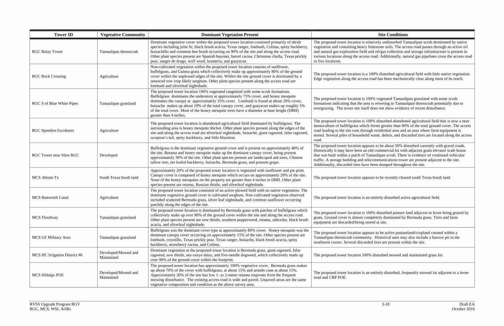
RVSS Upgrade Program RGV 3-18 Draft EA
RGC, MCS, WSL AORs October 2016
Tower ID Vegetative Community Dominant Vegetation Present Site Conditions
RGC Relay Tower Tamaulipan thornscrub
Dominant vegetative cover within the proposed tower location consisted primarily of shrub
species including joint fir, black brush acacia, Texas ranger, lotebush, Colima, spiny hackberry,
huisachillo and common bee brush occurring on 90% of the site and along the access road.
Other plant species present are Spanish bayonet, barrel cactus, Christmas cholla, Texas prickly
pear, sangre de drago, wolf weed, krameria, and guayacan.
The proposed tower location is relatively undisturbed Tamaulipan scrub dominated by native
vegetation and containing heavy limestone soils. The access road passes through an active oil
and natural gas exploration field and oil/gas collection and storage infrastructure is present in
various locations along the access road. Additionally, natural gas pipelines cross the access road
in five locations.
RGC Rock Crossing Agriculture
Non-cultivated vegetation within the proposed tower location consists of sunflower,
buffelgrass, and Guinea grass which collectively make up approximately 80% of the ground
cover within the unplowed edges of the site. Within the site ground cover is dominated by a
senesced row crop likely sorghum. Other plant species present along the access road are
lotebush and silverleaf nightshade.
The proposed tower location is a 100% disturbed agricultural field with little native vegetation.
Edge vegetation along the access road has been mechanically clear along most of its reach.
RGC S of Blue White Pipes Tamaulipan grassland
The proposed tower location 100% vegetated rangeland with some scrub formations.
Buffelgrass dominates the understory at approximately 75% cover, and honey mesquite
dominates the canopy at approximately 35% cover. Lotebush is found at about 20% cover,
huisache makes up about 10% of the total canopy cover, and guayacan makes up roughly 5%
of the total cover. Most of the honey mesquite trees have a diameter at base height (DBH)
greater than 4 inches.
The proposed tower location is 100% vegetated Tamaulipan grassland with some scrub
formations indicating that the area is reverting to Tamaulipan thornscrub potentially due to
overgrazing. The tower site itself does not show evidence of recent disturbance.
RGC Speedios Escobares Agriculture
The proposed tower location is abandoned agricultural field dominated by buffelgrass. The
surrounding area is honey mesquite thicket. Other plant species present along the edges of the
site and along the access road are silverleaf nightshade, huisache, giant ragweed, false ragweed,
scorpion’s tail, spiny hackberry, and little bluestem.
The proposed tower location is 100% disturbed abandoned agricultural field that is now a near
monoculture of buffelgrass which forms greater than 90% of the total ground cover. The access
road leading to the site runs through residential area and an area where farm equipment is
stored. Several piles of household waste, debris, and discarded tires are located along the access
road.
RGC Tower near Silos RGC Developed
Buffelgrass is the dominant vegetative ground cover and is present on approximately 40% of
the site. Retama and honey mesquite make up the dominant canopy cover, being present
approximately 30% of the site. Other plant species present are landscaped ash trees, Chinese
tallow tree, net leafed hackberry, huisache, Bermuda grass, and possum grape.
The proposed tower location appears to be about 50% disturbed currently with gravel roads.
Historically it may have been an old commercial lot with adjacent grain elevator scale house
that was built within a patch of Tamaulipan scrub. There is evidence of continued vehicular
traffic. A storage building and telecommunications tower are present adjacent to the site.
Additionally, discarded tires have been dumped throughout the site.
MCS Abram Tx South Texas brush land
Approximately 20% of the proposed tower location is vegetated with sunflower and pie print.
Canopy cover is composed of honey mesquite which occurs on approximately 20% of the site.
None of the honey mesquites on the property are greater than 4 inches in DBH. Other plant
species present are retama, Russian thistle, and silverleaf nightshade.
The proposed tower location appears to be recently cleared south Texas brush land.
MCS Banworth Canal Agriculture
The proposed tower location consisted of an active plowed field with no native vegetation. The
dominant vegetative ground cover is cultivated sorghum. Non-cultivated vegetation observed
included scattered Bermuda grass, silver leaf nightshade, and common sunflower occurring
patchily along the edges of the site.
The proposed tower location is an entirely disturbed active agricultural field.
MCS Floodway Tamaulipan grassland
The proposed tower location is dominated by Bermuda grass with patches of buffelgrass which
collectively make up over 90% of the ground cover within the site and along the access road.
Other plant species present are sow thistle, southern pepperweed, retama, saltcedar, black brush
acacia, and silverleaf nightshade.
The proposed tower location is 100% disturbed pasture land adjacent to levee being grazed by
goats. Ground cover is almost completely dominated by Bermuda grass. Tires and farm
equipment are discarded/being stored at site.
MCS GF Military Area Tamaulipan grassland
Buffelgrass was the dominant cover type at approximately 80% cover. Honey mesquite was the
dominant canopy cover occurring on approximately 15% of the site. Other species present are
lotebush, coyotillo, Texas prickly pear, Texas ranger, huisache, black brush acacia, spiny
hackberry, strawberry cactus, and Colima.
The proposed tower location appears to be active pastureland/cropland created within a
Tamaulipan thornscrub community. Historical uses may also include a burrow pit in the
southwest corner. Several discarded tires are present within the site.
MCS HC Irrigation District #6 Developed/Mowed and
Maintained
Dominant vegetation at the proposed tower location is Bermuda grass, giant ragweed, false
ragweed, sow thistle, sea oxeye daisy, and five-needle dogweed, which collectively made up
over 90% of the ground cover within the footprint.
The proposed tower location 100% disturbed mowed and maintained grass lot.
MCS Hidalgo POE Developed/Mowed and
Maintained
The proposed tower location has approximately 100% vegetative cover. Bermuda grass makes
up about 70% of the cover with buffelgrass, at about 15% and arundo cane at about 15%.
Approximately 30% of the site has low 1- to 2-meter retama resprouts from the frequent
mowing disturbance. The existing access road is wide and paved. Unpaved areas are the same
vegetative composition and condition as the above survey area.
The proposed tower location is an entirely disturbed, frequently mowed lot adjacent to a levee
road and CBP POE.
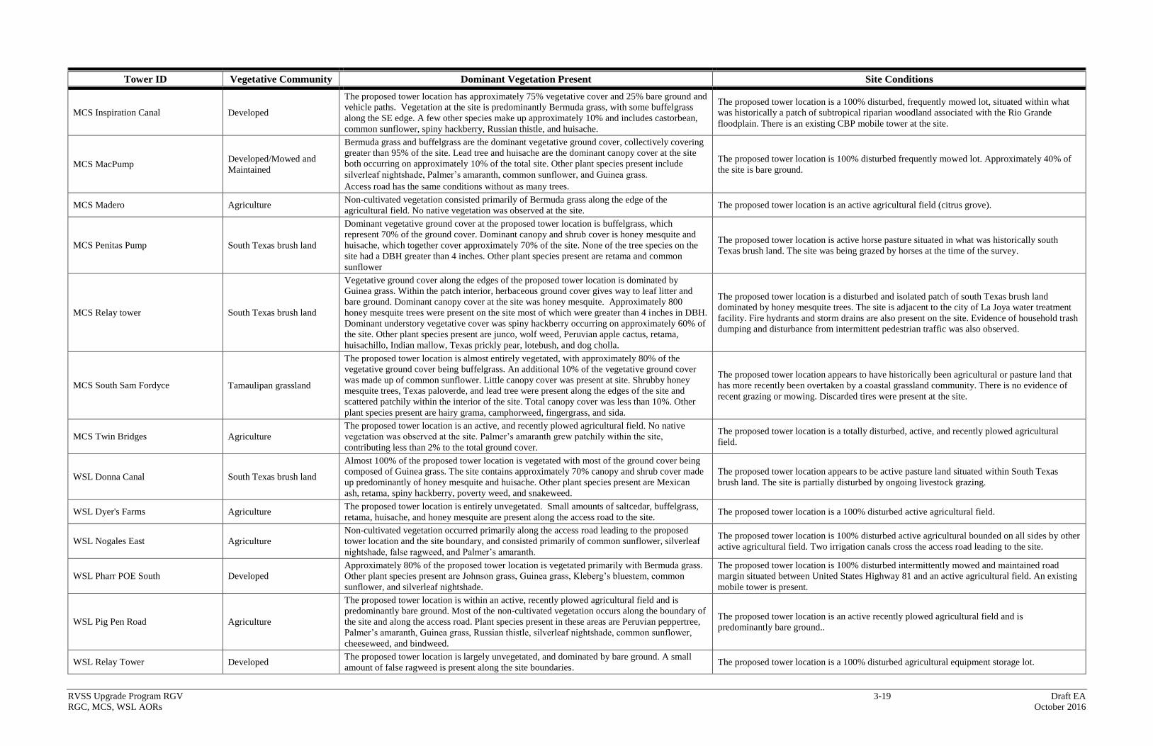
RVSS Upgrade Program RGV 3-19 Draft EA
RGC, MCS, WSL AORs October 2016
Tower ID Vegetative Community Dominant Vegetation Present Site Conditions
MCS Inspiration Canal Developed
The proposed tower location has approximately 75% vegetative cover and 25% bare ground and
vehicle paths. Vegetation at the site is predominantly Bermuda grass, with some buffelgrass
along the SE edge. A few other species make up approximately 10% and includes castorbean,
common sunflower, spiny hackberry, Russian thistle, and huisache.
The proposed tower location is a 100% disturbed, frequently mowed lot, situated within what
was historically a patch of subtropical riparian woodland associated with the Rio Grande
floodplain. There is an existing CBP mobile tower at the site.
MCS MacPump Developed/Mowed and
Maintained
Bermuda grass and buffelgrass are the dominant vegetative ground cover, collectively covering
greater than 95% of the site. Lead tree and huisache are the dominant canopy cover at the site
both occurring on approximately 10% of the total site. Other plant species present include
silverleaf nightshade, Palmer’s amaranth, common sunflower, and Guinea grass.
Access road has the same conditions without as many trees.
The proposed tower location is 100% disturbed frequently mowed lot. Approximately 40% of
the site is bare ground.
MCS Madero Agriculture Non-cultivated vegetation consisted primarily of Bermuda grass along the edge of the
agricultural field. No native vegetation was observed at the site. The proposed tower location is an active agricultural field (citrus grove).
MCS Penitas Pump South Texas brush land
Dominant vegetative ground cover at the proposed tower location is buffelgrass, which
represent 70% of the ground cover. Dominant canopy and shrub cover is honey mesquite and
huisache, which together cover approximately 70% of the site. None of the tree species on the
site had a DBH greater than 4 inches. Other plant species present are retama and common
sunflower
The proposed tower location is active horse pasture situated in what was historically south
Texas brush land. The site was being grazed by horses at the time of the survey.
MCS Relay tower South Texas brush land
Vegetative ground cover along the edges of the proposed tower location is dominated by
Guinea grass. Within the patch interior, herbaceous ground cover gives way to leaf litter and
bare ground. Dominant canopy cover at the site was honey mesquite. Approximately 800
honey mesquite trees were present on the site most of which were greater than 4 inches in DBH.
Dominant understory vegetative cover was spiny hackberry occurring on approximately 60% of
the site. Other plant species present are junco, wolf weed, Peruvian apple cactus, retama,
huisachillo, Indian mallow, Texas prickly pear, lotebush, and dog cholla.
The proposed tower location is a disturbed and isolated patch of south Texas brush land
dominated by honey mesquite trees. The site is adjacent to the city of La Joya water treatment
facility. Fire hydrants and storm drains are also present on the site. Evidence of household trash
dumping and disturbance from intermittent pedestrian traffic was also observed.
MCS South Sam Fordyce Tamaulipan grassland
The proposed tower location is almost entirely vegetated, with approximately 80% of the
vegetative ground cover being buffelgrass. An additional 10% of the vegetative ground cover
was made up of common sunflower. Little canopy cover was present at site. Shrubby honey
mesquite trees, Texas paloverde, and lead tree were present along the edges of the site and
scattered patchily within the interior of the site. Total canopy cover was less than 10%. Other
plant species present are hairy grama, camphorweed, fingergrass, and sida.
The proposed tower location appears to have historically been agricultural or pasture land that
has more recently been overtaken by a coastal grassland community. There is no evidence of
recent grazing or mowing. Discarded tires were present at the site.
MCS Twin Bridges Agriculture
The proposed tower location is an active, and recently plowed agricultural field. No native
vegetation was observed at the site. Palmer’s amaranth grew patchily within the site,
contributing less than 2% to the total ground cover.
The proposed tower location is a totally disturbed, active, and recently plowed agricultural
field.
WSL Donna Canal South Texas brush land
Almost 100% of the proposed tower location is vegetated with most of the ground cover being
composed of Guinea grass. The site contains approximately 70% canopy and shrub cover made
up predominantly of honey mesquite and huisache. Other plant species present are Mexican
ash, retama, spiny hackberry, poverty weed, and snakeweed.
The proposed tower location appears to be active pasture land situated within South Texas
brush land. The site is partially disturbed by ongoing livestock grazing.
WSL Dyer's Farms Agriculture The proposed tower location is entirely unvegetated. Small amounts of saltcedar, buffelgrass,
retama, huisache, and honey mesquite are present along the access road to the site. The proposed tower location is a 100% disturbed active agricultural field.
WSL Nogales East Agriculture
Non-cultivated vegetation occurred primarily along the access road leading to the proposed
tower location and the site boundary, and consisted primarily of common sunflower, silverleaf
nightshade, false ragweed, and Palmer’s amaranth.
The proposed tower location is 100% disturbed active agricultural bounded on all sides by other
active agricultural field. Two irrigation canals cross the access road leading to the site.
WSL Pharr POE South Developed
Approximately 80% of the proposed tower location is vegetated primarily with Bermuda grass.
Other plant species present are Johnson grass, Guinea grass, Kleberg’s bluestem, common
sunflower, and silverleaf nightshade.
The proposed tower location is 100% disturbed intermittently mowed and maintained road
margin situated between United States Highway 81 and an active agricultural field. An existing
mobile tower is present.
WSL Pig Pen Road Agriculture
The proposed tower location is within an active, recently plowed agricultural field and is
predominantly bare ground. Most of the non-cultivated vegetation occurs along the boundary of
the site and along the access road. Plant species present in these areas are Peruvian peppertree,
Palmer’s amaranth, Guinea grass, Russian thistle, silverleaf nightshade, common sunflower,
cheeseweed, and bindweed.
The proposed tower location is an active recently plowed agricultural field and is
predominantly bare ground..
WSL Relay Tower Developed The proposed tower location is largely unvegetated, and dominated by bare ground. A small
amount of false ragweed is present along the site boundaries. The proposed tower location is a 100% disturbed agricultural equipment storage lot.
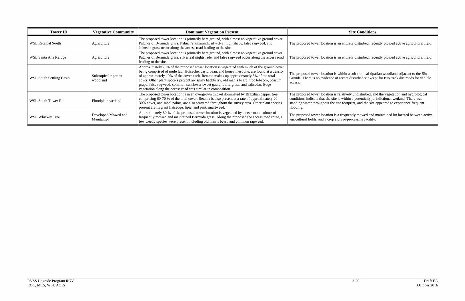
RVSS Upgrade Program RGV 3-20 Draft EA
RGC, MCS, WSL AORs October 2016
Tower ID Vegetative Community Dominant Vegetation Present Site Conditions
WSL Retamal South Agriculture
The proposed tower location is primarily bare ground, with almost no vegetative ground cover.
Patches of Bermuda grass, Palmer’s amaranth, silverleaf nightshade, false ragweed, and
Johnson grass occur along the access road leading to the site.
The proposed tower location is an entirely disturbed, recently plowed active agricultural field.
WSL Santa Ana Refuge Agriculture
The proposed tower location is primarily bare ground, with almost no vegetative ground cover.
Patches of Bermuda grass, silverleaf nightshade, and false ragweed occur along the access road
leading to the site.
The proposed tower location is an entirely disturbed, recently plowed active agricultural field.
WSL South Settling Basin Subtropical riparian
woodland
Approximately 70% of the proposed tower location is vegetated with much of the ground cover
being comprised of mule fat. Huisache, castorbean, and honey mesquite, are found at a density
of approximately 10% of the cover each. Retama makes up approximately 5% of the total
cover. Other plant species present are spiny hackberry, old man’s beard, tree tobacco, possum
grape, false ragweed, common sunflower sweet gaura, buffelgrass, and saltcedar. Edge
vegetation along the access road was similar in composition.
The proposed tower location is within a sub-tropical riparian woodland adjacent to the Rio
Grande. There is no evidence of recent disturbance except for two track dirt roads for vehicle
access.
WSL South Tower Rd Floodplain wetland
The proposed tower location is in an overgrown thicket dominated by Brazilian pepper tree
comprising 60-70 % of the total cover. Retama is also present at a rate of approximately 20-
30% cover, and sabal palms, are also scattered throughout the survey area. Other plant species
present are flagrant flatsedge, lipia, and pink smartweed.
The proposed tower location is relatively undisturbed, and the vegetation and hydrological
conditions indicate that the site is within a potentially jurisdictional wetland. There was
standing water throughout the site footprint, and the site appeared to experience frequent
flooding.
WSL Whiskey Tree Developed/Mowed and
Maintained
Approximately 80 % of the proposed tower location is vegetated by a near monoculture of
frequently mowed and maintained Bermuda grass. Along the proposed the access road route, a
few weedy species were present including old man’s beard and common ragweed.
The proposed tower location is a frequently mowed and maintained lot located between active
agricultural fields, and a crop storage/processing facility.
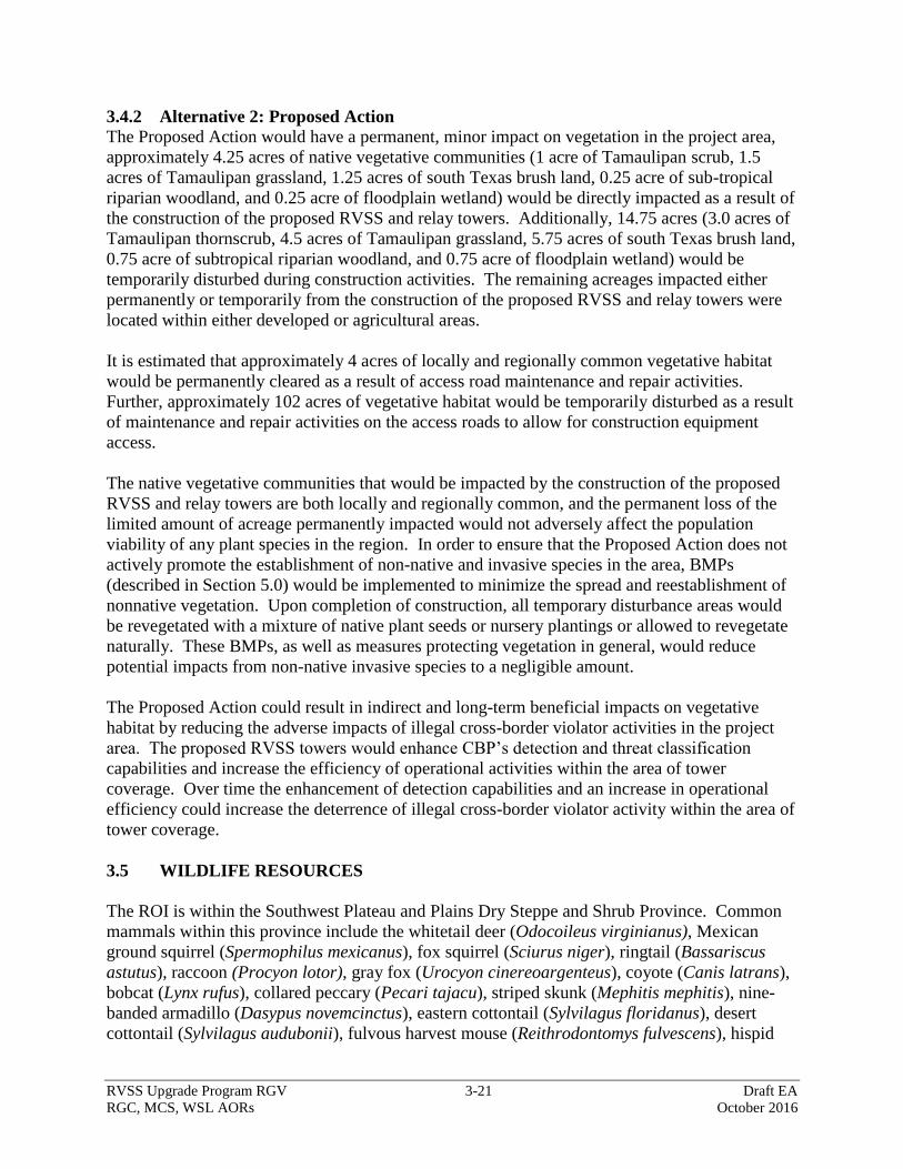
RVSS Upgrade Program RGV 3-21 Draft EA
RGC, MCS, WSL AORs October 2016
3.4.2 Alternative 2: Proposed Action
The Proposed Action would have a permanent, minor impact on vegetation in the project area,
approximately 4.25 acres of native vegetative communities (1 acre of Tamaulipan scrub, 1.5
acres of Tamaulipan grassland, 1.25 acres of south Texas brush land, 0.25 acre of sub-tropical
riparian woodland, and 0.25 acre of floodplain wetland) would be directly impacted as a result of
the construction of the proposed RVSS and relay towers. Additionally, 14.75 acres (3.0 acres of
Tamaulipan thornscrub, 4.5 acres of Tamaulipan grassland, 5.75 acres of south Texas brush land,
0.75 acre of subtropical riparian woodland, and 0.75 acre of floodplain wetland) would be
temporarily disturbed during construction activities. The remaining acreages impacted either
permanently or temporarily from the construction of the proposed RVSS and relay towers were
located within either developed or agricultural areas.
It is estimated that approximately 4 acres of locally and regionally common vegetative habitat
would be permanently cleared as a result of access road maintenance and repair activities.
Further, approximately 102 acres of vegetative habitat would be temporarily disturbed as a result
of maintenance and repair activities on the access roads to allow for construction equipment
access.
The native vegetative communities that would be impacted by the construction of the proposed
RVSS and relay towers are both locally and regionally common, and the permanent loss of the
limited amount of acreage permanently impacted would not adversely affect the population
viability of any plant species in the region. In order to ensure that the Proposed Action does not
actively promote the establishment of non-native and invasive species in the area, BMPs
(described in Section 5.0) would be implemented to minimize the spread and reestablishment of
nonnative vegetation. Upon completion of construction, all temporary disturbance areas would
be revegetated with a mixture of native plant seeds or nursery plantings or allowed to revegetate
naturally. These BMPs, as well as measures protecting vegetation in general, would reduce
potential impacts from non-native invasive species to a negligible amount.
The Proposed Action could result in indirect and long-term beneficial impacts on vegetative
habitat by reducing the adverse impacts of illegal cross-border violator activities in the project
area. The proposed RVSS towers would enhance CBP’s detection and threat classification
capabilities and increase the efficiency of operational activities within the area of tower
coverage. Over time the enhancement of detection capabilities and an increase in operational
efficiency could increase the deterrence of illegal cross-border violator activity within the area of
tower coverage.
3.5 WILDLIFE RESOURCES
The ROI is within the Southwest Plateau and Plains Dry Steppe and Shrub Province. Common
mammals within this province include the whitetail deer (Odocoileus virginianus), Mexican
ground squirrel (Spermophilus mexicanus), fox squirrel (Sciurus niger), ringtail (Bassariscus
astutus), raccoon (Procyon lotor), gray fox (Urocyon cinereoargenteus), coyote (Canis latrans),
bobcat (Lynx rufus), collared peccary (Pecari tajacu), striped skunk (Mephitis mephitis), nine-
banded armadillo (Dasypus novemcinctus), eastern cottontail (Sylvilagus floridanus), desert
cottontail (Sylvilagus audubonii), fulvous harvest mouse (Reithrodontomys fulvescens), hispid
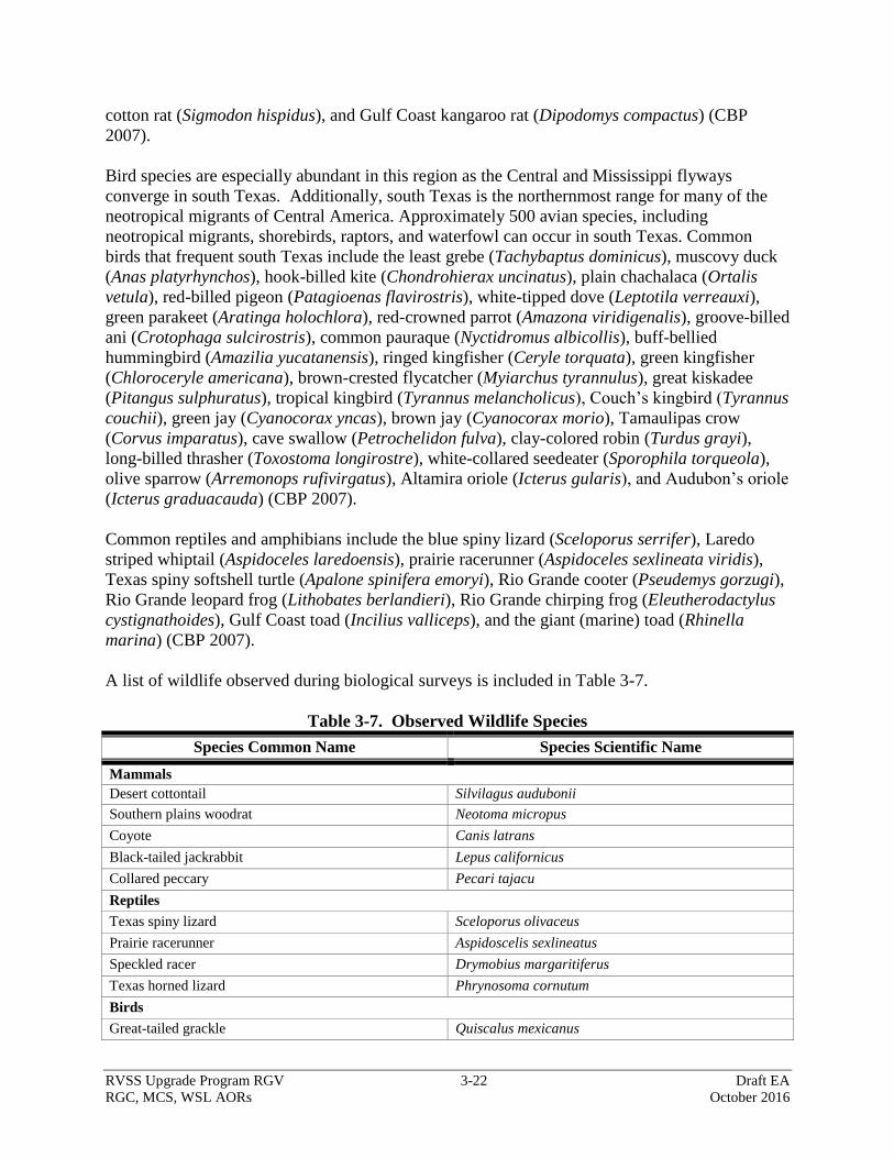
RVSS Upgrade Program RGV 3-22 Draft EA
RGC, MCS, WSL AORs October 2016
cotton rat (Sigmodon hispidus), and Gulf Coast kangaroo rat (Dipodomys compactus) (CBP
2007).
Bird species are especially abundant in this region as the Central and Mississippi flyways
converge in south Texas. Additionally, south Texas is the northernmost range for many of the
neotropical migrants of Central America. Approximately 500 avian species, including
neotropical migrants, shorebirds, raptors, and waterfowl can occur in south Texas. Common
birds that frequent south Texas include the least grebe (Tachybaptus dominicus), muscovy duck
(Anas platyrhynchos), hook-billed kite (Chondrohierax uncinatus), plain chachalaca (Ortalis
vetula), red-billed pigeon (Patagioenas flavirostris), white-tipped dove (Leptotila verreauxi),
green parakeet (Aratinga holochlora), red-crowned parrot (Amazona viridigenalis), groove-billed
ani (Crotophaga sulcirostris), common pauraque (Nyctidromus albicollis), buff-bellied
hummingbird (Amazilia yucatanensis), ringed kingfisher (Ceryle torquata), green kingfisher
(Chloroceryle americana), brown-crested flycatcher (Myiarchus tyrannulus), great kiskadee
(Pitangus sulphuratus), tropical kingbird (Tyrannus melancholicus), Couch’s kingbird (Tyrannus
couchii), green jay (Cyanocorax yncas), brown jay (Cyanocorax morio), Tamaulipas crow
(Corvus imparatus), cave swallow (Petrochelidon fulva), clay-colored robin (Turdus grayi),
long-billed thrasher (Toxostoma longirostre), white-collared seedeater (Sporophila torqueola),
olive sparrow (Arremonops rufivirgatus), Altamira oriole (Icterus gularis), and Audubon’s oriole
(Icterus graduacauda) (CBP 2007).
Common reptiles and amphibians include the blue spiny lizard (Sceloporus serrifer), Laredo
striped whiptail (Aspidoceles laredoensis), prairie racerunner (Aspidoceles sexlineata viridis),
Texas spiny softshell turtle (Apalone spinifera emoryi), Rio Grande cooter (Pseudemys gorzugi),
Rio Grande leopard frog (Lithobates berlandieri), Rio Grande chirping frog (Eleutherodactylus
cystignathoides), Gulf Coast toad (Incilius valliceps), and the giant (marine) toad (Rhinella
marina) (CBP 2007).
A list of wildlife observed during biological surveys is included in Table 3-7.
Table 3-7. Observed Wildlife Species
Species Common Name Species Scientific Name
Mammals
Desert cottontail Silvilagus audubonii
Southern plains woodrat Neotoma micropus
Coyote Canis latrans
Black-tailed jackrabbit Lepus californicus
Collared peccary Pecari tajacu
Reptiles
Texas spiny lizard Sceloporus olivaceus
Prairie racerunner Aspidoscelis sexlineatus
Speckled racer Drymobius margaritiferus
Texas horned lizard Phrynosoma cornutum
Birds
Great-tailed grackle Quiscalus mexicanus

RVSS Upgrade Program RGV 3-23 Draft EA
RGC, MCS, WSL AORs October 2016
Species Common Name Species Scientific Name
Common grackle Quiscalus quiscula
Couch’s kingbird Tyrannus couchii
Northern mockingbird Mimus polyglottos
Feral rock doves Columbina livia
Greater roadrunner Geococcyx californianus
Red-winged blackbird Agelaius phoeniceus
White-winged dove Zenaida asiatica
Pyrrhuloxia Cardinalis sinuatus
House finch Carpodacus mexicanus
Scissor-tailed flycatcher Tyrannus forficatus
Great kiskadee Pitangus sulphuratus
Mourning dove Zenaida macroura
Common ground dove Columbina passerina
Swainson's hawk Buteo swainsoni
Northern cardinal Cardinalis cardinalis
Cactus wren Campylorhynchus brunneicapillus
Killdeer Charadris vociferus
Black vulture Coragyps atratus
Northern bobwhite Colinus virginianus
Black-tailed gnatcatcher Polioptila melanura
Green jay Cyanocorax yncas
Turkey vulture Cathartes aura
Summer tanager Piranga rubra
Crested caracara Caracara cheriway
Great crested flycatcher Myiarchus crinitus
3.5.1 Alternative 1: No Action Alternative
Under the No Action Alternative, no direct impacts on wildlife resources would occur.
However, wildlife resources within the vicinity of the proposed RVSS and relay sites are directly
and indirectly affected by illegal cross-border violator pedestrian traffic and consequent law
enforcement activities. These areas experience damage to wildlife habitat, disturbance of
nesting/roosting areas and animals, and wildlife mortality from vehicle collision as result of these
activities. Under the No Action Alternative, USBP’s detection and threat classification
capabilities would not be enhanced and operational efficiency would not be improved within the
area of tower coverage, so illegal cross-border violator activities would continue to impact land
use in the project area.
3.5.2 Alternative 2: Proposed Action
The permanent loss of approximately 8.25 acres (4.25 acres [tower] + 4.0 acres [roads]) would
have a long-term, negligible impact and temporary degradation of approximately 132.25 acres of
the various vegetative habitats would have a short-term, minor impact on wildlife. Soil
disturbance and operation of heavy equipment could result in the direct loss of less mobile
individuals such as lizards, snakes, and ground-dwelling species such as mice and rats.
RVSS Upgrade Program RGV 3-24 Draft EA
RGC, MCS, WSL AORs October 2016
However, most wildlife would avoid any direct harm by escaping to surrounding habitat. The
direct degradation and loss of habitat could also impact burrows and nests, as well as cover,
forage, and other important wildlife resources. The loss of these resources would result in the
displacement of individuals that would then be forced to compete with other wildlife for the
remaining resources. Although this competition for resources could result in a reduction of total
population size, such a reduction would be extremely minimal in relation to total population size
and would not result in long-term effects on the sustainability of any wildlife species. The
wildlife habitat present in the project area is both locally and regionally common, and the
permanent loss of approximately 8.25 acres of wildlife habitat would not adversely affect the
population viability or fecundity of any wildlife species in the region. Upon completion of
construction, all temporary disturbance areas would be revegetated with a mixture of native plant
seeds or nursery plantings or allowed to revegetate naturally.
All RVSS and relay towers may have infrared lighting installed for aviation safety, and, if
installed, any such lighting would be compatible with NVG usage. All proposed RVSS and
relay tower sites may be lighted for security purposes. If installed, such lighting would consist of
a “porch light” on the tower shelter controlled by a motion detector. When installed, the light
would be shielded to avoid illumination outside the footprint of the tower site, and low-pressure
sodium bulbs would be used. USFWS (2000) Service Guidance on the Siting, Construction,
Operation and Decommissioning of Communications Towers and Recommendations for Design
and Construction of Cell Phone and Other Towers (USFWS 2008) would be implemented to
reduce nighttime atmospheric lighting and the potential adverse effects of nighttime lighting on
migratory bird and nocturnal flying species.
Noise associated with RVSS and relay towers and access drive construction, access road
maintenance and repair would result in temporary, negligible impacts on wildlife. Elevated
noise levels associated with construction and maintenance activities would occur. The effects of
this disturbance would include temporary avoidance of work areas and competition for
unaffected resources. BMPs as outlined in Section 5.0 would reduce noise associated with
operation of heavy equipment.
Noise levels associated with the operation and maintenance of the towers would have a
permanent, negligible impact on wildlife species. The permanent increase in noise levels
associated with operation of the proposed tower sites (i.e., generators) would be sporadic, only
occurring when this equipment is operating. Noise levels would be approximately 57 A-
weighted decibels (dBA) at approximately 40 feet from the generator. It is anticipated that
wildlife would become accustomed to these intermittent and minimal increases in noise and that
subsequent avoidance of tower sites and any adjacent habitats would be minor.
There is a possibility that the proposed RVSS and relay towers could pose hazards to migratory
birds and even some bird mortality through bird strikes with the towers or possibly guy wires on
relocatable towers. The loss of a few individual birds from the tower operation would not
adversely affect the population viability or fecundity of bird species in the region. The number
and extent of bird strikes in relation to the size of migratory bird populations and the extent of
the migratory flyway would be minor and would not affect sustainability of migratory bird
RVSS Upgrade Program RGV 3-25 Draft EA
RGC, MCS, WSL AORs October 2016
populations in the region. The Proposed Action would, however, have a long-term, negligible
adverse effect on migratory birds.
BMPs would be implemented to reduce disturbance and loss of wildlife such as surveys prior to
construction activities scheduled during nesting season and covering or providing an escape
ramp for all steep-walled holes or trenches left open at the end of the construction workday. If
relocatable towers are constructed, any guy wires would have visual markers on them to alert
birds of the wires presence. The proposed RVSS and relay towers could provide raptor perch and
nesting sites, but BMPs would also be used to discourage this activity.
3.6 THREATENED AND ENDANGERED SPECIES
The ESA was enacted to provide a program for the preservation of endangered and threatened
species and to provide protection for the ecosystems upon which these species depend for their
survival. All Federal agencies are required to implement protective measures for designated
species and to use their authorities to further the purposes of the ESA. The Secretary of the
Interior and the Secretary of Commerce (marine species) are responsible for the identification of
threatened or endangered species and development of any potential recovery plan. USFWS is
the primary agency responsible for implementing the ESA, and is responsible for birds and other
terrestrial and freshwater species. USFWS responsibilities under the ESA include (1) the
identification of threatened and endangered species; (2) the identification of critical habitats for
listed species; (3) implementation of research on, and recovery efforts for, these species; and (4)
consultation with other Federal agencies concerning measures to avoid harm to listed species.
An endangered species is a species officially recognized by USFWS as being in danger of
extinction throughout all or a significant portion of its range. A threatened species is a species
likely to become endangered within the foreseeable future throughout all or a significant portion
of its range. Proposed species are those that have been formally submitted to Congress for
official listing as threatened or endangered. Species may be considered eligible for listing as
endangered or threatened when any of the five following criteria occur: (1) current/imminent
destruction, modification, or curtailment of their habitat or range; (2) overuse of the species for
commercial, recreational, scientific, or educational purposes; (3) disease or predation; (4)
inadequacy of existing regulatory mechanisms; and (5) other natural or human-induced factors
affecting their continued existence.
In addition, USFWS has identified species that are candidates for listing as a result of identified
threats to their continued existence. The candidate designation includes those species for which
USFWS has sufficient information to support proposals to list as endangered or threatened under
the ESA; however, proposed rules have not yet been issued because such actions are precluded at
present by other listing activity. Although not afforded protection by the ESA, candidate species
may be protected under other Federal or state laws.
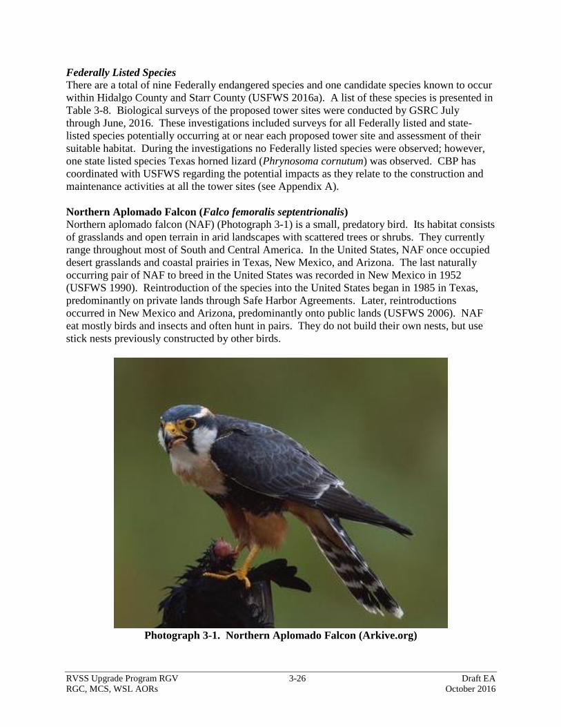
RVSS Upgrade Program RGV 3-26 Draft EA
RGC, MCS, WSL AORs October 2016
Federally Listed Species
There are a total of nine Federally endangered species and one candidate species known to occur
within Hidalgo County and Starr County (USFWS 2016a). A list of these species is presented in
Table 3-8. Biological surveys of the proposed tower sites were conducted by GSRC July
through June, 2016. These investigations included surveys for all Federally listed and state-
listed species potentially occurring at or near each proposed tower site and assessment of their
suitable habitat. During the investigations no Federally listed species were observed; however,
one state listed species Texas horned lizard (Phrynosoma cornutum) was observed. CBP has
coordinated with USFWS regarding the potential impacts as they relate to the construction and
maintenance activities at all the tower sites (see Appendix A).
Northern Aplomado Falcon (Falco femoralis septentrionalis)
Northern aplomado falcon (NAF) (Photograph 3-1) is a small, predatory bird. Its habitat consists
of grasslands and open terrain in arid landscapes with scattered trees or shrubs. They currently
range throughout most of South and Central America. In the United States, NAF once occupied
desert grasslands and coastal prairies in Texas, New Mexico, and Arizona. The last naturally
occurring pair of NAF to breed in the United States was recorded in New Mexico in 1952
(USFWS 1990). Reintroduction of the species into the United States began in 1985 in Texas,
predominantly on private lands through Safe Harbor Agreements. Later, reintroductions
occurred in New Mexico and Arizona, predominantly onto public lands (USFWS 2006). NAF
eat mostly birds and insects and often hunt in pairs. They do not build their own nests, but use
stick nests previously constructed by other birds.
Photograph 3-1. Northern Aplomado Falcon (Arkive.org)
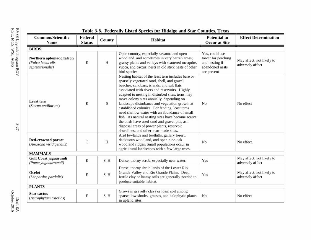
RV
SS
Up
grad
e Pro
gram
RG
V
3-2
7
Draft E
A
RG
C, M
CS
, WS
L A
OR
s
Octo
ber 2
01
6
Table 3-8. Federally Listed Species for Hidalgo and Star Counties, Texas
Common/Scientific
Name
Federal
Status County Habitat
Potential to
Occur at Site
Effect Determination
BIRDS
Northern aplomado falcon
(Falco femoralis
septentrionalis)
E H
Open country, especially savanna and open
woodland, and sometimes in very barren areas;
grassy plains and valleys with scattered mesquite,
yucca, and cactus; nests in old stick nests of other
bird species.
Yes, could use
tower for perching
and nesting if
abandoned nests
are present
May affect, not likely to
adversely affect
Least tern
(Sterna antillarum) E S
Nesting habitat of the least tern includes bare or
sparsely vegetated sand, shell, and gravel
beaches, sandbars, islands, and salt flats
associated with rivers and reservoirs. Highly
adapted to nesting in disturbed sites, terns may
move colony sites annually, depending on
landscape disturbance and vegetation growth at
established colonies. For feeding, least terns
need shallow water with an abundance of small
fish. As natural nesting sites have become scarce,
the birds have used sand and gravel pits, ash
disposal areas of power plants, reservoir
shorelines, and other man-made sites.
No No effect
Red-crowned parrot
(Amazona viridigenalis) C H
Arid lowlands and foothills, gallery forest,
deciduous woodland, and open pine-oak
woodland ridges. Small populations occur in
agricultural landscapes with a few large trees.
No No effect.
MAMMALS
Gulf Coast jaguarundi
(Puma yagouaroundi) E S, H Dense, thorny scrub, especially near water. Yes
May affect, not likely to
adversely affect
Ocelot
(Leopardus pardalis) E S, H
Dense, thorny shrub lands of the Lower Rio
Grande Valley and Rio Grande Plains. Deep,
fertile clay or loamy soils are generally needed to
produce suitable habitat.
Yes May affect, not likely to
adversely affect
PLANTS
Star cactus
(Astrophytum asterias) E S, H
Grows in gravelly clays or loam soil among
sparse, low shrubs, grasses, and halophytic plants
in upland sites.
No No effect
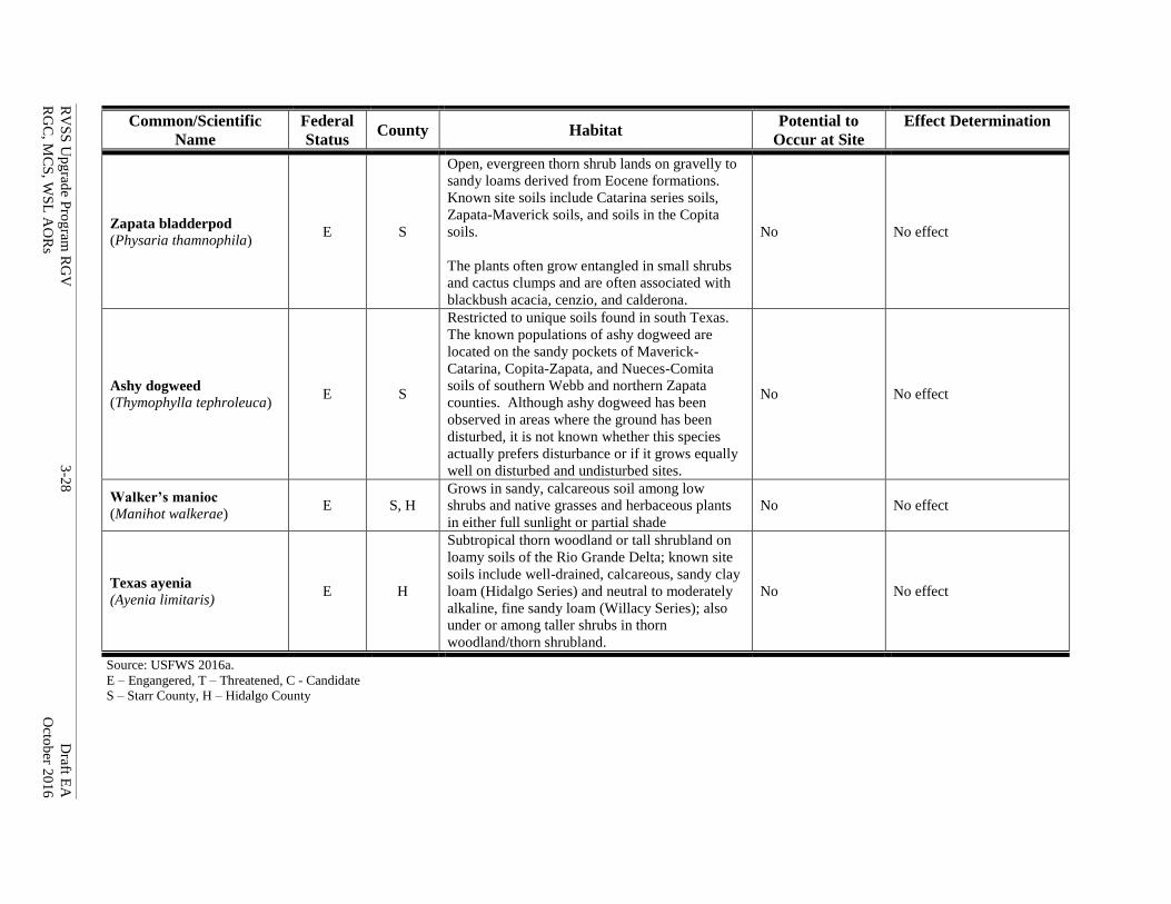
RV
SS
Up
grad
e Pro
gram
RG
V
3-2
8
Draft E
A
RG
C, M
CS
, WS
L A
OR
s
Octo
ber 2
01
6
Common/Scientific
Name
Federal
Status County Habitat
Potential to
Occur at Site
Effect Determination
Zapata bladderpod
(Physaria thamnophila) E S
Open, evergreen thorn shrub lands on gravelly to
sandy loams derived from Eocene formations.
Known site soils include Catarina series soils,
Zapata-Maverick soils, and soils in the Copita
soils.
The plants often grow entangled in small shrubs
and cactus clumps and are often associated with
blackbush acacia, cenzio, and calderona.
No No effect
Ashy dogweed
(Thymophylla tephroleuca) E S
Restricted to unique soils found in south Texas.
The known populations of ashy dogweed are
located on the sandy pockets of Maverick-
Catarina, Copita-Zapata, and Nueces-Comita
soils of southern Webb and northern Zapata
counties. Although ashy dogweed has been
observed in areas where the ground has been
disturbed, it is not known whether this species
actually prefers disturbance or if it grows equally
well on disturbed and undisturbed sites.
No No effect
Walker’s manioc
(Manihot walkerae) E S, H
Grows in sandy, calcareous soil among low
shrubs and native grasses and herbaceous plants
in either full sunlight or partial shade
No No effect
Texas ayenia
(Ayenia limitaris) E H
Subtropical thorn woodland or tall shrubland on
loamy soils of the Rio Grande Delta; known site
soils include well-drained, calcareous, sandy clay
loam (Hidalgo Series) and neutral to moderately
alkaline, fine sandy loam (Willacy Series); also
under or among taller shrubs in thorn
woodland/thorn shrubland.
No No effect
Source: USFWS 2016a.
E – Engangered, T – Threatened, C - Candidate
S – Starr County, H – Hidalgo County
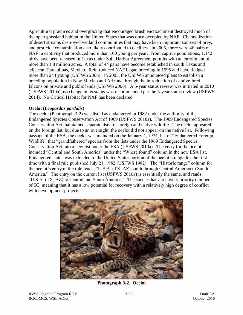
RVSS Upgrade Program RGV 3-29 Draft EA
RGC, MCS, WSL AORs October 2016
Agricultural practices and overgrazing that encouraged brush encroachment destroyed much of
the open grassland habitat in the United States that was once occupied by NAF. Channelization
of desert streams destroyed wetland communities that may have been important sources of prey,
and pesticide contamination also likely contributed to declines. In 2005, there were 46 pairs of
NAF in captivity that produced more than 100 young per year. From captive populations, 1,142
birds have been released in Texas under Safe Harbor Agreement permits with an enrollment of
more than 1.8 million acres. A total of 44 pairs have become established in south Texas and
adjacent Tamaulipas, Mexico. Reintroduced NAF began breeding in 1995 and have fledged
more than 244 young (USFWS 2006). In 2005, the USFWS announced plans to establish a
breeding population in New Mexico and Arizona through the introduction of captive-bred
falcons on private and public lands (USFWS 2006). A 5-year status review was initiated in 2010
(USFWS 2010a), no change in its status was recommended per the 5-year status review (USFWS
2014). No Critical Habitat for NAF has been declared.
Ocelot (Leopardus pardalis)
The ocelot (Photograph 3-2) was listed as endangered in 1982 under the authority of the
Endangered Species Conservation Act of 1969 (USFWS 2010a). The 1969 Endangered Species
Conservation Act maintained separate lists for foreign and native wildlife. The ocelot appeared
on the foreign list, but due to an oversight, the ocelot did not appear on the native list. Following
passage of the ESA, the ocelot was included on the January 4, 1974, list of “Endangered Foreign
Wildlife” that “grandfathered” species from the lists under the 1969 Endangered Species
Conservation Act into a new list under the ESA (USFWS 2010a). The entry for the ocelot
included “Central and South America” under the “Where found” column in the new ESA list.
Endangered status was extended to the United States portion of the ocelot’s range for the first
time with a final rule published July 21, 1982 (USFWS 1982). The “Historic range” column for
the ocelot’s entry in the rule reads, “U.S.A. (TX, AZ) south through Central America to South
America.” The entry on the current list (USFWS 2010a) is essentially the same, and reads
“U.S.A. (TX, AZ) to Central and South America”. The species has a recovery priority number
of 5C, meaning that it has a low potential for recovery with a relatively high degree of conflict
with development projects.
Photograph 3-2. Ocelot

RVSS Upgrade Program RGV 3-30 Draft EA
RGC, MCS, WSL AORs October 2016
The ocelot is a medium-sized spotted cat with nocturnal habits (USFWS 2010a). The ocelot
belongs to the genus Leopardus, which also includes the margay and the oncilla. The ocelot is
further divided into as many as 11 subspecies that ranged from the southwestern United States to
northern Argentina (USFWS 1990). Two subspecies occurred in the United States: the
Texas/Tamaulipas ocelot (L. p. albescens) and the Arizona/Sonora ocelot (L. p. sonoriensis)
(USFWS 2010b).
The ocelot uses a wide range of habitats throughout its range in the Western Hemisphere
(USFWS 2010a). Despite this, the species does not appear to be a habitat generalist. Ocelot
spatial patterns are strongly linked to dense cover or vegetation, suggesting that it uses a fairly
narrow range of microhabitats (USFWS 2010a). South Texas ocelots prefer shrub communities
with greater than 95 percent canopy cover and avoids areas with intermediate (50 to 75 percent)
to no canopy cover (USFWS 2010a). Ocelots do not prefer or avoid communities with 75 to 95
percent canopy cover. Other microhabitat features important to ocelots appear to be canopy
height (greater than 7.8 feet) and vertical cover (89 percent visual obscurity at 3 to 6 feet).
Ground cover at locations used by ocelots was characterized by a high percentage of coarse
woody debris (50 percent) and very little herbaceous ground cover (3 percent), both
consequences of the dense woody canopy (USFWS 2010a). Between 1980 and 2010 the ocelot
was documented by photographs or specimen in Cameron, Willacy, Kenedy, Hidalgo, and Jim
Wells counties (USFWS 2010a). Currently, the Texas population of ocelots is believed to be
fewer than 50 individuals, composing two separated populations in south Texas. The Laguna
Atoscosa National Wildlife Refuge primarily supports one of these populations and the other
occurs in Willacy and Kenedy counties on private ranches (USFWS 2010a). Individuals
occurring in Texas outside these areas are occasionally observed but are likely wandering or
released and not part of a breeding population. A third population of the Texas subspecies of
ocelot occurs in Tamaulipas, Mexico, but is geographically isolated from ocelots in Texas.
Genetic evidence shows little or no recent genetic exchange between these populations (USFWS
2010b). A separate subspecies of ocelot is occasionally found in southern Arizona but is disjunct
from populations in Texas.
Gulf Coast Jaguarundi (Puma yagouaroundi)
The Gulf Coast subspecies of jaguarundi (Photograph 3-3) was listed under the ESA as
endangered in 1976 (41 FR 24062). The jaguarundi is a small cat, slightly larger than a house
cat (Felis catus). With a slender build, long neck, short legs, small and flattened head, and long
tail, it resembles a weasel (Mustela sp.) more than other felines (USFWS 2013b).
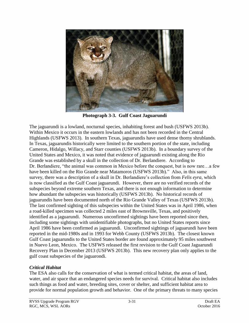
RVSS Upgrade Program RGV 3-31 Draft EA
RGC, MCS, WSL AORs October 2016
Photograph 3-3. Gulf Coast Jaguarundi
The jaguarundi is a lowland, nocturnal species, inhabiting forest and bush (USFWS 2013b).
Within Mexico it occurs in the eastern lowlands and has not been recorded in the Central
Highlands (USFWS 2013). In southern Texas, jaguarundis have used dense thorny shrublands.
In Texas, jaguarundis historically were limited to the southern portion of the state, including
Cameron, Hidalgo, Willacy, and Starr counties (USFWS 2013b). In a boundary survey of the
United States and Mexico, it was noted that evidence of jaguarundi existing along the Rio
Grande was established by a skull in the collection of Dr. Berlandiere. According to
Dr. Berlandiere, “the animal was common in Mexico before the conquest, but is now rare…a few
have been killed on the Rio Grande near Matamoros (USFWS 2013b).” Also, in this same
survey, there was a description of a skull in Dr. Berlandiere’s collection from Felis eyra, which
is now classified as the Gulf Coast jaguarundi. However, there are no verified records of the
subspecies beyond extreme southern Texas, and there is not enough information to determine
how abundant the subspecies was historically (USFWS 2013b). No historical records of
jaguarundis have been documented north of the Rio Grande Valley of Texas (USFWS 2013b).
The last confirmed sighting of this subspecies within the United States was in April 1986, when
a road-killed specimen was collected 2 miles east of Brownsville, Texas, and positively
identified as a jaguarundi. Numerous unconfirmed sightings have been reported since then,
including some sightings with unidentifiable photographs, but no United States reports since
April 1986 have been confirmed as jaguarundi. Unconfirmed sightings of jaguarundi have been
reported in the mid-1980s and in 1993 for Webb County (USFWS 2013b). The closest known
Gulf Coast jaguarundis to the United States border are found approximately 95 miles southwest
in Nuevo Leon, Mexico. The USFWS released the first revision to the Gulf Coast Jaguarundi
Recovery Plan in December 2013 (USFWS 2013b). This new recovery plan only applies to the
gulf coast subspecies of the jaguarondi.
Critical Habitat
The ESA also calls for the conservation of what is termed critical habitat, the areas of land,
water, and air space that an endangered species needs for survival. Critical habitat also includes
such things as food and water, breeding sites, cover or shelter, and sufficient habitat area to
provide for normal population growth and behavior. One of the primary threats to many species
RVSS Upgrade Program RGV 3-32 Draft EA
RGC, MCS, WSL AORs October 2016
is the destruction or modification of essential habitat by uncontrolled land and water
developments.
Zapata’s bladderpod (Physaira thamnophila) has designated critical habitat units in Texas. On
December 22, 2000, the USFWS designated seven tracts within the Lower Rio Grande National
Wildlife Refuge (USFWS 2004). A total of 5,160 acres of habitat has been designated as Critical
Habitat. All of the designated Critical Habitat for the Zapata bladderpod occurs in Starr County
with seven of the eight units occurring on the Lower Rio Grande Valley Wildlife Refuge
properties. The lone unit not on USFWS property consists of a 1.36-acre tract of private lands.
These units include the Cuellar, Chapeno, and Arroyo Morteros Tracts located south and
southwest of the Falcon Heights subdivision; the Las Ruinas, Los Negros, and Arroyo Ramirez
Tracts located west and northwest of the city of Roma; and the La Puerta Tract located southeast
of Rio Grande City.
State-Listed Species
TPWD lists several state-listed species that may also occur near the various project areas in Starr
and Hidalgo counties. The only state-listed species observed during biological surveys was the
Texas horned lizard (Phrynosoma cornutum), which is listed as threatened (TPWD 2016).
Appendix C has a complete list of all state-listed species with the potential to occur in Starr and
Hidalgo counties.
3.6.1 Alternative 1: No Action Alternative
Under the No Action Alternative, there would be no direct impacts on threatened or endangered
species or their habitats as no construction activities would occur. However, the direct and long-
term impacts of illegal border activities throughout the project area and surrounding areas would
continue to disturb threatened or endangered species and their habitats. Cross-border violator
activities create trails, damage vegetation, promote the dispersal and establishment of invasive
species and can result in catastrophic wildfires. These actions have an indirect adverse impact on
threatened and endangered species by causing harm to individuals and degrading habitats
occupied by these species.
3.6.2 Alternative 2: Proposed Action
Three Federally listed species (ocelot, jaguarundi, and NAF) have the potential to occur within
the project area. Based on the information outlined below, the Proposed Action may affect, but
is not likely to adversely affect, any of the three Federally listed or candidate species and would
not adversely modify designated critical habitat for the Zapata bladderpod. Section 7
consultation with USFWS is ongoing. Only one state-listed species, Texas horned lizard, was
observed within the project area and this species can easily avoid harm during tower
construction.
Northern Aplomado Falcon
No adverse effects on NAF are anticipated, because no nesting habitat for NAF would be
impacted, limited feeding habitat would be altered, and measures to reduce potential impacts
would be implemented. Increased human activity and traffic associated with construction or
operation of equipment would potentially disturb NAF, causing them to take flight and depart the
immediate area. After construction and installation, monthly maintenance visits, propane
RVSS Upgrade Program RGV 3-33 Draft EA
RGC, MCS, WSL AORs October 2016
deliveries, and the activity of generators would similarly disturb nearby NAF. These
disturbances would likely be discountable because they would be short in duration and limited in
their area of effect. NAF are a highly mobile species that would easily relocate a short distance
from such disturbances. However, effects would be greater if a NAF nest were to occur in the
immediate area. To minimize the likelihood of this possibility, biologists inspected each site for
any sign of NAF or nests, and none were detected. Additionally, if construction occurs during
the nesting season, a biologist would survey the tower site and adjacent area for signs of nesting
NAF and any active nest would be avoided. Additionally, if relocatable towers are used and guy
wires are installed, those guy wires would be outfitted with visual markers alerting the birds to
their presence.
NAF could potentially perch on towers, and the threat of striking the towers while flying exists.
However, implementation of BMPs recommended by USFWS (2000) would greatly reduce the
likelihood of such impacts. These recommendations include adjustments to lighting to reduce
the likelihood of bird strike, anti-perching devices, and visual markers. These measures would
also minimize impacts on other bird species that are prey for NAF. NAF are visual predators,
diurnally active, and agile in flight, so it is assumed they would be able to see and avoid towers
that might be in their flight path. Therefore, the Proposed Action may affect, but is not likely to
adversely affect, NAF.
Ocelot and Gulf Coast Jaguarundi
A total of 10 proposed tower sites (RGC Inside Mustang Gate Chapeno, RGC North of Bench
Landing Salineno, RGC South of Blue and White Pipes, RGC Papa Hill, RGC Azteca, RGC
North of Gar Starr Crossover, RGC South Sam Fordyce, WSL South Settling Basin, WSL South
Tower Road, and WSL Donna Canal) occur within or near suitable habitat for the ocelot and
jaguarundi. Clearing of potential habitat would occur at nine of the sites where approximately
0.25 acre of potential habitat would be permanently cleared at each site. No potential habitat
would be cleared at the RGC Azteca site, because the proposed tower site is located in an open
area devoid of shrubby vegetation; however, potential habitat occurs nearby.
In addition to clearing, the installation of equipment would create disturbances for a maximum of
60 days at each site during the construction period. Most of these disturbances would be limited
to the area immediately around the tower. When heavy equipment is in use noise would travel a
maximum of 1,138 feet from the tower site before attenuating to a noise level of 57 A-weighted
decibel (dBA). Since the cats are highly mobile, nocturnal species, and wary of human
disturbance, they would likely avoid the disturbed area without significant adverse effects on
their health. Construction activities would be limited to daytime hours; therefore, further
reducing the likelihood of adversely impacting either species. Maintenance activities and noise
from generators or other equipment would periodically cause disturbance in the area around the
proposed tower locations; however, the noise emissions would also be very limited in duration
(most likely 10 to 15 minutes per month for the operation of a generator) and the noise
disturbance would be 47 dBA at 50 feet from the source. Additionally, light pollution in the
form of spotlights and noise disturbance in the form of loud-hailers used during operational
activities around and near tower sites after construction would create a periodic disturbance.
However, spotlight and loud-hailer use would be intermittent and of very limited duration and
would likely only occur during detections of illegal cross-border violators. Approximately 2.25
RVSS Upgrade Program RGV 3-34 Draft EA
RGC, MCS, WSL AORs October 2016
acres of habitat would be permanently modified as a result of construction activity and
disturbance would be limited in duration and area. Habitat is regionally common and only small
areas spread throughout a vast geographic area would be impacted, additionally the project
would decrease habitat trampling activity of illegal cross border violators. Therefore, the
Proposed Action may affect, but is not likely to adversely affect, the ocelot and jaguarundi.
State-Listed Species
TPWD lists several state-listed species that may occur near the various project areas in Starr and
Hidalgo counties. Under the Proposed Action, approximately 4.25 acres of native habitat will be
permanently impacted and approximately 14.75 acres of potential habitat would be temporarily
impacted during tower construction and maintenance. Mobile species such as the Texas horned
lizard and Texas indigo snake (Drymarchon melanurus) may be temporarily displaced by tower
construction and maintenance activities, however these highly mobile species typically utilize
large expanses of suitable habitat and the effects of disturbance and alterations to small segments
are likely to be minimal to negligible to populations of these species. Grubbing, digging,
clearing, or ground-leveling activities at tower sites and along access roads may result in the
incidental take of some individuals of more sedentary state-listed species such as the Texas
tortoise (Gopherus berlandieri). The direct impacts on sedentary state-listed species would be
negligible due to the BMPs to be implemented and because of the limited amount of disturbance
to habitat relative to the amount of similar habitats within the ROI.
The Proposed Action could result in indirect and long-term beneficial impacts on Federally listed
and state-listed species by reducing the adverse impacts of illegal cross-border violator activities
in the project area. The proposed RVSS towers would enhance CBP’s detection and threat
classification capabilities and increase the efficiency of operational activities within the area of
tower coverage. Over time the enhancement of detection capabilities and an increase in
operational efficiency could increase the deterrence of illegal cross-border violator activity
within the area of tower coverage.
3.7 GROUNDWATER
The major aquifer within the ROI is the Gulf Coast Aquifer, which parallels the Gulf of Mexico
coastline from the western boundary of Louisiana to Mexico. This aquifer covers over 41,800
square miles with an annual use of approximately 1.1 million acre-feet. The Gulf Coast Aquifer
is found in all of Hidalgo County and most of Starr County. Within the Gulf Coast Aquifer lie
several other aquifers including the Jasper, Evangeline, and Chicot aquifers. These aquifers are
composed of discontinuous sand, silt, clay, and gravel beds. The upper portion of the Gulf Coast
Aquifer is generally fresher with saline levels increasing as the aquifer trends southward towards
Mexico. The aquifer is generally used for municipal, industrial, and agricultural purposes (Texas
Water Development Board [TWDB] 2011). Recharge of the Gulf Coast Aquifer occurs
primarily through percolation of precipitation and is supplemented in some areas by the addition
of irrigation water from the Rio Grande. Within Starr and Hidalgo counties the available
groundwater from the Gulf Coast Aquifer is estimated to be approximately 7,400 acre-feet per
year (TWDB 2016). It should be noted that groundwater is not a significant source of water
within southern Starr or Hidalgo counties; surface water from the Rio Grande is the major water
supply source.
RVSS Upgrade Program RGV 3-35 Draft EA
RGC, MCS, WSL AORs October 2016
The other aquifer found in the ROI, which is classified as a minor aquifer, is the Yegua-Jackson
Aquifer. The Yegua-Jackson Aquifer is found along the western boundary of the Gulf Coast
Aquifer from the Texas/Louisiana border to Mexico but only covers approximately 10,900
square miles. The western portion of Starr County is located in this aquifer (Starr County
Groundwater Conservation District [GCD] 2013).
3.7.1 Alternative 1: No Action Alternative
Under the No Action Alternative, no additional impacts on groundwater resources would occur
as a result of constructing the proposed RVSS and relay towers, constructing access drives, or
improving access roads.
3.7.2 Alternative 2: Proposed Action
Under the Proposed Action, water needed for construction activities would be obtained from
surface water sources. All water would be supplied to the construction sites either by a water
truck or nearby hydrant. BMPs would be in place in case of an accidental spill of oil, petroleum,
or lubricants from the water trucks to prevent this spill from entering the groundwater.
Therefore, the Proposed Action would have negligible impacts on groundwater resources within
the region.
3.8 SURFACE WATER AND WATERS OF THE U.S.
The Clean Water Act (CWA) §303[d][1][A] requires that each state monitor surface waters and
compile a "303[d] List" of impaired streams and lakes. The proposed towers sites and associated
roads are located across extreme southern Texas and are located in the Rio Grande and Nueces-
Rio Grande Coastal Basins. The Rio Grande Basin enters Texas at El Paso and travel 1,248
miles to the Gulf of Mexico forming the international boundary between the United States and
Mexico. It is estimated that within Texas approximately 48,259 square miles drain into surface
waters that eventually flow to the Gulf of Mexico. The Nueces-Rio Grande Coastal Basin lies on
the coastal plain between the Nueces River and the Rio Grande, and drains into the Laguna
Madre, Baffin Bay, and Oso Bay. The total drainage area is approximately 10,442 square miles
(TCEQ 2016). The TCEQ 2014 303(d) report lists three stream reaches near the proposed tower
sites. The closest impaired streams to the project areas are the Arroyo Los Olmos in Starr
County, the Rio Grande Below Falcon Reservoir, and the Arroyo Colorado Above Tidal in
Hidalgo County. Table 3-9 provides information on the impaired waterbodies near the various
RVSS tower sites.
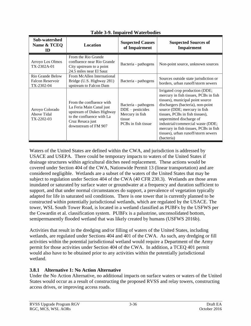
RVSS Upgrade Program RGV 3-36 Draft EA
RGC, MCS, WSL AORs October 2016
Table 3-9. Impaired Waterbodies
Sub-watershed
Name & TCEQ
ID
Location Suspected Causes
of Impairment
Suspected Sources of
Impairment
Arroyo Los Olmos
TX-2302A-01
From the Rio Grande
confluence near Rio Grande
City upstream to a point
24.5 miles near El Sauz
Bacteria - pathogens Non-point source, unknown sources
Rio Grande Below
Falcon Reservoir
TX-2302-04
From McAllen International
Bridge (U.S. Highway 281)
upstream to Falcon Dam
Bacteria - pathogens Sources outside state jurisdiction or
borders, urban runoff/storm sewers
Arroyo Colorado
Above Tidal
TX-2202-03
From the confluence with
La Feria Main Canal just
upstream of Dukes Highway
to the confluence with La
Cruz Resaca just
downstream of FM 907
Bacteria - pathogens
DDE – pesticides
Mercury in fish
tissue
PCBs in fish tissue
Irrigated crop production (DDE;
mercury in fish tissues, PCBs in fish
tissues), municipal point source
dischargers (bacteria), non-point
source (DDE; mercury in fish
tissues, PCBs in fish tissues),
unpermitted discharge of
industrial/commercial waste (DDE;
mercury in fish tissues, PCBs in fish
tissues), urban runoff/storm sewers
(bacteria)
Waters of the United States are defined within the CWA, and jurisdiction is addressed by
USACE and USEPA. There could be temporary impacts to waters of the United States if
drainage structures within agricultural ditches need replacement. These actions would be
covered under Section 404 of the CWA, Nationwide Permit 13 (linear transportation) and are
considered negligible. Wetlands are a subset of the waters of the United States that may be
subject to regulation under Section 404 of the CWA (40 CFR 230.3). Wetlands are those areas
inundated or saturated by surface water or groundwater at a frequency and duration sufficient to
support, and that under normal circumstances do support, a prevalence of vegetation typically
adapted for life in saturated soil conditions. There is one tower that is currently planned to be
constructed within potentially jurisdictional wetlands, which are regulated by the USACE. The
tower, WSL South Tower Road, is located in a wetland classified as PUBFx by the USFWS per
the Cowardin et al. classification system. PUBFx is a palustrine, unconsolidated bottom,
semipermanently flooded wetland that was likely created by humans (USFWS 2016b).
Activities that result in the dredging and/or filling of waters of the United States, including
wetlands, are regulated under Sections 404 and 401 of the CWA. As such, any dredging or fill
activities within the potential jurisdictional wetland would require a Department of the Army
permit for those activities under Section 404 of the CWA. In addition, a TCEQ 401 permit
would also have to be obtained prior to any activities within the potentially jurisdictional
wetland.
3.8.1 Alternative 1: No Action Alternative
Under the No Action Alternative, no additional impacts on surface waters or waters of the United
States would occur as a result of constructing the proposed RVSS and relay towers, constructing
access drives, or improving access roads.
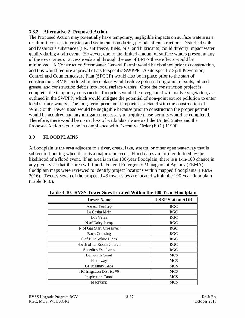
RVSS Upgrade Program RGV 3-37 Draft EA
RGC, MCS, WSL AORs October 2016
3.8.2 Alternative 2: Proposed Action
The Proposed Action may potentially have temporary, negligible impacts on surface waters as a
result of increases in erosion and sedimentation during periods of construction. Disturbed soils
and hazardous substances (i.e., antifreeze, fuels, oils, and lubricants) could directly impact water
quality during a rain event. However, due to the limited amount of surface waters present at any
of the tower sites or access roads and through the use of BMPs these effects would be
minimized. A Construction Stormwater General Permit would be obtained prior to construction,
and this would require approval of a site-specific SWPPP. A site-specific Spill Prevention,
Control and Countermeasure Plan (SPCCP) would also be in place prior to the start of
construction. BMPs outlined in these plans would reduce potential migration of soils, oil and
grease, and construction debris into local surface waters. Once the construction project is
complete, the temporary construction footprints would be revegetated with native vegetation, as
outlined in the SWPPP, which would mitigate the potential of non-point source pollution to enter
local surface waters. The long-term, permanent impacts associated with the construction of
WSL South Tower Road would be negligible because prior to construction the proper permits
would be acquired and any mitigation necessary to acquire those permits would be completed.
Therefore, there would be no net loss of wetlands or waters of the United States and the
Proposed Action would be in compliance with Executive Order (E.O.) 11990.
3.9 FLOODPLAINS
A floodplain is the area adjacent to a river, creek, lake, stream, or other open waterway that is
subject to flooding when there is a major rain event. Floodplains are further defined by the
likelihood of a flood event. If an area is in the 100-year floodplain, there is a 1-in-100 chance in
any given year that the area will flood. Federal Emergency Management Agency (FEMA)
floodplain maps were reviewed to identify project locations within mapped floodplains (FEMA
2016). Twenty-seven of the proposed 43 tower sites are located within the 100-year floodplain
(Table 3-10).
Table 3-10. RVSS Tower Sites Located Within the 100-Year Floodplain
Tower Name USBP Station AOR
Azteca Tertiary RGC
La Casita Main RGC
Los Velas RGC
N of Dairy Pump RGC
N of Gar Starr Crossover RGC
Rock Crossing RGC
S of Blue White Pipes RGC
South of La Rosita Church RGC
Speedios Escobares RGC
Banworth Canal MCS
Floodway MCS
GF Military Area MCS
HC Irrigation District #6 MCS
Inspiration Canal MCS
MacPump MCS
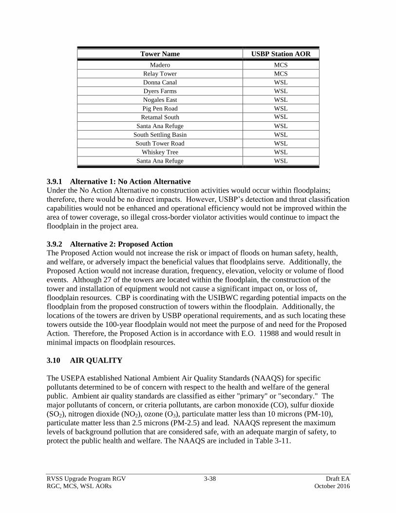
RVSS Upgrade Program RGV 3-38 Draft EA
RGC, MCS, WSL AORs October 2016
Tower Name USBP Station AOR
Madero MCS
Relay Tower MCS
Donna Canal WSL
Dyers Farms WSL
Nogales East WSL
Pig Pen Road WSL
Retamal South WSL
Santa Ana Refuge WSL
South Settling Basin WSL
South Tower Road WSL
Whiskey Tree WSL
Santa Ana Refuge WSL
3.9.1 Alternative 1: No Action Alternative
Under the No Action Alternative no construction activities would occur within floodplains;
therefore, there would be no direct impacts. However, USBP’s detection and threat classification
capabilities would not be enhanced and operational efficiency would not be improved within the
area of tower coverage, so illegal cross-border violator activities would continue to impact the
floodplain in the project area.
3.9.2 Alternative 2: Proposed Action
The Proposed Action would not increase the risk or impact of floods on human safety, health,
and welfare, or adversely impact the beneficial values that floodplains serve. Additionally, the
Proposed Action would not increase duration, frequency, elevation, velocity or volume of flood
events. Although 27 of the towers are located within the floodplain, the construction of the
tower and installation of equipment would not cause a significant impact on, or loss of,
floodplain resources. CBP is coordinating with the USIBWC regarding potential impacts on the
floodplain from the proposed construction of towers within the floodplain. Additionally, the
locations of the towers are driven by USBP operational requirements, and as such locating these
towers outside the 100-year floodplain would not meet the purpose of and need for the Proposed
Action. Therefore, the Proposed Action is in accordance with E.O. 11988 and would result in
minimal impacts on floodplain resources.
3.10 AIR QUALITY
The USEPA established National Ambient Air Quality Standards (NAAQS) for specific
pollutants determined to be of concern with respect to the health and welfare of the general
public. Ambient air quality standards are classified as either "primary" or "secondary." The
major pollutants of concern, or criteria pollutants, are carbon monoxide (CO), sulfur dioxide
(SO2), nitrogen dioxide (NO2), ozone (O3), particulate matter less than 10 microns (PM-10),
particulate matter less than 2.5 microns (PM-2.5) and lead. NAAQS represent the maximum
levels of background pollution that are considered safe, with an adequate margin of safety, to
protect the public health and welfare. The NAAQS are included in Table 3-11.
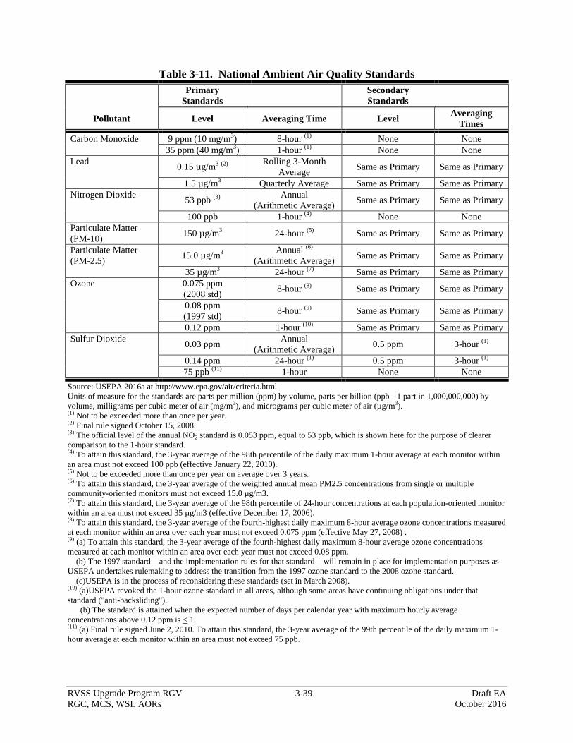
RVSS Upgrade Program RGV 3-39 Draft EA
RGC, MCS, WSL AORs October 2016
Table 3-11. National Ambient Air Quality Standards
Primary
Standards
Secondary
Standards
Pollutant Level Averaging Time Level Averaging
Times
Carbon Monoxide 9 ppm (10 mg/m3) 8-hour
(1) None None
35 ppm (40 mg/m3) 1-hour
(1) None None
Lead 0.15 µg/m
3 (2)
Rolling 3-Month
Average Same as Primary Same as Primary
1.5 µg/m3 Quarterly Average Same as Primary Same as Primary
Nitrogen Dioxide 53 ppb
(3)
Annual
(Arithmetic Average) Same as Primary Same as Primary
100 ppb 1-hour (4)
None None
Particulate Matter
(PM-10) 150 µg/m
3 24-hour
(5) Same as Primary Same as Primary
Particulate Matter
(PM-2.5) 15.0 µg/m
3
Annual (6)
(Arithmetic Average) Same as Primary Same as Primary
35 µg/m3 24-hour
(7) Same as Primary Same as Primary
Ozone 0.075 ppm
(2008 std) 8-hour
(8) Same as Primary Same as Primary
0.08 ppm
(1997 std) 8-hour
(9) Same as Primary Same as Primary
0.12 ppm 1-hour (10)
Same as Primary Same as Primary
Sulfur Dioxide 0.03 ppm
Annual
(Arithmetic Average) 0.5 ppm 3-hour
(1)
0.14 ppm 24-hour (1)
0.5 ppm 3-hour (1)
75 ppb (11)
1-hour None None
Source: USEPA 2016a at http://www.epa.gov/air/criteria.html
Units of measure for the standards are parts per million (ppm) by volume, parts per billion (ppb - 1 part in 1,000,000,000) by
volume, milligrams per cubic meter of air (mg/m3), and micrograms per cubic meter of air (µg/m3).
(1) Not to be exceeded more than once per year. (2) Final rule signed October 15, 2008. (3) The official level of the annual NO2 standard is 0.053 ppm, equal to 53 ppb, which is shown here for the purpose of clearer
comparison to the 1-hour standard. (4) To attain this standard, the 3-year average of the 98th percentile of the daily maximum 1-hour average at each monitor within
an area must not exceed 100 ppb (effective January 22, 2010). (5) Not to be exceeded more than once per year on average over 3 years. (6) To attain this standard, the 3-year average of the weighted annual mean PM2.5 concentrations from single or multiple
community-oriented monitors must not exceed 15.0 µg/m3. (7) To attain this standard, the 3-year average of the 98th percentile of 24-hour concentrations at each population-oriented monitor
within an area must not exceed 35 µg/m3 (effective December 17, 2006). (8) To attain this standard, the 3-year average of the fourth-highest daily maximum 8-hour average ozone concentrations measured
at each monitor within an area over each year must not exceed 0.075 ppm (effective May 27, 2008) . (9) (a) To attain this standard, the 3-year average of the fourth-highest daily maximum 8-hour average ozone concentrations
measured at each monitor within an area over each year must not exceed 0.08 ppm.
(b) The 1997 standard—and the implementation rules for that standard—will remain in place for implementation purposes as
USEPA undertakes rulemaking to address the transition from the 1997 ozone standard to the 2008 ozone standard.
(c)USEPA is in the process of reconsidering these standards (set in March 2008). (10) (a)USEPA revoked the 1-hour ozone standard in all areas, although some areas have continuing obligations under that
standard ("anti-backsliding").
(b) The standard is attained when the expected number of days per calendar year with maximum hourly average
concentrations above 0.12 ppm is < 1. (11) (a) Final rule signed June 2, 2010. To attain this standard, the 3-year average of the 99th percentile of the daily maximum 1-
hour average at each monitor within an area must not exceed 75 ppb.

RVSS Upgrade Program RGV 3-40 Draft EA
RGC, MCS, WSL AORs October 2016
Areas that do not meet these NAAQS standards are called non-attainment areas; areas that meet
both primary and secondary standards are known as attainment areas. The Federal Conformity
Final Rule (40 CFR Parts 51 and 93) specifies criteria and requirements for conformity
determinations of Federal projects. The Federal Conformity Rule was first promulgated in 1993
by the USEPA, following the passage of Amendments to the Clean Air Act in 1990. The rule
mandates that a conformity analysis be performed when a Federal action generates air pollutants
in a region that has been designated a non-attainment or maintenance area for one or more
NAAQS.
A conformity analysis is the process used to determine whether a Federal action meets the
requirements of the General Conformity Rule. It requires the responsible Federal agency to
evaluate the nature of a Proposed Action and associated air pollutant emissions and calculate
emissions that may result from the implementation of the Proposed Action. If the emissions
exceed established limits, known as de minimis thresholds, the proponent is required to perform a
conformity determination and implement appropriate mitigation measures to reduce air
emissions. The USEPA has designated Starr and Hidalgo counties as in attainment for all
NAAQS (USEPA 2016b).
Greenhouse Gases and Climate Change
Global climate change refers to a change in the average weather on the earth. Greenhouse Gases
(GHG) are gases that trap heat in the atmosphere. They include water vapor, carbon dioxide
(CO2), methane (CH4), nitrous oxide (N2O), fluorinated gases including chlorofluorocarbons
(CFC) and hydrochlorofluorocarbons (HFC), and halons, as well as ground-level O3 (California
Energy Commission 2007).
The major GHG-producing sectors in society include transportation, utilities (e.g., coal and gas
power plants), industry/manufacturing, agriculture, and residential. End-use sector sources of
GHG emissions include transportation (40.7 percent), electricity generation (22.2 percent),
industry (20.5 percent), agriculture and forestry (8.3 percent), and other (8.3 percent). The main
sources of increased concentrations of GHG due to human activity include the combustion of
fossil fuels and deforestation (CO2), livestock and rice farming, land use and wetland depletions,
landfill emissions (CH4), refrigeration system and fire suppression system use and manufacturing
(CFC), and agricultural activities, including the use of fertilizers (California Energy Commission
2007).
GHG Threshold of Significance
The CEQ drafted guidelines for determining meaningful GHG decision-making analysis. The
CEQ guidance states that if the Project would be reasonably anticipated to cause direct emissions
of 25,000 metric tons (27,557 U.S. tons) or more of CO2 GHG emissions on an annual basis,
agencies should consider this a threshold for decision-makers and the public. CEQ does not
propose this as an indicator of a threshold of significant effects, but rather as an indicator of a
minimum level of GHG emissions that may warrant some description in the appropriate NEPA
analysis for agency actions involving direct emissions of GHG (CEQ 2010).
The GHG covered by E.O. 13514 are CO2, CH4, N2O, HFC, perfluorocarbons, and sulfur
hexafluoride. These GHG have varying heat-trapping abilities and atmospheric lifetimes. CO2

RVSS Upgrade Program RGV 3-41 Draft EA
RGC, MCS, WSL AORs October 2016
equivalency (CO2e) is a measuring methodology used to compare the heat-trapping impact from
various greenhouse gases relative to CO2. Some gases have a greater global warming potential
than others. N2O for instance, have a global warming potential that is 310 times greater than an
equivalent amount of CO2 and CH4 is 21 times greater than an equivalent amount of CO2 (CEQ
2012).
3.10.1 Alternative 1: No Action Alternative
The No Action Alternative would not result in any direct impacts on air quality because there
would be no construction activities. However, USBP’s detection and threat classification
capabilities would not be enhanced and operational efficiency would not be improved within the
area of tower coverage, so illegal cross-border violator activities would continue to impact air
quality in the region.
3.10.2 Alternative 2: Proposed Action
Temporary and minor increases in air pollution would occur from the use of construction
equipment (combustion emissions) and the disturbance of soils (fugitive dust) during
construction of RVSS and relay towers and associated roads. Particulate emissions would occur
as a result of construction activities such as vehicle trips on unimproved roads, bulldozing,
compacting, truck dumping, and grading operations. Construction activities would also generate
minimal hydrocarbon, NO2, CO2, and SO2 emissions from construction equipment and support
vehicles. Fugitive dust would be generated during these construction activities, especially during
the road improvement activities. Fugitive dust and other emissions would minimally increase
during construction; however, these emissions would be temporary and return to pre-project
levels upon the completion of construction. Emissions as a result of the Proposed Action are
expected to be below the de minimus threshold (i.e., 100 tons per year) and therefore would not
be considered significant. BMPs, such as dust suppression and maintaining equipment in proper
working condition would reduce the temporary construction impacts. Furthermore, due to the
generally remote location of the various tower sites, good wind dispersal conditions, and because
both Starr and Hidalgo counties are in attainment, impacts to air quality are expected to be
minimal under the Proposed Action.
Operational Air Emissions
Operational air emissions refer to air emissions that may occur after the RVSS and relay towers
have been installed, such as maintenance and the use of generators. Generator run times for
systems connected to the commercial power grid would be limited to 1 to 5 hours twice per
month for maintenance purposes. System conditioning would occur during off-grid operational
schedules or if grid power is interrupted, and generators would temporarily be operated, as
needed, until grid power is again available. Previous calculations completed for towers with the
same footprints and operational requirements as the proposed RVSS and relay towers produced
an annual total CO2 and CO2 equivalent air emissions of approximately 34 and 165
tons/year/tower, respectively (CBP 2014). Based on these annual total air emissions per tower, it
is estimated that a total approximate CO2 and CO2 equivalent air emissions for the 43 towers
would be 1,462 and 7,095 tons/year/tower, respectively. These values are well below the de
minimis combined CO2 and CO2 equivalent threshold of 27,557 tons/year. Therefore, the
proposed construction and operational activities would not exceed Federal de minimis thresholds
for NAAQS and GHG and, thus, would not require a Conformity Determination. As there are no

RVSS Upgrade Program RGV 3-42 Draft EA
RGC, MCS, WSL AORs October 2016
violations of air quality standards and no conflicts with the state implementation plans, the
impacts on air quality from the implementation of the Proposed Action would be negligible and
would not be expected to affect the climate.
BMPs to be incorporated to ensure that fugitive dust and other air quality constituent emission
levels do not rise above the minimum threshold as required per 40 CFR § 51.853(b)(1) are listed
below:
Standard construction BMPs such as routine watering of the construction site, as well as
access drives to the site, would be used to control fugitive dust and thereby will assist in
limiting potential PM-10 excursions during the construction phase of the Proposed
Action.
All construction equipment and vehicles would be required to be maintained in good
operating condition to minimize exhaust emissions.
3.11 NOISE
Noise is generally described as unwanted sound, which can be based either on objective effects
(i.e., hearing loss, damage to structures) or subjective judgments (e.g., community annoyance).
Sound is usually represented on a logarithmic scale with a unit called the decibel (dB). Sound on
the decibel scale is referred to as sound level. The perceived threshold of human hearing is 0 dB,
and the threshold of discomfort or pain is around 120 dB (USEPA 1974). The dBA is a
measurement of sound pressure adjusted to conform to the frequency response of the human ear.
Noise levels occurring at night generally produce a greater annoyance than do the same levels
occurring during the day. It is generally agreed that people perceive intrusive noise at night as
being 10 dBA louder than the same level of intrusive noise during the day, at least in terms of its
potential for causing community annoyance. This perception is largely because background
environmental sound levels at night in most areas are also about 10 dBA lower than those during
the day.
Long-term noise levels are computed over a 24-hour period and adjusted for nighttime
annoyances to produce the day-night average sound level (DNL). DNL is the community noise
metric recommended by the USEPA and has been adopted by most Federal agencies (USEPA
1974).
Residential Homes
When noise affects humans, it can be based either on objective effects (i.e., hearing loss, damage
to structures) or subjective judgments (e.g., community annoyance). A 65 dBA DNL is the
impact threshold most commonly used for noise planning purposes near residents and represents
a compromise between community impact and the need for activities like construction (U.S.
Department of Housing and Urban Development [HUD] 1984).
All the tower sites and access drives/access roads are located in remote locations in the ROI with
the exception of towers RGC Igloo House, RGC Rock Crossing, RGC South of LaRosita

RVSS Upgrade Program RGV 3-43 Draft EA
RGC, MCS, WSL AORs October 2016
Church, RGC North of Dairy Pump, RGC Tower Near Silos, MCS GF Military Area, and MCS
Relay Tower and their associated access roads.
National Parks and Wildlife Refuges
The Lower Rio Grande Valley National Wildlife Refuge (LRGVNWR) is considered a sensitive
noise receptor. There are 15 tower sites that are located near or within the LRGVNWR. The
towers shown in Table 3-12 are those towers located on the LRGVNWR or within 1,138 feet
(57 dBA threshold achieved). Table 3-12 also shows the approximate acreage impacted by noise
greater than 57 dBA per tower site.
Table 3-12. Proposed Towers in or within 1,138 feet of the LRGVNWR
Tower Name Acreage* Tower Name Acreage
RGC La Casita Main 58 MCS HC Irrigation District #6 13
RGC Los Velas 24 MCS Hidalgo POE 50
RGC North of Gar Starr Crossover 51 MCS Madero 24
RGC Papa Hill 40 MCS South Sam Fordyce 57
MCS Abram Tx 3 WSL Donna Canal 43
MCS Banworth Canal 57 WSL Retamal South 93
MCS Floodway 13 WSL South Settling Basin 50
MCS GF Military Area 7
*Acreage affected by noise high than 57 dBA.
Noise emission criteria for construction activities were published by the Federal Highway
Administration (FHWA), which has established a construction noise abatement criterion of 57
dBA for lands, such as National Parks and Wildlife Refuges, in which serenity and quiet are of
extraordinary significance (23 CFR § 722 Table 1). The 57 dBA criterion threshold is used to
measure the impacts from short-term noise emissions associated with constructing the proposed
towers and access drives and maintaining and repairing access roads. For long-term noise
emissions, the USEPA (1978) notes that noise emissions of 55 dBA or less are suitable for areas
in which quiet is a basis for use. This 55 dBA criterion threshold is used to measure the impacts
from noise emissions associated with tower operations.
Noise Attenuation
As a general rule, noise generated by a stationary noise source, or “point source,” will decrease
by approximately 6 dBA over hard surfaces and 9 dBA over soft surfaces for each doubling of
the distance. For example, if a noise source produces a noise level of 85 dBA at a reference
distance of 50 feet over a hard surface, then the noise level would be 79 dBA at a distance of 100
feet from the noise source and 73 dBA at a distance of 200 feet. To estimate the attenuation of
the noise over a given distance, the following relationship is utilized:
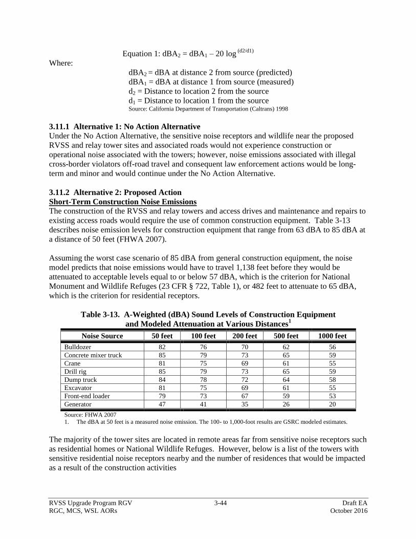
RVSS Upgrade Program RGV 3-44 Draft EA
RGC, MCS, WSL AORs October 2016
Equation 1: dBA2 = dBA1 – 20 log (d2/d1)
Where:
dBA2 = dBA at distance 2 from source (predicted)
dBA1 = dBA at distance 1 from source (measured)
d2 = Distance to location 2 from the source
d1 = Distance to location 1 from the source Source: California Department of Transportation (Caltrans) 1998
3.11.1 Alternative 1: No Action Alternative
Under the No Action Alternative, the sensitive noise receptors and wildlife near the proposed
RVSS and relay tower sites and associated roads would not experience construction or
operational noise associated with the towers; however, noise emissions associated with illegal
cross-border violators off-road travel and consequent law enforcement actions would be long-
term and minor and would continue under the No Action Alternative.
3.11.2 Alternative 2: Proposed Action
Short-Term Construction Noise Emissions
The construction of the RVSS and relay towers and access drives and maintenance and repairs to
existing access roads would require the use of common construction equipment. Table 3-13
describes noise emission levels for construction equipment that range from 63 dBA to 85 dBA at
a distance of 50 feet (FHWA 2007).
Assuming the worst case scenario of 85 dBA from general construction equipment, the noise
model predicts that noise emissions would have to travel 1,138 feet before they would be
attenuated to acceptable levels equal to or below 57 dBA, which is the criterion for National
Monument and Wildlife Refuges (23 CFR § 722, Table 1), or 482 feet to attenuate to 65 dBA,
which is the criterion for residential receptors.
Table 3-13. A-Weighted (dBA) Sound Levels of Construction Equipment
and Modeled Attenuation at Various Distances1
Noise Source 50 feet 100 feet 200 feet 500 feet 1000 feet
Bulldozer 82 76 70 62 56
Concrete mixer truck 85 79 73 65 59
Crane 81 75 69 61 55
Drill rig 85 79 73 65 59
Dump truck 84 78 72 64 58
Excavator 81 75 69 61 55
Front-end loader 79 73 67 59 53
Generator 47 41 35 26 20
Source: FHWA 2007
1. The dBA at 50 feet is a measured noise emission. The 100- to 1,000-foot results are GSRC modeled estimates.
The majority of the tower sites are located in remote areas far from sensitive noise receptors such
as residential homes or National Wildlife Refuges. However, below is a list of the towers with
sensitive residential noise receptors nearby and the number of residences that would be impacted
as a result of the construction activities
RVSS Upgrade Program RGV 3-45 Draft EA
RGC, MCS, WSL AORs October 2016
RGC Igloo House
o 27 residences
RGC Rock Crossing
o 21 residences
RGC South of LaRosita Church
o 3 residences and 1 church (LaRosita Church)
RGC North of Dairy Pump
o 4 residences
RGC Tower Near Silos
o 8 residences
MCS GF Military Area
o 4 residences
MCS Relay Tower
o 6 residences
The residential noise receptors may experience temporary noise intrusion equal to or greater than
65 dBA from construction equipment. Noise generated by the construction activities would be
intermittent and last for approximately 2 months, after which noise levels would return to
ambient levels. To minimize impacts, construction activity should be limited to daylight hours,
between 8:00 a.m. to 5:00 p.m. on Monday through Friday. Therefore, the noise impacts from
construction activities would be considered temporary and minor.
Approximately 576 acres of the LRGVNWR would experience elevated noise levels during
construction activities (see Table 3-12). However, this noise too would be intermittent and last
for approximately 2 months, after which noise levels would return to ambient levels. The same
BMPs mentioned above would be used for those towers near or within the LRGVNWR.
Additionally, several of the towers that could have noise impacts on the LRGVNWR would be
located within or next to developed areas (i.e., MCS Hidalgo POE) or farmed areas (i.e., RGC
LaCasita Main) and experience high levels of noise on a constant basis currently. Therefore,
noise impacts from construction of the towers in or near the LRGVNWR would be considered
temporary and minor, as well.
Long-Term Operational Noise
Long-term noise emissions refer to noise emissions that would occur after the new towers have
been installed. All of the towers would be connected to commercial grid power. They would
also have a propane generator installed for backup power. The propane generator would be
expected to operate a total of 10 to 15 minutes per month for maintenance purposes. The
generators used are all self-contained and generally within baffle boxes to help reduce the noise.
While in operation, the generator dBA would be 47 at 50 feet from the source. System
conditioning would occur during off-grid operational schedules or if grid power is interrupted,
and the generator would be operated temporarily, as needed, until grid power is again available.
Therefore, the noise impacts from ongoing tower activities would be considered negligible.
RVSS Upgrade Program RGV 3-46 Draft EA
RGC, MCS, WSL AORs October 2016
3.12 CULTURAL, HISTORICAL, AND ARCHAEOLOGICAL RESOURCES
Cultural resources include historic properties, archaeological resources, and sacred sites.
Historic properties are defined by the NHPA as any prehistoric or historic district site, building,
structure, or object included on, or eligible for inclusion in the National Register of Historic
Places (NRHP), including artifacts, records, and material remains relating to the district, site,
building, structure, or object (National Park Service [NPS] 2006a). To be considered eligible for
the NRHP a property would need to possess integrity of location, design, setting, materials,
workmanship, feeling, and association and must also meet at least one of four criteria (NPS
2002):
A. Be associated with events that made a significant contribution to the broad pattern of our
history
B. Be associated with the lives of significant persons in our past
C. Embody the distinctive characteristics of a type, period, or method of construction, or that
represent the work of a master, or that possess high artistic values, or that represent a
significant and distinguishable entity whose components may lack individual distinction
D. Have yielded, or be likely to yield, information important in history or prehistory
A Traditional Cultural Property (TCP) is a specific type of historic property that is eligible for
inclusion in the NRHP because of its association with cultural practices or beliefs of a living
community that (a) are rooted in that community’s history, and (b) are important in maintaining
and the continuing cultural identity of the community (Parker and King 1998). Given the broad
range in types of historic properties, historic properties can often include other types of cultural
resources such as cultural items, archaeological resources, sacred sites, and archaeological
collections.
Cultural items as defined by the Native American Graves Protection and Repatriation Act
(NAGPRA) are defined as human remains, as well as both associated and unassociated funerary
objects, sacred objects, and objects of cultural patrimony or objects that have an ongoing
historical, traditional, or cultural importance to a Native American group or culture (NPS 2006b).
Archaeological resources, as defined by the Archaeological Resources Protection Act (ARPA),
consist of any material remains of past human life or activities that are of archaeological interest
and are at least 100 years of age. Such items include, but are not limited to, pottery, basketry,
bottles, weapons, weapon projectiles, tools, structures or portions of structures, pit houses, rock
paintings, rock carvings, intaglios, graves, human skeletal remains, or any portion or piece of
those items (NPS 2000c). Sacred sites are defined by EO 13007, Indian Sacred Sites, as any
specific, discrete, narrowly delineated location on Federal land that is identified by an Native
American tribe or Native American individual determined to be an appropriately authoritative
representative of an Native American religion as sacred by virtue of its established religious
significance, or ceremonial use by, an Native American religion, provided that the tribe or
appropriately authoritative representative of a Native American religion has informed the Federal
land-owning agency of the existence of such a site (NPS 1996).
RVSS Upgrade Program RGV 3-47 Draft EA
RGC, MCS, WSL AORs October 2016
Cultural and Historic Overview
The proposed RVSS tower sites are distributed across the South Texas and Coastal Texas
archaeological regions. The first evidence of human occupation in the area was during the
Paleoindian period of the South Texas archaeological region. The waning of the Ice Age, or
Pleistocene, 11,000 years Before Present (B.P.), showed the first evidence of the Paleoindians in
the south Texas area. Their culture would last until 8000 B.P. These first people relied upon
hunting and gathering subsistence and moved as nomadic bands as the seasons changed
following the availability of edible vegetation and game animals in the region. Within the South
Texas archaeological region, archaeological sites have recovered the remains of multiple
animals, including a broad range of fish, horse, bison, rabbit, turtle, lizard, ducks, rats, and other
species that the Paleoindian people used for subsistence resources. Archaeological sites in the
region for this period vary from early Paleoindian terrestrial sites to eroded late Paleoindian
artifacts found on the surface mixed with later Archaic period artifacts. Some of the lithic
artifacts recovered are the Folsom, Clovis, Golondrina, Barber, and Angostura projectile points
that range in complexity from early fluted forms to stemmed points by the end of the cultural
period. (Black 1989a; Hester 1989, 2004). Evidence of Paleoindian habitation within the
Coastal Texas archaeological region is very limited. As a result, Ricklis (2004) states that the
earliest demonstrable human occupation and exploitation of the central coast shoreline occurred
during the subsequent Early Archaic period. The lack of Paleoindian sites within the Coastal
Texas archaeological region is probably the result of fluctuations in sea level during the terminal
Pleistocene to early Holocene. Bousman et al. (2004) note that no true coastal Paleoindian sites
have been recorded because the Pleistocene coasts were flooded by rising sea levels that
probably inundated such sites.
Archaeological evidence of the Early Archaic period, 8000 to 4500 years B.P., suggests
considerable increase of human population along with the change to a dryer and warmer
environment as compared to the evidence from the Paleoindian period. Hunting and gathering
continued to be the way of life with the major change of this culture being in the designs of flint
knapping (Black 1989a; Hester 1980). Hester (2004) has subsequently defined two horizons
that make up the early Archaic, the Early Basal-Notched horizon followed by the early Corner-
Notched horizon based on distinctive forms of dart points and associated stone artifacts. In the
Coastal Texas archaeological region, Ricklis (2004) also notes that there are two major
prehistoric occupations during the Early Archaic period centering at ca. 7500 to 6800 B.P. and
ca. 5800 to 4200 B.P. Evidence of the initial shoreline occupation dating from 7500 to 6800 B.P.
consists of thick but dense lenses or strata of oyster shells (Crassotrea virginica) which rest at
the base of the Holocene deposits and on top of the Pleistocene Beaumont Formation. Evidence
for the later Early Archaic period (ca. 5800 to 4200 B.P.) occupation is better documented.
Evidence from this portion of the Early Archaic similarly consists of thin strata of oyster shells
near shoreline occupations and brackish-water clams (Rangia flexuosa) within river-influenced
areas. Artifacts from excavated contexts are limited, but include chert debitage, utilized chert
flakes, chert end-scrapers, shell tools (perforated shell oyster, edge-modified oyster shell), and
chert dart points such as Bell, Early Triangular, Tortugas, and Gower point forms. Although the
cultural deposits from this period are generally too old to preserve most bone, the presence of
dart points suggests some hunting was taking place and limited faunal evidence has been
recovered at some sites (Ricklis 2004).
RVSS Upgrade Program RGV 3-48 Draft EA
RGC, MCS, WSL AORs October 2016
The South Texas artifact assemblages of the Middle Archaic period, 4500 to 2400 years B.P., are
dominated by Triangular dart points, known as Tortugas and Abasolo, along with regionally
specific types such as the Carrizo (Black 1989a; Hester 2004). The subsistence data available,
particularly from the Choke Canyon Reservoir area, suggests that plant resources were heavily
utilized during this period. This is reflected in the increase in formal hearths, earth ovens, and
burned rock accumulations. In the Coastal Texas region, Middle Archaic period (ca. 4500 B.P.
to 2400 B.P.) radiocarbon data from the shows little occupation of the shoreline (Black 1989a;
Ricklis 2004). Within the Coastal Bend area, there is a continued adaptation to the littoral
resources, particularly those of the estuary bays. Evidence of increased plant utilization for
subsistence is also seen during the Middle Archaic period of Coastal Texas as suggested by the
increase in the use of ground stones, as well as an increase in roasting/baking hearths. In the
Coastal Bend subarea the earliest Aransas complex material start to appear in the Middle Archaic
(Black 1989a).
The climate during the Late Archaic period, ca. 2400 B.P. to A.D. 600/700, slowly changed to a
moister environment with some of the vegetation from the arid period remaining in the western
reaches of Texas. Artifacts recovered from Late Archaic sites within the South Texas
archaeological region include small, corner- or side-notched dart points including Ensor, Frio,
Marcos, Fairland, Shumla, Montell, and Ellis dart points. Other artifacts noted during this period
include Olmos bifaces, small triangular gouge-like tools with specialized resharpening
techniques, which may have also continued to be used into the Late Prehistoric period (Hester
2004). Subsistence data, as well as the presence of extensive deposits of fire-cracked rock (FCR)
and grinding implements, suggest a further expanded use of plant resources during this period.
Faunal data from the Late Archaic contexts show the exploitation of small animals, such as
rodents, rabbits, turtles, fish, lizards, snakes, and deer. Rabdotus snails and mussels also
continue to be common food sources. In the Coastal Texas archaeological region. the Late
Archaic period (ca. 2400 B.P. to A.D. 800/1200) populations continued to increase, as is evident
from the increase in Late Archaic period site density. Evidence for subsistence in the Coastal
Bend area, during the Late Archaic, suggests the exploitation of a wide range of shellfish, fish,
and small mammals, with a focus on marine resources, particularly those of estuary bays. Inland
sites show a focus on plant resources, but also included the use of a variety of small mammal
such as rodents and rabbits. Artifacts indicative of the Late Archaic Period include similar small,
corner- or side-notched darts as seen in the South Texas archaeological region. In the Coastal
Bend subarea, later Aransas complex materials are present including Ensor, Fairland, Darl,
Catán, and possibly Matamoros dart points (Black 1989a).
During the Late Prehistoric Period (A.D. 800 to A.D. 1600) of the South Texas archaeological
region, the Late Archaic small, expanding stem dart points were replaced with still smaller
expanding stem Late Prehistoric arrow points (Hester 2004). The Late Prehistoric can be divided
into two time periods termed the Austin and Toyah horizons. The Austin horizon dates between
roughly A.D. 800 and A.D. 1350, while the Toyah horizon dates after A.D. 1250/1300 (Black
1989a; Hester 2004). The Toyah Horizon is the best documented Later Prehistoric pattern in the
South Texas region. Cultural traits noted for Toyah sites included Perdiz points, small end
scrapers, flake knives, beveled knives, bone-tempered pottery, perforators made on flakes,
ceramic figurines, pipes, marine shell and freshwater mussel shell ornaments, tubular bird bone
beads, and spatulate objects made on bison bone fragments (Hester 2004). Faunal material
RVSS Upgrade Program RGV 3-49 Draft EA
RGC, MCS, WSL AORs October 2016
recovered from Toyah sites include abundant bison bone, though white-tailed deer may have
been more extensively hunted, along with pronghorn and a variety of smaller game. Turtles,
freshwater mussels, and land snails also continue to be part of the diet. Sites, like in the latter
part of the Middle Archaic, as well as the Late Archaic periods, are located along present stream
channels or nearby sloughs, often buried just under the surface of natural levees. The later part
of the Late Prehistoric period, which includes the Toyah horizon, also shows evidence of south
Texas connections to a north-south Plains trade network (Hester 2004).
In the Coastal Texas archaeological region, the Late Prehistoric period begins somewhat later
(ca. 1200 A.D.) as compared to the South Texas archaeological region. The Late Prehistoric
occupations of the Coastal Texas archaeological region are divided into two cultural complexes,
the Rockport complex which extends geographically from Matagorda Bay to Baffin Bay, and the
Brownsville complex in the area of the Rio Grande Delta. The increased number of Late
Prehistoric period sites suggests that population densities were higher during the Late Prehistoric
period. In the Coastal Bend subarea, there is also a considerable amount of faunal diversity,
including a variety of marine and brackish water species. Generally, arrow points and pottery
are the diagnostic artifacts associated with Late Prehistoric sites in the Coastal Bend subarea. In
the Coastal Bend subarea, the Fresno (triangular) and Padre (ovate) projectile points are
indicative of the earlier part of the Late Prehistoric period, while the Perdiz and Bulbar Stemmed
projectile points are indicative of the later part of the Late Prehistoric period. Bone-tempered
pottery is common during the Late Prehistoric period in inland sites, while Rockport pottery is
indicative of the Rockport Complex in the Coastal Bend subarea. The Brownsville complex is
dominated by a shell working industry containing various shell tools (scrapers, gouges, projectile
points, etc.) along with other ornaments such as beads, pendants, gorgets, etc. (Black 1989a).
By the early nineteenth century the protohistoric native peoples of the area were either culturally
or biologically extinct or displaced. As a result, the information on the historic Native American
populations of the area are derived predominantly from historic documents from Spanish
expeditions, missionaries, and the earliest Anglo-European explorers and settlers. The Coastal
Bend subarea was inhabited by several different groups of Native Americans during the Historic
Period, including the Coahuiltecans, Karankawas, Lipan Apaches, and Tonkawas. These groups
were subdivided into numerous smaller bands including the Atakapa, Borado, Cavas, Capoque,
Emet, Kohani, Kopani, Malaquite, Payata, and Sana Tamique, as well as others (Hester 1989;
Newcombe 2002).
The Historic period chronology of the South Texas and Coastal Texas regions can be divided
into five temporal subperiods; Spanish Exploration, Spanish Colonial, Mexican Colonial, Texas
Republic and American, and twentieth century American periods. These historic subperiods are
defined by distinct artifact assemblages along with historic archival and documentary evidence.
The Spanish Exploration period begins with the presence of European explorers, mostly of
Spanish descent in the Coastal Bend region. The first Europeans thought to enter the area were
Alvar Nuñez, better known as Cabeza de Vaca, along with three companions (Sánchez 1992).
The Panfilo de Narváez expedition, of which Cabeza de Vaca was a member, was shipwrecked
on the upper Texas coast, at a location they described as the Isla del Malhado (Sánchez 1992;
Hester 1999). The Isla del Malhado was probably Galveston Island or a nearby island, given the

RVSS Upgrade Program RGV 3-50 Draft EA
RGC, MCS, WSL AORs October 2016
known ethnohistoric and archaeological record (Hester 1999). There is disagreement among
historians, anthropologists, and archaeologists on the route taken by Cabeza de Vaca’s group
across Texas. The Krieger route, which takes Cabeza de Vaca from the upper and central Texas
coast, through southern Texas, into northeastern Mexico, and perhaps back into west Texas, is
the most probable of all the routes proposed given the archaeological and ethnohistoric record
(Hester 1999). By 1535, Cabeza de Vaca and his three companions crossed southern Texas,
reaching different points along the Rio Grande (Sánchez 1992).
The Spanish Colonial period began with the initial Spanish Exploration and settlement of the
area. No real attempts to settle the area were made until the late seventeenth century in response
to a French settlement established by René Robert Cavelier, Sieur de La Salle, on the Texas coast
in 1568. After an unsuccessful attempt at establishing missions in east Texas during the latter
part of the seventeenth century, the Spanish decided that a three-pronged approach that included
mission, presidio, and civilian settlement would be the best strategy to establish a Spanish
presence in the area. The Corpus Christi Bay remained unexplored until 1747, when Joaquín
Prudencio de Orobio y Basterra led an expedition down the Nueces River to its mouth. After
several failed attempts, the first settlement in the area was founded by Blas María de la Garza
Falcòn in 1766. He established a ranch called Santa Petronila, on Petronila Creek. Despite
many ranchers from the RGV applying for and receiving land grants in the lower Nueces valley
during the end of the eighteenth century, the area was slow to develop. By 1794, a large ranch
belonging to Juan Barrera, known as Rancho de Santa Gertrudis, was established on the north
side of Corpus Christi Bay. An Indian uprising in 1812 forced many of the colonists to seek
refuge in RGV. Hostilities with the Comanches and Lipans in the area continued until the end of
Spanish Control of the region (Long 2010; A. Fox 1989).
The Mexican Colonial period began with Mexican independence in 1821, the region became part
of Tamaulipas. Remaining land in the area was deeded to individuals by the Tamaulipan
government. After several unsuccessful attempts to establish settlements in the area, Fort
Lipantitlán was established in 1831 where the road from Matamoros to Goliad crossed the river.
Both Irish and German settlers also moved into the area during the 1820s and 1830s (Long 2010;
A. Fox 1989).
The Texas Republic period began in 1836 after the Texas Revolution. During this time the
region became a no man’s land with both Mexican and Texan merchants engaging in illegal
trading within the Nueces valley. Henry Lawrence Kinney established a trading post and fort on
Corpus Christi Bay in 1839 in what would become Corpus Christi. By 1842, a post office had
opened, and in 1845, the settlement experienced a brief boom, though population declined after
the Mexican War (Long 2010; A. Fox 1989).
The Mexican War began only 3 months after Texas’ formal annexation to the United States. The
primary issue involved in the conflict was the border between Mexico and the United States.
When Texas gained its independence from Mexico in 1836, it claimed the Rio Grande as its
southern boundary. In contrast, the Mexican government considered the Nueces River as the
border. In March 1846, under orders from the president, General Zachary Taylor moved his
troops from Corpus Christi to Brazos Santiago near the mouth of the Rio Grande River. The
Mexican government considered this movement of troops as an act of invasion and engaged the
RVSS Upgrade Program RGV 3-51 Draft EA
RGC, MCS, WSL AORs October 2016
troops in battle at Palo Alto and Resca de la Palma on May 8 and 9, 1846. This prompted the
U.S. Congress to pass a declaration of war, and hostilities moved south into Mexico. The war
ended with the Treaty of Guadalupe Hidalgo where the United States gained California, Arizona,
New Mexico, and the Rio Grande boundary of Texas, as well as portions of Utah, Nevada, and
Colorado. The United States established a series of military posts along the Rio Grande as a line
of defense against further armed incursions into Texas. These included Camp Ringgold (Fort
Ringgold), Fort Brown, Camp Crawford (Fort McIntosh), and Fort Duncan (Bauer 2011; THC
1993).
During this period, large-scale ranching rapidly became one of the major bases of the economy
(Long 2010; A. Fox 1989). Large ranches such as Toluca Ranch and King Ranch were
established in the region. King Ranch ranks as one of the most outstanding and best known of
all cattle enterprises in the history of the southwestern cattle frontier. In 1852, Richard King
purchased several tracts of land fronting Santa Gertrudis Creek. The first grant obtained was the
Ricón de Santa Gertrudis, consisting of approximately 15,500 acres of land at the junction of the
Santa Gertrudis and San Fernando creeks near where they join Laguna Madre. This parcel
included the area of present-day Kingsville. King also purchased Santa Gertrudis de la Garza
consisting of approximately 4,000 acres of land. It was on this land that King would begin his
cattle operation. In 1860, King founded R. King and Company, along with partners James
Walworth and Mifflin Kenedy, which joined all the land titles of James Woolworth, King and his
wife Henrietta, as well as Mifflin Kenedy (Coalson 2010; Chessman 2010; THC 1966a). The
Toluca Ranch was founded in 1880 by Florencio Saenz (1836 to 1927) on part of the Llano
Grande (Big Plain) Grant which was deeded to Juan Jose Hinojosa Balli by the Spanish Crown in
1790. Saenz, a direct descendant of the Balli family, purchased a total of 15,898 acres of land to
establish his ranch through multiple purchases (THC 1983).
The sectional controversies that divided the North and South in the 1850s troubled and divided
Texans. The secession convention met in Austin on January 28, 1861, and was dominated by
secessionists. On February 1, 1861, the delegates adopted an ordinance of secession, and on
February 23 the ordinance was approved by the voters. Sam Houston, the Governor of Texas at
that time and a Unionist, refused to recognize the authority of the convention and take an oath of
allegiance to the new government. The convention in response declared the office of governor
vacant and elevated Lieutenant Governor Edward Clark to the position (Wooster 2011). During
the Civil War, King and his partners entered into several contracts with the Confederate
government to supply European buyers with cotton while they, in return, supplied Confederate
forces with beef, horses, imported munitions, medical supplies, clothing, and shoes. King, who
also owned a steamship company, moved operations of the steamship to Matamoros under
Mexican registry, which successfully avoided Union blockades for the most part. At the end of
the war, King fled to Mexico, returning after securing his pardon from President Andrew
Johnson in 1865 (Coalson 2010; Chessman 2010; THC 1966a).
At the start of the Twentieth Century American period the St. Louis, Brownsville, and Mexico
Railway was being built through south Texas to Brownsville, and Henrietta King opened several
tracts of her land for sale. Florencio Saenz also granted right-of-way (ROW) over his property
for the railroad in 1904. With the introduction of the railroad, the economic base of the area
began to change from ranching to farming and dairying. The population continued to rapidly
RVSS Upgrade Program RGV 3-52 Draft EA
RGC, MCS, WSL AORs October 2016
grow in the region during the early part of the twentieth century. Several industries, particularly
the oil and gas industry, in the early to middle twentieth century prompted additional large
population growth in the region (Stokes et al. 2009).
Previously Conducted Cultural Resources Investigations and Recorded Cultural Resources
Prior to the initial fieldwork, an archival record check was performed using the Texas
Archeological Site Atlas maintained by the THC. All previously conducted archaeological
investigations and archaeological sites that were located within the footprints of the proposed
tower sites and their associated access roads and utility corridors were identified. In addition all
NRHP-listed properties, Official Texas Historical Markers (OTHMs), Recorded Texas Historic
Landmarks (RTHLs), and Historic Texas Cemeteries (HTCs) recorded within the visual areas of
potential effect of the proposed towers were also identified. The visual Area of Potential Effect
(APE) for this project was set at 0.5 mile in accordance with previously established visual APEs
for towers that are less than 200 feet in height. The NRHP includes buildings, structures, sites,
objects, and districts that possess significance at a local, state, or National level and retain
sufficient integrity to convey that significance. An RTHL is a property judged by the THC to be
historically and architecturally significant. The THC awards RTHL designation to buildings at
least 50 years old that are judged worthy of preservation for their architectural and historical
associations. The THC administers another type of marker program that is solely educational in
nature and conveys no legal designation or restrictions on the property. A resource that falls
within this category is listed as an OTHM. Administered by the THC, HTC designation is an
official recognition of family and community graveyards and encourages preservation of historic
cemeteries. The designation imposes no restrictions on private owners’ use of the land adjacent
to the cemetery, but provides for the recordation of the cemetery into the county deed records as
a historically dedicated property worthy of preservation. Table 3-14 summarizes the previously
recorded archaeological resources within the tower footprints and their associated access and
utility corridors and the historic (aboveground) resources that are within the visual APEs of each
tower.
Six previously recorded archaeological sites are located within the footprints of the proposed
tower sites and their associated access roads and utility corridors. These sites include the historic
Military Road (41HG230 and 41SR397), lithic procurement/quarry sites (41SR384 and
41SR403), a farmstead/homestead (41HG162), and a historic brick kiln (41HG32). Military
Road (41HG230/41SR397) intersects with the access roads for a large number of the proposed
tower locations and is considered to be not eligible (NE) for the NRHP within the ROW of the
existing highway and has an undetermined eligibility (U) of the NRHP where it diverges outside
of the highway ROW. Two of the sites (41SR384 and 41HG162) have been determined to be
not eligible for inclusion in the NRHP and not considered to be significant archaeological
resources. The remaining two archaeological sites (41SR403 and 41HG32) do not have a
recorded NRHP determination and are considered to have an undetermined eligibility for the
NRHP.
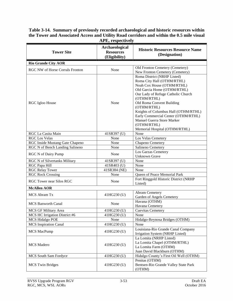
RVSS Upgrade Program RGV 3-53 Draft EA
RGC, MCS, WSL AORs October 2016
Table 3-14. Summary of previously recorded archaeological and historic resources within
the Tower and Associated Access and Utility Road corridors and within the 0.5 mile visual
APE, respectively
Tower Site
Archaeological
Resources
(Eligibility)
Historic Resources Resource Name
(Designation)
Rio Grande City AOR
RGC NW of Horse Corrals Fronton None Old Fronton Cemetery (Cemetery)
New Fronton Cemetery (Cemetery)
RGC Igloo House None
Roma District (NRHP Listed)
Roma City Hall (OTHM/RTHL)
Noah Cox House (OTHM/RTHL)
Old Garcia Home (OTHM/RTHL)
Our Lady of Refuge Catholic Church
(OTHM/RTHL)
Old Roma Convent Building
(OTHM/RTHL)
Knights of Columbus Hall (OTHM/RTHL)
Early Commercial Center (OTHM/RTHL)
Manuel Guerra Store Marker
(OTHM/RTHL)
Memorial Hospital (OTHM/RTHL)
RGC La Casita Main 41SR397 (U) None
RGC Los Velas None Los Velas Cemetery
RGC Inside Mustang Gate Chapeno None Chapeno Cemetery
RGC N of Bench Landing Salineno None Salineno Cemetery
RGC N of Dairy Pump None Los Garzas Cemetery
Unknown Grave
RGC N of Silvertanks Military 41SR397 (U) None
RGC Papa Hill 41SR403 (U) None
RGC Relay Tower 41SR384 (NE) None
RGC Rock Crossing None Queen of Peace Memorial Park
RGC Tower near Silos RGC None Fort Ringgold Historic District (NRHP
Listed)
McAllen AOR
MCS Abram Tx 41HG230 (U) Abram Cemetery
Garden of Angels Cemetery
MCS Banworth Canal None Havana (OTHM)
Havana Cemetery
MCS GF Military Area 41HG230 (U) Cuevitas Cemetery
MCS HC Irrigation District #6 41HG230 (U) None
MCS Hidalgo POE None Hidalgo-Reynosa Bridges (OTHM)
MCS Inspiration Canal 41HG230 (U) None
MCS MacPump 41HG230 (U) Louisiana-Rio Grande Canal Company
Irrigation System (NRHP Listed)
MCS Madero 41HG230 (U)
La Lomita (NRHP Listed)
La Lomita Chapel (OTHM/RTHL)
La Lomita Farm (OTHM)
Juan David Blackburn (OTHM)
MCS South Sam Fordyce 41HG230 (U) Hidalgo County’s First Oil Well (OTHM)
MCS Twin Bridges 41HG230 (U)
Penitas (OTHM)
Bentsen-Rio Grande Valley State Park
(OTHM)

RVSS Upgrade Program RGV 3-54 Draft EA
RGC, MCS, WSL AORs October 2016
Tower Site
Archaeological
Resources
(Eligibility)
Historic Resources Resource Name
(Designation)
Weslaco AOR
WSL Dyer's Farms 41HG230 (U) Louisiana-Rio Grande Canal Company
Irrigation System (NRHP-listed)
WSL Nogales East 41HG230 (U) None
WSL Pharr POE South 41HG162 (NE) Louisiana-Rio Grande Canal Company
Irrigation System (NRHP-listed)
WSL Pig Pen Road 41HG230 (U) None
WSL Retamal South 41HG32 (U) None
WSL Santa Ana Refuge None Louisiana-Rio Grande Canal Company
Irrigation System (NRHP-listed)
WSL South Settling Basin 41HG230 (U) Louisiana-Rio Grande Canal Company
Irrigation System (NRHP-listed)
WSL South Tower Rd None Weber Cemetery
WSL Whiskey Tree None Guzman-Toluca Cemetery
* Not Eligible (NE), Undetermined (U)
A total of 34 previously recorded historic resources are located within the 0.5-mile viewshed of
the proposed towers. Fourteen of the historic resources are cemeteries on file with Texas Sites
Atlas. None of the 14 cemeteries are designated as HTCs. Four of the historic resources are
NRHP-listed historic districts. Finally, 17 of the resources are OTHM markers or medallions.
Of these 17 OTHM, 10 are also designated as RTHLs.
Current Investigations
GSRC personnel conducted cultural resources surveys to identify any new archaeological
resources or historic (aboveground) resources that may be located within the project footprint of
the proposed towers and their associated access roads and utility corridors. Table 3-15
summarizes the new archaeological and historic resources recorded during the surveys conducted
for this EA.
A total of 11 archaeological sites and six isolated finds were found within the footprints of the
proposed towers and their associated access and utility corridors. Seven of the newly recorded
archaeological sites would require additional archaeological investigations in order to determine
their significance and whether they would be eligible for inclusion in the NRHP. Until
additional archaeological investigations are conducted and the sites’ eligibility for the NRHP is
determined, the sites should be treated as if they are eligible for the NRHP. The remaining five
sites are not considered eligible for inclusion on the NRHP and are not considered significant
archaeological resources. The six isolated finds are loci that do not contain the minimal material
to be considered an archaeological site. By their nature they are considered not eligible for the
NRHP and are not considered to be a significant archaeological resource.
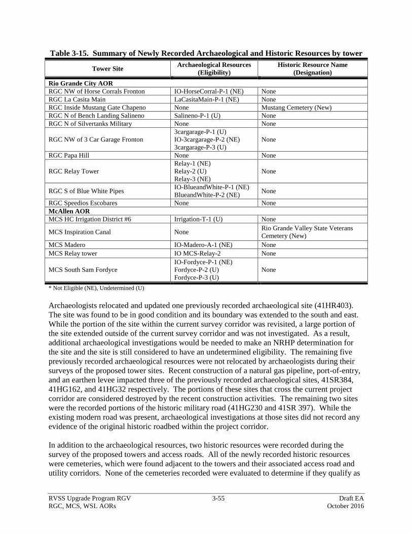
RVSS Upgrade Program RGV 3-55 Draft EA
RGC, MCS, WSL AORs October 2016
Table 3-15. Summary of Newly Recorded Archaeological and Historic Resources by tower
Tower Site Archaeological Resources
(Eligibility)
Historic Resource Name
(Designation)
Rio Grande City AOR
RGC NW of Horse Corrals Fronton IO-HorseCorral-P-1 (NE) None
RGC La Casita Main LaCasitaMain-P-1 (NE) None
RGC Inside Mustang Gate Chapeno None Mustang Cemetery (New)
RGC N of Bench Landing Salineno Salineno-P-1 (U) None
RGC N of Silvertanks Military None None
RGC NW of 3 Car Garage Fronton
3cargarage-P-1 (U)
IO-3cargarage-P-2 (NE)
3cargarage-P-3 (U)
None
RGC Papa Hill None None
RGC Relay Tower
Relay-1 (NE)
Relay-2 (U)
Relay-3 (NE)
None
RGC S of Blue White Pipes IO-BlueandWhite-P-1 (NE)
BlueandWhite-P-2 (NE) None
RGC Speedios Escobares None None
McAllen AOR
MCS HC Irrigation District #6 Irrigation-T-1 (U) None
MCS Inspiration Canal None Rio Grande Valley State Veterans
Cemetery (New)
MCS Madero IO-Madero-A-1 (NE) None
MCS Relay tower IO MCS-Relay-2 None
MCS South Sam Fordyce
IO-Fordyce-P-1 (NE)
Fordyce-P-2 (U)
Fordyce-P-3 (U)
None
* Not Eligible (NE), Undetermined (U)
Archaeologists relocated and updated one previously recorded archaeological site (41HR403).
The site was found to be in good condition and its boundary was extended to the south and east.
While the portion of the site within the current survey corridor was revisited, a large portion of
the site extended outside of the current survey corridor and was not investigated. As a result,
additional archaeological investigations would be needed to make an NRHP determination for
the site and the site is still considered to have an undetermined eligibility. The remaining five
previously recorded archaeological resources were not relocated by archaeologists during their
surveys of the proposed tower sites. Recent construction of a natural gas pipeline, port-of-entry,
and an earthen levee impacted three of the previously recorded archaeological sites, 41SR384,
41HG162, and 41HG32 respectively. The portions of these sites that cross the current project
corridor are considered destroyed by the recent construction activities. The remaining two sites
were the recorded portions of the historic military road (41HG230 and 41SR 397). While the
existing modern road was present, archaeological investigations at those sites did not record any
evidence of the original historic roadbed within the project corridor.
In addition to the archaeological resources, two historic resources were recorded during the
survey of the proposed towers and access roads. All of the newly recorded historic resources
were cemeteries, which were found adjacent to the towers and their associated access road and
utility corridors. None of the cemeteries recorded were evaluated to determine if they qualify as

RVSS Upgrade Program RGV 3-56 Draft EA
RGC, MCS, WSL AORs October 2016
an HTC. Architectural historians also revisited the previously recorded historic resources within
the visual APE of the proposed tower sites to evaluate the potential visual impacts on the
resources by the proposed tower.
3.12.1 Alternative 1: No Action Alternative
Under the No Action Alternative there would be no construction and no impacts would be
anticipated to cultural resources.
3.12.2 Alternative 2: Proposed Action
Under the Proposed Action a total of 17 archaeological sites could be directly affected by
implementation of the Proposed Action. Six of the 17 archaeological sites are not considered
eligible for listing in the NRHP and are not considered significant archaeological resources. The
remaining 11 archaeological resources are considered to have an undetermined eligibility for the
NRHP. Three of the 11 archaeological resources consisted of previously recorded resources that
were not relocated during the current surveys. As a result, those resources are not considered to
extend within the current survey areas. Effects on the remaining eight archaeological resources,
prior to their assessment for the NRHP, would be considered adverse and significant. Mitigation
measures would be developed in consultation with the Texas SHPO, as well as other interested
parties, to reduce the effects to less than significant levels. The mitigation measures would be
outlined in a Historic Properties Treatment Plan (HPTP) and would be implemented prior to the
initiation of construction. The implementation and completion of the HPTP would reduce the
effect to a non-significant level.
None of the 37 previously recorded and newly recorded historic resources would be directly
impacted by the implementation of the Proposed Action. Indirect visual impacts on the 37
historic resources would occur, but given the large amount of already existing modern
infrastructure (houses, towers, etc.) within the viewshed of the historic resources, the visual
effects are not considered adverse or significant.
3.13 UTILITIES AND INFRASTRUCTURE
American Electric Power, Texas Central Company, distributes electrical energy on behalf of the
various Retail Electric Providers operating within the project area. Commercial grid power is
either currently available or would be acquired for all proposed RVSS and relay towers.
3.13.1 Alternative 1: No Action Alternative
Under the No Action Alternative, the proposed RVSS towers would not be constructed. The No
Action Alternative would not affect the availability of utilities or require construction of
additional facilities.
3.13.2 Alternative 2: Proposed Action
The Proposed Action would result in negligible effects on the availability of utilities throughout
the ROI because of the limited amperage needed by each tower to operate all equipment and
because all towers would be tied into an existing and available service transmission line.
RVSS Upgrade Program RGV 3-57 Draft EA
RGC, MCS, WSL AORs October 2016
3.14 ROADWAYS AND TRAFFIC
U.S. Highway 83 / Interstate 2 is the primary route for vehicular traffic through the Lower Rio
Grande Valley. U.S. Highway 83 is one of the longest north-south U.S. Highways in the United
States. The highway starts in Brownsville, Texas at the Veterans International Bridge on the
United States Mexico border and terminates north of Westhope, North Dakota, at the Canada-
United States border. U.S. Highway 83 runs roughly east-west through the Lower Rio Grande
Valley. U.S. Highway 281 / Interstate 69C is the main north-south route connecting San
Antonio, Texas, to Pharr, Texas. There are five United States-Mexico border crossings within
the ROI, which are located in the cities of Roma, Rio Grande, Mission, Hidalgo, and Pharr,
Texas. Additionally, there are numerous local, city, and county roads that transect the ROI.
County Road 1430, runs east-west through Hidalgo County between the Rio Grande and U.S.
Highway 83.
3.14.1 Alternative 1: No Action Alternative
Under the No Action Alternative, impacts on roadways and traffic would remain status quo.
3.14.2 Alternative 2: Proposed Action
With the implementation of the Proposed Action, construction activities at the RVSS and relay
tower sites would have a temporary, minor impact on roadways and traffic within the project
area. An increase of vehicular traffic along U.S. Highway 83, U.S. Highway 281, and the
adjacent county roads would occur to supply materials and work crews to the RVSS and relay
tower sites during the construction phase and also in support of tower maintenance and refueling
trips.
Tower maintenance requires vehicle travel to each of the proposed tower sites for fuel delivery,
maintenance and operations of the proposed RVSS and relay tower sites. The number of
maintenance trips and refueling trips would be limited as all of the towers would be equipped
with commercial grid power. Traffic impacts associated with tower maintenance would be long-
term and negligible.
3.15 AESTHETIC AND VISUAL RESOURCES
The ROI consists of gently rolling hills covered with mesquite, Texas ebony, huisache, wild
olive, cactus, and native grasses. Many oxbow lakes are found throughout. Other aesthetic
resources include the Rio Grande, the Falcon International Reservoir, agricultural and ranch
land, the LRGVNWR, and many urban areas. Metropolitan areas adjacent to the project area
include McAllen, Edinburg, Mission, Rio Grande City, and Pharr. U.S. Highways 83 and U.S
281 are the main roads through the project area.
Federal lands are often assigned visual resource inventory classes. Neither the State of Texas nor
the USFWS have an established visual resource impact inventory classification system; however,
the Bureau of Land Management (BLM) visual zone classes were used as a means to quantify
the visual impacts of each RVSS tower site analyzed in this EA.These landscapes are often
subdivided into three distance zones based on relative visibility from observation points. The
three zones are: foreground-middleground, background, and seldom-seen. The foreground-

RVSS Upgrade Program RGV 3-58 Draft EA
RGC, MCS, WSL AORs October 2016
middleground zone includes areas seen from highways, rivers, or other viewing locations that are
less than 5 miles away and where management activities might be viewed in detail. This zone
can be more visible to the public and changes may be more noticeable. The background zone
includes areas beyond the foreground-middleground zone but usually less than 15 miles away.
This does not include areas in the background that are so far distant that the only thing
discernible is the form or outline. Areas that are not visible within the foreground-middleground
zone or background zone are in the seldom-seen zone (BLM 2009).
3.15.1 Alternative 1: No Action Alternative
Under the No Action Alternative there would be no construction and thus, there would be no
impacts on aesthetic or visual resources.
3.15.2 Alternative 2: Proposed Action
The Proposed Action would have a long-term, moderate impact on aesthetic qualities within the
project area. Depending on the location and elevation of a viewer, it is possible that most of the
proposed RVSS or relay towers would be visible from up to 5 miles away. However, due to the
existing levees, vegetation, and development that are within the project area, no towers are
expected to be visible from more than 5 miles away. Those towers located nearby or within the
LRGVNWR would have a greater visual resources impact within the project area than the other
towers because of the nature of the LRGVNWR. However, the offsetting beneficial impacts
those same towers would have on the overall visitor experience at the LRGVNWR as a result of
the reduction and potential elimination of illegal cross-border activities within the LRGVNWR
would greatly outweigh the moderate adverse impacts of the towers themselves.
Temporary aesthetic and visual resource impacts during the construction phase of the project
would occur at the RVSS and relay tower sites. Generally these temporary impacts would
involve the presence of construction equipment on the landscape and temporary ground
disturbances. Post-construction revegetation with native species and surface contouring would
be utilized to minimize and reduce these temporary impacts.
3.16 HAZARDOUS MATERIALS
Hazardous materials are substances that cause physical or health hazards (29 CFR 1910.1200).
Materials that are physically hazardous include combustible and flammable substances,
compressed gases, and oxidizers. Health hazards are associated with materials that cause acute
or chronic reactions, including toxic agents, carcinogens, and irritants. Hazardous materials are
regulated in Texas by a combination of mandated laws promulgated by the USEPA and the
TCEQ.
A Transaction Screen Site Assessment was conducted for each proposed RVSS and relay tower
site in accordance with the American Society for Testing and Materials International Standard
E1528-06. These assessments were performed to evaluate any potential environmental risk
associated with the construction and operation of the proposed RVSS and relay towers. Each
assessment included a search of Federal and state records of known hazardous waste sites,
potential hazardous waste sites and remedial activities and included sites that are either on the
National Priorities List or being considered for the list. Several tower sites had evidence of
RVSS Upgrade Program RGV 3-59 Draft EA
RGC, MCS, WSL AORs October 2016
hazardous materials or recognized environmental conditions detected during the site inspections
conducted from June 2015 through June 2016 and during the review of state and Federal records.
Hazardous materials indications resulted from previous or ongoing oil and gas exploration and
production activities on or adjacent to the sites and from dumping.
The following tower sites exhibit a potential risk to CBP for existing hazardous materials.
RGC South of La Rosita Church – This site is located behind a dwelling where a wide variety
of junk, debris, garbage, and some hazardous materials have been dumped for about 40 years.
The materials on the site include several junk automobiles and motors, an abandoned farm
tractor, used batteries, barrels with unknown contents, household garbage, and piles of debris
from unknown sources. There is a potential to encounter petroleum fluids and other hazardous
materials when excavating on the property. The debris, including the automobiles, would need
to be removed to an authorized landfill prior to use of the property by CBP.
MCS Abram, Texas – This site is located adjacent to an active gas condensate production well
and facility. There are aboveground storage tanks (ASTs) containing condensate and produced
water adjacent to the site, as well as the active production well. There is evidence of soil staining
by petroleum products adjacent to the piping and the ASTs, indicating spills in the past. The
operator of the well could not be contacted to verify that no ground contamination exists. There
is a potential to encounter petroleum fluids when excavating on the property.
3.16.1 Alternative 1: No Action Alternative
Under the No Action Alternative, no new RVSS towers would be installed; therefore, no existing
hazardous materials risks would be encountered and no potential for hazardous materials spills
during tower installations would be realized. No impacts from hazardous materials would result
from the No Action Alternative.
3.16.2 Alternative 2: Proposed Action
Installation of RVSS and relay towers at the sites indicated for the Proposed Action would
involve the use of heavy construction equipment. There is a potential for the release of
hazardous materials such as fuels, lubricants, hydraulic fluids, and other chemicals during the
construction of the tower sites and erection of the towers. The impacts from spills of hazardous
materials during construction would be minimized by utilizing BMPs during construction such as
fueling only in controlled and protected areas away from surface waters, maintaining emergency
spill cleanup kits at all sites during fueling operations, maintaining all equipment in good
operating condition to prevent fuel and hydraulic fluid leaks, and protecting surface waters on
and near the tower sites from stormwater runoff.
If hazardous materials are encountered at the two tower sites indicated above during excavation,
proper cleanup and disposal of any contaminated soil by a certified hazardous waste transporter
would occur, thereby minimizing impacts on the environment and preventing contamination of
soil or surface waters off-site.
No hazardous materials would be used for the normal operation and maintenance of the RVSS
and relay towers. Backup electrical generators would be powered by propane or natural gas to
RVSS Upgrade Program RGV 3-60 Draft EA
RGC, MCS, WSL AORs October 2016
avoid the potential for spilled fuel contamination. Therefore, impacts from hazardous materials
due to implementation of the Proposed Action would be minor.
3.17 RADIO FREQUENCY ENVIRONMENT
The radio frequency (RF) environment refers to the presence of electromagnetic (EM) radiation
emitted by radio waves and microwaves on the human and biological environment. EM
radiations are self-propagating waves of electric and magnetic energy that move through space
via radio waves and microwaves emitted by transmitting antennas. RF is a frequency or rate of
oscillation within the range of about 3 hertz and 300 gigahertz. This range corresponds to
frequency of alternating current and electrical signals used to produce and detect radio waves.
The EM radiation produced by radio waves and microwaves carry energy and momentum and
can interact with matter.
The FCC is responsible for licensing frequencies and ensuring that the approved uses would not
interfere with television or radio broadcasts or substantially affect the natural or human
environments. The FCC adopted recognized safety guidelines for evaluating RF exposure in the
mid-1980s (Office of Engineering and Technology [OET] 1999). Specifically, in 1985, the FCC
adopted the 1982 American National Standards Institute (ANSI) guidelines to evaluate exposure
due to RF transmitters that are licensed and authorized by the FCC (OET 1999). In 1992, ANSI
adopted the 1991 Institute of Electrical and Electronics Engineers (IEEE) standard as an
American National Standard (a revision of its 1982 standard) and designated it as ANSI/IEEE
C95.1-1992 (OET 1999). The FCC proposed to update its rules and adopt the new ANSI/IEEE
guidelines in 1993, and in 1996 the FCC adopted a modified version of the original proposal.
The FCC’s guidelines are also based on the National Council on Radiation Protection and
Measurements (NCRP) exposure guidelines. The NCRP and ANSI/IEEE exposure criteria
identify the same threshold levels at which harmful biological effects may occur. The whole-
body human absorption of RF energy varies with the frequency of the RF signal. The most
restrictive limits on exposure are in the frequency range of 30 to 300 megahertz where the human
body absorbs RF energy most efficiently when exposed in the air field of an RF transmitting
source (ANSI/IEEE C95.1-1992).
There are two tiers or exposure limits: occupational or “controlled” and general or
“uncontrolled.” Operational exposure is when people are exposed to RF fields as a part of their
employment and they have been made fully aware of the potential exposure and can exercise
control over their exposure. Uncontrolled exposure is when the general public is exposed or
when persons employed are not made fully aware of the potential for exposure or cannot exercise
control over their exposure.
In order for a transmitting facility or operation to be out of compliance with the FCC’s RF
guidelines in an area where levels exceed Maximum Permissible Exposure (MPE) limits, it must
first be accessible to the public. The MPE limits indicate levels above which people may not be
safely exposed regardless of the location where those levels occur.

RVSS Upgrade Program RGV 3-61 Draft EA
RGC, MCS, WSL AORs October 2016
Adverse biological effects associated with RF energy are typically related to the heating of tissue
by RF energy. This is typically referred to as a "thermal" effect, where the EM radiation emitted
by an RF antenna passes through and rapidly heats biological tissue, similar to the way a
microwave oven cooks food. The Health Physics Society indicates that numerous studies have
shown that environmental levels of RF energy routinely encountered by the general public are
typically far below levels necessary to produce significant heating and increased body
temperature and are generally only associated with workplace environments near high-powered
RF sources used for molding plastics or processing food products. In such cases, exposure of
human beings to RF energy could be exceeded, thus requiring restrictive measures or actions to
ensure their safety (Kelly 2007).
There is also some concern that signals from some RF devices could interfere with pacemakers
or other implanted medical devices. However, it has never been demonstrated that signals from
a microwave oven are strong enough to cause such interference (OET 1999). Furthermore, EM
shielding was incorporated into the design of modern pacemakers to prevent RF signals from
interfering with the electronic circuitry in the pacemaker (OET 1999).
Other non-thermal adverse effects such as disorientation of passing birds by RF waves are also
of concern. Past studies on effects of communications towers were noted by Beason (1999)
during the 1999 Workshop on Avian Mortality at Communication Towers (Evans and Manville
2000). During this workshop, Beason (1999) noted that most research on RF signals produced
by communications towers generally have no disorientation effects on migratory birds.
However, more research is needed to better understand the effects of RF energy on the avian
brain.
Currently, CBP, USFWS, local law enforcement agencies, and the military use 2-way radios as
part of their daily operations in the project area. Further, several of these agencies operate and
maintain radio repeaters within the ROI.
3.17.1 Alternative 1: No Action Alternative
Under the No Action Alternative, the new communications equipment would not be installed or
operated. Daily radio operations by CBP and USFWS, and local law enforcement would
continue within the project area. The existing RF emitted would continue to have adverse,
negligible impacts on the human or natural environments.
3.17.2 Alternative 2: Proposed Action
The Proposed Action would install new communications equipment within the project area. As
with any RF transmitter, all of these systems would emit RF energy and EM radiation; therefore,
a potential for adverse effects could occur. However, any adverse effects on human safety and
wildlife would likely be negligible due to the minimal exposure limits associated with both the
type of equipment used and the tower site location. The risk of exposure is further minimized
because the tower would be up to 199 feet tall. The distance between the antennas (on top of the
tower) and human populations would be too great to present a significant exposure risk. Under
normal operating conditions, maintenance personnel working within the tower site would not be
exposed to any RF energy that exceeds MPE limits set by the FCC.
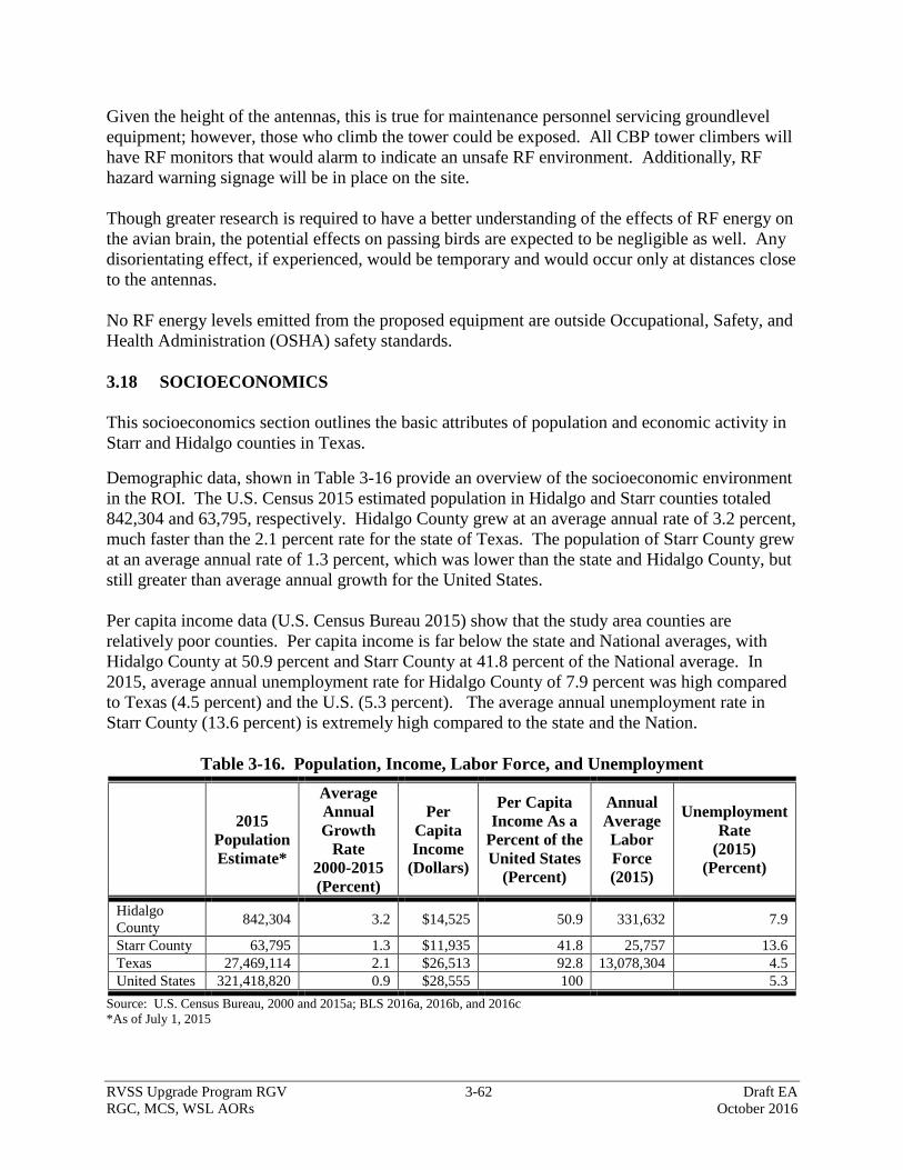
RVSS Upgrade Program RGV 3-62 Draft EA
RGC, MCS, WSL AORs October 2016
Given the height of the antennas, this is true for maintenance personnel servicing groundlevel
equipment; however, those who climb the tower could be exposed. All CBP tower climbers will
have RF monitors that would alarm to indicate an unsafe RF environment. Additionally, RF
hazard warning signage will be in place on the site.
Though greater research is required to have a better understanding of the effects of RF energy on
the avian brain, the potential effects on passing birds are expected to be negligible as well. Any
disorientating effect, if experienced, would be temporary and would occur only at distances close
to the antennas.
No RF energy levels emitted from the proposed equipment are outside Occupational, Safety, and
Health Administration (OSHA) safety standards.
3.18 SOCIOECONOMICS
This socioeconomics section outlines the basic attributes of population and economic activity in
Starr and Hidalgo counties in Texas.
Demographic data, shown in Table 3-16 provide an overview of the socioeconomic environment
in the ROI. The U.S. Census 2015 estimated population in Hidalgo and Starr counties totaled
842,304 and 63,795, respectively. Hidalgo County grew at an average annual rate of 3.2 percent,
much faster than the 2.1 percent rate for the state of Texas. The population of Starr County grew
at an average annual rate of 1.3 percent, which was lower than the state and Hidalgo County, but
still greater than average annual growth for the United States.
Per capita income data (U.S. Census Bureau 2015) show that the study area counties are
relatively poor counties. Per capita income is far below the state and National averages, with
Hidalgo County at 50.9 percent and Starr County at 41.8 percent of the National average. In
2015, average annual unemployment rate for Hidalgo County of 7.9 percent was high compared
to Texas (4.5 percent) and the U.S. (5.3 percent). The average annual unemployment rate in
Starr County (13.6 percent) is extremely high compared to the state and the Nation.
Table 3-16. Population, Income, Labor Force, and Unemployment
2015
Population
Estimate*
Average
Annual
Growth
Rate
2000-2015
(Percent)
Per
Capita
Income
(Dollars)
Per Capita
Income As a
Percent of the
United States
(Percent)
Annual
Average
Labor
Force
(2015)
Unemployment
Rate
(2015)
(Percent)
Hidalgo
County 842,304 3.2 $14,525 50.9 331,632 7.9
Starr County 63,795 1.3 $11,935 41.8 25,757 13.6
Texas 27,469,114 2.1 $26,513 92.8 13,078,304 4.5
United States 321,418,820 0.9 $28,555 100 5.3
Source: U.S. Census Bureau, 2000 and 2015a; BLS 2016a, 2016b, and 2016c
*As of July 1, 2015

RVSS Upgrade Program RGV 3-63 Draft EA
RGC, MCS, WSL AORs October 2016
3.18.1 Alternative 1: No Action Alternative
Under the No Action Alternative, the proposed RVSS upgrade would not be constructed in the
USBP’s RGC, MCS, and WSL Stations’ AORs, so no direct socioeconomic impacts would be
expected. Indirect impacts from illegal activity would continue, and indirect impacts from cross-
border violator activities and subsequent USBP interdiction activities would be greater under the
No Action Alternative than the Preferred Alternative.
3.18.2 Alternative 2: Proposed Action
The Proposed Action would have temporary, minor adverse socioeconomic impacts in some of
the areas immediately adjacent to some of the towers. Most of the 40 proposed towers are
located in rural areas, and socioeconomic impacts related to their construction, operation, and
maintenance would be negligible. For the few sites where homes are located in the vicinity of
the proposed tower or access road, residents may experience minor increases in traffic, noise,
and dust associated with construction; however, these impacts would be temporary. For the few
sites that impact agricultural lands, landowners may experience minor, temporary impacts
associated with construction, as a result of increases in traffic, noise, and dust. In a few cases, a
proposed tower may cause land to be taken out of agricultural production, resulting in permanent
impacts to landowners. With almost 800,000 acres in Hidalgo County and approximately
668,000 acres in Starr County in agricultural production (U.S. Department of Agriculture
[USDA] 2012), impacts on the counties overall would be negligible. There is one residence used
as a weekend retreat, located along Guerra Avenue in Rio Grande City, that would be directly
and permanently impacted by construction, operation, and maintenance of tower (RGC Igloo
House). However, the RVSS upgrade would allow the USBP to focus efforts on interdiction of
those involved in illegal cross-border activities and spend less time locating illegal entries,
thereby enhancing rapid response capabilities. Agents could be more efficiently deployed to
patrol the more remote sections of the RCG, MCS, and WSL, Stations’ AORs, which would
likely contribute to a decrease in cross-border violators. The decrease in cross-border violator
activities could have a beneficial effect on the incidence of crime and enhance safety in USBP
RGC, WSL, and MCS Station’s AORs, providing long-term beneficial impacts in the region.
Temporary minor beneficial impacts in the form of jobs and income for area residents, revenues
to local businesses, and sales and use taxes to counties, cities, and the State of Texas from locally
purchased building materials could be realized if construction materials are purchased locally
and local construction workers are hired for tower construction and installation.
3.19 ENVIRONMENTAL JUSTICE AND PROTECTION OF CHILDREN
Environmental Justice
EO 12898, Federal Actions to Address Environmental Justice in Minority Populations and Low-
Income Populations, was issued by President Clinton on February 11, 1994. It was intended to
ensure that proposed Federal actions do not have disproportionately high and adverse human
health and environmental effects on minority and low-income populations and to ensure greater
public participation by minority and low-income populations. It required each agency to develop
an agency-wide environmental justice strategy. A Presidential Transmittal Memorandum issued
with the EO states that “Each Federal agency shall analyze the environmental effects, including
human health, economic and social effects, of Federal actions, including effects on minority
communities and low-income communities, when such analysis is required by the NEPA 42
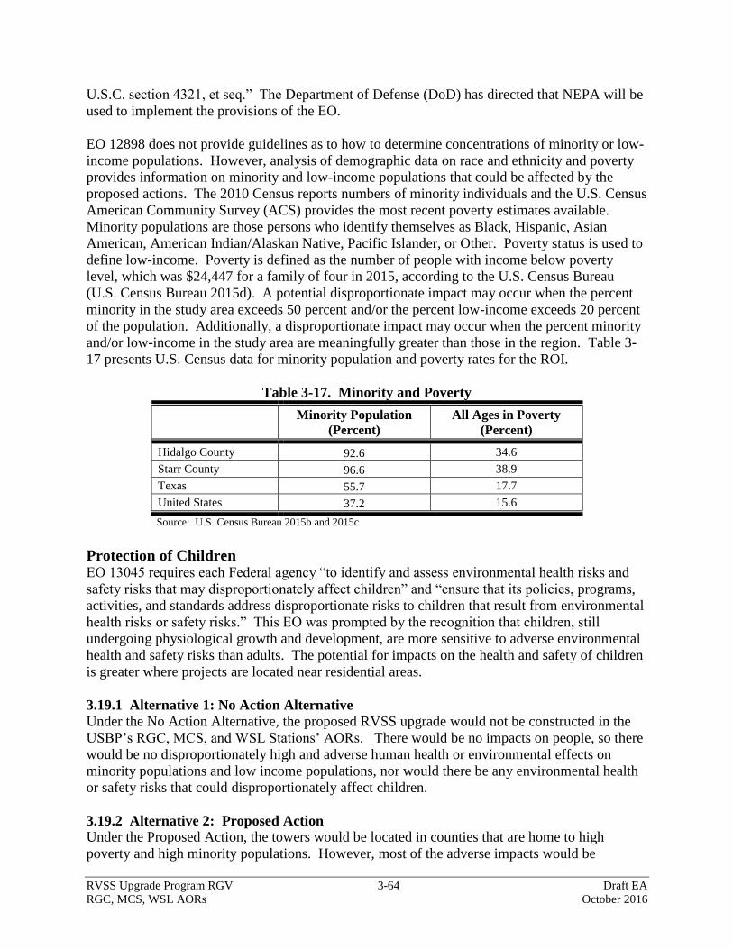
RVSS Upgrade Program RGV 3-64 Draft EA
RGC, MCS, WSL AORs October 2016
U.S.C. section 4321, et seq.” The Department of Defense (DoD) has directed that NEPA will be
used to implement the provisions of the EO.
EO 12898 does not provide guidelines as to how to determine concentrations of minority or low-
income populations. However, analysis of demographic data on race and ethnicity and poverty
provides information on minority and low-income populations that could be affected by the
proposed actions. The 2010 Census reports numbers of minority individuals and the U.S. Census
American Community Survey (ACS) provides the most recent poverty estimates available.
Minority populations are those persons who identify themselves as Black, Hispanic, Asian
American, American Indian/Alaskan Native, Pacific Islander, or Other. Poverty status is used to
define low-income. Poverty is defined as the number of people with income below poverty
level, which was $24,447 for a family of four in 2015, according to the U.S. Census Bureau
(U.S. Census Bureau 2015d). A potential disproportionate impact may occur when the percent
minority in the study area exceeds 50 percent and/or the percent low-income exceeds 20 percent
of the population. Additionally, a disproportionate impact may occur when the percent minority
and/or low-income in the study area are meaningfully greater than those in the region. Table 3-
17 presents U.S. Census data for minority population and poverty rates for the ROI.
Table 3-17. Minority and Poverty
Minority Population
(Percent)
All Ages in Poverty
(Percent)
Hidalgo County 92.6 34.6
Starr County 96.6 38.9
Texas 55.7 17.7
United States 37.2 15.6
Source: U.S. Census Bureau 2015b and 2015c
Protection of Children EO 13045 requires each Federal agency “to identify and assess environmental health risks and
safety risks that may disproportionately affect children” and “ensure that its policies, programs,
activities, and standards address disproportionate risks to children that result from environmental
health risks or safety risks.” This EO was prompted by the recognition that children, still
undergoing physiological growth and development, are more sensitive to adverse environmental
health and safety risks than adults. The potential for impacts on the health and safety of children
is greater where projects are located near residential areas.
3.19.1 Alternative 1: No Action Alternative
Under the No Action Alternative, the proposed RVSS upgrade would not be constructed in the
USBP’s RGC, MCS, and WSL Stations’ AORs. There would be no impacts on people, so there
would be no disproportionately high and adverse human health or environmental effects on
minority populations and low income populations, nor would there be any environmental health
or safety risks that could disproportionately affect children.
3.19.2 Alternative 2: Proposed Action
Under the Proposed Action, the towers would be located in counties that are home to high
poverty and high minority populations. However, most of the adverse impacts would be
RVSS Upgrade Program RGV 3-65 Draft EA
RGC, MCS, WSL AORs October 2016
temporary impacts, including minor increases in traffic, noise, and dust associated with
construction, related to the construction of towers. Permanent, adverse impacts would be minor,
impacting one landowner with a weekend retreat cabin and on several landowners with land in
agricultural production and rangelands. Additionally, the construction site would be fenced off
to avoid accidental entry into the construction zone. All entry and egress points into the
construction zone would be gated and locked upon completion of work for the day to minimize
the potential for accidental entry during non-work hours. Further, proper signage would be
attached to the perimeter fence. The Proposed Action would not result in disproportionately high
and adverse human health or environmental effects on minority populations and low income
populations, nor would there be environmental health or safety risks that disproportionately
affect children.
3.20 SUMMARY OF IMPACTS
Table 3-18 is provided to summarize the impacts of the No Action Alternative and Proposed
Action on each of the elements discussed in this section (Affected Environment).
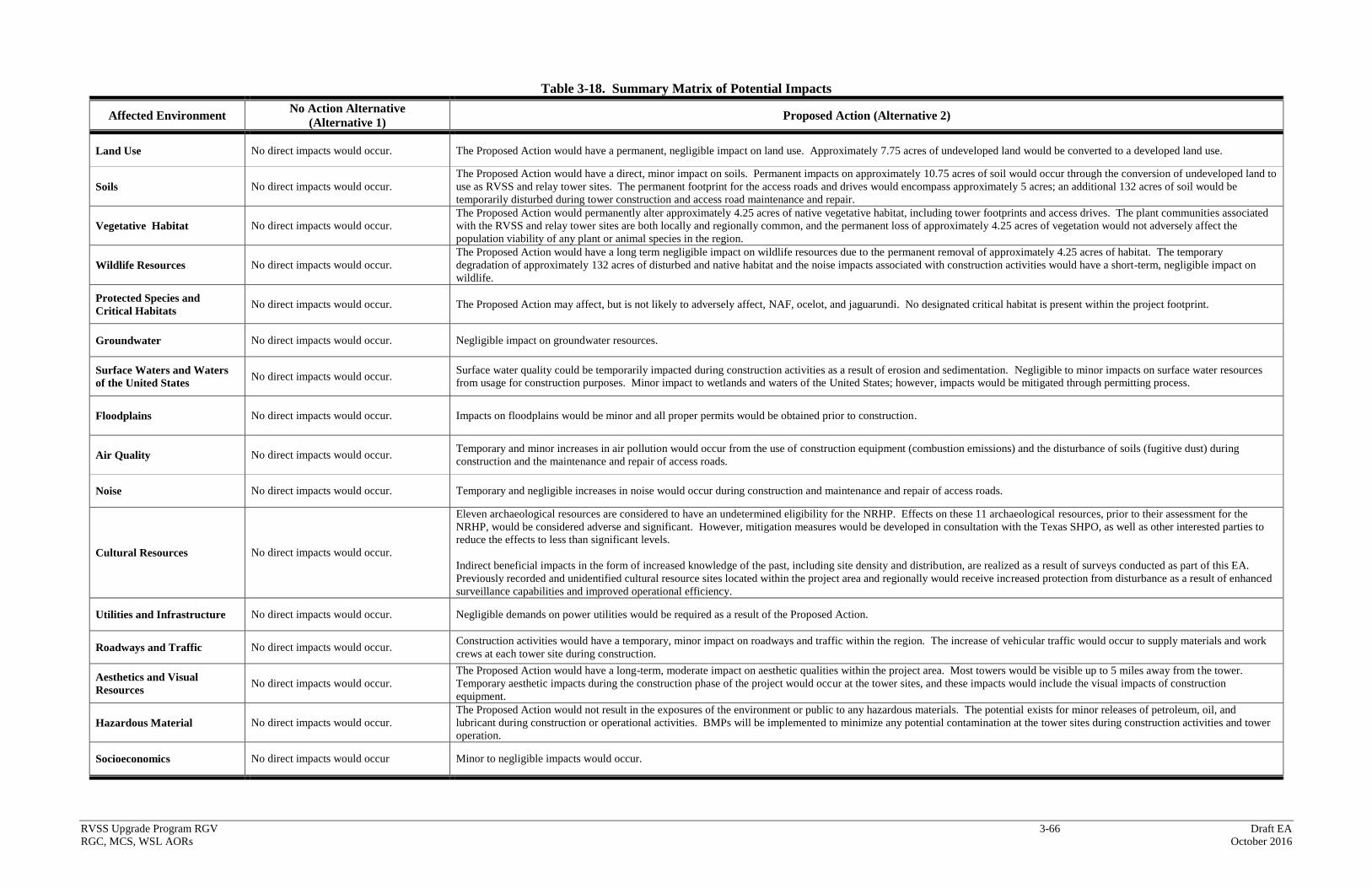
RVSS Upgrade Program RGV 3-66 Draft EA
RGC, MCS, WSL AORs October 2016
Table 3-18. Summary Matrix of Potential Impacts
Affected Environment No Action Alternative
(Alternative 1) Proposed Action (Alternative 2)
Land Use No direct impacts would occur. The Proposed Action would have a permanent, negligible impact on land use. Approximately 7.75 acres of undeveloped land would be converted to a developed land use.
Soils No direct impacts would occur.
The Proposed Action would have a direct, minor impact on soils. Permanent impacts on approximately 10.75 acres of soil would occur through the conversion of undeveloped land to
use as RVSS and relay tower sites. The permanent footprint for the access roads and drives would encompass approximately 5 acres; an additional 132 acres of soil would be
temporarily disturbed during tower construction and access road maintenance and repair.
Vegetative Habitat No direct impacts would occur.
The Proposed Action would permanently alter approximately 4.25 acres of native vegetative habitat, including tower footprints and access drives. The plant communities associated
with the RVSS and relay tower sites are both locally and regionally common, and the permanent loss of approximately 4.25 acres of vegetation would not adversely affect the
population viability of any plant or animal species in the region.
Wildlife Resources No direct impacts would occur.
The Proposed Action would have a long term negligible impact on wildlife resources due to the permanent removal of approximately 4.25 acres of habitat. The temporary
degradation of approximately 132 acres of disturbed and native habitat and the noise impacts associated with construction activities would have a short-term, negligible impact on
wildlife.
Protected Species and
Critical Habitats No direct impacts would occur. The Proposed Action may affect, but is not likely to adversely affect, NAF, ocelot, and jaguarundi. No designated critical habitat is present within the project footprint.
Groundwater No direct impacts would occur. Negligible impact on groundwater resources.
Surface Waters and Waters
of the United States No direct impacts would occur.
Surface water quality could be temporarily impacted during construction activities as a result of erosion and sedimentation. Negligible to minor impacts on surface water resources
from usage for construction purposes. Minor impact to wetlands and waters of the United States; however, impacts would be mitigated through permitting process.
Floodplains No direct impacts would occur. Impacts on floodplains would be minor and all proper permits would be obtained prior to construction.
Air Quality No direct impacts would occur. Temporary and minor increases in air pollution would occur from the use of construction equipment (combustion emissions) and the disturbance of soils (fugitive dust) during
construction and the maintenance and repair of access roads.
Noise No direct impacts would occur. Temporary and negligible increases in noise would occur during construction and maintenance and repair of access roads.
Cultural Resources No direct impacts would occur.
Eleven archaeological resources are considered to have an undetermined eligibility for the NRHP. Effects on these 11 archaeological resources, prior to their assessment for the
NRHP, would be considered adverse and significant. However, mitigation measures would be developed in consultation with the Texas SHPO, as well as other interested parties to
reduce the effects to less than significant levels.
Indirect beneficial impacts in the form of increased knowledge of the past, including site density and distribution, are realized as a result of surveys conducted as part of this EA.
Previously recorded and unidentified cultural resource sites located within the project area and regionally would receive increased protection from disturbance as a result of enhanced
surveillance capabilities and improved operational efficiency.
Utilities and Infrastructure No direct impacts would occur. Negligible demands on power utilities would be required as a result of the Proposed Action.
Roadways and Traffic No direct impacts would occur. Construction activities would have a temporary, minor impact on roadways and traffic within the region. The increase of vehicular traffic would occur to supply materials and work
crews at each tower site during construction.
Aesthetics and Visual
Resources No direct impacts would occur.
The Proposed Action would have a long-term, moderate impact on aesthetic qualities within the project area. Most towers would be visible up to 5 miles away from the tower.
Temporary aesthetic impacts during the construction phase of the project would occur at the tower sites, and these impacts would include the visual impacts of construction
equipment.
Hazardous Material No direct impacts would occur.
The Proposed Action would not result in the exposures of the environment or public to any hazardous materials. The potential exists for minor releases of petroleum, oil, and
lubricant during construction or operational activities. BMPs will be implemented to minimize any potential contamination at the tower sites during construction activities and tower
operation.
Socioeconomics No direct impacts would occur Minor to negligible impacts would occur.

RVSS Upgrade Program RGV 4-1 Draft EA
RGC, MCS, WSL AORs October 2016
4.0 CUMULATIVE IMPACTS
This section of the EA defines cumulative impacts, identifies past, present, and reasonably
foreseeable projects relevant to cumulative impacts, and analyzes the potential cumulative
impacts associated with the implementation of the Proposed Action and other projects/programs
planned within the ROI, which comprises the USBP’s RGC, MCS, and WSL Stations’ AORs.
4.1 DEFINITION OF CUMULATIVE IMPACTS
The CEQ defines cumulative impacts as “the impact on the environment which results from the
incremental impact of the action when added to other past, present and reasonably foreseeable
actions regardless of what agency (Federal or non-Federal) or person undertakes such other
actions” (40 CFR § 1508.7). Cumulative impacts can result from individually minor but
collectively significant actions taking place over a period of time by various agencies (Federal,
state, or local) or individuals. CEQ guidance on cumulative effects requires the definition of the
scope of the other actions and their interrelationship with the Proposed Action (CEQ 1997). The
scope must consider geographic and temporal overlaps with the Proposed Action and all other
actions occurring within the ROI. Informed decision making is served by consideration of
cumulative impacts resulting from activities that are proposed, under construction, recently
completed, or anticipated to be implemented in the reasonably foreseeable future.
This cumulative impacts analysis summarizes expected environmental effects from the combined
impacts of past, current, and reasonably foreseeable future activities affecting any part of the
human or natural environment impacted by the Proposed Action. Activities were identified for
this analysis by reviewing CBP and USBP documents, news/press releases, and published media
reports, and through consultation with planning and engineering departments of local
governments and state and Federal agencies.
4.2 PAST IMPACTS WITHIN THE REGION OF INFLUENCE
The ecosystems within the ROI have been significantly impacted by historical and ongoing
activities such as ranching, livestock grazing, mining, agricultural development, cross-border
violator activity and resulting law enforcement actions, and climate change. All of these actions
have, to a greater or lesser extent, contributed to several ongoing threats to the ecosystem,
including loss and degradation of habitat for both common and rare wildlife and plants and the
proliferation of roads and trails due to cross-border violator activity and resulting law
enforcement actions. Although activities that occurred on Federal lands (DOI and BLM) were
regulated by NEPA, the most substantial impacts of these activities within the ROI such as
ranching, livestock grazing, and cross-border violator activity and resulting law enforcement
actions, were not or are not regulated by NEPA and did not include efforts to minimize impacts.
4.3 CURRENT AND REASONABLY FORESEEABLE CBP PROJECTS WITHIN
AND NEAR THE REGION OF INFLUENCE
USBP has conducted law enforcement actions along the border since its inception in 1924 and
has continuously transformed its methods as new missions, modes of operations of cross-border
RVSS Upgrade Program RGV 4-2 Draft EA
RGC, MCS, WSL AORs October 2016
violators, agent needs, and National enforcement strategies have evolved. Development and
maintenance of training ranges, station and sector facilities, detention facilities, roads, and fences
have impacted thousands of acres, with synergistic and cumulative impacts on soil, wildlife
habitats, water quality, and noise. Beneficial effects, too, have resulted from the construction
and use of these roads and fences, including, but not limited to, increased employment and
income for border regions and its surrounding communities; protection and enhancement of
sensitive resources north of the border; reduction in crime within urban areas near the border;
increased land value in areas where border security has increased; and increased knowledge of
the biological communities and prehistory of the region through numerous biological and
cultural resources surveys and studies.
With continued funding and implementation of CBP’s environmental conservation measures,
including use of biological monitors, wildlife water systems, and restoration activities, adverse
impacts due to future and ongoing projects would be avoided or minimized. Recent, ongoing,
and reasonably foreseeable proposed actions will result in cumulative impacts; however, the
cumulative impacts will not be significant. CBP is currently planning, is conducting, or has
completed several projects in the USBP’s RGC, MCS, and WSL Stations’ AORs, including the
following:
Demolition of eight USBP owned housing units at Falcon Village, Texas, which included
completely removing all housing and related infrastructure (fences, underground storate
tanks, aboveground storage tanks, septic tanks, cisterns, walkways, and trees and
vegetation). Falcon Village is located at the southeastern tip of Falcon Lake in Starr
County, Texas.
Construction, operation, and maintenance of USBP Falfurrias Station Traffic Checkpoint.
Establishment of a 6-acre construction staging/laydown area adjacent to the proposed
Falfurrias Station Traffic Checkpoint and temporarily grading approximately 8 acres
within an existing gas pipeline ROW adjacent to the checkpoint.
Maintenance and repair of tactical infrastructure along the US/Mexico international
border in the El Paso, Big Bend, Del Rio, Laredo, and RGV sectors.
Construction and maintenance of 32 RVSS towers and associated roads within the
Falfurrias, Brownsville, Harlingen, Fort Brown, and Kingsville Station’s AORs.
In addition, TxDOT and the LRGVNWR are currently planning or conducting several projects in
the ROI and include:
Improvements to US 281 (Military Highway) between farm to market (FM) 3248 FM
1421. The project includes expanding the existing road from a 2-lane road to a 4-lane
road with a continuous center turn lane and will entail constructing left and right turn
lanes at intersections.
Improvements to FM 494 between state highway (SH) 107 and FM 1924 (Mile 3). The
project includes construction of four 12-foot-wide travel lanes, one 16-foot-wide
continuous left turn lane, 10-foot-wide outside shoulders, 6-foot sidewalks where needed,
an underground storm drain system, and two drainage outfalls.
Construction of a US 83 relief route from FM 886 to Showers Road in La Joya, Texas.
The project consists of constructing a four-lane controlled access expressway facility
RVSS Upgrade Program RGV 4-3 Draft EA
RGC, MCS, WSL AORs October 2016
within a usual 350-foot-wide to a maximum 450-foot-wide ROW. The project begins
approximately 1.0 mile east of FM 886 (El Faro Road) and runs east approximately 0.50
mile west of Showers Road. The total project length is projected to be approximately 8.9
miles.
Improvements to Interstate 2 (I-2) and Bicentennial Boulevard in McAllen, Texas. The
project consists of replacing the I-2 underpass at Bicentennial Boulevard with an
overpass, raising bridges and overpasses on 23rd
Street and 10th
Street, changing entrance
and exit ramps along I-2, resurfacing I-2 from FM 2220 to McColl Road, as well as
utility, sidewalk, and crosswalk signal improvements.
Yearly LRGVNWR farmland phase-out and revegetation program and participation in
the Friends of the Wildlife Corridor campaign. Since 1997 LRGVNWR and Friends of
the Wildlife Corridor have implemented these programs and approximately 300 acres per
year are revegetated with native vegetation creating habitat corridors.
A summary of the anticipated cumulative impacts relative to the Proposed Action is presented
below. The discussion is presented for each of the resources described previously.
4.4 ANALYSIS OF CUMULATIVE IMPACTS
Impacts on each resource were analyzed according to how other actions and projects within the
ROI might be affected by the No Action Alternative and Proposed Action. Impacts can vary in
degree or magnitude from a slightly noticeable change to a total change in the environment. For
the purpose of this analysis the intensity of impacts will be classified as negligible, minor,
moderate, or major. These intensity thresholds were previously defined in Section 3.1. A
summary of the anticipated cumulative impacts on each resource is presented below.
4.4.1 Land Use
A major impact would occur if any action is inconsistent with adopted land use plans or if an
action would substantially alter those resources required for, supporting or benefiting the current
use. About half of the project area is currently undeveloped scrub and brush rangeland located in
rural areas. Under the No Action Alternative, land use would not change. However, cross-
border violator activities would continue to impact land use in the project area. Although the
Proposed Action would convert approximately 7.25 acres of undeveloped land to a developed
use, the Proposed Action and other CBP actions would not initiate an increase of development in
the immediate vicinity of the projects. Therefore, the Proposed Action, when combined with
past and proposed actions in the region, would not be expected to result in a major cumulative
adverse effect.
4.4.2 Soils
A major impact on soils would occur if the action exacerbates or promotes long-term erosion, if
the soils are inappropriate for the proposed construction and would create a risk to life or
property, or if there would be a substantial reduction in agricultural production or loss of prime
farmland soils. Modification of soils would not occur under the No Action Alternative; however,
soils would continue to be impacted due to cross-border violator activity in the area of tower
coverage. The Proposed Action and other CBP actions would not substantially reduce prime
farmland soils or agricultural production regionally, as much of the land developed by CBP has
RVSS Upgrade Program RGV 4-4 Draft EA
RGC, MCS, WSL AORs October 2016
not been previously used for agricultural production. Pre- and post-construction SWPPP
measures would be implemented to control soil erosion. Indirect beneficial impacts due to the
deterrence of cross-border violator activity within the area of tower coverage resulting in a
reduction in soil disturbances are anticipated. The permanent impact on 7.25 acres of soils (of
which 1.75 acres are considered prime farmland soils) from the Proposed Action, when
combined with past and proposed actions in the region, would not be considered a major
cumulative adverse effect.
4.4.3 Vegetative Habitat
A major impact on vegetation would occur if a substantial reduction in ecological processes,
communities, or populations would threaten the long-term viability of a species or result in the
substantial loss of a sensitive community that could not be offset or otherwise compensated.
Vegetative habitat would not be disturbed or removed under the No Action Alternative since the
proposed RVSS and relay towers and associated road construction and improvements would not
occur. However, long-term direct and indirect impacts on vegetation communities would
continue as a result of cross-border violator activities that create unauthorized roads and trails,
damage vegetation and promote the dispersal and establishment of nonnative invasive species.
The South Texas Brush Country ecoregion encompasses approximately 28,000 square miles in
south Texas. Therefore, due to the permanent impact of only 8.25 acres (road and tower site) on
native vegetation, in conjunction with other past, ongoing and proposed regional projects, the
Proposed Action would not create a major cumulative effect on vegetative habitat in the region.
4.4.4 Wildlife Resources
A major impact on wildlife and aquatic resources would occur if a substantial reduction in
ecological processes, communities, or populations would threaten the long-term viability of a
species or result in the substantial loss of a sensitive community that could not be offset or
otherwise compensated. Under the No Action Alternative, no direct impacts on wildlife or
wildlife habitats would occur. However, off-road cross-border violator activity and required
interdiction actions would continue to degrade wildlife habitat through a loss of cover, forage,
nesting or other opportunities and potentially a loss of suitable habitat over large areas. The
wildlife habitat present in the project area is both locally and regionally common. In fact, the
USFWS has a program that revegetates approximately 300 acres of existing farmland per year
with native vegetation. Therefore, due to the permanent impact of only 8.25 acres of native
habitat, in conjunction with other past, ongoing, and proposed regional projects, the amount of
habitat potentially removed would be minor on a regional scale. Thus, the Proposed Action
would not create a major cumulative effect on wildlife populations in the region.
4.4.5 Threatened and Endangered Species
A major impact on protected species would occur if any action resulted in a jeopardy opinion for
any endangered, threatened, or rare species. Under the No Action Alternative, there would be no
direct impacts on threatened or endangered species or their habitats as no construction activities
would occur. However, the direct and long-term impacts of illegal border activities throughout
the project area and surrounding areas would continue due to the creation of trails, damage to
vegetation, and the promotion of the dispersal and establishment of invasive species which can
result in catastrophic wildfires.

RVSS Upgrade Program RGV 4-5 Draft EA
RGC, MCS, WSL AORs October 2016
Although potential habitat for the jaguarundi, ocelot, and NAF exists at and near the proposed
RVSS and relay tower sites, the construction, operation, and maintenance activities associated
with the towers and road improvements, construction, and maintenance would not likely
adversely affect these species. Likewise, BMPs, which limit potential impacts on these species,
would be in place during the construction of the Proposed Actions and would continue to be in
place once the RVSS and relay towers are operational. Thus, when combined with other existing
and proposed actions in the region, the Proposed Action would not result in major cumulative
impacts on protected species or designated Critical Habitats. Any indirect, cumulative impacts
on protected species would be negligible to minor.
4.4.6 Groundwater, Surface Water, Waters of the U.S., and Floodplains
Under the No Action Alternative, no impacts on water resources would occur because the
construction of the proposed RVSS and relay towers and associated access drives and
maintenance and repair of access roads would not occur. No groundwater withdrawals are
expected as a result of the Proposed Action; therefore, there would be no cumulative effects.
Drainage patterns of surface waters would not be impacted by the Proposed Action and minimal
amounts of surface waters for construction purposes would be used within the USBP RGV
Sector. Water quality would remain unchanged under the Proposed Action. A potentially
jurisdictional wetland would be impacted; however, through the permitting process a no net loss
of wetlands would be achieved. Therefore, no cumulative impacts would occur on wetlands. As
mentioned previously, specific erosion and sedimentation controls and other BMPs would be in
place during construction as standard operating procedures. There is potential to impact the 100-
year floodplain as a result of the Proposed Action; however, CBP is coordinating with the
USIBWC regarding potential impacts on the floodplain from the proposed construction of towers
within the floodplain. The reforestation of current agricultural land would have a minimal
impact on flows within the floodplain. Therefore, the Proposed Action, in conjunction with other
past, ongoing, and proposed regional projects, would not create a major cumulative effect on
water resources in the region.
4.4.7 Air Quality
No direct impacts on air quality would occur due to construction activities under the No Action
Alternative; however, fugitive dust emissions created by illegal cross-border violators and
resulting law enforcement actions, as well as vehicle traffic on authorized roads, would continue.
The emissions generated during the construction of the RVSS and relay tower sites, and all
associated road construction, repair, and improvement would not exceed Federal de minimis
thresholds and would be short-term and minor. Generator emissions would be sporadic and
would not exceed Federal de minimis thresholds. There would be no long-term increase in
vehicular traffic in the region’s airshed. Therefore, the Proposed Action, when combined with
other past, ongoing, and proposed actions in the region, would not result in major adverse
cumulative impacts.
4.4.8 Noise
A major impact would occur if ambient noise levels permanently increased to over 65 dBA in
general or greater than 57 dBA within or near the LRGVNWR. Under the No Action
Alternative, the sensitive noise receptors and wildlife near the proposed RVSS and relay tower
sites and associated roads would not experience construction or operational noise associated with
RVSS Upgrade Program RGV 4-6 Draft EA
RGC, MCS, WSL AORs October 2016
the towers; however noise emissions associated with cross-border violators and consequent law
enforcement actions would be long-term and minor, and would continue under the No Action
Alternative. The vast majority of the noise generated by the Proposed Action would occur
during RVSS and relay tower construction, road construction, road improvement, and road
maintenance. These activities would be temporary and would not contribute to cumulative
impacts on ambient noise levels. Operational noise would also be sporadic and would not
increase ambient noise conditions above 65 dBA or 57 dBA within refuge lands. Thus, the noise
generated by the Proposed Action, when considered with the other existing and proposed actions
in the region, would not result in a major cumulative adverse effect.
4.4.9 Cultural Resources
Although no impacts on cultural resources would occur from construction activities under the No
Action Alternative, potential adverse impacts on cultural resources would continue to occur due
to cross-border violators within the area of tower coverage. The Proposed Action would not
affect cultural resources or historic properties once mitigation measures have been implemented
but is anticipated to provide increased protection from disturbance due to the deterrence of cross-
border violators within the area of tower coverage. Therefore, the Proposed Action, when
combined with other existing and proposed actions in the region, would not result in major
cumulative impacts on cultural resources or historic properties. Additionally, beneficial impacts
in the form of increased knowledge of the past, including site density and distribution, are
realized as a result of surveys conducted as part of the Proposed Action, and other past, ongoing,
and proposed actions in the region.
4.4.10 Utilities and Infrastructure
Actions would be considered to cause major impacts if they require greater utilities or
infrastructure use than can be provided. The proposed RVSS and relay towers would not be
constructed under the No Action Alternative, so the availability of utilities would not be affected.
All of the proposed RVSS and relay towers would connect to existing commercial grid power
infrastructure. The use of commercial grid power would not require greater utilities or
infrastructure than can be provided since the RVSS and relay tower sites are located near
existing commercial grid power infrastructure. Therefore, when combined with past, ongoing, or
proposed actions in the region, no major cumulative adverse effect on utilities or infrastructure
would occur as a result of the Proposed Action.
4.4.11 Roadways and Traffic
Impacts on traffic or roadways would be considered to cause major impacts if the increase of
average daily traffic exceeded the ability of the surface streets to offer a suitable level of service
for the area. Under the No Action Alternative, impacts on roadways and traffic would remain
status quo. In general, the roads in the vicinity of the RVSS and relay towers sites are very
lightly travelled and construction activities for the Proposed Action would be limited in duration,
and maintenance trips would be sporadic. Therefore, when combined with past, ongoing, or
proposed actions in the region, no major cumulative adverse effect on roadways and traffic
would occur as a result of the Proposed Action.

RVSS Upgrade Program RGV 4-7 Draft EA
RGC, MCS, WSL AORs October 2016
4.4.12 Aesthetics and Visual Resources
Actions that cause the permanent loss of the characteristics that make an area visually unique or
sensitive would be considered to cause a major impact. Aesthetics would not be directly affected
by the No Action Alternative because no towers would be constructed, however, discarded
debris and trash resulting from cross-border violator activity would be expected to continue and
would increasingly detract from the visual quality of the project area. No major impacts on
visual resources would occur from construction of the proposed RVSS and relay tower sites and
road construction, repair, or improvements. However, the proposed towers would be readily
visible from 3 to 5 miles depending on the location and elevation of an observer. The Proposed
Action, in conjunction with other past, ongoing, and proposed actions in the region, would result
in moderate adverse cumulative impacts on the region’s visual resources.
4.4.13 Hazardous Materials
Major impacts would occur if an action creates a public hazard, if the project area is considered a
hazardous waste site that poses health risks, or if the action would impair the implementation of
an adopted emergency response or evacuation plan. Under the No Action Alternative, no
impacts associated with the use of hazardous materials would be expected. Only minor increases
in the use of hazardous substances would occur as a result of the Proposed Action. BMPs would
be implemented to minimize the risk from hazardous materials during construction at the RVSS
and relay tower sites. One of the proposed RVSS tower sites has debris and automobiles that
would require removal and disposal to an approved off-site location. Another site could have
potential to encounter petroleum fluids during construction. If hazardous materials are
encountered at the two tower sites during construction, proper cleanup and disposal of any
contaminated soil would minimize the impact on the environment and prevent contamination of
soil or surface waters off-site. Through the use of BMPs, no health or safety risks would be
created by the Proposed Action. The effects of the Proposed Action, when combined with other
past, ongoing, and proposed actions in the region, would not be considered a major cumulative
effect.
4.4.14 Radio Frequency (RF) Environment
Under the No Action Alternative, daily radio operations by CBP and other law enforcement
would continue; however the RVSS and relay tower sites would not be installed or operated.
There would be no impacts on the existing RF environment or effects on the human or natural
environment. The communications and sensor equipment proposed as part of the tower project
would emit EM and RF; however, the equipment proposed by CBP was certified to be safe for
humans and wildlife at normal exposure levels. CBP will seek NTIA certification for
communications equipment. No other known actions would affect the EM and RF environment
within the project area; thus, the Proposed Action would have a negligible cumulative effect.
4.4.15 Socioeconomics and Environmental Justice
Although no impacts on socioeconomics or environmental justice would occur from construction
activities under the No Action Alternative, potential adverse impacts on socioeconomics or
environmental justice would continue to occur due to cross-border violators within the area of
tower coverage. No adverse direct impacts would occur on socioeconomics or environmental
justice issues as a result of the Proposed Action; therefore, no adverse cumulative impacts would
occur. However, construction of the proposed RVSS and relay towers would have temporary
RVSS Upgrade Program RGV 4-8 Draft EA
RGC, MCS, WSL AORs October 2016
cumulative beneficial impacts on the region’s economy due to temporary employment and sales
taxes generated through the purchase of construction-related items such as fuel and food. When
combined with the other currently proposed or ongoing projects within the region, the Proposed
Action is considered to have minor beneficial cumulative impacts.
RVSS Upgrade Program RGV 5-1 Draft EA
RGC, MCS, WSL AORs October 2016
5.0 BEST MANAGEMENT PRACTICES
This chapter describes those measures that will be implemented to reduce or eliminate potential
adverse impacts on the human and natural environments. Many of these measures have been
incorporated as standard operating procedures by CBP on past projects. BMPs will be presented
for each resource category that would be potentially affected. It should be emphasized that these
are general BMPs and the development of specific BMPs will be required for certain activities
implemented under the action alternatives. The proposed BMPs will be coordinated through the
appropriate agencies and land managers/administrators, as required.
It is Federal policy to reduce adverse impacts through the sequence of avoidance, minimization,
and, finally, compensation. Compensation varies and includes activities such as restoration of
habitat in other areas, acquisition of lands, etc., and is typically coordinated with the USFWS and
other appropriate Federal and state resource agencies.
5.1 GENERAL PROJECT PLANNING CONSIDERATIONS
1. If security lights are necessary, only low-sodium bulbs that are both shielded and motion-
activated will be used.
2. If required, night-vision-friendly strobe lights necessary for CBP operational needs will use
the minimum wattage and number of flashes per minute necessary to ensure operational
safety.
3. Avoid contamination of ground and surface waters by storing concrete wash water, and any
water that has been contaminated with construction materials, oils, equipment residue, etc., in
closed containers on-site until removed for disposal. This wash water is toxic to wildlife.
Storage tanks must have proper air space (to avoid rainfall-induced overtopping), be on-
ground containers, and be located in upland areas instead of washes.
4. Avoid lighting impacts during the night by conducting construction and maintenance
activities during daylight hours only. If night lighting is unavoidable, 1) use special bulbs
designed to ensure no increase in ambient light conditions, 2) minimize the number of lights
used, 3) place lights on poles pointed down toward the ground, with shields on lights to
prevent light from going up into sky, or out laterally into landscape, and 4) selectively place
lights so they are directed away from all native vegetative communities.
5. CBP will notify USFWS land managers 2 weeks before any project construction and
maintenance activities begin and within one week after project construction and maintenance
activities are completed.
6. CBP will avoid the spread of non-native plants by not using natural materials (e.g., straw) for
on-site erosion control. If natural materials must be used, the natural material would be
certified weed and weed-seed free. Herbicides not toxic to listed species that may be in the
area can be used for non-native vegetation control. Application of herbicides will follow
RVSS Upgrade Program RGV 5-2 Draft EA
RGC, MCS, WSL AORs October 2016
Federal guidelines and can be used according to in accordance with label directions. A
USFWS Pesticide Use Permit will be obtained prior to applying herbicides on USFWS lands.
7. CBP will ensure that all construction will follow DHS Directive 025-01 for Sustainable
Practices for Environmental, Energy, and Transportation Management.
8. CBP will place drip pans under parked equipment and establish containment zones when
refueling vehicles or equipment.
5.2 SOILS
1. Clearly demarcate the perimeter of all new areas to be disturbed using flagging or temporary
construction fencing. Do not allow any disturbance outside that perimeter.
2. The area of disturbance will be minimized by limiting deliveries of materials and equipment
to only those needed for effective project implementation.
3. Within the designated disturbance area, grading or topsoil removal will be limited to areas
where this activity is needed to provide the ground conditions necessary for construction or
maintenance activities.
4. Only those roads necessary for construction of tower sites will be constructed or repaired.
5. Road repairs shall avoid making windrows with the soils once grading activities are
completed, and any excess soils will be used on-site to raise and shape the tower site or road
surface as applicable.
6. Roads will be properly designed and located such that the widening of existing or created
roadbed beyond the design parameters due to grading and use will be avoided or minimized.
7. Properly design and locate roads such that the potential for roadbed erosion into Federally
listed species habitat will be avoided or minimized.
8. Rehabilitation will include revegetating or the distribution of organic and geological
materials (i.e., boulders and rocks) over the disturbed area to reduce erosion while allowing
the area to naturally vegetate.
9. Vehicular traffic associated with the construction activities and operational support activities
will remain on established roads to the maximum extent practicable.
5.3 BIOLOGICAL RESOURCES
1. Materials used for on-site erosion control will be free of non-native plant seeds and other
plant parts to limit potential for infestation.
RVSS Upgrade Program RGV 5-3 Draft EA
RGC, MCS, WSL AORs October 2016
2. Identify by its source location any fill material, sandbags, hay bales, and mulch brought in
from outside the project area. These materials will be free of non-native plant seeds and
other plant parts to limit potential for infestation.
3. Native seeds or plants, which are compatible with the enhancement of protected species, will
be used to revegetate temporarily disturbed areas.
4. Obtain materials such as gravel, topsoil, or fill from existing developed or previously used
sources that are compatible with the project area and are from legally permitted sites. Do not
use materials from undisturbed areas adjacent to the project area.
5. The number of vehicles traveling to and from the project site and the number of trips per day
will be minimized to reduce the likelihood of disturbing animals in the area or injuring
animals on the road.
6. Construction vehicle speed limits will not exceed 35 miles per hour (mph) on major unpaved
roads (i.e., graded with ditches on both sides) and 25 mph on all other unpaved roads.
During periods of decreased visibility (e.g., night, poor weather, curves), do not exceed
speeds of 25 mph.
7. To prevent entrapment of wildlife species, ensure that excavated, steep-walled holes or
trenches are either completely covered by plywood or metal caps at the close of each
workday or provided with one or more escape ramps (at no greater than 1,000-foot intervals
and sloped less than 45 degrees) constructed of earthen fill or wooden planks.
8. Each morning before the start of construction or maintenance activities and before such holes
or trenches are filled, ensure that they are thoroughly inspected for trapped animals. Ensure
that any animals discovered are allowed to escape voluntarily (by escape ramps or temporary
structures), without harassment, and before construction activities resume, or are removed
from the trench or hole by a qualified person and allowed to escape unimpeded.
9. The Migratory Bird Treaty Act (MBTA) (16 U.S.C. 703-712, [1918, as amended 1936, 1960,
1968, 1969, 1974, 1978, 1986 and 1989]) requires that Federal agencies coordinate with the
USFWS if a construction activity would result in the take of a migratory bird. If construction
or clearing activities are scheduled during nesting season (March 1 through September 1)
within potential nesting habitats, surveys will be performed to identify active nests. If
construction activities will result in the take of a migratory bird, then coordination with the
USFWS and TPWD will be required and applicable permits would be obtained prior to
construction or clearing activities. Other mitigation measure that would be considered is to
install visual markers on any guy wires used, schedule all construction activities outside
nesting season, negating the requirement for nesting bird surveys. The proposed RVSS and
relay towers would also comply with USFWS guidelines for reducing fatal bird strikes on
communications towers (USFWS 2000), to the greatest extent practicable.
10. Anti-perching devices will be incorporated into the site design and installed on the tower.

RVSS Upgrade Program RGV 5-4 Draft EA
RGC, MCS, WSL AORs October 2016
11. CBP will not, for any length of time, permit any pets inside the project area or adjacent
native habitats. This BMP does not pertain to law enforcement animals.
12. The backup generator noise at the tower site will not exceed existing day-night average
ambient noise levels, to the greatest extent practicable.
5.4 PROTECTED SPECIES
1. All contractors, work crews (including military personnel), and CBP personnel in the field
performing construction and maintenance activities will receive environmental awareness
training. At a minimum, environmental awareness training will provide the following
information: maps indicating occurrence of potentially affected and Federally listed species;
the general ecology, habitat requirements, and behavior of potentially affected Federally
listed species; the BMPs listed here and their intent; reporting requirements; and the penalties
for violations of the ESA. It will be the responsibility of the project manager(s) to ensure
that their personnel are familiar with general BMPs, the specific BMPs presented here, and
other limitations and constraints. Photographs of potentially affected Federally listed species
will be incorporated into the environmental awareness training and posted in the contractor
and resident engineer’s offices where they will remain through the duration of the project,
and copies will be made available that can be carried while conducting proposed activities.
In addition, training in identification of non-native invasive plants and animals will be
provided for contracted personnel engaged in follow-up monitoring of construction sites.
5.5 CULTURAL RESOURCES
1. Vehicular traffic associated with the construction activities and operational support activities
will remain on established roads to the maximum extent practicable. NRHP-eligible sites
(recommended and determined) and those of undetermined eligibility, as detailed in Section
3.12, should be avoided and will be demarked with green flagging tape.
2. In the event that unanticipated archaeological resources are discovered during construction or
any other project-related activities, or should known archaeological resources be
inadvertently affected in a manner that was not anticipated, the project proponent or
contractor shall immediately halt all activities in the immediate area of the discovery and take
steps to stabilize and protect the discovered resource until it can be evaluated by a qualified
archaeologist.
5.6 AIR QUALITY
1. BMPs will include the placement of flagging and construction fencing to restrict traffic
within the construction limits in order to reduce soil disturbance. Soil watering will be
utilized to minimize airborne particulate matter created during construction activities. Bare
ground may be covered with hay or straw to lessen wind erosion during the time between
tower construction and the revegetation of temporary impact areas with a mixture of native
plant seeds or nursery plantings (or both). All construction equipment and vehicles will be
kept in good operating condition to minimize exhaust emissions.
RVSS Upgrade Program RGV 5-5 Draft EA
RGC, MCS, WSL AORs October 2016
5.7 WATER RESOURCES
1. Wastewater is to be stored in closed containers on-site until removed for disposal.
Wastewater is water used for project purposes that is contaminated with construction
materials or from cleaning equipment and thus carries oils or other toxic materials or other
contaminants as defined by Federal or state regulations.
2. Avoid contamination of ground and surface waters by collecting concrete wash water in open
containers and disposing of it off-site.
3. Avoid contaminating natural aquatic and wetland systems with runoff by limiting all
equipment maintenance, staging, and laydown and dispensing hazardous liquids, such as fuel
and oil, to designated upland areas.
4. Cease work during heavy rains and do not resume work until conditions are suitable for the
movement of equipment and materials.
5. Erosion control measures and appropriate BMPs, as required and promulgated through a site-
specific SWPPP and engineering designs, will be implemented before, during, and after soil-
disturbing activities.
6. Areas with highly erodible soils will be given special consideration when preparing the
SWPPP to ensure incorporation of various erosion control techniques, such as straw bales,
silt fencing, aggregate materials, wetting compounds, and rehabilitation, where possible, to
decrease erosion.
7. All construction and maintenance contractors and personnel will review the CBP-approved
spill protection plan and implement it during construction and maintenance activities.
8. Wastewater from pressure washing must be collected. A ground pit or sump can be used to
collect the wastewater. Wastewater from pressure washing must not be discharged into any
surface water.
9. If soaps or detergents are used, the wastewater and solids must be pumped or cleaned out and
disposed of in an approved facility. If no soaps or detergents are used, the wastewater must
first be filtered or screened to remove solids before being allowed to flow off-site.
Detergents and cleaning solutions must not be sprayed over or discharged into surface
waters.
12. Road maintenance will be designed and implemented so that the hydrology of streams,
ponds, and other water course are not altered.
13. Properly design and locate roads such that the potential for entrapment of surface flows
within the roadbed due to grading will be avoided or minimized.
RVSS Upgrade Program RGV 5-6 Draft EA
RGC, MCS, WSL AORs October 2016
5.8 NOISE
1. All generators will have an attached muffler or use other noise-abatement methods in
accordance with industry standards.
2. Avoid noise impacts during the night by conducting construction and maintenance activities
during daylight hours only.
3. All OSHA requirements will be followed. To lessen noise impacts on the local wildlife
communities, construction will only occur during daylight hours. All motor vehicles will be
properly maintained to reduce the potential for vehicle-related noise.
5.9 SOLID AND HAZARDOUS WASTES
1. BMPs will be implemented as standard operating procedures during all construction
activities, and will include proper handling, storage, and/or disposal of hazardous and/or
regulated materials. To minimize potential impacts from hazardous and regulated materials,
all fuels, waste oils, and solvents will be collected and stored in tanks or drums within a
secondary containment system that consists of an impervious floor and bermed sidewalls
capable of containing the volume of the largest container stored therein. The refueling of
machinery will be completed in accordance with accepted industry and regulatory guidelines,
and all vehicles will have drip pans during storage to contain minor spills and drips.
Although it is unlikely that a major spill would occur, any spill of reportable quantities will
be contained immediately within an earthen dike, and the application of an absorbent (e.g.,
granular, pillow, sock) will be used to absorb and contain the spill.
2. CBP will contain non-hazardous waste materials and other discarded materials, such as
construction waste, until removed from the construction and maintenance sites. This will
assist in keeping the project area and surroundings free of litter and reduce the amount of
disturbed area needed for waste storage.
3. CBP will minimize site disturbance and avoid attracting predators by promptly removing
waste materials, wrappers, and debris from the site. Any waste that must remain more than
12 hours should be properly stored until disposal.
4. All waste oil and solvents will be recycled. All non-recyclable hazardous and regulated
wastes will be collected, characterized, labeled, stored, transported, and disposed of in
accordance with all applicable Federal, state, and local regulations, including proper waste
manifesting procedures.
5. Solid waste receptacles will be maintained at the construction staging area. Non-hazardous
solid waste (trash and waste construction materials) will be collected and deposited in on-site
receptacles. Solid waste will be collected and disposed of by a local waste disposal
contractor.
RVSS Upgrade Program RGV 5-7 Draft EA
RGC, MCS, WSL AORs October 2016
6. Disposal of used batteries or other small quantities of hazardous waste will be handled,
managed, maintained, stored, and disposed of in accordance with applicable Federal and state
rules and regulations for the management, storage, and disposal of hazardous materials,
hazardous waste and universal waste. Additionally, to the extent practicable, all batteries
will be recycled locally.
7. All rainwater collected in secondary containment will be pumped out, and secondary
containment will have netting to minimize exposure to wildlife.
8. A properly licensed and certified hazardous waste disposal contractor will be used for
hazardous waste disposal, and manifests will be traced to final destinations to ensure proper
disposal is accomplished.
5.10 ROADWAYS AND TRAFFIC
1. Construction vehicles will travel and equipment will be transported on established roads with
proper flagging and safety precautions.
RVSS Upgrade Program RGV 6-1 Draft EA
RGC, MCS, WSL AORs October 2016
6.0 IRRETRIEVABLE AND IRREVERSIBLE COMMITMENT OF RESOURCES
NEPA requires that Federal agencies identify “any irreversible and irretrievable commitments of
resources which would be involved in the Proposed Action should it be implemented” (42 U.S.C.
§ 4332). An irreversible commitment of resources occurs when the primary or secondary
impacts of an action result in the loss of future options for a resource. Usually, this is when the
action affects the use of a nonrenewable resource or it affects a renewable resource that takes a
long time to renew. An irretrievable commitment of resources is typically associated with the
loss of productivity or use of a natural resource (e.g., loss of production or harvest).
Most impacts for this project are short-term and temporary or, if long-term, are negligible. An
irreversible commitment of resources includes the commitments of labor, energy/fossil fuels, and
construction materials (e.g., sand, gravel, steel, aluminum). However, not all this material would
be irreversibly committed because some of it may be recovered and recycled later. An
irreversible commitment of resources would also include the commitment of land and natural
resources, such as soils and vegetation, located within the project area. However, not all of this
would be irreversible because much of the land could be converted back to prior use at a future
date. The loss of agricultural land (land used for grazing and farming) would result in
irretrievable impacts on agricultural production during construction and operation of the tower
sites though. The accidental or unintentional removal or disturbance of previously unidentified
cultural resources could result in the irretrievable and irreversible loss of data. However, BMPs
decrease the likelihood of this occurring. No irreversible or irretrievable impacts on wetlands or
Federally protected species or their habitat is anticipated as mitigation for any lands lost would
be coordinated between the USACE, USFWS, and CBP.
RVSS Upgrade Program RGV 7-1 Draft EA
RGC, MCS, WSL AORs October 2016
7.0 REFERENCES
Bauer, K. Jack. 2011. “Mexican War.” Handbook of Texas Online. Electronic document,
http://www.tshaonline.org/handbook/online/articles/qdm02, accessed August 27, 2011.
Published by the Texas State Historical Association.
Beason, Robert. 1999. The Bird Brain: Magnetic Cues, Visual Cues, and Radio Frequency (RF)
Effects. Robert C. Beason, Ph.D., Biology Department, State University of New York,
Geneseo, NY 14454. Ph. 716/ 245-5310. Internet URL: http://www.fws.gov/
migratorybirds/issues/towers/beason.html.
Black, Stephen L. 1989a. South Texas Plains. In From the Gulf to the Rio Grande: Human
Adaptation in Central, South, and Lower Pecos Texas by Thomas R. Hester, Stephen L.
Black, D. Gentry Steele, Ben W. Olive, Anne A. Fox, Karl J. Reinhard, and Leland C.
Bement. Arkansas Archeological Survey Research Series No. 33. Prepared by the
Center for Archaeological Research at the University of Texas, San Antonio, Texas
A&M University, and the Arkansas Archeological Survey, Fayetteville.
Bousman, C. Britt, Barry W. Baker, and Anne C. Kerr. 2004. Paleoindian Archeology in Texas.
In The Prehistory of Texas edited by Timothy K. Perttula. Texas A&M University Press,
College Station, Texas.
Bureau of Land Management (BLM). 2009. U.S. Department of the Interior—BLM Manual H-
8410-1-Visual Resources Inventory. Internet URL: http://www.blm.gov/nstc/
VRM/8410.html.
California Energy Commission 2007. 2007 Integrated Energy Policy Report, CEC-100-2007-
008-CMF.
Chessman, Bruce S. 2010. “KING, RICHARD,” Handbook of Texas Online, Electronic
document: http://www.tshaonline.org/handbook/online/articles/KK/fki19.html, Last
accessed July 1, 2010. Published by the Texas State Historical Association.
Coalson, George O. 2010. “KLEBERG COUNTY,” Handbook of Texas Online. Electronic
document: http://www.tshaonline.org/handbook/online/articles/KK/hck10.html, Last
accessed July 1, 2010. Published by the Texas State Historical Association.
Council on Environmental Quality (CEQ). 1997. Considering Cumulative Effects: Under the
National Environmental Policy Act. January 1997. Internet URL:
http://ceq.hss.doe.gov/nepa/ccenepa/exec.pdf.
CEQ. 2010. Memorandum for Heads of Federal Departments and Agencies. Draft NEPA
Guidance on Consideration of the Effects of Climate Change and Greenhouse Gas
Emissions. Nancy H. Sutley., February 18, 2010.
CEQ. 2012. Federal Greenhouse Gas Accounting and Reporting Guidance. June 4, 2012.
RVSS Upgrade Program RGV 7-2 Draft EA
RGC, MCS, WSL AORs October 2016
Department of Homeland Security (DHS). 2011. Report on the Assessment of the Secure
Border Initiative-Network (SBInet) Program. Office of the Secretary, Washington, D.C.
Evans, W. R., and A. M. Manville, II (eds.). 2000. “Avian mortality at communication towers.”
Transcripts of Proceedings of the Workshop on Avian Mortality at Communication
Towers. August 11, 1999, Cornell University, Ithaca, NY. Internet URL: http://
migratorybirds.fws.gov/issues/towers/agenda.html.
Federal Emergency Management Agency (FEMA). 2016. FEMA Flood Map Service Center.
Internet URL: https://msc.fema.gov/portal.
Federal Highway Administration (FHWA). 2007. Special Report: Highway construction Noise:
Measurement, Prediction, and Mitigation, Appendix A Construction Equipment Noise
Levels and Ranges. www.fhwa.dot.gov/environment/noise/highway/hcn06.htm.
Fox, Anne A. 1989. Historic Anglo-European Exploration and Colonization. In From the Gulf
to the Rio Grande: Human Adaptation in Central, South, and Lower Pecos Texas by
Thomas R. Hester, Stephen L. Black, D. Gentry Steele, Ben W. Olive, Anne A. Fox, Karl
J. Reinhard, and Leland C. Bement. Arkansas Archeological Survey Research Series No.
33. Prepared by the Center for Archaeological Research at the University of Texas, San
Antonio, Texas A&M University, and the Arkansas Archeological Survey, Fayetteville.
Hester, Thomas R. 1980. Digging into South Texas Prehistory: A Guide for Amateur
Archaeologists. Corona Publishing Company, San Antonio, Texas
Hester, Thomas R. 1989. Historic Native American Populations. In From the Gulf to the Rio
Grande: Human Adaptation in Central, South, and Lower Pecos Texas by Thomas R.
Hester, Stephen L. Black, D. Gentry Steele, Ben W. Olive, Anne A. Fox, Karl J.
Reinhard, and Leland C. Bement. Arkansas Archeological Survey Research Series No.
33. Prepared by the Center for Archaeological Research at the University of Texas, San
Antonio, Texas A&M University, and the Arkansas Archeological Survey, Fayetteville.
Hester, Thomas R. 1999. Artifacts, Archeology, and Cabeza de Vaca in Southern Texas and
Northeastern New Mexico. Bulletin of the Texas Archeological Society 70:17-28.
Hester, Thomas R. 2004. The Prehistory of South Texas. In The Prehistory of Texas edited by
Timothy K. Perttula. Texas A&M University Press, College Station, Texas.
Kelly, C. 2007. “Health Physics Society, Radiofrequency (RF) Radiation.” Internet URL:
http://hps.org/hpspublications/articles/rfradiation.html.
Long, Christopher. 2010. “NUECES COUNTY,” Handbook of Texas Online. Electronic
document: http://www.tshaonline.org/handbook/online/articles/NN/hcn5.html, accessed
July 1, 2010. Published by the Texas State Historical Association.

RVSS Upgrade Program RGV 7-3 Draft EA
RGC, MCS, WSL AORs October 2016
National Park Service (NPS). 1996. Executive Order 13007. Electronic document,
http://www.nps.gov/history/local-law/eo13007.htm, accessed January 19, 2016.
NPS. 2002. National Register Bulletin: How to Apply the National Register Criteria for
Evaluation. National Register Bulletin No. 15, prepared by the staff of the National
Register of Historic Places, finalized by Patrick W. Andrus, and edited by Rebecca H.
Shrimpton. Electronic resource, http://www.nps.gov/nr/publications/bulletins/nrb15/.
Last accessed January 19, 2016.
NPS. 2006a. National Historic Preservation Act, As Amended in Federal Historic Preservation
Laws published by the National Center for Cultural Resources, National Park Service,
Department of the Interior. Electronic document, http://www.nps.gov/history/local-
law/FHPL_HistPrsrvt.pdf. Accessed January 19, 2016.
NPS. 2006b. Native American Graves Protection and Repatriation Act, As Amended in Federal
Historic Preservation Laws published by the National Center for Cultural Resources,
National Park Service, Department of the Interior. Electronic document,
http://www.nps.gov/history/local-law/FHPL_NAGPRA.pdf. Accessed January 19, 2016.
NPS. 2006c. Archaeological Resources Protection Act, As Amended in Federal Historic
Preservation Laws published by the National Center for Cultural Resources, National
Park Service, Department of the Interior. Electronic document,
http://www.nps.gov/history/local-law/FHPL_ArchRsrcsProt.pdf. Accessed January 19,
2016.
NatureServe. 2009. International Ecological Classification Standard: Terrestrial Ecological
Classifications. NatureServe Central Databases. Arlington, VA. U.S.A. Data current as of
08 October 2009.
Newcombe, Jr., W.W. 2002. The Indians of Texas: From Prehistoric to Modern Times.
University of Texas Press. Thirteenth Edition. Austin, Texas.
Office of Engineering and Technology (OET). 1999. Questions and Answers about Biological
Effects Potential Hazards of Radiofrequency Electromagnetic Fields. OET, Federal
Communications Commission Bulletin Number 56, Fourth Edition, August 1999.
Internet URL: http://www.fcc.gov/Bureaus/Engineering_Technology/Documents/
bulletins/oet56/oet56e4.pdf.
Parker, Patricia L. and Thomas F. King. 1998. National Register Bulletin: Guidelines for
Evaluating and Documenting Traditional Cultural Properties. National Register Bulletin
No. 38, National Park Service, Electronic resource,
http://www.nps.gov/nr/publications/bulletins/nrb38/. Last accessed January 19, 2016.
RVSS Upgrade Program RGV 7-4 Draft EA
RGC, MCS, WSL AORs October 2016
Ricklis, Robert A. 2004. Prehistoric Occupation of the Central and Lower Texas Coast: A
Regional Overview in The Prehistory of Texas edited by Timothy K. Pertula. Texas
A&M University Press, College Station, Texas.
Sánchez, J. P. 1992. From El Paso to Eagle Pass: Spanish Entradas along the Lower Rio Grande
in the Sixteenth and Seventeenth Centuries. Bulletin of the Texas Archeological Society
63:53-66.
Starr County Groundwater Conservation District (GCD). 2013. Starr County GCD Management
Plan. October 2013
Stokes, Anne V., Brenda Swann, Monte Kim, Len E. Winters, and Norma Barrera 2009.
Naval Air Station Kingsville: Integrated Cultural Resources Management Plan, 2009 to
2014. Integrated Cultural Resource Management Plan prepared by Southeastern
Archaeological Research, Inc. Jonesville, Florida, Naval Facilities Engineering
Command, Southeast, Naval Air Station, Jacksonville, Florida, and Naval Air Station
Kingsville, Kingsville, TX.
Texas Commission on Environmental Quality (TCEQ). 2016. Atlas of Texas Surface Waters.
Internet URL: http://www.tceq.state.tx.us/publications/gi/gi-316/index.html.
Texas Parks and Wildlife Department (TPWD). 2015. Plant Guidance by Ecoregions,
Ecoregion 6 – South Texas Brush Country. Internet URL:
https://tpwd.texas.gov/huntwild/wild/wildlife_diversity/wildscapes/ecoregions/ecoregion
_6.phtml.
TPWD, Wildlife Division, Diversity and Habitat Assessment Programs. TPWD County Lists of
Protected Species and Species of Greatest Conservation Need. [Hidalgo County, Starr
County, 1/7/2016 ]. 2/2/2016.
Texas Water Development Board (TWDB), 2011. Aquifers of Texas, Report 380.
TWDB. 2016. Rio Grande Regional Water Planning Group. 2016 Region M Water Plan,
Chapter 3: Water Supplies. Internet URL:
http://www.riograndewaterplan.org/downloads/2016RWP/RWP_V1_Chapter3.pdf.
U.S. Bureau of Labor Statistics (BLS). 2016a. Local Area Unemployment Statistics. Labor
Force Data by County 2015 Annual Averages and Unemployment Rates for States.
Internet URL: http://www.bls.gov/lau/.
BLS. 2016b. Employment Status of the Civilian Noninstitutional Population by Sex, Race,
Hispanic or Latino Ethnicity, Marital Status, and Detailed Age, 2015 Annual Averages.
Internet URL: http://www.bls.gov/lau/
BLS. 2016c. States and selected areas: Employment status of the civilian noninstitituioal
population, 1976 to 2015 annual averages.
RVSS Upgrade Program RGV 7-5 Draft EA
RGC, MCS, WSL AORs October 2016
U.S. Census Bureau. 2000. 2000 Decennial Census. Internet URL:
http://factfinder2.census.gov/.
U.S. Census Bureau. 2015a. American Community Survey (ACS), 5-Year Estimates, 2010-
2014. Per Capita Income in the Past 12 Months: B19301. Internet URL:
http://factfinder2.census.gov/.
U.S. Census Bureau. 2015b. American Community Survey (ACS), 5-Year Estimates, 2010-
2014. Demographic and Housing Estimates: DP05. Internet URL:
http://factfinder2.census.gov/.
U.S. Census Bureau. 2015c. ACS, 5-Year Estimates, 2010-2014. Poverty Status in the Past 12
Months: S1701. Internet URL: http://factfinder2.census.gov/.
U.S. Census Bureau, Population Division. 2015d. Poverty Thresholds for 2015 by Size of
Family and Number of Related Children Under 18 Years.
U.S. Census Bureau, Population Division. 2016a. Annual Estimates of the Resident Population:
April 1, 2010 to July 1, 2015. Internet URL: http://factfinder2.census.gov/.
U.S. Customs and Border Protection (CBP). 2007. Environmental Impact Statement for
Construction, Maintenance, and Operation of Tactical Infrastructure, Rio Grande Valley
Sector, Texas.
CBP. 2012. 2012-2016 Border Patrol Strategic Plan. CBP Office of Border Patrol.
Washington, DC 20229. Internet URL:
http://www.cbp.gov/linkhandler/cgov/border_security/border_patrol/bp_strat_plan/bp_str
at_plan.ctt/bp_strat_plan.pdf.
CBP. 2014. Draft Environmental Assessment for Integrated Fixed Towers on the Tohono
O’Odham Nation in the Ajo and Casa Grande Stations’ Area of Responsibility, U.S.
Border Patrol Tucson Sector, Arizona, U.S. Customs and Border Protection, Department
of Homeland Security.
U.S. Department of Agriculture (USDA), 2012. National Agricultural Statistics Service, Census
of Agriculture. Hidalgo and Starr Counties, Texas. Internet URL:
http://www.agcensus.usda.gov.
U.S. Environmental Protection Agency (USEPA). 1974. Information on Levels of
Environmental Noise Requisite to Protect Public Health and Welfare with an Adequate
Margin of Safety. Report 550/9-74-004.
USEPA. 2016a. . Internet URL: http://www.epa.gov/air/criteria.html
USEPA. 2016b. Welcome to the Green Book Nonattainment Areas for Criteria Pollutants.
www.epa.gov/oar/oaqps/greenbk. Last Accessed. 10/11/13.
RVSS Upgrade Program RGV 7-6 Draft EA
RGC, MCS, WSL AORs October 2016
U.S. Fish and Wildlife Service (USFWS). 1982. Endangered and threatened wildlife and plants;
endangered status for U.S. population of the ocelot. Federal Registar 47: 31 670-31 672.
USFWS. 1990. Northern aplomado falcon recovery plan. U.S. Fish and Wildlife Service.
Albuquerque, New Mexico. 56.pp
USFWS. 2000. “Service Guidance on the Siting, Construction, Operation, and
Decommissioning of Communications Towers.” Memorandum to Regional Directors
from Director Jamie Rappaport Clark. 14 September 2000.
USFWS. 2004. Zapata Bladderpod (Lesquerella thamnophila) Recovery Plan. U.S. Fish and
Wildlife Service, Albuquerque, New Mexico. I-vii + 30pp., Appendices A-B.
USFWS. 2006. Endangered and Threatened Wildlife and Plants; Establishment of a
Nonessential Experimental Population of Northern Aplomado Falcons in New Mexico
and Arizona and Availability of Draft Environmental Assessment. Federal Register
70(26): 6819.
USFWS. 2010a. Draft Ocelot (Leopardus pardalis) Recovery Plan, First Revision. U.S. Fish
and Wildlife Service, Southwest Region, Albuquerque, New Mexico.
USFWS. 2010b. Endangered and Threatened Wildlife and Plants; 5-Year Status Reviews of 14
Southwestern Species. Federal Register 75(59):15454.
USFWS. 2013a. “Revised Voluntary Guidelines for Communication Tower Design, Siting,
Operation, Retrofitting, and Decommissioning.” Suggestions Based on Previous USFWS
Recommendations to FCC Regarding WT Docket No. 03-187, FCC 06-164, Notice of
Public Rulemaking, “Effects of Communication Towers on Migratory Birds” (2007),
Docket No. 08-61, FCC’s Antenna Structure Registration Program (2011), Service 2012
Wind Energy Guidelines, and Service 2013 Eagle Conservation Plan Guidance.
Submitted by Albert M. Manville, 27 September 2013.
USFWS. 2013b. Gulf Coast jaguarundi (Puma yagouaroundi cacomitli) Recovery Plan, First
Revision. USFWS, Southwest Region. Albuquerque, New Mexico.
USFWS. 2014. Northern Aplomado Falcon 5-Year Review: Summary and Evaluation. Internet
URL: http://ecos.fws.gov/docs/five_year_review/doc4436.pdf.
USFWS. 2016a. Information for Planning and Conservcation (IPaC). Proposed, Candidate,
Threatened, and Endangered Species. Internet URL: https://ecos.fws.gov/ipac/.
USFWS. 2016b. National Wetland Inventory, Wetlands Code Interpreter. Internet URL:
https://www.co.kittitas.wa.us/uploads/cds/land-use/Administrative%20Segregations/SG-
04-11091%20Rinehart/PUBFx%20Wetlands%20Code%20Interpreter.pdf.
RVSS Upgrade Program RGV 7-7 Draft EA
RGC, MCS, WSL AORs October 2016
US Housing and Urban Development (HUD) 1984. 24 CFR Part 51 - Environmental Criteria and
Standards Sec. 51.103 Criteria and standards 44 FR 40861, July 12, 1979, as amended at
49 FR 12214, Mar. 29, 1984.
Wooster, Ralph A. 2011. “Civil War,” Handbook of Texas Online. Electronic Document,
http://www.tshaonline.org/handbook/online/articles/qdc02, accessed August 23, 2001.
Published by the THC.
RVSS Upgrade Program RGV 8-1 Draft EA
RGC, MCS, WSL AORs October 2016
8.0 ACRONYMS/ABBREVIATIONS
ACS U.S. Census American Community Survey
ANSI American National Standards Institute
AoA Analysis of Alternatives
AOR Area of Responsibility
ARPA Archaeological Resources Protection Act
AST Aboveground Storage Tank
ASTM American Society for Testing and Materials
BGS Below ground surface
BLM Bureau of Land Management
BMP Best management practices
BPA Border Patrol Agents
BPFTI Border Patrol Facilities and Tactical Infrastructure
C2 Command and Control
CBP U.S. Customs and Border Protection
CEQ Council on Environmental Quality
CFC chlorofluorocarbons
CFR Code of Federal Regulations
CH4 methane
CO2 Carbon dioxide
CWA Clean Water Act
dBA A-weighted decibel
DHS Department of Homeland Security
DNL Day-night average sound level
DOI U.S. Department of the Interior
EA Environmental Assessment
EM Electromagnetic
E.O. Executive Order
ESA Endangered Species Act
FAA Federal Aviation Administration
FCC Federal Communications Commission
FCR fire-cracked rock
FHWA Federal Highway Administration
FONSI Finding of No Significant Impact
GCD Groundwater Conservation District
GHG Greenhouse Gases
HFC hydrochlorofluorocarbons
HTC Historic Texas Cemeteries
HUD U.S. Department of Housing and Urban Development
IEEE Institute of Electrical and Electronics Engineers
IoI items of interest
LRGVNWR Lower Rio Grande Valley National Wildlife Refuges
MCS McAllen
MPE Maximum Permissible Exposure
N2O nitrous oxide
RVSS Upgrade Program RGV 8-2 Draft EA
RGC, MCS, WSL AORs October 2016
NAAQS National Ambient Air Quality Standards
NAF Northern Aplomado Falcon
NAGPRA Native American Graves Protection and Repatriation Act
NCRP National Council on Radiation Protection and Measurements
NE not eligible
NEPA National Environmental Policy Act
NHPA National Historic Preservation Act
NOA Notice of Availability
NRHP National Register of Historic Places
NTIA National Telecommunications and Information Administration
NVG night vision goggles
OET Office of Engineering and Technology
OSHA Occupational Safety and Health Administration
OTHM Official Texas Historical Markers
OTIA Office of Technology Innovation and Acquisition
POE Port of Entry
PMO Program Management Office
RF radio frequency
RGC Rio Grande City
RGV Rio Grande Valley
ROI region of influence
ROW right-of-way
RTHL Recorded Texas Historic Landmarks
RVSS Remote Video Surveillance Systems
SHPO Texas State Historic Preservation Officer
SPCCP Spill Prevention, Control and Countermeasure Plan
SST Self-standing towers
SWPPP Stormwater Pollution Prevention Plan
TCEQ Texas Commission on Environmental Quality
TCP Traditional Cultural Property
TI Tactical infrastructure
THC Texas Historical Commission
TPWD Texas Parks and Wildlife Department
TWDP Texas Water Development Board
TxDOT Texas Department of Transportation
U Undetermined eligibility
USACE U.S. Army Corps of Engineers
USBP U.S. Border Patrol
U.S.C. United States Code
USDA U.S. Department of Agriculture
USEPA U.S. Environmental Protection Agency
USFWS U.S. Fish and Wildlife Service
USIBWC International Boundary and Water Commission, U.S. Section
WSL Weslaco
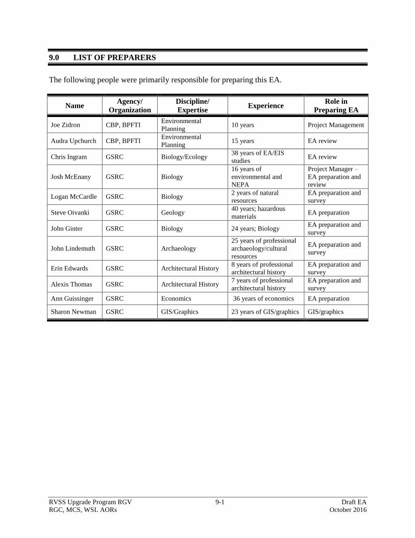
RVSS Upgrade Program RGV 9-1 Draft EA
RGC, MCS, WSL AORs October 2016
9-1
9.0 LIST OF PREPARERS
The following people were primarily responsible for preparing this EA.
Name Agency/
Organization
Discipline/
Expertise Experience
Role in
Preparing EA
Joe Zidron CBP, BPFTI Environmental
Planning 10 years Project Management
Audra Upchurch CBP, BPFTI Environmental
Planning 15 years EA review
Chris Ingram GSRC Biology/Ecology 38 years of EA/EIS
studies EA review
Josh McEnany GSRC Biology
16 years of
environmental and
NEPA
Project Manager –
EA preparation and
review
Logan McCardle GSRC Biology 2 years of natural
resources
EA preparation and
survey
Steve Oivanki GSRC Geology 40 years; hazardous
materials EA preparation
John Ginter GSRC Biology 24 years; Biology EA preparation and
survey
John Lindemuth GSRC Archaeology
25 years of professional
archaeology/cultural
resources
EA preparation and
survey
Erin Edwards GSRC Architectural History 8 years of professional
architectural history
EA preparation and
survey
Alexis Thomas GSRC Architectural History 7 years of professional
architectural history
EA preparation and
survey
Ann Guissinger GSRC Economics 36 years of economics EA preparation
Sharon Newman GSRC GIS/Graphics 23 years of GIS/graphics GIS/graphics

APPENDIX A
CORRESPONDENCE

APPENDIX B
RIO GRANDE CITY, MCALLEN, AND
WESLACO STATIONS’ SITE AND ROAD MAPS

APPENDIX C
STATE LISTED SPECIES