environment assessment and management framework
TRANSCRIPT

- Draft -
Himachal Pradesh Forests for Prosperity Project
Environment Assessment & Management Framework
Submitted By
Himachal Pradesh Forests Department,
Government of Himachal Pradesh, India
Prepared By
G. B. Pant National Institute of Himalayan Environment
& Sustainable Development, Himachal Regional Centre,
Mohal - Kullu - 175 126, Himachal Pradesh
SEPTEMBER , 2018

2
Table of Contents Table of Contents ................................................................................................................................ 2
List of Figures ...................................................................................................................................... 4
List of Tables: ...................................................................................................................................... 5
EXECUTIVE SUMMARY ........................................................................................................................... 7
Chapter 1 Introduction to the Proposed Project ................................................................................. 16
1.1 Background to the HP FPP project .............................................................................................. 16
1.2 Project development objective (PDO) ........................................................................................ 19
1.3 Project Beneficiaries ................................................................................................................... 19
1.4 Detailed Description of the Project Components ....................................................................... 20
1.5 Project Implementation Area .................................................................................................. 24
1.6. Methodology for Preparation of EMF ........................................................................................ 27
1.6.1 Objectives of the EMF ................................................................................................................ 27
1.6.2 Methodology .............................................................................................................................. 27
Chapter 2 Environmental Baseline ...................................................................................................... 31
2.1 Introduction and overview of Himachal Pradesh ....................................................................... 31
2.2 Overview of the Sutlej Basin .................................................................................................... 32
Catchment Area Treatment Plan ........................................................................................................ 33
2.3 Environmental Baseline ........................................................................................................... 33
2.3.1 .................................................................................................................................................... 34
Physiographic Profile........................................................................................................................... 34
Climate ................................................................................................................................................ 36
2.3.2 Land Use Pattern ........................................................................................................................ 41
2.3.3 Forest Area ................................................................................................................................. 43
Flora .................................................................................................................................................... 49
Natural Habitats .................................................................................................................................. 51
2.3.4 Pastures and Grazing Areas ....................................................................................................... 53
2.3.5 Fuel Wood and Fodder............................................................................................................... 55
2.3.6 Non-Timber Forest Products and Medicinal Plants ................................................................... 56
2.3.7 Forest Nurseries ......................................................................................................................... 60
2.3.7 Forest Fires ................................................................................................................................. 64
2.3.8 Community Based Forest Institutions ........................................................................................ 66
2.3.3 Water Resources ........................................................................................................................ 67
3
2.3.3.1 River Sutlej .............................................................................................................................. 69
Chapter 3 Relevant Laws, Regulations and Development Programmes ............................................ 83
3.1. Introduction ............................................................................................................................... 83
3.2. Applicable World Bank Policies ................................................................................................ 83
3.3. Policy and Regulatory Framework of Government of India (GoI) and Government of Himachal
Pradesh (GoHP) ................................................................................................................................. 85
3.4. List of Statutory Clearances and Authorizations .................................................................... 91
Chapter 4: Stakeholder Consultation .................................................................................................. 93
4.1 Identification of Key Stakeholders .............................................................................................. 94
4.2 Consultation Meetings with Key Institutions .............................................................................. 97
4.3 Stakeholder Consultations at District and Village Levels ............................................................ 98
4.4 Disclosure Workshops ............................................................................................................... 100
Chapter 5 Environment Assessment .................................................................................................. 101
5.1 Assessment of Environmental Impacts Associated with Project Activities .............................. 113
Chapter 6 Environment Management Framework ........................................................................... 132
6.1 Environmental Screening of Project Activities .......................................................................... 132
6.2 Environmental Management Plan ............................................................................................ 133
6.3 Workplan for Environmental Management .............................................................................. 134
6.4 Pest Management Plan ............................................................................................................. 136
Chapter 7 Institutional and Implementation Arrangement ............................................................. 137
7.1 Project Implementation through HPFD ................................................................................. 137
7.2 Project Level Institutional Structures ........................................................................................ 138
7.3 Implementation Plans ............................................................................................................... 139
7.4 Environment management under HPFD ................................................................................... 139
7.5 Monitoring and Reporting ........................................................................................................ 141
7.6 Capacity Building under Environment Management ................................................................ 142
7.7 Budgetary Provisions for EMF Implementation ........................................................................ 143

4
Annexure 1: List of References and Sources of Secondary Data ..................................................... 144
Annexure 2: Baseline Data Questionnaire for Field Surveys ............................................................ 148
Annexure 3: Key Findings from Baseline Field Surveys .................................................................... 155
Annexure 4: List of Stakeholders Met ............................................................................................... 158
Annexure 4: Details of Institutional Consultations ........................................................................... 161
Annexure 5: Proceedings of District Level Stakeholder Consultations ............................................ 177
Annexure 6: Proceedings of Disclosure Workshops ......................................................................... 197
Annex 7: Screening Checklists ........................................................................................................... 204
Annex 8: Format for Environmental Management Plan .................................................................. 208
Annexure 9: Environmental Management Plan for Small Civil Works – A Model Format .............. 224
Annexure 10: Occupational Health and Safety Guidelines for Forestry Operations ...................... 231
Annexure 11: Pest Management Plan for Forest Nurseries ............................................................. 234
Annexure 12: Baseline of Rupi Bhabha WLS ..................................................................................... 238
Annexure 13: Majathal WLS Baseline ................................................................................................ 242
List of Figures
Figure 1 Project Area Forest Ranges ........................................................................................................... 25
Figure 2 HPFPP Project Area (Forest Ranges) ................................................ Error! Bookmark not defined.
Figure 3 HP FFP EMF Overview ................................................................................................................... 30
Figure 4 Geographical Map of Sutlej basin ................................................................................................. 33
Figure 5 Elevation and Slope Map of the Project Area ............................................................................... 35
Figure 6 Earthquake Zones within the Sutlej basin ..................................................................................... 36
Figure 7 Climate Zones of Himachal Pradesh (left) Agro Ecological Zones in Sutlej basin (right) .............. 37
Figure 8 Map of Vulnerable, Ravine and Scrub Areas ................................................................................. 40
Figure 9 Forest Types of Himachal Pradesh ................................................................................................ 45
Figure 10 Forest Types in the Sutlej Basin .................................................................................................. 46
Figure 11 Forest/ Canopy Density Map of HP ............................................................................................. 48
Figure 12 Protected Areas in HP and Project Area ..................................................................................... 51
Figure 13 Collection calendar for important NTFPs/ MAPs ........................................................................ 59
Figure 14 Step Wise Seedling Development Practice in Current Nursuries ............................................... 62
5
Figure 15 Forest fire risk zonal map of Himachal Pradesh.......................................................................... 65
Figure 16 Sutlej River Tributaries and Classification ................................................................................... 71
Figure 17 Project area in Sutlej Catchment ................................................................................................ 72
Figure 18 Organogram of SPMU ............................................................................................................... 138
Figure 19 Responsibilities of Environment Specialist in SPMU ...................... Error! Bookmark not defined.
Figure 20 reporting framework for environmental management ............................................................ 141
List of Tables:
Table 1 General Overview of Himachal Pradesh......................................................................................... 31
Table 2 Month wise maximum and minimum temperature at selected Stations of Himachal Pradesh .... 37
Table 3 Rainfall pattern in Different districts of Himachal Pradesh District (in mm) ................................. 39
Table 4 Land Use pattern of Himachal Pradesh .......................................................................................... 41
Table 5 District wise land use patterns (In hectare) of Himachal Pradesh ................................................. 42
Table 6 Forest types in Himachal Pradesh (as per Champion and Seth) .................................................... 43
Table 7 Legal Status of Forests in Himachal Pradesh .................................................................................. 47
Table 8 Legal Classification of Forests in Project Districts .......................................................................... 47
Table 9 Geographical Distribution of Forest Density (As per FSI Report 2015) .......................................... 48
Table 10: Project District Forest Density 2015 ............................................................................................ 48
Table 11 Change in Forest Cover 2005-2017 (ISFR 2017) ........................................................................... 49
Table 12 Flora in different zones (Altitude) ................................................................................................ 49
Table 13 List of Protected Areas in FFP project area .................................................................................. 52
Table 14 Important Bird Areas of Himachal Pradesh .................................................................................. 52
Table 15 Pasture Areas in Project Districts ................................................................................................. 53
Table 16 Description of Weed Infestation in Forest Areas ......................................................................... 54
Table 17 Description of Weed Infestation in Forest Areas ......................................................................... 54
Table 18 Fodder Collection (Kg) household-1 day-1 from different altitudinal zones in Himalaya .............. 56
Table 19 Fodder Consumption (Kg) animal-1 day-1 in different seasons at different altitudinal zones ...... 56
Table 20 Value of major forest produce of Himachal Pradesh ................................................................... 57

6
Table 21 Out-turn and value of major forest produce ............................................................................... 58
Table 22 Species and Sowing Time ............................................................................................................. 60
Table 23 Details regarding nurseries in the different ranges of Rampur and Kinnaur ............................... 63
Table 24 Circle wise forest fire incidences of last two years ...................................................................... 64
Table 25 Status of Community Based Forest Institutions ........................................................................... 67
Table 26 District wise detail of Water Resources of Himachal Pradesh ..................................................... 68
Table 27 The status of development of groundwater resources in the state ............................................ 68
Table 28 Catchment details of river system of Himachal Pradesh ............................................................. 68
Table 29 Critical Environmental Resources in Project Area Forest Ranges ................................................ 73
Table 30 Baseline of economic activities in the project areas .................................................................... 75
Table 31 World Bank Safeguard policies..................................................................................................... 84
Table 32 Analysis of National and State Level Regulation applicable under the project ........................... 85
Table 33 List of Statutory Clearances and Authorizations which may be required .................................... 91
Table 34 Government Development Programmes with similar elements to HPFFPError! Bookmark not
defined.
Table 35 Government Schemes with implications on Project Design ........... Error! Bookmark not defined.
Table 36 Stakeholder Information Matrix .................................................................................................. 94
Table 37 Institutional Consultations .............................................................. Error! Bookmark not defined.
Table 38 Assessment of current threats on Forests in HP ........................................................................ 101
Table 39 Summary of Project Interventions ............................................................................................. 104
Table 40 Environmental Impact and Mitigation Guidelines .......................... Error! Bookmark not defined.
Table 41 Break Up of Forest administration unit ...................................................................................... 137
Table 42 Typical Pests and Bio Control ..................................................................................................... 234
Table 43 Typical Diseases and their control.............................................................................................. 234
Table 44 Pest Control Strategies for Key Forest Species .......................................................................... 235
Table 45 Good Nursery Management Practices Effective for Control of Pests ........................................ 235

7
EXECUTIVE SUMMARY
About the Project
The Himalayan ecosystem is fragile and one of the most complex and diverse ecosystem on the earth. It
includes over 51 million people who practice hill agriculture and remains vulnerable. The Himalayan
ecosystem is vital to the ecological security of the Indian landmass, through providing forest cover, feeding
perennial rivers that are the source of drinking water, irrigation, and hydropower. It also conserves unique
biodiversity, providing a rich base for high value agriculture, and spectacular landscapes for sustainable
tourism. Thus, forests form the important components of Himalayan ecosystem.
In Himachal Pradesh (HP), forests are an important natural asset with 67% of forest land of total
geographical area. In this total forest area, 46 % of land support, coniferous and broad-leaved forests
while the remaining 54 % include, high altitude areas above the tree line, snow peaks, alpine pastures,
and river beds. In Himachal Pradesh, Himachal Pradesh Forest Department (HPFD) owns and manages the
forest related issues. It is a unitary body and undertakes all functions of forest management, spanning
from policy formulation and planning, to provision of forest goods and services, to monitoring and
evaluation, to enforcement of rules and regulations. According to HP Forest Sector Policy and Strategy of
2005, the goal of the HPFD is to promote sustainable forest management in the state to maintain and
rehabilitate forests and enhance rural livelihoods. As per the provisions of the 14th Finance Commission,
the HPFD secure financial resources for state development programs, while maintaining forest cover of
the state. Timber, firewood, fodder, and other Non-timber Forest Products (NTFP) produced by HPFD on
public forests enhance local livelihoods. Similarly, HPFD ensure sediment retention and water regulation
services to the benefit of the hydropower sector though catchment area management plans. The
Department has also zoned 22.65% of the legally classified forest area as protected areas (5 national parks,
26 wildlife sanctuaries and 3 conservation reserves) to protect biodiversity and promote ecotourism in
these areas. It also manages all the activities falling place in these areas.
Project Description
The Project Development Objective is ‘To improve the governance, management, and community use of
forests, pastures, and watersheds at selected sites in Himachal Pradesh.’ The critical aspects in this
objective are the institutional improvements and the institutional development approach to address the
issues mentioned before. These two elements will contribute to building the momentum for reforming
the forest sector. The project will contribute to improving forest quality in the state of Himachal Pradesh
by strengthening the core functions and service delivery of the HP Forest Department; and facilitating
participation of communities and private sector in forest sector activities. This will ensure the sustainable
delivery of key ecosystem services from forest land while contributing to the state’s economic
development goals. Systemic improvements in the states afforestation programs will help to increase the
fiscal allocations to the state, from the center, a part of which are made based on forest quality. This will
lead to an overall increase in the state budget for development programmes. A more inclusive institutional
regime will enable the provision of incentives for community participation in forest and pasture
management. The project will focus on increasing benefits from sustainable managed value chains of Non-

8
Timber Forest products (NTFPs). Institutional changes will also be brought about to increase accountability
and create an enabling policy environment for private sector investments in the forestry sector.
Project Components
• The HP Forests for Prosperity Project is designed to address: i) the poor quality and density of HP’s
forests (caused by increasing pressure on the forests and the low technical and institutional capacity
of the HPFD), through a combination of institutional reform of the HPFD (while encouraging
greater cooperation and synergy of all institutions involved in watershed management), capacity
building and investments in the field targeted through a watershed management based approach;
and, ii) the limited community participation and benefit sharing from forest and pasture
management. These issues are then addressed through a number of critical interventions, so that
the project can help HP move towards improved forest management and community participation
in the medium term, with the outcomes of improved quality of forest and pasture, increased central
budget allocation from the Finance Commission, strengthened climate resilience of forests and
pastures and improved livelihoods, jobs, and income for targeted communities in the longer term.
•
➢ Component 1: Improving the provision of forest sector goods and services by HPFD
❖ Sub-component 1A: Institutional strengthening of the Himachal Pradesh Forest
Department (HPFD)
❖ Sub-component 1B: Investing in Seed and Nursery Development and Planting and
Maintenance
❖ Sub-component 1C: Improving effectiveness of the Comprehensive Catchment Area
Treatment (CCAT) plan
➢ Component 2. Facilitating better and more sustainable community and private sector forest and
pasture use
❖ Sub-component 2A: Creating an enabling environment for the sustainable trade of NTFPs
❖ Sub-component 2B: Support community participation in forest fire and pasture land
management
➢ Component 3. Institutional Coordination and Project Management
❖ Sub-component 3A: Institutional coordination
❖ Sub-component 3B: Project management
•
Preparation of Environment Assessment and Management Framework
The Environmental Management Framework (EMF) is developed to incorporate environmental and social
concerns into the main project planning, execution and operation. It will be applied to all the sub-projects
in different stages of the project cycle. The framework has been developed considering three broad stages
of project cycle viz. project preparation, project implementation and project operation. For each stage,
potential adverse environmental and social issues have been identified and mitigation measures proposed
that have been integrated with the EMF implementation process.
The specific objectives of the EMF are as under:
a. To provide a systematic approach for identifying the various possible environmental impacts at the
different stages of the project cycle.
b. To identify appropriate mitigation measures for addressing the identified environmental impacts.
9
c. To devise an institutional arrangement for mainstreaming environmental management in project
implementation processes.
Environmental Baseline
Himachal is in the western Himalayas covering an area of 55,673 km2 Most of the state lies on the foothills
of the Dhauladhar Range. At 6,816 m Reo Purgyil is the highest mountain peak in the state of Himachal
Pradesh.The drainage system of Himachal is composed both of rivers and glaciers. Himalayan rivers
crisscross the entire mountain chain. Himachal Pradesh provides water to both the Indus and Ganges
basins. The drainage systems of the region are the Chandra Bhaga or Chenab, Ravi, Beas, Sutlej, and
Yamuna rivers. These rivers are perennial and are fed by snow and rainfall. They are protected by an
extensive cover of natural vegetation.
• The state is divided into three main topographical regions; (i) the Shivalik (ii) the lesser Himalayas
and (iii) the Greater Himalayas.
• The Sutlej valley has relatively poor sandy loam constituting exposed bedrock, and gravel soil. The
soils in the study area as grouped under Udalts – Ochrepts soils are shallow, veneer and brown in
color with high base in Lahul and Spiti and Kinnaur region; Othents – Ochrepts soil are
combination of shallow red loamy and sandy ideally suitable for horticulture in Kullu and Kinnaur
district; Udoll soil characterization of cold desert and found in Kinnaur district.
• The elevation in Sutlej basin varies from 300 meters to 7000 meters. After Mandi district, the
variation in altitude of Sutlej catchment area is not high as much as in Kinnaur, Kullu, Shimla, and
Mandi districts. It flows from moderate slope at an altitude of 656 meters to 290 meters
• The Sutlej basin lies in seismically sensitive zones (zone V and IV) as per the Seismic Zoning Map
of India (Ref: IS: 1893-1984 Fourth Revision). Thirty Two percent of the total geographical area of
the State is prone to the severe seismic risks as it falls into the Very High Damage Risk Zone V.
• The climate of the state varies from place to place depending on the altitude. It varies from hot
and sub-humid tropical (450-900 m) in the southern low tracts, warm and temperate (900-1,800
m), cool and temperate (1,900-2,400 m) and cold alpine and glacial (2,400-4,800 m) in the
northern and eastern high mountain ranges.
• The climate of basin varies from hot and sub-humid tropical in the southern part and while the
glacier and alpine are seen in the eastern and northern part of the basin. In the region, the
temperature generally starts rising from the beginning of March till June, which is the hottest
month of the year.
• Sutlej basin receives precipitation from western disturbances. The western disturbance passes
over the northwestern part during the winter. Sutlej valley faced the heavy monsoon of the outer
Himalayas and heavy snowfall of the arid Tibetan.
• Climate change is affecting ecosystems and vegetation in the state. Vegetation in Himachal
Pradesh especially in upper altitudes is more vulnerable because of its sensitivity to higher
temperatures. Analysis of temperature trends in the Himalayan region shows that temperature
increases are greater in the uplands than that in the lowlands (Shrestha et al., 1999).
The total area of Himachal Pradesh is 55,673 km2, out of this 66.52% of the area of the state is legally
defined as forestland (37033 km2). But forest and tree cover constitute only 27.63% of the total
geographical area (FSI, 2013). It has been reported that only 30.5% of the recorded forest area can support

10
vegetation, as rest of the area is uncultivable because of terrain and snow (HPFD, 2005). State has 14683
sq km of forest cover and 697 sq. km of tree cover constituting a total of 15380 sq. km of forest and tree
cover (ibid). Forests are distributed across four zones in the State- viz sub-tropical forests, sub-temperate
forests, wet-temperate and dry temperate forests (GoHP, 2002).
The forest Types in Himachal Pradesh are:
❖ Sub-tropical forests occur at an elevation up to 915 meters above mean sea level (msl) with annual
rainfall between 700 to 1000 mm.
❖ Sub temperate forests are found at an elevation between 916 to 1523 MSL with an annual rainfall
of 900 to 1200 mm.
❖ Wet temperate forests are found at an elevation ranging from 1524 to 2472 meters above msl with
annual rainfall of 1000 to 2500 mm.
❖ Dry temperate forests are found above 2472 meters where mean annual precipitation of 2500 mm.
Forests fall under three legal categories of reserve, protected and unclassed forests. The reserve forests
offer minimum rights of use for local people (5.12%). The protected forests recognize many rights
including timber, grazing and non-timber forest produce for local people. Almost 90% of the state forests
fall under this category, 57% of the protected forest areas have not been demarcated i.e. their limits have
not been set through legislative orders. The unclassed is a category of forest in transition i.e. after surveys
and settlement of rights, these could be either shifted to reserve or protected forest category (Vasan,
2001)
In case of Himachal Pradesh, the area under very dense forest cover has been stable from 2005 to 2013.
Area under the category of moderately dense forests has slightly declined during this period. The open
and scrub forest area constitute 35% of the total forest cover.
The hills contain western Himalayan broadleaf forests and Himalayan subtropical pine forests.
Various deciduous and evergreen oaks live in the broadleaf forests, while chir pine dominates the pine
forests. Western Himalayan subalpine conifer forests grow near tree line, with species that include East
Himalayan fir, West Himalayan spruce, deodar (the state tree), and blue pine.
Himachal Pradesh supports 463 birds and 359 animal species, including the leopard, snow leopard (the
state animal), ghoral, musk deer and western tragopan. Himachal Pradesh has two National Parks, (Great
Himalayan National Park and Pin Valley National Park, (The Great Himalayan National Park in Kullu district
was created to conserve the flora and fauna of the main Himalayan range, while the Pin Valley National
Park to conserve the flora and fauna of the cold desert), 30 Wildlife Sanctuaries, and 3 conservation
reserves. Of which two wildlife sanctuaries fall within the project area. The Majthal Sanctuary is situated
in Solan District and has steep and rugged terrain. The sanctuary is about 10 km on the kacha road
Kararaghat (Shimla-Bilaspur Highway) to Kashlog. The sanctuary is said to have a large population of
endangered cheer pheasant, and there is also a large goral population. Rupi-Bhaba Wildlife Sanctuary is
locally well known for its vast and extensive alpine pastures above 3500m.
The permanent pastures including alpine meadows form a very important and stable ecosystem, and
cover more than 12,000km2 and constitute 21% of state geographical area. Various natural scrub forests
cover an area of 566km2 and constitute another 1% of the state geographical area. Both alpine and scrub
pastures provide important habitats to medicinal and aromatic plants in the state. HP land use estimates
indicate the area under permanent pastures and grazing lands was 1,163,402 Ha (11,634 km2) in 1966,
11
1,193,602 (11,936 km3) in 1995 and 1,471,536 (15,190km2) in 2000. The increase in alpine pasture are
recorded in 4 districts (Shimla, Kinnaur, Lahaul and Spiti, Una, and Hamirpur) where settlement operations
have been fully or partially completed, otherwise all other districts show a decrease.
Himachal’s landscape and pastures are under threat by invasive species and weeds, and this has become
a cause of serious concern from the ecological, biodiversity, socio-economic and health point of view. Key
species of concerns are Lantana camara L.; Parthenium hysterophorus L.; Ageratum conyzoides L;
Eupatorium adenophorum Sp. These invasive are a major issue in the subtropical and lower temperate
areas in the State and affect the quality of forests and the pasture lands, and availability of fodder.
Legal and Regulatory Framework
Project would be implemented with following key applicable acts, notifications, and policies: Scheduled
Tribes and Other Traditional Forest Dwellers (Recognition of Forest Rights) Act, 2006; National Policy on
Tribal Development, 1999;Panchayati Raj Act, PESA 1996; Right to Information Act, 2005; Environment
(Protection) Act and amendments,1986; National Forest Policy, 1988; Indian Forest Act, 1927; Forest
Conservation Act, 1980; HP State Forest Policy, 1980; Payment for Ecosystem Services (PES) policy 2013;
Wildlife (Protection) Act, 1972; Himachal Pradesh Participatory Forest Management Regulations, 2001
etc. World Bank' operational policies on Environmental Assessment OP/ BP 4.01; Natural Habitats OP/BP
4.04; Forests OP/BP 4.36; Pest Management OP/BP 4/.09; Physical and Cultural Resources OP/BP 4.11 and
World Bank EHS Guidelines would be applicable as well.
Stakeholder Consultations
In accordance with the World Bank Safeguard policies, consultations have been carried out with all
relevant stakeholders those who have been identified through stakeholder analysis. The consultation
process has been carried out at three levels (state, district, and village level).
• Two district level consultations were held in Reckong Peo (District Kinnaur) and Rampur (District
Shimla) with the representatives from HP forest department, associated line department officials,
block officers, forest guards, elected members of village assembly, JFMCs, NTFP collectors and
sellers, community members, NGOs, and technical/research groups. The objective of the
consultation sessions was to improve the project’s interventions regarding environmental
management and to seek views from the stakeholders on the environmental issues and the ways
these could be resolved.
• Village level consultation meetings were also held in 14 villages to create awareness and generate
understanding about the project among stakeholders, and to collect their opinion, suggestions for
planning and designing of the project.
• State level institutional consultations were undertaken with government officials in Forest
Department, Wildlife Conservators, Department of Environment, Science and Technology,
Agriculture Producer Marketing Board, Forest Development Corporation, Forest Training Institute,
and Himalayan Forest Research Institute, and Indian Grassland and Fodder Research Institute.
• Following disclosure of the draft EMF, comments and two public disclosure workshops were held
one at Reckong Peo (Schedule-V area), Distt Kinnaur and other at Rampur bushar, Distt. Shimla
for wider publicity on dated 23.08.2018 and 24.08.2018, respectively.

12
• During the workshops power point presentations were given by the Scientist’s from GB Pant
Institute regarding the project activites and their implications on the lives of the communities and
environment in general.
• The suggestions by the participants were also invited during these workshops and were duly
incorporated in the report and in project design.
The key objective of consultations was:
a. To create awareness and generate understanding about the project among stakeholders, and to
collect their opinion, suggestions for planning and designing of the project
b. To find out whether the communities are likely to accept the measures suggested under the
HPFPP and to find out whether these measures have no or little environmental impacts on the
communities.
c. To assess positive as well as adverse environmental impacts in the area through participatory
methods such as walk through and focus group discussions.
d. To identify the need and concern of the stakeholders
e. To assess cultural patterns and behavior of local communities towards the project
f. To understand the environmental issues associated with the project through discussions
g. To understand suggestions and opinions of the community, Government officials and NGOs on
mitigation measures to counter and check the adverse and negative impact that threaten the
environment in the area.
h. To understand the satisfaction level of people with proposed mitigation and management
measures proposed for the project.
Key Environment Risks and Impacts
The forests of Himachal Pradesh are a storehouse of rich biodiversity, in addition to providing forest cover,
they feed perennial rivers that are the source of drinking water, irrigation, and hydropower and provide
ecosystem services such as carbon sequestration, soil moisture regulation, erosion control, support
pollination and water and climate regulation. The forests currently face challenges of degradation,
including (i) irregular and diminished flow of natural springs, (ii) loss of soil fertility due to erosion (iii)
widening gap between demand and supply of fuel wood and fodder, and (iv) increase incidences of forest
fires, and invasive weeds leading to deterioration in habitat quality and pastures. The project
interventions themselves are designed to mitigate these issues.
The project has the potential for causing small adversely impact on the local environment if not
appropriately designed, executed and/or operated. The potential adverse impacts/risks of project
financed activities which would be managed through the provisions in the EMF include (i) pest control
strategies in forest nurseries (ii) disposal of plastic root trainers and polybags (iii) integration of species
selection, nursery planning with the planting site to ensure good survival rates (iv) construction and repair
of small erosion control structures (check dams) if not implemented with due caution could lead to
localized drainage problems and/or habitat disturbance (v) with project investment in value chain
infrastructure and enterprise support to NTFPs, there could be unsustainable expansion/intensification of

13
NTFP harvesting, and demand for feeder roads. There is also a need to ensure that all small scale civil
works (post-harvest infrastructure, nursery up-gradation, and staff quarters) do not lead to adverse
impacts on soil, drainage, noise and air quality that could impact sensitive and pristine habitats. In the
same way, component 2 activities need to ensure that incentives provided to communities to manage
forests are sustainable from environmental and sylvicultural standpoints.
Environmental Management
The Environmental Management Framework (EMF) is developed to incorporate environmental and
concerns into the main project planning, execution and operation. The main purpose of the EMF is to
provide a transparent framework with clear accountability for managing environment impacts and risks
associated with the project, outlining the criteria and procedures that the project should follow to help
ensure compliance with the Bank’s safeguard policies.
Since, the precise details and exact locations of the site-specific investments within the targeted ranges
will take place during project implementation, and are not yet known, an Environmental Management
Framework (EMF) has been prepared in accordance with the provisions of OP/BP 4.01 category B
requirements. The EMF mainstreams environmental considerations within the project, minimizing
adverse impacts and provides mitigation actions, institutional and monitoring requirements for
supervision, which will be integrated into the Project Implementation Manual. All civil works supported
by the project will be screened for environmental risks, and specified mitigations will be adopted, where
required, such as in the case of a centralized seed center, a standalone EMP would be prepared before
any works commence. Specific to the project activities the EMF includes (i) screening of project
investments based on their potential environmental impacts and benefits; (ii) compliance measures with
regulatory requirements and forest department management plans (iv) impact identification and
associated mitigation measures, and (v) guidelines based on best management practices for (a) seed
collection, management and storage; (b) nursery upgradation and management; (c) plantation
establishment; (d) soil and water conservation works (e) pest and disease control; (f) forest fire control
and response; (g) management of invasive weeds; (h) NTFP and MAP harvesting; (i) development of NTFP
pre and post-harvest value chain infrastructure, and enterprise facilitation centres; (j) health and safety
management in forestry operations; and, (k) detailed guidance on preparation of standalone EMPs for
investments which will be identified through detailed studies in project implementation such as the seed
center.
Institutional and Implementation Arrangements
The project implementation arrangements are anchored on the HPFD. The project will be managed under
the overall umbrella of the forest governance and management structure in India and following the HPFD
rules, including circles, division’s, ranges and JFMCs.
(a) State Level:
i. State Level Steering Committee: The project management and coordination will be the
responsibility of the HPFD under the overall supervision and control of the State Level
Steering Committee (SLSC). The SLSC will be headed by the Additional Chief Secretary of
the Government of HP who also heads the Department of Forest and Environment

14
ii. State Project Management Unit (SPMU): The project will be implemented by HPFD through
a State Project Management Unit headed by a Chief Project Director (CPD) who would have
day-to-day executive control of the project. The core personnel of the SPMU are 3 Deputy
Project Directors (DPD) one each for (ia) General Administration, (iib) Operations, and (iii)
Liaison, Coordination and Training (LCT). Project will have Subject Matter Specialists (SMS)
one each for Social and Community Institution Development, Environment Management,
Forest Based Livelihood, Communications and Knowledge Management, IT, Procurement,
Monitoring and Evaluation). Besides, activities such as Finance and Accounts, Administration
and Staff Matters will be handled by the superintendent staff deputed from the HPFD to the
project.
iii. Circle Office Level: The administrative control of all forest divisions rests with respective
Circles Offices headed by the Conservator of Forests who will execute the project at the field
level. An officer of the level of DFO will be appointed to coordinate and plan project activities
at the Circle level and supervise performance of divisions with respective circles. The nodal
officer will be supported by a Superintendent, Junior Engineer (JE) and an Office Assistant.
iv. Division Office Level: The project operations at the division will be planned and supervised
by respective Division Forest Officers. He will be supported by an Assistant Conservator of
Forests, Senior Assistance and Office Assistant.
v. Range Office Level: Range will be the basic unit of project planning and implementation. All
activities of component 1 and 2 will be planned through a Range Management Plan. Each
Range Officer will be supported by their respective Dy. Rangers, Office Assistants and Beat
Managers (Forest Guards). Each beat will have community facilitator, hired from the local
community, to mobilize communities for project activities.
vi. JFMC / User Group Level: all operations will be conducted through JFMCs / Forest User
Groups as per the provision of PFM regulations 2001. Members of JFMCs will be trained in
various aspects of sustainable forest management.
Monitoring and Evaluation
• The Forest Department, GoHP has prior experience and expertise to implement World Bank funded
operations. It is agreed that GoHP will have an Environmental Specialist as a core team member in
the SPMU who will be supported, as required; by consultants. The SPMU will monitor overall
implementation of the EMF. In addition, focal points may be identified at the range level for site
based monitoring of project interventions, facilitating the screening, and reviewing the
implementation of mitigation measures. The Environment Specialist would be responsible for
analysis of the screening process and inspection of project sites to assess compliance with EMF
procedures, work with the communities to integrate any required measures into the activities.
Implementation of mitigation actions and environmental good practice guidelines will be regularly
monitored by the project M&E system and during supervision missions.
•
Implementation Plans

15
The SPMU will undertake overall planning and implementation of the project. It will be responsible for
reviewing and finalizing fund flow mechanisms, procurement management, reporting and monitoring,
policy advocacy and awareness generation. It will prepare guidelines and technical manual for programme
activities, including the community operational manual. Moreover, it will provide infrastructural and
institutional support to district, block and village level units. Specifically, the DPD – Operations will be
responsible for planning and implementation of field operations such as development of range-plans,
nursery management, plantations, fire management, community mobilization and commercial projects
under PPP, and forest-based livelihood promotion.
The Range will be the basic unit of project planning and implementation. All activities of component 1 and
2 will be planned through a Range Management Plan. Each Range Officer will be supported by their
respective Dy. Rangers, Office Assistants and Beat Managers (Forest Guards). Each beat will have
community facilitator, hired from the local community, to mobilize communities for project activities.
Since the project is community -driven, all operations will be conducted through JFMCs as per the
provision of PFM regulations 2001. Members of JFMCs will be trained in various aspects of sustainable
forest management.
Budget
Under the Project Implementation Plan (PIP), the cost for EMF implementation comprises of staffing
arrangements at SPMU level, and associated trainings. The EMF will also support application of
environmental best practices in preparation and implementation of the range management plans,
trainings, capacity building workshops, action/innovation research, monitoring, tools etc. Most of the
mitigation actions are already mainstreamed into the project design and do not require activities such as
special constructions. The initial budget lines and estimate of lump sum amount necessary to cover the
EMF. The cost of implementing some of the provisions of the EMF, over 5 years of the project, is up to
1% of the total project cost, for ensuring implementation of all activities proposed under the EMF.
Disclosure
The draft EMF report alongwith Executive summary (Hindi & English) were disclosed on the website of the
Department of Forests (HPFD) http://hpforest.nic.in/pages/display/NHNkZmFjg3dkNGY2NQ==-himachal-
pradesh-forests-for-prosperity-project, on dated 16th June 2018, publicized in newspapers (national and
local) and hard copies were made available to the project stakeholders through all the Divisional forest
offices (10 nos.) in Project area on the same day.

16
Chapter 1 Introduction to the Proposed Project
1.1 Background to the HP FPP project
India is world’s fastest growing economy in which forest sector can play a key role in enabling a growth
trajectory that is sustainable and climate resilient. Forests can help to meet the growing global demands
for food, fiber, bio-fuel, shelter and other bio-products as the world population are estimated to increases
9 billion by 2050. Because, forest resources are renewable and store carbon as they grow. They have the
potential to reduce greenhouse gas emissions and mitigate climate change by replacing non-renewable
materials and substituting fossil fuels. The forest sector is also an important source of both formal and
informal jobs, particularly in remote areas with are few economic alternatives. India is among the world’s
top ten most forested nations with 79.42 million Ha of forest and tree cover. According to Nation Forest
Policy, Government has a goal of converting the current 24.16% of geographical area under forest cover
to 33%. Under the Green India Mission, the government aims to increase forest area to 5 million Hectare
and additional 5 million Hectares to enhance ecosystem services, contribute to carbon sequestration and
to create livelihoods.
The Himalayan ecosystem is fragile and one of the most complex and diverse ecosystem on the earth. It
includes over 51 million people who practice hill agriculture and remains vulnerable. The Himalayan
ecosystem is vital to the ecological security of the Indian landmass, through providing forest cover, feeding
perennial rivers that are the source of drinking water, irrigation, and hydropower. It also conserves unique
biodiversity, providing a rich base for high value agriculture, and spectacular landscapes for sustainable
tourism. Thus, forests form the important components of Himalayan ecosystem.
In Himachal Pradesh (HP), forests are an important natural asset with 67% of forest land of fatal
geographical area. In this total forest area, 46 % of land support, coniferous and broad-leaved forests
while the remaining 54 % include, high altitude areas above the tree line, snow peaks, alpine pastures,
and river beds. In Himachal Pradesh, Himachal Pradesh Forest Department (HPFD) owns and manages the
forest related issues. It is a unitary body and undertakes all functions of forest management, spanning
from policy formulation and planning, to provision of forest goods and services, to monitoring and
evaluation, to enforcement of rules and regulations. According to HP Forest Sector Policy and Strategy of
2005, the goal of the HPFD is to promote sustainable forest management in the state to maintain and
rehabilitate forests and enhance rural livelihoods. As per the provisions of the 14th Finance Commission,
the HPFD secure financial resources for state development programs, while maintaining forest cover of
the state. Timber, firewood, fodder, and other Non-timber Forest Products (NTFP) produced by HPFD on
public forests enhance local livelihoods. Similarly, HPFD ensure sediment retention and water regulation
services to the benefit of the hydropower sector though catchment area management plans. The
Department has also zoned 22.65% of the legally classified forest area as protected areas (5 national parks,
26 wildlife sanctuaries and 3 conservation reserves) to protect biodiversity and promote ecotourism in
these areas. It also manages all the activities falling place in these areas.
17
Himachal Pradesh, the land of apples and snow, is situated in the northern tip of India. It has geographical
area of 55,673 km2 and constitutes nearly 11 % of the total area of Himalaya (Map). Nearly 30 % of its
geographical area is permanently under snow and more than 66 % is designated as forest with nearly 15
% falling within the Protected Area (PA) network. The state almost wholly comprises of mountain ranges,
hills and valleys, and has 4 major agro-climatic zones viz., Sub-tropical low hills (Shivalik Range, below 800
ml), Mid-hills sub-temperate zone (between 800 to 2800 m), High hills, temperate wet and sub- alpine
(above 2800 m) and High hill, temperate dry alpine zone (higher reaches of inner and outer Himalaya).
The High Hill Region covering Kinnaur, Lahaul & Spiti and Chamba districts accounts for > 30% of states
geographical area. This zone is further divided into sub- alpine zones lies at an altitude of 3000 - 3500 m
and alpine zone lies above 3500 m. About 80 % Inner Himalaya is under pastures, with cultivated and
forested areas spreading over 10 % of land and inhabited by transhumant indigenous communities that
use these alpine pastures for grazing their livestock.
Forestry interventions have largely managed forests for tree production, with few interventions to
augment the supply of firewood, fodder and grasses to meet the needs of local populations. The gap
between demand and supply for these resources has subsequently been widening. To add to the problem,
many forest areas that in the past served as grazing lands, including alpine pastures, have been negatively
affected by invasive species. Similarly, while the NTFP resources of the state has a potential to supplement
the livelihood of rural communities by adding the value of the products. The economic contribution of
this sector has largely remained underexploited in the state.
Provision of forest ecosystem services to the hydropower sector is also falling short. Projects above 10
MW capacities are required to contribute at least 2.5% of total project investment costs to be invested by
the HPFD to reduce the flow of sediment and regulate the flow of water to hydropower facilities. Despite
investments in developing and implementing CAT plans, sediment continues to reduce the efficiency of
hydropower facilities in the state. In 2012, the Nathpa Jhakri project alone was said to have lost USD 1.3M
as a result of high levels of silt in the river, which halted power generation. In general, the technical
capacity required to design effective CAT plans which is currently lacking in the state. Also, the resources
invested are insufficient to implement CAT plan activities at a large scale for the interventions to have an
impact on sediment retention. At the same time, the lack of monitoring of CAT plan implementation and
impacts has resulted in a lack of accountability. The state is also yet to realize the economic potential of
forest ecotourism. Therefore, there is a need to revise the concession policy to promise private sector
participation with the necessary checks and balances to prevent forest degradation.
Recognizing the challenges facing the forest sector, many of which are institutional and systemic, the
Government of Himachal Pradesh (GoHP) has articulated a clear vision and commitment to reform the
sector. Improving the effectiveness of forest-services provision by the HPFD – be it maintenance and
improvement of forest cover, provision of timber, firewood, and fodder to local communities, catchment
area management for sustainable hydropower – and minimizing the role of the HPFD in areas such as
NTFP value chains and ecotourism where communities and private sector have a role to play, are the two
main prongs of the reform strategy. These priorities underpin the scope of the proposed Project. The

18
GoHP has requested this Project as a follow on to the successful DPOs financed by the World Bank to
realize the vision of a forest sector as an additional engine of green growth. This operation is part of a
broader World Bank’s strategic re-engagement with the forestry sector in India to achieve multiple goals:
livelihoods, jobs, better service provision, and climate change adaptation and mitigation
Furthermore, the HPFD will soon receive substantial new funds from the Compensatory Afforestation
Management and Planning Authority (CAMPA) program to spend on various afforestation activities.
Enhancing the effectiveness of afforestation programs will help ensure that these funds are used
effectively. The HPFD has identified several priorities for the forest sector, including improving community
engagement and program accountability, as well as plantation and pasture management, to enhance
forest quality and the economic contribution of these natural assets to the state economy.
As part of project preparation, the project management unit has undertaken an Environmental
Assessment exercise to provide inputs into the design of HPFD in accordance with the World Bank
Operational Guidelines. It involved identification of key environmental issues arising out of the proposed
project activities and mainstream the environmental management measures in all stages of the project
cycle.
Along with the many forest services listed above, forests also provide another key service, namely, the
provision on drinking water. Springs and local streams play an important role in the provision of drinking
water in hill states. Over 8000 schemes of the Irrigation and Public Health Department of Himachal
Pradesh depend heavily on natural flows of water from springs, streams and rivers for providing water for
drinking and domestic use and irrigating agriculture. However, in the last few decades the discharge in
springs and streams is reducing and becoming seasonal. Such declines are common across the Himalayas
and are linked to changes in precipitation patterns, climate change, infiltration, land use change, number
of snow retention days etc., all leading to reduce infiltration and reduced base flows especially in summer.
In addition, demand has increased exponentially, leading to a search for water further and further away.
Revisiting forest management to integrate managing for water is an essential requirement in ensuring
drinking water security. By improving the capacity of the HPFD to provide ecosystem services to the
hydropower sector, namely by improving their capacity to management the catchment, the project will
also enable the HPFD to provide other services provided by the catchment, including drinking water.
The Environmental Management Framework (EMF) is developed to incorporate environmental and social
concerns into the main project planning, execution and operation. It will be applied to all the sub-projects
in different stages of the project cycle. The framework has been developed considering three broad stages
of project cycle viz. project preparation, project implementation and project operation. For each stage,
potential adverse environmental and social issues have been identified and mitigation measures proposed
that have been integrated with the EMF implementation process.
The project will contribute to improving forest quality in the state of Himachal Pradesh by strengthening
the core functions and service delivery of the HP Forest Department; and facilitating participation of
communities and private sector in forest sector activities. This will ensure the sustainable delivery of key
ecosystem services from forest land while contributing to the state’s economic development goals.

19
Systemic improvements in the states afforestation programs will help to increase the fiscal allocations to
the state, from the center, a part of which are made based on forest quality. This will lead to an overall
increase in the state budget for development programmes. A more inclusive institutional regime will
enable the provision of incentives for community participation in forest and pasture management. The
project will focus on increasing benefits from sustainable managed value chains of Non-Timber Forest
products (NTFPs). Institutional changes will also be brought about to increase accountability and create
an enabling policy environment for private sector investments in the forestry sector.
1.2 Project development objective (PDO)
The Project Development Objective is ‘To improve the governance, management, and community use of
forests, pastures, and watersheds at selected sites in Himachal Pradesh.’
Two critical aspects in this objective are the institutional improvements and the institutional development
approach to address the issues mentioned before. These two elements will contribute to building the
momentum for reforming the forest sector
1.3 Project Beneficiaries
The Project will be implemented in 5 districts of Himachal Pradesh falling under the upper Sutlej river’s
catchment area. These comprise of Kinnaur, Shimla, Solan, Mandi and Kullu. As per the 2011 census, the
total population of the target area is 690,312 of which 47 percent are female. The rural population
comprises 73 percent of the total in the target area, and a significant proportion of the rural population
is highly dependent on forests and pastures for their livelihoods.
Key beneficiaries from the project include local communities, especially women, and
nomadic/transhumant/pastoral communities. Village communities depend on forest land for fuel wood
and green fodder and will benefit from the multi-layered plantations (including grass, herbs, shrubs, and
trees) which will be undertaken as part of the Project. Improvements in the availability of fodder will
benefit women, as they are the primary stakeholders involved with livestock management.
Women, and the community at large, will also benefit from employment opportunities in nursery and
plantation activities and the development of NTFP value chains. Other employment opportunities for
local community members will also arise as part of the Project, including as fire watchers for forest fire
management. Community members will benefit from training on forest management as well as support
on NTFP enterprise development. Improvements brought about under the project to the quality of
pastures will also provide livelihood benefits to several indigenous nomadic/transhumant/pastoralist
communities (such as the Kinnauris, Lahuals, Gaddis and Gujjars).
HPFD is expected to benefit from improved IT capabilities and staff capacity to manage forests better.
The state of Himachal Pradesh, more generally, will benefit from the increased efficiency and
accountability of HPFD as well as enhanced ecosystem services from forests and pasture land. The state
also potentially stands to gain through increased financial allocations from the Centre because of better

20
forest quality. Through improved nursery and plantation techniques, the project will expedite the
provision of a carbon sink - a global public good.
1.4 Detailed Description of the Project Components
The HP Forests for Prosperity Project is designed to address: i) the poor quality and density of HP’s forests
(caused by increasing pressure on the forests and the low technical and institutional capacity of the HPFD),
through a combination of institutional reform, capacity building and investments in the field targeted
through a watershed based approach, and ii) the limited community participation and benefit sharing
from forest and pasture management. These issues are then addressed through a number of critical
interventions, so that the project can help HP move towards improved forest management and
community participation in the medium term, with the outcomes of improved quality of forest and
pasture, increased allocation from the finance commission, strengthened climate resilience of forests and
pastures and improved livelihoods, job creation and income for targeted communities achievable in the
longer term.
Component 1 focuses on activities related to technical and institutional strengthening within the HPFD,
including the implementation of an engagement strategy to launch a reform process, and targeting key
investments in the forest to optimize the protection of the landscapes, while Component 2 covers
activities related to enabling community and private sector participation in forest management through
institutional strengthening and pilot activities in developing sustainable NTFP value chains. Component 3
will thread component 1 and 2 together through improved institutional coordination and project
management. The detailed description of components is given below.
Component 1: Improving the provision of forest sector goods and services by HPFD
The objective of Component 1 is to improve the provision of forest sector services by HPFD, using an
evidence-based approach to establish the facts of operational performance HPFD, and to tackle problems
as they occur at each point along the management chain, towards the delivery of robust forest and
pasture land that yields multiple benefits. The project intervention areas and activities for improved forest
quality will be determined through a review of the performance and status of implementation of the
State’s Comprehensive Catchment Area Treatment (CCAT) plan for the Sutlej basin which specifically
targets where interventions will have the most impact in terms of watershed management.
he project will strengthen the delivery of core functions of the HPFD, including the provision of public
goods such as increased forest cover, improved forest quality and improved pasture quality resulting in
enhanced ecosystem service provision. To enable this, the project will use a diagnostic approach by
putting in place processes and systems to identify and address gaps in HPFDs planning and
implementation of the CCAT plan. This will lead to the establishment of a model catchment management
approach, as well as approaches that enhance technical capacity, accountability and community
engagement. The project seeks to improve service delivery by HPFD, both through the application of state
of the art technology with respect to planning, implementing and monitoring of forestry interventions as
well as through institutional change that fosters improved forest management that is more inclusive and
collaborative.

21
Sub-component 1A: Institutional strengthening of the Himachal Pradesh Forest Department (HPFD) will
support: (i) an engagement strategy including an Institutional Assessment, to identify a vision, goal and
timebound action plan for change, followed by the commencement of the change process; (ii)
development of an IT strategy across HPFD, including preparation of a roadmap for the convergence of
different applications on one common geospatial database platform and use of open source technology;
(iii) development of a Monitoring and Evaluation System including updating the Management Information
System (MIS), Geographical Information Systems (GIS) and Information Technology (IT) support to forest
management in the state1.; (iv) establishment of a centralized system of performance monitoring; and,
(v) Training and Capacity Building within HPFD including development of a training plan2, and
strengthening the training infrastructure at the State Forest Training Institute at Chail.
The engagement strategy to launch the reform process of the HPFD, will commence with an Institutional
Assessment (IA) which will include the HP State Forest Development Corporation (which undertakes
activities including the harvesting and processing of timber and non-timber forest products such as resin).
It will benchmark performance against similar Indian states but also regionally and more broadly
internationally to identify areas for efficiency, accountability and transparency gains. This will be followed
by a consultative and participatory process (to include a range of relevant stakeholders such as other
related government institutions, the private sector, forestry communities, etc.) to develop overall
institutional goal and vision and road map for implementation. This process will recognize the current
political realities and the vision and roadmap will be based on what is achievable within the prevailing
system and culture. This IA will include an analysis of the national and state level legal and regulatory
framework, to identify constraints and bottlenecks. A time bound action plan with key milestones will be
developed in conjunction with an appropriate monitoring framework with agreed indicators to track
progress. The project will then provide support to start implementing these changes. Additionally, existing
policies and procedures that hamper the effective and accountable participation of private sector in forest
management, in areas such as NTFP trade and eco-tourism will be reviewed and appropriately revised.
The institutional reform process will include:
• Agreeing on the overall vision and goal for the sector and institutions,
• Clarifying responsibilities of the different institutions and departments within the institutions,
avoiding conflicting, overlapping and duplicating roles,
• Identifying the roles that private sector and local communities can play in contributing to sustainable
forest management and how they can be a part of sustainable green growth in the state,
• Identifying legal constraints and bottlenecks and proposing the necessary amendments and changes,
to ensure the change process is not unnecessarily hindered;
1 This will include the strengthening of a GIS and MIS center at Shimla for integrated monitoring of forestry activities.

22
• Putting in place, and maintaining transparent systems for planning, budgeting, monitoring and
accountability,
• Ensuring ownership and buy in of both government and the institutions themselves with influential
champions to drive the process forward, and
• Developing clear benchmarks to monitor results going forward.
This process of reform will be undertaken in five steps: (1) Institutional Assessment, (2) Roadmap for
reforms, (3) Implementation and monitoring framework, (4) Initial implementation of key reforms, and
(5) Institutional functions within HPFD defined with clear separation. For example, as part of the project’s
interventions, an upgraded monitoring system will be designed and established. Part of this new system
will be the need for both recording in the new IT system the geographically referenced site-specific plans
that will identify the tasks to be implemented by the project and at what sites. These plans and their
subsequent implementation will then be verified by staff from the monitoring department to ensure
accurate reporting and follow up. Additionally, on a sample basis, plans and reporting will be verified by
third party independent monitors. Through the introduction of this new monitoring system, institutional
change will have already commenced through ensuring that the same departments do not set themselves
targets and monitor their own performance.
Sub-component 1B: Investing in Seed and Nursery Development and Planting and Maintenance will
support (i) Establishment of a system where seeds are collected from known ‘plus’ trees and the sources,
location and provenance of the seed is accurately recorded and kept with the seeds and included in the
FMIS; (ii) Enhancement of seed treatment through the establishment of a centralized seed center to
process, treat, store and test the seed in controlled conditions; (ii) Design and implementation of a seed
certification and distribution system of certified seed of known germination capacity to field nurseries;
(iii) Establishment of a seed bank for storage of seeds of different species by origin in controlled conditions
of humidity and temperature; (iv) Nursery establishment including selection of sites for nursery
development and raising of seedlings in nurseries (v) Development of infrastructure and provision of
machinery and equipment in identified nurseries and (vi) innovative methods of planting and
maintenance under which new planting models will be piloted through simple treatment replication trials
(of for example plant size, spacing, maintenance techniques etc.) at a proportion of selected sites3
followed by cost benefit analysis of the different tested treatments.
Sub-component 1C: Improving effectiveness of the Comprehensive Catchment Area Treatment (CCAT)
plan will: (i) Undertake a review of the CCAT plan to: extend the plan to include districts of Bilaspur and
Una; review all the activities that have been undertaken since plan preparation and update their current
status; identify the most important intervention activities within the Sutlej catchment and make
recommendations for an enhanced menu of activities and improved action planning processes based on
experience, advances in nursery and seedling establishment techniques and in research and development;
3 Planting and maintenance will involve afforestation and reforestation (aligned to CCAT plan priorities) in open and medium
density forests and slopes vulnerable to soil erosion and protection of plantations. Based on the success of these trials the project
will adapt the program to follow the most successful options and the new techniques will be adopted as standard practice.

23
(ii) Install measuring instruments for water flows and sediment load that will provide data for calibration
and running of hydrological models for improved planning; and (iii) once the data are available run
optimization software (e.g. InVEST models) to identify key hotspots and intervention activities to
maximize the silt retention and surface water absorption. These outputs will be used to refine the
interventions proposed by the CCAT plan.
Component 2. Facilitating better and more sustainable community and private sector forest and pasture
use
This component to encourage community and private sector participation in forest management, and
technical constraints. It will identify and support commercially viable NTFP value chains for enhanced
incomes and livelihoods. Apart from commercially important NTFPs such as Medicinal and Aromatic Plants
(MAPs), the enhanced supply of fodder, fuel wood will be covered under this component.
Sub-component 2A: Supporting an enabling environment for NTFP value chain development will support
(i) community level institutional review of institutions such as Joint Forest Management Committees
(JFMCs), Self-Help Groups (SHGs), Farmer Producer Organizations and NGOs engaged in the NTFP trade.
The review will cover challenges faced and recommend the way forward for community institutions to
engage in propagation, conservation and sustainable harvesting and value addition of NTFPs, through co-
management with the Forest Department; (ii) Research and mapping of NTFPs to identify ‘priority NTFPs’
for propagation in the wild, based on a market demand assessment. Based on this, a management plan
and package of practices for the conservation and sustainable production of priority NTFPs will be
developed; (iii) NTFP trade promotion including improvements in the existing transit permit system,
designation of special purpose agencies for supply of certified planting material and raw drugs, review
and piloting of relevant certification schemes, creation of financial incentives for NTFP enterprises
including the establishment of a research and innovation fund and capital investments in community
based NTFP enterprises; (iv) Strengthening of community NTFP enterprises through consultative meetings
with growers/ collectors and key institutions with the aim of forming and federating institutions around
NTFP clusters. NTFP clusters will be strengthened through the provision of linkages to training facilities,
finances, infrastructure and markets/ e-markets for local NTFP value addition; and (v) Support to local
entrepreneurs (private sector) to establish Enterprise Facilitation Centers to provide services for the NTFP
clusters through the aggregation of NTFPs products, pre-harvest and post-harvest common facilities,
processing facilities, loading and unloading bays, common procurement of inputs at whole sale price and
on credit, provide linkages with banks, renting of material handling equipment, provision of market
information, transportation of produce and establishment of market linkages. Ten Enterprise Facilitation
Centers will be supported under the project.
Sub-component 2B: Supporting community and private sector participation in management of forest
land and pastures will include: (i) Preparation of models for community participation in forest and pasture
management and prevention of forest fires (ii) Study to delineate forest areas for the supply of fodder
through the establishment of sustainable forest and pasture management practices; (iii) assessment of
the damage caused by invasive species and scientific interventions for their control; (iv) regulatory
standards for management of pastures will be developed and piloted, encouraging sustainable pasture

24
management by women user groups and SHGs; (v) Investments for control of forest fires, including
awareness generation and organizing and incentivizing communities (e.g. telecommunication allowances,
watch and ward) as fire protection groups; provision of firefighting equipment and mobility facilities to
HPFD and communities, undertaking an assessment of fire lines and development of new fires lines if
required (in response to changes in species composition, climatic conditions and population pressures);
implementation of forest fire danger rating and early warning systems to anticipate fire incidences and
warn communities about possibility of fire in specific seasons and more immediately; training
communities on controlled burning; and development of van-sarovars (“forest lakes”) in vulnerable areas
for storing water to douse fires.
Component 3. Institutional Coordination and Project Management
Sub-component 3A: Institutional coordination will support, through the financing of recurrent
expenditures, the creation and maintenance of the Project’s Steering Committee (SC) as a key vehicle to
ensure multi-sectoral coordination and participation among the HPFD and other relevant sectors that are
involved with the project and have the institutional mandate to advise or implement activities related to
watershed treatment, NTFPs, or ecotourism. The project will finance technical meetings of the SC;
Quarterly district level meetings for convergence with other developmental schemes/programs of the
Government which will be jointly chaired by the District Collector and the Conservator of Forest (Forest
Circle-in-Charge) and attended by all agencies concerned with development in the district. These meetings
will review strategies for convergence, status of implementation of convergence plans and provide
opportunities for the participants to know and get involved in the project; exposure visits to project
activity sites for information and learning from project implementation; International exposure visits and
training of the PMU officials and other policy makers on best practices in forest management. Two such
exposure visits and trainings will be organized in different parts of the world.
Sub-component 3B: Project management will finance Project management activities (mainly through
consultant services), which will be undertaken by a Project Implementation Unit (PIU) established in the
HPFD. The PIU activities will include (i) budgeting, (ii) preparing annual work plans, (iii) contract
management, (iv) financial management, (v) procurement, (vi) environmental and social risk
management, and (vii) monitoring and evaluation. Under this component, all reporting on
implementation progress will be prepared, including monitoring of the PDO and the Results Framework
indicators.
1.5 Project Implementation Area
Activities under the project will be implemented in the districts falling under the Sutlej river’s catchment
area. The seven districts of Una, Solan, Shimla, Bilaspur, Mandi, Kullu and Kinnaur will be covered. The
administrative unit for work under the project are forest ranges and 19 ranges have been selected based
on the level of degradation prescribed by the Comprehensive CAT Plan. The need for activity in new sites
may have arisen since the CAT plan was drawn up and this possibility must also be catered for. The “NERIL
Report”, which is the analytical underpinning, was prepared for the Sutlej Basin up to a point where it
entered Bilaspur district and the lower areas of the Districts of Bilaspur and Una were not considered.
Therefore, some areas/ ranges of District Bilaspur and Una might have also become eligible for treatment

25
which need to be taken up. Institutional strengthening activities will have a state-wide coverage, as their
results will be applicable at the state level.
The Comprehensive CAT Plan for Sutlej Catchment in Himachal Pradesh was prepared by HP forest
department in 2011. For better implementation Micro Watershed, being the smallest natural unit affected
by the displacement of water and silt, was chosen to be the unit of study for preparation of
Comprehensive CAT Plan As per the Methodology adopted in Comprehensive CAT Plan the Sutlej
Catchment was divided in sub catchments (SC) and micro-watershed (MWs) from Kol Dam onwards to
Spiti. However, for Spiti valley and for the area between Wangtoo to upper Kinnaur nomenclature was
yet to be done in All India Land Use and Soil Survey. Thus, nomenclature provided by the Himachal Pradesh
Krishi Vishwa Vidyalaya (HPKVV) was used for this region. It is to be noted that the NERIL CAT Plan Report
was prepared for the Sutlej Basin up to a point where it entered Bilaspur district and the lower areas of
Dist. Bilaspur & Una were not considered. Therefore, some areas/ ranges of District Bilaspur & Una might
have also become eligible for treatment which needs to be taken up.
So far, the interventions suggested in the CCAT Plan are being implemented by HPFD from last 4-5 years
in consonance with individual CAT Plans of respective Hydro Power Projects in Sutlej basin under CAMPA
(Compensatory Afforestation Fund Management and Planning Authority). However, to comprehensively
treat the Sutlej basin HPFD has planned to treat the sub catchments in CCAT under two projects i.e. HP
FPP and with JICA. HP FPP is going to treat 19 ranges having 25 sub catchments whereas the rest 16 are
being taken up under JICA funded project.
Figure 1 Identified Project Area Forest Ranges
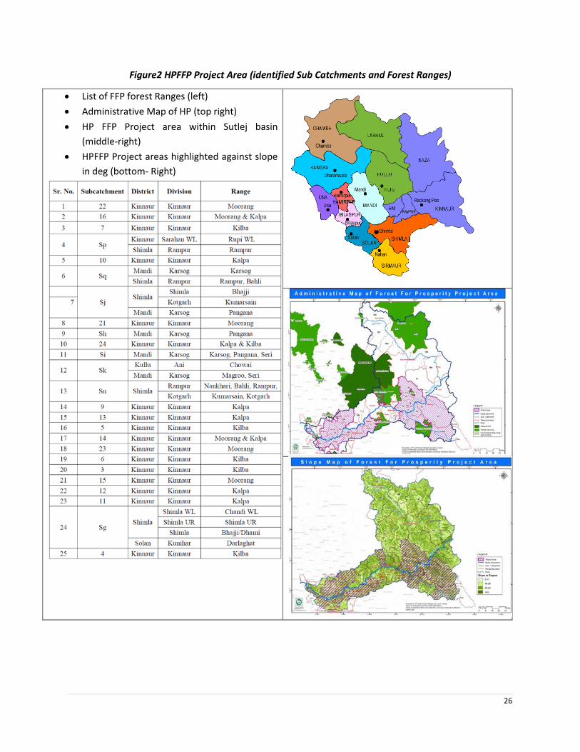
26
Figure2 HPFFP Project Area (identified Sub Catchments and Forest Ranges)
• List of FFP forest Ranges (left)
• Administrative Map of HP (top right)
• HP FFP Project area within Sutlej basin
(middle-right)
• HPFFP Project areas highlighted against slope
in deg (bottom- Right)
27 |
A major portion of the Sutlej basin lies in the greater Himalayan range. The elevation of the catchment
varies widely from about 500 m to 7,000 m, although only a very small area exists above 6,000 m. The
mean elevation of the basin is about 3,600 m. The gradient is very steep near its source and gradually
reduces downstream. Owing to large differences in seasonal temperatures and great range of elevation
in the catchment, the snowline is highly variable, descending to an elevation of about 2,000 m during
winter.
Vegetation of the area mainly comprises of sub-tropical, temperate, sub- alpine and alpine types. The sub-
tropical vegetation is mainly dominated by Acacia catechu, Diospyros montana, Pinus roxburghii and other
miscellaneous species. The temperate forests are mainly dominated by Pinus roxburghii, Cedrus deodara,
Quercus leucotrichophora, Quercus floribunda, Pinus wallichiana, Picea smithiana, etc. Sub- alpine
vegetation is dominated by Abies pindrow, Quercus semecarpifolia, Prunus cornuta, Betula utilis, Acer
acuminatum, etc. Alpine vegetation is dominated by alpine shrubs and herbaceous species. There are two
Natural Habitats in the project area comprising of Majathal and Rupi BhabhaWLS. The Rupi Bhaba Wildlife
Sanctuary lies in Nichar subdivision of Kinnaur district, Himachal Pradesh along the Upper Sutlej Valley.
Chandi Wildlife Sanctuary falls in Arki -Sub Division of Solan District and remaining part falls under Shimla
Rural Sub- Division (Sunni Tehsil) of Shimla District.
1.6. Methodology for Preparation of EMF
1.6.1 Objectives of the EMF
In order to ensure that the environmental issues are systematically identified and addressed in the various
stages of the implementation of subprojects, an Environment Management Framework (EMF) has been
developed for this project. The term EMF is used to depict operations with multiple subprojects/
interventions and spread over the lifetime of the project over a wide geographic area. Design of
subprojects, exact locations as well as impacts are not determined at the preparation stage of the project
The specific objectives of the EMF are as under:
d. To provide a systematic approach for identifying the various possible environmental impacts at
the different stages of the project cycle.
e. To identify appropriate mitigation measures for addressing the identified environmental impacts.
f. To devise the institutional arrangement, capacity building strategy and monitoring plan for
mainstreaming environmental management in project implementation processes.
The Environment Assessment is conducted by G.B. Pant Institute of Himalayan Studies, Kullu by a team
subject specialist on environmental issues and field facilitators.
1.6.2 Methodology
Task 1: Desk Review of Literature and Similar Projects
Review of secondary data and literature from the viewpoint of identifying key environment issues across
the state, and the project area pertaining to forest and natural resource management. The review also
included relevant environment policies, legal and regulatory provisions of the World Bank, Government
of India and Government of Himachal Pradesh. Further, relevant projects of WB viz. HP Mid Himalayan
Watershed project (HPMHWDP), HP Development Policy Lending phase I & II (HP DPL) and other donor

28 |
funded projects such as KfW Himachal Pradesh Forest Ecosystems Climate Proofing Project, Indo-German
Indo-German Eco-Development Project. and JICA funded “Himachal Pradesh Forests Ecosystem
Management and Livelihoods Improvement Project” having an objective to manage and enhance forests
area ecosystems in the project area by sustainable forests ecosystem management, biodiversity
conservation, livelihoods improvement support and strengthening institutional capacity, thereby
contributing to environmental conservation and sustainable socio-economic development in the project
area in the state of Himachal Pradesh. Subsequently, field visits for validating the above issues were
conducted to the identified GP clusters. (For details of field visit please see Annex). Based on the desk
review of forest sector in HP and initial discussions/ consultations with the various state agencies/
stakeholder’s, the consultants have documented the key environmental issues that are identified in the
project, and investments/activities that could pose higher environmental risks.
Task 2: Review of Legal and Policy Framework
Compliance of the project with the relevant legislations of GoI (MoEF & CC), GoHP, and policies of World
Bank has been ascertained. Applicable legislations during implementation of the project and necessary
provisions for compliance has also examined. The data gaps generated between these policies has been
identified and fulfilled. The World Bank safeguard policies /directives that would be applicable by the
proposed interventions has been reviewed, and the implications of which have been outlined.
Task 3: Generation of Baseline Data
For the accomplishment of objectives, both primary and secondary data were collected, analyzed,
synthesized and documented. To identify the salient characteristics of the state, region and subproject
districts, a complete profile of the environmental characteristics has been compiled. The secondary
information are collected in such a way that are relevant to understanding the baseline, as well as the
design of mitigation and enhancement measures, as pertaining to physical (topography, geology, soil
characteristics, climate, seismicity, water resources (surface and groundwater), water quality, air quality,
biological (flora, fauna, protected areas (sanctuaries, national parks, bio reserves, wetland etc.,) and
forests (protected forest, reserved forest social forest etc.,)) and economy, Eco Tourism, and NTFPs.
Secondary data was collected from the relevant Central/State Government Departments, Universities,
different research organizations, local authorities etc. (Please see Annexure I for sources of information).
Field surveys were also undertaken in the done through interviews, interactive meetings and PRA’s in
selected villages in Kinnaur, Shimla, Ani, Karsog, and Kunihar Forest Divisions. Questionnaire based
surveys and samplings will be done for the information on changes in land use pattern, floristic diversity,
status of water resources, natural hazards, impacts of developmental activities on forest resources.
Task 4: Stakeholders Consultation and Disclosure
Consultations has been carried out with all relevant stakeholders those who have been identified through
stakeholder analysis, these include government, community institutions, and private sector. The
consultation process has been carried out at three levels (state level, forest division level, forest
department officials and beneficiaries) in discussion with the respective line departments. In this context
consultation-cum-interaction meetings were conducted at Reckong Peo (District Kinnaur) and Rampur
(District Shimla) with the representatives from HP forest department, local NGO, elected members of

29 |
village assembly, JFMC and residents of concerned villages. The objective of the consultation sessions is
focused to improve the project’s intervention with regard to environmental management and to seek
views from the stakeholders on the environmental issues and the ways these could be resolved. The
procedure for conducting stakeholder and public consultations with relevant consultation formats/
questionnaires/ checklists has been prepared and enclosed with the EMF in Annexure 3, which acts as a
guide for conducting consultations at any stage of the subproject implementation. In addition to
consultations with community institutions, forest guards, NGOs and village members, the project also
undertook institutional consultations with Forest Department, Department of Environment, Science and
Technology, Agriculture Producer Marketing Company, Forest Corporation, Forest Training Institute, and
Himalayan Forest Research Institute. A second round of consultations will be carried out once the draft
EMF has been disclosed on the project website for stakeholder views and suggestions.
Task 5: Impact Prediction & Mitigation Measures
The potential impact (both positive and negative) due to the subprojects intervention has been
determined through the identification, analysis and evaluation of these impacts on sensitive areas (natural
habitats; sites of historic, cultural and conservation importance), and forest range areas. These have been
identified as significant positive and negative impacts, direct, indirect, and residual impacts. For each
impact that has been predicted from the above analysis, if unavoidable, a feasible and cost-effective
mitigation measures has been identified in order to reduce or mitigate them.
Task 6: Environment Management Plan
Based on the assessed Environmental Impacts, specific Environmental Guidelines, and EMPs are prepared,
in such a manner that these are amenable for incorporation in the bidding/contract document. The EMP
is prepared as per the requirements of Bank's safeguard polices. The EMP includes detailed environmental
mitigation measures; separate for pre-construction, construction and operation period.
Task 7: Institutional Arrangement to Manage Environment Impacts Effectively
The institutional arrangement in HP Forest PMU for implementing the safeguards has been reviewed and
outlines with roles and responsibilities, this pertains to inter-sectoral arrangements, management
procedures and training, staffing, operation and maintenance and budgeting.
Public Disclosure: The draft EMF report alongwith Executive summary (Hindi & English) were disclosed
on the website4 of the Department of Forests (HPFD), dated 16th June 2018, publicized in newspapers
(national and local) and hard copies were made available to the project stakeholders through all the
Divisional forest offices.
4 http://hpforest.nic.in/pages/display/NHNkZmFjg3dkNGY2NQ==-himachal-pradesh-forests-for-prosperity-project

30 |
Figure 2 HP FFP EMF Overview

31 |
Chapter 2 Environmental Baseline
2.1 Introduction and overview of Himachal Pradesh
Himachal Pradesh is a mountainous state with two-thirds of its geographical area under forest and other
natural ecosystems (DoEST, undated). It is bound by Tibet to the east, Uttarakhand to the south, Punjab
to the west and Jammu and Kashmir to the North. More than 90% of the population in the state is rural,
most of which is dependent on forests for at least part of their livelihoods (DoEST, 2012; DoEST, undated).
Besides supporting the livelihoods of people in the State, forests protect catchment of important river
systems such as Sutlej, hence providing hydrological services to millions of people downstream (HPFD,
2005). Besides, forests in the state regulate weather and rainfall across the entire region, hence
influencing the economies of neighboring states such as Haryana and Punjab.
State is rich in floral and faunal biodiversity. Its vegetation varies from dry scrub forests at lower altitudes
to alpine pastures at higher altitudes (HPFD,). The state has established a large network of protected areas
including 2 national parks, 30 wildlife sanctuaries and 3 conservation reserves.
Forests have a much large ecological significance beyond the state and should be conserved. But there
are a range of issues affecting the quantity and quality of forests in the area. Open and scrub forests
constitute over one-third of the forest cover in the state underlining the widespread degradation.
According to National Forest Policy, 1988, at least two third i. e 66.6% of the geographical area should be
under forest cover in the hilly states like Himachal Pradesh. Himachal is also known as the fruit bowl of
the country, with orchards being widespread. Meadows and pastures are also seen clinging to steep
slopes.
Table 1 General Overview of Himachal Pradesh
FACTS ON THE STATE
1 Total Area of the State 55,673 km2 (1.7% of country)
2 Administrative Districts 12 [Shimla, Kullu, Kinnaur, Lahaul
and Spiti, Mandi, Solan, Chamba,
Hamirpur, Sirmaur, Nahan, Kangra
and Bilaspur]
3 Villages 20,011
4 Population 6.08 million (0.57% of country)
5 Livestock population 5.11 million (1.1% of country)
6 Grazing land Available per livestock 0.26 ha
7 Recorded Forest Area 37,033 sq km (66.52%)
8 Forest Cover 15,100 sq km
9 Forest area under snow cover 16,376 sq km
10 Extent of Water Bodies in Forests 455 sq km
11 No. of Protected Areas [NPs and WLs) 2 NPs; 30 WLS
12 Canopy density (Very Dense Forests) 3,110 sq km
32 |
13 Canopy density (Medium Dense Forests) 6705 sq km
14 Canopy density (scrub) 5285 sq km
15 Hydropower Potential 21000 MW
19 Tourists 5.5 million per annum
Sources for further Information: State of Environment Report for HP, Forest Department and FSI Report
for Himachal Pradesh, 2017
2.2 Overview of the Sutlej Basin
River Sutlej traverses a course of 320 km within Himachal Pradesh and considered as a largest river among
the four rivers (Beas, Ravi, Yamuna and Chenab). Sutlej basin covers 45 per cent of the total geographical
area of the state. The elevation of the basin varies between 6680 m in sub catchment near Tidong in
Kinnaur district; to 540 m in Bilaspur district. Along its course the river passes through Lahaul & Spiti,
Kinnaur, Shimla, Kullu, Mandi, Solan and Bilaspur districts. It leaves the Himachal Boundary at Bhakhra
Dam, which is the second highest dam 225.55 m in India. The catchment area of River Sutlej (20,398 km2)
accounts for around 38 % of the total catchment area of the five major rivers of Himachal Pradesh. The
catchment area of the River Sutlej is located above the permanent snow line at an altitude of 4,500
meters. The bulk of annual precipitation in monsoon falls due to movement of the southeast monsoon
from the Bay of Bengal.
On account of varying geographical features, the Sutlej basin topographically divided into two parts, i.e.
the Upper Sutlej basin and lower Sutlej basin. Beyond the Nathpa village in Kinnaur district, Sutlej is the
upper Sutlej basin, while southwestern part of the Nathpa village to Bilaspur, it is known as the lower
Sutlej basin. Agriculture, horticulture and animal husbandry are the mainstay of 60-70% of the population
despite very small area under irrigation. The major portion of the Sutlej catchment comprises of steep to
very steep high hills. The major natural disasters or hazards experienced by the region over the years
include earthquakes, landslides, flash floods, cloud burst, avalanches and hailstorms/droughts. The area
is prone to the severest seismic risks as it falls into the Very High Damage Risk Zone V. There are several
major hydroelectric projects on the Sutlej, e.g., the 1000 MW Karcham-Wangtoo Hydroelectric project,
1500 MW Nathpa-Jhakri Project, Shongtong-Karcham project-450 MW, Rampur Hydropower project 412
MW, Baspa Hydropower project- 300 MW, Kashang project 243 MW, Tidong project 100 MW.

33 |
Figure 3 Geographical Map of Sutlej basin
Catchment Area Treatment Plan
The State is moving towards a river basin approach to the development and implementation of Integrated
Basin Catchment Area Treatment (CAT) Plans–deemed global best practice. The CAT Plan of Sutlej River
basin covers an area of 20000 KM² upstream of Kol dam. It envisages an expenditure of Rs. 1440 crore on
various treatment measures, over a period of ten years, to reduce the silt load in the streams catering to
many hydro projects
The plan has been prepared for this purpose with the following objectives;
a. To facilitate the hydrological functioning of the catchment and to augment the quality of water of
the river and its tributaries
b. Conservation of soil cover and to arrest the soil erosion, floods and siltation of the river and its
tributaries and consequent reduction of siltation in the reservoir of the project
c. Demarcation of the priority of sub watersheds of treatment based on soil erosion intensity in the
catchment area
d. Rehabilitation of degraded forest through afforestation measures
e. Soil conservation through biological and engineering measures to reduce sediment load in river and
tributaries, thus improving the quality of water
f. Ecosystem conservation resulting from increased vegetative cover and water retaining properties
of soil
2.3 Environmental Baseline
This section details the existing environmental profile of the project areas, namely Kinnaur, Solan, Kullu,
Shimla, Mandi, Una and Bilaspur. The environmental profile is based on the review of secondary
information/ data collected from the respected departments, literature/ journals, websites and also
observation obtained from the site visits to the project districts.

34 |
2.3.1 Physiographic Profile
Himachal is in the western Himalayas covering an area of 55,673 km2 Most of the state lies on the foothills
of the Dhauladhar Range. At 6,816 m Reo Purgyil is the highest mountain peak in the state of Himachal
Pradesh.The drainage system of Himachal is composed both of rivers and glaciers. Himalayan rivers
crisscross the entire mountain chain. Himachal Pradesh provides water to both the Indus and Ganges
basins. The drainage systems of the region are the Chandra Bhaga or Chenab, Ravi, Beas, Sutlej, and
Yamuna rivers. These rivers are perennial and are fed by snow and rainfall. They are protected by an
extensive cover of natural vegetation.
Topography
The state can be divided into three main topographical regions; (i) the Shivalik (ii) the lesser Himalayas
and (iii) the greater Himalayas.
The Shivalik or Outer Himalaya: It covers the lower hills of Kangra, Hamirpur, Una, Bilaspur, lower parts of
Mandi, Solan and Sirmour districts. Within this zone, altitude varies from 350 m to 1500 m.
Inner Himalayas or Mid-mountains: Altitude varies from 1500 m to 4500 m and includes areas such as the
upper parts of Pachhad and Renuka in Sirmaur district, Chachiot and Karsog tehsils of Mandi district and
upper parts of Churah tehsil of Chamba district.
Alpine zone or the Greater Himalaya: Has altitude above 4500 m and comprises areas of Kinnaur district,
Pangi tehsil of Chamba district and areas of Lahaul & Spiti district.
Soils:
The Sutlej valley has relatively poor sandy loam constituting exposed bedrock, and gravel soil. The soils in
area as grouped under Udalts and Ochrepts. Ochrepts soil are combination of shallow red loamy and
sandy ideally suitable for horticulture in Kullu and Kinnaur district; Udoll soil characterization of cold
desert and found in Kinnaur district. Glaciers and snow cap soils are found where the glaciers and snow
cover are present throughout the year in Lahual and Spiti, and Kullu district. Medium deep, well-drained
soil with loamy surface was observed in the lower reach of the Sutlej with limited area.
In the Sutlej basin plutonic rocks or hypabyssal rocks like Granites, Syenites, Diorites, Gabbros, and
Volcanic rocks are found and are charecterised by strong and durable character, interlocking texture, hard
silicate mineral composition, absence of any inherent weak planes, and resistance to weathering. The well
cemented siliceous sandstones have good compressive strength. The Quartzites are very hard and highly
resistant to weathering and suitable for foundation of dam sites.
Topography and Elevation
The elevation in Sutlej basin varies from 300 meters to 7000 meters. The Kinnaur district varies from 2,550
meters to 6,791 meters. At the altitude of 2,670 meters Kalpa village is situated which is connected by link
road of 14 kilometers from Powari to Rekong Peo. Village Moorang village (2,591 meters) is situated about

35 |
39 kilometers away from Kalpa on left bank of River Sutlej. Due to such variations in the altitudes, Sutlej
River flows with high speed in district Kinnaur. Just after Kinnaur, River Sutlej has entered into Shimla
district. The altitude of district varies from 300 meters to 6,000 meters. Rampur is situated on the banks
of River Sutlej with an altitude of 924 meters along the Hindustan-Tibet road. Mandi district extents upto
754 meters of heights.Bilaspur varies between altitudes of 290 meters to 1,980 meters. From Kinnaur to
Mandi River Sutlej flows from an altitude of 6000 meters to 656 meters. After Mandi district, the variation
in altitude of Sutlej catchment area is not high as much as in Kinnaur, Kullu, Shimla, and Mandi districts.
It flows from moderate slope at an altitude of 656 meters to 290 meters.
Figure 4 Elevation and Slope Map of the Project Area
Natural Disasters
The Sutlej basin lies in seismically sensitive zones (zone V and IV) as per the Seismic Zoning Map of India
(Ref: IS: 1893-1984 Fourth Revision). Thirty Two percent of the total geographical area of the State is
prone to the severe seismic risks as it falls into the Very High Damage Risk Zone V. The Kinnaur earthquake
of January 19, 1975 (Magnitude (M) = 6.7) and the Dharamshala earthquake of April 26, 1986 (M = 5.7)
are well recorded in respect of damages caused and losses incurred. During the past five decades, 20
earthquakes with magnitude > 5 have been recorded from the Sutlej Valley (Wulf et al., 2012).

36 |
Figure 5 Earthquake Zones within the Sutlej basin
The hills and mountains are liable to landslides during monsoons and high intensity earthquakes. The
vulnerability of the geologically young and not so stable steep slopes has been reported to be increasing
in the recent decade due to inappropriate human activity like deforestation, road cutting, terracing and
agriculture shift to cultivation of crops that require more intense watering. (State Council for Science,
Technology and Environment and Disaster Management, Himachal Pradesh 2012). The occurrence of
water related natural disasters especially floods and flash floods in summer is also common.
Climate
The climate of the state varies from place to place depending on the altitude. It varies from hot and sub-
humid tropical (450-900 m) in the southern low tracts, warm and temperate (900-1,800 m), cool and
temperate (1,900-2,400 m) and cold alpine and glacial (2,400-4,800 m) in the northern and eastern high
mountain ranges.

37 |
Figure 6 Climate Zones of Himachal Pradesh (left) Agro Ecological Zones in Sutlej basin (right)
Temperature
The climate of basin varies from hot and sub-humid tropical in the southern part and while the glacier and
alpine are seen in the eastern and northern part of the basin. In the region, the temperature generally
starts rising from the beginning of March till June, which is the hottest month of the year. The mean
minimum and maximum temperature generally fall between 15.6oC to 24oC in the region. With the onset
of monsoons by the end of June, temperature begins to fall. The rate of drop in day temperature is
considerable than the rate of drop in night temperature. After the withdrawal of monsoons by the mid-
September, the night temperature falls rapidly. The month of January is the coldest month when the mean
maximum and minimum temperatures seen in usually between 8.9oC and 1.7oC. During winters, under
the influence of the western disturbances, the temperature falls considerably and it may go even below
0oC. Downstream of upper Kinnaur, the catchment experienced the three seasons (summer, rainy, and
winter season).
Table 2 Month wise maximum and minimum temperature at selected Stations of Himachal Pradesh
Maximum Temperature (in Celsius)
Sl.
No
Centr
es
Months
Jan Feb Mar Apr May June Jul Aug Sept Oct Nov Dec
1 Kalpa 3.60 1.9
0
9.7
0
16.
60
21.7
0
22.3
0
23.6
0
22.5
0
21.3
0
19.2
0
14.0
0
10.2
0
2 Shiml
a
12.2
0
12.
50
19.
00
21.
40
26.4
0
24.4
0
23.5
0
22.7
0
23.1
0
20.9
0
18.4
0
15.5
0
3 Solan 117.
70
18.
00
24.
20
26.
90
32.2
0
28.8
0
28.3
0
28.3
0
28.0
0
26.2
0
23.5
0
19.9
0
Minimum Temperature- (in Celsius)
Jan Feb Mar Apr May June Jul Aug Sept Oct Nov D
ec
38 |
3 Kalpa -5.30 -
4.8
0
0.7
0
3.50 8.30 12.0
0
14.6
0
13.9
0
9.60 6.40 0.90 -
1.
7
0
7 Shiml
a
2.80 3.8
0
9.1
0
11.70 17.1
0
16.5
0
17.2
0
16.6
0
14.7
0
12.2
0
7.60 4.
8
0
9 Solan 1.10 4.6
0
8.3
0
11.50 15.5
0
18.5
0
19.7
0
19.5
0
15.7
0
12.4
0
4.70 2.
0
0
Source: Statistical Year Book of Himachal Pradesh 2013-2014, Department Of Economics
Precipitation
Sutlej basin receives precipitation from western disturbances. The western disturbance passes over the
northwestern part during the winter. Sutlej valley faced the heavy monsoon of the outer Himalayas and
heavy snowfall of the arid Tibetan. The monsoons from the first hits the outer ranges of the Indian
Himalayas, become the reason of heavy monsoon rains.
The zone within which the part of present study region falls also receives heavy snowfall i.e. Kinnaur
district. The total annual rainfall is observed about 766 mm in Kinnaur and 800 mm at Rampur. The
maximum rainfall is received from January to March. About 55% of the total rainfall is received during
winter season. A part of the precipitation received during winter months is in the form of snow. The
average humidity observed during winter in the study area is about 50%. Overall, humidity ranges during
winter from 35 to 54.2% which is very low. While in monsoon months, humidity is observed more than
90%.
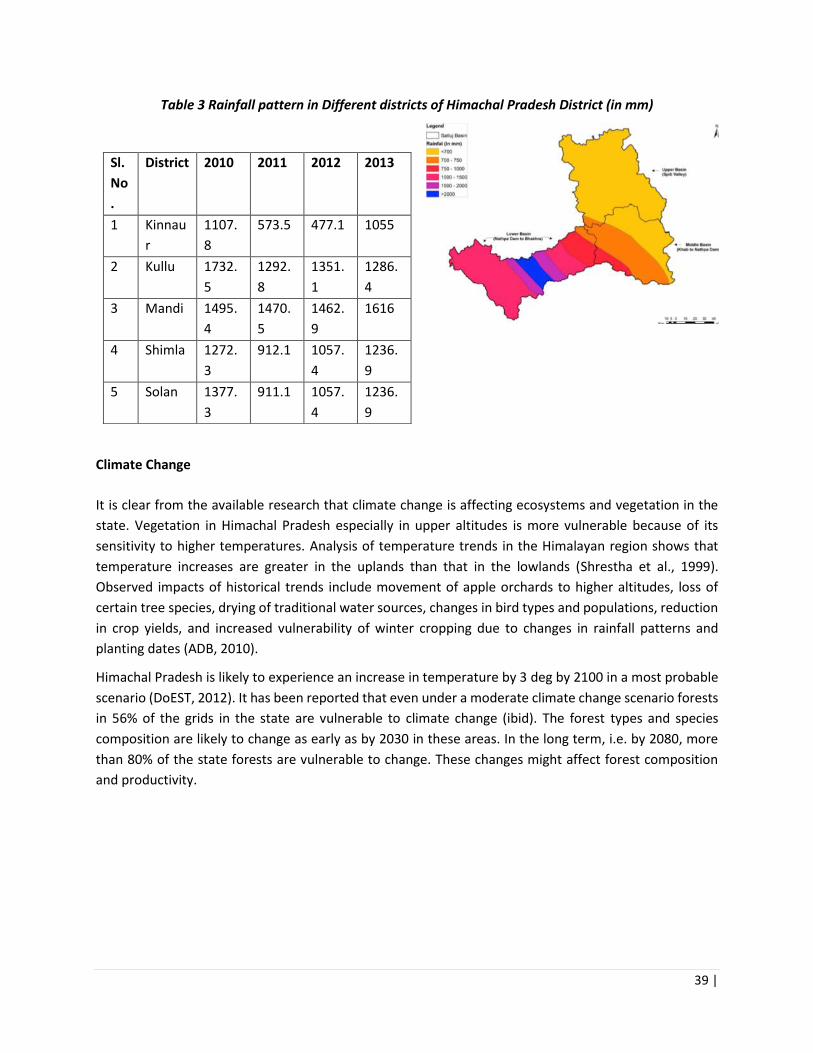
39 |
Table 3 Rainfall pattern in Different districts of Himachal Pradesh District (in mm)
Sl.
No
.
District 2010 2011 2012 2013
1 Kinnau
r
1107.
8
573.5 477.1 1055
2 Kullu 1732.
5
1292.
8
1351.
1
1286.
4
3 Mandi 1495.
4
1470.
5
1462.
9
1616
4 Shimla 1272.
3
912.1 1057.
4
1236.
9
5 Solan 1377.
3
911.1 1057.
4
1236.
9
Climate Change
It is clear from the available research that climate change is affecting ecosystems and vegetation in the
state. Vegetation in Himachal Pradesh especially in upper altitudes is more vulnerable because of its
sensitivity to higher temperatures. Analysis of temperature trends in the Himalayan region shows that
temperature increases are greater in the uplands than that in the lowlands (Shrestha et al., 1999).
Observed impacts of historical trends include movement of apple orchards to higher altitudes, loss of
certain tree species, drying of traditional water sources, changes in bird types and populations, reduction
in crop yields, and increased vulnerability of winter cropping due to changes in rainfall patterns and
planting dates (ADB, 2010).
Himachal Pradesh is likely to experience an increase in temperature by 3 deg by 2100 in a most probable
scenario (DoEST, 2012). It has been reported that even under a moderate climate change scenario forests
in 56% of the grids in the state are vulnerable to climate change (ibid). The forest types and species
composition are likely to change as early as by 2030 in these areas. In the long term, i.e. by 2080, more
than 80% of the state forests are vulnerable to change. These changes might affect forest composition
and productivity.
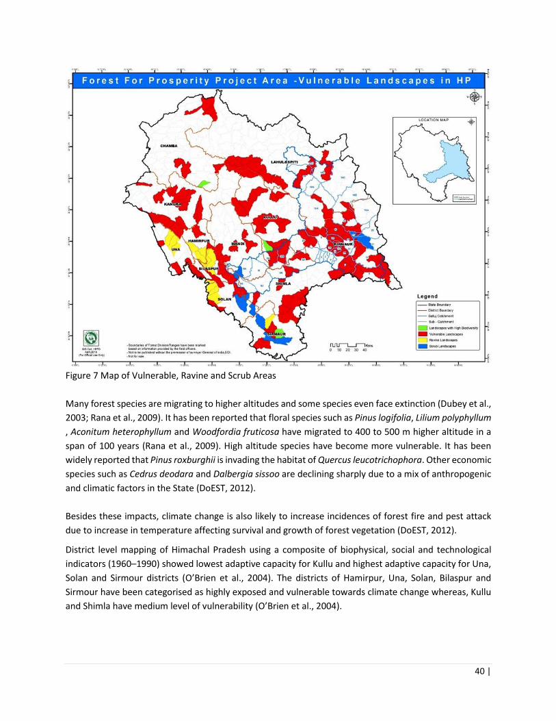
40 |
Figure 7 Map of Vulnerable, Ravine and Scrub Areas
Many forest species are migrating to higher altitudes and some species even face extinction (Dubey et al.,
2003; Rana et al., 2009). It has been reported that floral species such as Pinus logifolia, Lilium polyphyllum
, Aconitum heterophyllum and Woodfordia fruticosa have migrated to 400 to 500 m higher altitude in a
span of 100 years (Rana et al., 2009). High altitude species have become more vulnerable. It has been
widely reported that Pinus roxburghii is invading the habitat of Quercus leucotrichophora. Other economic
species such as Cedrus deodara and Dalbergia sissoo are declining sharply due to a mix of anthropogenic
and climatic factors in the State (DoEST, 2012).
Besides these impacts, climate change is also likely to increase incidences of forest fire and pest attack
due to increase in temperature affecting survival and growth of forest vegetation (DoEST, 2012).
District level mapping of Himachal Pradesh using a composite of biophysical, social and technological
indicators (1960–1990) showed lowest adaptive capacity for Kullu and highest adaptive capacity for Una,
Solan and Sirmour districts (O’Brien et al., 2004). The districts of Hamirpur, Una, Solan, Bilaspur and
Sirmour have been categorised as highly exposed and vulnerable towards climate change whereas, Kullu
and Shimla have medium level of vulnerability (O’Brien et al., 2004).

41 |
2.3.2 Land Use Pattern
Himachal Pradesh is a hilly state, one third area remain snow covered for about seven months in a year.
Like other parts of the Himalayan region, human settlements are scattered but largely concentrated in
the low and mid hill areas while highlands are sparsely populated. The dominant features of hill farming
in Himachal Pradesh are largely rainfed farming on sloping marginal farmlands and small land holdings.
Table 4 Land Use pattern of Himachal Pradesh
The land use in the project area is varying according to the altitude. The maximum area falls under the
snow cover and forest class, and the main occupation is agriculture and horticulture sector. The
agricultural crops which are sown and harvested mainly include wheat, seed-potato, paddy, maize, barley,
pulses, vegetables, etc. The main horticulture fruits are in the study region is apple, pear, almond, apricot,
and dry fruits. The Kinnaur district is known as for the production of nuts and dry fruits. Chilgoza (pine
nuts), medicinal and brewing herbs, and other minor forest produce support the tribal economy. The
Kalpa, Ribba, and Rampur are known for the horticulture producing areas. The Solan is famous for tomato
production. Bilaspur area under Sutlej catchment is related to the production in the agriculture sector.

42 |
Table 5 District wise land use patterns (In hectare) of Project Districts
Year/Dist
rict
Geograp
hical
area by
village
papers
Forest
Land
Misc.
tree
crops &
Groves
(Not
included
in net
area
sown)
Permane
nt
pastures
& other
grazing
lands
Culturabl
e waste
land
Land put
to non-
agricult
ural
uses
Barren
and
uncultur
able
land
Curren
t
Fallow
Other
Fallow
Net area
sown
Area
sown
more
than
once
Total
cropp
ed
area
District – wise
Bilaspur 111776 14013 151 39583 6061 15845 4437 1535 964 29187 27714 56901
Kinnaur 624216 38590 101 322043 3254 117878 132444 1513 83 8310 2336 10646
Kullu 64224 2520 3804 3911 1300 7931 3207 2604 462 38485 21112 59597
Mandi 397948 175289 352 96250 4505 16567 8590 6558 1062 88775 71835
16061
0
Shimla 525386 149692 8898 235206 13078 19867 11521 16089 5091 65944 20524 86468
Solan 180923 20271 553 77695 14980 13293 10903 2586 2896 37746 24709 62455
Una 154875 16549 6645 13532 22620 27575 24139 3105 2181 38529 35496 74025
43 |
2.3.3 Forest Area
The total area of Himachal Pradesh is 55,673 km2, out of this 66.52% of the area of the state is legally
defined as forestland. but forest and tree cover constitute only 27.63% of the total geographical area (FSI,
2013). It has been reported that only 30.5% of the recorded forest area can support vegetation, as rest of
the area is uncultivable because of terrain and snow (HPFD, 2005). State has 14683 sq km of forest cover
and 697 sq. km of tree cover constituting a total of 15380 sq. km of forest and tree cover (ibid). Forests
are distributed across four zones in the State- viz sub-tropical forests, sub-temperate forests, wet-
temperate and dry temperate forests (GoHP, 2002).
Forest types
The forests of the state can be classified on ecological basis broadly into coniferous forests and broad-
leaved forests. As laid down by Champion and Seth the forest types of the state are shown in Table 13.
Sub-tropical forests occur at an elevation up to 915 meters above mean sea level (msl) with annual rainfall
between 700 to 1000 mm. These comprise of dry deciduous Sal, Chir Pine and other miscellaneous species
(ibid).
Sub temperate forests are found at an elevation between 916 to 1523 MSL with an annual rainfall of 900
to 1200 mm. These include Oaks and various broad-leaved species.
Wet temperate forests are found at an elevation ranging from 1524 to 2472 meters above msl with annual
rainfall of 1000 to 2500 mm. The forest vegetation includes conifers, oaks, firs and rhododendron species.
Dry temperate forests are found above 2472 meters where mean annual temperature is around 10oC.
Annual precipitation is about 2500 mm, most of which is received in form of snow. Species include willow,
Robinia and Chilgoza (ibid).
Table 6 Forest types in Himachal Pradesh (as per Champion and Seth)
Sr.
No.
Major Forest Group Classification
Code
Forest type
1 Tropical Moist Deciduous
Forests
3C Moist Shiwalik Sal forest, Moist Bhabar Sal
forest
2 Tropical Dry Deciduous Forests 5B Dry Shiwalik Sal forest, Northern Dry Mixed
Deciduous forest, Dry Deciduous Scrub, Dry
Bamboo Brakes, Khair Sissoo Forests
3 Subtropical Pine Forests 9C1 Himalayan subtropical Pine forests
9DS1 Himalayan subtropical scrub
9DS2 Subtropical Euphorbia scrub
4 Subtropical Dry Evergreen
Forest
10C1 Subtropical dry evergreen forest
10DS1 Dodona scrub
5 Himalayan Moist Temperate
Forests
12 Lower Western Himalayan Ban Oak forests,
Lower Western Himalayan Mohru Oak forests,
Lower Western Himalayan moist Deodar
forests, Lower Western Himalayan Mixed
Coniferous forests, Lower Western Himalayan

44 |
moist temperate deciduous forests, Upper
Western Himalayan Kharsu Oak forests, West
Himalayan upper Oak/ Fir forest Montane
bamboo brakes, Himalayan temperate
parklands
6 Himalayan Dry Temperate
Forest
13/C Dry broad leaved and coniferous forest (Q. ilex-
P. gerardiana), Dry temperate coniferous –
Neoza pine forests, Dry temperate coniferous –
dry deodar forests, West Himalayan high-level
dry blue pine forest, West Himalayan dry
Juniper forest
7 Sub-alpine Forest 14/C West Himalayan sub-alpine Fir forest, West
Himalayan subalpine Birch/ Fir forest
14/DS1 Sub-alpine pastures
8 Moist Alpine Scrub 15/C Birch/ Rhododendron scrub forest, Deciduous
alpine scrub, Alpine pastures
15/E1 Dwarf Rhododendron scrub
9 Dry Alpine Scrub 16/C1 Dry alpine scrub
16/E1 Dwarf Juniper scrub
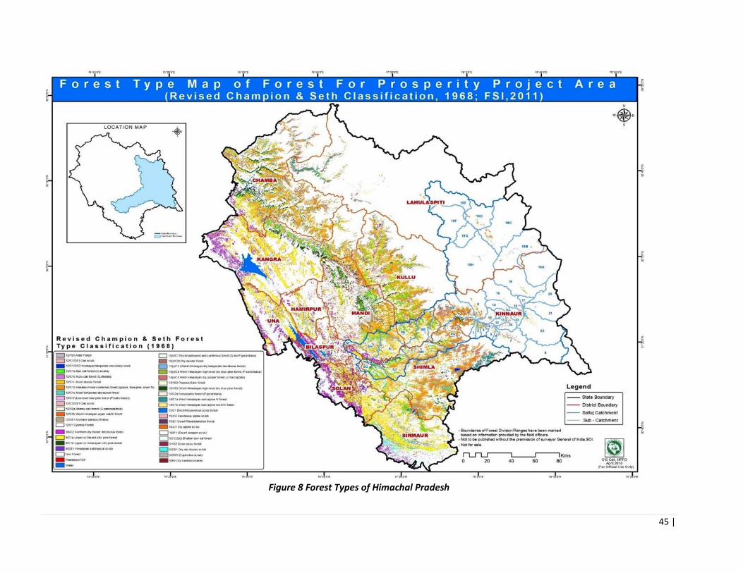
45 |
Figure 8 Forest Types of Himachal Pradesh
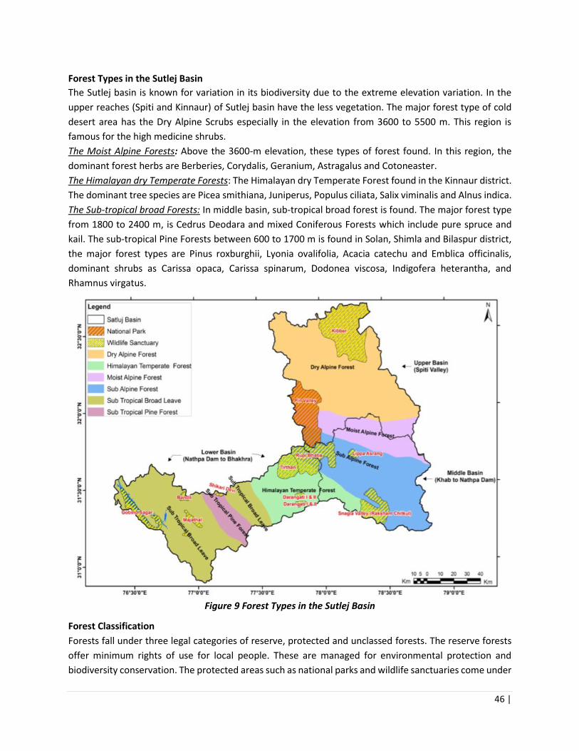
46 |
Forest Types in the Sutlej Basin
The Sutlej basin is known for variation in its biodiversity due to the extreme elevation variation. In the
upper reaches (Spiti and Kinnaur) of Sutlej basin have the less vegetation. The major forest type of cold
desert area has the Dry Alpine Scrubs especially in the elevation from 3600 to 5500 m. This region is
famous for the high medicine shrubs.
The Moist Alpine Forests: Above the 3600-m elevation, these types of forest found. In this region, the
dominant forest herbs are Berberies, Corydalis, Geranium, Astragalus and Cotoneaster.
The Himalayan dry Temperate Forests: The Himalayan dry Temperate Forest found in the Kinnaur district.
The dominant tree species are Picea smithiana, Juniperus, Populus ciliata, Salix viminalis and Alnus indica.
The Sub-tropical broad Forests: In middle basin, sub-tropical broad forest is found. The major forest type
from 1800 to 2400 m, is Cedrus Deodara and mixed Coniferous Forests which include pure spruce and
kail. The sub-tropical Pine Forests between 600 to 1700 m is found in Solan, Shimla and Bilaspur district,
the major forest types are Pinus roxburghii, Lyonia ovalifolia, Acacia catechu and Emblica officinalis,
dominant shrubs as Carissa opaca, Carissa spinarum, Dodonea viscosa, Indigofera heterantha, and
Rhamnus virgatus.
Figure 9 Forest Types in the Sutlej Basin
Forest Classification
Forests fall under three legal categories of reserve, protected and unclassed forests. The reserve forests
offer minimum rights of use for local people. These are managed for environmental protection and
biodiversity conservation. The protected areas such as national parks and wildlife sanctuaries come under

47 |
this category of forests. The protected forests recognize many rights including timber, grazing and non-
timber forest produce for local people. Almost 90% of the state forests fall under this category, 57% of
the protected forest areas have not been demarcated i.e. their limits have not been set through legislative
orders. The unclassed is a category of forest in transition i.e. after surveys and settlement of rights, these
could be either shifted to reserve or protected forest category (Vasan, 2001).
Table 7 Legal Status of Forests in Himachal Pradesh
Forest Classification Area (Km²) Percentage
1. Reserved Forests 1896 5.12
2. Demarcated protected Forests 11387 30.75
3. Un-demarcated Protected Forests 21656 58.48
4. Unclassed Forests 976 2.63
5. Others (managed by Forest Department 370 1.00
6. Not managed by Forest Department. 748 2.02
Total 37033 100.00
Table 8 Legal Classification of Forests in Project Districts
District Geographical
Area
Total Forest
Area
%age of the
total area
Reserved
Forests
Protected
Forests
Unclassified
forest
Kinnaur 6,401 5093 79.57 - 5092.61 -
Kullu 5,503 4952 89.99 160.52 4791.17 -
Mandi 3,950 1860 47.09 1,575.57 284.45 -
Shimla 5,131 3418 66.61 53.46 3310.38 -
Solan 1,936 728 37.60 53.55 502.05 165.77
Forest Density
Comparable data on forest density categories is available from 2005 to 2013 in India, hence this is the
best period to study such change. In case of Himachal Pradesh, the area under very dense forest cover
has been stable from 2005 to 2013. Area under the category of moderately dense forests has slightly
declined during this period. The open and scrub forest area constitute 35% of the total forest cover. The
open forest area has slightly increased whereas area under scrub vegetation has decreased for the period.
Overall open and scrub forest area has slightly declined, which could be attributed to the plantations in
the State. Some of the key factors behind the forest degradation are demand and supply gap of forest
products, shifting cultivation and forest fires, which have been discussed in detail in the report.

48 |
Figure 10 Forest/ Canopy Density Map of HP
Table 9 Geographical Distribution of Forest Density (As per FSI Report
2015)
Area (sq.km) % geographical
area
% of forest
area
Very Dense Forest 3224 5.79 8.7
Moderate Dense Forest 6381 11.46 17.23
Open Forest 5091 9.14 13.74
Table 10: Project District Forest Density 2015
Table 10 Project District Forest Density 2015 (Area in Km2)
District Geographical
Area
Very
Dense
Forest
Mod.
Dense
Forest
Open
Forest
Total % Geographical
area
Kinnaur 6401 82 262 260 604 9.73
Kullu 5503 79 266 278 623 33.11
Solan 1936 46 426 394 866 44.73
49 |
Shimla 5131 736 1039 624 2399 46.76
Mandi 3950 368 722 671 1761 44.58
Table 11 Change in Forest Cover 2005-2017 (ISFR 2017)
Category 2005 2007 2009 2011 2013 2017
1 Very Dense 3224 3224 3224 3224 3224 3110
2 Moderately Dense 6386 6383 6383 6381 6381 6705
3 Open Forest 5056 5061 5061 5074 5078 5285
4 Scrub 331 327 327 328 298 308
Flora The hills contain western Himalayan broadleaf forests and Himalayan subtropical pine forests.
Various deciduous and evergreen oaks live in the broadleaf forests, while chir pine dominates the pine
forests. Western Himalayan subalpine conifer forests grow near tree line, with species that include East
Himalayan fir, West Himalayan spruce, deodar (the state tree), and blue pine.
The higher elevations have western Himalayan alpine shrub and meadows in the northeast and north
western Himalayan alpine shrub and meadows in the northwest. Trees are sturdy with a vast network of
roots. Alders, birches, rhododendrons and moist alpine shrubs are there as the regional vegetation. The
rhododendrons can be seen along the hillsides around Shimla from March to May. The shrub lands and
meadows give way to rock and ice around the highest peaks. The southern part of the state, at lower
elevations has both tropical and subtropical dry broadleaf forests and tropical and subtropical moist
broadleaf forests.
Table 12 Flora in different zones (Altitude) of HP
Classification based on latitudinal
Zones
Flora of Himachal Pradesh
1. Lower Motane Zone (up to 1,000
m)
A. Trees
B. Shrubs
C. Grasses
Khair, Siris, Kachnar, Semal, Tun, Mango,
Behul, Shisham, Ritha, Tut, Behera, Chil, Vitex,
Munj, Ber, Ipomea, Dodonea, Bamboo,
Vetiver, Saccharum, Munj.
2. Middle Motane Zone (From 1,000
m to 2000 m)
A. Trees
B. Shrubs
C. Grasses
Kunish, Poplar, Willow, Ohi, Robinia, Drek,
Kail, Chil, Toon, Behmi, Chulli, Walnut, Khirik.
Vitex, Berberis, Carissa. Lolium, Dactylis,
Phleum & Phalaris.

50 |
Table 12 Flora in different zones (Altitude) of HP
Classification based on latitudinal
Zones
Flora of Himachal Pradesh
3. Temperate Zone (From 2,000 m to
3,000 m)
A. Trees
B. Shrubs
C. Grasses
Deodar, Fir, Spruce, Maple, Ash, Bhoj Patra,
Horse Chestnut, Alder, Robinia, Poplar,
Walnut.
Berberis, Festuca, Dactylis, Bromus, Lucaerna,
white Clover, Red Clover & Dioscorea.
4. Alpine Zone (Above 3,000 m) A. Trees
B. Shrubs
C. Grasses
Birch, Juniper, Cypress, Willow, Saussurea
costus, Cotoneaster microphylla, Artemisia
spp., Festuca arundinacea & Dactylis
glomerata.
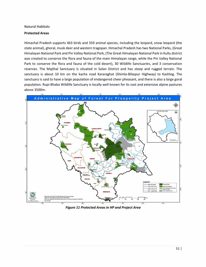
51 |
Natural Habitats
Protected Areas
Himachal Pradesh supports 463 birds and 359 animal species, including the leopard, snow leopard (the
state animal), ghoral, musk deer and western tragopan. Himachal Pradesh has two National Parks, (Great
Himalayan National Park and Pin Valley National Park, (The Great Himalayan National Park in Kullu district
was created to conserve the flora and fauna of the main Himalayan range, while the Pin Valley National
Park to conserve the flora and fauna of the cold desert), 30 Wildlife Sanctuaries, and 3 conservation
reserves. The Majthal Sanctuary is situated in Solan District and has steep and rugged terrain. The
sanctuary is about 10 km on the kacha road Kararaghat (Shimla-Bilaspur Highway) to Kashlog. The
sanctuary is said to have a large population of endangered cheer pheasant, and there is also a large goral
population. Rupi-Bhaba Wildlife Sanctuary is locally well known for its vast and extensive alpine pastures
above 3500m.
Figure 11 Protected Areas in HP and Project Area

52 |
Table 13 List of Protected Areas in FFP project area
Sl.
No. Protected Areas Area (sq
km) District (s) Fauna
1 Majathal WLS
57.55 Solan Deer, Bear, Cheer pheasant
2 Rupi Bhaba WLS 738.00 Kinnaur Serow, blue Sheep, red Fox, musk deer, Goral, ibex,
Leopard, snow Leopard, brown Bear, Himalayan black
Bear
Important Bird Areas (IBAS) Himachal Pradesh lies in the Western Himalayas Endemic Bird Area (EBA 128) has an area of 0.71 million
ha (12.87%) under the protected area network, that comprises two national parks and 32 wildlife
sanctuaries, covering 0.14 million ha and 0.57 million ha respectively. The Great Himalayan National Park
and the PinValley National Park have been identified as IBAs, and of the 32 wildlife sanctuaries, 24 are
IBAs. Two non-protected areas are also considered as IBAs (Table 17).
Eleven species are confined EBA: 128, out of which ten are known to occur in this State with confirmed
records. They are: Western Tragopan, Cheer Pheasant, Brook’s Leaf Warber Phylloscopus subviridis,
Tytler’s Leaf Warbler Phylloscopus tytleri, Kashmir Flycatcher Ficedula subrubra (vagrant), Whitecheeked
Tit Aegithalos leucogenys, White-throated Tit Aegithalos niveogularis, Kashmir Nuthatch Sitta
cashmirensis, Spectacled Finch Callacanthis burtoni and Orange Bullfinch Pyrrhula aurantiaca. Ten globally
threatened bird species are found in the different IBA of Himachal Pradesh State representing the West
Himalayan Endemic Bird Area: 128. Out of these 02 species are placed under Critically Endangered, 05
species are Vulnerable, and 03 Species are Near Threatened.
Table 14 Important Bird Areas of Himachal Pradesh
IBA site codes IBA sites names IBA criteria
IN-HP-15 Majathal Wildlife Sanctuary A1
IN-HP-20 Rupi Bhaba Wildlife Sanctuary A1, A2
Fauna Out of the total 527 faunal species recorded in the Sutlej basin, 26 species are listed under „Critical Faunal
Species‟ category of IUCN including 1 amphibians, 12 birds and 13 mammalian species. Of these, 5 species
are Critically Endangered (4 birds and 1 mammal), 4 species are endangered (1 bird and 3 mammals) and
17 species are Vulnerable species (1 amphibian, 7 birds and 9 mammals). Among the 19 species of reptiles
recorded, 8 species fall under the various appendices of the Indian Wildlife Protection Act (1972). Of the
368 species of bird species documented from the study area, 11 birds fall under “Schedule-I” category of
the Indian Wildlife Protection Act (1972). Among the 64 mammals recorded, 55 species fall under various
schedules of Indian Wildlife (Protection) Act, 1972. Of the total 55 species, 22 species fall under Schedule-
I. Out of the total 527 faunal species of different taxonomic groups recorded, one species of amphibian,
5 species of reptiles, 32 species of birds and 29 species of mammals are listed in various appendices of
CITES. An analysis of Sutlej basin fauna based on the National Red data Book (1994) showed that among
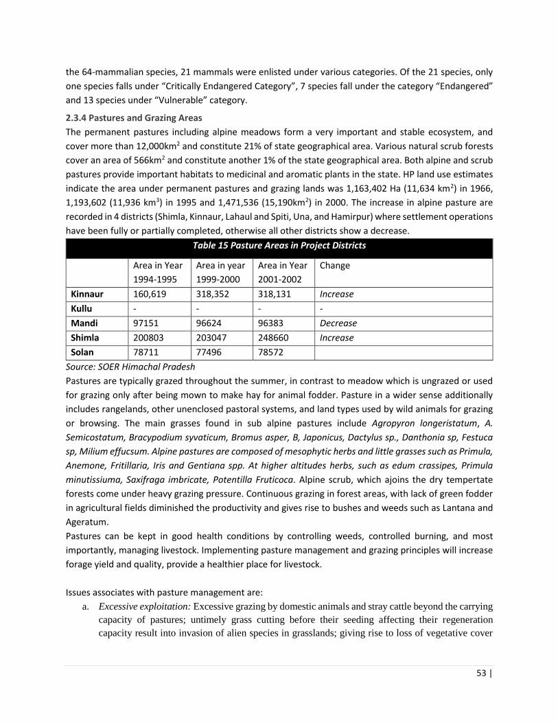
53 |
the 64-mammalian species, 21 mammals were enlisted under various categories. Of the 21 species, only
one species falls under “Critically Endangered Category”, 7 species fall under the category “Endangered”
and 13 species under “Vulnerable” category.
2.3.4 Pastures and Grazing Areas
The permanent pastures including alpine meadows form a very important and stable ecosystem, and
cover more than 12,000km2 and constitute 21% of state geographical area. Various natural scrub forests
cover an area of 566km2 and constitute another 1% of the state geographical area. Both alpine and scrub
pastures provide important habitats to medicinal and aromatic plants in the state. HP land use estimates
indicate the area under permanent pastures and grazing lands was 1,163,402 Ha (11,634 km2) in 1966,
1,193,602 (11,936 km3) in 1995 and 1,471,536 (15,190km2) in 2000. The increase in alpine pasture are
recorded in 4 districts (Shimla, Kinnaur, Lahaul and Spiti, Una, and Hamirpur) where settlement operations
have been fully or partially completed, otherwise all other districts show a decrease.
Table 15 Pasture Areas in Project Districts
Area in Year
1994-1995
Area in year
1999-2000
Area in Year
2001-2002
Change
Kinnaur 160,619 318,352 318,131 Increase
Kullu - - - -
Mandi 97151 96624 96383 Decrease
Shimla 200803 203047 248660 Increase
Solan 78711 77496 78572
Source: SOER Himachal Pradesh
Pastures are typically grazed throughout the summer, in contrast to meadow which is ungrazed or used
for grazing only after being mown to make hay for animal fodder. Pasture in a wider sense additionally
includes rangelands, other unenclosed pastoral systems, and land types used by wild animals for grazing
or browsing. The main grasses found in sub alpine pastures include Agropyron longeristatum, A.
Semicostatum, Bracypodium syvaticum, Bromus asper, B, Japonicus, Dactylus sp., Danthonia sp, Festuca
sp, Milium effucsum. Alpine pastures are composed of mesophytic herbs and little grasses such as Primula,
Anemone, Fritillaria, Iris and Gentiana spp. At higher altitudes herbs, such as edum crassipes, Primula
minutissiuma, Saxifraga imbricate, Potentilla Fruticoca. Alpine scrub, which ajoins the dry tempertate
forests come under heavy grazing pressure. Continuous grazing in forest areas, with lack of green fodder
in agricultural fields diminished the productivity and gives rise to bushes and weeds such as Lantana and
Ageratum.
Pastures can be kept in good health conditions by controlling weeds, controlled burning, and most
importantly, managing livestock. Implementing pasture management and grazing principles will increase
forage yield and quality, provide a healthier place for livestock.
Issues associates with pasture management are:
a. Excessive exploitation: Excessive grazing by domestic animals and stray cattle beyond the carrying
capacity of pastures; untimely grass cutting before their seeding affecting their regeneration
capacity result into invasion of alien species in grasslands; giving rise to loss of vegetative cover

54 |
and soil erosion. Conflicts of villages with trans-human pastoral tribes who digress from their
traditional paths (where they hold grazing rights) to other areas in search of grass
b. Harvesting practices: communities not only harvest fodder for their own use but also for selling it
within their village or in other villages nearby. Villages situated near dense forest areas with limited
fodder supply or on northern slopes with less fodder production capacity are at a disadvantage.
c. Burning of pastures: Traditionally, communities resort to controlled burning of pastures for getting
fresh blades of grass during summer, just before the rains. Sometimes, these fires go beyond control
thereby damaging forest areas. These fires not only destroy forest ecosystems but also affect the
supply of NTFPs thus decreasing livelihood resources of forest-dependent communities. Forest
fires, especially in pine areas, are a matter of conflict and concern both for communities and the
Forest Department. While the Forest Department is ill-equipped to tackle, and extinguish forest
fires, the affected communities lose important forest resources forever for a temporary gain of some
green pastures after the rain.
2.3.4.1 Weeds and invasive species
Himachal’s landscape and pastures are under threat by invasive species and weeds, and this has become
a cause of serious concern from the ecological, biodiversity, socio-economic and health point of view. Key
species of concerns are Lantana camara L.; Parthenium hysterophorus L.; Ageratum conyzoides L;
Eupatorium adenophorum Sp. These invasives are a major issue in the subtropical and lower temperate
areas in the State and affect the quality of forests and the pasture lands, and availability of fodder.
Lantana alone has invaded 150,000 hectares of forest lands, it is the major invasive/noxious species of
forest habitats under the administrative control of HP Forest Department. Parthenium, Ageratum and
Eupatorium occur over 50,000 hectares of forests, and are the major exotic weed species along road sides
and on lands classified as barren, culturable wastes and fallow. Whereas the incidence of Parthenium is
largely restricted to degraded and newly opened drier sites along roads and forest fringes, the other three
invasive alien species tend to occupy all possible vacant places even under tree canopy.
Table 16 Description of Weed Infestation in Forest Areas
Table 17 Description of Weed Infestation in Forest Areas
Description of land Estimated Infestation of Invasive Alien Species
(Area ha.)
Total
(Area ha.)
Lantana Others
(Parthenium, Ageratum,
Eupatorium)
Forest land 1,50,000 50,000 2,00,000
Road sides 2,000 8,000 10,000
Lands classified as
barren; culturable
wastes & fallow
25,000 1,25,000 1,50,000
Total (Area in ha.): 1,77,000 1,83,000 3,60,000

55 |
Management methods involve mainly mechanical removal of the exotic weeds, past efforts have not
yielded desired results due to lack of focus on long-term follow up system. Chemical methods (involving
mainly application of glyphosate) at control of Lantana/ Parthenium were abandoned after initial trials
due to concerns about their adverse environmental implications. Associating Lantana removal to use has
also not found favour with the local communities, the outputs/ returns from using cut Lantana for
furniture, briquetting or composting being not considered commensurate with the effort required for its
use.
2.3.5 Fuel Wood and Fodder
Approximately 90% of the population in the state live in rural areas, most of which depend on the forests
for their livelihoods (ibid). More important, forests have long been a major natural resource available to
people living in their vicinity, being a significant source of wood and other non-wood products, such as
edible items, fodder, fuelwood, medicinal plants, roofing materials, fiber for ropes, and so forth.
Historically, this dependence has been for both consumption and a source of income. There is a
substantial demand and supply gap in fuel wood and fodder in Himachal Pradesh. This leads to a vicious
circle where the unsustainable exploitation of forests contributes to their degradation which in turn
reduces the supply of products and services.
It has been reported that 93% of the population of Himachal Pradesh use fuel wood as a source of energy
(Parikh, 2009). 94% of the fuel wood users in the state collect it from forests. As per official estimates, 46
MT of fuel wood was extracted from the forests in Himachal Pradesh in 2008-09, Actual fuelwood
extraction is much higher and is harvested far beyond the sustainable levels.
Various studies underscore the relation between unsustainable extraction of fuel wood and degradation
of forests (for example Bhattacharya and Joshi 2000; Heltberg et al. 2000). Unsustainable extraction is a
consequence of both demand factors- increasing population, inefficient use of fuel wood, and lack of
energy alternatives for poor households- and supply side issues, which include low productivity of forests
(MoEF 2006).
Fodder in the form of grasses and hay/ tree leaves and young stems etc. are collected for animal feed.
The fodder statistics vary in different altitude zone and season. There are 5.23 million cattle with highly
inadequate pasture area in Himachal Pradesh (FSI 2011; DoEST undated-b). It makes more than 90% of
the forest area in the state open for grazing, which arguably has put pressure on its quality (DoEST
undated). The lowest amount of fodder 41.25 kg household-1 day-1 is collected during winter season in the
middle altitude and the highest amount of fodder 83.27 kg household-1 day-1 is collected during summer
season in the high-altitude villages). The variation of fodder collection due to high altitude villages are in
close vicinity of the forest and thus collect more fodder as compared to lower and middle altitude villages.

56 |
The peoples of middle and lower altitude collect maximum fodder from their farmland and on farm trees.
During rainy season the fodder consumption was found highest and during winter the lowest. Fodder
consumption (animal-1 day-1 ) is highest 21.77 kg in the higher altitude zone followed by 16.96 kg in middle
altitude and 16.65 kg in lower altitude zone. The total annual consumption of fodder was found highest
(7946.05 kg) at the high altitude and lowest (6077.25 kg) at the lower altitude villages (Table 22) (Dhanai
et al. 2014). The details on the district wise livestock data in presented in Table 23.
Table 18 Fodder Collection (Kg) household-1 day-1 from different altitudinal zones in Himalaya
Season
Altitudinal Zone (m, amsl)
500-1000
1000-1500 1500-2000
Dry Green Total Dry Green Total Dry Green Total
Winter 20.95 28.08 49.03 22.00 19.25 41.25 22.45 20.05 42.50
Summer 22.00 43.50 65.50 30.30 64.19 94.49 28.00 55.27 83.27
Rainy 00.00 55.40 55.40 00.00 81.70 81.70 00.00 65.10 65.10
(Mean) 21.47 42.32 56.64 26.15 55.04 72.48 25.22 46.80 63.62
Table 19 Fodder Consumption (Kg) animal-1 day-1 in different seasons at different altitudinal zones in
Himalaya
Altitudinal Zone (m,
amsl)
Seasons Average Consumption
Animal-1 Day-1 (Kg)
Annual Consumption
Animal-1 (Kg) Winter Summer Rainy
605-1000 12.37 15.43 22.16 16.65 6077.25
1000-1500 16.40 17.12 17.38 16.96 6190.40
1500-2301 18.33 20.96 26.04 21.77 7946.05
Mean 15.70 17.83 21.86 18.46 6737.90
2.3.6 Non-Timber Forest Products and Medicinal Plants
Non-Timber Forest Products (NTFPs) are, in broadest sense, any biological resources collected from wild
by rural people for direct consumption/income generation on a small scale. They include such as wild
edible foods; medicinal plants; floral greenery; horticultural stock; fibre of plants; fungi; resins; fuel wood;
small diameter wood used for poles, carvings, etc.
Many species have high prices/high value but collected in relatively small quantities. The market is highly
unregulated with much raw materials extracted and exported out of HP State unreported and unrecorded.

57 |
Market demand outstrips supply as Ayurveda / natural and organically produced herbs for health and
medicinal purposes is rapidly growing. Supply is dwindling with some species collected close to extinction
and are now rare in the wild, through both over extraction and unscientific collection.
Village level processing and value addition is limited using simple and often old technologies for oil
extraction. Grading is often poor due to incorrect picking. Little grading is carried out at the village level
due to 1) lack of knowledge of grades and 2) no price incentives to grade produce correctly. Drying is often
done in the open air in un-sanitary environments and packaging materials are basic. Collectors gain some
20-25% of annual income from seasonal collection of medicinal plants with involvement of women and
children close by and men usually collecting far from the village. Wholesale markets are very competitive
with many buyers and sellers and margins tight once raw materials are exported out of the State.
Table 20 Value of major forest produce of Himachal Pradesh
Major Forest Produce Unit Year wise Out-turn and value of major forest produce
2013-14 2014-15
Out turn Value
(in Rs ‘000)
Out turn Value
(in Rs ‘000)
1.Teak Cubic
meter
0 0 0 0
2. Shisham -do- 1006 23853 1044 24754
3. Sal -do- 14122 211223 9296 139040
4. Deodar -do- 14818 705692 47855 2675286
5. Chil -do- 104455 1945997 82723 1746862
6. Kail -do- 26001 989182 27232 1036526
7. Fir/ Spruce -do- 48748 1093759 55111 1236526
8. Other BL -do- 35933 139492 19627 76192
Total Industrial Wood -do- 245083 5109198 242288 6934674
Fuel wood -do- 253 404 1454 6668
• Source: Forest department H.P.
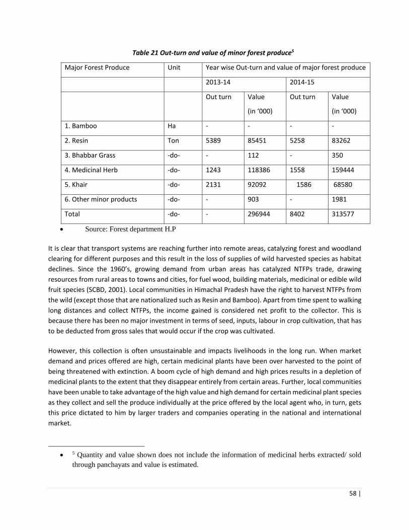
58 |
Table 21 Out-turn and value of minor forest produce5
Major Forest Produce Unit Year wise Out-turn and value of major forest produce
2013-14 2014-15
Out turn Value
(in ‘000)
Out turn Value
(in ‘000)
1. Bamboo Ha - - - -
2. Resin Ton 5389 85451 5258 83262
3. Bhabbar Grass -do- - 112 - 350
4. Medicinal Herb -do- 1243 118386 1558 159444
5. Khair -do- 2131 92092 1586 68580
6. Other minor products -do- - 903 - 1981
Total -do- - 296944 8402 313577
• Source: Forest department H.P
It is clear that transport systems are reaching further into remote areas, catalyzing forest and woodland
clearing for different purposes and this result in the loss of supplies of wild harvested species as habitat
declines. Since the 1960’s, growing demand from urban areas has catalyzed NTFPs trade, drawing
resources from rural areas to towns and cities, for fuel wood, building materials, medicinal or edible wild
fruit species (SCBD, 2001). Local communities in Himachal Pradesh have the right to harvest NTFPs from
the wild (except those that are nationalized such as Resin and Bamboo). Apart from time spent to walking
long distances and collect NTFPs, the income gained is considered net profit to the collector. This is
because there has been no major investment in terms of seed, inputs, labour in crop cultivation, that has
to be deducted from gross sales that would occur if the crop was cultivated.
However, this collection is often unsustainable and impacts livelihoods in the long run. When market
demand and prices offered are high, certain medicinal plants have been over harvested to the point of
being threatened with extinction. A boom cycle of high demand and high prices results in a depletion of
medicinal plants to the extent that they disappear entirely from certain areas. Further, local communities
have been unable to take advantage of the high value and high demand for certain medicinal plant species
as they collect and sell the produce individually at the price offered by the local agent who, in turn, gets
this price dictated to him by larger traders and companies operating in the national and international
market.
• 5 Quantity and value shown does not include the information of medicinal herbs extracted/ sold
through panchayats and value is estimated.
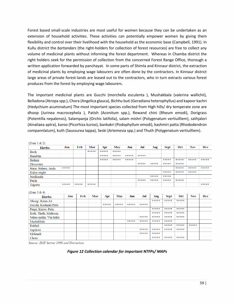
59 |
Forest based small-scale industries are most useful for women because they can be undertaken as an
extension of household activities. These activities can potentially empower women by giving them
flexibility and control over their livelihood with the household as the economic base (Campbell, 1991). In
Kullu district the bartandars (the right-holders for collection of forest resources) are free to collect any
volume of medicinal plants without informing the forest department. Whereas in Chamba district the
right holders seek for the permission of collection from the concerned Forest Range Office, thorough a
written application forwarded by panchayat. In some parts of Shimla and Kinnaur district, the extraction
of medicinal plants by employing wage labourers are often done by the contractors. In Kinnaur district
large areas of private forest-lands are leased out to the contractors, who in turn extracts various forest
produces from the forest by employing wage labourers.
The important medicinal plants are Gucchi (morchella esculenta ), Mushakbala (valerina wallichii),
Belladona (Atropa spp.), Chora (Angelica glauca), Bichhu buti (Geradiana heterophyllus) and kapoor kachri
(Hedychium acuminatum) The most important species collected from High hills/ dry temperate zone are
dhoop (Jurinea macrocephela ), Patish (Aconitum spp.), Rewand chini (Rheum emodi), Dorigrass
(Potentilla nepalensis), Salampanja (Orchis latifolia), salam mishri (Polygenatum vertiuilliem), sathjalori
(Ainaliaea aptra), karoo (Picorhiza kuroo), bankakri (Podophyllum emodi), kashmiri patta (Rhododendron
compannlatum), kuth (Saussurea lappa), Seski (Artemesia spp.) and Thuth (Polygenatum vertiuilliem).
Figure 12 Collection calendar for important NTFPs/ MAPs
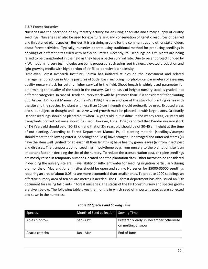
60 |
2.3.7 Forest Nurseries
Nurseries are the backbone of any forestry activity for ensuring adequate and timely supply of quality
seedlings. Nurseries can also be used for ex-situ raising and conservation of genetic resources of desired
and threatened plant species. Besides, it is a training ground for the communities and other stakeholders
about forest activities. Typically, nurseries operate using traditional method for producing seedlings in
polybags of different sizes filled with heavy soil mixes. Recently, tall seedlings /2-3 ft. plants are being
raised to be transplanted in the field as they have a better survival rate. Due to recent project funded by
KfW, modern nursery technologies are being proposed, such using root trainers, elevated production and
light growing media with high portion of air-filled-porosity is a necessity.
Himalayan Forest Research Institute, Shimla has initiated studies on the assessment and related
management practices in Alpine pastures of Sutlej basin including morphological parameters of assessing
quality nursery stock for getting higher survival in the field. Shoot length is widely used parameter for
determining the quality of the stock in the nursery. On the basis of height; nursery stock is graded into
different categories. In case of Deodar nursery stock with height more than 9” is considered fit for planting
out. As per H.P. Forest Manual, Volume –IV (1986) the size and age of the stock for planting varies with
the site and the species. No plant with less than 20 cm in length should ordinarily be used. Exposed areas
and sites subject to drought and excessive weed growth must be planted up with large plants. Ordinarily
Deodar seedlings should be planted out when 1½ years old, but in difficult and weedy areas, 2½ years old
transplants pricked out once should be used. However, Luna (1996) reported that Deodar nursery stock
of 1½ Years old should be of 20-25 cm and that of 2½ Years old should be of 30-45 cm height at the time
of out-planting. According to Forest Department Manual IV, all planting material (seedlings/stumps)
should meet the following criteria. Seedlings should (i) have straight, undamaged and unforked stems (ii)
have the stem well lignified for at least half their length (iii) have healthy green leaves (iv) from insect pest
and diseases. The transportation of seedlings in polythene bags from nursery to the plantation site is an
important factor in deciding the site of the nursery. To reduce the transportation cost, chir pine seedlings
are mostly raised in temporary nurseries located near the plantation sites. Other factors to be considered
in deciding the nursery site are (i) availability of sufficient water for seedling irrigation particularly during
dry months of May and June (ii) sites should be open and sunny. Nurseries for 25000-35000 seedlings
requiring an area of about 0.05 ha are more economical than smaller ones. To produce 1000 seedlings an
effective nursery area of ten square metres is needed. The HP forest department has also issued an SOP
document for raising tall plants in forest nurseries. The status of the HP Forest nursery and species grown
are given below. The following table gives the months in which seed of important species are collected
and sown in the nurseries.
Table 22 Species and Sowing Time
Species Month of Seed collection Sowing Time
Abies pindrow Sep - Oct Preferably early in December otherwise
on melting of snow
Acacia catechu Jan - Mar End of June
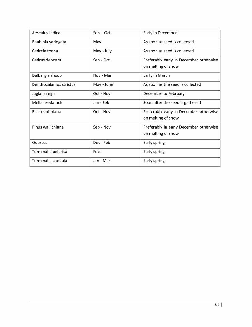
61 |
Aesculus indica Sep – Oct Early in December
Bauhinia variegata May As soon as seed is collected
Cedrela toona May - July As soon as seed is collected
Cedrus deodara Sep - Oct Preferably early in December otherwise
on melting of snow
Dalbergia sissoo Nov - Mar Early in March
Dendrocalamus strictus May - June As soon as the seed is collected
Juglans regia Oct - Nov December to February
Melia azedarach Jan - Feb Soon after the seed is gathered
Picea smithiana Oct - Nov Preferably early in December otherwise
on melting of snow
Pinus wallichiana Sep - Nov Preferably in early December otherwise
on melting of snow
Quercus Dec - Feb Early spring
Terminalia belerica Feb Early spring
Terminalia chebula Jan - Mar Early spring

62 |
Figure 13 Step Wise Seedling Development Practice in Current Nursuries
The figure above depicts the typical process of raising plants in exiting forest nurseries, overall, nursery
management can be improved through (i) integrated pest and disease control techniques (ii) selection of
only healthy seedlings to be transported to the planting site (ii) Sowing of seeds sterilized/fumigated,
clean beds and adequate watering (iv) Using sterilized budding knife, secateurs, and scissors during
budding and grafting (v) keeping planting material under proper sunlight, watering and clean environment
(vi) Providing Mycorrhizal inoculums (soil health) for raising quality stock of forestry species in high tech
and central nurseries. Common Pests include White grubs, Cutworms, Termites, Crickets and
Grasshoppers, Defoliators. Common Diseases include Damping-off (pre-and post-emergence), Collar rot,
Root rot, Foliage diseases.

63 |
Table 23 Details regarding nurseries in the different ranges of Rampur and Kinnaur N
ame
of
Div
isio
n
Nam
e o
f R
ange
Nam
e o
f B
lock
Nam
e o
f B
eat
Nam
e o
f N
urs
ery
Are
a in
ha.
Stock of Nursery Infrastructure of Nursery
Nam
e o
f sp
ecie
s
No
. of
pla
nts
Mal
i Hu
t
Ver
mi
com
po
st
Un
it
Wat
er
sto
rage
Tan
k
Po
ly h
ou
se
Ro
ot
trai
ner
Ap
pro
ach
ro
ad
Sto
re
Fen
cin
g
Ram
pu
r
Ram
pu
r
Deothi Deothi Deothi 0.60 Robinia, Deodar & Khanoor. 29000 √
Rampur Jakhari Jhakri 0.60 Ban, Daru, Kainth, Jamun, Amla Paza, Ritha, Chil Behmi Tun & Dreak
55610 √
Nogli Nogli Talai 1.20 Chil, Robinia, Ritha, Daru, Dreak, Kainth, Jakrinda, Amaltash, Tikoma & Chulli.
50049 √ √ √ √ √
Rampur Pashada Pashada 0.60 Ritha, Paza, Kainth, Robinia, Deodar & Chulli. 21840 √ √
Ram
pu
r
Nan
khar
i
Gahan Addu Addu 0.25 Behmi, Rai, Chulli & HC Nut. 16260 √
Nankhari Bagalti Bhadral 0.25 Deodar, HC Nut, Walnut & Rai. 12115 √ √
Sholi Delath Sharan 1.00 Dreak, Robinia, Shisham, Ritha, Chulli, Jakranda & Amaltash
20389 √ √ √
Gahan Gahan Gahan 1.00 Deodar, Tosh, Behmi, Chulli, HC Nut & Ban. 45400 √ √
Nankhari Kungal-Mundar
Kungal 0.50 Deodar Poplar, Ban, Jamun, Robinia, Tosh & HC Nut.
16230 √ √
Ram
pu
r
Bah
li
Surad Beunthal Beaunthal 0.50 Deodar, Robinia, Dreak, Kainth, Ritha & Chulli. 17200 √
Bahli Jarashi Jarashi 1.00 Deodar, Rai, Tosh, Khanoor, Chulli & Diascoria. 113970 √ √
Surad Surd Surad 0.50 Deodar, Chil, Robinia, Dreak, Ban & Chulli. 19910 √ √
Taklech Taklech Kuban 0.50 Robinia, Chulli, Kainth, Dreak, Paza, Khanoor. 9684
Kin
nau
r
Kal
pa
Kalpa Reckongpeo Reckong peo 0.25 Deodar, Neoza, Chulli, Bhemi - √ √ √

64 |
2.3.7 Forest Fires
Forests in HP have a high degree of susceptibility to forest-fires and these forest fires have destroyed
precious forest wealth and caused harms to the flora and fauna. However, spatial coverage in real time is
not available. It was made clear from the interview of forest officers that forest fire incidences are mainly
human induced and are common during the summer season. Local people believe that the burning of
forest areas improves the fodder resources by getting a fresh grass and tender herbs in the following
season. Some of the common measures to mitigate this is controlled burning, and maintenance of fire
lines.
The frequency, size, intensity, seasonality, and type of fires depend on weather and climate in addition to
forest structure and composition. The Chil belt fires are primarily due to negligence by communities, fires
are also common in November and Early December in the blue pine forests caused due to dry weather
and delay of winter rains. Following fires, soils are exposed to wind and rain leading to higher rates of
erosion, recharging of groundwater and flow of springs is also severely affected. The damage due to forest
fires varies from just burning of leaf litter and dry grass in case of ground fires to extensive damage to the
trees, biodiversity, and ecology in case the fires turn into crown fires. The forest fires also carry the risk of
getting out of control and extending to habitations.
The forest fire data for Himachal presented in table below indicates an increasing trend of the number of
forest fire incidents and resulting loss. Though latest data for forest fires in the state is not available
however, the table indicates that more than 10000 ha of forest area is affected due to forest fires in the
state (DoEST, undated). Most of the forest fires are man-made either due to negligence or intention. Chil
(Pinus roxburghii) forests are prone to forest fires during summer months while fires are very common in
the high Blue Pine (Pinus wallichiana) forests during November and early December when winter rains are
delayed (ibid).
Table 24 Circle wise forest fire incidences of last two years
Name
of
circle
Year
2015-16 2016-17
No. of
cases
Affected by fire (in
hectare)
Total
area
No.
of
cases
Affected by fire (in
hectare)
Total
area
Natura
l
Plantati
on
Othe
r Natura
l
Plantati
on
Oth
er
Kullu 44 501 187.4 0 688.4 7 23.1 0 27 50.1
Mandi 93 172.4 24 90 286.4 270 651.75 176.55 620.
8
1449.
1
Rampu
r 89 287 299.3 204 790.3 72 410.5 122.65
110.
5
643.6
5
Shimla 109 581.7 147.18 1 729.88 121 693 46.5 4 743.5
WL
Shimla 3 0 28 500 528 9 95 0 77 172
Source: Forest department of Himachal Pradesh

65 |
Fires also impact the health and species composition of forests. Repeated burning reduces the coppicing
power. In the case of moisture loving species like Oaks and Deodar, they tend to give way to species that
can come up in dried situations, or infested by exotic weeds smothering the regeneration of native
species. Some species like Sal have good coppicing power, and the seedling coppices emerge after
burning.
Figure 14 Forest fire risk zonal map of Himachal Pradesh.
Fires are a common feature in Chil forests area and in grasslands specially during summer season. Forest
fires affect the natural understory of the forests which often get invaded by alien species. Fires also
adversely affect the regeneration capacity of young crop, destroy ecosystems, and also affect the supply
of NTFPs. The fires in Himachal Pradesh are predominantly ground fires, causes vary amongst
accumulation of dry pine needles, thick under growth, dry grass, felling debris, drought, defective resin
tapping etc. Often, fires are set on purpose to obtain fresh grass (fodder) growth or drive away wild
animals or to encroach upon forest land.

66 |
Absence of controlled burning and other sylvicultural operations like pruning, cleaning and thinning in
regenerating areas have also result in wiping out large tract of Chil forests by forest fires. The HP
government has notified Forest Fire Rules, 1999, the department also has a forest fire manual which sets
forward the various roles and responsibilities in fire prevention and control.
Award Money of Rs. 5000/- to 10000/- to communities who co-operate in the Forest Fire Prevention
[Gram Panchyat and Village Forest Development Committee (VFDC) or Self-Help Group (SHG) and Joint
Forest Management Committee (JFMCs)]. The Forest Fire Watchers and Forest Officials who have done
commendable job in the prevention of Forest Fires, awarded during Van Mahotsav Programme of Forest
Department.
2.3.8 Community Based Forest Institutions
Joint Forest Management (JFM) was initiated in 1990 as a collaborative arrangement between Forest
Department (FD) and local communities to regenerate and manage degraded forests. These committees
are receiving benefits in form of fuel wood, fodder and various other non-timber forest products (NTFP).
There is a long tradition of participatory forest management in Himachal Pradesh. Cooperative Forest
Societies (CFS) envisaging the role of local people in the management of forest were constituted in district
Kangra as early as in 1940 (DoEST, undated). There were other areas where sacred forests or Deo Van
were being managed by the people. Based on these community traditions, various participatory
programmes such as Indo German Dhauladhar Farm Forestry project and Van Lagao Rozi Kamao scheme
were launched in the state prior to JFM (ibid). JFM was strengthened through Sanji Van Yojana or
participatory forest management scheme in 1998. Various community institutions have been created
under different projects and programmes such as Village Development Committees under Kandi project
and Indo German Eco development project; Village Forest Development Committees under HP (HPFD,
2014). There are 1023 committees managing 205000 ha of forests constituting 11% of the forest area in
the State (FRI, 2011). It has been estimated that JFM generates 2.7 lakh person days of annual
employment in the state.
The appropriate relationship between village forest institutions and local government in the form of
Panchayat Raj Institutions (PRIs) emerge as a potential common point of intervention, due to their
presence throughout HP and their constitutional nature, where the possibility of convergence of all local
village level institutions including forest ones is strongest. In January 2000, with a view to strengthening
the role of PRIs in the management of local resources and promotion of participatory forest management,
the HP Forest Department notified the constitution of panchayat, block and district level forest
committees. The notification states the composition and functions of the forest committees at the
different levels; they are to be in congruence with the three-tier standing committees – Panchayat,
Panchayat Samiti and Zila Parishad.
The draft Himachal Pradesh Participatory Forest Management Rules (‘PFM Rules’) (1999) and the
notification of January 2000 have clearly reflected the futuristic vision of HPFD to integrate its institutions
with PRIs. They include descriptions of the powers, responsibilities and duties of the VFDS, as well as the
benefits due to them; and state that the role of the HPFD is to ‘essentially provide a supportive role to
facilitate the process of Joint Forest Planning and Management through VFDS’ (through provision of

67 |
technical guidance, training, and funds). As a first step towards providing organic linkages between the
two, this may help the HPFD in defining active and meaningful participation in PRIs in forest-related
activities.
Table 25 Status of Community Based Forest Institutions
S.No Name of
Projects/Schemes
Year Name of Village
Institution
No. of Village
Institutions
Registered under
1 HP Forestry Project
(HPFP)
1994-2001 Village Forest
Development
Committees (VFDCs)
154 JFM Notification dated
12.5.1993
2 Indo-German Eco-
Development
Project
1994-2005 Village Development
Committees (VDCs)
294 JFM Notification dated
12.5.1993
3 IWD (Kandi) Project 1993-2005 Village Development
Committees (VDCs)
137 Societies Registration
Act 1860
4 Sanjhi Van Yojana
(SVY)
1998 Village Forest
Development Societies
(VFDS)
360 Societies Registration
Act 1860
5
Great Himalayan
National Park
1993
Ongoing
Village Eco-Development
Committee (VEDCs)
18 Director , GHNP
6 Mid Himalayan
Watershed Dev
Project
2005 Gram Panchayats 602 ---
7 National
Afforestation Project
(NAP)
2010 Joint Forest
Management
Committees (JFMC)
963 JFMCs Registered by
CFs/DFOs as per the
provision laid down in
Revised Operational
Guidelines, 2009 of
NAEB.
8 Integrated
Watershed
Management Swan
River Project
2006 Project Development
Committees
Not available Societies of
Registration Act 1860
2.3.3 Water Resources
There is a network of perennial rivers in Himachal Pradesh, which have glaciers as their sources. Majority
of the drainage of the state belongs to Indus River System. Statistics regarding the water sources of the
state are presented in the table below. The state is drained by nine river systems. The Satluj, Beas, Ravi,
Chenab, Spiti, Parbati, Pabbar, Tons and Giri are the main rivers of Himachal Pradesh. Of these, the Satluj,
is the largest river system in the state with a total catchment area of 20,398 km2, spread over the districts
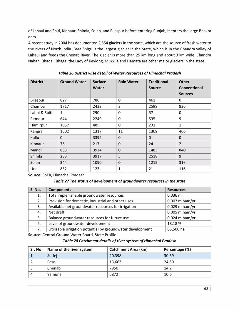
68 |
of Lahaul and Spiti, Kinnaur, Shimla, Solan, and Bilaspur before entering Punjab, it enters the large Bhakra
dam.
A recent study in 2004 has documented 2,554 glaciers in the state, which are the source of fresh water to
the rivers of North India. Bara Shigri is the largest glacier in the State, which is in the Chandra valley of
Lahaul and feeds the Chenab River. The glacier is more than 25 km long and about 3 km wide. Chandra
Nahan, Bhadal, Bhaga, the Lady of Keylong, Mukkila and Hamata are other major glaciers in the state.
Table 26 District wise detail of Water Resources of Himachal Pradesh
District Ground Water Surface
Water
Rain Water Traditional
Source
Other
Conventional
Sources
Bilaspur 827 786 0 461 0
Chamba 1717 2433 3 2598 836
Lahul & Spiti 1 290 0 57 0
Sirmour 644 2249 0 535 9
Hamirpur 1057 485 0 231 1
Kangra 1602 1317 11 1369 466
Kullu 0 3392 0 0 0
Kinnaur 76 217 0 24 2
Mandi 833 3924 0 1483 840
Shimla 233 3917 5 2518 9
Solan 344 1090 0 1215 316
Una 832 123 1 21 116
Source: SoER, Himachal Pradesh
Table 27 The status of development of groundwater resources in the state
S. No. Components Resources
1. Total replenishable groundwater resources 0.036 m
2. Provision for domestic, industrial and other uses 0.007 m ham/yr
3. Available net groundwater resources for irrigation 0.029 m ham/yr
4. Net draft 0.005 m ham/yr
5. Balance groundwater resources for future use 0.024 m ham/yr
6. Level of groundwater development 18.18 %
7. Utilizable irrigation potential by groundwater development 65,500 ha
Source: Central Ground Water Board, State Profile
Table 28 Catchment details of river system of Himachal Pradesh
Sr. No Name of the river system Catchment Area (km) Percentage (%)
1 Sutlej 20,398 30.69
2 Beas 13,663 24.50
3 Chenab 7850 14.2
4 Yamuna 5872 10.6
69 |
5 Ravi 5528 9.9
6 Indus 1450 2.6
7 Markanda 360 0.6
8 Ganga 290 0.5
9 Pabbar 262 0.5
Total 55673 100
There are a number of small and large lakes in Himachal Pradesh. These are in Kullu (Bhrigu, Dashair,
Seruvalsar, and Mantalai), Mandi (Rewalsar, Prashar), Kangra (Dal, Kareri, and Pong Dam), Nako in
Kinnaur, Surajtal and Chandertal in Lahul-Spiti, Chamba (Khajiar, Mani Mahesh, Gadhasaru, Gauri Kund,
Lam Dal Lake, Mahakali, and Khundi Maral), Renuka in Sirmaur and Chandernaun in Shimla. Water storage
in Himachal Pradesh is estimated at around 14,000 million m3. The Chandra Tal, Suraj Tal, Yonam Tso and
Nako Lake are the lakes formed due to damming of glaciers, while the Riwalsar and Renuka lakes are due
to damming of river/stream courses. The two major storages located on the borders of the state are The
Gobindsagar reservoir (Bhakra Dam) in the Satluj with 6,900 million m3 live storage, the Pong Dam located
on the border with Punjab in the Beas river with 7,300 million m3 live storage and The Pandoh Dam, a
hydroelectric dam on the river Beas upstream of Mandi, has live storage of 18 million m3.
2.3.3.1 River Sutlej
River Satluj is the largest river among the five rivers basing of Himachal Pradesh. Water Quality is generally
good (CPCB Class A, B) but untreated sewage towards Rampur and Bilaspur contribute to deteriorating
water quality. 6 It is estimated that more than 50 percent of the run-off in the Sutlej Rivers is from the
snowmelt. The average annual total run-off of river Sutlej is about 16,000 MCM. It traverses a course of
320 km area within Himachal Pradesh. The total catchment area of River Satluj is highest exists around 38
% area (20,398 km2) among the five major rivers of Himachal Pradesh.
The River Satluj basin divided into 11 sub basins. It is joined by various right bank tributaries such as Spiti,
Ropa, Rupi, Kashang, Taiti (Kiran), Mulgaon, Yul, Kerang, Wanger and Throng in Kinnaur. The Tirung,
Gayanthing, Duling, Baspa, Solding, Manglad and Nogli streams belong from the left bank tributaries. The
Major Tributari River are River Baspa, River Spiti, Nogli Khad and River Soan.
Tributaries in the Project Area
Kalpa block, Kinnaur
Kashang Khad: It originates at the foothill of Chikim and Mukim dhar that divided the Kalpa and Nichar
block. The Rogle Khad on the left bank tributary drains the water from the Sankarishul glacier. It joins the
River Satluj on left bank just below the Rarang village.
Pangi Nala: It is originated from Sankarishul glacier. Where the two tributaries Mebar Khad and Kojang
Khad meet, downward that point it is called as Pangi Nala. It joins the River Satluj just above the Pawari
village.
Rampur Block
6 HPPCB, 2007

70 |
Kut Khad: It originates just above the Kot Dogri near to the Nichar block boundary. The Kut Khad joins the
River Satluj at the bottom of Suru village.
Ganwi Khad: Ganwi Khad originated from the Sirikhand Mhadev. Its left bank tributaries are Daduwa
Khad, Ghartr Khad and right bank tributaries are Sagori, Kapni and Saran Khad.
Nogli Khad: It has joined River Satluj just south to the Rampur Bushahar at Nogli. It is known as a Sageti
Gad on its origin place. The Nogli Khad come to exist where the Suket Khad and Devpani Khad meets.
Karsog and Ani block
Baihna Khad: The Khudhi Khad and Kunir Khad confluence in Shawad village from that point it is known as
Baihna Khad. It joins the River Satluj in Phirnu village. One of the major tributaries of this river is Ani Khad
that joins the Baina Khad at Rorha village. The Baihna Khad also demarks the natural boundary between
Kullu (Ani block) and Mandi districts (Karsog Block).
Tangling Khad: It originates at the boundary of Pooh and Kalpa block of Kinnaur district. The main source
of water for this Khad is glaciers. It joins by the Kangrang Khad on right bank at the Kangrang Dogri. It joins
the River Satluj at Tangling village. The major settlements on the bank are Kangrang Dogri and Tangling.
Shyang / Shongtong Khad: It is left bank tributaries of the River Satluj that join the River Satluj at
Shongtong.
River Baspa: River Baspa is an important tributary of the River Satluj in its upper course. It is 70 km long
and second largest tributaries of Satluj. The river starts in the Baspa hills and joins River Satluj near the
left bank of Karcham at the lower end of Kinner Kailash. The Singan Khad and Hurba Khad join River Baspa
at Batseri village, Rokti Khad join Baspa at the Sangla and Baturi Khad join the Baspa at Chunang village.
Kunihar Block
Ali Khad: The catchment of this Khad is in the Kunihar and Bilaspur blocks. The Ali Khad comes to an exit
where the Badar Khad and Jor Khad meet. The Ali Khad joins the Gobind Sagar lake at Korwarni.
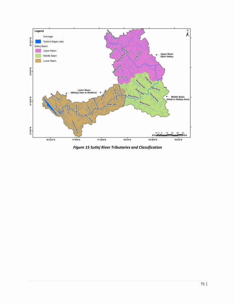
71 |
Figure 15 Sutlej River Tributaries and Classification

72 |
Figure 16 Project area in Sutlej Catchment

73 |
Table 29 Critical Environmental Resources in Project Area Forest Ranges
CERS Location CER Implications for
project design
Protected sites/
monuments/Cultural
properties
Kinnaur
Kinner Kailash mountain
Parvati Kund
Shrikhand Mahadev
mountain
Monasteries
Local Deities Temple in
every village
1. The project area does not involve any protected monument.
2. Any project works that are undertaken in the proximity of the identified cultural heritage sites will be done: (a) after consultation with the local community (b) by implementing required mitigation measures to avoid any negative impact on the identified cultural heritage site.
Solan Harsang temple
Badu Bara temple
Shimla Bhajji Fort
Narsingh Temple
Koteshwar Mahadev
Temple
Local Deities Temple
Mandi Mahunag Temple
Kamashka Devi Temple
Bhimakali Temple
Yogini Mata Temple
Baan Bhagwati
Dev Mahasu Temple
Chindi Mata Temple
Mahamaya Temple
Nag Dhamuni Temple
Mamleshwar Temple
Kullu Devi Pachala Temple
Nag Gadumbi Temple
Natli Nag Temple
Local Deities Temple
Protected areas-WLS, NPs,
IBAs
Kinnaur Rupi Bhava WLS, IBA Local’s movement
inside the forest and
collection of NTFP
from protected area
will be limited.
Solan Majathal WLS, IBA
Shimla NIL NIL
Mandi NIL NIL
Kullu NIL NIL
Schedule 1 species Rupi Bhava WLS,
IBA
• Leopard Cat
(Felis bengalensis)
• Snow Leopard
Since the project is
being implemented
by HPFD and in field

74 |
(Panthera uncia)
• Himalayan Brown
bear
(Ursus Arctos)
• Musk Deer
(Moschusoschiferus)
• Serow
(Capricornis sumatraensis)
• Himalayan Tahr
(Hemitragus jemlahicus)
• Himalayan Ibex
(Capra ibex)
• Western Tragopan
Pheasant (Tragopan
melanocephalus,)
• Monal Pheasants
(Lophophorus impeyanus,
Lophophorus Sclateri)
• Cheer Pheasant
(Catreuswallichii)
• Kalij pheasant
(Lophurs leucomelana)
• Lammergeier
(Gypaetus barbatus)
• Bharal
(Ovisnahura)
• Swiftlets
(Collocalia unicolor and
Collocalia fusiphaga
• Blue Sheep
(Pseudois nayaur)
by the Range Officer
and its ancillary staff
who are aware of
these species status
and are doing the
protection work
even before the
project.
Project works that
are undertaken near
the identified PAs
will be done by
implementing
required mitigation
measures to avoid
any negative impact
on the identified PA
and associated
species.
Majathal WLS, IBA • Cheer Pheasant
(Catreus wallichii)
• Common Leopard
(Panthera pardus)
• Leopard Cat
(Felis bengalensis)
• Indian Peafowl
(Pavo cristatus)
Since the project is
being implemented
by HPFD and in field
by the Range Officer
and its ancillary staff
who are well aware
of these species
status and are doing
the protection work

75 |
• Oriental White-
backed Vulture (Gyps
bengalensis)
• White-rumped
Vulture (Indian White-
backed Vulture)-
Gyps bengalensis
• Lammergeier
(Gypaetus barbatus)
• Kalij pheasant
(Lophurs leucomelana)
even before the
project.
Project works that
are undertaken
within or near the
identified PAs will be
done by
implementing
required mitigation
measures to avoid
any negative impact
on the identified PA
and associated
species.
Table 30 Baseline of economic activities in the project areas
Activity Location/types Issues impacting
forests
Implications for project
design
Hydropower • Nathpa Khakri HEP
(1500MW)
• Karchham Wangtoo HEP
(1000 MW)
• Shongtong Karchham
(450 MW)
• Rampur HEP (412 MW)
• Baspa-II HEP (300 MW)
• Bhabha HEP (120 MW)
• Kashang –I HEP (65 MW)
• Tidong HEP (60 MW)
• Shorang HEP (100 MW)
• Ghanvi-I HEP (23 MW)
• Tree felling
• Blasting
• Muck
Disposal
• Influx of
labour from outside
leading to pressure
on forest resources.
• Degradation /
deterioration of forest
area where the
interventions have
been implemented due
to construction
activities of the hydro
power projects.
Horticulture The main cash crops grown
in the region are the
horticulture trees like
apple, plum, almond,
apricot, walnut, peaches,
cherry, lemon etc. These
are solely harvested for
Cash and the demand for
these fruits all over the
country fetches good price.
On an average, an apple
• Illegal
encroachment of
forest land for
plantation of cash
crops like apple.
• Illegal clearing
of the forest area
where the
interventions have
been implemented.

76 |
Activity Location/types Issues impacting
forests
Implications for project
design
tree can fetch between Rs.
5000 to Rs. 7000 per
season, while plum tree can
fetch Rs.2500 to Rs. 4000
per season
Agriculture The agricultural crops
which are sown and
harvested mainly include
wheat, seed-potato, paddy,
maize, barley, pulses,
vegetables, etc.
• Illegal
encroachment of
forest land for
agriculture by
individuals.
• Illegal clearing
of the forest area
where the
interventions have
been implemented.
Ecotourism Local tourist inflow is
prevalent in Kinnaur and
Shimla Districts with many
tourist destinations like
Chitkul, Rakcham, Sangla,
Kalpa, Nako, Sarahan,
Tatapani, Mahu Nag
Temple, Kamashka Devi
Temple, Jalodi Pass, Kinnar
Kailash, Srikhand Mahadev
etc. Also, trekking routes to
Spiti, Kullu, Manali, Rohru,
Niti Valley (Uttrakhand) etc.
• Pressure on
forest resources
• Pollution like
plastic waste, solid
waste disposal
• Degradation /
deterioration of forest
area in project due to
pressure on forest
resources or
generation of plastic
waste, solid waste etc.
Mining Mining operations are
being done in the project
area either by approved
agencies/individuals for
extraction of river bed
material (RBM) for
construction activities like
hydro power projects, road
construction, infrastructure
development etc.
However, illegal mining is
being done by individuals in
forest area for sand/clay
who are being penalised/
booked by administration
or State Mining
Department or HPFD
• Change in flow
regime of river
• This result in
increased turbidity
of the water in the
river stretch making
it less usable and
aesthetically
appealing.
• Degradation /
deterioration of project
area where the
interventions have
been implemented due
to illegal mining
activities.
• all construction
material for project
interventions is
sourced from legal and
approved quarry sites.

77 |
Activity Location/types Issues impacting
forests
Implications for project
design
Fishing Fish catching is not very
prevalent in the area. Only a
few fishermen do fishing at
lower reaches of project
area for selling purpose. For
commercial purpose, the
fish is mainly brought from
downstream areas like
Bilaspur. At upstream, few
sites have been identified
for sport fishing i.e. Sangla
• None • None
Industry As such no key industries
are located in the area
along river Satluj. Only one
dairy plant is at Bithal.
Fewer packaging set-ups at
smaller level could be
located in upper reaches,
where in apple production
is in abundance.
• None • Not envisaged.
However, in future if
any new industry is
being set up in the
project area where
intervention are being
planned care must be
taken so that it does
not impact the
objective of the project
interventions.
Road construction Transport sector
infrastructure investments
are critical to improve
mobility of goods and
people, and to facilitate
trade and commerce. Road
being the lifeline of any
region for development is a
necessity. However, due to
hilly terrain the disposal of
debris during road
construction is a major
cause of concern for
increasing sediment flow in
Sutlej River.
• Muck/debris
disposal
• Tree felling
• Influx of labour from
outside leading to
pressure on forest
resources.
•
• Degradation /
deterioration of forest
area where the
interventions have
been implemented due
to road construction
activities.
• The direct impacts
(such as the direct
footprint or clearing
land for road or other
transport
infrastructure
construction) can be
easily identified and
mitigated (through
compensation
plantations).

78 |
Table 31 Analysis of Key Environmental Issues from Baseline Study
Issues /Sector Baseline conditions and Issues of
concern
Possible FFP/ EMF interventions
HEALTH AND
QUALITY OF
FORESTS
• Demand- Supply Gap for fuel
and fodder
• Illegal extraction
• Choice of the afforestation
species needs to match the
planting site
• No Collective management
of natural resources.
• Grassland and pasture
management practices
unsustainable
•
• Better community participation in
grassland management
• Creation of enterprises around
fuel and fodder for steady supply
• Fodder and fuel (dead wood)
harvesting and management
through community managed
depots
• Critical evaluation and appraisal
of existing programmes of
afforestation and deriving
meaningful path finders from
such evaluation.
• Development of plantation
models that meet the needs of
the planting site, and the
communities
• Training of forest officials at for
nursery development
• Assessment of forest fire damage
and inventory of the appropriate
technology/methodology for
prevention and control.
• Popularization and expansion of
the programme on the use of non-
conventional energy sources,
improved chullahs, use of Solar
Energy Systems, biogas, use of
LPG and Kerosene oil as a special
drive in villages falling in five km.
belt around the forest.
• Encourage people participation
for high rate survival success of
afforestation programmes.
• Check on the indiscriminate
removal/harvesting of MAPs

79 |
GRAZING LANDS
AND PASTURES:
• Excessive grazing resulting in
disappearance of protective
cover
• development of cattle tracts
into channels; compaction of
soil resulting in lower
infiltration rates.
• Growth of invasive species,
weeds
• Low productivity of pasture.
• Less area under cultivated
fodder/ grasses/ stall feeding
• Lack of desirable
composition of grasses and
legume in grazing lands.
• Lack of people participation
in grazing land management.
• The livestock population of
the state is three times the
carrying capacity of grazing
lands
• Continuous grazing reduces
the productivity and gives
rise to weeds such as
Lantana and Parthenium.
• Cattle need to be reared in
villages throughout the year,
encourage growth of fodder crops
and stall feeding
• Nomad cattle grazing could be put
into rotation mode
• Fencing cost can be high which
the project can support
• Need Soil and Water conservation
measures to reduce dryness in
summer
• Need location-specific grassland
species development for ensuring
adequate fodder supply, integrate
management of vegetation with
other NRM programs to achieve
multiple use objectives contained
in Forest land.
• Pastures need to be managed so
that they provide for livestock
forage, wildlife food and habitat
and contribute to economic and
social wellbeing of communities
by providing stability for
communities that depend on
pasture resources for their
livelihood
• Grazing land management
through deferred and rotational
grazing.
• Need to develop close
coordination between the State
Forest Development and Animal
Husbandry Dept. for management
and development of pasture
lands.
• Introduction of desirable
composition of grasses, legumes
and fodder trees which are
palatable and high in protein
content.
• Enhancement and restoration of
soil fertility with the application

80 |
for organic manure and bio
fertilizers.
• Fodder development through
People's Participation in grazing
land and livestock management.
•
FOREST FIRE • Burning for fodder
• Accidental occurrences
• Introduction of forest fire
assessment, ranking, and
management system (danger
ranking, forecasting)
• Increasing public awareness on
forest fires, and the associated
impacts
• Demarcation of fire line
• Focus on incentives (economic-
NTFP, ecotourism) for the
communities to draw from these
areas so they help in mitigating
fires.
• Need better management of
controlled burning for fodder
• Need management systems for
pine-needle collection (earmark
areas for collection)
• Build incentives/industry around
reside management (weeds, pine
needles) so communities can
support their collection.
CLIMATE CHANGE • Short duration rains, higher
intensity
• Quality of forest ecosystems
depleting, drying up of
springs, loss of soil cover
• Treatment of the most vulnerable
forest areas with scientific and
sylvicultural operations and
removal of alien species
•
QUALITY OF
PLANTING STOCK
• Current seed stands are old,
and expertise amongst local
communities to identify
good quality seeds is low.
• Current forest nurseries are
low- tech and use polybags
• Infrastcrture gaps such as (i)
Seed storage facilities are
• Need to develop good small
planting stock to be planted with
tall plants
• Silviculture spacing should be
maintained per plant size
• Promote best management
practices on silviculture thinning
• Initiate intensive training on
nursery management

81 |
inadequate (ii) No seed
orchards
• Use of Insectices and
fungicides in nurseries is not
scientific.
• Defined protocols for a nursery
manual
• Introduction of raised platforms,
root thinning, better compost
production
• Seed storage should be at known
temperature and humidity before
distribution to seed nursery.
SPECIES
SELECTION
• Better systems for
procurement of seeds is
required- origin of the seed
has to be recognized
• Quality of planting material
needs to be enhanced
• Modernization of nurseries
is needed
• High altitude MAPs still have
low productivity, low
survival
• Communities providing
preference for fuel, fodder
species
•
• Site specific species needs to be
selected for specific sites. This can
be done through better planning
for the forest nurseries in terms of
species selection.
• Zonation of species according to
agro-climatic zones needs to be
considered.
• Seed handling, collection, pre-
sowing management capacity
building is needed
• FD needs coordination for
multiple projects to measure
impacts
• Site selection of species can be
prioritized where there is least
development
• Species selection should be
vetted by an expert and yearly
requirements for seedlings should
be made.
• Tall/ Sturdy plants have 90%
survival rate in first year.
• If adopting root trainers, need
enriched potting media with 60%
organic matter [3:2:1] of FYM:
Sand: Soil. Species such as deodar
needs to be kept for 1.5-2 years in
Root Trainers.
FOREST
MANAGEMENT
SYSTEMS
• Need upgradation in
technology
• FD is implementing and
monitoring
• Need institutional assessment of
the forest department and Forest
development corporation to
understand the roles in
sustainable forest management.
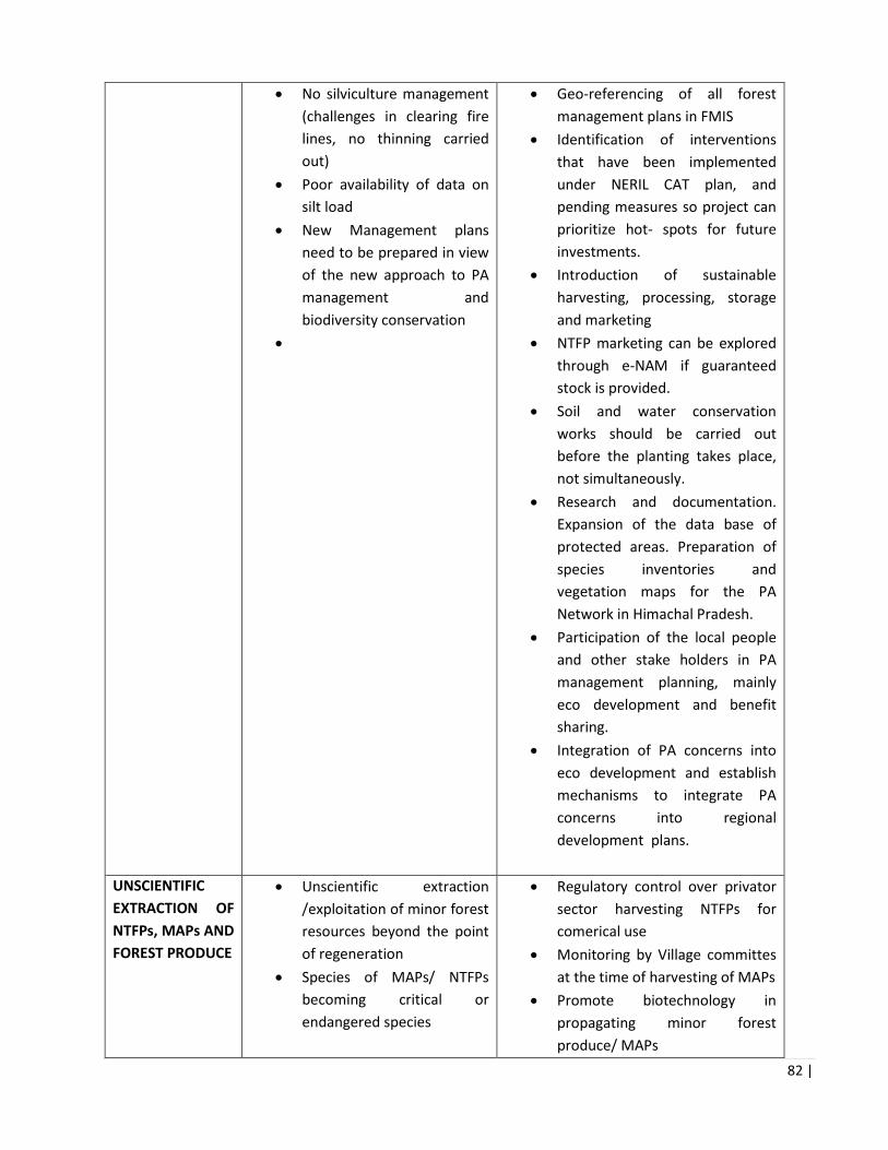
82 |
• No silviculture management
(challenges in clearing fire
lines, no thinning carried
out)
• Poor availability of data on
silt load
• New Management plans
need to be prepared in view
of the new approach to PA
management and
biodiversity conservation
•
• Geo-referencing of all forest
management plans in FMIS
• Identification of interventions
that have been implemented
under NERIL CAT plan, and
pending measures so project can
prioritize hot- spots for future
investments.
• Introduction of sustainable
harvesting, processing, storage
and marketing
• NTFP marketing can be explored
through e-NAM if guaranteed
stock is provided.
• Soil and water conservation
works should be carried out
before the planting takes place,
not simultaneously.
• Research and documentation.
Expansion of the data base of
protected areas. Preparation of
species inventories and
vegetation maps for the PA
Network in Himachal Pradesh.
• Participation of the local people
and other stake holders in PA
management planning, mainly
eco development and benefit
sharing.
• Integration of PA concerns into
eco development and establish
mechanisms to integrate PA
concerns into regional
development plans.
UNSCIENTIFIC
EXTRACTION OF
NTFPs, MAPs AND
FOREST PRODUCE
• Unscientific extraction
/exploitation of minor forest
resources beyond the point
of regeneration
• Species of MAPs/ NTFPs
becoming critical or
endangered species
• Regulatory control over privator
sector harvesting NTFPs for
comerical use
• Monitoring by Village committes
at the time of harvesting of MAPs
• Promote biotechnology in
propagating minor forest
produce/ MAPs

83 |
• Promote Marketing, value
addition, training, development
of nurseries for quality planting
material and inter linage with
other departments
• Trainings on sustainable
harvesting practices
Chapter 3 Relevant Laws, Regulations and Development Programmes
3.1. Introduction This chapter summarizes the laws, regulations and safeguard policies relvant to the project.
3.2. Applicable World Bank Policies To minimize and manage environmental and social impacts, the Bank’s Operational Policies (OPs) and Bank Procedures (BPs) have to be complied with as part of due diligence. The WB safeguards policies require integrating environmental impacts and risks into the planning and implementation of financed projects such as the HP FFPP. Additionally, HP FFPP will adhere to the World Bank Group Environmental, Health and Safety Standards as presented at www.ifc.org/ehsguidelines. The most relevant guidelines for this Project include the General Guidelines (which contain environmental, construction, occupational and community health and safety guidance relevant to small works and building refurbishment), and the Guidelines for Forest Harvesting Operations. The Bank’s safeguard policies, applicability and rationale have been given in Table 1.

84 |
Table 31 World Bank Safeguard policies
No. Policy Applicability Remarks on Applicability
1 Environmental Assessment OP/ BP 4.01.
Applicable The Bank requires environmental assessment (EA) of projects proposed for Bank financing to help ensure that they are environmentally sound and sustainable. Overall the project is expected to have positive impacts including: a reduction in greenhouse gas emissions with improved forest cover, reduction in silt loads, soil and moisture regulation and rural livelihood improvement. The potential negative environmental impacts will be known with more specificity as project activities and areas of influence are identified during project preparation but are expected to be limited, localized, small-scale and not significant given that many of the on the ground. This Environmental Management Framework (EMF) document has been developed to provide basic criteria and procedures for screening all interventions and for guiding the preparation of environmental management plans for the specific project interventions. The EMF also includes institutional arrangements, capacity building strategy, monitoring plan and budget. The EMF will be disclosed before project appraisal.
2 Natural Habitats OP/BP 4.04
Applicable The Project area contains two protected areas/ wildlife sanctuaries (Rupi Bhabha and Majathal). Also, the project area is in close proximity of other Protected Areas. The project will only implement activities as per the approved management plans of the protected areas. No activity which is contrary to the management plan will be supported under the project.
3 Forests OP/BP 4.36. Applicable Forest management is a primary focus of this project, in addition to pastures in the landscape. The project's long-term environmental impacts are expected to be highly positive overall, with reduced deforestation and forest degradation and increased benefits-sharing from forest resources. The EMF will include guidance on sustainable management of forests.
4 Pest Management OP/BP 4/.09
Applicable The Project supports strengthening of forest nurseries, supplies and equipment which may include use of pesticides if there is pest/ disease outbreak. While a stand-alone Pest Management Plan (PMP) is not required for this Project, the EMF contains measures to avoid usage of restricted pesticides, promote use of personal protective equipment (PPE), use of bio-pesticides, and promote use of biological and mechanical control of pests and diseases.
5 Physical and Cultural Resources OP/BP 4.11
Applicable The EMF contains measures for avoiding and managing impacts on known PCR in the project area as well as chance-finds procedures in case new resources are discovered in the course of the Project. Further, communities within the geographical area would recognize various physical cultural resources, including sacred forest areas as well as individual sacred trees and bushes. The EMF contains measures for consultation of communities in order to identify and take appropriate measures to mitigate any negative impacts on such cultural resources.

85 |
6 World Bank EHS Guidelines
Applicable The WB (EHS) guidelines (General Guideliens and Guidelines for Forest Harvesting Operations) containing performance level and measures on environmental, occupational health and safety for construction, community health and safety will be applicable for the project works.
7 FAO Guidance on Occupational Health and Safety in Forestry
Provides guidelines on safety in forest operations including harvesting, NTFP collection and forest fire management
3.3. Policy and Regulatory Framework of Government of India (GoI) and Government of Himachal Pradesh (GoHP)
Table 32 Analysis of National and State Level Regulation applicable under the project
Environment and Forests
No. Acts and Regulations Year Objective Applicability Authority
1 National Forest Policy 1988 Keeping the forest area intact in the Himalayan states- This policy implies to maintain the 66.7% of land under forest area in HP.
Applicable as project financed activities will be implemented/carried out on forest land. This policy needs to be complied with.
MoEFCC
2 Indian Forest Act 1927 Consolidates the law relating to forests, the transit of forest-produce and the duty livable on timber and other forest-produce.
Applicable if sub-projects involve felling of trees. The requisite permissions for tree felling will be taken prior to the activity taking place.
MoEFCC
3 Forest (Conservation) Act 1980 Any non-forest activity undertaken on forest land with the objective of providing benefits to individuals, communities, villages, Panchayats will require clearance under the Forest Conservation Act (1980). GOI has also issued guidelines (F. No. 11- 9/98-FC dated 03 January 2005) for diversion of forestland for non-forest purposes under the Forest (Conservation) Act, 1980 – General Approval under Section 2 of Forest (Conservation) Act, 1980 for diversion of forest land to Government
Applicable as all project financed activities will be carried out in forest areas, and sustainability of project financed investments should not be impacted due to diversion of forest land. However, none of the project financed activities require diversion of forest land.
MoEFCC, and State Forest Dept

86 |
Departments for certain developmental activities.
4 Scheduled Tribes and Other Traditional Forest Dwellers (Recognition of Forest Rights) Act
2006 The law concerns the rights of forest-dwelling communities to land and other resources, denied to them over decades as a result of the continuance of colonial forest laws in India. Right to hold and live in the forest land under the individual or common occupation for habitation or for self-cultivation for livelihood by a member or members of a forest dwelling Scheduled Tribe or other traditional forest dwellers
Right of ownership, access to collect, use, and dispose of minor forest produce (includes all non-timber forest produce of plant origin) which has been traditionally collected within or outside village boundaries.
Ministry of Tribal Affairs
5 The Biological Diversity Act 2002 The Act aims at the conservation of biological resources and associated knowledge as well as facilitating access to them in a sustainable manner. The Act was enacted to meet the obligations under Convention on Biological Diversity (CBD), to which India is a party
State Biodiversity Board should be consulted in the project preparation phase.
National Biodiversity Authority and State Biodiversity Boards
6 Wildlife (Protection) Act,
1972
The objective is to provide protection to the listed endangered flora and fauna and ecologically important protected areas. If the project extends to PA, then the relevant clearances under the Wildlife Protection Act (1972) will be needed. The project area involves two Protected Areas.
Applicable as there are two wildlife sanctuaries as part of the project area Project financed activities will be carried out as per the Management plan of the WLS.
MoEFCC
7 Eco-sensitive Zone Notifications 2015
2015 The activities in areas around Wildlife Sanctuaries and National Parks are regulated from the perspective of conservation of wildlife
Applicable. Monitoring Committee for ESZ in the State
8 Himachal Pradesh Forest Produce Transit (Land Routes) Rules.
2013 To ensure that the forest produce/species are extracted from the prescribed area in the approved extraction cycle and that the extraction has been done in a sustainable
Applicable when designing NTFP value chain for registration.
HP Forest Department
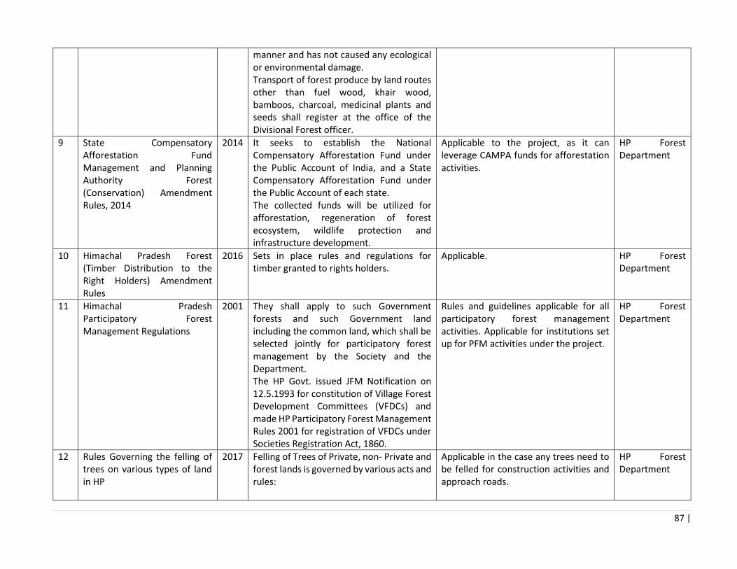
87 |
manner and has not caused any ecological or environmental damage. Transport of forest produce by land routes other than fuel wood, khair wood, bamboos, charcoal, medicinal plants and seeds shall register at the office of the Divisional Forest officer.
9 State Compensatory Afforestation Fund Management and Planning Authority Forest (Conservation) Amendment Rules, 2014
2014 It seeks to establish the National Compensatory Afforestation Fund under the Public Account of India, and a State Compensatory Afforestation Fund under the Public Account of each state. The collected funds will be utilized for afforestation, regeneration of forest ecosystem, wildlife protection and infrastructure development.
Applicable to the project, as it can leverage CAMPA funds for afforestation activities.
HP Forest Department
10 Himachal Pradesh Forest (Timber Distribution to the Right Holders) Amendment Rules
2016 Sets in place rules and regulations for timber granted to rights holders.
Applicable. HP Forest Department
11 Himachal Pradesh Participatory Forest Management Regulations
2001 They shall apply to such Government forests and such Government land including the common land, which shall be selected jointly for participatory forest management by the Society and the Department. The HP Govt. issued JFM Notification on 12.5.1993 for constitution of Village Forest Development Committees (VFDCs) and made HP Participatory Forest Management Rules 2001 for registration of VFDCs under Societies Registration Act, 1860.
Rules and guidelines applicable for all participatory forest management activities. Applicable for institutions set up for PFM activities under the project.
HP Forest Department
12 Rules Governing the felling of trees on various types of land in HP
2017 Felling of Trees of Private, non- Private and forest lands is governed by various acts and rules:
Applicable in the case any trees need to be felled for construction activities and approach roads.
HP Forest Department

88 |
13 HP Forest Fire Rules Transit Rules- Notifications MFP
1999 These rules may be called the Himachal Pradesh Forests (Protection from Fire) Rules, 1999. The objective is to set in place rules for precautionary measures to prevent fires, and also set forth prohibitions on activities which may lead to forest fires
Applicable to storing/ stacking of inflammable forest produce, kindling of fire within one hundred meters from a forest without permission of the Divisional Forest Officer, and Precautions to be taken in burning agriculture residue near forest.
HP Forest Department
14 Insecticide Act 1968; Insecticide Rules 1971; Insecticide (Control) Order 1985;
1968 1985
The GOI has notified various Acts for the control and prevention of pollution due to pesticides and fertilizers. The Act to regulate the import, manufacture, sale, transport, distribution and use of insecticides with a view to prevent risk to human beings or animal
The project investments are likely to involve use of pesticides (in nurseries and plantation activities). These activities will comply with the requirements of the Insecticide Act – especially with regard to non-use of banned pesticides, safe use of pesticides, etc.
Central Insecticides Board, GoI
15 APMB Department Notification agr F (150-26/2004 dated 11.3.2010. Amendment to The Schedule section 2 (a) of Himachal Pradesh Agricultural and Horticultural Produce Marketing (Development and Regulation) Act, 2005 (Amendment to the Schedule)
2010 HPSAMB to provide for improved regulation in marketing of agricultural produce, development of efficient marketing system, promotion of agri- processing and agricultural exports, establishment and proper administration of markets for agricultural produce in the State of Himachal Pradesh.
APMB provides marketing support o 37 Medicinal and Aromatic plants. APMB mandis can be used to auction this produce
Dept. of Agriculture (APMB)
16 Food Safety and Standards (Food Products Standards and Food Additives) Regulations, 2011 and subsequent amendment.
2011 The Food Safety and Standards Authority of India (FSSAI) has been established under the Food Safety and Standards Act, 2006 as a statutory body for laying down science based standards for articles of food and regulating manufacturing, processing, distribution, sale and import of food to ensure it is safe to consume.
FSSAI standards would apply if NTFPs supported under the project are processed for consumption.
FSSAI

89 |
Environment and Pollution Management
No. Acts and Regulations
Year Objective Applicability Authority
1 Environment (Protection) Act and amendments
1986 The Environment Protection Act, 1986 (the "Environment Act") provides for the protection and improvement of environment. The term "environment" is understood in a very wide term under s 2(a) of the Environment Act. It includes water, air and land as well as the interrelationship which exists between water, air and land, and human beings, other living creatures, plants, micro-organisms and property. Under the Environment Act, the Central Government issues notifications under the Environment Act for the protection of ecologically-sensitive areas or issues guidelines for matters under the Environment Act
The various environmental quality standards notified under this act are applicable to the project. These include: General standards for discharge of environmental pollutants Ambient air quality standards in respect of noise Vehicular exhaust norms Noise limits for vehicles Emission and noise limits for gensets
MoEFCC, CPCB
2 Water (Prevention and Control of Pollution) Act (and subsequent amendments)
1974 To provide for the prevention and control of water pollution and the maintaining or restoring of wholesomeness of water.
The project will have Investments on supply chain that may increase wastewater flow Proper measures as per the requirement of the Act have been incorporated in the EMP.
CPCB, and HPPCB
3 Air (Prevention and Control of Pollution) Act (and subsequent amendments)
1981 To provide for the prevention, control and abatement of air pollution, and for the establishment of Boards to carry out these purposes.
The project will involve construction of infrastructure and their clearance may be required by the Project. The project activities (especially construction and NTFP processing) will have to comply with the National Ambient Air Quality Standards.
CPCB, HPPCB, and Transport Department
4 The Municipal Solid Waste (Management and Handling) Rules,
2000 The rule facilitates and provides methods to manage the Municipal Solid Wastes in an efficient and reusable manner.
As project investments, will involve construction/up gradation of buildings/nurseries, supply chain infrastructure, generation and disposal of solid waste under different components will need to be managed in line with the rules.
MoEFCC, CPCB, and HPPCB
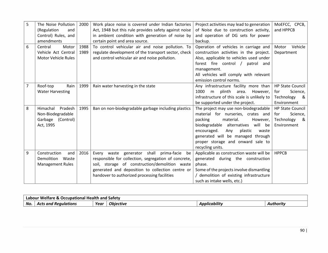
90 |
5 The Noise Pollution (Regulation and Control) Rules, and amendments
2000 Work place noise is covered under Indian factories Act, 1948 but this rule provides safety against noise in ambient condition with generation of noise by certain point and area source.
Project activities may lead to generation of Noise due to construction activity, and operation of DG sets for power backup.
MoEFCC, CPCB, and HPPCB
6 Central Motor Vehicle Act Central Motor Vehicle Rules
1988 1989
To control vehicular air and noise pollution. To regulate development of the transport sector, check and control vehicular air and noise pollution.
Operation of vehicles in carriage and construction activities in the project. Also, applicable to vehicles used under forest fire control / patrol and management. All vehicles will comply with relevant emission control norms.
Motor Vehicle Department
7 Roof-top Rain Water Harvesting
1999 Rain water harvesting in the state Any infrastructure facility more than 1000 m plinth area. However, infrastructure of this scale is unlikely to be supported under the project.
HP State Council for Science, Technology & Environment
8 Himachal Pradesh Non-Biodegradable Garbage (Control) Act, 1995
1995 Ban on non-biodegradable garbage including plastics The project may use non-biodegradable material for nurseries, crates and packing material. However, biodegradable alternatives will be encouraged. Any plastic waste generated will be managed through proper storage and onward sale to recycling units.
HP State Council for Science, Technology & Environment
9 Construction and Demolition Waste Management Rules
2016 Every waste generator shall prima-facie be responsible for collection, segregation of concrete, soil, storage of construction/demolition waste generated and deposition to collection centre or handover to authorized processing facilities
Applicable as construction waste will be generated during the construction phase. Some of the projects involve dismantling / demolition of existing infrastructure such as intake wells, etc.)
HPPCB
Labour Welfare & Occupational Health and Safety
No. Acts and Regulations Year Objective Applicability Authority

91 |
1 Building and Other Construction Workers (Regulation of Employment and Conditions of Service) Act, 1996
1966 It regulates the employment and conditions of service of building and other construction workers and provides for their safety, health and welfare.
This will be applicable for all building or other constructions works under the project that employ 10 or more workers.
District Labour Commissioner and Buildings Inspector
2 Workmen Compensation Act, 1923
1923 It provides for payment of compensation by employers to their employees for injury by accident i.e. personal injury or occupational disease.
Construction workers will be involved in the sub-projects.
District Labour Commissioner
3 Inter-state Migrant Workers Act, 1979
1979 It protects workers whose services are requisitioned outside their native states in India. A contractor who employs or who employed five or more Inter-State migrant workmen need to obtain registration under this act
Construction workers will be involved in the sub-projects
District Labour Commissioner
4 The Child Labour (Prohibition & Regulation) Amendment Act, 2016
2016 It prohibits employment of children in specified hazardous occupations and processes and regulates the working conditions in others.
There should not be any child labour in any project activity.
District Labour Commissioner
5 Minimum Wages Act, 1948 1948 Payment of minimum rate of wages as fixed and periodically revised by the State Government
Construction/daily wage workers will be involved in the sub-projects
District Labour Commissioner
6 Building and Other Construction Workers Welfare Cess Act, 1996
1996 An Act to provide for the levy and collection of a Cess on the cost of construction incurred by employers.
Sub-projects will involve construction workers
District Labour Commissioner
3.4. List of Statutory Clearances and Authorizations
Table __: List of Statutory Clearances and Authorizations which may be required
No. Activity Relevant Act/Rules Requirement Competent Authority Responsible Agency

92 |
1 Tree cutting from Private land classified as ‘Forests’
Forest Conservation Act 1980
Permission for tree cutting shall be processed under Forest Conservation Act 1980. Felling under this category will be granted by DFO after processing the case under FC Act and getting approval
DFO HP Forest Department
2 Tree cutting from government land not classified as forests
GoHP leteer no FFE-(b) F 913)53/2 006-1 dated 20.08.2011
Felling of trees except for Ban/Oak from non-forest land in rural areas for development activities not forming compact wooded block of above 5 Ha and land is not classified as van, Bani, and Jungle etc. in revenue record.
Chief Conservator of Forests/ CCF of the circle will grant permission, DFO shall inspect the trees after obtaining approval from CCF. Felling to be done through HP SFDC
HP Forest Department
2 Tree cutting from Government Land classified as forests
Forest Conservation Act 1980
Felling of trees from diverted forests land where final approval has been granted by GoI u/s 2 of FCA, 1980
DFO, of the concerned circle Felling to be done through HP SFDC
HP Forest Department
3 Extraction of ground water
Ground Water Rules of 2002
Permission for extraction of ground water for use in road/other construction activities
State Ground Water Authority HP Forest Department
4 Engagement of labour
Labour Act Labour license Labour Commissioner HP-Forest Contractor
5 Establishment of processing units for NTFP
Consent for Establishment and Consent for Operation are to be obtained from the State Pollution Control Board prior to establishment and commencement of operations, repectively.
State Pollution Control Board HP Forest Department

93 |
Chapter 4: Stakeholder Consultation
In accordance with the World Bank Safeguard policies, stakeholder consultations were conducted with the key project stakeholders during the Environmental Assessment and development of the Environmental Management Framework. The objectives of the stakeholder consultations were:
a. To create awareness and generate understanding about the project among stakeholders, and to
collect their opinion, suggestions for planning and designing of the project
b. To find out whether the communities are likely to accept the measures suggested under the HPFPP
c. To understand the environmental issues associated with the project through discussions
d. To assess positive as well as adverse environmental impacts in the area through participatory
methods
e. To identify the needs and concerns of the stakeholders
f. To assess cultural patterns and behavior of local communities towards the project
g. To elicit suggestions and opinions of the community, line department officials and NGOs on
mitigation measures to counter and check the adverse and negative impact
h. To assess the satisfaction level of people with proposed mitigation and management measures
proposed for the project
The key elements of the stakeholder consultation process are:
1. Identification of the key stakeholders
2. Consultation meetings with the identified key stakeholders
a. Consultation meetings with key institutions
b. Stakeholder consultation meetings at district level
c. Stakeholder consultation meetings at village level
3. Disclosure meetings for disclosure of the Environmental Assessment and Management Framework
to the key stakeholders
Stakeholder’s views were invited through informal and formal public consultation meetings. The stakeholders were informed about the project components, the assessment process, likely environmental impacts and poposed management framework before seeking their views. An executive summary of consolidated EAMF report will be made available for public access in local language (Hindi) versions at HP Forest Department website. Copies will also be made available at the Division and Range offices of the HP Forest Department.

94 |
4.1 Identification of Key Stakeholders The following table presents the key stakeholders in the project. Table __: Stakeholder Matrix
Type Stakeholder Stake in the project Importance
Project needs Perceived attitude
Nodal Implementing Agency
HP Forest Department, GoHP
Nodal Agency High Project Planning and Implementation Interested
Circle (Conservator of Forests)
Nodal Implementer High Existing channel for submission of APOs/ approval of APOs/ sanctioning power of works/ supervise performance of divisions / co-ordination with all Divisions/ grievance redressal / procurement of goods, works etc beyond competence of DFO
Interested
Division (Divisional Forest Officer)
Nodal Implementer
High Prepare APOs/ Sanction works within his competency/ supervise performance of staff up to range offices/ grievance redressal/ drawing and disbursing officer from government treasury/ co-ordination between all Range Officers and with other Departments/ procurement of goods, works etc within his competence
Interested
Range (Range Officer) and frontline staff
Nodal Implementer High Implementing activities as per approved APOs/ Inputting data in FMIS/ Sub-disburser of government funds/ liaising with public/ Attending to Forest offences/ fires
Interested
Other Relevant Line
HP State Forest Development
Line Department High NTFP harnessing and marketing Interested
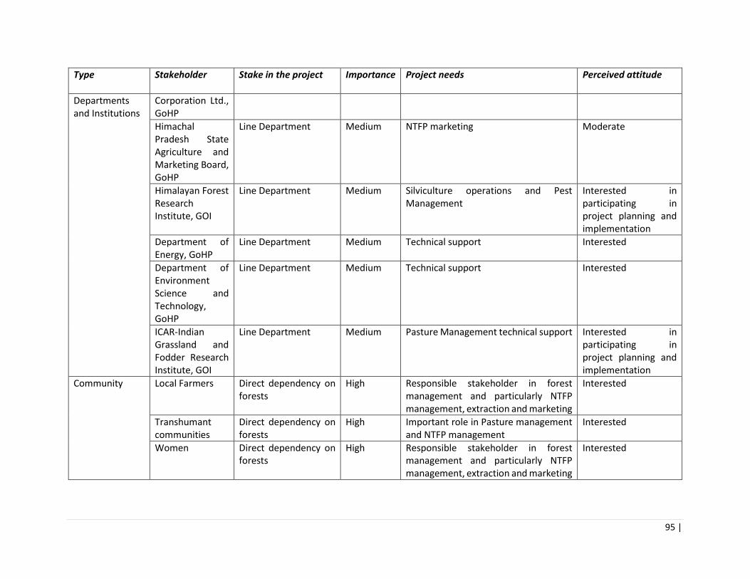
95 |
Type Stakeholder Stake in the project Importance
Project needs Perceived attitude
Departments and Institutions
Corporation Ltd., GoHP
Himachal Pradesh State Agriculture and Marketing Board, GoHP
Line Department Medium NTFP marketing Moderate
Himalayan Forest Research Institute, GOI
Line Department Medium Silviculture operations and Pest Management
Interested in participating in project planning and implementation
Department of Energy, GoHP
Line Department Medium Technical support Interested
Department of Environment Science and Technology, GoHP
Line Department Medium Technical support Interested
ICAR-Indian Grassland and Fodder Research Institute, GOI
Line Department Medium Pasture Management technical support Interested in participating in project planning and implementation
Community Local Farmers Direct dependency on forests
High Responsible stakeholder in forest management and particularly NTFP management, extraction and marketing
Interested
Transhumant communities
Direct dependency on forests
High Important role in Pasture management and NTFP management
Interested
Women Direct dependency on forests
High Responsible stakeholder in forest management and particularly NTFP management, extraction and marketing
Interested

96 |
Type Stakeholder Stake in the project Importance
Project needs Perceived attitude
SC and ST communities
Direct dependency on forests
High Responsible stakeholder in forest management and particularly NTFP management, extraction and marketing
Interested
Joint Forest Management Committees (JFMC)
Direct Dependency on forests and NTFP’s
High Main body entrusted for preparing individual management plan and its implementation
Interested
Forests Right Committees (FRC)
Constitutional body framed under Forests Right Act, 2006 for ensuring the rights of ST’s and Other traditional Forests Dwellers
Moderate Existing structure of addressing forests right of locals inhabitants
Interested
Self Help Groups (mahila mandals)
Dependency on forests, especially for NTFPs
Moderate Important part in implementation of government schemes.
Interested
Traders /Aggregators
Direct dependency on NTFP market value chain
High Critical role in value chain, provide informal financing to small farmers and take working capital risk.
Like to keep the tricks of trade secret and not share the details for fear of losing the monopoly.
Transporters Direct dependency on NTFP market value chain
High Critical for the fresh produce to reach market on time, for loss in transit and in providing market access.
Would be willing to co-operate subject to conflict with other perishable commodities like apple.
Processing units Direct dependency on NTFP market value chain
High Processes NTFP produce to various forms for end-use
Would be willing to help if capacity unutilized.
•

97 |
•
•
• Figure ___: Key Stakeholders in the Project
4.2 Consultation Meetings with Key Institutions Several institutions were consulted during the preparation of the Environmental Assessment and Management Framework for the purpose of seeking views and suggestions on the environmental issues, interventions, impacts and mitigation measures relevant to the project. The key institutions consulted include the following: Himachal Pradesh Forest Department Himachal Pradesh State Forest Development Corporation Himalayan Forest Research Institute Indian Grassland and Fodder Research Institute Himachal Pradesh State Agriculture and Marketing Board Department of Environment Science and Technology The key areas on which the inputs of the experts were sought are: nursery management, pest management, forest fire control, weed control, pasture management, NTFP value addition and marketing, waste
•Traders/Aggregators
•Input dealers
•Marketing Channels
•Processing Homes
• Transporters
•Community based Organisations
•JFMC
•Self Help Groups
• Farmer Producer Organisations
•Nodal Agency for Project planning and implementation
•Coordinates with line departments and Resarch Institutions of the State and GOI
•Existing Infrastructure
• Farmer
• Women
• Transhumants
• SC and ST communities
Local/ CommunityHP Forest
Department
Private SectorCBO/Civil Society/
NGOs

98 |
management, capacity building, climate change, etc. The inputs and suggestions provided have been incorporated into the Environmental Management Plan (see Annex ___). The detailed notes on the institutional consultations is provided in Annex 4
4.3 Stakeholder Consultations at District and Village Levels Stakeholder consultation meetings were organized at district and village levels to elicit stakeholder views on the key environmental issues, ascertain the environmental benefits and risks associated with the implementation of the various project activities, and to identify the required interventions and mitigation measures. The stakeholders consulted included NTFP collectors and sellers, Gram Pradhans and members from Gram Panchayats, members of JFMCs, farmers, village community members, NGOs, forest officers, research scholars and scientists. The district level consultation meetings were held in 4 districts:
• Consultation meeting at Kinnaur on 24 April 2018, attended by 60 participants
• Consultation meeting at Shimla and Kulla on 25 April 2018, attended by 120 participants
• Consultation meeting at Solan on 29 May 2018, attended by 50 participants
• Consultation meeting at Kinnaur on 30 May 2018, attended by 50 participants
The village level consultation meetings were held in 17 villages in the districts of Kullu, Shimla and Kinnaur.
District Villages Dates of the Consultation
Kullu Poshna, Anni, Bayal, Chowai 25.04.2018
Shimla Tacklesh, Sunni, Sakrodi, Jandrehad, Tattapani, Malgi 26.04.2018
Kinnaur Khwangi, Kalpa, Rogi, Kilba, Ribba, Skibba, Moorang 24.04.2018
The summary of the stakeholder views and project responses is presented below:
Community participation
Views and Suggestions: Traditionally the forest area in and around sacred groves are protected by locals. Community participates in plantation activities through various Government programs Community also participates in forest fire control People’s participation in the Forest Right Act implementation should be encouraged Awareness programs are being conducted at panchayat and school level and at public places by forest department during different occasions and should be conducted more frequently. Several Joint Forest Management Committees are non-functional and need to be revived. All activities should be planned and implemented with community consultation to address the community’s needs better and to increase sense of ownership. Convergence with other government departments should supplement the project efforts. Project Responses: The project will encourage conservation of natural resources through participatory management practices. The project will also involve local users in monitoring of natural resources. JFMCs will be constituted if not already done and will be consulted for preparation of range level plans, their implementation and monitoring. Pasture management plans will also be prepared in consultation with concerned JFMCs.

99 |
The project will take the community into confidence before closing areas and these arrangements will be included in the range level plans. Awareness programs, trainings, field visits will be conducted for capacity building of community of the project area. It will be ensured that the project components and schemes from other government department are in convergence with each other. Forest Rights are being settled by the concerned Deputy Commissioner/ Divisional Commissioner of the area.
Forest Fires
Views and Suggestions: The area prone to forest fires should be properly marked and cut off from the adjacent forest to prevent forest fire from spreading to nearby areas. Soil instead of water to be used for extinguishing forest fires. Forest fires in the region are hampering the regeneration of tree species. Project Responses: Forest Fire lines reassessment is being done under the project.
Plantations
Views and Suggestions: There are conflicts on choice of plant species during plantation (like Deodar, Populus instead of Pine). There is little monitoring of planted saplings. JFM Committees should be constituted at Panchayat level and should be involved in selection of species, plantation and monitoring survival and growth. Forest nurseries should be increased in the area and local communities should get saplings for free of cost. Project Responses: The plant species will be raised in nurseries in consultation with JFMC
NTFP
Views and Suggestions: Harvesting of some NTFP species has been commercialized in Kinnaur region. The project will help in increasing income from NTFPs. Project Responses: The project will facilitate development and maintenance of marketing tie-ups for NTFP’s The project will undertake regular monitoring to prevent over harvesting of forest resources. Livelihoods Views and Suggestions: The local communities are dependent on forests for fuel, fodder, timber, NTFP collection (Chilgoza, Guchii, etc.). Pastures have decreased due to overgrazing, poor management and increasing demand for fodder. Eco tourism should be taken up but firstly on pilot basis. It will be good source of income generation but can lead to pollution, plastic waste generation, etc. The project will help to address the fuelwood & fodder availability in the area. Project Responses: Agroforestry will help to fulfill the demand of fuel and fodder. The project will help ensure sufficient area for grazing to avoid excess biotic pressure. The project will take on board research institutes for improving the yield of pastures. Natural Resource Status

100 |
Views and Suggestions: Forest fires, land degradation, construction of roads, encroachments are the main issues impacting the health and quality of forests. Erratic rainfall, flash floods, spread of lantana and other weeds, pest attacks also contribute to forest degradation. There has been substantial decrease in natural resources mainly around the areas where large construction projects like hydropower projects, road construction are being implemented. The forest resources also decreased due to overexploitation to fulfill the demands of the increasing population in the area. There is wastage of forest timber as dried and fallen trees are not collected and managed properly by the forest department. There needs to be a fuel wood depot at the Panchayat level to provide wood to local community in case of emergencies. Project Responses:
Eradication of invasive alien species, mainly Lantana, is a part of the project and will be taken up either by cut root method or by using Class-III chemical (Glyphosate). The Forest Department will undertake regular monitoring of construction companies for proper muck dumping during the developmental activities, and will take necessary action, in case of non-compliance. The timber collection by HPFDC needs to be strengthened. Eco tourism sites are being selected on pilot basis by GoHP.
The detailed summary of the stakeholder consultation meetings at the district and village levels is presented
in Annex 5.
4.4 Disclosure Workshops Since the project area is large with distinct geographical, cultural and social features, two public disclosure workshops were held – one at Reckong Peo (Schedule-V area), Kinnaur District on 23/08/2018 and the other at Rampur busher, Shimla District on 24/08/2018. A total of about 170 people participated in the meeting including village community representatives, women’s groups, local government representatives, NGOs and staff of the Forest Department. The purpose of the Disclosure Workshops was to (i) share the Environment Assessment and Management Framework final report with the representatives of Panchayats and Forest Officials at various levels; (ii) discuss, validate and finalize the issues and the proposed management measures. Detailed presentations were made on the Environmental Assessment and Management Framework. The participants expressed broad agreement with the issues, interventions, impacts and mitigation meausres. Further, they shared opinions on a range of issues including the need for post-plantation care, native species plantation, pest management operations, forest fire prevention, community institution strengthening, and sustainable extraction of forest resources. Detailed proceedings of the disclosure workshops are provided in Annex 6.

101 |
Chapter 5 Environment Assessment
The process of scoping the environmental impacts of the FFP included consultation with a range of key stakeholders at the state level and in three districts of Sutlej basin (Kinnaur, Shimla & Solan). It also involved the collection and review of a range of background information and data. Details of individuals and organisations consulted are provided in Annex 3, and a list of reference materials is provided in Annex 1. The forests of Himachal Pradesh are a storehouse of rich biodiversity. In addition to providing forest cover, they feed perennial rivers that are the source of drinking water, irrigation, and hydropower. They provide ecosystem services such as carbon sequestration, soil moisture regulation, erosion control, water and climate regulation, and support pollination. The forests currently face challenges of degradation, including (i) irregular and diminished flow of natural springs, (ii) loss of soil fertility due to erosion, (iii) widening gap between demand and supply of fuel wood and fodder, (iv) increase incidences of forest fires and invasive weeds leading to deterioration in habitat quality and pastures. The project interventions themselves are designed to mitigate these issues as discussed in the table below:
Table __: Assessment of current threats on Forests in HP
Forest Resources
Threats Potential negative impacts in the without project situation
Potential positive impacts due to project intervention
DENSITY AND QUALITY OF FORESTS
No scientific/ silviculture management of forests
Thinning of forests, reduction in dense forest, reduced capacity for holding soil water, changes in micro-climatic conditions, impact on biodiversity Low survival rates of small/ young species in first year Quality of planting stock is low
Support forest sector reform process Implement scientific silviculture practices (nursery, for example plant size, spacing, maintenance techniques etc.) Implementation of innovative methods of planting and maintenance with new planting models The investments in seed and nursery development and planting and maintenance will incorporate specific features to ensure resilience to climatic change conditions.
WATER FLOW REGULATION
Road construction, lasting and various infrastcrture activities
Increased soil erosion, reduced land productivity, high runoff, increased silt load in streams
Strengthening of integrated forest management system, design and implement water flow and sediment monitoring network. Afforestation and reforestation activities, with soil and water conservation works based on identification of key hotspots and intervention
Additional increase in silt load of streams and water bodies
Increased incidences of flooding, stream bank erosion, reduced life of hydropower plants in downstream, reduced drinking water supply

102 |
Reduced potential of riverbanks to act as buffers against floods, implications on fisheries, damage to habitat
activities to maximize silt retention and surface water absorption.
Increased evaporation / high run off
Reduced the amount of water holding capacity of soils in root zone Steep slopes without adequate protection lead to high runoff and associated soil erosion leading to deteriorating water availability
PASTURES Proliferation of exotic and noxious weeds
Threats to indigenous species, reduced productivity of pastures, loss of grazing areas, fodder, forest cover, reduced production of NTFP
Create enabling conditions for community participation in pasture management Introduction of rotational grazing Implementation of scientific interventions for invasive weed control Regulatory standards for management of pastures will be developed, including its piloting by women user groups and SHGs.
Grazing and livestock pressure
Poor quality of pastures, depletion of ground flora, added pressures of nomadic communities and grazing rights.
Reduced fertility of soil in pastures
Allowing of overgrazing and not following rotational grazing, most pastures are facing depletion of soil phosphorus due to overgrazing, thus legumes are unable to form nodules and are depleting
EXPANSION OF HORTICULTURE
Illegal encroachment on sensitive ecosystems
Forests converted into apple orchards, and there is increased debris, deposition of wastes.
Establishment and operationalization of the Forest Management Information System
FUEL WOOD AND FODDER
Demand and supply gap for fuel wood and fodder is increasing.
Thinning of forests, removal of deadwood from forests impacting detritus and other decomposers, reduced habitat quality, carrying of head loads of fuel wood by community members, especially women.
Community involvement a part of project design to check impacts Plan for controlled burning for regeneration of new fodder.
FOREST FIRE Increasing rates of fires particularly in lower altitudes / Chil pine areas
Loss of biodiversity, increased soil Erosion, impacts on biodiversity, especially birds. Danger to communities living in the vicinity
Development of fire danger system, equipment and infrastructure for fire suppression. Reassessment of fire lines and development of new fires lines.
No collection system for pine needles
Pine needles from Chir pine areas are cause spread of forest fires.
Training for communities on controlled burning and developing van-sarovars to douse fire and collection and use of pine-needles

103 |
NTFP AND MAP Reduced natural regeneration / Loss of species
Reduction in natural regeneration of species, as some areas are harvested beyond carrying capacity
The project will support a favourable eco-system for responsible and sustainable trade in high-value forest products with the aim to enhance the economic benefit to communities. The three key areas supported by the project will be the conservation and responsible collection of NTFP raw material, promotion of cultivation of NTFPs and improving processing facilities and market linkages to strengthen NTFP value chains in the state.
Unsustainable harvesting of medicinal plants and herbs
Removal of medicinal herbs, reduced population sizes and restricted distribution, loss of forestland, exploitation of labour.
Habitat disruption
Habitat degradation, reduced productivity of habitats, low natural regeneration, changes in species community structure and composition, impacts on ecosystem processes

104 |
Table ___: Summary of Project Interventions
Component Sub Component Activities Year/Timing of Implementation
Stakeholder/ Implementer
Anticipated output
Component 1 Improving the Provision of Forest Sector Goods and Services by HPFD
Sub-component 1A: Institutional strengthening and development of the Himachal Pradesh Forest Department (HPFD)
Institutional assessment of forest department
Year 1 HPFD, HPFDC Institutional change- identification of institutional strengthening aspects within HPFD, building technical capacity for more effective model of forest management including community and private sector involvement
IT strategy for forest department MIS, GIS, M&E7
Year 1-5 HPFD Effective monitoring of forestry activities, IT strategy across FD
Performance monitoring of FD8 Year 1-5 HPFD Better performance assessment and improvement of the department.
Training and capacity building within HPFD including development of a training plans for nursery, seed collection9
Year 1-5 HPFD, Forest Training institute, HFRI, HPAU,
Training will be imparted on a wide range of subjects seed stands,
7 This will include the strengthening of a GIS and MIS center at Shimla for integrated monitoring of forestry activities. This will include the use of modern technology such as mobile
platforms to be used by communities and other users.
8 This activity will be connected to the IT Strategy and will involve work planning, work recording and monitoring records. Based on data and monitoring, a quality assurance process for
task standardization and performance assessment/improvement will be developed. This includes performance management of staff using physical targets, quality measures and ‘smart’
monitoring targets.
9 Trainings will cover a wide range of subjects relevant to the project including management of seed stands, nursery management, range management, forest protection and institutional
development.
.

105 |
YS Parmar University at Nauni. Etc.
nursery management fire protection etc.
Strengthening the training infrastructure at the State Forest Training Institute at Chail
Year 1-5 HPFD, Training Institute, Chail
Infrastructure upgradation for training institute in Chail.
Sub-component 1B: Investing in Seed and Nursery Development and Planting and Maintenance
Seed collection system from ‘plus’ trees10
Year 1-3 HPFD-Divisional Forest Officer (DFO) HPFD -Forest Ranger (FR) and his staff JFMC
Good quality of seeds selected,
Design and implementation of a seed certification11 and distribution system
Year 1-5 HPFD -Divisional Forest Officer (DFO) HPFD -Forest Ranger (FR) and his staff JFMC
System in place for tracking quality
Seed bank/ Seed storage in controlled conditions
Year 1-5 HPFD Maintain quality of seeds under controlled temperature and humidity.
Nursery development and raising of seedlings in nurseries12
Year 1-5 HPFD-PMU Nurseries upgraded for production capacity of
10 A plus tree is a tree of superior shape, form and growth rate.
11 Seed certification relates to the origin and provenance of the seed as well as the tested germination rates. Certified seeds can then be sold onto both HPFD field nurseries and the private
sector.
12 It is estimated that 19 nurseries across the project area, one in each range, will be selected from amongst the existing nurseries for raising of seedlings. Each nursery will have a production
capacity of around 200,000 seedlings a year. This extra production will create job opportunities for rural based local communities, especially women.

106 |
HPFD-Divisional Forest Officer (DFO) HPFD-Forest Ranger (FR) and his staff
200,000 seedlings/ year. 19 nurseries will be selected in total, per range under the project. The project will generate employment through silvicultural activities such as nursery raising, site preparation, seedling transportation, planting, fencing and maintenance of plantations
Planting activities, including the provision of machinery and equipment in identified nurseries13
Year 1-5 HPFD -Divisional Forest Officer (DFO) HPFD -Forest Ranger (FR) and his staff JFMC
More sturdy and robust stock is planted in the field.
Plantation trials at selected sites14 Year 1-5 HPFD -PMU External Agency (Research Institute)
Raising good quality planting stock with good maintenance – weeding, fire control, and survival monitoring.
13 Selection of techniques will be based on recommendations of an international nursery specialist towards enhancing CCAT plan effectiveness and through community consultations that
take into consideration community needs and enhance the supply of NTFPs.
14 Planting and maintenance will involve afforestation and reforestation (aligned to CCAT plan priorities) in open and medium density forests and slopes vulnerable to soil erosion and
protection of plantations. Based on the success of these trials the project will adapt the program to follow the most successful options and the new techniques will be adopted as standard
practice.

107 |
HPFD -DFOs/ FR
Centralized seed center to process, treat, store and test the seed
Year 1-5 HPFD Good Quality seeds are supplied to nurseries Better planning of nursery requirements and seeds.
1 C Improving effectiveness of CAT Plans
Silt monitoring network and equipment
During 1st and 2nd year of implementation of project
HPFD External Agency (Research Institute)
Availability of authenticated sediment load data
Review of status of implementation of NERIL plan include Bilaspur and Una
During 1st and 2nd year of implementation of project
HPFD Updating of list of priority areas for working
Consultancies, Training and Capacity Building
Design of plantation trials and monitoring protocols
During 1st and 2nd year of implementation of project
HPFD Better plantation models in place
Baseline survey (for information) During 1st year of implementation of project
HPFD Authentic pre-project data
IT Strategy During 1st year of implementation of project
HPFD Better IT enabled HPFD
Design of silt monitoring network and hydrological monitoring
During 1st year of implementation of project
HPFD Action plan
Feasibility study for seed stands During 1st year of implementation of project
HPFD Action plan
Institutional analysis of Forest Department
During 1st year of implementation of project
HPFD Road map for future

108 |
Review of CAT plan to measure effectiveness
During 1st year of implementation of project
HPFD Action Plan
Identification of key hotspots and intervention activities to maximize the silt retention and surface water absorption
During 1st year of implementation of project
HPFD Action plan outputs will be used to refine the interventions proposed by the CCAT plan
Development of Training material During 1st year of implementation of project
HPFD Better training material/aids
Facilitating Better and More Sustainable Community and Private Sector Forest and Pasture Use
Sub-component 2A: Creating an enabling environment for the sustainable trade of NTFPs
Preparation of a calendar of NTFP collection in targeted locations on annual basis
During 1st of implementation of project
HPFD, JFMCs Sustainable harvesting and collection of NTFPs and MAPs
Strengthening of community institutions or clusters around responsible NTFP collection
During 1st year to 3rd year of implementation of project
HPFD Enhanced community ownership, skills, environmental management and entrepreneurship
Preparation of a package of practices for scientific harvesting of NTFPs
Throughout the five years of project implementation
HPFD Better cultivation and harvesting techniques
Design and implementation of a system for traceability and certification of the raw material collected.
Throughout the five years of project implementation
HPFD Better price realization, quality control
Training, extension services, and demonstration plots for priority species
Throughout the five years of project implementation
HPFD, JFMCs, farmer Federations
Support communities/ JFMC in cultivation of high quality NTFPs
Support to farmer federation, and market linkages
Throughout the five years of project implementation
HPFD, JFMCs, farmer Federations
Increased sustained yield and better price realization

109 |
Provision of access to laboratory facilities for testing and certification of cultivated NTFPs.
Throughout the five years of project implementation
HPFD, JFMCs, farmer Federations
Increased sustained yield and better price realization
Contract farming, and NTFP cultivation on private lands
Throughout the five years of project implementation
HPFD, JFMCs, farmer Federations, private sector
Increased sustained yield and better price realization
Promotion of organic and sustainably harvested products based on established standards such as Organic and Fair Wild
Throughout the five years of project implementation
HPFD, JFMCs, farmer Federations, private sector
Better product visibility and acceptance
Laboratory services for quality control
Throughout the five years of project implementation
HPFD Better product quality
Mobile application and online portal for issue and tracking of permits
Throughout the five years of project implementation
HPFD Better product visibility and acceptance
Common infrastructure facilities centers with infrastructure for storing, grading, packaging and primary processing of NTFP
Throughout the five years of project implementation
HPFD, JFMCs, farmer Federations, private sector
Maintaining better product quality and less losses from poor storage facilities.
Capacity building for establishment of NTFP enterprises
During 1st year of implementation of project
HPFD, JFMCs, farmer Federations, private sector
Establishment of NTFP enterprises
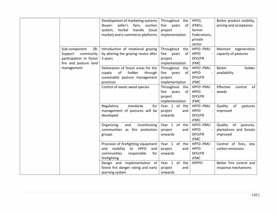
110 |
Development of marketing systems (buyer- seller’s fairs, auction system, herbal mandis (local market) and e-commerce platforms
Throughout the five years of project implementation
HPFD, JFMCs, farmer Federations, private sector
Better product visibility, pricing and acceptance
Sub-component 2B: Support community participation in forest fire and pasture land management
Introduction of rotational grazing by altering the grazing routes after 3 years
Throughout the five years of project implementation
HPFD -PMU HPFD -DFO/FR JFMC
Maintain regeneration capacity of pastures
Delineation of forest areas for the supply of fodder through sustainable pasture management practices
Throughout the five years of project implementation
HPFD -PMU HPFD -DFO/FR JFMC
Better fodder availability
Control of exotic weed species Throughout the five years of project implementation
HPFD -PMU HPFD -DFO/FR JFMC
Effective control of weeds
Regulatory standards for management of pastures will be developed
Year 1 of the project and onwards
HPFD -PMU HPFD -DFO/FR JFMC
Quality of pastures improved
Organizing and incentivizing communities as fire protection groups
Year 1 of the project and onwards
HPFD -PMU HPFD -DFO/FR JFMC
Quality of pastures, plantations and forests improved
Provision of firefighting equipment and mobility to HPFD and communities responsible for firefighting
Year 1 of the project and onwards
HPFD -PMU HPFD -DFO/FR JFMC
Control of fires, less carbon emissions
Design and implementation of forest fire danger rating and early warning system
Year 1 of the project and onwards
HPPFD Better Fire control and response mechanisms

111 |
Assessment of fire lines and development of new fires lines
Year 1 of the project and onwards
HPFD -PMU HPFD -DFO/FR JFMC
Better Fire control and response mechanisms
Training for communities on controlled burning and developing van-sarovars to douse fire and collection and use of pine-needles.
Year 1 of the project and onwards
HPFD -PMU HPFD -DFO/FR JFMC
Better Fire control and response mechanisms
Consultancies, Training / Exposure / Events
Assessment and value chain Study of prominent NTFPs in HP
During 1st year of implementation of project
HPFD To prepare detailed guidelines regarding future action plans. A review of community level
collection practices of NTFPs and
Review of community institutions dependent on forests
During 1st year of implementation of project
HPFD
Development of NTFP management plans in potential areas
During 1st year of implementation of project
HPFD
Development/ compilation of package of practices for selected NTFP (MAP) cultivation
During 1st year of implementation of project
HPFD
Guidelines for financing through research and innovations fund
During 1st year of implementation of project
HPFD
Trainings for private sector entrepreneurs and companies on relevant national and international laws and best practices applicable to the sustainable harvesting and production of NTFPs.
Compilation of schemes and support for NTFP business development from various sources
During 1st year of implementation of project
HPFD

112 |
Component 3 Institutional Coordination and Project Management
Sub-component 3A: Institutional coordination
Institutional coordination will support multi-sectoral coordination and participation among the HPFD and other relevant sectors including exposure visits.
Throughout the five years of project implementation
HPFD, Project Steering Committee
Effectively implement project interventions
Sub-component 3B: Project management
Project Management activities During all years of implementation of project
HPFD PMU in place and functional

113 |
5.1 Assessment of Environmental Impacts Associated with Project Activities The potential environmental impacts (both positive and negative) of the various physical interventions, envisaged under the FFP are summarised in the Table below. Proposed environmental mitigation, and in some cases good practice/measures, to be incorporated within the EMF are discussed in the next section
Component Activities Positive impacts Adverse impacts/ risks Proposed Mitigations
Component 1 Improving the Provision of Forest Sector Goods and Services by HPFD Sub-component 1A: Institutional strengthening and development of the Himachal Pradesh Forest Department (HPFD) Sub-component 1B: Investing in Seed and Nursery Development and Planting and Maintenance
Seed Development and management Seed collection system from ‘plus’ trees15 Design and implementation of a seed certification16 and distribution system Seed bank/ Seed storage in controlled conditions Nursery development and raising of seedlings in nurseries
This intervention will have positive impacts on afforestation and reforestation schemes. Selecting appropriate seed sources for the site will improve overall growth rate of the plantation since the trees are planted into an environment in which they are adapted. Appropriate seed certification and distribution to the nurseries will also reduce plantation losses due to maladapted genetic material/ incorrect species which may continue to thrive. Storage under controlled conditions of temperature and humidity will allow
Transportation of seedlings to planting site is dependent on site accessibility Impacts relating to small civil works- impacts on air, water, noise, and site drainage (such as during construction of seed bank facility) The potential environmental impacts (on drainage, water, aesthetics) under nursery upgradation (raising of seedlings, irrigation facility, storage area and staff quarters) this activity will be minimal. It is expected that physical works will be small-scale and – in some cases – will not require mitigation measures (for installation of water tank, compost pit etc.) In nurseries, use of pesticides against pests and diseases could impact human health, air quality,
All activities carried out in protected areas, wildlife sanctuaries, Eco sensitive zones, will be carried out consistent to the management plan of those areas. Only High quality seeds will be selected from the forest and plantation sources for raising seedlings. Plus, trees should be demarcated so labour/community are able to decipher which tree is known plus tree The seeds selected from good plus trees identified for seed collection. The seeds collected should be tested for their germination ability and growth. Floating seeds in water is good method for separating quality from damaged or immature seeds. Sound, mature acorns sink in water. Defective acorns will generally float. Water flotation also facilitates the
15 A plus tree is a tree of superior shape, form and growth rate.
16 Seed certification relates to the origin and provenance of the seed as well as the tested germination rates. Certified seeds can then be sold onto both HPFD field nurseries and the private
sector.

114 |
Component Activities Positive impacts Adverse impacts/ risks Proposed Mitigations
seeds to be stored over extended period, this will also allow nursery managers to have a reserve stock in case of additional plantation requirements (failure of seedlings due to pest and diseases)
groundwater, surface water and soil.
removal of leaves, and other debris making sowing of the seeds easier. For small works (on construction of green-houses or rehabilitation of space for installation of planting or storage equipment), it is proposed to use an EMP checklist on an as needed basis. The checklist for specific project site will be prepared by SPMU in collaboration with the respective staff participating in the activity. Project will utilize bio-pesticides, and strategy as prescribed under Annex 11. No procurement or use of banned pesticides or pesticides belonging to Class I and II as per WHO classification of pesticides (see Annex 11) The selection of species is based on the suitability for the altitude, slope or topography and site quality. Focus should be on native species or species that are highly adapted to the location. Further, among the suitable species, those with high to moderate growth rate of biomass and ability to provide multiple benefits to the community should be selected.

115 |
Component Activities Positive impacts Adverse impacts/ risks Proposed Mitigations
All plastic root trainers and polybags will be properly disposed. The management steps include:
• Storage of plastic waste
(bags, root trainers, etc.) on
site at the nursery.
• Periodic clearance and
collection of the plastic waste
by identified collector.
• Onward delivery of plastic
waste by collector to
aggregator or to recycling
facility.
• A clear register of the plastic
waste generated and sent
onward for recycling must be
maintained at each nursery.
• No plastic will be burned in
the open that impacts air
quality.
• Use of biodegradable
planting bags and root
trainers will be piloted in at
least one pilot site per
district, and will be evaluated
for further scaling up during
the project period.
To ensure better survival of plants, nursery techniques to be used for production of healthy nursery stock include:
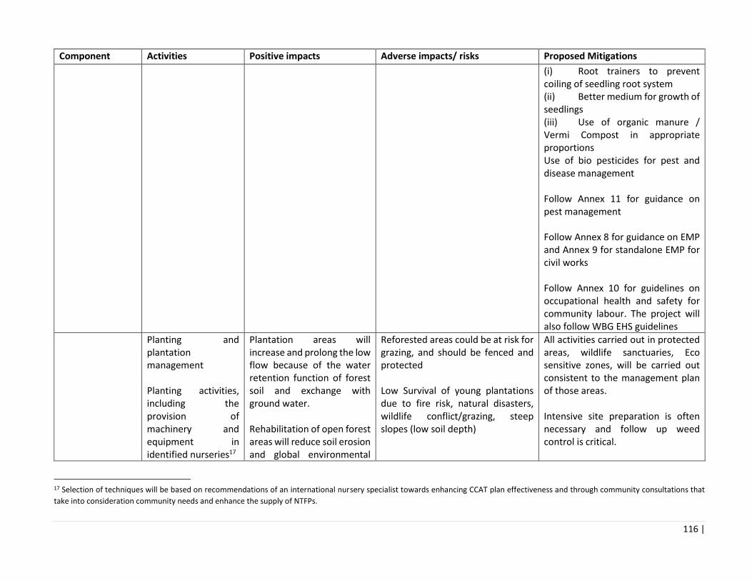
116 |
Component Activities Positive impacts Adverse impacts/ risks Proposed Mitigations
(i) Root trainers to prevent coiling of seedling root system (ii) Better medium for growth of seedlings (iii) Use of organic manure / Vermi Compost in appropriate proportions Use of bio pesticides for pest and disease management Follow Annex 11 for guidance on pest management Follow Annex 8 for guidance on EMP and Annex 9 for standalone EMP for civil works Follow Annex 10 for guidelines on occupational health and safety for community labour. The project will also follow WBG EHS guidelines
Planting and plantation management Planting activities, including the provision of machinery and equipment in identified nurseries17
Plantation areas will increase and prolong the low flow because of the water retention function of forest soil and exchange with ground water. Rehabilitation of open forest areas will reduce soil erosion and global environmental
Reforested areas could be at risk for grazing, and should be fenced and protected Low Survival of young plantations due to fire risk, natural disasters, wildlife conflict/grazing, steep slopes (low soil depth)
All activities carried out in protected areas, wildlife sanctuaries, Eco sensitive zones, will be carried out consistent to the management plan of those areas. Intensive site preparation is often necessary and follow up weed control is critical.
17 Selection of techniques will be based on recommendations of an international nursery specialist towards enhancing CCAT plan effectiveness and through community consultations that
take into consideration community needs and enhance the supply of NTFPs.

117 |
Component Activities Positive impacts Adverse impacts/ risks Proposed Mitigations
Plantation trials at selected sites18
benefits from carbon sequestration
Activities initiated by the project cease soon after it terminates, or the benefits from the project's activities are no longer available to the intended beneficiaries, because the resources needed to continue the project initiatives are not available. Use of exotic and non-native species for plantation/restoration of forests and protected areas should not be permitted Activities / good practice developed in the project area are not adopted elsewhere, so that it fails to become more than a pilot exercise, because it was too narrowly focused or was located in a situation that was not representative of the population as a whole. There is a risk that seedlings will not be successful, though many of these cases can be attributed to improper planning. Losses of seeds and small seedlings can be high.
Plantation maintenance with community should involve (i) Incentives. Without benefits to be gained by improving regeneration performance monitoring becomes inconsequential and inefficient. (ii) Records. Keep clear, concise, and current records. (iii) to deal with the risk of fire keep vegetative debris to a minimum and see that a ready supply of water for fire suppression is available (van sarovars). The presence of firebreaks and access roads will allow fire trucks to reach fires and will make it more difficult for flames to spread Only use indigenous and native species with multi-purpose benefits List available exotics and non-natives and issue notification disallowing their use in plantation/restoration New plantation sites need to be adequate fences and protected. Natural barriers of scrubs should be used.
18 Planting and maintenance will involve afforestation and reforestation (aligned to CCAT plan priorities) in open and medium density forests and slopes vulnerable to soil erosion and
protection of plantations. Based on the success of these trials the project will adapt the program to follow the most successful options and the new techniques will be adopted as standard
practice.

118 |
Component Activities Positive impacts Adverse impacts/ risks Proposed Mitigations
There is a risk that Land selected for plantations is eroded and has shallow soils.
Use of non-threatening measures to ward off wildlife (signs/sounds/barriers) Restoration of OF areas should be done through diverse set of local indigenous species If encountering archaeological findings during works, the community should stop operations and notify competent authorities Use youth for monitoring key species/indicators and survival rates Ensure regular use and reporting of species monitoring protocols JFMC experience in plantation - If experienced planters are not available provisions for training and supervision should be made by forest department so that quality of the plantation is not compromised Factors that should be considered when selecting species include: growth rate, site requirements, climatic suitability, genetic variability, wood properties, aesthetics, wildlife value, biological diversity, erosion control and potential insect and disease problems.

119 |
Component Activities Positive impacts Adverse impacts/ risks Proposed Mitigations
The use of tree species not native to HP should be contingent on credible evidence confirming that the species in question is not invasive, will not create significant risk to forest health, and is from appropriate provenances that are well adapted to the site and their ecological effects monitored. Sites to be avoided when considering seeding plantation are areas where seeding has already failed. Avoid sites prone to frost or frost heaving. Avoid sites where grazing could occur, and highly erodible soils or steep slopes where young plants could be washed away. Always use seed of appropriate seed sources that has been properly stored, stratified, and treated. Harmonization with measures proposed in EMP (accessibility, development planning, vegetation removal, construction practices, environmentally friendly construction materials, etc.) Discouraging monoculture and promoting mixed species plantations.
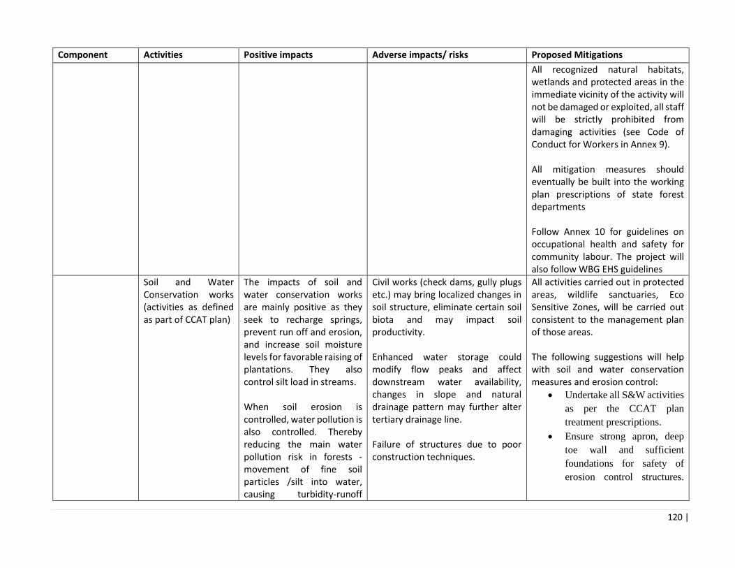
120 |
Component Activities Positive impacts Adverse impacts/ risks Proposed Mitigations
All recognized natural habitats, wetlands and protected areas in the immediate vicinity of the activity will not be damaged or exploited, all staff will be strictly prohibited from damaging activities (see Code of Conduct for Workers in Annex 9). All mitigation measures should eventually be built into the working plan prescriptions of state forest departments Follow Annex 10 for guidelines on occupational health and safety for community labour. The project will also follow WBG EHS guidelines
Soil and Water Conservation works (activities as defined as part of CCAT plan)
The impacts of soil and water conservation works are mainly positive as they seek to recharge springs, prevent run off and erosion, and increase soil moisture levels for favorable raising of plantations. They also control silt load in streams. When soil erosion is controlled, water pollution is also controlled. Thereby reducing the main water pollution risk in forests - movement of fine soil particles /silt into water, causing turbidity-runoff
Civil works (check dams, gully plugs etc.) may bring localized changes in soil structure, eliminate certain soil biota and may impact soil productivity. Enhanced water storage could modify flow peaks and affect downstream water availability, changes in slope and natural drainage pattern may further alter tertiary drainage line. Failure of structures due to poor construction techniques.
All activities carried out in protected areas, wildlife sanctuaries, Eco Sensitive Zones, will be carried out consistent to the management plan of those areas. The following suggestions will help with soil and water conservation measures and erosion control:
• Undertake all S&W activities
as per the CCAT plan
treatment prescriptions.
• Ensure strong apron, deep
toe wall and sufficient
foundations for safety of
erosion control structures.

121 |
Component Activities Positive impacts Adverse impacts/ risks Proposed Mitigations
where the fine particles of soil are suspended in water. turbid runoff can lead to silting up of drainage features. This reduces the quality of water for agriculture and domestic use and can harm aquatic life. S&W conservation activities couples with forest vegetation can impact the total volume of the surface flow; reduce the peak flow discharge and increase the base flow and thus increase the availability of water use efficiency.
Locate structures on stable
sites.
• Spurs or other stream bank
protection measures must not
cause drainage congestion.
• In areas where high/steep
slopes and poor and thin soil
layer, soil erosion control is
difficult. The design can
consider bio-engineering
methods for gully erosion
control, sand filtering, and
construction methods of
multi-layer forest stands in
stony mountain area.
• S&W activities should be
carried out before plantation
so that soil moisture
conditions are optimal
(especially in OF areas, steep
slopes etc.)
• Leave buffer zones near
streams to prevent siltation
• Don't use site preparation
techniques that might
increase erosion
• Concentrate trees in trouble
areas
• Keep drainage pathways
covered with grass
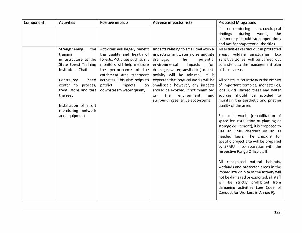
122 |
Component Activities Positive impacts Adverse impacts/ risks Proposed Mitigations
If encountering archaeological findings during works, the community should stop operations and notify competent authorities
Strengthening the training infrastructure at the State Forest Training Institute at Chail Centralized seed center to process, treat, store and test the seed Installation of a silt monitoring network and equipment
Activities will largely benefit the quality and health of forests. Activities such as silt monitors will help measure the performance of the catchment area treatment activities. This also helps to predict impacts on downstream water quality
Impacts relating to small civil works- impacts on air, water, noise, and site drainage. The potential environmental impacts (on drainage, water, aesthetics) of this activity will be minimal. It is expected that physical works will be small-scale however, any impacts should be avoided, if not minimized on the environment and surrounding sensitive ecosystems.
All activities carried out in protected areas, wildlife sanctuaries, Eco Sensitive Zones, will be carried out consistent to the management plan of those areas. All construction activity in the vicinity of important temples, monasteries, local CPRs, sacred trees and water sources should be avoided to maintain the aesthetic and pristine quality of the area. For small works (rehabilitation of space for installation of planting or storage equipment), it is proposed to use an EMP checklist on an as needed basis. The checklist for specific project site will be prepared by SPMU in collaboration with the respective Range Office staff. All recognized natural habitats, wetlands and protected areas in the immediate vicinity of the activity will not be damaged or exploited, all staff will be strictly prohibited from damaging activities (see Code of Conduct for Workers in Annex 9).

123 |
Component Activities Positive impacts Adverse impacts/ risks Proposed Mitigations
A survey and an inventory shall be made of large trees (tress measuring 20 or more inches in DCH - Diameter at Chest Height) in the vicinity of the construction activity, large trees shall be marked and cordoned off with fencing, their root system protected, and any damage to the trees avoided Adjacent wetlands and streams shall be protected from construction site run-off with appropriate erosion and sediment control feature to include but not limited to hay bales and silt fences Formulation of site specific EMP, based on EMP in Annex 8. If encountering archaeological findings during works, the community should stop operations and notify competent authorities Follow Annex 10 for guidelines on occupational health and safety for community labour. The project will also follow WBG EHS guidelines
COMPONENT 2B Facilitating better and more sustainable community and private sector
Sub-component 2A: Creating an enabling environment for the sustainable trade of NTFPs
Supply of NTFPs from project areas on a sustainable basis may create new processing industries these could be located
With increased support to community enterprises, the threat of local extinction of metapopulations of some rare, vulnerable and endangered species or other important MAP species.
Impart training to communities on how to collect harvest MAPs and NTFPs so its regeneration capacity is maintained

124 |
Component Activities Positive impacts Adverse impacts/ risks Proposed Mitigations
forest and pasture use
Preparation of a calendar of NTFP collection in targeted locations on annual basis Strengthening of community institutions or clusters around responsible NTFP collection Preparation of a package of practices for scientific harvesting of NTFPs Design and implementation of a system for traceability and certification of the raw material collected. Training, extension services, and demonstration plots for priority species Support to farmer federation, and market linkages
outside the project area and create new jobs There are several bottlenecks for establishment of NTFP/forestry enterprises which the project will address through its design, these include (i) government control over profitable forest produce, (ii) constraining regulations, (iii) lack of credit availability, (iv) poor technologies and low value addition. And (v) Requirement of transit permits and felling regulations for nationalized species discourages private enterprise
Linkages with markets may increase number of JFMC involved in MAP trading and increase chances of illegal trade, and demand for rural feeder roads to support marketing. The project should begin with trainings and awareness on sustainable harvesting of NTFPs, if enterprise facilitation or value chain infrastructure is provided before there may be a risk of indiscriminate collection of MAP from wild in initial period (before nursery development) both for meeting demand and for planting in nursery. The seasonal pattern of collection varies considerably with the bulk of collection concentrated between March and November. Premature and destructive extraction also takes place due to the open access to all collecting villages as also a competition for resources within the collectors of a village. Unscientific Extraction of non‐timber plant parts may alter biological processes at many levels. For instance, harvest may affect the physiology and vital rates of individuals, change demographic and genetic patterns of populations,
HPFD needs to ensure steady supply of seeds to the NTFP and MAPs nurseries so that the pressure of harvesting from the wild is reduced. Minimize inventory storage time for raw materials to reduce losses from putrefaction; In case of cold storage, monitor and regulate refrigeration and cooling systems during storage and processing activities to minimize product loss, optimize energy consumption, and prevent odors; In case of cold storage and processing facilities, take Consent for Establishment and Consent for Operation from State Pollution Control Board, as required. Consider use of enclosure techniques to minimize damage to raw materials stored/ dried outdoors; Monitor and optimize process yields, e.g. during manual grading or cutting activities, and encourage the most productive employees to train others in efficient processing. Clean, sort, and grade raw NTFPs, MAPs where possible at an early stage (e.g. at the harvest site), in
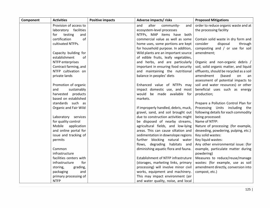
125 |
Component Activities Positive impacts Adverse impacts/ risks Proposed Mitigations
Provision of access to laboratory facilities for testing and certification of cultivated NTFPs. Capacity building for establishment of NTFP enterprises Contract farming, and NTFP cultivation on private lands Promotion of organic and sustainably harvested products based on established standards such as Organic and Fair Wild Laboratory services for quality control Mobile application and online portal for issue and tracking of permits Common infrastructure facilities centers with infrastructure for storing, grading, packaging and primary processing of NTFP
and alter community‐ and ecosystem‐level processes NTFPs, MAP items have both commercial value as well as some home uses, some portions are kept for household purpose. In addition, Wild plants are an important source of edible fruits, leafy vegetables, and herbs, and are particularly important in ensuring food security and maintaining the nutritional balance in peoples’ diets Enhanced value of NTFPs may impact domestic use, and most would be made available for markets. If improperly handled, debris, muck, gravel, sand, and soil brought out due to construction activities might be disposed of nearby streams, agricultural fields, and low-lying areas. This can cause siltation and sedimentation in downslope regions further blocking natural water flows, degrading habitats and diminishing aquatic flora and fauna. Establishment of NTFP infrastruture (storages, marketing links, primary processing) will involve minor civil works, equipment and machinery. This may impact environment (air and water quality, noise, and local
order to reduce organic waste and at the processing facility Contain solid waste in dry form and consider disposal through composting and / or use for soil amendment; Organic and non-organic debris / soil, solid organic matter, and liquid effluents, should be recycled as a soil amendment (based on an assessment of potential impacts to soil and water resources) or other beneficial uses such as energy production; Prepare a Pollution Control Plan for Processing Units including the following details for each commodity being processed: Name of NTFP: Nature of processing: (for example, deseeding, powdering, pulping, etc.) Key solid wastes: Key liquid wastes: Any other environmental issue: (for example, particulate matter during powdering) Measures to reduce/reuse/manage wastes: (for example, use as soil amendment directly, conversion into compost, etc.)
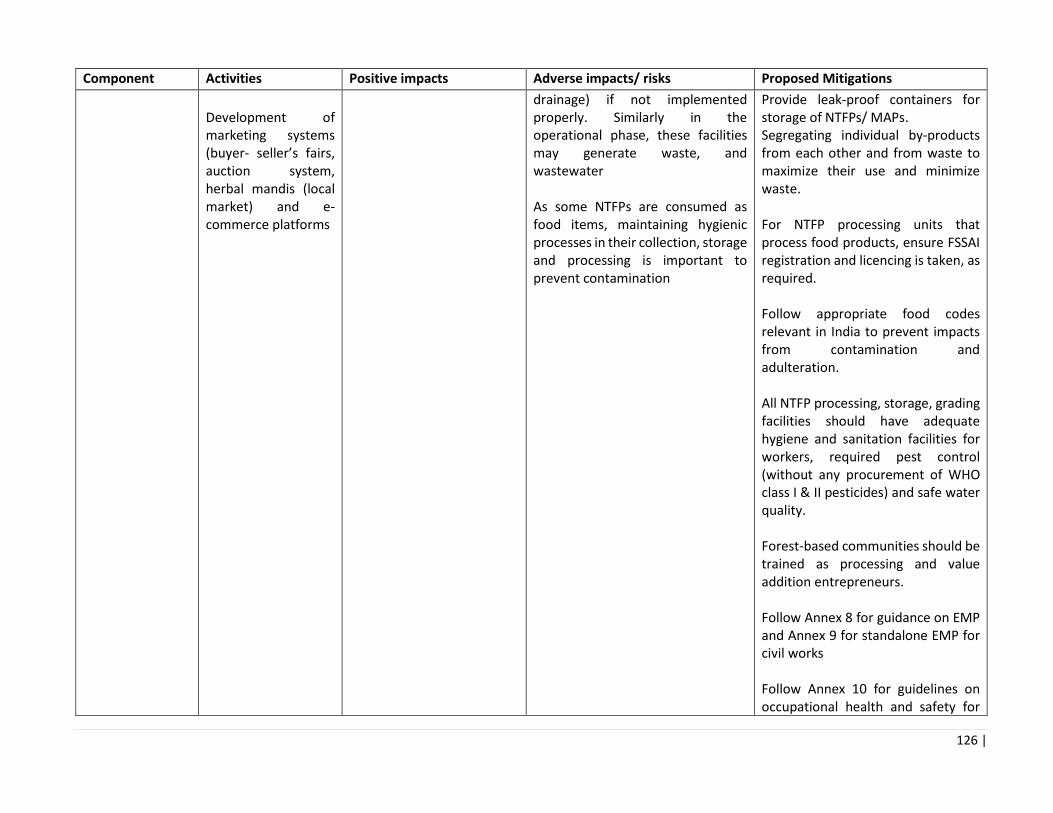
126 |
Component Activities Positive impacts Adverse impacts/ risks Proposed Mitigations
Development of marketing systems (buyer- seller’s fairs, auction system, herbal mandis (local market) and e-commerce platforms
drainage) if not implemented properly. Similarly in the operational phase, these facilities may generate waste, and wastewater As some NTFPs are consumed as food items, maintaining hygienic processes in their collection, storage and processing is important to prevent contamination
Provide leak-proof containers for storage of NTFPs/ MAPs. Segregating individual by-products from each other and from waste to maximize their use and minimize waste. For NTFP processing units that process food products, ensure FSSAI registration and licencing is taken, as required. Follow appropriate food codes relevant in India to prevent impacts from contamination and adulteration. All NTFP processing, storage, grading facilities should have adequate hygiene and sanitation facilities for workers, required pest control (without any procurement of WHO class I & II pesticides) and safe water quality. Forest-based communities should be trained as processing and value addition entrepreneurs. Follow Annex 8 for guidance on EMP and Annex 9 for standalone EMP for civil works Follow Annex 10 for guidelines on occupational health and safety for

127 |
Component Activities Positive impacts Adverse impacts/ risks Proposed Mitigations
community labour. The project will also follow WBG EHS guidelines
Sub-component 2B: Support community participation in forest fire and pasture land management Introduction of rotational grazing by altering the grazing routes after 3 years Delineation of forest areas for the supply of fodder through sustainable pasture management practices Control of exotic and noxious weed species Regulatory standards for management of pastures will be developed Organizing and incentivizing communities as fire protection groups
Enhanced fodder availability Increase in biodiversity Less loss of forest resources and wildlife due to forest fire
Increased grazing pressure in other areas due to displacement of cattle/livestock from pastures undergoing restoration/ rotation. Mechanical Methods adopted for exotic weed management such as ‘cut root stock’ may not be effective in the long term unless (i) comprehensive treatment and rehabilitation of the area is applied, else weeds will proliferate again (ii) labour/ communities are adequately trained in the method of cutting, depth of cutting and disposal of dead shrubs/ weeds. Loss of forestland by converting them to pastures. Livestock population may increase by assuring enhanced fodder availability, which may be a potential threat to natural areas. Shifting of grazing pressure in other areas after closing selected areas for grazing may speed up the degradation of remaining pastures nearby.
All activities carried out in protected areas, wildlife sanctuaries, Eco Sensitive Zones, will be carried out consistent to the management plan of those areas. Identify alternative areas before restoration of existing ones in use Form agreements on herd sizes with participating communities, and monitor livestock numbers Promote cultivation of Napier and elephant grasses on agriculture or wasteland, on-farm, along with stall feeding practices to reduce pressure on forests and pastures, sensitive areas. Efficiency in the use of fodder can be enhanced through a number of technological and management options like chopping, grinding, wetting and soaking of fodder, and enrichment of crop residues and dry fodder with mineral supplements. This will not only result in efficient use of available fodder but also improve its nutritional value.

128 |
Component Activities Positive impacts Adverse impacts/ risks Proposed Mitigations
Provision of firefighting equipment and mobility to HPFD and communities responsible for firefighting Design and implementation of forest fire danger rating and early warning system Assessment of fire lines and development of new fires lines Training for communities on controlled burning and developing van-sarovars to douse fire and collection and use of pine-needles.
Conflict with people when areas are closed for grazing. No incentives to collect pine needles which are the main causes for spread of ground fires. Firefighting staff need to be adequately trained in use of equipment, else occupational hazards can occur. Construction of Van Sarovars could have construction related short-term impacts such as air and noise pollution, disposal of excess soil, accidental falls in borrow areas, etc. Van Sarovars may pose safety risk to humans and wildlife is not properly designed – for example, if there are steep slopes, inadequate fencing, etc. Fire management being community-based does not simply mean they carry out paid work / rewarded for fire-control. They will need to be incentives to participate and monitor fires. Towns/ villages/ Communities living in the vicinity of high hazard areas are often not directly protected
Similarly, there are large areas of common pastureland, which can be used for cultivation of fodder trees and grasses in Himachal Pradesh. Eradication of invasive alien plant species need to be integrated with rehabilitation of cleared areas. Shift from the present methods of ‘one time removal of weeds’ to ‘complete rehabilitation’ of the treated areas. In view of their environmental/ ecological concerns, the rehabilitation measures will resort to chemicals methods of exotic weed control only as the last option. The natural regeneration of indigenous plant species on treated sites should be encouraged and facilitated to establish towards better environmental and ecological services, including fodder, fuel, water recharge, etc. No potentially invasive exotic species – (viz. Leucaena leucocephala, Prosopis juliflora, Teak, Darek, Silver Oak, Jatropha curcus, Tecoma stans, etc.) – will be used for plantations in the areas under weed management,

129 |
Component Activities Positive impacts Adverse impacts/ risks Proposed Mitigations
because of their deleterious effect on the native flora. Controlled burning activities should keep in mind the key breeding and nesting grounds/seasons of birds and other important species (Schedule I). Organise community enterprise and zonation around collection of pine needles. Facilitate marketing linkages to industries that can utilize pine needles as raw material or as fuel. Communities need to be sensitized that involvement in fire management and associated activities will improve their livelihood, health and security Communities should monitor (i) burning of agriculture residue near forest areas and (ii) stacking of inflammable forest material outside the boundary of or in the forest (dried leaves and pine needles, firewood, timber, bamboo and resin, on a land adjoining a forest) Vehicles supported under this component should comply with PUC standards. Fire-fighting vehicles should be placed at designated

130 |
Component Activities Positive impacts Adverse impacts/ risks Proposed Mitigations
parking lots or existing garages/sheds. Standard environmental safety requirements such as safe storage of fuel, other substances for fire fighting vehicles should be applied. The project can also consider vegetative firebreak to protect habitations- it is a management practice that is designed to create a fuel break (herbaceous and woody vegetation) are used to break up the flammable fuels. By using a combination of short grasses. Construction of Van Sarovars must be in accordance with approved design that incorporates safety elements such as appropriate fencing, side slope, etc. Follow Annex 8 for guidance on EMP checklist and Annex 9 for standalone EMP for civil works Follow Annex 10 for guidelines on occupational health and safety for community labour. The project will also follow WBG EHS guidelines
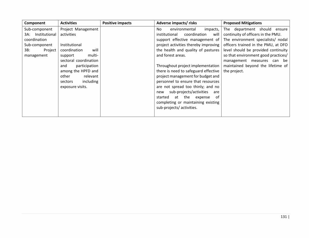
131 |
Component Activities Positive impacts Adverse impacts/ risks Proposed Mitigations
Sub-component 3A: Institutional coordination Sub-component 3B: Project management
Project Management activities Institutional coordination will support multi-sectoral coordination and participation among the HPFD and other relevant sectors including exposure visits.
No environmental impacts, institutional coordination will support effective management of project activities thereby improving the health and quality of pastures and forest areas. Throughout project implementation there is need to safeguard effective project management for budget and personnel to ensure that resources are not spread too thinly; and no new sub-projects/activities are started at the expense of completing or maintaining existing sub-projects/ activities.
The department should ensure continuity of officers in the PMU. The environment specialists/ nodal officers trained in the PMU, at DFO level should be provided continuity so that environment good practices/ management measures can be maintained beyond the lifetime of the project.

132 |
Chapter 6 Environment Management Framework
The chapters 6 and 7 set out the Environmental Management Framework (EMF) for the project and include: Environmental Screening of project activities (discussed in chapter 6)
Environmental Management Plans for project activities (discussed in chapter 6)
Description of workflow for environmental management (discussed in chapter 6)
Institutional arrangement for EMF implementation (discussed in chapter 7)
Environmental Monitoring and Reporting (discussed in chapter 7)
Capacity building and training plan (discussed in chapter 7)
Estimated incremental costs for EMF implementation (discussed in chapter 7)
Each of these elements will be incorporated in the Project Operational Manual.
6.1 Environmental Screening of Project Activities
All the field based project activites are broadly under two categories: 6.1.1 Activities in Range Management Plans:
A Range Management Plan (RMP) will be formulated for each range with guidance from the DFO and Range Officer. The RMP is a consolidation of individual plans approved by Joint Forest management Committees (JFMCs) of all panchayats under each range. The RMP will form part of the APOs of Forest Working Plans. The activities in the RMPs could include seed and nursery development, plantations, soil and water conservation activities, forest fire control, pasture management, etc. Some of these activities could include small scale civil works. 6.1.2 Activities on NTFP:
The NTFP based activities will decided after an assessment is undertaken as to which NTFPs would be selected to augment the supply demanded by the market and subsequently reduce pressure on wild stocks of rare species. These activities could include NTFP collection, harvesting and value-chain activities. A few of these activities, such as the value-chain activities could involve small scale civil works. All the RMP activities and the NTFP activities would need to be screened for identification of risks based on site specific factors, and, for ensuring compliance with legal and regulatory requirements. For this purpose, the screening process is undertaken. The screening process has three parts: Part 1 – Environmental Data Sheet (EDS): An Environmental Data Sheet (EDS) is used to identify the activities in the management plan and gives details of the sites where they will be implemented in. The EDS includes details on extent and status of forest area, pasture land and NTFP. The EDS format is included in Annex 7, Part 1. Attachments for additional information can be supplemented when needed. Part 2 – Eligibility Screening: This includes a list of activities that are not eligible to be financed under the project as they are not consistent with safeguards requirements. This format is included in Annex 7, Part 2.
133 |
Part 3 – Legal and Regulatory Requirements Checklist: This includes a list of legal and regulatory requirements and identification of their applicability to the project financed activities. This format is included in Annex 7, Part 3. The Range Office Focal Point is responsible for undertaking the screening process. The Environment Specialist in the SPMU is responsible for monitoring and ensuring that every RMP and NTFP activity undergoes screening. The filled in screening checklist has to be attached to every RMP plan and NTFP activity plan.
6.2 Environmental Management Plan
A simple Environmental Management Plan (EMP) will be developed for the project activities to identify: the required mitigation measures, the individuals responsible for implementation of the measures, the timeframe for implementation, and the resources required for implementation. For the activities to be financed under the RMP plan, the Annex 8 provides a standard checklist for identification of mitigation measures. All relevant mitigation measures should be taken to mitigate the potential negative impacts and enhance the postitive impacts of the proposed activities in the RMP plan. Activity-specific mitigation measures can also be added if appropriate. For small scale civil works such as buildings, the EMP format in Annex 9 should be utilized. For plantation and nursery activities involving pest management, the Pest Management Plan in Annex 11 should be utilized.

134 |
6.3 Workplan for Environmental Management
The Table below represents the work plan for environmental management activities during project implementation.
Phase EMF Activity Objectives Process Responsibility Outcome
Pre-planning Adequate dissemination of EMF awareness to DFO, RO and JFMC
To sensitize the various stakeholders about the possible negative impacts of the project activities and mitigation measures
Disseminate through website/copy with HPFD offices/JFMCs
SPMU, DPMU (Block, Range, Division & Circle Level), JFMCs
Increased awareness of the possible negative impacts of project activities and the ways to mitigate them.
Capacity building and training programmes on EMF
To enhance capacity of field staff/ communities to understand the need of safeguards during identification and implementation of activities.
Identify key personnel/ community members and depute for capacity building programme and conduct the said programme.
SPMU (Environment Specialist), DPMU (Division & Circle Level) & FTI (Chail)
Target group better equipped to understand the need of safeguards during identification and implementation of sub project activities.
Planning Screening of activities in Range Management Plan (RMP) and NTFP plan using the Screening Checklists
To ensure that activities with potentially significant environmental issues are identified at an early stage and avoided.
DPMU (Division and Range level) / Village facilitators to support communities in incorporation of environment safeguards in activities.
SPMU (DPD-Operations and Environment Specialist), DPMU (Range, Division & Circle Level) & JFMCs
Activities selected/rejected based on screening. Activities requiring mitigation measures identified. Regulatory compliance requirements identified.
Preparation of Environmental Management Plan (EMP) for RMP and NTFP plan
To ensure that relevant environmental issues have been identified and appropriate mitigation measures have been designed to address them.
RMPs and NTFP plans with environmental mitigation measures shall be approved by environment manager in SPMU
DPMU (Block, Range, Division & Circle Level) & JFMCs
Costs of EMF mitigation measures and monitoring incorporated into the Range Level Plan.

135 |
Implementation Implementation of EMP for RMP. Implementation of Pest Management Plan for activities involving pest management.
To ensure that the prescribed environmental mitigation measures are implemented.
Environment: The prescribed environmental mitigation measures as identified through the EMF are adequately implemented, indicators are monitored.
DPMUs (Block, Range, Division & Circle Level) and JFMCs.
Semi-annual safeguards progress report will indicate progress of EMP implementation.
Compliance with EMF provisions and monitoring measures
To monitor that the prescribed environmental mitigation measures are complied with.
Environment: The prescribed environmental mitigation measures suggested in EMF are compiled with and regularly are monitored
SPMU (Environment Specialist), Focal Points at Range Offices, DPMUs (Range, Division & Circle Level)
Semi-annual safeguards progress report will indicate monitoring as per list of indicators.
O&M Environmental Supervision, Monitoring and Evaluation
To ensure that screening, EMP preparation and implementation are completed in an adequate and timely fashion.
Environment: Monitoring of indicators will be conducted as per project monitoring protocol.
SPMU (Environment Specialist), Focal Points at Range Offices, DPMUs (Division Level & Circle Level)
PMU will submit bi annual reports to The World Bank on Safeguards Implementation.

136 |
6.4 Pest Management Plan
Since each forest nursery can supply plants for planting to many geographic areas, keeping pests out of nurseries is especially important. Buying healthy stock and carefully monitoring the condition of seedlings and cuttings are important practices. The controlled environment of the nursery, such as planting density, species or clone choice, and monoculture, can be favorable to pest development. During Baseline data collection, consultations with forest department and research institute it was identified that pest and disease outbreak in forest nurseries is an issue, though occurrences are few. There are several guidelines in place for pest control in nurseries that have been developed by ICFRE, HFRI, and Forest Department though, with the lack of trained forest nursery managers, the techniques adopted to control pests are ad-hoc and application is unscientific. Given that project will be investing in up gradation of forest nurseries, and beginning state of the art infrastructure, it is essential that clear and easy to follow guidelines are put in place with regards to pest management in nurseries. An analysis of the key pests and diseases affecting seedling stock in nurseries was analyzed, and bio-control strategies were developed such that they can be easily adopted in the field. In some cases, chemical control19 has been prescribed if biological methods are ineffective, these are chemicals which have negligible adverse human health and the environment (WHO class III), but at the same time shown to be effective against the target species. A training programme will also be implemented with Forest Rangers in the application of the prescribed practices. The detailed Pest Management Plan is provided in Annex ___.
19 The procurement of any pesticide in a Bank financed project is contingent on an assessment of the nature and degree of associated risks, taking into account the proposed use and the intended users. With respect to the classification of pesticides and their specific formulations, in reference to the World Health Organization's Recommended Classification of Pesticides by Hazard and Guidelines to Classification. It is required that any pesticides be manufactured, packaged, labeled, handled, stored, disposed of, and applied per standards acceptable to the WHO and health and safety standards 19as prescribed in the WBG Environment Health and Safety Standards. The project will not promote, procure or utilize formulated products that fall in WHO classes IA and IB, or formulations of products in Class II.

137 |
Chapter 7 Institutional and Implementation Arrangement
7.1 Project Implementation through HPFD
The Himachal Pradesh Forest Department (HPFD) operates through wing/ office formations and autonomous bodies within the umbrella of the HP State Government. HPFD is headed by the Principal Chief Conservator of Forest (Head of Forest Force) [PCCF(HoFF)] and comprises of the forest (territorial) wing, wildlife wing and direction (functional) offices. The Himachal Pradesh State Forest Development Corporation Limited (HPSFCDL) acts as the commercial wing of the Department and discharges the function of disposing various forest produces like timber, bamboo, resin, NTFPs etc. The State has 9 forest circles and 37 territorial forest divisions under the PCCF (HoFF), and 3 forest circles and 7 wildlife divisions under the PCCF (Wildlife), also the chief wildlife warden. In total, 44 divisions (37 territorial divisions and 7 wildlife divisions), 197 ranges (167 territorial ranges and 30 wildlife ranges), 560 blocks (493 territorial blocks and 67 wildlife blocks) and 2,033 beats (1,840 Territorial Beats and 193 Wildlife Beats) exist within HPFD as of July, 2017. Of this, the project area is limited to 10 divisions and 19 ranges.
Table ___: Break Up of Forest administration unit
State Level: Project implementation will be done directly by HPFD. The project will be implemented by the State Project Management Unit (SPMU) headed by a Chief Project Director (CPD). Circle Level: A Nodal Officer of the level of Divisional Forest Officer (DFO) will be appointed to coordinate and plan project activities at the Circle level and supervise the performance of divisions with the respective circles. Division level: DFOs will plan and supervise project operations. The range will be the basic unit of project planning and implementation, and all activities under components 1 and 2 will be planned through a Range Management Plan. The project area comprises of 10 divisions and 19 ranges. Range Level: The ROs will implement all the activities under component 1 & 2 in the field and will also be in constant touch with local communities in his range for preparing and implementing their individual management plans. Block/Beat Level will have a community facilitator hired from the local community to mobilize communities for project activities. Where relevant, project activities will involve JFMCs/Forest User Groups, and members of
State (PCCF office)
Managed by PCCF (HoFF)
Circle
Managed by CCF/ CF
Managed by PCCF (HoFF)
Forest Division
Managed by Divisional Forest Officer (DFO)
Managed by PCCF (HoFF)
Forest Range
Managed by Range Officer (RO)
Managed by PCCF (HoFF)
Forest Section/Block
Managed by Deputy Ranger
Managed by PCCF (HoFF)
Forest Beat
Managed by Forest Guard
Managed by PCCF (HoFF)

138 |
JFMCs will be trained in various aspects of sustainable forest management.
7.2 Project Level Institutional Structures
The Steering Committee (SLSC) will provide overall supervision to HPFD and will meet on a six-monthly basis to approve and review the work plans and budget. It will assess the physical and financial progress of the project and provide corrective measures. For some Project activities HPFD will coordinate with Industry, Rural Development, Environment, Energy and Pollution Control Board. The State Level Steering Committee (SLSC) has the mandate to coordinate all EAPs. The SLSC will meet on a six-monthly basis to approve and review the work plans and budget. It will assess the physical and financial progress of the project and provide corrective measures. State Project Management Unit (SPMU) The project will be implemented by the State Project Management Unit headed by a Chief Project Director (CPD) who would have day-to-day executive control of the Project. The core personnel of the SPMU are 3 Deputy Project Directors one each for a) General Administration, b) Operations and c) Liaison, Coordination and Training (LCT) ; Project will have Subject Matter Specialists (SMS) one each for Social and Community Institution Development, Environment Management, Forest Based Livelihood, Communications and Knowledge Management, IT, Procurement, Monitoring and Evaluation). These subject matter specialists will be hired from the market. Besides, activities such as Finance and Accounts, Administration and Staff Matters will be handled by the superintendent staff deputed from the HPFD to the project. Technical Support Services: All the activities will be implemented through H.P. Forest Department with Technical support from institutions like Himalayan Forest Research Institute(HFRI), HP University of Horticulture and Forestry, Nauni, Indian Grassland and Fodder Research Institute, Palampur and Institute of Himalayan Bio Resource Technology, CSIR Palampur. Consultancy services will be hired as per the requirement/need of the project.
Figure __: Organogram of SPMU
Chief Project Director
DPD Administration
DPD Operations (Una)
SMS
Environment
Technical
Support services
Social
NTFP M&E GIS/ IT Communication
DPD Admin (Shimla )
Field Offices
Training Institute

139 |
Circle Office Level: The administrative control of all forest divisions rests with respective Circles Offices headed by the Conservator of Forests. Since the project at the field level will be executed by forest department staff it is essential to synergize operations of the Department with that of the project. A Nodal Officer of the level of DFO will be appointed to coordinate and plan project activities at the Circle level and also supervise performance of divisions with respective circles. The nodal officer will be supported by a Superintendent (Grade 1), Junior Engineer and an Office Assistant. The JE will be responsible for preparing site designs for drainage line treatment measures and conducting monitoring to ensure quality of engineering works. Division Office Level: The project operations at the division will be planned and supervised by respective Division Forest Officers. He will be supported by an Assistant Conservator of Forests, Senior Assistance and Office Assistant.
7.3 Implementation Plans
The SPMU will undertake overall planning and implementation of the project. It will be responsible for reviewing and finalizing fund flow mechanisms, procurement management, reporting and monitoring, policy advocacy and awareness generation. It will prepare guidelines and technical manual for programme activities, including the community operational manual. Moreover, it will provide infrastructural and institutional support to district, block and village level units. Specifically, the DPD – Operations will be responsible for planning and implementation of field operations such as development of range-plans, NTFP management plans, nursery management, plantations, fire management, community mobilization and commercial projects under PPP, and forest based livelihood promotion. The Range will be the basic unit of project planning and implementation. All activities of component 1 and 2 will be planned through a Range Management Plan. Each Range Officer will be supported by their respective Dy. Rangers, Office Assistants and Beat Managers (Forest Guards). Each beat will have community facilitator, hired from the local community, to mobilize communities for project activities. Since the project is community-driven, all operations will be conducted through JFMCs / Forest User Groups as per the provision of PFM regulations 2001. Members of JFMCs will be trained in various aspects of sustainable forest management.
7.4 Environment management under HPFD
The SPMU, specifically the Environment Specialist will serve as the lead for safeguards implementation through the Forest Department and ensure linkages and coordination with other ranges/ divisions under the project. The Environment Specialist will oversee the implementation of all actions at the field level and oversee the implementation of mitigation actions for adverse environmental impacts, within FFP operational areas to the community level. Roles and Responsibilities of Environment Specialist in SPMU
The State PMU will have an Environmental Specialist as a core team member in the PMU who will be supported, as required, by technical consultants. The responsibilities of the Environment Specialist are outlined below. Supervision of Project Activities: The Environmental Specialist will have the following responsibilities:
• Provide inputs relating to EMF activities for all project plans.

140 |
• Review and Approve Range Management Plan, NTFP Value Chain Plans, associated
Environmental Screening Checklists, associated Envionmental Management Plans (EMPs).
• Prepare EMPs for all civil works undertaken in the project.
• Organise and provide orientation, training to concerned personnel at the division and beat level on
EMF.
• Ensure that environment management activities are mainstreamed into the activity design and work
plan. The Environment Specialist will review and endorse all activity documents to ensure the
incorporation of environmental issues.
• The Environment Specialist is responsible for the dissemination of project information at various
stages, including good practices and lessons learned from the field to all implementing partners of
the project.
• Support the project staff to implement surveys/trainings/plan according to the EMF/EMP
requirements and monitor the incorporation of community inputs into activity designs.
• Assist the state to identify and address implementation challenges (environment safeguards
management) of all activities and advise on appropriate solutions and/or preventive mitigation
measures.
Monitoring and Reporting: The Environmental Specialist will have the following responsibilities:
• Undertake field visits to the selected activity sites, hold discussions with the village institutions,
NGOs, Project Staff, and contractors and guide them in addressing safeguards issues with particular
reference to environmental issues.
• Prepare progress reports, briefs, and periodical reports and produce data as required.
• Participate as team member in all preparation/technical support or supervision missions of the
World Bank; maintaining regular dialog with the Bank on compliance with on environmental
policies.
• Participate in the progress review meetings of the project and GoHP and provide update on
environmental aspects, documents of the respective sub-projects/schemes.
• Coordinate all environmental safeguards activities within and between the PMU, share information
with Project Director and Task Team Leader of the World Bank, and project team members.

141 |
7.5 Monitoring and Reporting
The Environment Specialist based in the SPMU will prepare monitoring plans to assist in determining the progress of implementation of the safeguard provisions, and overall outcome of implementing the EMF. Monitoring and supervision of the EMF would include bi-annual monitoring reports by the PMU. The project will be monitoring a variety of indicators linked to the area brought under afforestation, regeneration of pastures, adoption of soil and water conservation and improved fire management practices. However, specifically for EMF, the following paraments should be monitored, as these pertain to the adoption of the environmental mitigation measures. This will be linked to the overall project monitoring and evaluation systems. Institutional indicator
• Number of trainings organized by type of training (6 monthly basis )
Indicators on application of EMF
• Number of range management plans prepared following environmental screening checklists, and
environmental management plans
• Survival of plantations (%) – and highlight causes of low survival rates
• Any instances where archeological chance finds have been identified, and the procedure followed.
Figure 17 reporting framework for environmental management
HP Forest Dept
SPMU technical SPMU- Environment Spl
Divisional Nodal officers
Local
Stakeholders
Range
officers/
Nursery
managers
Development of site management plan
Communit
y
institutions
/groups
NTFP SHGs
and
Enterprises
Support/advice for management plan
development/ screening
Submission of management
plan/proposals and screening
Approval of management plans and
screening
Environment specialist to provide advice
to forest range officer/ community on
mitigation/ EMP

142 |
• Pest and disease attacks in nurseries and application of bio-pesticides as per the prescribed PMP
• Number of communities taking up conservation activities – such as setting up of nurseries for rare,
endemic/ medicinal plants;
• Community training and participation in sustainable extraction of NTFPs, and application of OHS
guidelines.
• Any induced impacts/activities arising from undertaking the project financed investments such as
demand for (a) rural/feeder roads, (b) tourism infrastcrture (c) change in agriculture crops, due to
increase availability of water.
In addition, Environment Specialist may undertake inspection field visits to the community sites to check on implementation of the range management plans. Having screened the activities in the preparation phase, the specialist will check the effectiveness/adoption of mitigation measures, any other issues in implementing the mitigation measures, and cases where there are residual environmental impacts. This reporting format should cover (i) Environmental Impacts which were identified at screening and (ii) Environmental Impacts observed during the field visit against the predicted impacts and level of undertaking mitigations. In addition, focal points may be identified at the range level for site based monitoring of project interventions and facilitating and reviewing the implementation of EMPs.
7.6 Capacity Building under Environment Management
The training and awareness creation will be annual/ bi annual events and the primary participants will be the technical staff at SPMU, DFOs, and Range officers. The first step in pursuing capacity building will be to identify the capacity needs of the various project functionaries. The capacity building will include training workshops and production of guidance reports and tools. The following training programmes are planned: Training programme 1: Content: World Bank Safeguard Policies and WBG Environmental Health and Safety Guidelines for Forestry Operations Participants: Environment Specialist (SPMU), Divisional Forest Officers, Nodal Environmental Officers and Range Officers, Forest Guards, Nursery Managers. Training programme 2 Content: Filling out Screening Checklists, Preparation of Environment Management Plans Participants: Environment Specialist (SPMU), Divisional Forest Officers, Nodal Environmental Officers and Range Officers, Forest Guards/ Nursery Managers Training programme 3 Content: EMP checklists for civil works Participants: Environment Specialist (SPMU), Divisional Forest Officers, Nodal Environmental Officers, Junior Engineer at Circle Office, NTFP enterprises (under the project) Training programme 4 Content: Pest and Disease Management in Nurseries Participants: Environment Specialist (SPMU), Forest Guards/ Nursery Managers
143 |
7.7 Budgetary Provisions for EMF Implementation
Under the Project Implementation Plan (PIP), the cost for EMF implementation comprises of staffing arrangements at SPMU level, and associated trainings. The EMF will also support application of environmental best practices in preparation and implementation of the range management plans, trainings, capacity building workshops, action/innovation research, monitoring, tools etc. Most of the mitigation actions are already mainstreamed into the project design and do not require activities such as special constructions. The cost of mitigation actions that are identified during preparation of the EMPs will be integrated into the RMP budgets. The cost of implementing some of the provisions of the EMF, over 5 years of the project, is up to 1% of the total project cost, for ensuring implementation of all activities proposed under the EMF.

144 |
Annexure 1: List of References and Sources of Secondary Data
Sr. No. Data Source of Data
1. Socioeconomic Environment
Human settlements (Occupational
pattern, demographic profile,
economic profile, agricultural
practices and others)
Directorate of Economics and Statistics
Revenue Department
Himachal Pradesh Public Works Department
State Agricultural Department
State Horticulture Department
State Agricultural University
State Horticulture University
Public Health Irrigation and Public Health Department
Tourism District/State Tourism Department
Directorate of Tourism, Shimla
HP Forest Department
Dependence on water system Irrigation and Public Health Department
Directorate of Agriculture
Directorate of Horticulture
Sources of water pollution Irrigation and Public Health Department
State Pollution Control Board
Central Water Commission
Central Ground Water Board
Archaeological, cultural and
religious locations and places of
worship
State Archaeological Department
Directorate of Archaeology
Archaeological Survey of India
Department of Language, Art and Culture
Ward, Villages, Taluka and Districts
and Watershed boundaries
Survey of India
Directorate of Economics and Statistics
Revenue Department
Urban Development Department
Town and Country Planning Department
District Rural Development Authority
HP Forest Department
2. Air Environment
Climatology and rain fall for
hydrological consideration
State Meteorological Department
State Pollution Control Board
State Energy Department
Department of Environment, Science and Technology
Himachal Pradesh Council for Science, Technology
and Environment

145 |
Meteorology for dispersion of air
pollutant during construction
activities
State Meteorological Department
State Pollution Control Board
Air Quality State Pollution Control Board
Noise State Pollution Control Board
3. Water Environment
Hydro-geological aspect (siltation) State Energy Department
Central Water Commission
Central Ground Water Board
BBMB
HP Power Producers Forum
Hydrological cycle State Energy Department
Central Water Commission
Central Ground Water Board
State Meteorological Department
Surface Water Quality and Quantity
including nutrient levels
State Energy Department
Irrigation and Public Health Department
Central Water Commission
State Pollution Control Board
Ground water regime (ground
water table, aquifers)
Central Ground Water Board
Ground water quality Central Ground Water Board
Irrigation and Public Health Department
4 Land Environment
Land use and land cover Survey of India
National Bureau of Soil Survey and Land Use Planning
State Forest Department
Revenue Department
Department of Environment, Science and Technology
Himachal Pradesh Council for Science, Technology
and Environment
Mineral resources Geological Survey of India
Water use Irrigation and Public Health Department
State Agricultural Department
Directorate of Horticulture
Water logging Irrigation and Public Health Department
Urban Development Department
Town and Country Planning Department
Developmental Projects Urban Development Department
Directorate of Industries
HP Power Producers Forum Himurja

146 |
Irrigation and Public Health Department
State Energy Department
HP Public Works Department
District Rural Development Authority
Town and Country Planning Department
Solid Waste generation State Pollution Control Board
Municipal Council
Nagar Panchayats
Soil National Bureau of Soil Survey and Land Use Planning
Agriculture System Directorate of Agriculture
HPSAMB
Directorate of Horticulture
State Agricultural University
State Horticulture University
Economic activities such as,
agriculture, tourism, horticulture,
hydropower, industries, etc.
Department of Tourism & Civil Aviation
State Department of Horticulture & Agriculture
Himachal Pradesh Energy Development Agency
Department of Industries
5 Biological Environment
a. Forest cover and Type Survey of India
State Forest Department
b. Rare and endangered species State Forest Department
State Biodiversity Board
Ministry of Environment, Forests and Climate Change
c. Species which require
management
State Forest Department
State Biodiversity Board
State Medicinal Plant Board
Ministry of Environment, Forests and Climate Change
d. Species of economic significance
including NTFPs
State Forest Department
State Biodiversity Board
State Medicinal Plant Board
e. Species of special interest to local
population or tourists
State Forest Department
State Biodiversity Board
State Tourism Department
f. Aquatic fauna of
commercial/recreational value and
migratory fish species
along with their spawning ground
State Biodiversity Board
State Fisheries Department
Zoological Survey of India
CEIA for Sutlej Basin
g. All Natural habitat including
protected – unprotected including
important breeding and nesting
State Forest Department
Ministry of Environment, Forests and Climate Change

147 |
grounds and areas where schedule
1 species are present.
g. Habitat including breeding
ground and access corridor for food
and shelter
State Forest Department
Ministry of Environment, Forests and Climate Change
h. Biodiversity State Biodiversity Board
State Forest Department
Ministry of Environment, Forests and Climate Change
6 Policy Environment
a. State Policies (Policies on Forest,
Water and Air, Social welfare
schemes and others)
All concern State Departments/Directorate
b. Centre Policies (Policies on
Forest, Water and Air, Social
welfare schemes and others)
All concern Central Govt. Departments/Ministries
* Additionally Reports/publication/Previous CAT plans/Academic and R & D Institutes' records and other
materials will be referred for datasets.

148 |
Annexure 2: Baseline Data Questionnaire for Field Surveys
Name of village: Latitude: Date:
Altitude(m): Longitude: Aspect:
Details of the Respondents:
Name: Age:
Address:
Resident of the village:
Family members:
Members < 15 years 16 to 30 years • 31 to 60
years
• >60 years
Male
Female
Education:
Members Illiterate 10thPass 12th
Pass Graduate Post-Graduate
Male
Female
Occupation of the family members:
Gender Government Agriculture Business
Male
Female
Main income sources:
Occupation Products Rate/Unit Annual income
Land Use Pattern
Land use Current Status
(bigha/ha/ % )
• Change in land use
pattern
• (increase/decrease)
• Factors
affecting
the change
149 |
in land use
pattern
Agriculture land
Forest
Area under settlements
Area under paths & roads
Fallow land
a) Current fallow
(upto 1 yr)
b) Other fallow
(above 1 yr)
Grassland
Barren land /Waste land
Orchards
Others
Agriculture/ Horticulture
Crops and Area under cultivation
Name of the
Crop
Area under
cultivation
(Bigha /ha)
Category
(Kharif/Rabi)
Total
production
(Quintal
/year)
Income
generation
(Rs/yr)
• Factors
affecting
the crops
Doses of
Pesticides/
insecticides
and other
chemicals
(kg/Bigha)
150 |
Migration
Emigration of people from the village during the last 10 years
Family Male Female Emigrated to Reason for
Emigration
Immigration of people in the village during the last 10 years :
Family Male Female Immigrated to Reason for
immigration
•
•
•
•
•
•
•

151 |
Water Resource
Source Availability
Status
Change in volume
(increase/decrease)
Factors responsible for the loss of
water resource
Glacier
Water bodies
Rivers/ Lakes/ Ponds
Ground water
(Hand pump or
well)
Potable Water
(Streams, springs,
hand pumps, Tap
water, etc.)
Irrigation facilities
(Channel, Rain fed,
Hydram, Tank etc.)
Risks and disasters/hazards management
Disaster/hazards types: - Mitigation measures
Net annual water available
Floods and drainage
Cloud burst
Cold wave
Snow avalanches
Droughts
Erosion due to road construction and other
activities
Wastewater discharges
A. Water and climate disasters
Floods and drainage
Cloud burst
Cold wave
Snow avalanches
Droughts
6.Erosion
B. Geological disasters
Landslides

152 |
Mudflows
Earthquakes
Dam bursts
Mining/squaring
C. Accidental disasters
Forest fires
Village fire
Building collapse
Electrical disasters and fires
Road accidents
D. Biological disasters
Epidemics
Pest attacks
Cattle epidemics and food poisoning
Man-made
E. Natural disasters
Flood
Droughts
Earthquakes
Landslides
Avalanches
Man-made
F. Solid waste management
Collection
Segregation
Disposal
G. Climate Change
Temperature
Precipitation
Tourism
Type of tourists No. of Tourists Visited
(in last 10 years)
Impacts on forest
Resources (Positive/
Negative)
Mitigation Measures
Eco-tourism
Cultural tourism
(Religious and
Spiritual)
Adventure tourism
Rural tourism
153 |
Wildlife tourism
Sports tourism
Medical tourism
Forest Resources
Questions Yes No Can’t say
Is forest resources have increased over the
year?
Have you noticed any change in the health
and quality of forests?
Has felling of trees increased over the year?
If yes, number? Rough value
Have you noticed any change in the richness
of plant and animals?
If Yes, please specify?
Is there any impact of climate change on
forests?
If yes, in what ways do you think the climate
change and other factors have impacted the
forests?
Is there any impact of developmental
activities (Hydropower, mining, road
construction, urbanization, etc.) on forests?
If yes, please specify the impacts and
magnitude?
Did you find any change in forest area?
Is there any forest diseases and pest
infection?
Is there any shifting of forest types?
Is there any change in species composition?
Are you aware of forest management
policies / rights in your area?
Are you deriving direct benefits from the
forest areas and other ecosystem services?
If yes, to what extent you are dependent on
the forest areas like food, building material,
nutrition, medicinal plants, etc.
Is the Livelihood pattern in the village has
affected natural resources?
If yes, please specify the changes?

154 |
Is there any interest in building value added
to the Non-Timber Forest Products (NTFP)
product locally?
If yes, what are these products?
Do you think community participation in
forest management is essential?
Do you participate in the management of
the forests?
If Yes / No, why?
Do you have any traditional management
practices for forests?
If yes, what are these practices?
Are there any conflicts between
management and the communities?
If yes, what types of conflicts exist?
Are there any conflicts between Human and
wildlife?
If yes, what types of conflicts exist?
Is there any step taken by Government for
creating mass awareness among the local
people about the biodiversity components?
Is there any network of relevant
departments/ organizations for information
sharing?
If yes, please indicate the departments/
organizations involved.
Mobile/Telephone No.
Signature

155 |
Annexure 3: Key Findings from Baseline Field Surveys
Description of sample GPs
Baseline surveys were conducted in13 Gram Panchayat (255 households) in the study area during 19-30th
April 2018. The questionnaire for Environmental Management Framework for Forest for Prosperity
Project was covered both ‘qualitative’ as well as ‘quantitative’ data in relation to their present conditions.
The panchayats selected were close to the forest area or respective village boundary touches with the
forest boundary. During field survey, it was observed that various forest produce plants were collected by
local people i.e. Gucchi (Morchella esculenta) Apricot (Prunus armeniaca, Prunus sp.), Banko Akhrot
(Juglans regia), Gallu (Taxus wallichiana) Chilgoza (Pinus gerardiana) Dhoop, Bankakri (Podophyllum
hexandrum), Kala zira (Bunium persicum), Karu (Picrorhiza kurrooa), Cedar cone (Cedrus deodara),
Kashmal (Berberis spp.), oak (Quercus spp.), Shishm (Dalbergia sissoo), etc.
Details of the sampled Gram Panchayats in the Satluj Basin.
Sr. No Panchayat Respondents Latitude Longitude Altitude(m) District
1 Kalpa 29 31.532 78.250 2777 Kinnaur
2 Kilba 29 31.513 78.148 1889 Kinnaur
3 Moorang 43 31.598 78.449 2593 Kinnaur
4 Ribba 13 31.582 78.367 2543 Kinnaur
5 Roghi 14 31.514 78.231 2756 Kinnaur
6 Khwangi 16 31.543 78.273 2245 Kinnaur
7 Bandali 14 31.331 77.026 1786 Mandi
8 Koel 16 31.480 77.500 985 Kullu
9 Chowai 20 31.446 77.443 1860 Kullu
10 Ogli 12 31.264 77.294 720 Shimla
11 Shakrori 14 31.226 77.145 706 Shimla
12 Juini 15 31.248 77.069 953 Shimla
13 Taklech 20 31.376 77.732 960 Shimla
Key issues highlighted with land, water and forest management:
➢ Status of water resources
Majority of respondents believe that natural water sources drying up over the year due to
decrease in precipitation, construction works, landslide and growing demand with increase
population (Fig. 10).
➢ Status of Forest Resources
Majority of respondents believe that forest area decreased and forest resources over the year
due to over-exploitation, habitat destruction, landslides, invasion of exotic species and forest fires
incidences (Fig. 11 A-C).
➢ Land use pattern
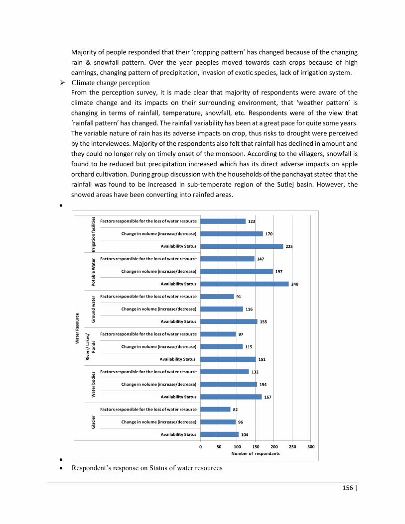
156 |
Majority of people responded that their ‘cropping pattern’ has changed because of the changing
rain & snowfall pattern. Over the year peoples moved towards cash crops because of high
earnings, changing pattern of precipitation, invasion of exotic species, lack of irrigation system.
➢ Climate change perception
From the perception survey, it is made clear that majority of respondents were aware of the
climate change and its impacts on their surrounding environment, that ‘weather pattern’ is
changing in terms of rainfall, temperature, snowfall, etc. Respondents were of the view that
‘rainfall pattern’ has changed. The rainfall variability has been at a great pace for quite some years.
The variable nature of rain has its adverse impacts on crop, thus risks to drought were perceived
by the interviewees. Majority of the respondents also felt that rainfall has declined in amount and
they could no longer rely on timely onset of the monsoon. According to the villagers, snowfall is
found to be reduced but precipitation increased which has its direct adverse impacts on apple
orchard cultivation. During group discussion with the households of the panchayat stated that the
rainfall was found to be increased in sub-temperate region of the Sutlej basin. However, the
snowed areas have been converting into rainfed areas.
•
•
• Respondent’s response on Status of water resources
104
96
82
167
154
132
151
115
97
155
116
91
240
197
147
225
170
123
0 50 100 150 200 250 300
Availability Status
Change in volume (increase/decrease)
Factors responsible for the loss of water resource
Availability Status
Change in volume (increase/decrease)
Factors responsible for the loss of water resource
Availability Status
Change in volume (increase/decrease)
Factors responsible for the loss of water resource
Availability Status
Change in volume (increase/decrease)
Factors responsible for the loss of water resource
Availability Status
Change in volume (increase/decrease)
Factors responsible for the loss of water resource
Availability Status
Change in volume (increase/decrease)
Factors responsible for the loss of water resource
Gla
cier
Wat
er b
od
ies
Riv
ers/
Lak
es/
Po
nd
sG
rou
nd
wat
erP
ota
ble
Wat
er
Irri
gati
on
faci
litie
s
Wat
er R
eso
urc
e
Number of respondants
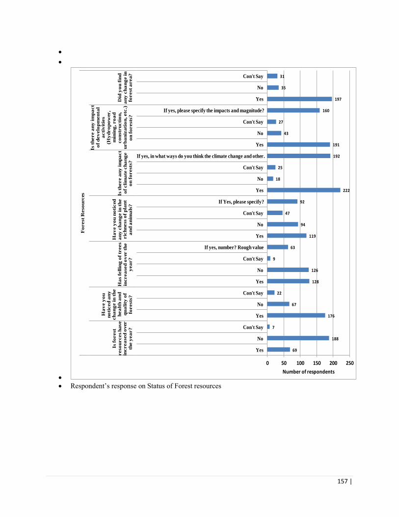
157 |
•
•
•
• Respondent’s response on Status of Forest resources
69
188
7
176
67
22
128
126
9
63
119
94
47
92
222
18
25
192
191
43
27
160
197
35
31
0 50 100 150 200 250
Yes
No
Con't Say
Yes
No
Con't Say
Yes
No
Con't Say
If yes, number? Rough value
Yes
No
Con't Say
If Yes, please specify?
Yes
No
Con't Say
If yes, in what ways do you think the climate change and other …
Yes
No
Con't Say
If yes, please specify the impacts and magnitude?
Yes
No
Con't Say
Is f
orest
reso
urces
have
increa
sed
over
the y
ea
r?
Ha
ve y
ou
no
ticed
an
y
ch
an
ge in
th
e
hea
lth
an
d
qu
ali
ty o
f
forests
?
Ha
s f
ell
ing
of
trees
increa
sed
ov
er t
he
yea
r?
Ha
ve y
ou
no
ticed
an
y c
ha
ng
e in
th
e
ric
hn
ess o
f p
lan
t
an
d a
nim
als
?
Is t
here a
ny
im
pa
ct
of
cli
ma
te c
ha
ng
e
on
fo
rests
?
Is t
here a
ny
im
pa
ct
of
dev
elo
pm
en
tal
acti
vit
ies
(Hy
dro
po
wer,
min
ing
, ro
ad
co
nstr
ucti
on
,
urb
an
iza
tio
n, etc
.)
on
fo
rests
?
Did
yo
u f
ind
an
y c
ha
ng
e in
fo
rest
area?
Fo
rest
Reso
urces
Number of respondents

158 |
•
•
• Fig. 4. Respondent’s response on Status of Forest resources
Annexure 4: List of Stakeholders Met
39
191
34
42
182
39
44
161
57
131
122
9
211
46
3
208
89
132
42
68
54
168
28
75
0 100 200 300
Yes
No
Con't Say
Yes
No
Con't Say
Yes
No
Con't Say
Yes
No
Con't Say
Yes
No
Con't Say
If yes, to what extent you are dependent on the forest areas like
food, building material, nutrition, medicinal plants, etc.
Yes
No
Con't Say
If yes, please specify the changes?
Yes
No
Con't Say
If yes, what are these products?
Is t
here a
ny
forest
dis
ea
ses
an
d p
est
infe
cti
on
?
Is t
here a
ny
sh
ifti
ng
of
forest
typ
es?
Is t
here a
ny
ch
an
ge in
sp
ecie
s
co
mp
osit
ion
?
Are y
ou
aw
are o
f
forest
ma
na
gem
en
t
po
licie
s / r
igh
ts
in y
ou
r a
rea
?
Are y
ou
deriv
ing
dir
ect
ben
efi
ts f
ro
m
the f
orest
areas a
nd
oth
er e
co
syste
m
serv
ices?
Is t
he L
iveli
ho
od
pa
ttern
in
th
e v
illa
ge
ha
s a
ffecte
d n
atu
ra
l
reso
urces?
Is t
here a
ny
in
terest
in
bu
ild
ing
va
lue a
dd
ed
to
th
e N
on
Tim
ber
Fo
rest
Pro
du
cts
(NT
FP
) p
ro
du
ct
loca
lly
?
Fo
rest
Reso
urces
Number of respondent
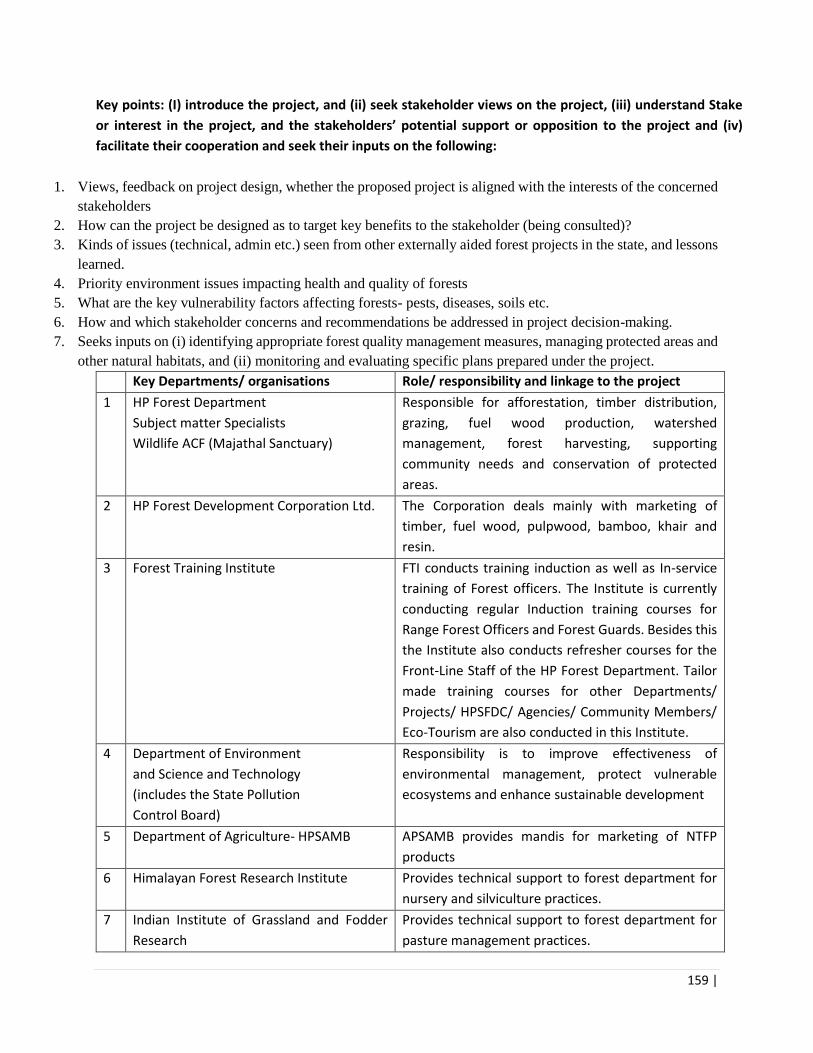
159 |
Key points: (I) introduce the project, and (ii) seek stakeholder views on the project, (iii) understand Stake
or interest in the project, and the stakeholders’ potential support or opposition to the project and (iv)
facilitate their cooperation and seek their inputs on the following:
1. Views, feedback on project design, whether the proposed project is aligned with the interests of the concerned
stakeholders
2. How can the project be designed as to target key benefits to the stakeholder (being consulted)?
3. Kinds of issues (technical, admin etc.) seen from other externally aided forest projects in the state, and lessons
learned.
4. Priority environment issues impacting health and quality of forests
5. What are the key vulnerability factors affecting forests- pests, diseases, soils etc.
6. How and which stakeholder concerns and recommendations be addressed in project decision-making.
7. Seeks inputs on (i) identifying appropriate forest quality management measures, managing protected areas and
other natural habitats, and (ii) monitoring and evaluating specific plans prepared under the project.
Key Departments/ organisations Role/ responsibility and linkage to the project
1 HP Forest Department
Subject matter Specialists
Wildlife ACF (Majathal Sanctuary)
Responsible for afforestation, timber distribution,
grazing, fuel wood production, watershed
management, forest harvesting, supporting
community needs and conservation of protected
areas.
2 HP Forest Development Corporation Ltd. The Corporation deals mainly with marketing of
timber, fuel wood, pulpwood, bamboo, khair and
resin.
3 Forest Training Institute FTI conducts training induction as well as In-service
training of Forest officers. The Institute is currently
conducting regular Induction training courses for
Range Forest Officers and Forest Guards. Besides this
the Institute also conducts refresher courses for the
Front-Line Staff of the HP Forest Department. Tailor
made training courses for other Departments/
Projects/ HPSFDC/ Agencies/ Community Members/
Eco-Tourism are also conducted in this Institute.
4 Department of Environment
and Science and Technology
(includes the State Pollution
Control Board)
Responsibility is to improve effectiveness of
environmental management, protect vulnerable
ecosystems and enhance sustainable development
5 Department of Agriculture- HPSAMB APSAMB provides mandis for marketing of NTFP
products
6 Himalayan Forest Research Institute Provides technical support to forest department for
nursery and silviculture practices.
7 Indian Institute of Grassland and Fodder
Research
Provides technical support to forest department for
pasture management practices.

160 |

161 |
Annexure 4: Details of Institutional Consultations
Table ___: Institutional Consultations
No. Name and
Designation
Field of Expertise Institution Time and
Date
Suggestions/ Key input
1 Sh. Rahul Sharma,
Silviculture Subject
Matter Specialist
Silviculture
Subject Matter
Specialist
HP Forest Department
(HPFD)
24/04/2018,
11.00 am
• Seed Storage (controlled temperature
environment) is required at each nursery.
• Proper collection of seeds required.
• Trained and dedicated nursery staff required.
• Seed orchard management required.
• Schedule of Rates prescribed by department does
not match up with present scenario/market rates.
• Plus trees not marked for seed orchards.
• Seed testing, processing and treatment lab
required (centralized or as per agro climatic zones
of HP).
• Fire control equipment insufficient.
• Budget allocation for fire control is insufficient.
• Awareness and training of staff required.
• Reassessment of fire lines.
• Long term planning required for seed orchard
management with sufficient funds.
• Counter fire management is not done due to lack
of training and insufficient staff.
• For lantana eradication, the cut root stock
method is not implemented as per the guidelines.
• Solid waste management for nursery waste is not
done.

162 |
No. Name and
Designation
Field of Expertise Institution Time and
Date
Suggestions/ Key input
2 Mrs. Anita
Bhardwaj,
Assistant
Conservator of
Forests (Wild Life),
O/o DFO(W/L),
Shimla
Wildlife and
Silviculture
HP Forest Department 24/04/2018,
11.45 pm
• Public participation is minimal due to Supreme
Court of India orders on no extraction from
Protected Area (PA).
• Illegal extraction and poaching of mammals and
pheasants is a cause of concern.
• Eco tourism can be promoted as each PA has its
own USP. But synergy between the two has to be
maintained.
• PA has very small geographical area with pressure
from human population residing in the vicinity of
the PA.
• Fire management is a cause of concern as its
endanger the wildlife in PA.
• Staff mobility for fire prevention/control/illegal
extraction and poaching is required.
• Control burning in forest is advisable but is not
done due to lack of trained field staff and
insufficient funds.
• The cut root stock method for lantana eradication
should be implemented as per guidelines. The
example of proper implementation is at Rajaji, Jim
Corbet and Kanha National Parks.
• Fire prevention and suppression should be taken
up on priority.
• Grading of plants has to be done at nursery level.
3 S. Hitender Sharma, Training,
Community
HPFD 24/04/2018,
12.30 pm
• Forest Training is provided by the institute in
Chail, and branch in Sundernagar. Typical courses

163 |
No. Name and
Designation
Field of Expertise Institution Time and
Date
Suggestions/ Key input
Joint Director,
Forest Training
Institute Chail (HP)
participation and
Silviculture
include 6-month training to forest guard
(provided bi-annually). Refresher training courses
in fire management and GIS.
• Forest Fire management is a major challenge.
• Dumping of debris and solid waste in forest areas
from human settlements and construction
activities is a major concern.
• Wildlife conflict due to construction activities in
the forest area, in many cases wildlife habitats
have been fragmented by roads and accessibility
to water sources in a problem.
• PWD used to reuse polybags in road construction
activities but the practice has been abandoned
• Bioengineering on hill slopes needs to be scale
dup
• Regular training of forest staff on FMIS,
GIS,IFMS,GPS,HRD etc. is required.
• Trained and dedicated staff for nurseries is
required for plants to be graded, identification of
healthiest plants. Good programme for nursery
supervision should be supported
• There is an infrastructure up gradation of training
schools (hostel facility, exposure visits,
equipment’s such as laptops, LED screens
conference halls etc.) is required.
• Faculty shortage at training schools.

164 |
No. Name and
Designation
Field of Expertise Institution Time and
Date
Suggestions/ Key input
Some key environmental challenges include (i)
Depletion of bio diversity due to invasive alien
species and forest fires (ii) Weed management
within nurseries, and (iii) management of stray
cattle
4 i. Sh. Raghav
Sood, Secretary
APMB (Bilaspur
& Shimla) and
ii. Mr. Solanki,
State
Coordinator , E
National
Agriculture
Market (eNAM)
Agriculture,
Medicinal and
Aromatic produce
marketing (NTFP
& MAP)
Himachal Pradesh
State Agriculture and
Marketing Board,
GoHP
25/04/2018,
3.30 pm
• There is a network of 60 markets across the state.
However, these market are dealing with
agriculture and horticulture produce mainly.
• The window for NTFP’s is only from November to
April where the mandis are not fully
operational/busy
• Kullu, Chamba, kangra, Shimla are major APMB
mandis
• No dedicated platforms or storage areas for NTFP.
Rented area for whole sale traders is provided.
• Out of 131 schedule items 37 are NTFP’s/MAPs as
notified by the GoHP which can be marketed/sold
through APMB
• The framers and traders negotiate directly with
no role of APMB.
• 1% of market fee is charged from trader (i.e. 1%
of total value of stock).
• No dedicated check on under value of product
stock.
• Farmer interest groups can be mobilized with
access to financial resources. The Govt of India
has started eNAM (http://www.enam.gov.in ),

165 |
No. Name and
Designation
Field of Expertise Institution Time and
Date
Suggestions/ Key input
wherein grading, sorting and auction is being
done online as per Directorate of Marketing
Inspection (DMI),GOI guidelines. 19 markets of
Himachal have been enrolled at the portal.
• Till date 90 commodities have been added.
• NTFP can be added to e-NAM subject to its
availability and quantity. eNAM can be later
expanded to logistics and warehousing
• the project can support with a single market
earmarked for NTFP/MAPs The said market
should be at main NTFP production area or at
state exit point.
• Sector is ‘organic’ by nature and its value needs to
capture this aspect.
• Before going for expansion, a strong buyer base
to be created.
• NTFP/MAPs need support for sorting, grading and
storage facilities. Currently there are no major
private players in this space.
• NTFP transit rule may be liberalized.
4 Dr. Suresh C Atri,
Principal Scientific
Officer
(Environment),
Environment,
Natural Resource
Management and
Climate Change
Department of
Environment Science
and Technology (DST),
GoHP
26/04/2018
10.30 am
• DST has developed Environment Master Plan of
State.
• The DST is main coordinating department with
every other sector department of the State for
natural resource management.
• DST gives policy input to other line departments.

166 |
No. Name and
Designation
Field of Expertise Institution Time and
Date
Suggestions/ Key input
• DST is the nodal office for climate change action
plan of the state.
• DST gives sectorial guidelines for all departments
regarding environment.
• The reason for climate change is due to rise in
temperature.
• The change in forest dependence of people is due
to options available for alternate fuel.
• Due to green felling ban in the state the forests
are not being used as resource and are just being
conserved.
• Planning process to be reformed for forest being
used as resources.
• Pine needle clearance from forest is not planned
as there is no online monitoring system.
• No awareness in people and low capacity of forest
department about pine needle collection.
• Wherever there is forest fire incidence the
invasive species/weed problem is more due to
sprouting of seeds.
• Community is not oriented about livelihood
practices from forests.
• Lack of awareness about bio diversity
conservation.
• Rise in temperature and less rainy days has led to
shifting of plant species towards N/W direction.

167 |
No. Name and
Designation
Field of Expertise Institution Time and
Date
Suggestions/ Key input
• The spring sources are drying due to extraction of
ground water, storage in water tanks, high
temperature and less rainy days.
• HP water table is going down due to excessive
harnessing of water especially in low lying area.
• Check on ground water extraction is a necessity.
• Application of knowledge and capacity of nodal
agencies (key stake holders) is missing.
• No subject specific trainers in concerned sector.
• Cadre of different field in HPFD. Dedicated cadre
is required.
• Limitation of resources, manpower.
• To build the capacity of the manpower its domain
should be fixed.
• Assign some economic value to the weed and
then only people will take interest in its
eradication.
• Install two industries for re-use of weed residue/
demonstration for weed management.
5 i. Dr. Sandeep
Sharma,
Scientist G
ii. Dr. P.S.Negi,
Scientist C
iii. Sh. Sanjeev
Kumar, DCF
iv. Dr. Ashwani
i.Nursery and
Medicinal
Plants.
ii.Seed and
Nursery
Technology
iii.Silviculture
Himalayan Forest
Research Institute ,
HFRI
(body of Indian Council
for Forest Research
and Education, ICFRE
under Ministry of
Environment, Forests
26/04/2018
3.00pm
• Most of the Joint Forest Management
committees (JFMC) are nonfunctional.
• Forest productivity in HP is less.
• Better collection of seeds through seed orchards
is required.
• Model nurseries to be constructed so that good
saplings can be grown and planted.

168 |
No. Name and
Designation
Field of Expertise Institution Time and
Date
Suggestions/ Key input
v. Dr. Ranjeet
Singh, Scientist E
iv.Pathologist
v.Entomology
and Climate Change,
GOI)
• Skill up gradation of line staff for seed collection
is required e.g. choice of species as per agro
climatic zones of state, seed quality, seed
handling, processing, nursery management, site
selection for plantation etc.
• Low productivity of forest due to low survival of
species which are not from same agro climatic
zone.
• Local community input should be taken for
selection of species.
• The selected specie has to be vetted from some
research institute or university to technical
aspect.
• Too many project in a single zone leads to
difficulty in assessment of impacts.
• Area to be selected where least activities has
been undertaken.
• A fringe forest i.e. around the vicinity of the
village area where dependency of community is
high has to be taken up on priority.
• Afforestation has to be done on properly marked
sites.
• GPS coordinates of the area where interventions
are planned has to be taken and maps be taken
before hand.
• FSI, DST is good tool for site selection.
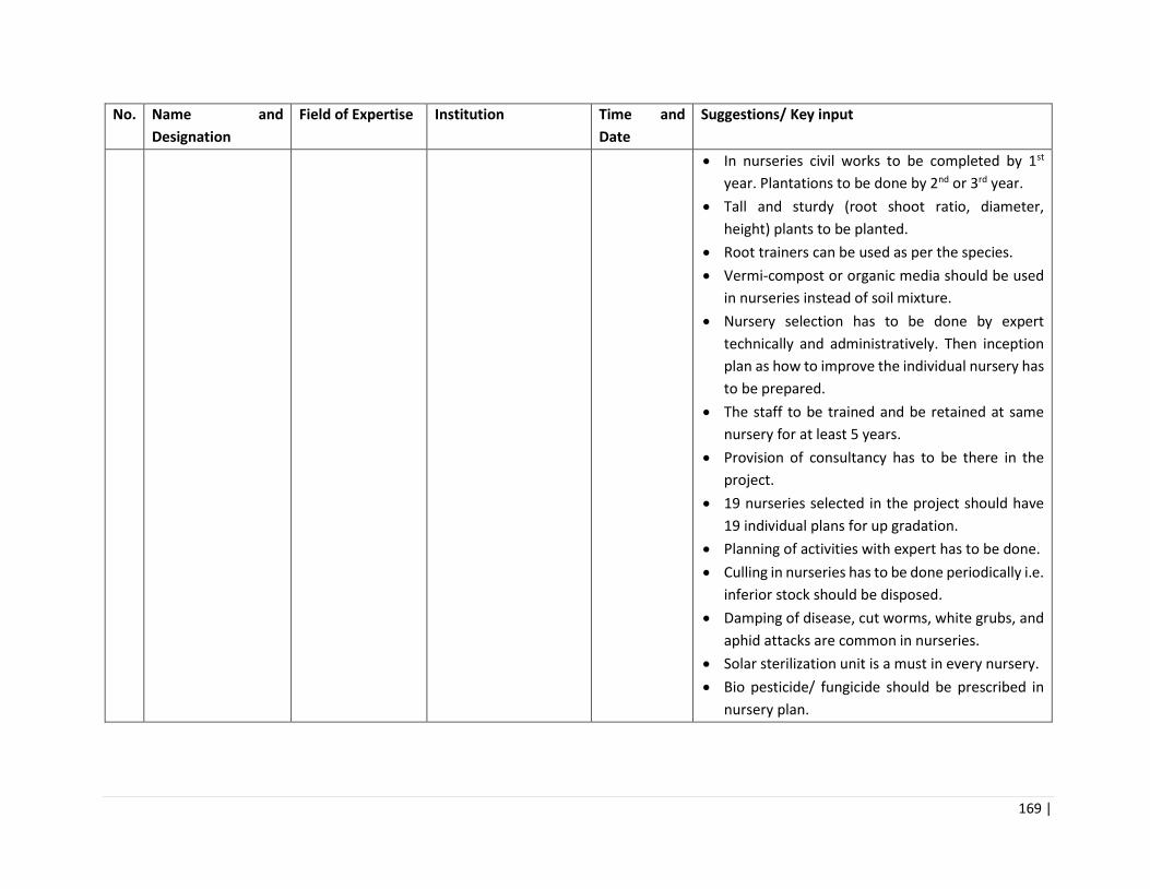
169 |
No. Name and
Designation
Field of Expertise Institution Time and
Date
Suggestions/ Key input
• In nurseries civil works to be completed by 1st
year. Plantations to be done by 2nd or 3rd year.
• Tall and sturdy (root shoot ratio, diameter,
height) plants to be planted.
• Root trainers can be used as per the species.
• Vermi-compost or organic media should be used
in nurseries instead of soil mixture.
• Nursery selection has to be done by expert
technically and administratively. Then inception
plan as how to improve the individual nursery has
to be prepared.
• The staff to be trained and be retained at same
nursery for at least 5 years.
• Provision of consultancy has to be there in the
project.
• 19 nurseries selected in the project should have
19 individual plans for up gradation.
• Planning of activities with expert has to be done.
• Culling in nurseries has to be done periodically i.e.
inferior stock should be disposed.
• Damping of disease, cut worms, white grubs, and
aphid attacks are common in nurseries.
• Solar sterilization unit is a must in every nursery.
• Bio pesticide/ fungicide should be prescribed in
nursery plan.
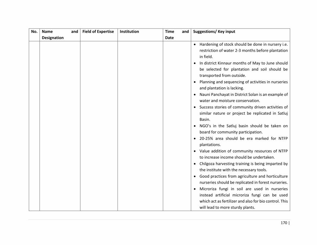
170 |
No. Name and
Designation
Field of Expertise Institution Time and
Date
Suggestions/ Key input
• Hardening of stock should be done in nursery i.e.
restriction of water 2-3 months before plantation
in field.
• In district Kinnaur months of May to June should
be selected for plantation and soil should be
transported from outside.
• Planning and sequencing of activities in nurseries
and plantation is lacking.
• Nauni Panchayat in District Solan is an example of
water and moisture conservation.
• Success stories of community driven activities of
similar nature or project be replicated in Satluj
Basin.
• NGO’s in the Satluj basin should be taken on
board for community participation.
• 20-25% area should be era marked for NTFP
plantations.
• Value addition of community resources of NTFP
to increase income should be undertaken.
• Chilgoza harvesting training is being imparted by
the institute with the necessary tools.
• Good practices from agriculture and horticulture
nurseries should be replicated in forest nurseries.
• Microriza fungi in soil are used in nurseries
instead artificial microriza fungi can be used
which act as fertilizer and also for bio control. This
will lead to more sturdy plants.

171 |
No. Name and
Designation
Field of Expertise Institution Time and
Date
Suggestions/ Key input
• Till date adhoc method are used in nurseries for
pest attack.
• Depending on pest the control measures should
be recommended.
• The nurseries should have ornamental shrubs,
trees etc. which act as natural biological barrier
against pest attack.
• Due to change in temperature the insect’s species
in nurseries are also evolving and new species are
proliferating.
• Trichoderma can be used for root rot or collar rot.
• Neem cake can be used to reduce the use of
pesticide or fungicide.
• Modern method should be used for pest
management.
• Trap crop or inter cropping can act as pest
control.
• Excess watering of plants in nurseries.
• Seed stands identified by HFRI and converted in
seed production area. Deodar seed stand in
Cheog.
• Seed stands are for only two species i.e. deodar
and Chid in HP.
• Seed stands converted to seed production area
will be of great benefit.
• Identifying new seed stands will require 5-6 years.

172 |
No. Name and
Designation
Field of Expertise Institution Time and
Date
Suggestions/ Key input
• Modern techniques can be used in nurseries for
germination of seeds, raising of saplings,
sprinklers, mixing media, drill marker, bed marker
etc.
6 Sh. Jamaldin,
Astt. Manager (Una
& Amb) , O/o
District Manager,
HPFDC (Hamirpur)
Timber salvage,
auction and Resin
collection
HP State Forest
Development
Corporation Ltd.
(HPFDC)
01/05/2018
2.30pm
• HPFDC is working on Timber salvage and Resin
collection only.
• Other major NTFP in forest and private land in low
lying area of HP is Kher (Senegalia catechu). It is
used for extraction of catechu which is
extensively used in India as food product and
medicine.
• The Kher are extensively planted by persons in
their private land holding and sold directly to
private contractors to fetch good money.
• HPFDC has no arrangement to buy these trees as
private contractors give cash whereas there is no
provision of such in HPFDC.
• Local people are engaged for resin collection as it
saves money as they know the forest and doesn’t
require lodging
• There is scope of market if the resin collection is
opened for private contractors.
• Rate of resin per quintal or Kilogram should be
notified before giving the contract to private
party. This will fetch more income to the state.
• Schedule of Rates for hiring labour is very less
with respect to prevailing market rates.

173 |
No. Name and
Designation
Field of Expertise Institution Time and
Date
Suggestions/ Key input
• Acute shortage of staff.
• Pine needle collection is being done by private
contractors and is used for fuel only.
• Earlier HPFDC had paper pulp factory near
Baijnath for processing pine needle. The same is
closed.
• The pine needle collection is very labour intensive
and is prone to termite attacks as there is no
storage facility available.
• NTFP’s in state are harnessed across a wide area
and in small quantity.
• Getting the NTFP to a single market will be un-
economical for the community.
• There are no such NTFP in low lying areas of the
state. Few NTFP’s are harnessed in small quantity.
• Earlier the forest cover around the village or
habitation was dense thus labour cost was less.
However, due to change in density of forest cover
around the habitation the resin collection has to
be done in far flung forest which is costing more.
• Economic value to be assigned to lantana for its
eradication from forest e.g. fire wood, furniture
making etc.
• The forest productivity is getting lower in state.

174 |
No. Name and
Designation
Field of Expertise Institution Time and
Date
Suggestions/ Key input
7 Dr. Sudesh
Randotra ,
Principal Scientist &
In charge
Himachal
Pasturelands
ICAR-Indian Grassland
and Fodder Research
Institute, Palampur
03/05/2018,
10.30am
• The institute is part of Eco system climate
proofing project in HP being funded by kfw.
• There is lack of communication between research
institutes and HP Forest Department.
• Quality of pastures i.e. yield/biomass is low in HP
due to lack of management, people interest and
weed infestation.
• The good pastures are being used but the low
quality pastures are not being treated to enhance
their quality.
• The treatment of pastures by HPFD is not very
useful as to eradicate weed infestation the
pastures have to be cleared for 3-4 years.
• New improved varieties of local seeds or other
seeds can be grown in pastures.
• Pastures treated to be properly marked and
closed.
• Community should be trained and mobilized for
pastures management and protection as they are
the direct beneficiaries.
• Private sector participation in pastures is very
difficult as the revenue generation is very low and
the areas are remote.
• Lantana is proliferating to higher pastures
i.e. Alpine with evidence are being found in
Keylong in Lahaul&Spiti.
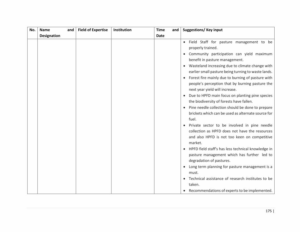
175 |
No. Name and
Designation
Field of Expertise Institution Time and
Date
Suggestions/ Key input
• Field Staff for pasture management to be
properly trained.
• Community participation can yield maximum
benefit in pasture management.
• Wasteland increasing due to climate change with
earlier small pasture being turning to waste lands.
• Forest fire mainly due to burning of pasture with
people’s perception that by burning pasture the
next year yield will increase.
• Due to HPFD main focus on planting pine species
the biodiversity of forests have fallen.
• Pine needle collection should be done to prepare
brickets which can be used as alternate source for
fuel.
• Private sector to be involved in pine needle
collection as HPFD does not have the resources
and also HPFD is not too keen on competitive
market.
• HPFD field staff's has less technical knowledge in
pasture management which has further led to
degradation of pastures.
• Long term planning for pasture management is a
must.
• Technical assistance of research institutes to be
taken.
• Recommendations of experts to be implemented.
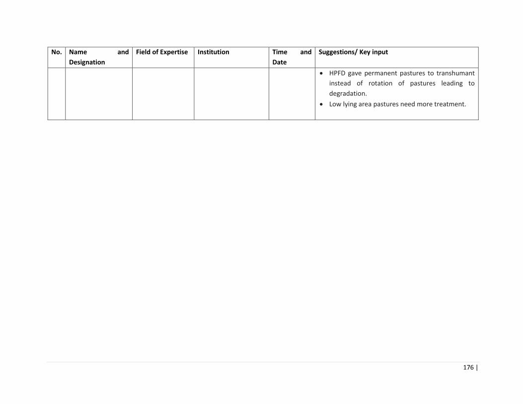
176 |
No. Name and
Designation
Field of Expertise Institution Time and
Date
Suggestions/ Key input
• HPFD gave permanent pastures to transhumant
instead of rotation of pastures leading to
degradation.
• Low lying area pastures need more treatment.

177 |
Annexure 5: Proceedings of District Level Stakeholder Consultations
Table ___: Details of Stakeholder Consultations Meetings at District Level
No. District Date Location Stakeholders
participated in
meetings
Stakeholder’s Views/ Concerns How these issues are planned to be
addressed
1 Kinnaur 24/04/2018 Forest
Rest
house,
Reckong
Peo
Total number of
participants were 60
including
• Concerned
Forest Range
Officers, Deputy
Ragers and
Forest Gaurds
of Three Ranges
of Kinnaur.
• Sh. R.S Negi
President Him
lok Jagriti
Manch
• Gram
Praddhans and
members of
villages
Moorang,
Kalpa, Kilba,
Ribba, Rispa &
Lippa
• The locals are dependent
on forests for Fuel, fodder,
Timber, NTFP collection
(Chilgoza, Guchii etc.)
• There has been substantial
decrease in natural
resources mainly around
the areas where large
construction projects like
hydropower projects, road
construction are being
implemented.
• Traditionally the forest
area in and around the
sacred groves are
protected by locals.
• The area prone to forest
fires should be properly
marked and cut off from
the adjacent forest to
prevent forest fire from
spreading to nearby areas.
• Forest Fire lines
reassessment is being done
under the project.
• Proper management of
Chilgoza pines will be
undertaken in the project.
• The Forest rights are being
settled by the concerned
Deputy Commissioner/
Divisional Commissioner of
the area.
• Eco tourism sites are being
selected on pilot basis by
GoHP and in future when
this component is taken up
by the project the
community views will be
taken.
• JFMCs will be constituted if
not already done and will be
consulted for preparation of
range level plans and its
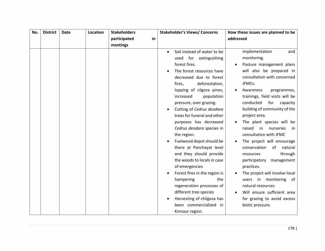
178 |
No. District Date Location Stakeholders
participated in
meetings
Stakeholder’s Views/ Concerns How these issues are planned to be
addressed
• Soil instead of water to be
used for extinguishing
forest fires.
• The forest resources have
decreased due to forest
fires, deforestation,
lopping of cilgoza pines,
increased population
pressure, over grazing.
• Cutting of Cedrus deodara
trees for funeral and other
purposes has decreased
Cedrus deodara species in
the region.
• Fuelwood depot should be
there at Panchayat level
and they should provide
the woods to locals in case
of emergencies
• Forest fires in the region is
hampering the
regeneration processes of
different tree species
• Harvesting of chilgoza has
been commercialized in
Kinnaur region.
implementation and
monitoring.
• Pasture management plans
will also be prepared in
consultation with concerned
JFMCs.
• Awareness programmes,
trainings, field visits will be
conducted for capacity
building of community of the
project area.
• The plant species will be
raised in nurseries in
consultation with JFMC
• The project will encourage
conservation of natural
resources through
participatory management
practices.
• The project will Involve local
users in monitoring of
natural resources
• Will ensure sufficient area
for grazing to avoid excess
biotic pressure.
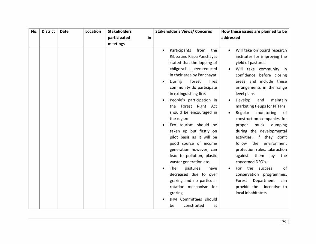
179 |
No. District Date Location Stakeholders
participated in
meetings
Stakeholder’s Views/ Concerns How these issues are planned to be
addressed
• Participants from the
Ribba and Rispa Panchayat
stated that the lopping of
chilgoza has been reduced
in their area by Panchayat
• During forest fires
community do participate
in extinguishing fire.
• People’s participation in
the Forest Right Act
should be encouraged in
the region
• Eco tourism should be
taken up but firstly on
pilot basis as it will be
good source of income
generation however, can
lead to pollution, plastic
waster generation etc.
• The pastures have
decreased due to over
grazing and no particular
rotation mechanism for
grazing.
• JFM Committees should
be constituted at
• Will take on board research
institutes for improving the
yield of pastures.
• Will take community in
confidence before closing
areas and include these
arrangements in the range
level plans
• Develop and maintain
marketing tieups for NTFP’s
• Regular monitoring of
construction companies for
proper muck dumping
during the developmental
activities, if they don’t
follow the environment
protection rules, take action
against them by the
concerned DFO’s.
• For the success of
conservation programmes,
Forest Department can
provide the incentive to
local inhabitatnts
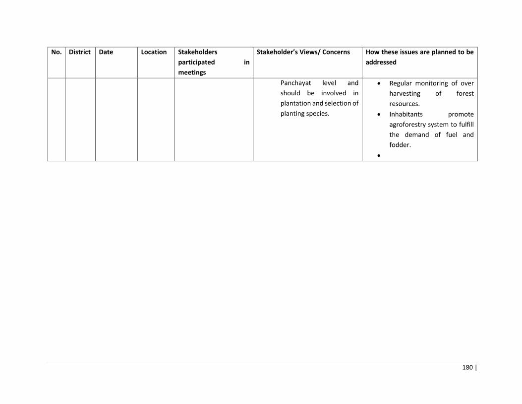
180 |
No. District Date Location Stakeholders
participated in
meetings
Stakeholder’s Views/ Concerns How these issues are planned to be
addressed
Panchayat level and
should be involved in
plantation and selection of
planting species.
• Regular monitoring of over
harvesting of forest
resources.
• Inhabitants promote
agroforestry system to fulfill
the demand of fuel and
fodder.
•

181 |
Stakeholder Consultation meeting at forest rest house Reckong Peo, Kinnaur

182 |
2 Shimla
& Kullu
25/04/2018 Forest
Rest
house,
Nogli,
Rampur
Total number of participants
were 120 including
• Chief Conservator
of Forests (Rampur
Circle- includes
District Kinnaur)
• Shri Ashok Negi
(DFO Rampur)
• Shri V. K. Agarwal
(DFO Luhri)
• Concerned ACF,
Forest Range
Officers, Deputy
Ragers and Forest
Gaurds from Bahli,
Rampur, Nankhari,
Sarahan, Nithar,
Nirmand, Chauwi,
Kotgarh.
• Gram Sabha , JFMC
members from
Rampur, Nogli,
Taklech
• There has been substantial
decrease in natural
resources due to drought,
deforestion road
construction, landslides,
unscientific muck dumping
during road construction
• The locals are dependent
on forests for Fuel, fodder,
Timber, NTFP collection
(Chilgoza, Guchii etc.)
• Demarcation around the
fire prone area to prevent
the spread of fire
• The forest resources
decreased due to
overexploitation of forest
resources to fulfill the
demand for increasing
population in the area,
forest fire and
encroachment of forest
lands by local inhabitants
• Wastage of forest
woods/timber in the area
as dried and fallen trees
are not collected and
managed properly by
forest department
• muck will be utilized on site
for project activities
• Forest Fire lines
reassessment will be done
under the project.
• JFMC’s will be constituted if
not already done and will
be consulted for
preparation of range level
plans and its
implementation and
monitoring.
• Pasture management plans
will also be prepared in
consultation with
concerned JFMC’s.
• Awareness programs,
trainings, field visits will be
conducted for capacity
building of community of
the project area.
• The plant species will be
raised in nurseries in
consultation with JFMC’s
• The timber collection of
HPFDC will be strengthened
• Regular monitoring of
construction companies for
proper muck dumping

183 |
• Forest nurseries should be
increased in the area and
locals should get plants for
free of cost
• Community do participate
in plantation through
MANREGA and forest
department, forest fire
prevention
• Joint committees should be
constituted involving the
local inhabitants for the
management and
monitoring of plants
• Conflicts on choices of
plant species during
plantation (Like Deodar,
Populus instead of Pine)
• Awarerness programms
are being conducted at
panchayat and school level
and at public places by
forest department during
different occasions
• awareness programmes
should be conducted at
villege/ Panchayat levels
more frequently
during the developmental
activities, if they don’t
follow the environment
protection rules, take
action against them by the
concerned DFO’s.
• For the success of
conservation programmes,
Forest Department can
provide the incentive to
local inhabitatnts
• Regular monitoring of over
harvesting of forest
resources.
• Inhabitants promote
agroforestry system to
fulfill the demand of fuel
and fodder.
• Will implement proper
monitoring plan for
performance of assets by
involving local people
• Will ensure sufficient area
for grazing to avoid excess
biotic pressure.
• Will take community in
confidence before closing
areas and will include these
arrangements in the range
level plans

184 |
• The pasture have
decreased due to
overgrazing, increasing
demand for fodder
• Only one JFMC is active
from last 22 years while,
rest are non fonctional and
the majority of the
Panchayat members
arenot aware about the
existance of such
committees
•
Stakeholder Consultation meeting at forest rest house Nogli, Rampur, Shimla

185 |

186 |
3 Solan 29/05/2018 Forest
Rest
House
Chandi,
Chandi
Wildlife
Range
Total number of
participants were 50
including
• Concerned,
Forest Range
Officers, Deputy
Ragers and
Forest Gaurds
from Chandi
WLS.
• NTFPs
collecters and
sellers,
• Gram Pradhans
• and Villagers
• The locals are dependent on
forests for Fuel, fodder, Timber,
NTFP collection
• Due to WLS restriction are more
as compared to open areas.
• The project is going to address
the fuelwood & fodder
availability in the area which will
be very helpful.
• Also, it will help in increasing the
income from NTFPs which is
nice step by the govt
• The activities should be planned
and implemented with our
consultation instead of the
planning being done elsewhere.
This way our needs will be
addressed better
• In past projects our
participation in work plan
formulation was not much. Also
not much focuses on our needs.
• Forest fires/ land degradation/
construction of roads/
encroachments are the main
issues impacting health and
quality of forests
• Erratic rainfall, flash floods
,forest fires , spread of lantana
• The restriction in WLS area
is as per Hon’ble Supreme
Court of India directions.
This project has to follow
the directions.
• The proposed activities
under the project will be
prepared and implemented
after consultation with
locals.
• A range level plan will be
prepared in consultation
with concerned JFMC’s
under Range area.
• Since the forest fires are
major concern in WLS area
forest fire lines
reassessment and fire
rating index will be
implemented through this
project.
• Regular monitoring of
construction companies for
proper muck dumping
during the developmental
activities, if they don’t
follow the environment
protection rules, take

187 |
and weeds, Use of
pesticides/chemical fertilizers in
agriculture /horticulture fields
are the key vulnerability factors
affecting forests- pests,
diseases, soils etc
• Convergence with other
government departments
should be there to supplement
the efforts and not work against
each other
• Increase awareness of
community to the harmful
effects adversely affecting the
health of forests , their causes
and remedial measures that are
locally acceptable/ feasible
• Our association in all aspects
right from planning to
implementation should be
taken only, then the \sense of
ownership will increase and
locals will take interest in
monitoring and evaluation.
action against them by the
concerned DFO’s.
• For the success of
conservation programmes,
Forest Department can
provide the incentive to
local inhabitatnts
• Regular monitoring of over
harvesting of forest
resources.
• Inhabitants promote
agroforestry system to
fulfill the demand of fuel
and fodder.
• Eradication of invasive alien
species mainly lantana is a
part of the project
component and will be
taken up either by cut root
method or by using Class-III
chemical (Glyphosate)
• It will be ensured that the
project components and
schemes from other
government department
are in convergence with
each other
• Awareness programs,
trainings, field visits will be
conducted for capacity

188 |
building of community of
the project area.
•
Stakeholder Consultation meeting at forest rest house Chandi, Chandi WL Range, Solan
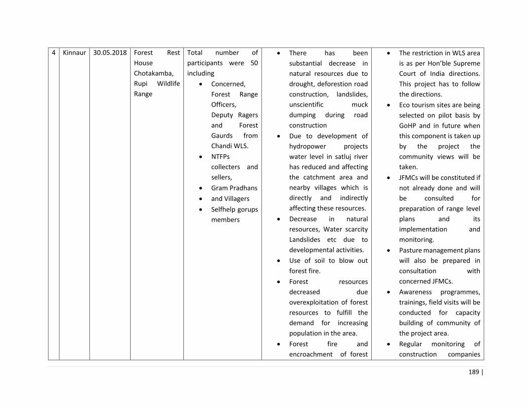
189 |
4 Kinnaur 30.05.2018 Forest Rest
House
Chotakamba,
Rupi Wildlife
Range
Total number of
participants were 50
including
• Concerned,
Forest Range
Officers,
Deputy Ragers
and Forest
Gaurds from
Chandi WLS.
• NTFPs
collecters and
sellers,
• Gram Pradhans
• and Villagers
• Selfhelp gorups
members
• There has been
substantial decrease in
natural resources due to
drought, deforestion road
construction, landslides,
unscientific muck
dumping during road
construction
• Due to development of
hydropower projects
water level in satluj river
has reduced and affecting
the catchment area and
nearby villages which is
directly and indirectly
affecting these resources.
• Decrease in natural
resources, Water scarcity
Landslides etc due to
developmental activities.
• Use of soil to blow out
forest fire.
• Forest resources
decreased due
overexploitation of forest
resources to fulfill the
demand for increasing
population in the area.
• Forest fire and
encroachment of forest
• The restriction in WLS area
is as per Hon’ble Supreme
Court of India directions.
This project has to follow
the directions.
• Eco tourism sites are being
selected on pilot basis by
GoHP and in future when
this component is taken up
by the project the
community views will be
taken.
• JFMCs will be constituted if
not already done and will
be consulted for
preparation of range level
plans and its
implementation and
monitoring.
• Pasture management plans
will also be prepared in
consultation with
concerned JFMCs.
• Awareness programmes,
trainings, field visits will be
conducted for capacity
building of community of
the project area.
• Regular monitoring of
construction companies

190 |
lands by local inhabitants
is prevelant.
• Increased demand of
forest products such as
timber, fuel, fodder, etc.
• Lack of monitoring of
planted plantlets
• Locals are dependent on
forests for fuel, fodder,
Timber, medicinal plants,
etc.
• After the formation of
Wildlife Sanctuary
dependency decreased
due to stringent laws.
• Locals participate in forest
acitivities mainly
Plantation and blow out
forest fire.
• Local peoples demands
some rights to use the
forest resources.
• There is lack of
awarerness programms.
• No tourism activities in
this area.
• Pasture have decreased
due to overgrazing.
for proper muck dumping
during the developmental
activities, if they don’t
follow the environment
protection rules, take
action against them by the
concerned DFOs.
• For the success of
conservation programmes,
Forest Department can
provide the incentive to
local inhabitatnts
• Regular monitoring of over
harvesting of forest
resources.
• Inhabitants promote
agroforestry system to
fulfill the demand of fuel
and fodder.
•

191 |
• Maximum JFM
committees are non
functional and the
majority of the Panchayat
members were not aware
about the existence of
such committees
•
•
•
•
• Stakeholder Consultation meeting at Forest rest house Chotta Kamba, Rupi WL Range, Kinaur
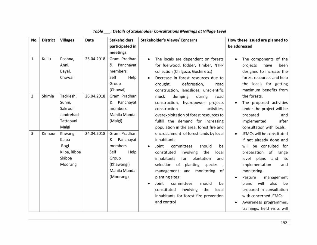
192 |
Table ___: Details of Stakeholder Consultations Meetings at Village Level
No. District Villages Date Stakeholders
participated in
meetings
Stakeholder’s Views/ Concerns How these issued are planned to
be addressed
1 Kullu Poshna,
Anni,
Bayal,
Chowai
25.04.2018 Gram Pradhan
& Panchayat
members
Self Help
Group
(Chowai)
• The locals are dependent on forests
for fuelwood, fodder, Timber, NTFP
collection (Chilgoza, Guchii etc.)
• Decrease in forest resources due to
drought, deforestion, road
construction, landslides, unscientific
muck dumping during road
construction, hydropower projects
construction activities,
overexploitation of forest resources to
fulfill the demand for increasing
population in the area, forest fire and
encroachment of forest lands by local
inhabitants
• Joint committees should be
constituted involving the local
inhabitants for plantation and
selection of planting species ,
management and monitoring of
planting sites
• Joint committees should be
constituted involving the local
inhabitants for forest fire prevention
and control
• The components of the
projects have been
designed to increase the
forest resources and help
the locals for getting
maximum benefits from
the forests.
• The proposed activities
under the project will be
prepared and
implemented after
consultation with locals.
• JFMCs will be constituted
if not already done and
will be consulted for
preparation of range
level plans and its
implementation and
monitoring.
• Pasture management
plans will also be
prepared in consultation
with concerned JFMCs.
• Awareness programmes,
trainings, field visits will
2 Shimla Tacklesh,
Sunni,
Sakrodi
Jandrehad
Tattapani
Malgi
26.04.2018 Gram Pradhan
& Panchayat
members
Mahila Mandal
(Malgi)
3 Kinnaur Khwangi
Kalpa
Rogi
Kilba, Ribba
Skibba
Moorang
24.04.2018 Gram Pradhan
& Panchayat
members
Self Help
Group
(Khawangi)
Mahila Mandal
(Moorang)

193 |
No. District Villages Date Stakeholders
participated in
meetings
Stakeholder’s Views/ Concerns How these issued are planned to
be addressed
• Conflicts on choices of plant species
during plantation (Like Deodar,
Populus instead of Pine)
• Awarerness programms are being
conducted at panchayat and school
level and at public places by forest
department during different occasions
• The pasture have decreased due to
overgrazing, increasing demand for
fodder
• Eco tourism should be taken up but
firstly on pilot basis as it will be good
source of income generation however,
can lead to pollution, plastic waste
generation, etc.
be conducted for
capacity building of
community of the project
area.
• The plant species will be
raised in nurseries in
consultation with JFMC.
• The project will
encourage conservation
of natural resources
through participatory
management practices.
• The project will involve
local users in monitoring
of natural resources.
• Eco tourism sites are
being selected on pilot
basis by GoHP and in
future when this
component is taken up by
the project the
community views will be
taken.
• Will ensure sufficient
area for grazing to avoid
excess biotic pressure.
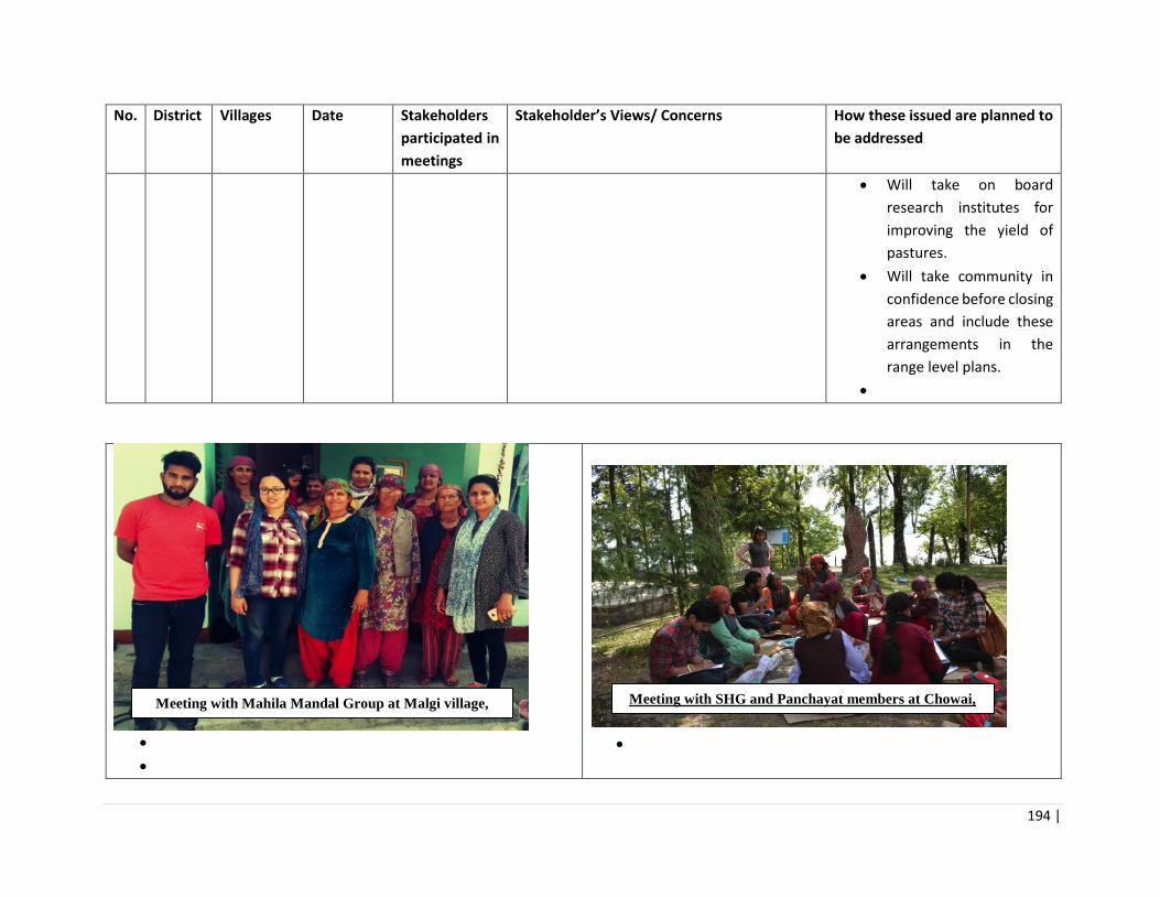
194 |
No. District Villages Date Stakeholders
participated in
meetings
Stakeholder’s Views/ Concerns How these issued are planned to
be addressed
• Will take on board
research institutes for
improving the yield of
pastures.
• Will take community in
confidence before closing
areas and include these
arrangements in the
range level plans.
•
•
•
•
Meeting with Mahila Mandal Group at Malgi village,
Shimla
Meeting with SHG and Panchayat members at Chowai,
Kullu

195 |
• •
•
•
•
Meeting with Pradhan and Panchayat embers at
Sakrodi, Shimla Meeting with Farmers at Jandehard village, Shimla
Meeting with Mahila Mandal Group at Moorang village,
Kinnaur Meeting with SHG at Khawangi village, Kinnaur

196 |

197 |
Annexure 6: Proceedings of Disclosure Workshops
Since the project area is large with distinct geographical, cultural and social features, two public disclosure workshops were held one at Reckong Peo (Schedule-V area), Kinnaur District and the other at Rampur busher, Shimla District. A) Disclosure Workshop at Reckong Peo (Schedule-V area), Kinnaur District One day Disclosure Workshop on Environment Assessment and Management Framework was organised on 23/08/2018 by G. B. Pant National Institute of Himalayan Environment & Sustainable Development, Himachal Regional Centre, Mohal – Kullu, Himachal Pradesh at Forest Rest House, Reckong Peo, District - Kinnaur, Himachal Pradesh. The aim of the Disclosure Workshop was to (i) share the Environment Assessment and Management Framework final report with the representatives of Panchayats and Forest Officers and Officials of the concerned Forest Ranges; (ii) discuss, validate and finalize the issues related to the Panchayats falling under the selected Forest Ranges. Shri Angel Chauhan, DFO, Kinnaur graced the occasion as Chief Guest and Shri Anil Soni, ACF as Guest of Honour. Total 104 participants representing Forest Officers and Officials (DFO, ACF, ROs, BOs and Forests Guards) of the selected Forest Ranges, Pradhans of different Panchayats and Mahila Mandals, JFMC Members and farmers from the selected panchayats namely, Kalpa, Kilba and Moorang actively participated in the Disclosure Workshop. The proceedings of the Disclosure Workshop are as follows. The Disclosure Workshop was started with the registration of all the participants. After that Dr. Renu Lata, Scientist ‘C’ welcomed all guests and participants. Dr. S.S. Samant, Scientist In-charge, GBPNIHESD, HRC and Convener felicitated to the Chief Guest and Guest of Honor. Dr. S. S. Samant, SIC, GBPNIHESD, HRC, Mohal – Kullu, H.P. & Convener of the workshop formally welcomed all the guests, dignitaries and participants. After that he briefly appraised the participants about the Institute and its R&D activities. He also briefed about the programme of the Disclosure Workshop. He said that the objective of the workshop is to share the outcomes of the Environment Assessment and Management Framework project with the participants, which was based on study and consultations conducted in Kinnaur district from April to July 2018. He gave the comprehensive presentation and highlighted the issues raised by the people and mitigation measures suggested during the study. During his presentation, he covered different components of the project e.g., background, study area, approach, institutional reforms for integrated watershed management with a focus on HPFD, improved investments in Participatory Forest Management (PFM), outcomes of the perception based study e.g., survey of households, views of respondents on various issues i.e., water resources, forest resources, environmental risks, etc.. Further, he briefed about the stakeholders consultation meetings organized at Kinnaur, Shimla and Solan districts. He also explained the issues (i.e., status of forest resources, dependency of inhabitance on forest resources, impacts of developmental activities on forests resources, community participation in conservation of forests and steps taken by government for creating mass awareness among local people, etc.) discussed in the consultation meetings and also told them that these issues are to be incorporated in the project. After that he explained about the stakeholder’s views and implications regarding the issues addressed by the people during study, he also briefed about the environmental issues and mitigation measure i.e., pest control strategies in forest nurseries, integration of species selection, nursery planning with the planting site to ensure good survival rates, construction and repair of check dams, value chain infrastructure and enterprise support to NTFPs. Further he added that the main purpose of the Environmental Management Framework (EMF) is to provide a transparent framework with clear

198 |
accountability for managing environmental impacts and risks associated with the project. He also briefed about the institutional arrangement of the project at state, circle, division, range and block/beat levels. He emphasized that people should know the importance of forests to mankind and made an appeal to the participants for the conservation of forests, and to maintain the forests prosperity by their sustainable use. Mr. Angel Chauhan, DFO, Reckong Peo, Kinnaur in his address highly appreciated the efforts and presentation made by GBPNIHESD, HRC, Mohal – Kullu, Himachal Pradesh. He also appreciated the World Bank as a funding agency for the Himachal Pradesh Forests for Prosperity Project. He added that the project duration is for 5 years with a total budget of 6.50 crores and wished for active participation of people for the successful implementation and further extension of the project. Mr. Anil Soni, ACF, Reckong Peo, Kinnaur in his address said that according to Satellite data, there is 4% increase in the forest cover of Himachal Pradesh but this increase in forest cover is due to plantations alongside the roads, orchards, etc., so need to pay attention on this. He also added that there should be focus on native species for plantation and the selection of the right area for plantation is important for the maximum survival of planted species. He further added that the forest fire in Kinnaur is different as compared to other areas of H.P. Due to dense layer of humus the fire burning is slow and long lasting viz., it increases with the course of time. It is not frequent as in other places. He said that there should be awareness about the forest fire. After the above presentation and addresses, the participants were invited for the comments, suggestions and validation of the outcomes of the project. All the participants actively involved in discussion. They fully agreed that all the issues presented and discussed were based on the interactions with the inhabitants during the surveys and interaction meeting. The further said that implementation of the identified issues will definitely help for the development of the panchayats falling under the selected Forest Ranges. They assured for their full cooperation during the implementation of the project in their respective panchayats. A few of them gave location specific suggestions which are as follows. Suggestions of participants Priya Negi, Pradhan Pangi: Proper managemnt of post plantation process i.e., proper watering/irrigation facilities, protection from forest fire and regular evaluation and monitoring of planted species is required for ensuring the maximum survival rate. Rama Nand Negi: Plantation of native species should be done in respective areas. Some suggested species are chulli (Prunus ameniaca) and Behami. Parmeshwar Negi , Village Member: Control on parasites, responsible for degradation of trees. Non-functional JFMCs should be made functional. Regular monitoring of saplings after plantation with the help of local people. Awareness programmes on forest fire, importance of forest, etc. should be coorganized at panchayat level.
199 |
There should be transprancy among Government Institutions, Research Organizations and local communities. Gram Panchayat Chagaon: Local peoples’ participation is necessary in the implementation of any project. Steps should be taken to prevent the ill effects of forest fire. Ram Prakash, Kuarin: Plantation should be done in barren land and landslide prone areas. Plantation should be based on water availabilty and soil types. Check walls should be erected first on the landslide prone areas, then in other sensitive areas. Bhupinder Singh Negi : Pradhan Brua: Steps should be taken by the Govt. to prevent the severe loss during any natural disaster. There should be proper plans and management for pre-disaster and preparedness to face the disaster and post-disaster preventive measures. The Disclosure Workshop ended with the vote of thanks by Dr. Kishor Kumar Kothari.
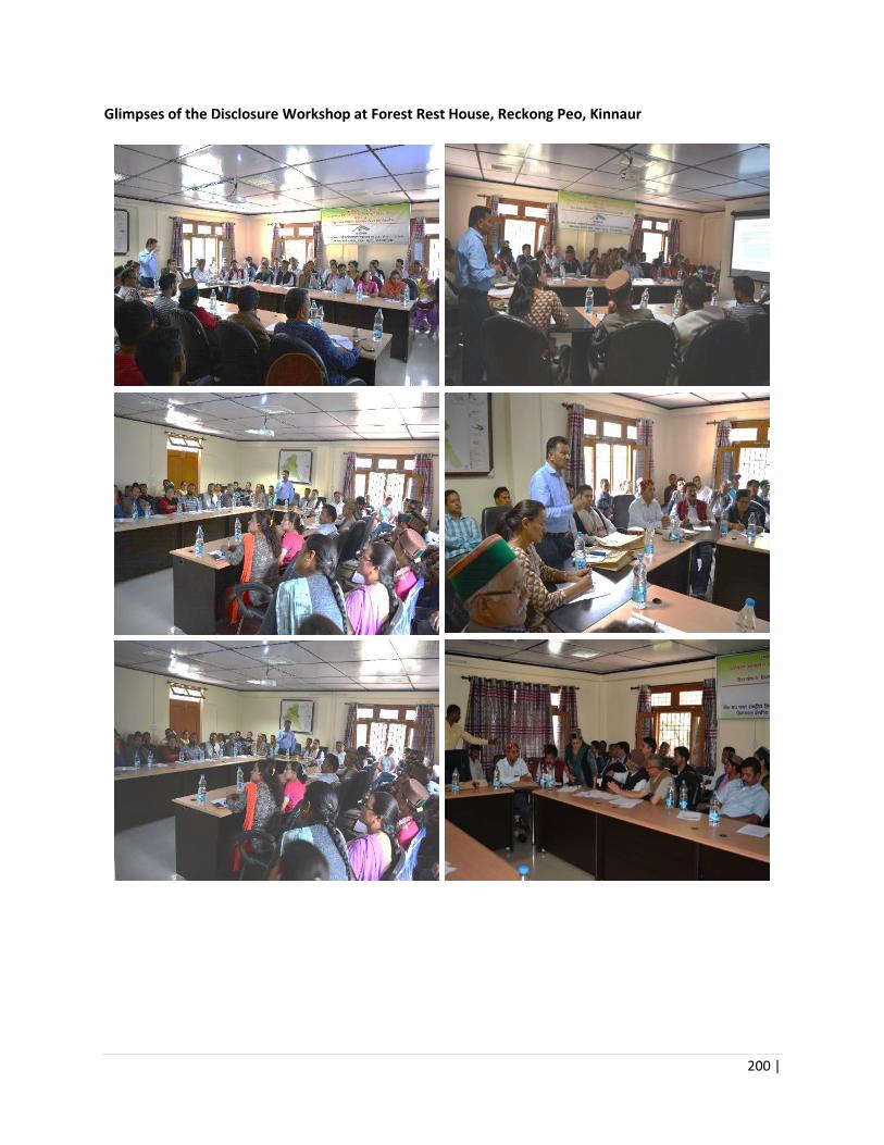
200 |
Glimpses of the Disclosure Workshop at Forest Rest House, Reckong Peo, Kinnaur

201 |
B) Disclosure Workshop at Rampur busher, Shimla District
One Day Disclosure Workshop on Environment Assessment and Management Framework was organised on 24/08/2018 by G. B. Pant National Institute of Himalayan Environment & Sustainable Development, Himachal Regional Centre, Mohal – Kullu, Himachal Pradesh at Forest Rest House, Nogli, Rampur, District - Shimla, Himachal Pradesh. The aim of the Disclosure Workshop was to; (i) share the Environment Assessment and Management Framework final report with the participants representing Panchayats and Forest Officers; (ii) discuss, validate and finalize the issues related to the Panchayats falling under the selected Forest Ranges. Shri Anil Thakur, IFS, CCF, Rampur Circle graced the occasion as Chief Guest, Shri Ashok Negi, DFO, Rampur as Guest of Honor, Shri K.B. Negi, DM, Forest Corporation, Rampur as Special Guest and Shri V. K. Agarwal,DFO, Anni as Guest. In addition, ACFs, ROs, DROs and Forest Guards from Bahli, Rampur, Nankhari, Sarahan, Nithar, Nirmand, Chauwi, Kotgarh ranges, Pradhans of different panchayats and Mahila Mandal, JFMC Members and farmers from different areas actively participated in the Workshop. Total 64 participants participated. The proceedings of the Disclosure Workshop are as follows. The Disclosure Workshop was started with the registration of all the participants. After that Dr. Renu Lata, Scientist ‘C’ welcomed all guests and participants. Dr. S.S. Samant, Scientist In-charge, GBPNIHESD, HRC and Convener felicitated the Chief Guest and Guest of Honor. Dr. S. S. Samant, SIC, GBPNIHESD, HRC, Mohal – Kullu, H.P. & Convener of the workshop formally welcomed all the guests, dignitaries and participants. After that he briefly appraised the participants about the Institute and its R&D activities. He also briefed about the programme of the Disclosure Workshop. He said that the objective of the workshop is to share the outcomes of the Environment Assessment and Management Framework project with the participants, which was conducted in Kinnaur district from April to July 2018. He gave the comprehensive Power Point presentation and highlighted a detailed account of information on the issues raised by the people and mitigation measures suggested during the study. During his presentation, he covered different components of the project e.g., background, study area, approach, institutional reforms for integrated watershed management with a focus on HPFD, improved investments in Participatory Forest Management (PFM), outcomes of the perception based study e.g., survey of households, views of respondents on various issues i.e., water resources, forest resources, environmental risks, etc.. Further, he briefed about the stakeholders consultation meetings organized at Kinnaur, Shimla and Solan districts. He also explained the issues (i.e., status of forest resources, dependency of inhabitance on forest resources, impacts of developmental activities on forests resources, community participation in conservation of forests and steps taken by government for creating mass awareness among local people, etc.) discussed in the consultation meetings and also told them that these issues are to be incorporated in the project. After that he explained about the stakeholder’s views and implications regarding the issues addressed by the people during study, he also briefed about the environmental issues and mitigation measure i.e., pest control strategies in forest nurseries, integration of species selection, nursery planning with the planting site to ensure good survival rates, construction and repair of check dams, value chain infrastructure and enterprise support to NTFPs. Further he added that the main purpose of the Environmental Management Framework (EMF) is to provide a transparent framework with clear accountability for managing environmental impacts and risks associated with the project. He also briefed about the institutional arrangement of the project at state, circle, division, range and block/beat levels. He emphasized that people should know the importance of forests to mankind and made an appeal to the participants for the conservation of forests, and to maintain the forests prosperity by their sustainable use.

202 |
Mr. Anil Kumar, CCF, Rampur Circle welcomed all the participants and explained that the problem of soil erosion is due to over collection of litter from the forest floor. Due to this, the soil is exposed to frequent erosion and said that there is need of collective efforts for the conservation of forests. He highly appreciated the efforts and presentation made by GBPNIHESD, HRC, Mohal – Kullu, Himachal Pradesh. He also appreciated the World Bank as a funding agency for the Himachal Pradesh Forests for Prosperity Project. He wished for the kind cooperation, support and active participation of all the stakeholders during the implementation of the project. Mr. Ashok Kumar Negi, DFO, Rampur, briefed about the project and its main objectives. He said that there is a need of collective efforts to conserve the forests and its resources. Mr. K. B. Negi, DM, Forest Corporation, Rampur said that public participation is necessary for the implementation of the project. After the above presentation and addresses, the participants were invited for the comments, suggestions and validation of the outcomes of the project. All the participants actively involved in discussion. They fully agreed that all the issues presented and discussed were based on the interactions with the inhabitants during the surveys and interaction meeting. The further said that implementation of the identified issues will definitely help for the development of the panchayats falling under the selected Forest Ranges. They assured for their full cooperation during the implementation of the project in their respective panchayats. A few of them gave location specific suggestions which are as follows. Suggestions of participants Lalit kumar, Deputy Ranger, Nankhari, Srahan Block: Pipes should be provided for the preparation of stacks of grass to store. The villagers are using trunk of Deodar (Cedrus deodara) and Rai (Picea smithiana) to support the stacks of grass. Caretaker should be appointed for taking care of planted species Indubala, Pradhan, Deothi Panchaya: Over collection of litter should be prohibited. Steps should be taken to stop the over exploitation of forest resources. Manish, Youth Club Member, Bhali: Mixed plant species should be planted to reduce the severe impact of forest fire. Nurseries should be developed at beat level and seedlings should be provided to the local people for plantation. Plantaion of native species should be done. New JFMCs should be constituted and inactive JFMCs should be made fuctional. Awareness programmes on forest fire, importance of forests etc. should be organized at panchayat level. O.P. Negi : Proper managemnt of post plantation process e.g., Proper watering facilities, protection from forest fire, etc. are essentially required for the maximum survival of plants. The Disclosure Workshop was ended with the vote of thanks by Dr. Kishor Kumar Kothari.

203 |
Glimpses of the Disclosure Workshop at Forest Rest House, Nogli, Rampur

204 |
Annex 7: Screening Checklists
Part 1: Environmental Data Sheet
Date of Screening:
Name of Range/Identified Landscape:
List of activities to be supported under the project:
1 Location District __________ Block_________
2 Range area (ha)
3 Forest Area Status Natural habitat Protected Area If in Protected Area If near Protected Area, mention distance Flora and Fauna Status Current use of forest for any livelihood activity Area infested by exotic/noxious weeds
_____ Ha
Degraded VDF MDF Scrub _____________ (name of natural habitat) Yes / No _____________ (name of Protected Area) _____________ (name of Protected Area) _____________ (distance from Protected Area) Name key flora and fauna species: __________ _____ Ha
4 Pasture Land Season when fodder is available Livestock numbers
_____ Ha _____ No # _____ No #
5 Forest Fire Vulnerability Forest fire incidences
______ ______ No #/ year
6 Availability of NTFPs, MAPs and minor forest produce Key NTFP species: Conservation status of NTFP species: Quantity harvested each season (species-wise):
7 Number of open wells ______ No #

205 |
Number of rivers, canals, streams Period of water availability Key fishery resources (location, species, quantity harvested)
______ No # ______ No # months
8 Presence of Forest nursery, or nearest nursery site ______ No # and area (ha) Annual production capacity (saplings/year):
9 Existing management plan for the selected range ______ (name of working plans/ management plans etc.)
10 Are any civil works proposed as part of the project in this range? Yes, civil works are part of the activities No, civil works are not part of the activities If yes, give details of the civil works:
11 Are there any sacred groves, religious sites, culturally important sites in the project activity area? If yes, please give details (name, distance from project site).
Yes, there are culturally important sites in project area No, there are no culturally important sites in project area If yes, give details of the culturally important sites:
Part 2: Eligibility Screening
Sl.
No
Activities listed below will NOT be eligible for support
under the proposed project
Confirmation that the activity is NOT
part of the project (please tick)
1 Activities that are not consistent with the protected area
management plan (in case of WLS and associated eco-
sensitive zones) or forest working plans (in case of forest
ranges).
Activity is not part of project
Activity is part of project
2 Activity that involves construction of check dam >3m height. Activity is not part of project
Activity is part of project
3 Activities that promote or involve procurement of pesticides
that falls in WHO classes IA, IB, or II.
Activity is not part of project
Activity is part of project
4 Activities that involve large-scale clearing of land, dredging
of water bodies, undercutting of slopes, replacement of
natural vegetation, habitat destruction, etc., that may cause
permanent, irreversible impacts.
Activity is not part of project
Activity is part of project

206 |
5 Any activity that has a significant potential of causing forest
fires.
Activity is not part of project
Activity is part of project
6 Any activity that involves child labour (persons under 18
years of age).
Activity is not part of project
Activity is part of project
7 Activities that would adversely affect places of cultural
significance and protected historical/archeological assets
(both natural and human-made)..
Activity is not part of project
Activity is part of project
8 Activities that involve felling of trees without a permit. Activity is not part of project
Activity is part of project
9 Activities that involve NTFP/MAP harvesting without
approvals/permits.
Activity is not part of project
Activity is part of project
10 Any activity that is not consistent with the project
description at time of project negotiations, unless
subsequently agreed to with the Bank along with the
appropriate level of environmental safeguards
management.
Activity is not part of project
Activity is part of project
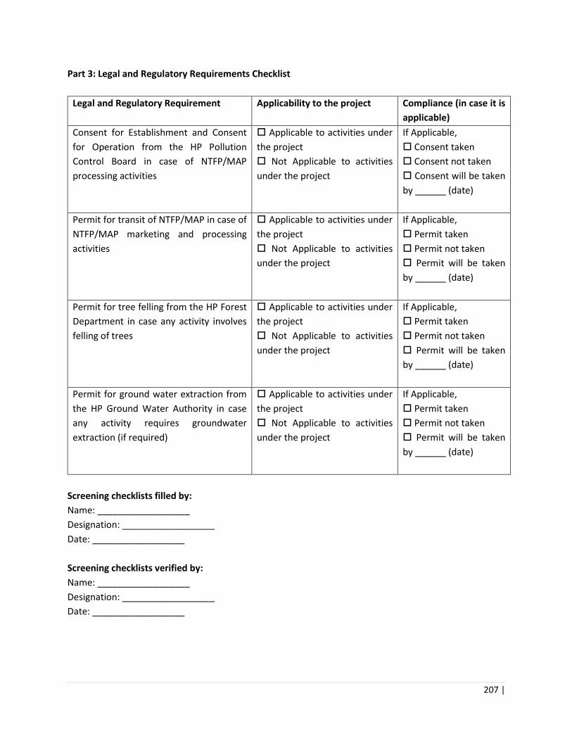
207 |
Part 3: Legal and Regulatory Requirements Checklist
Legal and Regulatory Requirement Applicability to the project Compliance (in case it is
applicable)
Consent for Establishment and Consent
for Operation from the HP Pollution
Control Board in case of NTFP/MAP
processing activities
Applicable to activities under
the project
Not Applicable to activities
under the project
If Applicable,
Consent taken
Consent not taken
Consent will be taken
by ______ (date)
Permit for transit of NTFP/MAP in case of
NTFP/MAP marketing and processing
activities
Applicable to activities under
the project
Not Applicable to activities
under the project
If Applicable,
Permit taken
Permit not taken
Permit will be taken
by ______ (date)
Permit for tree felling from the HP Forest
Department in case any activity involves
felling of trees
Applicable to activities under
the project
Not Applicable to activities
under the project
If Applicable,
Permit taken
Permit not taken
Permit will be taken
by ______ (date)
Permit for ground water extraction from
the HP Ground Water Authority in case
any activity requires groundwater
extraction (if required)
Applicable to activities under
the project
Not Applicable to activities
under the project
If Applicable,
Permit taken
Permit not taken
Permit will be taken
by ______ (date)
Screening checklists filled by:
Name: __________________
Designation: __________________
Date: __________________
Screening checklists verified by:
Name: __________________
Designation: __________________
Date: __________________

208 |
Annex 8: Format for Environmental Management Plan
Part 1: List of Activities Involved
Activity Is the activity part of the project? (please tick)
Triggered Mitigation Measures
Seed Collection and Management [ ] Yes [ ] No See Section A below
Nursery Upgradation [ ] Yes [ ] No See Section B below
Soil and water conservation activities [ ] Yes [ ] No See Section C below
Afforestation/reforestation and Plantation trials [ ] Yes [ ] No See Section D below
Building rehabilitation / General construction/ small scale civil works [ ] Yes [ ] No See Section 0 and E below
Activities in Natural Habitats / Protected areas / Eco sensitive zones [ ] Yes [ ] No See Section F below
Pasture Regeneration/fodder cultivation [ ] Yes [ ] No See Section 0 and G below
Forest Fire control [ ] Yes [ ] No See Section H below
NTFP Collection and Harvesting [ ] Yes [ ] No See Section I below
J: NTFP value chain set-up [ ] Yes [ ] No See Section 0 and J below
Part 2: Selection of Mitigation Measures
Activity Parameter Mitigation Measures Checklist (Tick All Selected Measures)
Who is Responsibile for Implementation Of the Mitigation Measure?
When is the Mitigation Measure to be Implemented?
What is the Budget Required for Implementaation of the Mitigation Measure? (integrate cost into the RMP or NTFP plan budget)

209 |
General Conditions
Community worker / Labour Safety
World Bank EHS guidelines will be
applicable
Project will also follow OHS
management practices listed in Annex
10.
All legally required permits have been
acquired for construction and/or
rehabilitation
Community Workers’ PPE will
comply with international good
practice (always hardhats, as needed
masks and safety glasses, harnesses
and safety boots)
Appropriate signposting of the sites
will inform workers of key rules and
regulations to follow.
Measures for public safety will be
ensured
Code of Conduct for Workers will be
adopted
Protection of natural environment and biodiversity
Undertaking all activities in protected
areas as per the management plans
Minimizing staff presence and vehicle
traffic
Sticking to existing roads and tracks as
much as possible
Protecting surface and groundwater
resources
Preventing any harvesting of plants or
poaching of wildlife by site personnel

210 |
Restoring surface and vegetation
where it has been significantly
disturbed
Taking out all waste after completion
of the assignment
Adjacent wetlands and streams shall
be protected from construction site
run-off with appropriate erosion and
sediment control features.
PCR Chance Finds
Ensure that provisions are put in place
so that any cultural artifacts or other
possible “chance finds” encountered
during field works are noted and
registered, secured, responsible
officials contacted, and further
activities delayed or modified to
account for such finds.
Seed Collection and Management
Only High quality seeds will be
selected from the forest and plantation
sources for raising seedlings. Plus,
trees should be demarcated so
labour/community are able to decipher
which tree is known plus tree.
The seeds collected should be tested
for their germination ability and
growth. Floating seeds in water is
good method for separating quality
from damaged or immature seeds.
Sound, mature acorns sink in water.
Defective acorns will generally float.
Water flotation also facilitates the

211 |
removal of leaves, and other debris
making sowing of the seeds easier.
Keep appropriate records that permit
identification of sources of production
material, and where it is grown and
planted out
Sowing of seeds in
sterilized/fumigated and clean beds
Locate the nursery producing the
seedlings away from commercial
stands to prevent contamination and
the subsequent spread of pests
Nursery Upgradation
For small works (on construction of
green-houses or rehabilitation of space
for installation of planting or storage
equipment), it is proposed to use an
EMP checklist on an as needed basis.
The checklist for specific project site
will be prepared by SPMU in
collaboration with the respective staff
of the participating in the activity.
Project will utilize bio-pesticides, and
strategy as prescribed under Annex 11
No procurement/use or use of banned
pesticides and pesticides belonging to
WHO Classes I and II
The selection of species is based on
the suitability for the altitude, slope or
topography and site quality. Focus
should be on native species or species
that are highly adapted to the location.

212 |
Within selected suitable species, those
with high to moderate growth rate of
biomass and ability to provide
multiple benefits to the community
should be selected.
Use of biodegradable nursery bags
and root trainers (e.g., those made
with coir).
Proper arrangement for segregation
and temporary storage of all plastic
waste at the nursery site.
Arrangement for periodic collection of
plastic waste for recycling by waste
aggregators or recycling facilities.
No plastic will be burned.
To ensure better survival of plants,
nursery techniques to be used for
production of healthy nursery stock
include:
Root trainers to prevent coiling of
seedling root system
Better medium for growth of seedlings
(FYM, soil and sand mix)
Use of organic manure / Vermi
Compost in appropriate proportions
Temperature in compost pit should not
exceed 50 deg to guard against
thermophilic bacteria
Solarization of soil to kill pests/
bacteria before planting pathogens.
Application of Mycorrhiza for root rot
diseases
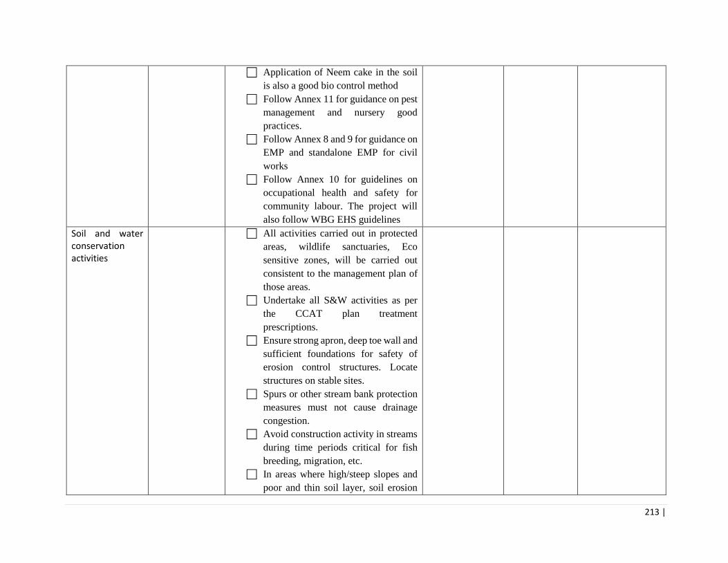
213 |
Application of Neem cake in the soil
is also a good bio control method
Follow Annex 11 for guidance on pest
management and nursery good
practices.
Follow Annex 8 and 9 for guidance on
EMP and standalone EMP for civil
works
Follow Annex 10 for guidelines on
occupational health and safety for
community labour. The project will
also follow WBG EHS guidelines
Soil and water conservation activities
All activities carried out in protected
areas, wildlife sanctuaries, Eco
sensitive zones, will be carried out
consistent to the management plan of
those areas.
Undertake all S&W activities as per
the CCAT plan treatment
prescriptions.
Ensure strong apron, deep toe wall and
sufficient foundations for safety of
erosion control structures. Locate
structures on stable sites.
Spurs or other stream bank protection
measures must not cause drainage
congestion.
Avoid construction activity in streams
during time periods critical for fish
breeding, migration, etc.
In areas where high/steep slopes and
poor and thin soil layer, soil erosion
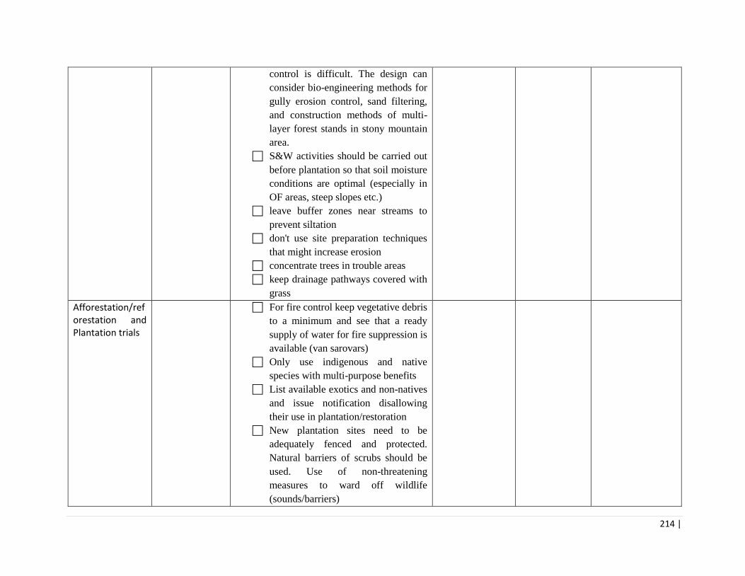
214 |
control is difficult. The design can
consider bio-engineering methods for
gully erosion control, sand filtering,
and construction methods of multi-
layer forest stands in stony mountain
area.
S&W activities should be carried out
before plantation so that soil moisture
conditions are optimal (especially in
OF areas, steep slopes etc.)
leave buffer zones near streams to
prevent siltation
don't use site preparation techniques
that might increase erosion
concentrate trees in trouble areas
keep drainage pathways covered with
grass
Afforestation/reforestation and Plantation trials
For fire control keep vegetative debris
to a minimum and see that a ready
supply of water for fire suppression is
available (van sarovars)
Only use indigenous and native
species with multi-purpose benefits
List available exotics and non-natives
and issue notification disallowing
their use in plantation/restoration
New plantation sites need to be
adequately fenced and protected.
Natural barriers of scrubs should be
used. Use of non-threatening
measures to ward off wildlife
(sounds/barriers)

215 |
JFMC experience in plantation - If
experienced planters are not available
provisions for training and supervision
should be made by forest department
so that quality of the plantation is not
compromised
Factors that should be considered
when selecting species include:
growth rate, site requirements,
climatic suitability, genetic
variability, wood properties,
aesthetics, wildlife value, biological
diversity, erosion control and potential
insect and disease problems.
Sites to be avoided when considering
seeding plantation are areas where
seeding has already failed. Avoid
sites prone to frost or frost heaving.
Avoid sites where grazing could
occur, and highly erodible soils or
steep slopes where young plants could
be washed away.
Always use seed of appropriate seed
sources that has been properly stored,
stratified, and treated.
Follow Annex 10 for guidelines on
occupational health and safety for
community labour. The project will
also follow WBG EHS guidelines
Follow Annex 11 on Pest
Management Plan for all pest control
activities

216 |
Building rehabilitation / General construction/ small scale civil works
Standalone EMP Case by case Environmental
Assessment by ES, PMU- use of EMP
checklist, and where required
preparation of Standalone EMP for
construction and operation. (format
provided in Annex 8 and 9)
Air Quality Any dust, shall be suppressed by
ongoing water spraying and/or
installing dust screen enclosures at site
The surrounding environment shall be
kept free of garbage and solid waste to
minimize dust.
There will be no open burning of
construction / waste material at the site
Noise Ensure compliance with prescribed
noise standards
Any drilling noise will be limited to
restricted times agreed to in the permit
Noise generating construction activity
will not be undertaken during night
Engine covers of generators, air
compressors and other powered
mechanical equipment shall be closed,
and equipment placed as far away
from any sensitive natural habitat or
nesting/ breeding sites areas.
Water Quality The site will establish appropriate
erosion and sediment control
measures such as e.g. hay bales and /
or silt fences to prevent sediment from
moving off site and causing excessive
turbidity in nearby water runoffs
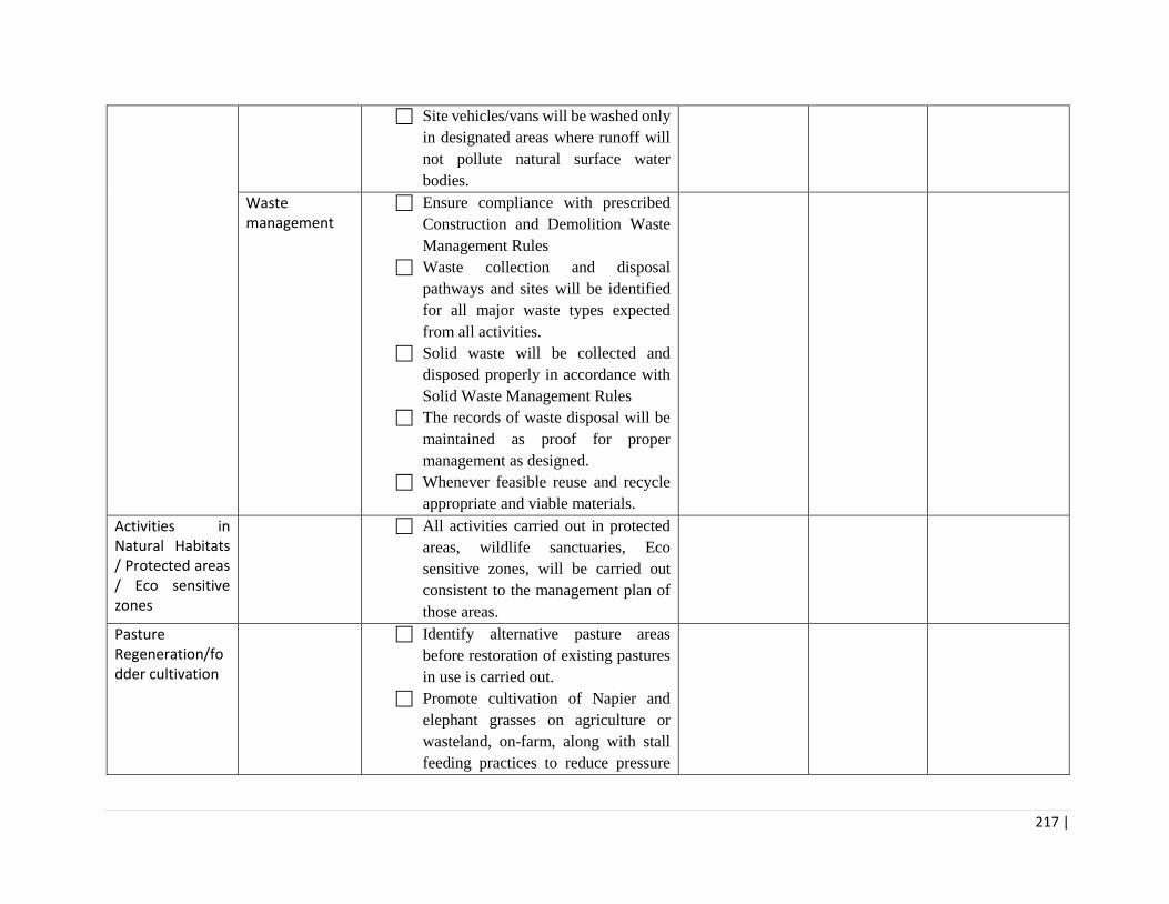
217 |
Site vehicles/vans will be washed only
in designated areas where runoff will
not pollute natural surface water
bodies.
Waste management
Ensure compliance with prescribed
Construction and Demolition Waste
Management Rules
Waste collection and disposal
pathways and sites will be identified
for all major waste types expected
from all activities.
Solid waste will be collected and
disposed properly in accordance with
Solid Waste Management Rules
The records of waste disposal will be
maintained as proof for proper
management as designed.
Whenever feasible reuse and recycle
appropriate and viable materials.
Activities in Natural Habitats / Protected areas / Eco sensitive zones
All activities carried out in protected
areas, wildlife sanctuaries, Eco
sensitive zones, will be carried out
consistent to the management plan of
those areas.
Pasture Regeneration/fodder cultivation
Identify alternative pasture areas
before restoration of existing pastures
in use is carried out.
Promote cultivation of Napier and
elephant grasses on agriculture or
wasteland, on-farm, along with stall
feeding practices to reduce pressure

218 |
on forests and pastures, sensitive
areas.
Efficiency in the use of fodder can be
enhanced through a number of
technological and management
options like chopping, grinding,
wetting and soaking of fodder and
enrichment of crop residues mineral
supplements to dry fodder. This will
not only result in efficient use of
available fodder but also improve its
nutritional value.
Similarly, there are large areas of
common pastureland, which can be
used for cultivation of fodder trees and
grasses in Himachal Pradesh.
Shift from the present methods of ‘one
time removal of weeds’ to ‘complete
rehabilitation’ of the treated areas.
In view of their environmental/
ecological concerns, the rehabilitation
measures will not employ any
chemicals methods of exotic weed
control.
The natural regeneration of
indigenous plant species on treated
sites should be encouraged and
facilitated to establish towards better
environmental and ecological
services, including fodder, fuel, water
recharge, etc.
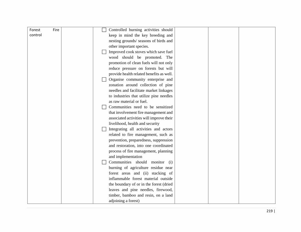
219 |
Forest Fire control
Controlled burning activities should
keep in mind the key breeding and
nesting grounds/ seasons of birds and
other important species.
Improved cook stoves which save fuel
wood should be promoted. The
promotion of clean fuels will not only
reduce pressure on forests but will
provide health related benefits as well.
Organise community enterprise and
zonation around collection of pine
needles and facilitate market linkages
to industries that utilize pine needles
as raw material or fuel.
Communities need to be sensitized
that involvement fire management and
associated activities will improve their
livelihood, health and security
Integrating all activities and actors
related to fire management, such as
prevention, preparedness, suppression
and restoration, into one coordinated
process of fire management, planning
and implementation
Communities should monitor (i)
burning of agriculture residue near
forest areas and (ii) stacking of
inflammable forest material outside
the boundary of or in the forest (dried
leaves and pine needles, firewood,
timber, bamboo and resin, on a land
adjoining a forest)

220 |
Vehicles supported under this
component should comply with PUC
standards. fire-fighting vehicles
should be placed at designated parking
lots or existing garages/sheds.
Standard environmental safety
requirements such as safe storage of
fuel, other substances for fire fighting
vehicles should be applied.
The project can also consider
vegetative firebreak to protect
habitations- it is a management
practice that is designed to create a
fuel break (herbaceous and woody
vegetation) are used to break up the
flammable fuels. By using a
combination of short grasses
Ensure that construction of Van
Sarovars is per approved design that
integrates all safety considerations
(such as fencing, appropriate side
slope, etc.)
Follow Annex 8 for guidance on EMP
checklist and standalone EMP for civil
works
Follow Annex 10 for guidelines on
occupational health and safety for
community labour. The project will
also follow WBG EHS guidelines
NTFP Collection and Harvesting
Impart training to communities on
how to collect harvest MAPs and

221 |
NTFPs so its regeneration capacity is
maintained
HPFD needs to ensure steady supply
of seeds to the NTFP and MAPs
nurseries so that the pressure of
harvesting from the wild is reduced.
A two-pronged strategy needs to be
adopted with the conservation of wild
gene pool and promoting agro
techniques of cultivable medicinal
plants.
NTFP value chain set-up
Ensure that processing and cold
storage facilities have Consent for
Establishment and Consenet for
Operation from the State Pollution
Control Board, as required
Minimize inventory storage time for
raw materials to reduce losses from
putrefication.
Consider use of enclosure techniques
to minimize damage to raw materials
stored/ dried outdoors;
Monitor and optimize process yields,
e.g. during manual grading or cutting
activities, and encourage the most
productive employees to train others
in efficient processing.
Clean, sort, and grade raw NTFPs,
MAPs where possible at an early stage
(e.g. at the harvest site), to reduce
organic waste and at the processing
facility
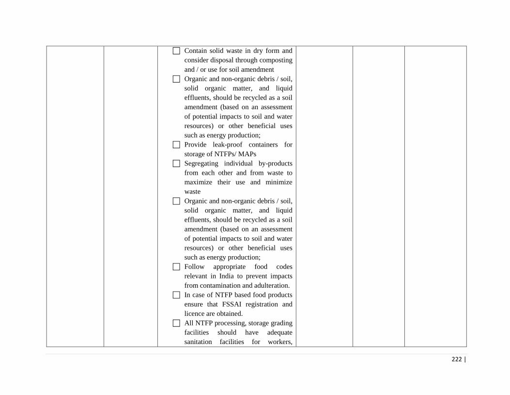
222 |
Contain solid waste in dry form and
consider disposal through composting
and / or use for soil amendment
Organic and non-organic debris / soil,
solid organic matter, and liquid
effluents, should be recycled as a soil
amendment (based on an assessment
of potential impacts to soil and water
resources) or other beneficial uses
such as energy production;
Provide leak-proof containers for
storage of NTFPs/ MAPs
Segregating individual by-products
from each other and from waste to
maximize their use and minimize
waste
Organic and non-organic debris / soil,
solid organic matter, and liquid
effluents, should be recycled as a soil
amendment (based on an assessment
of potential impacts to soil and water
resources) or other beneficial uses
such as energy production;
Follow appropriate food codes
relevant in India to prevent impacts
from contamination and adulteration.
In case of NTFP based food products
ensure that FSSAI registration and
licence are obtained.
All NTFP processing, storage grading
facilities should have adequate
sanitation facilities for workers,

223 |
appropriate pest control (no
procurement of banned pesticides and
WHO class I & II pesticides and safe
water quality.
Follow Annex 8 for guidance on EMP
checklist and standalone EMP for civil
works
Follow Annex 10 for guidelines on
occupational health and safety for
community labour. The project will
also follow WBG EHS guidelines
EMP prepared covering all project supported activities by: Name: __________________ Designation: __________________ Date: __________________ EMP checked for adequacy in removing/minimizing negative environmental impacts of project activities by: Name: __________________ Designation: __________________ Date: __________________

224 |
Annexure 9: Environmental Management Plan for Small Civil Works – A Model Format
A model format to be used for activities involving Buildings and Value Chain infrastructure
Part 1: EMP for Construction Phase of Civil Works
Environmental Aspect
Impact Mitigation Measure Responsibility for Implementation
Applicability
Site Selection Improper location can have multiple impacts on sustainability, biodiversity, disaster proofing, etc.
The site selected for the activity will not be in areas that are: wildlife conflict areas, waste dumpsites, highly polluted/ contaminated land or water areas, natural drainage courses, areas prone to floods. The site selected for the activity will not be in high conservation value sites (fish spawning sites, bird nesting and roosting sites, etc.) or culturally significant sites (sacred groves, monuments, etc.).
HP FD Oversight by Junior Engineer and Forest Ranger of the circle
Applicable Not Applicable If Applicable, include in Construction Design Document and Contract Clauses
Legal and Regulatory Compliance
Activities that do not comply with the relevant laws and regulations cannot be supported under the project.
Refer to the Screening Checklist and confirm the following: The proposed construction is not on the ‘list of ineligible activities’ given in Part 2 of the Screening Checklist. The proposed construction complies with the legal and regulatory requirements including those listed in Part 3 of the Screening Checklist.
HP FD Oversight by District Technical Specialist and Forest Ranger of the circle
Applicable Not Applicable If Applicable, include in Construction Contract Clauses
Felling of trees and clearing of vegetation
Loss of green cover including trees
Compensatory plantation will be undertaken in accordance with the conditions prescribed in the tree felling permission. Not less than 5 trees of diverse, local species will be planted for every tree that is felled.
HP FD Oversight by District Technical Specialist and Forest Ranger of the circle
Applicable Not Applicable If Applicable, include in Construction Contract Clauses

225 |
Provision for tree guard and not less than 5 years of plantation aftercare will be provisioned.
Construction materials
Unregulated quarrying can result in over-extraction, impact on natural drainage, soil erosion, loss of aesthetic appeal of the land scape, etc.
All construction material including sand, stone, brick, timber, etc., will be sourced from authorized quarries/sources. All borrow pits will be suitably rehabilitated.
HP FD Oversight by District Technical Specialist and Forest Ranger of the circle
Applicable Not Applicable If Applicable, include in Construction Contract Clauses
Pits and boreholes
Risk of falls into unsecured pits, boreholes, etc.
All boreholes will be properly secured in accordance with the Supreme Court guidelines20. All pits (including borrow pits) will be properly secured and will not exceed 2 meters in depth.
HP FD Oversight by District Technical Specialist and Forest Ranger of the circle
Applicable Not Applicable If Applicable, include in Construction Contract Clauses
Health & Safety Risk of accidents at worksite.
Cautionary signage and protective barriers will be used to warn public and prevent unauthorized access. All workers will be provided adequate PPE. The use of PPE at the construction site will be mandatory. A fully-provisioned first-aid box will be available at the construction site. An accident register will be maintained at the construction site.
HP FD Oversight by District Technical Specialist and Forest Ranger of the circle
Applicable Not Applicable If Applicable, include in Construction Contract Clauses
Air Quality Dust emissions from excavation. Emissions from vehicles and machinery, dust,
All vehicles will have a valid Pollution Under Control certification. All generator sets (diesel, petrol, kerosene, LPG, CNG) will meet the ‘CPCB noise
HP FD Oversight by District Technical Specialist and Forest Ranger of the circle
Applicable Not Applicable If Applicable, include in
20 Refer to: http://www.cgwb.gov.in/CGWA/Documents/Guidelines%20Supreme%20Court%20fatal%20Accident.pdf

226 |
etc., may lead to air pollution. High noise levels from construction activities may lead to noise pollution.
and emission control standards for Generator Sets’. Noise generating activities and machinery will meet the CPCB prescribed ‘Ambient Air Quality Standards in Respect of Noise’. Construction activity will be restricted to daylight hours.
Construction Contract Clauses
Water Quality Runoff and release of untreated wastewater may pollute nearby water bodies.
Release of waste water into water bodies, streams, etc., without any treatment will be avoided. All waste water will meet the ‘CPCB General Standards’ prior to disposal.
HP FD Oversight by District Technical Specialist and Forest Ranger of the circle
Applicable Not Applicable If Applicable, include in Construction Contract Clauses
Waste Management
Pollution and health impacts due to improper disposal of wastes such as open dumping, burning, unauthorized recycling, etc.
Dispose biodegradable and non-biodegradable wastes, including wastes from construction activity and labour camp, in a manner and at locations specified by the local government body. All construction and demolition waste will be cleared from the site and disposed at authorized locations in accordance with the Construction and Demolition Waste Management Rules, 201621. Any hazardous waste generated during construction/demolition activity will be handled in accordance with the Hazardous Waste Management Rules, 201622.
HP FD Oversight by District Technical Specialist and Forest Ranger of the circle
Applicable Not Applicable If Applicable, include in Construction Contract Clauses
Physical Cultural Resources
Loss of cultural artifacts.
In case of chance finds of archaeological significance (such as coins, utensils,
HP FD Oversight by District Technical
Applicable Not Applicable
21 Refer to: http://www.moef.gov.in/sites/default/files/C%20&D%20rules%202016.pdf
22 Refer to: http://www.moef.gov.in/sites/default/files/Final%20HWM%20Rules%202016%20(English)_0.pdf

227 |
artefacts, structures, etc.) are found during the excavation works, the Department of Archeology will be notified immediatly and further work will be stopped until directions are issued by the Department of Archeology.
Specialist and Forest Ranger of the circle
If Applicable, include in Construction Contract Clauses
Human Resource Capacity of contractor/ labour
Poor capacity for environmental management.
Capacity building activities through orientation, training and use of IEC (information, education, communication) for construction contractors, labour, etc. Development and implementation of ‘Code of Conduct for Workers’ (refer to Part 3 of EMP)
HP FD Oversight by District Technical Specialist and Forest Ranger of the circle
Applicable, include in Construction Contract Clauses
Compliance Monitoring
Weak compliance of the environmental management plan will lead to aggravated impacts and undermine sustainability.
Periodic monitoring and reporting (quarterly) on implementation of the EMP.
HP FD Environment Specialist In accordance with the M&E system of the project.
Applicable.
Note: Ensure that the activity budget provides adequate finances for implementation of the mitigation
measures identified in the EMP.

228 |
Part 2: EMP for Operation Phase of Civil Works
Environmental Aspect
Impact Mitigation Measure Responsibility for Implementation
Air and Water Pollution
Air and water pollution from NTFP/MAP processing units
All equipment installed will comply with Air quality standards prescribed by CPCB. In case waste water is being discharged from the processing units, it will comply with CPCB General Standards for Discahrge fo Environmental Pollutants.
Environment Specialist in the PMU. Division Level Nodal Officer
Health & Safety Equipment, machinery, vehicles, etc., that do not comply with relevant safety and environmental standards may pose risk to human and environmental health and safety.
All procured equipment and machinery will comply with relevant BIS standards. All vehicles (carriers, reefer vans, etc.) will comply with the relevant Bharat Stage (BS) emission norms.
Environment Specialist in the PMU. Division Level nodal officer
Risk of accidents (use of agri-machinery in the processing unit, etc.). .
Safety instructions will be provided to users of agri-machinery in the local language. Adequate PPE will be provided to users of agri-machinery and workers in processing units. The use of PPE will be mandatory. A fully-provisioned first-aid box will be available at the processing unit. Adequate number of functional fire extinguishers will be available at the processing units and warehouses. An accident register will be maintained at the processing unit.
Risk of use of hazardous chemicals.
Un-authorized chemical ripening agents (e.g., calcium carbide) will not be used.
Pest Management
Risk to human and environmental health from use of hazardous pesticides, and from improper use of pesticides.
Pest management in godowns, warehouses, etc., will be as per the Pest Management Plan (Refer to ‘Annexure 6: Pest Management Plan’).
Environment Specialist in the PMU. Division Level nodal officer
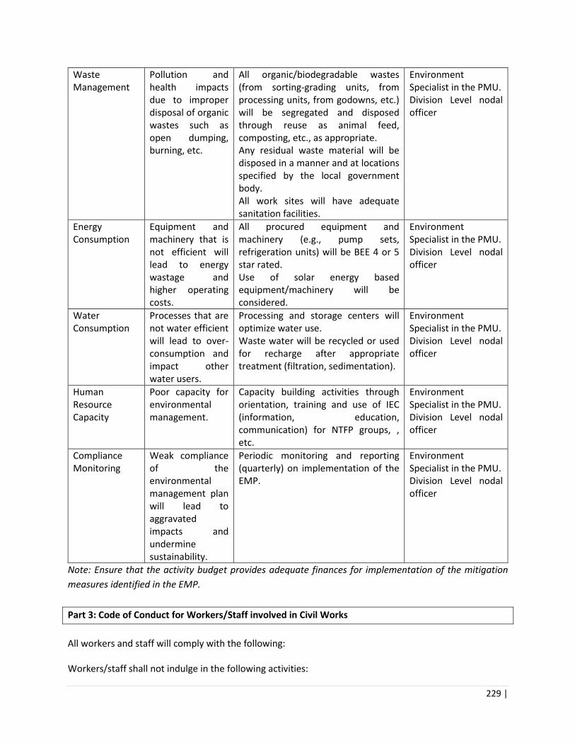
229 |
Waste Management
Pollution and health impacts due to improper disposal of organic wastes such as open dumping, burning, etc.
All organic/biodegradable wastes (from sorting-grading units, from processing units, from godowns, etc.) will be segregated and disposed through reuse as animal feed, composting, etc., as appropriate. Any residual waste material will be disposed in a manner and at locations specified by the local government body. All work sites will have adequate sanitation facilities.
Environment Specialist in the PMU. Division Level nodal officer
Energy Consumption
Equipment and machinery that is not efficient will lead to energy wastage and higher operating costs.
All procured equipment and machinery (e.g., pump sets, refrigeration units) will be BEE 4 or 5 star rated. Use of solar energy based equipment/machinery will be considered.
Environment Specialist in the PMU. Division Level nodal officer
Water Consumption
Processes that are not water efficient will lead to over-consumption and impact other water users.
Processing and storage centers will optimize water use. Waste water will be recycled or used for recharge after appropriate treatment (filtration, sedimentation).
Environment Specialist in the PMU. Division Level nodal officer
Human Resource Capacity
Poor capacity for environmental management.
Capacity building activities through orientation, training and use of IEC (information, education, communication) for NTFP groups, , etc.
Environment Specialist in the PMU. Division Level nodal officer
Compliance Monitoring
Weak compliance of the environmental management plan will lead to aggravated impacts and undermine sustainability.
Periodic monitoring and reporting (quarterly) on implementation of the EMP.
Environment Specialist in the PMU. Division Level nodal officer
Note: Ensure that the activity budget provides adequate finances for implementation of the mitigation
measures identified in the EMP.
Part 3: Code of Conduct for Workers/Staff involved in Civil Works
All workers and staff will comply with the following: Workers/staff shall not indulge in the following activities:

230 |
• Kindling of fire in the forest.
• Unauthorized storage of inflammable substances in labour camp or work site.
• Harm or disturbance to any wild animal or plant.
• Harm or disturbance to any culturally significant site.
• Unauthorized digging, removal of stones, removal of timber, etc., in the forest.
• Unauthorized use of pesticides or other chemcials in labour camp or work site.
• Unauthorized disposal of solid or liquid wastes in or near forests, water bodies, streams, etc.
Illicit or criminal activities including sexual harassment of women or children. Workers/staff shall implement the following activities:
• Use of all prescribed personal protective equipment while working.
• Compliance with the measures specified in the Environmental Management Plan.

231 |
Annexure 10: Occupational Health and Safety Guidelines for Forestry Operations
Risk Target Group Guidelines
Pesticide Application
Nursery Managers Forest Guards
If pesticide application is warranted, forest nursery managers should follow PMP in Annex 6, and take the following precautions to reduce the likelihood of environmental impacts: Apply pesticides based on criteria such as field observations of the target pest, weather data, time of treatment, and dosage, and maintain a pesticide logbook to record such information. Avoid the use of pesticides that fall under the World Health Organization Recommended Classification of Pesticides by Hazard Classes 1a and 1b and 2.
Forest staff Quarters/ Accommodation and Welfare
Forest Guards Forest Rangers Nursery Managers
Forest workers may live in camps in remote areas, which should meet certain minimum standards of sanitation, comfort and services, and an adequate supply of safe drinking water. Biological hazards include allergic reactions to plants, pollen, wood products and insect bites, as well as snakebite and diseases that can be contracted from, for example, mosquitos and ticks. The risks posed by many biological hazards can be reduced through adequate training, effective management (e.g. by reducing mosquito breeding grounds near accommodation and the use of mosquito nets and first aid kits)
Machinery and vehicles
Nursery Van Drivers Forest guards/ rangers (fire management. NTFP groups
Machinery and Vehicles Accidents may occur about the use of machines and vehicles, including tractors and harvesting machinery, and during the transport of workers along poorly maintained roads. Occupational safety and health impacts and controls relating to equipment and vehicle operation and repair are discussed in the WBG General EHS Guidelines. All vehicles used should follow provisions in Central Motor Vehicles Act. All drivers should be suitably trained
Isolated workers Forest Guards Forest Rangers NTFP collectors/ SHG groups
The collection of the herbs from the alpine pastures and distant forests is a specialized task undertaken by physically stronger and young members. It is a tough journey home with the heavy load of the collected herbs. Collection of forest products in remote locations may expose individuals to range of biological hazards as well as to extreme weather and accidents in hilly and remote terrain. Forestry operations may necessitate that workers are isolated and out of communication with a other workers, or other persons capable of providing aid and assistance. The worker is therefore at increased risk should an accident or injury occur. Recommendations to manage situations where workers are isolated are discussed in the WBG General EHS Guidelines which are referred to as part of the project framework and will be followed.
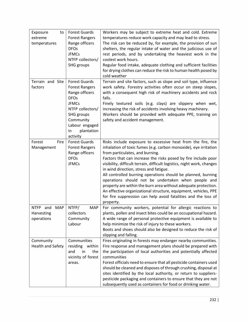
232 |
Exposure to extreme temperatures
Forest Guards Forest Rangers Range officers DFOs JFMCs NTFP collectors/ SHG groups
Workers may be subject to extreme heat and cold. Extreme temperatures reduce work capacity and may lead to stress. The risk can be reduced by, for example, the provision of sun shelters, the regular intake of water and the judicious use of rest periods, and by undertaking the heaviest work in the coolest work hours. Regular food intake, adequate clothing and sufficient facilities for drying clothes can reduce the risk to human health posed by cold weather
Terrain and Site factors
Forest Guards Forest Rangers Range officers DFOs JFMCs NTFP collectors/ SHG groups Community Labour engaged in plantation activity
Terrain and site factors, such as slope and soil type, influence work safety. Forestry activities often occur on steep slopes, with a consequent high risk of machinery accidents and rock falls. Finely textured soils (e.g. clays) are slippery when wet, increasing the risk of accidents involving heavy machinery. Workers should be provided with adequate PPE, training on safety and accident management.
Forest Fire Management
Forest Guards Forest Rangers Range officers DFOs JFMCs
Risks include exposure to excessive heat from the fire, the inhalation of toxic fumes (e.g. carbon monoxide), eye irritation from particulates, and burning. Factors that can increase the risks posed by fire include poor visibility, difficult terrain, difficult logistics, night work, changes in wind direction, stress and fatigue. All controlled burning operations should be planned, burning operations should not be undertaken when people and property are within the burn area without adequate protection. An effective organizational structure, equipment, vehicles, PPE for fire suppression can help avoid fatalities and the loss of property.
NTFP and MAP Harvesting operations
NTFP/ MAP collectors Community Labour
For community workers, potential for allergic reactions to plants, pollen and insect bites could be an occupational hazard. A wide range of personal protective equipment is available to help minimize the risk of injury to these workers. Boots and shoes should also be designed to reduce the risk of slipping and falling.
Community Health and Safety
Communities residing within and in the vicinity of forest areas.
Fires originating in forests may endanger nearby communities. Fire response and management plans should be prepared with the participation of local authorities and potentially affected communities Forest officials need to ensure that all pesticide containers used should be cleaned and disposes of through crushing, disposal at sites identified by the local authority, or return to suppliers- pesticide packaging and containers to ensure that they are not subsequently used as containers for food or drinking water.

233 |

234 |
Annexure 11: Pest Management Plan for Forest Nurseries
Table ___: Typical Pests and Bio Control
Pest Control Methods
White grub Metarhyzium anisopliae - (Bio Pesticide)
Cutworms Metarhyzium anisopliae (Bio Pesticide)
Termites Metarhyzium anisopliae, Beauveria bassiana (Bio Pesticide)
Crickets and Grasshoppers
Beauveria bassiana, Trichogramma chilonis (Bio Pesticide) Application of Malathion (0.25%) water emulsion spray is also effective in controlling the pests.
Defoliators Trichogramma chilonis (Bio Pesticide)
Table __: Typical Diseases and their Control
Diseases Control Methods Application
Damping-off (pre-and post-emergence)
Improve soil drainage by leveling soil, by installing subsurface drainage tiles, and by adjusting the frequency of irrigation. Irrigation must also be carefully controlled in container nurseries. Minimize exposure of seeds to soil pathogens by delaying sowing until the soil temperature has risen to near optimum for rapid seed germination.
Trichoderma Viride or Trichoderma harzianum (bio fungicide -It is used for seed and soil treatment for suppression of various diseases caused by fungal pathogens) Systemic infection can be controlled by dip treatment of seeds in 0.1% water solution of Emisan (bio-pesticide) for 15 minutes and keeping the seeds for 24 hours before sowing. Pre-emergence damping off can be controlled by treatment of seeds with slurry of 140 gm of Captan in one liter of water.
Collar rot Fungi which cause damping-off can also be responsible for root and collar rot.
Application of Trichoderma Viride (bio fungicide). The options available for the control of root and collar rot are the same as those described for "Damping-off".
Root rot Root rot differs from damping-off in that it attacks the root tips of older seedlings.
Trichoderma Viride (bio- fungicide) The options available for the control of root and collar rot are the same as those described for "Damping-off". Fusarium root rot diseases are controlled by drenching the soil with 0.2 % water suspension of Captan. Rhizoctonia root rot is controlled by drenching the soil with 0.2% solution of Brassicol.
Foliage diseases Foliage pathogens are controlled by spray of 0.2% water solution of Bavistin.

235 |
Table __: Pest Control Strategies for Key Forest Species
Species Key pests/ diseases and prescribed chemical treatment
Bio Control and Chemical Agents to be used in HPFD
Pinus roxburghii (Chir Pine / Chil)
Mostly cut worms and grubs do considerable damage to the growth of nursery seedlings Mostly species of Pythium, Phytophthora, Fusarium and Rhizoctonia cause damping off in the nursery seedlings before or after emergence from the soil. Cryptothelia crameri a defoliator of Pinus roxburghii
Metarhyzium anisopliae (Bio Pesticide) & Trichoderma Viride (biofungicide) Nursery fumigation with 5 per cent Formalin/Methyl bromide, 15 to 20 days prior to sowing and soil drenching with Carbendazin (0.1%) should be done when initial disease symptoms appears.
Cedrus deodara (Deodar / Himalayan cedar)
Damping off due to poor drainage in nursery often results in huge mortality of deodar seedlings.
Metarhyzium anisopliae (Bio Pesticide) & Trichoderma Viride (biofungicide) For damping off drenching with Indofil23 M-45 (0.25%) or Bavistin24 (0.1%) is recommended.
Pinus gerardiana (Neoza / Chilgoza)
Damping off of young seedlings in nursery
Use of Trichoderma Viride (biofungicide) In nursery bed. Application of neem cake and FYM before treatment increases the efficacy of treatment. Damping off of young seedlings in nursery can be avoided by drenching the polybag soil with Bavistin (0.1%).
Quercus leucotrichophora (Ban oak)
Caterpillars of Indian gypsy moth (Lymantria obfuscata) defoliate the trees.
Beauveria bassiana, Trichogramma chilonis (Bio Pesticides)
Table __: Good Nursery Management Practices Effective for Control of Pests
Phase/ Frequency Practices/ Guidelines
Seed Selection and Sowing
Nursery sites should be on south and south west in the higher hills (beyond 1500 m) and in the eastern and south eastern aspects in the lower hills. Local collection of seeds should be verified from selected plus trees.
23 Indofil (Mancozeb)- Technical grade active ingredients of pesticides unlikely to present acute hazard in normal use. 24 Bavistin contains 500 g/kg carbendazim in the form of a water dispersible granule. Carbendazim- Technical grade
active ingredients of pesticides unlikely to present acute hazard in normal use.
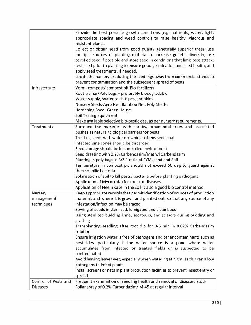
236 |
Provide the best possible growth conditions (e.g. nutrients, water, light, appropriate spacing and weed control) to raise healthy, vigorous and resistant plants. Collect or obtain seed from good quality genetically superior trees; use multiple sources of planting material to increase genetic diversity; use certified seed if possible and store seed in conditions that limit pest attack; test seed prior to planting to ensure good germination and seed health; and apply seed treatments, if needed. Locate the nursery producing the seedlings away from commercial stands to prevent contamination and the subsequent spread of pests
Infrastcrture Vermi-compost/ compost pit(Bio-fertilizer) Root trainer/Poly bags – preferably biodegradable Water supply, Water tank, Pipes, sprinkles. Nursery Sheds-Agro Net, Bamboo Net, Poly Sheds. Hardening Shed- Green House. Soil Testing equipment Make available selective bio-pesticides, as per nursery requirements.
Treatments Surround the nurseries with shrubs, ornamental trees and associated bushes as natural/biological barriers for pests Treating seeds with water drowning softens seed coat Infected pine cones should be discarded Seed storage should be in controlled environment Seed dressing with 0.2% Carbendazim/Methyl Carbendazim Planting in poly bags in 3:2:1 ratio of FYM, sand and Soil Temperature in compost pit should not exceed 50 deg to guard against thermophilic bacteria Solarization of soil to kill pests/ bacteria before planting pathogens. Application of Mycorrhiza for root rot diseases Application of Neem cake in the soil is also a good bio control method
Nursery management techniques
Keep appropriate records that permit identification of sources of production material, and where it is grown and planted out, so that any source of any infestation/infection may be traced. Sowing of seeds in sterilized/fumigated and clean beds Using sterilized budding knife, secateurs, and scissors during budding and grafting Transplanting seedling after root dip for 3-5 min in 0.02% Carbendazim solution Ensure irrigation water is free of pathogens and other contaminants such as pesticides, particularly if the water source is a pond where water accumulates from infected or treated fields or is suspected to be contaminated. Avoid leaving leaves wet, especially when watering at night, as this can allow pathogens to infect plants. Install screens or nets in plant production facilities to prevent insect entry or spread.
Control of Pests and Diseases
Frequent examination of seedling health and removal of diseased stock Foliar spray of 0.2% Carbendazim/ M-45 at regular interval

237 |
Nursery managers should notify the Forest Department or other appropriate officials if an unknown, important or regulated pest is found In affected areas, entry of animals and birds, which may spread pests, should be prevented Clean (thoroughly remove all soil and plant materials from all surfaces, disinfect all tools, footwear and equipment before entering and before leaving the nursery area, especially if a pest is present. Dispose of infested soil or growing media carefully so as not to contaminate new plants or soil Collect and remove dead plants and debris every week to decrease the probability of infestation Destroy or sanitize infested plant waste by composting or treating with heat to kill the pest. If composting, make sure that a high enough temperature is reached to kill the pest. Use deep burial (2 m) to dispose of plant waste that cannot be destroyed or sanitized.
Reduce mortality To reduce the mortality one of the nursery methods adopted is to harden the seedlings before lifting them. Hardening consists gradual reduction of watering (say, to once in 4 days) for the last two months of the seedlings life in the nursery and shoot and or side branch pruning, keeping one-third of crown intact. Grading and Culling before transfer to the field so less developed ones can be given extra attention through larger dose of fertilizer to bring them up to the desired specification. Seedlings that do not come up to the acceptable standard and should be rejected/culled at the nursery stage.
Table __: List of Pesticides Banned by the Government of India
Hyperlink to be added
Table __: WHO Classification of Pesticides by Hazard
Hyperlink to be added

238 |
Annexure 12: Baseline of Rupi Bhabha WLS
Rupi Bhaba Wildlife Sanctuary lies in Nichar subdivision of Kinnaur district, Himachal Pradesh along the
Upper Sutlej Valley, spreading between 31° 35' and 31° 45' N and 77° 49' and 78° 07' E. The main forest
types are deodar (2300-2600m), oak-pine forests (2400- 2600m), fir-spruce-blue pine dominant mixed
coniferous forests between 2400-3200, moist temperate broad leaved forests (2300-2800m), and sub-
alpine birch-fir forests (3000m and below tree line).
The sanctuary is known for several streams and rivers which cut through it, as well as it’s alpine pastures
above 3500m, where thousands of livestock are taken for grazing every summer. In particular, Phuphal
Ghad areas and alpine pastures of Upper Bhaba Valley that connect to Pin Valley in the north are notable
sites for the nomadic shepherds putting huge pressure on the fragile alpine ecosystem, with carrying
capacity under severe stress.
Local communities are dependent on the Sanctuary for a variety of resources, such as medicinal herbs,
particularly dhup (Jurinea macrocephalla), karu (Gentiana kurroo), mohra or patish (Aconitum
heterophyllum), and kuth (Saussurea lappa). Gucchi (Morchella esculenta) a commercially valuable fungus
is grown on the forest floor during monsoon is also a valuable commercial resource. The PA also supports
ecotourism activities such as trekking through the mountain-passes that connect the Sanctuary to
neighbouring parts of Great Himalayan National Park. Though seasonal fires are a major management
issue in Rupi Bhaba Sanctuary, there are no fire-lines in the Sanctuary. There are only two watchtowers,
and no trained fire-fighting squad in its field staff. During forest fires, Forest Rangers an Beat Guards would
gather workforce locally to fight the fires.
Some of the dominant and characteristic temperate woody plants are listed in the following table along
with their distribution in Rupi Bhaba Sanctuary (Jishtu, 2007).
Table 1: List of Trees

239 |
Table 2: List of Pastures
Table 3: List of Mammals

240 |
Table 4: List of Birds & Insects

241 |

242 |
Annexure 13: Majathal WLS Baseline
Majathal Wildlife Sanctuary is named after one of its major Demarcated Protected Forest viz. Majathal
DPF. Apart from DPF Majathal, the area of the Sanctuary also includes Harsang Baghal Demarcated
Protected Forest of Baghal area and Harsang Bhajji Demarcated Protected Forest of Bhajji area alongwith
numerous small UPFs. Major Part of the Sanctuary falls in Arki -Sub Division of Solan District and remaining
part falls under Shimla Rural Sub- Division (Sunni Tehsil) of Shimla District.The location co-ordinates and
altitudinal range are as under. The total area of the sanctuary is 37.71 Sq Km which includes privately
owned ghasnis also.
Latitude: 31°-15'-00" to 31°-18''-45" North
Longitude: 76°-56'-45" to 77°-02' -18" East
Altitude Range: 575 to 1975 m
Forests and Vegetation
The sanctuary has a subtropical monsoon climate. Himalayan Chir Pine (Pinus roxburghii), Ban Oak
(Quercus leucotrichophora) forests and sub tropical Euphorbia scrub are the major vegetation types
(Champion and Seth, 1968). The slopes are sparsely forested with Chir Pine and Ban Oak, and mostly
dominated by grassy tracts, often extending continuously from the ridge-tops down to about 1,000 m
(Garson 1983). The sanctuary has rich flora and fauna. Deodar is the dominant species of Harsang Baghal
and DPF Majathal. Other species include Ban-oak, Kail, Chir, Kainth, Khair, Kachnar, Daroo, Paja, Shisham,
Sanan, Jamun, Tor, Fegra, Amaltas, Trimble, Mango, and Bihul etc. Shrubs include Berberis, Rosa, Rubus,
Karonda, Indigofera etc. Ground flora includes various grass species, variety of ferns and vascular herbs.
The whole area of the sanctuary has very good vegetation in the form of mixed forests, while the open
wasteland is covered with grass along with shrubs. Wild animals get enough food in the various types of
vegetation found in the sanctuary. The cultivated crops near the main habitat are also sometimes predated
by Sambar, Barking Deer and Gorals.
According to H.G. Champion and Seth’s classification, the following forest types are found with this
Sanctuary:
Type 5B/C2 Northern dry mixed deciduous forests
Type 9/C1 Himalayan Sub Tropical Pine forests
Sub Type 12/C1a Ban Oak Forests.
Key Features:
Local people do not have any rights over forest produce in the sanctuary. No NTFP is collected from the
sanctuary by villagers of the surrounding villages.
There are two nurseries in Kyari (0.15) and Bombely (0.2 ha)
Weeds pose a serious problem of fodder availability for herbivores. Weeds are removed physically. No
weedicide should be used since they adversely affect several food chains. Many spots are manifested with
Lantana while others have spread of Parthenium.
Sanctuary has 40 km long fire-lines. Fire watchers should be deployed during the fire season.

243 |
Table 1: List of Fire-incidences
Year Area Affected (ha) Location
2012-13 51 D-12 Harsang Baghal
1 UPF Pajina 30 D-12 C-6 Harsang Baghal
8 D-11 C-1&2 Majathal
2013-14 1749.50 D-11 Majathal, D-12 harsang Baghal, UPF- Kiari, Saryali,
D-13 Harsang Bhajji, UPF Chilla & Madrech
2016-17 528 UPF madrech and D-13 Harsang Bhajji, D-11 Majathal,D-
12 Harsang Baghal
Table2: Forest Classification of the Majathal Wildlife Sanctuary
Legal Status of the Area Area (Ha)
Reserved Forests 0
Demarcated Forests 2603.6
Undemarcated Protected Forests 1009.8
Govt. Shamlat 0
Private land (Ghasnis) 157.24
Total 3770.64
Table 3: List of Demarcated Table 4: Un-demarcated Protected
Forests
Sr.No. Name of Forest Area (ha)
1. D-11 Majathal 1491.60
2. D-12 Harsang Baghal 768
3. D-13 Haskar(Harsang Bhajji) 402
Total 2661.60
S. No. Name of Forest Area in hac
1. Sohra Brahmana 6.90
2. Kyari 160
3. Chilla 49
4. Mandrech 37
5. Darwakot 7
Total 259.90
Table 5: List of Flora found in Majhathal Wildlife Sanctuary
Sr. No. Botanical Name Common Name
1 Abies pindrow Rai
2 Acacia catechu Khair
3 Bauhinia variegata Kachnar
4 Bombex ceiba Semal
5 Cedrus deodara Deodar
6 Erythrina suberosa Koral
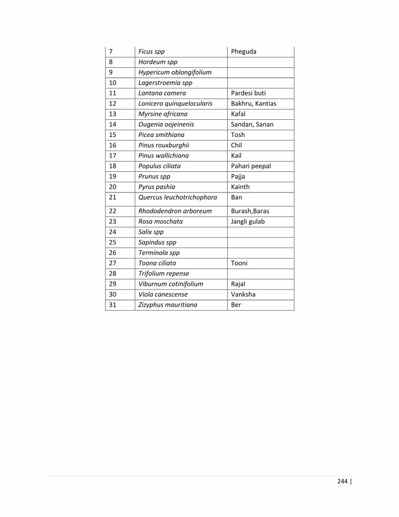
244 |
7 Ficus spp Pheguda
8 Hordeum spp
9 Hypericum oblongifolium
10 Lagerstroemia spp
11 Lantana camera Pardesi buti
12 Lonicera quinquelocularis Bakhru, Kantias
13 Myrsine africana Kafal
14 Ougenia oojeinenis Sandan, Sanan
15 Picea smithiana Tosh
16 Pinus rouxburghii Chil
17 Pinus wallichiana Kail
18 Populus ciliata Pahari peepal
19 Prunus spp Pajja
20 Pyrus pashia Kainth
21 Quercus leuchotrichophora Ban
22 Rhododendron arboreum Burash,Baras
23 Rosa moschata Jangli gulab
24 Salix spp
25 Sapindus spp
26 Terminala spp
27 Toona ciliata Tooni
28 Trifolium repense
29 Viburnum cotinifolium Rajal
30 Viola canescense Vanksha
31 Zizyphus mauritiana Ber

245 |
Table 6: List of Birds of Majhathal Wildlife Sanctuary
Sr No Scientific Name Common Name Family Status
1 Elanus caeruleus Black-shouldered Kite(Black-winged
Kite)
Accipitridae R
2 Milvus migrans Black Kite (Pariah Kite) Accipitridae R
3 Gypaetus barbatus Lammergeier Accipitridae R
4 Neophron percnopterus Egyptian Vulture Accipitridae R
5 Gyps bengalensis White-rumped Vulture (Indian
White-backed Vulture)
Accipitridae R
6 Gyps himalayensis Himalayan Griffon Vulture Accipitridae R
7 Sarcogyps calvus Red-headed Vulture (King Vulture) Accipitridae nT R
8 Circaetus gallicus Short - toed Snake Eagle Accipitridae R
9 Spilornis cheela Crested Serpent Eagle Accipitridae R
10 Spizaetus cirrhatus Changeable Hawk - Eagle Accipitridae R
11 Aegithalos concinnus Black-throated Tit (Red-headed Tit) Aegithalidae r
12 Tachymarptis melba Alpine Swift Apodidae R
13 Vanellus indicus Red-wattled Lapwing Charadriidae R
14 Prinia criniger Striated prinia (Brown Hill Warbler) Cisticolidae r
15 Columba livia Rock Pigeon (Blue Rock Pigeon) Columbidae R
16 Streptopelia orientalis Oriental Turtle Dove (Rufous Turtle) Columbidae RW
17 Streptopelia chinensis Spotted Dove Columbidae R
18 Streptopelia decaocto Eurasian Collared Dove (Indian Ring ) Columbidae R
19 Treron phoenicoptera Yellow-footed Green Pigeon
(Yellowlegged Green or Bengal)
Columbidae R
20 Garrulus lanceolatus Black-headed Jay Corvidae r
21 Urocissa erythrorhyncha Red-billed Blue Magpie Corvidae R
22 Dendrocitta vagabunda Rufous Treepie (Indian Treepie) Corvidae R
23 Dendrocitta formosae Grey Treepie (Himalayan Treepie) Corvidae r
24 Corvus splendens House Crow Corvidae R
25 Corvus macrorhynchos Large-billed Crow (Jungle Crow) Corvidae W
26 Pericrocotus flammeus Scarlet Minivet Corvidae R
27 Rhipidura hypoxantha Yellow-bellied Fantail (Flycatcher) Corvidae r
28 Rhipidura albicollis White-throated Fantail (Flycatcher) Corvidae R
29 Dicrurus macrocercus Black Drongo Corvidae R
30 Terpsiphone paradisi Asian Paradise- Flycatcher Corvidae R
31 Hierococcyx varius Common Hawk Cuckoo Cuculidae R
32 Cuculus micropterus Indian Cuckoo Cuculidae R
33 Cuculus canorus Cuckoo,Common Cuckoo Cuculidae r
34 Surniculus lugubris Drongo-Cuckoo Cuculidae r
35 Falco tinnunculus Common Kestrel Falconidae RW

246 |
36 Serinus pusillus Fire-fronted Serin (Gold-fronted
serin)
Fingillidae r
37 Cardueulis spinoides Yellow-breasted Greenfinch
(Himalayan Greenfinch)
Fingillidae r
38 Emberiza cia Rock Bunting Fingillidae r
39 Emberiza stewarti White-capped Bunting (Chestnut-
breasted Bunting)
Fingillidae rW
40 Halcyon smyrnensis White-throated Kingfisher
(Whitebreasted Kingfisher)
Halcyonidae R
41 Hirundo smithii Wire-tailed Swallow Hirundinidae R
42 Hirundo daurica Red-rumped Swallow Hirundinidae RW
43 Lanius schach Long-tailed Shrike (Rufous-backed) Laniidae R
44 Megalaima virens Great Barbet Megalaimida
e
r
45 Megalaima asiatica Blue-throated Barbet Megalaimida
e
R
46 Merops orientalis Green Bee-eater Meropidae R
47 Myophonus caeruleus Blue Whistling Thrush Muscicapida
e
R
48 Zoothera dauma Scaly Thrush (Smallbilled Mountain
Thrush)
Muscicapida
e
R
49 Turdus ruficollis Dark-throated Thrush Muscicapida
e
W
50 Ficedula strophiata Rufous-gorgeted Flycatcher Muscicapida
e
r
51 Eumyias thalassina Verditer Flycatcher Muscicapida
e
R
52 Culicicapa ceylonensis Grey-headed Canary Flycatcher Muscicapida
e
r
53 Tarsiger cyanurus Orange-flanked Bush Robin Muscicapida
e
r
54 Copsychus saularis Oriental Magpie- Robin Muscicapida
e
R
55 Saxicoloides fulicata Indian Robin Muscicapida
e
R
56 Phoenicurus
caeruleocephalus
Blue-capped Redstart (Blue-headed
Redstart)
Muscicapida
e
r
57 Chaimarrornis
leucocephalus
White-capped water Redstart Muscicapida
e
r
58 Rhyacornis fuliginosus Plumbeous Water Redstart Muscicapida
e
r
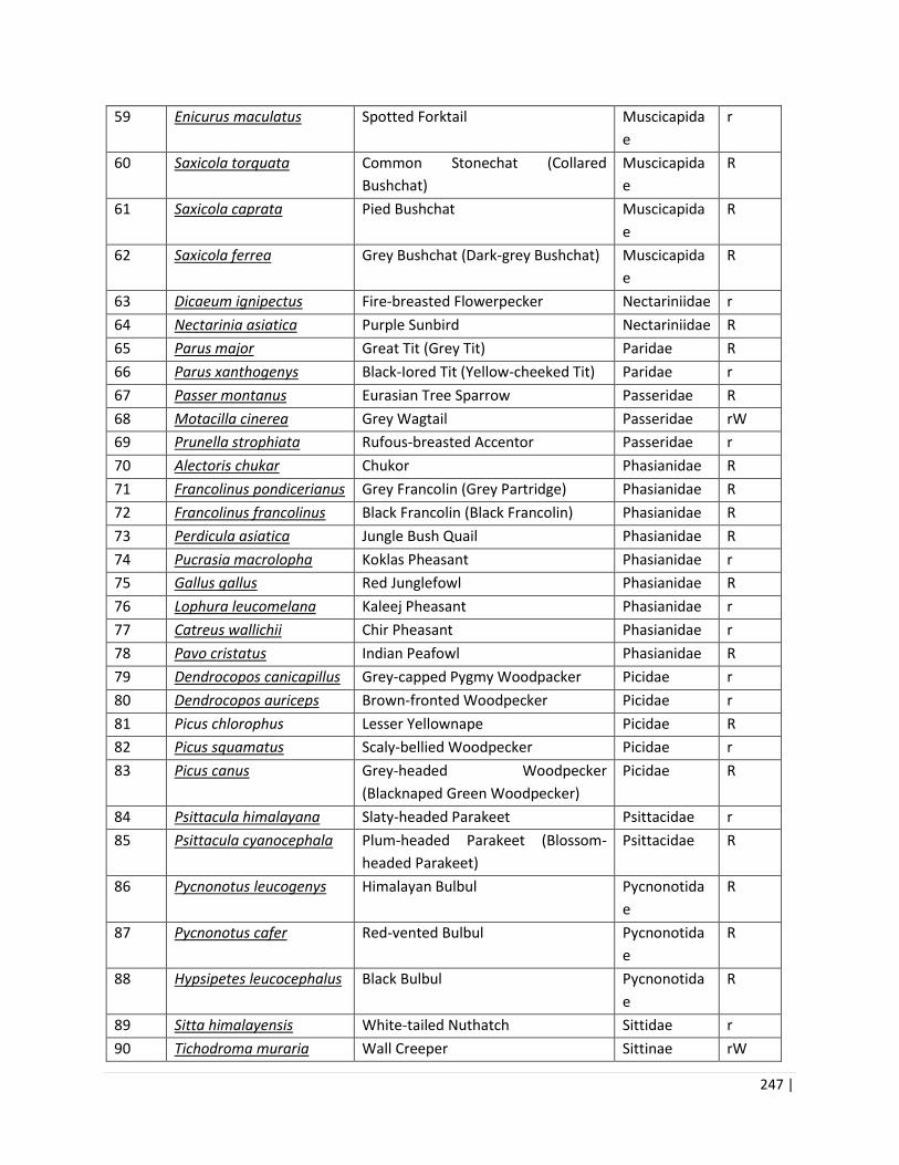
247 |
59 Enicurus maculatus Spotted Forktail Muscicapida
e
r
60 Saxicola torquata Common Stonechat (Collared
Bushchat)
Muscicapida
e
R
61 Saxicola caprata Pied Bushchat Muscicapida
e
R
62 Saxicola ferrea Grey Bushchat (Dark-grey Bushchat) Muscicapida
e
R
63 Dicaeum ignipectus Fire-breasted Flowerpecker Nectariniidae r
64 Nectarinia asiatica Purple Sunbird Nectariniidae R
65 Parus major Great Tit (Grey Tit) Paridae R
66 Parus xanthogenys Black-Iored Tit (Yellow-cheeked Tit) Paridae r
67 Passer montanus Eurasian Tree Sparrow Passeridae R
68 Motacilla cinerea Grey Wagtail Passeridae rW
69 Prunella strophiata Rufous-breasted Accentor Passeridae r
70 Alectoris chukar Chukor Phasianidae R
71 Francolinus pondicerianus Grey Francolin (Grey Partridge) Phasianidae R
72 Francolinus francolinus Black Francolin (Black Francolin) Phasianidae R
73 Perdicula asiatica Jungle Bush Quail Phasianidae R
74 Pucrasia macrolopha Koklas Pheasant Phasianidae r
75 Gallus gallus Red Junglefowl Phasianidae R
76 Lophura leucomelana Kaleej Pheasant Phasianidae r
77 Catreus wallichii Chir Pheasant Phasianidae r
78 Pavo cristatus Indian Peafowl Phasianidae R
79 Dendrocopos canicapillus Grey-capped Pygmy Woodpacker Picidae r
80 Dendrocopos auriceps Brown-fronted Woodpecker Picidae r
81 Picus chlorophus Lesser Yellownape Picidae R
82 Picus squamatus Scaly-bellied Woodpecker Picidae r
83 Picus canus Grey-headed Woodpecker
(Blacknaped Green Woodpecker)
Picidae R
84 Psittacula himalayana Slaty-headed Parakeet Psittacidae r
85 Psittacula cyanocephala Plum-headed Parakeet (Blossom-
headed Parakeet)
Psittacidae R
86 Pycnonotus leucogenys Himalayan Bulbul Pycnonotida
e
R
87 Pycnonotus cafer Red-vented Bulbul Pycnonotida
e
R
88 Hypsipetes leucocephalus Black Bulbul Pycnonotida
e
R
89 Sitta himalayensis White-tailed Nuthatch Sittidae r
90 Tichodroma muraria Wall Creeper Sittinae rW

248 |
91 Bubo bubo Eurasian Eagle Owl (Great Horned
Owl)
Strigidae R
92 Glaucidium brodiei Collared Owlet (Collared Pygmy) Strigidae r
93 Glaucidium cuculoides Barred Owlet,Asian Barred Owlet Strigidae r
94 Sturnus pagodarum Brahminy Starling (Black-headed
Myna)
Sturnidae R
95 Acridotheres tristis Common Myna Sturnidae R
96 Orthotomus sutorius Common Tailorbird Sylviidae R
97 Seicercus xanthoschistos Grey-hooded Warbler (Grey-headed
Flycatcher Warbler)
Sylviidae r
98 Garrulax lineatus Streaked Laughingthrush Sylviidae r
99 Garrulax variegatus Variegated Laughingthrush Sylviidae r
100 Erythrogenys
erythrogenys
Rusty-cheeked Scimitar Babbler Sylviidae r
101 Pteruthius flaviscapis White-browed Shrike Babbler (Red-
winged Shrike Babbler)
Sylviidae r
102 Heterophasia capistrata Rufous Sibia (Black-capped Sibia) Sylviidae r
103 Upupa epops Hoopoe, Common Hoopoe Upupidae RW
104 Zosterops palpebrosus Oriental White-eye Zosteropidae R
Status Categories
R- Widespread resident
r-very local resident
W- widespread winter visitor
w- sparse winter visitor
P- widespread migrant
p- sparse migrant
E- Endangered
V- vagarant
? – status uncertain
p- sparse migrant
rl- introduced resident
ex- extinct
nT- near threatened
Source: Mishra (2002) Birdlife International
Table 7: List of Reptiles found in Majathal Wildlife Sanctuary
Sr.No Local Name Common Name Zoological Name
1 Krait Common Indian krait Bungarus caerules
2 Kharpa Indian cobra Naja naja
3 Girgit Common Indian monitor Cnlotas vessicoloan

249 |
Table 8: List of Fauna found in Majhathal Wildlife Sanctuary
Sr.
No
Local Name Common Name Zoological Name
1 Baghera Leopard Panthera pardus
2 Jungli Billi Common jungle cat Felis chaus
3 Lomri Indian fox Vulpes bengalensis
4 Shail Indian procupine Hystrix indica
5 Goral Himalayan goat Nemorhaedus goral
6 Kakkar Barking deer Muntiacus muntjak
7 Sambar Sambar Cervus unicolor
8 Jungli Suwar Wild boar Sus scrofa
9 Khargosh Indian hare Lepus nigricollis
10 Galheri Himalayan striped squirrel Callosciurus macclellandi
11 Bander Monkey Macacque mulatta
12 Langoor Common languor Presbytis entellus
13 Gidar Jackal Canis aureus
14 Chuha Himalayan marmot Farmota bobak
15 Newla Common mongroose Herpestes edwardsi
16. Chamgadar Barbastelle Barbastella barbastellus