ebro delta (spain) - iczm projects and case...
TRANSCRIPT

EUROSION Case Study
1
EBRO DELTA (SPAIN)
Contact:
Inmaculada RODRÍGUEZ SANTALLA
Universidad Rey Juan Carlos
Escuela Superior de Ciencias Experimentales y Tecnología
C/ Tulipán, s/n 28933 Móstoles
Madrid (Spain)
Tel: +34 91 488 70 17 Fax: +34 91 488 74 90
e-mail: [email protected]
49

EUROSION Case Study
2
1. GENERAL DESCRIPTION OF THE AREA The delta of the River Ebro (see Figure 1) is on the north-eastern coast of Spain, in the province of Tarragona, in the Autonomous Community of Catalonia. It is the main coastal delta on the Iberian peninsula and one of the largest in the Mediterranean.
1.1. Physical process level
1.1.1 Classification
! General: delta plain, long strands with dune fields ! CORINE: beaches ! Coastal guide: delta, dunes
The Ebro delta was once considered a micro-tidal delta dominated by the river regime and wave action (Galloway, 1975). Owing to the loss in intensity of the influence of the River Ebro, the role of the waves has increased and its development and morphology are now dominated largely by wave action.
1.1.2 Geology The Holocene delta of the River Ebro has a coastal length of approximately 50km. It is basically a plain, not exceeding a height of 4 or 5m above sea level, with an emerged surface extending over approximately 325km2 (Rodríguez, 1999), while the submerged surface (prodelta) extends over approximately 2,172km2 (Serra, 1997). Geological mapping of the delta shows that the delta plain is occupied by quaternary Holocene sediments, deposited on a gravel base, largely made up of coarse and medium sand, muddy clays and mud, and with an upper layer of medium and fine sand. Together it forms crevasse, natural levee, dune and marsh structures (ITGE, 1996). The subsidence of the area is estimated at 0.20cm/yr (ITGE, 1996).

EUROSION Case Study
3
The average grain size of the sediment on the shoreline is around 250µm, showing variations along the coast depending on the energy of the incident swell and, therefore, the intensity of sediment transport. This sandy shore extends to a depth of 12-15m, below which very fine sediments appear around almost all the coastline (Sánchez-Arcilla et al., 1997).
Fig. 1: Location map of the Ebro Delta (satellite image).

EUROSION Case Study
4
Historical development of the Ebro delta In Roman times, the coast went in as far as Tortosa and in the 12th century it was situated near Amposta. In the 15th century, it extended over 130km2 and towards the beginning of the 16th century this coastal area behaved like an estuary and the shoreline was situated approximately at the level of Amposta. Between the beginning of the 16th century and the middle of the 17th century there was great deforestation caused by the need for ships following the discovery of America, which caused an expansion of the delta, as it facilitated erosion, generating a great progression of sediments (a figure of some 10m a year). In general, the increase in deposits in the area depended on the general coverage and on the prevailing climate in the area (Maldonado, 1972, 1986). The historic mouth of the River Ebro is situated on the eastern side of the pro-delta, but it changed because of a great flood which happened in October 1937, moving it to the north and beginning the opening of the current “Gola Nord” (Northern Mouth). By the end of the 50s, only this one was active and this situation continues until today. As well as this phenomenon, the construction of the Mequinenza and Ribarroja dams in the 60s conditioned the current development of the delta front, which suffers continuous erosion without compensation from river deposits.
2000 B.C.
C. 6th-10th A.D.
1580 A.D.
1700 A.D. approx.
1749 A.D.
1923 A.D.
Fig. 2: Historical evolution of the Ebro Delta shoreline (Source: Ebro Delta Natural Park - drawn by A. Canicio).
1.1.3 Morphology of the coast
The coastal morphology of the Ebro Delta (Figure 1) is made up of a delta front, in which the current mouth of the River Ebro is situated, and two spits that partially close two adjacent lagoons: El Fangar, situated to the NW and Los Alfaques, to the SW. The second spit is joined to the rest of the delta by the Trabucador bar, which is approximately 250m wide and 6km long. The mouth shows a very flat profile with a low slope, which encourages the development of bars. The current appearance of the Ebro delta is the result of various processes acting directly on it (see Figures 3a & 3b).

EUROSION Case Study
5
Firstly, the retention of solids by dams positioned along the course of the river and the increase in water consumption, basically for irrigation, and, secondly, the marine processes, which continuously reshape the delta and alter its configuration.
Fig. 3a: Last stretch of the River Ebro.
Fig. 3b: Actual mouth of the River Ebro.
River network The last 28km of the River Ebro run through the delta plain, showing notably different characteristics to the ones it has upstream, where it has been considerably altered during the second half of the 20th century. These changes are largely due to the construction and use of numerous dams throughout its basin, particularly those at Mequinenza and Ribarroja (Dolz et al., 1997) on the lower course of the River Ebro. The River Ebro basin is 97% regulated (Varela et al., 1986) and it is estimated that nowadays it discharges less than 1% of what the river used to discharge at the beginning of the 20th century. If to this is added the effect of the dams and the fall in precipitation in the Ebro’s drainage basin, as well as diversions of the course for irrigation, the result is a considerable decrease in the transport of sediments. Consequently, certain sections of the delta are receding (Rodríguez, 1999). Secondly, the reduction in flow encourages the intrusion of a wedge of salt water that penetrates the river underneath the fresh water. This salt wedge alters the capacity to transport solids and reduces the depth of the layer of fresh water, making it more difficult for the delta’s agricultural operations to use it. Navigation on the river, present in these waters since ancient times, has now been discovered as an interesting tourists attraction (Dolz et al., 1997).
EUROSION Case Study
6
1.1.4 Physical processes Maritime climate and coastal dynamics The environment is micro-tidal, with an astronomical tidal range of 25cm. It is worth pointing out the presence of meteorological tides, especially in the months from September to November, when they reach their greatest magnitude. The average annual significant wave height in deep water in the area is around 0.7m, with an average period of the order of 4s (Sánchez-Arcilla et al., 1997). The directions of origin of the swell are: north, acting on the northern hemi-delta; south acting on the southern hemi-delta; east acting on the entire delta. The latter produces the most significant transport of sediments, as it shows the largest waves with most energy generating movement towards the north in the northern hemi-delta and towards the south in the southern hemi-delta.
1.1.5 Erosion In general, erosion and progradation areas alternate on the Ebro delta coast. The longitudinal transport system along the coast is responsible for the distinctive configuration, with sedimentation and erosion effects. Currently, the developmental tendency of the delta is regressive, with variations of greater or lesser degree depending on the stretch. This is because wave action is eroding the beaches as it reaches the coast without replacement of the sediment removed. On a large scale, the delta can be considered as forming a closed system where the rates of erosion and progradation cancel each other out. According to Rodríguez (1999), between 1957 and 1998 there was a slight increase in the delta surface of about 500ha (5km2 out of the 320km2 of emerged surface currently recognised, approximately 1.5% of the total delta area), which may be considered as a redistribution of sediments following the patterns marked out by the system of currents in the area, together with the possible contribution of sediments by the river. The longitudinal transport system along the coast is responsible for the distinctive configuration with sedimentation and erosion effects, as explained in earlier sections. There are various factors with a direct impact on the erosion process in the Ebro delta. Firstly, the reduction in river flow and therefore in the sediments that arrive at the mouth due, on one hand, to the regulation of the river by means of dams and, on the other, to the diversion of the water for irrigation and water supplies. This reduction in flow also causes the salt water wedge to penetrate further and further, affecting the river’s power to transport solids. Secondly, the regulation of the river also weakens the flood regime, preventing the contribution of sediments to the delta plain compensating for the subsidence of the delta and the rise in sea level. Recently the Spanish government has approved the National Hydrological Plan (Act 10/2001, 5 July) which includes various measure, among them, the transfer of water between river basins with the aim of mitigating shortages in various Spanish provinces. In the case of the Ebro, the transfer of 1,050hm3/year is proposed to different areas, together with the building of new dams in the Ebro basin. The NHP has an estimated cost of 23,500 million euros and is the subject of much criticism and civil protest, because these plans are seen as a new threat to the Ebro delta ecosystem.

EUROSION Case Study
7
1.2. Socio-economic aspects
1.2.1 Population rate Human occupation of the delta began quite late and was closely linked to the transformation of the wetland into rice fields aided by the construction of irrigation channels. Since 1860, there has been a rapid increase in population, which seems to have stopped in the 1990s. However, it can still be said that the Delta continues to be, in terms of population, one of the most dynamic areas in southern Catalonia. Although the total population of the seven municipalities forming part of the delta was, in 1995, about 46,800 inhabitants, the population living in the delta itself is only about 15,000, basically concentrated in the municipalities of Deltebre and San Jaume, characterised by its great extension and dispersal. The density is about 120 inhab/km2, similar to the Catalan average and the highest in the so-called “Terres de l’Ebre” (Lands of the Ebro) (Environment Ministry, 2001).
1.2.2 Major functions of the coastal zone
! Fisheries and aquaculture: Fishing is a fundamental activity and it involves the ports of Sant Carles de la Rapita and L’Ampolla within the delta and the nearby parts of Les Cases d’Alcanar and L’Ametlla. It provides approximately 15% of Catalonia’s annual production, with jobs for around 2,000 people. However, fishing in the coastal lagoons has recently reduced because of over-exploitation and the degradation of the lagoons.
! Agriculture: Agriculture is one of the great economic bases, with the clear predominance of rice - of the 24,554 hectares under cultivation, 15,215 hectares correspond to this crop, which represents 98% of the total production of this cereal in Catalonia. It is followed by vegetables and fruit trees. Agricultural co-operatives, especially the organisations of rice-growers, are very important. In spite of the fact that the agricultural transformation has involved a considerable reduction in the natural surface of the delta plain, the rice fields have an important ecological component. They provide a large area of water during a large part of the year, creating a great source of food for birds that temporarily or permanently populate part of the delta. Livestock farming has been reduced to a small scale activity faced with the great weight of agriculture.
! Industry: little developed, with only that based on agriculture and salt extraction (Trinidad salt pans in Los Alfaques) worth mentioning.
! Hunting: this is another firmly rooted activity in the delta, which is now a leisure activity with deep sociological roots. This activity also brings financial income for the local population to supplement the agricultural activity, as private reserves charge for shooting rights. Hunting has been structured in zones and organised in different legal forms involving guaranteed conservation of the delta’s birds, and sustainable hunting practices.
! Tourism and recreation: this is a relatively recent activity in the delta, as previous attempts to develop this sector failed because of the lack of infrastructure and services, the presence of insects and various other factors. That changed in the 1980s, with the declaration of the Ebro Delta Natural Park, which involved publicity about the area’s natural, landscape and traditional values. The result has been a tourist offer based on the eco-tourism model that presents the Delta as an exceptional site.
EUROSION Case Study
8
! Ports and ships: there are two ports within the delta (Sant Carles de la Ràpita and l’Ampolla) and two ports nearby (Les Cases d’Alcanar and l’Ametlla). The main use of these ports is as fishing ports and recreational marinas.
1.2.3 Land use
The Ebro delta has isolated beaches with golden sands and peaceful bathing conditions with moderate waves. However, the degree of occupation of these beaches is average to low because their accessibility is limited, with a vehicle needed in order to reach them. In addition, most of them lack beach services (showers, bins, toilets, signs, parking etc.). Riumar beach is the only beach of a semi-urban nature. It has a promenade, parking and all beach services. The delta plain is occupied largely by rice fields. As well as rice, there are other irrigated crops, which are basically on plots near to the course of the river, and citrus fruit plantations in the interior of the island of Gracia. The occupation of all the Los Alfaques spit by the Trinidad salt pans is worth mentioning.
1.2.4 Assessment of capital at risk Information is unavailable
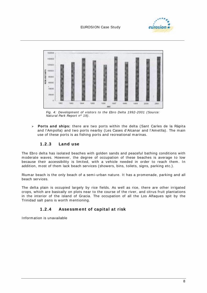
Fig. 4: Development of visitors to the Ebro Delta 1992-2001 (Source:Natural Park Report nº 19).

EUROSION Case Study
9
2. PROBLEM DESCRIPTION
2.1. Eroding sites The morphological configuration of the Ebro Delta leads to the existence of areas that behave differently in terms of coastal dynamics. There are beaches with a marked erosional nature and beaches whose tendency is accretion. The longitudinal transport system along the coast is responsible for the distinctive configuration, with sedimentation and erosion effects. Northern Hemi-delta This is made up almost completely of sand, which forms the beaches and dunes that run along the coastal fringe of the Fangar spit and the beaches of La Marquesa and Pal (see aerial view in Figure 5). Fangar spit The Fangar spit extends south-east from the Fangar lighthouse with an area which oscillates between 180,000m2 and 225,000m2. Its length various between 1,800 and 2,000m and it is between 175 and 350m wide depending on the prevailing climatology. It has a landscape of dunes practically all along the outside of the spit (Figure 6), which represents the most extensive formation in the whole delta and which currently is the only functioning dune area. At times of meteorological tide, the dunes are wiped out by wave action, depositing the sand inside the Port of Fangar. They are later being formed again by wind processes.
Peninsula of Fangar Natural Port of
Fangar Fangar Beach
Marquesa Beach
Pal Beach
Estany del Canal Vell o Balsa de L'Estella
Arenal Beach
Goleró Beach
Fig. 5: Northern Hemi-delta (Source: Aeroguía del litoral - geoplaneta.com).

EUROSION Case Study
10
In studies carried out in the area (University of Barcelona, 1997) the importance of wind transport was noted when making an overall evaluation of the marine dynamics, with average wind transport potential quantified at an average of 40m3/m/yr and occasionally greater during extreme events. Considering that the width of the current dune area is 250m, wind transport contributes to the sedimentary dynamic of the whole coast of the northern hemi-delta with a volume of 10,000m3/yr towards the SE. In a recent study of the development of the spit between 1957 and 2000, commissioned by the Environment Ministry (2001), it is estimated that the growth of the point of the spit over these 43 years has been 1,280m and the rate of growth in the last decade has been 33m/yr. The increase in surface area is measured at somewhat more than 180ha, which means an increase of more than 4 hectares per year (Figure 7). In the same study, the speed of growth of El Goleró beach, just opposite the point of the sand spit was estimated, obtaining a result of 2m/yr. These figures allow for an estimated possible closure of the bay, if the hydrodynamic conditions governing the system allow it, in about 35 years.
Fig. 6: Dune field – Fangar Sand Spit (August 2002).

EUROSION Case Study
11
La Marquesa and Pal beaches The dune cordon continues towards the SE from the Fangar bar along La Marquesa beach until Gola de Pal, interrupted by various structures (a road, a breakwater and a restaurant). Plans haven been made that involve eliminating these barriers and regenerating the dune system,which is currently in a very poor state. This is largely due to the human activity, involving the indiscriminate entry and parking of vehicles among the dunes. La Marquesa and Pal beaches show considerable regression in the coastline (Figure 7), which has been quantified at 200m and 245m respectively in the last 40 years, with a reduction in their area of 116 hectares, which is equivalent to almost 3ha/yr (Environment Ministry, 2001). River mouth At the river mouth the processes of progradation and regression of the delta front happen much faster than on the rest of the delta coast due to higher wave energy in this area (see aerial view in Figure 8).
Fig. 7: Variation in the coastline of the Northern Hemi-delta (Env. Minist. 2001)

EUROSION Case Study
12
In terms of physical geography, the outstanding feature is the growth of spit at the point of the mouth (San Antonio spit), which is progressively moving towards the west because of the predominant direction of the currents in this part of the delta. Due to storms the spit can disappear, being formed again afterwards (Jiménez et al, 1995). Cape Tortosa is the area that has suffered most erosion in recent years because it is the area of the delta that absorbs most wave energy (Serra, 1997). It is estimated that the linear regression has been close to 1,600m in 40 years (Figure 9), which corresponds to a velocity of 39m/yr (Rodríguez, 1996, 1999). The maximum was reached between the 1950s and 1970s, gradually diminishing in subsequent periods. In the period 1994-1998 regression was close to zero , giving rise to the idea that the delta is reaching a more stable configuration (Rodríguez, 1996, 1999). As a result of these erosion processes, there has been an accumulation of sand in the form of spits, configuring the current morphology of the river mouth.
Buda Island
San Antonio Island
Riomar beach
Mitjorn Beach
Serrallo beach
Eucalitus Beach
Tortosa Cape
Ebro River
Fig. 8: Mouth of the River Ebro (Source: Aeroguía del litoral - geoplaneta.com).

EUROSION Case Study
13
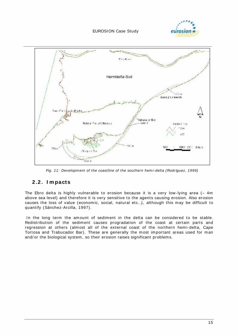
Southern Hemi-delta The southern hemi-delta, situated on the south side of the river mouth, is favoured by net sedimentation as a result of coastal transport processes (see aerial view in Figure 10). Los Eucaliptus beach The developmental tendency of this beach is slightly towards progradation, showing an advance in the coastline of approximately 300m from 1957 to 1998 (Rodríguez, 1999). See Figure 11.
Fig. 9: Shoreline retreatment of the river mouth (Rodríguez, 1999).

EUROSION Case Study
14
Trabucador spit The Trabucador Bar is a narrow, sandy, rectangular formation about 250m wide and 6km long. It was formed due to the mutual annexation of sand bars with material from the erosion of the delta front, transported by the effects of longshore drift. At certain times and under heavy storm conditions the bar is overwashed (at times it has even been broken) introducing sediments inside the bay, which causes the spit to migrate towards the coast. Rodríguez (1999) estimates that the bar has turned almost 3º towards land and its width has slightly reduced to an average of approximately 60m. Los Alfaques spit The Los Alfaques spit is formed by strips of sand that have annexed each other, forming the present shape of the bar. It is worth pointing out the presence of beach ridges which mark the different positions the coast has taken up. Together with the Fangar spit, it is one of the main areas for the deposition of eroded material anywhere in the delta. The area has increased by 200ha between 1957 and 1998 (Rodríguez 1999).
Sant Carles de la Rápita
Natural Port of Els Alfaqs
Trabucador Bar
Fig. 10: Southern Hemi-delta (Source: Aeroguía del litoral – geoplaneta.com).
EUROSION Case Study
15
2.2. Impacts The Ebro delta is highly vulnerable to erosion because it is a very low-lying area (∼ 4m above sea level) and therefore it is very sensitive to the agents causing erosion. Also erosion causes the loss of value (economic, social, natural etc…), although this may be difficult to quantify (Sánchez-Arcilla, 1997). In the long term the amount of sediment in the delta can be considered to be stable. Redistribution of the sediment causes progradation of the coast at certain parts and regression at others (almost all of the external coast of the northern hemi-delta, Cape Tortosa and Trabucador Bar). These are generally the most important areas used for man and/or the biological system, so their erosion raises significant problems.
Fig. 11: Development of the coastline of the southern hemi-delta (Rodríguez, 1999)

EUROSION Case Study
16
3. SOLUTIONS / MEASURES
3.1. Policy options Do nothing, Hold the line, Managed realignment.
3.2. Strategy The delta system as a whole is part of environmental surroundings to which plants, animals and man contribute. Any engineering action has to be integrated in the dynamic balance. This action should tend to rebalance the shape of the coast without damaging the system. Measures to control erosion must be achieved using techniques which do not have a negative impact on the rest of the delta’s physical and ecological system (Montoya and Galofré, 1997). Action on the delta coast has been marked by the presence of the protective form of the Ebro Delta Natural Park, since it was set up by the Catalan government (Decree 357/1983, 4 August, ratified and expanded by Decree 332/1986, 23 October). So, coastal engineering options have been basically directed at preserving and recovering the environment, attempting to mitigate and/or minimise the impact of hard engineering measures.
3.3. Technical measures
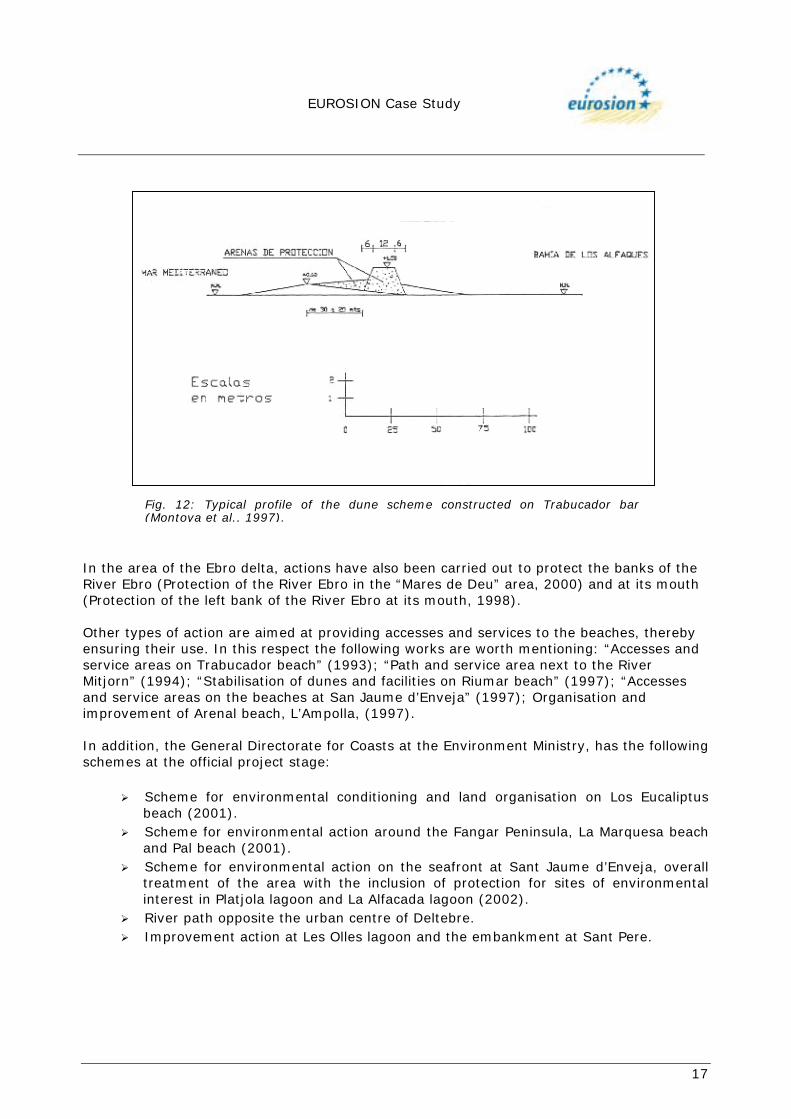
3.3.1 History, type and technical details As has already been mentioned, action carried out in the Ebro delta environment has always been directed at recovering the natural environment, with attempts made to minimise the impact involved in any coastal engineering action. However, some schemes have been drawn up proposing the rigid fixing and total defence of the delta to prevent the regression of the coastline (Iberinsa, 1992). Other measures have been directed at protecting the Ebro delta against the rising sea level and overwashing without taking erosion processes into account. These measures were taken as a consequence of the breaking of Trabucador Bar in October 1990 because of a storm. The volume eroded was about 70,000m3 and represents practically 85% of the whole bar (Sánchez-Arcilla et al., 1997). In January 1991 this event led to the beginning of emergency works, building 1km of dune 1.5m high, 12m wide at the crown and 24m at the base, fixing it using cane stakes and dune vegetation (Amophila Arenaria, Othanthus Marítima and Elymus Factus). This action was completed in 1992 with the “Trabucador Bar Protection Scheme” (see Figure 12) which consisted of extending the above solution along the whole bar, positioning the dune in the interior, beside the bay, with the aim of preventing overwashing by water from the open sea when high waves were produced. The fixing system consisted on the one hand of constructing 10 x 10m stake “corrals” of spartina versicolor, and on the other hand of planting dune vegetation (Montoya et al., 1997).
EUROSION Case Study
17
In the area of the Ebro delta, actions have also been carried out to protect the banks of the River Ebro (Protection of the River Ebro in the “Mares de Deu” area, 2000) and at its mouth (Protection of the left bank of the River Ebro at its mouth, 1998). Other types of action are aimed at providing accesses and services to the beaches, thereby ensuring their use. In this respect the following works are worth mentioning: “Accesses and service areas on Trabucador beach” (1993); “Path and service area next to the River Mitjorn” (1994); “Stabilisation of dunes and facilities on Riumar beach” (1997); “Accesses and service areas on the beaches at San Jaume d’Enveja” (1997); Organisation and improvement of Arenal beach, L’Ampolla, (1997). In addition, the General Directorate for Coasts at the Environment Ministry, has the following schemes at the official project stage:
! Scheme for environmental conditioning and land organisation on Los Eucaliptus beach (2001).
! Scheme for environmental action around the Fangar Peninsula, La Marquesa beach and Pal beach (2001).
! Scheme for environmental action on the seafront at Sant Jaume d’Enveja, overall treatment of the area with the inclusion of protection for sites of environmental interest in Platjola lagoon and La Alfacada lagoon (2002).
! River path opposite the urban centre of Deltebre. ! Improvement action at Les Olles lagoon and the embankment at Sant Pere.
Fig. 12: Typical profile of the dune scheme constructed on Trabucador bar(Montoya et al., 1997).

EUROSION Case Study
18
The various actions and objectives shown by the schemes mentioned above are summarised below:
! Construction of walkways on the dunes to prevent deterioration and preserve the natural defence they provide against erosion (example: Riumar, Pal, Marquesa and Fangar beaches).
! Regeneration of dunes, fixed with the help of stakes and dune vegetation (example: Trabucador Bar).
! Removal of infrastructure located on the shore that prevents the normal development of the coastal dynamic (example: La Marquesa and Pal beaches).
! Organisation of uses in the coastal area which involve actions ranging from the building of car parks, preventing the dunes being used for this purpose (example: Marquesa and Fangar beaches), to the compulsory purchase of agricultural land (rice fields) located on the edge of the beach (Pal beach) and limiting wheeled vehicle traffic in the dunes (example: Fangar bar) and the creation of new alternative beach accesses and the conservation of nesting areas by staking them off.
! Putting up signs near areas of landscape, environmental and cultural interest. Respect for the cultural values of the area (examples: throughout the delta).
! Construction of landscape viewpoints that allow the contemplation, study and control of the protected environment (examples: Fangar, Riumar, mouth of the Mitjorn, La Marquesa beach, La Alfacada lagoon, Los Eucaliptus beach – the last three at the plan stage).
! Experimenting with a new method of coastal defence called the Beach Drainage System which encourages the deposition of sand on the beach by installing drainage and a pumping system (example: Riumar beach).
3.3.2 Costs
Figure 13 (next page) shows all the works carried out in the Ebro delta and the forthcoming actions planned, as well as the budget for carrying them out.

EUROSION Case Study
19
Fig. 13: Map of the position of works carried out and planned works (Environment Ministry, 2002)
EUROSION Case Study
20
4. EFFECTS AND LESSONS LEARNT
4.1. Effects related to erosion The evaluation of the effects of interventions on the delta system can only be attempted in the medium and long term because they have been aimed at protecting and maintaining the beach, the dune ecosystems and the recovery of natural environments, like the lagoons and banks of the River Ebro. However, the interventions carried out have enabled the elimination of man-made barriers impeding the natural development of the delta system; reducing and regulating activities and uses causing its degradation and stimulating natural processes supporting its recovering. The interventions planned in the area have been characterised by minimising building activity within it, being directed towards regulatory intervention policies that basically cover the organisation of the land, affecting land use and the exploitation of the existing natural resources. Direct effects on the delta ecosystems can be quantified from the censuses of species colonising it and also from the growth of the surface area of the delta affected by protective regulations. This is included as an area that can be colonised by natural species living there and using the delta seasonally for reproduction or as a transit area on migration.
4.2. Effects related to socio-economic aspects
The actions carried out in most cases impose restrictions on land use and the exploitation of its natural resources. In principle, these actions could be judged as negative for the social and economic development of the area. However, it must be taken into account that the expected impacts refer to indicators supporting the concept of Sustainable Development, which is rational use compatible with the environment and the natural resources, preserving their exploitation and benefits for future generations. Although the design of the schemes aims at the reduction, in many cases, of agricultural, fishing and hunting activity; overall it has not had a worrying impact on these sectors. In addition, it has made and is making possible the development of other activities belonging to the service sector, with a much greater socio-economic development potential, producing not merely a compensatory effect, but also growth. In this way, the design of actions has been aimed at harmonising their impacts with the development of capacity in the tourist sector, connected to the ecological, landscape, environmental, cultural and educational values of the environment, which have been incorporated as strategic objectives of the actions. The visitor statistics for the area, together with schemes to develop hotel, restaurant and eco-museum facilities, walking and cycle touring activities, special gastronomic and educational events, management of beach access, identification of swimming areas, viewpoints etc. among others, are the most important indicators in this respect. • Gaps in information In ecosystems as fragile as those of the delta, actions must be directed towards integrating natural and human aspects, using sustainable development criteria which enable the different uses the delta currently has (fishing, agriculture, salt extraction, bathing) to be made compatible with the natural environments and unique biodiversity ecosystems (plant and animal communities). To do this, it is necessary to have a land organisation tool that enables forecasting of the future impact of any action on the rest of the delta and the areas most sensitive to erosion, predicting possible threats.

EUROSION Case Study
21
5. REFERENCES Decree 357/1983 Decree 332/1986 Dolz, J.; Gómez, M.; Nieto, J. (1997). El Ebro en el Delta. Revista de Obras Públicas, Num. 3,368; pp. 7-14. Galloway, W.E. (1975). Process framework for describing the morphologic and stratigraphic evolution of deltaic depositional systems. . In: Deltas, Models for Exploration, M.L. Broussard (ed.). Houston Geological Society, p. 87-98. Iberinsa, (1992). Estudio geofísico de la costa de Vizcaya. Servivio de Proyectos y Obras. Dirección General de Costas. Ministerio de Obras Públicas y Transportes. Madrid. I.T.G.E. (1996). Estudio geológico del Delta del Ebro. Proyecto para la evaluación de la tasa de subsidencia actual. Informe Técnico de Instituto Tecnológico y Geominero de España; 83 pp. Guillén, J.; Jiménez, J.A. (1995) Processes behind the longshore variation of the sediment grain size in the Ebro delta coast. Reprint from Journal of Coastal Research, vol. 11, nº 1, pp. 205-218) Jiménez, J.A. (1996). Evolución costera en el Delta del Ebro. Un proceso a diferentes escalas de tiempo y espacio. Tesis doctoral. Departamento de Ingeniería Hidráulica, Marítima y Ambiental. Universidad Politécnica de Cataluña; 274 pp. Maldonado, A. (1972). El delta del Ebro: estudio sedimentológico y estratigráfico. Boletín de Estratigrafía, 1, vol. extra. Universidad de Barcelona. Maldonado, A. (1986). Dinámica sedimentaria y evolución litoral reciente del Delta del Ebro. Sistema Integrado del Delta Del Ebro: Estudio Interdisciplinar; pp. 33-60. Ministerio De Medio Ambiente. Dirección General De Costas (2001). Proyecto de actuación medioambiental en el entorno de la península del Fangar, Playa de la Marquesa y Playa de Pal en el Delta del Ebro. Realizado por el Centro de Estudios de Teledetección Y SIG, S.L. Montoya, F.; Galofré, J. (1997). El Ebro en el Delta. Revista de Obras Públicas, Num. 3.368; pp. 33 - 46. Protection of the River Ebro… (2000) (see p.17) Protection of the left bank… (1998) (see p.17) Rodríguez, I. (1996). Estudio de la dinámica litoral del Delta del Ebro y prognosis de su evolución. Análisis de los cambios geomorfológicos de la desembocadura del Delta del Ebro mediante el uso de un SIG. Tesina de licenciatura. Rodríguez, I. (1999). Evolución geomorfológica del Delta del Ebro y prognosis de su Evolución. Tesis Doctoral. Departamento de Geografía, Universidad de Alcalá de Henares.
EUROSION Case Study
22
Sánchez Arcilla, A.; Jiménez, J.A.; Gelonch, G.; Nieto, J. (1997). El problema erosivo en el Delta del Ebro. Revista de Obras Públicas, Num. 3.368; pp. 23 - 32. Serra, J. (1997). El sistema sedimentario del Delta del Ebro. Revista de Obras Públicas, Num. 3.368; pp. 15 - 22. Universidad De Barcelona (1997). Estudio de la situación actual y evolutiva de las formaciones eólicas litorales del Delta del Ebro. Informe Técnico. Facultad de Geología, Universidad de Barcelona; 49 pp.