dunwoody village vision of the future
TRANSCRIPT

The City of Dunwoody’s Comprehensive
Land Use Plan, adopted in 2010,
provides a vision and direction for the
City of Dunwoody and lays out the
foundation for a more detailed master
planning effort for the Dunwoody Village
area.
The Master Plan was developed to
explore the Comprehensive Plan’s vision
in greater detail, create an area-specific
land use and circulation framework, and
develop short and long-term action plans
to guide the City’s initiatives and
investments.
The Dunwoody Village Master Plan was
developed based upon the direct input of
residents, businesses, property owners,
and other stakeholders in the area, and
the City staff and elected officials are
committed to implementing that vision
for now and future generations.
The Dunwoody Village Area Master Plan pursues
a walkable/bikable city center will serve as the
civic heart of the community. The vision for the
Dunwoody Village is to develop an area for civic
celebrations and programs, park and
recreational areas, small-scale, boutique retail
and restaurants, and walkable residential units
that can afford long-time Dunwoody residents
the ability to age in place and enjoy first class
amenities at their fingertips.
The Master Plan seeks to implement the Livable
Centers Initiative through goals such as:
identifying an appropriate mix of uses,
implementing transportation demand reduction
measures, mobility enhancements, connectivity,
and mixed income housing.
HOW IS THE CITY
COMMITTED TO THE MASTER PLAN?
Dunwoody’s Vision
41 Perimeter Center East, Suite 250
Dunwoody, GA 30346
(678) 382-6700
www.dunwoodyga.gov
Dunwoody Village
Our community’s vision for the future of the
Dunwoody Village
Vision of the Future
OUR COMMUNITY HAS A VISION FOR THE FUTURE
AND A PROVEN RECORD OF INVESTING AND PARTNERING TO ATTAIN OUR GOALS
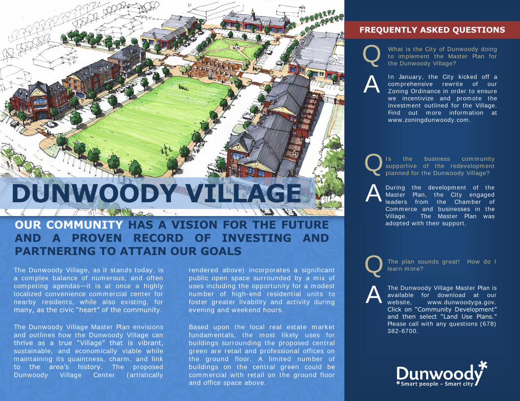
The Dunwoody Village, as it stands today, is
a complex balance of numerous, and often
competing agendas—it is at once a highly
localized convenience commercial center for
nearby residents, while also existing, for
many, as the civic “heart” of the community.
The Dunwoody Village Master Plan envisions
and outlines how the Dunwoody Village can
thrive as a true “Village” that is vibrant,
sustainable, and economically viable while
maintaining its quaintness, charm, and link
to the area’s history. The proposed
Dunwoody Village Center (artistically
rendered above) incorporates a significant
public open space surrounded by a mix of
uses including the opportunity for a modest
number of high-end residential units to
foster greater livability and activity during
evening and weekend hours.
Based upon the local real estate market
fundamentals, the most likely uses for
buildings surrounding the proposed central
green are retail and professional offices on
the ground floor. A limited number of
buildings on the central green could be
commercial with retail on the ground floor and office space above.
QA
QA
QA
What is the City of Dunwoody doing to implement the Master Plan for the Dunwoody Village?
In January, the City kicked off a comprehensive rewrite of our Zoning Ordinance in order to ensure we incentivize and promote the investment outlined for the Village.
Find out more information at www.zoningdunwoody.com.
Is the business community supportive of the redevelopment planned for the Dunwoody Village?
During the development of the Master Plan, the City engaged leaders from the Chamber of Commerce and businesses in the
Village. The Master Plan was adopted with their support.
The Dunwoody Village Master Plan is available for download at our
website, www.dunwoodyga.gov.
Click on “Community Development” and then select “Land Use Plans.” Please call with any questions (678) 382-6700.
The plan sounds great! How do I learn more?
DUNWOODY VILLAGE
FREQUENTLY ASKED QUESTIONS

Welcome to theDunwoody Village
P AFFLUENT HOUSEHOLDS, HIGH PURCHASING POWERP MARKET STUDY DOCUMENTING RETAIL NEEDSP HIGH TRAFFIC COUNTS AND STRONG VISIBILITY
P CITY INVESTMENT FOR A VIBRANT VILLAGE
HIGH VOLUMES TRAVEL MAJOR CORRIDORSMount Vernon Road and Chamblee Dunwoody Road connect the Dunwoody Village, providing easy access to GA 400, I-285, and the Perimeter area. • 17,000 vehicles per day travel Chamblee Dunwoody Road • 20,000 vehicles per day travel Mount Vernon Road just west of the Village• 16,000 vehicles per day travel Mount Vernon just east of the Village
Additionally, the City is in the midst of a fully-funded, $2.2 million streetscape project for Dunwoody Village Parkway.
Preliminary concepts, submitted to GDOT this spring, reshape the Parkwaywiththeadditionoffivefootbikelanes,landscapestrips,andwide sidewalks accomplished through the removal of the existing median and the conversion of the roadway from four lanes to two.
These enhancements will improve connectivity and access within the Villageitself,improvingpedestrianandbicycletrafficforretailers.
(678) 382-6700 www.dunwoodyga.gov
STEADY TRAFFIC FLOW, HIGH VISIBILITY
IMAGINE YOUR BUSINESS IN DUNWOODY VILLAGE
EXISTING DEMAND, UNLIMITED POTENTIAL2010 MARKET STUDY SHOWS RETAIL NEEDS
An analysis of retail expenditures within the Dunwoody Village 2-mile trade area reveals the area is under-served, with demand far exceeding supply, in the following retail categories:
• Restaurant with Bar or Tavern g $9.1 million of unmet demand • Health and Personal Care g $7.7 million of unmet demand• Home and Garden g $2.6 million of unmet demand
In total, expenditure data reveals that as much as $22.6 million in annual expenditures are ‘leaking out; to other retail areas.
New retailers to the Dunwoody Village will complement the existing variety of retail destinations and add to the well-established sense of place in the Dunwoody Village.
The City of Dunwoody unanimously adopted a redevelopment plan for the Dunwoody Village in March2011.Theplanfocusesoncreatingsignificant,opengreenspacewithintheDunwoodyVillage surrounded by new, high-quality, multi-story redevelopment. Based on the completed market study, retail will surround the green with residential units above.
As the City moves forward towards purchasing and creating the central Village Green it is seeking partners for redevelopment.
STRONG DEMOGRAPHICSAFFLUENT, WELL-EDUCATED POPULATION
As of the 2010 Census, Dunwoody is home to 46,267 residents. The largest age groups in Dunwoody are individuals 25-34 and 35-44, in the prime of their working and family lives.
Education is extremely important to the citizens of Dunwoody - 40% have a bachelor’s degree and 21% have a master’s degree (or higher) in 2000. Dunwoody is home to Georgia Perimeter College with an annual student population over 9,000.
1 Mile 2 Mile 3 Mile
Population 9,623 42,240 89,064
Households 3,874 19,761 41,962
Average Household Income $139,895 $107,462 $108,810
Median Housing Value $293,515 $280,727 $261,691
Average Age 39.4 38 38.5

HIGH-QUALITY RETAIL TO SURROUND OPEN SPACEThe Village Green is proposed for the southern portion of the superblock bounded by Chamblee Dunwoody Road, Mount Vernon Road, and Dunwoody Village Parkway. The Village Green itself anchors over the current site of the United States Postal Building. From the City’s discussions with USPS, they are open to the possibility of relocating within the Dunwoody Village as retail store within the new redevelopment.
TheproposedVillageGreenenvisionedbyourMasterPlanincorporatesasignificantpublicopenspacesurroundedbynew,high-quality,multi-storyredevelopment.Basedonthecompletedmarketstudy,retailandprofessionalofficeswillsurroundthegreenwith residential units above.
The City is seeking partners for redevelopment as it moves towards creating this new central gathering space within the Village to create a more walkable, vibrant Village Center with new high-quality retail and high-end residential units to foster greater activity during evening and weekend hours.
(678) 382-6700 www.dunwoodyga.gov
BE PART OF THE NEW VILLAGE GREEN
Dunwoody VillageP RETAIL DEMAND P HIGH PURCHASING POWER P STEADY TRAFFIC COUNTS P COMMUNITY SUPPORT FOR REDEVELOPMENT
Mount Vernon Road
Cham
ble
e D
unw
oody R
oad

Dunwoody Village Parkway Improvements
Mount Vernon
Cham
ble
e D
unw
oody
PROJECT OBJECTIVES
P Maintain Efficient Automobile FlowP Implement the Dunwoody Village Master Plan’s
Vision for a Vibrant Village
P Provide Sidewalks and Bike Lanes
P Leverage Grant Funding to Multiply City Investment
FREQUENTLY ASKED QUESTIONS
TRAFFICHow will reducing the number of travel lanes affect automobile traffic?
Traffic studies and traffic analysis of current and future demands on Dunwoody Village Parkway indicate the capacity of the current roadway significantly exceeds the traffic volume. With one automobile travel lane in each direction and left turn lanes at major intersections, traffic studies have concluded that it will continue to efficiently move both current and future traffic.
PRIORITIZATIONWhy are we working on Dunwoody Village Parkway? Don’t other streets need work?
Addressing Dunwoody Village Parkway was identified as a top priority in the Dunwoody Village Master Plan as well as the Comprehensive Transportation Plan. The City is committed to implementing these community-based plans. Additionally, implementing this project now allows the City to leverage $1.1 million in grant funding to multiply the City’s investment. This funding is specifically designated for Dunwoody Village Parkway and can’t be reallocated.
TIMINGWhen is this project scheduled to begin?
Meetings with neighboring businesses and an Open House for the community was conducted in the Spring of 2011 after the adoption of the Master Plans. Construction is now scheduled to begin as early as the second half of 2013.
QA
PROJECT OVERVIEW
The Dunwoody Village Master Plan and Comprehensive Transportation Plan both prioritize pedestrian improvements for Dunwoody Village Parkway. Converting the Parkway into a two lane street is the most cost-effective means to accomplish this goal in a manner that is consistent with the Master Plan and existing zoning with on-street bicycle lanes, wide sidewalks, and landscape buffers.
BUSINESSES
How will the project affect businesses along Dunwoody Village Parkway?
The Parkway will remain open to traffic during construction. Existing access driveways to businesses will be maintained. Feedback from businesses has been very positive. They recognize that the construction of sidewalks, bike lanes, and landscaping will improve the business environment.
ALTERNATIVES
Why not just add sidewalks and bike lanes along the existing roadway?
The City-owned right-of-way is too narrow to accommodate bike lanes, landscaping, and sidewalks without reducing the existing roadway. Adding to the existing roadway would likely add another $350,000 to the project cost, destroy several stands of mature trees, and remove several key drive aisles and parking areas for neighboring businesses.
FUNDING
How much will this project cost?
Total project costs are $2.4 million but the City has secured $1.1 million in grant funding from state and federal sources. The remaining funds have been budgeted as part of the City’s Capital Improvements Plan.
PROJECT LOCATION
The improvements will be completed along the length of Dunwoody Village Parkway, from its southern terminus at Mount Vernon Road to its intersection with Chamblee Dunwoody Road. Dunwoody Village Parkway is indicated in red on the map to the right.
QA
QA
QA
QA
QA
Existing Conditions
(678) 382-6700 www.dunwoodyga.gov

(678) 382-6700 www.dunwoodyga.gov
Dunwoody Village ParkwayP MAINTAIN EFFICIENT AUTOMOBILE FLOW P ADD SIDEWALKS AND BIKE LANES P CREATE A MORE VIBRANT DUNWOODY VILLAGE
Cham
blee Dunw
oody
Mount Vern
on
h Concept Planf Artist Rendering of completed improvements
Dunwoody Village Parkway Improvements• 11’ Automobile Travel Lanes• 5’ On-street Bicycles Lanes • 6’ Landscape Buffer• 6’ Sidewalks (to be expanded to 12’ if and
when redevelopment occurs• Street Trees• Pedestrian Lighting• Benches• Roadway Lighting

Welcome to
GeorgetownDirect access to Interstate 285 and high traffic counts throughout Georgetown provide high visibility and easy access for customers.
• 13,000 vehicles per day travel Chamblee Dunwoody Road • 11,000 vehicles per day travel Cotillion Drive • 5,000 vehicles per day travel North Shallowford south of Georgetown• 6,000 vehicles per day travel Peeler Road north of Georgetown
Georgetown is the City of Dunwoody’s southern gateway. New signage and wayfinding system is planned, and currently under design, to better denote this critical gateway into the City. The City intends to invest in new landscaping and signage at the entry points into Georgetown.
Grandfathered as a Livable Centers Initiative study, the City of Dunwoody hopes to work with the Atlanta Regional Commission for grant funding to complete streetscape improvements along Chamblee Dunwoody Road.
Significant pedestrian and bicycling improvements are planned throughout the area. The first of these improvements have already begun as Coro Realty broke ground in 2011 on its renovation to the Georgetown Shopping Center which includes streetscape improvements.
STRONG DEMOGRAPHICS
STEADY TRAFFIC FLOW
AFFLUENT, WELL-EDUCATED POPULATION
As of the 2010 Census, Dunwoody is home to 46,267 residents. The largest age groups in Dunwoody are individuals 25-34 and 35-44, in the prime of their working and family lives.
Education is extremely important to the citizens of Dunwoody - 40% have a bachelor’s degree and 21% have a master’s degree (or higher) in 2000. Dunwoody is home to Georgia Perimeter College with an annual student population of over 9,000.
1 Mile 2 Mile 3 Mile
Population 12,773 40,546 94,813
Households 6,013 18,639 38,882
Average Household Income $106,792 $106,826 $106,997
Median Housing Value $235,499 $239,141 $245,548
Average Age 38.2 38.5 37.5
2010 MARKET STUDY SHOWS RETAIL NEEDS
An analysis of retail expenditures within the Georgetown 2-mile trade area reveals the area is under-served, with demand far exceeding supply, in the following retail categories:
• Grocery and Specialty Food g $27.7 million of unmet demand• Restaurant with Bar or Tavern g $7.9 million of unmet demand• Health and Personal Care g $6.0 million of unmet demand
The Georgetown area is home to approximately 12,773 residents and 6,013 households within a 1 mile radius. The median household income of the area is over $81,000.
The core of Georgetown is dominated by a number of large-scale multi-family communities, the bulk of which are for-rent developments. This commercial core is surrounded by stable, single family residential neighborhoods including the communities of North Springs, Chateau Woods, Georgetown, and Village Oaks.
This residential density creates a ‘built-in’ market for neighborhood-serving retail.
IMAGINE YOUR BUSINESS IN GEORGETOWN
(678) 382-6700 www.dunwoodyga.gov
The City of Dunwoody unanimously adopted a Redevelopment Master Plan for Georgetown and is committed to its implementation. Among other investments, in 2011, the City purchased a 16 acre parcel in the heart of Georgetown and is seeking partners for redevelopment of this prime property.
This catalytic project, built around a common green, will spark the transformation of Georgetown from an obsolete former medical office district into a true community gathering place that serves the commercial needs of residents.
GATEWAY INTO DUNWOODY
P ADOPTED PLAN FOR REDEVELOPMENTP STRONG CITY INVESTMENTP DIRECT ACCESS TO INTERSTATE 285 P HIGH TRAFFIC COUNTS & VISIBILITYP SUPPORT FOR RETAIL MARKET EXPANSIONP AFFLUENT, WELL-EDUCATED POPULATION
“Georgetown is an ideal location for
investment and the City looks forward
to working with new partners to revitalize
this critical area.”Warren Hutmacher
City Manager
EXISTING DEMAND; UNLIMITED POTENTIAL

CH
AM
BLEE D
UN
WO
OD
Y RO
AD
NORTH SHALLOWFORD ROAD
SAVOY DR
COTILLION DR
285 EB EXPWY
285 WB EXPWY
PEACHFORD RD
VILLAGE DR
CHATEAU DR
SPRINGS DR
ROCHELLE DR
DU
NW
OO
DY
PK
DUNBAR D
R
OLD SPRING HOUSE LN
PEELER RD
PERNOSHAL CT
285 WB ENTRY NUM 30 RAMP
285 EB EXIT NUM 30 RAMP
PEACH
FOR
D C
IR
GEORGIA WAY
KELLOGG SPRINGS DR
KELLOGG CIR
CHOWNING WAY
PINERIDGE CIR
ORLEANS CT
ORLEANS
DR
GEO
RG
ETO
WN
SQ
LAKE RIDGE LN
VILLAGE OAKS TR
V ILLAGE OAK S LN
CHARLESTON PL
SIMS BURY LNBUCKT
ROUT PL
CHATEAU CT
VILLAGE OAKS WAY
285 EB EXPWY
285 WB EXPWY
GEORGETOWN PROPERTIES 0 500 1,000 1,500 2,000250Feet Z
CITY OF DUNWOODY
Georgetown Shopping Center
§̈¦285INTERSTATE
§̈¦285INTERSTATE
(678) 382-6700 www.dunwoodyga.gov
j gPeachford
road extensiondeveloPment
analysis
0’ 60’ 120’ 240’ north
Prepared By: Urban Collage, Inc.Version: August 24, 2011
OPTION 2:COMMERCIAL MIxED-UsE
no
r t h s h
al l o
wf o
r d r o
ad
Amli Perimeter Gardens
Two Blocks
Georgia Power
P E a C h f o r d E X t E n s I o n ( n E w )N E W S T R E E T
du
nw
oo
dy
Pa
rk
so
ut
h
+/-
21
0 s
pa
ces
CO M M E R C I A L M I X E D - U S E2 - 3 s t o r i e s
+ / - 7 0 , 0 0 0 s q u a r e f e e t3 0 o n - s t r e e t s p a c e s
2 1 0 o f f - s t r e e t s p a c e s
CO M M E R C I A L M I X E D - U S E2 a n d 3 s t o r i e s
+ / - 5 5 , 0 0 0 s q u a r e f e e t5 0 o n - s t r e e t s p a c e s
1 5 0 o f f - s t r e e t s p a c e s( m i x o f r e t a i l & l o f t o f f i c e )
+ / - 1 5 0 s p a c e s
CO N S E R VAT I O N A R E A
New Road ConnectivityTo improve the east-west connectivity presently afforded by Dunwoody Park Drive and Cotillion Drive, in December 2011 the City finalized a sales contract to purchase a critical 5 acre property for the future extension of Peachford Road to Dunwoody Park Drive, through the center of Georgetown.
The Peachford Road extension is envisioned as a “complete street” with on-street bicycle lanes, on-street parking, landscape strips, lighting, and wide sidewalks.
Streetscape ImprovementsWith over 13,000 vehicles per day traveling Chamblee Dunwoody Road, it serves as a vital artery to Georgetown. The City has planned a significant streetscape (sidewalk, landscape, and lighting) project for Chamblee Dunwoody Road from I-285 to North Shallowford Road (above in pink).
Preliminary plans include improving the visual appeal, walkability, and safety of the corridor including landscape buffers, street trees, pedestrian lighting, street lighting, wide sidewalks, and intersection enhancements.
City-owned, 16 acre ParcelIn September 2011, the City purchased the 16 site in the heart of Georgetown. The site is bounded on the west by Chamblee Dunwoody and on the east by North Shallowford Road.
The City intends to anchor the site with a community park and a multi-use trail, path, or wide sidewalk to provide connectivity across the site. The City looks forward to working with new partners to finalize redevelopment plans for this 16 acre site.
Originally planned as the second phase of a neighboring apartment complex, the site was prepared with utilities, stormwater, and basic road infrastructure. Since closing on the property, the City capped the PVC pipe below grade to maintain the integrity of existing structures while allowing our community to passively enjoy the site until redevelopment plans can be finalized.
19 Acre Site - former Medical ComplexIn June 2011, HCA (Hospital Corporation of America) demolished their former medical center building which had occupied 14 acres of the 19 acres complex.
The now greenfield site awaits the right redevelopment opportunity.
P STRONG DEMOGRAPHICS P EXISTING DEMAND P HIGH TRAFFIC COUNTS P GATEWAY LOCATION P UNLIMITED POTENTIAL
m
Georgetown
f
The City of Dunwoody’s Comprehensive
Land Use Plan, adopted in 2010,
provides a vision and direction for the
City of Dunwoody and lays out the
foundation for a more detailed master
planning effort for the Georgetown/North
Shallowford area.
The Master Plan was developed to
explore the Comprehensive Plan’s vision
in greater detail, create an area-specific
land use and circulation framework, and
develop short and long-term action plans
to guide the City’s initiatives and
investments.
The Georgetown/North Shallowford
Master Plan was developed based upon
the direct input of residents, businesses,
property owners, and other stakeholders
in the area, and the City staff and
elected officials are committed to
implementing that vision for now and future generations.
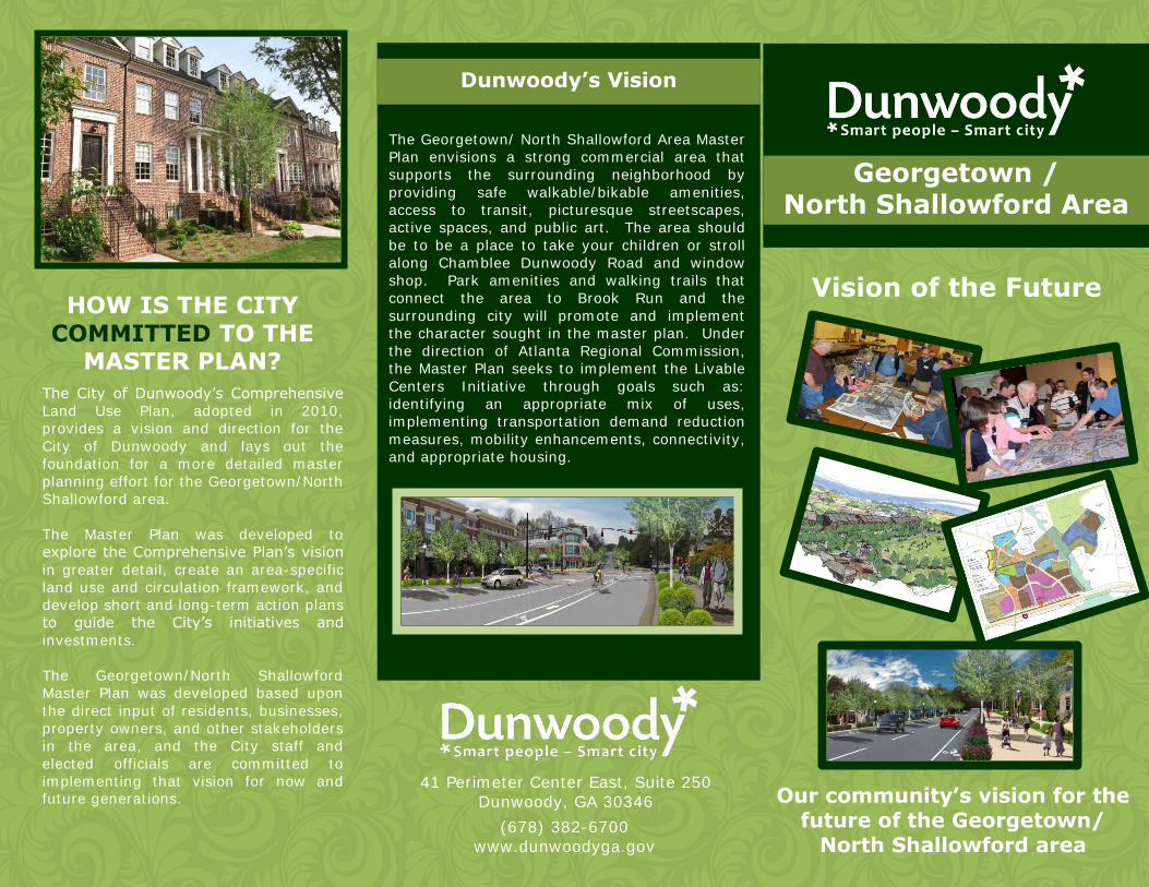
The Georgetown/ North Shallowford Area Master
Plan envisions a strong commercial area that
supports the surrounding neighborhood by
providing safe walkable/bikable amenities,
access to transit, picturesque streetscapes,
active spaces, and public art. The area should
be to be a place to take your children or stroll
along Chamblee Dunwoody Road and window
shop. Park amenities and walking trails that
connect the area to Brook Run and the
surrounding city will promote and implement
the character sought in the master plan. Under
the direction of Atlanta Regional Commission,
the Master Plan seeks to implement the Livable
Centers Initiative through goals such as:
identifying an appropriate mix of uses,
implementing transportation demand reduction
measures, mobility enhancements, connectivity,
and appropriate housing.
HOW IS THE CITY
COMMITTED TO THE MASTER PLAN?
Dunwoody’s Vision
41 Perimeter Center East, Suite 250
Dunwoody, GA 30346
(678) 382-6700
www.dunwoodyga.gov
Georgetown / North Shallowford Area
Our community’s vision for the future of the Georgetown/
North Shallowford area
Vision of the Future

OUR COMMUNITY HAS A VISION FOR THE FUTURE
AND A PROVEN RECORD OF INVESTING AND PARTNERING TO ATTAIN OUR GOALS
The Georgetown / North Shallowford area
directly abuts Interstate 285 and is
currently an assemblage of diverse and
disparate land uses ranging from strip
center commercial, to numerous multifamily
developments (owner and renter) to large
scale institutional uses, to a local utility
operations center.
The Georgetown / North Shallowford Master
Plan outlines targeted initiatives to improve
the “gateway” appearance and create
connectivity while encouraging high quality
retail and filling the gaps in supply of
housing for all ages.
The Master Plan focuses on three key
properties with great susceptibility to
change – (1) the vacant, former DeKalb
County School site, (2) the vacant, former
Emory Medical Center site, and (3) the 16
acre vacant property. The Master Plan
outlines proactive strategies for each key
property.
Additionally, the Master Plan contemplates
new roadway connections to increase
connectivity, enhance walkability, and
create opportunities for higher-quality
development as well as new transit-
oriented redevelopment and significant
streetscape projects.
Q
A
QA
Q
A
What is the City of Dunwoody doing to implement the Master Plan for Georgetown / North Shallowford?
The City recognizes that public investment will help catalyze improvement in this area. The City plans to pursue Master Plan implementation by coordinating a mix of commercial uses that will
activate the area, park amenities, walking trails connecting to Brook
Run Park, and streetscape improvements. The Master Plan recommendations will bring new and re-investment to the area to provide for the current and future
needs of the community.
Is the community supportive of the redevelopment planned for the Georgetown / N. Shallowford area?
As part of the Master Planning process, the City conducted a survey in which 74% of the respondents noted that the area needs extensive redevelopment.
The Georgetown / North Shallowford
Master Plan is available for download at our website, www.dunwoodyga.gov. Click on “Community Development” and select “Land Use Plans.” Please call with any questions (678) 382-6700.
The plan sounds great! How do I
learn more?
GEORGETOWN / N SHALLOWFORD
FREQUENTLY ASKED QUESTIONS
Project RenaissanceA New Georgetown
Awaken Revitalize Renew Transform Catalyze
(678) 382-6700 www.dunwoodyga.gov
IT ALL STARTED WITH A PLAN...
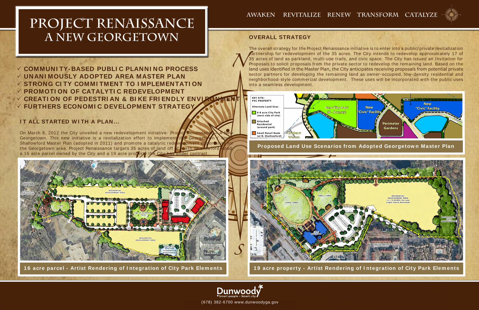
On March 8, 2012 the City unveiled a new redevelopment initiative: Project Renaissance – A New Georgetown. This new initiative is a revitalization effort to implement the Georgetown / North Shallowford Master Plan (adopted in 2011) and promote a catalytic redevelopment opportunity for the Georgetown area. Project Renaissance targets 35 acres of land off of North Shallowford Road, a 16 acre parcel owned by the City and a 19 acre property the City has under contract.
P COMMUNITY-BASED PUBLIC PLANNING PROCESSP UNANIMOUSLY ADOPTED AREA MASTER PLANP STRONG CITY COMMITMENT TO IMPLEMENTATIONP PROMOTION OF CATALYTIC REDEVELOPMENT P CREATION OF PEDESTRIAN & BIKE FRIENDLY ENVIRONMENTP FURTHERS ECONOMIC DEVELOPMENT STRATEGY
0’ 50’ 100’ 200’ 300’ NORTH
19-AcRe siTeIllustrated By: Urban Collage, Inc.
n. s h
al l o
wf o
r d r o
ad
Columns At Lake Ridge
GablesDunwoody
Village Oaks
N AT U R E A R E A /T R E E
P R E S E R VAT I O N
A M P H I T H E AT R E
1 5 ’ M U LT I - U S ET R A I L
1 5 ’ M U LT I - U S E T R A I L( c o n n e c t t o B r o o k R u n )
E X I S T I N G P E R N O S H A L C T
S M A L L L AW N R E S I D E N T I A LD E V E LO P M E N T A R E A
( + / - 7 . 9 A C R E S ; f o r - s a l e s i n g l e - f a m i l y d e t a c h e d )
NE
W R
OA
D
C I V I C B U I L D I N G
240’
L A R G E L AW N
P U B L I C PA R K I N G( + / - 1 5 0 s p a c e s )
0’ 50’ 100’ 200’ 300’ NORTH
16-ACRE PARCELMARCH 9, 2012
Artist Rendering Of
NEIGHBORHOOD COMMERCIAL NODEIllustrated By: Urban Collage, Inc.
N O R T H S H A L L O WF O R D R O A D
CH
AM
BL
EE
DU
NW
OO
DY
RO
AD
DU
NW
OO
DY
PA
RK
Amli Perimeter
Gardens
Delido Apartments
Two Blocks
DCSS Site
E X I S T I N G R O A D WAY
E X I S T I N G R O A D WAY
E X I S T I N GS TO R M WAT E R M A N A G E M E N T
L AW N
1 - 2 S TO R Y N E I G H B O R H O O D R E TA I L( 2 5 - 3 5 , 0 0 0 s . f . ;
+ / - 1 1 0 o f f - s t r e e t p a r k i n g s p a c e s ; + / - 5 0 o n - s t r e e t s p a c e s )
S I G N AT U R EP L AYG R O U N D
PAV I L I O N &E N T R Y P L A Z A
R E S I D E N T I A LD E V E LO P M E N T A R E A
E X I S T I N G R O A D WAY
C I T Y O F D U N W O O DYPA R K
G R E E N WAY T R A I LCO N N E C T I O N
G R E E N WAY T R A I LCO N N E C T I O N
R E S I D E N T I A LD E V E LO P M E N T A R E A
0 300 600 900150Feet
0 300 600 900150Feet
0 300 600 900150Feet
285 EB EXPY
285 WB EXPY
SAVOY DR
COTILLION DR
PEACHFORD RD
N P
EAC
HTR
EE R
D
PEEL
ER R
D
N SHALLOWFORD RD
CHAMBLEE DUNWOODY RD
VILLAGE DR S GEORGIA WAY
BARCLAY DR
CHATEAU DR
N SPRINGS DR
DUNWOODY PARK
LAKE RIDGE LN
RO
CH
ELLE
DR
OLD SPRING HOUSE LN
VERMACK CT
DUNBAR DRPERNOSHAL CT
VILLAGE MILL RD
KINGS DOWN CIR
VER
MA
CK
RD
CHOWNING WAY
DU
NW
OO
DY
PAR
K S
THERAPY DR
285 EB EXIT NUM 30 RAMP
KELLOGG SPRINGS DR
KELLOGG CIR
N GEORGIA WAY
VILLAG
E CT
N FO
REST
TRL
PINERIDGE CIR
285 WB ENTRY NUM 30 RAMP
LAK
E VI
LLA
GE
DR
ORLE
ANS
DR
ORLEANS CT
POWER DR
GEO
RGET
OW
N S
Q
INDEPENDENCE SQ
CHARLESTON PL
VILLAG
E OA
KS D
R
PEELER M
ILL CT
DU
NW
OO
DY PA
RK
N
VER
MA
CK
PL
EQUESTRIAN WAY
DUNWOODY XING
DEKALB DR
285 WB EXIT NUM 30 RAMP
VERMACK RDG
285 EB ENTRY NUM 30 RAMP
CAM
BRID
GE D
R
VILL
AG
E O
AK
S LN
ASBURY CMN
COBB
LE L
N
E KINGS POINT CIR
BUCKTROUT PL
CHATEAU CT
CH
ATEA
U C
LB
KIN
GS
DO
WN
CT
VILLAGE OAKS WAY
SIMSBURY LN
VILLAGE OAKS CT
BRIDLE PATH
VILLAG
E MILL D
R
PEAC
HFO
RD
CIR
285 WB EXPY
LAKE RIDGE LN
0 300 600 900150Feet
0 100’ 200’ 400’ 800’ north
KE Y SITE:DCSS PROPERT Y
Alternate L and Uses Civic/ Institutional L imited Op en Space ( incorp orated with Civic/ Institutional)
KE Y SITE:PVC PROPERT Y
Alternate L and Uses 6-8 acre Cit y Park (west s ide of s ite) Attached
Residential (around park) Small Retai l No de (at N. Shallowford)
KE Y SITE:EMORY MEDIC AL SITE
Alternate L and Use Attached Residential
(S enior Vi l lage)
FUTURETRANSIT STATION
F U T U R E I - 2 8 5 T R A N S I T L I N E
+ / - 1 0 m i n u t e w a l k
+ / - 5 m i n u t e w a l k
NO
RT
H S
HA
LL
OW
FO
RD
RD
PE
EL
ER
R
D
CH
AM
bL
EE
D
UN
WO
OD
Y
RD
§̈¦285
Peachford Hospital
Fire Station
Peachtree Middle School
Chesnut ES
First baptist Church
DCSS Site
City of Dunwoody boundary
Study Area boundary
Study Area boundary
Village Oaks
IndependenceSquare
Chateau Woods
North Springs
DelidoApartments
Two blocks
Terraces ofDunwoody
Madison Square
Senior Village
CamdenDunwoody
Gables Dunwoody
Columns atLake Ridge
barclay at Dunwoody
Apartments
Sterling ofDunwoody
Townhomes
PerimeterGardens
New City Park(6 - 8 acres)
New“Civic” Facility
brook Run Park
New“Civic” Facility
E X I S T I N G F E A T U R E S
M ajor Streets
Parcels
100 Year Flo o d Plain
building Fo otprint
Natural Tree Cover (approximate)
G E O R G E T O W N / N O R T H S H A L L O W F O R D D I S T R I C T S
CONVENIENCE RETAIL:• Primari ly exist ingretai l no des• Limitedoff ice• Limitedopp or tunit y for new
development• Fac ade/ tenant up gradesover t ime• Internal landsc ap e/ p edestrian
/ s ite improvements over t ime (private)
SINGLE-FAMILY RESIDENTIAL:• Small- lot / large-home
development approach due to high land value and compatibi l it y needs
• Ver y l imitedopp or tunit ies
SMALL-SC ALE OFFICE:• Primari ly exist ingoff ice no des• Limitedopp or tunit y for new
development• Fac ade/ tenant up gradesover
t ime• Internal landsc ap e/ p edestrian
/ s ite improvements over t ime (private)
CIVIC / INSTITUTIONAL:• Exist ingcivic / institutional uses
(Peachford H ospital , Fire Station) • Opp or tunit y for newCivic No de
on N. Shallowford• Potential newrecreationcenter
(private) , scho ol (public or private) , communit y / senior ser vices (private) , etc.
AT TACHED RESIDENTIAL:• Combinationof exist ingandnew
development opp or tunit ies• Primari ly l imitedtofor-sale
residential pro duc t• Highp otential for age-targeted
developments (empt y nesters and up)• Newdevelopmentat 2-3stories• Variet y of t yp olo gies including
townhomes, f lats, etc.• L ikely higher-endpricep oints
due to land values and low densit ies
EXISTING MULTI-FAMILY:• Exist ingdevelopment• 3-4stor yexist inggarden-
st yle and f lats (apar tments and condos)
• M ost units built withinthe last10 to 15 years
• Longtermopp or tunit y formixed-use redevelopment
MAJOR NE W CIT Y PARK:• 4 to 8 acrenewpublic c it y park• Incorp orationof a major fo c al
p oint to provide communit y identit y (e.g. , plaza, fountain, splash pad, public sculpture, etc. )
MIXED-USE T.O.D.• Opp or tunit y for longer term
mixed-use development asso ciated with I -285 transit
• Potential newoff ice, residential ,retai l
• 4-8 stor ymid-rise developmentwith op en space committment
GeorGetown/north Shallowford road area MaSter PlanCITY OF DUNWOODY
URBAN COLLAGE, INC. HOUSEAL LAVIGNE ASSOCIATESRCLCO kImLEY-HORN AND ASSOCIATES, INC.
land useFRaMeWORK plan
OVERALL STRATEGY
The overall strategy for the Project Renaissance initiative is to enter into a public/private revitalization partnership for redevelopment of the 35 acres. The City intends to redevelop approximately 17 of 35 acres of land as parkland, multi-use trails, and civic space. The City has issued an Invitation for Proposals to solicit proposals from the private sector to redevelop the remaining land. Based on the land uses identified in the Master Plan, the City anticipates receiving proposals from potential private sector partners for developing the remaining land as owner-occupied, low-density residential and neighborhood-style commercial development. These uses will be incorporated with the public uses into a seamless development.
16 acre parcel - Artist Rendering of Integration of City Park Elements 19 acre property - Artist Rendering of Integration of City Park Elements
Proposed Land Use Scenarios from Adopted Georgetown Master Plan
Project Renaissance - A New Georgetown IMAGINE THE FUTURE IN GEORGETOWN
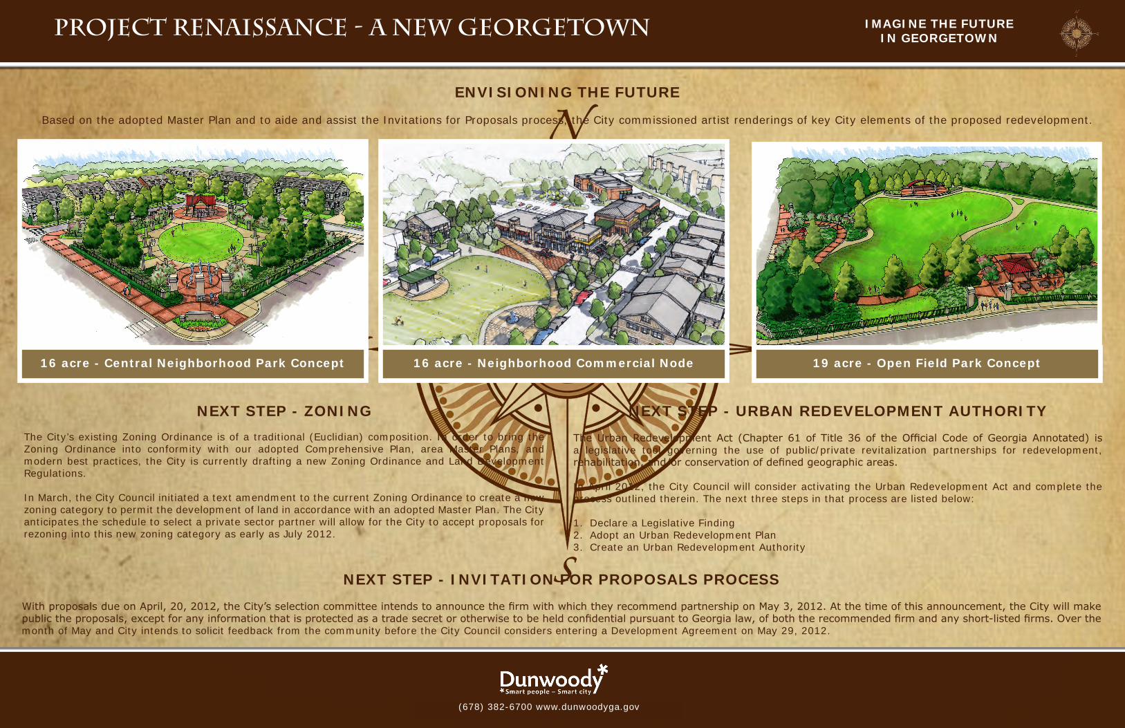
16 acre - Central Neighborhood Park Concept
16-ACRE PARCELMARCH 9, 2012
Artist Rendering Of
NEIGHBORHOOD COMMERCIAL NODEIllustrated By: Urban Collage, Inc.
16 acre - Neighborhood Commercial Node 19 acre - Open Field Park Concept
NEXT STEP - ZONING
The City’s existing Zoning Ordinance is of a traditional (Euclidian) composition. In order to bring the Zoning Ordinance into conformity with our adopted Comprehensive Plan, area Master Plans, and modern best practices, the City is currently drafting a new Zoning Ordinance and Land Development Regulations.
In March, the City Council initiated a text amendment to the current Zoning Ordinance to create a new zoning category to permit the development of land in accordance with an adopted Master Plan. The City anticipates the schedule to select a private sector partner will allow for the City to accept proposals for rezoning into this new zoning category as early as July 2012.
NEXT STEP - URBAN REDEVELOPMENT AUTHORITY
The Urban Redevelopment Act (Chapter 61 of Title 36 of the Official Code of Georgia Annotated) is a legislative tool governing the use of public/private revitalization partnerships for redevelopment, rehabilitation, and/or conservation of defined geographic areas.
In April 2012, the City Council will consider activating the Urban Redevelopment Act and complete the process outlined therein. The next three steps in that process are listed below:
1. Declare a Legislative Finding 2. Adopt an Urban Redevelopment Plan3. Create an Urban Redevelopment Authority
NEXT STEP - INVITATION FOR PROPOSALS PROCESS
With proposals due on April, 20, 2012, the City’s selection committee intends to announce the firm with which they recommend partnership on May 3, 2012. At the time of this announcement, the City will make public the proposals, except for any information that is protected as a trade secret or otherwise to be held confidential pursuant to Georgia law, of both the recommended firm and any short-listed firms. Over the month of May and City intends to solicit feedback from the community before the City Council considers entering a Development Agreement on May 29, 2012.
ENVISIONING THE FUTURE
Based on the adopted Master Plan and to aide and assist the Invitations for Proposals process, the City commissioned artist renderings of key City elements of the proposed redevelopment.
(678) 382-6700 www.dunwoodyga.gov