drought plan 2019...analysis of minimum inflows (for drought response surface), 18 month drought...
TRANSCRIPT
Drought Plan 2019
APPENDICES
Yorkshire Water
May 2020

Yorkshire Water |Drought Plan 2019| Yorkshire Water 2
In accordance with Drought Plan guidance, this statement certifies that Yorkshire Water’s Drought Plan has been reviewed by our security team. Some information has been redacted or edited in this published version for reasons of national security.
CONTENTS PAGE
Appendix 1 Example control curves plus scenario lines 4
Appendix 1.1: Drought Planning in Weekly Water Situation Report: 1995-96 baseline scenario 1300Ml/d demand 4
Appendix 1.2: Drought Planning in Weekly Water Situation Report: 1929 one season drought scenario at 1460Ml/d
demand 6
Appendix 1.3: Drought Planning in Weekly Water Situation Report: 1929 one season drought scenario at 1380 Ml/d
demand 10
Appendix 1.4: Drought planning in Weekly Water Situation Report: 2 year drought at 1460Ml/d demand 12
Appendix 1.5: Drought planning in Weekly Water Situation Report: Two year drought at 1380Ml/d demand 16
Appendix 1.6: Drought planning in Weekly Water Situation Report: Three-year drought at 1460Ml/d demand (1995-
1996-1996) 18
Appendix 1.7: Drought response surfaces 23
Appendix 2: Drought Plan Direction 2016 25
Appendix 3: Drought management actions 27
Appendix 3.1: Demand-side drought management actions 27
Phase 1: Prior to implementation of Temporary Use Bans 27
Phase 2: Prior to drought order for restrictions of non-essential use 29
Phase 3: Emergency drought orders 31
Appendix 3.2: Drought permit and order application process 34
Appendix 3.3: Water use restrictions in a drought 38
Appendix 4: Temporary use ban consultations 43
Drought Plan 2013 customer research on new restrictions introduced by the Flood and Water Management Act
2010 43
Future options for managing customer demand for water White paper prepared for Yorkshire Water by London
Economics 2018 44
Consumer reactions and attitudes towards temporary use bans (TUBs) 44
Appendix 5: Supply-side drought management actions 47
Appendix 6: Habitats Regulations Assessment 1
Introduction 1
Approach 4
HRA Screening Results 13
Conclusions of HRA Screening: Final Drought Plan 2019 88
Annex A: Information to Inform the Appropriate Assessment 90
Potential impacts of the North Yorkshire Groundwater increased abstraction Drought Option 94

Yorkshire Water |Drought Plan 2019| Yorkshire Water 3
Geology 97
Hydrogeology 97
Potential impacts of the River Aire Abstraction Drought Option 100
Potential Impact on SPA designated features 102
Appendix 7: Example company drought management structure 106
Appendix 8: Drought Communications Plan 107
Introduction 107
Traffic light campaign – data and weather triggered approach 107
Communications objectives 107
Target Audience 107
Key messages 108
Communications plan 113

Yorkshire Water |Drought Plan 2019| Yorkshire Water 4
Appendix 1 Example control curves plus scenario lines
Appendix 1.1: Drought Planning in Weekly Water Situation Report: 1995-96 baseline scenario 1300Ml/d demand
Commentary
Regional stocks cross Environment Agency consultation line in November 1995, triggering company CRMT and liaison with the Environment Agency. The South West area abstractions would have been reduced in summer 1995 when stocks fell faster in that area than others, and the area would have been supported by grid transfers.
The figure in Appendix 1.1 shows the predicted reservoir storage under a repeat of 1995-1996 inflows at an average annual demand of 1300Ml/d, with a dry year monthly demand profile. The simulation shows no temporary use bans as our service has improved since 1995-1996. In practice,

Yorkshire Water |Drought Plan 2019| Yorkshire Water 5
during 1995-1996 we had drought orders throughout the region. The improved service, compared to the actual situation in 1995-1996, is due to the significant investment in leakage control and the grid network that we have made in the last 20 years. This scenario shows no temporary use bans as it is based on the entire 1995-1996 period, and the start of 1995 was relatively wet. The scenario shown in Figure 2.2, with forecasts for 1995-1996 inflows starting in May 2017 shows temporary use bans because the start of 2017, was far drier than the start of 1995.
When January 1995-December 1996 inflows is repeated at a higher annual average demand of 1380Ml/d, temporary use bans are triggered. Since 2004 annual average demands have ranged from 1210Ml/d to 1317Ml/d, with an average of 1275Ml/d, so a 1380Mld annual average demand represents a high demand scenario.
The 1995-1996 event is the only two-year drought we have in our period of record. Rainfall totals for the 20 month period from March 1995 to October 1996 are just 67 per cent of the long-term average. This equates to a return period of about 1 in 500 to 1 in 1000 years. However, because the drought was preceded by and followed by relatively wet periods, if the entire two years 1995 and1996 are analysed, the 80 per cent rainfall in this period has a return period of only 1 in 20 years. This highlights the problems associated with the use of return period statistics in drought situations.
Scenario
Demand:1300Ml/d
Inflows: Jan 1995-December 1996
Return periods of regional rainfall (based on Tabony Tables)
March 1995-October 1996- 1000 year return period (67% average, 20 months)
Jan 1995-dec 1996- 24 months, 82% LTA, 20 year return period
Analysis of minimum inflows: Generalised Pareto Distribution (GPD) of 18 months ending in August 60% of average year, Return period approximately 1 in 100 to 1 in 200 years.
Timeline
Trigger Date Actions
May 1995 Usual summer conservation campaign commenced.
Regional NCL crossed June 1995 Reservoir abstractions reduced and rivers maximised.
EA trigger crossed in SW and central group
September 1995 South west area supported by grid transfers.
Increased leakage control
Increased voluntary water efficiency media communications
EA trigger crossed in regional group
November 1995 CRMT meet to implement Water Supply Escalation Plan
EA liaison commenced
Temporary Use Bans Triggered
None

Yorkshire Water |Drought Plan 2019| Yorkshire Water 6
Drought Orders None
Appendix 1.2: Drought Planning in Weekly Water Situation Report: 1929 one season drought scenario at 1460Ml/d demand
Commentary
In this scenario the EA trigger is crossed in April, and at this stage we would have started meetings with the Environment Agency and started our CRMT as part of our water supply escalation plan. We would implement our summer water efficiency program starting in May. TUBs are triggered in one area in July and in a further three areas in September. With the July threshold crossed, and further thresholds forecast to be crossed in late September, we would have begun preparation of our temporary use ban adverts in August, and advertised them in September. At the same time, we would have started to consult the Environment Agency and Natural England on supply side drought options, and begun preparation of our supply side drought permit applications and non-essential use bans. We would have considered imposing temporary use bans in late September, but when

Yorkshire Water |Drought Plan 2019| Yorkshire Water 7
rainfall resulted in the recovery of reservoirs in October we would not have proceeded with our supply side drought permit applications and non-essential use bans.
Scenario: Demand: 1460 Ml/d
Inflows: January to December 1929
Return Period analysis
Feb-September regional rainfall 8 months, 60% LTA- 100 year return period using Tabony Tables.
Analysis of minimum modelled reservoir stocks (deployable output demand)- 38% stocks correspond
to 50-100 year return period. Generalised Pareto Distribution extreme value analysis of lowest stocks.
Analyses for drought response surface 6 month drought ending in August - 50-100 year
return period using Generalised Pareto Distribution extreme value analysis of lowest inflows.
All analysis methods give a return period of 1 in 50-100 years.
Timeline
Trigger Date Actions
Regional NCL crossed March 1929 Reservoir abstractions reduced and rivers maximised
EA trigger crossed in regional group
April 1929 CRMT instigated
EA liaison commenced
May 1929 Summer efficiency campaign started.
Temporary Use Ban Restriction triggers crossed in South West Reservoir group
July 1929 SW area supported by grid transfers
Escalate summer water saving campaign
Temporary Use Ban Restriction triggers forecast to be crossed in next month
August 1929 Preparation of TUBs advertisements.
Consultation with EA and NE.
Analysis of regional and area rainfall to prove exceptional shortage
Temporary Use Ban Restriction triggers crossed in Central, North West and South Reservoir groups
September 1929
TUBs considered,
Initial preparation of non-essential use ban and supply side drought orders and permits
Mid September 1929
TUBs imposed if weather continues to be hot and dry
CRMT escalated to CIMT
Prepare non-essential use ban drought orders or permits
Prepare compensation reduction drought permits or orders
Prepare non-essential use ban drought orders or permits

Yorkshire Water |Drought Plan 2019| Yorkshire Water 8
Prepare increased river abstractions/HOF reduction drought orders
Temporary Use Ban Restriction triggers crossed in Regional Reservoir group Rainfall leads to recovery of reservoir stocks
October 1929 Final preparations to submit supply side drought permits and demand side drought orders for non-essential use bans would have been made, but then significant rainfall occurs.
Continue maximising river abstractions until reservoir stocks are above NCL
Reservoir stocks recover above NCL
November 1929 Return to normal operation
Drought Orders None
The figure below shows the timeline actions plotted on the graph of regional reservoir stocks. Note that this shows only the regional stocks, but actions triggered by area stocks are also shown to aid understanding of how we would have acted during this event.

Yorkshire Water |Drought Plan 2019| Yorkshire Water 9

Yorkshire Water |Drought Plan 2019| Yorkshire Water 10
Appendix 1.3: Drought Planning in Weekly Water Situation Report: 1929 one season drought scenario at 1380 Ml/d demand
Commentary
This scenario uses the 1929 inflows, but with a high realistic annual average demand of 1380Ml/d instead of
the Deployable output demand of 1460Ml/d. TUBs are triggered in 2 areas, but none are implemented.

Yorkshire Water |Drought Plan 2019| Yorkshire Water 11
Timeline
Scenario: Demand: 1380 Ml/d
Inflows: January to December 1929
Return Period analysis
Feb-September regional rainfall 8 months, 60% LTA- 100 year return period using Tabony Tables.
Analysis of minimum modelled reservoir stocks (deployable output demand)- 38% stocks correspond
to 50-100 year return period. Generalised Pareto Distribution extreme value analysis of lowest stocks.
Analyses for drought response surface 6 month drought ending in August - 50-100 year
return period using Generalised Pareto Distribution extreme value analysis of lowest inflows.
All analysis methods give a return period of 1 in 50-100 years.
Trigger Date Actions
Regional NCL crossed March 1929 Reservoir abstractions reduced and rivers maximised
EA trigger crossed in regional group
April 1929 CRMT instigated
EA liaison commenced
May 1929 Summer efficiency campaign started.
June-October 1920
Scenario modelling carried out.
Supplies balanced across region.
Rainfall, reservoir stocks and demands monitored.
Temporary Use Ban Restriction triggers crossed in Central and North West Reservoir group
September 1929
Central and north west area supported by grid transfers
Escalate water saving campaign
No TUBs imposed as only triggered in 2 areas and managed by support from other areas and river abstractions.
Rainfall leads to recovery of reservoir stocks
October 1929 Rivers still maximised as regional stocks below NCL
Reservoir stocks recover above NCL November 1929 Return to normal operation
Drought Orders None

Yorkshire Water |Drought Plan 2019| Yorkshire Water 12
Appendix 1.4: Drought planning in Weekly Water Situation Report: 2 year drought at 1460Ml/d demand
Commentary
When the Environment Agency trigger line is crossed in July of year 1 we would have started meeting the Environment Agency and convened our water supply escalation plan CRMT. We would also have requested voluntary reductions in demand, and escalated our summer efficiency campaign.
Our modelling shows temporary use bans are triggered in September in the central and south west reservoir groups, with triggers crossed in late October (outside our TUBs season) in our south reservoir group. We would be unlikely to implement temporary use bans at this time as they would have little effect due to the time of year. One of the main reductions in water use due to temporary use bans is garden watering, which is minimal even during a dry winter as it is outside the growing season. Instead we would carefully monitor the situation, and actively promote demand reduction and efficiency measures, and maximise leakage reduction. In line with our normal operating policy, with reservoirs below the NCL we would maximise river abstractions and minimise use of reservoirs

Yorkshire Water |Drought Plan 2019| Yorkshire Water 13
wherever possible. In this situation we would operate to rebalance reservoir stocks as far as possible, and minimise the use of reservoirs in the south and south west. In this situation we would consider applying for winter drought permits to increase annual abstraction limits on rivers if we were likely to exceed our annual limits if abstractions were maximised according to daily limits and relevant river flow thresholds. We may also have applied for winter permits to reduce compensation flows in areas where we were concerned about reservoir recovery and where we thought this would provide a benefit. Prior to applying for these permits we would have prepared environmental reports and liaised the Environment Agency and other relevant stakeholders.
If no winter permits had been applied for, over the winter period, if minimal winter refill had occurred, we would prepare our advertisements for temporary use bans and our applications for compensation reductions drought permits, including the preparation of environmental reports and liaison with Natural England and Environment Agency. Temporary use bans would be advertised in March of year 2, and implemented by April, coinciding with the start of the growing season. With the slight recovery of reservoir stocks over the winter period, we would have continued to monitor the situation, and applied for non-essential use bans and supply side drought permits or orders in May of year 2, with a view to implementing them by the start of July. During this time, we would have been continuously reassessing the situation and would have been performing scenario modelling, and with a repeat of 1929 inflows from March 1996, regional reservoir stocks would have been forecast to fall below the DCL at the start of July 1996.
During the summer of year 2 when we were applying for supply-side drought permits and non-essential use bans we would also be carrying out environmental assessments required for our long-term drought options, and assessing which options would be the most beneficial with respect to our current water resources position, as well as which were best in terms of the environment.
This scenario is based on our 1995/96 inflows, and its position on the DRS is shown as being on the border of having stocks below the DCL for the 18 month duration ending in August. In reality, the 1995/96 drought continued until October. It should also be noted that the DRS is for only the regional reservoir group, whereas the drought actions we have described relate to both regional and area groups. We manage our resources to balance stocks across the region as much as possible, so believe the regional DRS does offer an accurate reflection of our drought risk.
Scenario: Demand: 1460Ml/d Inflows 1995-96
Rainfall analyses using Tabony Tables - March 1995-October 1996- 1000 year return period
(67% average, 20 months)
Jan 1995-dec 1996- 24 months, 82% LTA, 20 year return period
April 1995-September 1996 analysis of rainfall data using Gringorten plotting position gives
Return period of 1:240 years (used in WRMP19 Table 10 links with this Drought Plan)
Analysis of minimum inflows (for Drought Response Surface), 18 month drought ending in
August, 60% of LTA, return period of 1 in 100 to 1 in 200 years
Data analyses give return periods of between 1 in 20 and 1 in 1000 years. We have chosen to use 1
in 240 years, as used in our WRMP19.
Timeline
Trigger Date Actions

Yorkshire Water |Drought Plan 2019| Yorkshire Water 14
Regional NCL crossed May 1995 Reservoir abstractions reduced and rivers maximised
Summer efficiency campaign started.
EA trigger crossed in regional group
July 1995 CRMT instigated
EA liaison commenced
Analysis to determine exceptional shortage of rainfall commenced.
TUBs triggers forecast to be crossed in September in 2 areas.
August 1995 Increase leakage management Increase water saving awareness campaigns Increased efficiency measures Continue to monitor the situation carefully. Continue rainfall analyses. Prepare TUBS advertisements
Temporary Use Ban Restriction triggers crossed in Central and southwest Reservoir groups
September 1995
South, Central and South West areas continue to be supported by grid transfers
Temporary Use Ban Restriction trigger crossed for 1 week only in South reservoir group Drought Control Line forecast to be crossed in December/January in South and South West Rainfall analysis shows high return period event.
October 1995 Continue with:
• Increased leakage management
• Increased water saving awareness campaigns
• Increased efficiency measures Monitor water resources position Continue with preparation of demand side drought permits/orders to restrict non essential use, Environmental Assessment Reports and supply side drought order/permit applications TUBS not applied for as outside the growing season and benefit limited at this time of year. Consider whether winter permits to reduce compensation flows would benefit reservoir stocks. Consider whether increase in annual licence drought permits would be required.
Lack of winter refill South and south West stocks just hit DCL.
December 1995 In light of very low reservoir stocks, continue with preparation of TUBs advertisements. South, Central and South West area supported by grid transfers.
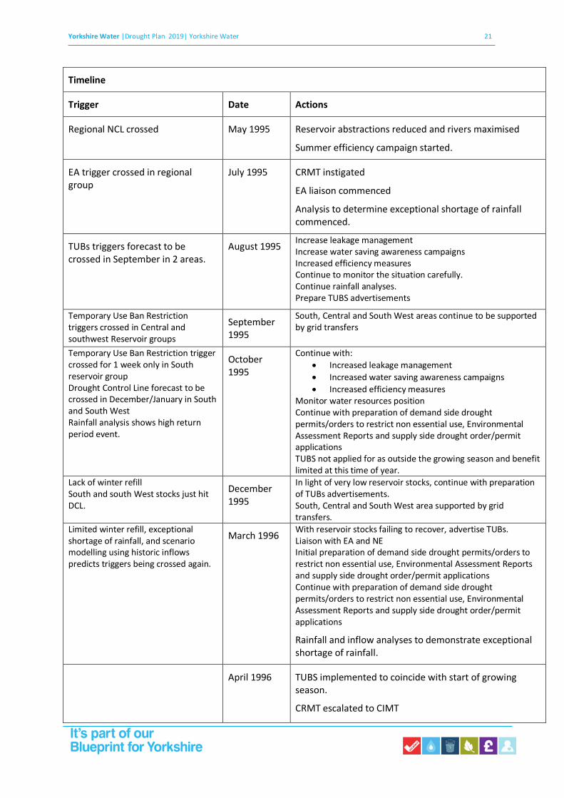
Limited winter refill, exceptional shortage of rainfall, and scenario modelling using historic inflows predicts triggers being crossed again.
March 1996 With reservoir stocks failing to recover, advertise TUBs. Liaison with EA and NE Initial preparation of demand side drought permits/orders to restrict non-essential use, Environmental Assessment Reports and supply side drought order/permit applications Continue with preparation of demand side drought permits/orders to restrict non-essential use, Environmental Assessment Reports and supply side drought order/permit applications
Rainfall and inflow analyses to demonstrate exceptional shortage of rainfall.
April 1996 TUBS implemented to coincide with start of growing

Yorkshire Water |Drought Plan 2019| Yorkshire Water 15
Scenario modelling (using 1929 inflows) indicates regional stocks falling below DCL in July
season.
CRMT escalated to CIMT
Continue to:
Prepare non-essential use ban drought orders or permits
Prepare compensation reduction drought permits or orders
Prepare non-essential use ban drought orders or permits
Prepare increased river abstractions/HOF reduction drought orders
Reservoir stocks start to fall again
May 1996 Submit supply side drought permits (compensation reduction and increased abstraction/HOFs) and demand side drought orders for non-essential use bans.
Start to discuss long term drought options with EA, NE and other stakeholders.
Depending on location of drought, identify most beneficial long-term drought options, and prepare environmental assessments.
July 1996 NEUB and supply side drought permits/orders obtained
and implemented.
Continue investigations and environmental assessment work on long term drought options.
Liaise with Environment Agency and Natural England.
Progress plans for long term options abstraction on River Aire, and increase in abstraction on the River Ouse, as flows in the Central and North West areas are healthier than those in the South and South West.
Reservoir stocks start to recover October 1996 Continue with compensation reduction drought
permits and non-essential use bans, but no longer implementing increased abstraction/HOFs drought permits.
Reservoir stocks recover above NCL
November 1996 Return to normal operation
Yorkshire Water |Drought Plan 2019| Yorkshire Water 16
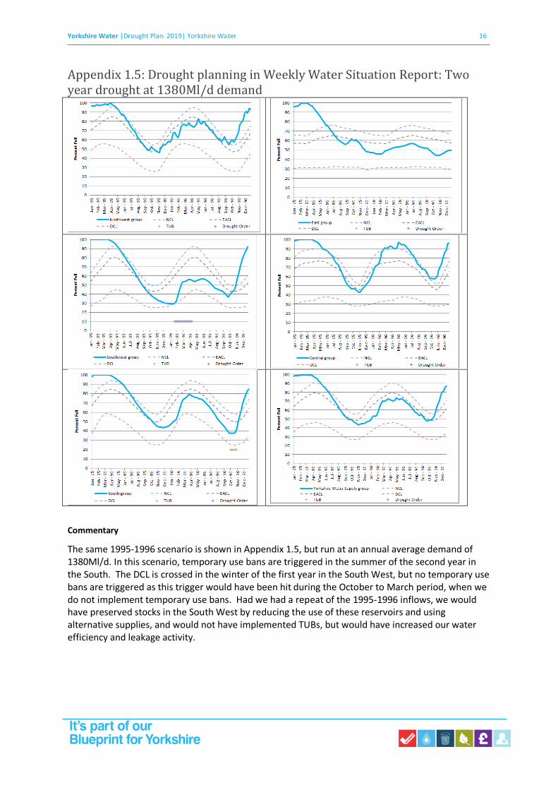
Appendix 1.5: Drought planning in Weekly Water Situation Report: Two year drought at 1380Ml/d demand
Commentary
The same 1995-1996 scenario is shown in Appendix 1.5, but run at an annual average demand of 1380Ml/d. In this scenario, temporary use bans are triggered in the summer of the second year in the South. The DCL is crossed in the winter of the first year in the South West, but no temporary use bans are triggered as this trigger would have been hit during the October to March period, when we do not implement temporary use bans. Had we had a repeat of the 1995-1996 inflows, we would have preserved stocks in the South West by reducing the use of these reservoirs and using alternative supplies, and would not have implemented TUBs, but would have increased our water efficiency and leakage activity.

Yorkshire Water |Drought Plan 2019| Yorkshire Water 17
Scenario: Demand 1380Ml/d Inflows 1995-96 inflows
Rainfall analyses using Tabony Tables - March 1995-October 1996- 1000 year return period
(67% average, 20 months)
Jan 1995-dec 1996- 24 months, 82% LTA, 20 year return period
April 1995-September 1996 analysis of rainfall data using Gringorten plotting position gives
Return period of 1:240 years (used in WRMP19 Table 10 links with this Drought Plan)
Analysis of minimum inflows (for Drought Response Surface), 18 month drought ending in
August, 60% of LTA, return period of 1 in 100 to 1 in 200 years
Data analyses give return periods of between 1 in 20 and 1 in 1000 years. We have chosen to use 1
in 240 years, as used in our WRMP19.
Timeline
Regional NCL crossed May 1995 Reservoir abstractions reduced and rivers maximised
Summer efficiency campaign started.
EA trigger crossed in regional group
July 1995 CRMT instigated
EA liaison commenced
South West Group stocks falling rapidly Lack of winter refill
December 1995 South West area supported by grid transfers Increase leakage management Increase water saving awareness campaigns Increased efficiency measures
South West group stocks fall below DCL
January 1996 Maximise support by grid transfers Increased leakage activity and demand management.
Continued lack of winter refill, exceptional shortage of rainfall, and scenario modelling using historic inflows predicts TUBs in April.
March 1996 Continue increased level of water saving campaigns.
April 1996-July Situation continuously monitored, analysing reservoir stocks and rainfall.
Preparations made for advertising TUBs.
TUBs triggered in South reservoir group
September 1996
No TUBs imposed taken as triggered in only one area.
Continue balancing stocks across the region,
Reservoir stocks start to recover October 1996
Reservoir stocks recover above NCL
November 1996 Return to normal operation

Yorkshire Water |Drought Plan 2019| Yorkshire Water 18
Appendix 1.6: Drought planning in Weekly Water Situation Report: Three-year drought at 1460Ml/d demand (1995-1996-1996)

Yorkshire Water |Drought Plan 2019| Yorkshire Water 19
Commentary
This is based on the January 1995 to August 1996 inflows, followed by 80% of September 1995 to December 1996 inflows. This again represents a more extreme position than has been experienced in Yorkshire in our period of record.
In this example, we would have implemented our CRMT water supply escalation plan in July of year 1 when regional reservoir stocks crossed the EA trigger, at the same time as starting liaison with the Environment Agency. In July we would also have escalated our summer water saving campaign, and requested voluntary reductions. Over the summer we would have continually reviewed the situation, and we would have prepared our TUBs advertisements, although as in the 2 year drought in Appendix 1.4, we would be unlikely to have implemented TUBs when they were first triggered in September and October after the TUBs season of year 1.
The drought control line was touched in the December of year 1 in the south west and January 1996 in the south reservoir groups, but in the period when we would not usually implement TUBs. During the winter we would have prepared our adverts for TUBS, and our applications for drought permits and orders to reduce compensation flows. In the spring of year 2, with some recovery, but with reservoir stocks still well below normal, we would have advertised and implemented TUBs, and would start the process of applying for non-essential use bans. In the summer of year 2 we would apply for supple side drought permits to reduce compensation flows, and to increase river abstractions in low flow bands.
During the summer of year 2 when we were applying for supply side drought permits and non-
essential use bans we would also be carrying out environmental assessments required for our long
term drought options, and assessing which options would be the most beneficial with respect to our
current water resources position, as well as which were best in terms of the environment. With the
drought ongoing, we would decide which long-term options to implement depending on resource
and environmental investigations, and commence the process of construction of long term drought
options. Depending on the time taken to construct the long term option, the additional resource
would be available sometime during year 3.
We would also assess the need for emergency drought orders from the summer of year 2, and
would continually review the requirements (and benefits) of these.
Scenario: 3 year drought Demand: 1460Ml/d Inflows: January 1995-August 96 inflows followed by 80% of September 1995-December 1996 inflows.
Return Preiod Analyses
Rainfall return period using Tabony Tables: January 1995-August 96 inflows followed by 80% of
September 1995-December 1996, 36 months of 73%LTA, >1000 year RP
(Jan 1995-August 96, followed by Sept 95-Dec 96, 36 months, 80% LTA, would have a 100-200
year return period)
Inflow analysis using Generalised Pareto distribution (as described in Drought Response Surface
analyses)
Inflows compared to “average” year 1952 Inflows used for the period January 1995-August 96 inflows
followed by 80% of September 1995-December 1996, 76% inflows for 36 months. DRS analyses are
carried out for 6 month periods ending in August and November, so:

Yorkshire Water |Drought Plan 2019| Yorkshire Water 20
For 30 months June 1995 to August 1996 followed by 80% September 1995- November 1996,
62% of average- 1 in 500 year return period.,
For 30 months March 1995 to August 1996 followed by 80% September 1995- August 1996,
64% of average- over 1 in 1000 year return period.
Yorkshire Water |Drought Plan 2019| Yorkshire Water 21
Timeline
Trigger Date Actions
Regional NCL crossed May 1995 Reservoir abstractions reduced and rivers maximised
Summer efficiency campaign started.
EA trigger crossed in regional group
July 1995 CRMT instigated
EA liaison commenced
Analysis to determine exceptional shortage of rainfall commenced.
TUBs triggers forecast to be crossed in September in 2 areas.
August 1995 Increase leakage management Increase water saving awareness campaigns Increased efficiency measures Continue to monitor the situation carefully. Continue rainfall analyses. Prepare TUBS advertisements
Temporary Use Ban Restriction triggers crossed in Central and southwest Reservoir groups
September 1995
South, Central and South West areas continue to be supported by grid transfers
Temporary Use Ban Restriction trigger crossed for 1 week only in South reservoir group Drought Control Line forecast to be crossed in December/January in South and South West Rainfall analysis shows high return period event.
October 1995
Continue with:
• Increased leakage management
• Increased water saving awareness campaigns
• Increased efficiency measures Monitor water resources position Continue with preparation of demand side drought permits/orders to restrict non essential use, Environmental Assessment Reports and supply side drought order/permit applications TUBS not applied for as outside the growing season and benefit limited at this time of year.
Lack of winter refill South and south West stocks just hit DCL.
December 1995
In light of very low reservoir stocks, continue with preparation of TUBs advertisements. South, Central and South West area supported by grid transfers.
Limited winter refill, exceptional shortage of rainfall, and scenario modelling using historic inflows predicts triggers being crossed again.
March 1996 With reservoir stocks failing to recover, advertise TUBs. Liaison with EA and NE Initial preparation of demand side drought permits/orders to restrict non essential use, Environmental Assessment Reports and supply side drought order/permit applications Continue with preparation of demand side drought permits/orders to restrict non essential use, Environmental Assessment Reports and supply side drought order/permit applications
Rainfall and inflow analyses to demonstrate exceptional shortage of rainfall.
April 1996 TUBS implemented to coincide with start of growing season.
CRMT escalated to CIMT

Yorkshire Water |Drought Plan 2019| Yorkshire Water 22
Scenario modelling (using 1929 inflows) indicates regional stocks falling below DCL in July
Continue to:
Prepare non-essential use ban drought orders or permits
Prepare compensation reduction drought permits or orders
Prepare non-essential use ban drought orders or permits
Prepare increased river abstractions/HOF reduction drought orders
Reservoir stocks start to fall again
May 1996 Submit supply side drought permits (compensation reduction and increased abstraction/HOFs) and demand side drought orders for non-essential use bans.
Start to discuss long term drought options with EA, NE and other stakeholders.
Depending on location of drought, identify most beneficial long term drought options, and prepare environmental assessments.
July 1996 NEUB and supply side drought permits/orders obtained
and implemented.
Continue investigations and environmental assessment work on long term drought options.
Liaise with Environment Agency and Natural England.
Progress plans for long term options abstraction on River Aire, and increase in abstraction on the River Ouse, as flows in the Central and North West areas are healthier than those in the South and South West.
Limited recovery of reservoir stocks October 1996
Continue maximising rivers when available.
Prepare for second dry winter
Continue planning and construction work on long term options.
Increased abstraction capacity available at the River Ouse
April 1997 Increased abstraction available from the River Ouse, but pipeline still under construction. We can increase abstraction slightly at the River Ouse and increase treatment there temporarily, allowing water usually supplied from Elvington to be used elsewhere.
Pipeline from the River Ouse complete.
River Aire abstraction complete,
July 1997 Able to use full licence on the River Ouse and transfer to Elvington for treatment.
Reservoir stocks recover above NCL
January 1998
Return to normal operation

Yorkshire Water |Drought Plan 2019| Yorkshire Water 23
Appendix 1.7: Drought response surfaces
Drought response surfaces have been calculated to provide an indication of the vulnerability of the Yorkshire Water system to droughts of varying magnitudes and durations. To produce the surface shown below and in Figure 2.5 of our Drought Plan, we have run our regional WRAPsim model for an “average” inflow year (1952), with inflows factored to represent a number of drought scenarios ranging from 6 to 48 months in duration, and from 25% to 95% of average inflows. In this example, all droughts end at the end of August, and the model is run for 20 years in total, with a five-year warm up period at the start and average conditions returning after the end of the specified drought duration. For each run, the number of weeks that the regional reservoir group is below the DCL has been recorded.
The inflows for the Yorkshire regional reservoir group have been analysed to determine the return period of historical inflows ending in August. To do this Peak Under Threshold (PuT) analyses have been carried out, selecting the driest 20 periods for each duration during the record starting in 1920, and applying a Generalised Pareto Distribution (GPD) to each duration. The driest 20 periods were selected to ensure that the analyses were for a genuine extreme distribution and not for all values in the period of record. The GPD provided return period inflows for all durations, and these have been plotted on Figure 2.5 of our Drought Plan.
Note that this DRS shows period below our Drought Control Line (DCL), and not the period below level 4 drought restrictions, although the period below both level 4 restrictions and DCL are shown in our final WRMP.
The DRS shown is for droughts ending in August. This means that droughts of 6, 18, 30 and 42 month durations start in March, and droughts of 12, 24, 36 and 48 month durations start in September.
The DRS is constructed using design droughts for fixed flow deficits and durations. The return period analyses carried out are based on our inflow data for these design drought durations, and have been carried out for each duration independently. The return period analyses are therefore reflective of the severity of droughts that have occurred in our record. For example, because we have had an extremely severe 18 month drought, this may appear to be more common than it really is because it is in our period of record and included in our analyses. This is shown by the shape of the lines connecting events of the same return period for different durations-all lines dip significantly at the 18 month duration, because our worst 18 month drought is far lower in terms of average flows than droughts of other durations.

Yorkshire Water |Drought Plan 2019| Yorkshire Water 24

Yorkshire Water |Drought Plan 2019| Yorkshire Water 25
Appendix 2: Drought Plan Direction 2016 The Drought Plan (England) Direction 2016
The Secretary of State, having consulted the Welsh Ministers in relation to Wales(a), makes the following
Direction in exercise of the powers conferred by—
(a) section 37B(11) of the Water Industry Act 1991(b), as applied by section 39B(5) of that Act; and
(b) section 39B(4)(d) and (9) of that Act(c).
Citation, commencement and application 1. —(1) This Direction may be cited as the Drought Plan (England) Direction 2016 and comes into force on
27th July 2016.
(2) This Direction applies in relation to a water undertaker whose area is wholly or mainly in England.
Interpretation 2.—(1) In this Direction—
“the Act” means the Water Industry Act 1991;
“drought plan” means the plan which a water undertaker is required to prepare, publish and maintain under section 39B(1) of the Act;
“water undertaker” is to be construed in accordance with section 6 of the Act.
(2) A reference in this Direction to section 37B of the Act is a reference to that section as applied by section 39B(5) of the Act.
Additional matters to be addressed in drought plans 3.—(1) A water undertaker, in its drought plan, must address the following matters—
(a) the management structure that the water undertaker will put in place during a drought and an explanation of how the management structure will manage, communicate and make decisions during a drought;
(b) the magnitude and duration of droughts for which the drought plan has been tested;
(c) the permits and approvals that the water undertaker expects to need in order to implement the
drought management measures;
(d) the discussions that have occurred between the water undertaker and the bodies responsible for granting those permits and approvals and the arrangements for discussions with those bodies during the onset, duration and abatement of all droughts covered by the drought plan;
(e) the measures that may be needed to mitigate any adverse effect on the environment resulting
from the implementation of a drought management measure;
(a) The functions of the Secretary of State under sections 37B and 39B of the Water Industry Act 1991 are exercisable in relation to Wales only after consultation with the Welsh Ministers (article 5 of, and Schedule 2 to, the National Assembly for Wales (Transfer of Functions) Ord er 1999 (S.I. 1999/672) (“the Order”) and section 162 of, and paragraph 30 of Schedule 11 to, the Government of Wales Act 2006 (c. 32)).
(b) 1991 c.56.
(c) Sections 37B and 39B were inserted into the Water Industry Act 1991 by sections 62 and 63 of the Water Act 2003 (c. 37).
Section 39B was amended by section 28 of the Water Act 2014 (c.21). Functions of the Secretary of State under sections
37B and 39B, in so far as they relate to matters other than the construction or enlargement of reservoirs, were transferred to the National Assembly for Wales in relation to any water undertaker whose area is wholly or mainly in Wales by the Order, article 2: see the entry in Schedule 1, as amended by section 100(2) of the Water Act 2003, for the Water Industry Act 1991. Those functions were subsequently transferred to the Welsh Ministers by virtue of section 162 of, and paragraph 30 of Schedule 11 to, the Government of Wales Act 2006.

Yorkshire Water |Drought Plan 2019| Yorkshire Water 26
(f) the permits and approvals that the water undertaker expects to need in order to implement those mitigation measures; and
(g) the compensation that may need to be made as a result of the implementation of a drought management measure.
(2) In this paragraph—
“compensation” means compensation within the meaning of Schedule 9 to the Water Resources Act 1991(a);
“drought management measure” means a measure mentioned in section 39B(4)(a) or (b) of the Act and set out in the drought plan.
Submitting draft drought plans to the Secretary of State
4. Except where the Secretary of State otherwise permits, for the purpose of section 37B(1) of the Act, a water undertaker must send a draft of its drought plan to the Secretary of State as follows—
(a) for a first drought plan, within 6 months after the date on which the water undertaker is required to prepare that drought plan; and
(b) for a revised drought plan—
(i) if section 39B(6)(a) of the Act applies, within 6 months after the date on which the
material change of circumstances occurs; and
(ii) if section 39B(6)(c) of the Act applies, within 4 years and 3 months after the date on
which its drought plan, or its last revised drought plan, is published.
Responding to representations 5. Except where the Secretary of State otherwise permits, a water undertaker must produce the statement required by regulation 4 of the Drought Plan Regulations 2005(b) within 15 weeks after the date on which the water undertaker publishes a draft of its drought plan under section 37B(3)(a) of the Act.
Revocation of the Drought Plan Direction 2011 6. The Drought Plan Direction 2011(c) is revoked in relation to water undertakers whose areas are wholly or mainly in England.
Holly Yates
Deputy Director, Water Services, for and on behalf of the
July 2016 Secretary of State for Environment, Food and Rural Affairs
(a) 1991 c.57.
(b) S.I. 2005/1905.
(c) The Drought Plan Direction 2011 came into force on 17th March 2011.

Yorkshire Water |Drought Plan 2019| Yorkshire Water 27
Appendix 3: Drought management actions Appendix 3.1: Demand-side drought management actions
Phase 1: Prior to implementation of Temporary Use Bans
Option Name Voluntary water conservation Increased leakage reduction Temporary bans on water use
Action description
Encourage domestic and commercial water users to take action to reduce their water use
Implement additional active leakage control beyond annual activity required to meet the current leakage target
Restrictions on use as defined in Code of Practice and Guidance for Water Companies on Water use Restrictions – 2013.
Trigger(s)
Or preceding actions
Water conservation is promoted to our customers annual however, activity will be enhanced when reservoir stocks cross Environment Agency trigger line
Dependent on time of year, current leakage level and potential yield benefit
When reservoir stocks within key areas are within 6 weeks of the Drought Control Line.
Demand Saving
(Mld) and how calculated
6 5 75
Demand Saving
Percentage reduction on peak week demand
0.5 0.5 5.7
Location
Area affected or whole supply zone
Whole supply area Whole supply area Whole supply area
Implementation timetable (time from trigger to implementation, time of year and duration of actions)
Increased communications with customers will be implemented when the monthly Water Resources Planning Report identifies potential drought in the near future (in advance of demand restrictions)
1 month team recruitment and deployment
1 month to achieve and then maintain continuous and target leakage savings
Typically 2 weeks.
However if reservoir stocks are rapidly declining this may be reduced.

Yorkshire Water |Drought Plan 2019| Yorkshire Water 28
Permissions required and constraints
Including details of liaison carried out with bodies responsible for giving any permits or approvals
No permissions required.
Publicity Campaign approved by Drought Management Team
There would be no change to our leakage policy in terms of response to leaks, however increased night line monitoring will reduce the delay between detection and repair
Evidence of exceptional shortage of rainfall.
Risks associated with option, e.g. effects on the environment, social and economic factors and uncertainties associated with timing, quantity, quality or cost
Increased communications with customers will be implemented as appropriate, when monthly Water Resources Planning Report identifies potential drought in near future (in advance of demand restrictions)
Publicity campaigns do not significantly reduce demand to such an extent in order to eliminate further restrictions should a drought persists. However, they do help customers to make decisions about their water use and provide an opportunity for demand reduction. Unfortunately, not all customers respond this way and the wishes of the company to conserve may have an adverse effect, leading to increased night time garden watering.
Leakage reduction measures include:
Find and fix reduction
Greater number of leakage control teams
Increased nightline monitoring
Benefits of these are dependent upon feasibility, available resource etc.
Restrictions beneficial in reducing peak demand during summer months.
Restrictions will not be implemented during winter months as they would have limited benefit

Yorkshire Water |Drought Plan 2019| Yorkshire Water 29
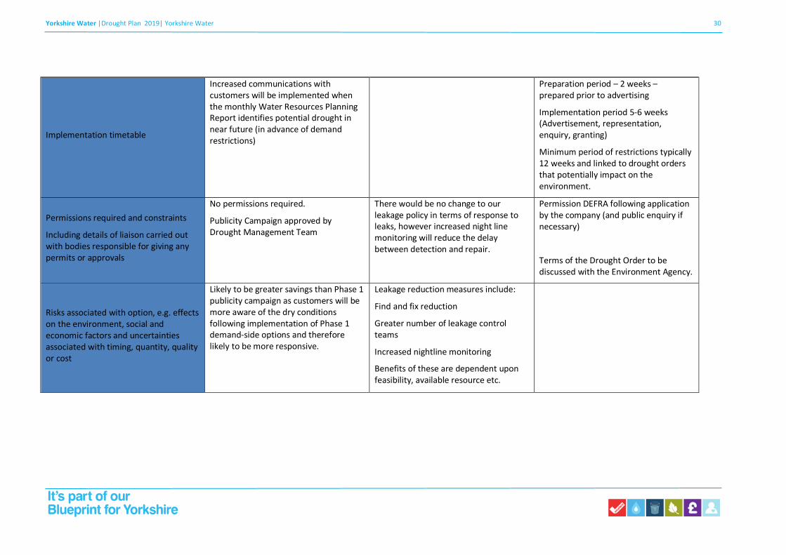
Phase 2: Prior to drought order for restrictions of non-essential use
Option Name Voluntary water conservation Increased leakage reduction Drought order for restrictions of non-
essential use
Action description
Encourage domestic and commercial water users to take action to reduce their water use
Implement additional active leakage control beyond annual activity required to meet the current leakage target
Restrictions on use as defined in Code of Practice and Guidance for Water Companies on Water Use Restrictions – 2013.
Trigger(s)
Or preceding actions
Timing and extent of publicity and support to our customers will be dependent on prevailing conditions but will be based on a precautionary approach to ensure that customers are fully aware of the latest situation
Dependent on time of year, current leakage level and potential yield benefit
Implemented when reservoir stocks for corresponding resource group cross below the Drought Control Line
Demand Saving
(Mld) and how calculated
Up to 15 5 10
Demand Saving
Percentage reduction on peak week demand
1.1 0.5 0.8
Location
Area affected or whole supply zone
Whole supply area Whole supply area Area affected
Yorkshire Water |Drought Plan 2019| Yorkshire Water 30
Implementation timetable
Increased communications with customers will be implemented when the monthly Water Resources Planning Report identifies potential drought in near future (in advance of demand restrictions)
Preparation period – 2 weeks – prepared prior to advertising
Implementation period 5-6 weeks (Advertisement, representation, enquiry, granting)
Minimum period of restrictions typically 12 weeks and linked to drought orders that potentially impact on the environment.
Permissions required and constraints
Including details of liaison carried out with bodies responsible for giving any permits or approvals
No permissions required.
Publicity Campaign approved by Drought Management Team
There would be no change to our leakage policy in terms of response to leaks, however increased night line monitoring will reduce the delay between detection and repair.
Permission DEFRA following application by the company (and public enquiry if necessary)
Terms of the Drought Order to be discussed with the Environment Agency.
Risks associated with option, e.g. effects on the environment, social and economic factors and uncertainties associated with timing, quantity, quality or cost
Likely to be greater savings than Phase 1 publicity campaign as customers will be more aware of the dry conditions following implementation of Phase 1 demand-side options and therefore likely to be more responsive.
Leakage reduction measures include:
Find and fix reduction
Greater number of leakage control teams
Increased nightline monitoring
Benefits of these are dependent upon feasibility, available resource etc.

Yorkshire Water |Drought Plan 2019| Yorkshire Water 31
Phase 3: Emergency drought orders
Option Name Emergency drought order
Action description Rota cuts/stand pipes
Trigger(s)
Or preceding actions
Stocks for corresponding resource group enter emergency storage
Demand Saving
(Mld) and how calculated
0 – 120 Ml/d
entirely dependent upon extent and practical implementation
Demand Saving
Percentage reduction on peak week demand
0 – 10 %
Location
Area affected or whole supply zone
Whole supply area
Implementation timetable Implemented when reservoir stocks for corresponding resource group enter emergency storage. The time to implement this measure will depend on the extent and success of other drought orders / permits and emergency drought orders. The preparation time will be approximately 4-6 weeks. Implementation time will be approximately 2-4 weeks
Permissions required and constraints
Including details of liaison carried out with bodies responsible for giving any permits or approvals
Permission by DEFRA following application by the company (and public inquiry if necessary)
Risks associated with option, e.g. effects on the environment, social and economic factors and uncertainties associated with timing, quantity, quality or cost
Estimates based on those provided in 1995 – Risks are that Rota cuts and Standpipe use is impracticable and that they will never be implemented for public health, social, economic and political reasons

Yorkshire Water |Drought Plan 2019| Yorkshire Water 32
Water saving through demand side drought management actions
We have estimated potential water saving from both activity within our control and resulting from external factors during a drought. Some of these estimates are based on observed water saving during the drought of 1995/96. Other values are based on estimated savings presented in the Code of Practice for Water Companies on Water Use Restrictions - 2013 (UKWIR, 2013).
Potential demand reduction through voluntary conservation have been based on current water efficiency activity and estimated savings, increased to reflect an enhanced communication campaign and provision of water efficient devices and information to customers as a drought develops.
However, each drought is associated with a unique pattern of events and the effect of future water efficiency campaigns and restrictions will not necessarily be the same in future droughts. As observed in Modelling the Impact of Restrictions on Demand During Drought (UKWIR, 2006/07), consumers’ response to drought may vary depending on the frequency and severity of future droughts and restrictions on demand.
The report also noted that restrictions are generally part of a sequence of events which combine to influence demand. Therefore, any decrease in demand cannot necessarily be attributed to the restriction itself. The observed impacts of a restriction are a function of all preceding activity such as earlier restrictions imposed, neighbouring water company restrictions, media coverage, awareness campaigns and timing of the implementation of restrictions.
Voluntary water conservation
We currently estimate annual savings in the region of 1.5 - 2Ml/d resulting from promotion of water efficiency to domestic customers. Savings are achieved through provision of water saving devices and behavioural change resulting from customer education and information.
In a period of prolonged dry weather this activity will be increased to distribute larger quantities of water saving devices and enhanced communication to customers through use of local media. We will also engage with commercial water users to promote and advise on water efficiency through the Market Operations team.
As a result of this increased activity we estimate water savings would increase from 2 to 6Ml/d through voluntary conservation. As the dry weather continues we will accelerate our activity further through promotional events and proactive media engagement to achieve maximum potential water savings of 15Ml/d.
Further details of our plans to promote water conservation and engage with customers are given in our Drought Communication Plan in Appendix 9.
This estimate is based on activity with our control. Water saving may be greater because of external influences such as national media and neighbouring water companies imposing temporary use bans. The UKWIR project Modelling the Impact of Restrictions on Demand During Drought (2006/07) looked at the effect of media coverage and neighbouring water company restrictions on resource zones without restrictions. Results for the three resource zones analysed suggested an impact on demand of -5 to -6% for national media and -1.4 to -2.6% reduction in demand resulting from neighbouring company hosepipe bans.
Increased leakage reduction
In addition to enhanced ‘find and fix’ activity, leakage reduction will be achieved through operation of existing pressure reducing valves (PRVs) on the distribution system. This will reduce the pressure of water within pipes and consequently reduce the volume of water lost through unidentified leaks. However, further reduction of pressure on our system increases the risk of low pressure at customers’ taps and increased customer complaints. It is estimated that operation of PRVs without significant impact on customers’ water supply could provide water savings of up to 10Ml/d. Previously the maximum water saving through PRV management was estimated to be 12Ml/d. However, plans to significantly reduce leakage by 2025 mean that the estimated impact of further pressure management is reduced.

Yorkshire Water |Drought Plan 2019| Yorkshire Water 33
Temporary use bans
We estimate water savings in the region of 75Ml/d as a result of a temporary use ban. This is a 5.7% reduction in an average dry year demand (DI) of 1310Ml/d, or 7.5% of demand excluding leakage. The majority of this saving (60Ml/d) is due to the ban on hosepipe use for garden watering and washing private vehicles. This is based on observed water savings when a hosepipe ban was imposed in the drought of 1995/96.
We assume small additional water savings resulting from a reduction in water use for washing windows (using a water fed pole), watering plants (in an outdoor pot) and cleaning patios and paths. The total water saving from prohibiting this activity is estimated to be less than 0.75% of average dry year demand (less than 10Ml/d maximum estimated saving).
Water saving as a result of all other activity covered by a temporary use ban; such as filling or maintaining a domestic paddling pool, domestic pond or ornamental fountain is estimated to be negligible.
The estimated savings are supported by the results of the report Modelling the Impact of Restrictions on Demand During Drought (UKWIR, 2006-07). This report quantifies the impact of restrictions during the drought on 2004-06 in South East England through multiple linear regression modelling. Average reduction in demand (DI minus leakage) during the summer were found to be in the region of 4.5% for unattended hosepipe and sprinkler bans and 7.5% for full hosepipe bans.
Similarly, the report Quantifying the impact of water company drought measures on water demand (Environment Agency, 2013) found demand decreased by a maximum of 6.5% prior to a temporary use ban, increasing to a maximum 10% reduction when a ban was imposed during the drought in 2012.
Restriction of non-essential use (Drought Order restrictions)
Estimated potential water saving due to restrictions of non-essential use are based where available on estimated savings and assumptions presented in the Code of Practice for Water Companies on Water Use Restrictions - 2013 (UKWIR, 2013). The restricted activities assumed to give the largest savings are operating a mechanical vehicle washer, cleaning a window of a non-domestic property and watering outdoor plants on commercial properties. Savings through restricting water use for activities such as cleaning industrial plant, suppressing dust and cleaning any vehicle, boat, aircraft or railway rolling stock are considered to be comparatively insignificant.
We estimate maximum water savings in the region of 10Ml/d as a result of restriction of non-essential use. This is a 0.8% reduction in an average dry year demand (DI) of 1310Ml/d, or 1% of demand excluding leakage.

Yorkshire Water |Drought Plan 2019| Yorkshire Water 34
Appendix 3.2: Drought permit and order application process
This table describes application process for drought permits and orders, including supply-side and demand-side drought orders.
Drought permit Drought order
Pre-application
We will notify relevant authorities (such as Defra, the Environment Agency, navigation authorities and Natural England) of our intention
to submit a drought permit or order application. We may need to apply for additional consents e.g. navigation authority consent, land
drainage consents, an environmental permit, planning permission.
Submission
Submit to the Environment Agency Submit to Defra
The application will include;
• Evidence of eligibility for the application including an explanation of why we need the permit/order and evidence of exceptional shortage of rainfall
• A description of how we'll use the permit/order, location map(s) and a completed environmental report
• A draft of the proposed drought permit/order
• Copies of any written consents relating to the application and any relevant existing abstraction licences and discharge permits
• Details of demand management activity we’ve carried out prior to the application.
Notice
We will send written notification of the application to;
• The Environment Agency
• Local authorities responsible for areas affected by the permit/order or with sources in the areas affected
• The internal drainage boards with sources in the area affected
• Other water companies and abstractors operating in area affected
• Organisations protected by a statutory requirement (e.g. for compensation water) that the permit/order suspends or modifies
• Navigational authorities responsible for any watercourse affected by the order.
The notice will;
• State the effects of the permit
• Identify the land the application relates to (if the permit authorises the occupation and use of land)
• State that all relevant maps or plans can be inspected free of charge for a period of 7 days from the date the notice is served

Yorkshire Water |Drought Plan 2019| Yorkshire Water 35
Drought permit Drought order
• State that objections to the application should be made within 7 days of the notice being served.
Advertisement
• We will advertise drought permit and order applications in one or more local newspapers circulating in the area affected by the permit and in the London Gazette.
• A complete copy of drought permit or order applications will be made available, free of charge, for inspection by anyone for 7 days from the date it is advertised. It will be made available at each of the following:
• an appropriate place (such as a local Post Office), no more than 8km by road (or as near as possible in remote areas) from either the point of abstraction or the point of compensation discharge
• the Yorkshire Water head office in Bradford and the office most local to the relevant area
• the Environment Agency local office.
Objections
Objections to be sent to the Environment Agency;
Water Resources Permitting Support Centre Environment Agency
Quadrant 2
99 Parkway Avenue
Parkway Business Park
Sheffield
S9 4WF
Objections to be sent to Defra;
Secretary of State for the Environment, Food and Rural Affairs
Water Supply and Regulation Division
Area 2C
Ergon House
Horseferry Road
London
SW1P 2AL

Yorkshire Water |Drought Plan 2019| Yorkshire Water 36
Drought permit Drought order
The Environment Agency / Defra will send Yorkshire Water copies of any objections it receives and we will aim to resolve or mitigate the
issues and reach an agreement with the objector(s).
Withdrawal
If we decide to withdraw a drought permit or order application we will;
• Notify Environment Agency/ Defra by telephone and in writing
• Send out a press release on the decision to withdraw
• Notify anyone who objected to the application.
Decision
On receipt of application the Environment Agency will aim to
provide a decision within 12 calendar days of the date of our last
advertisement, if no objections are received or all objections are
resolved and we have identified the permit application in the
Yorkshire Water Drought Plan
Defra will provide a decision on a drought permit application within
28 days if there are no objections are complications. Defra will inform
the Environment Agency and anyone who objected.
Hearing or public enquiry
If we are not able to resolve objections a hearing or public enquiry will take place. Objectors can give evidence or ask questions at a
hearing or public enquiry. If we can provide a full supporting case there’s an urgent need for a drought permit or order the Secretary of
State may decide that a hearing or public enquiry shouldn’t go ahead. This would only be permitted in extreme cases.
A hearing can take place any time after the 7-day limit for lodging
objections. The Environment Agency will appoint someone to run
the hearing, arrange a suitable venue and notify all parties of the
date, time and venue. They will usually provide 7 days’ notice,
though this may be shortened in more urgent cases.
The Environment Agency aim to make a decision within 7
calendar days of the receipt of the hearing report, though this
period can be longer or shorter.
Defra may hold a hearing or enquiry whether or not objections are
made. Defra will appoint someone to hold the hearing or enquiry and
Yorkshire Water will arrange a venue for the hearing or enquiry and
inform interested parties of the date, time and location (hotel, town
hall, Yorkshire Water office).
Defra will make a decision on the drought order and inform Yorkshire
Water if the application is successful or not.

Yorkshire Water |Drought Plan 2019| Yorkshire Water 37
Drought permit Drought order
Successful applications
We will advertise a successful application in the London Gazette and the same local newspaper where we advertised the application. The
advertisement will specify where the permit can be inspected, which will be the same places where the application was made available
for inspection.
Drought permits / orders are valid for up to 6 months and can be extended for a further 6 months.
Compensation
Any of the following can submit a compensation claim for any loss or damage caused by a drought permit;
The owners of the water source associated with the drought permit
Anyone with an interest in that source (for example, fishing clubs, navigation clubs, biodiversity groups)
Anyone applying for compensation must send Yorkshire Water their claim within 6 months of the expiry of the permit
Any disputes about compensation are referred to the Lands Tribunal.
Extension
We can apply to extend an existing drought permit or order for up to 6 months. We would need to apply for the extension at least 28
days before the existing permit expired. Objections can be made against an extension application and a hearing or public enquiry could
take place. Drought permits/orders can’t be in force for more than 12 months but we can make a new application to renew a permit after
this time.
The Environment Agency aims to provide a decision on an
extension within:
• 12 calendar days if there’s no hearing
• 7 calendar days of the receipt of the hearing report if
there’s a hearing.
Defra aims to provide a decision on an extension within:
• 7 calendar days if there are no objections to the
application
• 28 calendar days if a hearing or inquiry takes place.

Yorkshire Water |Drought Plan 2019| Yorkshire Water 38
Appendix 3.3: Water use restrictions in a drought
Temporary use ban categories and exceptions. Source: UKWIR Managing through drought - code of practice and guidance on water use restrictions – 2013.
1 The position that taxis are not classed as public service vehicles is as follows. The current legislation (Section 76(2)(b) of the Water Industry Act 1991) allows TUB restrictions to be imposed on “private motor vehicles”. The definition of a private motor vehicle in the Water Use (Temporary Bans)
Order 2010 (Regulation 5) excludes public service vehicles as defined by Section 1 of the Public Passenger Vehicles Act 1981. This definition includes vehicles not adapted to carry more than eight passengers and “used for carrying passengers for hire or reward at separate fares in the course of a business of carrying passengers.” Each element of this definition must be satisfied. In other words, it must be a vehicle which: is not adapted to carry more than eight passengers; ... used for carrying passengers for hire or reward; ... at separate fares; ... in the course of a business. In the case of taxis, elements 1,2 and 4 are satisfied, but (usually) not 3. A taxi, unlike a bus, does not (usually) carry passengers at separate fares. There is a fare for the journey undertaken rather than separate fares for each passenger in the vehicle. Further, in the DfT document (dated November 2011) Public Service Vehicle Operator Licensing Guide for Operators, there is a statement that “separate fares mean an individual payment by each passenger to the driver, conductor or agent of the operator for the journey undertaken” This is not how taxis operate, so they therefore fall within the definition of private motor vehicle in the WIA. Taxis will be licensed by the local authority, but is clear from the DfT guidance that if they don’t carry passengers at separate fares, they do not require a PSV licence, because they are not PSVs as defined.

Yorkshire Water |Drought Plan 2019| Yorkshire Water 39
Temporary use ban categories and exceptions (cont.)

Yorkshire Water |Drought Plan 2019| Yorkshire Water 40
Temporary use ban categories and exceptions (cont.)
Yorkshire Water |Drought Plan 2019| Yorkshire Water 41
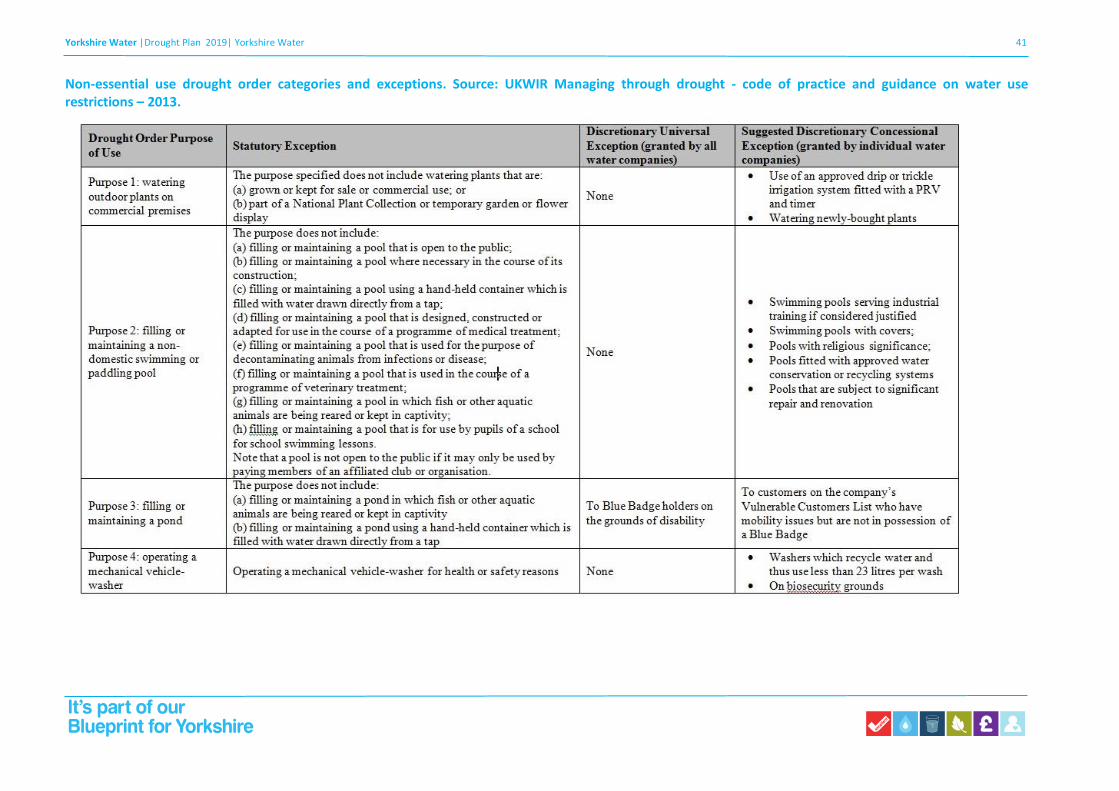
Non-essential use drought order categories and exceptions. Source: UKWIR Managing through drought - code of practice and guidance on water use restrictions – 2013.

Yorkshire Water |Drought Plan 2019| Yorkshire Water 42
Non-essential use drought order categories and exceptions (cont.)
Yorkshire Water |Drought Plan 2019| Yorkshire Water 43
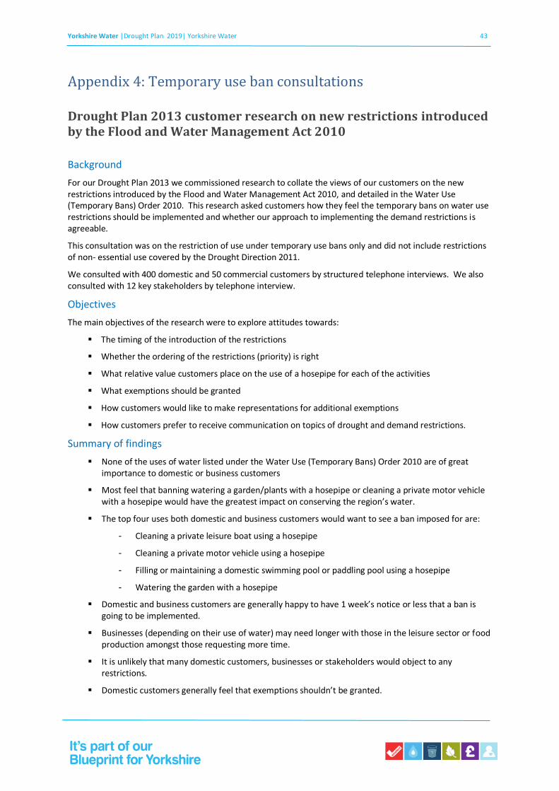
Appendix 4: Temporary use ban consultations
Drought Plan 2013 customer research on new restrictions introduced by the Flood and Water Management Act 2010
Background
For our Drought Plan 2013 we commissioned research to collate the views of our customers on the new restrictions introduced by the Flood and Water Management Act 2010, and detailed in the Water Use (Temporary Bans) Order 2010. This research asked customers how they feel the temporary bans on water use restrictions should be implemented and whether our approach to implementing the demand restrictions is agreeable.
This consultation was on the restriction of use under temporary use bans only and did not include restrictions of non- essential use covered by the Drought Direction 2011.
We consulted with 400 domestic and 50 commercial customers by structured telephone interviews. We also consulted with 12 key stakeholders by telephone interview.
Objectives
The main objectives of the research were to explore attitudes towards:
▪ The timing of the introduction of the restrictions
▪ Whether the ordering of the restrictions (priority) is right
▪ What relative value customers place on the use of a hosepipe for each of the activities
▪ What exemptions should be granted
▪ How customers would like to make representations for additional exemptions
▪ How customers prefer to receive communication on topics of drought and demand restrictions.
Summary of findings
▪ None of the uses of water listed under the Water Use (Temporary Bans) Order 2010 are of great importance to domestic or business customers
▪ Most feel that banning watering a garden/plants with a hosepipe or cleaning a private motor vehicle with a hosepipe would have the greatest impact on conserving the region’s water.
▪ The top four uses both domestic and business customers would want to see a ban imposed for are:
- Cleaning a private leisure boat using a hosepipe
- Cleaning a private motor vehicle using a hosepipe
- Filling or maintaining a domestic swimming pool or paddling pool using a hosepipe
- Watering the garden with a hosepipe
▪ Domestic and business customers are generally happy to have 1 week’s notice or less that a ban is going to be implemented.
▪ Businesses (depending on their use of water) may need longer with those in the leisure sector or food production amongst those requesting more time.
▪ It is unlikely that many domestic customers, businesses or stakeholders would object to any restrictions.
▪ Domestic customers generally feel that exemptions shouldn’t be granted.

Yorkshire Water |Drought Plan 2019| Yorkshire Water 44
▪ Half of the businesses surveyed felt exemptions should be granted, in particular to those customers reliant on water to survive and emergency services.
▪ Some stakeholders share this opinion with only a minority believing any domestic customers should be exempt.
▪ Stakeholders would like to be informed well advance of customers with many preferring on-going dialogue with Yorkshire Water as a means of communication.
▪ Generally, less lead in time is needed to inform customers that the ban is ending.
Future options for managing customer demand for water White paper prepared for Yorkshire Water by London Economics 2018
Consumer reactions and attitudes towards temporary use bans (TUBs)
The London Economics paper on behalf of Yorkshire Water presents evidence on consumers’ reactions and attitudes towards TUBs. The evidence on consumer reaction is mostly sourced from qualitative research (e.g. surveys, interviews, focus groups) commissioned by water companies, industry bodies and academic research.
The main reasons for consumer acceptability of these bans involve the perceived seriousness of the situation and how well they believe their water provider is managing water supply (e.g. leakages). If low water supply can be attributed to factors such as severe drought rather than mismanagement, they are more likely to be accepting of a restriction.
Evidence from UK water sector
According to a survey conducted by UKWIR (Understanding the Impacts of Drought Restrictions, UKWIR
2013), 68% and 75% of domestic and non-domestic respondents respectively, were aware there was a
hosepipe ban in their local area. Less than 1% of domestic respondents could correctly identify all the
restricted activities (from a list of 17). These responses are evidence that those affected by the hosepipe
ban failed to fully understand what the ban entailed and it seems likely that the impact of this TUB was
limited by this lack of understanding.
In 2018 Yorkshire Water also examined consumer reaction by commissioning research with the aim of
looking into the acceptability of hosepipe bans to customers1. Quotes from the research emphasise that
the acceptability of a hosepipe ban is linked to a customer’s perception of the provider’s current water
management. If the water company is perceived as responsible and the reason for implementing a ban is
a result of a serious shortage customers are more likely to accept a ban.
Further research commissioned by Yorkshire Water2 also attempted to gather consumer reaction and attitudes towards hosepipe bans. It emerged that for consumers the main areas of concern are garden watering, car washing and social relationships:
“The driveway is a gateway to my house; people view that, and they view you as a
1 This survey was completed by 775 respondents; These respondents were selected to ensure representativeness based on gender, age, SEG &
location; the data was weighted on unmetered and metered status for a 50/50 split. Focus groups were also conducted. These focus groups had 8-9 participants each, these participants had a variety of attitudes towards the environment (and were also a mix of ethnicities, ages and genders).
2 This research took the form of 6 qualitative workshops, designed to spark debate, comprising of 9 pa rticipants: 3 whom were supporte rs of
hosepipe bans, 3 participants whom were against hosepipe bans and 3 participants whom were ‘on the fence’. In addition to these workshops, 5 ‘at home in-depth interviews’ with selected customers were also conducted.

Yorkshire Water |Drought Plan 2019| Yorkshire Water 45
presentable person.”
“My son likes to water the plants with me and help his dad wash his bike; it’s lovely to do things together.”
“The lawn being burned away is literally your money being burned away.”
This report presents over thirty consumer quotes representing reaction to TUBs; these quotes mostly fall into the category of concerned homeowners who are worried that their garden, cars and social relationships will be damaged or diminished by a ban. However, these problems could be solved with handheld watering (which would not be banned under a hosepipe ban), implying that these consumers do not fully understand the ban, which is consistent with previous findings.
During the interviews, consumers were consulted on their views before and after being given information on ‘water use and the impact of hosepipe bans.’ As seen in Table 1, providing consumers with evidence on general water management almost always weakened support for TUBs. The two main concerns found in these interviews were that bans did not appear to save great amounts of water, and the amount of leakage.
Table 4.1 The effect that water usage statistics had on household views regarding TUBs
View prior
to receiving info
View after having considered provided
info
Associated Quote
Pro-ban Pro-ban “I’d still support a ban despite what we’ve heard, because every little helps”
Pro-ban ‘On the fence’ “I just assumed hosepipes accounted for so much more water use”
Pro ban Anti-ban “When you see what a ban achieves, it just feels
ridiculous”
‘On the fence’
Anti-ban
“Even though I use my hosepipe a lot, the info today doesn’t suggest me not using would make a great deal of difference”
Anti-ban Anti-ban “I’m even more anti that I was before given how much
water they lose a day”
Source: Yorkshire Water (2018), Reducing Demand for Water Research
Some non-domestic consumer reactions can be found in a code of practice and guidelines on water use
restrictions for water companies, published by UKWIR (2014). This included interviews with non- domestic
public and private associations. Their responses suggest that water use restrictions would have a range of
negative effects on their activities and businesses, including both financial and social consequences such
as job losses and safety concerns. The table below presents some views of respondents in different
sectors.
Table 4.2 Views of non-domestic water users on the impacts of TUBs on their organisations
Organisation How TUBs affect their activities/business
British Swimming Pool Federation
‘Demand in 2012 fell to 1000-1500 [swimming pools purchased] compared to 2500-3000 at time of [this] report (pre-2008 were 5-6000.’

Yorkshire Water |Drought Plan 2019| Yorkshire Water 46
Car Wash Association ‘If car washes could not operate during droughts, dedicated car wash businesses would be closed.’
England Golf ‘During 2012, there was a talk of a six month ban on sports in Thames Water area. Had this actuallyhappened, 30,000 jobs would have been affected.’
HorticulturalTrades Association
‘If landscapers cannot use water efficientlyto establish plants during the first phase of TUBs, then they will not be hired to establish or replant gardens.
There is an immediate knock on effect on the supply chain (garden centres and growers).’
Kent Cricket Board ‘Watering between weekend fixtures is vital for pitch safety.’
Racecourse Association
‘If the going (firmness of the ground) cannot be managed within industry guidelines, trainers maypull horses from races to avoid injury.' This will lead
to lower attendance levels which has a negative economic impact on the rest of the industry.’
Turf Grass Growers Association
‘If [...] customers cannot establish turfthere will be: adverse environmental
impact, adverse social impact, job losses, loss of income and wasted crops [for turf growers].’
Wandsworth Borough Council
‘The impacts of not being able to water planted bedding plants and street trees is financial (tens of thousands of pounds).’
The business plans of some UK water companies also include some additional insight on consumer attitudes towards TUBs, as presented in Table 3. Mixed consumer attitudes on TUBs emerge from these plans. Most providers stated that their consumers would want to either avoid TUBs entirely, or to keep the frequency to as low as 1 in every 10 years. However, some of these consumer responses imply that there may be some support for the use of TUBs and did not see a reduction of their frequency as a priority. These perceptions are also consistent with previous willingness to pay research, which found that consumers would prefer to experience water restrictions than see an increase in their bills.

Yorkshire Water |Drought Plan 2019| Yorkshire Water 47
Appendix 5: Supply-side drought management actions
Please see the following in the separate Appendix 5 spreadsheet;
Appendix 5.1: North Area options
Appendix 5.2: South Area options
Appendix 5.3: South West Area options
Appendix 5.4: North West Area options
Appendix 5.5: River options
Appendix 5.6: Long-term options

Yorkshire Water |Drought Plan 2019| Yorkshire Water 1
1
Appendix 6: Habitats Regulations Assessment
Introduction
Background
Water companies in England and Wales are required to prepare and maintain statutory Drought Plans under Sections 39B and 39C of the Water Industry Act 1991, as amended by the Water Act 2014, which set out the operational steps a company will take before, during and after a drought. The Water Industry Act 1991 (as amended) defines a Drought Plan as ‘a plan for how the water undertaker will continue, during a period of drought, to discharge its duties to supply adequate quantities of wholesome water, with as little recourse as reasonably possible to Drought Orders or Drought Permits’.
A water company must ensure its Drought Plan meets the requirements of the Habitats Regulations before implementation. The requirement for a HRA is established through Council Directive 92/43/EEC on the Conservation of natural habitats and of wild fauna and flora, hereby referred to as the 'Habitats Directive', in Articles 6(3) and 6(4). The Habitats Directive is transposed into national legislation by the Conservation of Habitats and Species Regulations 2017. Under Regulations 63 and 105, any plan or project which is likely to have a significant effect on a European site (either alone or in-combination with other plans or projects) and is not directly connected with, or necessary for the management of the site, must be subject to a HRA to determine the implications for the site in view of its conservation objectives.
Water companies in England are required to produce a Drought Plan every five years and submit a draft plan to the Secretary State in line with the timescales set out in the Drought Plan (England) Direction 2016. The Environment Agency’s Drought Plan Guidance3 also specifies that a water company must ensure that its drought plan meets the requirements of the Habitats Regulations. The Environment Agency’s 2015 Drought Plan Guidance advises companies to consult the UK Water Industry Research (UKWIR) report 'Strategic Environmental Assessment and Habitat Regulations Assessment - Guidance for Water Resources Management Plans and Drought Plans4 in preparing its HRA. The UKWIR report recommends that all Drought Plans should be subject to the first stage of HRA, i.e. screening for Likely Significant Effects (LSE).
Requirement
The responsibility for undertaking the Habitats Regulations Assessment lies with Yorkshire Water as the Plan making authority.
HRA Guidance for the appraisal of Plans5, summarises the Habitats Regulations. Regulation 63(5) states that the Plan making authority (in this case Yorkshire Water) shall adopt, or otherwise give effect to, the Plan only after having ascertained that it will not adversely affect the integrity of a European site, subject to Regulation 64 or 105 of the
3 Environment Agency (2015) How to write and publish a Drought Plan, December 2015. Available at https://www.gov.uk/government/collections/how-to-write-and-publish-a-drought-plan.
4 UKWIR (2012) Strategic Environmental Assessment and Habitats Regulations Assessments - Guidance for Water Resources
Management Plans and Drought Plans (WR/02/A).
5 Tyldesley, D. & Chapman, C. (2015) The Habitats Regulations Assessment Handbook. DTA Publications. Version 4.

Yorkshire Water |Drought Plan 2019| Yorkshire Water 2
2
Habitats Regulations.
Regulation 64 of the Habitats Regulations states:
(1) If the competent authority is satisfied that, there being no alternative solutions, the plan or project must be carried out for imperative reasons of overriding public interest (which, subject to paragraph (2), may be of a social or economic nature), it may agree to the plan or project notwithstanding a negative assessment of the implications for the European site or the European offshore marine site (as the case may be). (2) Where the site concerned hosts a priority natural habitat type or a priority species, the reasons referred to in paragraph (1) must be either— (a) reasons relating to human health, public safety or beneficial consequences of primary importance to the environment; or (b )any other reasons which the competent authority, having due regard to the opinion of the European Commission, considers to be imperative reasons of overriding public interest.
Regulation 105 of the Habitats Regulations states:
(1) Where a land use plan— (a) is likely to have a significant effect on a European site or a European offshore marine site (either alone or in combination with other plans or projects), and (b) is not directly connected with or necessary to the management of the site, the plan-making authority for that plan must, before the plan is given effect, make an appropriate assessment of the implications for the site in view of that site’s conservation objectives. (2) The plan-making authority must for the purposes of the assessment consult the appropriate nature conservation body and have regard to any representations made by that body within such reasonable time as the authority specifies. (3) The plan-making authority must also, if it considers it appropriate, take the opinion of the general public, and if it does so, it must take such steps for that purpose as it considers appropriate. (4) In the light of the conclusions of the assessment, and subject to regulation 107, the plan-making authority must give effect to the land use plan only after having ascertained that it will not adversely affect the integrity of the European site or the European offshore marine site (as the case may be). (5) A plan-making authority must provide such information as the appropriate authority may reasonably require for the purposes of the discharge by the appropriate authority of its obligations under this Chapter. (6) This regulation does not apply in relation to a site which is— (a) a European site by reason of regulation 8(1)(c), or (b) a European offshore marine site by reason of regulation 18(c) of the Offshore Marine Conservation Regulations (site protected in accordance with Article 5(4) of the Habitats Directive).
Article 6 of the Habitats Directive (Council Directive 92/43/EEC on the conservation of natural habitats and of wild flora and fauna) states:
6(3). Any plan or project not directly connected with or necessary to the management of the site but likely to have a significant effect thereon, either individually or in combination with other plans or projects, shall be subject to appropriate assessment of its implications for the site in view of the site's

Yorkshire Water |Drought Plan 2019| Yorkshire Water 3
3
conservation objectives. In the light of the conclusions of the assessment of the implications for the site and subject to the provisions of paragraph 4, the competent national authorities shall agree to the plan or project only after having ascertained that it will not adversely affect the integrity of the site concerned and, if appropriate, after having obtained the opinion of the general public.
6(4). If, in spite of a negative assessment of the implications for the site and in the absence of alternative solutions, a plan or project must nevertheless be carried out for imperative reasons of overriding public interest, including those of a social or economic nature, the Member State shall take all compensatory measures necessary to ensure that the overall coherence of Natura 2000 is protected. It shall inform the Commission of the compensatory measures adopted.
Best practice guidance6 recommends that if there are no alternative solutions and if, in exceptional circumstances, it is proposed that a Plan be adopted despite the fact that it may adversely affect the integrity of a European site, the HRA will need to address and explain the Imperative Reasons of Overriding Public Interest (IROPI) which the Plan making authority considers to be sufficient to outweigh the potentially adverse effects on the European site(s). It must also agree and secure a package of compensation measures for the features of the site that may be adversely affected by implementation of the Plan.
Context
HRA refers to the assessment of the potential effects of a plan or project on one or more European sites, including Special Protection Areas (SPAs) and Special Areas of Conservation (SACs):
• SPAs are classified under the European Council Directive ‘on the conservation of wild birds’ (2009/147/EC; ‘Birds Directive’) for the protection of wild birds and their habitats (including particularly rare and vulnerable species listed in Annex 1 of the Birds Directive, and migratory species).
• SACs are designated under the European Habitats Directive (1991) and target particular habitats (Annex 1) and/or species (Annex II) identified as being of European importance.
The Government also expects proposed SPAs (pSPAs), candidate SACs (cSACs) and Ramsar sites to be included within the assessment:
• Ramsar sites support internationally important wetland habitats and are listed under the Convention on Wetlands of International Importance especially as Waterfowl Habitat (Ramsar Convention, 1971).
For ease of reference, all three of the above designations are collectively referred to in this document as "European sites", despite Ramsar sites being designated at the international level.
6 Tyldesley, D. & Chapman, C. (2015) The Habitats Regulations Assessment Handbook. DTA Publications. Version 4.

Yorkshire Water |Drought Plan 2019| Yorkshire Water 4
4
Approach
Overview of HRA stages
There are four stages of the HRA process:
1. Firstly, a screening process was undertaken to identify whether each drought management measure in Yorkshire Water’s Drought Plan (either alone or in combination with other plans or projects) is likely to have any significant effects on European sites (reported in this HRA Report). There was an important judgment in the Court of Justice of the European Union (CJEU) in April 20187 which ruled that Article 6(3) of the Habitats Directive must be interpreted as meaning that mitigation measures should be assessed within the framework of an Appropriate Assessment and that it is not permissible to take account of mitigation measures at the screening stage.
2. Where a likely significant effect cannot be ruled out (noting the precautionary principle and the requirement to exclude consideration of mitigation measures), an Appropriate Assessment should be undertaken of the drought management measure to determine whether this would adversely affect the integrity of the European site(s), either alone or in combination with other Drought Plan options or other plans and projects, taking into account available specific mitigation measures.
3. Where adverse effects cannot be ruled out at the Appropriate Assessment stage, alternative, reasonably feasible options should be examined to determine whether it is possible to avoid adverse effects on the integrity of the European site as Stage 3 of the HRA.
4. Stage 4 comprises an assessment of compensatory measures where, in the light of an assessment of Imperative Reasons of Overriding Public Interest, and consideration of compensation measures it has been concluded that the Ministers should be asked to determine that the Plan should proceed (this is decision of the Welsh Ministers, not Yorkshire Water).
This document reports the HRA screening (i.e. Stage 1 as identified above) carried out for Yorkshire Water’s final Drought Plan 2019. The HRA screening reaches conclusions as to whether LSE on European designated sites of the drought options contained within Yorkshire Water’s Drought Plan can be ruled out, and, as such, determines the requirement for Appropriate Assessment. HRA is based on a rigorous application of the precautionary principle. Where uncertainty or doubt remains, an impact should be assumed, triggering the requirement for Appropriate Assessment of that option. In the event of Appropriate Assessment being required, Yorkshire Water would consult Natural England on the approach taken in the HRA and to confirm the outcomes and next steps.
Yorkshire Water’s Final Drought Plan forms an update to the 2017 Drought Plan, and reflects continued consultation with Natural England and the Environment Agency on a number of drought options, predominantly regarding the Environmental Assessment Reports (supporting environmental studies for the drought order / permits). There have been material changes to the Drought Plan and HRA since 2017, with the updates relating to the
7 Court of Justice of the European Union Case C-323/17: People over Wind & Sweetman v Coillte Teoranta

Yorkshire Water |Drought Plan 2019| Yorkshire Water 5
5
new drought options including the abstraction increase from the River Derwent at Loftsome Bridge and an increase to the annual abstraction form the River Wharfe.
Potential Impacts
To provide an indication of those measures more likely to have a significant effect on a European site(s), those drought management measures that are within 10km of a European site were identified initially. Consideration has also been given to the relative spatial locations of the drought management measures and designated sites within the same surface water and groundwater catchments and/or estuarine system to ensure that any hydrological connectivity over a longer distance that might affect water-dependent sites, qualifying features and designated mobile species has been taken into account. GIS data were used to map the locations and boundaries of European sites within or adjacent to the Yorkshire Water Water Resource Zones (WRZs) using publicly available data from Natural England.
The attributes of the European sites, which contribute to and define their integrity, have been considered with reference to Standard Data forms for SACs and SPAs and Information Sheets for Ramsar sites. An analysis of these information sources has enabled the identification of the site's qualifying features. This information, as well as Article 17 reporting, site conservation objectives, supplementary guidance, Site Improvement Plans and the supporting Site of Special Scientific Interest’s favourable condition tables, has been used to identify those features of each site which determine current conservation status, site integrity and the specific sensitivities of the site. Analysis of how potential impacts of the drought management measures may affect a European site has been undertaken using this information. The locations of the supply side and drought permit/order options were also mapped in order to establish their geographic proximity to the European sites.
The Final Drought Plan 2019 proposes a number of options which would make more water available for supply than is available under normal licensed conditions. Drought options include demand side options (e.g. water use restrictions), continued utilisation of existing licensed water sources within Yorkshire Water’s resource base (referred to as supply side options) and drought permits/orders.
Demand side options are designed to reduce the demand for water and the options available to Yorkshire Water are consistent across all resource zones (see Table 6.1).
Supply side measures are measures available to Yorkshire Water to introduce during the course of a drought to increase the amount of water available for supply. Supply side drought options that require drought permits/orders are listed in Table 6.2.

Yorkshire Water |Drought Plan 2019| Yorkshire Water 6
6
TABLE 6.1 DEMAND-SIDE DROUGHT MANAGEMENT OPTIONS (ALL WATER RESOURCE ZONES)
Demand-side options Comments
Drought publicity campaigns Increased water efficiency messages via increased customer communications.
Increased leakage detection and repair activity
Ensure that all maintenance programmes are up-to-date and
undertake additional leakage control, leading to demonstrable
water savings.
Introduction of temporary use ban Restrictions on the use of hosepipes for a range of uses, including the washing of vehicles and boats, watering gardens and sports grounds and filling of paddling pools.
Introduction of a drought order to ban non-essential water uses (defined in the Drought Direction 2016)
Drought order to restrict non-essential water uses to be applied for when reservoir stocks fall below the Drought Control Line
Emergency drought order to temporarily supply water by means of rota cuts or standpipes
An Emergency Drought order may be applied for in the event of an exceptional drought, in consultation and liaison with the Environment Agency, local authorities and the Consumer Council for Water. This situation would be extremely unlikely to occur and would not arise under a repeat of the worst recorded drought events in Yorkshire.
TABLE 6.2 DROUGHT PERMIT / ORDER OPTIONS
Water Source Type of Drought Management
Option
Grid Surface Water Resource Zone
North Area Standard Option Reservoirs [58]:
North Area Reservoir 1, North Area Reservoir 2,
North Area Reservoir 3, North Area Reservoir 4,
North Area Reservoir 5
Compensation flow release
reductions
Long Term Option (LTO) [1]:
North Yorkshire Groundwater increased abstraction
Increase in abstraction.
South Area Standard Option Reservoirs [6]:
South Area Reservoir 1, South Area Reservoir 2,
South Area Reservoir 3, South Area Reservoir 4,
South Area Reservoir 5, South Area Reservoir 6
Compensation flow or maintained
flow release reductions
8 The number in square bracket refers to the number of drought options within each area.

Yorkshire Water |Drought Plan 2019| Yorkshire Water 7
7
Water Source Type of Drought Management
Option
Calder Area Standard Option Reservoirs [22]:
South West Area Reservoir 1, South West Area
Reservoir 2, South West Area Reservoir 3, South
West Area Reservoir 4, South West Area Reservoir 5,
South West Area Reservoir 6, South West Area
Reservoir 3, South West Area Reservoir 8, South
West Area Reservoir 7, South West Area Reservoir 2,
South West Area Reservoir 9, South West Area
Reservoir 10, South West Area Reservoir 11, South
West Area Reservoir 12, South West Area Reservoir
13, South West Area Reservoir 14, South West Area
Reservoir 15, South West Area Reservoir 16, South
West Area Reservoir 17, South West Area Reservoir
18, South West Area Reservoir 19, South West Area
Reservoir 20, South West Area Reservoir 21, South
West Area Reservoir 22
Compensation flow release
reductions
North West Area Standard Option Reservoirs [11]:
North West Area Reservoir 1, North West Area
Reservoir 2, North West Area Reservoir 3, North
West Area Reservoir 4, North West Area Reservoir 5,
North West Area Reservoir 6, North West Area
Reservoir 7, North West Area Reservoir 8, North
West Area Reservoir 10, North West Area Reservoir
11
Compensation flow release
reductions
Increase abstraction to 10 Ml/d when
reservoir stocks greater than 55 Ml.
LTO [1]:
North West Area Reservoir 9
Increase in abstraction from
Reservoir. Water abstracted from the
reservoir would be transferred via a
temporary pipeline to the aqueduct
for subsequent treatment at either
Bradford WTW 1 or 2.
Stand Alone Standard option [6]:
Ouse increased abstraction
Increase river abstraction rates at
lower river flows
Ure increased abstraction Permit river abstraction at low flows
Wharfe reduced regulated flow Reduce river regulation requirements.
Wharfe increased annual abstraction Increase annual abstraction limit
Hull increased abstraction Reduce hands-off river flow to enable
increased abstraction.
Derwent annual abstraction increase Increase annual abstraction limit

Yorkshire Water |Drought Plan 2019| Yorkshire Water 8
8
Water Source Type of Drought Management
Option
LTO: [7]
Ouse increased abstraction
Increase the abstraction capacity of the
Ouse pumping station by 10 Ml/d.
This would enable the full daily abstraction licence volume to be abstracted from the Ouse increased abstraction when river flows exceed the prescribed flow set in the abstraction licence (or in a drought permit if granted).
Ouse water treatment works extension Additional river abstraction and water treatment capacity (additional 22 Ml/d average abstraction) at Ouse abstraction, within existing abstraction licence conditions.
Ouse Raw Water Transfer Additional river abstraction capacity of 60 Ml/d to enable the full average abstraction licence quantity of 96 Ml/d average to be abstracted (130Ml/d peak). New raw water pipeline to link to existing raw water pipeline Ouse pumping station to River Derwent Water Treatment Works 1.
Tees – Swale transfer
Permit abstraction of up to 60 Ml/d from the River Tees for transfer by pipeline to the River Swale, with subsequent re-abstraction of the discharged water further downstream from the. Ouse increased abstraction.
Tees - Derwent Pipeline
This option would not be additional to the River Tees to River Swale Transfer option. Only one of these two options would be implemented.
Abstraction of up to 40 Ml/d from the River Tees with construction of new pipelines to transfer the raw water to.
River Derwent Water Treatment Works.
Aire abstraction New river abstraction of up to 50 Ml/d
East Yorkshire Groundwater Option 2 Increase in abstraction.
East Surface Water Resource Zone
None n/a n/a
East Groundwater Resource Zone
None n/a n/a
In determining the likelihood of significant effects on European sites from any drought management measure, particular consideration has been given to the possible source-receptor pathways through which effects may be transmitted from activities associated with the measures to features contributing to the integrity of the European sites (e.g. groundwater or surface water catchments, air, etc.). Table 6.3 provides examples of the types of impacts the measures might have on European site qualifying features. Screening for LSEs has been determined on a proximity basis for many of the types of impacts, based on the proximity of the potential location of each measure to each European site.

Yorkshire Water |Drought Plan 2019| Yorkshire Water 9
9
However, there are many uncertainties associated with using set distances as there are very few standards available as a guide to how far impacts will extend. Different types of impacts can occur over different distances, and the assumptions and distances used in the HRA and justification for them are shown in Table 6.3.
Both construction and operational impacts must be considered in HRA Screening. Yorkshire Water’s Final Drought Plan 2019 includes alternative long term options available to the company in the event of a third consecutive year of drought which would, if deployed, involve some construction activity (e.g. intakes, pumping stations, recommissioning of STW and pipelines). For all of the remaining options, there is no construction phase associated with the option and it is only operational impacts that will need to be considered.
Table 6.3 Potential Impacts of Drought Options9
Broad categories of potential impacts on
European sites, with examples
Examples of operations responsible for impacts (Distance
assumptions shown in italics)
Physical loss/damage
- Destruction (including offsite effects, e.g. foraging habitat)
- Smothering - Sedimentation / silting - Prevention of natural processes - Habitat degradation, reduction, loss - Erosion - Fragmentation - Severance/barrier effect - Edge effects
Development and construction of built infrastructure
associated with scheme, e.g. pipelines, temporary weirs, water
treatment plant recommissioning, pipelines, desalination
plants, pumping stations.
Physical loss/damage is only likely to be significant where the
boundary of the scheme extends within the boundary of the
European site, or within an offsite area of known foraging,
roosting, breeding habitat (that supports species for which a
European site is designated), or where natural processes link
the scheme to the site, such as through hydrological
connectivity downstream of a scheme).
Non-physical disturbance
- Noise - Visual presence - Human presence - Light pollution
Noise from construction activities.
Taking into consideration the noise level generated from
general building activity10 (c. 122dB(A)) and considering the
lowest noise level identified in appropriate guidance11 as likely
to cause disturbance to bird species, it is concluded that noise
impacts could be significant up to approximately 1km from the
boundary of the European site.
Noise from vehicular traffic during construction of scheme.
Noise from construction traffic is only likely to be significant
where the transport route to and from the scheme is within or
in proximity to the boundary of the European site, or
within/adjacent to an offsite area of known foraging, roosting,
commuting, or breeding habitat (that supports species for
which a European site is designated).
Plant and personnel involved in construction and operation of
schemes e.g. for maintenance.
These effects (visual/human presence) are only likely to be
9 Note that the distances given in Table 2.3 are illustrative only and should be defined for each DP on a case by case basis.
10 British Standards Institute (BSI) (2009) BS5228 - Noise and Vibration Control on Construction and Open Sites. BSI, London.
11 Environment Agency (2013) Bird Disturbance from Flood and Coastal Risk Management Construction
Activities. Overarching Interpretive Summary Report. Prepared by Cascade Consulting (now Ricardo Energy & Environment
Water and Environment Practice) and Institute of Estuarine and Coastal Studies.

Yorkshire Water |Drought Plan 2019| Yorkshire Water 10
10
Broad categories of potential impacts on
European sites, with examples
Examples of operations responsible for impacts (Distance
assumptions shown in italics)
significant where the boundary of the scheme extends within
or is directly adjacent to the boundary of the European site, or
within/adjacent to an offsite area of known foraging, roosting,
breeding habitat (that supports species for which a European
site is designated).
Development of built infrastructure associated with scheme,
which includes artificial lighting.
Effects from light pollution are only likely to be significant
where the boundary of the scheme is within 500 m of the
boundary of the European site. From a review of Environment
Agency internal guidance on HRA and various websites it is
considered that effects of vibration and light are more likely to
be significant if development is within 500 metres of a
European site.
Water table/availability
- Drying - Flooding / stormwater - Changes to surface water levels and flows - Changes in groundwater levels and flows - Changes to coastal water movement - Interruption to hydrological continuity
Changes to water levels and flows due to water abstraction
and storage.
These effects are only likely to be significant where the
boundary of the scheme extends within the same ground or
surface water catchment as the European site. However,
these effects are dependent on hydrological continuity
between the scheme and the European site, and sometimes,
whether the scheme is up or down stream from the European
site.
Non-toxic/toxic contamination
- Nutrient enrichment (e.g. of soils and water) - Changes in salinity - Changes in thermal regime - Changes in turbidity, changes in
sedimentation/silting - Dissolved oxygen sag - Free ammonia - Metal contamination - Water pollution - Soil contamination - Air Pollution
Changes to water salinity, nutrient levels, turbidity, thermal
regime.
These effects are only likely to be significant where the
boundary of the scheme extends within the same ground or
surface water catchment as the European site. However, these
effects are dependent on hydrological continuity between the
scheme and the European site, and sometimes, whether the
scheme is up or down stream from the European site. This
level of information is not available until data such as
groundwater modelling is collected to accompany planning
applications.
Emissions of dust during earthworks, construction of plant and
tunnel/pipeline construction associated with schemes.
This effect is only likely to be significant where the
construction works for the scheme are within
or in proximity of the boundary of the European site13
Accidental spills of fuel or chemicals during the construction
phase.
Effects of water pollution are likely to be significant where
works are in the vicinity of, or upstream of a European site.
Mobilisation of contaminated soils or materials during
excavations.
These effects are only likely to be significant where the
boundary of the scheme extends within the same ground or

Yorkshire Water |Drought Plan 2019| Yorkshire Water 11
11
Broad categories of potential impacts on
European sites, with examples
Examples of operations responsible for impacts (Distance
assumptions shown in italics)
surface water catchment as the European site. However,
these effects are dependent on hydrological connectivity
between the scheme and the European site, and sometimes,
whether the scheme is up or down stream from the European
site.
Air emissions associated with vehicular traffic during
construction of schemes.
This effect is only likely to be significant where the transport
route to and from the scheme is within or in proximity to the
boundary of the European site12,13.
Biological disturbance
- Direct mortality - Changes to habitat availability - Out-competition by non-native species - Selective extraction of species - Introduction of disease - Rapid population fluctuations - Natural succession
Potential mortality or injuring of terrestrial, aquatic and marine
species during building of structures associated with the
scheme.
This effect is only likely to be significant when land take is
within the boundary of the European site or within an offsite
area of known foraging, roosting, breeding habitat (that
supports species for which a European site is designated).
Introduction of non-native or native invasive species due to
contaminated vehicles, receiving water from canal and river
transfers etc.
This effect is only likely to be significant where the receiving
water for the scheme is the European site or a tributary of the
European site.
Environmental Assessment for the Drought Plan
For this Drought Plan, environmental assessment of each drought option has been undertaken, culminating in the production of Options Impact Screening Reports (OISR)14 and Environmental Assessment Reports (EARs) as described below. The outcomes of this assessment have informed this HRA.
According to the revised DPG, Drought Plan reporting requirements include undertaking significant environmental assessment which can be aligned to fulfil wider reporting requirements, such as those for HRA (and SEA if applicable). This approach ensures duplication of work between HRA, SEA and the Drought Plan itself can be minimised.
Yorkshire Water has undertaken environmental assessment of the Drought Plan supply options according to guidance in the 2015 Drought Plan Guidelines; specifically Section 3 of the Environment Agency’s “Drought Plan Guideline Extra Information: Environmental Assessment for Water Company Drought Plans”. This e is reported in the OISRs. For each drought option, the assessment involved four phases:
1. An assessment of the hydrological or hydrogeological effects of the proposed
12 Highways Agency (2003) Design Manual for Roads and Bridges (DMRB), Volume 11.
13 Institute of Air Quality Management (2014) Guidance on the assessment of dust from demolition and construction v1.1.
14 YWSL (2017). Drought Plan: Drought Options Impact Screening. Final Report. Prepared by Ricardo Energy & Environment Water and Environment Practice (formerly Cascade Consulting). June 2017

Yorkshire Water |Drought Plan 2019| Yorkshire Water 12
12
action
2. An assessment of the environmental sensitivity of the affected areas
3. Identification of mitigation or compensation measures for impacted features
4. Development of an environmental monitoring plan, if required.
Phase 1 determined the zone and extent of hydrological influence of each drought option both on an individual basis, and taking into account cumulative effects of simultaneous option deployment where options were located within the same catchment, and across catchments. The Phase 1 assessment also considered cumulative effects of other discharges and abstractions using abstraction licence and discharge consent information supplied by the Environment Agency.
Using the outputs from Phase 1, sites and features which could be impacted were identified using GIS. These included European sites (SAC, SPA and RAMSAR). Phase 2 has considered the susceptibility of each site/feature to hydrological impacts (flow/level changes) in order to conclude as to the sensitivity of each site/feature, and thereby whether it should be taken forward for further consideration in the environmental assessment. Consideration of susceptibility in the case of SACs and SPAs took account of qualifying interests and whether, or to what extent, they were water dependent, and likely to be impacted by a drought option’s implementation, taking into account the appropriate baseline conditions against which an impact would be likely to arise (often severe drought conditions).
Drought options within the Drought Plan comprise reservoir compensation release reductions, river abstraction licence changes, new river abstractions,inter-basin transfer, groundwater abstractions, and recommissioning treatment plants.
Consideration of In-Combination Effects
The Phase 1 hydrological impact assessment described above and documented in the OISR/EARs considered cumulative hydrological impacts of simultaneous deployment of options within the same catchments, and across different catchments. Cumulative impacts that could arise with other non-public water supply abstractions are also considered, as are indirect impacts on water quality as a result of reduced dilution. Article 6(3) of the Habitats Directive requires an Appropriate Assessment of ‘Any plan or project not directly connected with or necessary to the management of the site but likely to have a significant effect thereon, either individually or in combination with other plans or projects, shall be subject to appropriate assessment of its implications for the site in view of the site's conservation objectives'.
The review has therefore considered the in-combination effects of the drought options in the YWSL Final DP, and the in-combination effects of the Final DP and a number of plans and projects, that could have an impact on the European sites identified within this HRA of the Final DP. The following plans and projects have been considered in the cumulatives effects assessment:
• Inter-option effects within the YWSL DP
• Other water company WRMPs and DPs:
- Severn Trent

Yorkshire Water |Drought Plan 2019| Yorkshire Water 13
13
- United Utilities
- Northumbrian Water
- Anglian Water Services Limited
• Water Resource Management Plan for Yorkshire Water (2019)15
• Environment Agency National Drought Action Plan
• Canal and Rivers Trust Putting Water into Waterways Water Resources Strategy 2015-2020.
The assessment has used all publicly available information. It should also be noted that the water companies are at different stages of updating their WRMPs and DPs and therefore further updates may be required to the HRA cumulative assessment as these become available between the draft and final submissions.
The findings of the in-combination impact assessments between each drought option and the schemes above can be found in Table 6.5, column 6: ‘Effect in combination with other options, plans and projects’.
Review of Consents
The Environment Agency’s Review of Consents process considered all existing abstraction licences to determine whether any could have the potential to affect the hydrogeological or hydrological regime of European sites. Investigations of relevance to Yorkshire Water’s Drought Plan include those which reviewed licences in relation to impacts on the Humber Estuary SAC / SPA / Ramsar (collectively referred to as the Humber Estuary European Marine Site (or EMS)), and the North Pennine Moors SAC / Moorhouse and Upper Teesdale SPA. The Humber Estuary investigation resulted in the modification of two abstraction licences for the river intakes from the River Ouse WTW, to include the requirement for installing fish protection measures, to reduce the potential for lamprey entrainment.
HRA Screening Results
Potential Effects of Drought Options
The HRA of the Final DP 2019 screened all of the drought options in each of YWSL WRZs. A total of 64 options (demand side, supply side and supply side drought permit/order options) were screened. This provided an indication of the schemes that may be likely to have a significant effect on a European site(s). The HRA screening matrix for this assessment is presented in Tables 6.4 – 6.6. As described above, an assessment of potential impacts on designated sites in proximity to the drought permit/order sites that were included in the 2013 DP was undertaken in consultation with Natural England. This screening assessment identified and agreed those designated sites that may be impacted during drought permit/order implementation, and this information was used to inform the HRA in 2013 and this update.
Effects in combination with other drought options within YWSL DP 2017 were assessed and
15 Yorkshire Water Services Limited 2018. Revised Draft Water Resources Management Plan 2019. September 2018.

Yorkshire Water |Drought Plan 2019| Yorkshire Water 14
14
are documented in the matrix.
The tables show that, apart from the North Yorkshire Groundwater increased abstraction drought option, all of the other options within YWSL DP 2019 are not considered likely to have significant adverse effects on the qualifying features of European sites.

15
Table 6.4 Screening of Demand Side Drought Options for Impacts on European Sites
Option Likely Significant Effect and Potential for Alteration of Measure to Avoid Effects?
Further HRA
Assessment
Required?
Drought publicity
campaigns
None – media/water efficiency campaign includes increased water efficiency messages via increased customer
communications.
No impacts on designated sites are anticipated, other than to acknowledge that decreased consumer demand will
have a net positive effect in combination with existing abstraction and/or drought option sites that have the
potential to impact European sites due to reduced pressure on water resources and reduced abstraction at
source.
No
Increased leakage
detection and repair
activity
None - it is envisaged that leakage detection and repair schemes will largely be undertaken primarily in urban
areas.
No impacts on designated sites are anticipated, other than to acknowledge that decreased consumer demand will
have a net positive effect in combination with existing abstraction and/or drought option sites that have the
potential to impact European sites due to reduced pressure on water resources and reduced abstraction at
source.
No
Introduction of temporary
use ban
None – a hose pipe ban, or any restrictions on consumer water use are demand management measures and
as such, are not anticipated to have impacts on European sites. It is acknowledged that decreased consumer
demand will have a net positive effect in combination with existing abstraction and/or drought option sites that
have the potential to impact European sites, due to reduced pressure on water resources and reduced abstraction
at source.
No
Introduction of a drought
order to ban non-
essential water uses
(defined in the Drought
Direction 2016)
None – a non-essential use ban and its components are demand management measures and as such are not
anticipated to have impacts on European sites. It is acknowledged that decreased consumer demand will have
a net positive effect in combination with existing abstraction and/or drought option sites that have the potential to
impact European sites due to reduced pressure on water resources and reduced abstraction at source.
No
Emergency drought
order to temporarily
supply water by means
of rota cuts or
standpipes
None – an emergency drought order includes extreme demand management measures and as such are not
anticipated to have impacts on European sites. It is acknowledged that decreased consumer demand will have
a net positive effect in combination with existing abstraction and/or drought option sites that have the potential to
impact European sites due to reduced pressure on water resources and reduced abstraction at source.
No

16
Table 6.5 HRA Screening of Supply Side Drought Options
Option(s) European Site
within zone of
minor, moderate or
major hydrological
impact16
Qualifying features (European sites) Potential for effects on qualifying
features/main habitats?
Potential
likely
significant
effect of
scheme on
European
site(s)
alone?
Effect in
combination
with other
options, plans
and projects?
Is scheme
likely to have
a significant
effect on
European
site(s)?
North Area Reservoirs
North Area
Reservoir 1
North Pennine Moors SAC (0.60km)
Northern Atlantic wet heaths with Erica tetralix
European dry heaths
Juniperus communis formations on heaths orcalcareous grasslands
Calaminarian grasslands of the Violetalia calaminariae
Siliceous alpine and boreal grasslands
Semi-natural dry grasslands and scrubland facies: on calcareous substrates (Festuco-Brometalia)
Blanket bogs
Petrifying springs with tufa formation (Cratoneurion)
Alkaline fens
Siliceous scree of the montane to snow levels (Androsacetalia alpinae and Galeopsietalia ladani)
Calcareous rocky slopes with chasmo phytic vegetation
Siliceous rocky slopes with
There is no construction related to this option
and no operational impacts have been identified.
The Moors are upstream of the impacted reach.
The gradients between the moor and the valley
are sufficiently steep that there would be no
hydrodynamic connectivity between channel and
the moor, particularly during dry conditions.
None None No
16 The distance given is to the nearest element of the drought option (e.g., impacted reaches or constructional element) and the designated site.

17
Option(s) European Site
within zone of
minor, moderate or
major hydrological
impact16
Qualifying features (European sites) Potential for effects on qualifying
features/main habitats?
Potential
likely
significant
effect of
scheme on
European
site(s)
alone?
Effect in
combination
with other
options, plans
and projects?
Is scheme
likely to have
a significant
effect on
European
site(s)?
chasmophytic vegetation
Old sessile oak woods with Ilex and Blechnum in the British Isles
Saxifraga hirculus
Marsh saxifrage Saxifraga hirculus
North Pennine Moors SPA (0.60km)
Assemblages of breeding birds-upland moorland and grassland breeding birds with waterbodies. Species include common sandpiper, curlew and ringed plover.
Golden Plover Pluvialis apricaria
Hen harrier Circus cyaneus
Merlin Falco columbarius
Peregrine Falco peregrinus
Dunlin Calidris alpina schinzii
Curlew Numenius arquata
There is no construction related to this option
and no operational impacts have been identified.
The Moors are upstream of the impacted reach.
The gradients between the moor and the valley
are sufficiently steep that there would be no
hydrodynamic connectivity between channel and
the moor, particularly during dry conditions.
None None No
North Area
reservoir 2
North Pennine Moors SAC (1km)
Northern Atlantic wet heaths with Erica tetralix
European dry heaths
Juniperus communis formations on heaths orcalcareous grasslands
Calaminarian grasslands of the Violetalia calaminariae
Siliceous alpine and boreal grasslands
Semi-natural dry grasslands and scrubland facies: on calcareous substrates (Festuco-Brometalia)
There is no construction related to this option
and no operational impacts have been identified.
The Moors are upstream of the impacted reach.
The gradients between the moor and the valley
are sufficiently steep that there would be no
hydrodynamic connectivity between channel and
the moor, particularly during dry conditions.
None None No

18
Option(s) European Site
within zone of
minor, moderate or
major hydrological
impact16
Qualifying features (European sites) Potential for effects on qualifying
features/main habitats?
Potential
likely
significant
effect of
scheme on
European
site(s)
alone?
Effect in
combination
with other
options, plans
and projects?
Is scheme
likely to have
a significant
effect on
European
site(s)?
Blanket bogs
Petrifying springs with tufa formation (Cratoneurion)
Alkaline fens
Siliceous scree of the montane to snow levels (Androsacetalia alpinae and Galeopsietalia ladani)
Calcareous rocky slopes with chasmo phytic vegetation
Siliceous rocky slopes with chasmophytic vegetation
Old sessile oak woods with Ilex and Blechnum in the British Isles
Saxifraga hirculus
Marsh saxifrage Saxifraga hirculus
North Pennine Moors SPA (1km)
Assemblages of breeding birds-upland moorland and grassland breeding birds with waterbodies. Species include common sandpiper, curlew and ringed plover.
Golden Plover Pluvialis apricaria
Hen harrier Circus cyaneus
Merlin Falco columbarius
Peregrine Falco peregrinus
Dunlin Calidris alpina schinzii
Curlew Numenius arquata
There is no construction related to this option
and no operational impacts have been identified.
The Moors are upstream of the impacted reach.
The gradients between the moor and the valley
are sufficiently steep that there would be no
hydrodynamic connectivity between channel and
the moor, particularly during dry conditions.
None None No
North Area North Pennine Moors Northern Atlantic wet heaths with Erica There is no construction related to this option None None No

19
Option(s) European Site
within zone of
minor, moderate or
major hydrological
impact16
Qualifying features (European sites) Potential for effects on qualifying
features/main habitats?
Potential
likely
significant
effect of
scheme on
European
site(s)
alone?
Effect in
combination
with other
options, plans
and projects?
Is scheme
likely to have
a significant
effect on
European
site(s)?
Reservoir 3 SAC (6.4km) tetralix
European dry heaths
Juniperus communis formations on heaths orcalcareous grasslands
Calaminarian grasslands of the Violetalia calaminariae
Siliceous alpine and boreal grasslands
Semi-natural dry grasslands and scrubland facies: on calcareous substrates (Festuco-Brometalia)
Blanket bogs
Petrifying springs with tufa formation (Cratoneurion)
Alkaline fens
Siliceous scree of the montane to snow levels (Androsacetalia alpinae and Galeopsietalia ladani)
Calcareous rocky slopes with chasmo phytic vegetation
Siliceous rocky slopes with chasmophytic vegetation
Old sessile oak woods with Ilex and Blechnum in the British Isles
Saxifraga hirculus
Marsh saxifrage Saxifraga hirculus
and no operational impacts have been identified.
The Moors are upstream of the impacted reach.
The gradients between the moor and the valley
are sufficiently steep that there would be no
hydrodynamic connectivity between channel and
the moor, particularly during dry conditions.
North Pennine Moors SPA (6.4km)
Assemblages of breeding birds-upland moorland and grassland breeding birds with waterbodies. Species include
There is no construction related to this option
and no operational impacts have been identified.
None None No

20
Option(s) European Site
within zone of
minor, moderate or
major hydrological
impact16
Qualifying features (European sites) Potential for effects on qualifying
features/main habitats?
Potential
likely
significant
effect of
scheme on
European
site(s)
alone?
Effect in
combination
with other
options, plans
and projects?
Is scheme
likely to have
a significant
effect on
European
site(s)?
common sandpiper, curlew and ringed plover.
Golden Plover Pluvialis apricaria
Hen harrier Circus cyaneus
Merlin Falco columbarius
Peregrine Falco peregrinus
Dunlin Calidris alpina schinzii
Curlew Numenius arquata
The Moors are upstream of the impacted reach.
The gradients between the moor and the valley
are sufficiently steep that there would be no
hydrodynamic connectivity between channel and
the moor, particularly during dry conditions.
North Area
Reservoir 4
North Pennine Moors SAC (4.10km)
Northern Atlantic wet heaths with Erica tetralix
European dry heaths
Juniperus communis formations on heaths or calcareous grasslands
Calaminarian grasslands of the Violetalia calaminariae
Siliceous alpine and boreal grasslands
Semi-natural dry grasslands and scrubland facies: on calcareous substrates (Festuco-Brometalia)
Blanket bogs
Petrifying springs with tufa formation (Cratoneurion)
Alkaline fens
Siliceous scree of the montane to snow levels (Androsacetalia alpinae and Galeopsietalia ladani)
Calcareous rocky slopes with
There is no construction related to this option
and no operational impacts have been identified.
The Moors are upstream of the impacted reach.
The gradients between the moor and the valley
are sufficiently steep that there would be no
hydrodynamic connectivity between channel and
the moor, particularly during dry conditions.
None None No

21
Option(s) European Site
within zone of
minor, moderate or
major hydrological
impact16
Qualifying features (European sites) Potential for effects on qualifying
features/main habitats?
Potential
likely
significant
effect of
scheme on
European
site(s)
alone?
Effect in
combination
with other
options, plans
and projects?
Is scheme
likely to have
a significant
effect on
European
site(s)?
chasmophytic vegetation
Siliceous rocky slopes with chasmophytic vegetation
Old sessile oak woods with Ilex and Blechnum in the British Isles
Saxifraga hirculus
Marsh saxifrage Saxifraga hirculus
North Pennine Moors SPA (4.10km)
Assemblages of breeding birds-upland moorland and grassland breeding birds with waterbodies. Species include common sandpiper, curlew and ringed plover.
Golden Plover Pluvialis apricaria
Hen harrier Circus cyaneus
Merlin Falco columbarius
Peregrine Falco peregrinus
Dunlin Calidris alpina schinzii
Curlew Numenius arquata
There is no construction related to this option
and no operational impacts have been identified.
The Moors are upstream of the impacted reach.
The gradients between the moor and the valley
are sufficiently steep that there would be no
hydrodynamic connectivity between channel and
the moor, particularly during dry conditions.
None None No
North Area
Reservoir 6
North Pennine Moors SAC (0.6km)
Northern Atlantic wet heaths with Erica tetralix
European dry heaths
Juniperus communis formations on heaths or calcareous grasslands
Calaminarian grasslands of the Violetalia calaminariae
Siliceous alpine and boreal grasslands
Semi-natural dry grasslands and
There is no construction related to this option
and no operational impacts have been identified.
The Moors are designated on higher elevations
above the river level. The gradients between the
moor and the valley are sufficiently steep that
there would be no hydrodynamic connectivity
between channel and the moor, particularly
during dry conditions
None No No

22
Option(s) European Site
within zone of
minor, moderate or
major hydrological
impact16
Qualifying features (European sites) Potential for effects on qualifying
features/main habitats?
Potential
likely
significant
effect of
scheme on
European
site(s)
alone?
Effect in
combination
with other
options, plans
and projects?
Is scheme
likely to have
a significant
effect on
European
site(s)?
scrubland facies: on calcareous substrates (Festuco-Brometalia)
Blanket bogs
Petrifying springs with tufa formation (Cratoneurion)
Alkaline fens
Siliceous scree of the montane to snow levels (Androsacetalia alpinae and Galeopsietalia ladani)
Calcareous rocky slopes with
chasmophytic vegetation
Siliceous rocky slopes with chasmophytic vegetation
Old sessile oak woods with Ilex and Blechnum in the British Isles
Saxifraga hirculus
Marsh saxifrage Saxifraga hirculus
North Pennine Moors SPA (0.6km)
Assemblages of breeding birds-upland moorland and grassland breeding birds with waterbodies. Species include common sandpiper, curlew and ringed plover.
Golden Plover Pluvialis apricaria
Hen harrier Circus cyaneus
Merlin Falco columbarius
Peregrine Falco peregrinus
Dunlin Calidris alpina schinzii
There is no construction related to this option
and no operational impacts have been identified.
The Moors are designated on higher elevations
above the river level. The gradients between the
moor and the valley are sufficiently steep that
there would be no hydrodynamic connectivity
between channel and the moor, particularly
during dry conditions
None No No

23
Option(s) European Site
within zone of
minor, moderate or
major hydrological
impact16
Qualifying features (European sites) Potential for effects on qualifying
features/main habitats?
Potential
likely
significant
effect of
scheme on
European
site(s)
alone?
Effect in
combination
with other
options, plans
and projects?
Is scheme
likely to have
a significant
effect on
European
site(s)?
Curlew Numenius arquata
South Area Reservoirs
South Area
Reservoir 1
North Pennine Moors SAC (5.50km)
Northern Atlantic wet heaths with Erica tetralix
European dry heaths
Juniperus communis formations on heaths orcalcareous grasslands
Calaminarian grasslands of the Violetalia calaminariae
Siliceous alpine and boreal grasslands
Semi-natural dry grasslands and scrubland facies: on calcareous substrates (Festuco-Brometalia)
Blanket bogs
Petrifying springs with tufa formation (Cratoneurion)
Alkaline fens
Siliceous scree of the montane to snow levels (Androsacetalia alpinae and Galeopsietalia ladani)
Calcareous rocky slopes with
chasmophytic vegetation
Siliceous rocky slopes with chasmophytic vegetation
Old sessile oak woods with Ilex and Blechnum in the British Isles
Saxifraga hirculus
There is no construction related to this option
and no operational impacts have been identified.
The Moors are upstream of the impacted reach.
The gradients between the moor and the valley
are sufficiently steep that there would be no
hydrodynamic connectivity between channel and
the moor, particularly during dry conditions.
None None No

24
Option(s) European Site
within zone of
minor, moderate or
major hydrological
impact16
Qualifying features (European sites) Potential for effects on qualifying
features/main habitats?
Potential
likely
significant
effect of
scheme on
European
site(s)
alone?
Effect in
combination
with other
options, plans
and projects?
Is scheme
likely to have
a significant
effect on
European
site(s)?
Marsh saxifrage Saxifraga hirculus
North Pennine Moors SPA (5.50km)
Assemblages of breeding birds-upland moorland and grassland breeding birds with waterbodies. Species include common sandpiper, curlew and ringed plover.
Golden Plover Pluvialis apricaria
Hen harrier Circus cyaneus
Merlin Falco columbarius
Peregrine Falco peregrinus
Dunlin Calidris alpina schinzii
Curlew Numenius arquata
There is no construction related to this option
and no operational impacts have been identified.
The Moors are upstream of the impacted reach.
The gradients between the moor and the valley
are sufficiently steep that there would be no
hydrodynamic connectivity between channel and
the moor, particularly during dry conditions.
None None No
South Area
Reservoir 2
Peak District Moors
(South Pennine
Moors Phase 1) SPA
(<0.50km)
Short eared owl Asio flammeus
Merlin Falco columbarius
Golden plover Pluvialis apricaria
Peregrine Falco peregrinus Dunlin Calidris alpina schinzii
There is no construction related to this option
and no operational impacts have been identified.
The Moors are upstream of the impacted reach.
The gradients between the moor and the valley
are sufficiently steep that there would be no
hydrodynamic connectivity between channel and
the moor, particularly during dry conditions.
None None No
South Pennine Moors
SAC (<0.50km)
Northern Atlantic wet heaths with Erica tetralix
European dry heaths
Blanket bogs
Transition mires and quaking bogs
Old sessile oak woods with Ilex and Blechnum in the British Isles
There is no construction related to this option
and no operational impacts have been identified.
The Moors are upstream of the impacted reach.
The gradients between the moor and the valley
are sufficiently steep that there would be no
hydrodynamic connectivity between channel and
the moor, particularly during dry conditions.
None None No

25
Option(s) European Site
within zone of
minor, moderate or
major hydrological
impact16
Qualifying features (European sites) Potential for effects on qualifying
features/main habitats?
Potential
likely
significant
effect of
scheme on
European
site(s)
alone?
Effect in
combination
with other
options, plans
and projects?
Is scheme
likely to have
a significant
effect on
European
site(s)?
South Area
Reservoir 3
Peak District Moors
(South Pennine
Moors Phase 1) SPA
(1.90km)
Short eared owl Asio flammeus
Merlin Falco columbarius
Golden plover Pluvialis apricaria
Peregrine Falco peregrinus Dunlin Calidris alpina schinzii
There is no construction related to this option
and no operational impacts have been identified.
The Moors are upstream of the impacted reach.
The gradients between the moor and the valley
are sufficiently steep that there would be no
hydrodynamic connectivity between channel and
the moor, particularly during dry conditions.
None None No
South Pennine Moors
SAC (1.90km)
Northern Atlantic wet heaths with Erica tetralix
European dry heaths
Blanket bogs
Transition mires and quaking bogs
Old sessile oak woods with Ilex and Blechnum in the British Isles
There is no construction related to this option
and no operational impacts have been identified.
The Moors are upstream of the impacted reach.
The gradients between the moor and the valley
are sufficiently steep that there would be no
hydrodynamic connectivity between channel and
the moor, particularly during dry conditions.
None None No
South Area
Reservoir 4
Peak District Moors
(South Pennine
Moors Phase 1) SPA
(4.40km)
Short eared owl Asio flammeus
Merlin Falco columbarius
Golden plover Pluvialis apricaria
Peregrine Falco peregrinus Dunlin Calidris alpina schinzii
There is no construction related to this option
and no operational impacts have been identified.
The Moors are upstream of the impacted reach.
The gradients between the moor and the valley
are sufficiently steep that there would be no
hydrodynamic connectivity between channel and
the moor, particularly during dry conditions.
None None No
South Pennine Moors
SAC (4.40km)
Northern Atlantic wet heaths with Erica tetralix
European dry heaths
Blanket bogs
Transition mires and quaking bogs
Old sessile oak woods with Ilex and
There is no construction related to this option
and no operational impacts have been identified.
The Moors are upstream of the impacted reach.
The gradients between the moor and the valley
are sufficiently steep that there would be no
hydrodynamic connectivity between channel and
None None No

26
Option(s) European Site
within zone of
minor, moderate or
major hydrological
impact16
Qualifying features (European sites) Potential for effects on qualifying
features/main habitats?
Potential
likely
significant
effect of
scheme on
European
site(s)
alone?
Effect in
combination
with other
options, plans
and projects?
Is scheme
likely to have
a significant
effect on
European
site(s)?
Blechnum in the British Isles the moor, particularly during dry conditions.
South Area
Reservoir 5
Peak District Moors
(South Pennine
Moors Phase 1) SPA
(2.15km)
Short eared owl Asio flammeus
Merlin Falco columbarius
Golden plover Pluvialis apricaria
Peregrine Falco peregrinus Dunlin Calidris alpina schinzii
There is no construction related to this option
and no operational impacts have been identified.
The Moors are upstream of the impacted reach.
The gradients between the moor and the valley
are sufficiently steep that there would be no
hydrodynamic connectivity between channel and
the moor, particularly during dry conditions.
None None No
South Pennine Moors
SAC (2.15km)
Northern Atlantic wet heaths with Erica tetralix
European dry heaths
Blanket bogs
Transition mires and quaking bogs
Old sessile oak woods with Ilex and Blechnum in the British Isles
There is no construction related to this option
and no operational impacts have been identified.
The Moors are upstream of the impacted reach.
The gradients between the moor and the valley
are sufficiently steep that there would be no
hydrodynamic connectivity between channel and
the moor, particularly during dry conditions.
None None No
South Area
Reservoir 6
South Pennine Moors
SAC (<1km)
Northern Atlantic wet heaths with Erica tetralix
European dry heaths
Blanket bogs
Transition mires and quaking bogs
Old sessile oak woods with Ilex and Blechnum in the British Isles
There is no construction related to this option
and no operational impacts have been identified.
The Moors are upstream of the impacted reach.
The gradients between the moor and the valley
are sufficiently steep that there would be no
hydrodynamic connectivity between channel and
the moor, particularly during dry conditions.
None None No
Peak District Moors
(South Pennine
Moors Phase 1) SPA
Short eared owl Asio flammeus
Merlin Falco columbarius
Golden plover Pluvialis apricaria
There is no construction related to this option
and no operational impacts have been identified.
None. The Moors are upstream of the impacted
reach. The gradients between the moor and the
valley are sufficiently steep that there would be
None None No

27
Option(s) European Site
within zone of
minor, moderate or
major hydrological
impact16
Qualifying features (European sites) Potential for effects on qualifying
features/main habitats?
Potential
likely
significant
effect of
scheme on
European
site(s)
alone?
Effect in
combination
with other
options, plans
and projects?
Is scheme
likely to have
a significant
effect on
European
site(s)?
(<1km) no hydrodynamic connectivity between channel
and the moor, particularly during dry conditions.
Calder Area Reservoirs
Calder Area
Reservoir 1
Calder Area
Reservoir 2
Calder Area
Reservoir 3
Calder Area
Reservoir 6
South Pennine Moors
SAC (option is within
designated site)
Northern Atlantic wet heaths with Erica tetralix
European dry heaths
Blanket bogs
Transition mires and quaking bogs
Old sessile oak woods with Ilex and Blechnum in the British Isles
There is no construction related to these options
and no operational impacts have been identified.
The Moors are upstream of the impacted reach.
The gradients between the moor and the valley
are sufficiently steep that there would be no
hydrodynamic connectivity between channel and
the moor, particularly during dry conditions. The
drought options will only affect flows downstream
of reservoirs. Drought options will help to
maintain rate of drawdown within the bounds of
normal operations.
None None No
Peak District Moors
(South Pennine
Moors Phase 1) SPA
(option is within
designated site)
Short eared owl Asio flammeus
Merlin Falco columbarius
Golden plover Pluvialis apricaria
Merlin Falco columbarius
Peregrine Falco peregrinus
Dunlin Calidris alpina schinzii
None None No
Calder Area
Reservoir 4
South Pennine Moors
SAC (<1km)
Northern Atlantic wet heaths with Erica tetralix
European dry heaths
Blanket bogs
Transition mires and quaking bogs
Old sessile oak woods with Ilex and Blechnum in the British Isles
There is no construction related to these options
and no operational impacts have been identified.
The Moors are upstream of the impacted reach.
The gradients between the moor and the valley
are sufficiently steep that there would be no
hydrodynamic connectivity between channel and
the moor, particularly during dry conditions. The
drought options will only affect flows downstream
of reservoirs. Drought options will help to
None None No
Peak District Moors Short eared owl Asio flammeus None None No

28
Option(s) European Site
within zone of
minor, moderate or
major hydrological
impact16
Qualifying features (European sites) Potential for effects on qualifying
features/main habitats?
Potential
likely
significant
effect of
scheme on
European
site(s)
alone?
Effect in
combination
with other
options, plans
and projects?
Is scheme
likely to have
a significant
effect on
European
site(s)?
(South Pennine
Moors Phase 1) SPA
(<1km)
Merlin Falco columbarius
Golden plover Pluvialis apricaria
Merlin Falco columbarius
Peregrine Falco peregrinus
Dunlin Calidris alpina schinzii
maintain rate of drawdown within the bounds of
normal operations.
Calder Area
Reservoir 5
South Pennine Moors
SAC (<1km)
Northern Atlantic wet heaths with Erica tetralix
European dry heaths
Blanket bogs
Transition mires and quaking bogs
Old sessile oak woods with Ilex and Blechnum in the British Isles
There is no construction related to this option
and no operational impacts have been identified.
The Moors are on higher elevations above the
impacted reach. The gradients between the moor
and the valley are sufficiently steep that there
would be no hydrodynamic connectivity between
channel and the moor, particularly during dry
conditions. The drought options will only affect
flows downstream of reservoirs. Drought options
will help to maintain rate of drawdown within the
bounds of normal operations.
None None No
Peak District Moors
(South Pennine
Moors Phase 1) SPA
(<1km)
Short eared owl Asio flammeus
Merlin Falco columbarius
Golden plover Pluvialis apricaria
Merlin Falco columbarius
Peregrine Falco peregrinus
Dunlin Calidris alpina schinzii
None None No
Calder Area
Reservoir 7
South Pennine Moors
SAC (<1km)
Northern Atlantic wet heaths with Erica tetralix
European dry heaths
Blanket bogs
Transition mires and quaking bogs
Old sessile oak woods with Ilex and Blechnum in the British Isles
There is no construction related to this option
and no operational impacts have been identified.
The Moors are upstream of the impacted reach.
The gradients between the moor and the valley
are sufficiently steep that there would be no
hydrodynamic connectivity between channel and
the moor, particularly during dry conditions. The
None None No

29
Option(s) European Site
within zone of
minor, moderate or
major hydrological
impact16
Qualifying features (European sites) Potential for effects on qualifying
features/main habitats?
Potential
likely
significant
effect of
scheme on
European
site(s)
alone?
Effect in
combination
with other
options, plans
and projects?
Is scheme
likely to have
a significant
effect on
European
site(s)?
Peak District Moors
(South Pennine
Moors Phase 1) SPA
(<1km)
Short eared owl Asio flammeus
Merlin Falco columbarius
Golden plover Pluvialis apricaria
Merlin Falco columbarius
Peregrine Falco peregrinus
Dunlin Calidris alpina schinzii
drought options will only affect flows downstream
of reservoirs.
None None No
Calder Area
Reservoir 8
South Pennine Moors
SAC (1.70km)
Northern Atlantic wet heaths with Erica tetralix
European dry heaths
Blanket bogs
Transition mires and quaking bogs
Old sessile oak woods with Ilex and Blechnum in the British Isles
There is no construction related to this option
and no operational impacts have been identified.
The Moors are upstream of the impacted reach.
The gradients between the moor and the valley
are sufficiently steep that there would be no
hydrodynamic connectivity between channel and
the moor, particularly during dry conditions. The
drought options will only affect flows downstream
of reservoirs.
None None No
Peak District Moors
(South Pennine
Moors Phase 1) SPA
(1.70km)
Short eared owl Asio flammeus
Merlin Falco columbarius
Golden plover Pluvialis apricaria
Merlin Falco columbarius
Peregrine Falco peregrinus
Dunlin Calidris alpina schinzii
None None No
Calder Area
Reservoir 9
South Pennine Moors
SAC (1.35km)
Northern Atlantic wet heaths with Erica tetralix
European dry heaths
Blanket bogs
Transition mires and quaking bogs
Old sessile oak woods with Ilex and Blechnum in the British Isles
There is no construction related to this option
and no operational impacts have been identified.
The Moors are upstream of the impacted reach.
The gradients between the moor and the valley
are sufficiently steep that there would be no
hydrodynamic connectivity between channel and
the moor, particularly during dry conditions. The
None None No

30
Option(s) European Site
within zone of
minor, moderate or
major hydrological
impact16
Qualifying features (European sites) Potential for effects on qualifying
features/main habitats?
Potential
likely
significant
effect of
scheme on
European
site(s)
alone?
Effect in
combination
with other
options, plans
and projects?
Is scheme
likely to have
a significant
effect on
European
site(s)?
Peak District Moors
(South Pennine
Moors Phase 1) SPA
(1.35km)
Short eared owl Asio flammeus
Merlin Falco columbarius
Golden plover Pluvialis apricaria
Merlin Falco columbarius
Peregrine Falco peregrinus
Dunlin Calidris alpina schinzii
drought options will only affect flows downstream
of reservoirs.
None None No
Calder Area
Reservoir 10
South Pennine Moors
SAC (<1km)
Northern Atlantic wet heaths with Erica tetralix
European dry heaths
Blanket bogs
Transition mires and quaking bogs
Old sessile oak woods with Ilex and Blechnum in the British Isles
There is no construction related to this option
and no operational impacts have been identified.
The Moors are upstream of the impacted reach.
The gradients between the moor and the valley
are sufficiently steep that there would be no
hydrodynamic connectivity between channel and
the moor, particularly during dry conditions. The
drought options will only affect flows downstream
of reservoirs.
None None No
Peak District Moors
(South Pennine
Moors Phase 2) SPA
(<1km)
Short eared owl Asio flammeus
Merlin Falco columbarius
Golden plover Pluvialis apricaria
Merlin Falco columbarius
Peregrine Falco peregrinus
Dunlin Calidris alpina schinzii
None None No
Calder Area
Reservoir 11
South Pennine Moors
SAC (<1km)
Northern Atlantic wet heaths with Erica tetralix
European dry heaths
Blanket bogs
Transition mires and quaking bogs
Old sessile oak woods with Ilex and Blechnum in the British Isles
There is no construction related to this option
and no operational impacts have been identified.
The Moors are upstream of the impacted reach.
The gradients between the moor and the valley
are sufficiently steep that there would be no
hydrodynamic connectivity between channel and
the moor, particularly during dry conditions. The
None None No

31
Option(s) European Site
within zone of
minor, moderate or
major hydrological
impact16
Qualifying features (European sites) Potential for effects on qualifying
features/main habitats?
Potential
likely
significant
effect of
scheme on
European
site(s)
alone?
Effect in
combination
with other
options, plans
and projects?
Is scheme
likely to have
a significant
effect on
European
site(s)?
Peak District Moors
(South Pennine
Moors Phase 2) SPA
(<1km)
Short eared owl Asio flammeus
Merlin Falco columbarius
Golden plover Pluvialis apricaria
Merlin Falco columbarius
Peregrine Falco peregrinus
Dunlin Calidris alpina schinzii
drought options will only affect flows downstream
of reservoirs.
None None No
Calder Area
Reservoir 12
South Pennine Moors
SAC (1.4km)
Northern Atlantic wet heaths with Erica tetralix
European dry heaths
Blanket bogs
Transition mires and quaking bogs
Old sessile oak woods with Ilex and Blechnum in the British Isles
There is no construction related to this option
and no operational impacts have been identified.
The Moors are upstream of the impacted reach.
The gradients between the moor and the valley
are sufficiently steep that there would be no
hydrodynamic connectivity between channel and
the moor, particularly during dry conditions. The
drought options will only affect flows downstream
of reservoirs.
None None No
Peak District Moors
(South Pennine
Moors Phase 2) SPA
(1.4km)
Short eared owl Asio flammeus
Merlin Falco columbarius
Golden plover Pluvialis apricaria
Merlin Falco columbarius
Peregrine Falco peregrinus
Dunlin Calidris alpina schinzii
None None No
Calder Area
Reservoir 13
Calder Area
Reservoir 14
South Pennine Moors
SAC (<1km or within
designation)
Northern Atlantic wet heaths with Erica tetralix
European dry heaths
Blanket bogs
Transition mires and quaking bogs
Old sessile oak woods with Ilex and Blechnum in the British Isles
There is no construction related to this option
and no operational impacts have been identified.
The Moors are upstream of the impacted reach.
The gradients between the moor and the valley
are sufficiently steep that there would be no
hydrodynamic connectivity between channel and
the moor, particularly during dry conditions. The
None None No

32
Option(s) European Site
within zone of
minor, moderate or
major hydrological
impact16
Qualifying features (European sites) Potential for effects on qualifying
features/main habitats?
Potential
likely
significant
effect of
scheme on
European
site(s)
alone?
Effect in
combination
with other
options, plans
and projects?
Is scheme
likely to have
a significant
effect on
European
site(s)?
Peak District Moors
(South Pennine
Moors Phase 2) SPA
(<1km or within
designation)
Short eared owl Asio flammeus
Merlin Falco columbarius
Golden plover Pluvialis apricaria
Merlin Falco columbarius
Peregrine Falco peregrinus
Dunlin Calidris alpina schinzii
drought options will only affect flows downstream
of reservoirs. Drought options will help to
maintain rate of drawdown within the bounds of
normal operations.
None None No
Calder Area
Reservoir 15
South Pennine Moors
SAC (2.15km)
Northern Atlantic wet heaths with Erica tetralix
European dry heaths
Blanket bogs
Transition mires and quaking bogs
Old sessile oak woods with Ilex and Blechnum in the British Isles
There is no construction related to this option
and no operational impacts have been identified.
The Moors are upstream of the impacted reach.
The gradients between the moor and the valley
are sufficiently steep that there would be no
hydrodynamic connectivity between channel and
the moor, particularly during dry conditions. The
drought options will only affect flows downstream
of reservoirs. Drought options will help to
maintain rate of drawdown within the bounds of
normal operations.
None None No
Peak District Moors
(South Pennine
Moors Phase 2) SPA
(2.15km)
Short eared owl Asio flammeus
Merlin Falco columbarius
Golden plover Pluvialis apricaria
Merlin Falco columbarius
Peregrine Falco peregrinus
Dunlin Calidris alpina schinzii
None None No
Calder Area
Reservoir 16
South Pennine Moors
SAC (<0.50km)
Northern Atlantic wet heaths with Erica tetralix
European dry heaths
Blanket bogs
Transition mires and quaking bogs
Old sessile oak woods with Ilex and Blechnum in the British Isles
There is no construction related to this option
and no operational impacts have been identified.
The Moors are upstream of the impacted reach.
The gradients between the moor and the valley
are sufficiently steep that there would be no
hydrodynamic connectivity between channel and
the moor, particularly during dry conditions. The
None None No
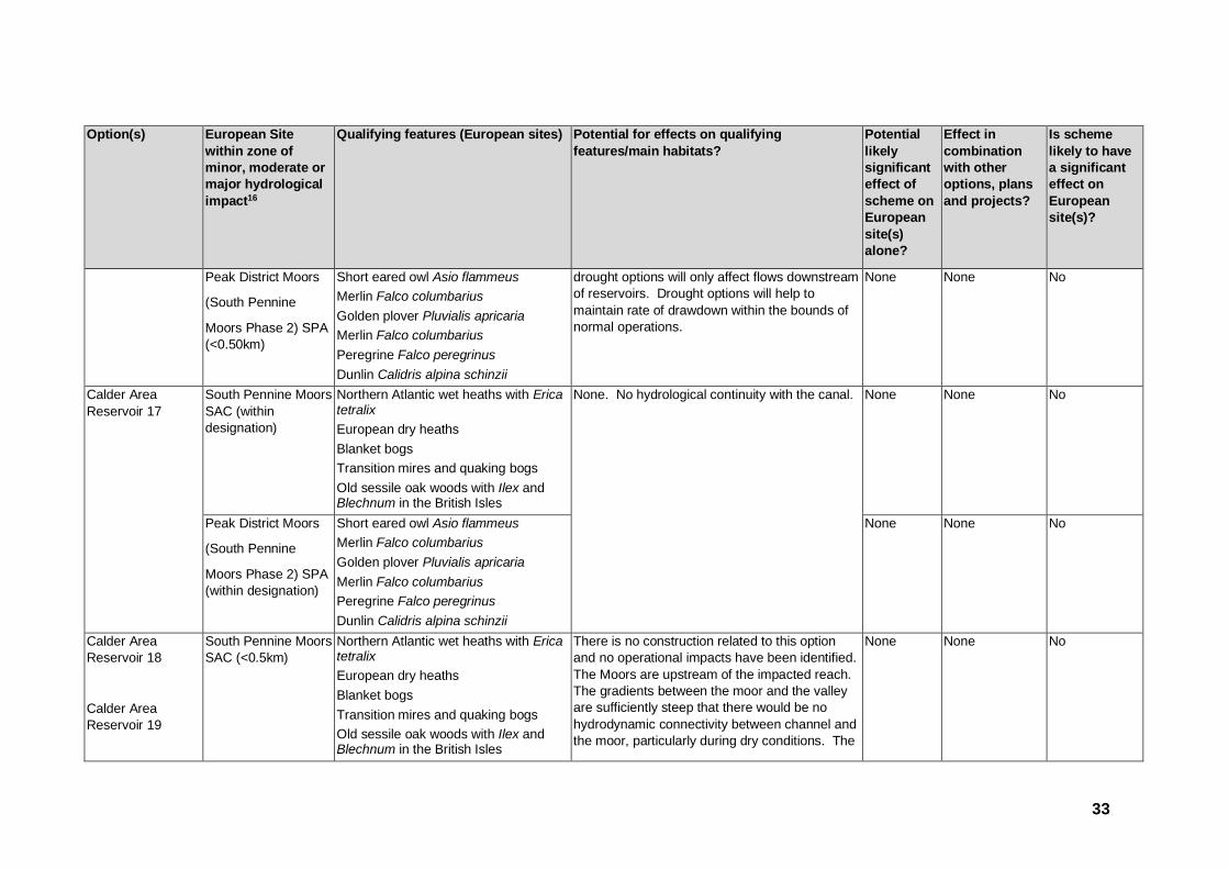
33
Option(s) European Site
within zone of
minor, moderate or
major hydrological
impact16
Qualifying features (European sites) Potential for effects on qualifying
features/main habitats?
Potential
likely
significant
effect of
scheme on
European
site(s)
alone?
Effect in
combination
with other
options, plans
and projects?
Is scheme
likely to have
a significant
effect on
European
site(s)?
Peak District Moors
(South Pennine
Moors Phase 2) SPA
(<0.50km)
Short eared owl Asio flammeus
Merlin Falco columbarius
Golden plover Pluvialis apricaria
Merlin Falco columbarius
Peregrine Falco peregrinus
Dunlin Calidris alpina schinzii
drought options will only affect flows downstream
of reservoirs. Drought options will help to
maintain rate of drawdown within the bounds of
normal operations.
None None No
Calder Area
Reservoir 17
South Pennine Moors
SAC (within
designation)
Northern Atlantic wet heaths with Erica tetralix
European dry heaths
Blanket bogs
Transition mires and quaking bogs
Old sessile oak woods with Ilex and Blechnum in the British Isles
None. No hydrological continuity with the canal.
None None No
Peak District Moors
(South Pennine
Moors Phase 2) SPA
(within designation)
Short eared owl Asio flammeus
Merlin Falco columbarius
Golden plover Pluvialis apricaria
Merlin Falco columbarius
Peregrine Falco peregrinus
Dunlin Calidris alpina schinzii
None None No
Calder Area
Reservoir 18
Calder Area
Reservoir 19
South Pennine Moors
SAC (<0.5km)
Northern Atlantic wet heaths with Erica tetralix
European dry heaths
Blanket bogs
Transition mires and quaking bogs
Old sessile oak woods with Ilex and Blechnum in the British Isles
There is no construction related to this option
and no operational impacts have been identified.
The Moors are upstream of the impacted reach.
The gradients between the moor and the valley
are sufficiently steep that there would be no
hydrodynamic connectivity between channel and
the moor, particularly during dry conditions. The
None None No

34
Option(s) European Site
within zone of
minor, moderate or
major hydrological
impact16
Qualifying features (European sites) Potential for effects on qualifying
features/main habitats?
Potential
likely
significant
effect of
scheme on
European
site(s)
alone?
Effect in
combination
with other
options, plans
and projects?
Is scheme
likely to have
a significant
effect on
European
site(s)?
Peak District Moors
(South Pennine
Moors Phase 1&2)
SPA (<0.5km)
Short eared owl Asio flammeus
Merlin Falco columbarius
Golden plover Pluvialis apricaria
Merlin Falco columbarius
Peregrine Falco peregrinus
Dunlin Calidris alpina schinzii
drought options will only affect flows downstream
of reservoirs. Drought options will help to
maintain rate of drawdown within the bounds of
normal operations.
None None No
Calder Area
Reservoir 20
South Pennine Moors
SAC (2.6km)
Northern Atlantic wet heaths with Erica tetralix
European dry heaths
Blanket bogs
Transition mires and quaking bogs
Old sessile oak woods with Ilex and Blechnum in the British Isles
There is no construction related to this option
and no operational impacts have been identified.
The Moors are upstream of the impacted reach.
The gradients between the moor and the valley
are sufficiently steep that there would be no
hydrodynamic connectivity between channel and
the moor, particularly during dry conditions. The
drought options will only affect flows downstream
of reservoirs. Drought options will help to
maintain rate of drawdown within the bounds of
normal operations.
None None No
Peak District Moors
(South Pennine
Moors Phase 1) SPA
(2.6km)
Short eared owl Asio flammeus
Merlin Falco columbarius
Golden plover Pluvialis apricaria
Merlin Falco columbarius
Peregrine Falco peregrinus
Dunlin Calidris alpina schinzii
None None No
Calder Area
Reservoir 21
South Pennine Moors
SAC (3.10km)
Northern Atlantic wet heaths with Erica tetralix
European dry heaths
Blanket bogs
Transition mires and quaking bogs
Old sessile oak woods with Ilex and Blechnum in the British Isles
There is no construction related to this option
and no operational impacts have been identified.
The Moors are upstream of the impacted reach.
The gradients between the moor and the valley
are sufficiently steep that there would be no
hydrodynamic connectivity between channel and
the moor, particularly during dry conditions. The
None None No

35
Option(s) European Site
within zone of
minor, moderate or
major hydrological
impact16
Qualifying features (European sites) Potential for effects on qualifying
features/main habitats?
Potential
likely
significant
effect of
scheme on
European
site(s)
alone?
Effect in
combination
with other
options, plans
and projects?
Is scheme
likely to have
a significant
effect on
European
site(s)?
Peak District Moors
(South Pennine
Moors Phase 1) SPA
(3.10km)
Short eared owl Asio flammeus
Merlin Falco columbarius
Golden plover Pluvialis apricaria
Merlin Falco columbarius
Peregrine Falco peregrinus
Dunlin Calidris alpina schinzii
drought options will only affect flows downstream
of reservoirs. Drought options will help to
maintain rate of drawdown within the bounds of
normal operations.
None None No
Calder Area
Reservoir 22
South Pennine Moors
SAC (<1.0km)
Northern Atlantic wet heaths with Erica tetralix
European dry heaths
Blanket bogs
Transition mires and quaking bogs
Old sessile oak woods with Ilex and Blechnum in the British Isles
There is no construction related to this option
and no operational impacts have been identified.
The Moors are upstream of the impacted reach.
The gradients between the moor and the valley
are sufficiently steep that there would be no
hydrodynamic connectivity between channel and
the moor, particularly during dry conditions. The
drought options will only affect flows downstream
of reservoirs. Drought options will help to
maintain rate of drawdown within the bounds of
normal operations.
None None No
Peak District Moors
(South Pennine
Moors Phase 1) SPA
(<1.0km)
Short eared owl Asio flammeus
Merlin Falco columbarius
Golden plover Pluvialis apricaria
Merlin Falco columbarius
Peregrine Falco peregrinus
Dunlin Calidris alpina schinzii
None None No
North West Area Reservoirs
North Area
Reservoir 1
South Pennine Moors
SAC (1.20km)
Northern Atlantic wet heaths with Erica tetralix
European dry heaths
Blanket bogs
Transition mires and quaking bogs
There is no construction related to this option
and no operational impacts have been identified.
The Moors are upstream of the impacted reach.
The gradients between the moor and the valley
are sufficiently steep that there would be no
None None No

36
Option(s) European Site
within zone of
minor, moderate or
major hydrological
impact16
Qualifying features (European sites) Potential for effects on qualifying
features/main habitats?
Potential
likely
significant
effect of
scheme on
European
site(s)
alone?
Effect in
combination
with other
options, plans
and projects?
Is scheme
likely to have
a significant
effect on
European
site(s)?
Old sessile oak woods with Ilex and Blechnum in the British Isles
hydrodynamic connectivity between channel and
the moor, particularly during dry conditions. The
drought options will only affect flows downstream
of reservoirs. Drought options will help to
maintain rate of drawdown within the bounds of
normal operations.
Peak District Moors
(South Pennine
Moors Phase 2) SPA
(1.20km)
Short eared owl Asio flammeus
Merlin Falco columbarius
Golden plover Pluvialis apricaria
Merlin Falco columbarius
Peregrine Falco peregrinus
Dunlin Calidris alpina schinzii
None None No
North Area
Reservoir 2
South Pennine Moors
SAC (1.0km)
Northern Atlantic wet heaths with Erica tetralix
European dry heaths
Blanket bogs
Transition mires and quaking bogs
Old sessile oak woods with Ilex and Blechnum in the British Isles
There is no construction related to this option
and no operational impacts have been identified.
The Moors are upstream of the impacted reach.
The gradients between the moor and the valley
are sufficiently steep that there would be no
hydrodynamic connectivity between channel and
the moor, particularly during dry conditions. The
drought options will only affect flows downstream
of reservoirs. Drought options will help to
maintain rate of drawdown within the bounds of
normal operations.
None None No
Peak District Moors
(South Pennine
Moors Phase 2) SPA
(1.0km)
Short eared owl Asio flammeus
Merlin Falco columbarius
Golden plover Pluvialis apricaria
Merlin Falco columbarius
Peregrine Falco peregrinus
Dunlin Calidris alpina schinzii
None None No
North Area
Reservoir 3
South Pennine Moors
SAC (<1.0km)
Northern Atlantic wet heaths with Erica tetralix
European dry heaths
Blanket bogs
Transition mires and quaking bogs
There is no construction related to this option
and no operational impacts have been identified.
The Moors are upstream of the impacted reach.
The gradients between the moor and the valley
are sufficiently steep that there would be no
None None No

37
Option(s) European Site
within zone of
minor, moderate or
major hydrological
impact16
Qualifying features (European sites) Potential for effects on qualifying
features/main habitats?
Potential
likely
significant
effect of
scheme on
European
site(s)
alone?
Effect in
combination
with other
options, plans
and projects?
Is scheme
likely to have
a significant
effect on
European
site(s)?
Old sessile oak woods with Ilex and Blechnum in the British Isles
hydrodynamic connectivity between channel and
the moor, particularly during dry conditions. The
drought options will only affect flows downstream
of reservoirs. Drought options will help to
maintain rate of drawdown within the bounds of
normal operations.
Peak District Moors
(South Pennine
Moors Phase 2) SPA
(<1.0km)
Short eared owl Asio flammeus
Merlin Falco columbarius
Golden plover Pluvialis apricaria
Merlin Falco columbarius
Peregrine Falco peregrinus
Dunlin Calidris alpina schinzii
None None No
North Area
Reservoir 4
South Pennine Moors
SAC (3.0km)
Northern Atlantic wet heaths with Erica tetralix
European dry heaths
Blanket bogs
Transition mires and quaking bogs
Old sessile oak woods with Ilex and Blechnum in the British Isles
There is no construction related to this option
and no operational impacts have been identified.
The Moors are upstream of the impacted reach.
The gradients between the moor and the valley
are sufficiently steep that there would be no
hydrodynamic connectivity between channel and
the moor, particularly during dry conditions. The
drought options will only affect flows downstream
of reservoirs. Drought options will help to
maintain rate of drawdown within the bounds of
normal operations.
None None No
Peak District Moors
(South Pennine
Moors Phase 2) SPA
(3.0km)
Short eared owl Asio flammeus
Merlin Falco columbarius
Golden plover Pluvialis apricaria
Merlin Falco columbarius
Peregrine Falco peregrinus
Dunlin Calidris alpina schinzii
None None No
North Area
Reservoir 5
South Pennine Moors
SAC (3.60km)
Northern Atlantic wet heaths with Erica tetralix
European dry heaths
Blanket bogs
Transition mires and quaking bogs
There is no construction related to this option
and no operational impacts have been identified.
The Moors are upstream of the impacted reach.
The gradients between the moor and the valley
are sufficiently steep that there would be no
None None No

38
Option(s) European Site
within zone of
minor, moderate or
major hydrological
impact16
Qualifying features (European sites) Potential for effects on qualifying
features/main habitats?
Potential
likely
significant
effect of
scheme on
European
site(s)
alone?
Effect in
combination
with other
options, plans
and projects?
Is scheme
likely to have
a significant
effect on
European
site(s)?
Old sessile oak woods with Ilex and Blechnum in the British Isles
hydrodynamic connectivity between channel and
the moor, particularly during dry conditions. The
drought options will only affect flows downstream
of reservoirs. Drought options will help to
maintain rate of drawdown within the bounds of
normal operations.
Peak District Moors
(South Pennine
Moors Phase 2) SPA
(3.60km)
Short eared owl Asio flammeus
Merlin Falco columbarius
Golden plover Pluvialis apricaria
Merlin Falco columbarius
Peregrine Falco peregrinus
Dunlin Calidris alpina schinzii
None None No
North Area
Reservoir 6
South Pennine Moors
SAC (1.00km)
Northern Atlantic wet heaths with Erica tetralix
European dry heaths
Blanket bogs
Transition mires and quaking bogs
Old sessile oak woods with Ilex and Blechnum in the British Isles
There is no construction related to this option
and no operational impacts have been identified.
The Moors are upstream of the impacted reach.
The gradients between the moor and the valley
are sufficiently steep that there would be no
hydrodynamic connectivity between channel and
the moor, particularly during dry conditions. The
drought options will only affect flows downstream
of reservoirs. Drought options will help to
maintain rate of drawdown within the bounds of
normal operations.
None None
No
Peak District Moors
(South Pennine
Moors Phase 2) SPA
(1.00km)
Short eared owl Asio flammeus
Merlin Falco columbarius
Golden plover Pluvialis apricaria
Merlin Falco columbarius
Peregrine Falco peregrinus
Dunlin Calidris alpina schinzii
None None
No
North Area
Reservoir 7
South Pennine Moors
SAC (<1.0km)
Northern Atlantic wet heaths with Erica tetralix
European dry heaths
Blanket bogs
Transition mires and quaking bogs
There is no construction related to this option
and no operational impacts have been identified.
The Moors are upstream of the impacted reach.
The gradients between the moor and the valley
are sufficiently steep that there would be no
None None
No

39
Option(s) European Site
within zone of
minor, moderate or
major hydrological
impact16
Qualifying features (European sites) Potential for effects on qualifying
features/main habitats?
Potential
likely
significant
effect of
scheme on
European
site(s)
alone?
Effect in
combination
with other
options, plans
and projects?
Is scheme
likely to have
a significant
effect on
European
site(s)?
Old sessile oak woods with Ilex and Blechnum in the British Isles
hydrodynamic connectivity between channel and
the moor, particularly during dry conditions. The
drought options will only affect flows downstream
of reservoirs. Drought options will help to
maintain rate of drawdown within the bounds of
normal operations.
Peak District Moors
(South Pennine
Moors Phase 2) SPA
(<1.0km)
Short eared owl Asio flammeus
Merlin Falco columbarius
Golden plover Pluvialis apricaria
Merlin Falco columbarius
Peregrine Falco peregrinus
Dunlin Calidris alpina schinzii
None None
No
North Area
Reservoir 8
South Pennine Moors
SAC (<0.5km)
Northern Atlantic wet heaths with Erica tetralix
European dry heaths
Blanket bogs
Transition mires and quaking bogs
Old sessile oak woods with Ilex and Blechnum in the British Isles
There is no construction related to this option
and no operational impacts have been identified.
The Moors are upstream of the impacted reach.
The gradients between the moor and the valley
are sufficiently steep that there would be no
hydrodynamic connectivity between channel and
the moor, particularly during dry conditions. The
drought options will only affect flows downstream
of reservoirs. Drought options will help to
maintain rate of drawdown within the bounds of
normal operations.
None None No
Peak District Moors
(South Pennine
Moors Phase 2) SPA
(<0.5km)
Short eared owl Asio flammeus
Merlin Falco columbarius
Golden plover Pluvialis apricaria
Merlin Falco columbarius
Peregrine Falco peregrinus
Dunlin Calidris alpina schinzii
None None No
North Area
Reservoir 9
South Pennine Moors
SAC (2.20km)
Northern Atlantic wet heaths with Erica tetralix
European dry heaths
Blanket bogs
Transition mires and quaking bogs
There is no construction related to this option
and no operational impacts have been identified.
The Moors are designated on higher elevations
above the impacted reach. The gradients
between the moor and the valley are sufficiently
None None No

40
Option(s) European Site
within zone of
minor, moderate or
major hydrological
impact16
Qualifying features (European sites) Potential for effects on qualifying
features/main habitats?
Potential
likely
significant
effect of
scheme on
European
site(s)
alone?
Effect in
combination
with other
options, plans
and projects?
Is scheme
likely to have
a significant
effect on
European
site(s)?
Old sessile oak woods with Ilex and Blechnum in the British Isles
steep that there would be no hydrodynamic
connectivity between channel and the moor,
particularly during dry conditions. The drought
options will only affect flows downstream of
reservoirs. Drought options will help to maintain
rate of drawdown within the bounds of normal
operations.
Peak District Moors
(South Pennine
Moors Phase 2) SPA
(2.20km)
Short eared owl Asio flammeus
Merlin Falco columbarius
Golden plover Pluvialis apricaria
Merlin Falco columbarius
Peregrine Falco peregrinus
Dunlin Calidris alpina schinzii
None None No
North Area
Reservoir 10
North Pennine Moors
SAC (0.25km)
Northern Atlantic wet heaths with Erica tetralix
European dry heaths
Juniperus communis formations on heaths or calcareous grasslands
Calaminarian grasslands of the Violetalia calaminariae
Siliceous alpine and boreal grasslands
Semi-natural dry grasslands and scrubland facies: on calcareous substrates (Festuco-Brometalia)
Blanket bogs
Petrifying springs with tufa formation (Cratoneurion)
Alkaline fens
Siliceous scree of the montane to snow levels (Androsacetalia alpinae and Galeopsietalia ladani)
There is no construction related to this option
and no operational impacts have been identified.
The Moors are upstream of the impacted reach.
The gradients between the moor and the valley
are sufficiently steep that there would be no
hydrodynamic connectivity between channel and
the moor, particularly during dry conditions. The
drought options will only affect flows downstream
of reservoirs. Drought options will help to
maintain rate of drawdown within the bounds of
normal operations.
None None No

41
Option(s) European Site
within zone of
minor, moderate or
major hydrological
impact16
Qualifying features (European sites) Potential for effects on qualifying
features/main habitats?
Potential
likely
significant
effect of
scheme on
European
site(s)
alone?
Effect in
combination
with other
options, plans
and projects?
Is scheme
likely to have
a significant
effect on
European
site(s)?
Calcareous rocky slopes with chasmophytic vegetation
Siliceous rocky slopes with chasmophytic vegetation
Old sessile oak woods with Ilex and Blechnum in the British Isles
Marsh saxifrage Saxifraga hirculus
North Pennine Moors
SPA (0.25km)
Assemblages of breeding birds-upland moorland and grassland breeding birds with waterbodies. Species include common sandpiper, curlew and ringed plover.
Golden Plover Pluvialis apricaria
Hen harrier Circus cyaneus
Merlin Falco columbarius
Peregrine Falco peregrinus
Dunlin Calidris alpina schinzii
There is no construction related to this option
and no operational impacts have been identified.
The Moors are upstream of the impacted reach.
The gradients between the moor and the valley
are sufficiently steep that there would be no
hydrodynamic connectivity between channel and
the moor, particularly during dry conditions.
None None No
North Area
Reservoir 11
North Pennine Moors
SPA (0.68km)
Assemblages of breeding birds-upland moorland and grassland breeding birds with waterbodies. Species include common sandpiper, curlew and ringed plover.
Golden Plover Pluvialis apricaria
Hen harrier Circus cyaneus
There is no construction related to this option
and no operational impacts have been identified.
The Moors are upstream of the impacted reach.
The gradients between the moor and the valley
are sufficiently steep that there would be no
hydrodynamic connectivity between channel and
the moor, particularly during dry conditions.
None None No

42
Option(s) European Site
within zone of
minor, moderate or
major hydrological
impact16
Qualifying features (European sites) Potential for effects on qualifying
features/main habitats?
Potential
likely
significant
effect of
scheme on
European
site(s)
alone?
Effect in
combination
with other
options, plans
and projects?
Is scheme
likely to have
a significant
effect on
European
site(s)?
Merlin Falco columbarius
Peregrine Falco peregrinus
Dunlin Calidris alpina schinzii
River Abstractions
Ouse increased
abstraction
Strensall Common SAC (7.1km)
North Atlantic wet heaths with Erica tetralix
European dry heath
There is no construction related to this option and no operational impacts have been identified. The SAC is a sufficient distance from the impacted reach that there would be no hydrodynamic connectivity between channel and the moor, particularly during dry conditions.
None None No
Humber Estuary SAC
(>10km17)
Sandbanks which are slightly covered
by sea water all the time
Estuaries
Mudflats and sandflats not covered by
seawater at low tide
Any reduction in freshwater flows could
potentially affect qualifying interests for which
Humber Estuary is designated, specifically river
and sea lamprey (entrainment, attractant flows,
dissolved oxygen etc).
The potential impact associated with entrainment
has been addressed by the installation of
None None No
17 Although outside of the buffer zone (10km radius), this has been included as the River Ouse discharges into the Humber Estuary EMS.

43
Option(s) European Site
within zone of
minor, moderate or
major hydrological
impact16
Qualifying features (European sites) Potential for effects on qualifying
features/main habitats?
Potential
likely
significant
effect of
scheme on
European
site(s)
alone?
Effect in
combination
with other
options, plans
and projects?
Is scheme
likely to have
a significant
effect on
European
site(s)?
Coastal lagoons
Annual vegetation of drift lines
Salicornia and other annuals colonising
mud and sand
Atlantic salt meadows (Glauco-
Puccinellietalia maritimae)
Embryonic shifting dunes
Shifting dunes along the shoreline with
Ammophila arenaria (“white dunes”)
Fixed dunes with herbaceous
vegetation (“grey dunes”)
Dunes with Hippophae rhamnoides
Sea lamprey Petromyzon marinus
River lamprey Lampetra fluviatilis
Grey seal Halichoerus grypus
permanent fish screens and this will negate any
likely significant effect on designated species.
Extensive work undertaken by YWSL and signed
off by Natural England and the Environment
Agency has shown that cumulative impacts of
drought options [for implementation in the first
two years of drought] would have no adverse
effect on the integrity of the European site. It
therefore follows that this option would
individually have no adverse effect18.
Humber Estuary SPA
(>10km)
Teal Anas crecca
Wigeon Anas penelope
Any reduction in freshwater flows could
potentially affect qualifying interests for which
Humber Estuary is designated.
None None No
18 Scott Wilson (2011). Yorkshire Water Drought Plan: Assessment of Possible Impact on Humber Estuary SPA/SAC. Final Report Revision 2 February 2011. Report for Yorkshire Water.

44
Option(s) European Site
within zone of
minor, moderate or
major hydrological
impact16
Qualifying features (European sites) Potential for effects on qualifying
features/main habitats?
Potential
likely
significant
effect of
scheme on
European
site(s)
alone?
Effect in
combination
with other
options, plans
and projects?
Is scheme
likely to have
a significant
effect on
European
site(s)?
Mallard Anas platyrhynchos
Ruddy turnstone Arenaria interpres
Pochard Aythya ferina
Great Bittern Botaurus stellaris
Dark bellied brent goose Branta
bernicla bernicla
A067 Goldeneye Bucephala clangula
Sanderling Calidris alba
Dunlin Calidris alpina alpina
Red Knot Calidris canutus
Ringed plover Charadrius hiaticula
Eurasian Marsh harrier Circus
aeruginosus
Hen harrier Circus cyaneus
Oystercatcher Haematopus ostralegus
Bar tailed godwit Limosa lapponica
Black tailed godwit Limosa limosa
islandica
Curlew Numenius arquata
Whimbrel Numenius phaeopus
Ruff Philomachus pugnax
European Golden plover Pluvialis
apricaria
Grey plover Pluvialis squatarola
Extensive work undertaken by YWSL and signed
off by Natural England and the Environment
Agency has shown that cumulative impacts of all
drought options [for implementation in the first
two years of drought] would have no adverse
effect on the integrity of the European site. It
therefore follows that this option would
individually have no adverse effect14.

45
Option(s) European Site
within zone of
minor, moderate or
major hydrological
impact16
Qualifying features (European sites) Potential for effects on qualifying
features/main habitats?
Potential
likely
significant
effect of
scheme on
European
site(s)
alone?
Effect in
combination
with other
options, plans
and projects?
Is scheme
likely to have
a significant
effect on
European
site(s)?
Pied avocet Recurvirostra avosetta
Little tern Sterna albifrons
Common Shelduck Tadorna tadorna
Common greenshank Tringa nebularia
Common Redshank Tringa totanus
Lapwing Vanellus vanellus
scaup Aythya marila
golden plover Pluvialis apricaria
knot Calidris canutus
Humber Estuary
RAMSAR (>10km)
Ramsar Criterion 1
The site is a representative example of
a near-natural estuary with the following
component habitats; dune systems and
humid dune slacks, estuarine waters,
intertidal mud and sand flats,
saltmarshes, and coastal
brackish/saline lagoons.
Ramsar Criterion 3
The Humber Estuary Ramsar site
supports a breeding colony of grey
seals Halichoerus grypus at Donna
Nook. It is the second largest grey seal
colony in England and the furthest
south regular breeding site on the east
coast. The dune slacks at Saltfleetby-
Theddlethorpe on the southern
There is no construction related to this option
and no operational impacts have been identified
Any reduction in freshwater flows could
potentially affect qualifying interests for which
Humber Estuary is designated, specifically river
and sea lamprey (entrainment, attractant flows,
dissolved oxygen etc).
Extensive work undertaken by YWSL and signed
off by Natural England and the Environment
Agency has shown that cumulative impacts of all
drought options [for implementation in the first
two years of drought] would have no adverse
effect on the integrity of the European site. It
therefore follows that this option would
individually have no adverse effect14.
None None No

46
Option(s) European Site
within zone of
minor, moderate or
major hydrological
impact16
Qualifying features (European sites) Potential for effects on qualifying
features/main habitats?
Potential
likely
significant
effect of
scheme on
European
site(s)
alone?
Effect in
combination
with other
options, plans
and projects?
Is scheme
likely to have
a significant
effect on
European
site(s)?
extremity of the Ramsar site are the
most north-easterly breeding site in
Great Britain of the natterjack toad Bufo
calamita.
Ramsar Criterion 5
Assemblages of international
importance: 153,934 waterfowl, non-
breeding season (5 year peak mean
1996/97-2000/2001)
Ramsar Criterion 6
12 Species/populations occurring at
levels of international importance.
Ramsar Criterion 8
The Humber Estuary acts as an
important migration route for both river
lamprey Lampetra fluviatilis and sea
lamprey Petromyzon marinus between
coastal waters and their spawning
areas.
Ure increased
abstraction
North Pennine Moors
SAC (3.2km)
Northern Atlantic wet heaths with Erica tetralix
European dry heaths
Juniperus communis formations on heaths or calcareous grasslands
Calaminarian grasslands of the
There is no construction related to this option
and no operational impacts have been identified.
The Moors are upstream of the impacted reach.
The gradients between the moor and the valley
are sufficiently steep that there would be no
hydrodynamic connectivity between channel and
None None No

47
Option(s) European Site
within zone of
minor, moderate or
major hydrological
impact16
Qualifying features (European sites) Potential for effects on qualifying
features/main habitats?
Potential
likely
significant
effect of
scheme on
European
site(s)
alone?
Effect in
combination
with other
options, plans
and projects?
Is scheme
likely to have
a significant
effect on
European
site(s)?
Violetalia calaminariae
Siliceous alpine and boreal grasslands
Semi-natural dry grasslands and scrubland facies: on calcareous substrates (Festuco-Brometalia)
Blanket bogs
Petrifying springs with tufa formation (Cratoneurion)
Alkaline fens
Siliceous scree of the montane to snow levels (Androsacetalia alpinae and Galeopsietalia ladani)
Calcareous rocky slopes with chasmophytic vegetation
Siliceous rocky slopes with chasmophytic vegetation
Old sessile oak woods with Ilex and Blechnum in the British Isles
Marsh saxifrage Saxifraga hirculus
the moor, particularly during dry conditions.
North Pennine Moors
SPA (0.25km)
Assemblages of breeding birds-upland moorland and grassland breeding birds with waterbodies. Species include common sandpiper, curlew and ringed plover.
Golden Plover Pluvialis apricaria
There is no construction related to this option
and no operational impacts have been identified.
The Moors are upstream of the impacted reach.
The gradients between the moor and the valley
are sufficiently steep that there would be no
hydrodynamic connectivity between channel and
None None No
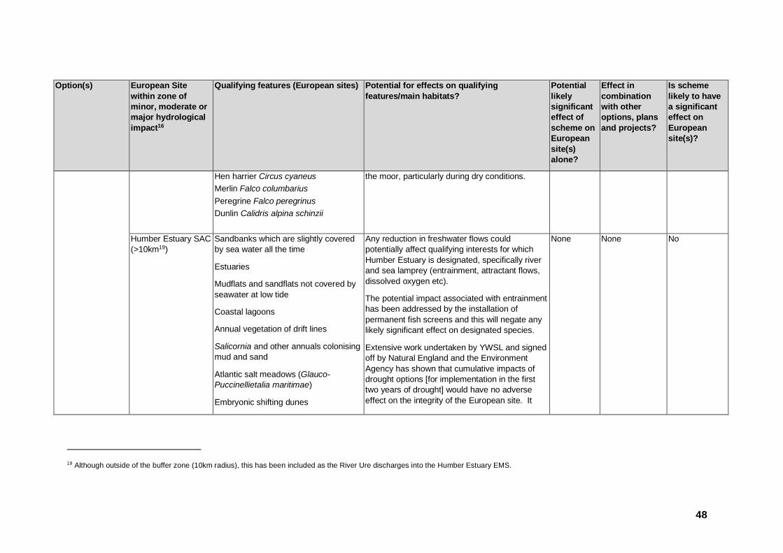
48
Option(s) European Site
within zone of
minor, moderate or
major hydrological
impact16
Qualifying features (European sites) Potential for effects on qualifying
features/main habitats?
Potential
likely
significant
effect of
scheme on
European
site(s)
alone?
Effect in
combination
with other
options, plans
and projects?
Is scheme
likely to have
a significant
effect on
European
site(s)?
Hen harrier Circus cyaneus
Merlin Falco columbarius
Peregrine Falco peregrinus
Dunlin Calidris alpina schinzii
the moor, particularly during dry conditions.
Humber Estuary SAC
(>10km19)
Sandbanks which are slightly covered
by sea water all the time
Estuaries
Mudflats and sandflats not covered by
seawater at low tide
Coastal lagoons
Annual vegetation of drift lines
Salicornia and other annuals colonising
mud and sand
Atlantic salt meadows (Glauco-
Puccinellietalia maritimae)
Embryonic shifting dunes
Any reduction in freshwater flows could
potentially affect qualifying interests for which
Humber Estuary is designated, specifically river
and sea lamprey (entrainment, attractant flows,
dissolved oxygen etc).
The potential impact associated with entrainment
has been addressed by the installation of
permanent fish screens and this will negate any
likely significant effect on designated species.
Extensive work undertaken by YWSL and signed
off by Natural England and the Environment
Agency has shown that cumulative impacts of
drought options [for implementation in the first
two years of drought] would have no adverse
effect on the integrity of the European site. It
None None No
19 Although outside of the buffer zone (10km radius), this has been included as the River Ure discharges into the Humber Estuary EMS.

49
Option(s) European Site
within zone of
minor, moderate or
major hydrological
impact16
Qualifying features (European sites) Potential for effects on qualifying
features/main habitats?
Potential
likely
significant
effect of
scheme on
European
site(s)
alone?
Effect in
combination
with other
options, plans
and projects?
Is scheme
likely to have
a significant
effect on
European
site(s)?
Shifting dunes along the shoreline with
Ammophila arenaria (“white dunes”)
Fixed dunes with herbaceous
vegetation (“grey dunes”)
Dunes with Hippophae rhamnoides
Sea lamprey Petromyzon marinus
River lamprey Lampetra fluviatilis
Grey seal Halichoerus grypus
therefore follows that this option would
individually have no adverse effect20.
Humber Estuary SPA
(>10km)
Teal Anas crecca
Wigeon Anas penelope
Mallard Anas platyrhynchos
Ruddy turnstone Arenaria interpres
Pochard Aythya ferina
Great Bittern Botaurus stellaris
Dark bellied brent goose Branta
bernicla bernicla
Goldeneye Bucephala clangula
Sanderling Calidris alba
Dunlin Calidris alpina alpina
Any reduction in freshwater flows could
potentially affect qualifying interests for which
Humber Estuary is designated.
Extensive work undertaken by YWSL and signed
off by Natural England and the Environment
Agency has shown that cumulative impacts of all
drought options [for implementation in the first
two years of drought] would have no adverse
effect on the integrity of the European site. It
therefore follows that this option would
individually have no adverse effect14.
None None No
20 Scott Wilson (2011). Yorkshire Water Drought Plan: Assessment of Possible Impact on Humber Estuary SPA/SAC. Final Report Revision 2 February 2011. Report for Yorkshire Water.

50
Option(s) European Site
within zone of
minor, moderate or
major hydrological
impact16
Qualifying features (European sites) Potential for effects on qualifying
features/main habitats?
Potential
likely
significant
effect of
scheme on
European
site(s)
alone?
Effect in
combination
with other
options, plans
and projects?
Is scheme
likely to have
a significant
effect on
European
site(s)?
Red Knot Calidris canutus
Ringed plover Charadrius hiaticula
Eurasian Marsh harrier Circus
aeruginosus
Hen harrier Circus cyaneus
Oystercatcher Haematopus ostralegus
Bar tailed godwit Limosa lapponica
Black tailed godwit Limosa limosa
islandica
Curlew Numenius arquata
Whimbrel Numenius phaeopus
Ruff Philomachus pugnax
European Golden plover Pluvialis
apricaria
Grey plover Pluvialis squatarola
Pied avocet Recurvirostra avosetta
Little tern Sterna albifrons
Common Shelduck Tadorna tadorna
Common greenshank Tringa nebularia
Common Redshank Tringa totanus
Lapwing Vanellus vanellus
scaup Aythya marila
golden plover Pluvialis apricaria
knot Calidris canutus

51
Option(s) European Site
within zone of
minor, moderate or
major hydrological
impact16
Qualifying features (European sites) Potential for effects on qualifying
features/main habitats?
Potential
likely
significant
effect of
scheme on
European
site(s)
alone?
Effect in
combination
with other
options, plans
and projects?
Is scheme
likely to have
a significant
effect on
European
site(s)?
Humber Estuary
RAMSAR (>10km)
Ramsar Criterion 1
The site is a representative example of
a near-natural estuary with the following
component habitats; dune systems and
humid dune slacks, estuarine waters,
intertidal mud and sand flats,
saltmarshes, and coastal
brackish/saline lagoons.
Ramsar Criterion 3
The Humber Estuary Ramsar site
supports a breeding colony of grey
seals Halichoerus grypus at Donna
Nook. It is the second largest grey seal
colony in England and the furthest
south regular breeding site on the east
coast. The dune slacks at Saltfleetby-
Theddlethorpe on the southern
extremity of the Ramsar site are the
most north-easterly breeding site in
Great Britain of the natterjack toad Bufo
calamita.
Ramsar Criterion 5
Assemblages of international
importance: 153,934 waterfowl, non-
breeding season (5 year peak mean
1996/97-2000/2001)
There is no construction related to this option
and no operational impacts have been identified
Any reduction in freshwater flows could
potentially affect qualifying interests for which
Humber Estuary is designated, specifically river
and sea lamprey (entrainment, attractant flows,
dissolved oxygen etc).
Extensive work undertaken by YWSL and signed
off by Natural England and the Environment
Agency has shown that cumulative impacts of all
drought options [for implementation in the first
two years of drought] would have no adverse
effect on the integrity of the European site. It
therefore follows that this option would
individually have no adverse effect14.
None None No

52
Option(s) European Site
within zone of
minor, moderate or
major hydrological
impact16
Qualifying features (European sites) Potential for effects on qualifying
features/main habitats?
Potential
likely
significant
effect of
scheme on
European
site(s)
alone?
Effect in
combination
with other
options, plans
and projects?
Is scheme
likely to have
a significant
effect on
European
site(s)?
Ramsar Criterion 6
12 Species/populations occurring at
levels of international importance.
Ramsar Criterion 8
The Humber Estuary acts as an
important migration route for both river
lamprey Lampetra fluviatilis and sea
lamprey Petromyzon marinus between
coastal waters and their spawning
areas.
Wharfe increased
abstraction
North Pennine Moors
SPA (1.40km)
Assemblages of breeding birds-upland moorland and grassland breeding birds with waterbodies. Species include common sandpiper, curlew and ringed plover.
Golden Plover Pluvialis apricaria
Hen harrier Circus cyaneus
Merlin Falco columbarius
Peregrine Falco peregrinus
Dunlin Calidris alpina schinzii
There is no construction related to this option
and no operational impacts have been identified.
The Moors are upstream of the impacted reach.
The gradients between the moor and the valley
are sufficiently steep that there would be no
hydrodynamic connectivity between channel and
the moor, particularly during dry conditions.
None None No
North Pennine Moors
SAC (1.40km)
Northern Atlantic wet heaths with Erica tetralix
European dry heaths
Juniperus communis formations on
None None No

53
Option(s) European Site
within zone of
minor, moderate or
major hydrological
impact16
Qualifying features (European sites) Potential for effects on qualifying
features/main habitats?
Potential
likely
significant
effect of
scheme on
European
site(s)
alone?
Effect in
combination
with other
options, plans
and projects?
Is scheme
likely to have
a significant
effect on
European
site(s)?
heaths or calcareous grasslands
Calaminarian grasslands of the Violetalia calaminariae
Siliceous alpine and boreal grasslands
Semi-natural dry grasslands and scrubland facies: on calcareous substrates (Festuco-Brometalia)
Blanket bogs
Petrifying springs with tufa formation (Cratoneurion)
Alkaline fens
Siliceous scree of the montane to snow levels (Androsacetalia alpinae and Galeopsietalia ladani)
Calcareous rocky slopes with chasmophytic vegetation
Siliceous rocky slopes with chasmophytic vegetation
Old sessile oak woods with Ilex and Blechnum in the British Isles
Saxifraga hirculus
Marsh saxifrage Saxifraga hirculus
Peak District Moors
(South Pennine
Moors Phase 2) SPA
(1.20km)
Short eared owl Asio flammeus
Merlin Falco columbarius
Golden plover Pluvialis apricaria
Merlin Falco columbarius
Peregrine Falco peregrinus
There is no construction related to this option
and no operational impacts have been identified.
The Moors are upstream of the impacted reach.
The gradients between the moor and the valley
are sufficiently steep that there would be no
None None No

54
Option(s) European Site
within zone of
minor, moderate or
major hydrological
impact16
Qualifying features (European sites) Potential for effects on qualifying
features/main habitats?
Potential
likely
significant
effect of
scheme on
European
site(s)
alone?
Effect in
combination
with other
options, plans
and projects?
Is scheme
likely to have
a significant
effect on
European
site(s)?
Dunlin Calidris alpina schinzii hydrodynamic connectivity between channel and
the moor, particularly during dry conditions. South Pennine Moors
SAC (1.20km)
Northern Atlantic wet heaths with Erica tetralix
European dry heaths
Blanket bogs
Transition mires and quaking bogs
Old sessile oak woods with Ilex and Blechnum in the British Isles
None None No
Humber Estuary SAC
(>10km21)
Sandbanks which are slightly covered
by sea water all the time
Estuaries
Mudflats and sandflats not covered by
seawater at low tide
Coastal lagoons
Annual vegetation of drift lines
Salicornia and other annuals colonising
mud and sand
Atlantic salt meadows (Glauco-
Puccinellietalia maritimae)
Any reduction in freshwater flows could
potentially affect qualifying interests for which
Humber Estuary is designated, specifically river
and sea lamprey (entrainment, attractant flows,
dissolved oxygen etc).
The potential impact associated with entrainment
has been addressed by the installation of
permanent fish screens and this will negate any
likely significant effect on designated species.
Extensive work undertaken by YWSL and signed
off by Natural England and the Environment
Agency has shown that cumulative impacts of
drought options [for implementation in the first
two years of drought] would have no adverse
effect on the integrity of the European site. It
None None No
21 Although outside of the buffer zone (10km radius), this has been included as the River Wharfe discharges into the Humber Estuary EMS.

55
Option(s) European Site
within zone of
minor, moderate or
major hydrological
impact16
Qualifying features (European sites) Potential for effects on qualifying
features/main habitats?
Potential
likely
significant
effect of
scheme on
European
site(s)
alone?
Effect in
combination
with other
options, plans
and projects?
Is scheme
likely to have
a significant
effect on
European
site(s)?
Embryonic shifting dunes
Shifting dunes along the shoreline with
Ammophila arenaria (“white dunes”)
Fixed dunes with herbaceous
vegetation (“grey dunes”)
Dunes with Hippophae rhamnoides
Sea lamprey Petromyzon marinus
River lamprey Lampetra fluviatilis
Grey seal Halichoerus grypus
therefore follows that this option would
individually have no adverse effect22.
Humber Estuary SPA
(>10km)
Teal Anas crecca
Wigeon Anas penelope
Mallard Anas platyrhynchos
Ruddy turnstone Arenaria interpres
Pochard Aythya ferina
Great Bittern Botaurus stellaris
Dark bellied brent goose Branta
bernicla bernicla
Any reduction in freshwater flows could
potentially affect qualifying interests for which
Humber Estuary is designated.
Extensive work undertaken by YWSL and signed
off by Natural England and the Environment
Agency has shown that cumulative impacts of all
drought options [for implementation in the first
two years of drought] would have no adverse
effect on the integrity of the European site. It
therefore follows that this option would
None None No
22 Scott Wilson (2011). Yorkshire Water Drought Plan: Assessment of Possible Impact on Humber Estuary SPA/SAC. Final Report Revision 2 February 2011. Report for Yorkshire Water.
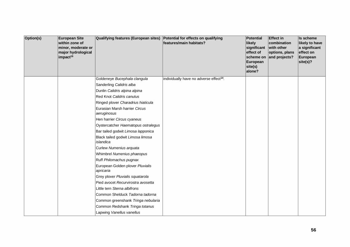
56
Option(s) European Site
within zone of
minor, moderate or
major hydrological
impact16
Qualifying features (European sites) Potential for effects on qualifying
features/main habitats?
Potential
likely
significant
effect of
scheme on
European
site(s)
alone?
Effect in
combination
with other
options, plans
and projects?
Is scheme
likely to have
a significant
effect on
European
site(s)?
Goldeneye Bucephala clangula
Sanderling Calidris alba
Dunlin Calidris alpina alpina
Red Knot Calidris canutus
Ringed plover Charadrius hiaticula
Eurasian Marsh harrier Circus
aeruginosus
Hen harrier Circus cyaneus
Oystercatcher Haematopus ostralegus
Bar tailed godwit Limosa lapponica
Black tailed godwit Limosa limosa
islandica
Curlew Numenius arquata
Whimbrel Numenius phaeopus
Ruff Philomachus pugnax
European Golden plover Pluvialis
apricaria
Grey plover Pluvialis squatarola
Pied avocet Recurvirostra avosetta
Little tern Sterna albifrons
Common Shelduck Tadorna tadorna
Common greenshank Tringa nebularia
Common Redshank Tringa totanus
Lapwing Vanellus vanellus
individually have no adverse effect14.
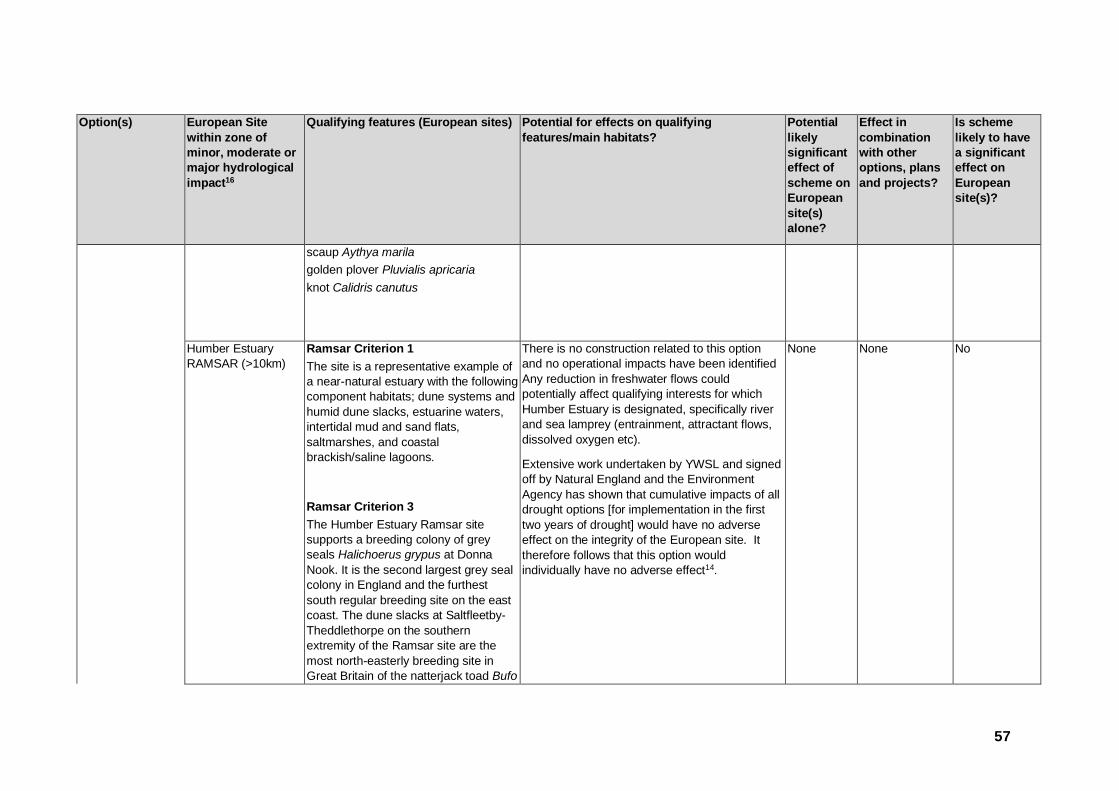
57
Option(s) European Site
within zone of
minor, moderate or
major hydrological
impact16
Qualifying features (European sites) Potential for effects on qualifying
features/main habitats?
Potential
likely
significant
effect of
scheme on
European
site(s)
alone?
Effect in
combination
with other
options, plans
and projects?
Is scheme
likely to have
a significant
effect on
European
site(s)?
scaup Aythya marila
golden plover Pluvialis apricaria
knot Calidris canutus
Humber Estuary
RAMSAR (>10km)
Ramsar Criterion 1
The site is a representative example of
a near-natural estuary with the following
component habitats; dune systems and
humid dune slacks, estuarine waters,
intertidal mud and sand flats,
saltmarshes, and coastal
brackish/saline lagoons.
Ramsar Criterion 3
The Humber Estuary Ramsar site
supports a breeding colony of grey
seals Halichoerus grypus at Donna
Nook. It is the second largest grey seal
colony in England and the furthest
south regular breeding site on the east
coast. The dune slacks at Saltfleetby-
Theddlethorpe on the southern
extremity of the Ramsar site are the
most north-easterly breeding site in
Great Britain of the natterjack toad Bufo
There is no construction related to this option
and no operational impacts have been identified
Any reduction in freshwater flows could
potentially affect qualifying interests for which
Humber Estuary is designated, specifically river
and sea lamprey (entrainment, attractant flows,
dissolved oxygen etc).
Extensive work undertaken by YWSL and signed
off by Natural England and the Environment
Agency has shown that cumulative impacts of all
drought options [for implementation in the first
two years of drought] would have no adverse
effect on the integrity of the European site. It
therefore follows that this option would
individually have no adverse effect14.
None None No

58
Option(s) European Site
within zone of
minor, moderate or
major hydrological
impact16
Qualifying features (European sites) Potential for effects on qualifying
features/main habitats?
Potential
likely
significant
effect of
scheme on
European
site(s)
alone?
Effect in
combination
with other
options, plans
and projects?
Is scheme
likely to have
a significant
effect on
European
site(s)?
calamita.
Ramsar Criterion 5
Assemblages of international
importance: 153,934 waterfowl, non-
breeding season (5 year peak mean
1996/97-2000/2001)
Ramsar Criterion 6
12 Species/populations occurring at
levels of international importance.
Ramsar Criterion 8
The Humber Estuary acts as an
important migration route for both river
lamprey Lampetra fluviatilis and sea
lamprey Petromyzon marinus between
coastal waters and their spawning
areas.
Hull increased
abstraction
Humber Estuary
SAC/SPA/ RAMSAR
(<1km)
As above There is no construction related to this option and no operational impacts have been identified. Reductions in freshwater flows to the Humber Estuary from the River Hull would not affect any qualifying interests for which the Estuary is designated a SAC/SPA/Ramsar.
The River Hull discharges to the estuary through natural gravity flow (there is normally no barrier unless the tidal gate is lowered), at a location
None Yes No

59
Option(s) European Site
within zone of
minor, moderate or
major hydrological
impact16
Qualifying features (European sites) Potential for effects on qualifying
features/main habitats?
Potential
likely
significant
effect of
scheme on
European
site(s)
alone?
Effect in
combination
with other
options, plans
and projects?
Is scheme
likely to have
a significant
effect on
European
site(s)?
where impacts on designated habitats would not occur, through the docks of Kingston upon Hull. A recent review made no reference to the River Hull as an important river for lamprey populations; unlike the Ouse, Derwent and Trent catchments23.
Wharfe annual
abstraction
increase
North Pennine Moors
SPA (1.40km)
Assemblages of breeding birds-upland moorland and grassland breeding birds with waterbodies. Species include common sandpiper, curlew and ringed plover.
Golden Plover Pluvialis apricaria
Hen harrier Circus cyaneus
Merlin Falco columbarius
Peregrine Falco peregrinus
Dunlin Calidris alpina schinzii
There is no construction related to this option and no operational impacts have been identified. The Moors are upstream of the impacted reach. The gradients between the moor and the valley are sufficiently steep that there would be no hydrodynamic connectivity between channel and the moor, particularly during dry conditions.
None None No
North Pennine Moors
SAC (1.40km)
Northern Atlantic wet heaths with Erica tetralix
European dry heaths
Juniperus communis formations on heaths or calcareous grasslands
Calaminarian grasslands of the
None None No
23 APEM (2007). Review of information on lamprey populations in the Humber Basin.

60
Option(s) European Site
within zone of
minor, moderate or
major hydrological
impact16
Qualifying features (European sites) Potential for effects on qualifying
features/main habitats?
Potential
likely
significant
effect of
scheme on
European
site(s)
alone?
Effect in
combination
with other
options, plans
and projects?
Is scheme
likely to have
a significant
effect on
European
site(s)?
Violetalia calaminariae
Siliceous alpine and boreal grasslands
Semi-natural dry grasslands and scrubland facies: on calcareous substrates (Festuco-Brometalia)
Blanket bogs
Petrifying springs with tufa formation (Cratoneurion)
Alkaline fens
Siliceous scree of the montane to snow levels (Androsacetalia alpinae and Galeopsietalia ladani)
Calcareous rocky slopes with chasmophytic vegetation
Siliceous rocky slopes with chasmophytic vegetation
Old sessile oak woods with Ilex and Blechnum in the British Isles
Saxifraga hirculus
Marsh saxifrage Saxifraga hirculus
Peak District Moors
(South Pennine
Moors Phase 2) SPA
(1.20km)
Short eared owl Asio flammeus
Merlin Falco columbarius
Golden plover Pluvialis apricaria
Merlin Falco columbarius
Peregrine Falco peregrinus
Dunlin Calidris alpina schinzii
There is no construction related to this option and no operational impacts have been identified. The Moors are upstream of the impacted reach. The gradients between the moor and the valley are sufficiently steep that there would be no hydrodynamic connectivity between channel and the moor, particularly during dry conditions.
None None No

61
Option(s) European Site
within zone of
minor, moderate or
major hydrological
impact16
Qualifying features (European sites) Potential for effects on qualifying
features/main habitats?
Potential
likely
significant
effect of
scheme on
European
site(s)
alone?
Effect in
combination
with other
options, plans
and projects?
Is scheme
likely to have
a significant
effect on
European
site(s)?
South Pennine Moors
SAC (1.20km)
Northern Atlantic wet heaths with Erica tetralix
European dry heaths
Blanket bogs
Transition mires and quaking bogs
Old sessile oak woods with Ilex and Blechnum in the British Isles
None None No
Humber Estuary SAC
(>10km24)
Sandbanks which are slightly covered
by sea water all the time
Estuaries
Mudflats and sandflats not covered by
seawater at low tide
Coastal lagoons
Annual vegetation of drift lines
Salicornia and other annuals colonising
mud and sand
Atlantic salt meadows (Glauco-
Puccinellietalia maritimae)
Embryonic shifting dunes
There is no construction related to this option
and no operational impacts have been identified
The drought permit would increase the daily
average abstraction at Lobwood by ~23.6Ml/d
(an indicative value that would be confirmed at
time of application) which would otherwise be
constrained by the annual licence total. This
would affect river flows at moderate and higher
flows. At most this would be up to a 5%
reduction in flow at moderate flows (flows greater
than 389Ml/d at Addingham gauge),
proportionally less at higher flows and no change
at low flows where these are supported by
regulation releases. The extent considered is
from the intake to the tidal limit of the river at
Ulleskelf, North Yorkshire, 72km of the River
None None No
24 Although outside of the buffer zone (10km radius), this has been included as the River Wharfe discharges into the Humber Estuary EMS.

62
Option(s) European Site
within zone of
minor, moderate or
major hydrological
impact16
Qualifying features (European sites) Potential for effects on qualifying
features/main habitats?
Potential
likely
significant
effect of
scheme on
European
site(s)
alone?
Effect in
combination
with other
options, plans
and projects?
Is scheme
likely to have
a significant
effect on
European
site(s)?
Shifting dunes along the shoreline with
Ammophila arenaria (“white dunes”)
Fixed dunes with herbaceous
vegetation (“grey dunes”)
Dunes with Hippophae rhamnoides
Sea lamprey Petromyzon marinus
River lamprey Lampetra fluviatilis
Grey seal Halichoerus grypus
Wharf. The magnitude of effect is considered
indiscernible (i.e. negligible), when compared
with the range of winter flows in the river, and
freshwater flows into the estuary will not be
affected.
Humber Estuary SPA
(>10km)
Teal Anas crecca
Wigeon Anas penelope
Mallard Anas platyrhynchos
Ruddy turnstone Arenaria interpres
Pochard Aythya ferina
Great Bittern Botaurus stellaris
Dark bellied brent goose Branta
bernicla bernicla
Goldeneye Bucephala clangula
Sanderling Calidris alba
Dunlin Calidris alpina alpina
Red Knot Calidris canutus
Ringed plover Charadrius hiaticula
None None No

63
Option(s) European Site
within zone of
minor, moderate or
major hydrological
impact16
Qualifying features (European sites) Potential for effects on qualifying
features/main habitats?
Potential
likely
significant
effect of
scheme on
European
site(s)
alone?
Effect in
combination
with other
options, plans
and projects?
Is scheme
likely to have
a significant
effect on
European
site(s)?
Eurasian Marsh harrier Circus
aeruginosus
Hen harrier Circus cyaneus
Oystercatcher Haematopus ostralegus
Bar tailed godwit Limosa lapponica
Black tailed godwit Limosa limosa
islandica
Curlew Numenius arquata
Whimbrel Numenius phaeopus
Ruff Philomachus pugnax
European Golden plover Pluvialis
apricaria
Grey plover Pluvialis squatarola
Pied avocet Recurvirostra avosetta
Little tern Sterna albifrons
Common Shelduck Tadorna tadorna
Common greenshank Tringa nebularia
Common Redshank Tringa totanus
Lapwing Vanellus vanellus
scaup Aythya marila
golden plover Pluvialis apricaria
knot Calidris canutus
Humber Estuary
RAMSAR (>10km)
Ramsar Criterion 1
The site is a representative example of
None None No

64
Option(s) European Site
within zone of
minor, moderate or
major hydrological
impact16
Qualifying features (European sites) Potential for effects on qualifying
features/main habitats?
Potential
likely
significant
effect of
scheme on
European
site(s)
alone?
Effect in
combination
with other
options, plans
and projects?
Is scheme
likely to have
a significant
effect on
European
site(s)?
a near-natural estuary with the following
component habitats; dune systems and
humid dune slacks, estuarine waters,
intertidal mud and sand flats,
saltmarshes, and coastal
brackish/saline lagoons.
Ramsar Criterion 3
The Humber Estuary Ramsar site
supports a breeding colony of grey
seals Halichoerus grypus at Donna
Nook. It is the second largest grey seal
colony in England and the furthest
south regular breeding site on the east
coast. The dune slacks at Saltfleetby-
Theddlethorpe on the southern
extremity of the Ramsar site are the
most north-easterly breeding site in
Great Britain of the natterjack toad Bufo
calamita.
Ramsar Criterion 5
Assemblages of international
importance: 153,934 waterfowl, non-
breeding season (5 year peak mean
1996/97-2000/2001)
Ramsar Criterion 6

65
Option(s) European Site
within zone of
minor, moderate or
major hydrological
impact16
Qualifying features (European sites) Potential for effects on qualifying
features/main habitats?
Potential
likely
significant
effect of
scheme on
European
site(s)
alone?
Effect in
combination
with other
options, plans
and projects?
Is scheme
likely to have
a significant
effect on
European
site(s)?
12 Species/populations occurring at
levels of international importance.
Ramsar Criterion 8
The Humber Estuary acts as an
important migration route for both river
lamprey Lampetra fluviatilis and sea
lamprey Petromyzon marinus between
coastal waters and their spawning
areas.
Derwent at
annual abstraction
increase
River Derwent SAC
(<1km)
Water courses of plain to montane
levels with the Ranunculion fluitantis
and Callitricho-Batrachion vegetation
River lamprey Lampetra fluviatilis
Sea lamprey Petromyzon marinus
Bullhead Cottus gobio
Otter Lutra lutra
In hydrological terms a 13-20Ml/d increase in daily average flows (assessed as up to 20Ml/d and would be confirmed at time of application) is a potentially positive impact as is it changes flow in the direction of a more natural flow regime for the lower River Derwent (when compared with Buttercrambe flow gauge). The extent considered is from Elvington intake to Loftsome Bridge intake, 24km of the River Derwent.
The hydrological effect is considered indiscernible (i.e. negligible), when compared with the range of winter flows in the river, and in the context of daily variability. Furthermore, where there is significant sub-daily differences in flow, as caused by the Barmby Barrage (at least from Bubwith Bridge some 16.5km downstream of Elvington intake) that pattern is the dominant feature on river hydrology.
None None No
Lower Derwent
Valley SAC (<1km)
Lowland hay meadows (Alopecurus
pratensis, Sanguisorba officinalis)
Alluvial forests with Alnus glutinosa and
Fraxinus excelsior (Alno-Padion, Alnion
incanae, Salicion albae)
Otter Lutra lutra
None None No
Lower Derwent
Valley SPA (<1km)
Corncrake Crex crex,
Ruff Philomachus pugnax
None None No

66
Option(s) European Site
within zone of
minor, moderate or
major hydrological
impact16
Qualifying features (European sites) Potential for effects on qualifying
features/main habitats?
Potential
likely
significant
effect of
scheme on
European
site(s)
alone?
Effect in
combination
with other
options, plans
and projects?
Is scheme
likely to have
a significant
effect on
European
site(s)?
Spotted Crake Porzana porzana
Bewick's Swan Cygnus columbianus
bewickii
Bittern Botaurus stellaris
Golden Plover Pluvialis apricaria
Teal Anas crecca
Over winter, the area regularly supports 39,936 individual waterfowl (5 year peak mean 1991/2 - 1995/6) including: Lapwing Vanellus vanellus, Pochard Aythya ferina, Shoveler Anas clypeata, Mallard Anas platyrhynchos, Wigeon Anas penelope, Teal Anas crecca, Ruff Philomachus pugnax, Golden Plover Pluvialis apricaria, Bewick's Swan Cygnus columbianus bewickii, Bittern Botaurus stellaris.
Lower Derwent
Valley Ramsar
(<1km)
Ramsar Criterion 1
The site represents one of the most
important examples of traditionally
managed species-rich alluvial flood
meadow habitat remaining in the UK
and they play a substantial role in the
hydrological and ecological functioning
of the Humber basin.
None None No

67
Option(s) European Site
within zone of
minor, moderate or
major hydrological
impact16
Qualifying features (European sites) Potential for effects on qualifying
features/main habitats?
Potential
likely
significant
effect of
scheme on
European
site(s)
alone?
Effect in
combination
with other
options, plans
and projects?
Is scheme
likely to have
a significant
effect on
European
site(s)?
Ramsar Criterion 2
The site has a rich assemblage of
wetland invertebrates including 16
species of dragonfly and damselfly, 15
British Red Data Book wetland
invertebrates and is the only known site
in GB for the leafhopper Cicadula
ornata.
Ramsar Criterion 4
The site qualifies as a staging post for
passage birds in spring, with nationally
important numbers of ruff Philomachus
pugnax and whimbrel Numenius
phaeopus.
Ramsar Criterion 5
The site supports an internationally
important assemblage of waterfowl in
the winter with 31,942 waterfowl.
Ramsar Criterion 6
The site supports Eurasian wigeon Anas penelope and Eurasian teal Anas

68
Option(s) European Site
within zone of
minor, moderate or
major hydrological
impact16
Qualifying features (European sites) Potential for effects on qualifying
features/main habitats?
Potential
likely
significant
effect of
scheme on
European
site(s)
alone?
Effect in
combination
with other
options, plans
and projects?
Is scheme
likely to have
a significant
effect on
European
site(s)?
crecca at levels of international importance during the winter.
Long-term options
East Yorkshire
Groundwater
Option 2
Skipwith Common
SAC (8.7km)
Northern Atlantic wet heaths with Erica tetralix
European dry heaths
Hydrological impacts of the option are unlikely to
influence the designated site. Impacts resulting
from this are unlikely to lead to significant effects
on qualifying features as the abstraction would
not be associated with the aquifer underlying the
SACs, SPA or Ramsar site.
Abstraction would also be within the limits of the
existing licence.
The site is sufficiently distanced for proposed
infrastructure for direct and in-direct impacts to
be unlikely and is not located within the IRZ of
any European Sites.
None No No
River Derwent SAC
(9.5km)
Water courses of plain to montane
levels with the Ranunculion fluitantis
and Callitricho-Batrachion vegetation
River lamprey Lampetra fluviatilis
Sea lamprey Petromyzon marinus
Bullhead Cottus gobio
Otter Lutra lutra
Lower Derwent
Valley SAC (>10km)
Lowland hay meadows (Alopecurus
pratensis, Sanguisorba officinalis)
Alluvial forests with Alnus glutinosa and
Fraxinus excelsior (Alno-Padion, Alnion
incanae, Salicion albae)
Otter Lutra lutra
Lower Derwent
Valley SPA (>10km)
Corncrake Crex crex,
Ruff Philomachus pugnax
Spotted Crake Porzana porzana
Bewick's Swan Cygnus columbianus
bewickii
Bittern Botaurus stellaris

69
Option(s) European Site
within zone of
minor, moderate or
major hydrological
impact16
Qualifying features (European sites) Potential for effects on qualifying
features/main habitats?
Potential
likely
significant
effect of
scheme on
European
site(s)
alone?
Effect in
combination
with other
options, plans
and projects?
Is scheme
likely to have
a significant
effect on
European
site(s)?
Golden Plover Pluvialis apricaria
Teal Anas crecca
Over winter, the area regularly supports
39,936 individual waterfowl (5 year
peak mean 1991/2 - 1995/6) including:
Lapwing Vanellus vanellus, Pochard
Aythya ferina, Shoveler Anas clypeata,
Mallard Anas platyrhynchos, Wigeon
Anas penelope, Teal Anas crecca, Ruff
Philomachus pugnax, Golden Plover
Pluvialis apricaria, Bewick's Swan
Cygnus columbianus bewickii, Bittern
Botaurus stellaris.
Lower Derwent
Valley Ramsar
(>10km)
Ramsar Criterion 1
The site represents one of the most
important examples of traditionally
managed species-rich alluvial flood
meadow habitat remaining in the UK.
The river and flood meadows play a
substantial role in the hydrological and
ecological functioning of the Humber
Basin
Ramsar Criterion 2
The site has a rich assemblage of
wetland invertebrates including 16
species of dragonfly and damselfly, 15

70
Option(s) European Site
within zone of
minor, moderate or
major hydrological
impact16
Qualifying features (European sites) Potential for effects on qualifying
features/main habitats?
Potential
likely
significant
effect of
scheme on
European
site(s)
alone?
Effect in
combination
with other
options, plans
and projects?
Is scheme
likely to have
a significant
effect on
European
site(s)?
British Red Data Book wetland
invertebrates as well as a leafhopper,
Cicadula ornata for which Lower
Derwent Valley is the only known site in
Great Britain.
Ramsar Criterion 4
The site qualifies as a staging post for
passage birds in spring. Of particular
note are the nationally important
numbers of Ruff, Philomachus pugnax
and Whimbrel, Numenius phaeopus.
Ramsar Criterion 5
Assemblages of international
importance: Species with peak counts
in winter: 31942 waterfowl (5 year peak
mean 1998/99-2002/2003)
Ramsar Criterion 6
Two species/populations occurring at
levels of international importance
North Yorkshire
Groundwater
increased
abstraction
North Pennine Dales
Meadows SAC (4.8
km)
Mountain hay meadows Molinia meadows on calcareous, peaty of clayey-silt-laden soils (Molinion caeruleae)
The SAC is located between 4 and 6km from the borehole location. Despite being some distance from the abstraction point, there is uncertainty with regards to the extent to which additional drawdown may impact on the designated
Yes No Yes

71
Option(s) European Site
within zone of
minor, moderate or
major hydrological
impact16
Qualifying features (European sites) Potential for effects on qualifying
features/main habitats?
Potential
likely
significant
effect of
scheme on
European
site(s)
alone?
Effect in
combination
with other
options, plans
and projects?
Is scheme
likely to have
a significant
effect on
European
site(s)?
habitats. As such, there is uncertainty with regards to the potential impacts on the designated features and whether these impacts are likely to be significant.
Tees – Swale
transfer
Moorhouse-Upper
Teesdale SAC
(~6.70km)
Hard oligo-mesotrophic waters with
benthic vegetation of Chara spp.
European dry heaths
Alpine and Boreal heaths
Juniperus communis formations on
heaths or calcareous grasslands
Calaminarian grasslands of the
Violetalia
Siliceous alpine and boreal grasslands
Semi-natural dry grasslands and
scrubland facies: on calcareous
substrates (Festuco-Brometalia)
Molinia meadows on calcareous, peaty
or clayey-siltladen soils (Molinion
caeruleae)
Hydrophilous tall herb fringe
communities of plains and of the
montane to alpine levels
Mountain hay meadows
Blanket bogs
Petrifying springs with tufa formation
(Cratoneurion)
These designated sites incorporate Cow Green Reservoir and the Upper Tees. These sites are designated for moorland and upland habitats which would not be impacted by water level changes in the River Tees as a result of the transfer. At Cow Green Reservoir, all releases and associated water level drawdown would be within the bounds of the current abstraction licences. The licensed abstractions and associated reservoir releases and changes in water levels have been considered by the Habitats Directive Review of Consents process, which concluded there would be no adverse effect on the integrity of these European sites.
None None No

72
Option(s) European Site
within zone of
minor, moderate or
major hydrological
impact16
Qualifying features (European sites) Potential for effects on qualifying
features/main habitats?
Potential
likely
significant
effect of
scheme on
European
site(s)
alone?
Effect in
combination
with other
options, plans
and projects?
Is scheme
likely to have
a significant
effect on
European
site(s)?
Alkaline fens
Alpine pioneer formations of the
Caricion bicoloris-atrofuscae
Siliceous scree of the montane to snow
levels (Androsacetalia alpinae and
Galeopsietalia ladani)
Calcareous and calcshist screes of the
montane to alpine levels (Thlaspietea
rotundifolii)
Calcareous rocky slopes with
chasmophytic vegetation
Siliceous rocky slopes with
chasmophytic vegetation
Limestone pavements
Round mouthed whorl snail Vertigo
genesii
Marsh saxifrage Saxifraga hirculus
North Pennine Moors
SPA (<1km)
Assemblages of breeding birds-upland moorland and grassland breeding birds with waterbodies. Species include common sandpiper, curlew and ringed plover.
Golden Plover Pluvialis apricaria
Hen harrier Circus cyaneus
Merlin Falco columbarius
None None No

73
Option(s) European Site
within zone of
minor, moderate or
major hydrological
impact16
Qualifying features (European sites) Potential for effects on qualifying
features/main habitats?
Potential
likely
significant
effect of
scheme on
European
site(s)
alone?
Effect in
combination
with other
options, plans
and projects?
Is scheme
likely to have
a significant
effect on
European
site(s)?
Peregrine Falco peregrinus
Dunlin Calidris alpina schinzii
Humber estuary
SAC/SPA/Ramsar
(<1km)
As listed above Transfer of water of potentially varying quality
between catchments – Swale discharges to the
Humber estuary via the Ouse. Water quality
impacts on the Swale were deemed likely to be
insignificant by the 2000 study. It follows that
impacts of a much reduced transfer on the
Humber Estuary would be negligible. At low
flows (Q95), 42Ml/d transferred from the
Tees/Tyne would make up 0.3% of the flow
discharging to the Humber Estuary.
None None No
Aire abstraction South Pennine Moors
SAC (<1km) Northern Atlantic wet heaths with Erica tetralix
European dry heaths
Blanket bogs
Transition mires and quaking bogs
Old sessile oak woods with Ilex and Blechnum in the British Isles
The option requires the construction of a new
river intake, a new pumping station, a break
pressure tank, and a pipeline.
The nearest designated site is <1km away from
the proposed pipeline. However, the impacted
reach and rest of the associated construction is
>4km away and if best practice for the
construction is followed for the intake, pumping
station and break pressure tank, there should be
no adverse impacts on noise or visual amenity.
The construction will require minimal numbers of
HGV lorries to transport the material. Transport
will utilise the existing road network, however,
the increase in vehicle numbers required for the
None None No

74
Option(s) European Site
within zone of
minor, moderate or
major hydrological
impact16
Qualifying features (European sites) Potential for effects on qualifying
features/main habitats?
Potential
likely
significant
effect of
scheme on
European
site(s)
alone?
Effect in
combination
with other
options, plans
and projects?
Is scheme
likely to have
a significant
effect on
European
site(s)?
construction of the scheme is considered to be
negligible, and will be for a temporary period.
However, the proposed pipeline infrastructure
required to support the option heads to the north
of Baildon and Bingley within 500m of the SAC
site. There is potential for impact upon the
designated habitats during the construction
phase as a result of dust generation.
The most sensitive floral species appear to be
affected by dust deposition at levels above
1,000mg/m3/day25. Guidance provided by the
Institute of Air Quality Management26 specific to
the assessment of dust from construction and
demolition identifies that deposition could be an
issue up to 50m from the boundary of the site
and 50m from haulage routes used by
construction vehicles for up to 500m from a large
construction site, 200m from a medium
construction site and 50m from a small
construction site. As the construction activities
25 Design Manual for Roads and Bridges (2007) Volume 11, Section 3, Part 1, Air Quality. Appendix F. DMRB, May 2007.
26 Institute of Air Quality Management (2014) Guidance on the assessment of dust from demolition and construction. IAQM, London,

75
Option(s) European Site
within zone of
minor, moderate or
major hydrological
impact16
Qualifying features (European sites) Potential for effects on qualifying
features/main habitats?
Potential
likely
significant
effect of
scheme on
European
site(s)
alone?
Effect in
combination
with other
options, plans
and projects?
Is scheme
likely to have
a significant
effect on
European
site(s)?
associated with the new pipeline will mostly be
related to the digging of a trench for a new
pipeline, at the construction activities (based on
the guidelines above) are considered to be
sufficiently distanced from the site.
The operation of the proposed is unlikely to impact upon the site hydrologically, with the site located upstream in the catchment compared to the abstraction
South Pennine Moors SPA (<1km)
Short eared owl Asio flammeus
Merlin Falco columbarius
Golden plover Pluvialis apricaria
Merlin Falco columbarius
Peregrine Falco peregrinus
Dunlin Calidris alpina schinzii
The option requires the construction of a new
river intake, a new pumping station, a break
pressure tank, and a pipeline.
The nearest designated site is <1km away from the proposed pipeline. However, the impacted reach and rest of the associated construction is >4km away and if best practice for the construction is followed for the intake, pumping station and break pressure tank, there should be no adverse impacts visual amenity. The construction will require minimal numbers of HGV lorries to transport the material. Transport will utilise the existing road network, however, the increase in vehicle numbers required for the construction of the scheme is considered to be negligible, and will be for a temporary period. Taking into consideration the noise level
Yes None No

76
Option(s) European Site
within zone of
minor, moderate or
major hydrological
impact16
Qualifying features (European sites) Potential for effects on qualifying
features/main habitats?
Potential
likely
significant
effect of
scheme on
European
site(s)
alone?
Effect in
combination
with other
options, plans
and projects?
Is scheme
likely to have
a significant
effect on
European
site(s)?
generated from general building activity (c. 122dB(A))27 and considering the lowest noise level identified in appropriate guidance28 as likely to cause disturbance to bird species (50dB), it is concluded that noise impacts could be significant up to 1km from the boundary of the European site (precautionary). The operation of the proposed scheme is unlikely to impact upon the site hydrologically, with the site located upstream in the catchment compared to the abstraction.
Ouse water
treatment works
extension
Strensall Common SAC (7.25km)
North Atlantic wet heaths with Erica tetralix
European dry heaths
The option requires the construction of a new
river intake and a new connection to the existing
raw water main. The nearest designated site is
7.25km away and if best practice for the
construction is followed, there should be no
adverse impacts on noise or visual amenity. The
construction will require minimal numbers of
HGV lorries to transport the material. Transport
will utilise the existing road network, however,
the increase in vehicle numbers required for the
construction of the scheme is considered to be
None None No
27 British Standards Institute (BSI) (2009) BS5228 - Noise and Vibration Control on Construction and Open Sites. BSI, London.
28 Environment Agency (2013) Bird Disturbance from Flood and Coastal Risk Management Construction Activities. Overarching Interpretive Summary Report. Prepared by Cascade Consulting and Institute of Estuarine and Coastal Studies

77
Option(s) European Site
within zone of
minor, moderate or
major hydrological
impact16
Qualifying features (European sites) Potential for effects on qualifying
features/main habitats?
Potential
likely
significant
effect of
scheme on
European
site(s)
alone?
Effect in
combination
with other
options, plans
and projects?
Is scheme
likely to have
a significant
effect on
European
site(s)?
negligible, and will be for a temporary period.
No operational impacts have been identified. The SAC is a sufficient distance from the impacted reach that there would be no hydrodynamic connectivity between channel and the common, particularly during dry conditions.
Ouse Raw Water
Transfer
Strensall Common SAC (7.25km)
North Atlantic wet heaths with Erica tetralix
European dry heaths
The option requires the construction of a new
river intake. The nearest designated site is
7.25km away and if best practice for the
construction is followed, there should be no
adverse impacts on noise or visual amenity. The
construction will require minimal numbers of
HGV lorries to transport the material. Transport
will utilise the existing road network, however,
the increase in vehicle numbers required for the
construction of the scheme is considered to be
negligible, and will be for a temporary period.
No operational impacts have been identified. The SAC is a sufficient distance from the impacted reach that there would be no hydrodynamic connectivity between channel and the common, particularly during dry conditions.
None None No
Increased Ouse
pumping capacity
Strensall Common SAC (7.1km)
North Atlantic wet heaths with Erica tetralix
European dry heaths
The option requires the construction of a new
pipeline and pumps. The nearest designated site
is 7.1km away and if best practice for the
construction is followed, there should be no
None None No

78
Option(s) European Site
within zone of
minor, moderate or
major hydrological
impact16
Qualifying features (European sites) Potential for effects on qualifying
features/main habitats?
Potential
likely
significant
effect of
scheme on
European
site(s)
alone?
Effect in
combination
with other
options, plans
and projects?
Is scheme
likely to have
a significant
effect on
European
site(s)?
adverse impacts on noise or visual amenity. The
construction will require minimal numbers of
HGV lorries to transport the material. Transport
will utilise the existing road network, however,
the increase in vehicle numbers required for the
construction of the scheme is considered to be
negligible, and will be for a temporary period.
The SAC is a sufficient distance from the impacted reach that there would be no hydrodynamic connectivity between channel and the common, particularly during dry conditions and the operation.
Tees – Derwent
Pipeline
North Pennine Dales Meadows SAC (>7km)
Mountain hay meadows Molinia meadows on calcareous, peaty of clayey-silt-laden soils (Molinion caeruleae)
Construction associated with this option includes
a new pipeline and inline pumping station which
will connect the existing Blackwell to Birkby
pipeline to a high point and a new break
pressure tank at the Yorkshire Water site at
Bullamoor. The construction will require number
of HGV lorries to transport the material.
Transport will utilise the existing road network,
however, the increase in vehicle numbers
required for the construction of the scheme is
considered to be negligible, and will be for a
temporary period. Noise and dust is likely to be
minimal if best practice methods are followed.
Further, the proposed pipeline and infrastructure
None None No

79
Option(s) European Site
within zone of
minor, moderate or
major hydrological
impact16
Qualifying features (European sites) Potential for effects on qualifying
features/main habitats?
Potential
likely
significant
effect of
scheme on
European
site(s)
alone?
Effect in
combination
with other
options, plans
and projects?
Is scheme
likely to have
a significant
effect on
European
site(s)?
required for the scheme are sufficiently distanced
from this European site for direct and in-direct
impacts to be unlikely to affect qualifying features
during construction and operation.
A single component of the European site, Thorneyburn Meadow, an alluvial floodplain, is located adjacent to the River Tyne approximately 7km downstream of Kielder Water. Although the impacts of additional releases from Kielder Reservoir during dry weather flows have the potential to alter water levels in the Tyne, it is unlikely that they will be of significant magnitude to have a significant effect on the qualifying features. Elsewhere, operation of the proposed scheme will not affect this European site as the hydrological connectivity falls outside of the area of influence of the scheme.
Border Mires,
Kielder-Butterburn
SAC (3.2km)
Blanket bogs Transition mires and quaking bogs Northern Atlantic wet heaths with Erica tetralix European dry heaths Petrifying springs with tufa formation (Cratoneurion)
The construction associated with this option is not nearby to the designated site, therefore no construction impacts are anticipated. The operational impact of additional drawdown of the reservoir to support the scheme and higher releases in dry weather is unlikely to impact on the bogs and mire habitat as the reservoir and flow releases do not contribute to the hydrological balance of these habitats.
None None No

80
Option(s) European Site
within zone of
minor, moderate or
major hydrological
impact16
Qualifying features (European sites) Potential for effects on qualifying
features/main habitats?
Potential
likely
significant
effect of
scheme on
European
site(s)
alone?
Effect in
combination
with other
options, plans
and projects?
Is scheme
likely to have
a significant
effect on
European
site(s)?
North Pennine Moors SAC (10km)
Northern Atlantic wet heaths with Erica tetralix
European dry heaths
Juniperus communis formations on heaths or calcareous grasslands
Calaminarian grasslands of the Violetalia calaminariae
Siliceous alpine and boreal grasslands
Semi-natural dry grasslands and scrubland facies: on calcareous substrates (Festuco-Brometalia)
Blanket bogs
Petrifying springs with tufa formation (Cratoneurion)
Alkaline fens
Siliceous scree of the montane to snow levels (Androsacetalia alpinae and Galeopsietalia ladani)
Calcareous rocky slopes with chasmophytic vegetation
Siliceous rocky slopes with chasmophytic vegetation
Old sessile oak woods with Ilex and Blechnum in the British Isles
Saxifraga hirculus
Marsh saxifrage Saxifraga hirculus
Construction associated with this option is not near this designated site. These designated sites incorporate Cow Green Reservoir and the Upper Tees. These sites are designated for moorland and upland habitats which would not be impacted by water level changes in the River Tees as a result of the transfer and operational use. At Cow Green Reservoir, all releases and associated water level drawdown would be within the bounds of the current abstraction licences. The licensed abstractions and associated reservoir releases and changes in water levels have been considered by the Habitats Directive Review of Consents process, which concluded there would be no adverse effect on the integrity of these European sites.
None None No

81
Option(s) European Site
within zone of
minor, moderate or
major hydrological
impact16
Qualifying features (European sites) Potential for effects on qualifying
features/main habitats?
Potential
likely
significant
effect of
scheme on
European
site(s)
alone?
Effect in
combination
with other
options, plans
and projects?
Is scheme
likely to have
a significant
effect on
European
site(s)?
Moor House - Upper Teesdale SAC (<1km)
Hard oligo-mesotrophic waters with
benthic vegetation of Chara spp.
Alpine and Boreal heaths
Juniperus communis formations on
heaths or calcareous grassland
Calaminarian grasslands of the
Violetalia calaminariae
Siliceous alpine and boreal grasslands
Semi-natural dry grasslands and
scrubland facies: on calcareous
substrates (Festuco-Brometalia)
Molinia meadows on calcareous, peaty
or clayey-silt-laden soils (Molinion
caeruleae)
Hydrophilous tall herb fringe
communities of plains and of the
montane to alpine levels
Mountain hay meadows
Blanket bogs
Petrifying springs with tufa formation
(Cratoneurion)
Construction associated with this option is not near this designated site. These designated sites incorporate Cow Green Reservoir and the Upper Tees. These sites are designated for moorland and upland habitats which would not be impacted by water level changes in the River Tees as a result of the transfer and operational use. At Cow Green Reservoir, all releases and associated water level drawdown would be within the bounds of the current abstraction licences. The licensed abstractions and associated reservoir releases and changes in water levels have been considered by the Habitats Directive Review of Consents process, which concluded there would be no adverse effect on the integrity of these European sites.
None None No

82
Option(s) European Site
within zone of
minor, moderate or
major hydrological
impact16
Qualifying features (European sites) Potential for effects on qualifying
features/main habitats?
Potential
likely
significant
effect of
scheme on
European
site(s)
alone?
Effect in
combination
with other
options, plans
and projects?
Is scheme
likely to have
a significant
effect on
European
site(s)?
Alkaline fens
Alpine pioneer formations of the
Caricion bicoloris-atrofuscae
Siliceous scree of the montane to snow
levels (Androsacetalia alpinae and
Galeopsietalia ladani)
Calcareous and calcshist screes of the
montane to alpine levels (Thlaspietea
rotundifolii)
Calcareous rocky slopes with
chasmophytic vegetation
Siliceous rocky slopes with
chasmophytic vegetation
Round-mouthed whorl snail Vertigo
genesii
Marsh saxifrage Saxifraga hirculus
European dry heaths
Limestone pavements
North York Moors
SPA & SAC (13km)
Northern Atlantic wet heaths with Erica
tetralix
European dry heaths
Blanket bogs Falcon Falco columbarius golden plover Pluvialis apricaria
Construction associated with this option is not near this designated site. Operation of the proposed scheme will not affect the European site as the hydrological connectivity falls outside of the area of influence of the scheme. In addition, the proposed pipeline
None None No

83
Option(s) European Site
within zone of
minor, moderate or
major hydrological
impact16
Qualifying features (European sites) Potential for effects on qualifying
features/main habitats?
Potential
likely
significant
effect of
scheme on
European
site(s)
alone?
Effect in
combination
with other
options, plans
and projects?
Is scheme
likely to have
a significant
effect on
European
site(s)?
and infrastructure required for the scheme are sufficiently distanced from the European site for direct and in-direct impacts to be unlikely to affect qualifying features.
Irthinghead Mires
Ramsar (7.48km)
The site supports an outstanding example of undamaged blanket bog characteristic of the vegetation of upland north-western Britain. The site also supports a notable variety of Sphagnum moss, several rare plants and the rare spider Eboria caliginosa.
No construction associated with this option is near the designated site. The operation of option and the compensation release in dry weather conditions from Kielder Water is unlikely to influence the hydrology of this European site. In addition, the proposed infrastructure required for this scheme is sufficiently distanced (>10km) from this European site for direct and in-direct impacts to be negligible.
None None No
North West
reservoir
abstraction
South Pennine Moors
SAC (2.20km)
Northern Atlantic wet heaths with Erica tetralix
European dry heaths
Blanket bogs
Transition mires and quaking bogs
Old sessile oak woods with Ilex and Blechnum in the British Isles
A temporary pump would be needed to transfer
the water from North West Reservoir to Bradford
WTW 1. The construction will require a number
of HGV lorries to transport the material.
Transport will utilise the existing road network,
however, the increase in vehicle numbers
required for the construction of the scheme is
considered to be negligible, and will be for a
temporary period. Noise and dust is likely to be
minimal if best practice methods are followed.
As the pipe is temporary there will be no long-
lasting impacts on the designation.
The Moors are upstream of the impacted reach.
None None No
Peak District Moors
(South Pennine
Moors Phase 2) SPA
(2.20km)
Short eared owl Asio flammeus
Merlin Falco columbarius
Golden plover Pluvialis apricaria
Merlin Falco columbarius
Peregrine Falco peregrinus
Dunlin Calidris alpina schinzii
None None No

84
Option(s) European Site
within zone of
minor, moderate or
major hydrological
impact16
Qualifying features (European sites) Potential for effects on qualifying
features/main habitats?
Potential
likely
significant
effect of
scheme on
European
site(s)
alone?
Effect in
combination
with other
options, plans
and projects?
Is scheme
likely to have
a significant
effect on
European
site(s)?
The gradients between the moor and the valley
are sufficiently steep that there would be no
hydrodynamic connectivity between channel and
the moor, particularly during dry conditions. The
drought option allows the continued release of
compensational flows and operational impacts
are considered negligible.

85
Information to Inform the Appropriate Assessment
HRA Guidance indicates that the Plan making authority (in this case Yorkshire Water) shall adopt, or otherwise give effect to the Plan, only after having ascertained that it will not adversely affect the integrity of a European site. Stage 1 HRA screening of the Final Drought Plan 2019 has indicated that likely significant effects on the North Pennine Dales Meadows SAC or the South Pennine Moors SPA could not be ruled out as a result of the implementation of the North Yorkshire Groundwater increased abstraction and Aire abstraction drought options respectively. As such, a Stage 2 HRA was required to determine whether the implementation of the these drought options could impact on the conservation objectives and subsequently site integrity of these European sites.
The Information to Inform the Appropriate Assessment is provided in full as Annex A.
In summary, the units of the North Pennine Dales Meadows SAC most likely to be affected by the scheme are located between 4.9km and 6.7km from the North Yorkshire Groundwater increased abstraction location. Analysis of geological and borehole data indicate that the SACs are above the groundwater water table level and that the SACs are designated for non-water dependant features. As such, it is concluded that abstraction from the proposed North Yorkshire Groundwater increased abstraction Scheme will not have a significant adverse effect on the qualifying features of the North Pennine Dales Meadows SAC.
The construction activities associated with the Aire abstraction Scheme could potentially result in noise impacts. To ensure that there are no adverse effects on this particular conservation objective, the target for all the qualifying features is to restrict the frequency, duration and/or intensity of disturbance affecting nesting, roosting, foraging, feeding, moulting and/or loafing birds so that the SPA assemblage feature is not significantly disturbed. However, with the incorporation of selected mitigation measures, it is considered that the impacts associated with the construction activities will not result in adverse effects the integrity of the site.
Potential In-Combination Effects of Drought Options
Individually, YWSL drought options were identified as having no likely significant effects on European sites (see Table 6.5). However, a number of drought options could be used at a similar time, should they be required, and therefore an assessment has been completed to determine the potential for LSEs, as detailed in Table 6.6, column 6. In addition, Table 6.6 shows the cumulative effects assessment for the Humber Estuary EMS.
In summary, no cumulative or in-combination impacts of operating the drought options at the same time, or with other relevant plans and projects, on European Sites have been identified.

86
Table 6.6 – Cumulative Effects Assessment on the Humber Estuary
CUMULATIVE EFFECTS ASSESSMENT
Option European Site or SSSI within zone of minor, moderate or major hydrological impact
Qualifying features (European sites) and main habitats (SSSI)
Potential for cumulative effects on qualifying
features/main habitats?
Potential
cumulative
effect?
Are the cumulative effects
of schemes likely to have
a significant effect on
European sites?
All Options Humber Estuary
SAC/SPA/ RAMSAR
As above Any reduction in freshwater flows could potentially
affect qualifying interests for which Humber Estuary is
designated, specifically river and sea lamprey
(entrainment, attractant flows, dissolved oxygen etc).
Extensive work undertaken by YWSL and signed off
by Natural England and the Environment Agency for
those options to be implemented in the first two years
of a drought has shown that cumulative impacts of all
drought options would be unlikely to have any adverse
effect on the integrity of the European site.
Assessment of the cumulative impact of options in a
third year of drought has been carried out. Not all of
the options for a third year of drought would be
implemented - at most, only 2 options are likely to be
implemented. The two options involving abstraction
from the River Tees would have no cumulative effect
on flows to the Humber Estuary EMS. Assessment
indicates that the additional abstraction from any
combination of the remaining long-term drought
options is unlikely to lead to any significant effect on
the Humber Estuary EMS.
If all of the River Ouse options were to be
implemented (and assuming the Ouse increased
abstraction drought permit is already in place),
Yes No

87
CUMULATIVE EFFECTS ASSESSMENT
Option European Site or SSSI within zone of minor, moderate or major hydrological impact
Qualifying features (European sites) and main habitats (SSSI)
Potential for cumulative effects on qualifying
features/main habitats?
Potential
cumulative
effect?
Are the cumulative effects
of schemes likely to have
a significant effect on
European sites?
cumulative impacts downstream of Naburn sewage
treatment works to the tidal limit at Q99 and Q95 flows
would be moderate and minor adverse respectively.
Mass balance water quality calculations suggest that
this would not result in significant effects on water
quality in the Humber Estuary, but this should be
reviewed in more detail in the event that a decision
was made to implement all of the River Ouse options
in a 3rd consecutive year of drought. This would need
to take into account the prevailing water quality
conditions during that specific drought event which will
vary according to time of year temperature and
underlying water quality conditions in the lower Ouse
and Humber Estuary.

88
Conclusions of HRA Screening: Final Drought Plan 2019
HRA Screening and Requirement for Appropriate Assessment
Stage 1 HRA screening of the Final Drought Plan 2019 has indicated that likely significant effects on the North Pennine Dales Meadows SAC could not be ruled out as a result of the implementation of the North Yorkshire Groundwater increased abstraction drought option. Similarly, the Stage 1 HRA screening also concluded that that likely significant effects on the South Pennine Moors (Phase 2) SPA could not be ruled out as a result of the construction activities associated with the new pipeline for the River Aire abstraction long-term drought option. An Appropriate Assessment has been undertaken for both options and are provided as Annex A. The Appropriate Assessment concludes that abstraction from the proposed North Yorkshire Groundwater increased abstraction drought option will not have an adverse effect on the qualifying features of the North Pennine Dales Meadows SAC. The Appropriate Assessment also concludes that, with the incorporation of suitable mitigation measures, the construction activities associated with the River Aire abstraction drought option will not have adverse effect on the qualifying features of the South Pennine Moors (Phase 2) SPA.
The HRA screening concludes there are no likely significant effects on the Humber Estuary European Marine site (EMS) or other European Designated Sites within the drought option areas. Table 6.5 shows the assessment for each drought option and Table 6.6 shows the cumulative effects assessment for the Humber Estuary EMS. Accordingly, it is concluded that there are no other requirements for Appropriate Assessment.
The HRA has included Long Term Options (LTO) in the event of a third year of a drought, although the specific timing of the LTO is unknown. None of these options would lead to likely significant effects on a European site.
Should all of the River Ouse options be implemented in a third year of drought, the cumulative impact would be a moderate impact on river flows in the reach between the River Ouse and Naburn sewage treatment works (STW) discharge and a minor impact on river flows downstream due to the flow contribution from the STW. The cumulative impact on water quality downstream of Naburn to the tidal limit due to reduced dilution is a minor change (7%) in ammonia concentrations and BOD at Q95 flows. The impacts of these changes in water quality are not considered to have a likely significant effect on water quality in the Humber Estuary EMS. It is important to distinguish between the impact of drought on the Humber Estuary and the additional impact due to implementation of the drought management options. The reduction in river flow due to the drought management options is ameliorated by the dry weather flow from Naburn sewage works discharge, such that the reduction in the River Ouse discharge to the Humber Estuary is not considered to have a likely significant effect on water quality in the Humber Estuary.
In-combination Impacts
Between Yorkshire Water Drought Options As identified above, cumulative impacts have been assessed between drought options and the conclusion reached that no likely significant effects on European sites would occur (see Tables 6.4-6.6).
It would be important to review the potential for cumulative effects on the Humber Estuary EMS as a drought develops, taking into consideration the prevailing water quality conditions, time of year, water temperatures and the prevailing quality of the key effluent discharges to the river systems draining to the Humber. This information would be available from the in-drought baseline monitoring set out in the Environmental Monitoring Plan.

89
With neighbouring water companies Assessment of cumulative impacts on the Humber Estuary EMS arising from drought plan options of neighbouring water companies that may affect river catchments draining to the Humber Estuary has also been carried out. There are no drought plan options in the Anglian Water Drought Plan 2019 that impact on the Humber Estuary. There are a small number of options in the River Trent basin in the Severn Trent Water Drought Plan 2019, but these are located a considerable distance upstream in the Derbyshire Derwent catchment and are assessed as having only a negligible impact on flows to the Humber Estuary.
Consequently, the cumulative impact of other water company drought plan options acting in combination with the Yorkshire Water Drought Plan is assessed as not having likely significant effects on the Humber Estuary EMS.

90
Annex A: Information to Inform the Appropriate Assessment
Introduction
Requirement for Habitats Regulations Assessment
This Annex presents the information required to inform the Appropriate Assessment of the
North Yorkshire Groundwater increased abstraction and the Aire abstraction long-term
drought options, which must be undertaken by the competent authorities, in this case
Yorkshire Water. This Annex represents Stage 2 of the Habitats Regulations Assessment
(HRA) process.
The Stage 2 assessment is required as screening has indicated that likely significant effects
on the North Pennine Dales Meadows Special Area of Conservation (SAC) could not be
ruled out as a result of the implementation of the North Yorkshire Groundwater increased
abstraction drought option. In addition, the proposed pipeline associated with the Aire
abstraction drought option will pass approximately 500m from the South Pennine Moors
(Phase 2) Protected Areas (SPA). Potential impacts could arise during the construction
phase as a result of noise generation.
It should be noted that screening identified that the implementation of either the North
Yorkshire Groundwater increased abstraction or Aire abstraction drought options is not likely
to result in effects when considered in-combination with any other plans or projects.
HRA Guidance for the appraisal of Plans29, summarises the Habitats Regulations.
Regulation 63(5) states that the Plan making authority (in this case Yorkshire Water) shall
adopt, or otherwise give effect to the Plan, only after having ascertained that it will not
adversely affect the integrity of a European site, subject to Regulation 64 or 105 of the
Habitats Regulations.
Regulation 64 of the Habitats Regulations states:
• If the competent authority is satisfied that, there being no alternative solutions, the plan or project must be carried out for imperative reasons of overriding public interest (which, subject to paragraph (2), may be of a social or economic nature), it may agree to the plan or project notwithstanding a negative assessment of the implications for the European site or the European offshore marine site (as the case may be).
• (2) Where the site concerned hosts a priority natural habitat type or a priority species, the reasons referred to in paragraph (1) must be either—
(a)reasons relating to human health, public safety or beneficial consequences of primary
importance to the environment; or
(b)any other reasons which the competent authority, having due regard to the opinion of the
European Commission, considers to be imperative reasons of overriding public interest.
Regulation 105 of the Habitats Regulations states:
• Where a land use plan –
29 Tyldesley, D. & Chapman, C. (2015) The Habitats Regulations Assessment Handbook. DTA Publications. Version 4.

91
o (a)is likely to have a significant effect on a European site or a European offshore marine site (either alone or in combination with other plans or projects), and
o (b)is not directly connected with or necessary to the management of the site, the plan-making authority for that plan must, before the plan is given effect, make an appropriate assessment of the implications for the site in view of that site’s conservation objectives.
• (2) The plan-making authority must for the purposes of the assessment consult the appropriate nature conservation body and have regard to any representations made by that body within such reasonable time as the authority specifies.
• (3) The plan-making authority must also, if it considers it appropriate, take the opinion of the general public, and if it does so, it must take such steps for that purpose as it considers appropriate.
• (4) In the light of the conclusions of the assessment, and subject to regulation 107, the plan-making authority must give effect to the land use plan only after having ascertained that it will not adversely affect the integrity of the European site or the European offshore marine site (as the case may be).
• (5) A plan-making authority must provide such information as the appropriate authority may reasonably require for the purposes of the discharge by the appropriate authority of its obligations under this Chapter.
• (6) This regulation does not apply in relation to a site which is – o (a)a European site by reason of regulation 8(1)(c), or o (b)a European offshore marine site by reason of regulation 18(c) of the
Offshore Marine Conservation Regulations (site protected in accordance with Article 5(4) of the Habitats Directive).
Article 6 of the Habitats Directive (Council Directive 92/43/EEC on the conservation of
natural habitats and of wild flora and fauna) states:
• 6(3). Any plan or project not directly connected with or necessary to the management of the site but likely to have a significant effect thereon, either individually or in combination with other plans or projects, shall be subject to appropriate assessment of its implications for the site in view of the site's conservation objectives. In the light of the conclusions of the assessment of the implications for the site and subject to the provisions of paragraph 4, the competent national authorities shall agree to the plan or project only after having ascertained that it will not adversely affect the integrity of the site concerned and, if appropriate, after having obtained the opinion of the general public.
• 6(4). If, in spite of a negative assessment of the implications for the site and in the absence of alternative solutions, a plan or project must nevertheless be carried out for imperative reasons of overriding public interest, including those of a social or economic nature, the Member State shall take all compensatory measures necessary to ensure that the overall coherence of Natura 2000 is protected. It shall inform the Commission of the compensatory measures adopted.
The Integrity test
The integrity test is the conclusion of the Stage 2 HRA (Appropriate Assessment) and
requires the competent authority to ascertain whether the Plan (either alone or in-
combination with other plans or projects), will not have a significant adverse effect on site
integrity. The following definition of site integrity is provided by Defra; the integrity of the site
is:

92
“the coherence of its ecological structure and function, across its whole area, that enables it
to sustain the habitat, complex of habitats and/or the level of populations of the species for
which it was classified”30.
From the evidence and assessments undertaken, a statement has been made as to whether
it can be ascertained that the North Yorkshire Groundwater increased abstraction drought
option alone, or in-combination with other plans or projects, will not adversely affect the
integrity of a European site.
Aims and content of this Annex
Discussions were held during the assessment of Yorkshire Water's revised draft Water
Resources Management Plan 2019 (WRMP19) regarding assessment of the North Yorkshire
Groundwater increased abstraction, which represents the same action as the North
Yorkshire Groundwater increased abstraction drought action. Yorkshire Water, Ricardo
Energy & Environment and Natural England discussed and agreed the approach to, and
initial findings of this assessment on 26 July 2018.
Subsequent to the publishing of Yorkshire Water’s Drought Plan in 2017, there was an
important judgment in the Court of Justice of the European Union (CJEU) in April 2018 which
ruled that Article 6(3) of the Habitats Directive must be interpreted as meaning that mitigation
measures should be assessed within the framework of an Appropriate Assessment and that
it is not permissible to take account of mitigation measures at the screening stage. As a
result, the potential for adverse effects associated with the construction activities of elements
of the Aire abstraction requires further consideration.
This assessment considers the potentially damaging aspects of the North Yorkshire
Groundwater increased abstraction and Aire abstraction drought options and the potential
effects on the European sites’ qualifying features and achievement of the conservation
objectives.
The potential for adverse effect on the integrity of the site depends on the scale and
magnitude of the proposed activity and its predicted impacts, taking into account the
distribution of the designated features across the site in relation to the predicted impact and
the location, timing and duration of the proposed activity and the level of understanding of
the effect, such as whether it has been recorded before and, based on current ecological
knowledge, whether it can be expected to operate at the site in question. Where qualitative
and/or quantitative information is available, this has been used to inform the assessment.
Where this information is not available, professional judgement has been used.
This report aims to set out, in sufficient detail for it to be transparent and understandable,
what the effects of the North Yorkshire Groundwater increased abstraction and Aire
abstraction drought options are likely to be on the internationally-designated site’s qualifying
feature, referring to relevant background documents and other information on which these
judgements, which are essentially ecological judgements, rely. Guidance states that the size
or complexity of the HRA Stage 2 report to inform the Appropriate Assessment will not
necessarily reflect the scale of the project or plan, but rather the complexity of potential
effects. The length of the report may not reflect the complexity of ecological judgements
30 Defra Circular 01/2005.

93
made to arrive at the necessary conclusions. Very complex ecological analysis and
judgements may be expressed succinctly, with detailed supporting analyses contained in
appendices or clearly referenced separate documents.
The main concern regarding the North Yorkshire Groundwater increased abstraction drought
option relates to the increased abstraction and the potential increase in groundwater
drawdown which could impact on the structure and function of water dependant habitat such
as Molinia meadows on calcareous, peaty or clayey-silt-laden soils (Molinion caeruleae)
(purple moor-grass meadows), a qualifying feature of the North Pennine Dales Meadows
SAC.
The River Aire abstraction option involves the construction and use of a new river
abstraction on the River Aire during a long-term drought. A new pipeline would be required
to transfer water to the existing Bradford WTW 1, but existing distribution infrastructure could
be used for transferring water from Bradford WTW 1 to the Bradford WTW 2. The
construction of the new pipeline and works at the Bradford WTW 1 would occur within 500m
of the South Pennine Moors SPA and noise emanating from the construction activities could
have an adverse impact on the designated features of the European sites. The following
sections describe the European sites and their associated conservation objectives, the
location of the SAC and the SPA in relation to the North Yorkshire Groundwater increased
abstraction and Aire abstraction options, the potential impacts on the European sites and the
findings of the integrity test.

94
Potential impacts of the North Yorkshire Groundwater increased abstraction Drought Option
North Pennine Dales Meadows SAC
The potential major threat to the North Pennine Dales Meadows SAC is from the change in
hydrology due to the drought option and the potential impacts on designated features
resulting from this. The site contains a series of isolated fields within several north Pennine
and Cumbrian valleys and encompasses the range of variation exhibited by mountain hay
meadows in the UK. The grasslands included within the site exhibit very limited effects of
agricultural improvement and show good conservation of structure and function. A wide
range of rare and local meadow species are contained within the meadows, including
globeflower Trollius europaeus, the lady’s-mantles Alchemilla acutiloba, A. monticola and A.
subcrenata, and spignel Meum athamanticum.
The site is designated under article 4(4) of the Directive (92/43/EEC) as it hosts the following
habitats listed in Annex I:
• Molinia meadows on calcareous, peaty or clayey-silt-laden soils (Molinion caeruleae). (purple moor-grass meadows).
• Mountain hay meadows.
Of particular concern with regards to the proposed scheme is the potential hydrological
impact of the scheme on the Molinia meadows. These meadows are found mainly on moist,
moderately base-rich, peats and peaty gley soils, often with fluctuating water tables. This
habitat type includes the most species-rich Molinia grasslands in the UK, in which purple
moor-grass Molinia caerulea is accompanied by a wide range of associated species,
including rushes, sedges and tall-growing herbs.
The North Yorkshire Groundwater increased abstraction drought option aims to increase
average abstraction by 2Ml/d (from 8Ml/d to 10Ml/d) and peak abstraction from 12.5 to
14.5Ml/d. Although the major threats to the SAC are related to soil compaction and land use
management, there remains uncertainty with regards to the extent of drawdown associated
with the increased abstraction and the subsequent impact on groundwater.
Conservation Objectives
The conservation objectives for North Pennine Dales Meadows SAC aims to ensure that the
integrity of the site is maintained or restored as appropriate, and ensure that the site
contributes to achieving the Favourable Conservation Status of its Qualifying Features, by
maintaining or restoring:
• The extent and distribution of qualifying natural habitats
• The structure and function (including typical species) of qualifying natural habitats, and
• The supporting processes on which qualifying natural habitats and the habitats of qualifying species rely.

95
Location of SAC in relation to the North Yorkshire Groundwater Boreholes
Details regarding the geographical location of the SAC in relation to the North Yorkshire
Groundwater Boreholes drought option is presented in Table A.1 and Figure A.1. The units
of the SAC most likely to be affected by the scheme are located between 4.9km and 6.7km
from the North Yorkshire Groundwater Boreholes. North Pennines Dales Meadows Unit 1 is
associated with the Richmond Meadows Site of Special Scientific Interest (SSSI), while Unit
2 and Unit 3 are associated with the Gingerfields SSSI.
Table A.1: SAC geographical details
SAC name and NGR Associated
SSSI
Distance from
borehole to
closest point
on boundary
(km)
Surface
elevation
(lowest
point)
(mAOD)
Difference in
surface elevation
between SAC and
borehole
(68.4mAOD)
(mAOD)
North Pennines Dales
Meadows (Unit 1)
(NZ1757900764)
Richmond
Meadows 4.911 100.6 32.2
North Pennines Dales
Meadows (Unit 2)
(NZ1671102229)
Gingerfields 5.966 214 145.6
North Pennines Dales
Meadows (Unit 3)
(NZ1608402419)
Gingerfields 6.692 240 171.6
Richmond Meadows
Richmond Meadows are of special interest for their areas of unimproved neutral grassland of
a type that is rare and threatened at the local and national levels. The nature conservation is
maintained through hay meadow management without agricultural intensification. The site
comprises two fields (SSSI units) which lie at altitudes of approximately 100m (eastern field)
and 150m (western field) above sea level. Both lie on moderately sloping ground, the former
on a north-facing slope, the latter south-facing. The grassland communities present are
typical of traditionally managed hay meadows of the Northern English Uplands.
Despite the differences in altitude and aspect, the two units are very similar in character and
retain a rich flora throughout with a diverse range of hay meadow species. Wood crane’s bill,
ribwort plantain (Plantago lanceolata), common sorrel (Rumex acetosa), sweet vernal-grass
and red fescue (Festuca rubra) are common components of both swards. Also occurring in
both fields are meadow crane’s bill (Geranium pratense), pignut (Conopodium majus),
meadow vetchling (Lathyrus pratensis), crested dog’s tail (Cynosurus cristatus), common
mouse-ear (Cerastium fontanum), and lady’s-mantle (Alchemilla glabra).
Localised variations in soil moisture contribute to variety in the sward’s species composition,
with great burnet (Sanguisorba officinalis)) and meadowsweet (Filipendula ulmaria) being
locally frequent on the damper areas. A marked ditch runs across the eastern field and this
supports a range of moisture-loving species absent from the western half of the site,

96
including, marsh-marigold (Caltha palustris), yellow iris (Iris pseudacorus), reed canarygrass
(Phalaris arundinacea) and floating sweet-grass (Gylceria fluitans).
A condition assessment of the SSSI habitat units indicated that the habitats were in an
Unfavourable (recovering) and favourable condition respectively. Considering the grassland
species associated with the Richmond Meadows SSSI, the meadows are most likely
representative of the Annex 1 habitat - Mountain hay meadows. This habitat type is not
considered to be a water dependant habitat31.
Gingerfields
Gingerfields comprises two meadows in close proximity which are botanically rich and
depend on the continuation of traditional grazing and mowing management for the survival of
their flora.
The eastern field (SSSI unit 1) is bounded by trees and shrubs including ash Fraxinus
excelsior, hazel Corylus avellana, blackthorn Prunus spinosa and dog-rose Rosa canina.
The sward is characterised by sweet vernal-grass Anthoxanthum odoratum, crested dog’s-
tail Cynosurus cristatus, yellow oat-grass Trisetum flavescens, quaking-grass Briza media
and false oat-grass Arrhenatherum elatius. Herbs are abundant and include wood crane’s-
bill Geranium sylvaticum, meadow crane’s-bill G. pratense, oxeye daisy Leucanthemum
vulgare, red clover Trifolium pratense, cowslip Primula veris, meadow vetchling Lathyrus
pratensis, lady’smantle Alchemilla agg., betony Stachys officinalis and goat’s-beard
Tragopogon pratensis.
The western field (SSSI unit 2) supports two distinct grassland types. Areas of thin soils
have a calcicolous (lime-loving) sward typified by sheep’s-fescue Festuca ovina, salad
burnet Sanguisorba minor, common rock-rose Helianthemum nummularium, lady’s bedstraw
Galium verum and mouseeared hawkweed Hieracium pilosella. The majority of the field
supports a more neutral sward of crested dog’s-tail, sweet vernal-grass, common bent
Agrostis capillaris and perennial ryegrass Lolium perenne. Herbs include ribwort plantain
Plantago lanceolata, cat’s-ear Hypochoeris radicata and great burnet Sanguisorba officinalis.
Most notably, the field supports a large population of the regionally rare species, meadow
saffron Colchicum autumnale.
A condition assessment of the SSSI habitat units indicated that the habitats were in an
unfavourable (recovering) and favourable condition respectively. Considering the grassland
species associated with the Gingerfields SSSI, the meadows are most likely representative
of the Annex 1 habitat - Mountain hay meadows. This habitat type is not considered to be a
water depended habitat32.
31 UK Technical Advisory Group on the Water Framework Directive (2003). Guidance on the Identification of Natura Protected Areas [Final].
32 UK Technical Advisory Group on the Water Framework Directive (2003). Guidance on the Identification of Natura Protected
Areas [Final].

97
Potential Impact on SAC designated features
Geology
A review of the geology associated with the study area has been undertaken. The North
Yorkshire Groundwater Borehole lies on a fault between Millstone Grit Group mudstones (to
the south, Namurian stage: 326-315Ma (millions of years) and Richmond Chert (to the north,
Pendelian stage: ~326Ma).
The geology of the North Pennine Dales Meadows SAC is described as follows:
• Unit 1: lies mostly on Richmond Chert. A small section of the SAC lies on Great Limestone Member (Pendelian, ~326Ma). (The Great Limestone Member is also known as the Main Limestone on British Geological Survey (BGS) 50k geological maps).
• Unit 2: Lies nearly wholly upon the Great Limestone Member. A small section of the site margin lies on Richmond Chert.
• Unit 3: Lies mostly upon the Alston Formation (sandstone) (Asbian stage to Pendelian stage, ~337.5-326Ma). Southern and western margins lie on the Great Limestone Member.
Faulting can commonly control groundwater movement. The borehole lies on an SW-NE
trending fault, with no faults linking with SACs. Unit 3 lies on a fault but is not connected to
others in the area (according to BGS mapping). It is therefore highly likely that there is no
fault connectivity between the three sites and the borehole and it is assumed that there is no
connectivity in groundwater between the sites and the borehole.
Hydrogeology
A review of Magic.gov.uk shows no presence of springs at any of the three sites on its
1:10000 OS mapping layer.
BGS hydrogeology classification data (625k scale) indicates that the lithologies forming the
rockhead around the borehole and outwards to the north and west (encompassing the three
SAC sites) are the Yordale Group aquifers which are classed as multi-layered, moderately
productive aquifers where flow is virtually all through fractures and discontinuities. The BGS
data indicates that in these rocks, yields of less than 5l/s are common with most water being
derived from limestones and sandstones. On the south side of the fault, where the borehole
is situated, the BGS data indicates the rocks are of the Millstone Grit Group aquifer, also a
regionally significant, multi-layered, moderately productive aquifer where virtually all flow is
through fractures and other discontinuities.
At the North Yorkshire Groundwater boreholes, BGS aquifer properties data state that the
borehole abstracts from the Stainmore Formation, which suggests that the source aquifer is
likely the Great Limestone Member.
Consideration of Environment Agency Source Protection Zones shows that there is a Zone 1
plotted around the borehole. This is funnel shaped with the wide end of the funnel pointing
due west. The largest distance between the boundary of Zone 1 and the borehole itself is not
more than 890m. At its nearest, the River Swale is located approximately 64m south of the
North Yorkshire Groundwater boreholes, outside of the Source Protection Zone.

98
There are two BGS boreholes drilled by George Stow for Yorkshire Water around the
abstraction site:
• SE29NW91 (93.5m depth):
http://scans.bgs.ac.uk/sobi_scans/boreholes/83334/images/14440971.html
• SE29NW121 (93.8m depth):
http://scans.bgs.ac.uk/sobi_scans/boreholes/83304/images/10097947.html
Both boreholes were drilled between 2 September 1996 to 13 November 1996 and it
appears that both of the aforementioned borehole logs are the same. Data indicates that the
boreholes are lined to 46mbgl. It is assumed that these are directly related to the North
Yorkshire Groundwater borehole. In the logs, the borehole is stated to be artesian and is
lined to maintain this. The pumping rate was recorded as 144.7l/s with a pumped water level
of 11.99mbgl. The log notes “Two sets of casings were grouted in to ensure the artesian
pressure could be contained at which ever depth it was encountered. Having hit a fissure at
81m the hole made water during drilling.” The lithology at 81mbgl is noted as “Hard
yellow/grey limestone” of 6.5m in thickness.
The A8802 Resource Study report33 indicates that the principal source rock for the borehole
is the Great Limestone Member (which underlies the Richmond Chert). In addition to this,
the report also indicates that water is supplied to the borehole from the underlying Yordale
Cycle rocks of the Wensleydale Group. The aquifers are complex multi-layered aquifers
comprising sequences of limestone, mudstone and sandstones. Correlation of the
aforementioned borehole logs and BGS cross-section and stratigraphic log on BGS 1:50000
map sheet 41 indicates that the Four Fathom Limestone is located around 81mbgl and this is
likely to be the other key groundwater source rock supplying the North Yorkshire
Groundwater borehole. The presence of artesian conditions indicates a confined aquifer, and
data indicates artesian flow from a head of up to 6m above ground level34.
The combination of geological data and the study report therefore indicate that the Great
Limestone Member and Four Fathom Limestone are the main sources of water to the
borehole, with the former lithology being the principal source.
The Great Limestone Member outcrops around 3km north west of the site and it is possible
that this is in hydraulic continuity with the Richmond Chert and the rocks of the underlying
Wensleydale Group. Several potential areas of recharge of the aquifer have been identified,
specifically from rainfall falling on the Great Limestone Member where it outcrops to the
north and north west or Richmond, indirect recharge through superficial deposits and upward
leakage from the underlying Carboniferous limestones particularly along faults and
fractures35. Analysis of structural geology of the area indicates that these rocks lie on the
southern limb of an anticlinal axis, the Middleton Tyas Anticline. As strata dip gently (~6-9°)
in a southeasterly direction, groundwater flows are highly likely to follow the stratal dip.
Therefore, the recharge areas are likely to lie to the north and northwest of Richmond.
Since all three units of the SAC lie to some degree on the Great Limestone Member or on a
lithology likely to be in hydrological connectivity to it, and hence lie within recharge areas for
33 Arup (2006). A8802 Resource Study. Factual Report. September 2006. 123pp.
34 Ibid.
35 Ibid.

99
the borehole, there are questions regarding the potential for impacts on groundwater at
these sites.
However, the pressure head in the borehole leads to a piezometric surface for the confined
water table to be around 6m above the ground level at the borehole (artesian) when the
borehole is not being pumped36. The surface elevation at the borehole is around 68mAOD
which places the confined water level at around an elevation of 75mAOD. Any drawdown
during pumping will lower this piezometric surface. Even though the three SAC units lie on
the primary source lithology for the water in the borehole, they all lie at elevations
significantly higher than 75mAOD (Table A.) (the lowest being Unit 1 which is ~35m higher
than this level). This indicates that although they lie in the recharge zone, they are all well
above the confined groundwater water table even when the borehole is not being pumped.
Summary of impacts
The Resource Study report and analysis of borehole log for the borehole indicate that the
Great Limestone Member is the principal aquifer at the borehole, with another source
contributing, likely the Four Fathom Limestone. The aquifer itself is confined. These aquifers
are multi-layered consisting of limestone beds with interbedded mudstones, siltstones and
sandstones. BGS data indicates that the aquifer is likely to be moderately productive aquifer
with flow being virtually all through fractures and discontinuities.
Analysis of BGS geological data, particularly faults, indicates that the boreholes lie on a fault.
Importantly this fault system does not appear to be connected, or pass close to, any of the
three SAC Units. Unit 1, lies on Richmond Chert, Unit 2 lies mostly on the Great Limestone
member while Unit 3 lies mostly on the Alston Formation. There are no springs identified on
high resolution OS mapping at any of these sites. The lithologies on which these SACs are
found are either the principal source for the borehole or likely hydrologically connected to it
(Great Limestone Member) and as such the SACs lie within the rainwater recharge area of
the borehole.
Although the Four Fathom Limestone has been identified as another source, the SACs lie on
rocks which are geologically younger and lie stratigraphically below the Four Fathom
Limestone. This, and the presence of less permeable lithologies stacked vertically, indicates
there is likely to be no impact on draw down in the Four Fathom Limestone.
The borehole is artesian, with a piezometric surface which is ~6mAOD above the ground
level at the borehole. This means that the rest water level in the confined aquifer from which
water is abstracted is no more than 75mAOD elevation. Compared with all three SAC sites,
this is significantly lower than the elevation of these sites. Therefore, all three sites already
lie above the groundwater water table and cannot be affected by drawdown.
It is also noted that the three SAC units are associated with the Richmond Meadows SSSI
and Gingerfields SSSI respectively. Priority habitat data indicates that the habitats
associated with these SSSIs are mountain hay meadows and this habitat is not considered
to be a water dependant habitat.
36 Arup (2006). A8802 Resource Study. Factual Report. September 2006. 123pp.

100
Therefore, given the evidence presented above, namely faults, the absence of springs,
stratigraphic relationships, dependency of vegetation habitats on water and relationships
between groundwater level and SAC site elevation, it is concluded that even though the
SACs lie within the recharge area, the sites cannot be impacted by abstraction from the
borehole.
Integrity Test
In conclusion, the North Yorkshire Groundwater Borehole drought option will not, alone or in-
combination with other plans or projects, have an impact on the conservation objectives or
the qualifying features of the North Pennine Dales Meadows SAC. As such, the North
Yorkshire Groundwater Borehole drought option will not have a significant adverse effect on
the integrity.
Potential impacts of the River Aire Abstraction Drought Option
South Pennine Moors (Phase 2) SPA The potential major threat to the South Pennine Moors (Phase 2) SPA relates to potential
noise impacts emanating for construction activities in the vicinity of the Bradford WTW 1.
The South Pennine Moors Phase 2 SPA includes two discrete blocks of moorland, one south
of Ilkley and another on the watershed between Bradford and Burnley and stretching south
to Marsden at the northern edge of the Peak District. It covers extensive tracts of semi-
natural moorland habitats including upland heath and blanket mire. The site is of European
importance for several upland breeding species of bird, including birds of prey and waders.
Habitats around the moorland provide key feeding areas for some key moorland-breeding
species in particular both Merlin Falco columbarius and Golden Plover Pluvialis apricaria.
The northern end of the South Pennine Moors SPA is within 10 km of the North Pennine
Moors SPA which supports a similar assemblage of upland breeding species
Conservation objectives
The conservation objectives for South Pennine Moors Phase 2 SPA aims to ensure that
integrity of the site is maintained or restored as appropriate, and ensure that the site
contributes to achieving the aims of the Wild Birds Directive, by maintaining or restoring;
• The extent and distribution of the habitats of the qualifying features,
• The structure and function of the habitats of the qualifying features,
• The supporting processes on which the habitats of the qualifying features rely,
• The population of each of the qualifying features, and,
• The distribution of the qualifying features within the site.
Location of SPA in relation to the River Aire Abstraction option
Details regarding the geographical location of the SAC in relation to the River Aire
Abstraction drought option, the areas most likely to be associated with the construction
activities includes Units 10 and 11 of the South Pennine Moors Site of Special Scientific
Interest (SSSI), located 950m and 490m from the nearest construction point. Both units are
considered to be in an unfavourable-recovering condition.
In addition to the qualifying features of the SAC, the deeper cover provided by the heather
provides nest sites for a range of other bird species. Most reliant on the heather moors are
the red grouse Lagopus lagopus scoticus a sub-species of the willow grouse restricted to the

101
British Isles. Their stronghold is on the managed moors of the Haworth Moors complex.
Golden plover are also known to nest on recently burnt areas of heather. Curlews favour the
wet acid grasslands and semi-improved areas on the edge of the moors to breed. A
significant number (0.8%) of the British curlew population breed on the South Pennine Moors
sharing this habitat with lapwing Vanellus vanellus and in the wettest areas snipe Gallinago
gallinago and redshank Tringa totanus. Twite Carduelis flavirostris on the South Pennine
Moors represent 1% of the British breeding population. These birds are an isolated southern
out-post of the race pipilans that occurs only in Scandinavia and the British Isles and is itself
isolated from the rest of the world population in the mountains of Central Asia. The birds on
the South Pennine Moors are vital to maintain the present world distribution. Twite use
virtually all the moorland habitats at different stages of their lifecycle. They prefer heather for
nesting but also use bracken, boulder screes, grass tussocks and dry stone walls. Feeding
on small seeds they utilise grassy areas throughout the moorlands, weedy areas on the
moorland edge, semi-improved pastures and even areas of burnt Molinia grassland.
The large reservoirs within and adjacent to the site provide feeding areas for moorland
nesting birds like dunlin as well as nesting habitat for common sandpiper Actitis hypoleucos
and grey wagtail Motacilla cinerea.

Potential Impact on SPA designated features
Noise Impacts
Information provided in the Supplementary advice on conserving and restoring site features suggest the
following37:
• At the time of its classification, the SPA supported 28 breeding pairs of merlin, which represented 4.3% of the British breeding population. A majority of merlin in the UK nest in a shallow scrape on the ground, lined with small twigs, pieces of heather, bracken and other material and concealed by heather. Territories are traditional, and are used repeatedly from year to year by successive generations of birds. Eggs are laid between May and early June and the young in a ground nest will often leave the nest at 18-20 days and scatter into the surrounding undergrowth. They fledge at 25-32 days, and are independent about a month later. One brood a year is raised. Replacement clutches are laid after early egg loss.
• At the time of its classification, the SPA supported 292 breeding pairs of golden plover, which represented 1.2 % of the British breeding population. Golden plover nest in a shallow scrape on the ground often hidden by moorland vegetation, favouring a mosaic of dense and short vegetation and large open areas for breeding. Rombalds moor particularly Burley moor region in the north, Oxenhope moor, Stairs swamp and Harry side in the central block of the SPA support good breeding densities of Golden plover whilst the southern block of the SPA supports fewer breeding numbers. Food consists of invertebrates, mainly beetles and earthworms, and so marginal or low-intensity agricultural pastures, adjacent to or nearby moorland nesting habitat, are important feeding grounds in the summer. Eggs are typically laid between April-mid-May and one brood is raised per year.
• Common sandpiper predominantly use the dense vegetation in close proximity to the major reservoir complexes in the SPA; Widdop/Gorple, Warley Moor, Walshaw Dean and Warland/ White reservoir’s. The central block of the SPA support the core breeding area for Dunlin, predominantly using Lord's and will's allotments and Nab hill. Twite predominantly use the southern block of the SPA, with the core breeding area being north of the M62 on the edges of Soyland and Rishworth Moor. Snipe use the eastern side of the central block predominantly Pickles rough and Warley moor. Curlew are present throughout the SPA with Oxenhope moor and Heptonstall Moor supporting high densities during the breeding season. Whinchat are scarce across the SPA and therefore difficult to determine local use across the site. Redshank can be found in the damp moorland fringe habitat near to Oxenhope Moor and Heptonstall Moor. Ring ouzel are scarce across the SPA and therefore difficult to determine local use across the site. Lapwing predominantly use the moorland fringe with shorter vegetation and Oxenhope moor supports the highest breeding pairs on the site.
Natural England’s supplementary advice brings together the findings of the best available scientific
evidence relating to the site’s qualifying features, which may be updated or supplemented in further
publications from Natural England and other sources. The local evidence used in preparing this
supplementary advice has been cited. The advice presents attributes which are ecological
characteristics of the designated species and habitats within a site. The listed attributes are considered
to be those that best describe the site’s ecological integrity and which, if safeguarded, will enable
achievement of the Conservation Objectives. Each attribute has a target which is either quantified or
qualitative depending on the available evidence. The target identifies as far as possible the desired state
to be achieved for the attribute.
37 Natural England (2018). European Site Conservation Objectives: Supplementary advice on conserving and
restoring site features. South Pennine Moors (Phase 2) Special Protection Area (SPA) Site Code: UK9007022. Published 19 November 2018.

A key attribute related to the proposed construction activities, relates to the aim of restoring and
enhancing supporting habitat (both within and outside the SPA) and minimising disturbance caused by
human activity. To ensure that there are no adverse effects on this particular conservation objective, the
target for all the qualifying features is to restrict the frequency, duration and/or intensity of disturbance
affecting nesting, roosting, foraging, feeding, moulting and/or loafing birds so that the SPA assemblage
feature is not significantly disturbed.
Taking into consideration the noise level generated from general building activity (c. 122dB(A))38 and
considering the lowest noise level identified in appropriate guidance39 as likely to cause disturbance to
bird species (50dB), it is concluded that noise impacts could be significant up to 1km from the boundary
of the European site (precautionary). The proposed construction activities could, therefore, result in
noise impacts that would disturb bird communities in the close proximity to the construction activities
(including the Weecher Reservoir which is considered a Supporting habitat).
Disturbing effects can for example result in changes to feeding or roosting behaviour, increases in
energy expenditure due to increased flight, abandonment of nest sites and desertion of supporting
habitat (both within or outside the designated site boundary where appropriate). This may undermine
successful nesting, rearing, feeding and/or roosting, and/or may reduce the availability of suitable habitat
as birds are displaced and their distribution within the site contracts. Ground-nesting birds can be at
particular risk from disturbance40.
The Waterbird Disturbance Mitigation Toolkit41 Informing Estuarine Planning and Construction Projects
takes this work further and looks at the sensitivity of a number of specific species to noise disturbance.
This showed that effects of disturbance on wintering waterbirds (estuarine) did not tend to extend
beyond 250m from the source of the noise, and also derived a generic overview table to calculate the
likely disturbance effect for a noise level and the distance required from the source to the receptor
allowing for a likely ‘acceptable’ noise dose of 70dB(A).
The potential disturbance from noise impacts can be mitigated through incorporation of the mitigation
measures provided below.
Mitigation Measures
Natural England’s supplementary advice indicate that significant numbers of each qualifying feature are
most likely to be present at the SPA during the months of March – June. Avoiding construction activities
during this period will reduce any impacts related to noise. Outside of this key period, the features are
not necessarily absent, but features may be present in less significant numbers in typical years.
Furthermore, in any given year, features may occur in significant numbers in months in which typically
they do not. As such, additional mitigation measures should be considered during construction.
Best practicable means (BPM) as defined by the Control of Pollution Act 1974 will be implemented as
part of the working methodology. This would serve to minimise the noise effects in the vicinity of the
construction works. Measures that will be included in the working methodology includes:
38 British Standards Institute (BSI) (2009) BS5228 - Noise and Vibration Control on Construction and Open Sites. BSI, London.
39 Environment Agency (2013) Bird Disturbance from Flood and Coastal Risk Management Construction Activities. Overarching Interpretive Summary Report. Prepared by Cascade Consulting and Institute of Estuarine and Coastal Studies.
40 Natural England (2018). European Site Conservation Objectives: Supplementary advice on conserving and
restoring site features. South Pennine Moors (Phase 2) Special Protection Area (SPA) Site Code: UK9007022. Published 19 November 2018.
41 Cutts N, Hemingway K and Spencer J (2013) The Waterbird Disturbance Mitigation Toolkit Informing Estuarine Planning and Construction Projects. Produced by the Institute of Estuarine and Coastal Studies (IECS). Version 3.2.

• Where reasonably practicable, quiet working methods to be adopted, using plant with lower noise emissions,
• Locate plant away from noise and vibration sensitive receptors,
• Use acoustic screening for static items of plant and work areas where feasible,
• Use silenced and well-maintained plant conforming with the relevant EU directives relating to noise and vibration,
• Avoid breaking out hard surfaces using percussion techniques,
• Use rubber linings for chutes and dumpers etc. to reduce impact noise,
• Start-up plant and vehicles sequentially rather than all together,
• Carry out regular inspections of noise mitigation measures to ensure integrity is maintained at all times,
• Provide briefings for all site-based personnel so that noise and vibration issues are understood, and mitigation measures are adhered to,
• Manage plant movement to take account of surrounding noise sensitive receptors, as far as is reasonably practicable, and
• Carry out compliance monitoring of on-site noise levels to ensure that the agreed noise and vibration limits are being adhered to.
Integrity test
In conclusion, the North Yorkshire Groundwater drought option will not, alone or in-combination with
other plans or projects, have an impact on the conservation objectives or the qualifying features of the
South Pennine Moors SPA. As such, the River Aire abstraction drought option will not have a significant
adverse effect on the integrity.
Conclusion
Stage 1 HRA screening has indicated that likely significant effects on the North Pennine Dales Meadows
SAC could not be ruled out as a result of the implementation of the North Yorkshire Groundwater
drought option. Similarly, the Stage 1 HRA screening also concluded that likely significant effects on the
South Pennine Moors (Phase 2) SPA could not be ruled out as a result of the construction activities
associated with the new pipeline for the North Yorkshire Groundwater long-term drought option.
HRA Guidance indicates that the Plan making authority (in this case Yorkshire Water) shall adopt, or
otherwise give effect to the Plan, only after having ascertained that it will not adversely affect the integrity
of a European site. As such, a Stage 2 HRA was required to determine whether the implementation of
the North Yorkshire Groundwater Borehole and North Yorkshire Groundwater long-term drought options
could impact on the conservation objectives or the qualifying features of the North Pennine Dales
Meadows SAC and the South Pennine Moors (Phase 2) SPA respectively.
The units of the SAC most likely to be affected by the North Yorkshire Groundwater Borehole drought
option are located between 4.9km and 6.7km from the North Yorkshire Groundwater Boreholes location.
Analysis of geological and borehole data42 indicate that the SACs are above the groundwater water table
level and that the SACs are designated for non-water dependant features. As such, it is concluded that
abstraction from the proposed North Yorkshire Groundwater Borehole drought option will not have a
significant adverse effect on the qualifying features of the North Pennine Dales Meadows SAC.
The construction activities associated with the new pipeline for the River Aire abstraction drought option
will occur in close proximity to the North Area 8 Reservoir, approximately 500m from the southern
boundary of the SPA. Noise impacts emanating from the construction activities could impact on the
42 Arup (2006). A8802 Resource Study. Factual Report. September 2006. 123pp.

qualifying feature of the SPA. However, the incorporation of suitable mitigation measures (including
timing of the construction activities) will ensure that the impacts will not result in adverse effects on site
integrity.

Appendix 7: Example company drought management structure

Appendix 8: Drought Communications Plan
Introduction
This document sets out our communications plans and details what messages and channels we
would activate during differing drought conditions. The aim of the communications would be to
update customers, stakeholders and colleagues about the situation whilst promoting the importance
of making increased effort to save water in the event of a drought.
As a drought develops we’ll monitor and review the effectiveness of our drought communication
activities and ensure we are promoting the right messages, at the right time via the right channels.
Traffic light campaign – data and weather triggered approach
Our drought communication messages will escalate as triggers relating to demand, rainfall and
reservoir levels are crossed to move from green to amber then to red status. Amber triggers are
linked to customer demand reaching the 75th percentile based on historic data, rainfall below 50% of
average or reservoir stocks crossing the Environment Agency early warning trigger line. If demand
increases further and either reaches the 90th percentile using historic demand, rainfall has been
below 50% for more than six weeks or reservoir stocks are ten weeks from crossing the DCL this
triggers a greater level of messaging and media.
During the campaign the messages for each of these levels will be communicated through a number
of channels. Key channels will be around owned and then paid for advertising and will use a range of
social and programmatic display including video on demand (VOD), digital out of home (OOH), audio,
spotify/radio etc. These can be activated on a post code level and messages can be escalated based
on triggers linked to customer demand increases, low rainfall, reservoir levels and weather conditions.
Communications objectives
Our communications during a drought will aim to reduce demand for water and keep customers and
stakeholders informed on the developing situation. The objectives of our communication plan are:
• Reduce domestic water use by promoting water saving messages and offering free retrofit
devices.
• In consultation with retailers providing services to commercial users in the Yorkshire region,
promote the need for water saving to non-household water users in our region.
• Work with the Environment Agency and other regulators to pro-actively manage
communications / messages about why a drought has occurred.
• Deliver clear and consistent communications in conjunction with other water companies
affected by a drought.
• Work with local stakeholders and third parties to promote drought communications in local
communities.
• Communicate the activities we’re undertaking to minimise the impact of the drought on
customers and the environment.
• In the event of a severe drought situation, ensuring customers have access to enough water
to meet their needs e.g. stand pipe locations or bottled water stations.
• Engage with customers to build their trust to know that we’re dealing with the drought.
Target Audience
Our target audiences include all our customers and third parties in contact with our customers, they
are grouped as:
• Five million domestic households

• Vulnerable domestic customers e.g. elderly, disabled, have a serious medical condition
• Retailers and over 120,000 non-household customers
• Sensitive non-household customers e.g. hospitals and care homes
• Non-household customers using water for production
• Media (national and regional)
• Stakeholders. E.g. MPs, local authorities, Environment Agency, Ofwat, CCWater, Defra &
non-government organisations (NGOs).
• Colleagues and service partners e.g. HomeServe, MMB, Kelda Group companies
• Emergency services.
To make our customer communications more effective we would use our Experian customer
segments to understand how our messages need to differ in relation to the audience types. This
would allow us to tailor our messages to have the best impact and enable us to target customers with
appropriate messages. For example, promote garden related water efficiency in areas with gardens
and not in those areas where predominately no gardens.
We would also use the customer segmentation data to identify target audiences based on
geographical location, allowing us to make the message more relevant to the developing situation in
that specific area, as well as identifying the most appropriate and effective communications channel to use.
Key messages
Our drought communication will aim to provide advice on how to reduce consumption and to explain
what we’re doing to reduce the impacts on our customers and the environment. The key messages
will be based around the following;
• We’re working hard to minimise the impact of the drought on our customers and the
environment by managing and monitoring our water stocks.
• Everyone can make a difference and there are practical steps that can be taken to reduce
use.
• We’ll increase leakage reduction activity on our pipes and our customers’ pipes.
• We have a unique grid system so that water can be moved around the region to where it’s
needed most.
Table 9.1 demonstrates the types of messages we would promote to our customers, stakeholders and
colleagues at different points within a developing water resource situation.

Yorkshire Water |Drought Plan 2019| Yorkshire Water 109
Drought Stage Situation Yorkshire Water actions Key message / action promoted to customers
Normal (green status)
The weather conditions are normal, and water availability is fairly typical for the time of year
• We have a plentiful supply of water in the region provided by numerous sources i.e. reservoirs, rivers and boreholes
• We manage supply through our unique grid system to meet demand in Yorkshire, moving water around the region as required, to maintain a balanced supply of available resources
• We monitor river, groundwater and reservoir levels, demand for water and changes in the weather to make sure we understand the current water situation
• We fix leaking pipes in our region to meet our annual leakage target
• We offer free water saving packs to customers and provide water efficiency information on the Yorkshire Water website and in our education centres and school lesson packs
• We deliver annual water saving campaign e.g. attending local events and shows
• Even in times of plentiful supply customers should use water wisely
• We can all play our part in conserving water for the future
• Efficient use of water helps retain more water in the environment, reduces the need for investment in new supplies and can reduce individual customer water (metered customers only) and energy bills
Developing drought (amber status)
There has been prolonged dry weather and reservoir stocks lower than usual for the time of year
• We continue to use our grid system to manage the amount of water we have available. Where appropriate we operate to conserve stocks in areas where resources are most affected or where there is a greater risk of environmental damage
• In addition to the above;
• We monitor the situation and predict the impact continued dry weather is likely to have on our water resource levels over the coming months
• We prepare to implement our Drought Plan if the situation worsens to minimise the impacts of droughts on customers and the
• We have experienced lower than average rainfall and although we are not in a drought there is a risk of a drought developing if the dry period continues
• Customers have a part to play in using water wisely and should take additional action to conserve water where possible
• If customers spot leaks they should

Yorkshire Water |Drought Plan 2019| Yorkshire Water 110
Drought Stage Situation Yorkshire Water actions Key message / action promoted to customers
• We reduce the use of river abstractions in line with licence conditions (hands off flows) to protect the environment.
environmental
• We work with stakeholders (e.g. Environment Agency, CCW, other water companies) to make customers aware of the situation
• We increase leakage reduction activity beyond the annual target
• We enhance our water saving messages to customers through the use of TV and other media and increased free device giveaways
report them to Yorkshire Water as soon as possible
• Yorkshire Water is operating to secure enough water for domestic and commercial use and the environment during dry weather
• Non-household customers utilising a lot of water should consider ways to reduce water use now, and consider resilience options if the drought continues.
Drought (red status) We are experiencing a prolonged and exceptional lack of rainfall which is impacting on water supplies and the environment
• Temporary Use Bans are imminent or already in place
• We are preparing our drought permits / order applications or they are already in place
• If the drought continues we’ll have to make decisions about how we conserve water for essential use and may need to impose essential use drought orders
• In addition to the above;
• We follow our Drought Plan to make the best use of the water available and minimise the impacts to people and the environment
• We work with government to ensure people have essential water
• We do all we can to reduce leakage from distribution pipes
• We work with stakeholders to ensure public health is our priority and that we minimise environmental impacts
• We provide regular updates through media channels on water resource
• Everyone must take action to help conserve water
• If applicable customers should follow restrictions that are put in place i.e. temporary use bans
• There is a realistic prospect that your water supply may be rationed if the situation worsens
• Current information on the drought and any restrictions in place can be found through the Yorkshire Water website, social media and other media communications
• We have plans in place should we enter a severe or prolonged drought

Yorkshire Water |Drought Plan 2019| Yorkshire Water 111
Drought Stage Situation Yorkshire Water actions Key message / action promoted to customers
• We are considering which long-term drought options will be most effective and if the situation worsens will start implementation
levels and what/if any restrictions on water usage are in place
• We only apply water usage restrictions when absolutely necessary
situation and we will keep customers informed of the situation
•
Severe Drought (red status)
Rainfall has remained low and water resources are not showing signs of recovery. We are approaching an emergency situation.
• We are seeing significant impacts such as fish kills/dry rivers/no water available for abstraction by business or agriculture
• Temporary use bans and drought permits / orders are still in place
• In the most sever situation public supply rota cuts may be in place
• Long term drought options are being implemented or are already in place
• Water companies are planning to use or are using emergency plans
• The Government are involved in developing plans for the area to ensure that public health is not threatened and that the environmental consequences are
• In addition to the above;
• All stakeholders, water companies and agencies are working together to maintain water supply to customers
• We forecast how the situation may develop over the coming weeks and months and how we can mitigate the impacts
• We prepare emergency drought orders in case we need to implement them
• We make customers aware that we are in a severe drought and that it is a serious situation
• Customer need to ensure they understand what restrictions are in place and adhere to the restrictions
• Everyone must play their part in helping to conserve water and only use what water they need
• Customers can receive regular updates and water saving advice on the situation through all media channels
• We are doing all we can to minimise the impacts and protect public health
• Please use water for essential use only. There is a realistic prospect that your water supply may be rationed

Yorkshire Water |Drought Plan 2019| Yorkshire Water 112
Drought Stage Situation Yorkshire Water actions Key message / action promoted to customers
minimised as much as possible
Recovering drought (amber status)
Following recent and significant rainfall we’re no longer in drought but it can take time for water resources and the environment to recover fully
• We are continuing to operate as appropriate for the situation and will manage resources depending on how well reservoir, river and groundwater levels are recovering in individual areas
• We cannot forecast when a drought will end, however many droughts end with excessive rainfall and flooding is then possible
• We continue to monitor water resources very closely to track recovery
• We keep customers updated on what restrictions are still in place
• We work with other stakeholders to help customers and the environment recover from the drought
• We continue enhanced leakage reduction and water efficiency activity to help keep demand low
• We review the delivery of the Drought Plan and lessons learnt from the drought situation
• There are plans in place to aid a recovery but it’s still important to be careful about the amount of water we use in our homes and businesses
• Thank you for your efforts to save water and report leaks. It helped, please keep it up
• It could take xxx amount of time and xxx rainfall to get back to normal. Some restrictions may remain in place until then
• Droughts can continue to affect your water supply during recovery
Table 9.1: Drought communications during different drought conditions

Yorkshire Water |Drought Plan 2019| Yorkshire Water 113
Communications plan
There are numerous channels of communication available to keep our customers informed. Many of
these channels give us direct communication with our customers. Others will require us to work with
third parties to deliver messages to a wider audience including inset appointees, National Farmers
Union and consumer groups. We will work with retailers on an ongoing basis to ensure appropriate
and timely communications for non-household customers in the Yorkshire supply area.
Initially communication channels will be used to raise awareness of low rainfall and encourage
customers to use less water. As a drought develops they will be used to keep customers informed of
a worsening situation and notify them of any restrictions. The following paragraphs explain how these
channels can be used in a drought.
Customers
Written customer communications
Any correspondence sent from us and our contract and service partners will contain key water saving
advice/messages. Bills and envelopes posted during a drought will also carry a water saving
message.
In the event of water restrictions, customers in affected areas would be sent direct customer
communications.
Face to face customer contact
Customer drop-ins, customer service field team presence or roadshows will be organised in local
shopping/town centres in key areas that are particularly affected by the drought.
Colleagues would be on-site to answer customer queries, provide advice and distribute free water
saving devices. Local customers would be invited to the drop-in by letter, media and social media
promotions.
Any customer drop-ins or face to face meetings scheduled in other parts of the business will promote
water saving messages and offer water saving devices. For example, we regularly communicate with
customers (around 30,000 customers a month) on capital schemes and would include key messages
on water saving.
Customer-facing field based staff will be briefed with key messages and given customer literature and
water saving devices to distribute to customers at properties where they have an appointment.
We would run an education outreach programme where our education centre guides will visit schools
to talk to children about the importance of saving water.
Digital Channels
Website
Water saving devices and advice would be heavily promoted to customers visiting our website via the
homepage, cross sell pods and banners throughout the site. A video could be made and featured on
the homepage advising how to save water easily.
We would also add new questions into the virtual agent on the website relating to water shortages,
droughts and provisions and we would use a similar Q&A document for call centre.
We would need to develop a drought information/advice page on the website which would provide
latest information on the situation (updated daily), including where to go if water restrictions are put in
place, latest information on water stocks, as well as the areas impacted by drought conditions. Any
social media or media activity should be linked back to this page.
Our web chat team would be on hand to provide any advice a customer may need on the developing
situation.

Yorkshire Water |Drought Plan 2019| Yorkshire Water 114
If drought control levels were crossed we would potentially look to activate a “dark site”, meaning the
main focus of the site would switch to promoting advice or restrictions currently in place across the
region.
Social Media
Our Twitter, Facebook and any other social media group pages would promote key water saving
advice, devices and any other useful videos or messages. To create engagement opportunities, if the
time was appropriate, we could run polls and competitions to prompt customers to think about water
saving.
Influential bloggers, websites and forums would be sent regular updates on the water stocks and
asked to promote water saving messages. Video’s featuring water saving advice will be promoted via
our social channels and sent to other relevant online platforms/websites.
Interviews with senior business people will be recorded and placed on Facebook, Twitter, websites,
forums and blogs informing how we are managing water supplies and how people can help.
We would use Hootsuite, a social media monitoring tool, to monitor conversations across social media
and use this platform to respond to customer enquiries. Yorkshire Water’s Communications Digital
Team and our customer contact centre would be provided with relevant and up to date messages to
help them respond to customer enquiries.
Enewsletter
Our existing database of over 300,000 customers would be sent an enewsletter featuring water
saving tips and links to special offers on water efficient gadgets. If the situation worsened, further
enewsletters would be sent to notify customers of a drought and any restrictions on use.
We would work with the contact centre to gather more email addresses and increase the number of
customers we could reach via this channel.
SMS blasting
Text messages would be sent via our blaster service to customers promoting water saving advice or
restrictions.
Advertising
Paid for advertising
The current situation and water saving advice would be publicised through digital advertising and pay
per click adverts on social media channels and key third party websites. All social media adverts
could be geographically targeted to customers in Yorkshire and we could change the message very
quickly should the situation worsen.
We would also consider radio, newspaper and billboard advertising, particularly if water use
restrictions were in place. In extreme cases of drought, television advertising would be used to
communicate a conservation message to as wide an audience as possible.
We would also look to do pre-rolling (advert appears before, after or during a programme being
watched online) on relevant websites promoting the messages.
Yorkshire Water Assets
A number of our vans and existing signs at our assets, such as water treatment works, would be
branded with water saving messages promoting advice.
Additional signs would be produced and displayed at reservoirs, particularly those affected by the
drought.

Yorkshire Water |Drought Plan 2019| Yorkshire Water 115
Customer contact centre
Our Customer Contact Centre (LOOP) staff will be briefed on how to talk to customers calling about
water conservation and will be provided with an extensive Q&A document to respond to customer
queries. Customer service advisors will also offer free water saving packs to customers.
Key conservation messages will be recorded to play to customers when on ‘hold’.
As the situation worsened we will would work with the contact centre to determine whether proactive
calls to customers were appropriate.
Media Activity
Pro-active media activity
Media will be sent a weekly updates on the current water supply situation. Interviews will be set up
with environment/consumer correspondents across regional media channels to explain how we are
managing water supplies and how customers can save water.
Media features would be developed to look at educating customers about how water is captured, the
different sources of supply we use, how we work hard to get it to customers’ homes from our
treatment works and how they can play their part in conserving it.
Features will also be developed to show customers what we are doing to conserve water for example,
they could spend a day with a leakage technician.
Localised stories will be prepared and targeted at the relevant media, focusing on local water
supplies. Case studies will be developed of people who have changed their water saving habits and
as a result are now using less water – these will be used to generate advice pieces in local media.
Competitions will be run with the local media, and the prizes related to water conservation e.g. water
efficient kitchen appliances.
Reactive media activity
The Yorkshire Water Media Relations team will be available 24 hours a day, seven days a week to
respond to media enquiries. Relevant spokespeople will be identified and trained from across the
business to take part in TV or radio interviews. Comments within social media arenas like Facebook,
Twitter, forums, blogs and websites will be responded to where it is felt to be appropriate.
Key Stakeholders
We will keep all key local and national stakeholders updated on the latest situation with tailored
communications to ensure they have the information most relevant to them. As well as feeding
information to stakeholders, we will ensure our communications promote two-way dialogue and
stakeholders have the opportunity to ask questions and feed their comments into our plans for dealing
with drought.
Yorkshire Water Customer Forum
We will share our plans for dealing with drought conditions with the Yorkshire Water Customer Forum
and invite their challenge and feedback. We will also test our proposed customer and stakeholder
communications plans with the Forum and invite them to help shape our proposals.
Regular email newsletter
We will increase the frequency of our existing regular email newsletter to stakeholders (including
politicians, regulators and NGOs) to provide updates on the latest situation and the action we are
taking. The content of the newsletter will be adapted to ensure it is relevant to the audience, for
example by providing local advice and information to MPs and Councillors and a more regional
position to key national stakeholders.
All newsletters will include links to more information on the website as well as contact details for the
Yorkshire Water Public Affairs Team should anyone have any questions or wish to discuss the issues
further.

Yorkshire Water |Drought Plan 2019| Yorkshire Water 116
One to one communication
We will bring forward planned meetings arranged through our Stakeholder Contact Programme to
ensure key stakeholders have the opportunity to discuss the situation with Yorkshire Water Directors.
The Public Affairs Team will offer meetings to other stakeholders who are not part of the Director level
contact programme.
The Public Affairs team will also offer visits to our control centre, or key water treatment works for
stakeholders to understand how we manage water resources. This will provide an opportunity to give
them more detail on the situation and will also act as a media hook for getting across key messages
to customers.
Online
In addition to the messages provided by the customer facing Yorkshire Water website and social
media channels, we will provide more stakeholder focused information on the Yorkshire Water Public
Affairs Twitter account - @ywpublicaffairs and on our Public Affairs web pages
yorkshirewater.com/publicaffairs.
Water Saving Resources
Members of Parliament and local councillors will be provided with water saving information to hand
out at surgeries, along with information to put on their websites and to issue in their email newsletters.
Key NGOs will also be encouraged to share water saving messages with their members through their
websites, newsletters and social media channels.
Colleagues
Making our colleagues aware and keeping them up-to-date with the developing situation will be key
throughout any dry weather or drought situations. A number of different channels will be used to do
this:
Intranet
The Yorkshire Water intranet will be one of the main places where colleagues can find the latest
information on the water resources situation. We would post articles, updates, Q&As and videos to
update colleagues on the key messages and inform colleagues about what we’re doing to manage
supplies, what current stock levels are and what key messages they should be giving to customers,
friends and family.
Other channels
• Text messages and emails could be sent to all colleagues containing essential information
on the situation.
• A ‘Hot Topic’ briefing could be emailed highlighting the latest need to know information
• Key senior managers and directors could tour the region holding face to face sessions with
colleagues on the water resources situation.
• Colleagues who deal directly with customers, particularly face to face, will be briefed and
sent specific regular updates so they can answer customer queries. This could be done via
email, their local team meetings, or newsletters.
Internal magazine
Our internal magazine, “The Source”, is a quarterly publication that, depending on the timing of the
water resource situation and how long it lasts, may be used to update colleagues on how we are
managing the situation.

Yorkshire Water |Drought Plan 2019| Yorkshire Water 117
Working with other water companies
We will work with neighbouring water companies to develop joint communications for customers and
media. This will ensure clear and consistent messaging to maximise understanding of the water
resources situation and the actions that our customers) can take to make a difference.
Water UK will provide a coordination role for joint water company planning and communication,
particularly if the drought impacts on multiple water companies.
Five neighbouring water companies in the north of England have developed a Water Resources North
group. The purpose of Water Resources North is to ensure co-ordination of water resources
discussions across the north of England. In the event of a drought the group would be instrumental in
facilitating planning and communication for the north of England.
Proposed Communications Schedule
A communication schedule would be agreed in the event of a drought and would be revised as the
situation progressed or recovered. Table 9.2 is an example timetable of drought plan communication
activities based on the trigger lines described in our Drought Plan.
Feedback and evaluation
As the drought develops our communication campaign will be more effective if we obtain feedback to
show us which messages and communication channels customers prefer.
A range of techniques will be used to measure and evaluate the effectiveness of the campaign:
• Response to surveys,
• Website hits
• Digital advertising performance
• Social media engagement
• Feedback from our online community panel
• Requests for water saving devices
• Feedback from customers in affected areas
• Stakeholder feedback
• Media coverage
• Colleague feedback
Trigger Action
Demand reaches the 75th percentile, rainfall
is below 50% of average or reservoirs cross
Environment Agency early warning trigger
line
Review current water efficiency activities and
opportunities to increase customer uptake of free
devices
Request voluntary reductions using key messages
and communication channels.
Consider joint messages with Environment Agency
and other water companies.
Reservoir stocks forecast to be 10 weeks
from away from DCL
Prepare adverts for temporary bans on water use.
Section 8 gives examples of the type of adverts we
would use.

Yorkshire Water |Drought Plan 2019| Yorkshire Water 118
Trigger Action
Reservoir stocks forecast to be eight weeks
from away from DCL
Advertise/consult on temporary bans on water use.
Reservoir stocks 6 weeks away from crossing
DCL
Impose temporary bans on water use.
Distribute adverts and use communication channels
to notify customers
Two weeks after impose temporary use bans Advertise and start consultation on drought orders
and permits. Notices will be published in one or
more local newspapers circulating within the
affected area and in the London Gazette.
Six weeks after impose temporary use bans Impose drought orders or permits.
Use communication channels to notify interested
parties.
Table 9.2: Example communication schedule
Creative marketing material
Below are examples of the types of marketing material we will use during a drought situation. We have
demonstrated two levels of creative. In the early stages of a drought situation (developing drought/
drought) we will use a less severe message which will be replaced with a more urgent creative if the
situation worsens (severe drought).

Yorkshire Water |Drought Plan 2019| Yorkshire Water 119
Figure 9.1: Drought communication example visuals

@yorkshirewater
facebook.com/yorkshirewater
yorkshirewater.com