dillon area mountain lakes guide
TRANSCRIPT
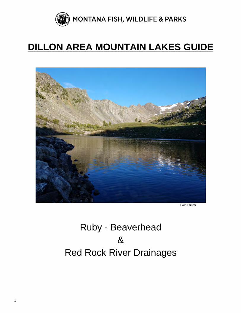
DILLON AREA MOUNTAIN LAKES GUIDE
Twin Lakes
Ruby - Beaverhead&
Red Rock River Drainages
1

Fellow Outdoor Enthusiasts and Adventurers,
The purpose of this report is to present information Montana FWP has collected for high mountain lakes in the
Beaverhead, Ruby, Red Rock watersheds. This guide is a compilation of historic data, including the most recent
sampling events. Lake sampling commonly includes overnight gill nets sets, angling surveys, and bathymetric
mapping. Campsite availability, presence of inlet and outlets streams, suitable fish spawning habitat, and
observations of reptiles and amphibians and aquatic insects are based on visual observations. This information is
used to provide a description of each lake and its fishery, direct management decisions, and create or maintain
unique and high quality angling experiences. While this report contains valuable information for anglers to consider
when planning a trip, it is not intended to be used as a comprehensive hiking, camping, and fishing guide. Our goal
was to create an informative tool to help anglers experience and enjoy unique high mountain lakes.
Anglers in the Beaverhead, Ruby, and Red Rock watersheds have opportunities to fish for Arctic Grayling, Brook
Trout, Brown Trout, Burbot, Golden Trout, Rainbow Trout, Westslope Cutthroat Trout, Yellowstone Cutthroat Trout,
and hybrid crosses of Rainbow and Cutthroat trout. Most of the lakes in the Beaverhead and Ruby watersheds are
either self-sustaining or stocked. Self-sustaining lakes provide adequate spawning habitat for fish populations to
maintain themselves without additional stocking. Fish in self-sustaining lakes are typically more abundant, smaller in
size, and usually more eager to be caught by an angler. Stocked lakes have little to no spawning habitat and rely on
FWP fish planting to maintain a fishery. Fish in stocked lakes are typically less abundant, larger in size, and can be
harder to catch. High mountain lakes in the Beaverhead and Ruby watersheds are commonly stocked every 4 years
with fingerling trout. Reviewing the stocking information in this report can be a helpful resource when planning a trip.
Many small fish are available to anglers the first couple years after stocking while fewer, but larger fish will be
available in following years. The best opportunity for trophy fish is four years after a stocking event.
This report will be updated regularly as future data collection occurs. Because adjustments to stocking rates and
creation of new fisheries may occur as new information is collected so we suggest checking FishMT each Spring for
the latest information. Some lakes have not been surveyed recently, if at all, and it is our intent to survey all
mountain lakes within the Beaverhead and Ruby watershed over the next few years. However, outdated or no
information does not necessarily mean a fishery does not exist. We still recommend a visit to these lakes as the
hike and views can be just as rewarding as catching fish and you never know what could be swimming around!
Special thanks to the FWP, BLM, and USFS personnel that contributed to this report and thank you to the
responsible anglers that enjoy and respect our Montana high mountain lakes!
For More Information Contact:
Matt Jaeger
Montana Fish, Wildlife and Parks
Dillon, MT
406-683-9310
2

Tips For Using This Guide
Latitude/Longitude: These are taken at the middle of the lakes and are used for stocking purposes.
Current and updated survey data are available online via FishMT: http://fwp.mt.gov/fish/
Enjoy and respect the high country. Good Fishing!
3

Table of Contents
7Centennial Mountains
. . . . . . . . . . . . . . . . . . . . . . . . . . . . . . . . . . . . . . . . . . . . . . . . . . . . . 7Blair Lake (Hellroaring Lakes)
. . . . . . . . . . . . . . . . . . . . . . . . . . . . . . . . . . . . . . . . . . . . . . . . . . . . . . . . . . . . 7Breneman Lake
. . . . . . . . . . . . . . . . . . . . . . . . . . . . . . . . . . . . . . . . . . . . . . . . . . . . . . . . . . . . . . 8Charlies Lake
. . . . . . . . . . . . . . . . . . . . . . . . . . . . . . . . . . . . . . . . . . . . . . . . . . . . . . . . . . . . . . . . 8Elk Lake
. . . . . . . . . . . . . . . . . . . . . . . . . . . . . . . . . . . . . . . . . . . . . . . . . . . . . . . . . . . . . . . 9Lillian Lake
. . . . . . . . . . . . . . . . . . . . . . . . . . . . . . . . . . . . . . . . . . . . . . . . . . . . . . . . . . . . . . . 9O'dell Lake
. . . . . . . . . . . . . . . . . . . . . . . . . . . . . . . . . . . . . . . . . . . . . . . . . . . . . . . . . . . . . . 10Smith Lake
12Beaverhead Mountains
. . . . . . . . . . . . . . . . . . . . . . . . . . . . . . . . . . . . . . . . . . . . . . . . . . . . . . . . . . . 12Cottonwood Lake
. . . . . . . . . . . . . . . . . . . . . . . . . . . . . . . . . . . . . . . . . . . . . . . . . . . . . . . . . . . . . 12Coyote Lake
. . . . . . . . . . . . . . . . . . . . . . . . . . . . . . . . . . . . . . . . . . . . . . . . . . . . . . . . . . . . 12Dad Creek Lake
. . . . . . . . . . . . . . . . . . . . . . . . . . . . . . . . . . . . . . . . . . . . . . . . . . . . . . . . . . . . 13Deadman Lake
. . . . . . . . . . . . . . . . . . . . . . . . . . . . . . . . . . . . . . . . . . . . . . . . . . . . . . . . . . . . 13Harkness Lakes
. . . . . . . . . . . . . . . . . . . . . . . . . . . . . . . . . . . . . . . . . . . . . . . . . . . . . . . . . . . . . 14Harrison Lake
. . . . . . . . . . . . . . . . . . . . . . . . . . . . . . . . . . . . . . . . . . . . . . . . . . . . . . . . . . 14Lake Canyon Lake
. . . . . . . . . . . . . . . . . . . . . . . . . . . . . . . . . . . . . . . . . . . . . . . . . . . . . . . . . . . . . 14Mooney Lake
. . . . . . . . . . . . . . . . . . . . . . . . . . . . . . . . . . . . . . . . . . . . . . . . . . . . . . . . . . . . . 15Morrison Lake
. . . . . . . . . . . . . . . . . . . . . . . . . . . . . . . . . . . . . . . . . . . . . . . . . . . . . . . . . . . . . . . 15Mud Lake
. . . . . . . . . . . . . . . . . . . . . . . . . . . . . . . . . . . . . . . . . . . . . . . . . . . . . . . . . . . . 15Reservoir Lake
. . . . . . . . . . . . . . . . . . . . . . . . . . . . . . . . . . . . . . . . . . . . . . . . . . . . . . . . . . . . . 16Selway Lake
. . . . . . . . . . . . . . . . . . . . . . . . . . . . . . . . . . . . . . . . . . . . . . . . . . . . . . . . . . . . . . . 16Swift Lake
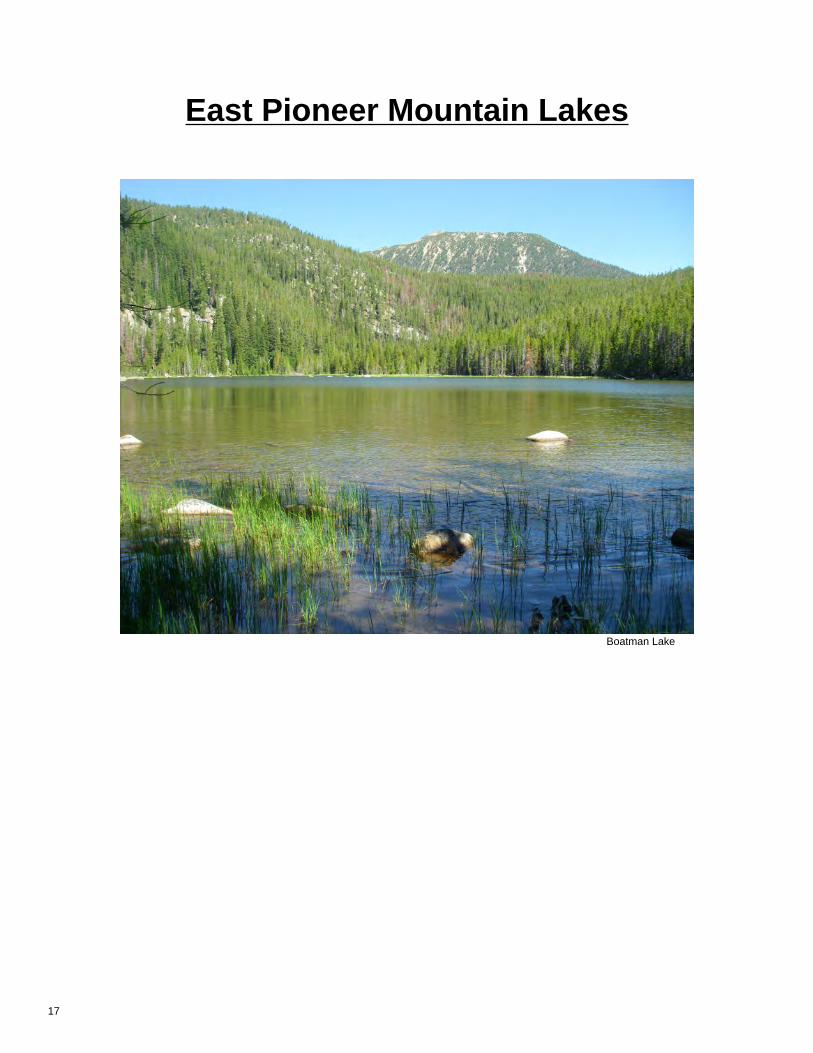
18East Pioneer Mountains
. . . . . . . . . . . . . . . . . . . . . . . . . . . . . . . . . . . . . . . . . . . . . . . . . . . . . . . . . . . . 18Boatman Lake
. . . . . . . . . . . . . . . . . . . . . . . . . . . . . . . . . . . . . . . . . . . . . . . . . . . . . . . . . . . . . . 18Chain Lake
. . . . . . . . . . . . . . . . . . . . . . . . . . . . . . . . . . . . . . . . . . . . . . . . . . . . . . . . . . . . . 18Dingley Lakes
. . . . . . . . . . . . . . . . . . . . . . . . . . . . . . . . . . . . . . . . . . . . . . . . . . . . . . . . . . . . . . 19Dollar Lake
. . . . . . . . . . . . . . . . . . . . . . . . . . . . . . . . . . . . . . . . . . . . . . . . . . . . . . . . . . . . . . 19Estler Lake
. . . . . . . . . . . . . . . . . . . . . . . . . . . . . . . . . . . . . . . . . . . . . . . . . . . . . . . . . . . . . . 19Harris Lake
. . . . . . . . . . . . . . . . . . . . . . . . . . . . . . . . . . . . . . . . . . . . . . . . . . . . . . . . . . . 20Kelley Reservoir
. . . . . . . . . . . . . . . . . . . . . . . . . . . . . . . . . . . . . . . . . . . . . . . . . . . . . . . . . . . . 20Minneopa Lake
. . . . . . . . . . . . . . . . . . . . . . . . . . . . . . . . . . . . . . . . . . . . . . . . . . . . . . . . . . . . . . 20Polaris Lake
. . . . . . . . . . . . . . . . . . . . . . . . . . . . . . . . . . . . . . . . . . . . . . . . . . . . . . . . . . . . 21Sawtooth Lake
. . . . . . . . . . . . . . . . . . . . . . . . . . . . . . . . . . . . . . . . . . . . . . . . . . . . . . . . . . . . . . . 21Scott Lake
. . . . . . . . . . . . . . . . . . . . . . . . . . . . . . . . . . . . . . . . . . . . . . . . . . . . . . . . . . . . . . . 22Tent Lake
. . . . . . . . . . . . . . . . . . . . . . . . . . . . . . . . . . . . . . . . . . . . . . . . . . . . . . . . . . . 22Twin Lake, Lower
. . . . . . . . . . . . . . . . . . . . . . . . . . . . . . . . . . . . . . . . . . . . . . . . . . . . . . . . . . . 23Twin Lake, Upper
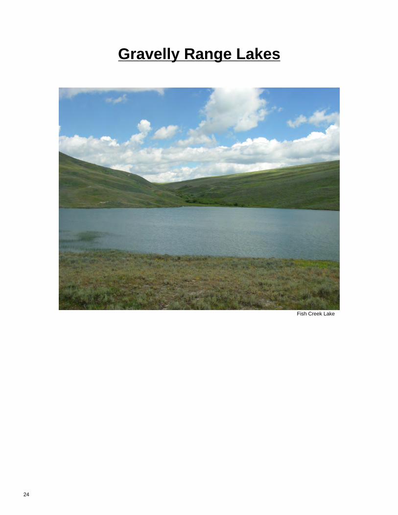
25Gravelly Range
. . . . . . . . . . . . . . . . . . . . . . . . . . . . . . . . . . . . . . . . . . . . . . . . . . . . . . . . . . . 25Fish Creek Lake
. . . . . . . . . . . . . . . . . . . . . . . . . . . . . . . . . . . . . . . . . . . . . . . . . . . . . . . . . . . . . . 25Moose Lake
4

. . . . . . . . . . . . . . . . . . . . . . . . . . . . . . . . . . . . . . . . . . . . . . . . . . . . . . . . . . . . . . . 25Red Lake
27Snowcrest Range
. . . . . . . . . . . . . . . . . . . . . . . . . . . . . . . . . . . . . . . . . . . . . . . . . . . . . . . . . 27Peterson Lake, Lower
. . . . . . . . . . . . . . . . . . . . . . . . . . . . . . . . . . . . . . . . . . . . . . . . . . . . . . . . . 27Peterson Lake, Upper
. . . . . . . . . . . . . . . . . . . . . . . . . . . . . . . . . . . . . . . . . . . . . . . . . . . . . . . . 28Rock Creek Reservoir
. . . . . . . . . . . . . . . . . . . . . . . . . . . . . . . . . . . . . . . . . . . . . . . . . . . . . . . . . . . 28Yellow Bear Lake
29Tendoy Mountains
. . . . . . . . . . . . . . . . . . . . . . . . . . . . . . . . . . . . . . . . . . . . . . . . . . 29Poison Lakes (Upper Poison Lake)
31Tobacco Root Mountains
. . . . . . . . . . . . . . . . . . . . . . . . . . . . . . . . . . . . . . . . . . . . . . . . . . . . . . . . . . . . . 31Blossom Lake
. . . . . . . . . . . . . . . . . . . . . . . . . . . . . . . . . . . . . . . . . . . . . . . . . . . . . . . . . . . . . . 31Crystal Lake
. . . . . . . . . . . . . . . . . . . . . . . . . . . . . . . . . . . . . . . . . . . . . . . . . . . . . . . . . . . . . . 31Gneiss Lake
. . . . . . . . . . . . . . . . . . . . . . . . . . . . . . . . . . . . . . . . . . . . . . . . . . . . . . . . . . . . . 32Hill Reservoir
. . . . . . . . . . . . . . . . . . . . . . . . . . . . . . . . . . . . . . . . . . . . . . . . . . . . . . . . . . . . . 32Jackson Lake
. . . . . . . . . . . . . . . . . . . . . . . . . . . . . . . . . . . . . . . . . . . . . . . . . . . . . . . . . 32Lower Branham Lake
. . . . . . . . . . . . . . . . . . . . . . . . . . . . . . . . . . . . . . . . . . . . . . . . . . . . . . . . . . . . 33Macaroni Lake
. . . . . . . . . . . . . . . . . . . . . . . . . . . . . . . . . . . . . . . . . . . . . . . . . . . . . . . . . . . . . . 33Noble Lake
. . . . . . . . . . . . . . . . . . . . . . . . . . . . . . . . . . . . . . . . . . . . . . . . . . . . . . . . . . . . . . . 34Oval Lake
. . . . . . . . . . . . . . . . . . . . . . . . . . . . . . . . . . . . . . . . . . . . . . . . . . . . . . 34Phyllis Lake (Taylor Lake)
. . . . . . . . . . . . . . . . . . . . . . . . . . . . . . . . . . . . . . . . . . . . . . . . . . . . . . . . . . . . . 34Rossiter Lake
. . . . . . . . . . . . . . . . . . . . . . . . . . . . . . . . . . . . . . . . . . . . . . . . . . . . . . . . . . . . . 35Sunrise Lake
. . . . . . . . . . . . . . . . . . . . . . . . . . . . . . . . . . . . . . . . . . . . . . . . . . . . . . . . . . . . 35Thompson Lake
. . . . . . . . . . . . . . . . . . . . . . . . . . . . . . . . . . . . . . . . . . . . . . . . . . . . . . . . . . . . . 35Triangle Lake
. . . . . . . . . . . . . . . . . . . . . . . . . . . . . . . . . . . . . . . . . . . . . . . . . . . . . . . . . . . . . . 36Twin Lakes
. . . . . . . . . . . . . . . . . . . . . . . . . . . . . . . . . . . . . . . . . . . . . . . . . . . . . . . . 36Upper Branham Lakes
5

Centennial Range Lakes
Odell Lake
6

Centennial Mountains
Blair Lake (Hellroaring Lakes)Drainage: Red RockElevation: 8157 ftLocation: 44.56297, -111.56934 (Map)Section: 15S1E2
Size: 8.96 acresDepth: 9ft (Ave), 19ft (Max)
Access: From I-15, take Exit 0 for Monida Head East on the South Valley Road andcontinue towards Red Rock Pass. The turnoff for the Lillian Trailhead is to thesouth.
Camp sites: Three campsites found in flat, dry spots. Some shade near campsites.Abundance of firewood around lake.
Trailhead Distance Elevation ChangeHell Roaring Creek Trail1815T to Unnamed TrailAlong Hell Roaring Creek
5.5 mi (5.5 on trail) 1230 up, 480 down
Stocking Data Historic PlannedRainbow Trout 16,000 in 1940; 17,780 in 1937Westslope Cutthroat Trout 1,000 in 2018; 1,000 in 2014 1,000 in 2022Yellowstone Cutthroat Trout 1,000 in 2004; 750 in 2000
Surveys Species # of fish Ave Length (in) Range (in)2018 Westslope Cutthroat Trout 7 19.0 17.4-20.72014 No Fish Caught 0
Comments: Blair Lake is a beautiful mountain lake located in the CentennialMountains. The lake is found in the Hell Roaring Drainage andhas an inlet and outlet. The northwest part of the lake is shallowand the southeast part of the lake has steep drop offs. There is ahigh amount of insect life in the lake and leeches were found inthe mouths of some fish. The lengthy hike to the lake is ofmoderate difficulty with some steep switchback portions, but thehike is well worth it. This lake does see moderate amounts ofhuman traffic and is reflected around the lake.
Notes: There is ample opportunity for shore fishing, but float tube or packraft is recommended to be able to fish the deeper middle part ofthe lake. The large cutthroat are catchable, but fishing can betricky.
Breneman LakeDrainage: Red RockElevation: 8148 ftLocation: 44.56746, -111.91632 (Map)Section: 14S03W36
Size: 5.7343 acresDepth: 7ft (Ave), 13ft (Max)
Access: From I-15, Take Exit 1 Monida and head East on the South Valley Road. Thetrailhead is located just east of Tipton Creek. The trail continues up the westside of Baldy Mountain. The trail is of moderate difficulty.
Camp sites: There are two campsites located around the lake and a lot of flat spots. Largeamounts of firewood available from the dead trees after the Winslow Fire.
Trailhead Distance Elevation ChangeBLM 1814T to BLM 1844T 4.25 mi (4.25 on trail) 1500 up, 480 down
Stocking Data Historic PlannedCutthroat Trout 4,800 in 1957Rainbow Trout 2,065 in 1963Westslope Cutthroat Trout 500 in 2018; 500 in 2016 500 in 2022
Surveys Species # of fish Ave Length (in) Range (in)2018 Westslope Cutthroat Trout 26 15.0 13.3-16.62011 Rainbow Trout 4 22.0 20.7-22.1
Comments: Breneman Lake is a man-made high mountain lake that is locatedat the top of Winlsow Creek in the Centennial Mountains. Thelake is in the area of the Winslow fire from 2003. There is a flat,open berm on the north end of the lake that formed the lake.Signs of human impact are high, but little traffic is seen other thanhunting outfits in the Fall.
Notes: A few fish can be seen rising around the lake. Shore fishing maybe limited away from outlet berm due to large amounts of windfallfrom the past wildfire.
7

Charlies LakeDrainage: Red RockElevation: 7959 ftLocation: 44.5779, -111.8378 (Map)Section: 14S2W27
Size: 1.597 acresDepth: 4ft (Ave), 10ft (Max)
Access: From I-15, take Exit 0 Monida and head east on South Valley Road. Beforereaching Lakeview, turn right to BLM trail 1839. Follow trail to Charlie's Lake.
Camp sites: One flat area on east end of lake good for camping. Plenty of firewoodaround.
Trailhead Distance Elevation ChangeTrail 1839 2.5 mi (2.5 on trail) 1115 up, 100 down
Surveys Species # of fish Ave Length (in) Range (in)2018 No Fish Caught 0
Comments: Charlies Lake is found in the Shambow Drainage in theCentennial Mountain Range. There are not fish presently inCharlies Lake, but there is ample bug life. A number of amphibianspecies can be observed around the lake including TigerSalamanders and Columbia Spotted Frogs. Charlies Lake showslittle signs of human impact and traffic is minimal other than somehunting outfits in the Fall.
Notes:
Elk LakeDrainage: Red RockElevation: 6682 ftLocation: 44.67606, -111.62352 (Map)Section: 13S1E29
Size: 283.19 acresDepth: 59ft (Max)
Access: From I-15, take either the North Valley or South Side Road through theCentennial Valley. Turn Northeast on Elk Lake Road and take it to the lake.The lake can also be accessed by Red Rock Pass from Henry's Lake.
Camp sites: Two flat camping areas are located on the Southwest end of the lake that canfit several campers and/or tents. Vault toilets and primitive fire rings areavailable at these locations. Firewood is limited close to the lake but availablein timbered mountains surrounding lake. Elk Lake Lodge is located on theWest shore of the lake and reservations must be made to stay there.
Trailhead Distance Elevation Change
Stocking Data Historic PlannedArctic Grayling 13,090 in 1957; 58,000 in 1955Cutthroat Trout 5,736 in 1968; 10,564 in 1965Rainbow Trout 2,100 in 1950; 5,068 in 1948Westslope Cutthroat Trout 25,000 in 2020; 25,000 in 2019 25,000 in 2022; 25,000 in 2023Yellowstone Cutthroat Trout 22,560 in 2001; 17,100 in 2000
Surveys Species # of fish Ave Length (in) Range (in)2020 Burbot 53 11.0 8.0-18.42020 Lake Trout 7 19.0 16.4-20.92019 Burbot 87 12.0 6.9-15.12019 Lake Trout 9 19.0 17.0-20.4
Comments: Elk Lake is located in the Northeast corner of the CentennialValley and is part of the Red Rock drainage. Elk Lake is a long,narrow, and deep lake settled in the Gravelly Mountains. Elk Lakeis unique in that it is one of a few Montana Lakes to host nativeLake Trout from the last glaciation. Human impact is high due toease of access and the lodge located on the lake, but beautifulwild scenery is still present.
Notes: Fishing can be good for Westslope cutthroat trout in Spring whenthey are cruising the shoreline. However, these trout can bedifficult to catch. Lake trout cruise the shallows in the Fall and areeasier to target for fishing, but all Lake Trout must be immediatelyreleased.
8

Lillian LakeDrainage: Red RockElevation: 7793 ftLocation: 44.56016, -111.5402 (Map)Section: 15S01E1
Size: 2.1457 acresDepth: 5ft (Ave), 8ft (Max)
Access: From I-15, take Exit 0 Monida and head west on the South Valley Roadtowards Red Rock Pass. The Lillian Trailhead is to the south of the road.
Camp sites: One good campsite found on west side of lake. Site was flat and shaded rightoff the trail with a good amount of firewood around.
Trailhead Distance Elevation ChangeHell Roaring Trail 1815T toUnnamed Trail Along HellRoaring Creek
4 mi (4 on trail) 910 up, 360 down
Surveys Species # of fish Ave Length (in) Range (in)2018 No Fish Caught 02011 No Fish Caught 0
Comments: Lillian Lake is located in the Hell Roaring Drainage of theCentennial Mountains. The lake is small, shallow, and susceptibleto winterkills. There is an abundance of herpitiles including tigersalamanders, columbia spotted frogs, and garter snakes as wellas ample insect life in the lake. The long hike does offer somegreat views of the Upper Hell Roaring Drainage.
Notes: Currently no fishing opportunities here. Hiking up to Blair lake isrecommended.
O'dell LakeDrainage: Red RockElevation: 7574 ftLocation: 44.54662, -111.79973 (Map)Section: 15S02W12
Size: 8.6293 acresDepth: 11ft (Ave), 25ft (Max)
Access: From I-15 take Exit 0 Monida and go east on South Valley Road. Thetrailhead is located just east of Lakeview. The trail is highly difficult and thereisn't a direct route from the trail to the lake.
Camp sites: One flat knob that is good for camping is located near the outlet on theNortheast side of the lake. It is flat and has some shade. There is abundantfirewood available.
Trailhead Distance Elevation ChangeO'dell Creek Trail 4.5 mi (3.5 on trail) 770 up, 380 down
Stocking Data Historic PlannedArctic Grayling 35,000 in 1981; 2,191 in 1978Westslope Cutthroat Trout 1,000 in 2018; 1,000 in 2014 1,000 in 2022Yellowstone Cutthroat Trout 1,000 in 2002; 1,000 in 1998
Surveys Species # of fish Ave Length (in) Range (in)2018 Westslope Cutthroat Trout 1 10.0 10.3-10.32011 No Fish Caught 02011 Westslope Cutthroat Trout 1 9.0 8.7-8.7
Comments: O'dell lake is lake located in the O'dell Creek Drainage of theCentennial Mountains. The route to lake is on the longer side, buttravels through the beautiful O'dell Canyon. Difficulty of accesshas left this lake in its pristine state. The lake is full of lifeincluding tiger salamanders, tadpoles, and insects, but samplingin 2018 showed fish numbers are low. Wildlife can also be seenaround the lake.
Notes: Fishing may be difficult due to low numbers of fish. A float tube orpack raft might help to cover more area of the lake.
9

Smith LakeDrainage: Red RockElevation: 8397 ftLocation: 44.5793, -111.8573 (Map)Section: 14S2W28
Size: 0.4835 acresDepth: 10ft (Ave), 18ft (Max)
Access: From I-15, take Exit 0 Monida and head east on the South Valley Road.Before getting to Lakeview, turn right to BLM trailhead 1839. Take the trail toCharlie's Lake and bushwhack 2.15 miles to the west to Smith Lake. A GPS isrequired to get there.
Camp sites: No campsites, but some small flat spots close by. Abundant firewoodavailable.
Trailhead Distance Elevation ChangeTrail 1839 4.5 mi (2.5 on trail) 1550 up, 0 down
Surveys Species # of fish Ave Length (in) Range (in)2018 No Fish Caught 0
Comments: Smith Lake is located in the Humphry drainage in the CentennialMountains. Smith Lake does not have fish, but does have anabundance of aquatic insect life. Some amphibians can also befound around the lake. Smith Lake has very little human impactand traffic other than some hunting activity in the Fall.
Notes:
10

Beaverhead Mountain Lakes
Morrison Lake
11

Beaverhead Mountains
Cottonwood LakeDrainage: Red RockElevation: 9620 ftLocation: 44.45673, -112.99774 (Map)Section: 16S11W7
Size: 3.3893 acresDepth:
Access: From I-15, take Big Sheep Creek Road up the valley. Turn left onto ForestRoute 657. Turn right onto USFS Rd. 8274 and follow to the Harkness Lakes.Bushwack from Harkness Lakes ~2.5 miles southwest to Cottonwood Lake.
Camp sites: Campsite and firewood availability unknown.
Trailhead Distance Elevation Change
Comments: Cottonwood Lake is part of the Big Sheep Creek Drainage in theBeaverhead Mountains. This remote lake is found at the very topend of Cottonwood Creek and is near the Continental Divide.
Notes:
Coyote LakeDrainage: Red RockElevation: 8170 ftLocation: 44.54482, -112.99207 (Map)Section: 15S11W7
Size: 3.3885 acresDepth:
Access: From Big Sheep Creek Road, turn onto USFS Rd. 3922. Follow USFS Rd.3922 ~9 miles. Getting to Coyote Lake requires bushwacking ~2 miles to thenorthwest. A GPS is recommended.
Camp sites: Campsite and firewood availability unknown.
Trailhead Distance Elevation Change
Comments: Coyote Lake is located in the Big Sheep Creek Drainage in theBeaverhead Mountains.
Notes:
Dad Creek LakeDrainage: Red RockElevation: 8958 ftLocation: 44.77675, -113.12717 (Map)Section: 12S13W24
Size: 2.8734 acresDepth:
Access: From Highway 324, turn south onto Medicine Lodge Creek Road. Turn rightonto USFS Rd. 949 and follow it to a right on USFS Rd. 976 which arrives atTrail 1501. Hike up Trail 1501 for ~2 miles to Dad Creek Lake.
Camp sites: Several campsites available and a good amount of firewood available.
Trailhead Distance Elevation Change1501 2 mi (2 on trail) None up, None down
Stocking Data Historic PlannedWestslope Cutthroat Trout 500 in 2018; 500 in 2014 500 in 2024Yellowstone Cutthroat Trout 500 in 2002; 500 in 1998
Surveys Species # of fish Ave Length (in) Range (in)2010 No Fish Caught 01962 Cutthroat Trout 3
Comments: Dad Creek Lake is located in the Medicine Creek Drainage in theBeaverhead Mountains. Dad Creek Lake is shallow and has amud bottom. The lake gets a moderate amount of human traffic.
Notes:
12

Deadman LakeDrainage: Red RockElevation: 8016 ftLocation: 44.441, -112.86048 (Map)Section: 16S10W18
Size: 4.4992 acresDepth:
Access: From I-15, take Big Sheep Creek Road up the Big Sheep Creek Drainage,turn left on Forest Route 657. Turn left off Forest Route 657 onto USFS Rd.3927 and follow it to the lake.
Camp sites: There is room to camp at the end of the road just above the lake. There isalso plenty of flat spots around the lake and firewood is somewhat availablenearby.
Trailhead Distance Elevation ChangeUnmarked trail that leadsdown to the lake from theparking area
None mi (0.20 on trail) None up, 600 down
Surveys Species # of fish Ave Length (in) Range (in)2020 Westslope X Rainbow 20 10.0 6.6-12.92012 Rainbow Trout 1 18.0 18.3-18.32012 Rainbow X Cutthroat Trout 30 10.0 3.1-18.3
Comments: Deadman Lake is located in the Big Sheep Creek Drainage in theBeaverhead Mountains.
Notes: Deadman Lake is a pretty high mountain lake that provides goodfishing. It is a short enough hike that you could use a float tube orother small floating device. Fishing from a canoe, raft or float tubewould make fishing easier. The road that leads down to the lakeis a steep dirt two track, it it is wet or muddy it can be impassible.You may get down to the parking area, but you will have troublegetting back up and out of there even with four-wheel drive.Deadman Lake is full of RBxWCT that will readily take dry fliesfrom shore during the spring, summer and fall.
Harkness LakesDrainage: Red RockElevation: 8180 ftLocation: 44.47052, -112.94876 (Map)Section: 16S11W4
Size: 6.0547 acresDepth:
Access: From I-15, take Big Sheep Creek Road to Forest Route 657. From ForestRoute 657, turn right onto USFS Rd. 8274. Follow the road to the lakes.
Camp sites: Multiple flat areas for camping are available around the lakes. Firewood andshade are not readily available around the lake.
Trailhead Distance Elevation Change
Stocking Data Historic PlannedRainbow Trout 675 in 1965
Surveys Species # of fish Ave Length (in) Range (in)2020 Westslope Cutthroat Trout 28 10.0 6.4-14.12012 Westslope Cutthroat Trout 49 10.0 6.0-16.8
Comments: The Harkness Lakes are located in the Big Sheep CreekDrainage in the Beaverhead Mountains. The Harkness Lakesconsist of Upper Harkness Lake, Middle Harkness Lake, andLower Harkness Lake.
Notes: There are multiple pot hole type lakes associated with theHarkness Lakes, none of them have enough depth to overwinterfish except for the bottom lake (Lower Harkness Lake) and thetop lake .Upper Harkness Lake). However Upper Harkness Lakeis inaccessible because it is entirely located on private property.Lower Harkness Lake is stocked with WCT and it has a good inletwhich provides natural reproduction as well. Fisherman shouldexpect to catch Westslope Cutthroat of all age classes. WCTsampled ranged in size from 6.5 inches to 14 inches long.
13

Harrison LakeDrainage: BeaverheadElevation: 8643 ftLocation: 45.26609, -113.217 (Map)Section: 06S13W32
Size: 4.1926 acresDepth:
Access: From Highway 278, turn onto USFS Rd. 7350 at Big Hole Pass. Follow roadto Trail 1194 and hike to lake.
Camp sites: Flat campsites may be limited but firewood is abundant.
Trailhead Distance Elevation Change1194 3 mi (3 on trail) None up, None down
Stocking Data Historic PlannedRainbow Trout 1,500 in 1968Westslope Cutthroat Trout 500 in 2018; 650 in 2014 500 in 2024Yellowstone Cutthroat Trout 500 in 2002; 500 in 1998
Surveys Species # of fish Ave Length (in) Range (in)2010 Westslope Cutthroat Trout 5 13.0 12.0-15.12006 Yellowstone Cutthroat Trout 16 14.0 12.5-15.6
Comments: Harrison Lake is located in the Grasshopper Creek Drainage inthe Pioneer Mountains. Harrison Lake has little human traffic.
Notes: Hook and line surveys in 2010 were able to capture WestslopeCutthroat with fly fishing gear.
Lake Canyon LakeDrainage: Red RockElevation: 7521 ftLocation: 44.81305, -113.09221 (Map)Section: 12S12W8
Size: 1.7374 acresDepth:
Access: From Highway 324, turn south onto Medicine Lodge Road. Turn right ontoUSFS Rd. 947 which arrives at Trail 1032. Take Trail 1032 to the lake.
Camp sites: Campsite and firewood availability unknown.
Trailhead Distance Elevation Change1032 2 mi (2 on trail) None up, None down
Comments: Lake Canyon Lake is located in the Medicine Lodge CreekDrainage in the Beaverhead Mountains.
Notes:
Mooney LakeDrainage: Red RockElevation: 7464 ftLocation: 45.1199, -113.4369 (Map)Section: 8S15W21
Size: 1.9052 acresDepth: 3ft (Ave), 5ft (Max)
Access: From Highway 324, turn onto Forest Route 181. From Forest Route 181, turnright onto USFS Rd. 919. Take a left off of USFS Rd. 919 to USFS Rd. 7404.Bushwacking is required off the road to make it to Mooney Lake and a GPS isrequired.
Camp sites: Some flat areas may be available for camping. Firewood is available.
Trailhead Distance Elevation Change
Surveys Species # of fish Ave Length (in) Range (in)2017 No Fish Caught 0
Comments: Mooney Lake is found in the Selway Creek Drainage in theBeaverhead Mountains. Mooney Lake is very shallow with a muckbottom.
Notes:
14

Morrison LakeDrainage: Red RockElevation: 8377 ftLocation: 44.60199, -113.03584 (Map)Section: 14S12W23
Size: 23.1012 acresDepth: 23ft (Ave), 50ft (Max)
Access: Exit I-15 at Dell and head west on the Big Sheep Creek Scenic Byway to theupper basin. Turn onto USFS Road 3920 and take it to the lake. The road canbe in rough shape especially when wet.
Camp sites: Four campsites around the lake with good flat spots and rock fire rings.Minimal shade at the camping spots. Firewood can be found in the forestedareas around the lake.
Trailhead Distance Elevation ChangeUSFS Rd. 3920 to lake None mi (None on trail) None up, None down
Stocking Data Historic PlannedChinook Salmon 12,000 in 1931; 10,000 in 1928Coho Salmon 7,200 in 1951; 170,000 in 1933Cutthroat Trout 6,000 in 1960; 6,000 in 1957Rainbow Trout 2,002 in 1976; 1,030 in 1971Westslope Cutthroat Trout 2,500 in 2018; 2,500 in 2014 2,500 in 2022Yellowstone Cutthroat Trout 2,500 in 2002; 2,500 in 1998
Surveys Species # of fish Ave Length (in) Range (in)2018 Longnose Dace 2 6.0 5.9-5.92018 Westslope Cutthroat Trout 14 16.0 14.1-17.22012 Westslope Cutthroat Trout 17 12.0 9.2-17.0
Comments: Morrison Lake is located in the Upper Big Sheep Creek Drainagein the Beaverhead Mountains. Morrison is a deep, clear lake withno inlet or outlet. A primitive boat launch can be found on the eastside of the lake, but motorized boats are not allowed. This lakedoes see a lot of human traffic including Continental Divide hikersand fall hunting outfits.
Notes: Fishing can be tough without a boat due to vegetation nearshoreand steep banks. The fish can be finicky but have been caught ondry flies and streamers.
Mud LakeDrainage: Red RockElevation: 8026 ftLocation: 45.18593, -113.44285 (Map)Section: 07S15W33
Size: 4.6786 acresDepth: 3ft (Ave), 5ft (Max)
Access: From Highway 324, turn onto Forest Route 181. From Forest Route 181, turnright onto USFS Rd. 919. Take a left off of USFS Rd. 919 to USFS Rd. 7405.Getting to the lake will require bushwacking ~1.5 miles up the Ore CreekDrainage.
Camp sites: Campsite availability unknown. Firewood available.
Trailhead Distance Elevation Change
Comments: Mud Lake is located in the Selway Creek Drainage in theBeaverhead Mountains. Mud Lake is shallow and unable tosupport fish.
Notes:
Reservoir LakeDrainage: Red RockElevation: 7196 ftLocation: 45.12414, -113.45502 (Map)Section: 08S15W21
Size: 40.7997 acresDepth: 22ft (Ave), 53ft (Max)
Access: Take Highway 324 west of Clark Canyon Reservoir. Turn on USFS 181 andfollow Bloody Dick Creek about 13 miles to the lake and campground.
Camp sites: Well developed USFS fee campground with 16 campsites. Campground hasrestrooms and running water. Firewood is limited in campground.
Trailhead Distance Elevation ChangeUSFS Rd. 181 to lake None mi (None on trail) None up, None down
Surveys Species # of fish Ave Length (in) Range (in)2018 Brook Trout 24 9.0 6.2-11.71963 Brook Trout 197 9.0 7.3-11.4
Comments: Reservoir lake is located in the Bloody Dick drainage in theBeaverhead-Deerlodge National Forest. The lake does not havean inlet or outlet. There is a boat launch on the east end of thelake, but motorized boats are not allowed. Reservoir Lake hashigh amounts of human impact and the well developedcampground results in a lot of human traffic.
Notes: Shore fishing opportunities are available from the campground. Aboat is recommended to cover more water not available to shorefishermen. The abundance of Brook trout should make for easycatching.
15

Selway LakeDrainage: Red RockElevation: 7797 ftLocation: 45.16179, -113.35923 (Map)Section: 08S14W6
Size: 0.8448 acresDepth: 7ft (Ave), 17ft (Max)
Access:Camp sites:
Trailhead Distance Elevation Change
Surveys Species # of fish Ave Length (in) Range (in)2017 Brook Trout 17 7.0 6.1-15.8
Comments: Selway Lake is located in the Selway Creek Drainage in theBeaverhead Mountains.
Notes: Good shorefishing opportunities for Brook Trout around the lake.The fish can be seen rising often in the summer months.
Swift LakeDrainage: Red RockElevation: 8797 ftLocation: 45.13111, -113.56492 (Map)Section: 08S16W21
Size: 2.0875 acresDepth:
Access: From Highway 324, turn North on Forest Route 181. Turn left off Forest Route181 onto USFS Rd. 7462. The trailhead for Trail 1144 is on the west side ofthe road. Trail 1144 arrives at the lake.
Camp sites: Campsite and firewood availability unknown.
Trailhead Distance Elevation Change1144 4.25 mi (4.25 on trail) None up, None down
Comments: Swift Lake is located in the Bloody Dick Creek Drainage in theBeaverhead Mountains. It is located at the very head end of ParkCreek and is very close to the Continental Divide.
Notes:
16
East Pioneer Mountain Lakes
Boatman Lake
17

East Pioneer Mountains
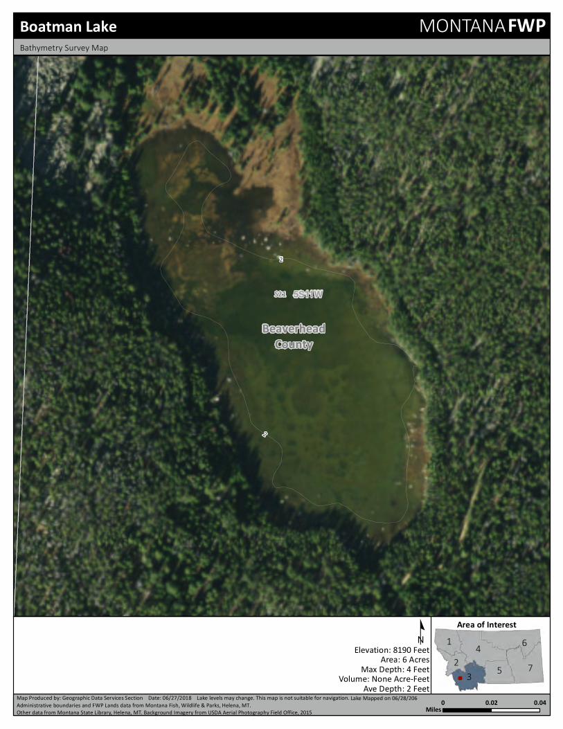
Boatman LakeDrainage: BeaverheadElevation: 8190 ftLocation: 45.38839, -112.97653 (Map)Section: 05S11W21
Size: 6.7623 acresDepth: 2ft (Ave), 4ft (Max)
Access: From I-15, take the Birch Creek exit and head west on Birch Creek Road.Turn left on USFS Rd. 7400 and take to the Minneopa Trailhead. Take trail1055 around the south end of Minneopa Lake and continue west on the trail toBoatman Lake.
Camp sites: Very few areas to camp with the amount of downed trees and standing timber.Plenty of firewood available.
Trailhead Distance Elevation ChangeMinneopa Trail 1055 1 mi (1 on trail) 0 up, 90 down
Surveys Species # of fish Ave Length (in) Range (in)2018 Westslope Cutthroat Trout 20 10.0 6.7-12.9
Comments: Boatman Lake is part of the Rattlesnake Creek Drainage in theEast Pioneer Mountains. The lake is very shallow, but has a welldefined inlet and outlet which allow fish to live in the lake. Theshoreline consists of large rocks and sand, the lake is entirelysurrounded by forest with little to no open areas. Human impact islow on this lake even with the ease of access.
Notes: Fishing from shore can be difficult in this lake with the denseforest around lake, but shallow wade fishing is available. A floattube would aid in ease of casting. Fish can be readily caught onflies.
Chain LakeDrainage: BeaverheadElevation: 9735 ftLocation: 45.41311, -113.00577 (Map)Section: 05S11W7
Size: 3.1998 acresDepth:
Access: No good routes known to get to Chain Lake.Camp sites: Campsite and firewood availability unknown.
Trailhead Distance Elevation Change
Comments: Chain Lake is located in the East Pioneer Mountains.Notes:
Dingley LakesDrainage: BeaverheadElevation: 9040 ftLocation: 45.44721, -113.04519 (Map)Section: 04S12W35
Size: 1.1012 acresDepth:
Access: From the Pioneer Scenic Byway, turn East onto USFS Rd. 2401. The roadgets ~1 mile from lakes and bushwacking in is required. The lakes can bereached by bushwacking North from Sawtooth Lake 2 miles. A GPS isrequired to get to the lakes.
Camp sites: Campsite and firewood availability unknown.
Trailhead Distance Elevation Change
Comments: The Dingley Lakes are located in the Grasshopper CreekDrainage in the Pioneer Mountains.
Notes:
18

Dollar LakeDrainage: BeaverheadElevation: 9135 ftLocation: 45.3981, -112.9993 (Map)Section: 05S11W18
Size: 5.8945 acresDepth: 7ft (Ave), 15ft (Max)
Access: From I-15, take the Birch Creek Exit and head west on Birch Creek. Turn ontoUSFS road 7400 which will arrive at the Minneopa Trailhead. Head North fromthe Minneopa Trail on trail 1076 to Tent Lake. Take the trail across the outletaround the south end of lake (US Forest Service Maps show trail going northaround lake) to Lower Twin Lake. The trail ends here and Dollar Lake islocated West-Southwest. It is recommended to take one of the finger ridgesup and over to Dollar Lake.
Camp sites: No campsites around lake. The area surrounding lake is steep and rocky.However, firewood is abundant.
Trailhead Distance Elevation ChangeMinneopa Trailhead 3.05 mi (2.75 on trail) 937 up, 50 down
Surveys Species # of fish Ave Length (in) Range (in)2018 No Fish Caught 0
Comments: Dollar lake is a beautiful, pristine lake located in the head end ofthe Rattlesnake Creek drainage in the East Pioneer Mountains.The lake is found at the base of the rocky peaks and the shorelineconsists of large granite boulders. Getting to the lake can betricky as trails do not lead all the way to the lake and camping onthe lake is not possible due to the rocky, steep slope. Difficulty ofaccess has left this lake in its natural state due to little humanimpact. There currently aren't fish in Dollar lake.
Notes:
Estler LakeDrainage: BeaverheadElevation: 7902 ftLocation: 45.37262, -112.97612 (Map)Section: 05S11W28
Size: 47.7578 acresDepth:
Access: From I-15, turn onto Birch Creek Road. Take a left from Birch Creek Roadonto USFS Rd. 7400 and take to Minneopa Trailhead. Take Trail 1055 pastBoatman Lake to Estler Lake.
Camp sites:
Trailhead Distance Elevation ChangeMinneopa Trailhead Trail1055
2.25 mi (2.25 on trail) None up, None down
Stocking Data Historic PlannedRainbow Trout 1,391 in 1957
Surveys Species # of fish Ave Length (in) Range (in)1961 Rainbow X Cutthroat Trout 151960 Rainbow X Cutthroat Trout 14
Comments: Estler Lake is a large high mountain lake located in theRattlesnake Creek drainage of the East Pioneer Mountains.
Notes:
Harris LakeDrainage: BeaverheadElevation: 8613 ftLocation: 45.3975, -112.9807 (Map)Section: 05S11W17
Size: 5.2484 acresDepth: 3ft (Ave), 7ft (Max)
Access: From I-15, take the Birch Creek Exit and head west on Birch Creek Road.Turn left on USFS Rd. 7400 and take it to the Minneopa Trailhead. From thetrailhead, take trail 1076 north to Tent Lake and head to Twin Lakes. Take thetrail ridge above Tent Lake and cut off the trail. Head southwest to HarrisLake. Another option is to take trail 1055 west around Minneopa Lake toBoatman Lake and bushwhack north to Harris Lake. A GPS is recommendedfor both routes.
Camp sites: One campsite found that was flat, dry, and shaded. Abundant firewoodavailable.
Trailhead Distance Elevation ChangeMinneopa Trail 1076 2.5 mi (1 on trail) 475 up, 90 downMinneopa Trail 1055 2.5 mi (2 on trail) 550 ft up, 640 ft down
Surveys Species # of fish Ave Length (in) Range (in)2018 No Fish Caught 0
Comments: Harris Lake is found in the Rattlesnake Creek Drainage in theEast Pioneer Mountains. The lake does not have fish, butamphibian life is good. Tiger Salamanders and Columbia SpottedFrogs can be found around the shore of the lake. There is littlehuman impact on this lake due to no distinct trail to the lake.
Notes:
19

Kelley ReservoirDrainage: BeaverheadElevation: 7180 ftLocation: 45.32783, -112.94525 (Map)Section: 06S11W10
Size: 17.9077 acresDepth: 11ft (Ave), 19ft (Max)
Access: Take Highway 278 south of Dillon to Argenta Road. From Argenta Road, headnorthwest on USFS Road 192 all the way to the lake.
Camp sites: There is an abundance of camping spots around the lake. Most spots haveprimitive fire rings and there is plenty of firewood around.
Trailhead Distance Elevation ChangeUSFS Rd. 192 to lake None mi (None on trail) None up, None down
Surveys Species # of fish Ave Length (in) Range (in)2018 Brook Trout 37 9.0 6.5-11.52018 Rainbow Trout 4 9.0 6.6-11.31971 Brook Trout 15 10.0 7.3-12.01971 Rainbow Trout 3 9.0 7.5-11.6
Comments: Kelley Reservoir is a man-made lake in the Pioneer Mountains. Itfound in the Rattlesnake Creek Drainage and is accessible by aUSFS road in a 4X4 vehicle. Kelley Reservoir has a well definedinlet and a spillway dam on the outlet. A primitive boat launch islocated on the southeast end of the lake and motorized boats areallowed on the lake. Kelley reservoir sees a lot of human trafficdue to the ease of access.
Notes: A boat is recommended for fishing this large lake. Many fish canbe seen rising around the lake during the summer.
Minneopa LakeDrainage: BeaverheadElevation: 8193 ftLocation: 45.39276, -112.96325 (Map)Section: 05S11W16
Size: 11.8619 acresDepth: 4ft (Ave), 7ft (Max)
Access: Exit I-15 at Birch Creek and head West on Birch Creek Road. Turn off onUSFS Road 7400 and follow to the Minneopa Trailhead to lake. Easy downhillhike to lake.
Camp sites: Five campsites found during sampling. More are likely to be found aroundlake. Campsites are flat and well shaded. Ample firewood available aroundlake.
Trailhead Distance Elevation ChangeMinneopa Trailhead 0.44 mi (0.44 on trail) 0 up, 90 down
Stocking Data Historic PlannedWestslope Cutthroat Trout 1,000 in 2018; 1,000 in 2014 1,000 in 2022Yellowstone Cutthroat Trout 1,000 in 2002; 1,000 in 1998
Surveys Species # of fish Ave Length (in) Range (in)2018 Westslope X Rainbow 20 11.0 6.4-17.52010 Westslope X Rainbow 13 11.0 6.0-13.5
Comments: Minneopa Lake is located in the East Pioneer Mountains in theRattlesnake Creek Drainage. It is large for a high mountain lakeand has a large inlet and outlet as well. Access to Minneopa Lakeis easy so it sees heavy human traffic and impacts. There is anabundance of insect life in the lake and a variety of insects werefound in the mouths of sampled fish.
Notes: A lot of fish rising throughout lake especially around inlet. Highamount of insect life suggests fish could be susceptible to flies.Shore fishing opportunities, but most effectively fished with a floattube.
Polaris LakeDrainage: BeaverheadElevation: 8371 ftLocation: 45.38863, -113.03376 (Map)Section: 05S12W24
Size: 10.6244 acresDepth:
Access: From the Pioneer Scenic Byway, turn East onto unnamed road near LakeCreek. Follow until the Trailhead for Trail 1201. Take Trail 1201 to PolarisLake.
Camp sites: Campsite and firewood availability unknown.
Trailhead Distance Elevation Change1201 4 mi (4 on trail) None up, None down
Stocking Data Historic PlannedCutthroat Trout 30,000 in 1934
Comments: Polaris Lake is located in the Grasshopper Creek Drainage in thePioneer Mountains.
Notes:
20

Sawtooth LakeDrainage: BeaverheadElevation: 8594 ftLocation: 45.43244, -113.03225 (Map)Section: 05S12W1
Size: 20.419 acresDepth: 18ft (Ave), 64ft (Max)
Access: From Hwy 278, turn North onto the Pioneer Scenic Byway. Turn East off theByway onto Clark Creek Road. Turn off Clark Creek Road onto USFS Rd.7441 which arrives at the trailhead for Trail 1195. Trail 1195 goes directly tothe lake.
Camp sites: Several flat, shaded campsite spots on the west side of the lake. There isample firewood available around the lake and some primitive fire rings.
Trailhead Distance Elevation ChangeTrail 1195 3.75 mi (3.75 on trail) 1600 up, 0 down
Stocking Data Historic PlannedCutthroat Trout 9,500 in 1937Golden Trout 2,560 in 1959
Surveys Species # of fish Ave Length (in) Range (in)2010 Brook Trout 25 8.0 6.4-9.92010 Golden Trout 1 9.0 8.5-8.51987 Brook Trout 17 10.0 8.2-11.21987 Golden Trout 8 10.0 8.6-12.7
Comments: Sawtooth Lake is a beautiful lake located in the Clark CreekDrainage. It is found in the East Pioneer Mountains. This lake isnamed after the sawtooth ridge that runs to the northeast of thelake. Sawtooth Lake is famous for a plane wreckage thatoccurred in the 1960s and parts of the plane can still be found onthe east shore. This lake has a little sign of human impact andtraffic can be moderate in the Summer.
Notes: The Brook Trout in Sawtooth Lake are not very large howeverthey can be easily taken with flies around the shore. A float tubewould aid in casting due to the densely forest shoreline.
Scott LakeDrainage: BeaverheadElevation: 8728 ftLocation: 45.36371, -113.0156 (Map)Section: 05S11W30
Size: 7.165 acresDepth:
Access: From I-15, turn West on Birch Creek Road. From Birch Creek Road, turn lefton USFS Rd. 7400 and take to Minneopa Trailhead. Follow Trail 1055 toEstler Lake. From Estler Lake, bushwacking for approximately 2 miles upEstler Creek is required to reach Scott Lake.
Camp sites: Campsite and firewood availability unknown.
Trailhead Distance Elevation Change1055 4.5 mi (2.5 on trail) None up, None down
Stocking Data Historic PlannedRainbow Trout 512 in 2004; 520 in 2000Westslope Cutthroat Trout 500 in 2016; 500 in 2012 500 in 2024
Surveys Species # of fish Ave Length (in) Range (in)1983 Rainbow Trout 1 21.0 21.2-21.2
Comments: Scott Lake is located at the head end of the Rattlesnake CreekDrainage in the Pioneer Mountains.
Notes:
21

Tent LakeDrainage: BeaverheadElevation: 8462 ftLocation: 45.40254, -112.97339 (Map)Section: 05S11W16
Size: 5.2707 acresDepth: 3ft (Ave), 7ft (Max)
Access: From I-15 take the Birch Creek Exit and head west on Birch Creek Road. Turnoff on USFS Road 7400 and take the road to the Minneopa Trailhead. Fromthe Minneopa Trailhead, take trail 1076 to the north to Tent Lake.
Camp sites: Two campsites located on south end of lake that are flat and well shaded.Firewood is readily available.
Trailhead Distance Elevation ChangeMinneopa Trail 1076 1.5 mi (1.5 on trail) 185 up, 90 down
Surveys Species # of fish Ave Length (in) Range (in)2018 Westslope X Rainbow 51 9.0 3.4-12.8
Comments: Tent Lake is part of the Rattlesnake Creek drainage in the EastPioneer Mountains. This is a beautiful lake as most of theshoreline is forested aside from a large meadow on northeast endnear inlet. Fish can be found in both the inlet and outlet of thelake. There are signs of human impact at Tent Lake and trafficcan be high due to ease of access from Minneopa Lake.
Notes: Tent Lake can be fished from shore especially around the inlet,but a float tube would greatly help in fishing more of the lake. Fishcan be seen rising often and are susceptible to being caught onflies.
Twin Lake, LowerDrainage: BeaverheadElevation: 8908 ftLocation: 45.40008, -112.99185 (Map)Section: 05S11W17
Size: 3.1818 acresDepth: 3ft (Ave), 4ft (Max)
Access: Exit I-15 at Birch Creek and head West on Birch Creek Road. Turn off onUSFS Road 7400 and follow to the Minneopa Trailhead. Head north from theMinneopa Trailhead on trail 1076. Take the trail across the outlet of Tent laketo the south of the lake (Forest Service maps show the trail on the north sideof Tent Lake) and follow trail to Lower Twin Lake.
Camp sites: Two campsites on the east side of lake with some shade. There is a goodamount of firewood available.
Trailhead Distance Elevation ChangeMinneopa Trail 1076 2.75 mi (2.75 on trail) 700 up, 90 down
Stocking Data Historic PlannedRainbow Trout 1,500 in 1952Westslope Cutthroat Trout 1,001 in 2013
Surveys Species # of fish Ave Length (in) Range (in)2018 Westslope X Rainbow 16 10.0 6.5-12.6
Comments: Lower Twin Lake is found in the Rattlesnake Creek Drainage inthe East Pioneer Mountains. The lake is very shallow but doeshave a well defined inlet and outlet that contain fish. The welldefined trail results in moderate human traffic.
Notes: Good shore and wading opportunities at Lower Twin lake and itsoutlet. Fish may travel out of lake during tough conditions due tothe shallowness of the lake. Insect life was low in late Spring sofishing efforts may be better directed towards Summer.
22
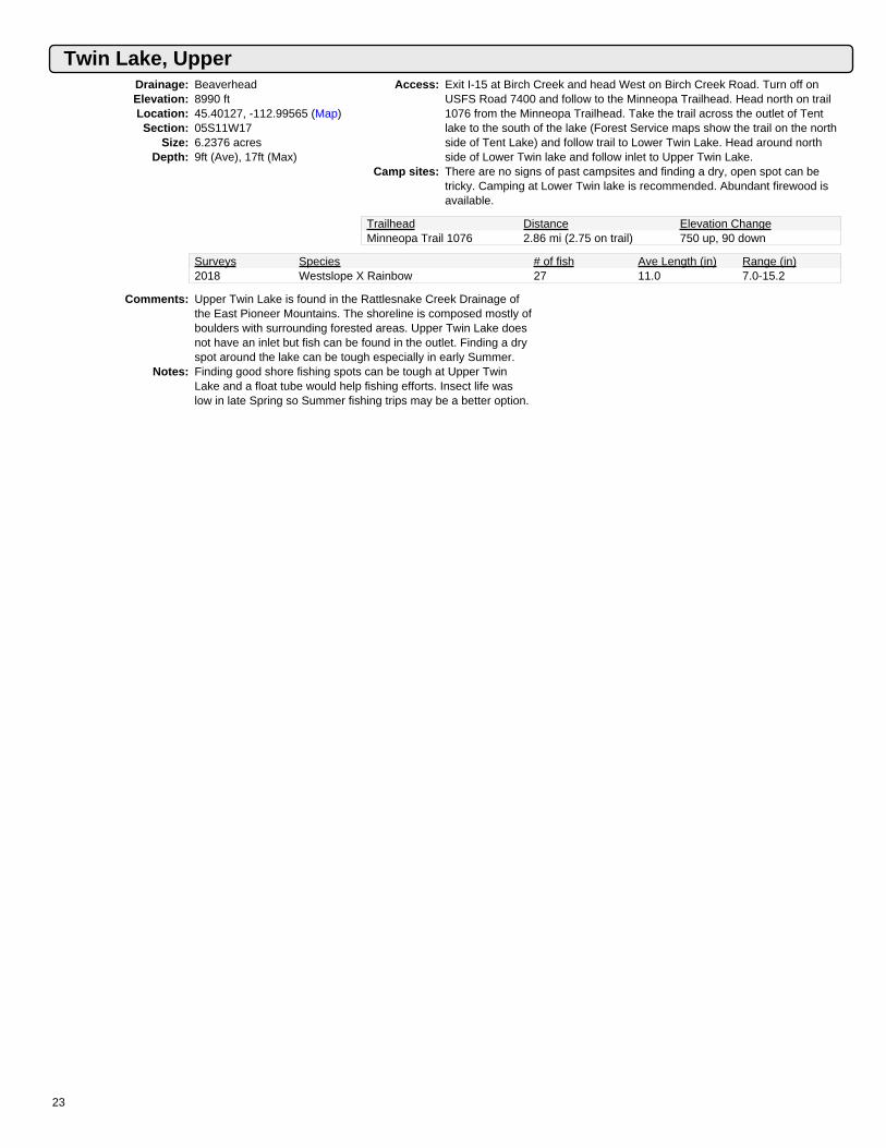
Twin Lake, UpperDrainage: BeaverheadElevation: 8990 ftLocation: 45.40127, -112.99565 (Map)Section: 05S11W17
Size: 6.2376 acresDepth: 9ft (Ave), 17ft (Max)
Access: Exit I-15 at Birch Creek and head West on Birch Creek Road. Turn off onUSFS Road 7400 and follow to the Minneopa Trailhead. Head north on trail1076 from the Minneopa Trailhead. Take the trail across the outlet of Tentlake to the south of the lake (Forest Service maps show the trail on the northside of Tent Lake) and follow trail to Lower Twin Lake. Head around northside of Lower Twin lake and follow inlet to Upper Twin Lake.
Camp sites: There are no signs of past campsites and finding a dry, open spot can betricky. Camping at Lower Twin lake is recommended. Abundant firewood isavailable.
Trailhead Distance Elevation ChangeMinneopa Trail 1076 2.86 mi (2.75 on trail) 750 up, 90 down
Surveys Species # of fish Ave Length (in) Range (in)2018 Westslope X Rainbow 27 11.0 7.0-15.2
Comments: Upper Twin Lake is found in the Rattlesnake Creek Drainage ofthe East Pioneer Mountains. The shoreline is composed mostly ofboulders with surrounding forested areas. Upper Twin Lake doesnot have an inlet but fish can be found in the outlet. Finding a dryspot around the lake can be tough especially in early Summer.
Notes: Finding good shore fishing spots can be tough at Upper TwinLake and a float tube would help fishing efforts. Insect life waslow in late Spring so Summer fishing trips may be a better option.
23
Gravelly Range Lakes
Fish Creek Lake
24

Gravelly Range
Fish Creek LakeDrainage: Red RockElevation: 7593 ftLocation: 44.74816, -111.94053 (Map)Section: 12S03W35
Size: 38.659 acresDepth:
Access: From the Ruby Divide Road in the Centennial Valley, turn onto USFS Rd.9627. Stay on USFS Rd. 9627 which arrives at the lake.
Camp sites: A lot of flat areas around lake, but no shade. Firewood is not available at thelake.
Trailhead Distance Elevation Change
Surveys Species # of fish Ave Length (in) Range (in)2011 No Fish Caught 02010 No Fish Caught 0
Comments: Fish Creek Lake is located in the Long Creek Drainage in theGravelly Mountains. The lake is man-made and located in sagebrush foothills. Fish Creek Lake is fishless, however, tigersalamanders are abundant in the lake. The lake sees little humantraffic.
Notes:
Moose LakeDrainage: RubyElevation: 7357 ftLocation: 45.02547, -111.90555 (Map)Section: 09S03W25
Size: 6.1058 acresDepth:
Access: From Ruby Reservoir, head south on County Route 248. Veer left ontoCounty Route 142. Turn left from County Route 142 onto USFS Rd. 163. Thetrail is on the right side of the road and is Trail 6412. The trail goes past theoutlet of the lake so follow the outlet to the lake.
Camp sites: Campsite and firewood availability unknown.
Trailhead Distance Elevation Change6412 3 mi (2.75 on trail) None up, None down
Comments: Moose Lake is located in the Upper Ruby River Drainage in theGravelly Mountains.
Notes:
Red LakeDrainage: RubyElevation: 9194 ftLocation: 44.96979, -111.87502 (Map)Section: 10S02W17
Size: 0.2893 acresDepth:
Access: Drive South on Ruby River Road and turn north on USFS Rd. 1244. Followthis road for about 5 miles before bushwacking east to Red Lake. A GPS isrecommended to find the lake.
Camp sites: Campsite and firewood availability unknown.
Trailhead Distance Elevation Change
Comments: Red Lake is located in the Upper Ruby Drainage in the GravellyMountain Range.
Notes:
25

Snowcrest Lakes
Upper Peterson Lake
26

Snowcrest Range
Peterson Lake, LowerDrainage: Red RockElevation: 8312 ftLocation: 44.76279, -112.11638 (Map)Section: 12S04W29
Size: 0.6159 acresDepth:
Access: From the North Valley Road in the Centennial Valley, turn onto the RubyDivide Road. Turn left onto USFS Rd. 9657 which arrives at Trail 6614trailhead. Follow Trail 6614 to Peterson Lakes. Lower Peterson is downhill tothe West of Upper Peterson Lake.
Camp sites: Some flat areas and firewood available for campers. Be extra bear awarehere.
Trailhead Distance Elevation Change6614 2 mi (2 on trail) None up, None down
Stocking Data Historic PlannedWestslope Cutthroat Trout 500 in 2012; 500 in 2008Yellowstone Cutthroat Trout 500 in 2002; 500 in 1998
Surveys Species # of fish Ave Length (in) Range (in)2011 Westslope Cutthroat Trout 1 15.0 15.1-15.12010 Westslope Cutthroat Trout 5 12.0 11.1-12.8
Comments: Lower Peterson Lake is in the Middle Creek Drainage in theSnowcrest Mountains. The lake is shallow compared to UpperPeterson nearby. The area does get grizzly bears. Human trafficcan be high during hunting season.
Notes: Fishless. We recommend fishing Upper Peterson Lake to theEast that contains Yellowstone Cutthroat trout.
Peterson Lake, UpperDrainage: Red RockElevation: 8361 ftLocation: 44.76232, -112.113 (Map)Section: 12S04W29
Size: 2.2466 acresDepth:
Access: From the North Valley Road in the Centennial Valley, turn onto Ruby DivideRoad and follow Long Creek. Turn left onto USFS Rd. 9657 which arrives atthe trailhead for Trail 6614. Follow Trail 6614 to the lake.
Camp sites: Some flat spots and firewood available around lake. Be extra bear aware inthis area.
Trailhead Distance Elevation Change6614 2 mi (2 on trail) None up, None down
Stocking Data Historic PlannedWestslope Cutthroat Trout 500 in 2014Yellowstone Cutthroat Trout 400 in 2018 300 in 2022
Surveys Species # of fish Ave Length (in) Range (in)2017 No Fish Caught 02015 Westslope Cutthroat Trout 6 13.0 10.8-14.9
Comments: Upper Peterson Lake is located in the Middle Creek Drainage inthe Snowcrest Mountains. It is located in the northern side of theCentennial Valley and grizzly bears have been seen in this area.Human traffic seems low other than during hunting season.
Notes:
27
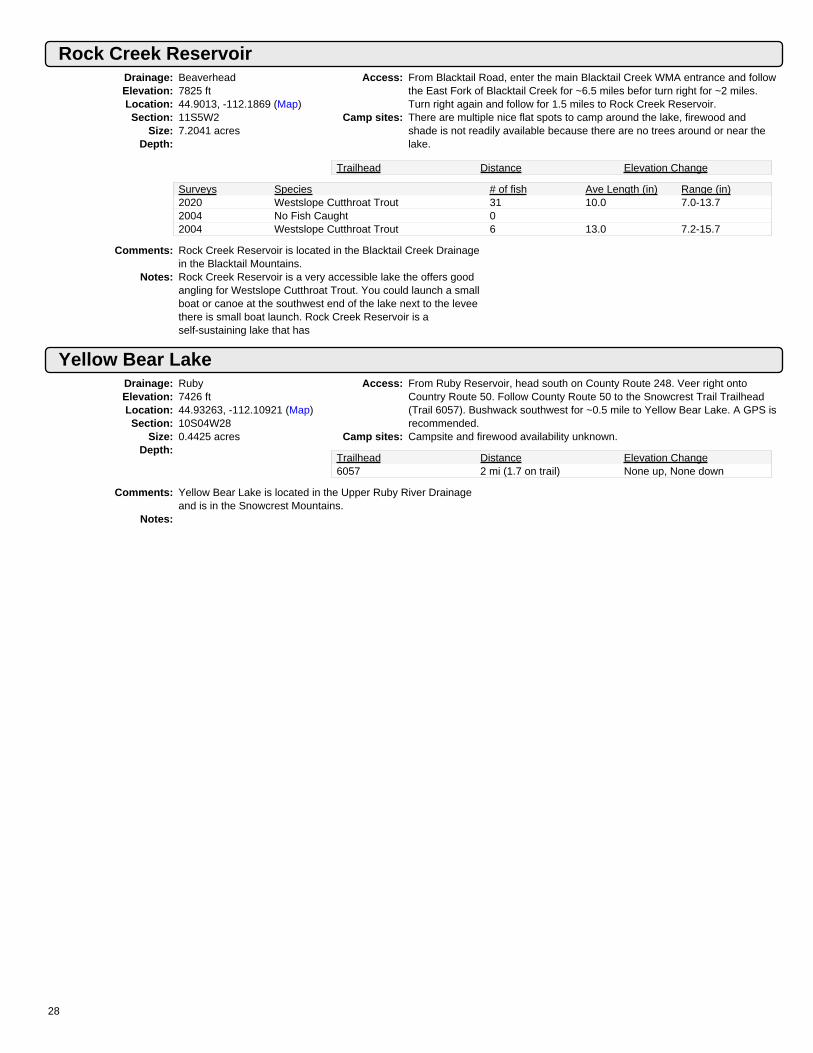
Rock Creek ReservoirDrainage: BeaverheadElevation: 7825 ftLocation: 44.9013, -112.1869 (Map)Section: 11S5W2
Size: 7.2041 acresDepth:
Access: From Blacktail Road, enter the main Blacktail Creek WMA entrance and followthe East Fork of Blacktail Creek for ~6.5 miles befor turn right for ~2 miles.Turn right again and follow for 1.5 miles to Rock Creek Reservoir.
Camp sites: There are multiple nice flat spots to camp around the lake, firewood andshade is not readily available because there are no trees around or near thelake.
Trailhead Distance Elevation Change
Surveys Species # of fish Ave Length (in) Range (in)2020 Westslope Cutthroat Trout 31 10.0 7.0-13.72004 No Fish Caught 02004 Westslope Cutthroat Trout 6 13.0 7.2-15.7
Comments: Rock Creek Reservoir is located in the Blacktail Creek Drainagein the Blacktail Mountains.
Notes: Rock Creek Reservoir is a very accessible lake the offers goodangling for Westslope Cutthroat Trout. You could launch a smallboat or canoe at the southwest end of the lake next to the leveethere is small boat launch. Rock Creek Reservoir is aself-sustaining lake that has
Yellow Bear LakeDrainage: RubyElevation: 7426 ftLocation: 44.93263, -112.10921 (Map)Section: 10S04W28
Size: 0.4425 acresDepth:
Access: From Ruby Reservoir, head south on County Route 248. Veer right ontoCountry Route 50. Follow County Route 50 to the Snowcrest Trail Trailhead(Trail 6057). Bushwack southwest for ~0.5 mile to Yellow Bear Lake. A GPS isrecommended.
Camp sites: Campsite and firewood availability unknown.
Trailhead Distance Elevation Change6057 2 mi (1.7 on trail) None up, None down
Comments: Yellow Bear Lake is located in the Upper Ruby River Drainageand is in the Snowcrest Mountains.
Notes:
28

Tendoy Mountains
Poison Lakes (Upper Poison Lake)Drainage: Red RockElevation: 8377 ftLocation: 44.84474, -112.90804 (Map)Section: 11S11W26
Size: 1.336 acresDepth:
Access: MAY NEED PERMISSION TO ACCESS ROAD! From Highway 324, turnsouth onto Medicine Lodge Road. Take Deer Canyon Creek Road for about4.5 miles until arriving at Poison Lakes.
Camp sites: Flat areas are available but may be wet and lacking shade. No firewoodavailable.
Trailhead Distance Elevation Change
Comments: Poison Lakes are located in the Medicine Lodge Creek Drainagein the Tendoy Mountain Range. The lakes see light human use.
Notes:
29

Tobacco Root Mountain Lakes
Twin Lakes
30

Tobacco Root Mountains
Blossom LakeDrainage: RubyElevation: 9197 ftLocation: 45.55243, -112.06934 (Map)Section: 03S04W26
Size: 3.1223 acresDepth: 3ft (Ave), 6ft (Max)
Access: From Highway 287, turn onto County Route 64. From Route 64, turn right andhead east on County Route 167. Turn off onto USFS Road 8300 and followuntil the turnoff to trail 6015. Hike up trail 6015 for half a mile and cut off trailand drop southeast a quarter mile to Blossom Lake.
Camp sites: No campsite or good flat spots. Some firewood is available.
Trailhead Distance Elevation ChangeWisconsin Creek Trail 8300to Trail 6015
5 mi (4.75 on trail) 3060 up, 50 down
Surveys Species # of fish Ave Length (in) Range (in)2018 No Fish Caught 0
Comments: Blossom Lake is a man-made lake in the Wisconsin CreekDrainage (Noble Fork) in the Tobacco-Root Mountains. The lakeis very shallow and does not support fish. It is a neat, high altitudelake characterized by large boulders and steep mountainsaround. Human traffic is low but human impact is evident withsigns of old mining.
Notes:
Crystal LakeDrainage: RubyElevation: 8597 ftLocation: 45.58253, -112.11618 (Map)Section: 03S04W8
Size: 9.1999 acresDepth: 7ft (Max)
Access: From Highway 287, turn onto County Route 64. Stay on County Route 64 andit turns into USFS Road 157. Stay on USFS Road 157 which goes all the wayto the lake.
Camp sites: Campsites and firewood availability unknown.
Trailhead Distance Elevation Change
Stocking Data Historic PlannedRainbow Trout 756 in 1970; 4,750 in 1946
Comments: Crystal Lake is located in the Wisconsin Creek Drainage in theTobacco-Root Mountains.
Notes:
Gneiss LakeDrainage: RubyElevation: 9591 ftLocation: 45.51614, -112.01227 (Map)Section: 04S03W6
Size: 4.0509 acresDepth:
Access: From Highway 287, turn onto Indian Creek Road near Sheridan, MT. IndianCreek Road turns into USFS Rd. 158. Follow USFS Rd. 158 to the trailheadfor Trail 6015. Take the trail to Thompson Lake and then bushwack southeastfor about a third of a mile.
Camp sites: Campsite and firewood availability unknown.
Trailhead Distance Elevation Change6015 1.5 mi (1 on trail) None up, None down
Stocking Data Historic PlannedYellowstone Cutthroat Trout 315 in 1988
Comments: Gneiss Lake is located in the South Fork of Indian CreekDrainage in the Tobacco-Root Mountains.
Notes:
31

Hill ReservoirDrainage: RubyElevation: 8594 ftLocation: 45.53928, -112.03822 (Map)Section: 03S04W25
Size: 9.6053 acresDepth:
Access: From Highway 287, turn onto Indian Creek Road near Sheridan, MT. Thisroad will turn into USFS Rd. 158. Don't go Southeast up the South Fork ofIndian Creek. Take Trail 6015 to Trail 6007 which arrives at Hill Reservoir.
Camp sites: There are plenty of campsites and firewood in the surrounding area aroundthe old lake shoreline.
Trailhead Distance Elevation Change6015 2 mi (2 on trail) None up, None down6007 0.5 mi (0.5 on trail) None ft up, None ft down
Comments: Hill Reservoir is located in the North Fork Indian Creek Drainagein the Tobacco-Root Mountains.
Notes: Hill Reservoir historically held fish, but over the years the outletstructure had aged and failed. The US Forest Service decidedthat this was high high-risk dam, because of multiple houses andother structures located near the creek on Lower Indian Creek itwas decided to remove and reclaim the dam. Hill reservoir nolonger exists as a lake, it is now a meadow with a stream flowingthrough it.
Jackson LakeDrainage: RubyElevation: 8895 ftLocation: 45.58129, -112.09995 (Map)Section: 03S04W16
Size: 4.1188 acresDepth: 14ft (Ave), 31ft (Max)
Access: From Highway 287, turn onto County Route 64. Stay on County Route 64 andit turns into USFS Road 157. Stay on USFS Road 157 and veer right on Trail6307. Stay on Trail 6307 to Jackson Lake. An off-road vehicle is necessary toget all the way to the lake.
Camp sites: Three campsites found during fish sampling and more flat spots around lake.There is an abundance of available firewood at Jackson Lake.
Trailhead Distance Elevation ChangeWisconsin Creek Trail 157 6 mi (6 on trail) 2560 up, 0 down
Stocking Data Historic PlannedWestslope Cutthroat Trout 502 in 2018; 500 in 2014 500 in 2022Yellowstone Cutthroat Trout 500 in 2002; 500 in 1998
Surveys Species # of fish Ave Length (in) Range (in)2018 Westslope Cutthroat Trout 3 13.0 12.5-12.92010 Westslope Cutthroat Trout 1 13.0 13.3-13.32010 Yellowstone Cutthroat Trout 1 16.0 15.5-15.5
Comments: Jackson Lake is found in the Wisconsin Creek Drainage in theTobacco-Root Mountains. The lake is man-made from back inmining times. The banks are forested with some areas of largeboulders. There are signs of human impact, and human traffic ismoderate.
Notes: Fishing this lake is very difficult without some sort of float tube orpack raft due to thickly forested banks.
Lower Branham LakeDrainage: RubyElevation: 8755 ftLocation: 45.5149, -111.9939 (Map)Section: 4S3W5
Size: 11.5231 acresDepth:
Access: From Highway 287, turn onto Mill Creek Road in Sheridan and head east. MillCreek Road becomes USFS Road 111 and goes right to Branham Lakes.
Camp sites: There are around 6 campsites with fire pits and flat spots at the lake. Somefirewood is available. The Upper Branham Lake campground has restroomsavailable.
Trailhead Distance Elevation Change
Comments:Notes: Lower Branham Lake is full of aggressive Brook Trout that are
eager to take a fly or lure. There are ample shorefishingopportunities around the lake. A float tube would benefit thoselooking to cover more water.
32

Macaroni LakeDrainage: RubyElevation: 4189 ftLocation: 45.53755, -112.03877 (Map)Section: 3S4W36
Size: 2.669 acresDepth:
Access: From Highway 287, turn onto Indian Creek Road near Sheridan, MT. Thisroad will turn into USFS Rd. 158. Don't go Southeast up the South Fork ofIndian Creek. Take Trail 6015 to Trail 6007. Halfway up Trail 6007, bushwacksouth ~0.25 miles to Macaroni Lake.
Camp sites: There are multiple flat places to Camp near the lake and firewood is readilyavailable in the vicinity.
Trailhead Distance Elevation Change6015 2 mi (2 on trail) None up, None down6007 .75 mi (.5 on trail) None ft up, None ft down
Comments: Macaroni Lake is a small high mountain lake in the North ForkIndian Creek Drainage. It is found in the Tobacco-RootMountains.
Notes: Macaroni Lake is located at 8,310 feet in elevation and wassampled on 6/23/2020 and it was fish-less. This lake does notappear to be deep enough to over winter fish. More than half ofthe lake was full of dead pine trees that had been swept down ahuge avalanche shoot that is located directly to the East of thelake. It is an amazing display of the raw power of nature.
Noble LakeDrainage: RubyElevation: 9204 ftLocation: 45.56324, -112.07337 (Map)Section: 03S04W22
Size: 17.9022 acresDepth: 16ft (Ave), 56ft (Max)
Access: From Highway 287, turn onto County Route 64. From Route 64, turn right andhead east on County Route 167. Turn off onto USFS Road 8300 and follow itto Noble Lake.
Camp sites: Three campsite found during sampling in 2018 near trail. Some other flatareas around the lake. There is little wood around as the lake is at thetreeline.
Trailhead Distance Elevation ChangeWisconsin Creek Trail 8300 5 mi (5 on trail) 2920 up, 0 down
Stocking Data Historic PlannedWestslope Cutthroat Trout 1,001 in 2018; 1,000 in 2014 1,000 in 2022Yellowstone Cutthroat Trout 1,000 in 2002; 1,000 in 1998
Surveys Species # of fish Ave Length (in) Range (in)2018 Westslope Cutthroat Trout 5 14.0 13.3-15.62018 Yellowstone Cutthroat Trout 15 12.0 7.2-14.91956 No Fish Caught 0
Comments: Noble Lake is a man-made lake located in the head end of theWisconsin Creek Drainage (Noble Fork) in the Tobacco-RootMountains. South end of the lake is artificial earth berm thatformed the lake. Noble Lake shows high amounts of human signdue to the off-road vehicle access and mining history.
Notes: Good shore fishing opportunities from the berm on the southwestside of lake. A float tube or pack raft would greatly increase theamount of area to fish and get out past the shallow shoreline.
33
Oval LakeDrainage: RubyElevation: 4189 ftLocation: 45.5343, -112.0308 (Map)Section: 3S3W31
Size: 2.4272 acresDepth:
Access: From Highway 287, turn onto Indian Creek Road near Sheridan, MT. Thisroad will turn into USFS Rd. 158. Don't go Southeast up the South Fork ofIndian Creek. Take Trail 6015 to Trail 6007 which arrives at Hill Reservoir.From Hill Reservoir, bushwack ~0.4 miles southeast to Oval Lake. A GPS isrecommended to find the lake.
Camp sites: There a few spots big enough for 2 man tents around the lake, and firewoodcan be found around the lake and the immediate vicinity.
Trailhead Distance Elevation Change6015 2 mi (2 on trail) None up, None down6007 0.9 mi (0.5 on trail) None ft up, None ft down
Surveys Species # of fish Ave Length (in) Range (in)2020 No Fish Caught 0
Comments: Oval Lake is located in the North Fork Indian Creek Drainage inthe Tobacco-Root Mountains.
Notes: During a sampling event in late June of 2020 the lake wasfish-less, this lake may not be deep enough to overwinter fish,however the lake and the surrounding area are beautiful andworth the hike.
Phyllis Lake (Taylor Lake)Drainage: RubyElevation: 4189 ftLocation: 45.53422, -112.03074 (Map)Section: 3S4W36
Size: 2.206 acresDepth:
Access: From Highway 287, turn onto Indian Creek Road near Sheridan, MT. Thisroad will turn into USFS Rd. 158. Don't go Southeast up the South Fork ofIndian Creek. Take Trail 6015 to Trail 6007 which arrives at Hill Reservoir.From Hill Reservoir, bushwack ~0.5 south miles to Phyllis Lake. A GPS isrecommended to find the lake.
Camp sites: There are a couple flat places to camp near the outlet and firewood is readilyavailable in the immediate vicinity.
Trailhead Distance Elevation Change6015 2 mi (2 on trail) None up, None down6007 1 mi (0.5 on trail) None ft up, None ft down
Comments: Phyllis Lake is a part of the North Fork Indian Creek Drainage inthe Tobacco-Root Mountains.
Notes: Phyllis Lake a.k.a (Taylor Lake) is a long oval shaped lake thatdoes not have much depth. on 6/23/2020 the lake was sampledand it showed that it is fish-less, it does not appear that this lakeis deep enough to overwinter fish.
Rossiter LakeDrainage: RubyElevation: 8997 ftLocation: 45.55583, -112.04381 (Map)Section: 03S04W24
Size: 3.6079 acresDepth:
Access: From Highway 287, turn onto Indian Creek Road near Sheridan, MT. Thisroad will turn into USFS Rd. 158. Don't go Southeast up the South Fork ofIndian Creek. Take Trail 6015 to the outlet of Rossiter Lake and hike up outletto the lake.
Camp sites: Campsite and firewood availability unknown.
Trailhead Distance Elevation Change6005 3.5 mi (3.2 on trail) None up, None down
Comments: Rossiter Lake is located in the North Fork Indian Creek Drainagein the Tobacco-Root Mountains.
Notes:
34

Sunrise LakeDrainage: RubyElevation: 9374 ftLocation: 45.57634, -112.08889 (Map)Section: 03S04W15
Size: 5.0547 acresDepth: 11ft (Ave), 31ft (Max)
Access: From Highway 287, turn onto County Route 64 and follow until it becomesUSFS Road 157. Follow USFS Road 157 up the mountain and turn right ontotrail 6307. Vehicles are not recommended on this trail as it is dangerous. Thelake is off to the right of the trail at the top of the mountain.
Camp sites: Three campsites that are flat, but rocky were found in 2018 sampling. Littlefirewood available because lake is right at treeline.
Trailhead Distance Elevation ChangeUSFS Rd. 157 To Trail 6307 7.5 mi (7.5 on trail) 3240 up, 0 down
Stocking Data Historic PlannedWestslope Cutthroat Trout 498 in 2018; 500 in 2014 500 in 2022Yellowstone Cutthroat Trout 500 in 2002; 500 in 1998
Surveys Species # of fish Ave Length (in) Range (in)2018 Westslope Cutthroat Trout 5 11.0 6.9-13.82018 Yellowstone Cutthroat Trout X Westslope
Cutth.29 11.0 6.6-17.5
2010 Cutthroat Trout 12 9.0 6.5-12.32010 Yellowstone Cutthroat Trout 1 19.0 18.7-18.7
Comments: Sunrise Lake is a beautiful lake located in the Wisconsin CreekDrainage in the Tobacco-Root Mountains. The lake is surroundedby gorgeous scenery including neat rock structures. Sunrise Lakeis man-made as evident by the berm on the southwest shoreline.Human impact is evident with its mining history but traffic is lowdue to the difficulty of the trail.
Notes: Good shore fishing opportunities available. The cutthroat can becaught on dry flies in early Summer. A float tube would aid infishing spots that can't be fished from shore.
Thompson LakeDrainage: RubyElevation: 9007 ftLocation: 45.5214, -112.0214 (Map)Section: 04S03W6
Size: 8.0375 acresDepth:
Access: From Highway 287, turn onto Indian Creek Road near Sheridan, MT. IndianCreek Road turns into USFS Rd. 158. Follow USFS Rd. 158 up the SouthFork of Indian Creek to the trailhead for Trail 6015. Take the trail to ThompsonLake.
Camp sites: Campsite and firewood availability unknown.
Trailhead Distance Elevation Change6015 0.5 mi (0.5 on trail) None up, None down
Comments: Thompson Lake is located in the South Fork Indian CreekDrainage in the Tobacco-Root Mountains.
Notes:
Triangle LakeDrainage: RubyElevation: 9204 ftLocation: 45.53189, -112.02925 (Map)Section: 03S03W31
Size: 1.1266 acresDepth:
Access: From Highway 287, turn onto Indian Creek Road near Sheridan, MT. Thisroad will turn into USFS Rd. 158. Don't go Southeast up the South Fork ofIndian Creek. Take Trail 6015 to Trail 6007 which arrives at Thompson Lake.Bushwack from Thompson Lake southeast ~0.65 miles to Triangle Lake. AGPS is recommended for finding the lake.
Camp sites: The lake is locted in a rocky cirque below an avalanche shoot, there is nocampsites and no good firewood in the immediate vicinity.
Trailhead Distance Elevation Change6015 2 mi (2 on trail) None up, None down6007 1.25 mi (0.5 on trail) None ft up, None ft down
Surveys Species # of fish Ave Length (in) Range (in)2020 No Fish Caught 0
Comments: Triangle Lake is found in the North Fork Indian Creek Drainage inthe Tobacco-Root Mountains.
Notes: Triangle Lake is a very small shallow lake located in a rocky highmountain cirque at the head end of Indian Creek in the TobaccoRoot Mountains. The view is spectacular, but the lake is fish-less.
35

Twin LakesDrainage: RubyElevation: 9400 ftLocation: 45.58291, -112.0897 (Map)Section: 03S04W10
Size: 2.4696 acresDepth: 9ft (Ave), 17ft (Max)
Access: From Highway 287, turn northeast on County Route 64. County Route 64turns into USFS Road 157. From USFS Rd. 157 turn right on trail 6307. It isrecommended to hike up trail 6307 as it is very dangerous even for aATV/UTV.
Camp sites: One large, flat campsite found above lake. No shade or firewood due to a lackof trees in the area.
Trailhead Distance Elevation ChangeUSFS Rd. 157 to Trail 6307 7.8 mi (7.8 on trail) 3240 up, 150 down
Stocking Data Historic PlannedRainbow Trout 3,510 in 1966Westslope Cutthroat Trout 498 in 2018; 500 in 2014 500 in 2022Yellowstone Cutthroat Trout 1,000 in 2004; 500 in 2002
Surveys Species # of fish Ave Length (in) Range (in)2018 Westslope Cutthroat Trout 11 13.0 11.4-14.11974 Rainbow Trout 1 11.0 10.8-10.81974 Yellowstone Cutthroat Trout 28 8.0 7.2-8.6
Comments: The Twin Lakes (Upper and Lower) are located in the WisconsinCreek Drainage in the Tobacco Root Mountains. Upper TwinLake is not much of a lake anymore, but Lower Twin Lakesupports fish. The shoreline is fairly steep all around the lake withhalf the shoreline consisting of rocky slopes. There are somesigns of human impact with the trail/4X4 road and an old miningclaim but traffic is slow here.
Notes: The shoreline is steep so casting could be difficult although thereare no trees around the lake. The south shore is vegetated whichmakes for easy maneuvering but the north shore is rocky andtricky to navigate. During sampling in 2018, many fish were seenrising and a few were tricked with a dry fly from shore.
Upper Branham LakesDrainage: RubyElevation: 8795 ftLocation: 45.51877, -111.99174 (Map)Section: 4S3W5
Size: 18.504 acresDepth:
Access: From Highway 287, turn onto Mill Creek Road in Sheridan and head east. MillCreek Road becomes USFS Road 111 and goes right to Branham Lakes.
Camp sites: Multiple developed campsites at USFS free campground on Upper BranhamLake. Fire pits, picnic tables, and restrooms available. Six flat campsites withfire pits and some available firewood at Lower Branham Lake.
Trailhead Distance Elevation Change
Stocking Data Historic PlannedRainbow Trout 2,003 in 1960; 1,980 in 1959
Surveys Species # of fish Ave Length (in) Range (in)2018 Brook Trout 90 9.0 6.4-10.91963 Rainbow Trout 5
Comments:Notes: Branham Lake have ample shore fishing opportunities for high
numbers of aggressive Brook trout. These fish can be caught ona variety of gear.
36

S35
S2
14S 1E
15S 1E10
15
5
5BeaverheadCounty
12
3
45
67
Blair Lake
Area of Interestº
0 0.030.015Miles
Map Produced by: Geographic Data Services Section Date: 06/27/2018 Lake levels may change. This map is not suitable for navigation.Administrative boundaries and FWP Lands data from Montana Fish, Wildlife & Parks, Helena, MT. Other data from Montana State Library, Helena, MT. Background Imagery from USDA Aerial Photography Field Office, 2015
MONTANAFWPBathymetry Survey Map
Area: 8 AcresElevation: 8157 Feet
Volume: None Acre-FeetMax Depth: 19 FeetAve Depth: 9 Feet

S23
S26
3S 4W
2
42
4
MadisonCounty
12
3
45
67
Blossom LakeBathymetry Survey Map
Area of Interest
0 0.0250.0125Miles
º
MONTANAFWP
Area: 3 AcresElevation: 9197 Feet
Volume: None Acre-FeetMax Depth: None FeetAve Depth: None Feet
Map Produced by: Geographic Data Services Section Date: 06/27/2018 Lake levels may change. This map is not suitable for navigation.Administrative boundaries and FWP Lands data from Montana Fish, Wildlife & Parks, Helena, MT. Other data from Montana State Library, Helena, MT. Background Imagery from USDA Aerial Photography Field Office, 2015
Lake Mapped on 06/28/206
S21 5S11W
2
2
BeaverheadCounty
12
3
45
67
Boatman LakeBathymetry Survey Map
Area of Interest
0 0.040.02Miles
º
MONTANAFWP
Area: 6 AcresElevation: 8190 Feet
Volume: None Acre-FeetMax Depth: 4 FeetAve Depth: 2 Feet
Map Produced by: Geographic Data Services Section Date: 06/27/2018 Lake levels may change. This map is not suitable for navigation.Administrative boundaries and FWP Lands data from Montana Fish, Wildlife & Parks, Helena, MT. Other data from Montana State Library, Helena, MT. Background Imagery from USDA Aerial Photography Field Office, 2015
Lake Mapped on 06/28/206

9
Mill Creek Rd
S4
S5
4S 3W
Branham LakesCampground andPicnic Area
30
25
20
15
10
5
5
MadisonCounty
12
3
45
67
Branham LakesBathymetry Survey Map
Area of Interest
0 0.070.035Miles
9 Camping º
MONTANAFWP
Area: 18 AcresElevation: 8856 Feet
Volume: None Acre-FeetMax Depth: None FeetAve Depth: None Feet
Map Produced by: Geographic Data Services Section Date: 06/27/2018 Lake levels may change. This map is not suitable for navigation.Administrative boundaries and FWP Lands data from Montana Fish, Wildlife & Parks, Helena, MT. Other data from Montana State Library, Helena, MT. Background Imagery from USDA Aerial Photography Field Office, 2015
Lake Mapped on 06/28/206

S36
14S 3W
10
8
8
6
64
4
2
2
10
12
BeaverheadCounty
12
3
45
67
Breneman Lake
Area of Interestº
0 0.0250.0125Miles
Map Produced by: Geographic Data Services Section Date: 06/27/2018 Lake levels may change. This map is not suitable for navigation.Administrative boundaries and FWP Lands data from Montana Fish, Wildlife & Parks, Helena, MT. Other data from Montana State Library, Helena, MT. Background Imagery from USDA Aerial Photography Field Office, 2015
MONTANAFWPBathymetry Survey Map
Area: 5 AcresElevation: 8147 Feet
Volume: None Acre-FeetMax Depth: 12 FeetAve Depth: 7 Feet

S27
14S 2W
8
6
4
4
2
2
BeaverheadCounty
12
3
45
67
Charlies Lake
Area of Interestº
0 0.010.005Miles
Map Produced by: Geographic Data Services Section Date: 06/27/2018 Lake levels may change. This map is not suitable for navigation.Administrative boundaries and FWP Lands data from Montana Fish, Wildlife & Parks, Helena, MT. Other data from Montana State Library, Helena, MT. Background Imagery from USDA Aerial Photography Field Office, 2015
MONTANAFWPBathymetry Survey Map
Area: 1 AcresElevation: 7959 Feet
Volume: 26 Acre-FeetMax Depth: 10 FeetAve Depth: 4 Feet
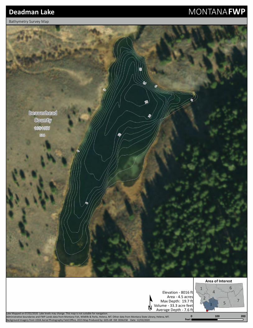
18
16
14
1210
86
4
20
16S10WS18
BeaverheadCounty
12
3
45
6
7
Deadman LakeBathymetry Survey Map
Area of Interest
0 200100Feet
º
MONTANAFWP
Area - 4.5 acresElevation - 8016 ft
Volume - 33.3 acre feetMax Depth: 19.7 ft
Average Depth - 7.6 ftLake Mapped on 07/02/2020 Lake levels may change. This map is not suitable for navigation.Administrative boundaries and FWP Lands data from Montana Fish, Wildlife & Parks, Helena, MT. Other data from Montana State Library, Helena, MT. Background Imagery from USDA Aerial Photography Field Office, 2015 Map Produced by: GDS-AR ISR: 0036258 Date: 12/03/2020

S17S18
5S11W15
10
5
5
BeaverheadCounty
12
3
45
67
Dollar Lake
Area of Interestº
0 0.020.01Miles
Map Produced by: Geographic Data Services Section Date: 06/27/2018 Lake levels may change. This map is not suitable for navigation.Administrative boundaries and FWP Lands data from Montana Fish, Wildlife & Parks, Helena, MT. Other data from Montana State Library, Helena, MT. Background Imagery from USDA Aerial Photography Field Office, 2015
MONTANAFWPBathymetry Survey Map
Area: 5 AcresElevation: 9134 Feet
Volume: None Acre-FeetMax Depth: 15 FeetAve Depth: 6 Feet

9
Elk La
ke Rd
S16S17S18
S19
S20 S21
S22
S27
S28
S29S30
S31S32 S33 S34
13S 1E
Elk LakeCampground
and Picnic Area
56
52
3
36
52
3
59
56
BeaverheadCounty
12
3
45
67
Elk LakeBathymetry Survey Map
Area of Interest
0 0.450.225Miles
9 Camping º
MONTANAFWP
Area: 283 AcresElevation: 6682 Feet
Volume: N/AMax Depth: N/AAve Depth: N/A
Map Produced by: Geographic Data Services Section Date: 06/27/2018 Lake levels may change. This map is not suitable for navigation.Administrative boundaries and FWP Lands data from Montana Fish, Wildlife & Parks, Helena, MT. Other data from Montana State Library, Helena, MT. Background Imagery from USDA Aerial Photography Field Office, 2015
Lake Mapped on 2003-11-01

S175S11W
64
2
6
4
BeaverheadCounty
12
3
45
67
Harris Lake
Area of Interestº
0 0.020.01Miles
Map Produced by: Geographic Data Services Section Date: 06/27/2018 Lake levels may change. This map is not suitable for navigation.Administrative boundaries and FWP Lands data from Montana Fish, Wildlife & Parks, Helena, MT. Other data from Montana State Library, Helena, MT. Background Imagery from USDA Aerial Photography Field Office, 2015
MONTANAFWPBathymetry Survey Map
Area: 5 AcresElevation: 8613 Feet
Volume: None Acre-FeetMax Depth: 6 FeetAve Depth: 3 Feet
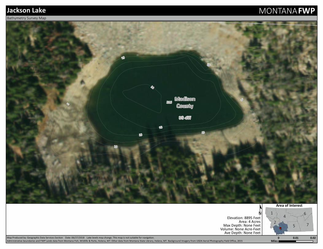
S16
3S 4W25
30
20 15
15
10
10
5
5
MadisonCounty
12
3
45
67
Jackson Lake
Area of Interestº
0 0.020.01Miles
Map Produced by: Geographic Data Services Section Date: 06/27/2018 Lake levels may change. This map is not suitable for navigation.Administrative boundaries and FWP Lands data from Montana Fish, Wildlife & Parks, Helena, MT. Other data from Montana State Library, Helena, MT. Background Imagery from USDA Aerial Photography Field Office, 2015
MONTANAFWPBathymetry Survey Map
Area: 4 AcresElevation: 8895 Feet
Volume: None Acre-FeetMax Depth: None FeetAve Depth: None Feet

Rattlesnake Creek
S3S4
S9 S10
6S11W
15
18
12
9
9
6
3
12
18
9
3
BeaverheadCounty
12
3
45
67
Kelley ReservoirBathymetry Survey Map
Area of Interest
0 0.10.05Miles
º
MONTANAFWP
Area: 17 AcresElevation: 7179 Feet
Volume: None Acre-FeetMax Depth: 18 FeetAve Depth: 11 Feet
Map Produced by: Geographic Data Services Section Date: 06/27/2018 Lake levels may change. This map is not suitable for navigation.Administrative boundaries and FWP Lands data from Montana Fish, Wildlife & Parks, Helena, MT. Other data from Montana State Library, Helena, MT. Background Imagery from USDA Aerial Photography Field Office, 2015
Lake Mapped on 06/28/206

S1
15S 1E
8
6
4
4
2
2
BeaverheadCounty
12
3
45
67
Lillian LakeBathymetry Survey Map
Area of Interest
0 0.020.01Miles
º
MONTANAFWP
Area: 2 AcresElevation: 7793 Feet
Volume: None Acre-FeetMax Depth: 8 FeetAve Depth: 4 Feet
Map Produced by: Geographic Data Services Section Date: 06/27/2018 Lake levels may change. This map is not suitable for navigation.Administrative boundaries and FWP Lands data from Montana Fish, Wildlife & Parks, Helena, MT. Other data from Montana State Library, Helena, MT. Background Imagery from USDA Aerial Photography Field Office, 2015
Lake Mapped on 06/28/206

Mill Cree
k Rd
S5
4S 3W
21
1815
12
9
9
6
63
3
MadisonCounty
12
3
45
67
Lower Branham LakeBathymetry Survey Map
Area of Interest
0 0.0450.0225Miles
º
MONTANAFWP
Area: 11 AcresElevation: 8755 Feet
Volume: 127 Acre-FeetMax Depth: None FeetAve Depth: None Feet
Map Produced by: Geographic Data Services Section Date: 06/27/2018 Lake levels may change. This map is not suitable for navigation.Administrative boundaries and FWP Lands data from Montana Fish, Wildlife & Parks, Helena, MT. Other data from Montana State Library, Helena, MT. Background Imagery from USDA Aerial Photography Field Office, 2015
Lake Mapped on 06/28/206

16S11WS4
BeaverheadCounty
22
20
16
14
12
6
20
12
3
45
6
7
Lower Harkness LakeBathymetry Survey Map
Area of Interest
0 200100Feet
º
MONTANAFWP
Area - 6.1 acresElevation - 8180 ft
Volume - 72.18 acre feetMax Depth: 23.9 ft
Average Depth - 8.5 ftLake Mapped on 07/02/2020 Lake levels may change. This map is not suitable for navigation.Administrative boundaries and FWP Lands data from Montana Fish, Wildlife & Parks, Helena, MT. Other data from Montana State Library, Helena, MT. Background Imagery from USDA Aerial Photography Field Office, 2015 Map Produced by: GDS-AR ISR: 0036258 Date:12/03/2020

64
4
2
0
16S11WS4S5
BeaverheadCounty
12
3
45
6
7
Middle Harkness LakeBathymetry Survey Map
Area of Interest
0 15075Feet
º
MONTANAFWP
Area - 2.77 acresElevation - 8394 ft
Volume - 10.65 acre feetMax Depth: 6.3 ft
Average Depth - 3.7 ftLake Mapped on 07/02/2020 Lake levels may change. This map is not suitable for navigation.Administrative boundaries and FWP Lands data from Montana Fish, Wildlife & Parks, Helena, MT. Other data from Montana State Library, Helena, MT. Background Imagery from USDA Aerial Photography Field Office, 2015 Map Produced by: GDS-AR ISR: 0036258 Date:12/03/2020
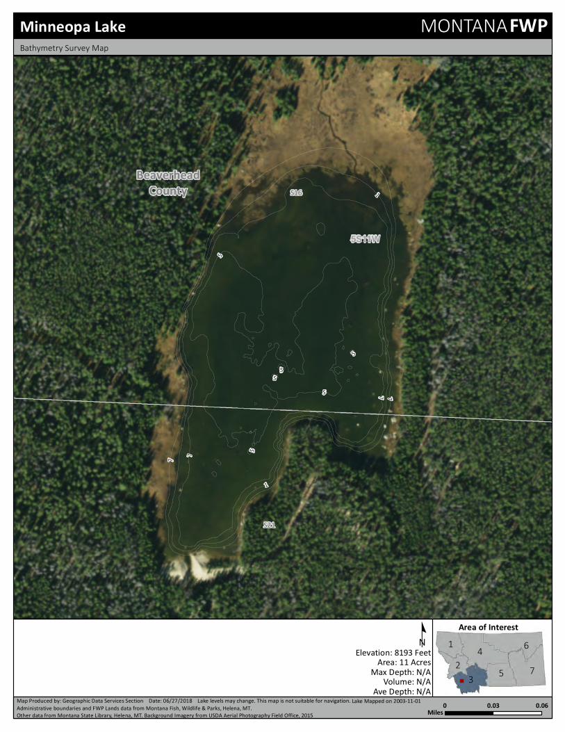
S16
S21
5S11W
77
5
5
1
5
5
1
77
55
BeaverheadCounty
12
3
45
67
Minneopa LakeBathymetry Survey Map
Area of Interest
0 0.060.03Miles
º
MONTANAFWP
Area: 11 AcresElevation: 8193 Feet
Volume: N/AMax Depth: N/AAve Depth: N/A
Map Produced by: Geographic Data Services Section Date: 06/27/2018 Lake levels may change. This map is not suitable for navigation.Administrative boundaries and FWP Lands data from Montana Fish, Wildlife & Parks, Helena, MT. Other data from Montana State Library, Helena, MT. Background Imagery from USDA Aerial Photography Field Office, 2015
Lake Mapped on 2003-11-01

S21S22
8S15W4
3
2
2
1
1
3
2
3
3
2
4
2
3
2
3
33
3
4
3 3
4
4
4
33
2
2
BeaverheadCounty
12
3
45
67
Mooney Lake
Area of Interestº
0 0.010.005Miles
Map Produced by: Geographic Data Services Section Date: 06/27/2018 Lake levels may change. This map is not suitable for navigation.Administrative boundaries and FWP Lands data from Montana Fish, Wildlife & Parks, Helena, MT. Other data from Montana State Library, Helena, MT. Background Imagery from USDA Aerial Photography Field Office, 2015
MONTANAFWPBathymetry Survey Map
Area: 1 AcresElevation: 7464 Feet
Volume: N/AMax Depth: N/AAve Depth: N/A
Lake Mapped on 2017-09-27

Morrison Lake
S22S23
14S12W
50
45
40
35
30
25
20
15
10
5
5
BeaverheadCounty
12
3
45
67
Morrison Lake
Area of Interestº
0 0.0650.0325Miles
Map Produced by: Geographic Data Services Section Date: 06/27/2018 Lake levels may change. This map is not suitable for navigation.Administrative boundaries and FWP Lands data from Montana Fish, Wildlife & Parks, Helena, MT. Other data from Montana State Library, Helena, MT. Background Imagery from USDA Aerial Photography Field Office, 2015
MONTANAFWPBathymetry Survey Map
Area: 23 AcresElevation: 8377 Feet
Volume: None Acre-FeetMax Depth: 50 FeetAve Depth: 23 Feet

S11
S12
15S 2W
24
2118
15
12
9
96
6
3
3
BeaverheadCounty
12
3
45
67
O'dell LakeBathymetry Survey Map
Area of Interest
0 0.0350.0175Miles
º
MONTANAFWP
Area: 8 AcresElevation: 7573 Feet
Volume: None Acre-FeetMax Depth: 25 FeetAve Depth: 11 Feet
Map Produced by: Geographic Data Services Section Date: 06/27/2018 Lake levels may change. This map is not suitable for navigation.Administrative boundaries and FWP Lands data from Montana Fish, Wildlife & Parks, Helena, MT. Other data from Montana State Library, Helena, MT. Background Imagery from USDA Aerial Photography Field Office, 2015
Lake Mapped on 06/28/206

8
6
4
2
0
3S 4W
3S 3W
S31
S36
MadisonCounty
12
3
45
6
7
Oval LakeBathymetry Survey Map
Area of Interest
0 10050Feet
º
MONTANAFWP
Area - 2.43 acresElevation - 4189 ft
Volume - 12.05 acre feetMax Depth: 10 ft
Average Depth - 5.25 ftLake Mapped on 07/02/2020 Lake levels may change. This map is not suitable for navigation.Administrative boundaries and FWP Lands data from Montana Fish, Wildlife & Parks, Helena, MT. Other data from Montana State Library, Helena, MT. Background Imagery from USDA Aerial Photography Field Office, 2015 Map Produced by: GDS-AR ISR: 0036258 Date:12/03/2020

Skinner Meadows Rd
S20
S21
8S15W
45
50
40
35
30
30
25
20
15
10
5
50
45
10
50
105
BeaverheadCounty
12
3
45
67
Reservoir LakeBathymetry Survey Map
Area of Interest
0 0.10.05Miles
º
MONTANAFWP
Area: 40 AcresElevation: 7196 Feet
Volume: None Acre-FeetMax Depth: 53 FeetAve Depth: 22 Feet
Map Produced by: Geographic Data Services Section Date: 06/27/2018 Lake levels may change. This map is not suitable for navigation.Administrative boundaries and FWP Lands data from Montana Fish, Wildlife & Parks, Helena, MT. Other data from Montana State Library, Helena, MT. Background Imagery from USDA Aerial Photography Field Office, 2015
Lake Mapped on 06/28/206

16
14
12
10
8
6
4
2
0
11S 5WS2
S3
BeaverheadCounty
12
3
45
6
7
Rock Creek ReservoirBathymetry Survey Map
Area of Interest
0 15075Feet
º
MONTANAFWP
Area - 7.2 acresElevation - 7825 ft
Volume - 51.98 acre feetMax Depth: 17.8 ft
Average Depth - 8.15 ftLake Mapped on 07/02/2020 Lake levels may change. This map is not suitable for navigation.Administrative boundaries and FWP Lands data from Montana Fish, Wildlife & Parks, Helena, MT. Other data from Montana State Library, Helena, MT. Background Imagery from USDA Aerial Photography Field Office, 2015 Map Produced by: GDS-AR ISR: 0036258 Date:12/03/2020

S1 5S12W
556050
45
40
35
3025
20
15
1510
5
BeaverheadCounty
12
3
45
67
Sawtooth Lake
Area of Interestº
0 0.050.025Miles
Map Produced by: Geographic Data Services Section Date: 06/27/2018 Lake levels may change. This map is not suitable for navigation.Administrative boundaries and FWP Lands data from Montana Fish, Wildlife & Parks, Helena, MT. Other data from Montana State Library, Helena, MT. Background Imagery from USDA Aerial Photography Field Office, 2015
MONTANAFWPBathymetry Survey Map
Area: 20 AcresElevation: 8593 Feet
Volume: N/AMax Depth: N/AAve Depth: N/A
Lake Mapped on 2017-12-27

S28
14S 2W
18
15
12
9 9
6
6
3
3
6
BeaverheadCounty
12
3
45
67
Smith Lake
Area of Interestº
0 0.00950.00475Miles
Map Produced by: Geographic Data Services Section Date: 06/27/2018 Lake levels may change. This map is not suitable for navigation.Administrative boundaries and FWP Lands data from Montana Fish, Wildlife & Parks, Helena, MT. Other data from Montana State Library, Helena, MT. Background Imagery from USDA Aerial Photography Field Office, 2015
MONTANAFWPBathymetry Survey Map
Area: 0 AcresElevation: 8397 Feet
Volume: 20 Acre-FeetMax Depth: 18 FeetAve Depth: 10 Feet

S15
3S 4W
3025
20
15
10
55
5
MadisonCounty
12
3
45
67
Sunrise LakeBathymetry Survey Map
Area of Interest
0 0.040.02Miles
º
MONTANAFWP
Area: 5 AcresElevation: 9374 Feet
Volume: None Acre-FeetMax Depth: None FeetAve Depth: None Feet
Map Produced by: Geographic Data Services Section Date: 06/27/2018 Lake levels may change. This map is not suitable for navigation.Administrative boundaries and FWP Lands data from Montana Fish, Wildlife & Parks, Helena, MT. Other data from Montana State Library, Helena, MT. Background Imagery from USDA Aerial Photography Field Office, 2015
Lake Mapped on 06/28/206
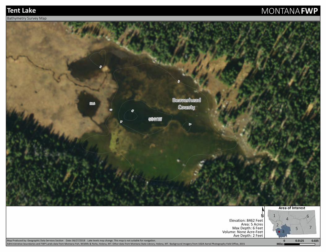
S16
5S11W6
4
2
2
4
2
BeaverheadCounty
12
3
45
67
Tent Lake
Area of Interestº
0 0.0250.0125Miles
Map Produced by: Geographic Data Services Section Date: 06/27/2018 Lake levels may change. This map is not suitable for navigation.Administrative boundaries and FWP Lands data from Montana Fish, Wildlife & Parks, Helena, MT. Other data from Montana State Library, Helena, MT. Background Imagery from USDA Aerial Photography Field Office, 2015
MONTANAFWPBathymetry Survey Map
Area: 5 AcresElevation: 8462 Feet
Volume: None Acre-FeetMax Depth: 6 FeetAve Depth: 2 Feet

S17 5S11W
42
2
BeaverheadCounty
12
3
45
67
Twin Lake, Lower
Area of Interestº
0 0.020.01Miles
Map Produced by: Geographic Data Services Section Date: 06/27/2018 Lake levels may change. This map is not suitable for navigation.Administrative boundaries and FWP Lands data from Montana Fish, Wildlife & Parks, Helena, MT. Other data from Montana State Library, Helena, MT. Background Imagery from USDA Aerial Photography Field Office, 2015
MONTANAFWPBathymetry Survey Map
Area: 3 AcresElevation: 8908 Feet
Volume: None Acre-FeetMax Depth: 4 FeetAve Depth: 2 Feet

S17
5S11W15
12
9
6
6
3
3
BeaverheadCounty
12
3
45
67
Twin Lake, Upper
Area of Interestº
0 0.030.015Miles
Map Produced by: Geographic Data Services Section Date: 06/27/2018 Lake levels may change. This map is not suitable for navigation.Administrative boundaries and FWP Lands data from Montana Fish, Wildlife & Parks, Helena, MT. Other data from Montana State Library, Helena, MT. Background Imagery from USDA Aerial Photography Field Office, 2015
MONTANAFWPBathymetry Survey Map
Area: 6 AcresElevation: 8990 Feet
Volume: None Acre-FeetMax Depth: 16 FeetAve Depth: 8 Feet

S9
S10
3S 4W
15
105
5
5
MadisonCounty
12
3
45
67
Twin Lakes
Area of Interestº
0 0.0150.0075Miles
Map Produced by: Geographic Data Services Section Date: 06/27/2018 Lake levels may change. This map is not suitable for navigation.Administrative boundaries and FWP Lands data from Montana Fish, Wildlife & Parks, Helena, MT. Other data from Montana State Library, Helena, MT. Background Imagery from USDA Aerial Photography Field Office, 2015
MONTANAFWPBathymetry Survey Map
Area: 2 AcresElevation: 9400 Feet
Volume: None Acre-FeetMax Depth: 17 FeetAve Depth: 9 Feet