digital ea data. - michigan
TRANSCRIPT


Environmental Areas, listed by County
digital EA data.
Not all EA's listed have digital maps. Please visit Wetlands Map Viewer to view
COUNTY TOWNSHIP GENERAL LOCATION TOWN/RANGE/SECTIONS AREA# Alcona Alcona Black River Island 28N/9E/12 07-01Alger Grand Island E. of Christmas 47N/19W/27,28 03-01Alger Grand Island Williams I 47N/19W/7,8 03-02Alpena Alpena Squaw Bay 30N/8E/9-11,15,16,22 05-12Alpena Alpena Sulphur Island 30N/8E/24 05-15Alpena Alpena Crooked Island 31N/9E/23,26 05-10Alpena Alpena Misery Bay 31N/9E/27 05-10Alpena Alpena Whitefish Bay 31N/9E/17,18,19,20 05-11Alpena Alpena Gull Island 31N/10E/29 05-14Alpena Alpena Sugar Island 31N/10E/32,33 05-14Alpena Alpena Grass Island 31N/8E/34 05-16Alpena Sanborn South Point 29N/08E/12,13 05-13Alpena Sanborn South Point 29N/09E/18,20,21,26,27,28 05-13Alpena Sanborn Bird Island 29N/9E/22 05-14Arenac Arenac Wigwam Bay 18N/06E/4,5,6 08-02Arenac Arenac Wigwam Bay 19N/05E/35,36 08-02Arenac AuGres Arenac N E 19N/06E/24,35 08-01Arenac AuGres Wigwam Bay 19N/05E/31,33 08-02Arenac Sims Arenac N E 19N/07E/18,19 08-01Arenac Standish Wigwam Bay 18N/05E/1,2,3,10 08-02Arenac Standish Whites Beach 18N/05E/10,15,16,20,21,29,32 08-03Arenac Whitney Charity Island 19N/09E/28,33 08-09Baraga Arvon Lightfoot 52N/31W/13,14 01-02Baraga L'Anse Pequaming South 51N/32W/4,5 01-01ABaraga L'Anse Pequaming South 52N/32W/32 01-01ABaraga L'Anse Pequaming North 52N/32W/33,34 01-01BBay Bangor N W of Saginaw R. 14N/05E/3 08-08Bay Fraser Nayanquing Point 16N/04E/12,13,23,24,25,26 08-06Bay Fraser Nayanquing Point 16N/05E/7,18,19,30 08-06Bay Hampton E of Saginaw River 14N/06E/8,9,10,13,14,23,24,25 08-07Bay Pinconning Pinconning North 17N/05E/6,7,18,19,30 08-04Bay Pinconning Pinconning South 17N/05E/30 08-05Charlevoix St. James Hog Island 39N/9W/1,2,10,11,14,15 05-20Charlevoix St. James Grape Island 39N/9W/9,10 05-20Charlevoix St. James Garden Island 39N/10W/3,12,13 05-21Charlevoix St. James Garden Island 39N/9W/6,7 05-21Charlevoix St. James High Island 39N/11W/27 05-22Charlevoix St. James Hat Island 40N/8W/28,33 05-17Charlevoix St. James Squaw Island 40N/10W/19,30 05-18Cheboygan Benton McLeod Bay 38N/1W/22,26,27 05-08Cheboygan Benton City of Cheboygan 38N/1W/28,29,30 05-09Chippewa Bruce 45N/2E/6 04-42AChippewa Bruce 46N/1E/13,24 04-42BChippewa Bruce 46N/2E/18,19,30,31 04-42C,DChippewa DeTour Saddlebag Island 41N/3E/15 04-25Chippewa DeTour Seymour Bay 41N/4E/3,4 04-26Chippewa Drummond Gravel Island 41N/5E/23 04-27Chippewa Drummond Glen Cove 42N/7E/26 04-29Chippewa Drummond N.of Paw Point 42N/6E/3 04-32Chippewa Drummond Potagannissing Bay 43N/6E/29,30,31,32 04-30Chippewa Drummond Cedar Island 43N/5E/26 04-31Chippewa Drummond N.of Paw Point 43N/6E/34 04-32Chippewa Pickford Munuscong Bay 44N/1E/12,13,14,23,24 04-37Chippewa Pickford Munuscong Bay 44N/2E/5,6,7 04-37Chippewa Pickford 44N/2E/5,6,7 04-38

COUNTY TOWNSHIP GENERAL LOCATION TOWN/RANGE/SECTIONS AREA# Chippewa Pickford Kemp's Point 44N/2E/4 04-39 Chippewa Raber Prentiss Bay 42N/2E/31 04-24 Chippewa Raber Round Island 43N/3E/23 04-33 Chippewa Raber Raber Bay 43N/3E/10,11,14,15,16 04-34 Chippewa Raber Gogomain River 43N/2E/1 04-35 Chippewa Raber Gogomain River 43N/3E/6 04-35 Chippewa Raber Gogomain River 44N/2E/36 04-35 Chippewa Raber Gogomain River 44N/3E/31 04-35 Chippewa Raber Maple to Rocky Pt. 44N/2E/26,27,28,33,34,35 04-36 Chippewa Soo Winter Point 44N/2E/10,11,14 04-40A Chippewa Soo Neebish Island 44N/2E/1,2 04-40B Chippewa Soo Sand Island 45N/2E/4,5,8,9,17 04-41 Chippewa Sugar Island 45N/2E/2,3 04-43 Chippewa Sugar Island Shingle Bay 46N/2E/21,22 04-44 Chippewa Sugar Island Duck Lake 46N/2E/22,23 04-45 Chippewa Sugar Island 46N/2E/14,15 04-46 Chippewa Sugar Island Rock Island 46N/2E/14 04-47 Chippewa Sugar Island Whipple Point 46N/2E/4,9,10 04-48 Chippewa Sugar Island Gem Island 47N/2E/33 04-49 Chippewa Sugar Island Baie De Wasai 47N/1E/13,14,15,23 04-51 Chippewa Sugar Island Hog Island 47N/1E/2 04-52 Chippewa Sugar Island Palmer's Point E. 48N/2E/20,28,29 04-50 Chippewa Tahquamenon Tahquamenon Island 48N/5W/28,29 04-53 Delta Bay de Noc Granskog Creek 39N/21W/ 03-09 Delta Bay De Noc Round Island 39N/20W/27,28 03-10 Delta Bay De Noc St. Vital's Island 39N/20W/3,4 03-11 Delta Brampton Days River 40N/22W/2 03-07 Delta Ensign Ogontz River 40N/20W/16 03-12 Delta Fairbanks Sucker Lake 38N/19W/13,24 03-14 Delta Ford River Ford River 38N/23W/21,22 03-05 Delta Ford River Portage Point 38N/22W/6,7,8 03-16 Delta Garden Portage Bay 39N/18W/28 03-15 Delta Garden Little Fish Dam R. 40N/19W/1 03-17 Delta Garden Little Fish Dam R. 41N/18W/32,33 03-17 Delta Masonville Rapid/Tacoosh River 41N/21W/29,30,31,32 03-08 Delta Nahma Nahma 40N/19W/19,20,29 03-13 Delta Nahma Nahma 40N/20W/24 03-13 Delta Wells Wells 39N/22W/7,18 03-06 Emmett Bliss Sturgeon Bay 39N/5W/19,30 05-16 Emmett Bliss Waugoshance Point 39N/6W/23 05-16 Emmett Bliss Waugoshance Island 39N/6W/all 05-16 Emmett Bliss Temperance Island 39N/6W/all 05-16 Houghton Torch Lake Traverse Island 54N/31W/17,18,20 01-03 Huron Caseville Sand Pt to Filion Rd 17N/10E/8 11-08 Huron Fairhaven N of Sebewaing 16N/09E/29,32 11-04 Huron Fairhaven Weale Rd to Rose Is. 16N/09E/15,16,21,22,28 11-05 Huron Fairhaven Bay Port S. to Weale Rd. 16N/09E/2,10,11 11-06 Huron Fairhaven Pitchers Island 16N/08E/25,26 11-09 Huron Fairhaven Maisou Islands 16N/09E/2-5,7-11,16-19 11-09 Huron Fairhaven Bay Port S. to Weale Rd. 17N/09E/35 11-06 Huron Fairhaven North Island 17N/09E/21,22 11-09 Huron Fairhaven Maisou Islands 17N/09E/28,29,32,33 11-09 Huron Gore Whiskey Harbor 18N/15E/17,18 11-10 Huron McKinley S of Filion Road 17N/10E/19,20,29,30 11-07 Huron McKinley Sand Pt to Filion Rd 17N/10E/17 11-08 Huron Pte. Aux Barques Pte Aux Barques 19N/13E/20,21 11-13 Huron Rubicon Hardwood Pt N 17N/15E/10,15 11-11 Huron Rubicon Harbor Beach N 17N/15E/26,35,36 11-12

COUNTY TOWNSHIP GENERAL LOCATION TOWN/RANGE/SECTIONS AREA# Huron Sebewaing S of Sebewaing 15N/09E/18 11-03 Huron Sebewaing N of Sebewaing 15N/09E/5,6,7 11-04 Mackinac Bois Blanc Snake Island 39N/1W/26 04-23 Mackinac Clark Goose Island 41N/1W/28 04-17 Mackinac Clark Voights Bay 41N/1W/13,14 04-18 Mackinac Clark Duck Bay 41N/1W/11,12 04-19 Mackinac Clark Sheppard Bay 41N/1W/1 04-20 Mackinac Clark Scotty Bay 41N/2E/5 04-21 Mackinac Clark Crow Island 41N/1E/12 04-22 Mackinac Clark Crow Island 41N/2E/7 04-22 Mackinac Clark Mismer Bay 42N/1W/29,30 04-14 Mackinac Clark Mackinac Bay 42N/1W/27,34 04-15 Mackinac Clark Mackinac Bay 42N/1W/26,35 04-16 Mackinac Garfield Crow River 42N/10W/18,19 04-02 Mackinac Garfield Naubinway Island 43N/9W/33 04-03 Mackinac Hendricks Epoufette Island 42N/7W/8 04-04 Mackinac Hendricks Epoufette Bay 42N/7W/4,5,6,7,8,9 04-04 Mackinac Marquette Lt.St.Martin Is & reefs 41N/2W/8,9 04-12 Mackinac Marquette St. Martin Point 41N/2W/2 04-13 Mackinac Marquette St. Martin Bay 42N/2W/22,27 04-11 Mackinac Moran St. Helena Island 40N/5W/14 04-06 Mackinac Moran Green Island 40N/4W/whole Island 04-07 Mackinac Moran Unnamed Island 40N/4W/whole Island 04-07 Mackinac Moran Pte. Aux Chenes Bay 41N/5W/23,24,25,26 04-05 Mackinac Newton Seiners Point 41N/12W/5 04-01 Mackinac Newton Crow River 42N/11W/24,25 04-02 Mackinac St. Ignace Martineau Creek 41N/3W/5,8 04-08 Mackinac St. Ignace Big St. Martin Island 41N/2W/6,7 04-10 Mackinac St. Ignace Big St. Martin Island 41N/3W/1,12 04-10 Mackinac St. Ignace Carp R to Pine R 42N/3W/9,10,16,21 04-09 Marquette Powell Big Bay-Squaw Beach 51N/27W/10,11 03-03 Marquette Powell Big Huron River 52N/29W/7,18 03-04 Monroe Berlin Pointe Mouillee 5S/10E/25,26,35,36 13-02 Monroe Berlin Pointe Mouillee 5S/11E/30,31 13-02 Monroe Berlin Pointe Mouillee 6S/10E/2,3,10,11 13-02 Monroe Erie 5S/10E/23,25-28,33,34,36 13-02 Monroe Erie 5S/10E/14,15,21-23,25-28,33,34,36 13-03 Monroe Frenchtown 5S/10E/16,21,28 13-03 Monroe Frenchtown Brest Bay Grove Sub 6S/10E/29 13-04 Monroe Monroe Ford Marsh 7S/9E/10,11 13-01 Tuscola Akron S of Sebewaing 15N/08E/9,10,12-16,20,22,29,30 11-03 Tuscola Akron N of Sebewaing 15N/08E/1 11-04 Tuscola Wisner Quanicassee 14N/07E/2,11,14,15,21,22,29,30,31 11-01 Tuscola Wisner Bay Park 14N/07E/1 11-02 Wayne Brownstown Celeron Island 5S/11E/6,7,whole island 14-21 Wayne Brownstown Cherry I. S.to Maple Beach 5S/10E/1,12,13 14-22 Wayne Brownstown Lee Rd to Pt Mouille 5S/10E/24,25 14-23 Wayne City of Ecorse Grassy Island 3S/11E/21, whole island 14-17 Wayne Grosse Isle Stony Island 4S/11E/whole Island 14-19

HALE
RD.
31 32 33
CHANNEL) T19N,R6E
GORDON RD.
34 35
HEME
NWAY
45
6
T19N,R6E
Saginaw Bay Lake HuronEnvironmental Areas
in Arenac CountyArenac and AuGres
Townships
0 0.5 1 1.5 2 2.5 3 Miles
N
EW
S
ArenacSimsOverview
NOTICE: This map was prepared based on Department and county/township property data. It is not a legal survey.Property lines and other boundaries may be subject to slight adjustments due to scale and data limitations. The lakeward extent of the Environmemental Area overlaps with Great Lakes bottomlands.
EA Boundary
Arenac CountyArenac and AuGres Township
Environmental Areas8-1-5 to 8-2-11
Michigan Department of Environmental QualityLand and Water Management Division

Michigan Department of Environmental QualityLand and Water Management Division
Arenac County, AuGres TownshipT19N R6E Section 35 Environmental Area
Lake Huron Saginaw Bay
Tax parcel information
A = 003-0-035-300-021-01
Environmental Area 8-1-5
Swenson Road
Santiago Road
Deyer Road Section 35Section 34
A
0 0.25 0.5 0.75 1 1.25 Miles
N
W EEnvironmental Area EA Boundary S
NOTICE: This map was prepared based on Department and county/township property data. It is not a legal survey.Property lines and other boundaries may be subject to slight adjustments due to scale and data limitations. Thelakeward extent of the Environmemental Area overlaps with Great Lakes bottomlands.
July 2001

Michigan Department of Environmental QualityLand and Water Management Division
Arenac County, AuGresTownshipT19N R6E Section 33 Environmental Area
Environmental Area 8-2-1
Environmental Area 8-2-2
Environmental Area 8-2-3
B
G FDECA
H
SaginawBay
Lake Huron
Tax parcel information
A = 003-0-033-400-020-00 B = 003-0-033-400-005-00 C = 003-0-033-400-025-00 D = 003-0-033-400-030-00 E = 003-0-033-400-035-00 F = 003-0-033-400-035-01 G = 003-0-033-400-040-00 H = 003-0-033-400-050-00
AuGres Township Arenac Tounship
A
0 0.25 0.5 0.75 1 Miles
N
W EEnvironmental Area SEA Boundary
NOTICE: This map was prepared based on Department and county/township property data. It is not a legal survey.Property lines and other boundaries may be subject to slight adjustments due to scale and data limitations. Thelakeward extent of the Environmemental Area overlaps with Great Lakes bottomlands.
July 2001

Michigan Department of Environmental QualityLand and Water Management Division
Arenac County, ArenacTownshipT18 N R6E Sections 4 & 5
Environmental Area Area 8-2-2
AuGres TownshipAuGres Township
# Arenac TounshipArenac Tounship
A Environmental Area 8-2-3
B Environmental Area 8-2-4
EnvironmentalC Area 8-2-5
Tax parcel information Environmental A = 002-0-004-100-005-00Area 8-2-6 B = 002-0-004-300-025-05
C = 002-0-005-100-005-00Lake Huron Saginaw Bay
0 0.25 0.5 0.75 1 1.25 Miles
N
W EEnvironmental Area SEA Boundary
NOTICE: This map was prepared based on Department and county/township property data. It is not a legal survey.Property lines and other boundaries may be subject to slight adjustments due to scale and data limitations. Thelakeward extent of the Environmemental Area overlaps with Great Lakes bottomlands.
July 2001

Michigan Department of Environmental QualityLand and Water Management Division
Arenac County, ArenacTownshipT18N R6E Section 6
Arenac County, AuGres TownshipT19N R6E Section 31 Environmental Area
AuGres Township #B Section 31
#
B
# Arenac TounshipSection 6
Environmental Area 8-2-11
A
Environmental CArea 8-2-10
Environmental Area 8-2-6EnvironmentalEnvironmental Environmental Area 8-2-7Area 8-2-9 Area 8-2-8
Tax parcel information Lake Huron A = 002-1-006-100-005-00 Saginaw BayB = 002-0-031-300-010-00 C = 002-0-005-100-005-00
0 0.25 0.5 0.75 1 1.25 1.5 Miles
N
W EEnvironmental Area SEA Boundary
NOTICE: This map was prepared based on Department and county/township property data. It is not a legal survey.Property lines and other boundaries may be subject to slight adjustments due to scale and data limitations. Thelakeward extent of the Environmemental Area overlaps with Great Lakes bottomlands.
July 2001
18
24 19
25
DE W
ITT
AU GRES
AU GRES
Lake Huron
Saginaw Bay
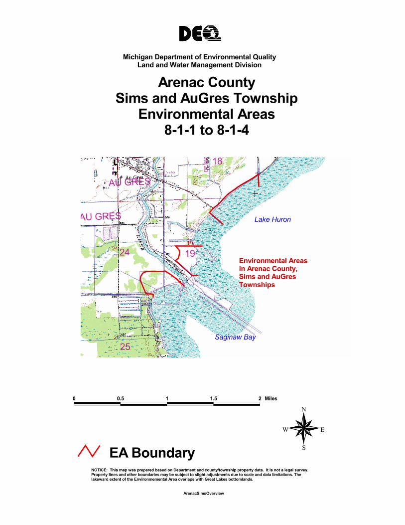
Environmental Areas in Arenac County, Sims and AuGres Townships
0 0.5 1 1.5 2 Miles
N
EW
S
ArenacSimsOverview
NOTICE: This map was prepared based on Department and county/township property data. It is not a legal survey.Property lines and other boundaries may be subject to slight adjustments due to scale and data limitations. The lakeward extent of the Environmemental Area overlaps with Great Lakes bottomlands.
EA Boundary
Michigan Department of Environmental QualityLand and Water Management Division
Arenac CountySims and AuGres Township
Environmental Areas8-1-1 to 8-1-4

Michigan Department of Environmental QualityLand and Water Management Division
Arenac County, SimsTownshipT19N R7E Sections 18 & 19
Environmental Area
Environmental Area 8-1-1
Environmental Area 8-1-2
Lake Huron
Saginaw Bay
Environmental
Tax Parcel Numbers
A = 009-0-018-300-035-01 B = 009-0-018-400-010-01 C = 009-0-018-400-010-02 D = 009-0-018-400-010-03 E = 009-0-018-400-010-04 F = 009-0-018-400-010-15 G = 009-0-018-400-020-00 H = 009-0-018-400-020-05 I = 009-0-018-400-020-06 J = 009-0-018-400-020-07 K = 009-0-018-400-020-09 L = 009-0-018-400-020-10 M = 009-0-018-400-030-01 N = 009-0-018-400-030-02 O = 009-0-018-400-030-03 P = 009-0-018-400-040-00 Q = 009-0-018-400-050-00R = 009-0-019-200-010-00
F
E DC
B
M ON
JIHK
L
G
P
Q A
R
A
Section 18 Section 19
0 0.25 0.5 0.75 1 Miles
N
Environmental Area EA Boundary
W
S
E
NOTICE: This map was prepared based on Department and county/township property data. It is not a legal survey.Property lines and other boundaries may be subject to slight adjustments due to scale and data limitations. Thelakeward extent of the Environmemental Area overlaps with Great Lakes bottomlands.
July 2001

AuGres River
Environmental Area 8-1-3
Lake Huron
Saginaw Bay
Environmental Area 8-1-4
C D
E
E
A
B
Tax parcel information
A = 009-0-019-300-005-00 B = 009-0-019-300-010-00 C = 003-0-024-400-040-00 D = 003-0-024-400-040-10 E = 003-0-024-400-040-15 F = 009-0-019-300-035-00 G = 003-0-024-400-city
F Manor Road
Sims Township
AuGres Township
Section 19Section 24
Section 25
G
Michigan Department of Environmental QualityLand and Water Management Division
Arenac County, Sims TownshipT19N R7E Section 19
Arenac County, AuGres TownshipsT19N R6E Section 24 Environmental Area
0.3 0 0.3 0.6 Miles
N
W EEnvironmental Area SEA Boundary
NOTICE: This map was prepared based on Department and county/township property data. It is not a legal survey.Property lines and other boundaries may be subject to slight adjustments due to scale and data limitations. Thelakeward extent of the Environmemental Area overlaps with Great Lakes bottomlands.
July 2001

2019
3029
31
D&M
R.R.
WORTH RD.
MAYETTE RD.
LENT
Z RD
.
WHITES BEACH RD.
STANDISH TWP.
T18N,R5E
AREN
AC S
TATE
RD.
LA F
AVE
RD.
T18N,R5E
SaginawBay
Lake Huron
Environmental Areas in Arenac CountyStandishTownship
0 0.5 1 1.5 2 2.5 Miles
N
EW
S
ArenacSimsOverview
NOTICE: This map was prepared based on Department and county/township property data. It is not a legal survey.Property lines and other boundaries may be subject to slight adjustments due to scale and data limitations. The lakeward extent of the Environmemental Area overlaps with Great Lakes bottomlands.
EA Boundary
Michigan Department of Environmental QualityLand and Water Management Division
Arenac County
Environmental AreasStandish Township
8-3-6 to 8-3-10

Michigan Department of Environmental QualityLand and Water Management Division
Arenac County, ArenacTownshipT19N R5E Sections 35 & 36
Arenac County, Standish TownshipT18N R5E Sections 1 & 2
Environmental Area
C B A
D Section 36Arenac Twp F E Section 35 Section 2
Standish Twp Rifle River
Section 1
EnvironmentalEnvironmental EnvironmentalEnvironmental Environmental Area 8-2-12Area 8-2-16 Area 8-2-15 Area 8-2-14 Area 8-2-13
Lake Huron Tax parcel information
A = 002-0-036-400-015-00 B = 002-0-036-400-010-00 C = 002-0-036-300-025-00Saginaw Bay D = 002-0-036-300-005-00 E = 002-0-036-300-055-00 F = 002-0-035-400-020-01
0 0.25 0.5 0.75 1 Miles
N
W EEnvironmental Area SEA Boundary
NOTICE: This map was prepared based on Department and county/township property data. It is not a legal survey.Property lines and other boundaries may be subject to slight adjustments due to scale and data limitations. Thelakeward extent of the Environmemental Area overlaps with Great Lakes bottomlands.
July 2001

Michigan Department of Environmental QualityLand and Water Management Division
Arenac County, Standish TownshipT18 N R5E Sections 2 & 3
Environmental Area
Environmental Area 8-2-18
A B C
Environmental Area 8-2-17D
E F
G HI
J K
Lake Huron Saginaw Bay
Tax parcel information
A = 010-1-002-200-015-00 B = 010-1-002-200-015-05 C = 010-1-002-100-010-00 D = 010-1-003-100-015-00 E = 010-1-003-400-010-00 F = 010-1-003-400-015-15 G = 010-1-003-400-020-00 H = 010-1-003-400-025-00 I = 010-1-003-400-030-00 J = 010-1-003-400-035-00 K = 010-1-003-400-040-00
Section 2Section 3
0 0.25 0.5 Miles N
W EEnvironmental Area SEA Boundary
NOTICE: This map was prepared based on Department and county/township property data. It is not a legal survey.Property lines and other boundaries may be subject to slight adjustments due to scale and data limitations. Thelakeward extent of the Environmemental Area overlaps with Great Lakes bottomlands.
July 2001

Michigan Department of Environmental QualityLand and Water Management Division
Arenac County, Standish TownshipT18 N R5E Section 10 Environmental Area
Environmental Area 8-3-1
Environmental Area 8-2-19
Pine River Saginaw Bay
Lake Huron
Tax parcel information
A = 010-1-010-300-005-00 B = 010-1-010-200-025-00
A
B
Pine River Road
0 0.25 0.5 0.75 1 Miles
N
W EEnvironmental Area SEA Boundary
NOTICE: This map was prepared based on Department and county/township property data. It is not a legal survey.Property lines and other boundaries may be subject to slight adjustments due to scale and data limitations. Thelakeward extent of the Environmemental Area overlaps with Great Lakes bottomlands.
July 2001

Palmer Road
Michigan Department of Environmental QualityLand and Water Management Division
Arenac County, StandishTownshipT18 N R5E Sections 15 & 16
Environmental Area
A B
EnvironmentalC Area 8-3-2
D Saginaw Bay
EnvironmentalIrwin Road Area 8-3-3
E Tax parcel information
EnvironmentalF Area 8-3-4 A = 010-1-015-200-005-00 B = 010-1-015-200-010-00 C = 0101-016-100-005-00
G D = 010-1-016-100-015-00 E = 010-1-016-300-005-05
Environmental F = 010-1-016-300-005-15 Area 8-3-5 G = 010-1-016-300-010-00
Sagatoo Road
Lake Huron
0 0.25 0.5 0.75 1 Miles
N
W EEnvironmental Area SEA Boundary
NOTICE: This map was prepared based on Department and county/township property data. It is not a legal survey.Property lines and other boundaries may be subject to slight adjustments due to scale and data limitations. Thelakeward extent of the Environmemental Area overlaps with Great Lakes bottomlands.
July 2001
Michigan Department of Environmental QualityLand and Water Management Division
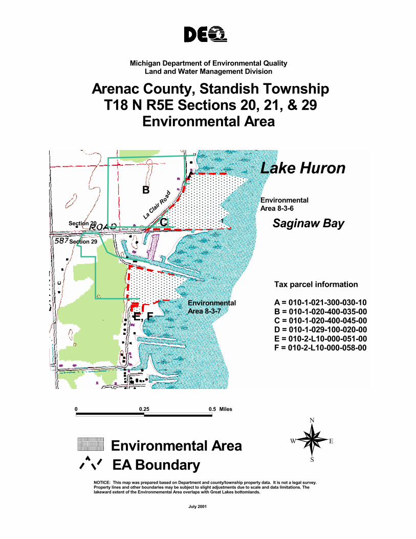
Arenac County, Standish TownshipT18 N R5E Sections 20, 21, & 29
Environmental Area
A B
Environmental Area 8-3-7
Environmental Area 8-3-6
Saginaw Bay
Lake Huron
E, F
D Tax parcel information
A = 010-1-021-300-030-10 B = 010-1-020-400-035-00 C = 010-1-020-400-045-00 D = 010-1-029-100-020-00 E = 010-2-L10-000-051-00 F = 010-2-L10-000-058-00
LaClair
Ro ad
Section 29
Section 20 Section 21C
0 0.25 0.5 Miles
N
W EEnvironmental Area SEA Boundary
NOTICE: This map was prepared based on Department and county/township property data. It is not a legal survey.Property lines and other boundaries may be subject to slight adjustments due to scale and data limitations. Thelakeward extent of the Environmemental Area overlaps with Great Lakes bottomlands.
July 2001

Michigan Department of Environmental QualityLand and Water Management Division
Arenac County, Standish TownshipT18 N R5E Sections 29 & 32
Environmental Area
Environmental Area 8-3-8Environmental
Area 8-3-9
Environmental Area 8-3-10
Environmental Area 8-3-11
Whites Beach Road
Saganing Creek
A
CB
D
E Saginaw Bay Lake Huron
Tax parcel information
A = 010-1-029-400-010-00 B = 010-1-029-300-065-05 C = 010-1-029-400-005-00 D = 010-1-032-200-005-00 E = 010-1-032-200-005-05
Section 29
Section 32
0 0.25 0.5 0.75 1 Miles
N
W EEnvironmental Area SEA Boundary
NOTICE: This map was prepared based on Department and county/township property data. It is not a legal survey.Property lines and other boundaries may be subject to slight adjustments due to scale and data limitations. Thelakeward extent of the Environmemental Area overlaps with Great Lakes bottomlands.
July 2001

Shady Shores Road
Tax Parcel Number
A = 09-010-S26-000-001-00
E = 09-010-S26-000-007-00F = 09-010-S26-000-009-00
B = 09-010-S26-000-004-00
M = 09-010-S26-000-017-00
J = 09-010-S26-000-014-00
N = 09-010-S26-000-018-00
R = 09-010-S35-010-008-00Q = 09-010-S35-001-005-00
C = 09-010-S26-000-005-00
G = 09-010-S26-000-011-00
L = 09-010-S26-000-016-00
D = 09-010-S26-000-006-00
I = 09-010-S26-000-013-00H = 09-010-S26-000-012-00
S = 09-010-S36-009-001-00
0 = 09-010-S35-001-001-00P = 09-010-S35-001-004-00
U = 09-010-S36-011-003-00V = 09-010-000-999-999-00
K = 09-010-S26-000-015-00
T = 09-010-S36-011-001-00
ABC D E F G HI JKLM
N
T
O
QP
S
R
U
V
Lake Huron
EnvironmentalArea 8-8
Alpin Beach
Saginaw River
Saginaw Bay
0 0.25 0.5 0.75 1 1.25 1.5 1.75 Miles
N
EW
SEnvironmental AreaEA Boundary
March 2000
NOTICE: This map was prepared based on Department and county/township property data. It is not a legal survey. Property lines and other boundaries may be sjubject to slight adjustments due to scale and data limitations. The lakeward extent of the Environmental Area overlaps with Great Lakes bottomlands.
Bay County, Bangor TownshipT14N R05E Section 3Environmental Area
Michigan Department of Environmental QualityLand and Water Management Division
1011 12
7
1314
242322
15
27 26
DETR
OIT
AND
MACK
INAC
R.R
.
SON RD.
WILLETTE DR.
THUME DR.
13
PREVO RD.
NEWBERG RD.
ERICKSON RD.
TOW
ER B
EACH
RD.
TOW
ER R
D.
CHEN RD.
TEBO DR. COGGINS RD.
DR.
DR.
TE RD.
SHERMAN RD.
D&M
R.R.
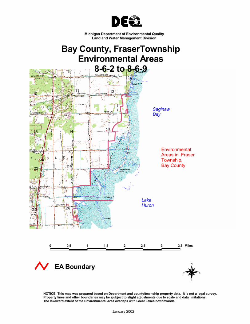
Environmental Areas in FraserTownship,Bay County
SaginawBay
LakeHuron
0 0.5 1 1.5 2 2.5 3 3.5 Miles
N
EW
S
EA Boundary
January 2002
NOTICE: This map was prepared based on Department and county/township property data. It is not a legal survey. Property lines and other boundaries may be sjubject to slight adjustments due to scale and data limitations. The lakeward extent of the Environmental Area overlaps with Great Lakes bottomlands.
Bay County, FraserTownshipEnvironmental Areas
8-6-2 to 8-6-9
Michigan Department of Environmental QualityLand and Water Management Division

Michigan Department of Environmental QualityLand and Water Management Division
Bay County, Fraser TownshipT16N R04E Sections 12, 13, 23, 24, 25 & 26
T16N R05E Sections 7, 18, 19 & 30
Lake
Sherman Road
Coggins Road
Erickson Road
Tower Beach Road
Kitchen Road
Gregory Drain
Prevo Road
Detroit and Mackinac Railroad
H P
K
L
N M
A
J
Environmental Area 8-6-2
Environmental Area 8-6-3
Environmental Area 8-6-4
Environmental Area 8-6-5
Environmental Area 8-6-6
B O
E #
F
# G
# C#
D I
Environmental Area 8-6-7 & 8
Tax Parcel Number
A = 09-040-002-200-090-00 B = 09-040-012-400-020-00 C = 09-040-012-400-030-00 D = 09-040-012-400-035-00 E = 09-040-012-400-040-00 F = 09-040-012-400-040-01 G = 09-040-012-400-040-02 H = 09-040-013-100-005-00 I = 09-040-013-200-010-00
J = 09-040-023-400-005-00 K = 09-040-024-100-005-00 L = 09-040-026-200-020-00 M = 09-040-026-200-322-00 N = 09-040-026-200-323-99 O = 09-040-041-100-005-00 P = 09-040-042-100-005-00
Lake Huron
SaginawBay
0 0.25 0.5 0.75 1 1.25 1.5 1.75 2 2.25 2.5 2.75 3 3.25 3.5 3.75 Miles
EA Boundary N
Environmental Area W E
S
NOTICE: This map was prepared based on Department and county/township property data. It is not a legal survey.Property lines and other boundaries may be sjubject to slight adjustments due to scale and data limitations.The lakeward extent of the Environmental Area overlaps with Great Lakes bottomlands.
March 2000

ExcludedEnvironmental
Area 8-6-9
F = 09-040-026-400-085-00
Tax Parcel Number
A = 09-040-026-400-050-00
C = 09-040-026-400-070-00
I = 09-040-026-400-316-99
E = 09-040-026-400-080-00
B = 09-040-026-400-065-00
G = 09-040-026-400-314-99 H = 09-040-026-400-315-99
D = 09-040-026-400-075-00
FIF
E D
C H
G B
A
Lake Huron Elevator Road
Sherman Road
Anderson Road SaginawBay
Michigan Department of Environmental QualityLand and Water Management Division
Bay County, Fraser TownshipT16N R04E Section 26 Environmental Area
0 0.25 0.5 Miles
EA Boundary W
N
E
Environmental Area S
NOTICE: This map was prepared based on Department and county/township property data. It is not a legal survey.Property lines and other boundaries may be sjubject to slight adjustments due to scale and data limitations.The lakeward extent of the Environmental Area overlaps with Great Lakes bottomlands.
March 2000
161718
212019
28
2930
ARMS RD.
HAMPTON RD.
NEBOBISH RD.
RIDGE RD.
KNODT RD.15
14
22 2324
2726 25
KNIG
HT R
D.
78
9
BURNS RD.
25WARNER RD.
FINN RD.
FARLEY RD.
CALLAMAN RD.
COTTER RD.
NOLET RD.
BORTON RD.
JONE
S RD
.
WAGNER RD.
HAMPTON TWP.
Lake Huron
Saginaw Bay
Environmental Areas in HamptonTownship,Bay County, Michigan
0 0.5 1 1.5 2 2.5 3 3.5 4 4.5 5 5.5 Miles
N
EW
S
EA Boundary
March 2000
NOTICE: This map was prepared based on Department and county/township property data. It is not a legal survey. Property lines and other boundaries may be sjubject to slight adjustments due to scale and data limitations. The lakeward extent of the Environmental Area overlaps with Great Lakes bottomlands.
Michigan Department of Environmental QualityLand and Water Management Division
Bay County, HamptonTownshipEnvironmental Areas
8-7-2 to 8-7-14

Michigan Department of Environmental QualityLand and Water Management Division
Bay County, Hampton TownshipT14N R06E Sections 08 & 09
Environmental Area
Lake Huron"Tax Parcel Numbers" A = 070-041-200-005-00Environmental B = 070-042-300-005-00
Area 8-7-3 & 4 C = 070-042-300-005-01 Saginaw Bay Environmental Area 8-7-5A
Environmental Area 8-7-6
C B Farley Road
Meilans Road
Finn Road
0 0.3 0.6 0.9 1.2 1.5 1.8 2.1 2.4 2.7 3 Miles
EA Boundary N
Environmental Area W E
S
NOTICE: This map was prepared based on Department and county/township property data. It is not a legal survey.Property lines and other boundaries may be sjubject to slight adjustments due to scale and data limitations.The lakeward extent of the Environmental Area overlaps with Great Lakes bottomlands.
March 2000

M-25
Michigan Department of Environmental QualityLand and Water Management Division
Bay County, Hampton TownshipT14N R05E Sections 14, 23, 24, & 25
Environmental Area
B Lake Huron Tax Paracel numbersC A = 070-044-100-005-00A B = 070-044-100-015-00Saginaw Bay C = 070-044-100-020-00 D = 070-044-400-005-00
D E = 070-053-200-010-00 Borton Ave F = 070-054--200-005-00
G = 070-054-200-005-00E
Environmental Areas 8-7-7 to 8-7-14Nebodish Road
FNolet Road Warner Road
G
Cotter Road
0 0.25 0.5 0.75 1 1.25 1.5 1.75 2 2.25 2.5 Miles
EA Boundary N
Environmental Area W E
S
NOTICE: This map was prepared based on Department and county/township property data. It is not a legal survey.Property lines and other boundaries may be sjubject to slight adjustments due to scale and data limitations.The lakeward extent of the Environmental Area overlaps with Great Lakes bottomlands.
March 2000

15
22
14 13 18
23 24 19
30252627
MALO
NEY
RD.
RASHOTT RD.
MOUNT FOREST RD.
LAPAN RD.
6123
1011
12 7
13
PINCONNING
NEUMAN RD.
SHOR
E RD
WIRBEL RD.
KAISER RD.
DENNY RD.
AIRP
ORT
RD.
PINCONNING R.
D&M
R.R.
D&M
R.R.
R.
PINCONNING
LakeHuron
SaginawBay
Environmental Areas inPinconningTownshipBay County
0 0.5 1 1.5 2 2.5 3 3.5 4 4.5 5 Miles
N
EW
S
EA Boundary
January 2002
NOTICE: This map was prepared based on Department and county/township property data. It is not a legal survey. Property lines and other boundaries may be sjubject to slight adjustments due to scale and data limitations. The lakeward extent of the Environmental Area overlaps with Great Lakes bottomlands.
Michigan Department of Environmental QualityLand and Water Management Division
Bay County, PinconningTownshipEnvironmental Areas
8-4-1 to 8-5-1

Michigan Department of Environmental QualityLand and Water Management Division
Bay County, Pinconning TownshipT17N R05E Section 06 Environmental Area
Rashott Road
Environmental Area 8-4-1
B
A
EnvironmentalArea 8-4-2
Whitefeather "Tax Parcel Number"
A
Lake Huron
Environmental Area 8-4-2
Whitefeather
"Tax Parcel Number"
A = 09-012-037-300-010-00 B = 09-120-037-300-095-00
SaginawBay
0 0.25 Miles
EA Boundary N
Environmental Area W E
S
NOTICE: This map was prepared based on Department and county/township property data. It is not a legal survey.Property lines and other boundaries may be sjubject to slight adjustments due to scale and data limitations.The lakeward extent of the Environmental Area overlaps with Great Lakes bottomlands.
March 2000

Michigan Department of Environmental QualityLand and Water Management Division
Bay County, Pinconning TownshipT17N R05E Sections 06 & 07
Environmental Area
A "Tax Parcel Number"B D A = 09-120-038-300-080-00 B = 09-120-038-300-090-00 C = 09-120-038-300-100-00Environmental D = 09-120-038-300-100-01Area 8-4-5C E = 09-120-038-300-010-00
E Environmental Area 8-4-6
0 0.25 0.5 Miles
EA Boundary W
N
E
Environmental Area S
NOTICE: This map was prepared based on Department and county/township property data. It is not a legal survey.Property lines and other boundaries may be sjubject to slight adjustments due to scale and data limitations.The lakeward extent of the Environmental Area overlaps with Great Lakes bottomlands.
March 2000

Whitefeather Road
AB
EnvironmentalArea 8-4-3
EnvironmentalArea 8-4-4C
Michigan Department of Environmental QualityLand and Water Management Division
Bay County, Pinconning TownshipT17N R05E Section 07 Environmental Area
"Tax Parcel Number"Whitefeather Road A = 09-120-038-100-050-00
B = 09-120-038-100-050-01 C = 09-120-038-100-060-00AB
Environmental Lake Area 8-4-3 Huron
SaginawEnvironmental BayArea 8-4-4C
0 0.25 0.5 Miles
EA Boundary W
N
E
Environmental Area S
NOTICE: This map was prepared based on Department and county/township property data. It is not a legal survey.Property lines and other boundaries may be sjubject to slight adjustments due to scale and data limitations.The lakeward extent of the Environmental Area overlaps with Great Lakes bottomlands.
March 2000

Michigan Department of Environmental QualityLand and Water Management Division
Bay County,Pinconning Township17N R05E Section 18 Environmental Area
E = 09-120-039-100-030-00
H = 09-120-039-100-030-03
"Tax Parcel Numbers"
A = 09-120-L05-000-019-00
F = 09-120-039-100-030-01
D = 09-120-L05-000-030-00
G = 09-120-039-100-030-02
B = 09-120-L05-000-025-00 C = 09-120-L05-000-028-00
Lake Huron
D
C
B
F
G
H
E
A
Mt. Forest Road
Lapan Subdivision
Environmental Area 8-4-7
D
C
B
F
G
H
E
A
Mt. Forest Road
Lapan Subdivision
SaginawBay
0 0.25 0.5 Miles
EA Boundary W
N
E
Environmental Area S
NOTICE: This map was prepared based on Department and county/township property data. It is not a legal survey.Property lines and other boundaries may be sjubject to slight adjustments due to scale and data limitations.The lakeward extent of the Environmental Area overlaps with Great Lakes bottomlands.
March 2000

Tax Parcel Numbers
A = 09-120-040-100-010-00B = 09-120-041-100-010-00C = 09-120-041-100-010-01D = 09-120-041-100-020-00E = 09-120-041-100-020-01F = 09-120-041-300-040-00G = 09-120-041-300-060-00
Michigan Department of Environmental QualityLand and Water Management Division
Bay County, Pinconning TownshipT17N R05E Sections 19,25 & 30
Environmental Area
Excluded
Environmental Area 8-4-9
Environmental Area 8-4-10
Environmental Area 8-4-11
Environmental Area 8-5-1
A
BC
D
E
GF
Cody-Esty Road
Pinconning Road
PinconningCountyPark
Excluded
Environmental Area 8-4-9
Environmental Area 8-4-10
Environmental Area 8-4-11
A
BC
D
E
G F
Cody-Esty Road
PinconningCountyPark
Pinconning Road
Tax Parcel Numbers
A = 09-120-040-100-010-00 B = 09-120-041-100-010-00 C = 09-120-041-100-010-01 D = 09-120-041-100-020-00 E = 09-120-041-100-020-01 F = 09-120-041-300-040-00 G = 09-120-041-300-060-00
Lake Huron
SaginawBay
0 0.25 0.5 0.75 1 1.25 1.5 1.75 2 2.25 2.5 Miles
EA Boundary N
Environmental Area W E
S
NOTICE: This map was prepared based on Department and county/township property data. It is not a legal survey.Property lines and other boundaries may be sjubject to slight adjustments due to scale and data limitations.The lakeward extent of the Environmental Area overlaps with Great Lakes bottomlands.
March 2000

MUD
2930
RICHMOND RD.
POBANZ RD.
MUD CREEK
MCKINLE
12 7 8 9
17
20
DUNN RD.
MUDLAKE
RICHMOND RD.
MUD LAKE
25
Saginaw Bay
Lake Huron
Environmental Areas In Caseville andMc Kinley TowhshipsHuron County
2 0 2 Miles
N
EW
S
EA Boundary
Notice: This map was prepared based on Department and county/township property data. It is not a legal survey.Property lines and other boundaries may be subject to slight adjustments due to scale and data limitations. The lakeward extent of the Environmental Area overlaps with Great Lakes bottomlands
January 2002
Michigan Department of Environmental QualityLand and Water Management Division
Huron County, Caseville andMcKinley TownshipsEnvironmental Areas
11-7-1 to 11-8-3

Huron County, McKinley TownshipT17N R10E Section 30 Environmental Area
30
25B = 3215-030-001-00
Tax-Parcel Numbers:
A = 3215-030-002-00
C = Highway right of way
A
B
B
Lake Huron
Environmental Area 11-7-1
M-25
C
SaginawBay
0 0.25 0.5 Miles
N
EA Boundary W E
Environmental Area S
Notice: This map was prepared based on Department and county/township property data. It is not a legal survey.Property lines and other boundaries may be subject to slight adjustments due to scale and data limitations. The lakeward extent of the Environmental Area overlaps with Great Lakes bottomlands
March 2000

Section 30
M-25
Section 19 Section 20
Section 29
F
Michigan Department of Environmental QualityLand and Water Management Division
Huron County, McKinley TownshipT17N R10E Sections 19, 20 & 30
Environmental Area
Lake EHuron
Saginaw D Bay
Environmental Area 11-7-2
Tax-Parcel Numbers: B A = 3215-019-001-00 B = 3215-020-010-25 C = 3215-020-004-00 D = 3215-020-011-00 E = 3215-020-010-26 F = 3215-030-001-00 CA
0 0.25 0.5 Miles N
EA Boundary Environmental Area
W
S
E
Notice: This map was prepared based on Department and county/township property data. It is not a legal survey.Property lines and other boundaries may be subject to slight adjustments due to scale and data limitations. Thelakeward extent of the Environmental Area overlaps with Great Lakes bottomlands
March 2000

Filion Rd
M-25
20
Michigan Department of Environmental QualityLand and Water Management Division
Huron County, McKinley TownshipT17N R10E Section 20 Environmental Area
Lake Huron Environmental
Area 11-7-4
SaginawBay
Environmental Area 11-7-3
Tax-Parcel Number: A A = 3215-020-001-00
0 0.25 0.5 0.75 Miles
N
EA Boundary Environmental Area
W
S
E
Notice: This map was prepared based on Department and county/township property data. It is not a legal survey.Property lines and other boundaries may be subject to slight adjustments due to scale and data limitations. Thelakeward extent of the Environmental Area overlaps with Great Lakes bottomlands
March 2000

Michigan Department of Environmental QualityLand and Water Management Division
Huron County, Caseville TownshipT17N R10E Sections 8 & 17
Environmental Area
H = 3215-017-100-00
E = 3215-017-103-00
G = 3215-017-102-00 F = 3215-017-101-00
Tax-Parcel Number:
A = 3204-170-038-00
D = 3204-178-064-00
B = 3204-170-039-00 C = 3204-170-039-50
A
B C D
E F
G H
Lake Huron
M-25
Dunn Rd.
Goldmann Rd.Goldmann Subdivision
Environmental Area 11-8-1
Environmental Area 11-8-2
Environmental Area 11-8-3
Excluded
SaginawBay
A
Section 8
Section 17
0 0.25 0.5 0.75 Miles
N
EA Boundary W E
Environmental Area S
Notice: This map was prepared based on Department and county/township property data. It is not a legal survey.Property lines and other boundaries may be subject to slight adjustments due to scale and data limitations. The lakeward extent of the Environmental Area overlaps with Great Lakes bottomlands
March 2000

36
1
12
13
24
25
2122
T16N,R9E
HENNE DRAIN
DRAIN
DRAIN
GETTEL
STAPLEFORD
35
2
11
1415
232221
2627
29
28
353433
2829
32 33
5
8
7
18
SHEBEON
PIGEON RD.
WEALE RD.
GEIGER
HAIST RD.
ROSE ISLAND RD.
DUTCHER RD.
KILMANA
LANGE RD.
STEIN R
WALLACE DR
FAIR HAVEN TWP.
SEBEWAING TWP.
32
CREEK
NORTH ISLAND
PITCHERS REEF
LONE TREEISLAND
DEFOEISLAND
HEISTERMAN ISLAND
ISLA
ND
MIDDLEGROUNDS
ISLAND
BAY POR
VOLTZ RD.
KUHL RD.
H. &
E. R
.R.
MANI
SOU
RIDG
E RD
.
FAIR HAVEN TWP.
T16N,R9E
25
25
142
Lake Huron
Saginaw Bay
Lake Huron
Environmental Areasin Huron CountyFairhaven Township
0 4 Miles
N
EW
S
EA Boundary
Notice: This map was prepared based on Department and county/township property data. It is not a legal survey.Property lines and other boundaries may be subject to slight adjustments due to scale and data limitations. The lakeward extent of the Environmental Area overlaps with Great Lakes bottomlands
January 2002
Michigan Department of Environmental QualityLand and Water Management Division
Huron County,FairhavenTownship
Environmental Areas 11-4-5 to 11-9

Section 29Dutc
Rose
Islan
d Rd
.
R.
C. &
O. R
.
Michigan Department of Environmental QualityLand and Water Management Division
Huron County, Fairhaven TownshipT16N R09E Sections 29 & 32
Environmental Area
Section 29 Section 28Environmental ALake Area 11-4-8 Huron Section 32 Section 33
B Environmental
Saginaw Area 11-4-7 Bay C
Tax-Parcel Numbers:
A = 3208-029-038-00 B = 3208-032-001-00 C = 3208-032-001-50 D = 3208-032-036-00
Environmental Area 11-4-6
D
Environmental Area 11-4-5
0 0.25 0.5 0.75 1 Miles
N
EA Boundary Environmental Area
W
S
E
Notice: This map was prepared based on Department and county/township property data. It is not a legal survey.Property lines and other boundaries may be subject to slight adjustments due to scale and data limitations. Thelakeward extent of the Environmental Area overlaps with Great Lakes bottomlands
March 2000

Rose
Islan
d Rd.
Michigan Department of Environmental QualityLand and Water Management Division
Huron County, Fairhaven TownshipT16N R09E Section 28 Environmental Area
Environmental DArea 11-5-1
Lake AHuron
SaginawBay
Tax-Parcel Numbers:
A = 3208-028-007-00
Environmental Area 11-5-1
E
B = 3208-028-012-00 B C = 3208-028-006-00 D = 3208-100-076-20 E = 3208-028-005-00
C
0 0.25 Miles
N
EA Boundary Environmental Area
W E
S
Notice: This map was prepared based on Department and county/township property data. It is not a legal survey.Property lines and other boundaries may be subject to slight adjustments due to scale and data limitations. Thelakeward extent of the Environmental Area overlaps with Great Lakes bottomlands
March 2000
EnvironmentalArea 11-5-5
C. &
O. R
.R.
EnvironmentalArea 11-5-4
dge R
d.
Environmental Section 21 Section 22 Area 11-5-2 iR
Haist Rd. Section 27 Haist Rd.
Section 28
C. &
O. R
. R.
Michigan Department of Environmental QualityLand and Water Management Division
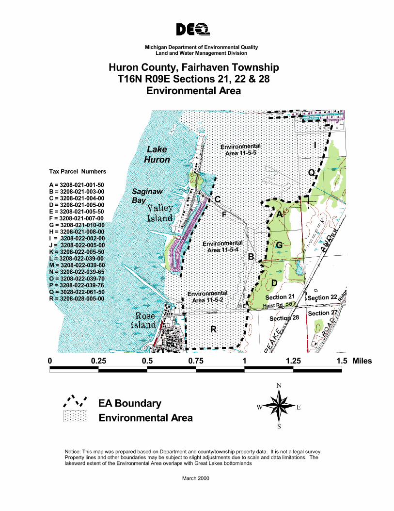
Huron County, Fairhaven TownshipT16N R09E Sections 21, 22 & 28
Environmental Area
K J
L NM P O
ILake Huron
Tax Parcel Numbers
A = 3208-021-001-50 B = 3208-021-003-00 C = 3208-021-004-00 D = 3208-021-005-00 E = 3208-021-005-50 F = 3208-021-007-00 G = 3208-021-010-00 H = 3208-021-008-00 I = 3208-022-002-00
Q SaginawBay C
F A
GJ = 3208-022-005-00 K = 3208-022-005-50 L = 3208-022-039-00 M = 3208-022-039-60 N = 3208-022-039-65 O = 3208-022-039-70
B
DP = 3208-022-039-76 Q = 3028-022-061-50R = 3208-028-005-00
H E
R
0 0.25 0.5 0.75 1 1.25 1.5 Miles
N
EA Boundary Environmental Area
W
S
E
Notice: This map was prepared based on Department and county/township property data. It is not a legal survey.Property lines and other boundaries may be subject to slight adjustments due to scale and data limitations. Thelakeward extent of the Environmental Area overlaps with Great Lakes bottomlands
March 2000

C. & O
. R.R.
Geiger Rd.
Michigan Department of Environmental QualityLand and Water Management Division
Huron County, Fairhaven TownshipT16N R09E Sections 15 & 16
Environmental Area
Lake Huron
SaginawBay A
Tax-Parcel Numbers:
Environmental Area 11-5-6
A = 3208-015-020-50 B = 3208-015-021-00 C = 3208-015-024-00 D = 3208-015-020-00
D
B Environmental
Area 11-5-7
C
Section 15Section 16
0 0.25 0.5 0.75 1 Miles
N
EA Boundary Environmental Area
W
S
E
Notice: This map was prepared based on Department and county/township property data. It is not a legal survey.Property lines and other boundaries may be subject to slight adjustments due to scale and data limitations. Thelakeward extent of the Environmental Area overlaps with Great Lakes bottomlands
March 2000

Stapleford Drain
C. & O
. R.R.
Weale Rd.
Michigan Department of Environmental QualityLand and Water Management Division
Huron County, Fairhaven TownshipT16N R09E Sections 10 & 11
Environmental Area
Environmental Area 11-6-3
Lake A Huron
Environmental Area 11-6-2
SaginawBay
Environmental BArea 11-6-1 Tax-Parcel Numbers:
A = 3208-011-012-00 B = 3208-011-019-00 C = 3208-010-001-00
Section 11CSection 10
0 0.25 0.5 0.75 1 Miles N
EA Boundary Environmental Area
W
S
E
Notice: This map was prepared based on Department and county/township property data. It is not a legal survey.Property lines and other boundaries may be subject to slight adjustments due to scale and data limitations. Thelakeward extent of the Environmental Area overlaps with Great Lakes bottomlands
March 2000

Excluded
Pigeon Rd.
Michigan Department of Environmental QualityLand and Water Management Division
Huron County, Fairhaven TownshipT16N R09E Section 2 Environmental Area
Lake ExcludedHuron BB
Environmental Saginaw Area 11-6-5 Bay
A Tax-Parcel Numbers: Environmental
Area 11-6-4A = 3208-002-010-00 B = 3208-002-007-00
0 0.25 N
0.5 Miles
EA Boundary Environmental Area
W
S
E
Notice: This map was prepared based on Department and county/township property data. It is not a legal survey.Property lines and other boundaries may be subject to slight adjustments due to scale and data limitations. Thelakeward extent of the Environmental Area overlaps with Great Lakes bottomlands
March 2000

Michigan Department of Environmental QualityLand and Water Management Division
Huron County, Fairhaven TownshipT16N R09E Section 2 & 17N R09E Section 35
Environmental Area
Lake Huron
SaginawBay
Tax-Parcel Numbers:
A = 3208-002-006-00 B = 3208-002-005-50 C = 3208-002-005-00 D = 3208-135-001-30 E = 3208-135-001-25 F = 3208-135-001-20 G = 3208-135-001-00
Environmental Area 11-6-6a
Environmental Area 11-6-6b
Environmental Area 11-6-7a
G
F
E BD
C
A M-
25
Section 35
Section 2
0 0.25 0.5 0.75 Miles
N
EA Boundary W E
Environmental Area S
Notice: This map was prepared based on Department and county/township property data. It is not a legal survey.Property lines and other boundaries may be subject to slight adjustments due to scale and data limitations. The lakeward extent of the Environmental Area overlaps with Great Lakes bottomlands
March 2000

Excluded
Michigan Department of Environmental QualityLand and Water Management Division
Huron County, Fairhaven TownshipT17N R09E Sections 21 & 22
Environmental Area
Lake Saginaw BayHuron
Tax Parcel Number EnvironmentalArea 11-9-1 Wildfowl Bay
A = 3208-121-003-00 AB= 3208-121-002-00 To Sand Point Caseville Twp.C = 3208-121-002-40 BD= 3208-121-001-00 CE = 3208-121-001-30 D EnvironmentalF = 3208-121-001-40 Area 11-9-2G = 3208-121-001-50
E F GH IH = 3208-121-001-60 JI = 3208-137-002-50 J = 3208-137-001-00 K To
Bay PortK = 3208-137-001-50 LL = 3208-137-001-70 North Island Section 21 Section 22
0 0.25 0.5 0.75 1 1.25 1.5 Miles
N
EA Boundary W E
Environmental Area S
Notice: This map was prepared based on Department and county/township property data. It is not a legal survey.Property lines and other boundaries may be subject to slight adjustments due to scale and data limitations. Thelakeward extent of the Environmental Area overlaps with Great Lakes bottomlands
March 2000

Lake Huron
Environmental Areain Gore TowhshipHuron County
0.5 0 0.5 1 1.5 Miles
N
EW
S
EA Boundary
Notice: This map was prepared based on Department and county/township property data. It is not a legal survey.Property lines and other boundaries may be subject to slight adjustments due to scale and data limitations. The lakeward extent of the Environmental Area overlaps with Great Lakes bottomlands
March 2000
Michigan Department of Environmental QualityLand and Water Management Division
Huron County, GoreTownshipEnvironmental Area11-10-1 to 11-10-3

Michigan Department of Environmental QualityLand and Water Management Division
Huron County, Gore TownshipT18N R15E Sections 17 & 18
Environmental Area
Environmental Area 11-10-2
125' north of center of access road
except 160' in the exclusion (shown)
Environmental Area 11-10-3
E = 3209-018-009-00 D = 3209-018-007-00
B = 3209-017-004-00 A = 3209-017-003-00
C = 3209-017-005-00
Tax-Parcel Numbers:
CBA
E
D
Lake Huron
WhiskeyHarbor
Pochert Rd.
Access Rd.
Environmental Area 11-10-1
0 0.25 0.5 Miles N
EA Boundary W E
Environmental Area S
Notice: This map was prepared based on Department and county/township property data. It is not a legal survey.Property lines and other boundaries may be subject to slight adjustments due to scale and data limitations. The lakeward extent of the Environmental Area overlaps with Great Lakes bottomlands
March 2000

20
21
2829
30
POINTE AUX BARQUES TWP
PORTAUSTIN
BARANSKI D
HELLEMS RD.
POINTE AUX
PORT AUSTIN
Environmental Areain Pt. Aux Barques Township, Huron County
Lake Huron
Saginaw Bay
1 0 1 Miles
N
EW
S
EA Boundary
Notice: This map was prepared based on Department and county/township property data. It is not a legal survey.Property lines and other boundaries may be subject to slight adjustments due to scale and data limitations. The lakeward extent of the Environmental Area overlaps with Great Lakes bottomlands
March 2000
Michigan Department of Environmental QualityLand and Water Management Division
Huron County, Pt. Aux BarquesTownshipEnvironmental Area
11-13

Port
Austi
n Blvd
.
Michigan Department of Environmental QualityLand and Water Management Division
Huron County, Point Aux Barques TownshipT19N R13E Sections 20 & 21
Environmental Area
Lake Huron
Some roads shown here
were not constructed.
I C
B
E
D
F
Tax-Parcel Numbers:
A = 3219-020-001-00 B = 3219-021-008-00 C = 3219-021-089-00 D = 3219-021-013-00 E = 3219-021-008-00 F = 3219-021-008-00 G = 3219-021-004-00 H = 3219-021-006-00 I = 3219-021-089-95
Environmental Area 11-13
Section 20
A
G
H
Section 21
0.25 0 0.25 Miles
N
EA Boundary Environmental Area
W
S
E
Notice: This map was prepared based on Department and county/township property data. It is not a legal survey.Property lines and other boundaries may be subject to slight adjustments due to scale and data limitations. Thelakeward extent of the Environmental Area overlaps with Great Lakes bottomlands.
July 2001

LION RD.
RAMSEY RD.
STAFFORD RD.
SCHMUCKER RD.
HARDWOOD POINT
SCHMUCKER CREEK
16
21 22
2728
15
33 34 35 36
25
Lake Huron
Environmental Areasin Rubicon TownshipHuron County
0 2 4 Miles
N
EW
SEnvironmental AreaEA Boundary
Notice: This map was prepared based on Department and county/township property data. It is not a legal survey.Property lines and other boundaries may be subject to slight adjustments due to scale and data limitations. The lakeward extent of the Environmental Area overlaps with Great Lakes bottomlands
January 2002
Michigan Department of Environmental QualityLand and Water Management Division
Huron County, Rubicon TownshipEnvironmental Areas
11-11-1 to 11-12-5

M-25
M-25
Michigan Department of Environmental QualityLand and Water Management Division
Huron County, Rubicon TownshipT17N R15E Sections 10 & 15
Environmental Area
A Environmental Area 11-11-1 Lake
Huron
Environmental B Area 11-11-2 Tax-Parcel Numbers:
A = 3221-010-094-00 B = 3221-015-001-00 C = 3221-015-002-50 D = 3221-015-004-00 E = 3221-015-002-00
C
Environmental Area 11-11-3
D E
0 0.25 0.5 0.75 Miles
N
EA Boundary Environmental Area
W
S
E
Notice: This map was prepared based on Department and county/township property data. It is not a legal survey.Property lines and other boundaries may be subject to slight adjustments due to scale and data limitations. Thelakeward extent of the Environmental Area overlaps with Great Lakes bottomlands
March 2000

C & O Railroad
M-25
Michigan Department of Environmental QualityLand and Water Management Division
Huron County, Rubicon TownshipT17N R15E Section 26 Environmental Area
Lake Huron
A
B Environmental Area 11-12-1
Tax-Parcel Numbers:
A = 3221-026-008-00 B = 3221-026-012-00
C C = 3221-026-009-00 D = 3221-026-017-00 E = 3221-026-015-00
B
Environmental Area 11-12-2
D
E
0 0.25 0.5 Miles
N
EA Boundary Environmental Area
W
S
E
Notice: This map was prepared based on Department and county/township property data. It is not a legal survey.Property lines and other boundaries may be subject to slight adjustments due to scale and data limitations. Thelakeward extent of the Environmental Area overlaps with Great Lakes bottomlands
March 2000

M -25
OLD SHORE ROAD
Strawberry Lane
Michigan Department of Environmental QualityLand and Water Management Division
Huron County, Rubicon TownshipT17N R15E Sections 35 & 36
Environmental Area
Environmental Area 11-12-3 Tax-Parcel Numbers:
Lake A = 3221-035-005-00Huron B = 3221-035-007-00 C = 3221-036-001-00A D = 3221-036-013-00Section 35 Section 36 E = 3221-036-005-00 F = 3221-036-009-90 G = 3221-036-009-00 H = 3221-036-010-00
Environmental I = 3221-036-009-80C Area 11-12-4 J = 3221-036-012-00B K = 3221-036-011-00 L = 3221-036-011-50
G HKL
I J F
D
E Environmental Area 11-12-5
0 0.25 0.5 0.75 1 Miles
N
EA Boundary Environmental Area
W
S
E
Notice: This map was prepared based on Department and county/township property data. It is not a legal survey.Property lines and other boundaries may be subject to slight adjustments due to scale and data limitations. Thelakeward extent of the Environmental Area overlaps with Great Lakes bottomlands
March 2000

LIKEN
RD.
ROSE
RID
GE R
D.5
8
7SEBEWAING
WEST BR.
HURO
N AN
D EA
STER
N R.
R.
SEBEWAINGAIRPORT
SEBEWAING AIRPORT
SEBEWAING
25
Lake Huron
SaginawBay
Environmental AreasIn Sebewaing TownshipHuron County
1 0 1 Miles
N
EW
S
EA Boundary
Notice: This map was prepared based on Department and county/township property data. It is not a legal survey.Property lines and other boundaries may be subject to slight adjustments due to scale and data limitations. The lakeward extent of the Environmental Area overlaps with Great Lakes bottomlands
January 2002
Michigan Department of Environmental QualityLand and Water Management Division
Huron CountySebewaing TownshipEnvironmental Areas
11-4-1 to 11-4-4

Michigan Department of Environmental QualityLand and Water Management Division
Huron County, Sebewaing TownshipT15N R09E Section 7 Environmental Area
Tax-Parcel Numbers:
A = 3239-007-084-50 B = 3239-007-098-00
Lake Huron
Environmental Area 11-4-1 A
B Bay St.
C. &
O. R
.R.
Sebewaing St.
Sebewaing AirportSaginawBay
0.3 0 0.3 Miles
N
EA Boundary W E
Environmental Area S
Notice: This map was prepared based on Department and county/township property data. It is not a legal survey.Property lines and other boundaries may be subject to slight adjustments due to scale and data limitations. The lakeward extent of the Environmental Area overlaps with Great Lakes bottomlands
March 2000

Michigan Department of Environmental QualityLand and Water Management Division
Huron County, Sebewaing TownshipT15N R09E Sections 5, 6 & 7
Environmental Area
Tax-Parcel Numbers:
A = 3223-005-011-00 B = 3223-006-001-00 C = 3239-007-003-00
Lake Huron
Environmental Area 11-4-2
Environmental Area 11-4-3
A
B
C
SaginawBay
Sebewaing
Section 5Section 6
Section 8Section 7
0.3 0 0.3 Miles
N
EA Boundary W E
Environmental Area S
Notice: This map was prepared based on Department and county/township property data. It is not a legal survey.Property lines and other boundaries may be subject to slight adjustments due to scale and data limitations. The lakeward extent of the Environmental Area overlaps with Great Lakes bottomlands
March 2000

Excluded
Tax-Parcel Numbers:
A = 3223-005-001-00
C = 3223-005-003-00 B = 3223-005-002-00 D = 3223-005-005-60
A
B
C
D D
Environmental Area 11-4-4
Lake Huron
Kilmanagh Rd. Exc.
SaginawBay
Section 32
Section 5
Michigan Department of Environmental QualityLand and Water Management Division
Huron County, Sebewaing TownshipT15N R09E Section 5 Environmental Area
0 0.25 0.5 Miles N
EA Boundary W E
Environmental Area S
Notice: This map was prepared based on Department and county/township property data. It is not a legal survey.Property lines and other boundaries may be subject to slight adjustments due to scale and data limitations. The lakeward extent of the Environmental Area overlaps with Great Lakes bottomlands
March 2000

UNIONVILLE
LOOMIS RD.
KINDLER RD.
9 10
1615
23222120
3029 28 27 26
BERGER RD.
WILDNER RD.
GOTHAM RD.
ZIMMERMAN RD.
LIKEN
RD.
12
13
24
25
NEIGHBORHOOD
THOMAS RD.
AUSTIN RD.
RINGLE RD. CLARK RD.
FORE
ST RD
.
ARMBUSTER DRAIN
WISCOGGIN DRAIN
AKRO
N TW
P.
HURO
N &
EAST
ERN
R.R.
25
Saginaw Bay
Lake Huron
Environmental Areasin Tuscola CountyAkron Township
0 1 2 3 4 Miles
N
EW
SEnvironmental AreaEA Boundary
January 2002
NOTICE: This map was prepared based on Department and county/township property data. It is not a legal survey.Property lines and other boundaries may be subject to slight adjustments due to scale and data limitations. The lakeward extent of the Enviromental Area overlaps with Great Lakes bottomlands.
Michigan Department of Environmental QualityLand and Water Management Division
Tuscola County, Akron TownshipEnvironmental Areas
11-3-4 to 11-4-1

State DesignatedEnvironmental Area
11-1
Saginaw Bay
Quanicassee River
Canal Drive
Michigan Department of Environmental QualityLand and Water Management Division
Tuscola County, Akron TownshipT15N R08E Sections 20, 29 & 30
Environmental Area
2120
30 29 28
THOMAS RD.
AUSTIN RD.
Tax Parcel Numbers
A = 79-01-120-000-0100 B = 79-01-120-000-0200 C = 79-01-120-000-0300 D = 79-01-120-000-0400 E = 79-01-120-000-0425 F = 79-01-129-000-0300 G = 79-01-130-000-0100
A
C
DE B
F
G
Thomas
Environmental Area 11-3-5
Environmental Area 11-3-4
Environmental Area 11-3-2
Environmental Area 11-3-3
Environmental Area 11-3-1
GOTHAM RD.
Lake Huron Saginaw Bay
C
0 0.25 0.5 0.75 1 1.25 1.5 1.75 2 Miles
N
EA Boundary W E
Environmental Area S
NOTICE: This map was prepared based on Department and county/township property data. It is not a legal survey.Property lines and other boundaries may be subject to slight adjustments due to scale and data limitations. The lakeward extent of the Enviromental Area overlaps with Great Lakes bottomlands.
July 2000

Quanicassee River
Canal Drive
E x
9
Ringle Road
16
Saginaw Bay
State DesignatedEnvironmental Area
11-1
Michigan Department of Environmental QualityLand and Water Management Division
Tuscola County, Akron TownshipT15N R08E Section16 Environmental Area
Area 11-3-9
K A10Lake Huron
Saginaw Bay
Tax Parcel Numbers Environmental
A = 79-01-116-000-0100 Area 11-3-7
Environmental A Area 11-3-8
Environmental Area 11-3-6
0 0.25 0.5 0.75 1 1.25 1.5 Miles
EA Boundary W
N
E
Environmental Area S
NOTICE: This map was prepared based on Department and county/township property data. It is not a legal survey.Property lines and other boundaries may be subject to slight adjustments due to scale and data limitations. Thelakeward extent of the Enviromental Area overlaps with Great Lakes bottomlands.
July 2000

State DesignatedEnvironmental Area
11-1
Saginaw Bay
Quanicassee River
Canal Drive
Michigan Department of Environmental QualityLand and Water Management Division
Tuscola County, Akron TownshipT15N R08E Section 1 Environmental Area
Tax Parcel Numbers
A = 79-01-101-0100 B = 79-01-101-0200 A
B
Environmental Area 11-4-1
Lake Huron
C. &
O. R
. R.
Sebewaing Airport
Sebewaing River
Huron County
Tuscola CountySaginaw Bay
Ex
0 0.25 0.5 0.75 1 Miles
N
EA Boundary W E
Environmental Area S
NOTICE: This map was prepared based on Department and county/township property data. It is not a legal survey.Property lines and other boundaries may be subject to slight adjustments due to scale and data limitations. The lakeward extent of the Enviromental Area overlaps with Great Lakes bottomlands.
July 2000

State DesignatedEnvironmental Area
11-1
Saginaw Bay
Quanicassee River
Canal Drive
Michigan Department of Environmental QualityLand and Water Management Division
Tuscola County, Akron TownshipT15N R08E Sections 09 & 10
Environmental Area
Lake Huron
Saginaw Bay
Tax Parcel Numbers
A = 79-01-110-000-0100 B = 79-01-110-000-0200 C = 79-01-110-000-0300 E = 79-01-110-000-0500 F = 79-01-110-000-0600 G = 79-01-110-000-0700 H = 79-01-110-000-1000
Lake Hu 9 10
I = 79-01-110-000-1100 J = 79-01-110-000-1200 K = 79-01-109-000-0100
A
J
K
E C H G F I
B
Environmental Area 11-3-11
Environmental Area 11-3-10
Environmental Area 11-3-9
Fish Point
E x
Excluded
0 0.25 0.5 0.75 1 1.25 1.5 Miles
EA Boundary N
Environmental Area W
S
E
NOTICE: This map was prepared based on Department and county/township property data. It is not a legal survey.Property lines and other boundaries may be subject to slight adjustments due to scale and data limitations. The lakeward extent of the Enviromental Area overlaps with Great Lakes bottomlands.
July 2000

Quanicassee River
Canal Drive
9 10
15 BERGER RD.
13 LIKEN
RD Ringle Road
16
WILDNER RD.
ARMBUSTER DRAIN
FORE
ST RD
.
HURO
N &
EAST
ERN
R.R.
24
22 KINDLER RD. 21 23
GOTHAM RD.
Saginaw Bay
State DesignatedEnvironmental Area
11-1
Michigan Department of Environmental QualityLand and Water Management Division
Tuscola County, Akron TownshipT15N R08E Sections 13, 14, 15 & 22
Environmental Area
A Area 11-3-11 I
Environmental Environmental Lake Huron Area 11-3-17 A Area 11-3-7 Saginaw Bay
Tax Parcel Numbers BA F
Environmental Area 11-3-12
Environmental Area 11-3-13
A = 79-01-113-000-0200 B = 79-01-113-000-0700 C = 79-01-114-000-0100 D = 79-01-114-000-0200 E = 79-01-122-000-0100 F = 79-01-115-000-0100
Environmental Area 11-3-15
C
Environmental Area 11-3-16
C
D Seagull Road
Environmental Area 11-3-14E
0 0.25 0.5 0.75 1 1.25 1.5 1.75 2 Miles
EA Boundary W
N
E
Environmental Area S
NOTICE: This map was prepared based on Department and county/township property data. It is not a legal survey.Property lines and other boundaries may be subject to slight adjustments due to scale and data limitations. Thelakeward extent of the Enviromental Area overlaps with Great Lakes bottomlands.
July 2000

State DesignatedEnvironmental Area
11-1
Saginaw Bay
Quanicassee River
Canal Drive
Michigan Department of Environmental QualityLand and Water Management Division
Tuscola County, Akron TownshipT15N R08E Section 12 Environmental Area
Lake Huron Saginaw Bay
Tax Parcel Numbers
A = 79-01-112-000-0100 B = 79-01-112-000-0200 C = 79-01-112-000-0300 D = 79-01-112-000-0400 E = 79-01-112-000-0500 F = 79-01-112-000-0550
Huron
12 Environmental Area 11-3-19
Environmental Area 11-3-20
B C
A
D
E
F
Huron County
Environmental Area 11-3-18 C.
& O
. R.R
.
Tuscola County
0 0.25 0.5 0.75 Miles
EA Boundary N
Environmental Area W
S
E
NOTICE: This map was prepared based on Department and county/township property data. It is not a legal survey.Property lines and other boundaries may be subject to slight adjustments due to scale and data limitations. The lakeward extent of the Enviromental Area overlaps with Great Lakes bottomlands.
July 2000

CARSON RD.
17181314
23 24 19
302526
ALLEN RD.
36
61
1112 7
BLACK RD.
15
2221
272829
30
AKRON TWP.
WISNER TW
P.
WIS
NER
TWP.
BRADFORD RD.
BRADLEYVILLE RD.
GARNER RD.
COSENS RD.
CASS CITY RD.
ELMWOOD RD.
DICKERSON RD.
KING RD.
STREVEL RD.
ROGERS RD.
KIRK RD.
ALLEN RD.
25
Lake Huron
Saginaw Bay
Environmental Areas in Tuscola CountyWisner Township
0 1 2 3 4 Miles
N
EW
S
EA Boundary
January 2002
NOTICE: This map was prepared based on Department and county/township property data. It is not a legal survey.Property lines and other boundaries may be subject to slight adjustments due to scale and data limitations. The lakeward extent of the Enviromental Area overlaps with Great Lakes bottomlands.
Michigan Department of Environmental QualityLand and Water Management Division
Tuscola County, WisnerTownshipEnvironmental Areas
11-1-1 to 11-2-3

24
29 2530
HAMP
TON
TWP
TUSC
OLA
CO.
M - 25
BAY
CO.
Michigan Department of Environmental QualityLand and Water Management Division
WIS
NER
TWP.
0 0.2 0.4 0.6 0.8 1 1.2 1.4 1.6 Miles
EA Boundary W
N
E
Environmental Area S
Tuscola County, Wisner TownshipT14N R07E Sections 29, 30 & 31
Environmental Area Tax Parcel Numbers Area A = 79-23-031-000-0900 B = 79-23-030-000-0100 C = 79-23-029-413-0021 D = 79-23-029-000-1900 E = 79-23-029-000-3600 F = 79-23-029-000-7100 G = 79-23-029-000-0100 H = 79-23-029-000-0200 I = 79-23-029-001-0600 J = 79-23-029-000-2100
Environmental Area 11-1-1
EnvironmentalLake Huron Area 11-1-8 Saginaw Bay Environmental EnvironmentaArea 11-1-6 Area 11-1-7
Environmental Area 11-1-5
G
Environmental Environmental Area 11-1-4 H
Area 11-1-2
I J F CEnvironmental
Area 11-1-3 E F D
B
A
NOTICE: This map was prepared based on Department and county/township property data. It is not a legal survey.Property lines and other boundaries may be subject to slight adjustments due to scale and data limitations. Thelakeward extent of the Enviromental Area overlaps with Great Lakes bottomlands.
July 2000

#
Quanicassee River
Canal Drive
DICKERSON RD.
BLACK RD.
22 BRADFORD RD.
21
GILMORE RD.
Saginaw Bay
State DesignatedEnvironmental Area
11-1
Michigan Department of Environmental QualityLand and Water Management Division
Tuscola County, Wisner TownshipT14N R08E Sections 21 & 22
Environmental Area
##
Tax Parcel Numbers
A = 79-23-021-000-0100 B = 79-23-021-000-0200 C = 79-23-021-000-0300 D = 79-23-022-000-0900
Environmental Area 11-1-10 #
#
D
Environmental Area 11-1-9
A
# # #
BEnvironmental Area 11-1-8
EnvironmentalEnvironmental C Area 11-1-6 Area 11-1-7
#
#
# #####
G #
H
0 0.3 0.6 0.9 1.2 1.5 Miles
EA Boundary Environmental Area
W
N
S
E
NOTICE: This map was prepared based on Department and county/township property data. It is not a legal survey.Property lines and other boundaries may be subject to slight adjustments due to scale and data limitations. Thelakeward extent of the Enviromental Area overlaps with Great Lakes bottomlands.
July 2000

State DesignatedEnvironmental Area
11-1
Saginaw Bay
Quanicassee River
Canal Drive
1
Michigan Department of Environmental QualityLand and Water Management Division
Tuscola County, Wisner TownshipT14N R07E Section 01 Environmental Area
Tax Parcel Numbers
A = 79-23-001-000-0100 B = 79-23-001-000-0200 C = 79-23-001-000-0300
A
B
C
Environmental Area 11-2-3
Environmental Area 11-2-2
Environmental Area 11-2-1
Lake Huron Saginaw Bay
Bay Park
##
#
#
0 0.25 0.5 0.75 Miles
N
EA Boundary W E
Environmental Area S
NOTICE: This map was prepared based on Department and county/township property data. It is not a legal survey.Property lines and other boundaries may be subject to slight adjustments due to scale and data limitations. The lakeward extent of the Enviromental Area overlaps with Great Lakes bottomlands.
July 2000