department of geoinformation science technische universität berlin ws 2006/07 geoinformation...
TRANSCRIPT

Department of Geoinformation Science
Technische Universität Berlin
WS 2006/07
Geoinformation Technology: lecture 9a
Triangulated Networks
Prof. Dr. Thomas H. Kolbe
Institute for Geodesy and Geoinformation ScienceTechnische Universität Berlin
Credits: This material is mostly an english translation of the course module no. 2 (‘Geoobjekte und ihre Modellierung‘) of the open e-content platform www.geoinformation.net.

WS 2006/072 T. H. Kolbe – Geoinformation Technology: lecture 9
Department of Geoinformation Science
Triangulated Networks

WS 2006/073 T. H. Kolbe – Geoinformation Technology: lecture 9
Department of Geoinformation Science
Overview
triangle networks – “Triangulated Irregular Networks“ (TINs)
modelling of the relief by TINs
Delaunay TINs: ‘especially good‘ TINs
break lines in the relief: Constrained Delaunay TINs
triangulated networks and hydrography

WS 2006/074 T. H. Kolbe – Geoinformation Technology: lecture 9
Department of Geoinformation Science
Triangulated Networks and Terrain Models
given: n irregularly distributed points with planimetric coordinates and height values
wanted: a data model for the terrain‘s relief
observation: 3 (linear independent) points define a plane
solution: construction of a triangle network

WS 2006/075 T. H. Kolbe – Geoinformation Technology: lecture 9
Department of Geoinformation Science
Triangulated Networks and Contour Lines

WS 2006/076 T. H. Kolbe – Geoinformation Technology: lecture 9
Department of Geoinformation Science
Categorisation of TINs
triangulated networks are:
a special tesselation of the plane with the height as an additional attribute
special simplicial complexes special maps (all internal
faces are triangles) discrete, finite approximate
representatives of fields
TINs as terrain models:
it applies: z = f(x,y)Digital Terrain Models
(DTM) are often called a “2,5D representation“

WS 2006/077 T. H. Kolbe – Geoinformation Technology: lecture 9
Department of Geoinformation Science
“Bad“ and “Good“ Triangulated Networks
usual triangulation may generate sharply peaked triangles
Delaunay-Triangulation with minimum (interior) angles
WS 2006/078 T. H. Kolbe – Geoinformation Technology: lecture 9
Department of Geoinformation Science
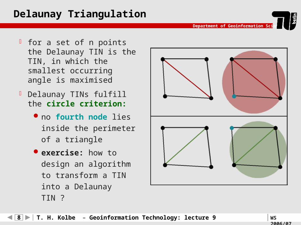
Delaunay Triangulation
for a set of n points the Delaunay TIN is the TIN, in which the smallest occurring angle is maximised
Delaunay TINs fulfill the circle criterion:
no fourth node lies
inside the perimeter of a
triangle
exercise: how to design
an algorithm to transform
a TIN into a Delaunay
TIN ?