department of environmental conservation · mr. krause 2 june 9, 2017...
TRANSCRIPT
Department of
Environmental Conservation
DIVISION OF SPILL PREVENTION AND RESPONSE Contaminated Sites Program
610 University Avenue
Fairbanks, AK 99709-3643 Phone: 907-451-2143
Fax: 907-451-2155 www.dec.alaska.gov
File: 350.38.009
June 9, 2017 Stephen Krause USAF - Elmendorf AFCEC/CZOP 10471 20th Street, Ste 348 Elmendorf AFB, JBER, Alaska 99506-2201 Re: Decision Document: Barter Island LRRS Refueling Area (CG002) Cleanup Complete Determination Dear Mr. Krause: The Alaska Department of Environmental Conservation, Contaminated Sites Program (DEC) has completed a review of the environmental records associated with the Barter Island Long Range Radar Site (LRRS) Refueling Area (CG002) located adjacent to Kaktovik, Alaska on the Beaufort Sea. Based on the information provided to date, it has been determined that the contaminant concentrations remaining on site do not pose an unacceptable risk to human health or the environment and no further remedial action will be required unless new information becomes available that indicates residual contaminants may pose an unacceptable risk. This Cleanup Complete determination is based on the administrative record for the Barter Island LRRS Refueling Area (CG002), which is located in the DEC office in Fairbanks, Alaska. This decision letter summarizes the site history, cleanup actions and levels, and standard site closure conditions that apply. Site Name and Location: Name and Mailing Address of Contact Party: Barter Island LRRS Refueling Area (CG002) Stephen Krause West of Hangar 611 CES/CEAR Barter Island Runway 10471 20th Street, Ste 348 Kaktovik, AK 99747 Elmendorf AFB, JBER, Alaska 99506-2201 DEC Site Identifiers: Regulatory Authority for Determination: File No.: 350.38.009 18 AAC 75 Hazard ID.: 4222 Site Description and Background Barter Island LRRS is located adjacent to the village of Kaktovik on the Beaufort Sea, approximately 75 miles west of the Canadian border. This installation was the prototype Distant Early Warning

Mr. Krause 2 June 9, 2017
\\FA-SVRFILE\Groups\SPAR\CS\38 Files (Contaminated Sites)\350 Barter Island-Kaktovik\350.38.009 Barter Island LRRS Refueling Area (CG002)\AAA DEC Word Docs\2017.06.09 DEC CC Ltr Barter LRRSCG002_F.docx
Line Station. The main facility was constructed from 1952–1953. In the mid-1980s, a Minimally Attended Radar was installed and is still operational today. The installation currently consists of 641 acres of low-lying tundra on the northern boundary of the Arctic National Wildlife Refuge. The U.S. Air Force (USAF) is in the process of reducing the size of the Barter Island LRRS installation to meet its current and future requirements. Debris and excess structures were removed as part of the USAF Clean Sweep Program in 2006. Additional cleanup activities were conducted by the USAF in 2008. The Barter Island Coastal Well Point Site (CG002) is an area located north and downgradient from the Former Barter Island LRRS Refueling Area (SS011), consisting of a sandy spit, with the Beaufort Sea directly to the north and the Former Refueling Area to the south. The Former Refueling Area, a former tank farm located west of the hangar and runway, is now utilized for aircraft refueling by the United States Fish and Wildlife Service under an agreement with the USAF. Aboveground fuel tanks were removed from this site during the 2006 Clean Sweep Program. Petroleum contamination, primarily from aviation gasoline, was prevalent throughout the Refueling Area north of the runway and was addressed as part of separate remedial actions. Contaminants of Concern During site characterization and cleanup at this site, samples were collected from soil and groundwater/porewater and analyzed for: gasoline range organics (GRO); diesel range organics (DRO); residual range organics (RRO); benzene, toluene, ethylbenzene, xylene (BTEX); total aromatic hydrocarbons (TAH); and total aqueous hydrocarbons (TAqH). Based on these analyses, the following contaminants were detected above the applicable cleanup levels and are considered contaminants of concern at this site:
• Gasoline Range Organics (GRO) • Benzene • Total Aqueous Hydrocarbons (TAqH)
Cleanup Levels Method Two Arctic Zone soil cleanup levels, established in 18 AAC 75.341(c), Table B2, were applicable for soils at this site. Migration to groundwater soil cleanup levels are not applicable for soils because the site is underlain by continuous permafrost. However, supra-permafrost groundwater in the active zone presents a migration pathway to water in the adjacent Beaufort Sea. As such, surface water quality standards established in 18 AAC 70 and referenced in 18 AAC 75.345(f), which stipulates that contaminated groundwater may not cause a violation of the water quality standards for surface water, were applicable for pore water at the point of compliance (the Beaufort Sea) and groundwater cleanup levels, established in 18 AAC 75.345(b)(1), Table C, were applicable for groundwater.
Table 1 – Approved Cleanup Levels
Contaminant
Soil
(mg/kg)
Groundwater
(µg/L)
Surface Water
(µg/L)
GRO 1,400 2,200 N/A Benzene 16 4.6 N/A TAqH N/A N/A 15
mg/kg = milligrams per kilogram µg/L = micrograms per liter

Mr. Krause 3 June 9, 2017
\\FA-SVRFILE\Groups\SPAR\CS\38 Files (Contaminated Sites)\350 Barter Island-Kaktovik\350.38.009 Barter Island LRRS Refueling Area (CG002)\AAA DEC Word Docs\2017.06.09 DEC CC Ltr Barter LRRSCG002_F.docx
Characterization and Cleanup Activities Characterization and cleanup activities conducted under the regulatory authority of the DEC Contaminated Sites Program began in 2006. These activities are described below. Above ground storage tanks (ASTs) were identified as the major contaminant source at the Former Refueling Area during the 2006 Clean Sweep Program. ASTs were removed from the site in 2006. Approximately 1,353 cubic yards of petroleum-contaminated soil was removed from three excavations. All but 450 cubic yards of the excavated soil was disposed of in the Kaktovik Landfill. Remaining soil was stockpiled for in-situ landfarming. Confirmation soil sampling conducted in 2006 and analyzed for BTEX, GRO, DRO, and RRO indicated two areas with GRO contamination remaining above cleanup levels. Maximum detections of GRO at the two sites were 1520 and 2490 mg/kg. In 2007 the remaining petroleum-contaminated soil was treated in-situ through the addition of fertilizer and mixing/aerating the soil. Land farming activities were completed in 2008 and treated soil and active zone water in four monitoring wells downgradient from the Former Refueling Area were sampled. Post-treatment sampling indicated that petroleum hydrocarbons detected in soil were below applicable cleanup levels; however, analytical results documented benzene and TAqH above the groundwater clean-up levels and water quality standards in the porewater/active zone water. Continued annual monitoring of active zone water for BTEX compounds was prescribed until two consecutive sampling events yielded concentrations below the water quality standards. Monitoring at CG002 was conducted at four temporary well points from 2011–2016. Well points were located as close to the original well point locations from 2008 and sampled at depths ranging 0.9–3 feet below ground surface, with the temporary points removed following each year’s annual sampling event. Results from the 2015–2016 active zone groundwater monitoring satisfied DEC’s annual monitoring requirements to demonstrate site cleanup with groundwater analytical results below water quality standards for two consecutive sampling events. Remaining benzene documented at the well points ranged 0.2–3.1 µg/L. Cumulative Risk Evaluation Pursuant to 18 AAC 75.325(g) when detectable contamination remains on-site following a cleanup, a cumulative risk determination must be made that the risk from hazardous substances does not exceed a cumulative carcinogenic risk standard of 1 in 100,000 across all exposure pathways and does not exceed a cumulative noncarcinogenic risk standard at a hazard index of one across all exposure pathways. Based on a review of the environmental record, DEC has determined that residual contaminant concentrations meet the human health cumulative risk criteria for residential land use. Exposure Pathway Evaluation Following investigation and cleanup at the site, exposure to the remaining contaminants was evaluated using DEC’s Exposure Tracking Model (ETM). Exposure pathways are the conduits by which contamination may reach human or ecological receptors. ETM results show all pathways to be one of the following: De-Minimis Exposure, Exposure Controlled, or Pathway Incomplete. A summary of this pathway evaluation is included in Table 2.

Mr. Krause 4 June 9, 2017
\\FA-SVRFILE\Groups\SPAR\CS\38 Files (Contaminated Sites)\350 Barter Island-Kaktovik\350.38.009 Barter Island LRRS Refueling Area (CG002)\AAA DEC Word Docs\2017.06.09 DEC CC Ltr Barter LRRSCG002_F.docx
Table 2 – Exposure Pathway Evaluation
Pathway Result Explanation Surface Soil Contact Pathway
Incomplete No contamination in surface soil remains.
Sub-Surface Soil Contact De-Minimis Exposure
Residual GRO contamination is present in the sub-surface, but is below human health cleanup levels.
Inhalation – Outdoor Air De-Minimis Exposure
GRO contamination remains in soil, but is below human health cleanup levels.
Inhalation – Indoor Air (vapor intrusion)
Pathway Incomplete
Buildings are not present on site that could be impacted by contaminant vapors.
Groundwater Ingestion De-Minimis Exposure
Residual benzene contamination is present in the suprapermafrost groundwater/pore water, but is below the groundwater cleanup levels.
Surface Water Ingestion Pathway Incomplete
The Beaufort Sea is the only surface water body present adjacent to this site and is not potable.
Wild and Farmed Foods Ingestion
Pathway Incomplete
Contaminants of concern do not have the potential to bioaccumulate in plants or animals.
Exposure to Ecological Receptors
De-Minimis Exposure
Benzene contamination above cleanup levels is not impacting the Beaufort Sea where ecological receptors could be effected.
Notes to Table 2: “De-Minimis Exposure” means that in DEC’s judgment receptors are unlikely to be adversely affected by the minimal volume or concentration of remaining contamination. “Pathway Incomplete” means that in DEC’s judgment contamination has no potential to contact receptors. “Exposure Controlled” means there is an institutional control in place limiting land or groundwater use and there may be a physical barrier in place that prevents contact with residual contamination. DEC Decision Soil and groundwater / pore water contamination at the site have been cleaned up to concentrations below the approved cleanup levels suitable for residential land use. This site will receive a “Cleanup Complete” designation on the Contaminated Sites Database, subject to the following standard conditions. Standard Conditions
1. Any proposal to transport soil or groundwater off-site requires DEC approval in accordance with 18 AAC 75.325(i). A “site” as defined by 18 AAC 75.990 (115) means an area that is contaminated, including areas contaminated by the migration of hazardous substances from a source area, regardless of property ownership. (See attached site figure.)
2. Movement or use of contaminated material in a manner that results in a violation of 18 AAC 70
water quality standards is prohibited.
3. Groundwater throughout Alaska is protected for use as a water supply for drinking, culinary and food processing, agriculture including irrigation and stock watering, aquaculture, and industrial use. Contaminated site cleanup complete determinations are based on groundwater being considered a potential drinking water source. In the event that groundwater from this site is to be used for other purposes in the future, such as aquaculture, additional testing and treatment may be required to ensure the water is suitable for its intended use.

Mr. Krause 5 June 9, 2017
\\FA-SVRFILE\Groups\SPAR\CS\38 Files (Contaminated Sites)\350 Barter Island-Kaktovik\350.38.009 Barter Island LRRS Refueling Area (CG002)\AAA DEC Word Docs\2017.06.09 DEC CC Ltr Barter LRRSCG002_F.docx
This determination is in accordance with 18 AAC 75.380 and does not preclude DEC from requiring additional assessment and/or cleanup action if future information indicates that contaminants at this site may pose an unacceptable risk to human health, safety, or welfare or to the environment. Appeal Any person who disagrees with this decision may request an adjudicatory hearing in accordance with 18 AAC 15.195 – 18 AAC 15.340 or an informal review by the Division Director in accordance with 18 AAC 15.185. Informal review requests must be delivered to the Division Director, 555 Cordova Street, Anchorage, Alaska 99501-2617, within 15 days after receiving the department’s decision reviewable under this section. Adjudicatory hearing requests must be delivered to the Commissioner of the Department of Environmental Conservation, 410 Willoughby Avenue, Suite 303, P.O. Box 111800, Juneau, Alaska 99811-1800, within 30 days after the date of issuance of this letter, or within 30 days after the department issues a final decision under 18 AAC 15.185. If a hearing is not requested within 30 days, the right to appeal is waived. If you have questions about this closure decision, please feel free to contact me at (907) 451-2166, or email at [email protected]. Sincerely, John Carnahan Environmental Program Specialist IV Note: This letter is being transmitted to you in electronic format only. If you require a paper copy, let us know and we will be happy to provide one to you. In the interest of reducing file space, the Division of SPAR/Contaminated Sites Program is transitioning to electronic transmission of project correspondence. Attach: Figures cc: Spill Prevention and Response, Cost Recovery Unit
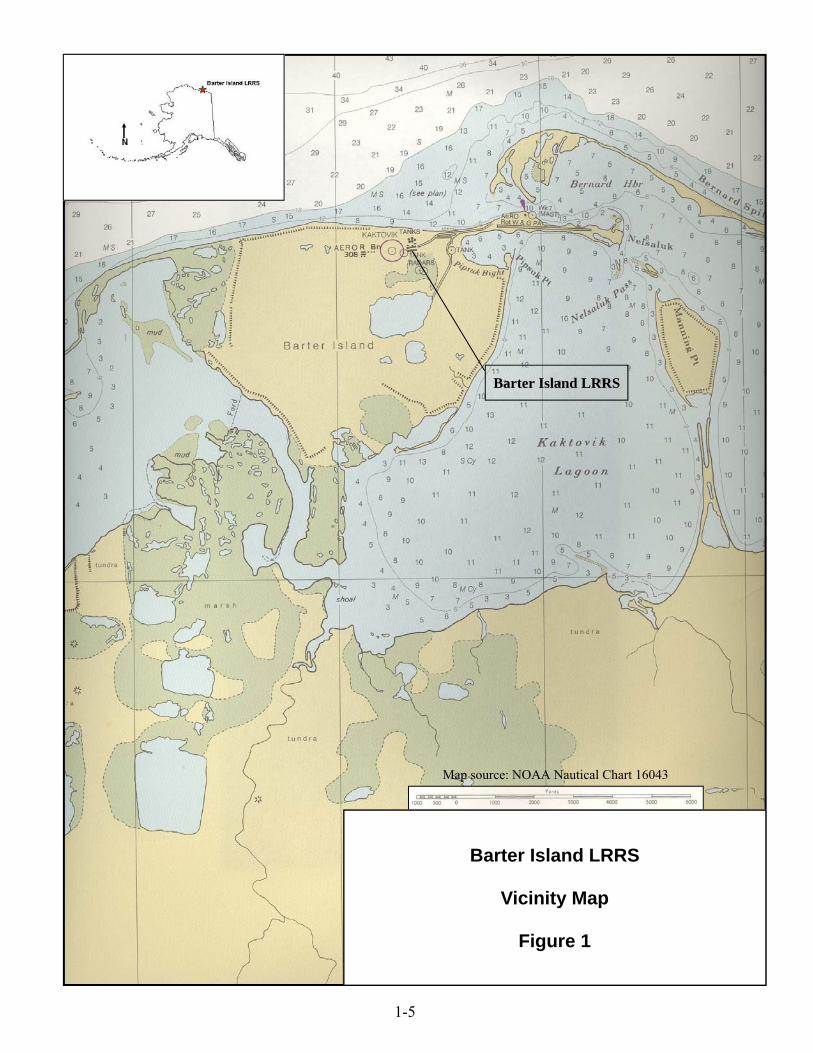
Barter Island LRRS
Vicinity Map
Figure 1
Map source: NOAA Nautical Chart 16043
1-5
Barter Island LRRS

Coastal Well Point Site (CG002)
Kaktovik
Kaktovik LagoonFormer
Heated Storage(SS013)
Barter Island LRRS
Garage(SS014)
Beaufort Sea
Barter Island LRRS, Alaska
0 600 1,200
Feet
Photo Date: 2010
^
^
^
^
Fairbanks
AnchorageJuneau
ALASKA
G u l f o fG u l f o fA l a s k aA l a s k a
B e r i n gB e r i n g
S e aS e a
CANADA
B e a u f o r tB e a u f o r t
S e aS e a
A r c t i c O c e a nA r c t i c O c e a n
_̂RUSSIA
Barrow
Barter Island LRRS
Figure 1:Barter Island LRRS Layout
±
Legend
Barter Island LRRS Installation Boundary
2016 Long Term Management Sites
PROJECT NO:09-WERC04NWF
DATE:May 2016
Work Plan For Environmental Long TermManagement Activities

Barter Island Long Range Radar Station Environmental Long Term Management
Technical Project Report 09-WERC04NWF
March 2016 15
Figure 2-1 Site CG002 Layout, Sample Locations and Results