coriolis mission operations collaboration - lessons learned
TRANSCRIPT

Coriolis Mission Operations Collaboration - Lessons Learned
Patricia KleinCoriolis Mission Manager
Space Electronics System Development BranchNaval Research [email protected]
(202) 767-6636
GSAW 2005 Working Group Session
“Teaming Early, Teaming Often”March 2, 2005

2“Coriolis Mission Operations Collaboration - Lessons Learned”GSAW 2005
Coriolis Program – Key ParticipantsSpace Test Program
Bus procurement, mission integration, launch, 1st year of Ops
Naval Research LaboratoryWindSat design/development, Years 2+ Ops, WindSat data processing
AFRLSMEI design/development, SMEI data processing
RSCC2; Mission planning and scheduling
NPOESS Integrated Program Office (IPO)X-band ground stations and data distributionNOAA/NESDIS
X-band ground station schedulingFairbanks Command & Data Acquisition Station (FCDAS)
Coriolis Space Vehicle @ Vandenberg AFB Dec 2002
3“Coriolis Mission Operations Collaboration - Lessons Learned”GSAW 2005
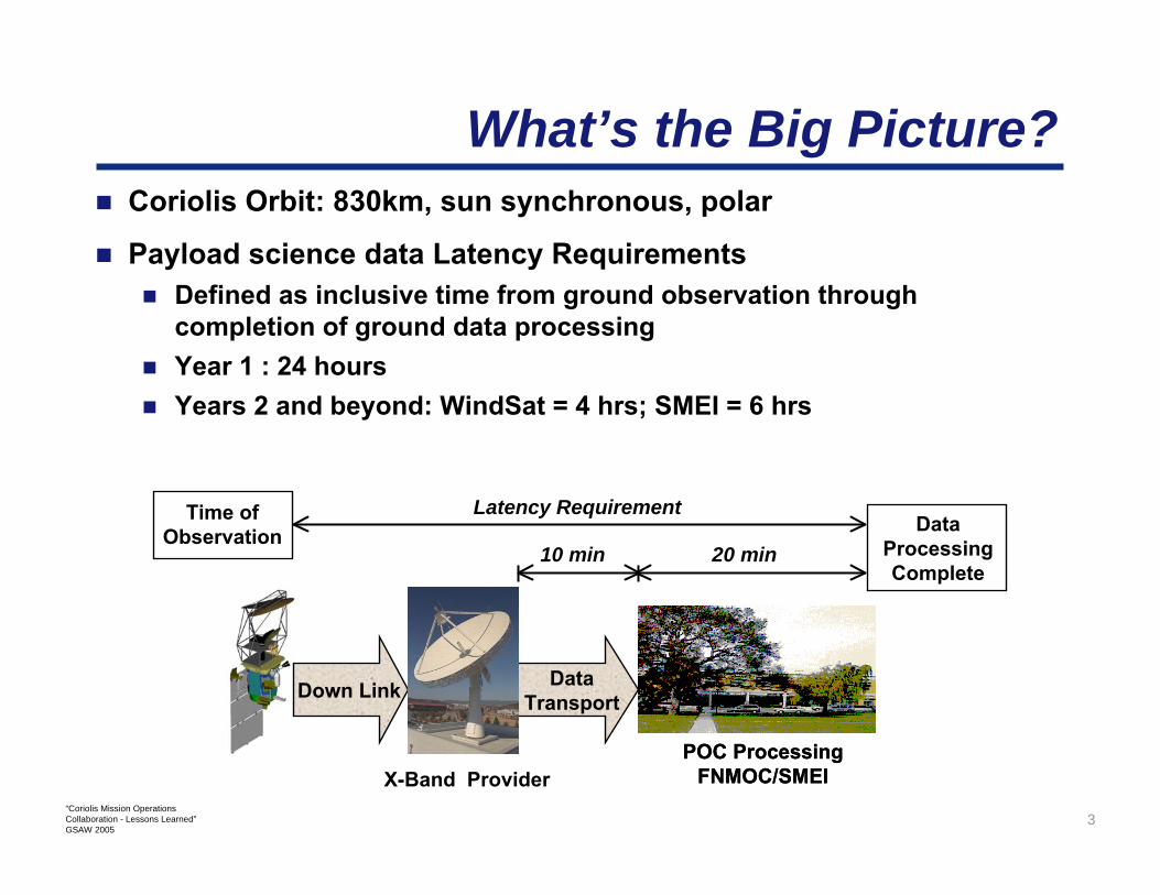
What’s the Big Picture?Coriolis Orbit: 830km, sun synchronous, polar
Payload science data Latency RequirementsDefined as inclusive time from ground observation through completion of ground data processingYear 1 : 24 hours Years 2 and beyond: WindSat = 4 hrs; SMEI = 6 hrs
10 min 20 min
Latency RequirementTime of Observation Data
Processing Complete
Down Link Data Transport
POC Processing FNMOC/SMEI
POC Processing FNMOC/SMEIX-Band Provider

4“Coriolis Mission Operations Collaboration - Lessons Learned”GSAW 2005
Coriolis X-band Data Distribution (Current)
Mission Data & SOHDREN
WindSat POCNRL
Washington, DC
NESDIS UserSuitland, MD
Internet
GE-4
CEMSCSSuitland, MD
IPOFairbanks65º north
IPOSvalbard78º north
SMEI POCAFRL
Hanscom AFB, MA
Mission Data & SOH
Mission Data
Mission Data, SOH, Status,
Control
Status & Control
Mission Data & SOH
Mission Data & SOH
FNMOCMonterey, CA
FNMOC Processing System
CODDS Server
Mission Data
Svalbard Ground Station began support ~13 months after launch

5“Coriolis Mission Operations Collaboration - Lessons Learned”GSAW 2005
What’s the Problem?
Year 1 Due to polar orbit, high latitude ground stations provide required coverageDownlinking on-board data recorder 4x/day using commercial X-band provider
More stringent Year 2 Latency Requirement drove overall ground system design
Requires downlinking recorder every orbit (14x/day)350% cost increase (over 1st year) just for ground station pass timeAdditional ground comm line bandwidth required, which increased program cost by an additional $360K/year for years 2 and beyond

6“Coriolis Mission Operations Collaboration - Lessons Learned”GSAW 2005
Why Collaborate?
NPOESS would eventually need to test their ground system conceptIf NPOESS ground segment funds and development schedule could be moved up by 1-2 years, it could support Coriolis X-band downlink and data distributionEarly deployment yields early test phase for NPOESS ground segment concept
Funds well spent for both programs – more bang for the buckNo significant NPOESS program cost ∆ – money would just be expended earlier
WindSat Mission ObjectivesMeasure Ocean Surface Wind Speed and DirectionWindSat instrument is a risk reduction for NPOESS CMIS (Conical Scanning Microwave Imager/Sounder) Instrument
NPOESS IPO has a strong interest in WindSatcontinuation

7“Coriolis Mission Operations Collaboration - Lessons Learned”GSAW 2005
Who’s Involved?The NPOESS-Coriolis collaboration is mainly a Government-Government effort, including the NRL, NOAA, and USAF
Aerospace Corp. provided requirements analysis, system engineering, and technical performance assessment
NPOESS contractors (Harris/Omaha, Raytheon/Aurora) and RSC Contractor (Northrop Grumman) are key participants
WindSat POCNESDIS User, Suitland, MD
SMEI POC
FNMOCRSC
Spectrum Astro
Coriolis Data Users

8“Coriolis Mission Operations Collaboration - Lessons Learned”GSAW 2005
How Did You Do It?
WindSat instrument had high visibility within the NPOESS IPOIPO came up with plan, received approval by managementLoading study completed to evaluate whether FCDAS could handle the extra workloadCoriolis downlink signal fc = DMSP - 1MHzIPO funded, designed, and implemented upgrades to FCDAS and Svalbard
All changes planned to minimized impact to on-orbit operations
Progress tracked by coordinating IPO effort with Coriolis Mission Manager
MOA/MOU/Mission Support PlansTest plansProgram schedule

9“Coriolis Mission Operations Collaboration - Lessons Learned”GSAW 2005
Did it Work?
Coriolis has been on-orbit since January 2003
Ground data distribution system consistently outperforms data latency requirements
Has undergone two significant upgrades with very little impact to data users
New antenna system at SvalbardChangeover and upgrade of international communication lines
Will save Coriolis program $13.5M over the 5 year design life

10“Coriolis Mission Operations Collaboration - Lessons Learned”GSAW 2005
What Helped?Early on, NPOESS System Program Director approved concept
True Win-Win situation provided high motivation to succeedMade funding available earlier than originally anticipated, i.e. NPOESS ground system development effort accelerated by about 1 year
Good peopleCreative thinkers; Outside-the-box thinkingTechnical expertiseWord is bond – Integrity of agreements
Minimal documentation
Extensive COTS useFrom antenna to user – nearly all COTSCCSDS-compliant data formatsRF downlink compatible with existing ground stations (DMSP)
Small, empowered ops teamRapid decision makingGood team communications – no one “out of the loop”
Close proximity of IPO (Maryland) and NRL (DC)Collaborative effort was somewhat simplified

11“Coriolis Mission Operations Collaboration - Lessons Learned”GSAW 2005
What Didn’t?
Data distribution network troubleshooting procedures should have been better defined and earlier

12“Coriolis Mission Operations Collaboration - Lessons Learned”GSAW 2005
What’s Next?
CoriolisGoal is to fly one year simultaneously with CMIS (2009-10)
NRLBlossom Point Satellite Tracking Facility (southern Maryland)
Government Owned Contractor Operated (GOCO) facility currently supports >165 satellite contacts per day for <$200/contactEngineering and operational support to all manner of space assetsReconfigurable hardware coupled with an open, distributed software environmentCurrently L-, C-, S-band compatible; STDN, SGLSInterested in teaming with other space and ground segment assets for all aspects of space operations, calibration, and technical demonstrations