consolidated dpr iwmp-vi development block una … dpr iwmp-vi development block una district una hp...
TRANSCRIPT
1
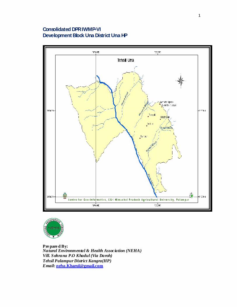
Consolidated DPR IWMP-VI Development Block Una District Una HP
Pre pare d By: Natural Environmental & Health Association (NEHA) Vill. Sohrana P.O Khadul (Via Daroh) Tehsil Palampur District Kangra(HP) Email: [email protected]

2
Contents
AAP* (Annual Ac tion Plan)
S.No Particular Page No. 1 About Una 3-5 2 Swot Analysis 6-7 3 Executive Summary 8-9 4 Approach & Outcome 10 5 Methodology 11 6 IWMP-VI at a glance 12-16 7 Baseline of IWMP-VI 17 8 Budget available under iwmp-vi 18 9 AAP* IWMP-VI 19-22 10 Panchayatwise details 23 11 Panchayat Arnialla Lower at a glance 23 12 Panchayat Arnialla Lower Baseline 24 13 AAP Arnialla Lower 25-27 14 Panchayat Arnialla Upper at a glance 28 15 Panchayat Arnialla Upper Baseline 29 16 AAP Arnialla Upper 30-31 17 Panchayat Dangoli at a glance 32 18 Panchayat Dangoli Baseline 33 19 AAP Dangoli 34-35 20 Panchayat Lamlehdi at a glance 36 21 Panchayat Lamlehdi Baseline 37 22 AAP Lamlehdi 38-39 23 Panchayat Madanpur at a glance 40 24 Panchayat Madanpur Baseline 41 25 AAP Madanpur 42-44 26 Panchayat Rampur at a glance 45 27 Panchayat Rampur Baseline 46 28 AAP Rampur 47-48 29 Panchayts Resolutions 49-54
3
ABOUT UNA DISTRICT Himachal Pradesh is divided in to 12 districts namely; Chamba, Kangra, U na,
Hamirpur, Bilaspur, Mandi, Kullu, Lahaul & Spiti, Kinnaur, Solan, Shimla and Sirmaur with a total geographical area of 55673 Square Kilometers. U na is one of the 12 districts and is situated towards south western part of the state sharing boundaries with Kangra and Hamirpur Districts of H.P. and with state of Punjab. Una has a total area of 1540 Sq.Kms supporting a population of 408849 as per 2001 census contained in 88181 households of which urban are 234 and rural 79947.Una district has atotal of 814 villages (Rural 758 +Urban habited 56).Una has a total of five development blocks. One of which is una, wherein the present watershed under consideration is located, with head quarters of both the development block and the sub-division at Una. The district is located towards the south of the state w ith its Una sub-division towards the extereme south of the district. The district is surronded by Punjab on the extereme south, Kangra district towards north and Hamirpur district on the east.
The Una D istrict is situated between north latitude 31° 31 ́41″ and east longitude 71° 26.05 .́1″, with an estimated area of 1540 square Kilometers and is located in the foot hills of shiwaliks.
Most of the area of Una District drains in River Satluj through its tributary known as SWAN Khad and a part drains in Beas river. Precipitation is mostly from rainfall during monsoon and winters. Most of the area is vulnerable to soil erosion due to heavy pressure of human and cattle, causing degradation of natural resources in the process and also due to the fragile nature of the terrain as the Shiwalik are young and unstable hill ranges geologically.
Una district is well developed in the industrial sector due to close proximity to Punjab. Mehatpur, Gagret, Tahliwal & Amb are main industrial centres of Una. In winter, climate is cool, woolen clothes required. In summer, climate is hot, cotton clothes required. From July to September, it is rainy & humid. Geographycally Una lies in the southwestern part of Himachal Pradesh, and it is circumscribed by the beautiful Shivalik ranges of the Himalayas.
4
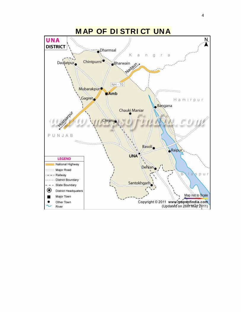
MAP OF DISTRICT UNA

5
Location of Una district in Himachal Pradesh
State Himachal Pradesh, India
Headquarters Una
Are a 1,549 km2 (598 sq mi)
Population 4,47,967 (2001)
Population de nsity
291 /km2 (750 /sq mi)
Urban population 8.8%
Lite racy 81.09%
Sex ratio 997
Average annual precipitation
1253 mm
.
6
SWOT ANALYSIS It was felt of utmost importance to carry out the SWOT Analysis before starting
consultation with residents of the panchayats w ith regard to their expectations from the Project and in preparation of an Integrated Watershed Management P lan for the Watershed . In order to understand the S trengths, Weaknesses, O pportunities and Threats commonly felt with regard to the area and circumstances, climate and environment informal discussions were held at various levels. The results of the discussion in the form of Strengths, Weaknesess, Opportunities and Threats are tabulated below.
STRENGTHS
1. The area of the panchayat is located in the proximity of the district head quarter and also the industrial zones, hence no marketing problem of the produce.
2. Due to heavy demand of farm produce and the paying capacity of the purchasers, growing of organic farm produce can be introduced.
3. There being high demand for the vegetables at the district head quarter the farmers can switch over to grow ing vegetables.
4. The farmers are already involved in dairy farming as vocation which can be promted on scientific and commercial lines.
5. Adequate run off water is available for pondage and psciculture can be promted comfortably.
6. Some of the ponds developed can be devoted to Pearl culture as some of the farmers have shown keen interest in this activity.
WEAKNESSES
1 Acute shortage of irrigational facilities and near drought conditions all the year around.
2 The soil of the area being sandy in nature has little water retention capacity.
3 The milk and milk produce is being sold in an unorganized manner. 4 Less participation of women folk in planning of developmental
activities.
7
OPPORTUNITIES
a. There is high demand of organically grown food items which can fetch good price to the farmers.
b. The area has a good potential for grow ing off season farm products through Poly House Culture which can fetch good financial returns to the farmers.
c. Deep seasonal rivulets with sand stone as the parent rock is prevalent
which can be tapped for developing pondage of the runoff water.
THREATS
1. The young generation is likely to prefer moving out of the area in search of greener pastures in the nearby industrial areas.
2. The watershed is a part of warmer climate and there is possibility of high disease prevalence in agriculture crops.
3. The area being nearer to Punjab the marketing competition for farm produce.

8
Executive Summary The work of preparation of DPR was entrusted to Natural Environmental and
He alth Association (NEHA) as a consequence of the past experience of the organization in
the field of watershed development and working w ith the local communities for their
upliftment in the social and economic sectors. The present DPR has been prepared after in
depth and intensive consultation with the local communities by organising formal meetings,
informal discussions, PRAs, transact walk and detailed house to house survey to collect base
line data and their perceptions about development, watershed management and their
suggestions to bring about the desired change. The thrust further revolves around
identification of natural resources; introduce protective measure so that the same remain
usable in continuity without harming or degrading them.
The DPR takes in to consideration the status of natural assets, resource gaps, and day
to day problems faced by people, proposed activities, estimated cost and budget available,
convergence with other Govt. departments and institutional system as it exists in watershed
area.
The major problems of the area, as identified by the communities themselves, include
scarcity of drinking water which they have been carrying from wells since ages, no
irrigational facilities for the cultivable land thus resulting in to low productivity, both from
farm and domestic animals. The other problems include soil erosion and land slides which
occur due to fragile geological phenomenon and little or no openings in the service sector.
Keeping all these problems in view , the main thrust in the DPR has been focused on
the problems related to water and a substantial budget has been proposed in this sector for
providing both drinking and irrigation water and providing necessary infrastructure. After
the availability of water, both for the farm and homestead increases, the production from farm
sector is expected to be more than four times the present from the same land. Apart from this
the other major thrust area of the DPR is the livelihood sector, in addition to the farm
activities, wherein it is proposed to impart training in skill development, to upgrade the
existing skills in farming, animal husbandry and individual skills like tailoring etc.
After the project has been implemented it is expected that the storage capacity of
water in the panchayats will increase to double for home stead for day to day use and some
area will be added to forest cover w hich will also increase the availability of grass and fodder
for the live stock of the area apart from recharging the aquifers. In the livelihood sector, after
the BPL families’s members of the same number of families have undergone training in
different skills, it is expected that their income will increase by 4000 rupees per month.
9
Similarly in the animal husbandry sector the production of as well as meat will also increase
to twofold after proposed breed improvement of local sheep.
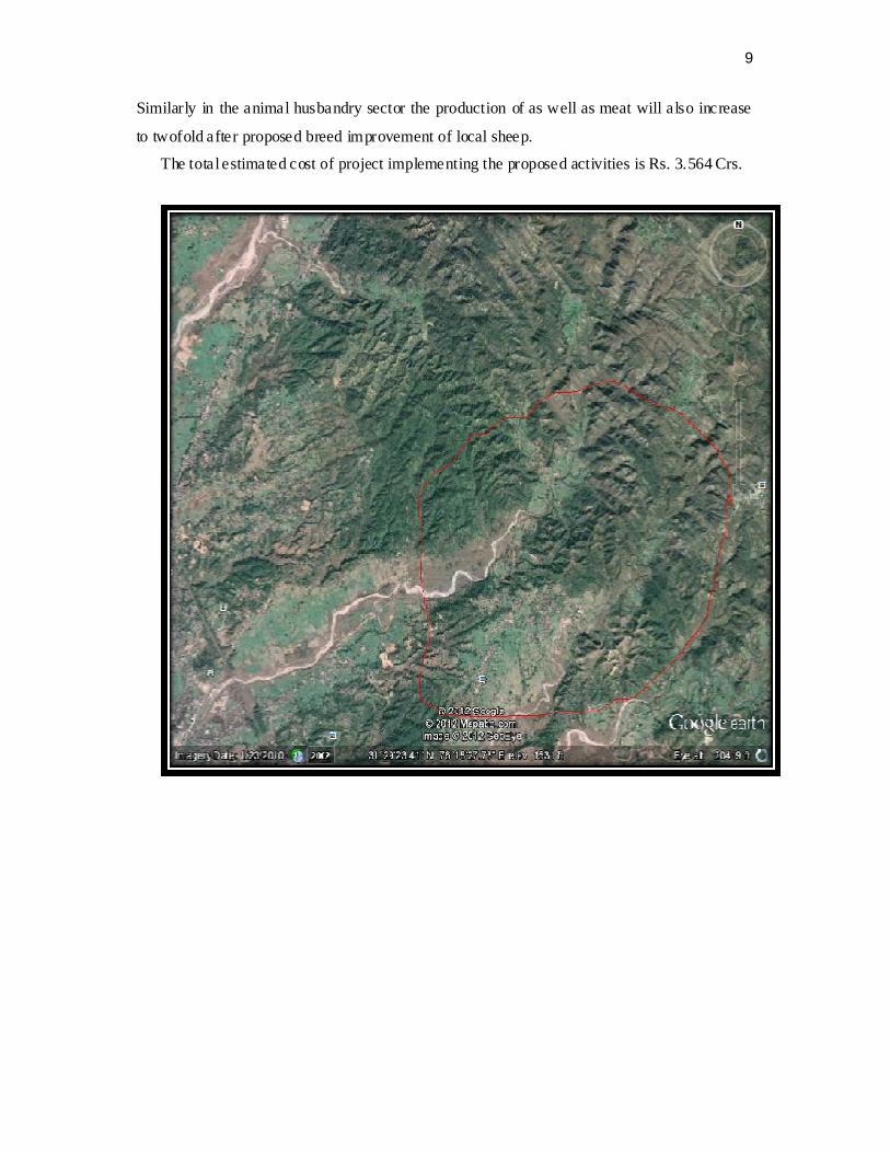
The total estimated cost of project implementing the proposed activities is Rs. 3.564 Crs.
10
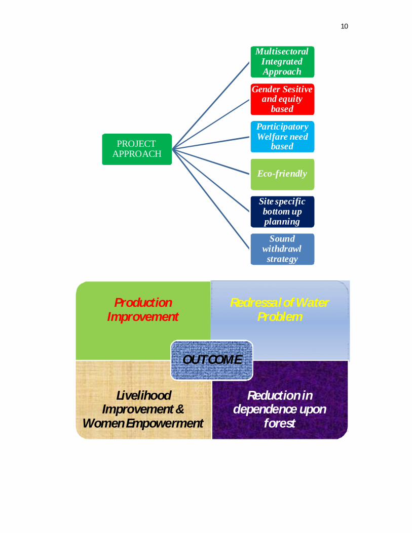
PROJECT APPROACH
Multisectoral Integrated Approach
Gender Sesitive and equity
based
Participatory Welfare need
based
Eco-friendly
Site specific bottom up planning
Sound withdrawl strategy
Production Improvement
Redressal of Water Problem
Livelihood Improvement &
Women Empowerment
Reduction in dependence upon
forest
OUT COME

11
METHODOLOGY:
NEHA started formulation of DPR of the area after conducting of Gram Sabha meeting of all 6 Panchayats which was presided over by the Pradhan Gram Panchyat concerned at every panchayat headquarter. Panchayats and the local communities were briefed regarding objectives, processes to be followed i.e. conducting of House to house survey, PRA exercises, carrying out transact walk along with villagers and Panchayat representatives of the village and then finalizing and prioritsing activities spread over the project period with their active participation.
House to house survey was conducted by team comprising of Sh Pratap Chand, Sh Raj Kumar and Sh.Bal Krishan, Up-Pradhans with the active support of Pradhan Gram Panchayats and the ward members. Sh. M.P .Vashist, Retd Director Forest Training Institute Sunder Nagar gave technical support in collection of data of household survey. The house hold survey was followed by the PRA exercises of all the wards/ villages of the all six Panchayat. The area of the Micro Watersheds was visited to take stock of the natural resources and transact walks were conducted by team comprising, Sh M S Kapoor and Sh. Raj Kumar and Sh. M.P.Vashist, Retd. Director, Forest Training Institute, Sunder Nagar accompanied by the villagers. Activities were prioritized after analyzing social acceptability, economical viability and technical feasibility while carrying out PRA. Detailed technical survey was also conducted before finalizing the activities. All the proposals were discussed with Panchayat representatives at the time of PRA and prioritizing of the activities. Block Development authorities were also consulted at the time of Survey, PRA and finalization of the activities. Likewise, DRDA was also consulted and briefed from time to time while carrying out the exercises of formulation of DPR. Draft proposal was discussed with the Panchayat and DRDA before it was finalized. Estimates of budgets were prepared keeping in view schedule of rates, carriage involved and cost of material which may vary at the time of physical achievements but overall estimate will remain more or less same.

12
IWMP-VI AT A GLANCE Name of Project IWMP-VI District Una Block Una Project Area 2376 Ha Area Proposed for Treatment 2376 Ha Cost 3.564 Cr Panchayats Covered under the
Project Six 1. Lamlehdi 2. Dangoli 3. Arniala- Upper 4. Arniala- Lower 5. Madanpur 6. Rampur
Total Micro Watersheds Six 1. Lamlehdi 2. Dangoli 3. Arniala- Upper 4. Arniala- Lower 5. Madanpur 6. Rampur
Total Projections in the DPRs as 4.064 Cr 9(i) Project Fund 3.564 Cr 9(ii) Convergence 0.494 Cr Total (9i+9ii) 4.064 Cr
0 Whether the year wise action plan
prepared or not. Yes, Prepared & Attached
1 Whether activity wise project fund
and convergence funds indicated separately or not.
Yes, Clearly mentioned.
2 Whether khasra No. of civil structure indicated or not.
Locations mentioned by local name, which local people/ Panchayat identify/understand better & coordinates are given.
3 Phy. & Fin. Target of the project
period mentioned in the annual action plan (AAP) or not.
Yes, mentioned.
4 Micro Watershed-wise code
mentioned or not. Yes, mentioned
5 Proposed Activities 1. Afforestat ion (Individual)
2. Farm Ponds/Wells 3. Crate wire Structure 4. Protection Wall in Agri. Land 5. Add. New Sewage Drains 6. Irrigation Channel 7. Renovation of Natural Water Resources (Wells) 8. Poultry Farming 9. Skill Development in (Tailoring 10. Buffalo Breed Improvement 11. Dairy Development
13
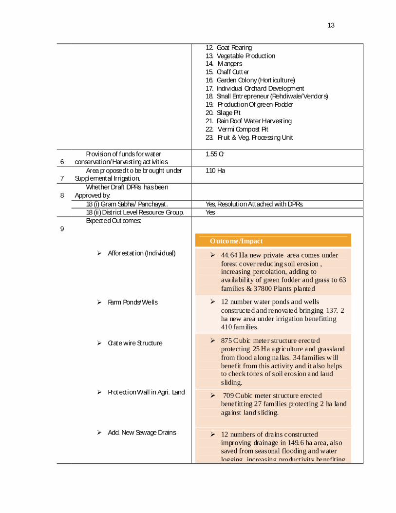
12. Goat Rearing 13. Vegetable Production 14. Mangers 15. Chaff Cutter 16. Garden Colony (Hort iculture) 17. Individual Orchard Development 18. Small Entrepreneur (Rehdiwale/Vendors) 19. Production Of green Fodder 20. Silage Pit 21. Rain Roof Water Harvesting 22. Vermi Compost Pit 23. Fruit & Veg. Processing Unit
6 Provision of funds for water
conservation/Harvesting act ivities. 1.55 Cr
7 Area proposed to be brought under
Supplemental Irrigation. 110 Ha
8 Whether Draft DPRs has been
Approved by:
18 (i) Gram Sabha/ Panchayat. Yes, Resolution Attached with DPRs. 18 (ii) District Level Resource Group. Yes
9 Expected Outcomes: Afforestat ion (Individual)
Farm Ponds/Wells Crate wire Structure
Protection Wall in Agri. Land
Add. New Sewage Drains
Outcome/Impact
44.64 Ha new private area comes under forest cover reducing soil erosion , increasing percolation, adding to availability of green fodder and grass to 63 families & 37800 Plants planted
12 number water ponds and wells constructed and renovated bringing 137. 2 ha new area under irrigation benefitting 410 families.
875 C ubic meter structure erected protecting 25 Ha agriculture and grassland from flood along nallas. 34 families w ill benefit from this activity and it also helps to check tones of soil erosion and land sliding.
709 Cubic meter structure erected benefitting 27 families protecting 2 ha land against land sliding.
12 numbers of drains constructed improving drainage in 149.6 ha area, also saved from seasonal flooding and water logging, increasing productivity benefiting

14
Irrigation Channel
Renovation of Natural Water
Resources (Wells) Poultry Farming
Skill Development in
(Tailoring) Buffalo Breed Improvement
Dairy Development
Goat Rearing
Vegetable Production Mangers
Chaff Cutter
Garden Colony (Hort iculture)
385 families.
16 numbers new irrigation channels constructed, 260 families will benefit and 40 Ha new area comes under irrigation increasing the crop output to double.
40 wells renovated increasing availability of adequate potable water in addition to increase in quantity of water for irrigation to 1233 families.
3 families will benefit from this activity. Increased availability of poultry products will address nutritional deficiency, increasing working capacity and also supplement the household income.
The trained beneficiaries save on stitching charges and by adopting it as vocation adding to family income. 90 families likely to benefit. 9 new SHGs formed.
9 buffalo bulls provided helping natural service to the buffalo stock of the entire watershed area improving breed and increasing milk yield.
27 Families benefit by adopting dairy farming as full time vocation practicing it with improved technical and scientific knowledge.
7 poor landless families benefit from addition of quality animals in their cattle stock increasing their family income.
73Families adopt vegetable production on commercial scale. 7 groups formed.
175 mangers constructed benefitting same
number of families saving on fodder and health of animals.
52 chaff cutters provided benefitting same
number of families, improving fodder quality and saving on wastage of fodder.
8.8 ha area is brought under Garden Colony. 8 families benefit by increased

15
Small Entrepreneur
(Rehdiwale/ Vendor) Production Of green Fodder
Silage Pit
Rain Roof Water Harvesting
Vermi Compost Pit
Fruit & Veg. Processing Unit
income also providing nutrition al addition to family intake.
6 families benefit getting full time vocation as vendors
Barseem 2700Kg &Chari 2904kg seed supply helps increased green fodder availability in the entire watershed improving cattle health.
56 Silage Pit help availability of quality fodder motivating other farmers as well to adopt the practice.
31 roof rain water harvesting tanks
constructed adding 310 cum of stored water available for irrigation and house hold use.
40 vermi compost pits constructed adding to
increased availability of quality com post increasing agriculture production and health and hygiene
1 unit created as SHG, helping 30 farmer
families checking wastage of farm produce in glut season and improving income of farmers after value addit ion
IWMP Status
0 Status Quo Analysis Total Geographical Area under
the Project 2376 Ha
Area Under Cultivation 568 Ha Forest Area/Fallow/Community
Land 1808 Ha
Current Cropping Pattern Two Crops Major crops Maize, Paddy, Wheat (Ravi/Khariff).
1 Water Harvesting
Current status of water harvesting in activities.
Ponds,Wells but not functioning
Water harvest ing potential in term of Cubic mtrs.
9224 cum
Proposed Activities 1. Aforestration 2. Farm Ponds 3. Crate wire Structure 4. Protection Wall in Agri Land 5. Water Storage Tank 6. Irrigation Channel 7. Renovation of Natural Water Resources (Wells)
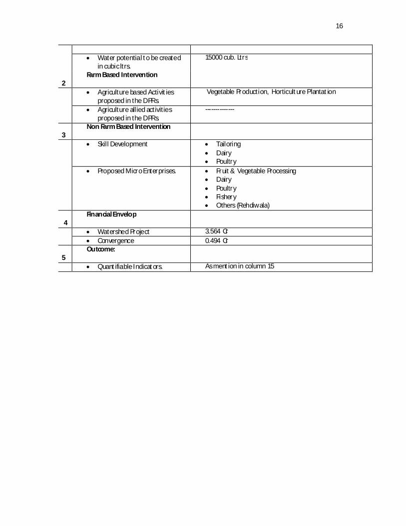
16
Water potential to be created
in cubic ltrs. 15000 cub. Ltrs
2 Farm Based Intervention
Agriculture based Activit ies proposed in the DPRs.
Vegetable Production, Horticulture Plantation
Agriculture allied activities proposed in the DPRs.
--------------
3 Non Farm Based Intervention
Skill Development Tailoring Dairy Poultry
Proposed Micro Enterprises. Fruit & Vegetable Processing Dairy Poultry Fishery Others (Rehdiwala)
4 Financial Envelop
Watershed Project 3.564 Cr Convergence 0.494 Cr
5 Outcome:
Quantifiable Indicators. As mention in column 15

17
Base Line Survey Project : - IWMP-VI UNA
Total Geographicial Area of Project ( Hectares) 2376 Ha
Project area Covering 2376 Ha
Treatable Area
Wasteland ( Hectares) 1818 Ha Rainfed
Agriculture Land ( Hectares)
558Ha
Total Cropped Area( Hectares) 832 Ha Net Shown Area 416 Ha
Total No.of water Storage Structure 108
Total No.of Water Extracting Units
146
Total Storage Capacity of water storage structure (cubic
meter) 9224 Cub. Meter
No.of Household 2236 SC 528 ST 0
Others OBC-1092, GEN-616
Total Population in the project area
10248 No. of
Household of Landless people
0
Total No. of BPL Household
343
No.of small Farmers's Household 460
No. of Margional Farmers's
Household
1768
Depth of Ground Water (meter) below Ground Level Pre- monsoon 6 Post -monsoon 20
No.of person-days of Seasonal Migration 0
Livestock Cow-398 Buffalow-1765 Goat-296

18
Component wise Budget Available under IWMP-VI Una
Name of Panchayat /Microwatersheds
P1 P2 P3 P4 P5 P6 Grand Total Lamlehdi Dangoli Lower Arniala Upper Arniala Rampur Madanpur
BUDGET COMPNENT Administrative Cost (10%) 11.835 2.415 5.94 3.525 5.715 6.21 35.64
Monitoring &Evaluation (2%)
2.367 0.483 1.188 0.705 1.143 1.242 7.128
Entry Point Activity (4%) 4.734 0.966 2.376 1.41 2.286 2.484 14.256
Institution And Capacity Building (5%)
5.9175 1.2075 2.97 1.7625 2.8575 3.105 17.82
DPR (1%) 1.1835 0.2415 0.594 0.3525 0.5715 0.621 3.564 Watershed Development work (56%)
66.276 13.524 33.264 19.74 32.004 34.776 199.584
Livelihood activities for the asset less persons (9%)
10.6515 2.1735 5.346 3.1725 5.1435 5.589 32.076
Production system & Micro Enter. (10%)
11.835 2.415 5.94 3.525 5.715 6.21 35.64
Consolidation Phase (3%) 3.5505 0.7245 1.782 1.0575 1.7145 1.863 10.692
Total 118.35 24.15 59.4 35.25 57.15 62.1 356.4

19
Consolidated MIS IWMP-VI Block & Distt. Una (Yearwise action plan Phy. & Fin) 2011-12 2012-13 2013-14 2014-15 2015-16 Total SNo Name of Activity Units Phy Fin Phy Fin Phy Fin Phy Fin Phy Fin Phy Fins 1 Land Dev A forestation Ha 0 0 5.15 0.6475 15.7 2.2515 10.9 2.328 0 0 32.6 5.227 Horticulture Ha 0 0 0.5 0.025 0 0 0 0 0 0 0.5 0.025
Agriculture Ha 0 0 0 0 0 0 0 0 0 0 0 0 Pasture Ha 0 0 0 0 0 0 0 0 0 0 0 0 2 SMC Staggered Renches Ha 0 0 0 0 0 0 0 0 0 0 0 0
Contour Trenching Ha 0 0 0 0 0 0 0 0 0 0 0 0 Graded Bunds Ha 0 0 0 0 0 0 0 0 0 0 0 0 Bench Terracing Ha 0 0 0 0 0 0 0 0 0 0 0 0 Other Ha 0 0 0 0 0 0 0 0 0 0 0 0 3 Vegetative Earthen Checks Cum 0 0 0 0 0 0 0 0 0 0 0 0 Engineering Brushwood Checks Rmt 0 0 0 0 0 0 0 0 0 0 0 0 Structures Gully Plugs Cum 0 0 0 0 0 0 0 0 0 0 0 0 Cratewire
Structures Cum 0 0 135 3.93 255 8.3 75 3.08 105 3.15 310 18.46
Gabian Structures Cum 0 0 0 0 0 0 0 0 0 0 0 0 Other/ Protection
Walls cum 0 0 40 1.6 240 14.614 30 2.4 29 2.3 359 20.914
4 WHS Farm PondsWells No 0 0 15 26.62 11 23.4 8 14.5 4 4.85 39 69.37 Check Dams No 0 0 0 0 0 0 0 0 0 0 0 0 Nallah Bunds No 0 0 0 0 0 0 0 0 0 0 0 0 Percolation Tanks No 0 0 0 0 0 0 0 0 0 0 0 0

20
Rooftop Water Storage Tank
No 0 0 17 6.12 11 3.96 13 4.68 6 2.16 47 16.92
Ground water recharge structures
No 0 0 1 7.519 3 9.424 2 3.5 0 0 6 20.443
Addit ion/New sewage Channel facility
No 0 0 0 0 4 13 4 6.25 3 11.7 11 30.95
Other Irrigation Channel
No 0 0 5 3.89 6 2.54 3 3.2 1 0.5 17 17.276
5 Livelihood No of on farm activities
No 0 0 0 0 0 0 0 0 0 0 0
Vegetable Production
No 0 0 0 0 5 1.022 0 0 0 0 5 1.022
No of Beneficiaries No 0 0 0 0 30 0 0 0 0 0 30 No of off farm
activities No 0 0 0 0 0 0 0 0 0 0 0
Tailoring Groups No 0 0 6 3.65 2 1.6 1 0.55 0 0 9 5.8
No of Beneficiaries No 0 0 60 0 20 0 10 0 0 0 90
Vermi Compost No 0 0 0 0 15 0.525 15 0.525 10 0.35 40 1.4
No of Beneficiaries No 15 15 10 40 0
Goat Rearing No 0 0 0 0 3 0.81 2 0.54 2 0.52 7 1.87
No of Beneficiaries No 3 2 2 7
Dairy Dev. No 0 0 0 0 8 4.2 11 8.7 6 2.78 25 15.68
No of Beneficiaries No 0 8 11 6 25
Poultry Farming No 0 0 0 0 0 0 1 0.27 2 0.5 3 0.77
No of Beneficiaries No 1 2 3
21
Small Enterpenor Dev.
No 0 0 3 0.66 1 0.2 1 0.2 1 0.126 6 1.186
No of Beneficiaries No 0 0 3 0 1 0 1 0 1 0 6
Fruit & Vegetable Processing Unit
No 0 0 0 0 0 0 1 3 0 0 1 3
No of Beneficiaries No 0 0 0 0 0 0 150 0 0 0 150
Gramin Haat (Shop) No 0 0 0 0 0 0 0 0 1 1.35 1 1.35
No of Beneficiaries No 0 0 0 0 0 0 0 0 150 150
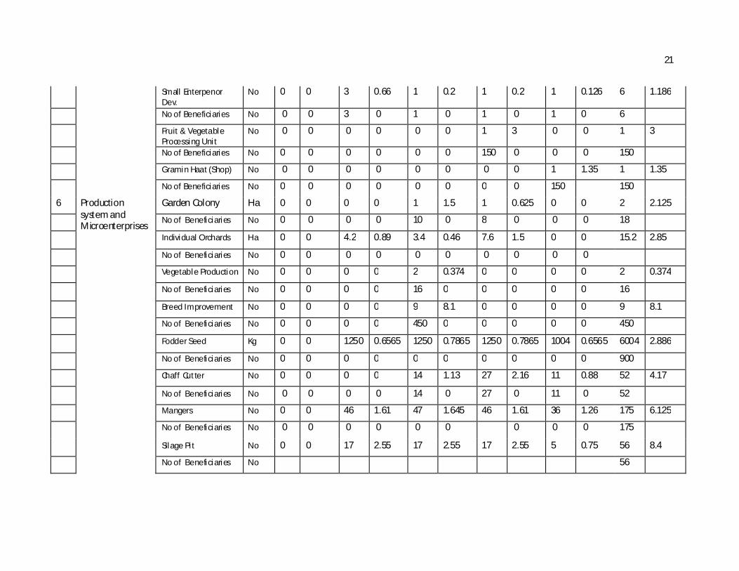
6 Production system and Microenterprises
Garden Colony Ha 0 0 0 0 1 1.5 1 0.625 0 0 2 2.125
No of Beneficiaries No 0 0 0 0 10 0 8 0 0 0 18
Individual Orchards H a 0 0 4.2 0.89 3.4 0.46 7.6 1.5 0 0 15.2 2.85
No of Beneficiaries No 0 0 0 0 0 0 0 0 0 0
Vegetable Production No 0 0 0 0 2 0.374 0 0 0 0 2 0.374
No of Beneficiaries No 0 0 0 0 16 0 0 0 0 0 16
Breed Improvement No 0 0 0 0 9 8.1 0 0 0 0 9 8.1
No of Beneficiaries No 0 0 0 0 450 0 0 0 0 0 450
Fodder Seed Kg 0 0 1250 0.6565 1250 0.7865 1250 0.7865 1004 0.6565 6004 2.886
No of Beneficiaries No 0 0 0 0 0 0 0 0 0 0 900
Chaff Cutter No 0 0 0 0 14 1.13 27 2.16 11 0.88 52 4.17
No of Beneficiaries No 0 0 0 0 14 0 27 0 11 0 52
Mangers No 0 0 46 1.61 47 1.645 46 1.61 36 1.26 175 6.125
No of Beneficiaries No 0 0 0 0 0 0 0 0 0 175
Silage Pit No 0 0 17 2.55 17 2.55 17 2.55 5 0.75 56 8.4
No of Beneficiaries No 56

22
Dairy Dev. No 0 0 0 0 2 0.78 0 0 2 0.78
No of Beneficiaries No 2 2
7 Monitoring& Evaluation
Rs 2.349 2.249 2.53 7.128
8 Admin Rs 6.753 7.253 7.253 7.253 7.128 35.64
9 Institution and capacity Building
SHG Formation UG Formation Formation of
Federation
Capacity Building Rs 3.564 3.564 3.564 3.564 3.564 17.82 10 EPA No 8 14.256 0 14.256 11 Consolidation
Phase
Rs 3.62 3.62 3.452 10.692
12 DPR Rs 3.564 3.564 Total Rs 28.137 71.185 119.96 79.641 50.507 356.57

23
Panchayatwise Details of IWMP-VI 1.Gram Panchayat: A rnialla Lower
Arniala Lowe r Panchayat- An Introduction Arniala Lower Panchayat is one of the sixteen panchayats of Development Block Una
and is located on the Right side of Hamirpur-Bangana- Una road some 1KMs short of U na. The panchayat is located 1 km from Una, the sub-divisional and block Head Quarter of Una sub-division and development block. The details regarding the existing infrastructure etc. as below :
DEMOGRAPHY & OTHER STATISTICS AT A GLANCE 1. Name of Panchayat : Arniala Lower 2. Name of the Micro Water shed : Arniala Lower 3. Tehsil, Dev, Block & Distt. : Una 4. State : Himachal Pradesh: 5. Distance from Development Block : 1Kms 6. Distance from District HQ : 1 Kms 7. Distance from main road : 0 Kms. 8. Revenue villages of the Panchayat : Arniala Lower 9. Total area of the Micro Watershed : 396 ha 10. Number of total H ouse Hold : 408 11. Number of total live stock : 267 (as per survey by NEHA) 12. Total Population : 1750, Male 892 &858 female 13. Number of BPL families : 47 14. Number of APL families : 361 15. Caste wise bifurcation : Gen 97, OBC 292, SC 19
16. No. of Anganbaris in the Panchayat : 3; Lower Arniala, Bhati Saini Muhla, Sharma
Saini Muhla 17. Number of schools : 1GPS At Arniala Lower
24
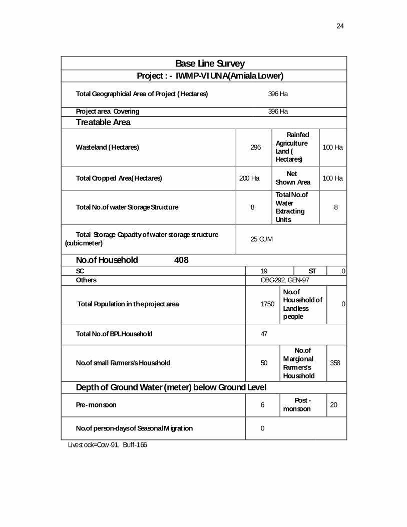
Base Line Survey
Project : - IWMP-VI UNA(Arniala Lower)
Total Geographicial Area of Project ( Hectares) 396 Ha
Project area Covering 396 Ha
Treatable Area
Wasteland ( Hectares) 296
Rainfed Agriculture Land ( Hectares)
100 Ha
Total Cropped Area( Hectares) 200 Ha Net
Shown Area 100 Ha
Total No.of water Storage Structure 8
Total No.of Water Extracting Units
8
Total Storage Capacity of water storage structure (cubic meter) 25 CUM
No.of Household 408 SC 19 ST 0 Others OBC-292, GEN-97
Total Population in the project area 1750
No.of Household of Landless people
0
Total No.of BPL Household 47
No.of small Farmers's Household 50
No.of Margional Farmers's Household
358
Depth of Ground Water (meter) below Ground Level
Pre- monsoon 6 Post -
monsoon 20
No.of person-days of Seasonal Migration 0
Livestock=Cow-91, Buff-166
25
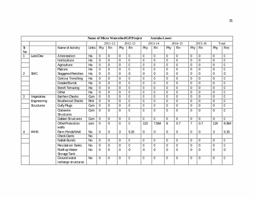
Name of Micro Watershed/GP/Project Arniala-Lower
2011-12 2012-13 2013-14 2014-15 2015-16 Total Sr No
Name of Activity Units Phy Fin Phy Fin Phy Fin Phy Fin Phy Fin Phy Fins
1 Land Dev A forestation Ha 0 0 0 0 0 0 0 0 0 0 0 0 Horticulture Ha 0 0 0 0 0 0 0 0 0 0 0 0 Agriculture Ha 0 0 0 0 0 0 0 0 0 0 0 0 Pasture Ha 0 0 0 0 0 0 0 0 0 0 0 0 2 SMC Staggered Renches Ha 0 0 0 0 0 0 0 0 0 0 0 0 Contour Trenching Ha 0 0 0 0 0 0 0 0 0 0 0 0 Graded Bunds Ha 0 0 0 0 0 0 0 0 0 0 0 0 Bench Terracing Ha 0 0 0 0 0 0 0 0 0 0 0 0 Other Ha 0 0 0 0 0 0 0 0 0 0 0 0 3 Vegetative Earthen Checks Cum 0 0 0 0 0 0 0 0 0 0 0 0 Engineering Brushwood Checks Rmt 0 0 0 0 0 0 0 0 0 0 0 0 Structures Gully Plugs Cum 0 0 0 0 0 0 0 0 0 0 0 0 Cratewire
Structures Cum 0 0 0 0 0 0 0 0 0 0 0 0
Gabian Structures Cum 0 0 0 0 0 0 0 0 0 0 0 0 OtherProtection
walls cum 0 0 0 0 110 7.564 8 0.7 7 0.7 124 8.964
4 WHS Farm Ponds/Well No 0 0 3 5.15 0 0 0 0 0 0 3 5.15 Check Dams No Nallah Bunds No 0 0 0 0 0 0 0 0 0 0 0 0 Percolation Tanks No 0 0 0 0 0 0 0 0 0 0 0 0 Rooftop Water
Storage Tank No 0 0 0 0 0 0 0 0 0 0 0 0
Ground water recharge structures
No 0 0 0 0 0 0 0 0 0 0 0 0
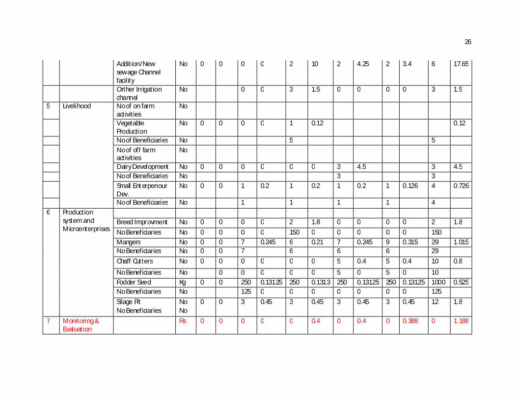
26
Addition/New sewage Channel facility
No 0 0 0 0 2 10 2 4.25 2 3.4 6 17.65
Orther Irrigation channel
No 0 0 3 1.5 0 0 0 0 3 1.5
5 Livelihood No of on farm activities
No
Vegetable Production
No 0 0 0 0 1 0.12 0.12
No of Beneficiaries No 5 5 No of off farm
activities No
Dairy Development No 0 0 0 0 0 0 3 4.5 3 4.5 No of Beneficiaries No 3 3 Small Enterpenour
Dev. No 0 0 1 0.2 1 0.2 1 0.2 1 0.126 4 0.726
No of Beneficiaries No 1 1 1 1 4 6 Production
system and Microenterprises
Breed Improvment No 0 0 0 0 2 1.8 0 0 0 0 2 1.8 No Beneficiaries No 0 0 0 0 150 0 0 0 0 0 150 Mangers No 0 0 7 0.245 6 0.21 7 0.245 9 0.315 29 1.015 No Beneficiaries No 0 0 7 6 6 6 29 Chaff Cutters No 0 0 0 0 0 0 5 0.4 5 0.4 10 0.8
No Beneficiaries No 0 0 0 0 0 5 0 5 0 10 Fodder Seed Kg 0 0 250 0.13125 250 0.1313 250 0.13125 250 0.13125 1000 0.525 No Beneficiaries No 125 0 0 0 0 0 0 0 125 Silage Pit No 0 0 3 0.45 3 0.45 3 0.45 3 0.45 12 1.8 No Beneficiaries No
7 Monitoring & Evaluation
Rs 0 0 0 0 0 0.4 0 0.4 0 0.388 0 1.188

27
8 Admin Rs 0 1.188 1.188 1.188 1.188 1.188 5.94 9 Institution and
capacity Building SHG Formation UG Formation Capacity Building Rs 0.594 0.594 0.594 0.594 0.594 2.97
10 Consolidation Phase
Rs 0 0 0 0 0 0.6 0 0.6 0 0.582 0 1.782
11 EPA
No 2 2.376 0 0 0 0 0 0 0 0 2 2.376 12 DPR
Rs 0.594 0 0 0 0 0 0 0 0 0 0.594
Total Rs 4.328 8.33425 25.028 14.0143 7.69525 59.4
28
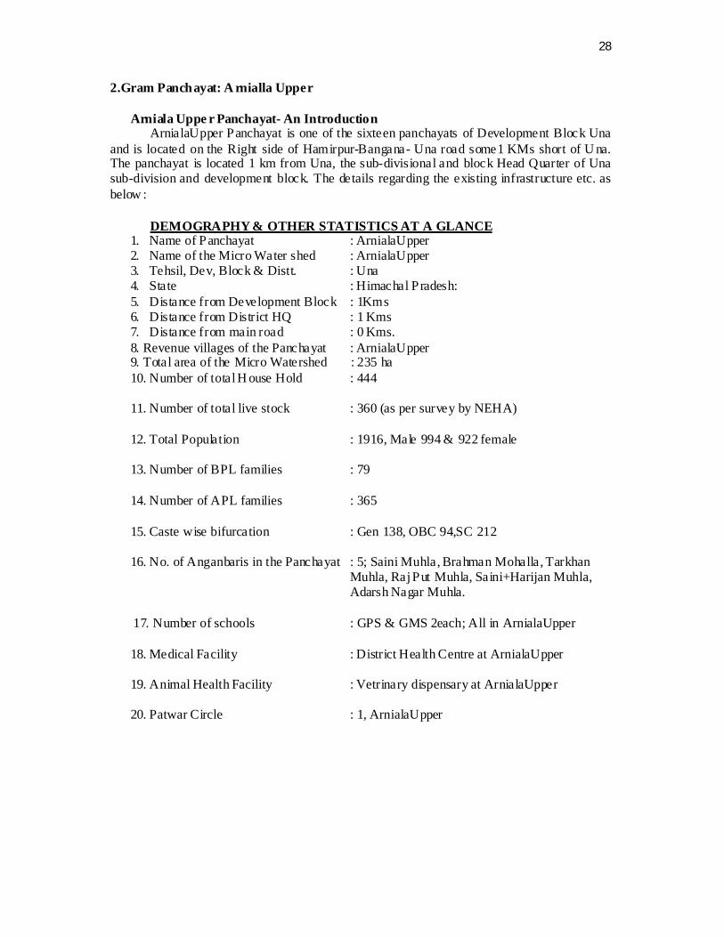
2.Gram Panchayat: A rnialla Upper
Arniala Uppe r Panchayat- An Introduction ArnialaUpper Panchayat is one of the sixteen panchayats of Development Block Una
and is located on the Right side of Hamirpur-Bangana- Una road some1 KMs short of U na. The panchayat is located 1 km from Una, the sub-divisional and block Head Quarter of Una sub-division and development block. The details regarding the existing infrastructure etc. as below :
DEMOGRAPHY & OTHER STATISTICS AT A GLANCE
1. Name of Panchayat : ArnialaUpper 2. Name of the Micro Water shed : ArnialaUpper 3. Tehsil, Dev, Block & Distt. : Una 4. State : Himachal Pradesh: 5. Distance from Development Block : 1Kms 6. Distance from District HQ : 1 Kms 7. Distance from main road : 0 Kms. 8. Revenue villages of the Panchayat : ArnialaUpper 9. Total area of the Micro Watershed : 235 ha 10. Number of total H ouse Hold : 444 11. Number of total live stock : 360 (as per survey by NEHA) 12. Total Population : 1916, Male 994 & 922 female 13. Number of BPL families : 79 14. Number of APL families : 365 15. Caste wise bifurcation : Gen 138, OBC 94,SC 212
16. No. of Anganbaris in the Panchayat : 5; Saini Muhla, Brahman Mohalla, Tarkhan
Muhla, Raj Put Muhla, Saini+Harijan Muhla, Adarsh Nagar Muhla.
17. Number of schools : GPS & GMS 2each; All in ArnialaUpper
18. Medical Facility : District Health Centre at ArnialaUpper 19. Animal Health Facility : Vetrinary dispensary at ArnialaUpper 20. Patwar Circle : 1, ArnialaUpper

29
Base Line Survey Project : - IWMP-VI UNA(Arniala Upper)
Total Geographicial Area of Project ( Hectares) 235 ha
Project area Covering 235 Ha
Treatable Area
Wasteland ( Hectares) 225
Rainfed Agriculture
Land ( Hectares)
110 Ha
Total Cropped Area( Hectares) 120 Ha Net Sown Area 60Ha
Total No.of water Storage Structure 5
Total No.of Water Extracting Units
4
Total Storage Capacity of water storage structure (cubic meter) 500 cum
No.of Household 444 SC 212 ST 0
Others OBC-94, GEN-138
Total Population in the project area 1916
No.of Household of Landless people
0
Total No.of BPL Household 79
No.of small Farmers's Household 50
No.of Margional Farmers's Household
396
Depth of Ground Water (meter) below Ground Level
Pre- monsoon 6 Post -monsoon
20
No.of person-days of Seasonal Migration 0
cow-45, Buff-245, Goat-65

30
MIS FORMAT Name of Micro Watershed/GP/Project Arniala-Upper
2011-12 2012-13 2013-14 2014-15 2015-16 Total Sr No
Name of Activi ty Units Phy Fin Ph y Fin Phy Fin Phy Fin Phy Fin Phy Fins
1 Land Dev A forestation Ha 2 0.196 1 0.075 3 0.271
Horticulture Ha Agriculture Ha Pasture Ha
2 SMC Staggered Renches Ha Con tour Trenching Ha Graded Bunds Ha
Bench Terracing Ha
Other Ha 3 Vegetative Earthen Checks Cu.m
Engineering Brushwood Checks Rmt Stru ctu res Gul ly Plugs Cu.m
Other/Cratewire Structures
Cu.m 45 1.35 45 1.35
Gabian Structures Cu.m Other/Protection Wall cum 40 1.6 25 1.1 7 0.5 12 0.9 84 4.1
4 WHS Farm Ponds No 1 0.5 1 3 1 3 4 6.5
Check Dams No Rooftop Water Storage Tank
No

31
Ground water recharge structures
No 1 7.519 1 7.519
5 Livelihood No of on farm activi ties No No of off farm activi ties No Tailoring Groups No 0 0 3 1.8 0 0 0 0 0 0 3 1.8 No of Beneficiaries No 0 0 30 0 0 0 0 0 0 0 30
Goat Rearing No 0 0 0 0 1 0.27 2 0.54 2 0.54 5 1.35
No of Beneficiaries No 0 0 0 0 1 0 2 0 2 0 5
6 Production system and Microenterprises
Activi ty
Fodder Seed Distribution Kg 0 0 250 0.13125 250 0.13125 250 0.13125 250 0.1313 1000 0.525 No Beneficiaries Breed Improvement No 0 0 0 0 1 0.9 1 0.9 No Beneficiaries No 50
Mangers No 10 0.35 11 0.385 9 0.315 7 0.245 37 1.295
No Beneficiaries No 10 11 9 7 37
Chaff Cutters No 0 0 0 0 3 0.24 4 0.32 3 0.24 10 0.8 No Beneficiaries No 3 4 3 10
7 Monitoring & Evaluation
Rs 0 0 0 0 0 0.2 0 0.2 0 0.305 0 0.705
8 Admin Rs 0.7 0.7 0.7 0.7 0.725 3.525 9 Insti tution and
capacity Building
SH G Formation No
UG Formation Capacity Bui lding Rs 0.353 0.3525 0.3525 0.3525 0.3525 1.7625
10 Consol idation Phase
Rs 0 0 0 0 0 0.35 0.35 0.3575 1.0575
11 EPA No 1 1.41 0 0 0 0 0 0 0 0 1 1.41
11 D PR Rs 0.353 0 0 0 0 0 0 0 0 0 0.353 Total Rs 2.625 13.7963 8.90125 6.17625 3.7238 35.2226

32
3. Gram Panchayat: Dangoli Dangoli Panchayat- An Introduction
Dangoli Panchayat is one of the sixteen panchayats of Development B lock Una and is located on the left side of Hamirpur-Bangana- Una road some 4KMs.The panchayat is located 4 km from Una, the sub-divisional and block Head Quarter of Una sub-division and development block. The details regarding the existing infrastructure etc. as below:
DEMOGRAPHY & OTHER STATISTICS AT A GLANCE
1. Name of Panchayat : Dangoli 2. Name of the Micro Water shed : Dangoli 3. Tehsil, Dev, Block & Distt. : Una 4. State : Himachal Pradesh: 5. Distance from Development Block : 4Kms 6. Distance from District HQ : 4 Kms 7. Distance from main road : 0 Kms. 8. Revenue villages of the Panchayat : Dangoli 9. Total area of the Micro Watershed : 161 ha 10. Number of total H ouse Hold : 450 11. Number of total live stock : 497 (as per survey by NEHA) 12. Total Population : 2098, Male 1076 &1022 female 13. Number of BPL families : 61 14. Number of APL families : 389 15. Caste wise bifurcation : Gen 100, OBC 237, SC 113
16. No. of Anganbaris in the Panchayat : 5; Tarkhan Basti, Brahman Basti, Harijan basti,
Brahman Basti, Jatt basti 17. Number of schools : 2 GPS; Upper Dangoli, Lower Dangoli
18. Medical Facility : Health Sub Centre at Dangoli 19. Tailoring &Cutting centre : Dangoli
33
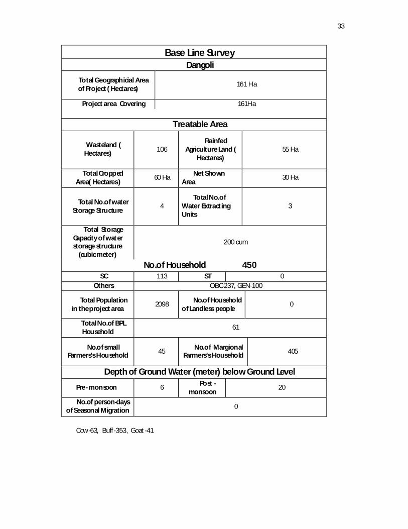
Base Line Survey Dangoli
Total Geographicial Area of Project ( Hectares)
161 Ha
Project area Covering 161Ha
Treatable Area
Wasteland ( Hectares) 106
Rainfed Agriculture Land (
Hectares) 55 Ha
Total Cropped Area( Hectares)
60 Ha Net Shown Area
30 Ha
Total No.of water Storage Structure
4 Total No.of
Water Extracting Units
3
Total Storage Capacity of water storage structure
(cubic meter)
200 cum
No.of Household 450 SC 113 ST 0
Others OBC-237, GEN-100
Total Population in the project area
2098 No.of Household of Landless people
0
Total No.of BPL Household
61
No.of small Farmers's Household 45 No.of Margional
Farmers's Household 405
Depth of Ground Water (meter) below Ground Level
Pre- monsoon 6 Post -monsoon
20
No.of person-days of Seasonal Migration 0
Cow-63, Buff-353, Goat-41

34
Yearwise annual action Plan
Name of Micro Watershed/GP Dangoli 2011-12 2012-13 2013-14 2014-15 2015-16 Total Sr No
Name of Activity Units Phy Fin Phy Fin Phy Fin Phy Fin Phy Fin Phy Fins
1 Land Dev A forestation Ha 0 0 0 0 0 0 0 0 0 0 0 0
Horticulture Ha 0 0 0 0 0 0 0 0 0 0 0 0 Agriculture Ha 0 0 0 0 0 0 0 0 0 0 0 0 Pasture Ha 0 0 0 0 0 0 0 0 0 0 0 0
2 SMC Staggered Renches Ha 0 0 0 0 0 0 0 0 0 0 0 0 Other Ha 0 0 0 0 0 0 0 0 0 0 0 0
3 Vegetative Earthen Checks Cum 0 0 0 0 0 0 0 0 0 0 0 0 Cratewire
Structures Cum 0 0 65 1.95 0 0 65 1.95
Gabian Structures Cum 0 0 0 0 0 0 0 0 0 0 0 0 Other/Protection
Walls Cum 0 0 0 0 15 1.25 15 1.2 10 0.7 40 3.15
4 WHS Farm Ponds No 0 0 1 0.5 1 0.5 0 0 0 0 2 1 Check Dams No 0 0 0 0 0 0 0 0 0 0 0 0 Rooftop Water Storage Tank
No 0 0 0 0 0 0 0 0 0 0 0 0
Ground water recharge structures
No 0 0 0 0 1 5.424 0 0 0 0 1 5.424
Other Irrigation Channel
1 0.5 1 0.5 1 0.5 1 0.5 4 2
5 Livelihood No of on farm activities
No 0 0 0 0 0 0 0 0 0 0 0 0
No of Beneficiaries No 0 0 0 0 0 0 0 0 0 0 0 0 No of off farm No 0 0 0 0 0 0 0 0 0 0 0 0
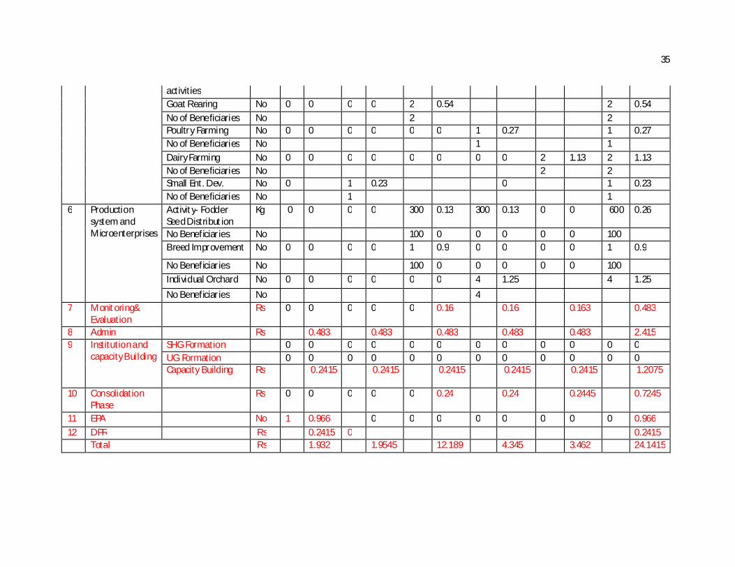
35
activities Goat Rearing No 0 0 0 0 2 0.54 2 0.54 No of Beneficiaries No 2 2 Poultry Farming No 0 0 0 0 0 0 1 0.27 1 0.27 No of Beneficiaries No 1 1 Dairy Farming No 0 0 0 0 0 0 0 0 2 1.13 2 1.13 No of Beneficiaries No 2 2 Small Ent. Dev. No 0 1 0.23 0 1 0.23 No of Beneficiaries No 1 1
6 Production system and Microenterprises
Activity- Fodder Seed Distribution
Kg 0 0 0 0 300 0.13 300 0.13 0 0 600 0.26
No Beneficiaries No 100 0 0 0 0 0 100 Breed Improvement No 0 0 0 0 1 0.9 0 0 0 0 1 0.9
No Beneficiaries No 100 0 0 0 0 0 100 Individual Orchard No 0 0 0 0 0 0 4 1.25 4 1.25 No Beneficiaries No 4
7 Monitoring& Evaluation
Rs 0 0 0 0 0 0.16 0.16 0.163 0.483
8 Admin Rs 0.483 0.483 0.483 0.483 0.483 2.415 9 Institution and
capacity Building SHG Formation 0 0 0 0 0 0 0 0 0 0 0 0 UG Formation 0 0 0 0 0 0 0 0 0 0 0 0 Capacity Building Rs 0.2415 0.2415 0.2415 0.2415 0.2415 1.2075
10 Consolidation Phase
Rs 0 0 0 0 0 0.24 0.24 0.2445 0.7245
11 EPA No 1 0.966 0 0 0 0 0 0 0 0 0.966 12 DPR Rs 0.2415 0 0.2415 Total Rs 1.932 1.9545 12.189 4.345 3.462 24.1415
36
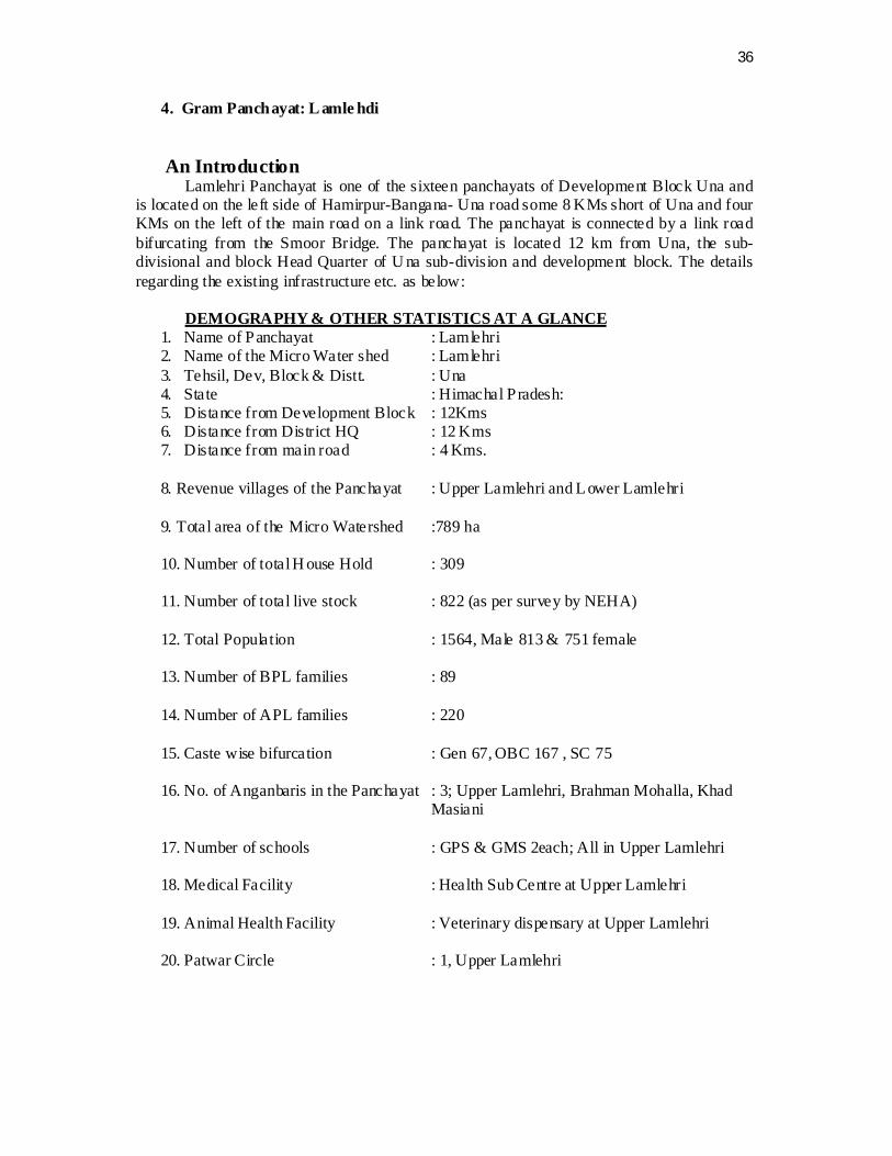
4. Gram Panchayat: L amle hdi An Introduction
Lamlehri Panchayat is one of the sixteen panchayats of Development Block Una and is located on the left side of Hamirpur-Bangana- Una road some 8 KMs short of Una and four KMs on the left of the main road on a link road. The panchayat is connected by a link road bifurcating from the Smoor Bridge. The panchayat is located 12 km from Una, the sub-divisional and block Head Quarter of U na sub-division and development block. The details regarding the existing infrastructure etc. as below:
DEMOGRAPHY & OTHER STATISTICS AT A GLANCE
1. Name of Panchayat : Lamlehri 2. Name of the Micro Water shed : Lamlehri 3. Tehsil, Dev, Block & Distt. : Una 4. State : Himachal Pradesh: 5. Distance from Development Block : 12Kms 6. Distance from District HQ : 12 Kms 7. Distance from main road : 4 Kms. 8. Revenue villages of the Panchayat : Upper Lamlehri and Lower Lamlehri 9. Total area of the Micro Watershed :789 ha 10. Number of total H ouse Hold : 309 11. Number of total live stock : 822 (as per survey by NEHA) 12. Total Population : 1564, Male 813 & 751 female 13. Number of BPL families : 89 14. Number of APL families : 220 15. Caste wise bifurcation : Gen 67, OBC 167 , SC 75
16. No. of Anganbaris in the Panchayat : 3; Upper Lamlehri, Brahman Mohalla, Khad
Masiani 17. Number of schools : GPS & GMS 2each; All in Upper Lamlehri
18. Medical Facility : Health Sub Centre at Upper Lamlehri 19. Animal Health Facility : Veterinary dispensary at Upper Lamlehri 20. Patwar Circle : 1, Upper Lamlehri
37
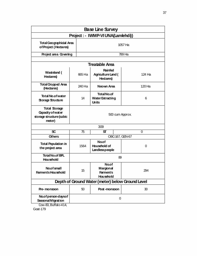
Base Line Survey Project : - IWMP-VI UNA(Lamlehdi))
Total Geographicial Area of Project ( Hectares)
1057 Ha
Project area Covering 789 Ha
Treatable Area
Wasteland ( Hectares)
665 Ha Rainfed
Agriculture Land ( Hectares)
124 Ha
Total Cropped Area (Hectares) 240 Ha Neown Area 120 Ha
Total No.of water Storage Structure 14
Total No.of Water Extracting Units
6
Total Storage Capacity of water
storage structure (cubic meter)
500 cum Approx.
309 SC 75 ST 0
Others OBC-167, GEN-67
Total Population in the project area 1564
No.of Household of Landless people
0
Total No.of BPL Household
89
No.of small Farmers's Household 15
No.of Margional Farmers's
Household
294
Depth of Ground Water (meter) below Ground Level
Pre- monsoon 50 Post -monsoon 30
No.of person-days of Seasonal Migration
0
Cow-83, Buffalo-414, Goat-179

38
Year wise Annual Action Plan
Name of Micro Watershed/GP/ Lamlehdi (MIS FORMAT) 2011-12 2012-13 2013-14 2014-15 2015-16 Total Sr No
Name of Activity Units
Phy Fin Phy
Fin Phy Fin Phy
Fin Phy Fin Phy Fins
1 Land Dev Aforestation Ha 0 0 2.4 0.189 9.7 0.714 4.9 0.378 17 1.281 Horticulture Ha 0 0 0 0 0 0 0 0 0 0 0 0 2 SMC Staggered Renches Ha 0 0 0 0 0 0 0 0 0 0 0 0 Other Ha 0 0 0 0 0 0 0 0 0 0 0 0 3 Vegetative Earthen Checks Cum 0 0 0 0 0 0 0 0 0 0 0 0 Cratewire Structures Cum 12
0 2.55 80 2.55 55 1.65 40 1.2 215 7.95
Gabian Structures Cum Other Protection walls Cum 0 0 0 0 30 1.9 0 0 0 0 4 1.9 4
WHS Farm Ponds No 0 0 7 15.07 6 14.5 4 8 0 0 17 37.57
Check Dams No 0 0 0 0 0 0 0 0 0 0 0 0 Rooftop RWH Tank No 0 11 3.96 5 1.8 6 2.16 6 2.16 28 10.08 Ground water recharge structures
No 0 0 0 0 2 4 2 3.5 0 0 4 7.5
5
Livelihood No of on farm activities No 0 0 0 0 0 0 0 0 0 0 0 0 No of off farm activit ies No Tailoring Group No 0 0 2 1.1 2 1.1 1 0.55 0 0 5 2.75 No of Beneficiaries No 20 20 10 50 Vermi Compost No 0 0 0 0 15 0.525 15 0.525 10 0.35 40 1.4 No of Beneficiaries No 0 0 0 0 15 0 15 0 10 0 40 Dairy Dev. No 0 0 0 0 4 2.4 4 2.4 2 1.2 10 6 No of Beneficiaries No 4 4 2 10
Poultry Farming No 2 0.5 2 0.5 No of Beneficiaries No 2 2

39
6 Production system and Microenter.
Garden Colony Ha 0 0 0 0 1 1.5 0 0 0 0 1 1.5
No of Beneficiaries No 0 0 0 0 5 0 0 0 0 0 5 0
Individual Orchards Ha 0 0 3 0.74 6 0.16 2 0.05 0 0 11 0.95 No of Beneficiaries No 6 5 11
Vegetable Production No 0 0 0 0 2 0.374 0 0 0 0 2 0.374 No of Beneficiaries No 0 0 0 0 17 0 0 0 0 0 17 0 Breed Improvement No 0 0 0 0 2 1.8 0 0 0 0 2 1.8
No of Beneficiaries No 0 0 0 0 200 0 0 0 0 0 200 0 Fodder Seed Kg 0 0 25
0 0.1315 250 0.1315 25
0 0.1315
254 0.1315 1004
0.526
No of Beneficiaries No 250
250 250
254 254
Chaff Cutter No 0 0 0 0 3 0.24 4 0.32 3 0.24 10 0.8 No of Beneficiaries No 3 4 3 Mangers No 0 0 10 0.35 11 0.385 10 0.35 0 0 31 1.085 No of Beneficiaries No 0 0 10 0 11 0 10 0 0 0 31 0 Silage Pit No 0 0 10 1.5 10 1.5 10 1.5 2 0.3 32 4.8 No of Beneficiaries No 0 0 10 0 10 0 1 0 0 0 0 0
7 M &E Rs 0 0 0 0 0 0.789 0.789 0.789 2.367 8 Admin Rs 0 2 2.5 2.5 0 2.5 2.335 11.835 9 EPA
1 4.734 0 0 0 0 0 0 0 0 1 4.734
10 Ins. and Cap.Building
SHG Formation 0 0 0 0 0 0 0 0 0 0 0 0 Capacity Building Rs 0 1.18 0 1.18 0 1.18 0 1.18 0 1.18 0 5.9175 11 Con. Phase Rs 0 0 0 0 0 1.18 0 1.18 0 1.1905 0 3.5505 11 DPR Rs 1.1835 0 0 0 0 0 0 0 0 0 1.1835 Total Rs 9.0975 29.270
5 41.2285
27.164
11.576 118.3535

40
5. Gram Panchayat: Madanpur
Madanpur Panchayat- An Introduction Madanpur Panchayat is one of the sixteen panchayats of Development Block Una and
is located on the left side of Mehat Pur- Una road some 4 KMs short of Una. The panchayat is located 4 km from Una, the sub-divisional and block Head Quarter of Una sub-division and development block. The details regarding the existing infrastructure etc. as below:
DEMOGRAPHY & OTHER STATISTICS AT A GLANCE 1. Name of Panchayat : Madanpur 2. Name of the Micro Water shed : Madanpur 3. Tehsil, Dev, Block & Distt. :Una 4. State :Himachal Pradesh: 5. Distance from Development Block : 4Kms 6. Distance from District HQ : 4 Kms 7. Distance from main road : 4 Kms. 8. Revenue villages of the Panchayat : Madanpur 9. Total area of the Micro Watershed :414 ha 10. Number of total H ouse Hold : 198 11. Number of total live stock : 197(as per survey by NEHA) 12. Total Population : 912, Male 475 & 437 female 13. Number of BPL families : 37 14. Number of APL families : 161 15. Caste wise bifurcation : Gen 115, OBC 81 , SC 2
16. N o. of Anganbaris in the Panchayat : 3; Labana Mohalla, Brahman Mohalla, Saini
Mohala 17. Number of schools : GPS at Madanpur
18. Medical Facility :Health Sub Centre at Upper Lamlehri
19. Tample : Baba Bankhandi Mahadev
20. Patwar Circle ; Madanpur

41
Base Line Survey Project : - IWMP-VI UNA(Madanpur)
Total Geographicial Area of Project ( Hectares)
432 Ha
Project area Covering 414 Ha
Treatable Area
Wasteland ( Hectares) 335 Ha Rainfed Agriculture Land ( Hectares)
79 Ha
Total Cropped Area( Hectares)
120 Ha Net Sown Area 60 Ha
Total No.of water Storage Structure 26
Total No.of Water Extracting Units
29
Total Storage Capacity of water storage structure
(cubic meter) 300 CUM
No.of Household 198 SC 2 ST 0
Others OBC-81, GEN-115
Total Population in the project area 912
No.of Household of Landless people
0
Total No.of BPL Household 37
No.of small Farmers's Household 45
No.of Margional Farmers's Household
143
Depth of Ground Water (meter) below Ground Level
Pre- monsoon 6 Post -
monsoon 20
No.of person-days of Seasonal Migration 0
Cow-43, Buf-140, Goat-4
42
Name of Micro Watershed/GP Madanpur (MIS) Yearwise Annual Action Plan 2011-12 2012-13 2013-14 2014-15 2015-16 Total Sr No
Name of Activity Units Phy Fin Phy Fin Phy Fin Phy Fin Phy Fin Phy Fins
1 Land Dev A forestation Ha 0 0 0.75 0.2625 5 1.4625 6 1.95 11.75 3.675
Horticulture Ha 0 0 0 0 0 0 0 0 0 0 0 0 Agriculture Ha 0 0 0 0 0 0 0 0 0 0 0 0 Pasture Ha 0 0 0 0 0 0 0 0 0 0 0 0 2 SMC Staggered Renches Ha 0 0 0 0 0 0 0 0 0 0 0 0 Contour Trenching Ha 0 0 0 0 0 0 0 0 0 0 0 0 Graded Bunds Ha 0 0 0 0 0 0 0 0 0 0 0 0 Bench Terracing Ha 0 0 0 0 0 0 0 0 0 0 0 0 Other Ha 0 0 0 0 0 0 0 0 0 0 0 0 3 Vegetative Earthen Checks Cum 0 0 0 0 0 0 0 0 0 0 0 0
Engineering Brushwood Checks Rmt 0 0 0 0 0 0 0 0 0 0 0 0 Structures Gully Plugs Cum 0 0 0 0 0 0 0 0 0 0 0 0
Cratewire Structures
Cum 0 0 0 0 15 1.38 25 2.45 20 1.43 60 5.26
Gabian Structures Cu.m 0 0 0 0 0 0 0 0 0 0 0 0 Other 0 0 0 0 0 0 0 0 0 0 0 0 4 WHS Farm Ponds No 1 5 1 5 1 3 1 4 4 17 Check Dams No 0 0 0 0 0 0 0 0 0 0 0 0 Nallah Bunds No 0 0 0 0 0 0 0 0 0 0 0 0
Percolation Tanks No 0 0 0 0 0 0 0 0 0 0 0 0 Rooftop Water
Storage Tank No 6 2.16 6 2.16 7 2.52 19 6.84
Ground water recharge
No 0 0 0 0 0 0 0 0 0 0 0 0
43
structures
Other/Irrigation Chanel
No 1 2 1 2
5 Livelihood No of on farm activities
No 0 0 0 0 0 0 0 0 0 0 0 0
No of Beneficiaries No 0 0 0 0 0 0 0 0 0 0 0 0
Vegetable Production
No 0 0 0 0 1 0.11 0 0 0 0 1 0.11
No of Beneficiaries No 1 1
No of off farm activities
No 0 0 0 0 0 0 0 0 0 0 0 0
Tailoring Groups No 0 0 1 0.75 1 0.75
No of Beneficiaries No 10 0 10
Dairy Development No
0 0 0 0 4 1.8 4 1.8 2 0.9 2 4.5
No of Beneficiaries No 2 2 Small Enterpenor Dev.
No 0 0 1 0.23 0 1 0.23
No of Beneficiaries No 0 1 0 0 0 0 0 0 0 1
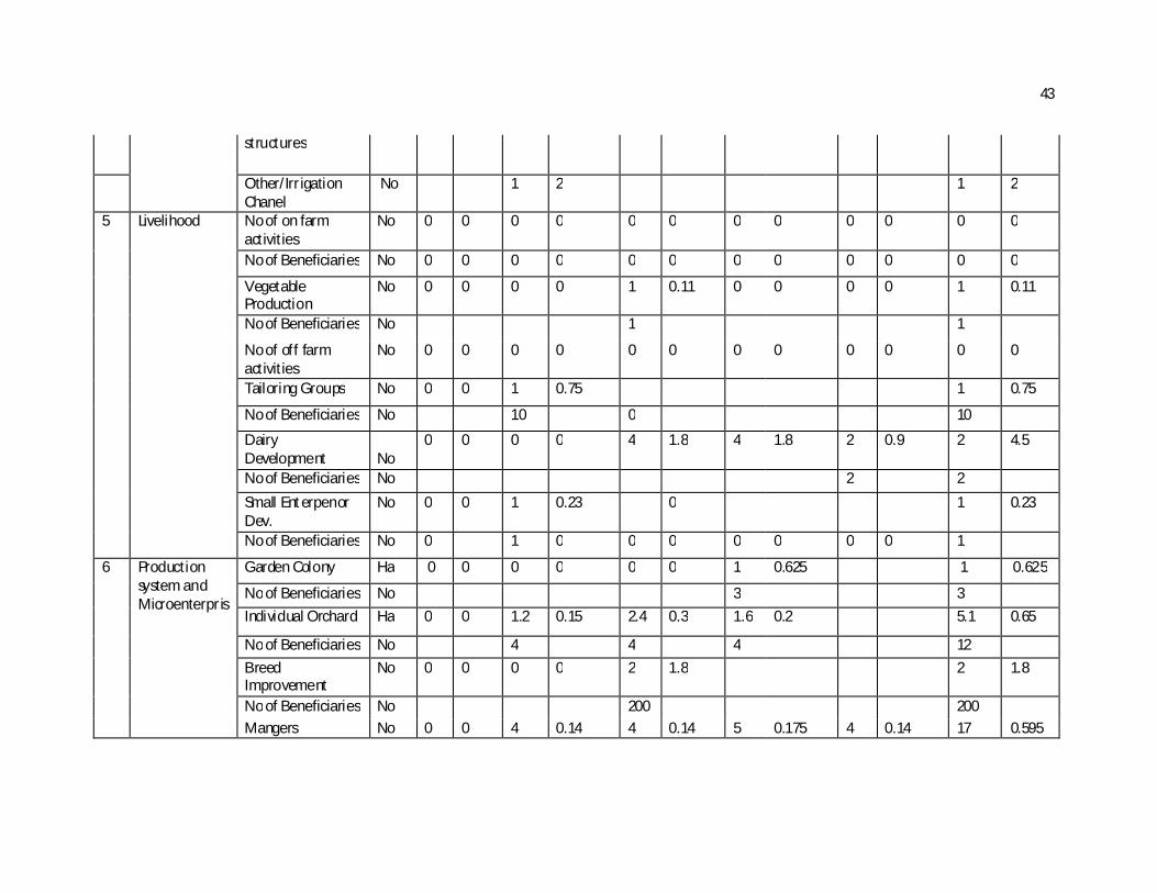
6 Production system and Microenterpris
Garden Colony Ha 0 0 0 0 0 0 1 0.625 1 0.625
No of Beneficiaries No 3 3 Individual Orchard Ha 0 0 1.2 0.15 2.4 0.3 1.6 0.2 5.1 0.65
No of Beneficiaries No 4 4 4 12 Breed Improvement
No 0 0 0 0 2 1.8 2 1.8
No of Beneficiaries No 200 200 Mangers No 0 0 4 0.14 4 0.14 5 0.175 4 0.14 17 0.595

44
No of Beneficiaries
No 4 4 5 4 17
Chaff Cutter No 0 0 0 0 0 0 5 0.4 5 0.4 No of Beneficiaries No 5 5 Fodder Seed Distribution
Kg 0 0 250 0.13125 250 0.13125 250 0.13125 250 0.13125 1000 0.525
No of Beneficiaries No 125 0 0 0 0 0 0 0 125 Silage Pit No 0 0 4 0.6 4 0.6 4 0.6 0 0 12 1.8 No of Beneficiaries No 4 4 4 12
7 Monitoring & Evaluation
Rs 0 0 0 0 0 0.4 0.4 0.442 1.242
8 Admin Rs 1.242 1.242 1.242 1.242 1.242 6.21 9 Institution and
capacity Building
SHG Formation 0 0 0 0 0 0 0 0 0 0 0 0 UG Formation 0 0 0 0 0 0 0 0 0 0 0 0 Capacity Building Rs 1.35 0.55 0.55 0.655 3.105
10 Consolidation Phase
Rs 0 0 0 0 0 0.65 0.65 0.563 1.863
11 EPA Rs 2 2.484 0 0 0 0 0 0 0 0 0 2.484 11 DPR Rs 0.621 0 0 0 0 0 0 0 0 0 0.621 Total Rs 4.347 13.44075 17.6008 16.56825 10.12825 62.085
45
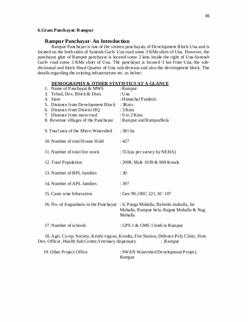
6.Gram Panchayat: R ampur
Rampur Panchayat- An Introduction Rampur Panchayat is one of the sixteen panchayats of Development B lock Una and is
located on the both sides of Santosh Garh- Una road some 3 KMs short of Una. However, the panchayat ghar of Rampur panchayat is located some 2 kms inside the right of Una-Santosh Garh- road some 3 KMs short of Una. The panchayat is located 3 km from Una, the sub-divisional and block Head Quarter of Una sub-division and also the development block. The details regarding the existing infrastructure etc. as below:
DEMOGRAPHY & OTHER STATISTICS AT A GLANCE
1. Name of Panchayat & MWS : Rampur 3. Tehsil, Dev, Block & Distt. : Una 4. State : Himachal Pradesh: 5. Distance from Development Block : 3Kms 6. Distance from District HQ : 3 Kms 7. Distance from main road : 0 to 2 Kms. 8. Revenue villages of the Panchayat : Rampur and RampurBela 9. Total area of the Micro Watershed : 381 ha 10. Number of total H ouse Hold : 427 11. Number of total live stock : 551(as per survey by NEHA) 12. Total Population : 2008, Male 1039 & 969 female 13. Number of BPL families : 30 14. Number of APL families : 397 15. Caste wise bifurcation : Gen 99, OBC 221, SC 107
16. No. of Anganbaris in the Panchayat : 6; Panga Mohalla, Balmiki mohalla, Jat
Mohalla, Rampur bela, Rajput Mohalla & Nag Mohalla
17. Number of schools : GPS 1 & GMS 1 both in Rampur
18. Agri. Co-op. Society, Krishi vigyan, Kendra, Fire Station, Defence Poly Clinic, Hort.
Dev. Officer, Health Sub Centre,Vetrinary dispensary : Rampur 19. Other Project Office : SWAN Watershed Development Project,
Rampur
46
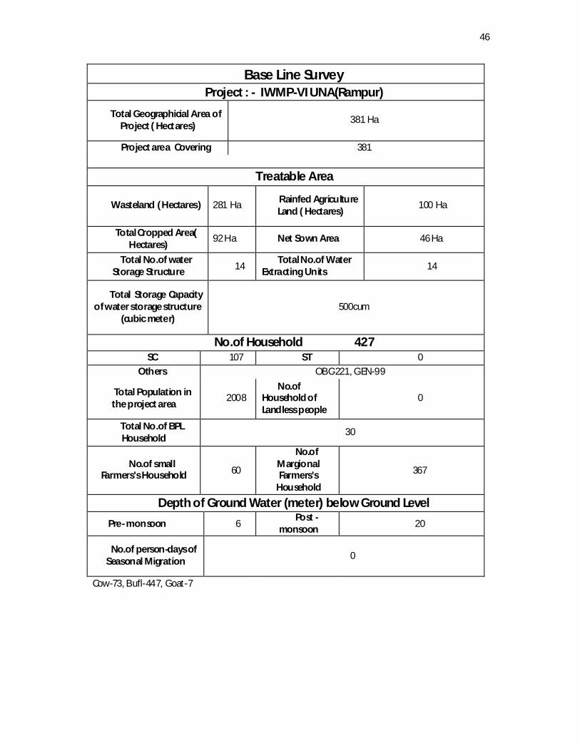
Base Line Survey Project : - IWMP-VI UNA(Rampur)
Total Geographicial Area of Project ( Hectares)
381 Ha
Project area Covering 381
Treatable Area
Wasteland ( Hectares) 281 Ha Rainfed Agriculture Land ( Hectares)
100 Ha
Total Cropped Area( Hectares)
92 Ha Net Sown Area 46 Ha
Total No.of water Storage Structure 14
Total No.of Water Extracting Units 14
Total Storage Capacity of water storage structure
(cubic meter) 500cum
No.of Household 427 SC 107 ST 0
Others OBC-221, GEN-99
Total Population in the project area
2008 No.of
Household of Landless people
0
Total No.of BPL Household
30
No.of small Farmers's Household 60
No.of Margional Farmers's
Household
367
Depth of Ground Water (meter) below Ground Level Pre- monsoon 6
Post -monsoon 20
No.of person-days of Seasonal Migration 0
Cow-73, Bufl-447, Goat-7

47
Name of Micro Watershed/GP Rampur Yearwise Annual Action Plan (MIS) 2011-12 2012-13 2013-14 2014-15 2015-16 Total Sr No
Name of Activity Units Phy Fin Phy Fin Phy Fin Phy Fin Phy Fin Phy Fins
1 Land Dev A forestation Ha 0 0 0 0 0 0 0 0 0 0 0 0
Horticulture Ha 0.5 0.025 0.5 0.025 Pasture Ha 0 0 0 0 0 0 0 0 0 0 0 0
2 SMC Staggered Trenches
Ha 0 0 0 0 0 0 0 0 0 0 0 0
Graded Bunds Ha 0 0 0 0 0 0 0 0 0 0 0 0 Bench Terracing Ha 0 0 0 0 0 0 0 0 0 0 0 0 Other Ha 0 0 0 0 0 0 0 0 0 0 0 0
3 Vegetative Earthen Checks Cum 0 0 0 0 0 0 0 0 0 0 0 0 Engineering Brushwood
Checks Rmt 0 0 0 0 0 0 0 0 0 0 0 0
Structures Gully Plugs Cum 0 0 0 0 0 0 0 0 0 0 0 0 Cratewire Struc. Cum 0 0 0 0 0 0 0 0 65 1.95 65 1.95 Other/Prot. Wall cum 60 2.8 60 2.8
4 WHS Farm Ponds No 2 0.4 2 0.4 2 0.5 3 0.85 9 2.15 Check Dams No Rooftop Water Storage Tank
No 0 0 0 0 0 0 0 0 0 0 0 0
Other/Irrigation Chanel
No 3 1.39 2 0.54 2 2.7 7 4.63
Sewage Channels
No 0 0 0 0 2 3 2 2 1 15.45 5 20.45
5 Livelihood No of on farm activities
No 1 0.792 1 3 30 3.792
No of Beneficiar No 30 30 60
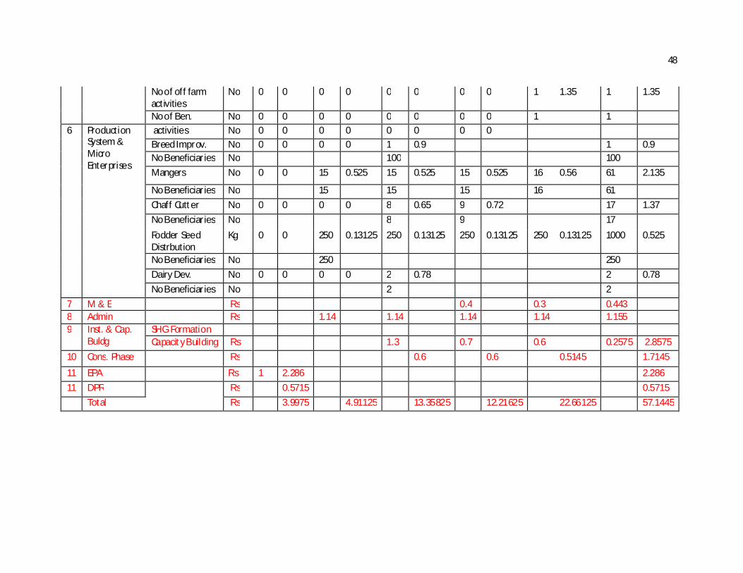
48
No of off farm activities
No 0 0 0 0 0 0 0 0 1 1.35 1 1.35
No of Ben. No 0 0 0 0 0 0 0 0 1 1 6 Production
System & Micro Enterprises
activities No 0 0 0 0 0 0 0 0 Breed Improv. No 0 0 0 0 1 0.9 1 0.9 No Beneficiaries No 100 100 Mangers No 0 0 15 0.525 15 0.525 15 0.525 16 0.56 61 2.135
No Beneficiaries No 15 15 15 16 61 Chaff Cutter No 0 0 0 0 8 0.65 9 0.72 17 1.37 No Beneficiaries No 8 9 17 Fodder Seed Distrbution
Kg 0 0 250 0.13125 250 0.13125 250 0.13125 250 0.13125 1000 0.525
No Beneficiaries No 250 250 Dairy Dev. No 0 0 0 0 2 0.78 2 0.78 No Beneficiaries No 2 2
7 M & E Rs 0.4 0.3 0.443 8 Admin Rs 1.14 1.14 1.14 1.14 1.155 9 Inst. & Cap.
Buldg SHG Formation Capacity Building Rs 1.3 0.7 0.6 0.2575 2.8575
10 Cons. Phase Rs 0.6 0.6 0.5145 1.7145
11 EPA Rs 1 2.286 2.286 11 DPR Rs 0.5715 0.5715 Total Rs 3.9975 4.91125 13.35825 12.21625 22.66125 57.1445
49
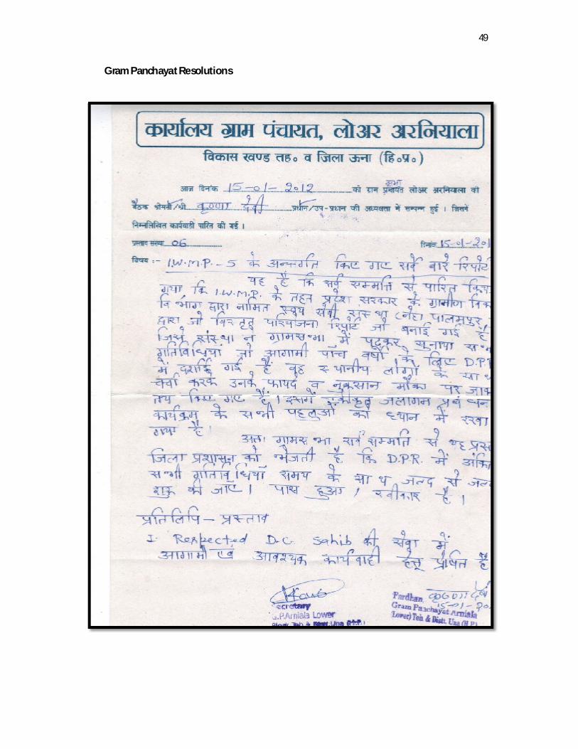
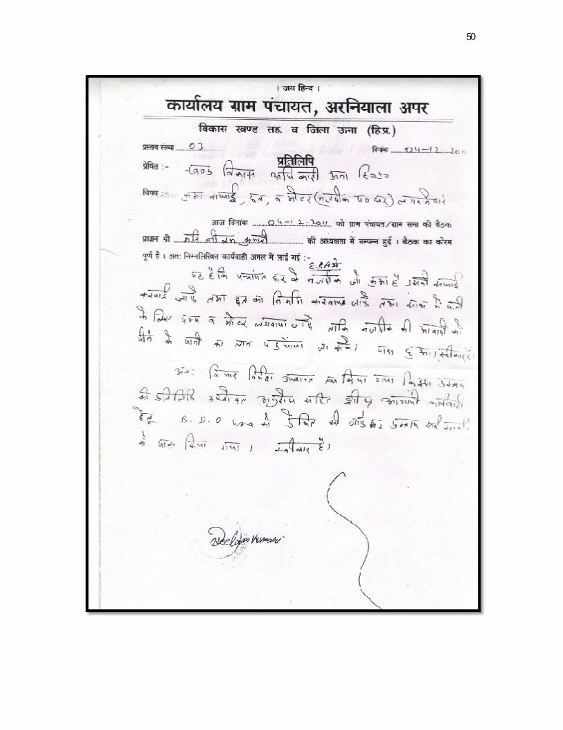
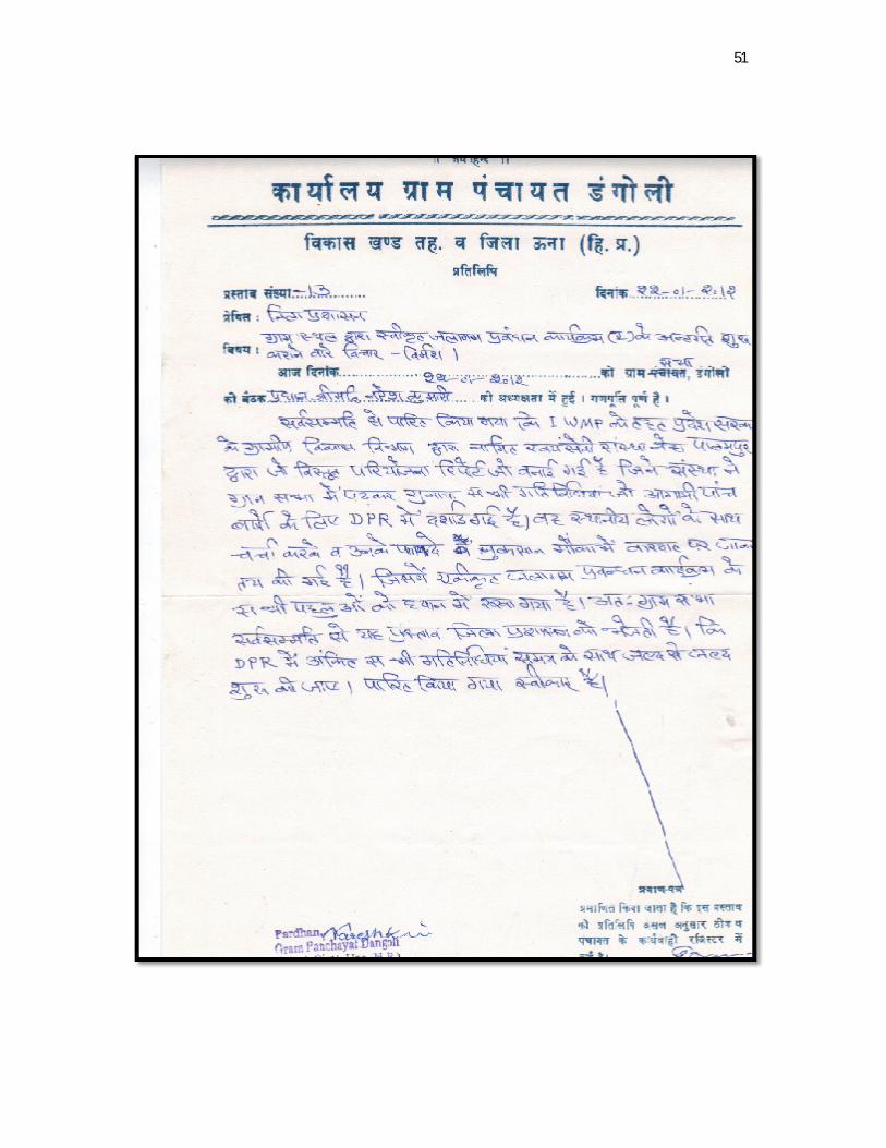
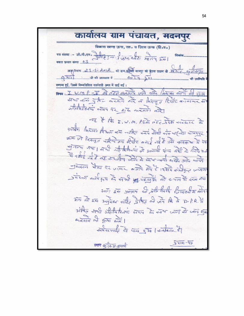
Gram Panchayat Resolutions
50
51

52

53
54