collection of cycle concepts 2012
TRANSCRIPT

ColleCtion of CyCle ConCepts 2012

COLOPHON
Title: Collection of Cycle Concepts 2012
Authors: Troels Andersen, Fredericia Municipality
Frits Bredal, Danish Cyclists’ Federation
Marianne Weinreich, VEKSØ
Niels Jensen, City of Copenhagen
Morten Riisgaard-Dam, Aros Kommunikation
Malene Kofod Nielsen, COWI
Advisory Group: Søren Underlien-Jensen, Trafitec
Henrik Nejst Jensen, The Danish Road Directorate
Troels Andersen, Fredericia Municipality
Malene Kofod Nielsen, COWI
Images: See Sources and photo credits
Layout: Aros Kommunikation
Translation: Joan Høberg-Petersen
Printer: Rounborg Grafiske Hus, Holstebro
Copies issued: 1,300
Publisher: Cycling Embassy of Denmark.
Published with funding from the national cycling promotion fund.
Collection of cycle concepts 2012 revises and updates
Collection of cycle concepts published by
the The Danish Road Directorate, 2000.

1 FOREWORD
The first edition of Collection of Cycle Concepts was published in 2000 and enjoyed a wide circulation among everyone interested in bicycle traffic. The simultaneous publication of the English version spread the Danish bicycle traffic experience to many parts of the world.The second edition, Collection of Cycle Concepts 2012, updates the field, featuring new challenges and the latest knowledge.Collection of Cycle Concepts 2012 is not intended to be a summary of Danish road standards, but to provide inspi-ration and motivation for creating more and safer bicycle traffic – in Denmark as well as the rest of the world.
Troels Andersen, chairman,Cycling Embassy of Denmark

Knowledge sharingInspirationCooperation
CampaignsMotivation
Benefits
Cost-benefitCycling initiatives
Models
Bicycle parking facilitiesSpoiling the cyclistBicycle service
PassabilitySecuritySafety
SignageCycle mapsCycle route planners

LifestyleActivitiesCycling facilities
MaintenanceQualitySign posting
Cycling infrastructureTraditionRoad safety
Cycle tourismAttractionsActivities
Bicycle trafficUrban planning Sustainable transport
City bikesCommuter bikesCompany bikes
2. Introduction 7 - 10 3. Collaborations and networks 11 - 14 4. Cost-benefit and traffic models 15 - 20 5. Campaigns and marketing 21 - 30 6. Health and cycling 31 - 36 7. Urban planning and bicycle planning 37 - 46 8. Planning the cycling infrastructure 47 - 72 9. Designing the cycling infrastructure 73 - 106 10. Bicycle parking 107 - 122 11. Road signage and maps, cycle route planners, and ITS 123 - 134 12. Maintenance and road construction 135 - 142 13. Public bikes and commuter bikes 143 - 148 14. Cycle tourism 149 - 156 15. Sources and photo credits 157 - 162
Contents

2 INTRODUCTIONCOLLECTION OF CYCLE CONCEPTS 2012
Bicycle traffic is healthy, environmentally friendly, and makes
cities more livable. Cycling is a fast and efficient urban
transport mode and requires less space than motor vehicle
traffic.
The Collection of cycle concepts 2012 presents a number of
ideas to help generate more bicycle traffic and reduce the
accident rate among cyclists.

INTRODUCTION
The growth of vehicular traffic presents a
challenge to the environment as well as to traffic
flows. The issue is less pronounced in Denmark
than in other European countries, but is getting
worse. Fortunately, Denmark has a strong bicycle
culture, developed over more than a century.
Today approximately 1 journey in 5 in Denmark
takes place by bike. The denser the urban area,
the higher the cycling modal share; in the densest
urban areas cycling is the primary transport
mode.
In order to create sustainable transport in future,
cycling must continue to play a major role. The
infrastructure must be designed so as to get
maximum use out of the bicycle’s features and
possibilities. In return bicycle traffic reduces the
need for major roads, thereby making it possible
to postpone or avoid costly road construction.
A large proportion of short journeys in cities can
take place by bicycle. Cars are often indispensable
for longer journeys and the bicycle cannot be the
sole transport mode. A reasonable interaction
between transport modes is necessary. The proper
balance of high quality roads and paths that
meet the needs of pedestrians, cyclists and drivers
can create more livable cities without sacrificing
interaction.
In recent years the use of cargo bikes and cycle
trailers to carry children or goods has become
increasingly widespread. This makes life much
easier for families with children even without a
car or a second car. A marked increase in the use
of e-bikes, which has not been at the expense
of traditional bikes, is another factor that helps
improve the quality of life over somewhat longer
distances.
Increasingly, cycling is being integrated with bus,
train and even air travel for long journeys; this is
important, since commuting is on the rise and
fewer and fewer people can rely on the bicycle
as their sole transport mode. There is a need for
traffic terminals that provide easy access when
changing from one transport mode to another.
Cycling is also of great benefit to the individual. A
half hour of daily physical activity, such as cycling,
increases the average life span by several years and
improves the physical and mental quality of life.
Cycling is a healthy, prophylactic form of exercise.
Furthermore, in urban areas cycling is often the
quickest means of getting from point A to point B.
When cycling you experience the weather and the
seasons more deeply, becoming an integral part of
the life of the city.

INTRODUCTION
Road authorities are not the only ones who are
instrumental in changing our transport attitudes,
making it more acceptable to bike; businesses,
schools, organizations, etc. can also play a major
role.
MORE CYCLISTS, PLEASE!Many people choose to cycle because it’s
convenient, healthy and cheap. However, it’s a
major challenge to encourage people to change
transport modes so that more people cycle rather
than drive.
It is essential to combine public relations,
educational campaigns and other soft measures
with hard, physical and economic initiatives. The
combination of hard and soft measures is crucial
to bring about a significant change in citizens’
transport habits and road safety behaviour. At
the same time the synergistic effect of multiple
initiatives yields a higher rate of behavior
modification for the money.
There are two general approaches for designing
campaigns to promote cycling. The first approach
aims at encouraging frequent cyclists to continue
cycling and occasional cyclists to cycle more.
This is a relatively cheap way to promote bicycle
traffic. The young and the middle aged are the
primary target audience and can be reached
through businesses and educational institutions.
A good example of this type of campaign is the
“We bike to work” campaign, which mobilizes
100,000 Danish participants. This type of
campaign is part of a larger picture in which
sustainable mobility is the key concept.
The second type of campaign aims at persuading
people who are primarily drivers to cycle.
Children as a target group play a vital role in
this kind of campaign because bicycle culture is
based on a continuous influx of new cyclists and
the foundation for cycling habit formation takes
place in childhood. Competitions and education
have proved effective in encouraging children
to cycle, especially in combination with projects
designed to improve road safety and sense of
security on school routes. Inveterate drivers
are relatively resource demanding, and should
therefore be dropped as a primary target group.
It is true of all cycling campaigns that a positive
approach based on enjoyable experiences,
humour and fun is far more effective than waving
an admonishing finger. In addition to running
promotional campaigns it is essential to tell
the public what steps are actually being taken
for cyclists. Over the long haul the continuous
marketing of good cycling stories constantly
reminds citizens of the advantages of cycling.
Improving physical conditions for cyclists is a must
since citizens need to see favourable material
changes to make them want to choose cycling
as an alternative to driving. The construction of
cycle tracks is excellent, but smooth road and
cycle track surfaces are also key parameters, as
are bicycle parking facilities. Small measures can
have a big impact, and cycle friendly installations
generate positive PR.
Quality lies in the details. There are many
different types of cycle track and the choice of
cross profile can be crucial. Intersection design
has a tremendous impact on safety as well as
passability. Fortunately, Denmark has many years
of experience with many different designs to
protect cyclists from injury. In recent years work
has been done to devise new methods of giving
cyclists priority so as to increase travel speeds
and reduce the number of stops. Cyclists can be
catered to by a number of different services that
make daily life a bit easier.
Cycling promotion becomes significantly more
difficult when motor traffic is encouraged by
favourable physical and economic conditions.
Motor traffic conditions are often improved,
particularly when automobile related expenses
drop. In Denmark we are accustomed to
introducing restrictions on motor traffic, such
as fuel taxes, parking fees and speed-limit
reductions. Such restrictions will continue to
be necessary if the measures intended to boost
cycling are to have the desired effect. At least
of equal importance is the competition interface
with public transport. The goal should be that
public transport shouldn’t appear too attractive
to potential cyclists.
Fruitful collaboration between transport modes is
critical to the smooth function of society, socially,
economically, and in relation to traffic and the
environment. A coordinated effort is an absolute
must for improving health and creating more
livable cities .
SAFER CYCLISTSIn many cities where the number of cyclists has
increased, the total number of traffic accidents
has dropped more than in other cities. In other
words, it is possible to increase bicycle traffic and
improve road safety at the same time. The more
cyclists there are, the safer the individual cyclist,
the reason being that drivers very rarely overlook
a cluster of cyclists. More people cycling means
9

INTRODUCTION
that cyclists become more experienced in traffic;
inexperienced cyclists run a far greater risk than
daily cyclists.
Bicycle equipment and design have a major
impact on cyclist safety. Cycling in the dark down
a country road where there is no cycle track is
extremely risky without a tail light, for example.
In Denmark bicycle equipment and design have
to meet stringent requirements. Many other
factors have an impact on safety apart from
safety requirements. Cycling with a shopping bag
in your hand, for example, is not a good idea
from the safety point of view. A three-wheel bike
can be a good idea for the elderly. And all cyclists
can improve their personal safety by using a
helmet (not compulsory in Denmark) and bicycle
lights.
Control also plays a major role for traffic safety,
including bicycle and speed control. The bike
shop can inform customers of any regulation
infringements or other bicycle related issues,
and the police can help by increasing their
efforts to prevent dangerous and unlawful traffic
behaviour.
Information and promotional campaigns have
proved effective in improving driver safety.
Road safety campaigns need to be designed to
encourage cyclists to develop safer attitudes and
behaviour.
Road modifications are costly but are sometimes
the only solution to a specific safety issue. When
roads and cycle tracks are being dug up for
other reasons, this is an excellent opportunity to
change the road’s design, making it safer, more
comfortable, and more passable.
Road users make mistakes, so it’s important
to minimize situations where this can happen.
When mistakes happen anyway, minimize the
consequences of any accidents that may arise.
Cyclist safety can be improved in many different
ways. A more systematic approach is necessary,
and solutions should be aimed at the areas and
groups where they have the greatest impact.
One of the major challenges confronting cycling
promotion and safety is the need to implement
many different initiatives at the same time.
The whole issue of cyclist safety needs to address
cyclists’ sense of security as well. If cyclists don’t
feel secure, many will feel compelled to take the
long way round or even not bike at all. On the
other hand, especially in intersections, cyclists
shouldn’t feel so secure that they cease being
vigilant to possible dangers. The challenge
is to create safety and a sense of security by
enhancing cyclist vigilance.
GETTING A GOOD STARTEncouraging more people to cycle requires an
active effort. A number of measures need to be
taken simultaneously to improve cyclist safety.
The aim of the Collection of cycle concepts 2012
is to provide a general overview of the field as
well as inspiration and motivation.
The Collection of cycle concepts 2012 is primarily
aimed at traffic planners, but can be usefully
read by anyone with an interest in cycling. The
publication consists of chapters that can be
read independently and is therefore suitable for
reference purposes.
Have a pleasant journey!

3Indhold
The municipal cycle network 12The Cycling Embassy of Denmark 13Cycling at conferences and other platforms 14European collaboration 14
Informal networks as well as formalized, well-organized
associations ensure the necessary knowledge sharing,
inspiration and cooperation that cut across local administrative
boundaries.
Formal networks also give rise to informal contacts, generating
new ideas and projects.
It is typical of the field of bicycle planning that there are very
few people whose sole area of responsibility is cycling. In
some local administrations the entire field of cycle planning
is covered by one staff member. This makes it difficult to test
out ideas and exchange views with peers, keep up-dated
on the latest solutions and enter into innovative working
relationships.
In Denmark there are several opportunities for joining a
network and entering into a collaborative alliance.
The municipal cycle network focuses on knowledge sharing
among municipal practitioners while the Cycling Embassy
of Denmark consolidates cooperation between the private,
public and civil sectors. In addition, there are a number of
other platforms that consolidate cooperation and knowledge
sharing, such as conferences and minor networks.
COLLABORATIONS AND NETWORKS

COLLABORATIONS AND NETWORKS
THE MUNICIPAL CYCLE NETWORKThe municipal cycle network functions as a
professional platform for municipal practitioners
working with bicycle promotion projects. There
is no Danish tradition of close cross-municipal
cooperation at this level, and one of the
network’s aims is to ensure such cooperation.
The municipal cycle network provides a platform
for:
• Mutualinspirationandexchangeofideas.
• Communicatingexperiences.
• Buildingaknowledgebase.
• Testingideas.
• Seminars,workshopsandstudytrips.
• Establishingareferencebaseoftested
measures aimed at decision makers, politicians
and police (historical overview of new cycling
initiatives).
Establishing the municipal cycle networkDeveloping Denmark into a cycle friendly country
is largely a decentralized, local process. It is
therefore crucial that the many valuable initiatives
andexperiencesfromalloverthecountryare
collected, systematized and passed on. There is
alwaystheriskthatvaluableexperiencewillbe
lost if the individual authority works in a vacuum.
For a number of years Danish municipalities
received state funding, financed by the so-called
Trafikpuljen, to promote cycling initiatives. A
requirement for receiving the grant was to
communicateresultsandexperiencestotheother
local authorities.
In 1999 Trafikpuljen was discontinued and the
Danish Road Directorate’s secretariat which had
administered Trafikpuljen was shut down. The
task of ensuring the spread of information was
now entirely in the hands of the local authorities,
and the professional platform that had been
formed between the individual municipalities was
in danger of disappearing.
To ensure that the collaboration that had already
been established would continue and that the
individualmunicipality’sexperienceswould
be passed along, an agreement was reached
The municipal cycle network functions as a
professional platform
between the municipalities and the Danish Road
Directorate to establish a professional cycle
network.
The Danish Road Directorate withdrew from
providing secretariat services for the cycle
network in 2001. There then followed a period
in which the individual members of the network
took turns planning the meetings. At present
the Danish Cyclists’ Federation has assumed
responsibility for the secretariat, including
preparing agendas, sending out invitations,
and generally being in charge of all practical
arrangements.
How the municipal cycle network worksThe collaboration is built around two annual
meetings and study trips, as well as the on-going
testing of ideas.
The members of the network host the meetings
on a rota basis. Of course there are also visits
back and forth in connection with current
projects.
Itemsontheagendaforthenextmeetingare
agreed on at the last meeting, based on current
needs. A main theme is decided on in advance of
eachmeeting.Sofarthemainthemeshavebeen:
“Collaborating with business stakeholders”,
“Bicycleparking”,and“Cyclistsafety”.A
constant item on the agenda is “Round the
table” in which all the participants report on the
current status of their projects.
17 municipalities are members of the network
as of 2011, and the Danish Cyclists’ Federation
functions as coordinator, secretariat and publisher
of the electronic newsletter, Cykelviden. The
Danish Road Directorate is not a member, but
is often present at the meetings so as to keep
up-dated on local activities and update the
municipalities in return. Non-members such as
researchers participate in special events.
Read more about the municipal cycle network at
www.cykelviden.dk. (Not available in English.)
THE LOCAL BRANCHES OF THE DANISH CYCLISTS’ FEDERATION The Danish Cyclists’ Federation is a member
organization, an NGO with around 40 local
branches located all over the country. Local
authorities can benefit from collaboration
with the local branches and the Copenhagen
secretariat in a number of areas:
• Impartialassessmentoflocalcycling
conditions.
• Listofmeasureswiththegreatestimpact,e.g.
best value for money.
• Formulateanoverallcyclingstrategy.

COLLABORATIONS AND NETWORKS
The name alone – Cycling Embassy of Denmark – attracts international attention.
“We’re just doing what you do in Copenhagen”, said Michael Bloomberg, Mayor of New York City,
when presented with a prize from the Cycling Embassy of Denmark. Inspired by Copenhagen, New
York has started establishing bike paths in many parts of the city.
• Establishconcreteobjectives.
• Mobilizecitizensupportfornewcycling
initiatives.
• Cyclingrelatedclassesfortheyoungandthe
elderly.
• Cyclinginitiativesasmunicipalpromotion.
• Collaborationwithcitizengroupsand/orother
local institutions.
• Lobbyofficialsandpoliticianstopromotenew
cycling initiatives.
• Cross-administrativecollaboration,e.g.
between the health, environmental and traffic
administrations.
• Promotenewcyclinginitiativestocitizensand
in the media.
• PromotenewcyclinginitiativestotheMinistry
ofTransportorMembersofParliament.
• ProvidecyclinginspirationfromDenmarkand
the rest of the world.
• Shareknowledgeofwhatotherlocal
authorities have done to promote cycling.
Collaboration between the local authorities
and the Danish Cyclists’ Federation is most
successfulifprojectexpectationsareinsync
from the start. The local branches are made up
of volunteers fueled by a high level of personal
engagement, which can prove invaluable to the
community. However, it may not be possible for
the local authority to invest what the volunteers
consider the optimal amount of resources in a
givenproject;itiscrucialtoadjustexpectations
and roles from the outset so the local branch
volunteers can fulfill their role as constructive
partners.
Meetingsheldearlyonintheprocesscanclarify
whether the authority and the local branch of the
Danish Cyclists’ Federation can make common
cause. They will often share common interests,
and the Danish Cyclists’ Federation can be a
powerful factor in creating credibility and popular
support, both politically and when it comes to
selling the idea to the local media.
Makingsurethatpressstatementsandreleases
correspond is crucial to the collaboration.
Situationscaneasilyarisewherethepartieshave
different attitudes and points of view. Indeed,
voicing different views is part of the cooperative
relationship, but confidence is best served if the
parties keep each other informed in advance so
new statements do not come as a surprise.
In addition to the local branches located all over
the country, the Danish Cyclists’ Federation
secretariat in Copenhagen is available for advice,
guidance and to test ideas.
CYCLING EMBASSY OF DENMARKThe Cycling Embassy of Denmark is a network
of different players in the field of cycling. No
traditionofclosecollaborationformerlyexisted
between private companies, local authorities
and other organizations, but it makes sense to
consolidate resources when the playing field is so
small compared to the rest of the world.
It is the cycling embassy’s vision that Denmark
shall be the world’s leading cycling country and
the primary source when it comes to knowledge,
dialogue and innovation in the field of cycling.
The organization wishes to encourage cycling all
over the world and its members work together
to develop and promote Denmark as a cycling
countrythroughexchangeofideas,development
and communication of bicycle culture in
Denmark.
In concrete terms the Cycling Embassy
contributes to:
• JointpromotionofDenmarkasacycling
country at conferences.
• MakingDanishcyclingknowledgeavailableto
non-Danes.
• Jointknowledgegatheringandpreparationof
publications related to cycling knowledge in
several languages.
• SupportingeventsatDanishembassiesand
other Danish agencies abroad.
• Knowledgesharingandexchangeofideas.
• Arrangingmasterclasses,excursionsand
courses.
• Professionalhandlingofvisitingdelegations.
• Ensuringaplatformfornetworkformation.
13

COLLABORATIONS AND NETWORKS
Establishing the Cycling Embassy of Denmark
Ever since 2005 the interest in daily cycling has
been growing slowly but surely all over the world.
This has put a certain amount of pressure on
Denmark (and Holland), where the cycling modal
shareishigh.Journalists,cityplanners,architects,
students, and politicians travel to Denmark to
discover why this is so. At the same time, Danish
embassies and agencies abroad have started to
take an interest in promoting Denmark as a bike-
friendly nation.
In 2009 a number of Danish players in the field
of cycling launched a new network called the
Cycling Embassy of Denmark. The network
saw the light of day at the European cycling
conferenceVelo-city,inBrussels.Atthetimeit
consisted of 13 members and both the Danish
RoadDirectorateandtheForeignMinistry
were – and still are – involved in the network.
In 2009-2010 seven members jointly initiated
a large number of activities and were granted
DKK500,000bytheMinistryforBusinessand
Growth’sMarketingFund.
There are currently 17 members in 2011,
including 6 municipalities, 6 private companies
(consultant as well as production) and other
types of organizations, such as VisitDenmark,
DSB,theDanishCancerSociety,theDanishbike
shop trade association, and the Danish Cyclists’
Federation.
How the Cycling Embassy of Denmark worksAlthough the Cycling Embassy is a network
in practice, it has a formalized structure with
a board of directors, articles of association,
dues, and a work plan. The network is open
to everyone who meets the requirements of
the articles of association, which means that
you have to be actively engaged; nothing takes
placeexceptattheinitiativeofthemembership.
Task groups are established as new projects and
events are defined, including media activities,
annual prize awards, biking tours for cycling
enthusiasts, and booths at cycling conferences.
Other activities include preparing publications
aimed at Danish and non-Danish readers, and
arranging bicycle game events and presentations
abroad in collaboration with Danish embassies
and other agencies.
The Danish Cyclists’ Federation has assumed the
function of the Cycling Embassy’s secretariat; it
prepares the meetings, draws up the minutes,
and coordinates many of the activities while
the Cycling Embassy ensures that the many
international enquiries are handled professionally.
3 annual meetings are held for the membership
asawhole,andtheBoardholds3-4additional
meetings annually. The members host the
meetings on a rota basis, and also have a say in
theagenda.Memberspaydueswhichprimarily
finance secretariat work. In addition they invest
the time and resources that they find meaningful.
You can read more at www.cycling-embassy.org.
CYCLING AT CONFERENCES AND OTHER PLATFORMSSince2008theDanishRoadDirectoratehas
held an annual, two-day national conference
at which projects, promotional campaigns, and
new knowledge are presented and discussed.
Theeventprovidesanexcellentoverviewof
the many activities taking place. Furthermore,
cycling is increasingly becoming a subtopic at
conferences on other themes, such as health, the
environment, mobility, urban planning, children
andphysicalexercise.
EUROPEAN COLLABORATIONIt is possible to apply for EU funding for cross-
municipal or cross-national cycling projects.
Among other things, this has given rise to
such projects as Nordic Cycle Cities with the
participation of 4 Danish municipalities, and
The EU can fund cycle projects across national
and municipal borders
Cyklerudengrænser(“BikeswithoutBorders”),
a collaboration between 4 Danish and 2 German
cycle cities. The Danish Cyclists’ Federation is
part of the European Cyclists’ Federation based
inBrussels,andisinanon-goingdialoguewith
the European Commission, among others.
Lobbying the Commission has important
consequences at the regional and local level as
the European Commission has an impact on
municipal development through the so-called
GreenBooks,whichdescribechallenges,offer
recommendations and propose solutions. The
Commission also has the power to develop or
establish subsidy schemes promoting innovation
and development.

4Contents
Cost-benefit in general 16Cost-benefit in relation to cycling
infrastructure and other cycling facilities 16Cases 18Bicycle traffic models 20
The cycling infrastructure and other cycling facilities are of
tremendous benefit to society, and in relation to health impact
bicycle transport far out distances other transport modes. New
studies quantify the benefits, providing a firm, quantitative
basis for prioritization of cycling infrastructure. Further,
traffic models can be used with great advantage to model
bicycle traffic, particularly in large cities where bicycle traffic
constitutes a significant modal share.
COST-BENEFIT AND TRAFFIC MODELS

COST-BENEFIT AND TRAFFIC MODELS
COST-BENEFIT IN GENERALBasically, what society wants is maximum value
for public money, which is why economic
considerations and cost-benefit analysis
have become an integral part of the political
prioritization process in a number of areas,
including the infrastructure. For many years
cost-benefit analyses have been mandatory when
assessing the profitability of major infrastructure
projects, just as medical technology and third
world development projects are subject to cost-
benefit analysis in order to determine the project’s
value to society.
In a cost-benefit analysis a project’s advantages
(benefits) are compared with its disadvantages
(costs), and if the benefits outweigh the costs
the project is of benefit to society. Every relevant
type of advantage and disadvantage is assigned a
monetary value if possible.
Costs are primarily incurred in the initial phases
(establishment phase), whereas benefits are
recurrent as long as the infrastructure is in
use (operational phase). Thus, the choice of
time horizon in the calculations is of primary
importance. Typically, a payback period of 5-8
years on cycling infrastructure is considered
satisfactory.
DTU Transport, Technical University of Denmark,
published Transportøkonomiske Enhedspriser
(the former Nøgletalskatalog) for the Ministry of
Transport, showing a number of assumptions and
parameters for calculating socioeconomic costs
and benefits. Unit prices include assumptions
regarding economic growth, car ownership and
transport costs.
COST-BENEFIT IN RELATION TO CYCLING INFRASTRUCTURE AND OTHER CYCLING FACILITIESCost-benefit analysis can be used to assess the
value to society of cycle projects. If bicycle traffic
is to get equal treatment with other transport
modes it is crucial to have a solid planning basis
to help decision makers prioritize transport
spending.
A preliminary set of unit values methodology
for cost-benefit analyses of cycling initiatives
was established for a project in the City of
Copenhagen. The unit values can be used to
perform cycling specific cost-benefit analyses,
including new infrastructure construction,
renovation of existing infrastructure (e.g.
accident reduction measures), and campaign
implementation. In addition, unit values can be
Cycling is good business for society
used to compare the different transport modes’
costs and benefits.
Unit costs consist of two parts: a) what the
individual making the transport mode decision
considers significant and b) the impact that
decision has on the rest of society. In economic
terms these are referred to as internalized and
externalized costs. Internalized costs include
value of time, vehicle attrition, petrol (for cars)
Socioeconomic effects of cycling.
and health, while externalized costs include
expenses in connection with traffic accidents,
hospital costs, negative environmental impact,
congestion, etc.
When all these factors are added up, each cycled
kilometer costs society DKK 0.60, whereas each
kilometer driven by car costs DKK 3.74. The
table below shows the costs of driving vs. cycling
calculated for different parameters.
Value for urban space
SYSTEMIC COSTS AND BENEFITS
Time costs
Transport costs
Accident costs
Insecurity costs
Air pollutioncosts
Health benefits
Discomfort costs
Recreationalvalue
Brandingvalue

COST-BENEFIT AND TRAFFIC MODELS
Average costs per cycled km, DKK, 2008 prices
Time costThe highest cycling related cost per kilometer is
time, namely DKK 5 per kilometer. The monetary
value of time is based on the population’s
willingness to pay in relation to time, based on a
Danish time-value study. People’s willingness to
pay typically increases with increasing prosperity.
4.3
Accident costs and the health effectAccidents cost DKK 0.78 per kilometer while
the direct maintenance and depreciation costs
of cycling are roughly DKK 0.33 per kilometer.
However, cycling provides many advantages to
society in the form of health and life expectancy
benefits. Taken as a whole, the benefits roughly
amount to DKK 5.50 per kilometer. Most of these
benefits affect the individual cyclist (internalized
benefits), calculated to approx. DKK 3.80 per
kilometer, while other sectors of society (the
health sector and the State) benefit by about DKK
1.81 per kilometer. The benefits include saved
costs for medical treatments and increased work
value due to less sick leave. The health effect is
based on the assumption that 50% of cyclists
are already in good shape and derive no added
benefit, while the other 50% are in poor shape
and achieve the full benefit.
Total socioeconomic impactTaken as a whole the costs per kilometer from
cycling are approx. DKK 0.60, which includes all
effects assigned monetary value. This means that
The table shows transport costs. A minus sign indicates a socioeconomic benefit. The assumption is 1.54 persons per car 4.1 for cars: 4.2
Bicycle (16 km/h) By comparison: Car (50 km/h) in city
Internalized External Total Internalized External Fees Total
Time cost (travel time, private) 5.00 0 5.00 1.60 0 0 1.60
Mileage cost 0.33 0 0.33 2.20 0 -1.18 1.02
Increased life expectancy -2.66 0.06 -2.59 0 0 0 0
Health -1.11 -1.80 -2.91 0 0 0 0
Accidents 0.25 0.54 0.78 0 0.22 0 0.22
Insecurity +(?) 0 +(?) ? ? 0 ?
Comfort and discomfort ? 0 ? ? ? 0 ?
Branding, tourism 0 -0.02 -0.02 ? ? 0 ?
Air pollution 0 0 0 0 0.03 0 0.03
Climate change 0 0 0 0 0.04 0 0.04
Noise 0 0 0 0 0.36 0 0.36
Road attrition 0 0 0 0 0.01 0 0.01
Congestion 0 0 0 0 0.46 0 0.46
Total 1.81 -1.22 0.60 3.80 1.13 -1.18 3.74
Health and time are the primary parameters in a cost-benefit analysis of cycling. The amenity value and
well-being derived from cycling are difficult to valuate, as shown here on the Frederiksberg greenway
the cost to society of cycling is much lower than
the cost of motor transport, assuming there are
no more than 1-2 persons per car; society saves
at least DKK 3 per cycled compared to driven
kilometer. 4.4 Switching from car journeys to
cycle journeys is thus an excellent investment.
Society saves at least DKK 3 per cycled compared to driven kilometer.
17

COST-BENEFIT AND TRAFFIC MODELS
Moreover, in some instances the result is even
better. For example, it is assumed that cars travel
at a rate of 50 km an hour. In many large cities,
however, cars move much slower during peak
hours, not counting the time spent finding a
parking space and walking from there to the
final destination, making it even more profitable
to invest in cycling. One conclusion of the
Odense Cycle City project was that the fact that
Odense citizens were cycling more had a positive
impact on public health and thus a positive
socioeconomic effect.
CASESBryggebro bridgeIn September 2006 the city of Copenhagen
opened Bryggebro bridge, a roughly 200 meter
long pedestrian and cycle bridge over the
Copenhagen harbour. The bridge links central
Copenhagen via Fisketorvet with Islands Brygge
and Amager.
A cost-benefit analysis was used to evaluate
the bridge, and showed that the bridge is very
likely an excellent investment. There have been
significant benefits to cyclists, primarily in terms
of time saved, estimated to exceed project costs.
The bottom line is that the bridge has yielded an
expected profit to society of DKK 33 million and a
return rate of 7.6%. 4.5
The Gyldenløvesgade intersectionThe cost-benefit method was also used when
renovating the dangerous Gyldenløvesgade
intersection in Copenhagen. The analysis
shows that there is a high probability that the
renovation is a fine investment. There have been
major benefits to cyclists in terms of heightened
welfare and to society in terms of saved medical
costs and increased tax revenues. Taken as a
whole, the benefits of the project are estimated
to vastly exceed the costs. The bottom line is that
the intersection has yielded an expected socio
economic profit of DKK 59 million and a return
rate of 33%. 4.6
Experience abroadA Dutch analysis supports the findings of the
Copenhagen study quantifying the enormous
health benefits associated with cycling. The
analysis shows that if 500,000 persons switch
to cycling instead of driving for their short,
daily journeys, they will achieve a huge health
benefit, vastly exceeding the small reduction in
life expectancy due to enhanced exposure to air
pollution and a greater risk of accidents, see table
below. 4.7
IMPACT ON INDIVIDUALS AND SOCIETY
EFFECT IMPACT ON LIFE ExPECTANCY
Exposure to 0.8-40air pollution lost days
Accidents 5-9 lost days
Physical 90 - 420activity extra days
4.8
Cost-benefit analyses show that Bryggebro Bridge is a fine investment with a return rate of 7.6%.
COST-BENEFIT AND TRAFFIC MODELS
British economists are also devising methods to
establish the value of cycling. Researchers at SQW
Consulting have discovered that a 20% increase
in bicycle traffic means a that society saves £300
million, and a 50% increase means a savings
of £1.3 billion due to reduced congestion, air
pollution and health expenses. The cost-benefit
ratio is estimated to be at least 3 to 1 in favour of
cycling. In other words, £3 are saved for every £1
invested, over a 30 year period. 4.9
Cost-benefit considerations will probably
become increasingly widespread and come to
play a greater role in relation to infrastructure
investments as a whole in coming years. Socio
economic considerations can be used to great
advantage by local planning authorities as well
as the State when dealing with cycle projects,
providing a more solid foundation for the political
prioritization of construction costs.
BIKEABILITY
The Danish Agency for Science, Technology and Innovation has allocated funds for a 3 year project, 2010-2013, to analyze and research cycling behaviour and motivation. The project is intended to provide a model capable of handling these parameters.
The project includes researchers from the Universities of Copenhagen, Aalborg and South-ern Denmark as well as the Danish Cancer Society and the Danish Cyclists’ Federation. Follow the project at www.bikeability.dk
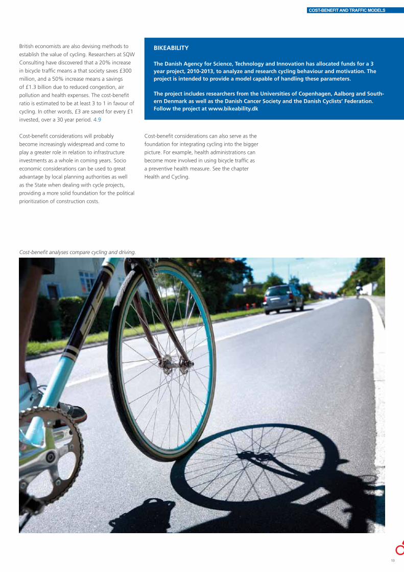
Cost-benefit analyses compare cycling and driving.
Cost-benefit considerations can also serve as the
foundation for integrating cycling into the bigger
picture. For example, health administrations can
become more involved in using bicycle traffic as
a preventive health measure. See the chapter
Health and Cycling.
19

COST-BENEFIT AND TRAFFIC MODELS
BICYCLE TRAFFIC MODELSTraffic model software can be used to optimize
traffic flows but is traditionally used primarily in
relation to motorized traffic. The models are used
as tools to calculate the traffic, environmental
and economic effects of traffic projects. Traffic
models can be used to evaluate the overall
consequences of road network modifications,
of public transport, population and workplace
siting, and of traffic goals. Traffic models and
traffic simulation models enable traffic engineers
to estimate traffic trends in relation to motorized
vehicles, public transport, cyclists and even the
consequences for pedestrians.
Simulation models such as VISSIM are often
used when planning and designing intersections,
for example, providing a picture of present and
future traffic flows. The models make it possible
to evaluate cost-intensive traffic construction
projects prior to the decision to initiate them.
Simulation models can accurately simulate
motorized, pedestrian and bicycle traffic,
which can be crucial when establishing an
urban intersection, for example. The simulation
models also make it possible to analyse the
consequences for cyclists, such as travel time,
delays, length of tailback, etc. VISSIM has been
used in projects evaluating the cycling effect of
road network modifications. The restructuring of
Nørrebrogade and the projected bridge system
around Christianshavns Canal in Copenhagen are
examples of this.
However, traffic models should be approached
with circumspection as there is always an element
of doubt in relation to future traffic trends and
traffic distribution. There is at least as much
doubt when it comes to bicycle traffic. There
are other options available for estimating a
project’s impact: considering the separate effects
of former projects, or perhaps experimentally
rerouting different traffic modes and measuring
the effect. Experience shows that a new cycle
track increases bicycle traffic by 20%, attracting
cyclists away from other routes and transport
modes. In the long run there is good potential
for further growth in cycling, depending on local
conditions.
The city of Odense is working on a vision to
create a cohesive town centre where the focus
is on urban life, where walking, cycling and
public transport are encouraged, and where the
planning perspective is sustainability. The local
planning authorities chose to create a multimodal
traffic model in VISUM as a useful decision
making instrument. The software can process
motorized traffic, public transport, bicycle traffic
and choice of transport mode all in one model.
Traffic simulations can be used to evaluate the consequences of a proposed modification. Bicycle traffic
should be factored into the modification process.
When the cycle route along Vestvold, Copenhagen’s western rampart, was being upgraded the cycling
potential for commuter journeys was evaluated based on calculations of commuter traffic streams for
the Copenhagen area. The OTM model, an advanced traffic model for the Greater Copenhagen Region,
was used. It includes public transport as well as automobile, pedestrian and bicycle traffic.
For example, the traffic model can provide the
planning authorities with the total picture of the
consequences of a road closure, calculating, for
instance, whether closing the road would mean
that drivers of motorized vehicles would choose
another route through the city, or instead shift
to cycling or public transport as an alternative.
The multimodal transport model can simulate
situations occurring today as well as for future
predictions.
Formerly in Denmark traffic models were not
oriented toward bicycle traffic; the focus was on
motorized and public transport. Cycling models
are thus not very widespread and the existing
cycling database is limited.

5Contents
Municipal cycling campaigns 22Behaviour modification 22New channels 25Anchorage and daily reality 27PR 28Evaluations 28
Denmark is one of the world’s most cycling countries. However,
cycling is far from a matter of course today as passenger
cars and public transport modes are obvious choices and are
affordable for most people. Cycling is a choice, and motivating
citizens to bike is crucial if a district wishes to reap the
ecological and health benefits of cycling.
CAMPAIGNS AND COMMUNICATIONS

CAMPAIGNS AND COMMUNICATIONS
The first part of this chapter describes the
local benefits derived from working with
communications and promotional campaigns,
and how active engagement, active involvement,
personal relevance, a sense of immediacy or
ownership, role models and competitions can
influence transport behavior. This is followed by
sections on the choice of communication channel
and how what is being communicated must
be solidly anchored in daily reality, and finally a
section on evaluation. The chapter concludes
with an overview of a number of successful
cycling campaigns conducted in recent years.
The campaigns reach out to different types of
target audience using different measures and
interventions. The overview is intended to serve
as an inspiration for local planning authorities
and others who wish to implement cycling
campaigns.
Generally speaking, a distinction is made
between motivational campaigns and safety
campaigns. Motivational campaigns aim
at changing transport modes while safety
campaigns aim at changing a given behavior.
Road safety as opposed to transport choice is
regulated by legislation and can be followed up
by controls and penalties. The results have been
generally favourable when such campaigns were
coupled with increased controls, for example
in the case of anti-liquour and save-the-seals
campaigns.
MUNICIPAL CYCLING CAMPAIGNSToday cycling expresses the conscious choice of
an efficient transport mode that benefits the
individual and society as a whole. Cycling is
not merely a question of transport – it involves
health, safety, a better environment, climate and
urban life. Cycling cuts across administrative
boundaries and is relevant for children, young
people, adults and the elderly. It is thus crucial
that all relevant administrations and sections
dealing with planning, urban life, health,
prevention, the environment and climate work
together to promote the use of the bicycle in
daily life. Add to this, investing in bicycle traffic is
relatively cheap in relation to the socioeconomic
benefits: healthier citizens, cleaner air and a more
flexible infrastructure.
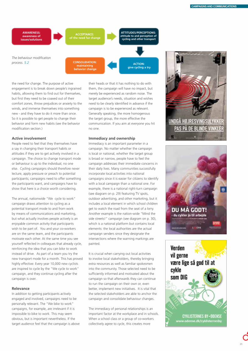
BEHAVIOUR MODIFICATIONExperience shows that campaigns are effective
in moving road users away from other transport
modes to cycling so campaigns can be used to
great advantage by the local planning authorities,
associations and businesses to modify the
behavior and attitudes of selected target groups.
Not all campaigns, however, are successful in
changing the target audience’s ingrained habits.
In this section we will examine six ways in which
campaigns have successfully affected behavior
and attitudes. Campaigns are here taken in the
broader sense, ranging from national TV spots
to the local community handing out muffins and
coffee. If communications and campaigns are to
be successful the priorities must be made clear:
what do you wish to achieve, whom do you wish
to affect, and how and when do you intend to
do it? Developing a communications strategy
is therefore a must. A communications strategy
need not be a lengthy document drawn up by
communications experts; the main thing is that
the sender has given serious consideration to the
goal so that resources are used appropriately.
Nordic Cycle Cities, a project in which 11 Danish,
Swedish and Norwegian cities work together
to increase the modal split of cycling, came up
with a form that all parties would be required
to complete when planning a communications
initiative.
Knowing where citizens stand is crucial to
the behavior modification process otherwise
resources are wasted on campaigns that miss
the target. The initial goal of communications
strategy is to affect citizens enough for them to
switch transport modes and to travel more safely
for the least amount of money. Afterwards it is
essential to maintain the behavior change.
Credibility plays a major role in the success of
cycling campaigns. For example there is no point
in directing cyclists to unsafe roads or combating
irritating but safe traffic habits. It is a great
advantage to coordinate the different campaigns
for better physical cycling conditions, motor
vehicle restrictions, road safety, and police control
of road users; a coordinated strategy has the
greatest chance of success.
Active engagementResearch and experience show that information
in itself is not enough to change people’s habits.
Most people, for example, know that cycling
is healthy and eco-friendly, but more is needed
before they change their habits. Consequently a
key objective in most Danish cycling campaigns
is to get the participants actively engaged; they
have to get out there and bike. You can present
convincing arguments for cycling until you’re blue
in the face, but in the last analysis the goal is to
get the participants onto their bikes. Experience
shows that it can take up to three years to get
people to accept a new message and recognize
5.1 Nordic Cycle Cities communications form. The specified categories are: activity, target group, goal,
message, channel, timeline, responsibility, budget.
6 wAYS OF MODIFYING BEHAVIOUR• Active engagement – knowledge isn’t
enough, participants have to get out there and bike!
• Active involvement – the campaign has to offer the participants some-thing they want.
• Relevance – the campaign has to match the target audience’s needs.
• Immediacy and ownership – the target audience have to feel their immediate concerns are addressed and it’s their campaign.
• Role models – we need to see our-selves reflected in others.
• Competitions – everyone loves to win!
CAMPAIGNS AND COMMUNICATIONS
AWARENESS:awareness of
issues/solutions
ACCEPTANCE: of the need for change
ATTITUDES/PERCEPTIONS: attitude to and perception of
cycling and other transport
ACTION: give cycling a try
CONSOLIDATION: maintaining
behavior change
the need for change. The purpose of active
engagement is to break down people’s ingrained
habits, allowing them to find out for themselves,
but first they need to be coaxed out of their
comfort zones, throw prejudices or anxiety to the
winds, and immerse themselves into something
new - and they have to do it more than once.
So it is possible to get people to change their
behavior and form new habits (see the behavior
modification section.)
Active involvementPeople need to feel that they themselves have
a say in changing their transport habits or
attitudes if they are to get actively involved in a
campaign. The choice to change transport mode
or behaviour is up to the individual, no one
else. Cycling campaigns should therefore never
lecture, apply pressure or preach to potential
participants; campaigns need to offer something
the participants want, and campaigns have to
show that here is a choice worth considering.
The annual, nationwide “We cycle to work”
campaign draws attention to cycling as a
potential transport mode to and from work
by means of communications and marketing,
but what actually involves people actively is an
enjoyable common activity that participants
wish to be part of. You and your co-workers
are on the same team, and the participants
motivate each other. At the same time you see
yourself reflected in colleagues that already cycle,
reinforcing the idea that you can bike to work
instead of drive. As part of a team you try the
new transport mode for a month. This has proved
highly effective: Every year 10,000 new cyclists
are inspired to cycle by the “We cycle to work”
campaign, and they continue cycling after the
campaign is over.
RelevanceIn addition to getting participants actively
engaged and involved, campaigns need to be
personally relevant. The “We bike to work”
campaigns, for example, are irrelevant if it is
impossible to bike to work. This may seem
obvious, but is important nevertheless. If the
target audience feel that the campaign is above
The behaviour modification
process. 5.2
their heads or that it has nothing to do with
them, the campaign will have no impact, but
merely be experienced as random noise. The
target audience’s needs, situation and wishes
need to be clearly identified in advance if the
campaign is to be experienced as relevant.
Generally speaking, the more homogenous
the target group, the more effective the
communication. If you aim at everyone you hit
no one.
Immediacy and ownershipImmediacy is an important parameter in a
campaign. No matter whether the campaign
is local or national, whether the target group
is broad or narrow, people have to feel the
campaign addresses their immediate concerns in
their daily lives. Many communities successfully
incorporate local activities into national
campaigns since it is easier for citizens to identify
with a local campaign than a national one. For
example, there is a national right-turn campaign
(see diagram on p. 29) featuring TV spots,
outdoor advertising, and other marketing, but it
includes a local element in which school children
get to watch the road from the seat of a lorry.
Another example is the nation-wide “Mind the
side streets!” campaign (see diagram on p. 30),
which is a national platform but contains local
elements: the local authorities are the actual
campaign senders since they designate the
intersections where the warning markings are
painted.
It is crucial when carrying out local activities
to involve local stakeholders, thereby bringing
extra resources as well as familiar spokesmen
into the community. Those selected need to be
sufficiently informed and motivated about the
campaign so that afterwards they can continue
to run the campaign on their own or, even
better, implement new initiatives. It is vital that
the selected stakeholders are able to anchor the
campaign and consolidate behaviour changes.
The immediacy of personal relationships is an
important factor at the workplace and in schools.
When a school class or a group of co-workers
collectively agree to cycle, this creates more
23
CAMPAIGNS AND COMMUNICATIONS
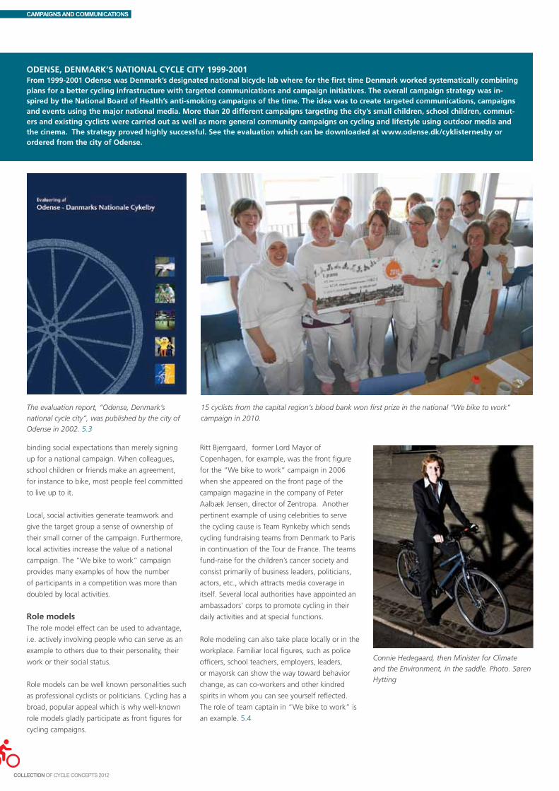
Odense, denmARk’s nAtIOnAl CyCle CIty 1999-2001From 1999-2001 Odense was denmark’s designated national bicycle lab where for the first time denmark worked systematically combining plans for a better cycling infrastructure with targeted communications and campaign initiatives. the overall campaign strategy was in-spired by the national Board of Health’s anti-smoking campaigns of the time. the idea was to create targeted communications, campaigns and events using the major national media. more than 20 different campaigns targeting the city’s small children, school children, commut-ers and existing cyclists were carried out as well as more general community campaigns on cycling and lifestyle using outdoor media and the cinema. the strategy proved highly successful. see the evaluation which can be downloaded at www.odense.dk/cyklisternesby or ordered from the city of Odense.
binding social expectations than merely signing
up for a national campaign. When colleagues,
school children or friends make an agreement,
for instance to bike, most people feel committed
to live up to it.
Local, social activities generate teamwork and
give the target group a sense of ownership of
their small corner of the campaign. Furthermore,
local activities increase the value of a national
campaign. The “We bike to work” campaign
provides many examples of how the number
of participants in a competition was more than
doubled by local activities.
Role modelsThe role model effect can be used to advantage,
i.e. actively involving people who can serve as an
example to others due to their personality, their
work or their social status.
Role models can be well known personalities such
as professional cyclists or politicians. Cycling has a
broad, popular appeal which is why well-known
role models gladly participate as front figures for
cycling campaigns.
The evaluation report, “Odense, Denmark’s
national cycle city”, was published by the city of
Odense in 2002. 5.3
15 cyclists from the capital region’s blood bank won first prize in the national “We bike to work”
campaign in 2010.
Ritt Bjerrgaard, former Lord Mayor of
Copenhagen, for example, was the front figure
for the “We bike to work” campaign in 2006
when she appeared on the front page of the
campaign magazine in the company of Peter
Aalbæk Jensen, director of Zentropa. Another
pertinent example of using celebrities to serve
the cycling cause is Team Rynkeby which sends
cycling fundraising teams from Denmark to Paris
in continuation of the Tour de France. The teams
fund-raise for the children’s cancer society and
consist primarily of business leaders, politicians,
actors, etc., which attracts media coverage in
itself. Several local authorities have appointed an
ambassadors’ corps to promote cycling in their
daily activities and at special functions.
Role modeling can also take place locally or in the
workplace. Familiar local figures, such as police
officers, school teachers, employers, leaders,
or mayorsk can show the way toward behavior
change, as can co-workers and other kindred
spirits in whom you can see yourself reflected.
The role of team captain in “We bike to work” is
an example. 5.4
Connie Hedegaard, then Minister for Climate
and the Environment, in the saddle. Photo. Søren
Hytting

CAMPAIGNS AND COMMUNICATIONS
CompetitionsFinally, competitions are often the bait needed to
get people to join a campaign or activity. Prizes
are generally an extremely motivating factor.
The prize need not necessarily be large and
expensive; the lure is in the competition itself.
The prizes of course have to be attractive to the
target audience and have a clear bearing on the
campaign’s motivating message. For example,
“All kids bike” is an exercise competition for
Henrik Jensen is a busy, active businessman with
his own carpentry business in Randers Midtby. He
cycles round to his customers on his carrier bike,
and saves lots of money on petrol and parking
fees. He is proud of being a cycle ambassador
and wishes to show Randers citizens that cycling
is a fantastic transport mode both for work and
leisure activities.
school classes and the prize is a class excursion
such as an MTB tour or a bike decoration course.
NEw CHANNELS When planning a campaign it is vital to choose
the appropriate channel for reaching the
audience. Formerly, organizing a campaign
meant printing piles of posters and folders
and distributing them to the target group.
Newspaper article about a committee chairman in Elsinore presenting a gift voucher for a cycling
holiday on Bornholm to a local family who had participated in the cycling campaign called “Vi cykler
nu”. The campaign was a parallel, local campaign to the national “We bike to work” campaign in
2011. The aim of “Vi cykler nu” was to activate the whole family. Parents were urged to bike to work
and children to bike to school. www.vicykler.nu.
Today new technology and new media offer
new possibilities and platforms: interactive
homepages, smartphones, YouTube, Facebook,
GPS technology and much more.
A growing number of campaigns are using the
new platforms with great success as the new
technologies and social media make it possible
to design campaigns that directly attract and
communicate the message to the selected target
group.
The social media, for example, are an excellent
channel for communicating with younger target
audiences since this is how they themselves
communicate. Social media have a broad
outreach potential since users pass on the
message – if it’s interesting enough! There
is also the huge advantage, which is also a
challenge, that the social media are a platform
for interactive communications; they enable the
sender to enter into interactive dialogue with
the target audience and the target audience
to contribute ideas and attitudes, thereby
strengthening the participants’ involvement in the
campaign. This also means that the sender needs
to be prepared to enter into a dialogue with the
target audience if they respond to the campaign.
Today many communities have supplemented
the municipal website with local cycle city
websites and Facebook pages where they inform
citizens of the cycling situation in the area and
where citizens can directly offer suggestions and
comments on municipal initiatives.
www.randerscykelby.dk
25

CAMPAIGNS AND COMMUNICATIONS
New technology is also becoming an important
element of campaign design. For instance, it is an
excellent idea to use cell phones since practically
everyone over the age of 10 has one today. One
example of a campaign using new technology
Aarhus Cykelby Facebook page
Children give their mother a helmet because they
love her as part of the campaign “Use a helmet
because we love you”.
to mobilise the target audience is “Around the
world in 80 days” in which school children take
turns cycling with a GPS device which registers
the number of cycled kilometers. Their results
are then uploaded onto the campaign website.
For every kilometer they cycle, the virtual
circumnavigator, Dr. Glob, moves a corresponding
kilometer on his trip around the world. See more
at http://www.cycling-embassy.dk/2011/06/29/
gps-tech-makes-cycling-fun/.
Another good example is the campaign called
“Use a helmet because we love you”. The
campaign included a video showing a couple of
local police officers distributing hugs and helmets
to random passing cyclists. The film was viewed
500,000 times on youtube.com over the course
of three days, and commented on by 2,200
bloggers. The campaign was an unparalleled
viral success drawing enormous attention to the
campaign, both abroad and in Denmark. The
campaign was followed up by the distribution
of helmets: Children, for example, gave their
parents helmets under the slogan “Because I love
you!”
The police distributed hugs and helmets to cyclists, viewed all over the world on YouTube, as part of the
“Use a helmet because we love you” campaign.

CAMPAIGNS AND COMMUNICATIONS
ANCHORAGE AND DAILY REALITYVery few people will change their traffic behavior
merely on the basis of a campaign; promotional
campaigns need to be coupled with better
physical cycling facilities, restrictions on motorized
traffic, road safety measures, etc. A coordinated
strategy, preferably cross-administrational, has
the greatest chance of success. If you want to
encourage more people to cycle you need to
take a careful look at local cycling conditions:
Are the cycle tracks geared to an increase in
cyclists? Is it safe? Are there satisfactory bicycle
parking facilities? etc. Motivation and structural
innovation are closely linked, and if the campaign
has no connection to everyday reality, the
campaign will fail to have the desired effect.
When people have once taken the first step and
changed their behavior, it is crucial to maintain
their motivation. This can be done, for example,
by regularly repeating a campaign such as the
right-turn campaign or “We bike to work”,
which runs annually. Generally speaking it’s a
good idea to keep people at it so they don’t take
a break but maintain a regular daily rhythm.
SMART OBjECTIVES
s specific
m measureable
A Attainable
R Results Oriented (realistic)
t timeline
Furthermore, it is essential to get people to
want to maintain the new behavior themselves,
internalizing the campaign message. Although a
campaign may be nationwide, it must articulate
the individual participant’s personal values. One
way of maintaining a high level of individual
motivation is use of the so-called SMART
objectives.
What is particularly effective is catching people
at a time when they are confronting a new phase
of life, for instance if they recently moved, or are
starting a new job or at a new school. People
are easier to reach in such situations since they
are about to form new habits anyway. This is
the basis of the city of Copenhagen’s campaign
aimed at new Copenhagen residents. New
residents receive a kit welcoming them to the
bike friendly city of Copenhagen. The kit includes
a cycle route map, road manner tips and a set of
bike lights.
BrandingIn recent years a growing number of cities and
municipalities have started supplementing other
promotional campaigns with actual branding
campaigns in which the city or municipality
wishes to establish itself as bicycle friendly in
the eyes of its citizens and possible newcomers,
linking its image to the positive values associated
with cycling, such as health, sustainability and
modern life style.
In 2009 Aarhus Cycle City launched its brand campaign “8000 good reasons to cycle”. The brand serves as a logo and a slogan and is used in all cycling
related activities initiated by the city involving infrastructure as well as communications. The brand communicates directly to Aarhus residents (the Aarhus
postal code is 8000), the message being that there are many, many good reasons to bike and that every cyclist has his or her own personal motive. All the
pictured localities are well known locations that the audience can relate to.
5.5
27

CAMPAIGNS AND COMMUNICATIONS
PRWhen the local authority organizes activities or
constructs facilities aimed at accommodating
cyclists, it is essential to tell the good stories in
the local media, either by issuing a press release
og through personal contacts to local journalists.
Sometimes the stories are even so good that
they are of interest to regional, national or
international media.
The main thing though is to tell the public about
the good things the local authorities are doing,
thereby increasing the initiative’s value.
Representatives of Aarhus Cycle City were in the streets regularly during the campaign launching and
in connection with other activities, distributing small gifts to cyclists. In addition to rewarding cyclists
for their choice of transport mode the activities aimed at giving the local authority a human face,
personalizing communication.
relationships with local journalists that can prove
useful when you have something in mind.
EVALUATIONCycling campaigns are often part of an overall
strategy and a long-term plan regardless of
whether their aim is safety, active engagement or
behavior maintenance. It is thus essential that a
targeted initiative or campaign is monitored and
rounded off with a comprehensive evaluation.
This is not merely useful for the community’s
own future work; it can inspire other towns
to implement similar measures if the results
are favourable, or avoid wasting resources on
activities or events with little or no impact.
It is crucial that evaluation should be factored
into the campaign design from the outset
so as to create an overview of desired data.
Nevertheless the evaluation phase is often
neglected, receiving little or no funding, and
often neither indicators nor effect objectives are
established for campaigns or communications.
Evaluation serves several excellent purposes apart
from gathering results and sharing knowledge;
it can be used to document impact, for example,
showing politicians whether they got good
value for their money. This might inspire them
to allocate more funds to communications and
campaigns.
There are many different evaluation methods,
including questionnaires or focus groups, and
several useful templates are available, such
as Max Sumo, which is free and easy to use.
Regardless of the method it is crucial to evaluate
multiple parameters and perhaps even repeat the
process at different times.
local media PR has several advantages:• Itisacheapandsimplemeansof
communication
• Youreachouttothelocalcitizens
• Politiciansenjoygettinglocalmediacoverage
PR has drawbacks too:• Youcannotbesurethemediawilltakethe
bait if there are other more important stories
to tell
• Youhavenocontrolovertheangle
It is consequently of prime importance to learn
the rules of the game and build up personal

CAMPAIGNS AND COMMUNICATIONS
the following overview shows examples of different types of campaigns that have run over the past 5 years, national as well as local. Contact the campaign sender for further information and inspiration
29
CAMPAIGN SENDER AIM TARGET CONCEPT IMPACT
We bike to work Danish Cyclists’ Federation and Firmaidrætten, (the national sports organization for the promotion of sports at workplaces)
Encourage more people to bike to and from work; Focus on the environment, health and congestion
Adults You sign up as a team. The idea is to bike to and from work as often as possible in a given time period. The strength of the campaign is derived from the sense of community in the workplace
Between 80,000-110,000 participate annually. 8% of the participants are new cyclists. This is the equivalent of around 10,000 new cyclists joining the campaign every year.
Tail wind on the cycle tracks
City of Odense Persuade passenger car commuters to choose to cycle rather than drive
Adults 100 drivers are supplied with free e-bikes over a 6- month period
The evaluation showed that around half the participants used the e- bike instead of the car 4-5 times a week. Roughly two thirds of the participants continued to bike or e- bike rather than drive at the final evaluation three months after the conclusion of the campaign. The campaign was thus highly successful in getting drivers to bike
Welcoming campaign (tilflytterkampagne)
City of Copenhagen Encourage newcomers to cycle Adults Every year Copenhagen experiences a population turnover of 10%. New residents receive a kit welcoming them to cycling Copenhagen. The kit includes a cycle route map, cycle track tips, and a set of bike lights.
Not evaluated at time of printing
Snabelræs City of Aarhus Let small children have fun learning to bike
Adults Get more kids biking; day care centres and child minders can order a free visit from a Snabelræs bus. The bus contains: a small group of trained instructors who play cycle games with the children; 10 striders (small bikes without pedals); helmets; and the Snabelræs mascot, Snabel Elephant.The aim of the visit is to provide children, parents and educators with ideas and inspiration to continue integrating bike games and cycling into the children’s daily lives
Snabelræs visited over 30 Aarhus institutions in 2010. In addition Snabelræs was awarded GF insurance company’s road safety prize in 2011.
Spacey from Cyclos City of Frederiksberg Get school children to bike to and from school
Years 0-5 The campaign is introduced by a task force who distribute flyers to parents containing: campaign information and good advice on children cycling; a board game poster; and a schedule in which the children are to note down their bicycle journeys and helmet use. The children are also given a small present which includes a competition booklet. The children are urged to jump on their bikes to hand in the booklet, if possible with Mum and Dad.
Not evaluated at time of printing
Cycling proficiency tests The Danish Road Safety Council and Trygfonden in collaboration with local police and schools
Teach school children traffic rules and road safety behaviour
Years 3 - 6 Schools are urged to give annual cycling proficiency tests in Years 3 and 6. The test is both theoretical and practical and tests the children’s basic traffic skills.
Distribution of “monster” reflectors
Trygfonden Encourage more children to remember to wear reflectors
Day care centre and school children
Every year Trygfonden donates 1 million reflectors to the country’s schools and day care centers. The children can help design the year’s reflectors via the internet.
The risk of getting hit by a car in the dark is reduced by 70% if you are wearing a reflector.
Mind the side streets Danish Road Safety Council and the regional road safety committees
Encourage cyclists to be more vigilant in non-signalized intersections
Adults and children
Nation-wide TV spots and outdoor work followed up locally by marking selected intersections with the “Mind the side streets” symbol.

CAMPAIGNS AND COMMUNICATIONS
CAMPAIGN SENDER AIM TARGET CONCEPT IMPACT
Right turn campaign Danish Road Safety Council, Danish Transport Authority, Danish Cyclists’ Federation, and the Danish Transport and Logistics Association (DTL)
Inform cyclists of the danger of being in the lorry blind spot. Inform lorry drivers how to adjust their cycle safety mirrors
Adults and children
Nation- wide TV spots and outdoor work and educational materials for cyclists and lorry drivers. In addition, local initiatives in which school children , for example, sit in a lorry and view the road from there.
The number of dead and seriously injured cyclists involved in right- turn accidents has generally dropped over the past 5 years, which coincides with intensive right-turn campaigns. However, the figures indicate that this varies from year to year so it is imperative to keep reminding cyclists and lorry drivers to keep an eye out for each other.
Bike light campaign Danish Cyclists’ Federation Encourage more school children to remember their lights and reflectors after dark
Year 4 school children
The campaign exploits children’s innate curiosity to find out how the world works. All participating classes receive: a kit containing bike lights, reflectors, etc; a teacher’s manual for integrating the materials into different school subjects; and post cards that can be sent to parents informing them of the campaign
In 2010 more than 33,000 school children from around half the country’s 4th year classes and their teachers evaluated the campaign. They said that the number of school children using mandatory bike lights and reflectors had increased by 10%.
Around the world in 80 days
City of Aarhus Make cycling fun for kids and make them want to bike more
School children in Years 6 -7
School children take part in a friendly competition as to who can bike furthest. Every class is given two GPS’s that chalk up kilometers into the class account as the children take turns cycling. The children upload their kilometers onto a homepage and for every cycled kilometer, virtual Dr. Glob advances a corresponding kilometer on his journey around the world.
370 children from 17 classes signed up. 62% of the participating students cycled more than usual and 40% took their bikes along on journeys which would otherwise have taken place solely by car
My helmet Danish Road Safety Council and Trygfonden
Encourage more people to use a helmet
Adults and children
A number of designer helmets sold at bargain prices were launched all over the country in collaboration with a designer and Netto, the supermarket chain. In addition, on the homepage you could design your own cool bike helmet idea, the 5 best of which were put into production.
In 2010 25% of cyclists used a helmet; in 2008 the figure was 15%. A helmet reduces the risk of head injury by 50%.
Use a helmet because we love you
City of Aalborg Get more people to use a helmet
Adults The campaign consisted of a video in which a couple of local police officers stopped random cyclists and gave them a hug and a helmet. The punch line was: “Use a helmet because we love you”. In addition to the film the campaign consisted of a number of events in which children presented their parents with helmets.
The campaign attracted major international attention and in the following years has been supplemented with new angles, the most recent being “Use a helmet, it’s cool” in 2011.
All kids bike Danish Cyclists’ Federation and Tryg fonden
Encourage school children to bike to school and remember their helmets
School children Years 0 –10
The campaign was based on the sense of community that already exists among school children. The participating classes competed as to which class could cycle the most days in the course of the given campaign period. The students were awarded 1 point for cycling and 1 point for using a helmet.
In 2010 over 140,000 school children from all over the country took part. In the two weeks the campaign ran the participating children biked a total of more than 637,000 days and used helmets on more than 559,000 days. (90% used a helmet.) 30% of the children enjoy cycling more after the campaign.

6Contents
The problem 32Physical activity 32Health policies 34Campaigns and other and other
cycling and health initiatives 35
Cycling is healthy and always has been. Today, however, there
is an added focus on creating favourable conditions for a
healthy lifestyle that includes physical activity. Statistics show
that the proportion of overweight citizens is rising and a large
proportion of the population is decidedly inactive. High-grade
cycling facilities are an initiative that promotes an active
lifestyle.
This chapter provides insight into why it makes good financial
sense to use cycling as a health promotion initiative as well as
examples of how to go about it.
HEALTH AND CYCLING

HEALTH AND CYCLING
THE PROBLEMFor a long time modern lifestyle has become
increasingly inactive, in Denmark as well as
a number of other Western countries. This
is partially due to increasing automation,
increasingly sedentary jobs and increased
dependence on motorized transport. Add to this
easy access to high-fat and high-sugar foods and
the result is a rising number of citizens that are
overweight and seriously overweight. Increasingly,
being seriously overweight is becoming a public
health issue just as inactivity in itself constitutes
a health risk for the individual; being overweight
or seriously overweight results in a heightened
risk of developing a number of chronic diseases,
social isolation and depression.
A survey conducted in connection with the
National Health Profile 2010 shows that 47% of
the Danish adult population is overweight (BMI
>25.0). The occurrence is significantly higher
The proportion of overweight adults defined as
having a BMI>25 has been steadily increasing
since 1987 6.1
among men; 54% of men are overweight while
the figure is only 39% for women. The figure
has been rising since the late eighties. The
same applies to the proportion of the seriously
overweight (BMI >30), which increased from
5.5% for both genders in 1987 to 11% for
women and 12% for men in 2010.
There is a connection between being overweight
and such factors as education and location of
residence; there are fewer overweight citizens
among the highly educated and in the nation’s
capital than the national average, while in the
North Denmark region the figure is above the
national average. By the same token, citizens of
Northern Jutland are the population group with
the lowest share of people engaging in moderate
to strenuous physical activity, according to the
National Health Profile, whereas the citizens of
the capital have the highest share. 6.2
The Danish Board of Health estimates that
roughly 30-40% of the adult Danish population
are physically inactive, i.e. physically active less
than 2 ½ times a week. This segment of the
population has a heightened risk of developing
various lifestyle diseases, which constitutes a
problem for the individual and for society as
a whole. Reduced life expectancy, increase in
lifestyle diseases, etc., have an impact on the
number of sick days, hospitalization, and personal
well-being.
PHYSICAL ACTIVITYModerate physical activity has a well-documented
health effect. The health authorities have
concluded that physical activity corresponding
Cycling is healthy for all age groups – seen here in Frederiksberg.
to 2,000-2,500 kcal/week is sufficient to
significantly reduce the risk of disease and
mortality. This is the equivalent of a little more
than 4 hours a week of brisk walking, for
example. The recommendation is 3-4 hours of
light to moderate exercise per week or ½ hour
per day in addition to daily activities at home and
work.
The Board of Health recommends a half hour
of physical activity a day in order to reduce
the risk of lifestyle diseases. Children should
be significantly more physically active and the
Board of Health recommends 1 hour a day for
them. The concept of physical activity covers any
type of muscular activity regardless of whether
it is structured, as in running, cycling, etc., or
unstructured in the form of daily activities such as
climbing stairs. However the activity should be of
at least 10 minutes duration to achieve a health
impact.
Current research into the effect of physical
activity shows that normally inactive people can
improve their health and physical well-being by
exercising regularly and that people of all ages,
children, adults, the elderly, women as well as
men, achieve positive physical changes as a result
of physical activity.
THE BOARD OF HEALTH RECOMMENDATIONS FOR PHYSICAL ACTIVITY
Children and young people 1 hour a dayAdults ½ hour a dayThe elderly ½ hour a dayThe overweight ½ hour a day
Physical activity affects the heart, the circulation
and the muscles as well as the metabolism
and the endocrine and immune systems. Add
to this love of life, energy, good relationships,
self-confidence and the ability to act. It has also
been proven that there is a positive connection
between physical activity and the cognitive
processes which are a prerequisite for children’s
learning. 6.4
A Danish study shows that active transport to and
from work, such as cycling, reduces the risk of
premature mortality by 40%, after adjustments
are made for physical leisure-time activities. 6.5
The health benefits of cycling are thus a key
parameter when considering the socioeconomic
consequences of increased cycling. The economic
0
10
20
30
40
50
60
1987 1994
Men
Proportion of overweight adults BMI>25
2000 2005 2010
Women

HEALTH AND CYCLING
benefits of cycling are discussed in the chapter
"Cost-benefit and Traffic Models".
An international study has further shown that
children who cycle to school are more active
throughout the rest of the day than those who
are driven to school by car. 6.6
Cycling is an excellent form of exercise for most
people. Being overweight or injured, for example,
make running or contact sports difficult, while
cycling along with swimming are much gentler
activities. When there are balance problems, in
the elderly for instance, 3 wheel bikes make it
possible to continue cycling, and e-bikes help
maintain an active lifestyle even in old age.
Cycling is an inclusive form of exercise, and
can be practiced regardless of age and physical
prowess.
Daily exercise such as walking or cycling to and
from school/work, choosing the stairs instead
of the elevator/escalator and doing housework
and gardening also have a demonstrable health
effect. 6.7
Bikes can be used for strenuous exercise.
Percentage of overweight
10 year olds compared
to percentage of children
that cycle in the same
countries 6.8
10%
10%
2%
Frequency of overweight 10 year olds
Percentage that cycle
England
Sweden
Germ
any
Switzerland
Denm
ark
Concrete examples of the connection between cycling and healthThe Odense cycle city project proved that an
integrated and coordinated approach to cycling
initiatives produces positive health effects.
Odense citizens between the ages of 16-74 were
more physically active on average approximately
three minutes a day compared to a control
group. The conclusion was that the project had
a significant positive public health impact; for
Biking to school or work is a form of daily exercise (Randers).
example, a lower mortality rate among Odense
citizens was registered during the project period,
1999-2002, leading to an average increase in life
expectancy of roughly 2 ½ months.
It was also noted that anticipated sick leave
increments received by Odense residents were
reduced by one half-day. This meant a 6%
reduction in disbursed sickness benefit, or the
equivalent of DKK 42 million for the period 1999-
2002. Although National Health Service expenses
increased by approximately DKK 8 million during
the same period, this coincided with a drop in
the number of hospital admissions and bed-days.
The DKK 33 million cost reductions were larger
than the campaign cost, DKK 20 million. It would
appear that there are cash benefits in the form of
reduced health care spending when people are
encouraged to cycle.
In a project in the city of Randers 25 cyclists
were given an e-bike for daily use. Car journeys
were replaced by the e-bike, in which an electric
motor assists the cyclist. The cyclists biked up to
15 km each way, but were able to get to work
without having to change their clothes, thanks
to the electric motor. 8 of the e-bikers accepted
an offer to measure their fitness level during the
project. Prior to the project 2 participants had a
33

HEALTH AND CYCLING
A survey carried out by the city of Odense shows that people who cycle feel they are in better shape
than people who don’t. 6.10
very low fitness level, 4 participants a low fitness
level, and 2 participants an average fitness level.
At the project’s conclusion they all had a very
high fitness level. This voluntary test indicates
that daily exercise has a powerful effect on
people who formerly used a car as their primary
transport mode.
The exercise argument for bikingFor many people exercise is already one of the
main reasons for cycling on a daily basis. A
number of councils have carried out bicycle
account surveys or other opinion polls about
people’s reasons for cycling, from which it
is evident that the exercise aspect plays an
important role. In Frederikshavn 92% cite exercise
as a reason for cycling while the fact that it is fast
and convenient comes in second with 71%. In
Copenhagen and Frederiksberg exercise and fresh
air are cited as the second most important factor
while the fact that biking is fast and convenient
is number one. In Frederiksberg 83% cite
exercise as one of their reasons for cycling. The
same pattern emerges when citizens are asked
50%
100%Daily cyclists Non-daily cyclists
0%
Wo
men
Men
Wo
men
Men
Poor
Fair
Good
Very good
Excellent
INSPIRATION TO ExERCISE
www.legepatruljen.dkwww.cykelleg.dkwww.getmoving.dkwww.sundhedsspor.dkwww.trafiklegedag.dk
what could get them to bike more. Faced with
daily time pressure, the opportunity to combine
exercise with transport may be a determining
factor when choosing to cycle.
In other words, adding a health benefit focus
to behavior campaigns aimed at adults and
children is an excellent idea, and at the same
time cross-disciplinary collaboration within
local administrations should be strengthened,
combining the traditional traffic and
environmental arguments for cycling (i.e. cycling
is faster, results in less congestion and has no
negative environmental impact) with the health
benefits.
HEALTH POLICIESIn many areas cycling promotion is an integral
part of the community’s health policy and
preventive health strategy. Effective cross-
administrative collaboration creates a synergistic
effect between cycling itself and the use of
cycling as an active preventive element for all
age groups. Politicians as well as the general
population are increasingly focusing on health
and prevention, and specially earmarked funds
are often allocated for the purpose. Collaboration
can mean increased value for money. It activates
the inactive, encourages more children and
commuters to bike, and creates better conditions
for those who bike already.
A good example of this is the city of Aalborg.
In 2007 Aalborg formulated a health policy
for the entire municipality. Health policy work
was broadly based involving all municipal
administrations, and focused on diet, smoking,
alcohol and exercise. Cycling was one of the
focus areas and the following was made
explicit: “… it is important that there are green
recreational areas available to all citizens and
that there are safe roads and cycle tracks to cycle
on.” The policy serves as a guideline for cross-
disciplinary initiatives; the different professional
administrations cooperate, thereby generating
increased value across administrative boundaries.

HEALTH AND CYCLING
CAMPAIGNS AND OTHER CYCLING AND HEALTH INITIATIVES On the national level as well as in the local
communities, campaigns and projects are being
developed that include a focus on the health
aspect of cycling. For example, The Danish Road
Safety Council and Trygfonden, (the Danish non-
profit organization for the promotion of safety,
health and well-being) have designed a special
cycle training track that schools and after-school
centres can borrow from the local authority
and use in road safety education and physical
education classes. Students in Years 4-6 are given
the opportunity to train their cycling skills and
learn about cycling and health.
There are many examples in recent years of how
communities have increasingly focused on the
health angle of cycling promotion, generating
increased value by coupling cycling with health.
In contrast to many other types of exercise
cycling often has a dual purpose, namely to get
from point A to point B, so that many people
experience cycling as an efficient form of
exercise. Children derive great health benefits
from walking and cycling to school.
Randers – Learning, playing and movingOver the past several years Randers has focused
on cycling as a way of ensuring exercise for all
age groups. The idea was further developed
in the municipal cycle plan Cykel-og stiplan of
2011 emphasizing the fact that cycling is fun.
In 2010-2011 campaigns targeted schools, day
care institutions and ordinary citizens, especially
in the Hornbæk neighbourhood. Special bike
game tracks, velocipedes and unicycles were
provided for schools, there were bikeability days
with scooters for preschoolers, local cycle paths
were established for geocaching and guided cycle
tours, all of which focused on promoting cycling
as a fun game and a great leisure activity.
The focus on cycling as a means of learning,
playing and moving goes hand in hand in
Randers with the focus on road safety, high
commuter passability, etc., encouraging citizens
to bike to work and education.
Vejle – adult cycling classes A community project in Vejle offers adult cycling
classes. The course is funded by the Danish
Board of Health and is part of a special offer
to the overweight in a neighbourhood with a
high proportion of residents of a different ethnic
background than Danish. The cycle training
course is one option among others, such as a
food workshop, individual counseling, etc.
Children on balance bikes in Randers, one way of using bicycles for exercise and fun.
In Vejle immigrant women learn how to bike so as to become more physically active and teach their
children good exercise habits too.
20 women have participated in the class which
takes place in a town parking lot. Project funds
were spent on acquiring two junior bikes and
hiring a cycling instructor, who in this case
is a community integration officer. In other
communities the local branch of the Danish
Cyclists’ Federation helps out.
The project’s health effect has not yet been
evaluated but the local Vejle authorities report
that the women learning to bike are extremely
proud and energized, balance laughing when
successful. The project gives them a lot of
freedom, self-confidence and some exercise. An
Arab woman of 38 hadn’t cycled since the age of
10 because her mother thought she was too old
to play. When she learned how to bike she raised
both her arms high, lowered them again and
exclaimed, “Yes! Now I can bike with my sons!”
35

HEALTH AND CYCLING
Team Odense Integration
Odense – integration and cyclingIn 2010 the city of Odense received a grant
from the national cycling promotion fund for a
project targeting 12 – 15 year old girls from the
Vollsmose neighbourhood, an area with a high
concentration of residents with an immigrant
background. The project’s stated objective was to
educate the girls about nutrition and health.
A cycle team was formed that trained twice a
week all spring in order to be able to participate
in the annual cycling race around Funen in the
summer of 2011. The girls received a bicycle and
cycling clothes for the project. The aim was that
in the long run the girls should use a bicycle as
their daily transport mode.
Aarhus – Health on 2 wheelsIn 2011 Aarhus implemented a health project
focusing on cycling’s many health benefits. The
aim was to encourage even more Aarhus citizens
to cycle to and from work. 6 former drivers had
to cycle to work over a 6 month period, either by
bicycle or e-bike.
Another project objective was to study the impact
of daily cycling on the participants’ health. The
half-way evaluation shows that their physical
condition has improved, they have more energy
and it’s easier for them to find the motivation to
cycle to work and to other activities. The final
results, including measurable health effects, were
not available at the time of printing.
”Healthy on 2 wheels”, Aarhus.
7Contents
Organization and planning procedures 38Government regulations and planning 38Population, population density and
urban spacial structure 39Siting workplaces and educational institutions 40The Freight yard area, Aalborg 42Nordhavnen, Copenhagen 42Siting shopping facilities 42Parking as a traffic management instrument 43Bicycle transport strategy and plan 44
Good city planning helps create a viable transport framework.
However, urban planning has a negligeable effect on
bicycle traffic volumes unless a conscious effort is made to
improve cycling conditions and incorporate cycling into the
infrastructure and the site selection of urban functions.
Changes in land use and residential patterns take place
gradually; nevertheless urban planning can have a major
impact on the siting of individual traffic generating functions,
and be instrumental in ensuring their accessibility to bicycle
traffic.
Urban planning and transport engineering go hand in hand.
When a concerted effort is made to work together toward the
common goal of more sustainable transport, including bicycle
transport, this generates a synergistic effect in relation to
cycling conditions.
URBAN PLANNING AND BICYCLE PLANNING

URBAN PLANNING AND BICYCLE PLANNING
ORGANIZATION AND PLANNING PROCEDURESBicycle transport planning in Denmark typically
takes place in the technical administration in
charge of traffic engineering and safety. However,
bicycle planning and urban and municipal
planning are inseparably linked, and a cross-
disciplinary collaboration between the fields of
health and prevention, public transport, climate
and the environment, construction management,
etc. markedly improves bicycle transport
conditions while at the same time providing the
other fields with a new angle for meeting the
challenges they confront.
The many options for interfacing with other
fields can create a synergistic effect and
even economic gains for the local authority,
promoting awareness of the authority’s many
new cycling initiatives, or incorporating cycling
into integration and health prevention efforts, for
example. Awareness of bicycle transport on the
part of urban planners and construction project
managers can create a bicycle friendly framework
for city planning, which includes writing bicycle
parking spaces into the local plans or creating
new squares and urban spaces. This makes it
possible from the outset to create a bike friendly
urban environment and to ensure that there are
the required number of bicycle parking facilities
at new construction or renovation sites, thereby
saving the extra time and expense of establishing
them afterwards.
Bicycle planning should be an integral part of
all planning, including the strategic plan, main
structure and municipal plan, and all other work
in the various municipal administrations. The
bicycle must be included as a matter of course
in any mobility or transport plan. However, it
is crucial to the plan’s implementation that the
local planners and politicians take ownership of
decisions to prioritize cycling initiatives, including
arranging workshops, dialogue meetings or other
measures where professional staff, politicians and
potential community stakeholders get together
to discuss and propose ideas for future cycle
planning. This is an instrument for creating broad
ownership of the bicycle planning process.
Since the various administrations and
organizations have a high diversity of interests
and expertise, large local councils would benefit
from a coordinator or cycle secretariat. Citizens
should be actively involved from the outset.
Citizens’ concerns, visions, general views and
concrete daily experiences working in conjunction
with professional expertise and overall view are
an excellent means of achieving the desired goal.
Public involvement also provides an opportunity
Bicycle Action Plan workshop in Frederiksberg – citizen involvement not only provides an excellent
insight into what citizens want, but also helps create co-ownership of the plan.
for airing ideas for new and better projects.
Strong roots in the local community are essential
from the start, as this greatly improves the
chances for cooperation and success. The project
has a far greater chance of success when citizens
as well as politicians are involved. It is crucial that
ambitions, goals and means are linked from day
one - economically and throughout the entire
process.
GOVERNMENT REGULATIONS AND PLANNINGUrban sprawl increases the distance between
home and destination thereby increasing the
need for a car.
The Danish government has established a number
of overall goals for the country’s physical planning
aimed at reducing the energy consumption and
negative environmental impact of motor traffic
while maintaining the flow of retail goods.
One of the guiding rules is that new residential
construction may only take place within existing
urban zones and in areas specifically designated
for urban development, and that commercial
construction and new public institutions must
be sited in regional and municipal centres. Since
the year 2000 the population of Danish cities
has increased by 10% and in 2010 86% of
the Danish population were residents of cities
covering an area of 2,700 km2 or the equivalent
of 6% of the total area of Denmark. 7.1 Since
the Danish population is relatively concentrated in
urban areas, this means that many local journeys
are easily carried out by bicycle. However, the
layout of many cities is characterized by the fact
that in recent years Danish residential planning
Dwellings, workplaces, institutions and other destinations should be located in such a way that the need for transport is reduced, local conditions permitting. Whenever possible, functions and activi-ties should be concentrated in centres so as to reduce total traffic volume, includ-ing motor vehicle traffic. Municipalities can usefully establish safe, passable access roads for cyclists and pedestrians.
Landsplanredegørelse 2010, (National Plan expectations to municipal physical planning)..
The car is the preferred transport mode at shopping centres on the outskirts of town, as shown here at
Aalborg Shopping Centre.
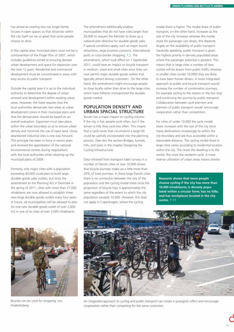
URBAN PLANNING AND BICYCLE PLANNING
has aimed at creating low-rise single-family
houses in open spaces so that distances within
the city itself can be so great that some people
choose to drive.
In the capital area, municipal plans must not be in
contravention of the Finger Plan of 2007, which
includes guidelines aimed at ensuring desired
urban development and space for expansion over
the next 12 years. Residential and commercial
development must be concentrated in areas with
easy access to public transport.
Outside the capital area it is up to the individual
authority to determine the degree of urban
renewal and development within existing urban
areas. However, the State requires that the
local authorities demarcate new areas as urban
development zones in their municipal plans and
that the demarcation should be based on an
overall evaluation. Expansion must take place
within the urban boundary so as to ensure urban
density and minimize the use of open land. Using
abandoned industrial sites is one way forward.
This principle has been in force in recent years
and received the approbation of the national
environmental centres during negotiations
with the local authorities when drawing up the
municipal plans of 2009.
Formerly, only major cities with a population
exceeding 40,000 could plan to build large,
durable goods sales outlets, but since the
amendment to the Planning Act in Denmark in
the spring of 2011, cities with more than 27,000
inhabitants are now allowed to establish three
new large durable goods outlets every four years.
In future, all municipalities will be allowed to plan
for one new durable goods outlet of over 2,000
m2 in one of its cities of over 3,000 inhabitants.
The amendment additionally enables
municipalities that do not have cities larger than
20,000 to request the Minister to draw up a
national plan directive for durable goods sales
if special conditions apply, such as major tourist
attractions, large business concerns, international
ports or cross-border shopping. 7.2. The
amendment, which took effect on 1 September
2011, could have an impact on bicycle transport
in medium- sized and small cities since they can
now permit major durable goods outlets that
typically attract driving customers. On the other
hand, the amendment might encourage people
to shop locally rather than drive to the large cities
which have hitherto monopolized the durable
goods market.
POPULATION DENSITY AND URBAN SPACIAL STRUCTURETerrain has a major impact on cycling volume:
If the city is flat, people cycle often, but if the
terrain is hilly they cycle less often. This means
that a cycle route that circumvents a large hill
could be usefully incorporated into the planning
process. (See also the section Bridges, tunnels,
hills, and stairs in the chapter Designing the
Cycling Infrastructure).
Data retrieved from transport habit surveys in a
number of Danish cities of over 10,000 shows
that bicycle journeys make up a little more than
20% of total journeys. In these large Danish cities
there is no connection between the size of the
population and the cycling modal share since the
proportion of bicycle trips is approximately the
same regardless of the extent to which the city
population exceeds 10,000. However, this does
not apply in Copenhagen, where the cycling
An integrated approach to cycling and public transport can create a synergistic effect and encourage
cooperation rather than competing for the same customers.
modal share is higher. The modal share of public
transport, on the other hand, increases as the
size of the city increases whereas the modal
share for passenger cars drops; this depends
largely on the availability of public transport.
Generally speaking, public transport is given
the highest priority in densely populated areas
where the passenger potential is greatest. This
means that in large cities a number of new
cyclists will be drawn from public traffic whereas
in smaller cities (under 10,000) they are likely
to have been former drivers. A more integrated
approach to public and bicycle transport would
increase the number of combination journeys,
for example cycling to the station or the bus stop
and continuing the journey by public transport.
Collaboration between cycle planners and
planners of public transport would encourage
cooperation rather than competition.
For cities of under 10,000 the cycle modal
share increases with the size of the city since
many destinations increasingly lie within the
city boundary and are thus accessible within a
reasonable distance. The cycling modal share in
large cities varies according to residential location
within the city. The closer the dwelling is to the
centre, the more the residents cycle. A more
intense utilization of urban areas means shorter
Research shows that more people choose cycling if the city has more than 10,000 inhabitants; is densely popu-lated within a circular form; has no hills; and has workplaces located in the city centre. 7.17
Bicycles can be used for shopping, too.
Frederiksberg.
39

URBAN PLANNING AND BICYCLE PLANNING
87%
78%
72%
65%
23%
Province- rural
Province - outer urban neighbourhoods
Province- inner urban neighbourhoods
Province - city centre
Copenhagen - city centre
distances between homes, workplaces, shops,
etc. A greater population density also means an
increase in the customer base for local services,
thereby reducing the need for longer journeys.
All things being equal, urban density increases
bicycle traffic.
The prime factor influencing choice of transport
mode over short distances is the difference in
terrain, according to a study based on transport
habit surveys. In the flattest areas of Denmark
21% of total transport activities take place by
bicycle; in the hilliest areas such as Vejle only
10% of transport activities are cycled, in other
words the cycling modal share is more than
halved. This also means that passenger car
transport increases from 66% in the flattest part
of Denmark to 74% in hilly areas such as Vejle.
On the other hand people walk a bit more in hilly
areas. The same study shows that differences in
temperature and in the number of daylight hours
also influence transport choices; people cycle less
in frosty weather and women particularly avoid
cycling in the dark.
Travel speeds are essential when it comes to
choosing a transport mode. A Dutch study shows
that cyclists’ own travel speed as well as the
difference in their mutual speeds are significant
factors when choosing to bike. According to the
People bike less when the weather is frosty, but
the decisive factors for cycling are travel time and
terrain.
study, the degree of hilliness and the number of
stops as well as the cyclist’s travel time are the
main motivating factors in the decision to cycle.
Cyclist travel time is based on the direct route
to the destination and a 10% speed increase
increases the cycle modal share by 3.4 %. 0.3
fewer stops per km means a 4.9% greater
cycle modal share (Both are measured as a city
average.) 7.3, 7.4
An urban spacial structure in which a large
part of the built- up area is concentrated along
narrow bands of public traffic routes means
short walking distances to public transport and,
normally, high quality public transport services.
Greater Copenhagen, formed as a “finger” city,
also encourages people to combine cycling and
public transport, for example by cycling to the
S- train stations.
The demand for dwellings located close to the
coast or a lake has resulted in band shaped
cities in Denmark. Travel distances, however,
0% 10% 20% 30% 40% 50% 60% 70% 80% 90%
100%
Kbh+F
rederi
ksbe
rg
Kbh. fo
rstad
er
>700
00
10-70
000
2-100
00
Land
og sm
å bye
r
Diverse
Kollektiv
Bil
Cykel
Gang
Distribution of transport modes in relation to urban structure for trips of less than 22 km. 7.4
are greater in band cities thereby increasing
automobile dependency. This means there will
be fewer cyclists in a band city than in a more
compact, circular city.
SITING WORKPLACES AND EDUCATIONAL INSTITUTIONSA balance between the size of the active work
force and the number of workplaces in a given
area seems to reduce commuting, all things
being equal. The location of homes has a greater
impact on transport activities than the location of
workplaces.
A Danish study shows that the location of
workplaces is of some significance in all Danish
cities, but plays a major role in the capital. It
is true of all cities that fewer people drive to
businesses located in the city centre than to
businesses outside the city centre. The city centre
effect, however, seems most pronounced in
Aarhus and Aalborg.
Driving to work is significantly more widespread in the provinces 7.5
Miscellaneous
Public
Car
Bicycle
Walking
Cope
nhag
en +
Fred
erik
sber
gCo
penh
agen
+ su
burb
s
>700
0
10,0
00-7
0,00
0
2,00
0-10
,000
Rura
l and
smal
l citi
es

URBAN PLANNING AND BICYCLE PLANNING
In the capital area planners are working
systematically on siting activities and enterprises
in close proximity to a station, based on the
principles set forth in the Finger Plan of 2007.
Station proximity is typically defined in terms of
pedestrian distances. The use of a bicycle can
significantly expand the proximity zone, although
this depends on the quality of the station bicycle
parking facilities, including the option of being
able to lock your bike indoors.
The conversion of many cities’ disused, centrally
located commercial and port areas can also
significantly increase the modal share of cycling,
especially if the number of car parking spaces
can be kept down, thereby enhancing the area’s
potential to attract a large number of cyclists.
Collaboration between urban planners and traffic
engineers is essential in this connection, and
investors will typically need to be convinced of
the value of developing a sustainable area.Bicycle parking facilities at the stairs leading to the platforms at Copenhagen Central Station make it
easy to combine cycling and train travel.
Principles for environment friendly siting 7.6
NON STATION-PROXIMITY AREA
STATION- PROXIMITY AREA
CORE STATION- PROXIMITY AREA
STATION
600 M
1,000 M (INNER METROPOLITAN AREA)1,200 (OUTER METROPOLITAN AREA)
Miscellaneous
Public
Car
Bicycle
Walking
Characteristic examples of siting options
Urban – high density- Large business and service entities employing many office
workers (> 1,500 m floor space)- Major, highly frequented institutions- Dense housing- Shops in accordance with retail regulations
Urban – middle density- Dense housing - Dense- low-rise housing- Small business and service entities (<1,500 m floor space)- In exceptional cases large business and service entities
employing many office workers (> 1,500 m floor space)- Local institutions- Shops in accordance with retail regulations
Urban areas with varying degrees of density- Dense and dense-low rise housing + single family housing- Local institutions- Extensive building, storage and production enterprises- Small business and service entities (< 1,500 m floor space)- Dense housing (in accordance with supplementary measures)- Shops in accordance with retail regulations
Criteria for demarcated areas
Core station-proximity areaDefined by municipal plan as lying within walking distance of max. 600 m to a station, as well as other urban planning considerations
Station-proximity area:Defined by municipal plan as normally based on an area within a 1000 m radius to the station in inner metropolitan areas and an area within a 1,200 m radius in outer metropolitan areas, as well as other urban planning considerations
Non station-proximity area:The other urban areas
41
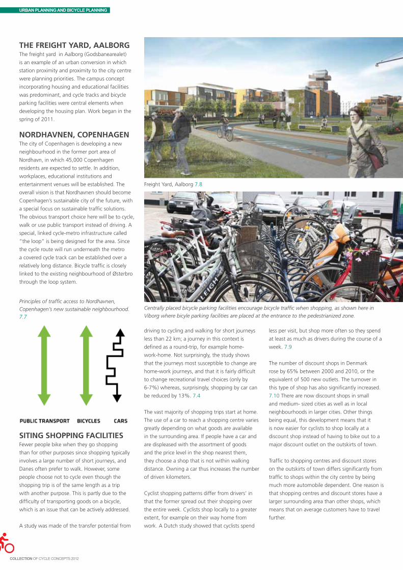
URBAN PLANNING AND BICYCLE PLANNING
ThE FREIGhT YARD, AALBORGThe freight yard in Aalborg (Godsbanearealet)
is an example of an urban conversion in which
station proximity and proximity to the city centre
were planning priorities. The campus concept
incorporating housing and educational facilities
was predominant, and cycle tracks and bicycle
parking facilities were central elements when
developing the housing plan. Work began in the
spring of 2011.
NORDhAVNEN, COPENhAGENThe city of Copenhagen is developing a new
neighbourhood in the former port area of
Nordhavn, in which 45,000 Copenhagen
residents are expected to settle. In addition,
workplaces, educational institutions and
entertainment venues will be established. The
overall vision is that Nordhavnen should become
Copenhagen’s sustainable city of the future, with
a special focus on sustainable traffic solutions.
The obvious transport choice here will be to cycle,
walk or use public transport instead of driving. A
special, linked cycle-metro infrastructure called
“the loop” is being designed for the area. Since
the cycle route will run underneath the metro
a covered cycle track can be established over a
relatively long distance. Bicycle traffic is closely
linked to the existing neighbourhood of Østerbro
through the loop system.
Freight Yard, Aalborg 7.8
SITING ShOPPING FACILITIESFewer people bike when they go shopping
than for other purposes since shopping typically
involves a large number of short journeys, and
Danes often prefer to walk. However, some
people choose not to cycle even though the
shopping trip is of the same length as a trip
with another purpose. This is partly due to the
difficulty of transporting goods on a bicycle,
which is an issue that can be actively addressed.
A study was made of the transfer potential from
driving to cycling and walking for short journeys
less than 22 km; a journey in this context is
defined as a round-trip, for example home-
work-home. Not surprisingly, the study shows
that the journeys most susceptible to change are
home-work journeys, and that it is fairly difficult
to change recreational travel choices (only by
6-7%) whereas, surprisingly, shopping by car can
be reduced by 13%. 7.4
The vast majority of shopping trips start at home.
The use of a car to reach a shopping centre varies
greatly depending on what goods are available
in the surrounding area. If people have a car and
are displeased with the assortment of goods
and the price level in the shop nearest them,
they choose a shop that is not within walking
distance. Owning a car thus increases the number
of driven kilometers.
Cyclist shopping patterns differ from drivers’ in
that the former spread out their shopping over
the entire week. Cyclists shop locally to a greater
extent, for example on their way home from
work. A Dutch study showed that cyclists spend
Centrally placed bicycle parking facilities encourage bicycle traffic when shopping, as shown here in
Viborg where bicyle parking facilities are placed at the entrance to the pedestrianized zone.
less per visit, but shop more often so they spend
at least as much as drivers during the course of a
week. 7.9
The number of discount shops in Denmark
rose by 65% between 2000 and 2010, or the
equivalent of 500 new outlets. The turnover in
this type of shop has also significantly increased.
7.10 There are now discount shops in small
and medium- sized cities as well as in local
neighbourhoods in larger cities. Other things
being equal, this development means that it
is now easier for cyclists to shop locally at a
discount shop instead of having to bike out to a
major discount outlet on the outskirts of town.
Traffic to shopping centres and discount stores
on the outskirts of town differs significantly from
traffic to shops within the city centre by being
much more automobile dependent. One reason is
that shopping centres and discount stores have a
larger surrounding area than other shops, which
means that on average customers have to travel
further.
Principles of traffic access to Nordhavnen,
Copenhagen’s new sustainable neighbourhood.
7.7

URBAN PLANNING AND BICYCLE PLANNING
An explicit goal is to shorten transport distances
to shopping facilities in order to cut down
on automobile dependency when shopping.
Furthermore, shopping areas should be easily
accessible to all types of traffic, including
pedestrians, cyclists and public transport. 7.1
One of the guiding rules is that newly designated
shopping areas should be located in the central
part of a city, in the very city centre or in the local
neighbourhood centre in the case of large cities.
PARKING AS A TRAFFIC MANAGEMENT INSTRUMENTParking norms for automobile traffic in
connection with new construction projects is
an effective instrument for keeping auto traffic
down. Traditionally, parking norms have been
used to ensure a sufficient number of parking
spaces. However, it has become increasingly
common to operate with upper limits for
passenger car parking within central urban areas
in order to reduce the number of car parking
spaces in new construction projects. The local
authority itself determines whether it should
specify a lower limit.
When planning a dense urban area the principle
of dual-use parking is useful in order to create
the desired parking capacity in relation to the
area’s functions. Differentiated parking rates
according to zone based on urban density is
another measure that encourages bicycle traffic.
A further option is the strategic use of parking
funds; a municipal parking fund is granted
revenues to create parking capacity if it is not
otherwise possible to establish the required
number of parking spaces. The local authority
can use the fund to establish parking garages in
accordance with the overall plan, for example
People cycle to centrally located shopping centres with good cycling facilities,
as shown here in Frederiksberg, which has a very high cycle modal share.
on the outskirts of the city centre. However, the
requirement that the money must be spent within
5 years makes it difficult for some cities to amass
sufficient funds to finance a parking garage.
It is possible to limit parking capacity in existing
commercial areas by voluntary cooperation
between private firms and the public authorities.
Studies show that an increase in cycling is best
achieved by creating better cycling conditions
while at the same time making life more difficult
for car owners, for instance by reducing car
parking capacity.
A study of the transfer potential from driving to
Parking norms and dual- use principles are strategic instruments for
reducing automobile traffic.
walking and biking shows that passenger car
traffic drops by 3 percentage points when the
percentage of people who perceive a change
in parking conditions as being too expensive or
as making it too difficult to find parking spaces
increases by 50%. 7.4
Communities can also write bicycle parking
norms into the plans for new construction
projects, just as with car parking. This ensures
that the developer includes bicycle parking
facilities from the outset so that cycling can
become a viable alternative to the automobile.
Read more about bicycle parking options in the
separate chapter, Bicycle Parking.
Function Bicycle parking norm
Residential and blocks of flats 2-2.5 per 100 m2 living area
Student residence 1 per resident
Child care centres 0.4 per staff + reserved area for trailers and special bikes
Schools 1 per student 4th year and up and 0.4 per staff
Educational institutions 0.4-0.8 per student and 0.4 per staff
Retail/ shops 2 per 100 m2 in the capital and 1 per 100 m2 in the provinces
Other urban professions (doctor, dentist, etc.) 0.3-0.4 per 100 m2 and 0.4 per staff
Stations 10-30% of the number of passengers (departures per day)
Bus stops and terminals 1 per 10 peak hour passengers (6 a.m. -9 a.m.)
Cinemas and theatres 0.25 per seat and 0.4 per staff
Hotels and restaurants 1 per 15 guests and 0.4 per staff
Sports centres and stadiums 0.6 per participant and 0.4 per spectator
Office and industry 0.4 per staff
Recreational areas 1-4 per 10 visitors
Bicycle parking norms are an excellent instrument for incorporating bicycle parking into the local
planning and handling of construction projects 7.12
43

URBAN PLANNING AND BICYCLE PLANNING
BICYCLE TRANSPORT STRATEGY AND PLANAs discussed above, cycling should be
incorporated into overall urban planning at all
levels on equal terms with automobile transport,
public transport and walking. The optimal
situation is for local authorities to draw up
mobility strategies and action plans in which
walking, cycling, public transport and passenger
car transport are considered as a whole, and
visions and goals are formulated for overall traffic
development.
If an overall solution proves unfeasible, the local
authority should promote bicycle transport by
drawing up a cycle strategy and cycle action
plan focusing on visions, goals and actions to
encourage cycling. A cycling strategy or cycling
action plan can also be devised as a supplement
to or preparatory work in advance of a general
mobility or traffic plan.
A bicycle strategy should contain an overall
vision for the long term development of bicycle
transport. In addition, it should formulate a
number of measurable objectives to be met
within a shorter time span, such as the desired
bicycle transport percentage increase, desired
modal split for cycling, desired modal split for
commuting to and from work, etc.
At the same time the stated objectives should be
followed up by concrete action plans and political
priorities. It is crucial that the action plan, goals
and economic resources correspond since the
action plan loses its credibility otherwise. Some
communities that have made cycling a high priority
have typically aimed at increasing bicycle traffic by
roughly 20-25% over a 4 year period.
In the EU project, Nordic Cycle Cities, 11 Danish,
Swedish and Norwegian communities formulated
procedures for bicycle strategy and action that
include the involvement of politicians, citizens
and other stakeholders. You can learn more at
www.nordiskecykelbyer.dk or in English at http://
shoploppen.dk/Velo-city_presentations/Marianne_
Weinreich.pdf.
MUNICIPALITY GOAL PERIOD
Elsinore 25% increase in bicycle traffic by 2012
Aarhus Significant increase -
Aalborg 10% increase in bicycle traffic by 2020 15-20% of journeys less than 5 km are cycled by 2012
Odense 25% increase in bicycle traffic by 2012 35% increase in bicycle traffic by 2020
Copenhagen 50% of commuters to work and education by 2015 within the municipal boundary are cyclists
Fredericia 25% increase in bicycle traffic by 2015
Randers 20% of trips less than 5 km are cycled
Bicycle traffic objectives in different cities 7.13
An increasing number of communities are drawing
up bicycle accounts as the basis for monitoring
the effect of bicycle strategies and bicycle action
plans. A bicycle account should incorporate citizen/
cyclist ratings of a number of conditions, monitor
developments within the cycling infrastructure,
etc., and follow up on the extent to which goals
and objectives are met. The city of Copenhagen
has year-long experience with the bicycle account
and actively uses it as a prioritization tool for
making decisions. A number of other communities
have already or will shortly draw up similar bicycle
accounts. Bicycle account measurements and
calculations can be carried out at a cost of approx.
DKK 25,000 and upwards, depending on the
scope.
Bicycle accounts or other types of cycling surveys
should be key elements in an active and forward-
looking municipal planning effort to promote bicycle
traffic. Such surveys can also be used as a marketing
tool, telling the story of what cyclists want.

URBAN PLANNING AND BICYCLE PLANNING
Benchmarking is another tool for getting cycling
onto the local agenda, as is BYPAD (Bicycle Policy
Audit). The purpose of BYPAD is not simply
to benchmark; it is primarily a tool to get the
ball rolling, cutting across local interests and
ensuring that public officials, politicians and
cyclists take part in the process. The benefit of
the round table discussions depends largely on
the composition of the constituted groups. The
systematic approach often gives rise to fruitful
discussions and the matching of expectations,
both internally within the local authority and, as
the group is cross-functional, between politicians
and interest groups participating in the process.
The Danish cities of Viborg, Nakskov, Odense and
Hillerød received the official BYPAD certificate in
2003 and Aalbog and Sønderborg were certified
in 2010. Learn more about BYPAD at ww.bypad.
org.
A number of local authorities have participated
at various times in EU funded projects in which
cycling was a focus area to a greater or lesser
degree. The authorities exchanged experiences
with other European cities, which can be useful
although collecting comparable data is no easy
task. The authorities were inspired by other
participants’ projects to implement projects that
would otherwise have been difficult to fund. EU
funded projects typically contain benchmarking
requirements in one form or another, and
cycling projects typically do not involve physical
construction.
A European project called Smart Cities compared
70 medium- sized European cities, including
Aalborg, Aarhus and Odense. The cities are
In the EU funded project, Nordic Cycle Cities, 11 Danish, Swedish and Norwe-gian local authorities developed proce-dures for compiling a bicycle account, including what type of facts it can and should contain and how to collect the relevant data.
(See the bicycle accounts in Danish at www. nordiskcykelbyer.dk.).
The BYPAD process 7.14
Project Smart Cities compares medium- size cities
on the basis of 6 different indicators 7.15
Out of 70 European cities 3 Danish cities rank among the top 5. 7.15
compared on the basis of 6 indicators: economy,
mobility, environment, people, living and
governance, and are required to perform well in
terms of predefined factors within each area in
order to qualify as a “smart city”.
In 2009 the Danish State reintroduced a national
cycling promotion fund. The grants it provides
have been instrumental in quick-starting local
initiatives. Even though funding is not always
granted due to limited resources, the mere act
of concretising a cycle project sets the stage for
developing creative new cycle projects. Projects
that receive a grant from the cycling promotion
fund are required to evaluate their project’s
strengths and weaknesses and communicate their
experiences to other cities. At the time of writing,
evaluation procedures were not sufficiently
advanced for such information to be included
in this publication. Projects that have received a
grant from the national cycling promotion fund
range from isolated cycle track projects, near a
school for example, to educational campaigns
targeting schoolchildren and the preparation of
cycling game materials, to comprehensive major
cycling city projects including infrastructure,
bicycle parking, marketing, new ITS initiatives
(Intelligent Transport Systems), and campaigns.
45

URBAN PLANNING AND BICYCLE PLANNING
Examples of National Cycling Promotion Fund project grants, 2011. 7.16
€1 = DKK 7.4, £1 = DKK 8.9 and $1 = DKK 5.6 at the time of writing.
MUNICIPAL CYCLING CITY PROjECTS (APPROx. DKK 12.6 MILLION)
• HerningMunicipality:Herning–cyclingasadailytransportmode(DKK4.1m)
• HorsensMunicipality:Horsens–twowheelsahead(DKK5.0m)
• HørsholmMunicipality:Hørsholmcyclingcity(DKK3.5m)
BICYCLE COMMUTING PROjECTS (APPROx. DKK 20.8 MILLION)
• BillundMunicipality:Grindstedvej,Billund–CyclepathlinkingBillundandlocalcommercialandrecreationalareas (DKK 0.5 m)
• Gladsaxemunicipality:TheFarumcyclesuperhighway, (Gladsaxe construction costs:DKK 0.8m)
• Hillerødmunicipality:Nr.Herlevpath(DKK2.5m)
• Hjørringmunicipality:BicycletrafficdevelopmentinHjørring–TheHøjenecycleroute(DKK1.9m)
• CityofCopenhagen:TheFarumcyclesuperhighwayCopenhagenpart,(Copenhagen’sconstructioncosts:DKK7.0 m)
• Middelfartmunicipality:Thegreenshortcut(DKK1.4million)
• Odensemunicipality:NewbicycleparkinggarageatOdenseStationCentre(DKK1.4m)
• Rødovremunicipality:JyllingevejBridgealongtheVestvoldcycleroute.
CYCLING TO SChOOL AND LEISURE ACTIVITIES (APPROx. DKK 26.1 MILLION)
• Assensmunicipality:Two-waycycletrackinHaarby(DKK0.3m)
• Ballerupmunicipality:Two-wayshared-usetrackalongKlakkebjerg(DKK0.5m)
• Residents’AssociationforØrumanditsEnvirons(Hedenstedmunicipality):Shared-usecycleandwalkingpathscriss-crossingtheareabetweenØrumandDaugård(DKK0.7m)
• Furesømunicipality:Increasedcyclingtoschoolbymeansofcycle“buses”(DKK0.1m)
• Faaborg-Midtfynmunicipality:ProjectcycletrackNyborgvej(DKK1.0m)
• Hedenstedmunicipality:Tørring(DKK1.1m)
• Kertemindemunicipality:ExtensionofanexistingcycletrackalongasectionoftherailwaypathatHindsholmbetween Dalby and Martofte (DKK 1.0 m)
• Lemwigmunicipality:CycletrackalongBallegårdvej(Kontorvej-Høgevej)(DKK0.2m)
• Mariagerfjordmunicipality:Extensionofcycle/walkingpathalongLøgstørvejinHobro(DKK3.7.m).

8Contents
The cycling infrastructure 48Daily cycling and leisure cycling 49Traffic safety vs. a sense of security 50Travel speed and comfort 51Segregation vs. integration 52Cyclists vs. pedestrians 54Good planning attracts cyclists 54Planning principles 57Drawing up the plan 60Anchoring 60The ways of the State 61Infrastructure, road sections and intersections 62Road section solutions 64Intersection solutions 66Road safety audit vs. service levels 69Materials, construction and aesthetics 69Construction projects 70Estimates and price calculations 71
This chapter is about planning the cycling infrastructure, and
offers ideas for a cycling infrastructure that will encourage
more people to cycle.
The cycling infrastructure is defined here as cycle tracks/lanes,
paths, greenways, intersection solutions, etc., in other words
anything that might be termed the cyclist circulation area.
Bicycle parking is discussed in a separate chapter.
The chapter first examines Danish cycle tracks, cycle routes,
etc., and the Danish cycling tradition underlying all planning. A
basic distinction is made between daily cycling and recreational
cycling. Road safety, a sense of security and travel speed and
comfort are taken up.
In Denmark cycling has always been recognized as an
independent transport mode with the “right” to its own
designated circulation area on equal footing with vehicular,
public and pedestrian transport. This tradition underlies any
discussion of cyclist circulation areas and the integration of
cycling and other transport modes.
The section offers suggestions for drawing up a cycling
infrastructure plan; different principles are discussed and an
overview is provided of the road section and intersection
solutions currently available in Denmark. The chapter also
offers ideas for new solutions and initiatives.
Finally there is an overview of methods for planning and
pricing construction projects.
PLANNING THE CYCLING INFRASTRUCTURE

PLANNING THE CYCLING INFRASTRUCTURE
THE CYCLING INFRASTRUCTURE
Existing cycling infrastructure and the Danish cycling traditionIn a number of Danish cities the cycling
infrastructure is almost entirely cohesive, whereas
in other cities and rural areas it is less so. Usually,
though, there is already something to build on.
Furthermore, there is a strong Danish cycling
tradition. Improving existing cycling facilities,
making high quality additions to the cycling
infrastructure, and introducing untraditional
measures encourage more people to cycle.
The cycling infrastructure can be improved by
linking existing circulation areas, upgrading
facilities to a contemporary standard, and actual
expansion. All such initiatives should be based
on a bicycle infrastructure plan, sometimes
referred to as a “cycle track plan”, or should
be an integral part of a “cycling action plan”,
which includes many different aspects of cycling
promotion.
Traffic calmed roads or slow-speed zones and
secondary roads with little motor traffic may be
included in the cyclist circulation area.
Future cycling infrastructureThe municipal plan should contain a road
network plan and a cycle network plan. If this
has not been done yet, it might be useful to start
out by drawing up a cycling infrastructure sector
plan which can then be integrated into the next
municipal plan. Better cycling facilities can also be
written into a traffic or mobility plan.
Ideally, establishing principles for road network
solutions should be addressed in the municipal
planning process, for example in connection
with road and cycle track classification, as well
as in the local plans in relation to principles
for street function and design. The concept
of "strøggade", i.e. a shared space shopping
street with mixed traffic and functions and
priority to pedestrians and cyclists, can be
usefully introduced as a special category.
Another interesting category to consider is
the “bicycle street”, inspired by the German
“Fahrradsstrassen”.
The cycling infrastructure includes cycle tracks/
lanes, paths, greenways, intersection solutions,
mixed traffic areas with special priority to cyclists
(slow speed limits for cars, extra space, etc.),
signed cycle routes, bicycle parking facilities, and
other physical measures to encourage cycling.
Bicycle parking is discussed in a separate chapter.
A cycling infrastructure plan is partly based on a
survey of cyclist issues and proposals, knowledge
of existing cycling patterns, siting of primary
corridors/links and major cyclist destinations
(workplaces, service institutions, shops, link-up
with public transport, recreational amenities, etc.)
In addition, road safety objectives will often be
included. For many years planners have worked
systematically improving road safety, and most
recently there has been a special focus on cyclists
and pedestrians. This is backed up by national
goals and policies which are often converted
into goals and policies on the local level. The
aim of road safety work is to combat and prevent
accidents, however, not encourage more people
to cycle.
Indeed, it is rather the cyclist’s sense of security,
i.e. the cyclist’s subjective perception of being
safe, that actually encourages cycling. For many
people insecurity is a reason for not cycling.
A better sense of security is often an explicit
objective of infrastructure plans, strategies, etc.,
but this is generally less clearly formulated than
road safety objectives. This is due to the fact
that it is more difficult to “measure” a subjective
sense of security. It can be done, however, as
proven by the telephone interviews carried out
for the bicycle accounts, for example. 8.1-8.3
It is also possible to draw up measurable
objectives for improved passability or faster travel
speeds. Copenhagen aims at increasing cyclist
travel speed by 10% over a few years. This has
made it necessary to develop a methodology for
measuring and monitoring the objective. 8.4.
Increased bicycle traffic will often be a more or
less explicit ambition in a cycling plan. Such an
objective may be qualitative or quantitative, and
more or less binding.
When a cycling action plan (or the more
limited cycling infrastructure/cycle track plan) is
politically approved and initiated it will often be
insufficiently funded. Public debate, however,
frequently serves to focus political attention,
often resulting in a higher funding priority.
Sometimes co-financing with the State is possible
(e.g. National Cycling Promotion Fund grants for
construction projects) or EU funding (normally
not available for construction projects). Danish
communities are in great demand for EU projects
and experience shows that local politicians are
very interested in getting their share. External
co-financing can be the kick-off for improving the
cycling infrastructure. In the long run it may turn
out that some cycling infrastructure construction
can be implemented in connection with utility
construction and road renovation. Building
construction and site development projects that
include cycling infrastructure as an integral part
One way of improving cycling facilities is during
utility construction.
A section of the green cycle route through Copenhagen, which was financed by a private developer
in accordance with an urban development project (Ny Tøjhusgrunden). The cycle route appears in the
municipal and the local plans as part of the “Amager route”.
of the project in a given area may also come to
play a role. Furthermore, school route projects
and road safety projects often take the cycling
infrastructure into account.
A well thought out plan is often needed so as to
be able to grasp any opportunity for improving
the cycling infrastructure that may arise.

PLANNING THE CYCLING INFRASTRUCTURE
High political ambitions for cycling should
be reflected in higher standards for new
infrastructure design. The existing infrastructure
can be improved, too. Focusing on security
and passability is an excellent starting point for
an upgrade, but of course safety concerns are
paramount too.
DAILY CYCLING AND LEISURE CYCLINGThe functional requirement for a successful
cycling infrastructure is that traveling from point
A to point B should be convenient and quick,
and the journey should be a safe and pleasant
experience. This applies especially to daily cyclists
(particularly commuters), but all types of cyclists
appreciate not having to make major detours.
Daily cyclists’ destinations are schools,
institutions, workplaces, shops, parks, leisure
facilities, train stations, and bus stops. Many
journeys are relatively short, but particularly
commuters are willing to cycle further, perhaps
6-8 km between home and work. Since many
people are now focusing on exercise and health,
perhaps more people will be willing to commute
even further, some with the assistance of an
Daily cyclists bike to school, child care,
employment, shopping, public transport, and
many other daily destinations.
e-bike. 8.5 Long cycle journeys are comparatively
few, but are already becoming a factor in the
kilometer account.
A special group of cyclists are cycling toddlers,
learning through playing how to become the
cyclists of the future. Children need to be able to
cycle safely near their homes, and traffic calmed
streets are a fine offer.
For Sunday cyclists a convenient link between the
city’s infrastructure and the activity destination
plays an important role. Sunday cycling takes
place within the course of a day, often in a
group. Typically, 10-30 km are cycled often in
combination with a public transport mode.
Holiday routes need not necessarily be direct but
on the other hand should never take cyclists in
the opposite direction of their destination. The
starting point for cyclists on holiday is a home,
train station, bus terminal, bike rental shop at the
holiday destination, etc. Lodging and shopping
facilities as well as active fun play an important
role for this group.
Cycling toddlers develop
motor skills through play.
Holiday and Sunday cyclists focus on an active, fun experience.
49

PLANNING THE CYCLING INFRASTRUCTURE
TRAFFIC SAFETY VS. A SENSE OF SECURITYThere are good grounds for taking safety and
security (and in the next section passability and
comfort as well) as a starting point in bicycle
traffic planning.
First of all, safety and a sense of security are NOT
the same thing.
A sense of security is the cyclist’s subjective
perception of what cycling in traffic feels like,
whereas safety is the objective registration of
accidents. A sense of security (or insecurity) can
be recorded by different types of interviews:
focus groups, telephone interviews, street
surveys. Safety (or accidents rather) is registered
by the police, categorized according to whether
or not the situation involves personal injury.
Accident rates can be calculated on the basis of
number, density, frequency, risk, etc.
A classic example illustrating the difference
between safety and a sense of security is when
the cycle track is shortened before cyclists enter
the intersection. This was introduced at one
point to make it easier for motor vehicles to turn
right at intersections. The solution means that
cyclists and cars merge which proved quite safe
purely from the safety point of view. However,
cyclists feel vulnerable and insecure, preferring
to have their own area that takes them all the
way up to the intersection. It is usually possible to
establish solutions that are both safe and secure.
Unfortunately, however, in some cases set back
stop lines for cars are not quite as safe as the
shortened cycle track.
If more people are to be encouraged to cycle,
cyclists need to feel that what they are offered
makes them feel secure. It is crucial that women
feel secure since that means increased cycling
among children, women and the elderly – as
well as men. Children cycle if they have learned
how and if they’re allowed to. It is the local
administration’s responsibility to ensure that they
may do so safely.
The trick is to develop solutions that are at once
safe and make cyclists feel secure. Good solutions
are either a narrowed cycle lane leading from
the shortened cycle track to the intersection or
a continued cycle track in its full width up to the
intersection. Set back stop lines for cars and cycle
crossings are provided in the intersection.
It is occasionally argued that some cyclist
insecurity is good for road safety since it keeps
cyclists on their toes. It may be that “planning by
fear” is effective, but it also discourages many
Shortened cycle track. Cars and cycles merge, which makes vulnerable cyclists in particular feel insecure.
Tietgensgade, Copenhagen.
Narrowed bike lane leads into the intersection. Cyclists are visible and have their own area.
Reventlowsgade, Copenhagen
Cyclists and buses, but not cars, share the area around this bus terminal. It works since the speed limit
is low. Aalborg.

PLANNING THE CYCLING INFRASTRUCTURE
potential cyclists. The problem should rather be
looked at in reverse: planning should serve the
interests of the most vulnerable cyclist groups so
that all types of cyclists will be able to use the
infrastructure. 8.7
The “self- evident road” is crucial in modern
traffic planning, meaning that the road design
should steer the road user’s attention and
vigilance to possible conflict areas. Road users
should not be made to feel afraid or insecure
in order to be vigilant; this should be a natural
consequence of speed, traffic regulations,
social responsibility, etc. A “forgiving” traffic
environment is another principle to ensure that
the consequences of making traffic mistakes are
minimized.
There are other ways to draw cyclists’ attention
to potentially dangerous situations than making
them feel insecure: road narrowing, for example,
which brings cyclists and motorists a little closer
to each other, or a speed hump that reduces
speed and heightens vigilance at the same time.
On some road sections it is easy to choose the
right solution since traditional cycle tracks offer
cyclists both safety and security. To a lesser extent
this also applies to cycle lanes, which all in all are
better than cycling in mixed traffic.
When the task is to encourage cycling in an
area with few cyclists, it is sometimes worth
considering which is better: many kilometers
of cycle lane or a few kilometers of cycle track.
If cycle lanes are installed initially they must
have full cycle track width so they can later be
upgraded to a cycle track. The cycle lane can
function as well as a cycle track if cars are parked
along the edge. Cycle lanes and parking spaces
must not be too narrow if the solution is to
function properly.
When cyclists have to share an area with many
cars and where speeds are high it is crucial that
cyclists have enough space. For example, the
inner lane on a heavily trafficked street without
a cycle track should be wider than normal to
prevent cyclists from being squeezed.
In Denmark “30 km scooters” may be used
on cycle tracks. Although the scooter modal
split has dropped significantly in cities, mopeds
should preferably (in contrast to the present legal
situation) use the carriageway in order for cyclists
to feel more secure. This would also improve
cyclist safety, although it is not clear what it
would mean for scooter safety. A new category
on the cycle tracks is the e-bike (up to 25 km/h),
which is legally considered a bicycle in Denmark.
Cycle track capacity issues can be addressed
by widened cycle tracks on the sections of the
network where there isn’t enough room. The
blue cycle crossing shows the former cycle track
width. Dr. Louises Bridge, Copenhagen.
TRAVEL SPEED AND COMFORT Travel speed from point A to point B plays an
important role for the individual cyclist and also
for cycling’s competitiveness in relation to other
transport modes. Travel speeds can be improved
by removing detours, e.g. by allowing contra-
flow cycling (reduced “detour factor”) and
providing better passability, e.g. pre-green for
cyclists at intersections.
Although cycle tracks may mean that cyclists
ride somewhat slower (perhaps because they
feel more secure than in mixed traffic) cycle
tracks on road sections generally provide good
passability since there are no parked cars in the
way. Cycle tracks can be so narrow, however, that
overtaking is difficult. In some cases cycle tracks
cannot accommodate the growing number of
cyclists, causing definite capacity issues. Generally
speaking, cycle tracks that make overtaking
difficult should be discouraged as they give rise to
dangerous situations and a high level of insecurity
since some cyclists prefer riding fast while others
ride slowly.
Cyclists should not experience unnecessary delays
in intersections; as a minimum they should be
given priority on equal footing with car and bus
Narrow cycle track – “the art of the possible”, Aalborg.
51

PLANNING THE CYCLING INFRASTRUCTURE
traffic and should even be given preferential
treatment in some areas. This can be done by
coordinating the existing traffic signals on the
basis of average cycle travel speeds (20 km/h in
Copenhagen). Even without a green wave it is
essential to give serious consideration to cyclists
when planning the individual intersection’s design
since this plays a major role for cyclist passability.
Heavy headwinds reduce cycling speeds. On
some sections passability and comfort can be
increased by wind breaks such as trees or shrubs.
Canopies, trees, etc. can be used to create shelter
from rain squalls.
Stops, half-stops, road incline and elevation, and
uneven road surfaces mean that cyclists expend
more energy, which reduces speed. This has a
negative impact on cycling’s competitiveness 8.8.
and may mean that fewer people cycle. Add to
this, delays, which at a signalized intersection
may last 40 seconds depending on the timing
interval. Measures that increase passability on
the other hand, (e.g. pre-green for cyclists), few
stops (e.g. allowing cyclists to “go straight on
red” through the top of the T in a T-intersection)
make cyclists feel they are advancing faster than
other traffic.
Comfort is essential. A smooth, even road and
track surface means that a cyclist can maintain
speed without constantly having to keep an eye
out for unevennesses. This increases comfort
and passability as well as enabling the cyclist to
observe other road users and attractions along
the route.
Basically there must never be potholes on the
cycle track, and when they do arise they must
be addressed immediately for reasons of cyclist
safety and to avert compensation claims against
the local authority. Furthermore, uneven surfaces
signal to cyclists that nobody cares about them.
Traffic engineers are used to considering road
surface service life (often 15-20 years), but to
maintain a satisfactory comfort level it may
be necessary to apply a powdered asphalt
treatment at an interval of perhaps 10 years. The
appropriate time interval should be determined
by road surface measurements in relation to
bicycle traffic volumes, or some other systematic
approach.
Cycle tracks and routes should be kept open
in winter to at least the same extent as traffic
lanes in the interests of cyclist safety, security and
comfort. Prioritization of the primary sections
to be gritted, salted and cleared can be based
on the number of cyclists benefited. Another
option is to define a primary cycle path network
hierarchy with a higher priority than the rest.
SEGREGATION VS. INTEGRATIONThe general speed limit in Denmark is 50 km/h
within city limits and 80 km/h outside urban
areas, not counting motorways, etc. This means
that at both levels cyclists should have their own
circulation areas on major city streets and on
primary roads for reasons of road safety alone.
Road surface measuring vehicle equipped with laser devices. A sign on the back of the van explains why the van is on the cycle track.
30 km/h speed zone in Odense where school children can cycle safely.

PLANNING THE CYCLING INFRASTRUCTURE
Many cyclists on heavily trafficked roads feel
insecure. This is often due to heavy motor traffic,
high speeds and not enough space, all of which
are excellent reasons for establishing cycle tracks.
Cycle track design and maintenance should
always be of such a standard that cyclists never
choose to ride on the carriageway instead.
Mixed traffic is acceptable on secondary country
roads where there are few cars. Furthermore, it’s
often unnecessary to segregate cyclists and cars
on minor roads in urban areas.
In cities, motor vehicle traffic can be concentrated
along fewer roads within a general road network,
along which cycle tracks should be established.
Roads not used by through-motor traffic can be
closed off to motor traffic or calmed, thereby
allowing them to serve as direct, secure cycle
routes with few cars.
Cyclist visibility in traffic is a prerequisite for road
safety. Parked cars, verge vegetation, bends in
the road, planting, noise barriers, etc. can make
it difficult for cyclists to view the road and make
cyclists less visible. Accidents between cars and
bicycles primarily occur in intersections so extra
efforts should be made at intersections to ensure
that cyclists are visible.
Areas between major traffic arteries, where
bicycles and cars are not segregated, are
often designated as slow-speed zones with a
lower speed limit than the general 50 km/h.
An appropriate speed for motor traffic is 30
km/h as in the slow-speed zones in Odense.
Unfortunately, the police in other areas will only
accept 40 km/h in such zones. The signed speed
limit indicates the desired speed, but what really
counts when pedestrians and probably cyclists as
well are injured in accidents is the actual speed.
At 40 km/h an accident will have far greater
consequences than at 30 km/h. 8.9
The figure at right shows cycling solutions in
relation to motor traffic volume and speed. Road
safety is a priority and segregation between
motor traffic and cars is enhanced to make
cyclists feel more secure. Cheaper principles are
of course an option but would mean a lower
level of cycle service. Some of the studies upon
which the example is based are described in this
publication. However, some of the assumptions
needed to draw the figure are not fully
documented.
A defect of this figure is that the number of
cyclists is not included. Cross traffic volumes (for
all types of traffic) and the distance between
intersections are also important. On-road
This closed road in Malmö is open to cyclists. Cars are removed, not bikes.
53

PLANNING THE CYCLING INFRASTRUCTURE
segregation becomes less attractive the greater
the volume of cross traffic and the shorter the
distance between crossing points.
CYCLISTS VS. PEDESTRIANSThe Danish planning tradition considers cycling to
be an independent transport mode with the same
right to its own area as pedestrians. Generally
speaking segregating bicycle from pedestrian
traffic is an excellent principle. However, this can
result in an undesirable fear of contact in areas
where it is acceptable (or even desirable) to allow
the two transport modes to share the same area.
The need to place responsibility in the case of
accidents means that the police often require that
cyclists and pedestrians should be segregated;
under present regulations the police must
approve all municipal traffic projects and thereby
in practice have the power of veto.
Only in areas where there are very few cyclists
and walkers, such as recreational paths, is it
generally accepted that the two road user
groups can manage to share an area. However,
pedestrians and cyclists may share space in busier
areas such as urban pedestrianized zones, at
certain times of the day if necessary; pedestrians
should always have priority.
Traffic restricted streets inspired by the Dutch
“woonerf” in Denmark became "opholds-og
legeområder" (living streets/home zones) i.e. a
residential area where pedestrians and cyclists
have priority, which was an early example of an
integrated solution. This entailed a specific set
of rules ensuring that speeds did not exceed 15
km /h.; it was later supplemented by "stilleveje"
(traffic calmed streets), where the speed limit
is 30 km/h. Most recently Denmark introduced
the concept of slow-speed zones (30-40 km/h)
making it possible to introduce lower speed limits
than usual in large urban areas; this requires
fewer physical modifications than traffic calming,
for example.
Vestergade in Odense has small speed humps and over 5,000 cyclists over a 24 hour period. Odense
allows cycling from 9 pm - 9 am throughout the entire pedestrianized zone.
The concept of “shared space”, which like traffic
restricted streets was inspired by Holland, applies
the principle of integration to the deregulation
of even primary roads and intersections based on
esthetic principles, the desire to create beautiful
solutions. For example, areas are built up with
uniform surfaces and traffic lights are removed
forcing road users to “negotiate” their way
through traffic. This requires nerves of steel for all
the road users involved and does not encourage
children and the elderly to cycle, although
experienced cyclists may perhaps be able to
handle the consciously chaotic traffic situation.
Shared space is discussed in a report by the
Danish Road Directorate. 8.10
LEGAL OR ILLEGAL?Public squares are an example of how cyclists’ need to pass across an area is completely neglected so they cut across illegally. Cyclists should be able to bike legally, however. A planning author-ity cannot accept a traffic solution that doesn’t meet cyclists’ needs because “they bike illegally anyway”. Cyclists’ reactions to a planned traffic solution need to be carefully analyzed (will they react legally or illegally?) in order to adjust the solution so that more people are encouraged to cycle legally.
It is likely that the vision impaired will fight shared
space solutions. This may lead to complications in
basing a cycling project on such principles.
GOOD PLANNING ATTRACTS CYCLISTSCities where bicycle traffic has increased have
this in common: they have established a cohesive
cycling infrastructure with a high level of cyclist
service (security, passability and comfort).
New cyclists can be drawn from public transport
or automobile traffic. The journeys that are
the easiest to influence are commuter trips. A
DTU (Danish Technical University) report 8.11
Cyclists in Kristiansand, Norway, are handed a cash compensation for cycling (NOK 10).

PLANNING THE CYCLING INFRASTRUCTURE
concludes that automobile traffic on short
journeys can theoretically be reduced by 39%.
Leisure traffic will be affected very little, 6-7%,
while, surprisingly, shopping traffic by car can be
reduced by 13%. There is thus a great potential
for moving car journeys over to cycling (and
walking). The willingness to change transport
mode can be further supported by promotional
campaigns such as “inga löliga bilresor” (no
absurd car journeys), a campaign carried out by
the Swedish city of Malmö.
The traditional philosophy underlying a cohesive
cycling infrastructure is that cycling should
be boosted by giving cyclists a better offer
(the carrot), whereas there has been general
reluctance to create restrictions on motor traffic
(the whip). In addition cycling can be marketed
in various ways (the tambourines). The Odense
national cycle city campaign put a great deal
of effort into marketing, changing attitudes to
cycling, etc. 8.13
The Danish cycling tradition means that there are
often so many cyclists on the road that motorists
are always prepared for a potential conflict
between cars and bikes over a large area, such
as an entire city or even country. The concept of
“critical mass” is relevant here. The mechanism
is that drivers watch out for cyclists and possible
conflicts. When the critical mass of bicycle traffic
has been reached the accident trend is positive;
THE WHIP, THE CARROT AND THE TAMBOURINESTHE WHIP can consist of motor vehicle parking restrictions and fees, regulation of the number of cars that may enter the central urban areas and toll rings, road pricing, congestion charges, etc.
Traffic signals make it possible to control the number of vehicles entering the city to a certain extent. In Copenhagen the signals are regulated so that traffic queues occur on the motorway towards the city rather than within the city itself.
Paid parking and other regulations such as few spaces and high parking rates are used in many large cities as a means to manage traffic, particularly when it comes to reducing traffic in the city centre. New parking spaces requiring fees or higher rates are, however, subject to Danish government restrictions based on the idea that the local authorities should not use paid parking as a source of revenue. This means that such income is deducted from government subsidies. As of 2011 it is not clear whether such funds may be used wholly or in part to establish parking facilities in construction projects.
At the time of writing local authorities don’t have the power to introduce road pricing, congestion charges, or toll rings, according to Danish legislation. However several Dan-ish cities are interested in introducing congestion charges if it becomes possible. The city of Copenhagen and a number of surrounding suburbs have agreed on a concrete GPS based road pricing proposal. It is difficult to say what effect this will have on bicycle traffic since this would partly depend on public transport rates and options.Lessons can be learned about road pricing and toll rings from Kristianssand, Stockholm and London. In addition to the question of whether such measures are actually effec-tive in reducing motor traffic and promoting alternative transport forms, the question of the right to dispose of the revenues and their use is also at issue. In Kristiansand some of the revenue is used to improve the cycling infrastructure in 6 municipalities in the region.
THE CARROT when it’s a question of encouraging more people to cycle is a cohesive, high-standard cycling infrastructure. It is also important to be able to integrate cycling with public transport since this can improve the competitive edge of both in relation to the car.
THE TAMBOURINES consist of promotional campaigns, for example, which are dis-cussed in a separate chapter.
Comparison of 47 Danish cities
– the more people cycle, the safer the cyclist. 8.19
Cycling km per person per year
Cyc
list
and
mop
ed c
asua
lties
per
mill
ion
cycl
e an
d m
oped
km
Cycle and moped km per person per day
Cyc
list
fata
litie
s pe
r100
mill
ion
cycl
ing
km
“Safety in numbers” shows that the more people that cycle in a
European country, the safer it is. 8.14
3.5
3.0
2.5
2.0
1.5
1.0
0.5
0.00.0 0.5 1.0 1.5 2.0 2.5 3.0 3.5
55

PLANNING THE CYCLING INFRASTRUCTURE
i.e. more cyclists mean fewer accidents 8.15. This
is in sharp contrast to the situation in many areas
abroad, which start out with very few cyclists. In
this case more cyclists will typically result in more
accidents – and more negative headlines.
It is probable that high bicycle traffic volume
activates another mechanism, as is now the
case in parts of central Copenhagen and a few
other cycle cities: Here cycling seems to be the
dominating factor in the traffic scene, defining
the traffic flow.
It has gradually become a recognized principle
in Danish traffic planning that cars in residential
and central urban areas should make a detour
whereas cyclists get the direct route. This has
been challenged in several instances, however,
and the local authorities must stand firm when
dealing with project developers and others.
In recent years in major Danish cities there has
been the will to give preferential treatment to
cycling solutions at the expense of motor traffic.
In small cities the traditionally high priority given
to motor traffic is more pronounced due to the
greater modal split of motorized traffic and the
more positive attitude to cars; bicycle planners in
these areas need to use the carrot principle more
extensively.
On shopping streets there is often an interest
in avoiding through-vehicular traffic, but also in
retaining at least some car parking facilities. Since
experience clearly shows that cyclists cannot
be moved from shopping streets/main traffic
arteries to back streets, planners should focus
on providing good cycling facilities on shopping
streets even when this is at the expense of motor
traffic.
There is a temptation to establish cycle tracks
where it would be easy and cheap to do so.
However cycle tracks should only be built where
they are necessary, which is often where it is
difficult and controversial.
The cycling infrastructure should be direct, logical
and convenient, otherwise a number of cyclists
will choose roads that are not planned for bicycle
traffic. At worst they won’t bike at all.
The bicycle is a transport mode in competition
with other transport modes. The daily cycle
commute should be able to compete with the
car and public transport. The reasons potential
cyclists choose cycling rather than another
transport mode varies greatly from city to city.
The quality of public transport and the size of the
city (and thereby the length of the journey) are
“Fahrradsstrassen” in Germany inspired Aarhus to apply to the Danish Road Directorate to initiate a
bicycle street pilot project.
Nørrebrogade in Copenhagen is an example of a radical reorganization of a street area to the benefit
of cyclists, pedestrians and buses (2011). The street is designated in the City Plan of Copenhagen as a
“strøggade”, a shopping street with priority to pedestrians, cyclists and buses
significant factors in determining whether the
bicycle is competing primarily with the car or with
public transport.
Good coordination between cycling and public
transport improves the competitive edge of both.
This means that it should be easy to bring a
bicycle onto public transport and there should be
good parking facilities at stations and bus stops.
Traditionally bicycles have been allowed on trains
and to a limited extent on coaches. However,
it appears that bus companies are becoming
increasingly interested in allowing bicycles on
board. In 2011 MOVIA (operating in the Greater
Copenhagen Area) experimented with bicycles
on two bus lines in the capital area and BAT on
Bornholm, where there are many bicycle tourists,
is introducing new buses with space for 5-6
bikes. A cycle space on BAT buses can be booked
online and at bus shelters. 8.16 8.17

PLANNING THE CYCLING INFRASTRUCTURE
Danes cycle primarily because it’s convenient
and fast, but increasingly also because daily
cycling is an excellent form of exercise. This
should be reinforced when planning the cycling
infrastructure. The topic has been discussed in
various bicycle accounts. 8.1-8.3. It appears that
particularly residents of cities in western Denmark
focus on the health aspect; in cities in eastern
Denmark (e.g. Copenhagen) there is more focus
on cycling as the fastest transport mode whereas
health plays a secondary role.
By contrast, the fact that cycling is good for
the environment, e.g. reduced CO2 emissions
and particle pollution, does not seem to play a
significant role for the individual when asked
why he or she cycles. For the local authorities
of course reduced air pollution levels and better
public health are significant factors.
In order to stay on course and maintain focus it’s
a good idea to formulate explicit objectives for
bicycle traffic development. Qualitative objectives,
such as “more cyclists”, are not particularly
binding. Quantitative objectives, such as
Copenhagen’s goal that “50% shall bike to work
and education situated in the city of Copenhagen
by 2015” 8.18, 8.19, 8.20 are more ambitious.
A distinction should be made between bicycle
and pedestrian traffic so that the goals and
objectives for each traffic mode can be monitored
independently.
PLANNING PRINCIPLESThe cycling infrastructure can be based on
different principles. The existing infrastructure
may well be excellent, but initially it can be a
good idea to leave it out of account for a minute
and examine the available options from a general
point of view based on one or a couple of
general principles.
A city’s current traffic volumes (registered by a
traffic count) is an excellent starting point for
improving cycling facilities for the maximum
number of cyclists within the allocated budget.
The potential for increasing bicycle traffic
is another prioritization parameter, e.g.
employment nodes. There is great potential in
establishing a cycle path near a school, creating
a secure school route and thereby encouraging
children to bike to school rather than be driven
or take the bus. On roads without cycle tracks,
prioritization can be based on estimates of the
number of potential cyclists. However, this is a
more complex process than basing it on a traffic
count.
It is now allowed to take a bicycle free of charge on the S- trains at all times of the day in the greater
Copenhagen area. This is one way of enabling a car free lifestyle.
Heavily trafficked, high speed roads with few
cyclists should have cycle tracks on safety
grounds alone.
In areas currently without bicycle traffic the sole
basis for prioritization is cycling potential as in the
case of new construction where a large modal
share of cyclists can be anticipated if cycling
facilities are favourable. Bridges can also create
brand new links and attract and/or generate
many new cyclists. In this connection a qualified
guess is highly appropriate.
There is also the question of one- way streets in
city centres or residential areas. A traffic count
of illegal contra-flow cyclists cannot be used to
predict future legal use, for assessment purposes,
however. In some streets legalization of contra-
flow cycling can provide cyclists with a short-cut,
thereby increasing cycling volume substantially.
In addition to calculating current and potential
bicycle traffic volume, it is helpful to know the
location of primary destinations and how they
can be linked. Mapping can be difficult, but
when the focus is destination rather than bicycle
traffic volume it is possible to locate the “missing
links” in the cycling infrastructure and point to
other solutions than traditional cycle tracks along
major roads.
Motor traffic volume, speed and in some cases
cyclist age breakdown can and should influence
the choice between a cycle track, cycle lane
or mixed traffic solution. Principles for a high
standard of intersection design are crucial and
should have top priority.
Since Danish municipalities vary greatly in
terms of size and structure they approach cycle
planning in different ways. Central Copenhagen,
EXAMPLES OF PLANNING PRINCIPLES ODENSE has used traffic counts for many years as the basis for prioritization – from the inside and out. Where would a new cycle track benefit the maximum number of cyclists?
AALBORG formerly used a model developed by the county authorities to establish: potential school route cyclists; a factor indicating which cyclist groups (commuters, recre-ational) are benefitted; funding (to create a balance between city and country)
COPENHAGEN uses 5 “cycling criteria” in its cycle track prioritization plan: many cyclists; accidents; insecurity; network cohesion; contra-flow cycling. Other considerations are coordination with other urban projects and whether the cycling infrastructure can be established “simply and cheaply”.
57

PLANNING THE CYCLING INFRASTRUCTURE
Frederikshavn and Albertslund have been selected
as examples. In urban areas an appropriate
cycling infrastructure mesh size is 4-500m.
Superimposing the infrastructure network onto
the plan makes it possible to assess whether the
network is sufficiently fine-meshed.
In rural areas planning must take into account
daily traffic, including commuting, cycling to
Cycling solutions in Central Copenhagen Planned “cycle link ups” in central Copenhagen, an element
of municipal cycle planning. A ring around the historic city centre, and cross links through a number
of one way streets will be made two-way for bicycle traffic. The idea is that such a simple structure will
gradually be stored as a map in the cyclist’s memory.
Frederikshavn Municipality’s plan for expanding the cycle track network in the three main cities (Skagen, Sæby and Frederikshavn) and in open country. The
first map shows existing paths in rural areas, the second shows plans for expanding the cycle network in the city of Frederikshavn.
CYCLE PLANNING IN FREDERIKSHAVNThe municipality of Frederikshavn has drawn up a cycle policy 8.21 containing 7 focus areas, one of which includes plans for expanding the cycle track network in the three main cities (Skagen, Sæby and Frederikshavn). Cycle tracks are being planned for daily urban cycling, school routes in the countryside, and recreational purposes. To accommodate Skagen’s many tourists, for example, a cycle track has been established all the way from Frederikshavn to Skagen. The municipality is currently (2011) investigat-ing opportunities for developing luggage transport for leisure cyclists and a “very bicycle friendly” label for accommoda-tion. The cycle policy was drawn up in connection with the project Nordic Cycle Cities 8.22, funded by the EU Regional Development Fund.
Cycle track
Cycle lane
Two-way cycle track
Marked shoulder lane
Segregated off-road cycle path
Other cycle track links
Cycle track
Cycle lane
Two-way cycle track
Marked shoulder lane
Segregated off-road cycle path
Other cycle track links
Legend
Legend

PLANNING THE CYCLING INFRASTRUCTURE
CYCLE PLANNING IN ALBERTSLUND
Albertslund was designed according to the principle of traffic differentiation. Albertslund Syd is a large differentiated resi-dential area, which was traffic calmed around 1980, opening some of the roads to bicycle traffic. 8.24. Albertslund commer-cial zones are not differentiated, unlike the residential areas. The local authority is working on improving bicycle com-muting facilities that will link cycle tracks along the primary roads with the existing network of separate paths and a new network of bicycle superhighways.
Albertslund municipal cycle strategy of 2009 8.25 aims at im-proving cycling facilities in Albertslund in order to encourage citizens and employees to cycle rather than drive. The stated objective is to increase bicycle traffic in the community by 10% from 2009-2012. This would reduce CO2 emissions and benefit the environment while improving public health. The strategy also aims at improving passability, access and security. Better road safety is a municipal priority, concentrating on paths and roads outside the segregated path system.
The aim of the cycle network plans is to ensure that the network covers the entire municipal area, creating cycle access from residential areas to all urban functions, including employ-ment centres, institutions and shopping. The plans should further ensure access to municipal recreational areas as well as attractive links to the surrounding communities.
CYCLE LINKS IN ALBERTSLUND ARE PLANNED ON THE BASIS OF THE FOLLOWING PRINCIPLES:
1. Retention of the differentiated traffic system should be a priority of municipal plans and projects.
2. A network of commuter paths should be installed ensuring high passability within and across the municipal boundary.
3. Plans for establishing the missing cycle links in order to create cycle path cohesion should be drawn up with a special focus on:
a. Commuter paths b. The area around Albertslund Centre c. Municipal commercial areas
4. When traffic terminals are established (light rail station, greater capacity bus stops, etc.) cycle tracks should be established that link up with the municipal cycle net-work.
5. Municipal local plans, site development, etc. should ensure access to the municipal cycle network whenever possible.
6. Wherever motor vehicle traffic is allowed on the primary cycle network it should be restricted to the greatest possible extent.
7. The municipal authorities should enter into and support strategic efforts to improve national and regional cycle routes.
Albertslund municipal cycle path plan
school, etc., as well as Sunday and holiday
cycling. Since traffic volumes in the countryside
are much lower than in cities, traffic counts are
less appropriate as a planning tool since the
figures are too small and the chance of random
variation too great. Destination mapping in the
countryside needs to take account of the entire
surrounding area, the public transport structure
and the registered accident rate.
When it comes to Sunday and holiday cycling it
is vital to link planned urban infrastructure with
cycle tracks along the highways and existing
and planned cycle routes, including paths with
their own segregated layout. Although natural
areas, beaches, etc. are the primary attraction,
holiday cyclists in particular need to pass through
cities to shop but also for the sake of variety.
Accommodation facilities such as camping areas,
hostels and inns should be accessible without
having to cycle the last 5 km in the dark down a
country road with fast moving traffic.
In rural areas it’s a good idea to initially plan daily
cycling and recreational cycling separately. The
first phase of recreational cycle planning is to
identify desirable corridors or routes. The next
step is to take a look at existing routes, such as
the national cycle routes, a path along a stream
or a disused railway. The final phase is to identify
options for convergence or coordination. These
are most likely to occur near cities and in the
transition between city and countryside. 8.6
A-Q Missing links
Primary path
Planned primary path
Local path
Recreational path
59

PLANNING THE CYCLING INFRASTRUCTURE
Friluftsrådet, the Danish Outdoor Council, has
issued a publication providing inspiration for the
planning and administration of cycle paths in the
great outdoors. 8.23
Cycle tracks along heavily trafficked roads in
cities and in the countryside are often perceived
as more logical and easier to navigate than
segregated, off-road tracks and routes along local
roads. This applies particularly to new cyclists
who are either former motorists or newcomers
to the area. Confusing changes of direction on
the cycle route can disorient the cyclist; distinctive
geographic features in the area can serve as
landmarks and help cyclists find their way.
A uniform design over a long stretch is an
essential component of cycle route planning.
Clear signage, however, can make otherwise
disconnected cycle infrastructure elements more
coherent. Some cities have chosen to mark
special routes with road studs, or mark road
plates with cycle symbols, etc. as a supplement to
normal cycle path signage.
Cycle routes that are clearly visible from the
road, in fact any form of human activity, create
a greater sense of security. When cycle routes
are hidden from other road users, fear of being
attacked is increased while segregated, off-road
tracks are occasionally plagued by fast moving
existing cycling infrastructure into the plan.
In the 1960s a number of communities were built
around the principle of traffic differentiation, i.e.
one infrastructure for motor vehicles and another
for cyclists and pedestrians. Crossings between
roads and paths were grade separated (usually
tunnels). Such systems offer a high sense of
security in traffic, which means that significantly
more people choose to cycle and children start
cycling at an earlier age than in more traditional
traffic systems. However it appears that there
may be benefits to some softening of the
rigid segregation between road users in traffic
differentiated systems.
Cycle tracks along roads are one of the most
useful types of circulation areas for cyclists. In
addition there are a wide variety of other options,
including safe and secure intersection design.
The existing and planned road hierarchy, i.e.
specifically designated road and cycle path
categories (including the appropriate speed limits
for cars), is absolutely crucial. If there is no basis
for identifying a suitable primary cycle network,
then there is good reason to take another look at
the overall road structure.
A presentation of ideas for a cycling infrastructure
plan includes choice of corridor; the routes are
worked out in greater detail in an actual plan.
Since all cycle journeys ultimately start and finish
with a parked bicycle, bicycle parking is discussed
in a separate chapter.
There are a number of considerations when it
comes to an overall plan and choice of suitable
cyclist circulation areas.
• Roadclosureandsupplementarytraffic
calming can make cycle tracks unnecessary.
• Aparkinggaragemaycreatemorespaceon
the cycle tracks by reducing the need for kerb
side parking.
• Alternate-sideparkingcreatesacoupleof
meters extra for cycling. This may be enough
for a cycle track/lane on one side of the road.
If a few more meters can be found, cycling
facilities can be established on both sides.
• Contra-flowcyclingononewaystreetscan
greatly benefit cyclist passability.
• “Backstreetsolutions”inwhichcyclistsare
directed to cycle in parallel with primary roads
are NOT a good idea, according to all Danish
experience. Good cycling facilities should
primarily be created on major shopping streets;
cyclist issues must be addressed where cyclists
circulate.
• Existingtrafficdifferentiatedresidential
areas with grade separated crossings (usually
tunnels) can be made more cycle friendly by
allowing cycling on roads and some road level
crossing.
• Mixed-trafficresidentialareasbetweenprimary
roads with mandatory cycle tracks may be
designated as slow-speed zones (30-40 km/h),
in some areas supplemented with 30 km/h or
even 15 km/h streets.
• Through-roadsrunningthroughvillagescan
be traffic calmed according to the Danish
principles of “environmentally friendly
thoroughfares”.
When restructuring and developing urban areas
the priority given to cycling must be decided in
advance. Objectives for the cycling modal split
should be explicitly defined in major projects.
The planned cycling infrastructure should render
it probable that the objective is achievable. It is
absolutely crucial that the infrastructure provides
a link between the existing urban area and
new urban development, and funding for the
necessary infrastructure in the adjacent areas
must be ensured and written into the urban
development project.
In addition to cycling infrastructure requirements,
such factors as road lighting, operations,
maintenance, etc. are vital when it comes to
offering cyclists favourable cycling facilities.
ANCHORINGA “cycle track plan” involves politicians, the
general public, planners, operations personnel,
etc. In the final analysis the plan must be
politically approved and becomes binding for the
local authority in the form of an action plan or by
being written into the municipal plan.
The public must be involved along the way,
organizations as well as the general public, partly
because citizens know a great deal about cyclist
issues and partly to anchor the plan solidly in the
community. Focus groups or workshops can help
identify issues and possible solutions. A bicycle
account in which citizens’ views are clearly voiced
can help create a constructive public debate.
8.1-8.3
Citizens should be involved in the process before
the local authority fully commits to a plan.
Openness is vital when presenting the underlying
principles and prioritization methods to the
public.
Citizen input can be used as an argument for
larger budget allocation and can motivate
stakeholders such as underground cable owners,
operations personnel, etc. to support the plan.
The plan can usefully include infrastructure and
This Malmö cycle tunnel provides excellent
visibility thereby enhancing cyclist’s sense of
security.
scooters. Segregated off-road tracks are thus
sometimes inappropriate as they create a sense
of insecurity. Good lighting and a feeling of
openness in the construction and planting can
counteract this effect to a certain extent.
DRAWING UP THE PLANBefore the overall visions and general guidelines
for the municipal cycling infrastructure can
actually be put on paper, the principles discussed
above as well as other planning principles must
be taken into account. Add to this the local
authority’s former policies and the municipal
traffic plans that are currently in effect. Finally,
decisions must be made on integrating the

PLANNING THE CYCLING INFRASTRUCTURE
other facilities such as bicycle parking as well as
operation and maintenance priorities.
The overall structure must be clearly established
as a great many people are actively involved in
the process of changing road and path systems.
The cycle track network plan is an integral part
of a common understanding and collaboration
within the local administration. However,
planners are not allocated sufficient funding
to build up the cycle network alone. The local
authority (the road administration) should require
that all tasks and projects that might be useful
in implementing elements of the cycle network
IS THE PLAN COHESIVE?When an administration draws up a cycling infrastructure plan, often with the as-sistance of a consultant, it should be discussed and assessed whether the plan will be cohesive in practice.
Does the cycling infrastructure link residential areas with primary cycling destinations such as schools, educational institutions and employment centres? Are the routes direct? Is it easy to get to shops, sports facilities, entertainment venues and traffic ter-minals? Are the residential locations linked, providing cyclists with shortcuts that make it faster to bike than drive on local journeys? Has an overall hierarchy been established (formalized or informal) that gives prior-ity to primary routes rather than side streets and local routes, so that the majority of cyclists are attracted to primary routes? Is the flow broken by poor lighting, annoying barriers, too many signal intersections or poor maintenance? Small breaches should be addressed as quickly as possible since they drive cyclists away. Major “missing links” should be addressed in the long term.
Does the existing cycling infrastructure live up to the newest construction standards? If not, a “cycle track inspection” should be carried out with a special focus on inter-sections. The individual intersection’s design is often characteristic of the period of its construction and the aim of the inspection is to upgrade the existing design to a uniform standard.
Does the plan accommodate experienced as well as vulnerable cyclists? A direct but heavily trafficked road may be acceptable for adult cyclists but not for school children. School children (and their parents!) need to feel secure and should perhaps have an al-ternative route to school rather than a major road. Are school route plans coordinated with the cycling infrastructure plan?
Are there recreational options for Sunday cyclists and cycle tourists? They need an ac-tive experience and service.
If the infrastructure is initially established to a relatively low standard, have provisions been made for improvements over time, so that, for example, signed routes can be upgraded to cycle lanes, which in turn can be upgraded to actual cycle tracks?
Is the mesh-size of the urban cycling infrastructure appropriate? In many areas 400—500 m is sufficient but in areas with many destinations, for example a city centre, the mesh size should be smaller while in the periphery it should be larger. In the countryside it is necessary to check whether the proposed infrastructure leads to primary destinations such as schools, workplaces and services, and that routes leading to attractive recreational destinations and lodging are secure and clearly signed. Are enough provisions for supplementary segregated off-road tracks included in the plan?
Are cycle tracks planned for roads with fast moving traffic? It may be necessary to construct cycle tracks along such roads for reasons of cyclist safety and health. Perhaps the speed limit can be reduced until cycle path construction is completed? It is crucial for planner to be well acquainted
with the project area. This is done best by
initial inspection by bike. In the picture below
agreement has been reached that the shed
needs to be torn down to establish a cycle link in
Østerbro in Copenhagen.should be investigated at the earliest possible
moment. One obvious example is that the funds
received by the road authority from independent
user financed utility companies for reinstating
municipal roads after underground cable
construction should be coordinated with the cycle
track plan. There can be a 50% price reduction
for establishing a segregated cycle track in
connection with new construction, such as laying
natural gas pipelines, reducing the track price by
half in reality. Of course the rest of the money has
to be raised somehow!
It is useful to estimate construction costs within
the plan’s timeline. Anticipated co-financing from
other sources can be included. Copenhagen, for
example, operates with a price of DKK 8 million
per 1 km of cycle track (for one side of the road)
whereas elsewhere in the country it might cost
half that. When estimating the price of concrete
construction projects it is necessary to perform
actual price calculations.
When prioritizing different projects, especially in
small municipalities consisting of several equal
communities, an objective prioritization may
be based on an assessment of bicycle traffic
potential, including traffic to school routes,
educational institutions, businesses, and cycle
track network links. Of course there will always
be a certain amount of local politics involved in
the final political prioritization no matter what
method is used.
A politically approved priority plan for the
realization of the cycling infrastructure is an
enormous help. It saves many working hours
answering citizens’ inquiries.
THE WAYS OF THE STATEIn 2007 the Ministry of Transport published the
national cycle strategy, "Flere cykler på sikker vej i
staten” (More bicycles, safer roads) 8.26 outlining
a number of desirable focus areas for cycling
on state roads. These included: establishing a
new cycling infrastructure, focused maintenance
efforts, improved road safety for cyclists, and
better planning. The Danish Road Directorate
is drawing up a cycle track plan for state roads
based on 7 priorities.
The cycle strategy did not contain provisions for
new funding, however, apart from the existing
cycling promotion funds. In the transport
61

PLANNING THE CYCLING INFRASTRUCTURE
agreement of 2009, "En grøn transport politik"
(A Green Transport Policy),8.27 a DKK 1
billion cycling promotion fund was established
distributed over a few years 8.28. One third
of financing was earmarked for the cycling
infrastructure on state roads and approximately
two thirds for grants and subsidies to cycling
projects initiated by the local authorities,
organizations and businesses.
Implementation of the cycling promotion fund
takes place by means of annual follow-up
traffic agreements based on Road Directorate
recommendations concerning cycle projects on
state roads, and grants to local cycling projects by
application.
INFRASTRUCTURE, ROAD SECTIONS AND INTERSECTIONSAlthough road sections and intersections are
discussed separately below it is essential that they
be seen as a whole. A suitable general standard
should be established, and the types of solutions
chosen should be used consistently whenever
possible on long routes or within a smaller area.
There are a number of available options for road
section and intersection design when planning
the cycling infrastructure.
On major roads the traditional one-way cycle
track on both sides of the road will normally be
the preferred solution. Over almost a century they
have proved their worth and solidity in Danish
traffic planning.
In cities caution is advisable when using two-way
cycle tracks on one side of the road as the main
element of the urban cycling infrastructure since
Danish drivers do not expect cyclists to come
from the “wrong side”. Two-way tracks can be
used in moderation, however, to link the network
if there are no other options available. In the
countryside two-way cycle tracks are often the
most obvious consistent solution.
Cyclists can perfectly well cycle in mixed traffic
with low motor traffic volume and when car
speeds have been reduced by traffic calming. In
other areas segregated, road adjacent or off-road
paths are a good solution; sometimes cycle routes
can be composed of different types of solutions.
The solution chosen for road sections also
determines the intersection treatment to a certain
extent. Danish intersection design is largely
characterized by the fact that “small, soft, flat”
left turns were discontinued several years ago
to keep cyclists from floundering about in the
middle of the intersection. Intersection design
should reinforce the Danish Traffic code principle
that cyclists must keep right and that they have
to proceed to the opposite corner before turning
left.
A number of considerations enter into the choice
of solution: the professional and political level of
ambition, space, funding, etc.
The Danish road standards are an invaluable
support when designing cyclist circulation areas.
The rules regulating the cycling infrastructure are
integrated into the general set of road standards
and regulations. Forming an overview may be
difficult, but all road standards are available on
the Danish Road Directorate’s "Vejregel Portal"
8.29
There are a number of road standards and
Bus nub (kerb extension) where the waiting area between the cycle track and the bus takes space from
the cross profile. Car traffic – but not cycle traffic – has to wait while the bus stops at the bus stop.
In many new cycle cities abroad solutions are
often established merely by painting. Here a
bike box in New York. Occasionally it might be
worthwhile to consider “Quick and dirty” in
Denmark as well.
Shunt in Aalborg improves passability since cyclists needn’t wait for the green signal before turning right.
regulations that are of special interest to Danish
cycle planners pertaining to: urban traffic areas

PLANNING THE CYCLING INFRASTRUCTURE
CYCLE TRACK CAPACITYA two-lane cycle track should be at least 2 m wide theoretically; the 2.2 m recommended in the road standards for one-way tracks works as a two-lane track. A two-lane cycle track has a capacity of 2,000 cyclists/hour according to the road standards from 1943 as well as more recent versions. Each new lane means an extra 1,500 cyclists. A 3.0 m wide one-way cycle track will be able to accommodate 3,500 cyclists/h.
These calculations do not take into account the rising number of wide or long bicycles. Cycle path capacity studies would be useful to determine whether large bicycles can be converted into “standard bicycle equivalents” in the same way as lorries and cyclists are con-verted into passenger car equivalents when calculating motorized traffic;, a cyclist counts as 0.3 passenger cars.
A purely numerical approach to bicycle traffic capacity calculation is not necessarily the only relevant input for determining cycle track width. “Conversation cycling”, i.e. cycling two abreast with enough space for a third party to pass, might be an argument for a width of 3.0 m on important routes, as promoted by Copenhagen in 2011. Copenhagen’s cycling strategy of 2011 also introduces “fast lanes” on very wide cycle tracks. 8.20
A short section of a two-way cycle track and a signalized cyclist crossing makes the Nørrebro cycle
route continuous and cohesive.
8.30, planning roads and paths in open country
8.31, signage on cycle routes, equestrian paths
and hiking trails 8.32, and fauna and human
passageways. 8.33.
The road standards that regulate cycling
primarily belong in the category “guidelines”
or “explanatory notes”. This means that actual
infrastructure design is largely determined by the
local authorities. Two-way cycle tracks, however,
have their own “norm”, i.e. the prescribed rules
must be followed.
In recent years several Danish cities have profiled
themselves as cycle cities. When Odense was the
national cycle city the local authorities developed
new infrastructure solutions. For example Odense
allows right turn on red (shunts) in many areas.
Copenhagen aims at becoming the world’s
best cycle city. Aarhus, Aalborg, etc. have also
demonstrated that focused cycling promotion
generates more cyclists.
Cycle cities provide an opportunity for innovation
and higher standards. There will also be a need
for new solutions for which no standards have
yet been formulated. Although road standards
are regularly updated a number of revisions are
necessary before many manifestly sensible cycling
solutions can be implemented.
Options to consider when revising road standards
and regulations:
• Contra-flowcyclinginmixedtrafficshouldbe
legalized without having to establish contra-
flow cycle track/lanes that often make it
necessary to remove all car parking facilities.
• Bicyclestreetsshouldbeintroducedwherecars
have to give way to bicycles.
• Cyclistsshouldbeallowedtoturnrighton
red when this can be done without seriously
inconveniencing other road users.
• Cargobikes,cycletrailers,etc.shouldbe
integrated into all calculations from cross
profiles to curve radii. This will require a number
of special studies. Car bays act as buffers protecting cyclists in the cycle lane. Farimagsgade, Copenhagen.
63

PLANNING THE CYCLING INFRASTRUCTURE
Less costly solutions such as painted barrier lines
or other tactile or colour surface treatments
which are common abroad, might be used to a
greater extent in Denmark. Less space demanding
and cheaper solutions such as nailed or glued-on
kerb ramps, etc. could also be used.
Two-way cycle tracks along the road should only
be used to a limited extent in urban areas and
only after careful consideration. The problem is
that Danish drivers do not expect cyclists to come
from both sides. However, two-way cycle tracks
can be used in urban areas where there are few
intersecting roads. Special attention should be
paid to managing possible conflicts when the
tracks terminate. Two-way cycle tracks can and
should be used when there is no other way to
create a continuous cycling infrastructure.
Two- way cycle tracks are often the only realistic
solution in the countryside where there are often
few intersecting roads. It will usually be possible
to design intersections where cyclists are clearly
visible. Two- way cycle tracks are considerably
cheaper than cycle tracks on both sides of the
road. Be advised that there are binding road rules
in Denmark for minimum two-way cycle track
width, 2.5 m, and perhaps verge to carriageway
It is possible to try out new solutions on an
experimental basis to a certain extent. This
requires a dispensation from the Danish Road
Directorate, but they are generally willing.
In Denmark transport planning lies with the
State and the municipal authorities. The police
and the local authority need to agree on new
road projects, and if this proves impossible
appeal can be made to the Ministry of Justice.
The police thus have a good deal of influence
on traffic planning in practice, including cycling
infrastructure design.
ROAD SECTION SOLUTIONSThe traditional Danish cycle track with a kerb
separating cyclists and pedestrians is almost
always placed between the pavement and any
parked cars. This solution can be used in the
great majority of urban situations and is a familiar
element to everyone, so familiar that it is no
longer necessary to mark it with the cycle track
sign. Cycle tracks offer cyclists safety, security and
passability on sections between intersections.
Cyclist satisfaction is doubled on cycle tracks as
compared to cycle lanes. Cycle tracks can increase
bicycle traffic. For example, in Copenhagen, a
bicycle traffic increase of 20% and a motor traffic
drop of 10% are observed when a new cycle
track section is opened. 8.34,8.35,8.36
Communities without much bicycle traffic such
as Frederikshavn can choose relatively narrow,
cheaper solutions such as cycle tracks with
maintenance-friendly segregation of cycle track
and pavement, two-way cycle tracks, and cycle
lanes in urban areas. 8.24
When cycle tracks are installed between the
pavement and the carriageway there is a built-in
conflict between cyclists and bus passengers.
Efforts must be made to ensure that bus
passengers do not descend directly onto the cycle
track. When this is not possible, cyclists must give
way to bus passengers.
Road safety issues involving parked cars are
almost always completely resolved by establishing
cycle tracks provided they are wide enough.
However, some of the cycle track’s comfort and
safety benefits are lost on roads with large,
closely spaced intersections regulated by give-
way rules. Cycle tracks work fine on roads with
signalized intersections and minor side roads
when the right intersection solutions have been
chosen.
Cyclist insecurity even on cycle tracks increases
when car speeds are high. Verge segregation
along the section improves the sense of security.
Skagavej, one of the approach roads to Skagen,
has a cycle lane on each side. The financially
challenged municipality of Frederikshavn
chose cycle lanes, which is far better than the
alternative: nothing.
New cycle tracks along Koktvedvej in
Frederikshavn. The cycle track and pavement
are clearly segregated by a beveled kerb. This
facilitates cleaning and winter maintenance of
cycle tracks and pavements.
Two-way cycle track along Kragholmen in
Frederikshavn. The solution works well as there
are no side roads.
HOW MUCH SPACE IS REQUIRED?
Cycle track width is increasingly be-coming a practical issue in cycle cities with growing bicycle traffic volumes and more and more 3 wheeled cargo bicycles which may be as wide as 1.25 m according to official regulations 8.37.
On a 2.5 m two-way cycle track (2.5 m is the minimum required width for a two-way cycle track according to the road standards), two legal cargo bikes will not be physically able to pass each other. A width of 3.0-3.5 m can prove necessary with high cyclist volumes. The road standards 8.33 need to be adjusted on this point.
On a one-way cycle track the road stan-dards guide- line width is 2.2 m, mini-mum 1.7 m. The minimum width barely allows two ordinary bicycles to pass each other and it becomes even more difficult if one of them is a wide cargo bike. 2.5 m will often be a suitable stan-dard in cities with many cyclists, but to ensure that cargo bikes can pass each other this should be increased to 3.0 m. The alternative is that the fastest cyclist can’t pass. In cities with less concen-trated cycling the guideline width of 2.2 m is usually appropriate.

PLANNING THE CYCLING INFRASTRUCTURE
“The necktie solution” allowing contra-flow cycling on a small street in the historic centre of
Copenhagen. This has the advantage that only the start and the finish need to be marked at
intersections, and car parking need not be removed from the section.
width as well. It should be carefully considered on
which side of the road the two-way cycle track
should be placed. Ownership can be a factor, but
the choice of solution should primarily be based
on the number of intersections and on which
side of the road the primary destinations (e.g.
schools) are located. If crossing the road cannot
be avoided, a traffic island makes it much easier
and more secure for cyclists to cross.
Cycle lanes marked with a 30 cm wide solid
white line and of suitable width can be an
acceptable solution when speeds are 50km/h
and under and traffic volumes are medium. If the
road is wide enough, establishing a cycle lane
is cheap, but when the road has to be widened
cycle lane costs end up being the same as the
costs for a proper cycle track. Cycle lanes improve
cyclists’ sense of security although not to the
same extent as cycle tracks. Cycle lanes are a
good solution on urban roads without shops
and with few intersections. Cycle lanes do not
address the safety issues connected with parked
cars on the cycle lane, but if car bays are clearly
marked outside the cycle lane virtually all cars
will park correctly and serve as an effective buffer
against moving motor traffic.
Cycle lanes can serve as precursors to actual cycle
tracks. If this option is to be kept open, the cycle
lane must be of the same width as the future
cycle track and the same parking restrictions
should apply. It will then be easy to install cycle
tracks when funding is available.
Shoulder lanes ("kantbaner") are primarily used
in the countryside. They resemble cycle lanes but
are usually narrower and cars are allowed to park
on them. Parking can be prevented by signage,
however. In cities with a great deal of through
traffic, traffic calming is often necessary to meet
the needs of the inhabitants and vulnerable road
users. In such areas and on highways with little
motor traffic wide shoulder lanes are often better
than nothing. If the road needs to be widened in
order to establish the shoulder lane, cycle tracks
should be established instead.
In Denmark comparatively few major urban
roads are one-way but on minor roads one-way
traffic is more common. It may prove necessary
to establish contra-flow cycle lanes or cycle
tracks on major one-way roads, which is usually
approved by the Police with no trouble.
When one-way traffic is only signed at a single
point or section, it will often be possible to allow
cycling by merely replacing the “No entry” sign
with the “No motor vehicles” sign. Contra-flow
cycling without a designated cycle lane or track
Cycle tracks of varying widths on Gammel Kongevej, Frederiksberg.
will often be quite safe on a small street, but of
course the concrete situation always needs to be
assessed. In some areas of Denmark the police
allow contra-flow cycling without requiring a
designated contra-flow cycle path-signage is
enough, and perhaps pavement markings at
intersections (“neckties”). Elsewhere the police
require a special cycle track/lane even though
the local authority does not consider it necessary.
This means that some projects are simply not
implemented since kerb-side parking may not
be removed without due cause. A revision of the
road standards 8.38 might make it possible to
allow contra-flow cycling in mixed traffic.
In Brussels it was decided to “shift the burden
of proof” and allow contra-flow cycling on all
streets apart from those actively designated
and documented by the road authority as being
unsafe for the purpose. A similar procedure could
be considered in Denmark.
When speeds are slow and motor traffic volumes
low, cyclists can perfectly well circulate in mixed
65
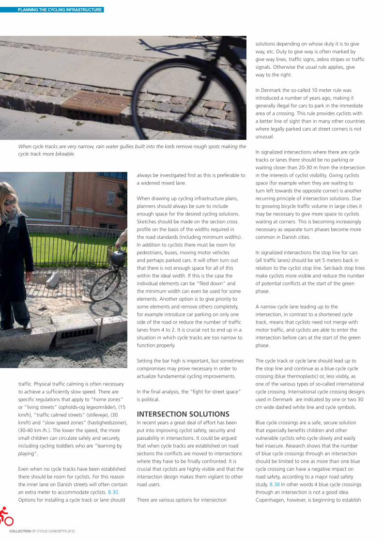
PLANNING THE CYCLING INFRASTRUCTURE
traffic. Physical traffic calming is often necessary
to achieve a sufficiently slow speed. There are
specific regulations that apply to “home zones”
or “living streets” (opholds-og legeområder), (15
km/h), “traffic calmed streets” (stilleveje), (30
km/h) and “slow speed zones” (hastighedszoner),
(30-40 km /h.). The lower the speed, the more
small children can circulate safely and securely,
including cycling toddlers who are “learning by
playing”.
Even when no cycle tracks have been established
there should be room for cyclists. For this reason
the inner lane on Danish streets will often contain
an extra meter to accommodate cyclists. 8.30.
Options for installing a cycle track or lane should
When cycle tracks are very narrow, rain water gullies built into the kerb remove rough spots making the
cycle track more bikeable.
always be investigated first as this is preferable to
a widened mixed lane.
When drawing up cycling infrastructure plans,
planners should always be sure to include
enough space for the desired cycling solutions.
Sketches should be made on the section cross
profile on the basis of the widths required in
the road standards (including minimum widths).
In addition to cyclists there must be room for
pedestrians, buses, moving motor vehicles
and perhaps parked cars. It will often turn out
that there is not enough space for all of this
within the ideal width. If this is the case the
individual elements can be “filed down” and
the minimum width can even be used for some
elements. Another option is to give priority to
some elements and remove others completely,
for example introduce car parking on only one
side of the road or reduce the number of traffic
lanes from 4 to 2. It is crucial not to end up in a
situation in which cycle tracks are too narrow to
function properly.
Setting the bar high is important, but sometimes
compromises may prove necessary in order to
actualize fundamental cycling improvements.
In the final analysis, the “fight for street space”
is political.
INTERSECTION SOLUTIONSIn recent years a great deal of effort has been
put into improving cyclist safety, security and
passability in intersections. It could be argued
that when cycle tracks are established on road
sections the conflicts are moved to intersections
where they have to be finally confronted. It is
crucial that cyclists are highly visible and that the
intersection design makes them vigilant to other
road users.
There are various options for intersection
solutions depending on whose duty it is to give
way, etc. Duty to give way is often marked by
give way lines, traffic signs, zebra stripes or traffic
signals. Otherwise the usual rule applies, give
way to the right.
In Denmark the so-called 10 meter rule was
introduced a number of years ago, making it
generally illegal for cars to park in the immediate
area of a crossing. This rule provides cyclists with
a better line of sight than in many other countries
where legally parked cars at street corners is not
unusual.
In signalized intersections where there are cycle
tracks or lanes there should be no parking or
waiting closer than 20-30 m from the intersection
in the interests of cyclist visibility. Giving cyclists
space (for example when they are waiting to
turn left towards the opposite corner) is another
recurring principle of intersection solutions. Due
to growing bicycle traffic volume in large cities it
may be necessary to give more space to cyclists
waiting at corners. This is becoming increasingly
necessary as separate turn phases become more
common in Danish cities.
In signalized intersections the stop line for cars
(all traffic lanes) should be set 5 meters back in
relation to the cyclist stop line. Set-back stop lines
make cyclists more visible and reduce the number
of potential conflicts at the start of the green
phase.
A narrow cycle lane leading up to the
intersection, in contrast to a shortened cycle
track, means that cyclists need not merge with
motor traffic, and cyclists are able to enter the
intersection before cars at the start of the green
phase.
The cycle track or cycle lane should lead up to
the stop line and continue as a blue cycle cycle
crossing (blue thermoplastic) or, less visibly, as
one of the various types of so-called international
cycle crossing. International cycle crossing designs
used in Denmark are indicated by one or two 30
cm wide dashed white line and cycle symbols.
Blue cycle crossings are a safe, secure solution
that especially benefits children and other
vulnerable cyclists who cycle slowly and easily
feel insecure. Research shows that the number
of blue cycle crossings through an intersection
should be limited to one as more than one blue
cycle crossing can have a negative impact on
road safety, according to a major road safety
study. 8.38 In other words 4 blue cycle crossings
through an intersection is not a good idea.
Copenhagen, however, is beginning to establish

PLANNING THE CYCLING INFRASTRUCTURE
Blue cycle crossing, and international cycle crossing of the “one quarter type” indicated by a white
dashed line on the cyclists’ left. Enghavevej/Vesterbrogade, Copenhagen.
Internal road safety considerations in the City of Copenhagen tend toward using up to 2 blue cycle
crossings per intersection, based on a concrete assessment of the individual situation. Tagensvej.
When the cycle track incline means that cyclists ride faster than normal the cycle track is shortened in
the interests of cyclist safety. Knippelsbro bridge, Copenhagen.
up to two blue cycle crossings in intersections.
This is done only after giving close consideration
to road safety issues and careful prioritization of
which directions are most in need of blue cycle
crossings.
If the road goes downhill cyclists ride faster
than usual. This is one of the few cases where
the cycle track should be shortened so that
cyclists and motorists merge. If the cycle track is
shortened the right-turn lane must be at least 4
m wide to make merging possible.
Cyclists experience shortened cycle tracks as
insecure. Shortened cycle tracks were formerly in
common use since it’s a safe design and leaves
space for turning cars. The idea that the solution
is acceptable in certain situations cannot be
dismissed, but it is not a solution that makes
cyclists feel more secure or that will attract more
cyclists. One might consider continuing some of
the shortened cycle tracks that are to be found in
Danish cities as a narrow cycle lane leading into
the intersection combined with set-back stop
lines for cars.
Bike boxes are established in many cities abroad
but do not fit in well with the mandatory wide
Danish left turn. Lorry drivers cannot necessarily
see a cyclist waiting in a bike box. One might
consider a pilot project testing bike boxes as a
continuation of the bicycle lane since possibly
a cluster of cyclists can be moved through the
intersection faster than a long queue of cyclists,
thereby enabling drivers to turn right before the
next red.
It should also be considered whether provisions
can be made for cyclists to turn right on red,
possibly by means of a “shunt”. Experience from
Odense shows that this results in a high level of
cyclist satisfaction and no change in road safety
levels. 8.16 It must be determined in advance
whether there is enough space for the shunt,
and appropriate pedestrian facilities must be
provided.
The local authorities in Copenhagen are at
the time of writing discussing with the police
whether signage can be established in selected
intersections allowing cyclists to turn right on
red. At T-intersections it is already allowed to
“go straight on red” through the top of the T
since pedestrians can cross the track at the non-
regulated pedestrian crossings where cyclists have
the give-way duty.
On small side roads in urban areas a continuous
cycle track allowing cyclists to cross the pavement
without dismounting is a safe, secure and
67

PLANNING THE CYCLING INFRASTRUCTURE
comfortable solution for cyclists.
On large urban side roads and on highways
the cycle track should be dropped. Cycle tracks
and lanes may be continued as a cycle crossing
marked through the intersection. Blue marking
can be used if the marking needs to be especially
clear.
Small roundabouts and mini-roundabouts can
occasionally serve as traffic calming measures.
Cars leaving the roundabout have to give way
to cyclists continuing through the roundabout.
Drivers may perceive this as going straight,
which is dangerous and insecure for cyclists
continuing left in the roundabout. When there
are many cyclists the motor traffic capacity of a
Barriers are replaced by speed humps in Aarhus.
which are common in rural areas, requires special
consideration. Solutions at road level or two-way
tracks combined with tunnels are both options.
A set-back, give-way cycle track may enhance
safety. On one-way cycle tracks in rural areas it
has been found that set- back, give-way crossings
have produced favourable results.
Cycle bridges and tunnels are used when there
is a large volume of motor traffic and/or fast
moving motor traffic. Ramps have to live up to
the incline regulations prescribed by the road
standards and are thus quite long. This applies
especially to overpass elevation which has to be
fairly high to allow for sufficient headroom for
the motor traffic below. Access to tunnels should
be wide and it’s important that the tunnel is
perceived as “open”. Good lighting and perhaps
openings to the sky are important elements.
Malmö and Odense have put a great deal of
effort into designing secure tunnels.
When roads are fairly large, traffic islands in
middle of the crossing between the road and
a segregated cycle track are useful in making it
easier for cyclists to cross the road. If there is a
great deal of motor traffic it may be necessary to
signalize the crossing.
It is often useful to regulate crossings between
cycle paths by the duty to give way to the right.
Give-way regulations are particularly indicated
when the line of sight is poor, combined with
other measures if possible. All road users must
understand well in advance who has to give way.
Placing barriers at the cycle path entrance and
exit should be used only as a last resort, in fact it
is barely acceptable, partly because cargo bikes
can rarely pass through barriers. If barriers are
used, the distance between them must be wide
enough to make it possible to cycle through
slowly. Rumble strips or speed humps can be
necessary, especially if there is a considerable
amount of scooter traffic. The road standard line
of sight requirements are mandatory.
In intersections as on road sections pilot projects
Traffic calmed roundabout with tarmacked cycle lane all the way around. Halmtorvet, Copenhagen.
Åbuen. A bridge was the only feasible solution here as the alternative was a traffic signal which would
significantly reduce motor vehicle capacity on this approach road. An underpass was not an option
either since a stream runs under the road. The bridge links the municipalities of Copenhagen and
Frederiksberg.
small roundabout is lower than in a signalized
intersection.
Bicycle traffic management in large roundabouts,

PLANNING THE CYCLING INFRASTRUCTURE
ROAD SAFETYAUDIT CHECKLIST EDITED WITH A FOCUS ON CYCLING FACILITIES 8.39
• Hastheplacementofleft-turningcyclistsinintersectionsbeentakenintoaccount?• Doesthesignaltimingsufficientlytakecyclistsintoaccount(intersectionclearancetimesin
head winds and up-hill, and whether the cyclist can cross the intersection in one stage)?• Isthereaneedforspecialcyclephases(max.waitingtimes;pre-greenforrightturningcars
should generally be avoided; can cyclists wholly or in part be exempt from signalization, for example on right turns)?
• Istheplacementofdetectorswhenthecyclistapproachestheintersectionsuitableandsuf-ficient?
• Iscoordinationwithothernearbysignalssuitable?• Istheselectedtypeofintersectionsuitableandhave(blue)cyclecrossingsbeenconsidered
for road level intersections?• Istheroaduser’sroutethroughthecrossingclearinalldirectionsandforallmanoeuvers?• Aretrafficislandswideenoughforwaitingcyclists?• Aretheregullygratesorothersurfaceobstaclesonthecycleroute?• Willdriversofmotorvehiclesrealizethattheyarecrossingatwo-waycycletrack?• Isthereaneedforbarriersorspeedhumpsonthetracktomakegive-wayrulesclear?(bar-
riers, etc. may pose a collision danger for cyclists).• Aretheresafewaitingandboardinganddeboardingareasforbuspassengers?Arethe
waiting areas wide enough? They should be min. 1.5 m wide and clearly marked as not belonging to the cycle track.
• Isthereaneedforspecialmeasurestopointoutgive-wayrulesbetweenpassengersandcyclists, such as raised areas, special surface colours, rumble strips?
• Istheroadsurfaceinsatisfactoryconditionatcrossingsandontheadjacentcyclepaths?• Aretherespecialrequirementswhenmopedsareallowedonpaths,suchastrafficcalming
for mopeds? • Isthereaneedforextrasegregationbetweenthecycletrackandparkedcarswhenopen-
ing car doors?• Two-waycycletracksalongroadsshouldbeavoidediftherearemorethanveryfewside
roads/private driveways.
can be carried out reducing the width of the
individual elements or giving priority to one of
the elements. Allowing the cycle track, or at least
a narrow cycle lane, to lead all the way up to
the intersection, is desirable. Parked cars do not
take up space in the intersection, but right-turn
and left-turn lanes for motor traffic are highly
space demanding. One might consider dropping
a left-turn lane for motor traffic in order to make
room for something else, but of course the safety
impact must first be assessed.
When a concrete design proposal, of an
intersection for example, is on the table the next
step is to cycle through it mentally, preferably
in dialogue with a colleague, to assess whether
it will actually work for cyclists and other road
users.
ROAD SAFETY AUDITS VS. SERVICE LEVELSCycle projects will often be assessed in a
road safety audit 8.39 to ensure an impartial
assessment of the project’s anticipated safety
impact and to point out and study possible safety
issues. The work is done by specially educated
road safety auditors.
Road safety audits can be carried out at different
times throughout the planning process, from the
sketch project to the completed construction.
Some administrations choose to perform an audit
when the complete project plan has been drawn
up, whereas others may benefit more from an
assessment of a sketch project.
Ideally a project should promote cycling and be
safe, secure and passable at the same time. Road
safety audits focus solely on safety and do not
include any other factors that may influence the
design of cyclist circulation areas. It is not easy to
oppose a road safety audit recommendation, but
sometimes it can be the right thing to do, based
on overall considerations.
Hitherto, a suitable instrument for evaluating
security and passability has not been available.
As a supplement to road safety audits the road
standards’ new instruments for measuring
perceived service levels can calculate the level of
cyclist satisfaction for the individual road section
and intersection as well as for a larger network.
8.40. The instruments are based on a relatively
small amount of data concerning road design,
surroundings, and traffic. The primary cyclist
parameter, “satisfaction”, is closely linked to
security and passability. Service level instruments
can be used to identify the least satisfactory
intersections and road sections or to calculate
the impact of a given renovation on cyclist
satisfaction. The instruments can also be used
to optimize a renovation’s service level so as to
maximize road user satisfaction for the money.
MATERIALS, CONSTRUCTION AND AESTHETICSIf city streets are not merely to serve as traffic
arteries, but should also be beautiful and
attractive places for citizens to enjoy, the traffic
situation must be considered as a whole;
architects, engineers and landscape gardeners
must collaborate and gain insight into each
other’s fields. 8.41
Road surfaces are often up for discussion when
squares and other urban spaces are being
renovated. Design considerations may require a
uniform road surface whereas traffic engineers
tend to prefer varying surfaces indicating the
different traffic functions.
As a general rule asphalt is the most suitable
material for cycle track surfaces and is therefore
standard on Danish cycle tracks. Asphalt offers
Cycle lane, “enhanced” by cycle track installation on some sections. Pile Allé, Frederiksberg
69

PLANNING THE CYCLING INFRASTRUCTURE
a smooth, even surface and can be repaired as a
matter of routine. Powdered asphalt is produced
by mixing hot soft bitumen and crushed stones.
Powdered asphalt is well suited as the wearing
course for cycle tracks and normally has a
technical service life of 15-20 years, although it
may only remain acceptably even for 10 years.
Powedered asphalt’s excellent surface makes
it easy and pleasant for cycling, provides good
friction, and is available in many colours. Asphalt
should always be applied mechanically.
Gravel should not be used on cycle paths
although it may be used when the path doesn’t
need to be bikeable when there’s snow.
Recreational paths can be laid out with stone
dust which is well suited for cycling. A newer
type of gravel is “castle gravel” (and similar
terms) which provides a good surface for cycling.
Another advantage to this material is that it can
be laid at one go and also serves as the bearing
layer. Gravel surfaces cannot be swept or snow
cleared.
A road surface treatment is the cheapest fixed
surface. It bears a certain similarity to gravel and
may be a compromise option in natural areas
where there is a reluctance to use asphalt.
Surface quality is perceived differently by
each road user group. Cyclists’ field of vision
is naturally directed downwards and cyclists’
experience of street space is largely dependent on
surface quality.
Granite paving slabs and paving stones in general
can be used to indicate a pedestrian area. Paving
slabs over a large area tend to become uneven
with time. Paving stones and sett paving make
for a more uneven surface than asphalt but are
becoming somewhat more acceptable if they
are sawn (for evenness) and jet burnt (for better
friction). Slabs, paving stones, and the like should
not be used on cycle tracks and only to a very
”ENHANCED” CYCLE LANES AND THE LIKEIt is not always possible to establish the best solution, which in a Danish context is the classical Danish cycle track. The local authorities address this in different ways:
• FREDERIKSBERGhasinstalledanumberofcyclelanesboostedbyindividualmeasuressuch as traffic islands and the like.
• COPENHAGENusesthe“enhancedcyclelane”modelwhencycleinfrastructurefundingis limited. Cycle lanes are installed as this is a less costly procedure provided the kerb need not be moved. The cycle lanes are enhanced in certain areas by establishing a traditional cycle track (for example at bus stops, where they are compulsory).
• AALBORGhasestablishedalongcyclelanesectiononHadsundvej.Whensideroadsare closely spaced proper cycle track crossings replace the cycle lanes.
limited extent at squares, etc., primarily in the
shape of bands to focus attention, for example.
Cycling areas in pedestrianized zones can be
segregated from the pedestrian areas by a 3
cm high border. Cyclists must be able to cross
squares, and other spaces legally, otherwise they
will often be forced to make a long detour.
In more regulated traffic areas the choice of
surface and colour can clearly indicate the area
designated for each road user. Surface and colour
should guide road users to the appropriate area
and clearly indicate the give-way regulations. In
areas where road users are left to themselves
to negotiate their way through an area, it is
important to try to predict cyclist behavior in
advance.
A coloured surface application that clearly
stands out from the surroundings can highlight
a circulation area and help render give-way
regulations visible. Examples of this are coloured
asphalt or blue thermoplastic cycle crossings.
When special colour materials are used, e.g. the
red asphalt used for cycle tracks in Nakskov, it is
important that sufficient material is available for
repairs.
Cycle track surfaces should be even and provide
sufficient friction in the interests of comfort and
safety. The track’s construction should be able
to withstand pressure from motor vehicles using
the track such as maintenance vehicles or illegally
parked lorries. The road bed can usefully continue
under the cycle track along roads with no verge.
On segregated cycle tracks the base, etc. should
be constructed so that maintenance materials do
not cause cracking along the sides of the track.
CONSTRUCTION PROJECTSIt is crucial that plans for the cycle network are
included in investment decisions regarding traffic
and other physical planning, for operations as
well as construction. Prompt action is sometimes
required, which means that it is a good idea to
have prepared a priced overview of ideas or a
sketch project for key cycle network elements.
Visionary, long-term thinking makes it possible
to promote safe, secure bicycle traffic within
reasonable budgets if this is coordinated with
other on-going projects.
When other considerations than cycling are the
starting point for new construction or renovation,
a cycle audit or revision defined by cycling
parameters ensures that elements of the cycling
infrastructure are implemented as an integral part
The quoted contractor prices are at 2011 levels and are used to estimate and calculate cycling
infrastructure prices. 20-80% should be added to cover preliminary studies, projecting, inspection,
administration, and unforeseeable expenses.
Metropolis Towns Countryside (many intersections) Two-way cycle track DKK 2.5 – 6.0 mill. 1.0 – 2.5 mill.(2.5 – 3.0 m wide) per km per km One-way cycle track DKK 5.0 -15.0 mill. DKK 3.5-8.0 mill. DKK 2.5-5.0 mill.(2x2.22 m) incl. drainage per km per km per km
Cycle lanes (2x1.5 m wide) DKK 0.5-10.0 mill. 0.25-5.0 mill. DKK 1.5-3.0 mill.The low price only per km per km per kmcovers surface marking
Recreational stone dust DKK 0.5-2.5 mill. DKK 0.4-1.0 mill.paths (3.0) m wide per km per km
Extensive traffic calming DKK 5.0 – 20.0 million per km (chicanes, humps, road narrowing, etc.)

PLANNING THE CYCLING INFRASTRUCTURE
of other projects.
As a rule most new construction and major
renovations are carried out individually, for
example one cycle track at a time. However, there
can be economic and communications benefits
to be gained by implementing many minor
improvements at once, such as traffic signs,
road markings, etc. The majority of the set-back
stop lines for cars at signalized intersections in
Copenhagen were implemented at the same
time.
Finally, there are “special option projects”. An
area may be physically reserved for the cycling
infrastructure pending a future allocation. If
the project is temporarily established to a low
standard, supplementary funding may later
permit an upgrade to a higher standard. One
example of a special option is when cycle lanes
are installed along roads where the aim is to
establish cycle tracks at a later date. Another,
in rural areas, is to reserve an area on one side
of the road for a two-way cycle track. Urban
development areas also contain many options for
long-term projects.
When construction projects are sketch planned,
the cross-profile and the intersection design,
for example, should be determined, and a price
estimate should be drawn up. When a project has
been approved on the basis of an idea or sketch
project and a price estimate, a detailed project
should be drawn up including a more precise
price estimate. The local authority will often
hire a consultant to plan the actual construction
project. It is crucial to describe the project in
detail from the outset and clearly define the task
and the level of ambition.
When a construction project has been through
the political process and funds have been
allocated there will usually be a round of
competitive bidding in order to implement the
project as cheaply as possible. Open bidding
typically means a lower price than closed bidding.
In open bidding it is vital to ensure the firm’s
financial solidity.
Operations should be priced too. A city street
with cycle tracks will often be more expensive
in terms of operational economics than a street
without cycle tracks, partly because there are a
number of rain water gullies. There should be
a distinction between the cost of maintaining
asphalt, etc., and the maintenance cost of
cleaning/ snow clearance (which requires
narrower machines). Major expenses should be
anticipated for both categories when establishing
cycle tracks.
It is often impossible to get extra funding for
operations, but this is a must in the long run and
when there are many cycle projects if general
maintenance is not to be adversely affected.
ESTIMATES AND PRICE CALCULATIONSThe price of implementing a major cycling
infrastructure plan can be roughly estimated
on the basis of local, experience-based unit
prices (e.g. cycle track per km incl. intersection
renovation). For example, the unit price for a
cycle track on one side of the road in a given
area in the countryside may be DKK 5 million /km
while elsewhere it may amount to DKK 8 million.
An entire plan can cost as much as DKK 100
million. Exchange rates at the time of writing, €1
= DKK 7.4, £1 = DKK 8.9 and $1 = DKK 5.6.
The price estimate of concrete construction
projects can be calculated on the basis of
a sketch project. All prices in the table on
the opposite page are indicative contractor
quotations and do not include a number of other
expenses. For purposes of estimation 20-80%
should be added to the contractor quotation,
covering preliminary studies, planning, inspection,
administration and unforeseeable expenses. Add
to that area acquisitions.
The differential lies within the range of the
Danish Road Directorate’s appropriations
requirement for construction estimates. It
includes adjustment supplements of up to 80%
added to contractor expenses (physical estimate)
and unforeseen risk events of simple municipal
projects (contractor expenses plus 20%); it does
not include area acquisitions, and projection,
inspection and administration are severely
limited. In other words the 20% primarily covers
unforeseeable expenses.
A good rule of thumb for planning or sketch
planning purely municipal projects is to add a
total of 50% to contractor expenses.
20% covers preliminary studies, planning,
inspection and administration.
30% covers area acquisitions and unforeseeable
expenses. As the planning process progresses and
the questions that have been in doubt are cleared
up, unforeseeable expenses can be written off
and usually end up as 10-15% at the start of the
contract.
Contractor expenses may have risen in the
meantime, however, and there may also be
increased expenses for preliminary studies,
planning, administration and area acquisitions.
Prices depend on the amount or scope of the
project to be carried out, and there are regional
differences (up to 20-25% between the capital
area and Northern and Western Jutland). This is
reflected in the price interval.
When there is competitive bidding on a project,
calculations are much more detailed, including
price per square meter, price per running meter,
etc. The price quote is partly dependent on the
amount of new construction that has to be done.
(Small projects are thus relatively more expensive).
The current state of the construction industry also
has a significant impact on the price, and price
is further dependent on whether contractors are
hungry for work.
71


9Contents
Appropriate design 74Mixed traffic 75Cycle lanes 77Shoulder and kerb lanes 80One-way cycle tracks 82Two-way cycle paths 85Give-way regulated intersections 90Signalized intersections 93Roundabouts 99Pedestrianized areas, squares
and other urban spaces 101Bridges, tunnels, hills, and stairs 102One-way streets 104Managing motor traffic 105
For cyclists, a well-designed circulation area is easily passable,
secure and safe. In order to choose the right design it is
essential to first identify the problems that need to be
addressed and prevented, and to make sure that the proposed
solution does not create new problems.
A good design should be functional and easily understandable.
For safety reasons the traffic system must be designed so as to
minimize the possibility of making mistakes, and if accidents
do occur, to minimize the consequences of such mistakes
in order to prevent serious casualties. What road users do
naturally must be safe.
DESIGNING THE CYCLING INFRASTRUCTURE

DESIGNING THE CYCLING INFRASTRUCTURE
APPROPRIATE DESIGNAs a basic principle, road design should be
self-explanatory. Everyone should have a clear
perception of his or her natural place in traffic at
all times. The road’s design should be determined
by road user speeds and traffic composition; road
surface, signage and road markings are not the
same in a pedestrianized zone as on a country
highway. These basic principles combined with
the fact that roads and paths have a diversity of
functions means that designing circulation areas
appropriately is an extremely complex process.
Segregated pathsSegregated paths are established for the sole
use of cyclists and walkers. Cyclists do not like
hills or stops so segregated paths should be
designed without too many inclines and stops.
Cyclist passability is increased in lightly trafficked
areas when the cycle path continues through the
intersection and cars have to give way to cyclists.
Cars have to give way to a segregated commuter
path
Shopping streetsAdequate space for pedestrians is the key
element on shopping streets. If walkers cannot
move securely and without hindrances, there
won’t be a great deal of shopping. On shopping
streets where pedestrians can cross the road
without difficulty car speeds should be 30 km /h
maximum. Cycle tracks are seldom necessary in
such cases. When there are many motor vehicles,
the street becomes divided into two separate
shopping areas for all practical purposes. A
compromise solution in shopping streets will
often be possible, involving cycle tracks, traffic
calming, and integration of crossing pedestrians.
Residential roadsSecurity is the key concept here, and low speeds
are a must. Many issues in residential areas can
be resolved without having to resort to cycle
tracks if planners have a thorough knowledge of
traffic calming measures and car parking facilities.
Primary roadsThe city as traffic machine is determined by its
primary roads, i.e. the major traffic arteries whose
prime function is to facilitate the smooth flow of
motor and bicycle traffic. However this is where
approx. 70-80% of urban traffic accidents occur,
this is where major conflicts between safety,
the environment and passabilty arise, and this is
where details are crucial. A thorough knowledge
of road markings, intersection design, etc. is
needed to address such issues appropriately. Bicycle traffic boosts retail sales.
Speeds here are naturally low.
Cycle tracks are often an essential part of the
solution.
HighwaysIn high speed areas it is crucial to segregate
cyclists from motor traffic. On such roads the
optimal cycling solution is to establish cycle tracks
and shoulder lanes. Safe cycling facilities are a
prerequisite for increasing bicycle traffic over
greater distances.
Segregation of road and cycle track.

DESIGNING THE CYCLING INFRASTRUCTURE
MIXED TRAFFICCyclists often feel insecure in mixed traffic,
especially when there are large numbers of cars
and lorries traveling at high speeds. Safety levels
partly depend on speed levels, parking facilities
and road width. Consequently, bicycles and cars
should only be mixed on road sections with little
motor traffic and suitably slow speeds.
It’s a good idea to reduce speed here, by a speed
hump, for example.
6 out of 10 cyclists experience conflict situations
especially in mixed traffic. On roads with cycle
tracks only one third of cyclists experience conflict
situations. In mixed traffic the behavior of other
road users, parked cars, and intersections are
the situations in which cyclists most commonly
experience conflicts. On roads with cycle tracks
the main problem areas for cyclists are at
intersections and side streets. 9.1
Cross profileThe width of the carriageway has little impact on
the cyclist’s experience of the road in urban areas,
according to an American study. 9.2 Danish
studies support this; urban road width has little
or no impact on cyclist safety whereas cyclist risk
in open country drops as lane width increases.
9.3, 9.4
When the road width in urban areas is less than
6.5 m, the motor traffic speed limit should be
30-40 km /h maximum. If motor traffic speeds
are higher, the traffic lanes should be wider.
At speeds higher than 40 km /h traffic calming
measures or segregated facilities should be
considered.
On roads where motor vehicles pass cyclists
at 30-50 km/h while oncoming traffic passes
by in the other direction, the choice between
segregating cyclists from cars or allowing
cyclists and cars to mix on a widened traffic lane
depends on traffic volumes, parking conditions,
space, etc. The presence of children and elderly
cyclists argues in favour of a segregated cycle
track.
Parking Cyclists often perceive parked cars as a problem
in mixed traffic, and the accident risk for cyclists
in mixed traffic is increased even when car- and
bus bays have been established.
Parking manoeuvers and opening car doors can
injure passing cyclists. Scattered parking along
the road may make cyclists less visible to other
road users. Parking should either occur in a
parking lane or else speeds should be slowed to
approx. 30 km /h.
When parking is angled or perpendicular car
speeds should only be 10-20 km/h. This is not an
appropriate solution, however, when there are
many cyclists and traffic is mixed.
Parking restrictions result in an approx. 20-25%
drop in the casualty rate even though parking
restrictions may mean that cars drive faster.
However, the traffic pattern may be modified
by parking restrictions, which may cause more
accidents.
With one-side parking the accident risk is higher
than on both sides since one-side parking leads
to dangerous parking manoeuvers and limits the
cyclist’s line of vision. Sometimes, however, it may
be necessary to limit parking to one side so as to
create space for a cycle track.
Bus stopsIn mixed traffic, bus bays prevent confrontation
accidents between cyclists and cars. Cyclists don’t
have to look back and check for busses and cars;
in fact, cyclists rarely look back.
In streets with many parked cars, the parking
and waiting prohibition at bus stops can
be supplemented by a pedestrian refuge.
Cyclists often find kerb extensions at bus stops
inconvenient in mixed traffic.
It is a good idea to segregate motor vehicles and cyclists when traffic volumes are high and there are
many parked vehicles.
Traffic calming measuresPhysical traffic calming is often necessary in
mixed traffic to improve road safety and make
cyclists and other vulnerable road users feel
secure.
At road narrowings or speed humps it is
important that there is a designated, independent
cycling area such as a cycle gap, cycle track or
cycle lane. Cyclists feel more secure passing
speed humps and road narrowings in a cycle gap
than without a cycle shunt. 9.8, 9.9
10-15 m should be kept clear of parked vehicles
before and after the cycle gap, by means of
islands or 30- 40 m long cycle lanes. The cycle
gap should be wide enough for a legal bicycle,
minimum 1.4 m.
When an area is traffic calmed and speeds are
reduced, this results in increased pedestrian and
bicycle traffic, particularly among children and
the elderly. 9.10
Kerb extensions and shrubberies keep parking under
control.
75

DESIGNING THE CYCLING INFRASTRUCTURE
Parking lanes prevent slaloming.
An English accident study of 72 slow-speed areas
shows a 60% drop in the number of accidents.
The drop was highest for motor vehicles and
pedestrians and lowest for cyclists. The average
speed of motor vehicles was reduced from 40
A good cycle gap is 1.4 m wide. If the gap is too
narrow cyclists use the carriageway and if it’s too
wide, cars may use the gap.
Speed humps are a particularly effective traffic calming measure. The hump can be installed over the
entire width of the road without a cycle gap, which in this case is best for cyclists and cheaper to install.
To prevent squeezing, cycle tracks or cycle lanes
can be established by a median divider.
Cycle gaps, manhole covers, debris, and parked
vehicles are an unfortunate combination.
km/h before speed reduction to 26 km/h after.
Speed reduction measures do not have nearly the
same beneficial effect on cyclists as on other road
users, partly because most cycling accidents take
place at intersections. 9.11 In Denmark the total
safety effect is typically 30%, vs. approx.10% for
cyclists. 9.12

DESIGNING THE CYCLING INFRASTRUCTURE
CYCLE LANESCycle lanes are primarily used in urban areas.
Cycle lanes are a good alternative to cycle tracks
when space and funding make it difficult to
install cycle tracks. Cycle lanes may also serve as
a transition phase before establishing cycle tracks
with kerbs.
Cycle lanes are more common abroad and are
used to mark the cycling area, using what funds
are available, rather than establish what Danes
would call a “proper” cycle track.
Wide cycle lanes result in significant accident
reduction on road sections, but may cause safety
issues at intersections. Three different studies
show a rise of 10% in the number of cycling
accidents when cycle lanes are installed in
urban areas. The total increase in the number of
accidents covers a major drop on road sections
and a major increase at intersections. 9.13, 9.14,
9.15 A more recent study in Copenhagen shows
a 5% accident increase on road sections and
intersections, and a 15% increase in personal
injuries. During the same period, bicycle/moped
traffic increased by 5-7% while motor traffic
remained unchanged.
Studies indicate that accidents on road sections
involving parked cars are not addressed by
installing cycle lanes. Accidents in which cyclists
are hit by cars from behind continue to occur due
to narrow cycle lanes. 9.17, 9.18
Left-turning cars are a major issue on roads
with cycle lanes; the most serious intersection
accidents take place when cyclists turn left. Mini-
roundabouts, clearly designated cycle tracks, and
motor traffic speed limit reduction are measures
which seem to prevent some intersection
accidents on roads with cycle lanes.
Danish bicycle counts show that installing a cycle
lane on a single road has a negligeable effect,
a mere 0.5% increase. 9.19, 9.20 If, however,
an entire network of cycle lanes is established in
an urban area without cycle tracks the number
of cyclists will increase. This is also the case in
New York where the cycling infrastructure is
primarily based on cycle lanes. Cyclists feel more
secure and perceive the cycle lane as a genuine
improvement of the service level compared to
being forced to bike in mixed traffic. 9.21
Installing cycle lanesA cycle lane is marked on the carriageway by
a 0.3 m wide, solid white line, and painted
cycle symbols placed at intervals of approx.
100 m, and after each break in the solid white
line (after intersections). Painted cycle symbols
Cycle lanes are often used to park unlawfully.
may be replaced by a bicycle track road sign at
intersections. Cycle lanes should be established
on each side of the road so that cycling is one-
way. Cars may not park on the cycle lane, but
may use the carriageway outside the cycle lane,
unless parking is prohibited.
Cycle lanes combined with speed humps are reasonably safe and secure.
77

DESIGNING THE CYCLING INFRASTRUCTURE
Cross profileCycle lanes should be at least 1.5 m wide
including a 0.3 m solid white line. When the
lane is narrower than 1.5 m, overtaking cyclists
often use the carriageway. A more acceptable
width for passing is 1.7 m. The white line itself
should be solid, but may be profiled to increase
driver vigilance. Thermoplastic is an excellent road
marking material due to good visibility, durability,
friction and cost. 9.23
Cycle lane surfaces can be installed using contrast
colours, such as red or brown, to emphasize the
cycle route’s continuity. The coloured surface can
be continued through intersections, marked as a
cycle path with a wide, dashed line and the cycle
symbol. The effect of coloured surface treatments
is not known, however.
Coloured surfaces mean cyclists experience
fewer disturbances from motor vehicles; cyclists’
feel positively about coloured surfaces. 9.24 A
coloured surface is important when cycle lanes
are wider than 1.8 m as the cycle lane can
otherwise be mistaken for a carriageway or a
parking lane. The safety effect of coloured cycle
lanes is not documented. The coloured surface
should be regularly maintained to prevent it from
becoming unsightly and unattractive.
Several studies indicate that narrow cycle lanes
are unsuitable on mixed traffic road sections from
a safety point of view. 9.25 When the width of
the cycle lane is increased, the distance between
the cyclist and the car increases, and the number
of cyclists briefly using the car lanes drops.
ParkingParking should be prohibited on roads with cycle
lanes when there is a large turnover of parked
cars, for example on shopping streets or streets
with blocks of flats. Parking should always be
designed so that the spaces cannot be used for
other purposes than parking, i.e. cannot be used
as an extra lane at peak hours for example.
When the parking area is placed between the
cycle lane and the carriageway, a 2 – 2.5 m wide
cycle lane enables cyclists to overtake safely and
makes it easier for them to dodge open car doors
and pedestrians. A 1.0 m wide island or painted
barrier should be established between the cycle
lane and the parking lane if possible. Otherwise
it’s a good idea to place islands along the outer
edge of the cycle lane. If the interval between the
islands is small, the cycle lane can be considered
a cycle track. Signage or cycle symbols should be
used to make the area’s traffic function clear.
Parking occurs even when it’s prohibited.
Parking on the cycle lane can put cyclists in a dangerous position.
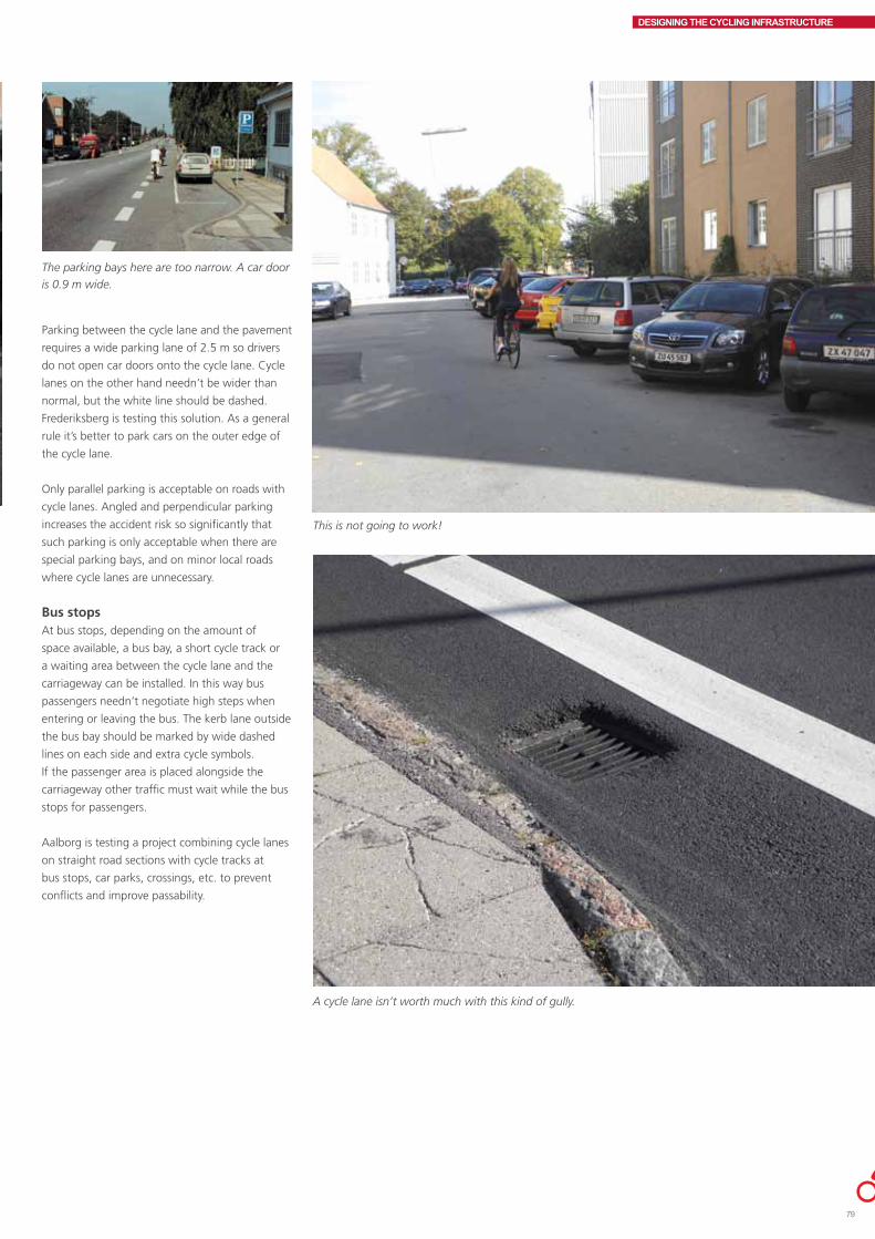
DESIGNING THE CYCLING INFRASTRUCTURE
Parking between the cycle lane and the pavement
requires a wide parking lane of 2.5 m so drivers
do not open car doors onto the cycle lane. Cycle
lanes on the other hand needn’t be wider than
normal, but the white line should be dashed.
Frederiksberg is testing this solution. As a general
rule it’s better to park cars on the outer edge of
the cycle lane.
Only parallel parking is acceptable on roads with
cycle lanes. Angled and perpendicular parking
increases the accident risk so significantly that
such parking is only acceptable when there are
special parking bays, and on minor local roads
where cycle lanes are unnecessary.
Bus stopsAt bus stops, depending on the amount of
space available, a bus bay, a short cycle track or
a waiting area between the cycle lane and the
carriageway can be installed. In this way bus
passengers needn’t negotiate high steps when
entering or leaving the bus. The kerb lane outside
the bus bay should be marked by wide dashed
lines on each side and extra cycle symbols.
If the passenger area is placed alongside the
carriageway other traffic must wait while the bus
stops for passengers.
Aalborg is testing a project combining cycle lanes
on straight road sections with cycle tracks at
bus stops, car parks, crossings, etc. to prevent
conflicts and improve passability.
The parking bays here are too narrow. A car door
is 0.9 m wide.
This is not going to work!
A cycle lane isn’t worth much with this kind of gully.
79

DESIGNING THE CYCLING INFRASTRUCTURE
SHOULDER AND KERB LANESThe Danish term "kantbaner" is in this
publication called shoulder lanes when used in
rural areas and kerb lanes when used in villages
and urban areas. They are often narrower than
ordinary cycle lanes and parking is permitted.
Shoulder lanes allow cyclists to bike more
comfortably and provide pedestrians with a more
solid foundation for walking. Furthermore, wide
shoulder lanes reduce carrying capacity issues
along the shoulder. 9.26 The wider the shoulder
lane, the better cyclists like it. Motor vehicles are
allowed to park on the shoulder lane. Narrow
shoulder lanes are not advisable as cyclists will
then use the carriageway, and drivers are not
prepared for this.
Shoulder lanes are established by changing the
road marking or physically expanding the traffic
lane. It is not recommended to expand the road
in order to install a shoulder lane; build a cycle
track instead. Road expansion costs the same as
a cycle track 9.28 but does not improve the level
of cyclist service or road safety to nearly the same
degree. On the other hand shoulder lanes do
increase motorist safety.
Lane marking may result in higher driving speeds.
9.29, 9.30 A number of the accidents that occur
on roads with shoulder lanes occur when cyclists
turn left. Shoulder and cycle lanes in themselves
do not generally reduce the number of left-turn
accidents. 9.31 One option is to establish a left-
turn lane on the right side of the road, which has
been done on several highways in Funen.
Cross profileThe guide-line width for kerb lanes in urban areas
is 1.5 m including a 0.3 m solid white line; if this
much space is available, a cycle lane is a better
alternative. In rural areas the guideline width for
a shoulder lane is 1.2 m including the line, but
should be no narrower than minimum 0.9 m. The
0.3 m wide white line should not be used unsless
the shoulder lane is min. 0.9 m wide, including
the line. Otherwise the line should only be 0.1 m
wide. The line should be solid.
Shoulder lane width has a crucial safety impact
in rural areas. Overtaking, cycling abreast, and
bicycle trailers don’t work on narrow shoulder
lanes. Motorists are startled when cyclists use the
carriageway even for a short period of time. On
roads with cycle tourists and roads with over 100
cyclists over a 24 hour period the shoulder lane
should be 1.5 m wide, but a proper cycle track or
cycle lane is preferable.
A Danish before-and-after study shows that the
number of accidents on country highways drops
as shoulder lane width increases. The drop is
greatest among vulnerable road users. 9.32
A cycle track with a verge is excellent on highways and on road sections without side roads
A shoulder lane is better than nothing.
A separated, shared-use path can work when
there are few cyclists and pedestrians.

DESIGNING THE CYCLING INFRASTRUCTURE
ParkingWide kerb lanes in urban areas particularly are
often subject to undesirable parking, which
means that waiting and parking restrictions and
prohibitions are advisable. In urban areas one
should always consider designing kerb lanes as
cycle lanes with painted cycle symbols. This is a
good way to prevent parking in the lane.
It is easier to implement kerb lanes than cycle
tracks and cycle lanes since kerb lanes place no
limits on parking. In villages with a long through-
road, parking is usually only possible on the
through road. Here kerb lanes combined with
traffic calming would be a sensible solution.
A cycle lane delineator like this one can work on roads with very few crossing pedestrians. It’s cheaper and doesn’t require drainage facilities.
The traditional Danish cycle track with a kerb provides excellent segregation between road user groups.
81
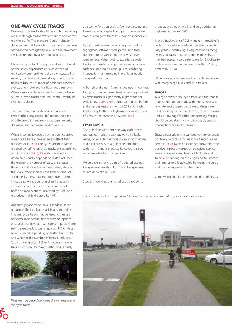
DESIGNING THE CYCLING INFRASTRUCTURE
ONE-WAY CYCLE TRACKSOne-way cycle tracks should be established along
roads with high motor traffic volumes and/or fast
moving traffic. The standard Danish solution is
designed so that the cycling area has its own level
between the carriageway level and the pavement
level, segregated by a kerb on each side.
Choice of cycle track category and width should
not be solely dependent on such criteria as
road safety and funding, but also on passability,
security, comfort and general enjoyment. Cycle
tracks reduce the number of accidents between
cyclists and motorized traffic on road sections.
When roads are dimensioned for speeds of over
50 km/h, cycle tracks help reduce the severity of
cycling accidents.
There are four main categories of one-way
cycle tracks along roads, defined on the basis
of differences in funding, space requirements,
drainage, and perceived level of service.
When it comes to cycle tracks in open country,
wide tracks have a greater safety effect than
narrow tracks. 9.33 The cyclist accident rate is
reduced by half when cycle tracks are established
on highways 9.34, 9,35 while the effect in
urban areas partly depends on traffic volumes:
the greater the number of cars, the greater
the impact. 9.37 A Copenhagen study showed
that cycle tracks increase the total number of
accidents by 10%, but that this covers a drop
in road section accidents and an increase in
intersection accidents. Furthermore, bicycle
traffic on road sections increased by 20% and
motorized traffic dropped by 10%.
Apparently cycle tracks have a modest, speed
reducing effect on both cyclists and motorists.
In cities, cycle tracks may be used to create a
narrower road profile, better crossing options,
etc., and thus have a broad safety impact. Motor
traffic speed reductions of approx. 1-5 km/h can
be anticipated depending on traffic lane width
and whether the number of lanes is reduced.
Cyclists ride approx. 1-2 km/h slower on cycle
tracks compared to mixed traffic. This is partly
due to the fact that cyclists feel more secure and
therefore reduce speed, and partly because the
smaller area gives them less room to manoeuver.
Cyclists prefer cycle tracks along the road (or
segregated, off-road cycle paths), and they
like them to be well lit and to have an even
road surface. When cyclists experience cycle
tracks negatively this is primarily due to uneven
surfaces, man-hole covers, gullies, confusing
intersections, a narrow path profile or poorly
designed bus stops.
A Danish and a non-Danish study each show that
for cyclists the perceived level of service provided
by cycle tracks is significantly higher than for
cycle lanes. 9.39, 9.40 Counts carried out before
and after the establishment of 25 km of cycle
track along 10 Danish highways showed a jump
of 37% in the number of cyclists. 9.41
Cross profileThe guideline width for one-way cycle tracks
segregated from the carriageway by a kerb,
verge, or lane delineator is 2.2 m in both urban
and rural areas with a guideline minimum
width of 1.7 m. In practice, however, it is not
recommended to go under 2 m.
When a cycle track is part of a shared-use path
the guideline width is 1.7 m and the guideline
minimum width is 1.5 m.
Studies show that the risk of cyclist accidents
Trees may be placed between the pavement and
the cycle track.
drops as cycle track width and verge width on
highways increases. 9.42
A cycle track width of 2.2 m makes it possible for
cyclists to overtake safely. Since cycling speeds
vary greatly, overtaking is very common among
cyclists. In cases of large numbers of cyclists it
may be necessary to create space for 3 cyclists to
cycle abreast, with a minimum width of 2.8 m,
preferably 3.0 m.
Wide cross profiles are worth considering in areas
with many cargo bikes and bike trailers.
VergesA verge between the cycle track and the road is
a good solution on roads with high speeds and
few intersections per km of road. Verges are
used primarily in the countryside, thereby making
kerbs or drainage facilities unnecessary. Verges
should be avoided in cities with closely spaced
intersections for safety reasons.
Grass verges along the carriageway are assessed
positively by cyclists for reasons of security and
comfort. 9.43 Danish experience shows that the
positive impact of verges on perceived service
levels occurs at speed levels of 60 km/h and up.
To prevent parking on the verge and to improve
drainage, a kerb is advisable between the verge
and the carriageway on city streets.
Verge width should be determined on the basis
The verge should be dropped well before the intersection to make cyclists more easily visible.

DESIGNING THE CYCLING INFRASTRUCTURE
of an overall assessment of desirable planting,
line of sight requirements, distance to solid
objects, and space. In the countryside 1.5 m
wide verges are normal whereas the figure varies
greatly in cities. In the countryside, solid objects
such as trees should not be placed on the verge
in the interests of driver safety on impact.
Verges with trees between the cycle track and the
carriageway should be at least 2 m wide in urban
areas. Trees between the pavement and the cycle
track may be planted on a 1 – 1.5 m wide verge.
A grass verge should be at least 0.6 m wide.
Crash barriers are normally established on the
outer edge of the carriageway since placing them
between the carriageway and the cycle track
requires a wider verge and also hampers and
raises the costs of mowing and snow clearance,
etc. Crash barriers on the verge prevent the verge
from functioning as a breakdown lane.
Divided tracksDivided tracks should be established when there
are few cyclists and pedestrians and little space is
available. However, the risk of accidents between
pedestrians and cyclists is greater when the
cycle track and pavement are on the same level,
only separated by road markings or different
road surfacing. Pedestrians will use the cycle
track more or less consciously if the areas are
not clearly designated. The narrower the cycle
track, the more likely that cyclists will bike on the
pavement. One alternative to a divided track is a
shared-space track where cyclists and pedestrians
freely share the area.
Cycle lane delineators
crossing pedestrians will often trip over it. Cycle
lane delineators are available in a wide variety of
shapes and materials including rubber, plastic,
concrete, asphalt and stone.
The delineator can be made visible by starting
as a traffic island in an intersection. Painted lines
and different road surfacing may be used to
clearly indicate the delineator on road sections.
At driveway entrances and exits, delineators
made of concrete or asphalt and barrier kerbs
should be provided with ramps. Other types of
delineator should be dropped entirely during the
interval.
Delineators may be damaged by the tire pressure
of lorries and buses. Drainage should take place
through min. 30 cm wide holes in the delineator.
The holes should be placed 1 m upstream from
the gully or at even intervals in non-sewered
areas. The impact of delineators on the number
of cyclists has not been established. 9.44
Delineators should not be used where many
pedestrians cross the road. Like kerbs, delineators
should be approx. 10 cm high to achieve good
segregation to the carriageway. Delineators
hamper winter maintenance as they are easily
damaged on impact.
Creative solutions for the future might involve
such measures as computer controlled lighting
sequences placed along cycle lane delineators.
Other physical segregationOther types of physical segregation are available,
such as bollards. However, it is important to set
Narrow, divided tracks can be a problem despite
their different surfaces.
The use of cycle lane delineators rather than
kerbs may be practicable for economic reasons.
The basic idea of a cycle lane delineator is to
achieve the benefits of a cycle track without
the drainage and construction costs of a kerb.
Cyclists generally feel more secure on tracks
with cycle lane delineators than in mixed traffic.
The reaction to a cycle lane delineator may be
negative if the delineator is not clearly visible;
them 30 cm back into the pedestrian area rather
than at the normal kerb line so that bicycle
baskets and pedals don’t hit the bollards.
Standard cycle tracksThe kerb height to the carriageway on road
sections should be 7 cm min. and 12 cm max.
Between the cycle track and the pavement, the
kerb height on road sections should be 5 cm min.
and 9 cm max.
The stated kerb heights offer a number of
benefits:
• Mostdriversofmotorvehiclesrefrainfrom
parking on cycle tracks.
• Motorvehiclesexitingandenteringbuilding
areas do so very slowly.
• Drainagecanfunctionperfectlywell.
• Cyclistsrarelybikeonthepavement;thanksto
the kerb pedestrians are aware that they are
leaving the pavement.
The given heights are based on a balanced
assessment of positive and negative factors such
as cyclist and pedestrian falling accidents and
mobility for the disabled.
Drainage facilities involve gullies on the
carriageway and the cycle track. If gullies on the
cycle track are to be avoided, the entire road bed
needs to be lowered. Gully grates on cycle tracks
do not seriously affect the section of the cycle
track that is used by cyclists since cyclists maintain
a safety margin to the kerb. However, depressions
around the grate pose a problem.
The area between pedestrians and cyclists is only segregated by bollards.
83

DESIGNING THE CYCLING INFRASTRUCTURE
When the transverse inclination is towards the
pavement, side-entry gullies may be established
that do not take up space on the cycle track
surface. This is particularly important if the cycle
track is very narrow.
Parked carsOn sections where there is a high demand for
waiting and parking, a longitudinal island can
be placed between the carriageway/parking lane
and the cycle track, with a recommended width
of 1.0 m. No kerb is necessary between the island
and the cycle track. The island and the cycle track
should have different surfaces. Alternatively, the
cycle track may be widened 1 m.
Cycle tracks result in a major drop in the number
of accidents between cyclists and parked cars. In
Denmark motor vehicles are not allowed to wait
or park on cycle tracks.
A pedestrian refuge between the cycle track and
the carriageway at pedestrian crossings improves
pedestrian safety on roads with parked cars
without a cycle track, and means that pedestrians
don’t have to wait on the cycle track. Another
option is to remove a number of car parking
spaces and establish a median refuge area in the
pedestrian crossing.
Bus stopsCycle tracks may increase the number of bicycle
accidents at bus stops if no safety measures are
taken. Accidents involving bus passengers leaving
the bus primarily occur when the waiting area
is narrow or lacking, while accidents involving
passengers entering the bus occur at bus stops
with wide waiting areas. At bus stops without
waiting areas, virtually all accidents are between
passengers leaving the bus and cyclists.
Studies of bus passengers and cyclists at bus
stops without a waiting area have shown that
zebra crossings significantly reduce cycling speeds
while the bus is waiting at the bus stop and
that the number of serious conflicts between
cyclists and bus passengers is reduced. Give-
way markings, rumble strips, and road surface
markings do not provide the same benefits as
zebra crossings. 9.46,9.47
However, according to the Danish road standards,
it is no longer legal to establish zebra crossings
on cycle tracks. Dreams of the future involve
intelligent lights on buses that project zebra
crossings onto the cycle track, or vehicle actuated
The pedestrian refuge between the cycle track and the carriageway enables pedestrians to cross the
street more safely.
Be careful with drainage construction. The hole
here around the grate is much too deep.
bus stops that can morph into waiting areas and
zebra crossings.
It’s a good idea to establish a section of standard
cycle track, i.e. with a kerb, between the cycle
track and the pavement at bus stops on roads
with lane delineated cycle tracks.
Bus stops before intersections should be placed
at least 20 m from the intersection. Otherwise
waiting buses will negatively affect cyclist safety
and make cyclists less visible to other road users.
Bus stops must never be placed directly before
the stop line at signalized intersections since
waiting cyclists block the way for passengers
Bus stops with a waiting area make it easier
for passengers to cross the cycle track without
coming into conflict with cyclists.
If there is no waiting area, a special surface at the
bus stop can indicate the crossing point.
The cycle track runs behind the waiting area.

DESIGNING THE CYCLING INFRASTRUCTURE
getting onto or off the bus. Bus stops should
preferably be placed after the intersection,
allowing the bus easier passage.
A waiting area should be at least 1.5 m wide
and should be made of another surface than the
cycle track. At bus stops with many passengers
entering and leaving the bus, a 2.5 m waiting
area ensures that the waiting area doesn’t
become overfilled and that passengers with
prams can safely enter and leave the bus.
The second most dangerous traffic situation
is entering and leaving the bus, say elderly
pedestrians along Frederikssundsvej in
Copenhagen. Around half the elderly frequently
experience problems with cyclists at bus stops.
9.48
Designing the start and the finishThe cycle track’s start and finish is a key element
of the detailed project design. Ramps to and
from the track should provide a smooth transition
between the road and the track, which is best
done by continuing the cycle track surface but
dropping the segregating kerbs. Existing kerbs,
formerly often used to mark the end of the track,
may usefully be removed.
Terminating the cycle track in mixed traffic can
be done by a 15-20 m wedge shaped traffic lane
expansion. A solid white line should be painted
15-20 m into the traffic area from where the
cycle track terminates. When a cycle track is
continued as a kerb lane or a cycle lane the kerb
lane width should remain the same as the cycle
track width; cyclists should be able to continue
straight ahead without having to move sideways.
When a cycle track terminates abruptly motorists
should be made aware of this by signage and
an approx. 1 m wide island, which can prevent
overtaking accidents.
When cyclists need to enter and exit a cycle track
from a side street, provisions must be made so
that wide bicycles and trailers can turn the corner.
The city of Copenhagen has begun to paint
approaches white to make them easier to find.
TWO-WAY CYCLE PATHSTwo-way cycle paths may be established through
recreational areas, as a short cut between cities,
as a cycle path system in residential areas, or
along major roads with few intersections.
Two-way cycle paths often function as a shared-
use path for pedestrians and cyclists. Two-
way paths have a self-contained cross profile
independent of adjoining roads.
Two-way paths can be divided into two main
groups:
1. Two-way path along a road.
2. Segregated off-road cycle path or greenway
through green open spaces, residential areas, etc.
Uncomfortable, dangerous, and unlit.
This smooth transition and logical continuation of
the path is preferable.
Two-way path along a roadTwo-way paths along roads should only
be established after a safety assessment of
conditions in the area. The assessment should
include options for other solutions for vulnerable
road users. Two-way cycle paths should only be
established in exceptional cases, but may be the
right solution if a school, ball field, etc. is located
outside the city, and a two-way path would
eliminate the need to cross the road in open
country.
Two-way paths give the individual cyclist more
space, but are not as safe as one-way tracks at
intersections and driveway entrances and exits.
Two-way paths are cheaper to install than one-
way cycle tracks.
Two-way cycle paths along the road should not
be placed where there are many side roads or
driveway entrances and exits crossing the path,
e.g. through cities. Safety issues arise when
the two-way path crosses a side road because
motorists often don’t realize that there may
be cyclists coming from the “wrong” side. The
solution here is to establish a one-way cycle track
on each side of the road instead.
Two-way paths in the countryside should be
established on densely trafficked roads with
ample space, for example along motorways and
heavily trafficked highways. From the safety point
of view it is often best to place the two-way
Two-way cycle path along the road segregated by a crash barrier.
85

DESIGNING THE CYCLING INFRASTRUCTURE
cycle track on the side of the road with the least
amount of side roads and driveways. On the
other hand, if cyclists use the side roads it may
be safest to place the two-way cycle track on the
same side as the side road. The need for traffic
islands, etc. should be considered where the two-
way path terminates.
Segregated, off-road cycle pathsA segregated off-road cycle path usually means
that it is far away from motor traffic. Paths
through recreational or residential areas offer
shorter, safer, more scenic and more secure
routes where the focus is on cycling and cyclists.
In residential areas the paths create favourable
conditions for children and elderly cyclists in
particular. Pedestrians are also allowed on such
paths.
Small children can use a segregated off-road cycle
path without adult accompaniment provided the
path doesn’t cross major roads on the same level.
The paths may also be used to provide cyclists
with shortcuts between primary destinations such
as schools and shopping sites. Segregated, off-
road paths may be included in a general traffic
plan for the separation of traffic modes, forcing
motor traffic to make a detour in relation to cycle
path traffic. Segregated, off-road paths may
also be established with a view to boosting cycle
tourism and recreational activities.
A segregated off-road path occasionally means
that the cyclist has to make a detour. Cyclists
Segregated, off-road path.
often have the give-way duty if the path crosses
a road, which makes the path less passable for
cyclists. Paths can have a smaller curve radius on
horizontal and vertical curves than roads.
Segregated off-road paths should be well lit
and airy, and be clearly visible from the road
or residential area in the interests of crime
prevention and security when it’s dark. This is
especially important at tunnels.
Cross profileThe path should be dimensioned so that two
cyclists with trailers can pass each other. If space
for pedestrians is required, the width should be
increased. A two-way shared-use path should
be 3 m wide minimum and (according to road
standards) a two-way cycle track 2.5 m wide
minimum with a separate walking area alongside.
Path width is crucial to cyclist comfort and
passability. The given widths allow two people to
cycle abreast and chat during the journey.
In urban areas the verge between the
carriageway and the two-way path should be 1.0
m wide minimum.
The verge along highways should be 1.5 m
wide minimum. The recommended verge width
along primary roads is 3 m. For narrower verge
widths a crash barrier is recommended. If the
two-way path is closer than 15 m to a motorway
or expressway, crash barriers should be installed
between the path and the road. 9.50
Horizontal and vertical radii On two-way paths, bends in the road must be
designed with a clear line of sight to oncoming
path users in order to prevent dangerous
situations. This also applies to bends at tunnels,
intersections with other paths, etc. If mopeds are
allowed on the path the curve radii should be
dimensioned for the moped line of sight.
If it proves impossible to establish an adequate
line of sight, the two directions of travel should
be segregated by a median, verge, etc. A cheap
solution is a painted barrier separating the two
directions.
A horizontal curve (to the right or to the left)
should be passable at 30 km/h for bicycles and
mopeds. When the horizontal curve is combined
with a vertical curve it may be necessary to
dimension the area for higher cyclist and moped
speeds so cyclists can get around the curve
without crashing. In horizontal radii of less than
50 m a transverse inclination toward the bend’s
centre may be necessary.
As a minimum there should be a clear line
of sight to oncoming traffic in vertical bends
(upwards and downwards) on two-way cycle
paths. On cycle paths and tracks with moped
traffic, track dimensions should be based on
mopeds.
GradientsAs everyone knows, cyclists have to provide the
energy needed to propel the bicycle forward
themselves. Steep gradients on the path have
a tremendous impact on the number of cyclists
using the path. Furthermore, cyclist safety is
closely linked to the steepness of the gradient.
It is therefore necessary to calculate a maximum
gradient factor on cycle paths.
The amount of energy expended by a cyclist
going uphill defines the limits of the length of
the incline and the gradient. It is economically
feasible to design segregated off-road paths in
such a way that the longitudinal inclination poses
no problem for cyclists. The gradient of the cycle
path should be steeper at the bottom of the hill
than at the top.
Cyclist safety drops if a steep incline is combined
with a sharp horizontal curve. At a gradient of 50
‰ the path should be dimensioned for 40 km/h
and at a gradient of 30 ‰ for 36 km/h. Extreme
care should therefore be taken with tunnels and
bridges especially.
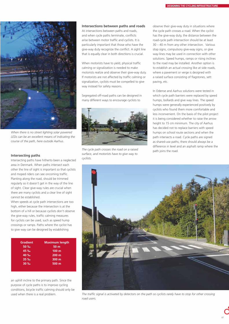
DESIGNING THE CYCLING INFRASTRUCTURE
Intersecting pathsIntersecting paths have hitherto been a neglected
area in Denmark. When paths intersect each
other the line of sight is important so that cyclists
and moped riders can see oncoming traffic.
Planting along the road, should be trimmed
regularly so it doesn’t get in the way of the line
of sight. Clear give-way rules are crucial when
there are many cyclists and a clear line of sight
cannot be established.
When speeds at cycle path intersections are too
high, either because the intersection is at the
bottom of a hill or because cyclists don’t observe
the give-way rules, traffic calming measures
for cyclists can be used, such as speed hump
crossings or ramps. Paths where the cyclist has
to give way can be designed by establishing
When there is no street lighting solar powered
LEDs can be an excellent means of indicating the
course of the path, here outside Aarhus.
Gradient Maximum length 50 ‰ 50 m 45 ‰ 100 m 40 ‰ 200 m 35 ‰ 300 m 30 ‰ 500 m
Intersections between paths and roadsAt intersections between paths and roads,
and when cycle paths terminate, conflicts
arise between motor traffic and cyclists. It is
particularly important that those who have the
give-way duty recognize the conflict. A sight line
that is equally clear in both directions is crucial.
When motorists have to yield, physical traffic
calming or signalization is needed to make
motorists realize and observe their give-way duty.
If motorists are not affected by traffic calming or
signalization, cyclists must be compelled to give
way instead for safety reasons.
Segregated off-road paths can be designed in
many different ways to encourage cyclists to
an uphill incline to the primary path. Since the
purpose of cycle paths is to improve cycling
conditions, bicycle traffic calming should only be
used when there is a real problem.
observe their give-way duty in situations where
the cycle path crosses a road. When the cyclist
has the give-way duty, the distance between the
road-cycle path intersection should be at least
30 – 40 m from any other intersection. Various
stop signs, compulsory give-way signs, or give
way-lines may be used in connection with other
solutions. Speed humps, ramps or rising inclines
to the road may be installed. Another option is
to establish an actual crossing like at side roads,
where a pavement or verge is designed with
a raised surface consisting of flagstones, sett
paving, etc.
In Odense and Aarhus solutions were tested in
which cycle path barriers were replaced by speed
humps, bollards and give way lines. The speed
humps were generally experienced positively by
cyclists who found them more comfortable and
less inconvenient. On the basis of the pilot project
it is being considered whether to raise the arrow
height to 15 cm minimum. The city of Aarhus
has decided not to replace barriers with speed
humps on school route sections and when the
path intersects a road. Cycle paths are signed
as shared-use paths; there should always be a
difference in level and an asphalt ramp where the
path joins the road. The cycle path crosses the road on a raised
surface, and motorists have to give way to
cyclists.
The traffic signal is activated by detectors on the path so cyclists rarely have to stop for other crossing
road users.
87

DESIGNING THE CYCLING INFRASTRUCTURE
Finally, barriers may be used to compel cyclists
to observe their give-way duty. This is effective,
but inconvenient for all path users. Sometimes
barriers are used to prevent motor vehicles from
entering the path, but bollards with reflectors are
equally effective.
Barriers should only be used in the rare cases
where cyclists risk serious injury from collision.
The barriers should be placed approx. 15-20 m
from the edge of the road so that the cyclist has
ample time to manoeuver into position. The first
barrier should always be placed on the right as
Danes drive on the right side of the road. Barriers
and bollards should be well lit and be visible from
the path at a distance of 30 m minimum. When
barriers are necessary, they should be placed in
such a way that cargo bikes and bicycles with
trailers can pass through at low speeds without
having to stop.
Many two-way paths along highways terminate
at the city outskirts. The termination may be
combined with traffic calming measures at a
town gate. A median island enables cyclists to
cross the road in two phases. Since it is important
to avoid unsuitable, two-way bicycle traffic along
the side of the road in urban areas, cyclists should
be able to cross the road easily at the termination
of the two-way cycle path. On heavily trafficked
roads tunnels and bridges may be the right
solution.
When segregated off- road cycle paths terminate
at a through road section, motorists should not
be compelled to give way. The same design
should be used as when cycle paths cross a road.
Segregated off-road cycle paths may usefully
terminate at the end of a dead end road.
Many cyclists will try to bypass speed humps,
ramps, barriers, etc. Such attempts are best
thwarted by installing 10-15 cm high kerbs on
The transition from one two-way path to two one-way tracks is solved by a median traffic island that
helps cyclists get to the other side of the road.
both sides of the path or by erecting a railing.
The kerb and the railing should be constructed
in such a way that the cyclist would have to bike
approx. 20 m from the path itself to avoid the
barrier.
A good alternative to a barrier is to install short
cyclist speed humps to make cyclists give way.
This reduces cycling speeds without forcing the
cyclist to stop.
Other measuresCyclists seldom use unlit segregated off-road
paths and greenways in the dark. They use the
road network instead, or they don’t bike at all.
Bike lights do not light up the path. Lighting
on segregated, off-road cycle paths should
therefore illuminate the entire path in such a way
that a cyclist riding at 25 km an hour can easily
distinguish the path from the surrounding area;
otherwise the lighting is worthless. If funding
is not available for proper path lighting, solar
powered LEDs provide a reasonable alternative.
SafetySegregated off-road cycle paths are very safe for
cyclists and make them feel secure. The typical
bicycle accidents on this type of path are solo
accidents or collisions with pedestrians, mopeds
and other cyclists. A number of accidents are
due to slippery roads, high speeds, sharp bends,
poor lines of sight, and unclear give-way rules at
path crossings. It should be noted that the vast
majority of accidents on segregated off-road cycle
paths are not registered by the police, perhaps as
many as 95-99%.
Barriers are set up to reduce moped speeds.
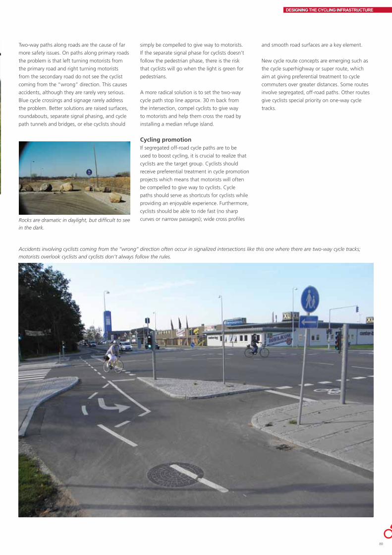
DESIGNING THE CYCLING INFRASTRUCTURE
Two-way paths along roads are the cause of far
more safety issues. On paths along primary roads
the problem is that left turning motorists from
the primary road and right turning motorists
from the secondary road do not see the cyclist
coming from the “wrong” direction. This causes
accidents, although they are rarely very serious.
Blue cycle crossings and signage rarely address
the problem. Better solutions are raised surfaces,
roundabouts, separate signal phasing, and cycle
path tunnels and bridges, or else cyclists should
Rocks are dramatic in daylight, but difficult to see
in the dark.
Accidents involving cyclists coming from the “wrong” direction often occur in signalized intersections like this one where there are two-way cycle tracks;
motorists overlook cyclists and cyclists don’t always follow the rules.
simply be compelled to give way to motorists.
If the separate signal phase for cyclists doesn’t
follow the pedestrian phase, there is the risk
that cyclists will go when the light is green for
pedestrians.
A more radical solution is to set the two-way
cycle path stop line approx. 30 m back from
the intersection, compel cyclists to give way
to motorists and help them cross the road by
installing a median refuge island.
Cycling promotionIf segregated off-road cycle paths are to be
used to boost cycling, it is crucial to realize that
cyclists are the target group. Cyclists should
receive preferential treatment in cycle promotion
projects which means that motorists will often
be compelled to give way to cyclists. Cycle
paths should serve as shortcuts for cyclists while
providing an enjoyable experience. Furthermore,
cyclists should be able to ride fast (no sharp
curves or narrow passages); wide cross profiles
and smooth road surfaces are a key element.
New cycle route concepts are emerging such as
the cycle superhighway or super route, which
aim at giving preferential treatment to cycle
commuters over greater distances. Some routes
involve segregated, off-road paths. Other routes
give cyclists special priority on one-way cycle
tracks.
89

DESIGNING THE CYCLING INFRASTRUCTURE
GIVE-WAY REGULATED INTERSECTIONSThere are two types of give way controlled
intersections, i.e. duty to give way to the right,
when the road user has to give way to traffic
coming from the right, and duty to give way,
when the road user coming from a secondary
road has to give way to all traffic on the primary
road. Intersections regulated by a stop sign are a
third option.
Stop signs have an approx. 10 times greater
traffic safety effect than the duty to give way.
Stop signs and give-way-to-the right intersections
are rare in Denmark. The duty to give way is
considered preferable to giving way to the right
because giving way to the right results in more
accidents. Some road users ignore the duty
to give way to the right while others find the
rules confusing. Giving way to the right is more
common abroad. It may be an option to replace
the duty to give way to the right with the duty to
give way.
The most serious cyclist casualties in give-way
regulated intersections are crossing collisions and
left turn accidents. Serious cyclist accidents occur
primarily when cyclists are crossing a primary
road. 9.51
Visibility and give-way rulesIt is crucial that give-way rules at intersections
are very clear. This can be done by road marking,
traffic islands or clearly marked traffic calming,
for example crossing treatments.
Line of sight at intersections depends on
bends, planting, lighting, etc. Line of sight at
intersections is crucial to the traffic safety of all
road users. It is essential that the line of sight is
equally clear in both directions since otherwise
road users are so focused on traffic from the
direction where the line of sight is impaired that
they forget to look in the other direction.
Parked cars close to the intersection make it
difficult for road users to view traffic clearly.
This can be a problem for road users coming
from secondary roads as well as for road users
on primary roads. Cyclists on the primary road
should be visible both to road users coming
from secondary roads and to motorists turning
off the primary road at least 20 m before the
intersection. When there is a longitudinal incline
on the primary road the distance should be
greater, e.g. 24 m at 20 ‰ and 30 m at 50 m ‰.
This may affect parking facilities in the vicinity of
the intersection.
The intersection should be easily recognizable.
It should be noted that buildings, planting
and parked cars can be visually perceived as
an unbroken line, which makes it difficult for
cyclists to realize that there is an intersection
ahead. Intersections can be made more visible by
prohibiting parking, removing some planting, and
by road markings.
Parked cars are part of daily life.
The verge between the cycle track and the
carriageway should be removed at a reasonable
distance before the intersection, partly to make
cyclists more visible and partly to ensure optimal
line of sight from the secondary road.
At major give-way controlled intersections, for
example where the primary road has 4 lanes, left
turns are difficult. There is a relatively high risk
that a left turning motorist may overlook cyclists.
Road marking can remind motorists that cyclists
are present, but there are other solutions as well,
such as roundabouts or traffic signals.
Continuous cycle tracks through intersections At intersections with small amounts of traffic on
the secondary road, the cycle track should be
continued through the intersection. A continuous
cycle track has a traffic calming effect on motor
vehicles entering and leaving the intersection on
secondary roads since they are compelled to cross
the cycle track and frequently the pavement as
well. Crossing in this fashion makes it easier for
road users on secondary roads to understand and
observe the give-way rules. A study of cyclist
safety in minor intersections further showed that
the number of bicycle accidents dropped by up
to 50% when secondary roads were crossed on
continuous cycle tracks and/or pavement. 9.52 A
more recent study showed a drop of up to 25%
in the number of bicycle accidents as well as
major benefits for pedestrians. 9.53
A safe crossing with an excellent line of sight
is produced by shortening the cycle track,
adding a blue cycle crossing, and continuing the
pavement.

DESIGNING THE CYCLING INFRASTRUCTURE
To make the cycle track more visible as it runs
through the intersection, the cycle track can
be made of another surface, or cycle symbols,
checkered patterns, etc. can be painted on the
road surface. Behavioural studies indicate that
motorists and cyclists are more vigilant of each
other with a white checkered pattern through the
intersection. 9.54
Shortened cycle trackAt intersections with greater amounts of traffic
the cycle track can be dropped to the level of the
carriageway before the intersection. A shortened
cycle track is more dynamic since turning traffic
can drive faster. On the other hand cyclists are on
the same level as motor traffic in the intersection,
but this may get everyone up on their toes.
A shortened cycle track can be continued as a
cycle crossing through the intersection so as to
clearly identify the cyclist circulation area. In high
risk areas for cyclists and moped riders the cycle
crossing may be marked in blue.
At give-way controlled intersections in open
country the cycle track is almost always
shortened. Right turn lanes should be avoided
because right turning motor vehicles interfere
with secondary road users’ line of sight. However,
with high volumes of motor traffic, right turn
lanes may be established by painted barriers or
traffic islands between the right turn lane and the
carriageway. The verge should be removed from
such intersections.
Shortened cycle tracks that continue into the
right turn lane are not generally recommended
for give-way regulated intersections. Instead,
traffic turning off the primary road should be
compelled to go very slowly. However there are a
few positive examples of shortened cycle tracks
in give-way regulated intersections where cycling
speeds are high.
Blue cycle crossing on give-way controlled, continuous cycle track.
Small curve radii may encourage turning
motorists to reduce speed when the cycle track is
not continued across the side road.
Cycle lanesWhen a cycle lane along a primary road continues
to the intersection, a marked cycle crossing
should be established through the intersection.
An accident study of bicycle accidents in give-way
controlled T intersections in urban areas showed
that accidents were less severe when an existing
cycling facility continued through the intersection
as a cycle crossing. 9.55. To prevent crowding
between cyclists and motorists the cycle lane
may be indicated by a profiled, 30 cm line on the
last section before the intersection. A continuing
pavement would also improve cyclist safety.
Set back cycle trackIn intersections with dense traffic on the primary
road it’s a good idea to set the cycle track 5-7
m back from the road and run the track over
the secondary road on a raised surface. Setting
the track back makes it easier for road users to
and from the secondary road to be prepared for
conflicts with cyclists and also provides them
with a clear line of sight to the intersection.
The track should be set 5-7 m back so there is
enough space for a standard passenger car to
wait without inconveniencing other traffic. The
raised surface compels motorists to respect their
give-way duty and prevents them from waiting
on the cycle track. If this solution is chosen, it
must be made very clear to motorists that they
have to give way to cyclists. Set-back cycle tracks
should not be established where many lorries use
the secondary road as there isn’t enough room
for them to wait in the waiting area outside the
cycle track.
Set-back cycle track. The bend means that cyclists can’t bike through the intersection faster than 20
km/h; motor vehicles have a waiting area on the outer edge of the cycle track.
91

DESIGNING THE CYCLING INFRASTRUCTURE
Mixed trafficIn mixed traffic it’s a good idea to establish
crossings on secondary roads by continuing the
pavement through the intersection. 9.56, 9.57
In addition, curve radii should be relatively small.
Pavement crossings do not seem to affect cyclist
safety but have a highly favourable impact on
pedestrian safety.
Two-way cycle tracksTwo- way cycle tracks and give-way controlled
intersections are a bad combination; they cause
safety issues that are difficult to address when
the track runs along a primary road. If the track
runs along a secondary road instead and crosses
the primary road, the problem is smaller.
When two-way cycle tracks are established along
primary roads, the conflict at the intersection
must be made very clear to cyclists and motorists
alike. Two-way cycle tracks should always
continue to the intersection. 9.58
Space permitting, the cycle track should be set
5-7 m back from the primary road and cross the
secondary road on a raised surface.
The alternative is to set the track 30-40 m back
from the primary road and compel cyclists to give
way to motorists. This means that cyclists have
to give way to all traffic on the secondary road.
This solution is not particularly cyclist friendly
but may be necessary for safety reasons and
from the point of view of motor traffic flow. It’s
necessary to set the track 30-40 m back from
the intersection since it’s impossible for a cyclist
to relate to traffic coming from all directions at
once when actually at the intersection. There are
intersections, however, where a 10-15 m setback
has proved sufficient.
Traffic calmingThe intersection may also be constructed on a
raised surface. However, it is uncertain whether
a raised intersection affects cyclist safety. Raised,
give-way controlled intersections may make the
give-way rules appear unclear, so the appropriate
give-way rule should be clearly marked.
In rural areas especially, traffic calming islands
make it easier for road users to see the
intersection.

DESIGNING THE CYCLING INFRASTRUCTURE
SIGNALIZED INTERSECTIONSSignalized intersections are often established to
improve traffic flows, road safety and security.
When cross traffic streams are separated by
timing intervals, the likelihood of crossing
collisions is reduced. On the other hand a traffic
signal means a concentrated time interval of
conflict between turning road users and road
users that are going straight ahead, which is
usually not resolved by regulating the signal. 9.59
The typical cyclist casualty in signalized
intersections involves left turning and right
turning cars and crossing collisions when cyclists
cross on red. Signalization has a highly favourable
impact on safety outside the intersection; in
urban areas the beneficial effect is approx. 1.5
times greater than the benefit in the intersection
itself. 9.60
Cyclist visibility partly depends on the geometric
and visual size of the intersection. Parked cars
and waiting buses near the intersection may
reduce cyclist visibility.
Right turn/left turn arrows for motor vehiclesAt intersections without a separate cyclist signal,
cyclists have to use the motor vehicle signal. Arrow
signals apply to all road users who wish to travel in
the direction the arrow indicates. According to the
Road Traffic Act, however, cyclists in Denmark may
not follow the motorists’ left turn arrow since they
have to turn left in two phases: first they have to
proceed to the opposite corner of the intersection
and only then may they complete their left turn
when it can be done without inconveniencing
other traffic, independently of whether the signal
is green or red. 9.61 This rule is not commonly
When an intersection has a compulsory left turn
signal for motor traffic, the number of accidents
between left turning motorists and on coming
cyclists in major intersections with many traffic
lanes is reduced.
known, however, which is why cyclists need space
at the intersection’s corners where they can wait
for the green signal.
Cyclist signals At intersections where cycle tracks or cycle lanes
continue to the stop line, a separate cyclist signal
may be installed. In this way cyclists have their
own signal phase, wholly or partially. Cyclist
signals can be used for pre-green for cyclists
several seconds before motor vehicles. This gives
Separate left turn phase for cyclists while cyclists going straight merely observe the
give-way rules.
cyclists who have been waiting for red a head
start in relation to motor vehicles, rendering them
more visible. The aim is to reduce the number of
conflicts between motorists and cyclists.
In addition, cyclist signals are used to shorten
the green phase for cyclists in order to make the
intersection more easily passable for motor traffic.
In intersections with separate cyclist signals cyclists
must always observe the cyclist signal.
Pre-green for cyclists may reduce the number of accidents occurring in the initial part of the green phase.
93

DESIGNING THE CYCLING INFRASTRUCTURE
In intersections with two or more turn lanes
traveling in the same direction from an approach
leg, the turn lanes should have a separate turn
phase as it can be difficult to see cyclists. This
shortens the green phase for cyclists going
straight or turning left.
In Denmark cyclist signals with a countdown
function have not yet been tested. Perceived
waiting time is significantly reduced, and a
countdown signal might counteract cyclists’
tendency to cross on red, as it does in the case of
pedestrians.
Detecting cyclists in vehicle actuated traffic control systemsIn vehicle actuated systems the length of the
green phase is controlled by traffic coming from
different directions. Motor vehicles activate
the signal by a loop or wire buried in the road.
Bicycles may be detected by loops, or manually by
pressing a pushbutton. In some areas pedestrians
and cyclists press the same pushbutton;
elsewhere they may have separate posts.
The optimal solution for cyclists is both a
magnetic loop and a separate, manual cyclist
pushbutton, which should be mounted on a
low post at the stop line. When a cyclist has
been detected a small light on the post flashes.
If contrary to expectation the light doesn’t
flash, the cyclist may then activate the signal by
pressing the pushbutton.
If loops are laid in the cycle track/cycle lane well
in advance of and up to the stop line, cyclists
will be detected in ample time for the signal to
change from red to green or to prolong the green
phase so that cyclists don’t need to stop.
Dutch count-down signal for cyclists.
In some intersections left-turning cyclists can only
be detected by placing loops before the stop line.
To prevent crossing cyclists from falsely activating
the signal, the loop has to be kept covered for at
least 2 seconds.
The advantage of magnetic loops is that cyclists
only have to wait for shorter periods and don’t
have to press a pushbutton. Manual detection
has the disadvantage that not all cyclists are
aware that they have to press a pushbutton and
may become impatient and cross on red. The
disadvantage of automatic cyclist detection is that
cyclists have to stop within a well-defined area in
order to be detected. This area should be marked
if a self-explanatory solution proves too difficult.
Only vehicle actuated systems will be used
in future, according to coming Danish road
standards. Coordination will be possible,
however, but not an actual timer controlled
system. The new road standards are expected to
be passed in 2012.
Bypassing traffic signalsIn signalized T-intersections when the cycle track
continues to and through the intersection and
there is a set-back stop line for cars, cyclists going
straight ahead may be allowed to ride past the
traffic signal. This reduces the number of stops
and passability is improved.
The traffic signal post should be on the left of the
cyclist going straight ahead. Otherwise a “Cyclists
excepted” sign should be placed under the traffic
signal on the signal post.
This may be combined with a left turn lane for
cyclists. Cyclists must give way to pedestrians in
the pedestrian crossing so this solution is most
suitable where there are few crossing pedestrians.
Another option is to install an island between the
cycle track and the carriageway to clearly indicate
the different give-way rules (traffic signal vs.
pedestrian crossing). An island may also make it
possible to remove the pedestrian crossing area
from the cycle track.
Cyclists going straight ahead pass the traffic signal, while cyclists turning left have their own signalized
lane.

DESIGNING THE CYCLING INFRASTRUCTURE
In signalized intersections with ample space, a
right turn lane for cyclists may be established
behind the traffic signal post (“shunt”). In this
way right turning cyclists don’t have to stop for
red. This solution is very popular among cyclists,
but not always popular among pedestrians
so it’s best to use it where there are no major
pedestrian streams.
Right turn allowed for cyclistsDanish studies show that approx. half the
right turning cyclists that arrive at a signalized
intersection on red, turn right on red. Cyclists
may be allowed to turn right on red by changing
the signage and road marking. The solution
makes it clear to motorists that they must give
way to the remaining cyclists crossing on green.
Denmark doesn’t have enough experience with
the solution to be able to draw conclusions as
to the safety effect. On the face of it however, it
would seem that a more flexible traffic regulation
might encourage cyclists to be more law abiding.
Continuing the cycle track/cycle lane up to the intersectionIn signalized intersections where cycling speeds
are not particularly high, the basic rule is continue
the cycling facility to the stop line, and then mark
out a cycle crossing through the intersection.
When cyclist speeds are high because of an
incline, for example, and there are no right
turning lanes for motor vehicles, it is safer to
continue the cycle track or cycle lane to the
intersection than to shorten it. Set- back stop
lines for cars and blue cycle crossings enhance
safety further. The advantage of continuing the
cycle track/lane to the intersection is that it meets
cyclist requirements to have their own area and
makes them feel secure.
In intersections with many right turning lorries,
however, one should proceed with caution before
continuing the cycle track/lane to the intersection
as lorry drivers have a blind spot on the right
and have difficulty perceiving cyclists. 9.63 Many
safety issues with lorries can be addressed by
setting the stop line for motor vehicle traffic 5 m
behind the pedestrian crossing and establishing a
cycle crossing through the intersection.
Cyclists can take a short cut to the right, past the traffic signal.
Cyclists are always allowed to turn right here, but mind the pedestrians!
95

DESIGNING THE CYCLING INFRASTRUCTURE
When a cycle lane continues to the intersection,
squeezing between cyclists and motorists may be
prevented by separating the cycle lane from the
carriageway by a profiled white line.
In order to make room for a right turn lane
and create better interaction between right
turning motorists and cyclists going straight
ahead, a wide cycle track/lane may be continued
as a narrower cycle lane for the last 20-60 m
before the stop line. This may reduce cycling
accidents with right turning motor vehicles, but
in situations with high volumes of bicycle traffic
capacity may be reduced if the solution is not
combined with a bike box before the right turn
car lane.
Shortened cycle track/cycle laneIn signalized intersections with fast moving
cyclists, for example when the cycle track has
a steep incline, it is usually significantly safer
to shorten the cycle track/lane. The cycle track
should be shortened 20-30 m minimum before
the intersection (the distance depends on the
number of right turning motor vehicles; a long
combination vehicle is 25 m long). In this way
cyclists and motorists move on the same level,
are physically closer to each other, and are both
responsible for any conflicts that arise. To make
sure that motor vehicles as well as cyclists have
ample space, the right turn lane should be 4 m
wide or more. This solution is also appropriate
where there are many mopeds. However, if the
only way to make room for a right turn lane for
motor traffic is to drop the cycle track/lane, the
safest solution is probably to establish a right turn
lane and shorten the cycle track.
In intersections with a shortened cycle track there
should be no driveway entrances and exits on
the “shortened” section before the intersection.
Shortened cycle tracks/lanes should not be used
in intersections where there are many children
since it is an insecure solution, and children bike
slowly. Insecure solutions may mean that fewer
people feel like cycling on that section.
Set-back stop linesIt is recommended for all signalized intersections
to set motor vehicle stop lines in all traffic lanes 5
m back from the pedestrian crossing or the cyclist
stop line. Set-back stop lines increase pedestrian
and cyclist visibility when signals change
and allow vulnerable road users to enter the
intersection first, thereby preventing a number of
conflicts. An accident study found a drop of 35%
in the number of accidents between right turning
cars and cyclists going straight ahead, and a drop
of 50% in the number of cyclist casualties in this
type of accident. 9.64
Set-back stop lines do not generally reduce intersection car capacity.
Shortened cycle track continued as a narrow cycle lane up to the stopline.
Safe crossing for pedestrians across the cycle track.

DESIGNING THE CYCLING INFRASTRUCTURE
In fatal accidents, when a bicycle/moped is hit by
a right turning vehicle, 90% of the time the other
vehicle is a lorry. 9.65 Set-back stop lines render
cyclists, particularly, more visible to lorry drivers.
At the time of writing a new study of set-back
stop lines is being prepared.
Cycle lane between motorists’ right turn lane and lane for straight ahead trafficAt large signalized intersections a cycle lane may
be established between the motorists’ lane for
straight ahead traffic and the right turn lane.
The idea is to replace the conflict between right
turning cars and cyclists going straight ahead
with a less dangerous merging situation before
the intersection. This also renders cyclists going
straight more visible to oncoming, left-turning
motorists. This measure may be combined with
a cycle track in the intersection area. An accident
study has not been able to document a safety
effect, however. 9.66
Mixed trafficAt approaches to signalized intersections with
mixed traffic, a short, narrow (1.5 m) cycle lane
may be established the last 20-50 m before the
intersection. Cyclists thus have their own area
for entering the intersection, which makes the
area more easily passable and makes cyclists
feel more secure. We don’t know whether this
is better than nothing from a safety point of
view. The solution makes it possible to mark a
cycle crossing through the intersection. A cycle
crossing may be marked through an intersection
even if there is no cycling facility directly before
the intersection.
Cycle crossings running through intersectionsA cycle crossing may be established when it is
deemed necessary to draw attention to potential
conflicts between cyclists going straight ahead
and turning motorists. In addition to clearly
indicating the conflict area, the cycle crossing
visually separates cyclists going straight from
motorists and makes cyclists feel more secure.
In Denmark there are four types of cycle
crossings: one is blue, others consist of white,
dashed 0.3 m wide lines. Cycle crossings are
always marked with cycle symbols.
An accident study of cycle crossings in signalized
intersections showed that cycle crossing marking
has resulted in a 36% drop in the number of
bicycle accidents and a whopping 57% drop in
the number of serious cyclist casualties. The study
further showed that when cycle crossings were
established in major intersections the greatest
Cycle crossing between motor vehicles’ right turn lane and lane for straight ahead traffic.
There are too many blue cycle crossings here.
reduction occurred in accidents between left
turning cars and cyclists going straight ahead.
It seems that motorists move part of their focus
from pedestrians to cyclists since there was
a rise in pedestrian accidents. 9.67 Another
Blue cycle crossing at signalized intersection where there are major streams of oncoming, left turning
motor traffic.
study indicated that 1 blue cycle crossing per
signalized intersection produces a safety benefit,
but 2 blue cycle crossings should only be
established exceptionally, and only in signalized T
intersections. 3 and 4 blue cycle crossings actually
97

DESIGNING THE CYCLING INFRASTRUCTURE
increase the number of accidents. The blue cycle
crossings should be placed where most of the
accidents between cars and cyclists take place.
9.68
Bike boxesBike boxes may be established at signalized
intersections by painting the cycle symbol in front
of the motorist stop line in turning lanes. This
enables cyclists stopping at red to get ahead of
cars. It has the advantage that cyclists stopping at
red are more visible to turning cars, and cyclists
enter the intersection before cars. Bike boxes
before left turn lanes may only be marked on
secondary roads in signalized T-intersections (not
in 4 armed intersections). At the time of writing
a special dispensation from the road standards is
needed to establish a bike box in Denmark.
A study of left turning cyclists in bike boxes in
Copenhagen showed that bike boxes make
cyclists feel more secure and more satisfied. All
the cyclists interviewed felt that the bike box
renders them more visible to motorists and that
the bike box makes circulation easier. 9.69
However bike boxes should be used with caution
when there are many heavy vehicles. A lorry
driver cannot necessarily see cyclists directly in
front of the lorry.
Channelising cyclists at intersectionsIn intersections with a large modal share of
cyclists, cyclists may be usefully channelised
into separate right turn lanes and lanes going
straight ahead. The advantage of channelisation
is that it places cyclists in the best position for
entering the intersection. The cycle lane should
be wide enough for two cyclists to stop abreast
of each other, i.e. at least 1.85 m. 9.70 Without
channelisation there is the risk that cyclists will
use the pavement or stop ahead of the stop line,
in the pedestrian crossing, or in front of cars. On
the other hand, a right turn cyclist lane should
not be established where there are relatively few
right turning cyclists.
In intersections with mandatory right turn
signals or separate right turn phases, cyclists
should always be channelised. In practice it may
be difficult to find sufficient space for cyclists
waiting at the intersection to prevent the queue
of cyclists from becoming so long that the last
cyclists can’t make it through the first green
phase. When there are many right turning
cyclists, an island between the right turning
cyclists and the cyclists going straight ahead is a
good idea; cyclists turning right don’t necessarily
need a traffic signal; the duty to give way will do.
Bike box in front of right turn lane.
In signalized and give way T-intersections, a
left turn lane on the cycle track opposite the
intersecting road is always a good idea.
Warning: right turning lorriesPilot projects have tested electronic cyclist
warning devices in relation to right turning
traffic, especially lorries. A project in Aarhus has
had positive results, but there is still no definite
conclusion as to the traffic safety effect.
The city of Copenhagen and Aabenraa
municipality have tested a system by which LEDs
along cycle tracks just before the signal warn
right turning lorry drivers of cyclists coming from
behind.
If warning measures are to function properly, it
is essential that they are supportive and do not
lull road users, cyclists as well as right turning
motorists, into becoming irresponsible or less
vigilant. Technology can fail to work! The sign lights a warning to cyclists that they risk
meeting a right turning lorry in the signalized
intersection ahead.

DESIGNING THE CYCLING INFRASTRUCTURE
ROUNDABOUTSIn Denmark, roundabouts are often used to
enhance road safety in the countryside and in
cities. A roundabout may also be used as a traffic
calming measure and often improves traffic flows
when it replaces a signalized intersection. There is
no risk of left turn accidents or crossing collisions
in a roundabout. However, roundabouts do not
always reduce the frequency of bicycle accidents.
On the contrary, all Danish and non-Danish studies
show that when an intersection is converted
into a roundabout or a mini-roundabout the
frequency of bicycle accidents increases and that
such accidents are no less serious than before. For
the vision impaired navigating a roundabout is
especially difficult. The majority of bicycle accidents
involve vehicles entering the roundabout.
Roundabouts may be designed with one or more
lanes in the circulation area and in the approach
and exit lanes. Bicycle traffic is not recommended
within the roundabout when there is more than
one lane in the circulation area or the approach
or exit lane; bicycle traffic should be directed to
the perimeter in this case. There is not sufficient
experience with signalized roundabouts in
Denmark.
It is not a good idea to establish a two-way cycle
track adjoining the circulation area when motorists
have to give way since motorists often think that
all circulation in the roundabout is one way.
Generally speaking, the approach lane width
should be no wider than 3.5 m, preferably
narrower in small and medium sized roundabouts.
Exit lanes should be no wider than 4 m. Crossing
areas made of sett paving towards the centre of
the roundabout may make it easier for lorries and
busses to get through, but may mean increased
speeds through the roundabout.
Roundabouts in open countryIn open country roundabouts are usually relatively
dynamic, which means that circulating cars can
move relatively fast. This is made possible by a
large central island of 20-40 m in diameter and
triangular and trumpet shaped splitter islands at
the legs of the roundabout.
In dynamic roundabouts cyclists should not
circulate in the roundabout itself. Instead cyclists
should have a path set back approx. 10 – 30 m
from the circulation area, and they must give way
to motor vehicles when crossing the road. The
path may be two-way so cyclists don’t have to
take the long way round. Another solution is to
establish a cyclist tunnel. This is a good idea for
crossing heavily trafficked roads with 4 or 6 lanes.
This roundabout is designed for speed - at least for cars.
When the roundabout is less dynamic, with a
central island of 10-20 m in diameter and parallel
or small triangular islands at the legs, cyclists
may ride in the roundabout itself. In this type of
roundabout it is essential that cyclists should have
a one-way cycle track on the perimeter of the
circulation area, and the approach and exit lanes
should have cycle tracks.
The cycle track and islands in less dynamic
roundabouts should be designed for traffic
calming. It is common practice in Denmark to
establish one-way cycle tracks in the circulation
area. Denmark has no experience with one-way
cycle tracks set 3-7 m back from the circulation
area. Swedish, German and Dutch experience
indicates that it is safer to establish a verge of
approx. 5 m between the cycle track and the
circulation area. The cycle track should be one-way
and motorists must give way to cyclists.9.71 ,9.72,
9.73, 9.74, 9.75
City roundaboutsIn cities, car speeds are generally slower so city
roundabouts are normally smaller than in the
countryside and significantly more traffic calming.
There are more vulnerable road users in city
roundabouts, and roundabout design should take
this into account. The maximum capacity is 25,000
motor vehicles per 24 hour period in a one lane
roundabout, and 40,000 in a two lane. Design and
traffic composition may reduce capacity.
Cycle lanes in roundabouts should be used with
caution since a cycle lane increases the circulation
area and may be used by motorists to drive faster.
In addition there is a greater risk that cyclists will
be squeezed in the approach and exit lanes than
when they are physically segregated.
In lightly trafficked roundabouts on roads with a
30-50 km/h speed limit, cyclists should mix with
motor traffic in the one lane circulation area. The
roundabout should be traffic calming. The central
island should be only approx. 10 m in diameter,
and there should be no splitter islands at the legs.
Placing the entire roundabout on a raised surface
is worth considering.
In major roundabouts with a central island of
15-30 m in diameter a one-way cycle track may be
established. It is probably best to set the cycle track
approx. 5 m back from the one-way circulation
area, but this cannot be documented due to a lack
of statistical material. It is crucial to ensure that no
one can be in doubt as to the give-way rules.
If there is not enough space for a cycle track in a
roundabout with less than approx. 8,000 motor
vehicles within a 24 hour period, it is worth
considering establishing a circulation area with
no cycling facilities or with a cycle lane and a
narrow circulation area for motor traffic. When
there is little space and greater traffic volumes, a
small central island or signalization are possible
solutions.
99

DESIGNING THE CYCLING INFRASTRUCTURE
In larger roundabouts with central islands of
20-30 m in diameter, traffic volume is generally
so great and driving speeds so fast that
cyclists should not mix with motor traffic at
all. A one-way cycle track set back 5-7 m from
the circulation area should be established in
roundabouts with a one lane circulation area and
approach and exit lanes. It’s worth considering
whether this type of cycle track should be on a
raised surface. Again it’s crucial to ensure that the
give-way rules are absolutely clear.
Mini-roundaboutsIn a mini-roundabout it is possible to drive
over the central island. The capacity of a
mini-roundabout is up to 15,000 cars per 24
hour period. Mini-roundabouts are used when
the signed speed limit is 30-50 km/h. A mini-
roundabout costs roughly only one tenth of
a standard roundabout and the diameter of
the circulation area is only 15-25 m. Mini-
roundabouts are usefully established as a traffic
calming measure in urban areas or on primary
roads. Mini-roundabouts are not appropriate for
heavy traffic, such as bus routes. This is because
the bus or lorry fills the entire mini-roundabout,
blocking the circulation area for the duration.
Give-way rules must be clearly marked in the
mini-roundabout. There is a safety benefit in
constructing the mini-roundabout on a raised
surface.
In lightly trafficked mini-roundabouts cyclists
should mix with motor traffic in the circulation
area. The mini-roundabout should be highly
traffic calming.
In mini- roundabouts with over 6-8,000 vehicles
per 24 hour period a one-way cycle track should
be established; it is probably best placed at
approx. 5 m from the circulation area.
A large mini-roundabout; the cycle lane is probably not suitable.
A mini-roundabout can be a boon for cyclists.

DESIGNING THE CYCLING INFRASTRUCTURE
PEDESTRIAN AREAS, SQUARES, AND OTHER URBAN SPACESIn Denmark pedestrians, cyclists and motorists
are often completely segregated so that each
traffic mode has its own area. Motor vehicles,
cyclists and pedestrians rarely share the same
area. In a pedestrianized zone where driving is
allowed, motorists and cyclists must be vigilant
and show due consideration to pedestrians;
motorists and cyclists must always give way to
pedestrians. Cyclists may be forbidden to enter
a pedestrianized zone by using appropriate
signage.
Many cyclists do their shopping in town
and therefore circulate as cyclists as well as
pedestrians. It may be a good idea to allow
cyclists to enter traditional pedestrianized zones
to a greater extent than is the case today. In some
pedestrianized zones, however, there is so much
pedestrian traffic that this would inconvenience
cyclists and pedestrians alike. The disabled and
the visually impaired should also be taken into
consideration.
Cyclists in pedestrianized zonesAs a general rule bicycle traffic is not allowed in
pedestrianized areas in Denmark. When cycling
is allowed in a pedestrianized area and there
are no cycle tracks or cycle lanes, cyclists must
always give way to pedestrians. Rather than
totally prohibit bicycle traffic in a pedestrianized
zone, cycling may be allowed at certain times
of the day, for example outside business hours,
when there is often very little pedestrian traffic.
Experience from Odense shows that pedestrians
appreciate the fact that there are more people on
the street in the evening.
When there is ample space and an appropriate
number of pedestrians, a cycle track may be
established in a pedestrianized zone. This reduces
The pedestrianized zone is a shortcut for cyclists
from 9 p.m. – 9 a.m
the number of conflicts between cyclists and
pedestrians. The drawback of a cycle track is
that it may function as a barrier to crossing
pedestrians. A cycle track is a major obstacle
to the physically disabled, whereas the visually
impaired can orient themselves more easily by
following the edge of the cycle track.
In pedestrianized zones different surfaces and
perhaps variation in level (2-7 cm) make road
users aware of different use of areas. A low kerb
should be vertical.
Designing squares/urban spacesThe concept of squares and other urban spaces
ranges from major, centrally located squares
and marketplaces to small, intimate spaces.
The recreation of the central market place as a
meeting and market area is a central element of
many traffic calming projects.
Many squares and spaces have been made
wholly or partially car-free, parking spaces for
cars have been removed, and new surfaces and
planting have been installed. Street furniture
and benches have been set up on most squares
and spaces and there are often outdoor cafés.
Cycling is often automatically prohibited. Bicycle
traffic should be factored in when renovating and
establishing squares and spaces.
Cycling across a square can be prevented by
ensuring that the square does not offer cyclists
a shortcut. Otherwise the surface should make
cycling difficult, for example by cobble stones,
or a railing may be set up. It is difficult for the
police to enforce cycling prohibitions if the square
or space is a good cyclist shortcut. Bicycle stands
should be set up regardless of whether or not
cycling is allowed to prevent cyclists from parking
unsuitably.
The principle of “shared space” means that all
road users may circulate together on the same
surface, and the rules are reduced to a minimum.
Some cyclists and pedestrians feel somewhat
insecure in such areas, but on the whole road
user vigilance is increased.
Slow-speed zones and living streetsThere are good examples of shared space areas
for all road users in Denmark. Pedestrians, cyclists
and motor vehicles share slow-speed zones
("sivegader"), but pedestrians always have the
right of way. Slow-speed zones may have a speed
limit of 15 km/h and be one-way for motor
traffic. There are many slow- speed zones as well
as living streets or home zones ("opholds-og
legeområder") in Denmark, based on the Dutch
concept of woonerf. In Denmark there should
be no segregation between the carriageway
and the pavement in living streets, and there
should be no continuous height difference in the
road’s cross profile. The section of the road that
is suitable for motor traffic may be marked by a
change of surface, for example.
Bicycle streetsThere are no official bicycle streets in Denmark as
yet since the legal requirements have not been
fully established. The idea is that motor vehicles
are allowed but have to give way to cyclists. The
city of Aarhus intends to establish bicycle streets
using a cycle track sign showing that motor
traffic is allowed. The project has been approved
by the police.
The crossing is raised to pavement level.
101

DESIGNING THE CYCLING INFRASTRUCTURE
BRIDGES, TUNNELS, HILLS, AND STAIRS
BridgesHigh railings and crash barriers are necessary
to protect pedestrians, cyclists and help lorries
on bridges. The recommended railing height is
1.2 m. Cyclists should not be able to skid under
the railing. A windbreak is useful to cyclists on
windy, gusty bridges. There is no recommended
height for windbreaks due to lack of experience.
Another option is to place cycle tracks indoors.
TunnelsLighting is crucial inside and outside tunnels.
A number of tunnels are lit 24 hours a day. It
should be possible to see what’s going on in the
tunnel from the outside, preferably throughout
the entire tunnel. Window openings should be
installed in new tunnels to let essential daylight
shine on cyclists.
Pedestrians and cyclists should always be
segregated in tunnels whenever possible. Barriers,
bollards and sharp bends should be avoided
inside or directly outside the underpass.
Well designed bridge.
Dark, narrow tunnel.
Opening of new cycle tunnel. The sides slope
outwards and there are roof windows to let in
daylight.
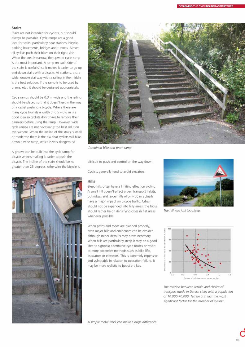
DESIGNING THE CYCLING INFRASTRUCTURE
StairsStairs are not intended for cyclists, but should
always be passable. Cycle ramps are a good
idea for stairs, particularly near stations, bicycle
parking basements, bridges and tunnels. Almost
all cyclists push their bikes on their right side.
When the area is narrow, the upward cycle ramp
is the most important. A ramp on each side of
the stairs is useful since it makes it easier to go up
and down stairs with a bicycle. At stations, etc. a
wide, double stairway with a railing in the middle
is the best solution. If the ramp is to be used by
prams, etc., it should be designed appropriately.
Cycle ramps should be 0.3 m wide and the railing
should be placed so that it doesn’t get in the way
of a cyclist pushing a bicycle. Where there are
many cycle tourists a width of 0.5 – 0.6 m is a
good idea so cyclists don’t have to remove their
panniers before using the ramp. However, wide
cycle ramps are not necessarily the best solution
everywhere. When the incline of the stairs is small
or moderate there is the risk that cyclists will bike
down a wide ramp, which is very dangerous!
A groove can be built into the cycle ramp for
bicycle wheels making it easier to push the
bicycle. The incline of the stairs should be no
greater than 25 degrees, otherwise the bicycle is
Combined bike and pram ramp.
A simple metal track can make a huge difference.
difficult to push and control on the way down.
Cyclists generally tend to avoid elevators.
HillsSteep hills often have a limiting effect on cycling.
A small hill doesn’t affect urban transport habits,
but ridges and larger hills of only 50 m actually
have a major impact on bicycle traffic. Cities
should not be expanded into hilly areas; the focus
should rather be on densifying cities in flat areas
whenever possible.
When paths and roads are planned properly,
even major hills and eminences can be avoided,
although minor detours may prove necessary.
When hills are particularly steep it may be a good
idea to signpost alternative cycle routes or resort
to more expensive methods such as bike lifts,
escalators or elevators. This is extremely expensive
and vulnerable in relation to operation failure. It
may be more realistic to boost e-bikes.
The hill was just too steep.
The relation between terrain and choice of
transport mode in Danish cities with a population
of 10,000-70,000. Terrain is in fact the most
significant factor for the number of cyclists.
The
diff
eren
ce in
ele
vatio
n in
the
city
’s t
erra
in in
met
ers
Number of cycle journeys per person per day.
0.0 0.3 0.6 0.9 1.2 1.5
103

DESIGNING THE CYCLING INFRASTRUCTURE
ONE-WAY STREETSThere are many traffic destinations in city centres,
which means that being able to cycle in both
directions on all streets is highly convenient. If
the street is wide enough, contra-flow cycling
can work in one-way streets without hampering
traffic flows or presenting safety problems.
Special attention should be paid to intersection
design.
In Denmark one-way streets are primarily aimed
at reducing motor traffic volume by establishing
two parallel one-way streets in opposite
directions, or at enabling parking. In contrast
to Spain or the US, for example, no Danish city
has a network of major one-way roads aimed at
improving traffic flows.
Cross profileWhen cyclists have a separate, contra-flow area
they move somewhat faster. It is a moot question
whether a separate area improves cyclist safety
since cyclists will be less vigilant, but on the
other hand motorists on the one-way street will
be more aware of contra-flow cyclists. But then
again vehicles passing parked cars may create
problems for the contra-flow cyclist.
A separate area for contra-flow cyclists is not
necessary on very lightly trafficked, one-way
streets. On more heavily trafficked streets a
contra-flow cycle track or cycle lane may be
established. The position of the police is often
very clear on this.
The cycle track should be 1.7 m wide minimum
The sign draws motorists’ attention to the fact that there are contra-flow cyclists about.
while the cycle lane should be 1.5 m wide. If
cars are parked immediately outside the cycling
facility, the cycling facility should be at least 2.0
m wide. The cycling facility is usefully made of a
contrasting surface material.
When parking is on the left side of the street, a
cycle track or cycle lane should be placed on the
left of parked cars since motorists parked on the
left have trouble seeing oncoming cyclists on the
right of their car.
A solution on small streets for preventing
unlawful or inappropriate parking is to erect
bollards, but not too many. There should be no
kerbs on such streets so that cyclists can easily
bike around cars blocking their path. Such streets
may be signed as 15 km/h streets ("opholds-og
legeområde", or living streets).
IntersectionsTraffic islands or kerb extensions are sensible
solutions particularly in intersections with speeds
of 40 km/h or more. This makes it easier to
prevent parking close to the intersection and
makes cyclists moving in the “wrong” direction
visible. Contra-flow cyclists may thereby safely
enter and exit the one-way street.
At slow speed intersections, road markings,
contrasting surface materials and bollards may
be sufficient to prevent parking close to the
intersection so as to improve the line of sight.
SafetyA German study concluded that contra-flow
cycling is safer than cycling with the flow on one-
way streets. The city of Copenhagen attempted
to analyze accidents in relation to contra-flow
cycling but there were no accidents in the police
register.
Cycling promotionContra-flow cycling on one-way streets clearly
favours cyclists by shortening their route
compared to motorists and legalizing unlawful,
daily contra-flow cycling at the same time.
If contra-flow cycling is to be safe, there should
be no parking on the left side of the road

DESIGNING THE CYCLING INFRASTRUCTURE
MANAGING MOTOR TRAFFIC
Permanent road closurePermanent road closures in Denmark are primarily
aimed at removing through motor traffic. Road
closure is increasingly used to reduce the total
amount of motor traffic in central city areas in
order to improve road safety. When road closures
divide urban areas into separate zones, short car
journeys become less attractive.
Roads are often closed at intersections when
fewer arms are required, for example. Motorists,
however, need to turn on one or both sides
of the road closure, which makes design a
challenge. The “Dead end” sign should be clearly
visible from a distance to prevent time consuming
turning manoeuvers. Cyclists should have easy
access to a closed off road since the road closure
rarely aims at preventing cyclists from entering.
There should be two passages for cyclists, each
1.3-1.4 m wide. However, widths of less than
1.6 m mean that sweeping and snow clearance
have to be done manually. Another option is to
establish adjacent cycle shunts separated by a
removable bollard. This facilitates cleaning and
maintenance in the closed off area. It is crucial
that there is no parking in front of the cycle
shunt.
Planting, bollards, bicycle parking facilities and
high kerbs without ramps enhance the purpose
of the road closure.
Intelligent and timer-controlled road closure devicesThe urban environment may be significantly
improved if no commuter traffic or through
traffic is allowed into central city areas.
Retractable bollards and access cards are one way
of keeping undesirable motorists out of an urban
area. Access cards may be given to inhabitants,
ambulances, police, waste disposal collectors,
shop owners, etc. Delivery vans may access
the area by keeping the bollards lowered for a
few hours a day. Conversely, the bollards can
remain raised during peak commuting periods.
Exit areas should be designed so that cars can
always easily leave the area and no one is shut in.
Unfortunately substantial maintenance costs may
be anticipated.
Bus sluicesThe aim of a bus sluice, similar to a road closure,
is to reduce motor traffic and give greater priority
to pedestrian, bicycle and bus traffic. Bus sluices
help buses keep to schedule avoiding delays.
Like road closures, bus sluices can of course be
intelligent or time controlled.
The road is closed to cars but allows cyclists easy access.
The simplest type of bus sluice merely consists
of signposting “No entry except buses”. Physical
obstacles are often necessary to prevent other
motor traffic from entering, such as barriers
or bus-actuated rising bollards. Another and
often better solution is to install wheel gauge
obstacles so that only wide vehicles traveling at
slow speeds can pass through. Bus sluices should
always be provided with a 1.3 -1.4 m bicycle
shunt on each side of the road. When roads are
closed off by bus sluices, this should be clearly
marked, particularly during the start-up period,
to prevent motor vehicles from inadvertently
entering the bus sluice because they are used to
using the road as a through road.
Sluices can be established for other purposes as
well, such as light rails, lorries, etc., but always
remember the bicycle sluices.
Parking regulationsIn areas where there is a large demand for
waiting and parking facilities, signage prohibiting
stopping, waiting or parking is not always
enough.
Many motorists know that they are not allowed
to park within 10 m from an intersection in
Denmark, but they park illegally nevertheless
since the prohibition is seldom marked. A
discreet but visible marking is the best solution.
The Copenhagen authorities have implemented
this over the entire city; painted yellow triangles
starting 10 m from the intersection help motorists
remember to keep their distance.
Parking is illegal on cycle tracks and cycle lanes
in Denmark and is extremely unpopular among
cyclists. Parking on narrow, heavily trafficked
roads, double parking, and parking on cycle
tracks and cycle lanes cause potentially extremely
dangerous situations for cyclists.
This lorry sluice is difficult for cyclists to pass
through and may mean that cyclists choose the
left-hand pavement instead even though it’s
illegal.
105

DESIGNING THE CYCLING INFRASTRUCTURE
Double parking issues may be addressed by
making the road narrower and introducing
time limited parking. Attractively placed cab
stands near major hotels, traffic terminals,
pedestrianized zones and restaurants, cafés,
nightclubs, and bars are often an excellent
solution. Kiss-and-ride spaces at schools,
institutions, traffic terminals, etc. may also prove
necessary.
Shop owners on shopping streets are often
advocates of parking due to the necessity of
unloading delivery goods. An alternative option is
to establish loading zones outside relevant shops.
Loading and unloading should only take place in
specially designated bays which at other times
may be used as a pedestrian area. The city of
Copenhagen has tested dual-use parking bays for
cars or bicycles depending on the time of day.
20-25 cm high kerbs or concrete blocks are the
last resort when preventing unlawful waiting
and parking. Bollards and high kerbs make
cyclists feel insecure and increase the risk of solo
accidents with solid objects. Road safety should
be carefully assessed and the distance between
bollard and cyclist should be at least 30 cm.
CostsThe following experience-based guideline prices
may be helpful when establishing a cycling
infrastructure budget:
2011 prices
Extensive traffic calming (chicanes, speed humps, road narrowing, etc.) DKK 500-20,000 per RM
0.3 m wide thermoplastic line DKK 25-50 per RM
0.1 m wide thermoplastic line DKK 10-20 per RM
10 cycle symbols DKK 10-20 apiece
Crossing with full cycle track and pavement DKK 50,000-150,000
2.2 m wide blue, thermoplastic cycle crossing DKK 400-800 per RM
Red powdered asphalt DKK 250-400 per RM
Road closure DKK 5,000-75,000
1 speed hump on existing roadway,Kerb to kerb incl. marking DKK 15,000-30,000
1 mini- roundabout DKK 100,000-1.500,000
Roundabout with 1 circulation lane and splitter islands at legs DKK 1,500,000 – 4,000,000
Cycle track shunt around traffic signal DKK 50,000-100,000
Shortened cycle track by 30 m DKK 50,000 - 250,000
Pedestrian refuge in intersection DKK 50,000-250,000Cyclist signal in signalized intersection DKK 50,000-200,000
Cycle path signage incl. contractor costs DKK 1,500 -10,000 per signpost
€1 = DKK 7.4, £1 = DKK 8.9 and $1 = DKK 5.6.

10
Contents
The Bicycle Parking Manual 108Attracting attention 109Location 109Area design 110Capacity 110Choice of racks and stands 112Operations and maintenance 119Spoiling cyclists 120Bicycle parking plan 120Checklist 120Bicycle service 121Better coordination with public transport 121Recreational bicycle parking 122Funding 122
Any bicycle journey ends with a parked bicycle, and since over
5 million bicycles are in regular use in Denmark this means that
many bicycles need to be parked every day.
Although car parking has been a central issue in area planning
for the past 50 years, little attention has been paid to bicycle
parking in urban planning and construction projects. However,
regardless of whether it is a question of new construction,
conversion, renovation, improvements, etc., bicycle parking
should be an integral part of any project from the outset; if
people are to be encouraged to cycle, they need space to park
their bicycles.
This can be done in a variety of ways. The present section
offers good advice and a number of recommendations for
establishing suitable bicycle parking facilities that cyclists will
actually use.
BICYCLE PARKING

THE BICYCLE PARKING MANUALThere is a fight for space going on in modern
cities. This challenge has to be met by
establishing bicycle parking areas since superior
bicycle parking facilities help create order and
space in public and private areas. Good bicycle
parking facilities also reduce bicycle theft and
boost cycling since an area in which there is
room for parked bicycles signals that cyclists are
welcome.
Bicycles are welcome to park anywhere in
Denmark. According to the Danish Highway
Code bicycles are allowed to park on cycle tracks,
foot paths and pavements (although evacuation
zones must be kept passable). It is thus illegal
to effectuate the “Bicycles left here will be
removed” sign.
It is not allowed, however, to lock a bicycle to
municipal property or to a building entrance as
this will generally inconvenience other traffic.
Bicycle Parking Manual, Danish Cyclists’ Federation, 2007.
A message from the Aarhus police from former
times. It reads "Do not place bicycles at the kerb."
Cyclists are threatened all over town, although
it is not legal to carry out the threats. (The sign
reads: “Bicycles will be removed and melted
down - Use the bike stand around the corner.”)
Not all shops are “cycle hostile”. TANK in Aarhus
welcomes cyclists as customers. (The sign reads:
“Welcome cyclist. You can park here.”)
Cyclists are often perceived as anarchists
who park wherever they like no matter what.
However, this is often because there are too few
spaces of inferior quality in the wrong places.
If bicycle parking facilities are to be used, bicycle
parking must be factored into all types of projects
from the outset or in connection with renovation.
Whether or not bicycle parking is a success often
proves to be a question of planning.
In 2007 the Danish Cyclists’ Federation published
the Bicycle Parking Manual. The manual contains
a number of recommendations, a technical
instructions section, and a collection of examples
for inspiration. The following recommendations
are largely based on the Bicycle Parking
Manual. It is highly recommended, however, to
supplement the present outline with the manual
itself, which is very useful as a reference work.
THE BICYCLE PARKING MANUAL OUTLINES A NUMBER OF SIMPLE, BASIC PRINCIPLES FOR PLAN-NING AND ESTABLISHING BICYCLE PARKING FACILITIES
1. Attract attention 2. Choose the right location 3. Outline a solution that works 4. Make sure there are enough spaces 5. Identify the right racks and stands 6. Make parking safe 7. Consider operation and
maintenance 8. Spoil the cyclists
BICYCLE PARKING

ATTRACTING ATTENTIONBicycle parking facilities cost money, for the local
authority or the private developer.
Convincing arguments must be made for the
necessity of bicycle parking investment to make it
a winner. For example, it is a good idea to write
bicycle parking costs into the construction budget
as a natural part of the project from the outset.
Here are a couple of good arguments to
convince the local decision makers of the crucial
importance of bicycle parking:
• Agoodcyclinginfrastructureisneededto
boost cycling as a transport mode.
• Goodbicycleparkingfacilitiesmean
less obstruction for pedestrians and the
handicapped, and enhance the city’s esthetic
appeal.
Here are a couple of good arguments for
developers, companies, and organizations:
• Good,visiblebicycleparkingfacilitiesgivethe
enterprise a responsible profile.
• Goodbicycleparkingfacilitiesencouragestaff
to cycle, which reduces the need for and the
pressure on car parking spaces and results in a
healthy, energetic and satisfied working staff.
LOCATIONThe location of bicycle parking facilities must be
carefully considered before setting up the stands.
If the location is wrong they will not be used.
Here are a number of basic rules for positioning
bicycle parking facilities:
• Thebicycleparkingfacilityshouldbeanatural
place to park en route to the final destination.
• Anacceptabledistancefromtheparking
facility to the destination depends on the
parking duration.
• Thebicycleparkingfacilityshouldbevisibleto
cyclists.
• Accesstothebicycleparkingfacilityshouldbe
in direct continuation of the cyclist traffic flow.
Bicycle parking facilities in Odense create orderly conditions and easy access.
The lack of parking facilities close to the Aalborg bus terminal means that cyclists park in the path to
pedestrian crossings.
Bike stands at the Randers bus terminal are placed close to the destination. The result is orderly
conditions and free pedestrian paths.
BICYCLE PARKING
109

AREA DESIGNWhen the right location has been found the area
needs to be designed so that cyclists can easily
reach the rack with a bicycle, place it in the rack,
continue on foot and pick up the bicycle later.
The following basic principles should be applied:
• Directaccess–obstaclessuchasstairs,doors,
steep ramps, etc. may mean that cyclists do
not use the bicycle parking facility.
• Accesslanesshouldbewideenoughto
manoeuver a bicycle.
CAPACITYWhen planning bicycle parking facilities it is
crucial to establish an adequate number of
spaces. Rather 10 stands too many than 10
too few. Experience shows that good parking
facilities increase demand and it is therefore
recommended to factor in a minimum of 25%
extra stands with a view to possible future
expansion.
The bicycle parking facility at the Copenhagen Metro is not easily accessible.
Too few spaces at Magasin, Aarhus create a state
of bicycle chaos.
� �
�
��
The need for parking facilities can be partially
based on the number of parked bicycles. It’s
a good idea to conduct a count and chart the
results on a map showing the existing number
of bicycle parking spaces supplemented with the
number of parked bicycles at peak periods inside
as well as outside the bicycle parking facility.
Required capacity should be calculated on the
basis of short-term, one hour, all-day, and all-
night parking to establish the need for each
individual standard. It is a good idea to register
the number of parked bicycles at the individual
bicycle parking facility on a regular basis,
both day and night, so as to keep an eye on
developments and catch overcrowding before it
gets out of hand.
When many bicycles are parked outside the
stand, this is perceived as overcrowded and
messy. Overcrowding may occur even when the
parking facility as a whole is not overcrowded,
for example if some spaces are perceived by users
as being too far away leaving the closest spaces
jam-packed. Placing covered stands furthest from
the destination is one way of spreading cyclists
over the whole area.
Day-time occupancy counts are best taken
between 10 a.m-12 noon and night-time counts
between 9 p.m.- 6 a.m. In shopping areas Friday
afternoons or Saturday mornings are often peak
periods while the peak period for entertainment
and sports facilities are the times with the highest
visitors’ rate.
There will often be a lack of sufficient space
at primary travel destinations such as stations,
shopping centres, centrally located employment
nodes, etc. Here are 4 options for addressing the
issue:
• Changetheareadistributiontogive
preferential treatment to cyclists, for example
by changing car parking spaces into bicycle
parking spaces either in the car park, which
frees up a large area, or at the kerb, where
there is typically space for 8-10 bicycles per
parking bay.
• Compressbicycleparking,e.g.two-tier
parking, underground bicycle parking facilities,
automatic facilities, etc.
• Useangleorstaggeredparking.
• Tidyupregularlysoabandonedbicyclesdonot
take up space
Example of bicycle parking mapping in a central city area. The following
was registered during one afternoon peak time period: a) number of
stands distributed over 3 standards (stand; covered; locked/monitored)
b) peak time loads for 4 standards ( no stand; uncovered stand; covered
bicycle parking facility; locked/monitored bicycle parking facility). The
figures in bold indicate the number of stands in use.
no stand
stand
covered stand
locked, monitored stand
BICYCLE PARKING

It is tempting to place bicycle parking spaces
close together to provide more spaces but this
often means that only every other space is used.
It is recommended for perpendicular parking on
the same level to allow 60 cm between stands
to make room for different types of equipment,
luggage carriers, etc. If perpendicular stands are
staggered (alternately up and down), the space
between stands can be reduced to 40 cm. If 45
degree angled parking is used, an interval of 35
cm is sufficient.
Municipal parking normsIt is recommended that the local authorities
draw up a politically approved norm for the
establishment of bicycle parking at: new
construction; additions to and conversions of
existing construction; squares and other urban
spaces; workplaces and institutions; public
transport terminals; shops and pedestrianized
zones in residential areas; and blocks of flats.
A municipal bicycle parking norm ensures that
bicycle parking is factored into the planning
phase of all projects. Bicycle parking thus
automatically becomes an integral part of the
construction project itself with its own budget.
Bicycle parking is especially important to residents
of large blocks of flats. The larger the block of
flats, the more critical it is to address parking
issues since bicycles are out of sight and thus
subject to vandalism and theft.
Bicycle parking in sheds, basements, etc. where
the bicycles are kept under lock and key and
protected from the elements should be standard,
and should be written into the local plans.
Bicycle parking costs are often lower than car
parking costs even though there should be 2-12
Capacity was doubled at the Aarhus railway station by replacing 500 ordinary perpendicular, front wheel spaces with 1000 two-tier spaces.
AREA USE BICYCLE PARKING NORM
Block of flats, youth housing 2 per dwelling
Professional 1 per 100m2
Factory, storage and workshop sites ½ per 100 m2
Daily and durable goods 1 per 100 m2
Theatres, cinemas, etc. 2 per seat
Sports facilities 3 per 3 seats
Schools and educational institutions 5 per 10 students
Public transport centres e.g. An appropriate number based onrailway and bus stations passenger figures
Bicycle parking norm proposal, Viborg Municipality
Covered bicycle parking facility at Viborg student residence combined with a rubbish disposal facility.
BICYCLE PARKING
111
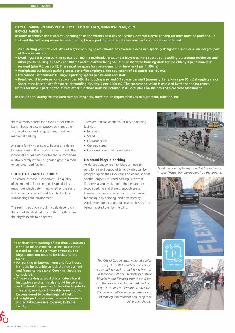
BICYCLE PARKING NORMS IN THE CITY OF COPENHAGEN, MUNICIPAL PLAN, 2009BICYCLE PARKINGIn order to achieve the vision of Copenhagen as the world’s best city for cyclists, optimal bicycle parking facilities must be provided. To that end the following norms for establishing bicycle parking facilities at new construction sites are established:
•Asastartingpointatleast50%ofbicycleparkingspacesshouldbecovered,placedinaspeciallydesignatedshedorasanintegralpartof the construction.
•Dwellings:2.5bicycleparkingspacesper100m2residentialarea,or2.5bicycleparkingspacesperdwelling.Atstudentresidencesandother youth housing 4 spaces per 100 m2 and at assisted living facilities or sheltered housing units for the elderly 1 per 100m2 per resident (plus 0.5 per staff). There must be space for space demanding bicycles (1 per 1,000m2).
•Workplaces:0.5bicycleparkingspaceperofficeemployee,theequivalentof1.5spacesper100m2.•Educationalinstitutions:0.5bicycleparkingspacesperstudentandstaff.•Retail,etc.:3bicycleparkingspacesper100m2shoppingareaand0.5spacesperstaff(normally1employeeper30m2shoppingarea.)
Space must be set aside for space- demanding bicycles, 1 per 1,000 m2. The concrete situation is assessed by the shopping centre. Norms for bicycle parking facilities at other functions must be included in all local plans on the basis of a concrete assessment.
Inadditiontostatingtherequirednumberofspaces,therecanberequirementsastoplacement,function,etc.
•Forshorttermparkingoflessthan30minutesit should be possible to use the kickstand or a stand next to the primary entrance. The bicycle does not need to be locked to the stand.
•Forparkingofbetweenoneandfourhoursit should be possible to lock the front wheel and frame to the stand. Covering should be considered.
•All-dayparkingatworkplaces,educationalinstitutions and terminals should be covered and it should be possible to lock the bicycle to the stand; monitored, lockable areas should be considered to protect against theft.
•All-nightparkingatdwellingsandterminalsshould take place in a covered, lockable facility.
times as many spaces for bicycles as for cars in
Danishhousingblocks.Uncoveredstandsare
also needed for cycling guests and short term
residential parking.
At single family houses, row houses and dense
low-rise housing the situation is less critical. The
individual household’s bicycles can be contained
relatively safely within the garden gate in a more
or less organized fashion.
CHOICE OF STAND OR RACKThe choice of stand is important. The quality
of the material, function and design all play a
major role which determines whether the stand
will be used and whether it fits into the local
surroundings and environment.
The parking solution should largely depend on
the size of the destination and the length of time
the bicycle needs to be parked.
The City of Copenhagen initiated a pilot
project in 2011 combining no-stand
bicycle parking and car parking in front of
a secondary school. Students park their
bicycles in the flex area from 7 am-5 pm
and the area is used for car parking from
5 pm-7 am when there are no students.
The scheme will be assessed with a view
to making it permanent and using it at
other city schools.
There are 5 basic standards for bicycle parking
facilities:
• No-stand
• Stand
• Lockablestand
• Coveredstand
• Lockable/monitoredcoveredstand
No-stand bicycle parking At destinations where few bicycles need to
park for a short period of time, bicycles can be
propped up on their kickstands or leaned against
anotherobject.No-standparkingisrelevant
if there is a large variation in the demand for
bicycle parking and there is enough space.
However the parking area needs to be marked,
for example by painting, and protected by
windbreaks, for example, to prevent bicycles from
being knocked over by the wind.
No-stand parking facility tested in Copenhagen.
It reads "Place your bicycle here" on the ground.
BICYCLE PARKING

Stand parkingAt destinations where many bicycles need to
be placed for a shorter or longer term, it is
recommended to install bike stands. The stand
should support the bicycle without damaging it
and should be convenient and easy to use.
The Butterfly rackThe most common solution in Denmark is the so-
called butterfly rack, in which the bicycle’s front
wheel is placed. The Danish Cyclists’ Federation
recommends vertical butterfly racks in which
the front wheel is held in place by a wedge and
thus fits all tire widths. Butterfly racks may be
supplemented by locking devices.
Two-sided butterfly rack, Frederiksberg. The
stand is vertical and wedge shaped to fit different
tire widths without damaging the tires.
One-sided butterfly rack by the wall of a
residential building, Aalborg.
“Bicycle enclosures” were chosen in Randers. There are typically 5 spaces per enclosure. The enclosures
were installed all over the city where bicycle parking was considered necessary (here at the old Town
Hall). This means that in Randers bicycles are no longer parked every which way; cyclists park in the
enclosed stands.
In Fredericia a stand was developed from
which a wire can be pulled out and the
bicycle can be locked to the stand by means
of a Basta- ock (typical Danish lock that is
attached to the bicycle).
In Odense butterfly racks have been
supplemented by a locking mechanism in the
shape of a wire pulled up from the ground.
BICYCLE PARKING
113

The hoop standStands in which the bicycle leans against the
stand are another option. One of the benefits of
the hoop stand is that the bicycle frame can be
secured to the stand. This is why hoop stands are
primarily used abroad where bicycle theft makes
it necessary to secure both the wheel and the
frame.
Hoop stands have the drawback that the bicycle
may be scratched by the stand and if the stand
is too narrow the front wheel often gets turned
around making it impossible to park on the other
side. In fact it is very common that only one side
of a hoop stand is in use.
Hoop stand at the Royal Library, Copenhagen
Hoop stand, Aarhus
Hoop stand, Odense
Many countries outside Scandinavia typically
use the so-called “Sheffield stand” in which the
bicycle is leaned against a thick metal bar and the
frame and wheel secured by a bike chain lock.
The New York city council organized a design
competition which was won by two Danish
designers. The stand “HOOP”is now installed in
central areas in New York.
The musician, David Byrne, has designed a number of amusing bicycle stands shaped as musical
instruments or here as a high heeled shoe. The stands have been installed in New York and elsewhere.
BICYCLE PARKING
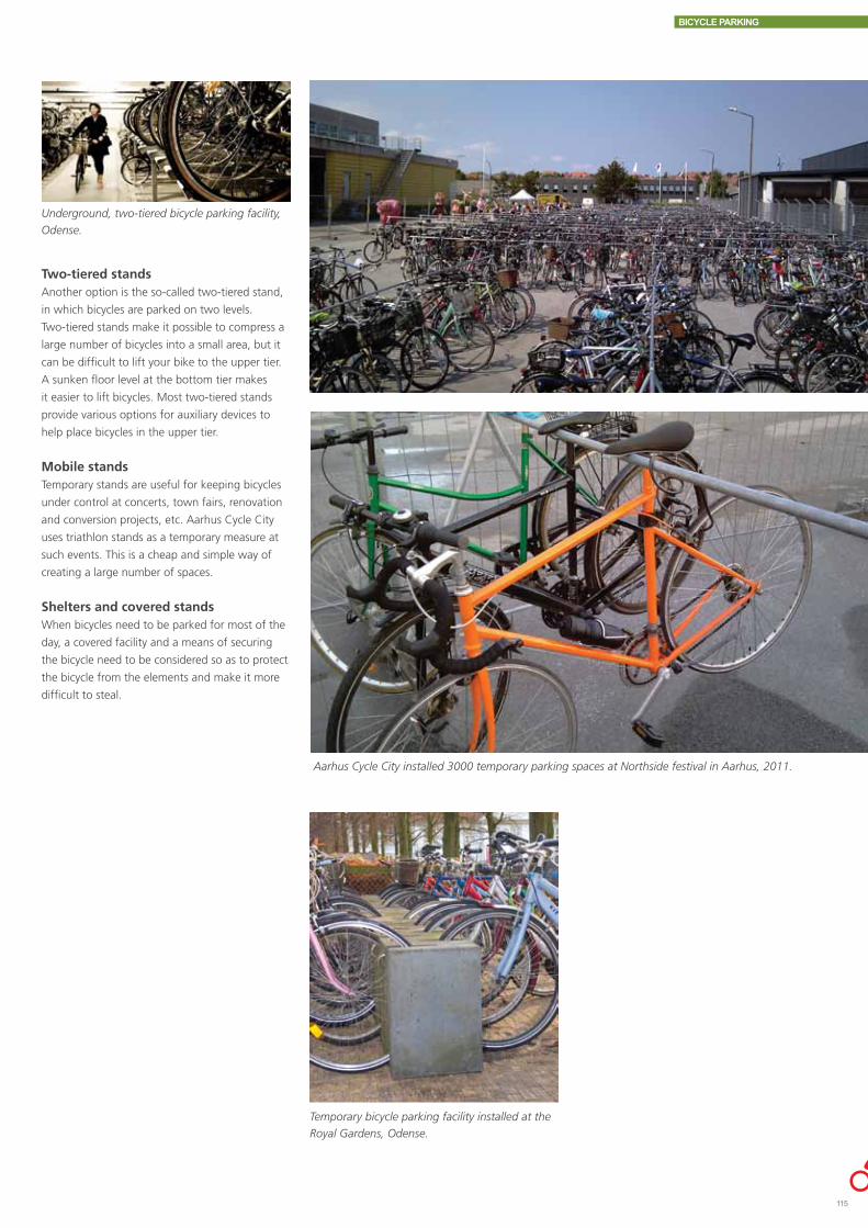
Two-tiered standsAnother option is the so-called two-tiered stand,
in which bicycles are parked on two levels.
Two-tiered stands make it possible to compress a
large number of bicycles into a small area, but it
can be difficult to lift your bike to the upper tier.
A sunken floor level at the bottom tier makes
it easier to lift bicycles. Most two-tiered stands
provide various options for auxiliary devices to
help place bicycles in the upper tier.
Mobile standsTemporary stands are useful for keeping bicycles
under control at concerts, town fairs, renovation
and conversion projects, etc. Aarhus Cycle City
uses triathlon stands as a temporary measure at
such events. This is a cheap and simple way of
creating a large number of spaces.
Shelters and covered standsWhen bicycles need to be parked for most of the
day, a covered facility and a means of securing
the bicycle need to be considered so as to protect
the bicycle from the elements and make it more
difficult to steal.
Underground, two-tiered bicycle parking facility,
Odense.
Aarhus Cycle City installed 3000 temporary parking spaces at Northside festival in Aarhus, 2011.
Temporary bicycle parking facility installed at the
Royal Gardens, Odense.
BICYCLE PARKING
115

A covered facility at stations, educational and
cultural institutions, workplaces, etc. is a clear
signal that cyclists are welcome and that their
choice to cycle rather than drive is important.
Covered bicycle parking facility at railway station
Covered bicycle parking facility at Kinopladsen, Odense, at night.
Covered bicycle parking facility at block of flats
BICYCLE PARKING

Lockable parkingAt locations where bicycles need to be parked all
night or locked for several days at a time, covered
parking facilities should be provided, preferably
indoors. This creates a sense of security in relation
to bicycle theft. However it is crucial to ensure
that the bicycle parking facility is safe at night or
in the evening.
Lockable bicycle parking facility, Randers. Solar cells on the roof power LED lighting in the facility.
If there is not adequate space for a lockable
bicycle parking facility above ground it can be
established underground. In this automated
Spanish facility, 92 bicycles can be parked
underground. The system protects the bicycles
from the elements and from theft, and there is
also space for the cyclist’s luggage.
The City of Aarhus has established a Park and
Bike facility at Egå Engsø in northern Aarhus. It
primarily targets automobile commuters who
wish to take the last section into central Aarhus
by bike rather than be stuck in traffic on the way
to work. In addition to 100 bicycle parking spaces
it provides water, a bicycle pump, and an area for
bicycle repairs.
BICYCLE PARKING
117

New solutionsNewtypesofstandsandsolutionsareconstantly
being developed. So check out the market and
discuss with colleagues in other communities
what works best.
A Dutch stand. The bicycle is secured by the
pedal.
In Aalborg bicycles are hung on the rack in an
attempt to better utilize urban space.
There is a fight for urban space. In Seoul, Korea, building gables are utilized for bicycle parking.
Another good idea is to have different users test
out a prototype or specimen before installing
the entire system. This makes it possible to test
the solution in practice and assess it in terms of
space, accessibility, etc.
In Copenhagen 25% of all families with 2 or more children have a cargo bike, which requires a great
deal of space when parked. The City of Copenhagen has consequently installed several brightly
coloured bicycle parking facilities for carrier bikes, at the same time demonstrating that where there
was only room for one passenger car before, there is now room for 4 cargo bikes.
It has not yet been established whether the
most user-friendly means of securing the bicycle
is by the wheel, the saddle, the frame or the
handlebars.
BICYCLE PARKING

PricesThere are many suppliers and all kinds of different
models and qualities are available. The Bicycle
Parking Manual published by the Danish Cyclists’
Federation assesses a number of the stands and
racks on the market.
One bicycle space costs approx. DKK 1,000 per
butterfly rack, approx. DKK 2,000 per hoop rack,
approx. DKK 5,000 per covered space.
SECURITY AND SAFETYAs mentioned above, the cyclist’s security is
important in a parking situation since the cyclist
is much more vulnerable to attack than on the
journey itself. This means that the facility should
be well lit and easily visible to passersby and
others in the area, in taxis, shops, etc. Bicycle
parking facilities should therefore be placed
where people pass by naturally.
An underground parking facility or any other
lockable facility should be easily viewed in its
entirety, have several entrances and exits, and the
area to be walked should be short. In addition
it can be monitored by either manned or video
surveillance.
OPERATION AND MAINTENANCEIt is crucial to factor operation and maintenance
into bicycle parking plans from the outset. A
bicycle parking facility has to last for many years
and should not only look good when new but
also many years later. For example, finish and
paint peel off when they come in contact with
bicycle frames or wheels. In addition facilities
should not become run down because of lack
of cleaning and sweeping, or because of graffiti
and abandoned bicycles. Attention should also
be paid to the appearance of the design and
materials when the facility is empty.
Clearing up As mentioned at the start of this section it is not
legal to remove bicycles in Denmark, not even
if they get in the way and are very likely lost
property.
If bicycles are to be removed the bicycle’s owner
must be so advised. Many local authorities do this
by tagging bicycles, stating that the bicycle will
be removed at a given date 4 -5 weeks later if the
tag is not removed.
According to the lost property act section 4
anyone who removes a bicycle after tagging must
keep the removed bicycle for 3 months after
which the bicycle is to be sold at auction unless
it is obviously worth nothing. The auction is held
so as to be able to prove that the bicycle was
sold at the highest price in case the owner turns
up. Another option is simply to clear up regularly,
moving bicycles out of the way.
Aarhus Cycle City hired two so-called bicycle
parking inspectors in 2010. Their job was to raise
overturned bicycles and move bicycles blocking
the way for pedestrians.
Copenhagen has a similar system called “bicycle
butlers”. In addition to tidying up they service
bicycles with air and lubrication. Citizens have
reacted very positively.
It can be difficult to get rid of your old bike if
you live in a city and don’t have a car. This means
that many old bicycles are abandoned because
owners don’t know how to get rid of them. The
local authority can establish a scrapping system
by which you receive DKK 100 for handing in an
old, worn-out bicycle. The bicycles can then be
donated to organizations that repair them and
send them to developing countries.
Bicycle tag, Odense
The area in front of Aarhus railway station before
and after the bicycle parking inspector’s visit.
Bicycle butler at work, Copenhagen.
BICYCLE PARKING
119

SPOIL THE CYCLISTSBicycle parking is not the only way to spoil
cyclists; they can be spoiled with extra service
facilities to show them that their choice of
cycling as a transport mode is important. Many
communities in Denmark have installed various
types of bicycle pumps (with or without a
compressor), drinking water, and mini bike
workshops.
In addition to such services as air and water,
some authorities have made cycling easier and
more fun by installing angled rubbish containers
and foot rests at intersections.
BICYCLE PARKING PLAN A bicycle parking plan is a really good investment,
or at least make a map of existing bicycle parking
facilities and an analysis of future demand within
central sections of the municipal area.
Overall goals, guide lines, design formats, etc.
for future investments and projects can be
established on the basis of mapping.
Get different stakeholders and users actively
involved in municipal bicycle parking planning.
Arrange meetings to promote the exchange of
ideas, innovation, cross collaboration between
the different authorities, administrations,
institutions, and stakeholders.
It is absolutely mandatory to factor bicycle
parking into all building and construction
projects, physically, functionally and economically.
Norms,standards,buildingregulations,local
plans, etc. should be focus areas.
Today’s Danish building regulations do not specify
parking norms for automobiles and bicycles;
there is a clear tendency to use the old rules for
automobile parking because there is uncertainty
as to the alternative.
CHECK LISTThe following box shows a check list for
establishing attractive bicycle parking facilities.
The check list is based on studies and experience,
and is ordered according to the cyclists’ own
prioritization of their needs and wishes.
Notallbicycleparkingfacilitiesneedtomeetall
the requirements but it is a good idea to take all
points into account so as to have an adequate
planning basis.
The concept “easy to find” is particularly
important. It is crucial that the bicycle parking
facility is visible to cyclists from a distance. It’s a
myth that cyclists want to be able to bike directly
to the entrance. What they want is to be able
Bicycle pump, Aalborg
Bicycle pump, Fisketorvet, Odense
The city of Copenhagen makes it easier for cyclists to hit the rubbish bin by placing it at an
angle.
Cyclist footrest, Copenhagen.
GOOD BICYCLE PARKING FACILITIES MUST:•Beveryclosetothedestination•Haveanadequatenumberofspaces•Beeasytouse•Besafeandeasilyviewedinthe
entirety•Beeasytofindandvisibleatadistance•Besafeandsecurewhenenteringand
leaving•Bedesignedtosupportthebicycle
without damaging it•Belocked,orenablethebicycletobe
locked•Beattractive,fitinwiththe
surroundings and preferably enhance the local environment
•Protectthebicycle,particularlythesaddle, from rain and snow
•Besolidandsturdyaswellasmaintenance and cleaning friendly
to bike directly to the bicycle parking facility and
preferably into it. If the facility is visible from a
distance, cyclists will head for it, park there and
continueontheirway–butonlyifit’splaced
right!
BICYCLE PARKING

BICYCLE SERVICEIn Denmark during and after the Second World
War, bicycle surveillance at railway stations was
common, and the local bicycle repair shop was
frequently located next to the station. The local
bicycle repairman kept an eye on the bicycles and
provided service and repairs while people were
at work.
There are not many such bicycle centres left
in Denmark today, but there are more than a
hundred in Holland.
It should be possible to provide bicycle
surveillance and repairs today by rethinking and
coordinating bicycle parking with other functions,
such as ticket sales, bike shops, cafés, kiosks,
take aways, shops and car parks, etc. In Germany
“bicycle stations” are being tried out: manned
cycle centres at formerly unmanned stations as an
employment project.
Bicycle service could be coupled with a commuter
pass or the like at stations with locked bicycle
parking facilities.
In several cities one-man businesses have
specialized in mobile bicycle service, setting
up shop at large companies, on squares, at
Bicycle parking garage with indoor and outdoor parking and bike shop, Næstved.
supermarkets, etc. and servicing bicycles while
the cyclists are at work or doing other business.
BETTERCOORDINATIONWITHPUBLIC TRANSPORTIf cycling is to be encouraged it must be easily
combined with public transport. Bicycles, buses
and trains go hand in hand, partly because public
transport enables cyclists to travel over greater
distances.
The Danish Transport Authority published
a collection of ideas in 2009, Bedre samspil
mellem cyklen og den kollektive trafik, (Better
integration of cycling and public transport) based
on a number of focus group interviews with
railway commuters from major Danish cities.
The commuters would like:
• Morestandsclosetothestation
• Highqualitystands
• Widerintervalbetweenparkingspaces
• Coveredspaces
• Lockingfacilities
• Clearerlayout
In 2009 DSB (Danish State Railways) and
the Danish Government earmarked DKK 1
billion for better parking facilities at stations,
including bicycle parking. It is thereby possible
for a municipality to enter into a collaborative
agreement with DSB to establish more bicycle
parking spaces at stations.
Railway station, Aarhus.
You can park your bike indoors at Schiedam station, Amsterdam, with or without surveillance and
repairs
BICYCLE PARKING
121

RECREATIONAL BICYCLE PARKINGNotonlydailycyclistsneedtoparktheirbicycles;
many people take out their bikes on weekends or
holidays and use them as a recreational transport
mode.
Bicycle parking should be factored in at
recreational destinations such as beaches,
museums, etc. where cyclists need a safe place
to park their bicycles, preferably with luggage
facilities.
Innovative thinking is in order here so as to
coordinate parking solutions with other options,
e.g. a port facility that includes bicycle parking,
toilets, and showers, or a parking garage for
bicycles close to the tourist office.
FUNDINGA clear division of responsibilities must be
established between the State, the municipality,
the transport services organization, and the
private sector when it comes to bicycle parking
funding, and project managers and coordinators
within the individual organizations must be
clearly identified. In addition, different funding
options should be considered.
Bicycle parking fundsCurrently in Denmark car parking funds may
not be legally used to expand bicycle parking
facilities.Normaybicycleparkingfundsbe
established (since bicycle parking does not rank
alongside car parking inasmuch as bicycle parking
occurs in the immediate vicinity of the main
door).Newconstructionshouldincludebicycle
parking facilities from the outset and it should
not be possible to circumvent this by paying into
a parking fund.
State fundingPublic and private stakeholders may apply for
co-financing of bicycle parking facilities to the
Danish Road Directorate’s cycling promotion fund
which is available through 2013 at the time of
writing.
The State and DSB have allocated funds to boost
bicycle parking at railway stations (the DSB
parking fund). Local authorities may enter into
collaboration with DSB to improve and expand
bicycle parking facilities at local stations.
Funding through advertisingStreet furniture funded by advertising is
becoming increasingly popular in many
communities. This may be an option for funding
bicycle parking facilities.
Another option is to motivate businesses,
institutions, shops, trade associations, cultural
and entertainment venues, transport services
organizations, etc. to sponsor bicycle parking
facilities. The sponsorship may include advertising
at different events.
Bicycle parked at Åen canal, Aarhus.
User chargesBicycle parking in Denmark is traditionally free.
However at locked bicycle parking facilities, for
example at stations, users often pay a small
annual fee for a key or a key card to the facility.
The price varies from almost free of charge to
DKK 300 annually. The most common price is
between DKK 100-200 annually for outdoor,
locked, covered or underground bicycle parking.
Stands are available on the international market
that also serve as parking meters. Coin or card
payment releases a device to lock the bicycle to
the stand. The stands may be installed individually
onpavementsorsquares.Nonehaveyetbeen
installed in Denmark.
It is important to establish bicycle parking
facilities at recreational destinations.
Bicycle parking can be indicated in many different ways. (The sign reads: “Parking reserved for bread
powered vehicles.”)
BICYCLE PARKING

11
Contents
Signage 124Cycle maps 126Cycle route planners 128ITS – Intelligent Transport Solutions 131
Signage and information are an essential element of the
concept offered to cyclists. Infrastructure, signage and
information should be planned and implemented as an
integrated whole.
Cycle route maps, in addition to providing an excellent
overview of cycling options, highlight the municipality’s efforts
to promote cycling. This also applies to cycle route planners
on the internet, which is the newest way of helping cyclists
find their way. On-line cycle route planners are developing by
leaps and bounds, and more products are expected to be put
on the market. Cyclists themselves can even help develop some
of them.
ITS, Intelligent Transport Solutions, provides new options for
improving cycling facilities. This field is undergoing rapid
development as well.
ROAD SIGNAGE, MAPS, CYCLE ROUTE PLANNERS, AND ITS

ROAD SIGNAGE, MAPS, CYCLE ROUTE PLANNERS, AND ITS
SIGNAGECycle signposts are the connecting link between
segregated off-road cycle tracks, paths along
roads, minor municipal roads, wooded roads, etc.
Routes that consist of many different elements
should be signposted as a continuous route by
uniform signposting. Cycle signposts should
provide the same high level of service as road
signs. Cycle signage should be clear, fit in with
the surroundings, and be easily distinguishable
from road signs so that there can be no doubt as
to the targeted road user.
The latest version of the Danish road standards
for “signage on cycling, equestrian and hiking
routes” and the accompanying government
directive 11.1 covers signage for pedestrians and
horse riders as well as cyclists. The rules define
terminology, lay down principles for signage
design, and formulate requirements to the
national cycle routes. The procedures for route
modification are also described. A number of the
regulations laid down in the road standards are
codes of practice, such as types of signage, cycle
symbols and colours.
Signposting cycle routesThe road standards’ signage regulations make it
possible to develop local, regional and national
cycle routes. Today there are several thousand
kilometers of signposted cycle routes in Denmark.
The road standards divide cycle routes into 3
categories by number:
• Nationalroutes1-15.Whitenumberonred
field with white border (the national colours).
• Regionalroutes16-99.Whitenumberonblue
background with white border.
• Localroutes100-999.Whitenumber/name/
logo on blue background with white border.
In addition there are:
• Europeanroutes.Maybemarkedbyasign
placed under the national route sign.
ThetwoEuropeancycleroutesinDenmarkare
part of a comprehensive network developed by
theEuropeanCyclists’Federation. 11.2
Danish cycle route numbers may be
supplementedbyaname.Forlocalroutesjustthe
name is enough, or even a logo (for example a
pigindicatesthe“Pigroute”).Logoshavetobe
approvedbytheDanishRoadDirectorate.Local
routes in city centres are often called “commuter
route” or “centre route”.
Standard road standard signage in the field.
Danish signage has been inspirational for signage standards in other European countries, as here in
Lithuania.

ROAD SIGNAGE, MAPS, CYCLE ROUTE PLANNERS, AND ITS
A cycle route is identified by a cycle symbol and
aroutenumber/name/logo.Arrowsandthelike
may not be placed within the border. The route
identification is used consistently on all types of
signs, including directional signs.
Directions are given to far-off as well as near-by
destinations.Examplesoffar-offdestinationsare
markettowns,majorcities,ferrysites,andpoints
ofsupporttoout-dooractivities.Examplesof
near-by destinations are minor towns, villages,
urban neighbourhoods, woods, lakes, beaches,
and points of local interest.
The most frequently used signpost is the cycle
routesignwhichisusuallysquare,40X40,30X30,
20X20cmdownto10x10cm,inwoodedareas,
for example. The signpost is used to confirm that
the cyclist is on the right route, and in minor
intersections where the sign may be placed
a short way down the right road. An arrow
may be added under the sign, and geographic
destinations and distances may be indicated on a
separate sign under the cycle route sign.
The directional arrow sign is the simplest type of
sign,andisusedinmajorintersectionsandwhen
the route changes direction and it’s necessary to
indicate several geographic destinations. Tabular
signs and diagram signs are used for more
complicated situations.
Special service signs are only used when cyclists
use other routes than cars. Service signs for
cyclists have hitherto not been in extensive use,
apart from campsite signs for non-motorized
road users.
The road standards require that signs should be
placed on signposts or hangars. In cities the sign
may have special shapes, such as bollards.
Sign size and placement The consistent use of the colour blue accustoms
cyclists to the fact that a blue sign means cyclist
information. Information is more easily grasped
when signs are consistently placed on the same
side of the road and at the same height. This
makes it possible to minimize the sign’s size while
ensuring that it is easily seen by cyclists.
Since most cyclists sit in a bent forward position
with their eyes on the ground ahead the signs
should be placed low. On the other hand they
shouldn’t be so low that they can be covered by
grass or other plants in the summer or snow in
the winter. Cycle signs are best placed on the
right side of the road at a height of approx. 1 m.
The size of the sign should be based on the speed
of the cyclist and the amount of information on
the sign. Reading distances and the height of
uppercase letters have been tested in practice.
Campsite signs are the most frequently used
service sign.
125

ROAD SIGNAGE, MAPS, CYCLE ROUTE PLANNERS, AND ITS
The choice of sign and its design are further
described in the road signage standards 11.1.
Courses in cycle route signage are regularely
offered in Denmark.
Special urban signageSignposts and hangars are not appropriate in
cities. Consequently, modified bollards may
be used without special dispensation from the
Danish Road Directorate. Copenhagen 11.3 and
Odense have developed their own designs in
collaborationwiththeRoadDirectorate.Most
recently Aarhus introduced new signsposts 11.4.
The basic principles and the choice of colour
and pictograms for the new urban signs remain
unchanged, however.
It can be difficult to signpost cycle routes
through narrow, winding streets in city centres.
Pictograms may be used in cyclist circulation
areas but not in mixed traffic lanes. In practice, it
appears that cyclists have difficulty understanding
pictograms, for example on a ring route around
thecitycentre.Furthermoremaintainingthe
signage over a period of years can prove difficult.
The city of Copenhagen developed a special sign system consisting of posts and bollards to signpost
green cycle routes 11.3.
New cycle route signpost in Aarhus 11.4.
OdensefollowedbyAarhusin2011changedthe
signage to arrow signs on signposts along routes
in the city centre 11.5.
CYCLE MAPS Publication of cycle maps should be an integral
part of any municipal strategy to boost cycling.
In fact many local authorities do this more or less
regularly.Experienceshowsthatthereisahuge
user demand for cycle maps. Cycle maps help
highlight municipal cycling initiatives.
Whencommunicatingcyclerouteinformationit
is important to bear in mind the different types
of users (holiday cyclists, Sunday cyclists, and
daily cyclists including commuters) and their
different needs. All groups can use cycle route
maps to plan their route and to find their way.
Sunday cyclists and holiday cyclists, in addition
to information on cycle tracks, routes, etc., need
a certain amount of practical information on
services such as accommodation, restaurants,
shopping and bicycle repairs. A cycle map also
helpstouristsrecallthejourneylater.
Odense 11.6 and Roskilde distribute their cycle
maps door-to-door, and Copenhagen sent its
pocketcycleroutemapto5,000newlyarrived
citizensin2011asapilotproject11.7.Many
local Danish authorities publish updated cycle
maps on a regular basis. They are generally free
of charge.
TheDanishCyclists’Federationpublishes
a nation-wide series of guidebooks with
accompanyingmapsonascaleof1:10,000.
11.8 In addition, the Danish Road Directorate’s
digital maps of the national cycle routes are
available online 11.9. Guidebooks are available
for some of the national cycle routes (published
by an Austrian publisher, available in Danish and
German) with maps 11.10. In some tourist areas
(forexamplenorthernFunenandLangeland)
local cycle maps are available on a scale of
1:50,000,showinglocalroutesandsuggestions
forcircularjourneysinadditiontothesignposted
national and regional cycle routes. Such maps are
also highly popular among the local population.
1:50,000isanexcellentscaleforamapcovering
an average Danish municipality. A city map
shouldbemoredetailed,forexample1:25,000
oreven1:10,000inthecitycentre.Themap
Cycle route
Logo
Route plan
Route map
Area specific
information
Base
Cycle route
Far-off and
near-by
destinations
Base
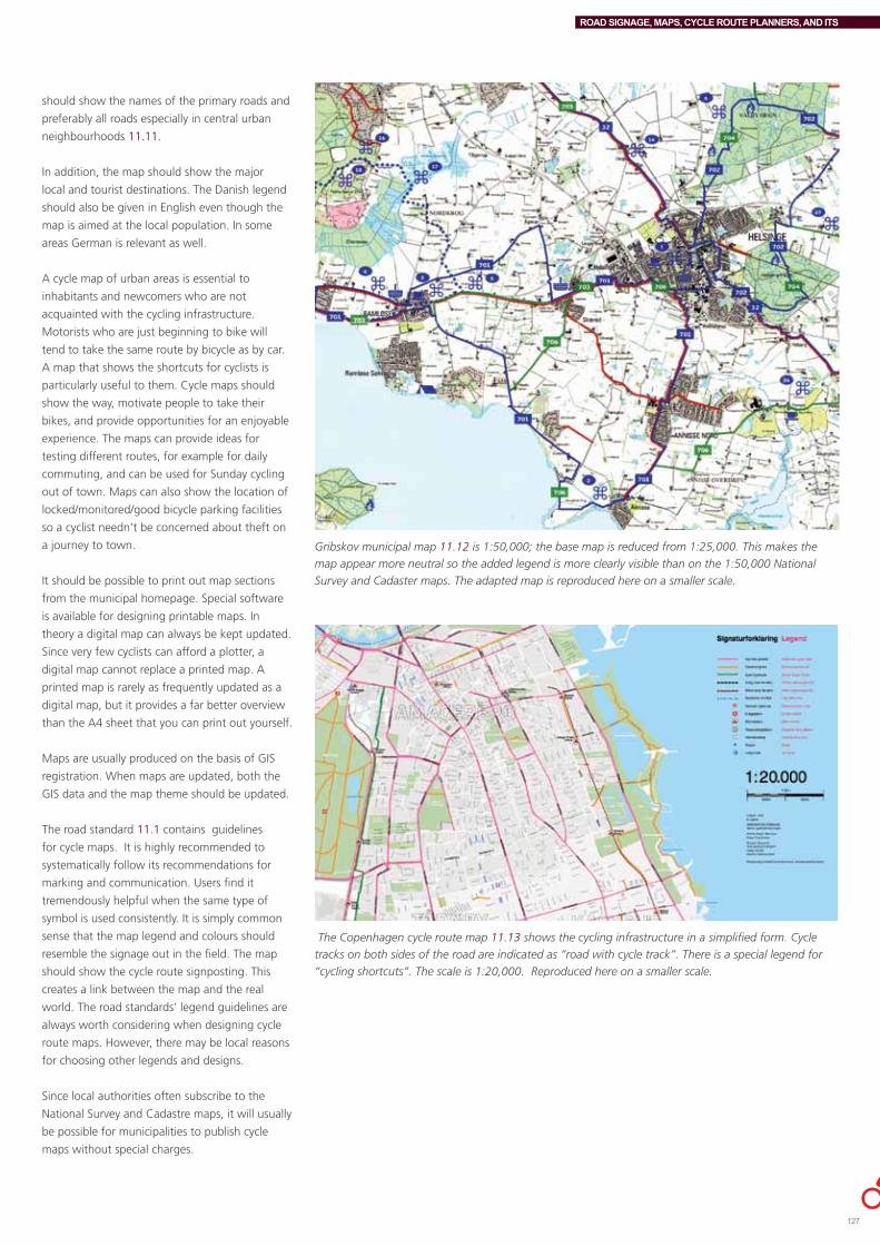
ROAD SIGNAGE, MAPS, CYCLE ROUTE PLANNERS, AND ITS
should show the names of the primary roads and
preferably all roads especially in central urban
neighbourhoods 11.11.
Inaddition,themapshouldshowthemajor
local and tourist destinations. The Danish legend
shouldalsobegiveninEnglisheventhoughthe
map is aimed at the local population. In some
areas German is relevant as well.
A cycle map of urban areas is essential to
inhabitants and newcomers who are not
acquainted with the cycling infrastructure.
Motoristswhoarejustbeginningtobikewill
tend to take the same route by bicycle as by car.
A map that shows the shortcuts for cyclists is
particularly useful to them. Cycle maps should
show the way, motivate people to take their
bikes,andprovideopportunitiesforanenjoyable
experience. The maps can provide ideas for
testing different routes, for example for daily
commuting, and can be used for Sunday cycling
outoftown.Mapscanalsoshowthelocationof
locked/monitored/goodbicycleparkingfacilities
so a cyclist needn’t be concerned about theft on
ajourneytotown.
It should be possible to print out map sections
from the municipal homepage. Special software
is available for designing printable maps. In
theory a digital map can always be kept updated.
Since very few cyclists can afford a plotter, a
digital map cannot replace a printed map. A
printed map is rarely as frequently updated as a
digital map, but it provides a far better overview
than the A4 sheet that you can print out yourself.
MapsareusuallyproducedonthebasisofGIS
registration.Whenmapsareupdated,boththe
GIS data and the map theme should be updated.
The road standard 11.1 contains guidelines
for cycle maps. It is highly recommended to
systematically follow its recommendations for
marking and communication. Users find it
tremendously helpful when the same type of
symbol is used consistently. It is simply common
sense that the map legend and colours should
resemble the signage out in the field. The map
should show the cycle route signposting. This
creates a link between the map and the real
world. The road standards’ legend guidelines are
always worth considering when designing cycle
route maps. However, there may be local reasons
for choosing other legends and designs.
Since local authorities often subscribe to the
NationalSurveyandCadastremaps,itwillusually
be possible for municipalities to publish cycle
maps without special charges.
Gribskov municipal map 11.12 is 1:50,000; the base map is reduced from 1:25,000. This makes the
map appear more neutral so the added legend is more clearly visible than on the 1:50,000 National
Survey and Cadaster maps. The adapted map is reproduced here on a smaller scale.
The Copenhagen cycle route map 11.13 shows the cycling infrastructure in a simplified form. Cycle
tracks on both sides of the road are indicated as “road with cycle track”. There is a special legend for
“cycling shortcuts”. The scale is 1:20,000. Reproduced here on a smaller scale.
127

ROAD SIGNAGE, MAPS, CYCLE ROUTE PLANNERS, AND ITS
CYCLE ROUTE PLANNERSThe internet, cell phones, smart phones, and
GPS devices (and doubtless future technologies
as well) are new options for providing cyclists
with information on choice of route, points of
interest, etc. Cycle route planners are also known
asjourneyplannersortripplanners.Theyare
developed for several different platforms, not
merely the internet, but also smart phones, for
example, to accommodate different user groups
and generations of cyclists.
Cycle route planners can simplify cycling, making
it more accessible to daily cyclists and tourists.
They raise the status of cycling and in the long
run may even encourage more people to cycle
if continuous cycling routes are integrated with
public transport.
Odense has offered cyclists an on-line cycle
route planner for several years. It shows the
shortest and safest route and includes many
fixed destinations. Aalborg has a similar, first
generation cycle route planner 11.15 with a good
route calculator. However, it is being shut down
(at the time of writing) since the graphics and
flexibility are not up to current standards. The
firm which developed the cycle route planner
updated the cycling infrastructure on a regular
basis for a fee.
In2011Fredericiabeganofferingacycleroute
planner which updates automatically, based on
GoogleMaps.11.16
Some cheap versions of cycle route planners
are also available on-line in Denmark. They are
usuallybasedonamotorvehiclejourneyplanner;
motorways are merely deactivated and motorway
cycle tracks are not shown, rendering them
rather useless.
Developing cycle route plannersWhenalocalauthoritywishestoofferacycle
route planner, the available products and their
function should be carefully considered. Several
consultancies would like to enter the cycle route
planner market, but are not usually able to
provide the full package.
Since the field is undergoing rapid development it
is worth considering the free cycle route planners
that are expected to be put online (Google,
Naviki,etc.)asanalternativetothemore
traditional planners.
Albertslund cycle
route planner for
cell phones uses
Android. 11.14
Aalborg cycle route planner, now
outdated.11.15
Fredericia’s newly developed cycle route planner, 2011. 11.16

ROAD SIGNAGE, MAPS, CYCLE ROUTE PLANNERS, AND ITS
TIPS ON CYCLE ROUTE PLANNERSWhen you’re choosing a cycle route planner, or if you wish to develop one yourself, the focus is often on the user interface. However, it is essential to consider cycling infrastructure data, route calculations, operations as well as user interface.
Gathering infrastructure dataIt is crucial that cycling infrastructure information is correct from the outset. Basic data on the cycling infrastructure should be collected or developed by the individual municipality. At best, existing GIS data can be updated. Road authority systems in Denmark can also contain cycling infrastructure data. Extra knowledge gathered from users in OpenStreetMap can be used as a quality control. There should always be a control procedure to make sure the geometry fits, including the link to neighbouring communities across the municipal boundary.
Types of cycling infrastructureThe cycling infrastructure includes cycle tracks, cycle lanes, mixed traffic, contra-flow cycling and segregated off-road cycle paths. Signposted routes (e.g. the national cycle routes) consist of different kinds of infrastructure, but a cycle route planner should be able to process them as a continuous route as well as by their individual elements; a continuous route is of great value to cyclists. Whenever cycling infrastructure data is updated this should be done in GIS and the cycle route planner at the same time.
Road dataFOT, (Standardized Danish mapping - National Survey and Cadastre) 11.17, and Det Digitale Vejnet 11.18 (the digitization of the Danish road network is in its initial phase in 2011) are initiatives to standardize geodata across the country and to provide continuity and standardization of Danish road data. In the long run they may also help standardize cycling infrastructure registration and classification as well. However, the project’s initial focus is the overall road network; independent cycle tracks, etc. will not be addressed until later, so there is a long way to go before the data can be imported by cycle route planners. At the time of writing the local authorities can’t wait for a “state-of-the-art” data base to be implemented before they can start developing cycle route planners.
Who owns the data and what does it cost?The question of who owns the bicycle theme data (and the cycle route planner, for that matter) is important, as is the question of what it costs to develop and establish a data processing system. Who owns the base map, and should there be a charge for using it? Can free open source maps be used, or the municipal map, or should the National Survey and Cadastre maps be used free of charge, since the local authorities usually subscribe to them? Users should be able to print out maps free of charge without having to worry about rights.
Route calculationWell-functioning route planning software is already available on the market. Some is commercial, others open source. It’s a good
idea to grant user access to the server hosting the software since this makes it easier for other stakeholders to develop applications.
Users should be able to correct dataUsers of the cycle route planner should be able to correct the product, and there should be a procedure for this. This is already an integral part of OpenStreetMap. Correction procedures should be integrated with municipal “bicycleGIS”). A cycle route planner must be dependable, credible (i.e. include short cuts), and updated. User feedback should be addressed quickly so users can see they are taken seriously. The route planner should be stable and fast.
Text and base mapPreliminary versions of the cycle route planner should be tested in a testing phase; it should be made clear that this is not the finished product. The design and function of the interface display on the monitor should be carefully considered. The cycle route planner may be based on one or more base maps depending on the zoom angle. This makes it possible to increase the level of detail while zooming in; perhaps the municipal map should be used as the base map for the most detailed view.
Getting from point A to point BIt should be possible to select and enter a starting point, a destination and via points. The result of the search should be made visible as a line on the map, and it should be possible to display distance (preferably in times and km). A route description is desirable too.
Best routeIn addition to the shortest or the fastest route, there should be an alternative suggestion, such as “best route”. The best route can focus on sections with cycle tracks, signposted cycle routes, etc. even when this involves a (minor) detour. It is too risky for a public authority to propose a “safest route”. Many conditions might be of interest, such as cycling weather. Other real time information, such as current air pollution, may turn out to be extremely time consuming to install and maintain.
Service information Supplementary functions can be added to the cycle route planner for daily use in town (e.g. restaurants or cinemas) and for recreational use on Sundays (e.g. tourist information.)
Integrating cycling and public transportIdeally, it should be possible to integrate a cycle journey with public transport based on the principle of seamless travel, which for cyclists often involves combined journeys.
Never underestimate operationsOperation of the cycle journey planner is crucial. Who is responsible for updating information and what does it cost on an annual basis? As a rule municipalities will not enter into financial obligations for more than one fiscal year at a time, which makes it difficult to develop products in collaboration with neighbouring communities.
11.19,11.20
129
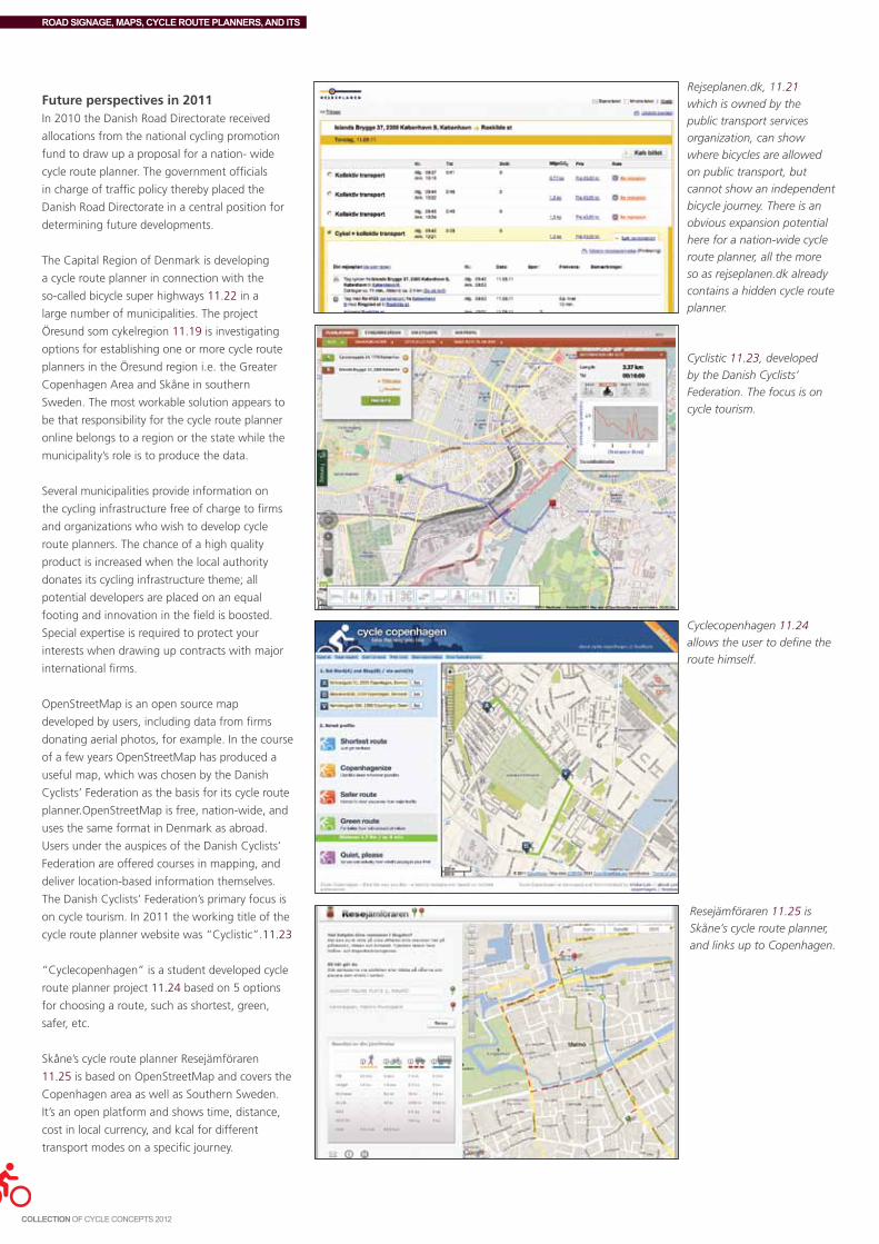
ROAD SIGNAGE, MAPS, CYCLE ROUTE PLANNERS, AND ITS
Future perspectives in 2011In2010theDanishRoadDirectoratereceived
allocations from the national cycling promotion
fund to draw up a proposal for a nation- wide
cycle route planner. The government officials
in charge of traffic policy thereby placed the
Danish Road Directorate in a central position for
determining future developments.
The Capital Region of Denmark is developing
a cycle route planner in connection with the
so-called bicycle super highways 11.22 in a
largenumberofmunicipalities.Theproject
Öresund som cykelregion 11.19 is investigating
options for establishing one or more cycle route
planners in the Öresund region i.e. the Greater
Copenhagen Area and Skåne in southern
Sweden. The most workable solution appears to
be that responsibility for the cycle route planner
online belongs to a region or the state while the
municipality’s role is to produce the data.
Several municipalities provide information on
the cycling infrastructure free of charge to firms
and organizations who wish to develop cycle
route planners. The chance of a high quality
product is increased when the local authority
donatesitscyclinginfrastructuretheme;all
potential developers are placed on an equal
footing and innovation in the field is boosted.
Special expertise is required to protect your
interestswhendrawingupcontractswithmajor
international firms.
OpenStreetMapisanopensourcemap
developed by users, including data from firms
donating aerial photos, for example. In the course
ofafewyearsOpenStreetMaphasproduceda
useful map, which was chosen by the Danish
Cyclists’Federationasthebasisforitscycleroute
planner.OpenStreetMapisfree,nation-wide,and
uses the same format in Denmark as abroad.
Users under the auspices of the Danish Cyclists’
Federationareofferedcoursesinmapping,and
deliver location-based information themselves.
TheDanishCyclists’Federation’sprimaryfocusis
oncycletourism.In2011theworkingtitleofthe
cycle route planner website was “Cyclistic”.11.23
“Cyclecopenhagen” is a student developed cycle
routeplannerproject11.24basedon5options
for choosing a route, such as shortest, green,
safer, etc.
Skåne’scyclerouteplannerResejämföraren
11.25isbasedonOpenStreetMapandcoversthe
Copenhagen area as well as Southern Sweden.
It’s an open platform and shows time, distance,
cost in local currency, and kcal for different
transportmodesonaspecificjourney.
Rejseplanen.dk, 11.21
which is owned by the
public transport services
organization, can show
where bicycles are allowed
on public transport, but
cannot show an independent
bicycle journey. There is an
obvious expansion potential
here for a nation-wide cycle
route planner, all the more
so as rejseplanen.dk already
contains a hidden cycle route
planner.
Cyclistic 11.23, developed
by the Danish Cyclists’
Federation. The focus is on
cycle tourism.
Cyclecopenhagen 11.24
allows the user to define the
route himself.
Resejämföraren 11.25 is
Skåne’s cycle route planner,
and links up to Copenhagen.
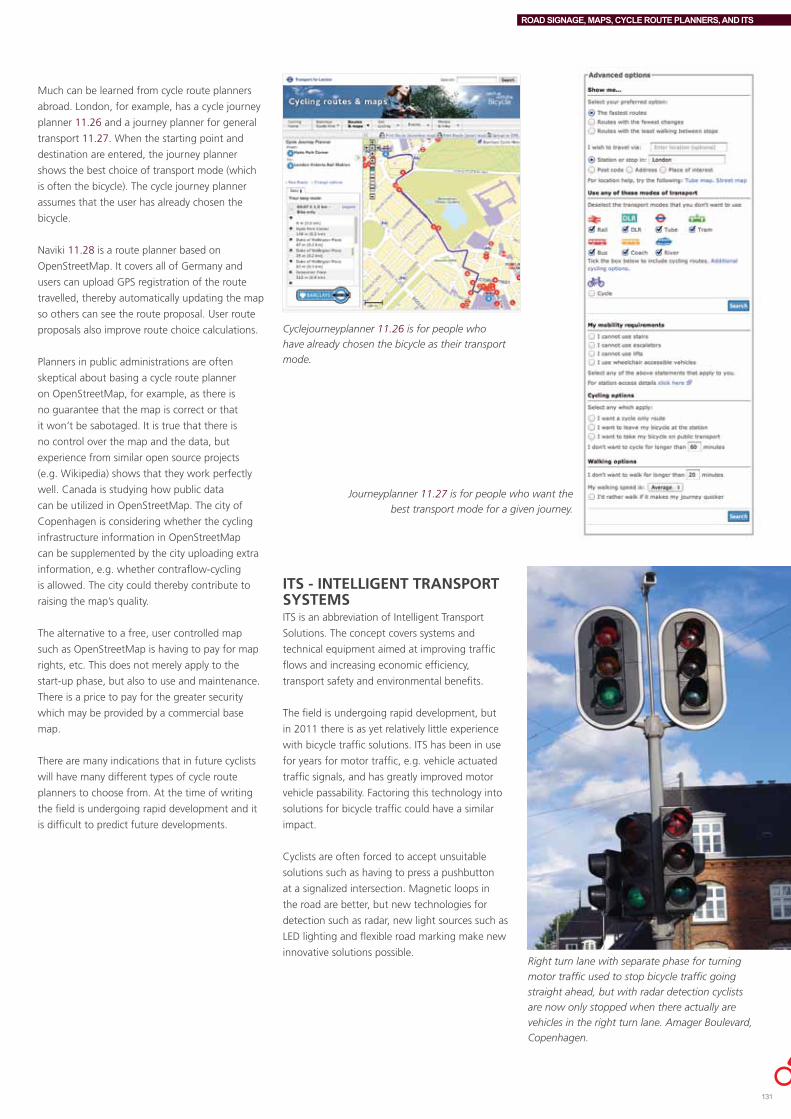
ROAD SIGNAGE, MAPS, CYCLE ROUTE PLANNERS, AND ITS
Muchcanbelearnedfromcyclerouteplanners
abroad.London,forexample,hasacyclejourney
planner 11.26andajourneyplannerforgeneral
transport 11.27.Whenthestartingpointand
destinationareentered,thejourneyplanner
shows the best choice of transport mode (which
isoftenthebicycle).Thecyclejourneyplanner
assumes that the user has already chosen the
bicycle.
Naviki11.28 is a route planner based on
OpenStreetMap.ItcoversallofGermanyand
users can upload GPS registration of the route
travelled, thereby automatically updating the map
so others can see the route proposal. User route
proposals also improve route choice calculations.
Planners in public administrations are often
skeptical about basing a cycle route planner
onOpenStreetMap,forexample,asthereis
no guarantee that the map is correct or that
it won’t be sabotaged. It is true that there is
no control over the map and the data, but
experiencefromsimilaropensourceprojects
(e.g.Wikipedia)showsthattheyworkperfectly
well. Canada is studying how public data
canbeutilizedinOpenStreetMap.Thecityof
Copenhagen is considering whether the cycling
infrastructureinformationinOpenStreetMap
can be supplemented by the city uploading extra
information, e.g. whether contraflow-cycling
is allowed. The city could thereby contribute to
raising the map’s quality.
The alternative to a free, user controlled map
suchasOpenStreetMapishavingtopayformap
rights, etc. This does not merely apply to the
start-up phase, but also to use and maintenance.
There is a price to pay for the greater security
which may be provided by a commercial base
map.
There are many indications that in future cyclists
will have many different types of cycle route
planners to choose from. At the time of writing
the field is undergoing rapid development and it
is difficult to predict future developments.
Journeyplanner 11.27 is for people who want the
best transport mode for a given journey.
Cyclejourneyplanner 11.26 is for people who
have already chosen the bicycle as their transport
mode.
ITS - INTELLIGENT TRANSPORT SYSTEMSITS is an abbreviation of Intelligent Transport
Solutions. The concept covers systems and
technical equipment aimed at improving traffic
flows and increasing economic efficiency,
transport safety and environmental benefits.
The field is undergoing rapid development, but
in2011thereisasyetrelativelylittleexperience
with bicycle traffic solutions. ITS has been in use
for years for motor traffic, e.g. vehicle actuated
traffic signals, and has greatly improved motor
vehiclepassability.Factoringthistechnologyinto
solutions for bicycle traffic could have a similar
impact.
Cyclists are often forced to accept unsuitable
solutions such as having to press a pushbutton
atasignalizedintersection.Magneticloopsin
the road are better, but new technologies for
detection such as radar, new light sources such as
LEDlightingandflexibleroadmarkingmakenew
innovative solutions possible. Right turn lane with separate phase for turning
motor traffic used to stop bicycle traffic going
straight ahead, but with radar detection cyclists
are now only stopped when there actually are
vehicles in the right turn lane. Amager Boulevard,
Copenhagen.
131

ROAD SIGNAGE, MAPS, CYCLE ROUTE PLANNERS, AND ITS
Lane lightsLanelightswereinventedfortheprojectOdense
as national Cycle City to help cyclists keep up a
steady rhythm in relation to traffic signals (for
example15-16km/h),andinsomesituations
advise them to reduce speed so as not to have to
cometoafullstoponred.Lanelightsshowthe
optimal speed for steady cycling, even when this
is under cyclists’ average speed. Cyclists approve
of the fact that they are being thought of.
Odense lane lights, which have been removed
forotherreasons,weregreenLEDsplacedon
bollards. It was a requirement that the lane light
shouldn’t confuse cyclists into crossing on red.
Forthisreasonthelastthreelightsflashedyellow
before the light signal changed from green to
yellow. Half the cyclists in Odense felt positively
about the lane lights and very few were negative.
The lane lights fulfilled their function, and helped
promote Odense Cycle City.11.29
LanelightsarebeinginstalledinCopenhagen
(2011)onanexperimentalbasisinconnection
with an existing green wave for cyclists (four
signalizedintersectionsonNørreFarimagsgade).
The lights aim to help cyclists enter the green
waverhythm.Lanelightsareinstalledinboth
directions before the first intersection included in
the green wave. A number of lights are placed
before each intersection. The lights are installed
in the cycle track and are directed so as not
to disturb other road users. The Danish Road
Directorate has given dispensation to carry out
thepilotprojectandhasapprovedthatthelights
flash green.
Green waveGreen wave for cyclists was first introduced in
Denmarkin2002inOdenseCycleCity11.29.
The wave included 4 intersections on a commuter
routeandthespeedwassetat22km/h.In2004
Lane lights in Odense Cycle City helped cyclists
maintain the right speed.11.29
a green wave was established on an experimental
basisonNørrebrogadeinCopenhagen11.30
and included 13 signalized intersections with a
speedof20km/h.Trafficengineersdidn’tthink
that green waves were feasible for bicycle traffic
since speed deviation among cyclists is much
greater than among drivers. However, after the
completionofthepilotprojectitwasconcluded
that the green cycle wave functioned well.
Nørrebrogade, Copenhagen. Signs and
pictograms make cyclists aware of the green
wave. The green wave is set for 20km/h in
changing directions according to the time of
day.11.30
Green wave, Nørrebrogade, Copenhagen. Above: Before the green wave was installed (when cyclists
were stopped by many traffic lights). Below: After (non-stop.)11.30
ThegreenwaveonNørrebrogadewasestablished
byadjustingtheexistingsignalswhichwere
already synchronized for motor traffic. The
signals were synchronized toward the city centre
in the morning and away from the city center
in the afternoon corresponding to peak bicycle
commuting times. The result was that after the
installation of the green wave, cycling speed rose
to20.3km/hcomparedto15.5km/hbeforeit
was installed. 11.30 Other traffic (motor vehicles
and buses) were only affected to a limited extent.
The green wave for cyclists has now been made
permanent.In2011theplanistofine-tunethe
green wave to accommodate bus transport,
without breaking the green wave for cyclists. This
may be possible using ITS devices. A few more
green waves for cyclists have subsequently been
installed in Copenhagen.
In principle it is not possible to establish a green
wave for cyclists in both directions on the same
streetatthesametime.Norcangreenwaves
criss-cross the city since they would counteract
each other, as is the case with motor vehicles.
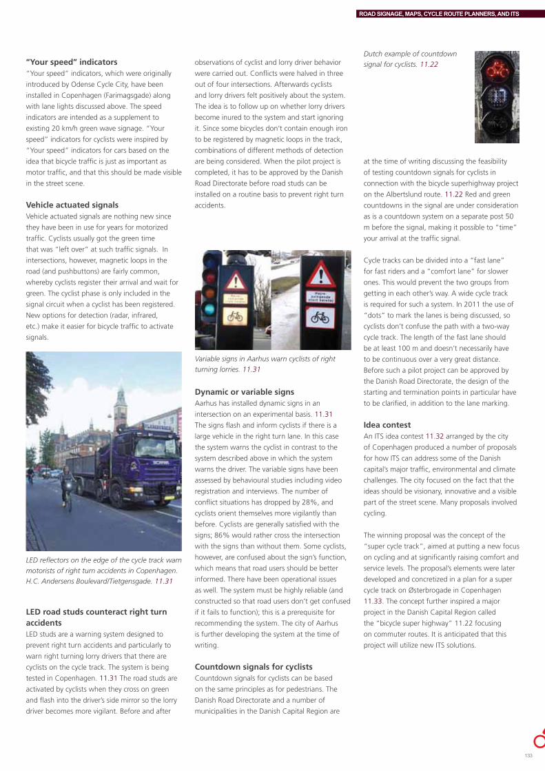
ROAD SIGNAGE, MAPS, CYCLE ROUTE PLANNERS, AND ITS
“Your speed” indicators“Your speed” indicators, which were originally
introduced by Odense Cycle City, have been
installedinCopenhagen(Farimagsgade)along
with lane lights discussed above. The speed
indicators are intended as a supplement to
existing20km/hgreenwavesignage.“Your
speed” indicators for cyclists were inspired by
“Your speed” indicators for cars based on the
ideathatbicycletrafficisjustasimportantas
motor traffic, and that this should be made visible
in the street scene.
Vehicle actuated signalsVehicle actuated signals are nothing new since
they have been in use for years for motorized
traffic. Cyclists usually got the green time
that was “left over” at such traffic signals. In
intersections, however, magnetic loops in the
road (and pushbuttons) are fairly common,
whereby cyclists register their arrival and wait for
green. The cyclist phase is only included in the
signal circuit when a cyclist has been registered.
Newoptionsfordetection(radar,infrared,
etc.) make it easier for bicycle traffic to activate
signals.
LED reflectors on the edge of the cycle track warn
motorists of right turn accidents in Copenhagen.
H.C. Andersens Boulevard/Tietgensgade. 11.31
LED road studs counteract right turn accidentsLEDstudsareawarningsystemdesignedto
prevent right turn accidents and particularly to
warn right turning lorry drivers that there are
cyclists on the cycle track. The system is being
tested in Copenhagen. 11.31 The road studs are
activated by cyclists when they cross on green
and flash into the driver’s side mirror so the lorry
driver becomes more vigilant. Before and after
observations of cyclist and lorry driver behavior
were carried out. Conflicts were halved in three
out of four intersections. Afterwards cyclists
and lorry drivers felt positively about the system.
The idea is to follow up on whether lorry drivers
become inured to the system and start ignoring
it. Since some bicycles don’t contain enough iron
to be registered by magnetic loops in the track,
combinations of different methods of detection
arebeingconsidered.Whenthepilotprojectis
completed, it has to be approved by the Danish
Road Directorate before road studs can be
installed on a routine basis to prevent right turn
accidents.
Variable signs in Aarhus warn cyclists of right
turning lorries. 11.31
Dynamic or variable signsAarhus has installed dynamic signs in an
intersection on an experimental basis. 11.31
The signs flash and inform cyclists if there is a
large vehicle in the right turn lane. In this case
the system warns the cyclist in contrast to the
system described above in which the system
warns the driver. The variable signs have been
assessed by behavioural studies including video
registration and interviews. The number of
conflict situations has dropped by 28%, and
cyclists orient themselves more vigilantly than
before. Cyclists are generally satisfied with the
signs;86%wouldrathercrosstheintersection
with the signs than without them. Some cyclists,
however, are confused about the sign’s function,
which means that road users should be better
informed. There have been operational issues
as well. The system must be highly reliable (and
constructed so that road users don’t get confused
ifitfailstofunction);thisisaprerequisitefor
recommending the system. The city of Aarhus
is further developing the system at the time of
writing.
Countdown signals for cyclists Countdown signals for cyclists can be based
on the same principles as for pedestrians. The
Danish Road Directorate and a number of
municipalities in the Danish Capital Region are
Dutch example of countdown
signal for cyclists. 11.22
at the time of writing discussing the feasibility
of testing countdown signals for cyclists in
connectionwiththebicyclesuperhighwayproject
on the Albertslund route. 11.22 Red and green
countdowns in the signal are under consideration
asisacountdownsystemonaseparatepost50
m before the signal, making it possible to “time”
your arrival at the traffic signal.
Cycle tracks can be divided into a “fast lane”
for fast riders and a “comfort lane” for slower
ones. This would prevent the two groups from
getting in each other’s way. A wide cycle track
isrequiredforsuchasystem.In2011theuseof
“dots” to mark the lanes is being discussed, so
cyclists don’t confuse the path with a two-way
cycle track. The length of the fast lane should
beatleast100manddoesn’tnecessarilyhave
to be continuous over a very great distance.
Beforesuchapilotprojectcanbeapprovedby
the Danish Road Directorate, the design of the
starting and termination points in particular have
to be clarified, in addition to the lane marking.
Idea contestAn ITS idea contest 11.32 arranged by the city
of Copenhagen produced a number of proposals
for how ITS can address some of the Danish
capital’smajortraffic,environmentalandclimate
challenges. The city focused on the fact that the
ideas should be visionary, innovative and a visible
partofthestreetscene.Manyproposalsinvolved
cycling.
The winning proposal was the concept of the
“super cycle track”, aimed at putting a new focus
on cycling and at significantly raising comfort and
service levels. The proposal’s elements were later
developed and concretized in a plan for a super
cycle track on Østerbrogade in Copenhagen
11.33.Theconceptfurtherinspiredamajor
projectintheDanishCapitalRegioncalled
the “bicycle super highway” 11.22 focusing
on commuter routes. It is anticipated that this
projectwillutilizenewITSsolutions.
133

ROAD SIGNAGE, MAPS, CYCLE ROUTE PLANNERS, AND ITS
The “super cycle track concept” and some of its ideasSome of the ideas developed by the super cycle
track concept are being implemented at the time
of writing while others are still merely ideas.
Some of the proposals mentioned below require
careful consideration. If they prove feasible, they
will then have to be approved both by the Police
and by the Danish Road Directorate as a pilot
project.
CopenhagenWheel prototype. 11.36
Dr.Glob,circumnavigate40,000kmaroundthe
world by cycling themselves. A GPS log controls
the number of kilometers cycled, and uploads it
towww.80dage.dk.
Bicycle counters Bicycle counters or “bicycle barometers” are a
way of showing cyclists that they count, and that
cycling is a desirable transport mode. Odense
CycleCity1999-200211.29 developed the
country’s first bicycle counter, which shows
cyclists and other citizens the number of cyclists
passing and also serves as an automatic traffic
counter. It provides useful information on bicycle
traffic developments but is not as accurate as a
manual count. Several other cities have acquired
bicycle counters which are now available as a
standard product in a couple of brands. Bicycle
counters have become a Danish export item
11.35.
Cyclists can see they’re being counted
while they’re being counted. The
picture shows a bicycle counter
on a cold December afternoon in
Frederiksberg. The counter shows this
year’s and last year’s bicycle traffic as
well as the number of cyclists on the
given day. 11.35
Copenhagen WheelCopenhagenWheel11.36wasdevelopedbyMIT
(MassachussettsInstituteofTechnology)forthe
COP15climateconferenceinCopenhagenin
2009.Thewheelcanbemountedonanybicycle
and transform it into an e-bike that regenerates
braking energy, etc. The wheel contains a motor,
3 gears, batteries, sensors, GPRS, etc. A smart
phone can be mounted onto the handle bars,
and communicates with the wheel via Bluetooth.
The phone can be used to lock the bike, switch
gears, activate and deactivate the motor, and
see real time information on air and noise
pollution, congestion and road conditions. CO2
levels,NOxs,noise(db),relativehumidityand
temperature are measured. The data gathered
can be used individually, but if data is donated to
the city it can provide new information that can
be used for planning, etc.
INFO STRIPEAn info stripe is envisioned as a road marking (e.g. a 30 cm green stripe on the left side of the cycle track) indicating that the cyclist is on a super cycle track. The info stripe should show lane lights and pictograms indicating cycling times, e.g. to the next S-train station.
GREEN EXTENSIONS, ACTUATED SIGNAL CONTROLGreen extensions are already utilized for buses and cars. Groups of cyclists in the final part of the green phase may be able to get across with a green extension of perhaps 10 seconds.
BUS WAITING AREASWhen it is not possible to install a traditional waiting area at a bus stop, a virtual bus waiting area might help cyclists and bus passengers pass each other with fewer conflicts. The idea is that when the bus’s arrival is registered, a waiting area becomes visible by changing an asphalt coloured stripe to white. The cycle track becomes visually narrower while the bus is waiting, but still allows cyclists to pass.
DYNAMIC TURN PROHIBITIONS Dynamic turn prohibitions for motor vehicles can be established by a no turning sign that is activated at peak times, when there are many cyclists and many potential conflicts between cyclists going straight ahead and turning cars.
GPSGPS, which is increasingly common in cell
phones, can be used for GPS trailing in addition
to telling you where you are. GPS technology
can also be used in promotional campaigns.
Several municipalities have presented 12-13 year
olds with the GPS based cycle campaign “Can
youbikearoundtheworldin80days?”11.34
The students help the virtual circumnavigator,

12
Contents
Prioritizing operational resources 136Highway capital vs. cyclist service level 137Cycle path evenness and quality 137Winter maintenance 139Cleaning 140From construction to operation 140Poor maintenance and operation result in accidents 140Road repair 140General remarks on road repair 141Citizen information 141Signage and marking 141Barrier materials 141Marker lights 141Cover plates and the like 141Speed reduction 142Accident risk 142
High quality operation of the cyclist circulation area is a
primary factor in determining whether cyclists feel like cycling.
Poor surfaces can distract cyclists and in some instances cause
serious accidents. Low quality operation and maintenance help
maintain the bicycle’s image as a low status transport mode.
Quality improvement is therefore highly recommended. An
excellent way to start is by performing a major maintenance
check of roads and cycle paths by bicycle every year.
OPERATION AND MAINTENANCE

OPERATION AND MAINTENANCE
PRIORITIZING OPERATIONAL RESOURCESA Fredericia Cycle City study showed that 56% of
citizens demanded better maintenance of paths
and roads, a demand that exceeded all other
demands. In Copenhagen only 50% of cyclists
were satisfied with cycle track surfaces, but were
even more dissatisfied with road surfaces. (Bicycle
Account 2008).
Operational resources are prioritized according
to several different technical and political
parameters. Operation often has low priority
in relation to new construction. All arguments
should be consciously weighed against each
other when establishing prioritization principles.
Cyclists are particularly sensitive to operation
quality. Since a high percentage of Danish citizens
are cyclists, there is naturally a great demand for
high quality operation in the cyclist circulation
area. Furthermore, it is often cheaper to improve
quality on cycle paths than on traffic lanes, which
means that prioritizing high quality cycle paths
rather than traffic lanes might be an excellent
idea.
It is crucial to cyclists that cycle tracks and
other circulation areas are not rough or full of
potholes. Cyclist comfort is significantly reduced
by the unpleasantness of bumpy surfaces. In
addition luggage can be knocked off the bicycle.
Furthermore, a cyclist expends more energy
on an uneven surface. Finally, a bicycle can be
permanently damaged by biking over a pothole,
particularly the spokes, tires and wheel rims.
Cyclists often try to ride around potholes thereby
getting in the way of other cyclists.
Bumps reduce cyclist safety since the cyclist risks
falling and being injured. If the cyclist wobbles he
risks hitting the kerb, pedestrians or other cyclists.
In some cases the cyclist can land in front of a
motor vehicle and risk serious injury.
Uneven road surfaces are primarily the result of
badly executed road reinstatement after utilities
construction, asphalt patching, ramps, manhole
covers and tree roots. Add to this normal road
An even surface is crucial to cyclists.
Potholes distract cyclists from traffic.
surface attrition caused by frost and thaw,
salt, etc. All contractors should be informed
that all asphalt repairs must be carried out in a
workmanlike manner with no noticeable edges
or differences in level to the existing asphalt. One
option is to move the cables running under the
cyclist circulation area to under the pavement. In
addition, all patching should be across the entire
width of the cycle track.
Cycle tracks should be repaired by using
powdered asphalt if the thickness of the layer
is less than 3 cm. When the base is made of
crushed asphalt concrete it should be finished
with powdered asphalt. Powdered asphalt should
not contain flint chippings; granite should be
used instead.
Machine laying is highly recommended for
reinstating longitudinal cable trenches or as a
machine repair of a large area. Reinstatement
of transverse trenches should normally be
performed manually. The different repair
treatments are described in the Danish Road
Directorate’s road standards for the construction
and maintenance of roads and paths.
When tree roots are the cause of the damage,
repairs will have a temporary effect since the
tree’s continued growth will lift the asphalt
and kerb further. It is occasionally necessary to
remove individual roots, which should be cut off
and dug up on the section under the circulation
area. Since this is a serious procedure for the tree
it must only be carried out under professional
guidance.
The problem is more serious if the tree is planted
in an area that is too small for its root system
to develop properly. Cutting the tree down or
replanting it are possible options depending
on the tree’s age and species. Good growing
conditions prevent such problems, typically
30 cm topsoil on 80 cm well drained, non-
compressed subsoil, which in turn should lie
on loosened ground soil. Since the roots are
usually of the same proportions as the tree
crown, the area around the tree should be as
large as possible. Alternatively, the tree crown
can be pruned regularly which means that the
root system won’t need so much space. Special
skeletal soils are available so that the roots can
spread.
Roads and paths operation has become
more costly following the Danish decision to
prohibit the use of pesticides in public areas.

OPERATION AND MAINTENANCE
An even surface is crucial to cyclists.
It’s obvious when the cycle path surface has been there for many years.
Maintenance involving heavy vehicles on
thin path surfaces may result in longitudinal
cracks where weeds can grow. Once weeds
take hold, the surface deteriorates more
rapidly. The spraying prohibition places new
demands on cycle path construction, light-
weight maintenance vehicles and cycle path
inspection. In practice, unless extra funding is
granted for operation, cycling will become more
uncomfortable.
HIGHWAY CAPITAL VS. CYCLIST SERVICE LEVELHuge sums have been invested in road
construction over time. Most of this value lies
in the wearing surface of traffic lanes and cycle
paths. The value, in the shape of the wearing
surface, can only be maintained by the on-going
maintenance or renovation of the protecting
wearing surface as it inevitably deteriorates.
There is a relation between annual expenses for
wearing surface renovation and annual expenses
for maintenance. If wearing surface renovation
is reduced, maintenance expenses rise, and vice-
versa.
Financially, the most cost-effective maintenance is
to keep the total sum of wearing cost renovation
and wearing cost maintenance as low as possible.
This means that the wearing surface should be
renovated at the precise time when renewing the
wearing surface is cheaper than continuing to
repair it.
However, since cyclists are highly sensitive to
rough surfaces, caused by repairs for example,
the state of cycle track wearing surfaces should
have top priority even though it might seem more
rational from an operational/economic point of
view to continue to repair them. Minor roads
with little bicycle traffic may be deprioritized.
When new cycle tracks are being planned, it’s
worth considering whether stronger roadbeds
should be established since this may reduce
maintenance.
CYCLE PATH EVENNESS AND QUALITYQuality criteriaQuality criteria may be based on subjective
experience or objective registration. An example
of a subjective assessment of bumpiness is an
assessment of road conditions carried out by
the operations personnel of a given district. The
assessment is personal, and is primarily based
on observations from daily inspection, as well as
enquiries and complaints from citizens, interest
groups, etc. This type of regular inspection, which
is not systematic, is usually carried out by car, but
it’s a better idea to do it by bicycle.
Experience from Odense indicates that inspection
by bicycle is a time consuming task that will
typically be met with opposition among traffic
technicians. In the long run, however, the
technicians involved gain greater insight by
experiencing for themselves what minor bumps,
for example, may mean for cyclists. This means
that more repairs may be anticipated than when
cycle paths are inspected in a motor vehicle.
However, it should be noted that the technicians
involved gain a greater understanding of what it
feels like to be a cyclist in traffic.
The Danish Cyclists’ Federation is carrying out a
new project in 2011 to develop a new method of
cycle track inspection.
Systematic registration of the amount of
damage should be performed once each spring
by a major inspection. The major inspection of
cycle paths should include a road technician
riding through the entire network on a bicycle.
Potholes, patches, subsidence, cracking should
be registered and measured as well as the
extent of work necessary to renew the wearing
surface. The data should then be processed by
maintenance software that selects sections for
technical evaluation. The software prints out
prioritized lists of wearing surface renewal and
repairs, in accordance with the budget.
The “bumpmeter” bicycle provides a correct,
objective registration of uneven surfaces.
Alternatively, in many areas road surface
measurements are carried out by a small laser
equipped vehicle that registers a very precise
longitudinal profile. This makes it possible to
formulate quantitative objectives for the evenness
of each sub-section, which is an excellent
instrument for funding prioritization.
Technicians in the city of Copenhagen have
covered the entire cycling network with a
bumpmeter bicycle and classified each section
into one of three categories of surface quality, the
appropriate number of categories for subjective
inspection. Several local authorities, including
137
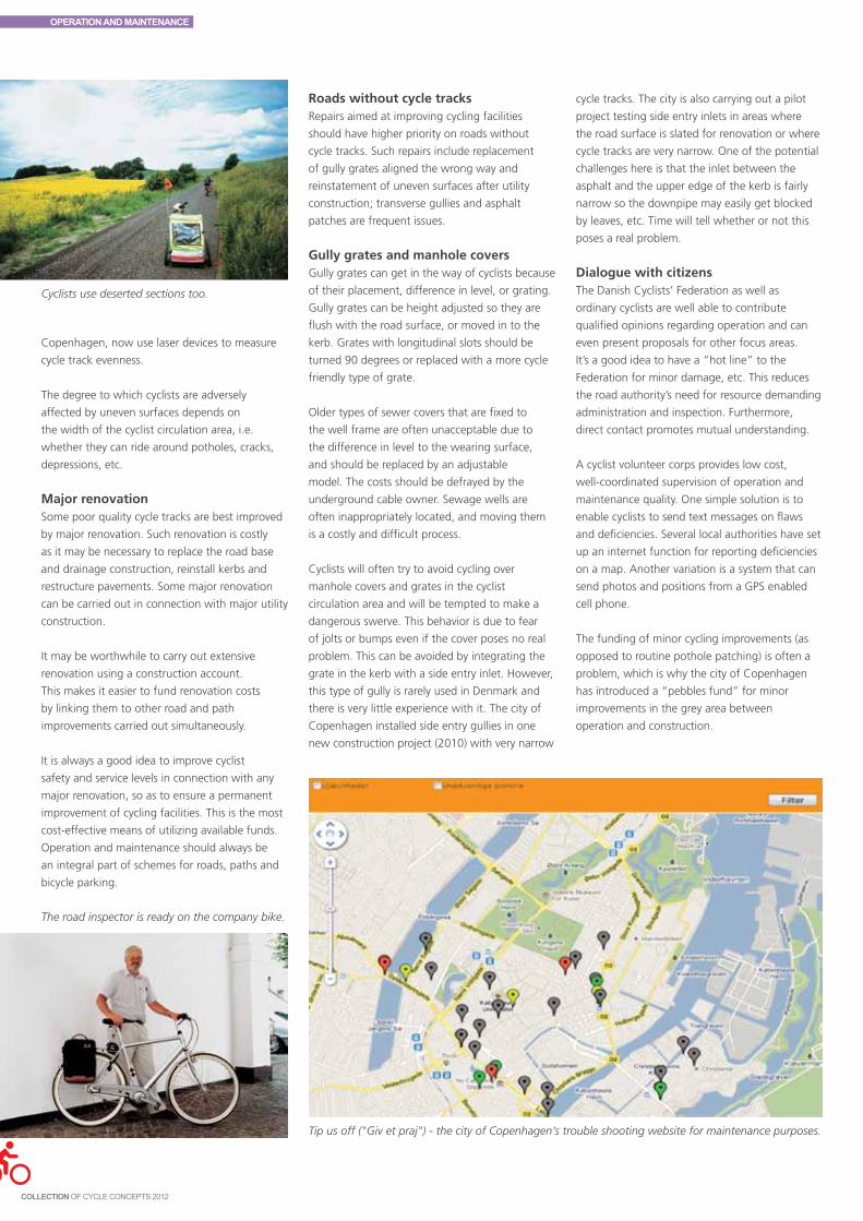
OPERATION AND MAINTENANCE
The road inspector is ready on the company bike.
Cyclists use deserted sections too.
Copenhagen, now use laser devices to measure
cycle track evenness.
The degree to which cyclists are adversely
affected by uneven surfaces depends on
the width of the cyclist circulation area, i.e.
whether they can ride around potholes, cracks,
depressions, etc.
Major renovationSome poor quality cycle tracks are best improved
by major renovation. Such renovation is costly
as it may be necessary to replace the road base
and drainage construction, reinstall kerbs and
restructure pavements. Some major renovation
can be carried out in connection with major utility
construction.
It may be worthwhile to carry out extensive
renovation using a construction account.
This makes it easier to fund renovation costs
by linking them to other road and path
improvements carried out simultaneously.
It is always a good idea to improve cyclist
safety and service levels in connection with any
major renovation, so as to ensure a permanent
improvement of cycling facilities. This is the most
cost-effective means of utilizing available funds.
Operation and maintenance should always be
an integral part of schemes for roads, paths and
bicycle parking.
Roads without cycle tracksRepairs aimed at improving cycling facilities
should have higher priority on roads without
cycle tracks. Such repairs include replacement
of gully grates aligned the wrong way and
reinstatement of uneven surfaces after utility
construction; transverse gullies and asphalt
patches are frequent issues.
Gully grates and manhole coversGully grates can get in the way of cyclists because
of their placement, difference in level, or grating.
Gully grates can be height adjusted so they are
flush with the road surface, or moved in to the
kerb. Grates with longitudinal slots should be
turned 90 degrees or replaced with a more cycle
friendly type of grate.
Older types of sewer covers that are fixed to
the well frame are often unacceptable due to
the difference in level to the wearing surface,
and should be replaced by an adjustable
model. The costs should be defrayed by the
underground cable owner. Sewage wells are
often inappropriately located, and moving them
is a costly and difficult process.
Cyclists will often try to avoid cycling over
manhole covers and grates in the cyclist
circulation area and will be tempted to make a
dangerous swerve. This behavior is due to fear
of jolts or bumps even if the cover poses no real
problem. This can be avoided by integrating the
grate in the kerb with a side entry inlet. However,
this type of gully is rarely used in Denmark and
there is very little experience with it. The city of
Copenhagen installed side entry gullies in one
new construction project (2010) with very narrow
cycle tracks. The city is also carrying out a pilot
project testing side entry inlets in areas where
the road surface is slated for renovation or where
cycle tracks are very narrow. One of the potential
challenges here is that the inlet between the
asphalt and the upper edge of the kerb is fairly
narrow so the downpipe may easily get blocked
by leaves, etc. Time will tell whether or not this
poses a real problem.
Dialogue with citizensThe Danish Cyclists’ Federation as well as
ordinary cyclists are well able to contribute
qualified opinions regarding operation and can
even present proposals for other focus areas.
It’s a good idea to have a “hot line” to the
Federation for minor damage, etc. This reduces
the road authority’s need for resource demanding
administration and inspection. Furthermore,
direct contact promotes mutual understanding.
A cyclist volunteer corps provides low cost,
well-coordinated supervision of operation and
maintenance quality. One simple solution is to
enable cyclists to send text messages on flaws
and deficiencies. Several local authorities have set
up an internet function for reporting deficiencies
on a map. Another variation is a system that can
send photos and positions from a GPS enabled
cell phone.
The funding of minor cycling improvements (as
opposed to routine pothole patching) is often a
problem, which is why the city of Copenhagen
has introduced a “pebbles fund” for minor
improvements in the grey area between
operation and construction.
Tip us off ("Giv et praj") - the city of Copenhagen’s trouble shooting website for maintenance purposes.

OPERATION AND MAINTENANCE
Different types of gullies.
Snow removal is crucial to bicycle traffic volume.
Prioritization and service goalsSince roads and paths can be classified in a
hierarchy according to their importance, one
obvious solution is to handle them differently.
This makes it possible to utilize resources to best
advantage by creating a reasonable balance
between traffic, environmental and financial
considerations.
In practice roads and paths can be classified
into 3 snow removal categories, A, B, and C,
according to the importance of their function.
Since year round cycling is a political priority it is
crucial to give cycle tracks high priority in winter.
Category A contains primary segregated off-road
cycle paths and cycle tracks along primary roads.
It is essential that the service level on such paths
is high since snow and ice are highly inconvenient
for cyclists. Cyclists should not be tempted to use
the carriageway instead of the cycle track. Such
sections are so important for bicycle traffic, and
in the final analysis for the entire community,
that they should be kept open without major
inconvenience 24 hours a day 7 days a week.
Category B includes school routes and feeder
paths. Snow removal and de-icing treatments are
only carried out during daytime, 7 days a week.
Category C includes shorter paths of minor
importance. Snow clearance and de-icing
treatments are only carried out exceptionally.
Recreational paths, with a gravel surface, for
example, should not usually be included in winter
maintenance.
De-icing treatments and snow removalIcy surfaces can be treated on paths by traditional
road salt, gritting or alternatively by a saline
solution.
Traditional salt is highly detrimental to the path
environment since for technical reasons the salt
dosage on cycle paths needs to be far higher
than on traffic lanes.
Gritting too has environmental costs, in addition
to increasing the risk of puncture and skidding.
Furthermore, gritting is not particularly effective
as a de-icing measure. Grit must be continuously
removed from sewers, and the grit that remains
on roads and paths needs to be deposited at
specially controlled waste dumps due to its
mixture with hazardous materials. There is a
special deposit charge in Denmark. Furthermore,
grit is a scarcer resource than gravel.
A saline solution consisting of 22% sodium
chloride reduces salt consumption by 80% when
Time lag after new construction
The normal practice for major road renovation
and new construction is to wait until the year
following the completion of all work before
laying the wearing surface. The time lag between
laying the base and the wearing surface is
necessary due to the subsidence that occurs after
work is completed; this is unavoidable in practice.
When cyclists are informed of this, for example
by writing “temporary road surface” directly on
the road base, they are less likely to complain.
When the new cycle track road base is laid in the
same quality as the road itself, the only reason
to postpone the laying of the road base is winter
frost.
WINTER MAINTENANCEAim and scopeA modern urban community can only function
optimally if roads, tracks and paths are kept
passable and safe regardless of season and
weather conditions. It is therefore crucial to
effectively address the inconvenience caused
by snow and ice on circulation areas. The road
authority is compelled, pursuant to the “law on
winter maintenance and cleaning of roads”, to
remove snow and to take measures to address
slippery surfaces on public roads and path areas.
it is applied correctly, compared to traditional salt
consumption. Applying the saline solution costs
approximately the same as using traditional salt,
but only 2/3 of what it costs to apply grit. Saline
solutions, however, have proved less effective
for heavy snow fall and thick layers of ice. Good
meteorological data makes it possible to use salt
as a preventive measure prior to heavy snowfall
and frost.
De-icing treatments are only effective if snow is
removed first. In Denmark the same vehicle can
usually easily handle snow removal and de-icing.
Heavy tractors are necessary to ensure high
service levels in all snow situations by quickly and
efficiently removing snow from circulation areas.
Normally, snow may be piled in an embankment
on the kerb between the cycle track, pavement
and carriageway, but when cycle tracks and lanes
are very narrow, snow should be removed and
carted away. This is so costly that it should only
be done when absolutely necessary, which is
139

OPERATION AND MAINTENANCE
another reason for never compromising on cycle
track width.
CLEANINGThere should be a high service standard for cycle
path cleaning as well. Paths should be swept
systematically according to the maintenance
hierarchy, from twice a month to once every two
months.
In addition extra sweeping is necessary during
leaf fall. An emergency corps should be available
for the acute removal of dangerous objects and
broken glass. This applies especially to Saturday
and Sunday mornings in urban streets where
night life results in broken glass strewn over
paths and roads.
When cleaning can’t be performed by standard
tractors, and special, extra narrow vehicles are
needed instead, the minimum passage of such
vehicles is 1.6 m.
FROM CONSTRUCTION TO OPERATIONOperation personnel should be an integral part
of any construction project to provide them with
adequate knowledge of the project’s aim and
to incorporate their experience into the project
scheme. In addition, the operations department
should always inspect construction before the
contractor delivers the end product.
Examples of the most common issues after
delivery are incorrectly aligned gullies, drainage
construction that fails to work, and subsidence.
The operations department should ensure that
the contractor addresses such issues during the
period for supplementary performance.
Costly operational elementsWhen sett paving, paving stones, etc. are
installed for aesthetic reasons, it should be
noted that such surfaces are more difficult and
more costly to maintain and clean than asphalt
surfaces. In addition, uneven surfaces are often
criticized by cyclists.
Blue cycle crossings are also more expensive to
maintain, since the price is approx. twice as high
as standard thermoplastic. Painted marking costs
approx. ¾ of the price of thermoplastic, but
its service life is only 1/10 of the service life of
thermoplastic. In addition, aggregate materials in
thermoplastic prevent it from being slippery.
The Danish road standards state that cycle tracks
may be signed by cycle track signposts or marked
by a thermoplastic cycle symbol. Cycle symbols
are the most cost effective unless there are other
reasons to choose signposting. In urban areas
cycle tracks are usually not signposted.
POOR MAINTENANCE AND OPERATION RESULT IN CYCLIST ACCIDENTSLow quality operation, including poor winter
maintenance, increases cyclist risk of traffic
accidents. A number of accidents are related
to operation quality. It is not always possible to
establish the real cause of an accident. Accidents
are usually due to a combination of factors that
are difficult to keep apart. Solo accidents are
generally caused by fewer factors than
accidents where several parties are involved.
The Accident Analysis Group at Odense University
has made a study of solo cycling accidents. It is
interesting to note that only 2% of solo accidents
are registered by the police compared to 26%
of multiple accidents. In approx. 70% of the
studied solo accidents there were no flaws and
deficiencies on the road surface, which might
have caused the accident. In 10-15% of the
accidents loose objects (branches, pebbles, etc.)
were a contributing factor, while 3-4% were
caused by a pothole. Factors such as incline, road
work, gullies and railway tracks were of minor
importance.
There are many indications that accidents can
be prevented by more frequent sweeping of
roads and paths and faster patching of potholes
on paths and along the road. Roads with poor
surface quality constitute a particular risk for solo
accidents among cyclists. Finally, snow removal
is important as it eliminates any risk for cyclists,
but primarily to increase cycling volumes during
the winter.
De-icing should be performed before the road
becomes icy. When cycle tracks are wet and the
temperature is touching zero cyclists risk falling
since "black ice" forms suddenly, making it
difficult for cyclists to judge whether the surface
is slippery. A slippery surface warning system is an
invaluable instrument, helping the administration
avoid such situations.
ROAD REPAIRIt is often consciously or unconsciously assumed
that road users can tackle road construction sites
on their own. It’s a good idea to give cyclists
special consideration during road construction
since they’re more vulnerable to rough surfaces
and diversions than motorists. Clear marking
and barriers can prevent bicycle accidents.
Occasionally it may be necessary to manage
motor traffic in the interests of cyclist safety,
comfort and passability. 2-3% of bicycle solo
accidents are caused by road construction.
The road authority can introduce stricter
requirements for utility construction sites and
The road sweeping vehicle does not necessarily
sweep around bollards.
arge puddles make it necessary for cyclists to
engage in dangerous dodging manoeuvers.

OPERATION AND MAINTENANCE
asphalt works on cyclist circulation areas, and
above all improve inspection and control. It is in
the road authority’s interests that the condition of
the reinstated circulation area is at least as good
as before excavation.
GENERAL REMARKS ON ROAD REPAIRSRoad construction sites are often highly
inconvenient and risky for road users. Cyclists
demand smooth surfaces and road construction is
particularly inconvenient for them. Cyclist safety,
passability and comfort should always be taken
into account regardless of whether the contractor
is the road authority, the underground cable
owner or others, and regardless of whether the
road authority performs the work itself or hires
an independent contractor.
Road construction is often of short duration
and will not necessarily have a negative impact
on the cycling experience. However, there are a
number of measures that can be taken to meet
cyclist needs. In some cases road users are not be
allowed to enter the work area; in such cases the
best alternative route should be indicated.
When cyclists are directed onto the carriageway,
there should be a “Cyclists on road” sign. Many
excavations direct cyclists into the pedestrian area
rather than the carriageway. Depending on the
amount of space available and the number of
pedestrians, it may be a safer solution to place
cyclists with pedestrians.
Cyclists shouldn’t have to ride over high kerbs or
dismount at road construction. High kerbs and
dismounting are only acceptable as an exception,
and only for road construction of under a day’s
duration and outside peak hours.
CITIZEN INFORMATIONCitizens do not always receive notification of
excavation in advance since there are so many
projects. Notification of excavation is only
required when passage will be obstructed or
prevented, or when road users may anticipate
significant delays.
Notice of excavation is typically given in a local
newspaper, a door-to-door distributed weekly,
or as a news item on the local radio station.
Large construction signboards can also be used
to inform citizens of the road construction and
its duration. It’s also a good idea to present
the benefits, for example when a new wearing
surface is being laid on a cycle track.
SIGNAGE AND MARKINGSignage and road marking of a road construction
site should be easily understandable. It may be
necessary to issue a warning at an appropriate
distance, partly to heighten cyclist vigilance and
partly to give cyclists time to choose another
route.
It is often difficult for cyclists to adjust their
speed in relation to road construction since
there is rarely preliminary warning of sharp
bends and high kerbs. It should be clearly
signed when cyclists need to reduce speed at a
road construction site. Occasionally temporary,
clearly painted road markings on the track or
carriageway are the best means of directing
cyclists.
Incorrect or unnecessarily restrictive signage
may occur when excavation takes place at short
notice. A typical example is a “No entry” sign
when a “No motor vehicles” sign would do.
Cycling prohibitions should be avoided whenever
this is technically possible without jeopardizing
safety.
It can be necessary to divert cyclists when
construction takes up the full width of the road.
It is crucial that cyclists should be informed of
the diversion in good time and that they know
it’s in force. Diversions are more inconvenient
for cyclists than for motorists. The longer the
construction lasts, the greater the inconvenience.
There are examples of incorrect placement of
temporary traffic signs. Traffic signs are typically
mounted on a low post on a rubber base, and
typically placed on the edge of the road or on
the cycle track. Cyclists can’t pass underneath
the low height of the post and the sign including
the safety margin takes up 1 meter of the
cycling area. This is particularly problematic in
bad weather when cyclists are typically looking
downwards. A standard bike light is not sufficient
to light up the sign in the dark.
BARRIER MATERIALSIt is essential that construction site barriers are
made of correct materials, especially when
it’s a question of a deep excavation that may
constitute a cyclist risk. It should not be possible
for a cyclist to fall over or under the barrier. In
addition, cyclists should not be squeezed against
the barrier by other traffic.
A lateral cycle track barrier can be established by
a bar, a wire fence, etc. and should be marked
with at least two marker lights unless the barrier
is sufficiently illuminated, which is rarely the case.
The advantage of a full height wire fence
compared to a bar barrier is that it prevents
the cyclist from falling into the excavation.
Regardless of the type of barrier used it should be
continually inspected since at worst a defect may
be fatal to the cyclist.
MARKER LIGHTSNormally marker lights are only required when
containers, etc. are placed on the carriageway.
Since bike lights can rarely light up the road
and cycle path safely, marker lights should
be considered for dark areas and dangerous
excavations.
There should be 2 m max. between lights at
lateral cycle track barriers, and 10 m. max at
longitudinal barriers.
COVER PLATES AND THE LIKEExcavations are covered with plates, etc. in order
to facilitate traffic flow. These are usually thick
iron plates with a high metal edge. Rounded
edges should be used whenever possible in the
interests of bicycle tires and spokes. It is difficult
for the cyclist to judge whether the edge is
uncomfortable and whether he needs to “jump”,
stand up, or reduce speed. When an excavation
is of longer duration asphalt ramps should be
installed on all plates with a high edge.
When there are cables and pipes running across
the road a board is often placed on each side,
frequently with a height difference of several
centimeters. Cyclists find this very annoying and
it may cause falls.
141

OPERATION AND MAINTENANCE
SPEED REDUCTIONMotorists trying to overtake cyclists on sections
with narrow traffic lanes in mixed traffic pose
a significant threat to cyclist safety. Narrow
spaces combined with the risk of falling into
an excavation may make it necessary to reduce
traffic speeds in the interests of the working
environment and road safety.
Speeds can be reduced by signing a slower speed
limit. In exceptional cases it may be necessary
to install temporary physical traffic calming
measures, such as removable, screwed on speed
humps made of loose asphalt or rubber. In a
few cases it might be worthwhile considering
reducing cycling speed. In that case a cyclist
speed hump, etc. can be installed.
ACCIDENT RISKAs a general rule construction work cannot
be considered a major cause of solo cycling
accidents. This is due to the fact that road
construction is not particularly widespread so
that when cyclists encounter it they increase their
vigilance.
The Accident Analysis Group at Odense
University Hospital has made a study of cyclist
solo accidents. More than 70% of the injured
cyclists were involved in solo accidents. 2.4% of
the cyclists interviewed in a solo accident survey
stated that there was road construction on the
road. 1.8% of the cyclists cited barrier materials
as the cause of the accidents. 2.7% of collisions
with solid objects were caused by a cyclist
hitting a barrier. There were more adults than
children and young people involved in solo road
construction accidents.
The exact relation between road construction and
cyclist accident risk has not been studied. Still,
there is every reason to believe that considerate
design of road construction may prevent some
bicycle accidents.
PLACING CYCLISTSThe following is a brief introduction to the placement of cyclists at fixed construction sites.
ROAD CONSTRUCTION ON ROADS WITH CYCLE TRACKS
• Ifthereare1.2mminimumofcycletrackoutsidetheworkarea,cyclistsshouldremainonthe track.
• Ifthepavementoutsidetheworkareaiswiderthan3m,atemporarycycletrackshouldbe installed on the pavement by a longitudinal barrier.
• Ifthepavementoutsidetheworkareais2-3mwide,placingcyclistsonthepavementwith or without a longitudinal barrier should be considered.
• Ifcyclistsarenotplacedonthepavement,a1.2mminimumwidecycletrackshouldbeestablished on the carriageway by a longitudinal barrier.
• Ifatemporarycycletrackonthecarriagewayisundesirable,trafficcalmingofmotortraf-fic should be considered.
• Establishgoodcyclistdiversionroutesorgoodasphaltrampsonthecarriageway.
ROADCONSTRUCTIONONROADSWITHMIXEDTRAFFIC,KERBLANESORCYCLELANES
• Considerestablishinga1.2mwideminimumtemporarycycletrackonthecarriagewaybya longitudinal barrier.
• Ifthepavementismorethan2mwide,atemporarycycletrackonthepavementwithorwithout a longitudinal barrier should be considered.
• Considermotortrafficcalming.
• Establishagooddiversionrouteforcyclists.
Potholes are a threat to cyclists.

13
Contents
Public bikes 144Commuter bikes 146Station bikes 146Company bikes 146Principles 147
Danish cyclists do most of their biking on their own bicycles,
and in Denmark this will continue to be the case. Many
cities abroad, however, have kick-started significant bicycle
traffic growth by making bicycles available to the public. The
situation in Denmark is quite different since most people
already own one or more bicycles. However, there is a potential
in offering bicycles in different contexts. There are four
concepts: public bikes, commuter bikes, station bikes, and
company bikes.
The following examples illustrate Danish experience in this
field. The chapter also provides examples of public bike systems
from abroad, which are quite different from Danish solutions.
PUBLIC BIKES AND COMMUTER BIKES

PUBLIC BIKES AND COMMUTER BIKES
PUBLIC BIKESPublic bikes in Denmark are normally located
throughout the city centre and are either freely
available to everyone or only to registered users.
The original systems (which were primarily
Danish) were free with a refundable coin deposit.
More recent systems cost money based on an
hourly rate. The bicycles must be returned to a
public bike stand whereas the German Call-A-
Bike system allows the bikes to be dropped off
anywhere. Since bicycles are often vandalized
Danish public bikes are very robust and thus
not very comfortable. On the other hand once
the user has returned the bike to the stand he
needn’t worry about it anymore.
More than 100 cities abroad have city bikes.
There is a growing trend to install new public bike
systems as a supplement to collective transport
concentrated around major railway stations. In
some cities public bikes may only be used within
a certain area.
A large number of cities abroad are introducing
public bikes in order to kick- start bicycle traffic
growth within a short period of time. New
York is an example where there are plans to
introduce 10,000 public bikes in central urban
neighbourhoods in 2012.
Danish experience with public bikesDanish public bikes are typically funded by
external support and partially funded by
advertisements on the bike frames and in
advertising displays. In several areas operation
and maintenance have been linked to job
training. Copenhagen started out in 1995
followed by Aarhus, Aalborg, Frederikshavn,
Assens and Odense. Aarhus introduced public
bikes in 2005. 93% of citizens have either never
used a public bike or have used them less than
once a week. 2% have used a public bike at
least once a week. The Aarhus system is similar
to Copenhagen except that some Aarhus public
bikes have 3 gears.
The Copenhagen and Frederiksberg authorities
are planning to introduce a new public bike
system with DSB (Danish State Railways) and
Movia (local bus service provider) as potential
partners.
Danish public bikes are fairly similar and often
lack a bike basket or luggage carrier. Very few
Danish public bikes have bike lights and no
public bikes are lockable. Danish public bikes
are too unreliable for commuters, partly because
they’re only available during the summer months.
Experience from cities such as Copenhagen
that have a high cycling modal split indicates
that public bikes don’t always promote the
city’s image; a bad, worn out public bike system
can impair the city’s cycle image. Aalborg is
an example of a well- functioning public bike
system.
Odense public bikes Odense introduced a system of 120 public bikes
in 2010. The design resembles other Danish
public bikes, but the bicycles have 3 gears,
bike lights and baskets. Bike use is paid for by
mobile access thereby eliminating the need for
dispensing machines on the street.
The public bikes are placed in 9 locations and
cost DKK 20/h. Public bikes may be returned at
any stand. Public bikes were rented 288 times
during the first 5 months. Out of 9 locations,
61% of the rentals took place at 2 locations: the
central station and the town hall.
ParisIn Paris there are a total of 23,000 public bikes.
The system is largely based on experience from
a pilot project for JCDecaux in Lyon. The system
has put both cities on the map as extremely
progressive cycle cities, a status they didn’t
formerly have.
There are typically 300 meters between the Vélib
public bike stations.
In order to use the Vélib public bikes in Paris the
user has to be at least 14 years old and have
an access card. The card can be purchased at
any bike station by following instructions on
the screen. Payment is exclusively by credit card.
Tourists can buy a one day card or a 7 day card to
the public bikes, but may not keep the same bike
for an entire day or week.
The first half hour is free. The same bike may
Commuter public bikes in Odense.
Vélib public bikes in Paris.

PUBLIC BIKES AND COMMUTER BIKES
be taken again after a minute, and is free for
another half hour. After one half hour the bike
costs €1, after 3 half hour periods €2, and the
following half hour periods cost €4. The idea is
that the progressive rates will encourage users to
return public bikes quickly and rent them again
later in the day. A one-day card costs €1 euro and
a 7 date card costs €5.
JCDecaux has 400 employees in charge of
operating the Paris system. Their primary task is
to maintain the public bikes and transfer public
bikes between stations. www.velib.paris.fr
BerlinCall-A-Bike is run by Deutsche Bahn in 6 German
cities, including Berlin. The user has to sign up
with Deutsche Bahn with a credit card number
in order to use a Call- a- Bike bicycle in Berlin.
The user calls in when a bike has been found.
The system has no stations, stands, dispenser
machines or other fixed locations.
Personal data is linked to a mobile phone and the
system can immediately see whether the caller
is an approved user. The user is given a code to
unlock the bike and the bike can be returned
anywhere. The public bike merely has to be
fastened to a solid object on the street, preferably
on a major thoroughfare. When the bike is
locked, the user calls in the confirmation code.
The initial charge is €5. Bike rental costs 8 cents
a minute and €9 for the entire day. The system
switches automatically to the day rate after €9.
www.callabike.de
LondonOY Bike is a London bike provider. Before using
the bike the user has to sign up and whenever
a bicycle is rented the user calls and receives a
PIN code to unlock the bike. There are detailed
instructions at all public bike stations explaining
what to do.
Registration costs £10. The first half hour is
free. After that it costs £2 for the first 31-60
minutes, £4 for 61-120 minutes, £6 for121-180
minutes. For periods longer than 3 hours the user
automatically pays for a 24 hour rental, which
costs £8. The price structure does not encourage
rapid return of the bicycle. www.oybike.com
StockholmA special pass is needed to use the public bikes.
The pass is available as a 3 day pass or a season
pass. Bike stands open at 6 a.m. and the bicycles
have to be back in a stand by 9 p.m. Cycle
journeys may take up to 3 hours after which the
bicycle has to be returned to the stand. However,
it is allowed to take a new bicycle from the stand
at once.
The 3 day pass costs SEK 125, the season pass
is valid from 1 April – 31 October, and costs SEK
200. www.stockholmcitybikes.se
Effects of public bikes abroadCities such as Lyon, Paris and Barcelona have
managed to boost bicycle traffic significantly by
introducing public bikes, primarily because hardly
anyone used a bicycle before.
In Lyon the introduction of public bikes in 2005
doubled bicycle traffic in 2 years. 16% of public
bike users would have taken the bus if public
bikes hadn’t existed. On the other hand public
bikes function as a feeder link to buses so the
total impact on buses is estimated to be neutral.
In Paris public bikes are used 4 times a day during
the winter. In Barcelona experience with the
Clear Channel bicycle system indicates that each
public bike is used 12 times a day. Such figures
are irrelevant in a Danish context, however, since
bicycle ownership is so high.
Redefining Danish public bikes to reach new
target groups and at the same time raise the
standard of the entire system is an exciting future
challenge.
In Germany, Call-A-Bike bicycles are parked at random all over the city.
Public bikes in Stockholm are functional.
145

PUBLIC BIKES AND COMMUTER BIKES
COMMUTER BIKESCommuter bikes are aimed at journeys between
home and work place/educational institution.
They may display a commercial logo and the
project is often sponsored by the employer. These
are typically high quality bicycles. Folding bikes
can be used, the smallest versions of which can
be taken on the train and bus as hand luggage,
which doesn’t require a special ticket.
Aarhus Bike BustersThe city of Aarhus ran a pilot project from May
1995 to May 1996 offering free bicycles and
bus passes to 175 daily Aarhus commuters.
Their motivation was boosted with small gifts,
information and health checkups.
Prior to the project’s initiation, in April 1995,
78% of the participants’ travel activities were by
car and 11% by bicycle. In March 1996 the car
market share was 31% and the bicycle market
share was up to 35%. In September 1996 56%
of the participants’ journeys was by bicycle and
only 43% by car, i.e. 5 times as many bicycle
journeys as before the project.
The conclusion was that it is possible to
significantly change people’s daily transport
habits, but it requires a great deal of
concentrated effort; it is easier to encourage
motorists to use their bicycles than take the bus.
STATION BIKESStation bikes are located at railway stations and
target the last portion of the journey from train
to workplace or educational institution. The area
within cycling distance is 8 times greater than
the area within walking distance. It takes more or
less the same amount of time to cycle or take the
bus, but many people prefer the freedom of only
having to worry about train schedules. Nationally,
20% of passengers cycle from home to station
while only 5% cycle from the station to their final
destination (workplace or educational institution);
a huge potential lies in encouraging people to
cycle to and from the station.
Aalborg commuter bikesIn 1999 NT Nordjyllands Trafikselskab (Northern
Jutland’s regional bus service) established a
commuter bike/station bike rental system
in Aalborg for DKK 100 per month. 11-22
bikes were rented each month and each bike
was ridden 3-4 km each way. The project
demonstrated that the combination bicycle/public
transport is a feasible alternative to commuting
by passenger car. At the time a rental system
could be established with an initial investment in
the bicycle’s purchase price and a running grant
for operating costs of approx. DKK 900/bicycle/
year including administration and marketing,
and renovation of the bicycle stock every 4 years.
After administration and marketing costs were
deducted, operation of the rental system could
break even with a grant for operating costs of
approx. DKK 350 per bike per year at a rental
charge of DKK 100 per bike per month.
Odense station bikesIn 2010 Odense introduced a station bike system
consisting of 80 bikes. The design resembles
other Danish public bikes but the bikes have 7
gears, bike lights and baskets. A wire lock makes
it possible to lock the bicycle during use. Rental
is paid via mobile access eliminating the need for
dispensing machines on the street.
Station bike stands are located at the central
station and three local stations. The bicycles cost
DKK 1000 per year and may be booked on line
from 1 week – 3 months. The bicycles have to be
returned to the same stand so the user gets the
same bicycle every day.
Fredericia station bikesFredericia is a railway junction with many
incoming commuters. In 2011 Fredericia and
DSB (Danish State Railways) wished to study
the potential of train/bicycle integration in
Danish market towns with railway stations. The
target group was people who commuted to
their workplace in Fredericia by car from other
communities. Participants were offered a 3
month loan of a carbon unisex bicycle, lockable
bicycle parking facilities, a helmet and a free
commuter pass for the train.
136 people volunteered and 30 were chosen for
each period.
COMPANY BIKESCompany bikes are aimed at journeys during
working hours. This typically involves staff who
have not cycled to work, but who find it more
practicable to use a bicycle for work related
journeys. Many workplaces have a number of
bikes available for the common use of the staff.
However, there are often difficulties booking
the bicycles or maintaining them properly. If
employers are made more aware of the cost
and health benefits, this may encourage them
to improve the offer. Some bicycle shops are
starting to offer on-site bicycle maintenance at
workplaces.
The Aalborg ABC project The ABC project (stands for work, home, cycle)
made 35 bicycles available to 9 companies
from May to November, 1996; afterwards the
bicycles would be donated to the company free
of charge if the company had cycled at least
300 km. Bicycle use was registered in a log. The
bicycles could be used to and from work and on
Station bikes in Fredericia are used to encourage
motorists to combine cycling and rail travel
instead of using their car.
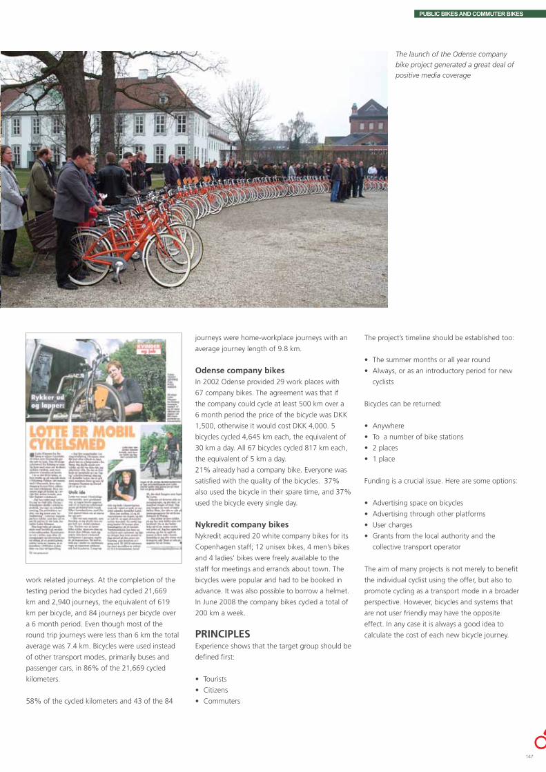
PUBLIC BIKES AND COMMUTER BIKES
The launch of the Odense company
bike project generated a great deal of
positive media coverage
work related journeys. At the completion of the
testing period the bicycles had cycled 21,669
km and 2,940 journeys, the equivalent of 619
km per bicycle, and 84 journeys per bicycle over
a 6 month period. Even though most of the
round trip journeys were less than 6 km the total
average was 7.4 km. Bicycles were used instead
of other transport modes, primarily buses and
passenger cars, in 86% of the 21,669 cycled
kilometers.
58% of the cycled kilometers and 43 of the 84
journeys were home-workplace journeys with an
average journey length of 9.8 km.
Odense company bikesIn 2002 Odense provided 29 work places with
67 company bikes. The agreement was that if
the company could cycle at least 500 km over a
6 month period the price of the bicycle was DKK
1,500, otherwise it would cost DKK 4,000. 5
bicycles cycled 4,645 km each, the equivalent of
30 km a day. All 67 bicycles cycled 817 km each,
the equivalent of 5 km a day.
21% already had a company bike. Everyone was
satisfied with the quality of the bicycles. 37%
also used the bicycle in their spare time, and 37%
used the bicycle every single day.
Nykredit company bikesNykredit acquired 20 white company bikes for its
Copenhagen staff; 12 unisex bikes, 4 men’s bikes
and 4 ladies’ bikes were freely available to the
staff for meetings and errands about town. The
bicycles were popular and had to be booked in
advance. It was also possible to borrow a helmet.
In June 2008 the company bikes cycled a total of
200 km a week.
PRINCIPLESExperience shows that the target group should be
defined first:
• Tourists
• Citizens
• Commuters
The project’s timeline should be established too:
• Thesummermonthsorallyearround
• Always,orasanintroductoryperiodfornew
cyclists
Bicycles can be returned:
• Anywhere
• Toanumberofbikestations
• 2places
• 1place
Funding is a crucial issue. Here are some options:
• Advertisingspaceonbicycles
• Advertisingthroughotherplatforms
• Usercharges
• Grantsfromthelocalauthorityandthe
collective transport operator
The aim of many projects is not merely to benefit
the individual cyclist using the offer, but also to
promote cycling as a transport mode in a broader
perspective. However, bicycles and systems that
are not user friendly may have the opposite
effect. In any case it is always a good idea to
calculate the cost of each new bicycle journey.
147


14
Contents
Current status 150Concept 151Destination development 151Organisational framework 153Marketing 154Quality control 155Summary 156
Denmark is flat as a pancake; the country has a highly
developed network of cycling routes and cycle tracks. In other
words, Denmark is an obvious destination for cycle tourists.
However, cycle tourism in Denmark is almost non-existent from
the commercial point of view and compared to our neighbours.
If Denmark wishes to be recognized as a cycle tourist country,
we have to develop products that are credible to the industry
and attractive to tourists.
The potential is enormous and there is every reason to believe
that the field will experience explosive growth in the coming
years. All the prerequisites are in place: a growing interest in
green tourism, environmental and climate considerations plus
a growing interest in health issues and activity holidays, all
factors that contribute to telling a stronger story of Denmark
as a cycle friendly country.
CYCLE TOURISM
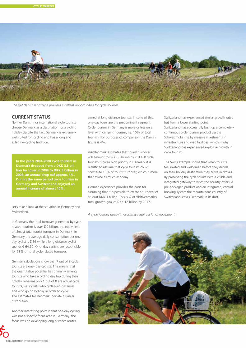
CURRENT STATUSNeither Danish nor international cycle tourists
choose Denmark as a destination for a cycling
holiday despite the fact Denmark is extremely
well suited for cycling and has a long and
extensive cycling tradition.
The flat Danish landscape provides excellent opportunities for cycle tourism.
In the years 2004-2008 cycle tourism in Denmark dropped from a DKK 3.6 bil-lion turnover in 2004 to DKK 3 billion in 2008, an annual drop oaf approx. 4%. During the same period cycle tourism in Germany and Switzerland enjoyed an annual increase of almost 10%.
Let’s take a look at the situation in Germany and
Switzerland.
In Germany the total turnover generated by cycle
related tourism is over € 9 billion, the equivalent
of almost total tourist turnover in Denmark. In
Germany the average daily consumption per one-
day cyclist is € 16 while a long distance cyclist
spends € 64.60. One- day cyclists are responsible
for 63% of total cycle related turnover.
German calculations show that 7 out of 8 cycle
tourists are one- day cyclists. This means that
the quantitative potential lies primarily among
tourists who take a cycling day trip during their
holiday, whereas only 1 out of 8 are actual cycle
tourists, i.e. cyclists who cycle long distances
and who go on holiday in order to cycle.
The estimates for Denmark indicate a similar
distribution.
Another interesting point is that one-day cycling
was not a specific focus area in Germany; the
focus was on developing long distance routes
aimed at long distance tourists. In spite of this,
one-day tours are the predominant segment.
Cycle tourism in Germany is more or less on a
level with camping tourism, i.e. 10% of total
tourism. For purposes of comparison the Danish
figure is 4%.
VisitDenmark estimates that tourist turnover
will amount to DKK 85 billion by 2017. If cycle
tourism is given high priority in Denmark it is
realistic to assume that cycle tourism could
constitute 10% of tourist turnover, which is more
than twice as much as today.
German experience provides the basis for
assuming that it is possible to create a turnover of
at least DKK 3 billion. This is ¼ of VisitDenmark’s
total growth goal of DKK 12 billion by 2017.
A cycle journey doesn’t necessarily require a lot of equipment.
Switzerland has experienced similar growth rates
but from a lower starting point.
Switzerland has successfully built up a completely
continuous cycle tourism product via the
Schweizmobil site by massive investments in
infrastructure and web facilities, which is why
Switzerland has experienced explosive growth in
cycle tourism.
The Swiss example shows that when tourists
feel invited and welcomed before they decide
on their holiday destination they arrive in droves.
By presenting the cycle tourist with a visible and
integrated gateway to what the country offers, a
pre-packaged product and an integrated, central
booking system the mountainous country of
Switzerland leaves Denmark in its dust.
CYCLE TOURISM

CONCEPTEvery 3 years VisitDenmark asks a large number
of tourists what made them travel to Denmark.
30% of them state that being able to cycle is a
primary factor. Unfortunately this is not put into
practice when the tourist is actually here; access
to good cycling experiences is too difficult.
The Danish concept of cycle tourism needs to
be rethought. The following section contains
a number of ideas and recommendations that
should be implemented in order to create the
necessary basis for developing economically
sustainable cycle tourism. A number of these
projects have already been initiated.
Denmark was a pioneer cycle country at the
time the national cycle routes were established;
the mere existence of the national routes put
Denmark in the lead. Suddenly it was possible
to cycle on a long, continuous route that was
signposted, communicated by mapping materials,
and which the cycle tourist knew had a certain
standard. Being a cycle tourist was suddenly
made easier and the label “national route” gave
the concept a certain promotional value.
The value turned out to be limited, however.
Other countries took up the idea, and developed
it in terms of essential parameters such as activity
themes, full service cycling holiday offers, and
visibility, clarity, and easy access to all information
during the planning phase.
The cycle routes in themselves are not enough
to attract tourists to the country. They can of
course still be used promotionally to attract long
distance cyclists who go on holiday in order to
ride several hundred kilometers on a Danish
cycle route, but the real potential lies in one-day
tourists.
The aim of most tourists is not merely to cycle;
they want to experience the Danish outdoors,
Danish culture and history. The challenge is to
communicate the elements of Danish life style
and cultural history that could be interesting
to outsiders while at the same time developing
offers that are best experienced by bicycle.
A cycle tour is an experience in itself. However,
if Denmark wishes to attain a higher level of
tourist volume and turnover, we have to market
more than the mere route. We need to remove
the focus from the route to the destination and
to develop theme based activity clusters linked
to and arising from the Danish outdoors, Danish
culture and history.
Denmark has many asphalt secondary roads,
which are excellent cycle routes.
The effect of the national cycle routes has not been measured. Experience shows, however, that the routes in themselves do not generate traffic; good facilities and interesting activi-ties are what attract tourists. Market-ing should aim at giving tourists the necessary information on their options. Close collaboration is essential between operators, providers, local authorities and others to provide easy access to such activities.
The next four sections discuss the following
development perspectives:
1. Activity options should be further developed
and communicated as destinations.
2. Organisational coherence should be developed
between the cycling holiday’s different
constituent elements and the different types
of service provider.
3. The concept should be marketed with a focus
on attracting new groups of cycle tourists in
order to generate critical mass, which can
serve as an incentive for further investments
and initiatives.
4. The cycle tourist should be guaranteed a
minimum standard for the quality of the
offered product, including the infrastructure.
DEVELOPING DESTINATIONSIf Denmark is to compete on the European level
there are two prerequisites that need to be in
place. First, a product has to be created that can
be marketed and that the tourist industry feels is
exciting to market. Second, the product should
make the potential guest feel that an activity
is being offered that cannot be experienced
elsewhere.
The following is recommended:
• Developthemebasedactivityclustersand
destinations.
• Furtherdevelopsignage.
• Maximizeuserfriendliness.
ThematizationThe existing Danish cycle routes can in principle
be further developed into theme based activity
clusters and destinations in two ways:
1) If a cycle route already has a story, the story
should be told. The primary examples are
the coastal routes and Hærvejen, the historic
trading and military path running through
Jutland, which because of their location and
context can either constitute the story itself or
be a major part of the story.
2) If the cycle route runs through areas that refer
to major historical figures and events beyond
the local level, the stories should be collected
and communicated on a regional basis. Theme
based detours can be added to the existing
route creating a coherent theme throughout
the established route so the guest can take a
circular route and return to the main route.
This makes it possible for interested tourists to
visit medieval churches, gourmet restaurants
and small island communities, or choose
unique outdoor experiences in collaboration
with the national parks, for example. The
concept is based on the existing national
routes, but the marketing focus should be on
destinations and associated activities.
Examples of uniquely Danish themes that are
sure to strike a responsive chord in visitors from
abroad are the manor houses and castles visited
by Hans Christian Andersen, the castles and
monuments of Kongernes Danmark , and the
Viking ships. These themes can be developed
into a battering ram for general growth in cycle
tourism in Denmark.
SignageDenmark is privileged in having a national,
a regional and a local cycle route network
characterized by consistent, uniform signage.
When the signage was introduced it served
CYCLE TOURISM
151

as an inspiration abroad because it was easily
recognizable and logical. The signs are easily
readable and discreet in the landscape. The
challenge is that several numbering systems
overlap, particularly among the regional routes,
and that the numbers assigned to regional or
local routes seem to be fairly arbitrary.
When designing routes and signage, it’s a moot
question whether the most user friendly routes
are the most linear. In Holland, for example, the
route network consists of very short routes that
always end at a junction where there are several
options. Each section has a number and it’s up to
the user to combine the individual elements into
a continuous route. The user chooses his own
starting point A and termination point B.
Signage is crucial, particularly for the
inexperienced user. Another crucial factor is the
allocation of funding to maintain and develop
existing routes. The routes are a product that can
be used to promote Denmark as a bike friendly
country; furthermore they knit the country
together. In addition there should be a focus on
local routes.
Keep in mind that what knits cycle routes
together are activities and not municipal
boundaries, and that traveling by bicycle should
always be made easy and attractive.
The use of GPS and smart phones will gradually
reduce the demand for physical signage in the
landscape. There are now 3 categories of users:
those who are completely dependent on signage
to find their way, those that always bring a map,
and those who prefer a digital solution. Gradually
as routes become more user friendly and the
cyclist target group younger, it is likely that the
new digital instruments will become increasingly
popular.
Two pieces of simple advice on signage make it
easy to be a guest:
• Makesurethesignageisinworking
order when and where the guest needs it
(maintenance).
• Buildupnewroutesaroundthemebased
experience clusters using the existing route
network as a starting point.
User friendlinessIn Denmark products are usually developed by an
individual enterprise in a chain collaboration or
within a geographically demarcated area, such as
a municipality. This is partly due to the fact that
development is funded by the enterprise or the
municipality.
There is a huge potential in one-day cycle tourism.
The problem is that cycle tourists often visit
several different enterprises, don’t limit
themselves to enterprises within a specific chain
collaboration, and cross municipal boundaries.
This means that tourists need to use several
different booking systems, that rules for whether
bicycles are allowed at accommodation vary,
that map materials look different, and that on
Children are old enough to bike at an early age.
the whole tourists find it very difficult to form an
overall picture in advance.
One solution to this challenge is the quality
label scheme, Active Denmark, which defines
a standard for what a guest may expect and
follows it up by official inspection to ensure the
standard is upheld.
CYCLE TOURISM

The German Bett&Bike system is a huge success.
The price of joining is low and visibility is high. It’s
a simple concept which Denmark would do well
to copy.
Another option is to create a cohesive product
and marketing concept such as www.hærvej.
dk. The guest should be informed of the
activity options along the route, which should
be presented as an integrated whole, cf. the
discussion of theme based activities above.
Cohesiveness can be created for example by
offering cycling guests activity based reductions,
by establishing central booking systems, and by
coordinating luggage transport and bike rental.
A central luggage transport booking system
inspired by the Swiss model is worth considering
in order to generate critical mass, which is
necessary to attract the interest of professional
providers.
The local authorities should bear in mind that
not only does tourist development generate new
workplaces and revenues; it also provides an
infrastructure for the use of the local population.
Even though municipal boundaries are not interesting to tourists, municipali-ties have an active, central role to play in the development process, both in terms of construction and infrastructure and in relation to creating collaborative relationships and motivation for new initiatives.
Infrastructure:• Constructionandaboveallmainte-
nance of routes and signage• Constructionofbicycleparkingfacili-
ties and cycle space in woods and towns
• Inter-municipalcollaborationtocre-ate longer routes
Motivation:• Supportdestinationandactivity
development• Supportnewoperators• Supportlocaltouristorganisations
in their product development and marketing efforts.
Another excellent option is a bike rental
collaboration between the tourist office and the
local bicycle shops. In Odsherred for example
the tourist office and the bicycle shop have
an agreement by which the tourist office is in
charge of administration while the bicycle shop
is in charge of bicycle service. This is an excellent
business for both parties.
ORGANISATIONAL FRAMEWORKIt is not easy to market a product whose
ownership is distributed across 98 municipalities
all of which have different priorities. The aim
should be to develop the product to a level
that is interesting to private investors in the
industry. Proposed initiatives must respect the
existing administrative structure and division of
responsibilities.
In Denmark a liaison committee for tourist
road signage already exits (Samabejdsudvalg
vedrørende Turistvejvisning). An obvious option
is to expand the committee’s authority so
that committee consultation is required for
all modifications of the national cycle routes.
Another obvious step is to anchor all signage
projects in the committee.
It is a problem that municipalities have highly
varying knowledge of the rules regulating cycle
routes. It might be a good idea to give the
Danish Road Directorate the role of initiator and
coordinator based on the Norwegian model
(pådriver). This would mean that the Danish
Road Directorate is in command of the situation
and can monitor the individual municipality’s
maintenance and development initiatives.
The first step toward further product
development can be taken by establishing a
cycle industry partnership in which all relevant
stakeholders participate. The advisory group
that was established in connection with the new
digital communications platform (Gateway til
cykeloplevelser i Danmark, see Box 5) would be
an excellent starting point for the partnership.
The group includes the Danish Road Directorate,
HORESTA, VisitDenmark, the regional tourist
development companies, the Danish Nature
Agency, the Danish Outdoor Council, and the
quality label scheme Active Denmark.
Other potential stakeholders include Foreningen
Danske Destinationer, Danish Regions, LGDK
(Local Government Denmark), the Danish
Ministry for the Environment, DN (Danish Society
for Nature Conservation), the Danish Cancer
Society, and Ældre Sagen.
The second step is to create a framework and
conditions that make it attractive for professional
tour operators to develop a wide range of cycling
holiday products. There is a great need for
tour operators. At the time of writing there are
fewer than 5 Danish players in the field and the
number of foreign operators that arrange tours in
Denmark is also limited.
Danish operators are needed because of the way
the package is packaged, marketed and sold. A
large part of a Danish tour operator’s tour sales
take place in collaboration with operators in
different countries (Ruby rejser for example.)
When a tourist buys a tour from Ruby’s catalogue
an operator at the destination is usually the
subcontractor. In other words if tours to Denmark
are to be included in the major established chain’s
catalogues there need to be subcontractors in
Denmark who can carry out the tours in practice.
The individual destination can make it easier
to attract tour operators, primarily by helping
them design tours and enter into dialogue with
hotels, etc. but also by developing appropriate
information materials.
Many people still prefer to map out their cycle
tour on a printed map.
CYCLE TOURISM
153

MARKETINGThe information a tourist needs is not easily
accessible today. Information on cycling options
in Denmark is distributed over different platforms
and even if the tourist is successful in finding all
the information no coherent picture emerges.
The cycle tourist needs to be particularly
experienced and resourceful to plan a cycling
holiday in Denmark. The difficulty involved in
accessing information and the lack of overview
precludes new target groups.
The situation is aggravated by the fact that very
little existing material is communicated digitally.
A potential tourist from abroad planning a bicycle
tour in Denmark can find very little information
on the internet despite the fact that studies show
that 2/3 of tourist information seeking is online.
Switzerland has been successful in creating a
completely cohesive product via the Schweizmobil
site. Massive investments were made in
Many Danish municipalities have suc-cessfully turned cycle tourism into a significant source of tourist revenue.At the time of writing Bornholm is the number one cycle tourist destination thanks to the conversion of disused railway tracks into cycle tracks, a solid supply of accommodation, and a focus on cycle track construction. One out of 10 tourists to Bornholm is a cycle tourist.
Viborg has recently established a number of super cycle routes which not only enable commuters to bike from neighbouring towns into Viborg but also allows cycle tourists to spend the night in one area and bike out to new landscapes and new activities every day. This creates a win-win-win situation for accommodation providers in Viborg, tourist destinations in the surrounding area, and local bicycle commuters.
Vordingborg has converted the pre-served ferry Ida into a museum ship and bike ferry thereby making the infrastruc-ture even more cohesive. A regional and inter-municipal collaboration has been established to develop the Danish continuation of the popular German “monk route” thereby establishing links across municipal and national boundar-ies. Communicating information about the route is a focus area. Finally a cycle route map was produced covering all of Møn and opening up new opportunities for experiencing the area.
infrastructure and website facilities, which is why
cycle tourism in Switzerland experienced almost
explosive growth.
In Denmark we have a product which is
considered attractive abroad. As mentioned
above the Danish cycling infrastructure is
excellent and there are many accommodation
and activity options. The crucial challenge is
that the product is not visible to the world at
large and it is difficult for tourists to plan their
holiday. A simple comparison between Denmark
and competing cycle holiday destinations shows
that product visibility is a critical success factor.
The Danish Cyclists’ Federation has therefore
taken the initiative to implement a digital
communications platform to function as an
intelligent planning tool for the cycle tourist and
render activity options visible.
Good cycling infrastructure increases road safety and provides an enjoyable experience.
The Gateway platform provides a link between cycle tourism and all types of provider. Local authorities and destina-tions can put all relevant information on their website and it will be rendered di-rectly visible to potential customers. New destinations, local routes and events, new service options, etc. can be added continuously. Another benefit is that local authorities and destinations may freely print out maps and other materials from the gateway and use the material to market local options.
Target groupsThe term “cycle tourist” often conjures up the
image of a professionally equipped lonely rider.
VisitDenmark has focused on the so-called “hard
core” segment and the national cycle route
network was largely developed for long distance
cycling. The definition in itself, i.e. that a national
cycle route needs to be at least 200 km long,
indicates this.
The problem is that the major potential doesn’t
lie in the hard core segment, but in shorter tours.
Furthermore the classification into hard core or
soft core is far from adequate. In the first place
demand from people of different nationalities
varies, in the second place there are divisions
around families with children and adult couples,
and finally tourists have a number of other
holiday wishes than cycling, such as experiencing
history, eating well, spending time with their
families, etc.
In this context it is recommended to focus
on Danish target groups and the areas with
maximum potential for these target groups.
This means focusing on:
• Touristswhoareinterestedinshortertours.
• Adultcouplesandfamilieswithchildren.
• Touristsinterestedincultureandgastronomy.
Product development should focus on developing
options for shorter tours and a variety of activities
along the routes.
Marketing should switch focus from long routes
and equipment demanding tourism to lifestyle. It
CYCLE TOURISM

should also be taken into account that individual
destinations and enterprises are attractive to
different target groups; this should be included in
the overall marketing framework.
QUALITY CONTROLThe quality and attractiveness of the national
cycle routes is very uneven. The route’s design
and the activities provided vary greatly as does
the maintenance standard. The product being
offered is uneven and opaque. This results in the
following:
• Lackofinterestinmarketingtheroutes.
• Usershaveabadormixedexperience.
• Lackofstandardsforroutemaintenance.
In order to break the vicious circle a set of criteria
should be developed which have to be met
before a route may be termed national. This
applies to physical quality as well as the quality of
the service facilities offered in the area and along
the route.
Appropriate senders of such criteria are users (the
Danish Cyclists’ Federation), commercial interests
(HORESTA, Destinations, the regional tourist
development companies and VisitDenmark), and
“owners” (Danish Nature Agency, LGDK, and the
Danish Road Directorate).
The criteria should address the following issues as
a minimum:
• Qualityassuredsurfacethatissuitablefor
cycling
• Reliablesignage(maps,signposts,etc.)
• Criticalmassofactivities
• Criticalmassofaccommodationand
restaurants
• Securityandsafety
• Facilitiesforgettingtoandfromtheroute
(bus, train, parking)
Cycle routes do not have to be uniform. A route
may offer large variations in terrain, level of
difficulty, surface, etc. However, there should
be a minimum standard and it is crucial that the
information the tourist is given about the route
before embarking is reliable. Safety is absolutely
essential and non-negotiable. Heavily trafficked
road sections are not suitable for family cycling
with children. National cycle routes must never
include such sections.
A quality labeling scheme for cyclist friendly
accommodation and other facilities already
exists. It is essential that the standard is
further developed and maintained. If a cycle
tourist repeatedly experiences non-existent
Families with children are a major target group.
cycling facilities at supposedly cycling friendly
accommodation, the system loses its value.
Maintaining on-going quality control is costly;
users should be actively involved so as not to
drain public funds. Homepages and websites
already exist where cyclists can report potholes
on the cycle track directly to the local technical
administration. Such systems should be further
developed both on the sender and receiver level.
On-site reporting systems should be developed.
They should be built up selectively and include
a system that makes it easy for the receiver to
understand the report’s importance and the
action required.
Road safety is crucial, especially when cycling with children.
CYCLE TOURISM
155

It should constantly be born in mind that, finally,
the routes exist in order to give users a great
experience. The likelihood of developing an
attractive route network is significantly increased
by opening up for user input, allowing users to
create new experiences and submit proposals for
modifying the routes and improving services.
SUMMARYExploiting the inherent potential of cycle tourism
will create economic growth and employment
even in the peripheral areas. The following
prerequisites must be met:
1. Activities and destinations should be marketed
rather than cycle routes.
2. The experience should be as seamless as
possible for the cycle tourist, from the
planning stage to the field.
3. Physical facilities should be maintained and
developed, and coordinated across municipal
boundaries. The routes should be reliable in
terms of cycling comfort, signage and safety.
4. Users should be actively involved in
maintenance and development.
5. Public and private services should be
developed and coordinated so they support
each other. Municipalities play a central role in
such collaboration.
CYCLE TOURISM

15SourceS and photo creditS
Contents
Chapter 3 - Collaborations and networks 158Chapter 4 - Cost-benefit and traffic models 158Chapter 5 - Campaigns and marketing 158Chapter 6 - Health and cycling 158Chapter 7 - Urban planning and bicycle planning 159Chapter 8 - Planning the cycling infrastructure 159Chapter 9 - Designing the cycling infrastructure 160Chapter 10 - Bicycle parking 161Chapter 11 - Road signage and maps, cycle route planners, and ITS 161Chapter 12 - Maintenance and road construction 161Chapter 13 - Public bikes and commuter bikes 162Chapter 14 - Cycle tourism 162Photo credits 162

SourceS and photo creditS
Sources 6.1 Statens Institut for Folkesundhed,
Sundheds- og sygelighedsunder-
søgelserne 1987-2005.
6.2 Sundhedsstyrelsen (2011): Den nationale sund-
hedsprofil 2010 – Hvordan har du det?
6.3 Det økologiske råd (2005) Cykling, motion, miljø
og sundhed.
6.4 Sundhedsstyrelsen, Center for Forebyggelse
(2003): FYSISK AKTIVITET – håndbog om
forebyggelse og behandling del 1 og del 2.
6.5 Andersen L.B, Schnohr P, Schroll M, Hein HO.
All-cause mortality associated with physical activity
during leisure time, work, sports, and cycling to
work. Arch Intern Med (2000):160:11.:1621-
1628.
6.6 Cooper, Andersen, Wedderkopp, Page, Froberg.
Physical activity level of children who walk, cycle
or are driven to school. Accepted 2004, Am J Prev
Med.
6.7 House of Commons Health Committee: Obe-
sity,2004, oprindeligt lavet af Sustrans (Sustainable
Transport Charity). Kilder: andel overvægtige:
International Obesity task force (2002). Andel
cyklende børn: Department for Transport (1996).
6.8 Motions- og Ernæringsrådet (2007):
Fysisk inaktivitet - konsekvenser og sammenhænge.
6.9 Odense Kommune, Evaluering af Odense
– Danmarks Nationale Cykelby.
6.10 Troelsen, Jens (2004): Syddansk Universitet Mobil
på cykel.
6.11 Berlingske Tidende, Jakob Stig Jørgensen 2.
november 2010.
Sources 5.1 Kommunikationsplan.
5.2 Transport Studies Group (1998) INPHORMM,
England.
5.3 Eval_Odense.
5.4 Contact sheet Randers.
5.5 Kenneth Hartley Blanchard and Spencer Johnson:
”The one minute manager”
Sources 4.1 COWI (2008): Samfundsøkonomiske analyser af
cykeltiltag - metode og cases.
4.2 DTU Transport og COWI (2010): Transportøkono-
miske enhedspriser til brug for samfundsøkonomi-
ske analyser.
4.3 Johan de Hartog J, Boogaard H, Nijland H, Hoek
G.: Do the health benefits of cycling outweigh
the risks? Environ Health Perspect. 2010
Aug;118(8):1109-16. Epub 2010 Jun 11.
4.4 SQW (2007): Valuing the Benefits of Cycling
-Executive Summary.
4.5 Kevin Mayne, CTC The UK Cyclist’s Organisation
(2010): The proces of evaluating English Cycling
cities - præsentation på National cykelkonference
2010.
4.6 Tetraplan (2009): Opgradering af cykelruten langs
Vestvolden - med fokus på at tiltrække flere pend-
lere.
Sources 3.1 Dansk Cyklist Forbund og Cycling Embassy of
Denmark.
Chapter 6health and CyCling
Chapter 4CoSt-benefit and traffiC modelS
Chapter 5 - CampaignS and marketing
Chapter 3CollaborationS and networkS

SourceS and photo creditS
Sources 8.1 Cykelregnskaber for nordiske cykelbyer, bl.a.
Frederikshavn, Silkeborg og Viborg.
www.nordiskecykelbyer.dk.
8.2 Cykelregnskab 2009. 8000 fordele ved at cykle.
Aarhus Kommune. 2009. www.aarhuscykelby.dk.
8.3 Cykelregnskaber for 2008 og 2010. København
cyklernes by. Københavns Kommune 2009 og
2011. www.kk.dk/cyklernesby.
8.4 Niels Jensen. Udvikling og implementering af
målemetode for cyklisters rejsehastighed. Konfe-
renceindlæg Trafikdage 2004. www.trafikdage.dk.
8.5 Cykelsuperstiprojektets hjemmeside.
ww.cykelsuperstier.dk.
8.6 Planlægning for cyklister, hverdag og fritid.
Miljøministeriet. 1985.
8.7 8-80cities hjemmeside. www.8-80cities.org.
8.8 Nicolas Mercat. Modelling of bicycle journeys,
using energy rather than journey time or distance.
Proceedings Velo-City 99. Graz & Maribor.
8.9 Krister Spolander (1999): Staden, bilen, farten.
Malmö.
8.10 Shared space. Eksempelsamling. Vejdirektoratet.
www.vejsektoren.dk.
8.11 Linda Christensen og Thomas C. Jensen (2008):
Korte ture i bil – Kan bilisterne ændre adfærd til
gang og cykling. . DTU Transport.
www.transport.dtu.dk.
8.12 Inga löjliga bilresor (Malmö kampagne).
www.ingalojligabilresor.nu
8.13 Odense cykelby. www.odense.dk.
8.14 European Cyclists’ Fedration Road Safety Charter:
Halving injury and fatalily rates for cyclists by
2020. ECF 2010. www.ecf.com. Tal fra figuren:
Safety in numbers (i ECF’s rapport) bearbejdet til
brug i Idékataloget.
8.15 Søren Underlien Jensen (1998): DUMAS - Safety
of Pedestrians and Two-wheelers. Note 51.
Vejdirektoratet.
8.16 Movia - www.moviatrafik.dk: Pedaler i bussen.
8.17 Danmarks Radio - www.dr.dk (2010): Book plads
til cyklen. P4 Bornholm.
8.18 Niels Jensen (2002): Cykelpolitik 2002-12. .
Københavns Kommune. www.kk.dk/cyklernesby.
8.19 Københavns Kommune (2007): Miljømetropolen.
Vores vision CPH 2015. www.kk.dk/cyklernesby.
8.20 Københavns Kommune (2010): Fra god til verdens
bedste. Københavns cykelstrategi 2011-2025.
www.kk.dk/cyklernesby.
8.21 Frederikshavn Kommune (2011): Flere cykler.
Opfølgning på byrådets cykelpolitik (forslag) .
8.22 Nordiske cykelbyer. www.nordiskecykelbyer.dk.
8.23 Friluftsrådet (2011): Stier – inspiration til plan-
lægning og forvaltning. www.friluftsrådet.dk (se
politik og derefter planlægning).
8.24 Trafiksanering i en bydel med trafikadskillelse (Al-
bertslund Syd). I Planlægning for cyklister, hverdag
og fritid. Miljøministeriet. 1985 (ref. 8.6).
8.25 Cykelstrategi. Albertslund Kommune. 2009.
www.albertslund.dk
8.26 Flere cykler på sikker vej i staten. Transport- og
Energiministeriet 2007.
www.trm.dk/publikationer/2007
Sources 7.1 Miljøministeriet (2010): Landsplanredegørelse
2010
7.2 Naturstyrelsen, Miljøministeriet (2011) Planloven
7.3 Rietveld, Piet, V. Daniel (2004):
Determinants of bicycle use: do municipal policies
matter? Transportation Research Part A no. 38 p.
531–550
7.4 Linda Christensen og Thomas C. Jensen, (2008):
Korte ture i bil DTU Transport
7.5 Hartoft-Nielsen, Peter (2001):
Arbejdspladslokalisering og transportadfærd
7.6 Miljøministeriet (2007): Fingerplan 2007
7.7 Jan W Hansen og Roseels Tegnestue (2009)
7.8 By & Havn og Københavns Kommune (2009):
Nordhavnen Urban Strategy
7.9 Fietsberad (juni 2011): Specialist’s news
7.10 Retail Institute Scandinavia (2011)
7.11 Miljøministeriet (2007): Planloven i praksis
7.12 Celis, Pablo og Bølling-Ladegaard, Erik (2007):
Cykelparkeringshåndbog
7.13 Helsingør Kommune, Aarhus Kommune, Aalborg
Kommune, Odense Kommune, Københavns Kom-
mune, Fredericia Kommune, Randers Kommune;
Kommunale cykelhandlingsplaner m.v. (2008-
2011)
7.14 Bypad.org (2011)
7.15 European smart cities; Pleon Publico Salzburg m.fl.
www.smart-cities.eu. (2011)
7.16 Vejdirektoratet (2011): Aftale om
HyperCard, busser, cykler, trafiksikkerhed, støjbe-
kæmpelse mv.
7.17 Jensen, Søren Underlien og Nielsen,
Michael Aakjer (1996): Bystrukturens betydning
for cykeltrafikken, konferencerapport fra Trafik-
dage på Aalborg Universitet ‘99.
Chapter 7Urban planning and biCyCle planning
Chapter 8planning the CyCling infraStrUCtUre
8.27 Aftale mellem regeringen (Venstre og Konservative
og Socialdemokraterne, Dansk Folkeparti, Det
Radikale Venstre og Liberal Alliance): En grøn
transportpolitik. 29. januar 2009.
www.trm.dk/publikationer
8.28 Cykelpuljen 2011. www.vejsektoren.dk.
8.29 Vejregelportal: http://vejregler.lovportaler.
dk/. Også henvisning til trykte hæfter. "Hæfte
0"/"Håndbog"/"Stikordsregister" for en given
vejregel (se nedenfor) giver overblik.
8.30 Byernes trafikarealer. "Hæfte 0" giver overblik.
http://vejregler.lovportaler.dk/
8.31 Planlægning af veje og stier i åbent land. "Hæfte
0" giver overblik. http://vejregler.lovportaler.dk/
8.32 Vejvisning på cykel-, vandre- og rideruter.
"Håndbog". http://vejregler.lovportaler.dk/
8.33 Fauna og menneskepassager. "Håndbog".
http://vejregler.lovportaler.dk/
8.34 Niels Jensen: Sikkerhed og tryghed på cykelstier i
København. Københavns Kommune. Cykelviden
nr. 13 (feb. 2007). http://issuu.com/cykelviden/.
8.35 Trafiksikkerhed for cyklister. Indsatsplan for sikker
cykeltrafik 2007-2012. www.kk.dk. Følg By og
trafik, Byens Trafik, Trafiksikkerhed. Heri links til
Trafitec-undersøgelser for Københavns Kommune
(se også 8.36).
8.36 Sikkerhed og tryghed ved cykelstier og cykelbaner
i København. 4 Trafitec-undersøgelser (Søren
Underlien Jensen) for Københavns Kommune: Ef-
fekter af cykelstier og cykelbaner (2006). Cyklisters
oplevede tryghed og tilfredshed (2006). Effekter
af overkørsler og blå cykelfelter (2006). Smalle
cykelbaner ved lyskryds (2010). www.trafitec.dk.
8.37 Bekendtgørelse om cyklers indretning og udstyr.
nr. 316 af 20-5-1999. www.retsinfo.dk.
8.38 Bekendtgørelse nr. 783 af 6-7-2006 om vejaf-
mærkning. Ny udgave i høring medio 2011.
http://vejregler.lovportaler.dk/
8.39 Håndbog for trafiksikkerhedsrevision og -revision.
1.dec. 2009. http://vejregler.lovportaler.dk/
8.40 Fodgængeres og cyklisters oplevede serviceniveau
på vejstrækninger (tilsvarende for kryds er under
udarbejdelse i 2011).
http://vejregler.lovportaler.dk/.
8.41 Det visuelle miljø. Hæfte 10 (1992). Byernes
trafikarealer. http://vejregler.lovportaler.dk/.
159

SourceS and photo creditS
Chapter 9deSigning the CyCling infraStrUCtUre
Sources 9.1 Engel, Ulla og Iversen, Lis (1979): Cyklisters
kriterier for rutevalg, Rådet for trafiksikkerheds-
forskning, Danmark.
9.2 Landis, Bruce W.; Vattikuti, Venkat R. og Brannick,
Michael T. (1996): Real-Time Human Perceptions
– Toward a Bicycle Level of Service, Transportation
Research Record 1578, USA.
9.3 Greibe, Poul og Hemdorff, Stig (1998): Uheldsmo-
del for bygader – Del 2: Model for strækninger,
Notat 59, Vejdirektoratet, Danmark.
9.4 Møller, Jes og Larsen. Flemming (1983): Cykel- og
knallertulykker i landområder - Dokumentations-
rapport, Vejdirektoratet, Danmark.
9.5 Vejdirektoratet (1992): Cykelstier i Frederiksborg
Amt - En brugerundersøgelse, Danmark.
9.6 Møller, Jes og Larsen. Flemming (1983): Cykel- og
knallertulykker i landområder - Dokumentations-
rapport, Vejdirektoratet, Danmark.
9.7 Elvik, Rune; Mysen, Anne Borger og Vaa, Truls
(1997): Trafiksikkerhetshåndbok, Transportøkono-
misk institutt, Norge.
9.8 Davies, D.G.; Ryley, T.J.; Rayler, S.B. og Halliday,
M.E. (1997): Cyclists at road narrowings, Report
241, Transport Research Laboratory, England.
9.9 Vejdirektoratet (1985): Trafiksanering af store
bygader – nogle eksempler, Danmark.
9.10 Taylor, David (1996): The Feet First Report, Eng-
land.
9.11 Taylor, David C. og Mackie, Archie M. (1996):
Review of traffic calming schemes in 20 mph
zones, Report 215, Transport Research Laboratory,
England.
9.12 Søren Underlien Jensen – Trafitec: Sikkerhedsef-
fekter af trafiksanering og signalregulering i
København Teknik og Miljø, januar 2009.
9.13 Coates, Nigel (1999): The safety benefits of cycle la-
nes, Proceedings of Velo-City ’99, Østrig/Slovenien.
9.14 Nielsen, Erling Dan, Andersen, Karina Vestergaard
og Lei, Karen Marie (1996): Trafiksikkerhedsef-
fekten af cykelbaner i byområder, Rapport 50,
Vejdirektoratet, Danmark.
9.15 Smith, Robert L. og Walsh, Thomas (1988): Safety
Impacts of Bicycle Lanes, Transportation Research
Record 1168, USA.
9.16 Trafitec (2006): Effekter af cykelstier og cykelbaner.
9.17 Ágústsson, Lárus og Lei, Karen Marie (1994):
Trafiksikkerhedseffekten af cykelbaner på
strækninger mellem kryds i byområder, Notat 12,
Vejdirektoratet, Danmark.
9.18 Nielsen, Erling Dan, Andersen, Karina Vestergaard
og Lei, Karen Marie (1996): Trafiksikkerhedsef-
fekten af cykelbaner i byområder, Rapport 50,
Vejdirektoratet, Danmark.
9.19 Nielsen, Erling Dan, Andersen, Karina Vestergaard
og Lei, Karen Marie (1996): Trafiksikkerhedsef-
fekten af cykelbaner i byområder, Rapport 50,
Vejdirektoratet, Danmark.
9.20 Søren Underlien Jensen, Trafitec (2006): Effekter
af cykelstier og cykelbaner.
9.21 Landis, Bruce W.; Vattikuti, Venkat R. og Brannick,
Michael T. (1996): Real-Time Human Perceptions
– Toward a Bicycle Level of Service, Transportation
Research Record 1578, USA.
9.22 CROW (1993): Sign up for the bike, Record 10,
Holland.
9.23 CROW (1998): Recommendations for traffic provi-
sions in built-up areas, Record 15, Holland.
9.24 Giæver, Terje; Øvstedal, Liv og Lindland, Terje
(1998): Utforming av sykkelanlegg - intervju og
atferdsundersøkelser, Rapport STF22 A97615,
SINTEF, Norge.
9.25 Herrstedt, Lene; Nielsen, Michael Aakjer; Ágústs-
son, Lárus; Krogsgaard, Karen Marie Lei; Jørgen-
sen, Else og Jørgensen, N.O. (1994): Cyklisters
sikkerhed i byer, Rapport 10, Vejdirektoratet,
Danmark.
9.26 Rosbach, Ole (1984): Kantlinier forbedrer både
bilisters og cyklisters sikkerhed, Dansk Vejtidsskrift
nr. 10, Danmark.
9.27 Vejdirektoratet (1992): Cykelstier i Frederiksborg
Amt - En brugerundersøgelse, Danmark.
9.28 Møller, Jes og Larsen. Flemming (1983): Cykel- og
knallertulykker i landområder - Dokumentations-
rapport, Vejdirektoratet, Danmark.
9.29 CROW (1998): Recommendations for traffic provi-
sions in built-up areas, Record 15, Holland.
9.30 Risegaard, Peter (1995): Ny type kantbaner af-
prøvet i nordjyske byer, Dansk Vejtidsskrift nr. 11,
Danmark.
9.31 Ludvigsen, Henrik S. (1982): Cykel- og knaller-
tuheld på veje med kantbaner, Dansk Vejtidsskrift
nr. 6, Danmark.
9.32 Rosbach, Ole (1984): Kantlinier forbedrer både
bilisters og cyklisters sikkerhed, Dansk Vejtidsskrift
nr. 10, Danmark.
9.33 Møller, Jes og Larsen. Flemming (1983): Cykel- og
knallertulykker i landområder - Dokumentations-
rapport, Vejdirektoratet, Danmark.
9.34 Jørgensen, Else (1978): Cykelstier på landet, Vejdi-
rektoratet, Danmark.
9.35 Møller, Jes og Larsen. Flemming (1983): Cykel- og
knallertulykker i landområder - Dokumentations-
rapport, Vejdirektoratet, Danmark.
9.36 Alrutz, Dankmar; Fechtel, Hans W. og Krause,
Juliane (1989): Unfall- und Sicherheitsforschung
Strassenverkehr – Dokumentation zur Sicherung
des Fahrradverkehrs, Heft 74, Bundesanstalt für
Strassenwesen, Tyskland.
9.37 Trafitec (2006): Effekter af cykelstier og cykelbaner.
9.38 Nielsen, Michael Aakjer; Olsen, Mette og Lund,
Belinda la Cour (2000): Cyklisthastigheder i byom-
råder, Notat 62, Vejdirektoratet, Danmark.
9.39 Søren Underlien Jensen, Trafitec (2006): Fod-
gængeres og cyklisters oplevede serviceniveau på
vejstrækninger.
9.40 Page, Matthew; Siu, Yim Ling; Tight, Miles og
Wardman, Mark (1999): Cycling and urban travel
choice, Proceedings of Velo-city ’99, Østrig/Slove-
nien.
9.41 Vejdirektoratet (1999): Trafikindeks, Danmark.
9.42 Møller, Jes og Larsen. Flemming (1983): Cykel- og
knallertulykker i landområder - Dokumentations-
rapport, Vejdirektoratet, Danmark.
9.43 Vejdirektoratet (1992): Cykelstier i Frederiksborg
Amt - En brugerundersøgelse, Danmark.
9.44 Lahrmann, Harry (1992): Cykelbaner med asfal-
tvulst, Aalborg Universitet, Danmark.
9.45 Herrstedt, Lene; Nielsen, Michael Aakjer; Ágústs-
son, Lárus; Krogsgaard, Karen Marie Lei; Jørgensen,
Else og Jørgensen, N.O. (1994): Cyklisters sikkerhed
i byer, Rapport 10, Vejdirektoratet, Danmark.
9.46 Engel, Ulla og Thomsen, Lars Krogsgård (1985):
Cyklister ved busstoppesteder, Dansk Vejtidsskrift
nr. 7/8, Danmark.
9.47 Engel, Ulla og Thomsen, Lars Krogsgård (1986):
Rumlestriber på cykelstier, Dansk Vejtidsskrift nr. 2,
Danmark.
9.48 Københavns Kommune (1999): Frederikssundsvej
– Evaluering af spørgeskemaundersøgelse, Udkast,
Danmark.
9.49 Ministeriet for offentlige arbejder (1984): Cirku-
lære om etablering af dobbeltrettede cykelstier
langs vej, Cirkulære nr. 567-00-04, Danmark.
9.50 Vejdirektoratet – Vejregeludvalget (1987):
Vejregler for opsætning af vej- og broautoværn,
Danmark.
9.51 Vejdirektoratet (2000): Vejsektorens Informations-
System (VIS), Danmark.
9.52 Herrstedt, Lene (1979): Sikkerhed for cyklister og
knallertkørere på hovedfærdselsårer i Københavns-
området, Notat 5, Rådet for Trafiksikkerhedsforsk-
ning, Danmark.
9.53 Søren Underlien Jensen, Trafitec (2006): Effekter
af overkørsler og blå cykelfelter.
9.54 Nielsen, Michael Aakjer (1994): Nye afmærkninger
på cykelstier ved ikke signalregulerede T-kryds
– Effektundersøgelse, Notat 8, Vejdirektoratet,
Danmark.
9.55 Lund, Belinda la Cour (1999): Cyklisters sikkerhed
i kryds – Forslag til nye design af vigepligtsregule-
rede T-kryds, upubliceret materiale, Vejdirektora-
tet, Danmark.
9.56 Herrstedt, Lene (1979): Sikkerhed for cyklister og
knallertkørere på hovedfærdselsårer i Københavns-
området, Notat 5, Rådet for Trafiksikkerhedsforsk-
ning, Danmark.
9.57 Søren Underlien Jensen, Trafitec (2006): Fod-
gængeres og cyklisters oplevede serviceniveau på
vejstrækninger.
9.58 Vejdirektoratet – Vejregeludvalget (1991-93): Byer-
nes trafikarealer – Hæfte 1-10, Danmark.
9.59 Lahrmann, Harry og Leleur, Steen (1994): Vejtrafik
– Trafikteknik & Trafikplanlægning, Polyteknisk
Forlag, Danmark.
9.60 Søren Underlien Jensen, Trafitec (2009): Safety
Effects of Intersection Signalization: a Before-After
Study
9.61 Vejdirektoratet – Vejregeludvalget (1984): Vejreg-
ler for signalanlæg, Danmark.
9.62 Søren Underlien Jensen, Trafitec (2006): Effekten
af cykelstier og cykelbaner.
9.63 Behrensdorff, Inge og Hansen, Lars Klit (1994):
Sidespejle på lastbiler - brug og effekt af nærzone
og vidvinkelspejle, Rådet for Trafiksikkerhedsforsk-
ning, Danmark.
9.64 Herrstedt, Lene; Nielsen, Michael Aakjer; Ágústs-
son, Lárus; Krogsgaard, Karen Marie Lei; Jørgen-
sen, Else og Jørgensen, N.O. (1994): Cyklisters
sikkerhed i byer, Rapport 10, Vejdirektoratet,
Danmark.
9.65 Behrensdorff, Inge og Hansen, Lars Klit (1994):
Sidespejle på lastbiler - brug og effekt af nærzone
og vidvinkelspejle, Rådet for Trafiksikkerhedsforsk-
ning, Danmark.
9.66 Nielsen, Michael Aakjer (1995): Cyklisters sikker-
hed i byen, Dansk Vejtidsskrift nr. 8, Danmark.
SourceS and photo creditS
Sources 12.1 Mercat, Nicolas (1999): Modelling of bicycle jour-
neys: Using energy expended rather than journey
time or distance, Proceedings of Velo-City ’99,
Østrig/Slovenien.
12.2 Mikkelsen, Leif og Prahl, Knud Bjørn (1999):
Vintertjeneste med saltlage på cykelstier, Dansk
Vejtidsskrift nr. 10, Danmark.
12.3 Larsen, Lars Binderup (1991): Eneuheld på cykel,
UlykkesAnalyseGruppen, Odense Sygehus, Dan-
mark.
12.4 Vejdirektoratet – Vejregeludvalget (1987): Vejreg-
ler for afmærkning af vejarbejder, Danmark.
12.5 Davies, D.G.; Ryley, T.J.; Coe, G.A. og Guthrie,
N.L. (1998): Cyclist safety at road works, Report
12.6 Larsen, Lars Binderup (1991): Eneuheld på cykel,
UlykkesAnalyseGruppen, Odense Sygehus, Dan-
mark.
Sources 11.1 Vejvisning på cykel-, vandre- og rideruter. "Hånd-
bog". http://vejregler.lovportaler.dk/.
Bekendtgørelse nr. 841 om vejvisning på cykel-,
ride- og vandreruter af 8-9-2009. www.retsinfo.dk.
11.2. Europæiske cykelruter. www.EuroVelo.com.
11.3 Grøn cykelruteskiltning i København. Bilag til møde
i Teknik- og Miljøudvalget 9-4-2008.
www.kk.dk. Søg under Politik.
11.4 Cykelruteskiltning i Aarhus. Personlig meddelse fra
Pablo Celis, Aarhus Kommune 2011.
11.5 Midtby cykelskiltning i Aarhus. Personlig medde-
lelse fra Pablo Celis, Aarhus Kommune 2011.
11.6 Odense cykelkort. Odense Kommune.
www.odense.dk.
11.7 Kom frit frem. Cykelkort over København 2011.
Pop-up kortet er en del af kampagnen God cykel-
karma. www.kk.dk/cyklernesby.
11.8 Cyklistforbundets landsdækkende serie af guidebø-
ger med tilhørende kort i 1:100.000. www.dcf.dk.
11.9 Vejdirektoratets digitale kort over nationale cykelru-
ter på nettet. www.trafikken.dk.
11.10 Guidebøger Cycline/Esterbauer forlag. www.ester-
bauer.com. Udsolgte udgaver ses ikke på forlagets
hjemmesiden, men kan lånes i danske folkebiblioteker.
11.11 Kommunale cykelkort. Jens Erik Larsen. Konferen-
ceindlæg 2010. www.vejforum.dk.
11.12 Cykelrutekort. Gribskov kommune. 2009.
11.13 Cykelkort København/Cycling Map Copenhagen. 2.
udgave 2010. Også PDF på nettet.
www.kk.dk/cyklernesby.
11.14 Albertslunds cykelplanner til mobiltelefon.
www.albertslund.dk/cykelruteplanner.
11.15 Aalborg cykelplanner på nettet. Udarbejdet af Krak/
Eniro for kommunen.
www.trafikken.dk/Nordjylland.
11.16 Fredericia cykelplanner på nettet. Udarbejdet af
Kofoed & Co for kommunen. www.fredericiacykel-
guide.dk.
11.17 Fællesoffentligt Geografisk Administrationsgrund-
lag. www.fotdanmark.dk.
11.18 Det digitale vejnet. Pilotprojekt for 7 kommuner.
2011. www.digitalt-vejnet.dk.
11.19 Öresund som cykelregion, delprojekt Info n Bike.
Forarbejder (upubliceret) til cykelruteplanner. 2011.
www.oresundsomcykelregion.nu.
11.20 Forarbejder til cykelplanner (Cykelsekretatiatet, Kø-
benhavns Kommune, upubliceret). Desuden bilig til
møde i Teknik og Miljøudvalget 26-9-2011. www.
kk.dk. Søg under Politik.
11.21 Rejseplanen. www.rejseplanen.dk.
11.22 Cykelsuperstiprojektetes hjemmeside. www.cykel-
superstier.dk.
11.23 Cyclistic. www.cyclistic.dk.
11.24 Cyclecopenhagen. www.cyclecopenhagen.dk.
11.25 Resejämföraren.
www.kartor.lund.se/resejamforaren.
11.26 Cyclejourneyplanner. www.cyclejourneyplanner.tfl.
gov.uk
11.27 Journeyplanner. www.transportdirect.info
11.28 Naviki. www.naviki.org.
11.29 Evaluering af Odense – Danmarks Nationale Cy-
kelby. Odense Kommune 2004. www.trafitec.dk.
11.30 Nicolai Ryding Høgh. Grøn bølge for cyklister i
København. Konferenceindlæg. www.vejforum.dk/
vejforum2007.
Chapter 11road Signage and mapS, CyCle roUte plannerS, and itS
Chapter 12 maintenanCe androad ConStrUCtion
11.31 Michael Bloksgaard, Anders Kreutzfeld og Karen
Marie Lei. Trafik & Veje nr. 3 (2011): Forsøg med
variable tavler, lyssøm og stibump.
www.trafikogveje.dk.
11.32 ITS idékonkurrence. Københavns Kommune. 2009.
www.kk.dk/ITS.
11.33 Supercykelstier i København. Projektudviklingsplan.
Udarbejdet af Rambøll By og Trafik for Københavns
Kommune. Center for Trafik, Teknik- og Miljøfor-
valtningen. Københavns Kommune. 2009.
11.34 Marianne Weinreich (Veksø A/S) og Morten
Riisgaard-Dam (Aros Kommunikation). Newsletter
3, 29-6-2011: GPS-technologi makes cycling fun!
Cycling Embassy of Denmark. www.cyclingem-
bassy.dk/2011.
11.35 Marianne Weinreich (Veksø A/S). 3-1-2011: Sho-
wing cyclists that they count. Cycling Embassy of
Denmark. www.cyclingembassy.dk/2011.
11.36 Copenhagen wheel.
www.senseable.mit.edu/Copenhagenwheel/.
Sources 10.1 Dansk Cyklistforbund (2007): Cykelparkerings-
håndbog.
10.2 Trafikstyrelsen (2009): Bedre samspil mellem
cyklen og den kollektive trafik.
Chapter 9deSigning the CyCling infraStrUCtUre
Chapter 10biCyCle parking
9.67 Jensen, Søren Underlien og Nielsen, Michael Aak-
jer (1996): Cykelfelter - Sikkerhedsmæssig effekt i
signalregulerede kryds, Rapport 51, Vejdirektora-
tet, Danmark.
9.68 Trafitec (2006): Effekter af overkørsler og blå
cykelfelter.
9.69 Trafitec (2009): Cykellommer - Spørgeundersø-
gelse om tryghed, tilfredshed, mv.
9.70 Vejdirektoratet – Vejregeludvalget (1991-93): Byer-
nes trafikarealer – Hæfte 1-10, Danmark.
9.71 Brüde, Ulf og Larsson, Jörgen (1996): The safety
of cyclists at roundabouts, VTI meddelande 810A,
Sverige.
9.72 CROW (1993): Rontondes, Publikatie 79, Holland.
9.73 CROW (1998): Eenhein in rotondes, Publikatie
126, Holland.
9.74 Fietsersbond enfb (1999): Fietsvriendelijke roton-
des, Holland.
9.75 Haller, Wolfgang; Lange, Johannes; Dankmar,
Alrutz og Stellmacher-Hein, Jörg (1999): Verkehrs-
sicherheit von Fussgängern und Radfahrern an
kleinen Kreisverkehrsplätzen, Strassenverkehr-
stechnik 10/99, pp. 496-502, Tyskland.
9.76 Hülsen, H. (1993): Unfälle mit radfahrern in
Bayern, Beratungstelle für Schadenverhütung,
Mitteilung 33, Tyskland.
9.77 Vejdirektoratet (1992): Cykelstier i Frederiksborg
Amt - En brugerundersøgelse, Danmark.
161

SourceS and photo creditS
Chapter 13pUbliC bikeS and CommUter bikeS
photo CreditS
Chapter 14CyCle toUriSm
Sources 14.1 Dansk Cyklist Forbund
SourcesNone
Albertslund Kommune
Atkins Danmark A/S
Clear Channel
Foreningen Frie Fugle
Fredericia Cykelby
Frederikshavn Kommune
Kristian Ravnevand
Københavns Kommune
Frederiksberg Kommune
Lars Bahl
Linda Hansen
Malmö Stad
Søren Hytting
Middelfart Kommune
Odense Kommune
Rambøll Danmark A/S
Dansk Cyklist Forbund
Sweco Infrastrukture AB
Vejdirektoratet
Aalborg Kommune
Aarhus Kommune
Randers Kommune
Lars Gemsø
Veksø A/S
Flexys
MANIFESTO
Cycling Embassy of Denmark
COWI A/S
Kræftens Bekæmpelse
Vejle Kommune

