coastal louisiana levee consortium 2015 report · table of contents table of contents 3 members of...
TRANSCRIPT

COASTAL LOUISIANA LEVEE CONSORTIUM 2015 REPORT
An Advisory Commission to the Coastal Protection and Restoration Authority May 14, 2015

CLLC Position Paper
2
COASTAL LOUISIANA LEVEE CONSORTIUM 2015 REPORT
Submitted to
The Coastal Protection and Restoration Authority of Louisiana (CPRA)
By
Coastal Louisiana Levee Consortium, an Advisory Commission of CPRA In accordance with Acts 2014, No. 387, §2 and R.S. 49:214.6.8

CLLC Position Paper
3
TABLE OF CONTENTS
TABLE OF CONTENTS 3
MEMBERS OF THE COASTAL LOUISIANA LEVEE CONSORTIUM 4
ACKNOWLEDGMENTS 5
INTRODUCTION 5
DIVERSIONS 6
LAND BRIDGES 7
BARRIER ISLANDS 8
BARRIER SHORELINES 8
COMPUTER MODELING 9
FLOOD INSURANCE 10
LEVEE STANDARDS 10
NAVIGATION 11
LEGISLATION AND PRESENT LAW 13
ECONOMICS 13
CONCLUSION 14
APPENDIX A: COMPREHENSIVE AND INTEGRATED APPROACH TO MEET THE WATER RESOURCES NEEDS IN THE WAKE OF HURRICANES KATRINA AND RITA 16 APPENDIX B: VIEWS ON DIVERSION 17 APPENDIX C: REPORT ON NFIP REFORM 18 APPENDIX D: FEDERAL FLOOD RISK MANAGEMENT STANDARD 19 APPENDIX E: GUIDELINES ON BUILDING AFFORDABLE LEVEES 20 APPENDIX F: SLLD DRAFT DOCUMENT ON INTERIM DESIGN PROCEDURES FOR HURRICANE PROTECTION LEVEES 21 APPENDIX G: 2015 LEGISLATIVE ISSUES 22 APPENDIX H: APPROPRIATION OF LEVEE SERVITUDE IN LOUISIANA, BY DAVID PETERSON 23 Image on cover: https://lacoast.gov/new/Data/Maps/lastate453n.jpg

CLLC Position Paper
4 Members of the Coastal Louisiana Levee Consortium
Amite River Basin Drainage and Water Conservation District Atchafalaya Basin Levee District Office of the Governor-Coastal Activities Chenier Plain Coastal Restoration & Protection Authority Grand Isle Independent Levee District Iberia Parish Levee, Hurricane and Conservation District Jefferson Davis Parish Government Lafitte Area Independent Levee District Lafourche Basin Levee District Non-Flood Protection Asset Management Authority North Lafourche Conservation, Levee and Drainage District Plaquemines Parish Government Pontchartrain Levee District The Sewerage and Water Board of New Orleans South Lafourche Levee District Southeast Louisiana Flood Protection Authority – East Southeast Louisiana Flood Protection Authority – West St. Mary Levee District St. Tammany Levee District Terrebonne Levee and Conservation District

CLLC Position Paper
5 Acknowledgments Coastal Louisiana Levee Consortium Chair Windell Curole, General Manager South Lafourche Levee District Coastal Louisiana Levee Consortium Vice-Chair Earl A. Landry, Jr., President Chenier Plain Coastal Restoration & Protection Authority
Coastal Louisiana Levee Consortium Technical-Chair Dwayne Bourgeois, Executive Director North Lafourche Conservation, Levee and Drainage District Coastal Louisiana Levee Consortium Secretary Nedra S. Davis, Executive Director Chenier Plain Coastal Restoration & Protection Authority
Dietmar Rietschier, Executive Director Amite River Basin Drainage and Water Conservation District Will Tyson, Executive Director Atchafalaya Basin Levee District Laurie T. Cormier, Coastal Program Coordinator Calcasieu Parish Police Jury Jason Lanclos, Deputy Executive Director Coastal Protection and Restoration Authority of Louisiana - Executive Division David Peterson, Deputy General Counsel Coastal Protection and Restoration Authority of Louisiana Richard L. Traina, Esq. Coastal Protection & Restoration Authority Board, Counsel; Louisiana Department of Justice Ronnie Gonsolin, President Iberia Parish Levee District Henri Boulet, Director LA 1 Coalition Timothy Kerner, President Lafitte Area Independent Levee District Randy Trosclair, Executive Director Lafourche Basin Levee District Dr. Paul Coreil, Vice Chancellor & Director-Emeritus LSU AgCenter-Louisiana Cooperative Extension Service
Greg Ernest, Chair Non-Flood Protection Asset Management Authority Charles Sutcliffe, Director of Policy & Programs Office of the Governor - Coastal Activities Billy Nungesser, Parish President Plaquemines Parish Government Steve Wilson, President Pontchartrain Levee District Simone Theriot Maloz, Executive Director Restore or Retreat, Inc. Robert “Bob” Turner, Regional Director Southeast LA Flood Protection Authority – East John Monzon, Regional Director Southeast LA Flood Protection Authority – West William “Bill” Hidalgo, President St. Mary Levee District Ted Falgout, President Ted M. Falgout and Associates Reggie Dupre, Executive Director Terrebonne Levee and Conservation District Rykert Toledano, Jr. Toledano & Herrin, LLC (St. Tammany Levee, Drainage and Conservation District) Ronny Paille, Senior Biologist US Fish and Wildlife Service

CLLC Position Paper
6
Introduction
The Coastal Louisiana Levee Consortium’s, (the “Consortium”), was created by Act 387 of the Louisiana
Legislature’s 2014 Regular Session. The goal of the Consortium is to provide the best possible flood
protection for the communities of South Louisiana in coordination with the communities’ economic and
environmental needs. Our challenge is to provide this security on a subsiding delta and retreating
coastline. Largely due to funding constraints and difficulties in obtaining permits, our communities have
not been able to cope with increasing flood risks and therefore will continue to have flood losses.
To better respond to the risk, we believe that the use and implementation of local practical knowledge,
construction experience, and economic data will increase the construction pace and effectiveness of
projects. Although there will always be different opinions on how to best protect coastal communities,
the wise use of technical knowledge combined with practical knowledge and historical data will produce
the best projects. Practical knowledge is essential in developing projects that minimize the effects to
the economic and environmental needs of the community, and also helps to eliminate obstacles to
construction. Environmental projects will also have obstacles removed by fully vetting the flood
protection and economic needs of the local community by incorporating practical knowledge.
There is a great wealth of knowledge and guidance that we can receive from environmental scientists in
the field who spend a great amount of time in estuarine communities or on the water. Environmental
and flood protection projects could be improved with incorporation of that experience. There is also a
tremendous amount of untapped local practical knowledge and historical data, which must be used to
insure the best possible projects are constructed and maintained.
Appendix A: ∙ Comprehensive and Integrated Approach to Meet the Water Resources Needs
in the Wake of Hurricanes Katrina and Rita
Diversions
Diversions are a basic necessity in reestablishing water and sediment flows in ways to maintain our
estuaries and reduce the influence of saltwater and the effects of saltwater intrusion from the Gulf
CLLC Position Paper
7 of Mexico. The challenge of maintaining our land and fresher water environments is increased by
the need to maintain the commercial and recreational species, which may suffer from certain
diversion management practices.
Louisiana must move forward with implementation and full commitment to large scale sediment
diversions wherever feasible and affordable. Reintroduction of suspended sediment inputs to the
marsh ecosystem is crucial to the sustainability of the coast and inland communities (storm
buffering benefits). We must, however, be sensitive to fisheries and relocation impacts and mitigate
these effects as much as possible. It is time to act on implementation and, as a consortium, to
advance this process expeditiously.
Appendix B: ∙ Views on Diversion
Land Bridges
Land bridges function in maintaining water bodies and prevent higher salinity water from expanding
into the upper reaches of our estuaries. In the past, the barrier island systems and adjacent
marshes functioned as land bridges. Remnant ridges and cheniers also acted as critical land bridges.
The swales between the cheniers hold the freshwater wetlands integral to the region’s renowned
biological productivity. Miles of marsh extending from large river and bayou ridges also performed
the function of stabilizing salinity (isohaline) lines. With the collapse of our natural systems, we can
reestablish the buffering function with levees, spoil banks, and slurry pipeline corridors, which act as
man-made land bridges to help stabilize the isohaline lines.
The protection of existing land bridges and the construction of new ones should be a major priority
in our Louisiana coastal restoration plan implementation. Beneficial use of dredged sediment and
sand material must remain a high priority across the coast; it is the material that Mother Nature has
used over the millennium to build land along coastal Louisiana. The construction of new land
bridges and the enhancement of existing ones have been identified in the State Master Plan, and
must continue to receive a high priority.

CLLC Position Paper
8 Barrier Islands
Barrier islands were created by the growth and collapse of river deltas. The need for the ecosystem
functions provided by the barrier islands is critical, but our ability and the economic feasibility to
maintain them in their present location has always been in question. It is necessary to discuss
whether it is more beneficial and cost effective to reestablish the islands closer to the present areas
of marsh and ridges. The natural locations of these islands are established by their relationship with
the bays behind them. For this reason, it is important to address barrier island issues in concert with
other marsh creation and land bridge projects inside the estuaries.
Barrier Shorelines
The coastal marsh wetlands in the Chenier Plain region are significant both in size as well as
vulnerability to sea level rise. Cameron Parish has more wetland acres than any Gulf Coast state
county or parish with 669,137 acres comprising 85% of the parish’s territory. As NOAA’s Digital
Coast mapping web site states, “Healthy wetlands provide more than just a pretty view. Wetlands
are a pivotal part of the natural system, supplying tremendous benefits for coastal communities.
Even small acreages can provide some level of benefit.” The chart below shows that Cameron Parish
ranks 5th among the Gulf States’ counties or parishes in percent of wetlands but has the most total
wetland acres in the Gulf of Mexico ecoregion and the second highest rate of net wetland decrease:
Parish/County Percent of land Total wetland Percent net decrease Rate of wetlands lost that is wetlands acres total wetlands at net decrease % 1. Monroe, FL 96% 632,781 (#2) 0.32% (#5) 2,024 (#5) 2. St. Bernard, LA 93% 236,171 (#5) 5.8% (#2) 13,699 (#4) 3. Plaquemines, LA 89% 373,204 (#4) 10.41% (#1) 38,850 (#1) 4. Terrebonne, LA 88% 601,035 (#3) 2.88% (#4) 17,309 (#3) 5. Cameron, LA 85% 669,137 (#1) 5% (#3) 33,456 (#2)
This chart drawn from NOAA’s Digital Coast shows that Cameron Parish has the most wetland acres of any parish or county in the Gulf of Mexico coast. It has the second highest net loss of wetland acres rate behind only Plaquemines Parish, and the third highest net decrease overall at 5% behind Plaquemines and St. Bernard Parishes. It is necessary to discuss reestablishing our barrier shorelines to protect Southwestern Louisiana.

CLLC Position Paper
9 The ranking of the three Chenier Plain Parishes by total wetland acres is below. Parish Total Wetland Acres Percent of Parish in Wetlands Cameron 669,137 85% Vermillion 338,919 46% Calcasieu 177,399 26% Total LA Chenier Plain = 1,185,455
Computer Modeling
Computer modeling is a tool which has been embraced by academics and government, and has
allowed analyzing and assessing of future conditions and scenarios that would have been impossible
to accomplish not so many years ago. Computer models should be understood and used in the
context of a holistic approach with the understanding that these models can only analyze a narrow
scope of the broad natural spectrum. Many government entities do not have the experience to
properly interpret the information provided by the models because they are not familiar with the
reality the computer models attempt to represent. Valuable information is omitted at times
because it cannot be easily incorporated into a data set that a computer model utilizes. It is critical
that we use the best information available and not limit our facts and science just to the type of data
that can be utilized by computer models.
With the computer modeling capacity at major universities across the state, we should be able to
enhance project monitoring and success as well as improve our capability to document subsidence,
sea level rise and coastal erosion loss rates. This can be accomplished with the caveat that we must
achieve a high degree of accuracy from those models. The best way to achieve that result is to
ensure that the models integrate practical knowledge and experience along with raw numerical
data.

CLLC Position Paper
10
Flood Insurance
Flood insurance must continue to be made available at an affordable cost to all coastal
communities. Homeowners and business owners must be able to live and work along the coast with
protection from storms. The seafood, oil and gas, river borne commerce and tourism industries are
crucial to the entire country; therefore, we must not handicap coastal Louisiana more than other
regions of the U.S. that also face varying natural hazards such as wildfires, mud slides, river flooding,
earthquakes, tornados, etc. All risks must be addressed in the offering and availability of affordable
insurance options. There are certain areas, such as management and rates, which, if improved, can
produce a better National Flood Insurance Program (NFIP). The attached paper, “Report on NFIP
Reform”, is thoroughly endorsed by the Consortium.
Appendix C & D: ∙ Report on NFIP Reform
∙ Federal Flood Risk Management Standard
Levee Standards
Levee standards and guidelines have been radically changed since Hurricane Katrina in 2005. The
changes were based on the Interagency Performance Evaluation Task (IPET) report on the response
to the performance of the levees in the New Orleans area. Understandably the new standards are
extremely high. It is apparent that dependable levees can be constructed in a less costly manner
and perform to a predictable level; this knowledge stems from the advantage of more time to
review levee performance since Hurricane Katrina. Guidelines must be provided to help our
engineers design affordable levees.
Appendix E & F: ∙ Guidelines on Building Affordable Levees
∙ SLLD Draft Document on Interim Design Procedures for Hurricane
Protection Levees
Another critical issue to consider when building and maintaining and/or enhancing levees across
coastal Louisiana is subsidence. If at all possible, we must consider at least a 100 year time horizon
CLLC Position Paper
11 when planning and implementing levee heights. Engineering designs that assure levee integrity
during high water periods and account for height loss due to subsidence are crucial.
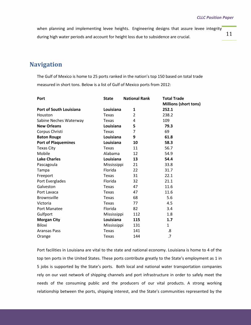
Navigation
The Gulf of Mexico is home to 25 ports ranked in the nation’s top 150 based on total trade
measured in short tons. Below is a list of Gulf of Mexico ports from 2012:
Port State National Rank Total Trade Millions (short tons) Port of South Louisiana Louisiana 1 252.1 Houston Texas 2 238.2 Sabine Neches Waterway Texas 4 109 New Orleans Louisiana 5 79.3 Corpus Christi Texas 7 69 Baton Rouge Louisiana 9 61.8 Port of Plaquemines Louisiana 10 58.3 Texas City Texas 11 56.7 Mobile Alabama 12 54.9 Lake Charles Louisiana 13 54.4 Pascagoula Mississippi 21 33.8 Tampa Florida 22 31.7 Freeport Texas 31 22.1 Port Everglades Florida 32 21.1 Galveston Texas 47 11.6 Port Lavaca Texas 47 11.6 Brownsville Texas 68 5.6 Victoria Texas 77 4.5 Port Manatee Florida 82 3.4 Gulfport Mississippi 112 1.8 Morgan City Louisiana 115 1.7 Biloxi Mississippi 131 1 Aransas Pass Texas 141 .8 Orange Texas 144 .7
Port facilities in Louisiana are vital to the state and national economy. Louisiana is home to 4 of the
top ten ports in the United States. These ports contribute greatly to the State’s employment as 1 in
5 jobs is supported by the State’s ports. Both local and national water transportation companies
rely on our vast network of shipping channels and port infrastructure in order to safely meet the
needs of the consuming public and the producers of our vital products. A strong working
relationship between the ports, shipping interest, and the State’s communities represented by the

CLLC Position Paper
12 Levee Districts is critical to protecting these communities and the ports and shippers. The
construction of numerous shipping channels needed to reach inland port facilities has contributed to
coastal land loss due to wave erosion, saltwater intrusion and faster and strong tidal movement
deep inland. The direct and indirect impact of these channels must be mitigated to prevent future
continuing damage to our coastal land areas. Saltwater buffering of land forms and structures to
prevent damages must be an integral part of the planning for our flood protection as well as
proposed channel improvements.
As channel improvements are considered in the future, consideration must be given to prevention
of future damage. Land loss is a cost of shipping and port development and operation, so we must
develop a way to incorporate these costs into current and future operations. Conversely, as flood
protection features are proposed for the protection of communities, effects on navigation, ports
and related interests should be considered as our interests are shared.
Port and navigation interests must also be considered in the planning and resulting action in times
of flood due to high river water. Close coordination between the Levee Districts concerned about
protection of the critical infrastructure such as levees and floodwalls, is required to prevent damage,
while minimizing impacts on commerce. The U.S. Coast Guard often imposes travel restrictions on
rivers and waterways in times of high water. Mooring of vessels in the vicinity of levees and
floodwalls sometimes can put this infrastructure at risk. Accordingly, during high water events, the
USACE maintains a standard of prohibiting the mooring of vessels within 100 ft. of the toe of a levee
or 180 ft. of the centerline of the levee on the Mississippi River. In the case of other navigable
waterbodies, the Levee District should development an appropriate buffer for the mooring of
vessels on that waterbody. The interest of the community and the protection afforded by this flood
protection infrastructure must be included in the regulation of these navigable waterways. Similar
to flood protection investments, investments in making coastal ports resilient are critical to
Louisiana’s future. A U.S.D.H.S./U.L.L. co-authored Consequence Analysis estimates that a storm-
induced loss of access to Port Fourchon could cause the nation up to $7.8 billion in loss Gross
Domestic Product. Supporting restoration which makes our coastal ports and access infrastructure
more resilient reflects long-term resilience planning for our communities and the job values they
bring to coastal Louisiana.
Ports and Levee Districts need to be true partners in order to effectively carry out its functions.

CLLC Position Paper
13 Legislation and Present Law
In 2012, the Louisiana Legislature approved the first Coastal Master Plan from the Coastal Protection
and Restoration Authority (CPRA). Each year since, the Louisiana Legislature has approved the
Annual Plan for the CPRA, which provide funding for our vital coastal projects. Members of the
Legislative Committee of the Consortium will attend this Legislative Session to support a suite of bills
that affect our coastal communities. Former Louisiana Senator Reggie Dupre provided a
comprehensive look at the bills and legal instruments presented this Session. It is important that
the Consortium stay informed of issues as they develop. Levee Districts and Authorities face many
legal issues. David Peterson, Deputy General Counsel of the CPRA, provided a briefing on the
“Appropriation of Levee Servitude in Louisiana”.
Appendix G & H: ∙ 2015 Legislative Issues
∙ Appropriation of Levee Servitude in Louisiana, by David
Peterson
Economics
It is anticipated that offshore revenue sharing monies made possible through the 2006 Gulf of
Mexico Security Act (GOMESA) will be the largest funder of state master plan coastal projects for the
coming 50 years. Strengthening the sustainability of the existing communities, which support that
GOMESA income, makes business sense because it is protecting the asset that makes that revenue
possible. In Louisiana’s case, investment in infrastructure access to coastal job bases is also a
challenge, and this need should be taken in to account in the bigger picture of coastal sustainability.
From the federal government’s perspective, several agencies already acknowledge the challenges
Louisiana will face to ensuring infrastructure access to the growing job bases on the coast, which
support energy production on federal offshore lands. The U.S. Congress has designated Louisiana
Highway One in Lafourche Parish as High Priority Corridor, one of only 64 highways nationwide with
this designation, and the sole highway designated as such for its role as critical energy
infrastructure. LA 1 provides the sole highway access to Port Fourchon, which currently supports
95% of Deepwater oil & gas activity in the U.S. Gulf of Mexico, and is expected to support an
additional $70 billion of Deepwater investments by 2030. The expected LNG export boom will be
centered in the Chenier Plain ports of Sabine-Neches Waterway, bordered by Cameron and

CLLC Position Paper
14 Calcasieu Parishes. The Cheniere Energy LNG export terminal is under construction at a price tag of
$20 billion. The recently announced Sasol Ethane Cracker facility and a Sasol LNG export facility in
Calcasieu and Cameron Parishes respectively, will cost from $16 billion to $21 billion. The
deepening of the Sabine-Neches Waterway was the largest deepening and widening project
authorized by the U.S. Congress when it passed the Water Resources Reform and Development Act
in 2014. In January 2015, an LNG export bill was introduced in the U.S. Congress, which could
increase the energy trade importance of the Chenier Plain. Surface transportation corridors
traversing the Chenier Plain parishes are some of the nation’s busiest. Major east-west highways
and rail lines, plus many highways and rail systems radiating across the nation demonstrate the
impact of the Chenier Plain’s mid-continent location on the nation’s, Canada’s, and Mexico’s
economies. The federal government rightfully has carved out some infrastructure allotments in two
of the funding pots in the 2010 Macondo oil spill civil fines expenditure procedures. On the local end
of the spectrum, many coastal parish governments have long funded the huge infrastructure needs
of their constituents. All levels of government will need to work together to provide the economic
security our coastal energy communities are experiencing, including providing key road access to the
coastal job bases and protecting the homes of workers further inland. These two items are critical to
retaining the coastal populations which benefit us all. The Consortium needs to work with our local
Chambers and Economic Development Offices to develop a clear and achievable road map for how
to go about doing just that. With smart decisions and strategic allocation of resources, we can help
the people of our coastal communities.
Conclusion The need for coastal restoration is urgent and the resources needed to implement it are forthcoming.
The CPRA Master Plan Projects potentially represent Louisiana’s largest public works projects ever. The
need to protect our people and infrastructure coupled with the potential to include local companies and
a local workforce is a major economic opportunity that cannot be overlooked. This report details
strategies to protect and restore our coast, which include acknowledging the importance of: diversions,
land bridges, computer modeling, barrier islands, barrier shorelines, flood insurance, levee standards,
navigation, legislation & present law, and economics. Coordination and leadership are necessary to fulfill
the goals of ensuring coastal protection and the economic benefits of coastal restoration so that they
can be maximized for Louisiana and its residents. The Consortium is advocating for a proactive approach

CLLC Position Paper
15 in anticipation of coastal dollars being distributed and infrastructure constructed to accomplish these
goals.
“LOCAL COASTAL KNOWLEDGE CAN HELP SOLVE LOCAL COASTAL PROBLEMS”

CLLC Position Paper
16
APPENDIX A: Comprehensive and Integrated Approach to Meet the Water Resources Needs in the Wake of Hurricanes Katrina and Rita


CLLC Position Paper
17
APPENDIX B: Views on Diversion
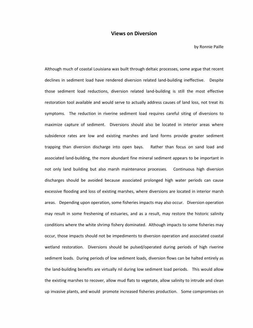
Views on Diversion
by Ronnie Paille
Although much of coastal Louisiana was built through deltaic processes, some argue that recent
declines in sediment load have rendered diversion related land-building ineffective. Despite
those sediment load reductions, diversion related land-building is still the most effective
restoration tool available and would serve to actually address causes of land loss, not treat its
symptoms. The reduction in riverine sediment load requires careful siting of diversions to
maximize capture of sediment. Diversions should also be located in interior areas where
subsidence rates are low and existing marshes and land forms provide greater sediment
trapping than diversion discharge into open bays. Rather than focus on sand load and
associated land-building, the more abundant fine mineral sediment appears to be important in
not only land building but also marsh maintenance processes. Continuous high diversion
discharges should be avoided because associated prolonged high water periods can cause
excessive flooding and loss of existing marshes, where diversions are located in interior marsh
areas. Depending upon operation, some fisheries impacts may also occur. Diversion operation
may result in some freshening of estuaries, and as a result, may restore the historic salinity
conditions where the white shrimp fishery dominated. Although impacts to some fisheries may
occur, those impacts should not be impediments to diversion operation and associated coastal
wetland restoration. Diversions should be pulsed/operated during periods of high riverine
sediment loads. During periods of low sediment loads, diversion flows can be halted entirely as
the land-building benefits are virtually nil during low sediment load periods. This would allow
the existing marshes to recover, allow mud flats to vegetate, allow salinity to intrude and clean
up invasive plants, and would promote increased fisheries production. Some compromises on

diversion operation to accommodate fisheries production should be enacted given the
importance of commercial and recreational fisheries. Specifically, diversion operations should
be conducted to avoid impacts to white shrimp recruitment and production to the greatest
extent possible.
Paille Research: Marsh soil cores collected from west Terrebonne marshes reveal that clays are
building new marshes many miles from the Atchafalaya River delta and it appears that rivers
and diversion may build and maintain a solid expanse of marshes having little open water (in its
healthy climax condition). Cores collected from the Davis Pond ponding area and from the
Caernarvon area reveal that the soils in those marshes are becoming more mineral. These more
mineral soils will likely be more resilient to storm surge damage than similar marshes deprived
of river water input (and are more organic and fragile as a result).

CLLC Position Paper
18
APPENDIX C: Report on NFIP Reform

Re
po
rt o
n N
FIP
Re
form
Pre
pa
red
by t
he
:
3/5/2015

NF
IP R
efo
rm:
Wh
ere
do
th
ing
s st
an
d t
od
ay
?
NF
IP:
the
Na
tio
na
l F
loo
d I
nsu
ran
ce p
rog
ram
is
a
pro
gra
m a
dm
inis
tere
d t
hro
ug
h t
he
Fe
de
ral
Em
erg
en
cy M
an
ag
em
en
t A
ge
ncy
(F
EM
A)
tha
t p
rovi
de
s fl
oo
d in
sura
nce
to
ho
me
an
d b
usi
ne
ss
ow
ne
rs.
Big
ge
rt-W
ate
rs:Fe
de
ral
leg
isla
tio
n e
na
cte
d i
n 2012
th
at
aim
ed
to
re
me
dy
NF
IP’s
pe
rce
ive
d in
solv
en
cy b
y p
ha
sin
g o
ut
sub
sid
ize
d in
sura
nce
pre
miu
m r
ate
s a
nd
sh
ifti
ng
po
lici
es
to c
urr
en
t ri
sk r
ate
s.
Ho
me
ow
ne
rs F
loo
d I
nsu
ran
ce A
ffo
rda
bil
ity
Act
:
(H.R
. 3370
) T
his
act
re
pe
ale
d c
ert
ain
po
rtio
ns
of
the
B
igg
ert
-Wa
ters
Flo
od
In
sura
nce
Re
form
Act
of 2012
(B
W12
). F
rom
a r
esi
de
nti
al h
om
eo
wn
er’
s p
oin
t o
f vi
ew
, it
re
pe
ale
d t
he
mo
st d
am
ag
ing
pa
rts
of
BW12
.
LAM
P:
Leve
e A
na
lysi
s M
ap
pin
g P
roce
du
re in
itia
l im
ple
me
nta
tio
n i
n 5
LA
Pa
rish
es,
25
na
tio
na
lly.

NF
IP R
efo
rm:
Wh
at’
s N
ex
t?
Th
e E
nti
re N
ati
on
al
Flo
od
In
sura
nce
Pro
gra
m i
s u
p f
or
re-a
uth
ori
zati
on
in
20
17
:
•T
he
pro
gra
m h
as
be
en
th
rou
gh
we
ll o
ver 30
lon
g a
nd
sh
ort
te
rm
re-a
uth
ori
zati
on
s o
ver
the
ye
ars
.
•B
W12
wa
s su
pp
ose
d t
o b
e a
pe
rma
ne
nt
“FIX
” to
th
e s
olv
en
cy o
f
the
NFI
P. B
W12
wa
s cr
aft
ed
wit
ho
ut
an
y in
pu
t fr
om
us.
HIF
A w
as
a B
an
d-A
id t
o “
FIX
” p
art
s o
f B
W12
.
•If
we
are
no
t in
volv
ed
in t
his
re
-au
tho
riza
tio
n p
roce
ss,
som
eo
ne
els
e w
ill “
FIX
” th
e N
FIP
fo
r u
s a
gain
.
BW12
ext
en
de
d t
he
au
tho
riza
tio
n o
f th
e N
FIP
fo
r th
e 5
ye
ar
pe
rio
d e
nd
ing
Sep
tem
be
r 30
th, 2017
. W
ith
ou
t a
co
nti
nu
ing
re
solu
tio
n o
r re
-au
tho
riza
tio
n,
the
en
tire
Na
tio
na
l Flo
od
Insu
ran
ce P
rog
ram
en
ds
at
tha
t ti
me
.

NF
IP R
efo
rm:
Wh
at’
s N
ee
de
d?
Fir
st a
nd
Fo
rem
ost
, A
LL c
ha
ng
es
to t
he
NF
IP s
ho
uld
be
ma
de
go
ing
forw
ard
. W
e c
an
’t p
un
ish
pe
op
le w
ho
pla
ye
d b
y F
EM
A’s
ru
les.
•T
his
is a
n o
vera
rch
ing
pri
nci
ple
th
at
sho
uld
be
ap
plie
d t
o a
ll co
nsi
de
red
cha
nge
s to
th
e N
FIP
leg
isla
tio
n.
•W
ith
th
e e
xce
pti
on
of
Seve
re R
ep
eti
tive
Lo
ss p
rop
ert
ies,
all
corr
ect
ive
leg
isla
tio
n s
ho
uld
be
str
uct
ure
d s
uch
th
at
all
exi
stin
g p
olic
yho
lde
rs
(pre
-fir
m o
r p
ost
-fir
m)
of
an
y p
rop
ert
y cl
ass
(p
rim
ary
re
sid
en
ce,
no
n-
pri
ma
ry r
esi
de
nce
, b
usi
ne
ss o
r o
the
r) m
ust
be
ab
le t
o:
•B
e a
llow
ed
to
pu
rch
ase
Flo
od
In
sura
nce
at
ap
pro
xim
ate
ly t
he
sa
me
cost
as
be
fore
BW12
as
lon
g a
s th
ere
is n
o la
pse
in c
ove
rage
or
an
acc
um
ula
tive
cla
im e
qu
al t
o t
he
FM
V o
f th
e p
rop
ert
y.
•B
e a
llow
ed
to
se
ll o
r o
the
rwis
e t
ran
sfe
r ti
tle
of
the
pro
pe
rty
to a
ne
w o
wn
er
wh
o w
ill t
he
n b
e a
ble
to
co
nti
nu
e w
ith
insu
ran
ce
cove
rage
as
de
scri
be
d a
bo
ve.

NF
IP R
efo
rm:
Wh
at’
s N
ee
de
d?
Th
e S
olv
en
cy o
f th
e p
rog
ram
mu
st b
e a
dd
ress
ed
in
a m
ore
eq
uit
ab
le
ma
nn
er.
We
ne
ed
to
ad
dre
ss p
rog
ram
CO
ST,
no
t ju
st R
EV
EN
UE
!
•Fr
om
1978
to
2013
th
e p
rog
ram
co
llect
ed
ove
r $9
.6B
mo
re in
pre
miu
ms
tha
n it
pa
id in
cla
ims.
•A
nd
ye
t th
e p
rog
ram
is $25
B in
de
bt.
•T
his
su
gge
st s
eve
re is
sue
s w
ith
th
e c
ost
of
ad
min
istr
ati
ng
an
d o
pe
rati
ng
the
pro
gra
m.
•T
he
WYO
insu
ran
ce c
om
pa
nie
s m
ake
a 30%
ma
rgin
on
po
licy
sale
s a
nd
the
y d
o n
ot
hav
e t
o u
nd
erw
rite
an
y o
f th
e r
isk.
•In
all
of
the
re
form
leg
isla
tio
n t
o d
ate
, th
e o
nly
gro
up
ask
ed
to
giv
e
mo
re t
o c
orr
ect
th
is d
efi
cit
in t
he
NFI
P is
th
e p
olic
yho
lde
rs t
hro
ug
h
incr
ea
sed
pre
miu
ms.

NF
IP R
efo
rm:
Wh
at’
s N
ee
de
d?
Th
ere
is
a h
ug
e l
ack
of
ma
nd
ato
ry p
art
icip
ati
on
in
th
e p
rog
ram
:
•In
LA
, w
e h
ave
be
tte
r th
an
85%
co
mp
lian
ce w
ith
th
is
req
uir
em
en
t.
•B
ut,
na
tio
na
lly,
a s
tud
y d
on
e in
200
6 s
ho
we
d t
ha
t o
nly
49%
of
tho
se r
eq
uir
ed
to
hav
e f
loo
d in
sura
nce
act
ua
lly h
ad
it.
•Fu
rth
er,
it is
est
ima
ted
th
at
wh
en
“Su
pe
r-st
orm
Sa
nd
y”
wa
s
he
ad
ing
up
th
e e
ast
ern
se
ab
oa
rd o
f th
e U
S, o
nly
15
-25%
of
the
at
risk
po
pu
lati
on
ha
d f
loo
d in
sura
nce
.
•B
W12
incr
ea
sed
th
e p
en
alt
ies
to le
nd
ing
inst
itu
tio
ns
for
no
n-
com
plia
nce
. B
ut,
th
is la
w m
ust
be
en
forc
ed
.
It h
as
be
en
th
e la
w s
ince
1973
, th
at
an
y a
pro
pe
rty
ma
pp
ed
by
FEM
A in
a
Spe
cia
l Flo
od
Ha
zard
Are
a m
ust
pu
rch
ase
flo
od
insu
ran
ce i
f th
e p
rop
ert
y is
mo
rtga
ged
by
a le
nd
ing
inst
itu
tio
n r
eg
ula
ted
by
the
Fe
de
ral G
ove
rnm
en
t.

NF
IP R
efo
rm:
Wh
at’
s N
ee
de
d?
Th
ere
is
a b
ig p
rob
lem
wit
h t
he
act
ua
ria
l ca
lcu
lati
on
s u
sed
to
de
term
ine
th
e c
ost
of
insu
ran
ce f
or
the
pro
gra
m:
•St
an
da
rd A
ctu
ari
al
Pra
ctic
es
for
Insu
ran
ce u
se H
isto
ric
Loss
ye
ars
plu
s a
re
serv
e t
o c
alc
ula
te r
eq
uir
ed
pre
miu
m r
ate
s.
•T
he
Am
eri
can
Aca
de
my
of
Act
ua
rie
s re
po
rte
d t
o C
on
gre
ss t
ha
t
incl
ud
ing
Ca
tast
rop
hic
loss
ye
ars
wa
s n
ot
in li
ne
wit
h S
tan
da
rd
Act
ua
ria
l P
rin
cip
les
be
fore
BW12
wa
s e
ven
pa
sse
d.
•A
lso
, w
e m
ust
co
nsi
de
r h
ow
a p
rog
ram
, d
esi
gn
ed
to
mit
iga
te f
or
100
ye
ar
flo
od
loss
th
rou
gh
a q
uid
pro
re
lati
on
ship
wit
h lo
cal
com
mu
nit
y’s
flo
od
pla
in m
an
age
me
nt
be
exp
ect
ed
to
ab
sorb
400
yea
r e
ven
ts?
BW12
re
qu
ire
d F
EM
A t
o in
clu
de
Ca
tast
rop
hic
Lo
ss y
ea
rs in
th
e a
ctu
ari
al
calc
ula
tio
ns
wh
ich
se
t th
e c
ost
of
Insu
ran
ce.
Th
is g
rea
tly
cha
nge
s th
e m
eth
od
FEM
A u
ses
to d
ete
rmin
e t
he
co
st o
f In
sura
nce
.

NF
IP R
efo
rm:
Wh
at
if w
e f
ail
?
Rip
ple
Eff
ect
s o
f fl
oo
d i
nsu
ran
ce p
rem
ium
hik
es:
➥D
rop
in h
om
e a
nd
bu
sin
ess
va
lue
➥D
rop
in h
om
e a
nd
bu
sin
ess
sa
les
➥N
eig
hb
orh
oo
d-w
ide
de
cre
ase
in p
rop
ert
y va
lue
s
➥P
rop
ert
ies
be
com
e u
nsa
lab
le
➥B
an
ks lo
se m
ort
gage
po
rtfo
lio
➥R
ea
l est
ate
ma
rke
t fr
ee
zes
➥C
om
pa
nie
s lo
se w
ork
ers
➥Lo
cal g
ove
rnm
en
ts lo
se t
ax
ba
se
➥E
con
om
ies
de
stro
yed
A
stro
no
mic
al f
loo
d in
sura
nce
pre
miu
m h
ike
s e
sca
lati
ng
ra
pid
ly o
ver
tim
e
H
om
e &
Bu
sin
ess
va
lue
s h
ave
alr
ea
dy
be
en
low
ere
d in
so
me
are
as
D
rop
in h
om
e a
nd
Bu
sin
ess
va
lue
s im
pa
cts
ind
ivid
ua
l H
om
eo
wn
ers
an
d
Bu
sin
ess
ow
ne
rs in
wh
at
is li
kely
th
eir
larg
est
in
vest
me
nt
Th
e p
ote
nti
al
imp
act
is
de
va
sta
tin
g:
TH
IS I
S A
FIG
HT
WE
SIM
PLY
CA
N’T
AF
FO
RD
TO
LO
SE
.

NF
IP R
efo
rm:
Mo
re d
eta
ils.
IA
ll C
ha
nge
s a
re G
oin
g F
orw
ard
.
IIE
nfo
rce
th
e M
an
da
tory
pa
rtic
ipa
tio
n r
eq
uir
em
en
ts in
NFI
P t
ha
t a
lre
ad
y e
xist
.
III
Ad
dre
ss t
he
Co
st o
f A
dm
inis
tra
tio
n o
f th
e N
FIP,
no
t ju
st t
he
Re
ven
ue
.
IVR
eve
rse
th
e u
nre
aso
na
ble
ch
an
ge t
o F
EM
A’s
me
tho
d o
f p
erf
orm
ing
Act
ua
ry
calc
ula
tio
ns
bro
ug
ht
on
by
BW12
.
VP
ay f
or
the
CB
O c
ost
of
the
se r
efo
rms.
VI
Re
-Dir
ect
Fu
nd
ing
to
Id
en
tify
an
d M
itig
ate
exi
stin
g r
isk
in h
igh
po
ten
tia
l lo
ss a
rea
s.
VII
Re
form
th
e N
FIP
to
Mit
iga
te R
esi
du
al R
isk
to n
ew
co
nst
ruct
ion
be
hin
d a
ll fl
oo
d
con
tro
l sys
tem
s.
Th
e f
oll
ow
ing
pa
ge
s p
rov
ide
ad
dit
ion
al
de
tail
s, f
act
s a
nd
req
uir
ed
act
ion
fo
r e
ach
of
the
pil
lars
of
this
re
form
eff
ort
.

All
Ch
an
ge
s a
re G
oin
g F
orw
ard
Ob
ject
ive
: T
his
is a
n o
vera
rch
ing
pri
nci
ple
th
at
ap
plie
s to
all
pro
po
sed
co
rre
ctiv
e a
ctio
n.
Wit
h t
he
exc
ep
tio
n o
f Se
vere
Re
pe
titi
ve L
oss
(SR
L) p
rop
ert
ies,
an
y
corr
ect
ive
Le
gis
lati
on
pro
po
sed
sh
ou
ld b
e s
tru
ctu
red
su
ch t
ha
t e
xist
ing
po
licyh
old
ers
(pre
-fir
m o
r p
ost
-fir
m)
of
an
y p
rop
ert
y cl
ass
(p
rim
ary
re
sid
en
ce,
no
n-
pri
ma
ry r
esi
de
nce
, b
usi
ne
ss o
r o
the
r) m
ust
be
ab
le t
o c
on
tin
ue
to
:
a.)
Be
allo
we
d t
o p
urc
ha
se f
loo
d in
sura
nce
at
ap
pro
xim
ate
ly t
he
sa
me
co
st a
s b
efo
re B
W12
(n
otw
ith
sta
nd
ing
no
min
al f
ee
s p
rop
ose
d t
o p
ay
for
this
leg
isla
tio
n a
nd
bu
ild a
re
serv
e f
un
d o
r ty
pic
al l
imit
ed
FE
MA
dis
cre
tio
na
ry y
ea
rly
incr
ea
ses)
up
an
un
til:
1)
Th
e p
rop
ert
y in
curs
flo
od
re
late
d lo
sse
s cu
mu
lati
vely
eq
ua
l to
th
e F
air
Ma
rke
t V
alu
e (
FMV
) o
f th
e p
rop
ert
y m
aki
ng
it a
SR
L p
rop
ert
y.
2)
Th
ere
is a
lap
se in
th
e p
olic
y.
b.)
Be
allo
we
d t
o s
ell
or
oth
erw
ise
tra
nsf
er
the
tit
le o
f th
e p
rop
ert
y to
a n
ew
ow
ne
r w
ho
sh
all
be
ab
le t
o c
on
tin
ue
as
de
scri
be
din
a.)
ab
ove
.
Re
aso
nin
g:
Firs
t a
nd
fo
rem
ost
, it
is t
he
fa
ir a
nd
re
aso
na
ble
th
ing
to
do
. T
he
se f
loo
d i
nsu
ran
ce p
olic
ies
we
re o
ffe
red
by
FEM
A,
eit
he
r p
re-f
irm
or
po
st-f
irm
as
pa
rt o
f a
qu
id p
ro q
uo
arr
an
ge
me
nt
to m
itig
ate
Flo
od
Re
late
d c
ost
to
th
e F
ed
era
l Go
vern
me
nt.
Th
ey
we
re o
ffe
red
by
the
Fe
de
ralG
ove
rnm
en
t to
th
e
po
licyh
old
ers
un
de
r th
e b
elie
f th
at
do
ing
so
wa
s e
qu
ally
be
ne
fici
al
to t
he
Fe
de
ral G
ove
rnm
en
t. E
ven
pre
-FIR
M p
rop
ert
ies,
th
e o
nly
po
licie
s co
nsi
de
red
as
sub
sid
ize
d b
y FE
MA
, ca
me
wit
h f
loo
dp
lain
ma
na
ge
me
nt
rest
rict
ion
th
at
FEM
A r
eq
uir
ed
fo
r th
e c
om
mu
nit
y to
pa
rtic
ipa
te i
n t
he
NFI
P.
Th
e F
ed
era
l
Go
vern
me
nt
no
t o
nly
imp
lied
th
at
this
aff
ord
ab
le in
sura
nce
wo
uld
be
ava
ilab
le f
or
the
life
of
the
pro
pe
rty;
it p
ub
lish
ed
an
d p
rom
ote
d t
he
pro
gra
m
acc
ord
ing
ly.
Cit
ize
ns
an
d b
usi
ne
sse
s m
ad
e h
ug
e f
ina
nci
al
de
cisi
on
s, in
mo
st c
ase
s th
e la
rge
st f
ina
nci
al d
eci
sio
n o
f th
eir
en
tire
life
, b
ase
d o
n t
his
pro
mis
e
of
the
Fe
de
ral G
ove
rnm
en
t.
FEM
A o
ffe
rs f
loo
d in
sura
nce
in r
etu
rn f
or
com
mu
nit
ies
ad
op
tin
g f
loo
dp
lain
ma
na
ge
me
nt
stra
teg
ies
tha
t F
EM
A b
elie
ves
mit
iga
tes
the
ris
k o
f FE
MA
ha
vin
g t
o p
ay
a c
laim
fo
r fl
oo
din
g in
up
to
a 100
ye
ar
flo
od
eve
nt.
FE
MA
est
ima
tes
tha
t th
is “
un
ifie
d f
loo
dp
lain
ma
na
ge
me
nt
stra
teg
y” s
ave
s th
e n
ati
on
an
est
ima
ted
$1
.6B
an
nu
ally
in a
void
ed
flo
od
loss
es.
Th
at
is $73
.6B
of
mit
iga
ted
flo
od
ing
ove
r th
e li
fe o
f th
e p
rog
ram
. Th
e M
ap
Mo
de
rniz
ati
on
pro
gra
m t
ha
t
FEM
A b
eg
an
in 2003
sh
ow
s m
an
y a
rea
s p
revi
ou
sly
ma
pp
ed
to
be
at
a lo
we
r ri
sk t
o c
urr
en
tly
be
in a
hig
he
r ri
sk. B
ut,
th
e p
revi
ou
s in
acc
ura
cy o
f th
e F
EM
A
pu
blis
he
d p
rio
r m
ap
is n
ot
a r
ea
son
to
pu
nis
h t
he
po
licyh
old
ers
.
Furt
he
r, a
pp
roxi
ma
tely
50%
of
the
Na
tio
n’s
Gro
ss D
om
est
ic P
rod
uct
(GD
P)
is g
en
era
ted
in G
ulf
an
d A
tla
nti
c C
oa
sta
l Are
as
alo
ne
. T
he
GD
P
pe
rce
nta
ge
wo
uld
be
co
nsi
de
rab
ly la
rge
r if
yo
u i
ncl
ud
e a
rea
s a
dja
cen
t to
ou
r in
lan
d r
ive
r sy
ste
ms.
Co
ntr
ary
to
po
pu
lar
be
lief
inth
e r
est
ruct
uri
ng
of
the
NFI
P,
pe
op
le li
ve in
th
ese
re
gio
ns
for
a r
ea
son
. T
ha
t re
aso
n b
en
efi
ts t
he
en
tire
na
tio
n.
Leg
isla
tio
n R
eq
uir
em
en
ts:
Co
nsi
de
r e
very
pro
po
sed
leg
isla
tive
re
visi
on
to
th
e N
FIP
ag
ain
st t
his
ove
rarc
hin
g p
rin
cip
le.
Re
vers
e e
very
thin
g in
BW12
th
at
de
fea
ts t
his
ove
rarc
hin
g p
rin
cip
le.
Pri
or
to B
W12
, th
is w
as
FEM
A’s
ap
pro
ach
to
th
e a
pp
lica
tio
n o
f N
FIP
leg
isla
tio
n.

En
forc
e t
he
Ma
nd
ato
ry p
art
icip
ati
on
re
qu
ire
me
nts
in
NF
IP
tha
t a
lre
ad
y e
xis
t.
Ob
ject
ive
:T
he
Flo
od
Dis
ast
er
Pro
tect
ion
Act
of 1973
est
ab
lish
ed
a m
an
da
tory
flo
od
insu
ran
ce p
urc
ha
se r
eq
uir
em
en
t fo
r st
ruct
ure
s lo
cate
din
an
ide
nti
fie
d
Spe
cia
l Fl
oo
d H
aza
rd A
rea
(SF
HA
). W
ith
th
e p
ass
ag
e o
f th
is a
ct,
fed
era
lly r
eg
ula
ted
len
de
rs w
ere
ob
liga
ted
to
re
qu
ire
flo
od
insu
ran
ce o
n a
ny
loa
n s
ecu
red
by
imp
rove
d r
ea
l est
ate
in a
FE
MA
id
en
tifi
ed
SFH
A i
n N
FIP
pa
rtic
ipa
tin
g c
om
mu
nit
ies.
Th
is r
eq
uir
em
en
t m
ust
be
pro
pe
rly
en
forc
ed
.
Re
aso
nin
g:
Th
e f
orc
ed
pla
cem
en
t o
f fl
oo
d i
nsu
ran
ce f
or
fed
era
lly
ba
cke
d l
oa
ns
is a
fu
nd
am
en
tal
cave
at
in t
he
qu
id p
ro q
uo
re
lati
on
ship
be
twe
en
th
e f
ed
era
l
go
vern
me
nt
an
d c
om
mu
nit
ies
pa
rtic
ipa
tin
g i
n t
he
NFI
P.
Th
e N
FIP
be
ga
n in
19
68
in
re
spo
nse
to
hu
rric
an
e B
ets
y in
19
65
. H
urr
ica
ne
Ag
ne
s in
1972
sh
ow
ed
ho
w l
imit
ed
th
e p
art
icip
ati
on
in
NFI
P w
as
at
tha
t ti
me
. T
he
Flo
od
Dis
ast
er
Pro
tect
ion
Act
of 1973
wa
s su
pp
ose
d t
o f
orc
e p
art
icip
ati
on
. B
ut,
so
me
20
ye
ars
late
r, a
fte
r th
e M
idw
est
flo
od
s o
f 1993
, C
on
gre
ss p
ass
ed
th
e 199
4 N
ati
on
al F
loo
d I
nsu
ran
ce R
efo
rm A
ct w
hic
h p
rovi
de
d im
pe
tus
for
stre
ng
the
nin
g le
nd
er
com
plia
nce
be
cau
se p
art
icip
ati
on
in t
he
NFI
P w
as
still
ve
ry lo
w.
Eve
n s
o,
a 200
6 s
tud
y o
f th
e N
FIP
’s m
an
da
tory
pu
rch
ase
re
qu
ire
me
nts
by
the
Ra
nd
Co
rpo
rati
on
co
ncl
ud
ed
th
at
on
ly 49%
of
the
sin
gle
fa
mily
ho
me
s in
SFH
A c
arr
ied
flo
od
in
sura
nce
. E
stim
ate
s a
re t
ha
t o
nly
15%
to
25%
of
the
pro
pe
rtie
s in
No
rth
ea
st w
ith
in S
FHA
we
re in
sure
d f
or
flo
od
lo
ss a
s Su
pe
r-st
orm
Sa
nd
y a
pp
roa
che
d.
Na
tio
na
lly,
rece
nt
rep
ort
s in
dic
ate
th
at
as
few
as 18%
of
ou
r ci
tize
ns
livin
g in
SFH
A a
re p
rote
cte
d b
y fl
oo
d in
sura
nce
.
Sim
ply
pu
t, t
he
Fe
de
ral G
ove
rnm
en
t h
as
pe
rfo
rme
d v
ery
po
orl
y a
t e
nfo
rcin
g t
his
co
rne
rsto
ne
iss
ue
in t
he
NFI
P’s
ab
ility
to
pro
vid
e lo
ng
te
rm
sust
ain
ab
le f
loo
d in
sura
nce
wh
ere
ne
ed
ed
. T
he
inte
nt
wa
s to
ha
ve a
ll o
f th
ese
pro
pe
rtie
s in
th
e N
FIP
fo
r tw
o p
rim
ary
re
aso
ns.
Firs
t, w
as
to in
cre
ase
reve
nu
e t
o t
he
NFI
P a
nd
se
con
d,
wa
s to
be
ab
le t
o u
se t
he
insu
ran
ce p
rin
cip
le o
f th
e “
Law
of
Larg
e N
um
be
rs”
to s
pre
ad
th
e r
isk
to t
he
pro
gra
m
ge
og
rap
hic
ally
.
BW12
se
ctio
n 100208
dra
stic
ally
incr
ea
ses
the
pe
na
lty
to le
nd
ing
inst
itu
tio
ns
for
no
n-c
om
plia
nce
wit
h t
he
fo
rce
d p
lace
me
nt
req
uir
em
en
t. T
he
pe
na
lty
is in
pla
ce,
up
fro
m $350
to
$2000
pe
r in
cid
en
ce;
bu
t, t
his
ince
nti
ve w
ill d
o li
ttle
go
od
wit
ho
ut
en
forc
em
en
t.
FEM
A s
tate
s th
at
it is
no
t re
spo
nsi
ble
for
ove
rsig
ht
an
d r
eg
ula
tio
n o
f th
e b
an
kin
g in
du
stry
; w
hic
h m
ay
be
tru
e.
Bu
t, h
avi
ng
su
ch a
ga
pin
g h
ole
in a
fo
un
da
tio
n o
f th
e N
FIP
sh
ou
ld h
ave
be
en
a
gra
ve c
on
cern
fo
r a
ll in
volv
ed
.
Ad
mit
ted
ly,
the
ne
wly
ca
lcu
late
d f
loo
d in
sura
nce
ra
tes
bro
ug
ht
up
on
by
the
pa
ssa
ge
of
BW12
wo
uld
ma
ke e
nfo
rce
me
nt
hig
hly
un
po
pu
lar
wit
h
tho
se w
ho
we
re n
ot
pa
yin
g in
to t
he
NFI
P a
ll o
f th
ose
ye
ars
. As
such
, a
nd
du
e t
o t
he
hu
ge
incr
ea
se i
n r
eve
nu
e b
rou
gh
t in
to t
he
NFI
P f
rom
su
ch a
ch
an
ge
,
the
en
forc
em
en
t o
f th
is lo
ng
sta
nd
ing
la
w s
ho
uld
co
inci
de
wit
h a
re
visi
on
to
th
e a
ctu
ary
ca
lcu
lati
on
s o
n t
he
co
st o
f in
sura
nce
.
Ad
min
istr
ati
ve
Re
qu
ire
me
nts
:T
he
re s
ho
uld
be
no
ne
ed
fo
r fu
rth
er
leg
isla
tio
n o
n t
his
issu
e a
s it
is a
nd
ha
s b
ee
n a
sta
nd
ing
law
fo
r a
lon
g t
ime
no
w.
Ho
we
ver,
Co
ng
ress
ma
y h
ave
to
fo
rce
wh
ate
ver
Fed
era
l Ag
en
cy t
ha
t is
re
spo
nsi
ble
fo
r e
nfo
rce
me
nt
to d
o s
o a
nd
to
fu
nd
wh
ate
ver
en
forc
em
en
t a
ctio
n a
nd
au
tho
rity
tha
t m
ay
be
re
qu
ire
d.
Th
e a
ctu
ari
ally
ba
sed
co
st o
f in
sura
nce
in t
he
NFI
P s
ho
uld
be
re
calc
ula
ted
in
clu
din
g t
he
ad
dit
ion
al p
art
icip
an
ts.

Ad
dre
ss t
he
Co
st o
f A
dm
inis
tra
tio
n o
f th
e N
FIP
, n
ot
just
th
e
Re
ve
nu
e.
Ob
ject
ive
:A
ll o
f th
e r
efo
rms
en
act
ed
by
the
pa
ssa
ge
of
BW12
ad
dre
ss a
pe
rce
ive
d r
eve
nu
e s
ho
rta
ge
in t
he
so
lve
ncy
of
the
NFI
P.
No
re
form
s to
da
te
seri
ou
sly
ad
dre
ss t
he
co
st s
ide
of
the
eq
ua
tio
n.
Wh
ile it
is t
rue
th
at
ap
pro
pri
ate
mit
iga
tio
n s
tra
teg
ies
can
re
du
ce t
he
co
st o
f cl
aim
s p
aid
, th
e c
ost
of
ad
min
istr
ati
on
of
the
NFI
P b
y FE
MA
an
d it
s co
ntr
act
ors
as
we
ll a
s it
s W
rite
Yo
ur
Ow
n (
WY
O)
insu
ran
ce a
ge
nts
is n
ot
ad
dre
sse
d in
an
y su
bst
an
tia
l wa
y.
FEM
A,
its
con
tra
cto
rs a
nd
th
e W
YO
ag
en
cie
s m
ust
be
fo
rce
d t
o f
ind
wa
ys t
o r
ed
uce
th
e a
dm
inis
tra
tive
co
st o
f th
e N
FIP
.
Re
aso
nin
g:
A s
tud
y o
f th
e v
alu
e o
f p
rem
ium
s w
ritt
en
by
the
po
licyh
old
ers
as
com
pa
red
to
th
e a
mo
un
t o
f cl
aim
s p
aid
by
NFI
P r
eve
al s
om
e v
ery
telli
ng
sta
tist
ics.
Th
e p
eri
od
fro
m 1978
to
2013
is 3
6 y
ea
rs. T
he
NFI
P p
aid
ou
t m
ore
in c
laim
s th
an
wa
s p
aid
in p
rem
ium
s b
y p
olic
yho
lde
rs i
n o
nly
9 o
f th
e 3
6
yea
rs. I
n e
very
oth
er
on
e o
f th
e 27
ye
ars
th
e N
FIP
co
llect
ed
mo
re in
pre
miu
ms
the
n it
pa
id in
cla
ims.
Du
rin
g t
ha
t p
eri
od
, th
e N
FIP
co
llect
ed
ju
st o
ver
$9
.67
B m
ore
in p
rem
ium
s fr
om
th
e p
olic
yho
lde
rs t
ha
n i
t p
aid
in c
laim
s to
th
e p
olic
yho
lde
rs.
Sta
tist
ica
lly,
the
larg
est
ou
tlie
r b
y a
ma
rgin
of
ap
pro
xim
ate
ly 5
:1 o
ver
the
clo
sest
oth
er
de
via
tio
n (
a g
ain
of
ne
arl
y $3
.2B
in2013
) is
th
e y
ea
r 2005
wh
ich
in
clu
de
d h
urr
ica
ne
s K
atr
ina
an
d R
ita
. If
yo
u t
ake
ou
t 2005
th
e N
FIP
co
llect
ed
ju
st o
ver
$25
.7B
mo
re in
pre
miu
ms
the
n it
pa
id in
cla
ims
be
twe
en
1978
an
d 2013
. I
t ca
n b
e a
rgu
ed
th
at
rem
ovi
ng
a s
ing
le o
utl
ier
is n
ot
a s
tati
stic
ally
so
un
d e
valu
ati
on
me
tho
d.
As
an
alt
ern
ati
ve, w
e c
an
use
a t
run
cate
d
me
an
to
iso
late
th
e c
en
tra
l te
nd
en
cy b
y re
mo
vin
g t
he
to
p 7
re
ven
ue
ge
ne
rati
ng
ye
ars
an
d t
he
to
p 7
re
ven
ue
de
ple
tin
g y
ea
rs.
In d
oin
g s
o,
the
NFI
P s
till
take
s in
ne
arl
y $10
.8B
mo
re in
pre
miu
ms
the
n i
t p
aid
in c
laim
s b
etw
ee
n 1978
an
d 2013
.
Th
ere
are
7 y
ea
rs d
uri
ng
th
is p
eri
od
(1978
–2013
) th
at
are
ca
lled
ca
tast
rop
hic
lo
ss y
ea
rs w
he
re t
he
NFI
P p
aid
ou
t m
ore
th
an
$1
B i
n c
laim
s. T
he
se
are
1995
, 2001
, 200
4, 2005
, 2008
, 2011
& 2012
. T
he
fa
ct t
ha
t th
ese
ye
ars
occ
ur
mo
stly
late
in t
he
NFI
P h
isto
ry a
re o
fte
n u
sed
toin
dic
ate
th
is is
th
e s
ha
pe
of
thin
gs
to c
om
e.
Ho
we
ver,
th
e 7
ye
ars
wh
ere
th
e N
FIP
co
llect
ed
th
e m
ost
ove
r w
ha
t it
pa
id in
pre
miu
ms
we
re in
2000
, 200
6, 2007
, 2009
, 2010
, 2011
,
2013
. T
he
se a
re e
ven
late
r in
th
e p
rog
ram
his
tory
. If
you
ta
ke a
loo
k a
t 2011
, FE
MA
sta
tist
ics
sho
w t
ha
t it
is b
oth
a c
ata
stro
ph
ic l
oss
ye
ar
an
d a
to
p
reve
nu
e g
ain
ing
ye
ar.
A p
rog
ram
th
at
con
sist
en
tly
take
s in
mo
re in
pre
miu
ms
fro
m t
he
po
licyh
old
ers
th
an
it
pa
ys t
o t
he
po
licyh
old
ers
ye
t st
ill f
ind
s it
self
in h
ug
e d
eb
t
ha
s a
n a
dm
inis
tra
tive
co
st /
fin
an
cia
l st
ruct
ure
issu
e.
It is
un
fair
an
d u
nre
aso
na
ble
to
th
ink
tha
t th
e c
urr
en
t d
efi
cit
of
this
pro
gra
m c
ou
ld o
r sh
ou
ld b
e
corr
ect
ly s
ole
ly b
y in
cre
asi
ng
re
ven
ue
s fr
om
th
e p
olic
yho
lde
rs.
Th
e p
rog
ram
wa
s n
eve
r ca
pit
aliz
ed
by
Co
ng
ress
. Fu
rth
er,
th
e c
urr
en
t d
eb
t to
th
e N
ati
on
al
Tre
asu
ry o
we
d b
y th
e N
FIP
, w
ith
a $1
B/y
ea
r in
tere
st a
dd
ed
on
, is
hig
h,
to s
ay
the
lea
st. H
ow
eve
r, w
he
n y
ou
co
nsi
de
r th
at
this
de
bt
wa
s la
rge
ly n
ot
the
fau
lt o
f th
e p
ayi
ng
po
licyh
old
ers
an
d t
ha
t th
e U
S G
ove
rnm
en
t d
eci
de
d t
o t
ake
a lo
ss o
f $10
.5B
on
Ge
ne
ral M
oto
rs a
lon
e,
the
be
ne
fici
al
na
tio
na
l im
pa
cts
of
forg
ivin
g t
his
cu
rre
nt
de
bt
com
e i
nto
fo
cus.
Leg
isla
tiv
e R
eq
uir
em
en
ts:
Forc
e F
EM
A a
nd
th
e W
YO
ag
en
ts t
o r
ed
uce
th
e c
ost
of
ad
min
istr
ati
on
of
the
NFI
P. C
on
sid
er
forg
ive
ne
ss o
f th
e c
urr
en
t d
eb
t (o
r a
t le
ast
inte
rest
cha
rge
d)
of
the
NFI
P t
o t
he
Na
tio
n’s
Tre
asu
ry.

Re
ve
rse
th
e u
nre
aso
na
ble
ch
an
ge
to
FE
MA
’s m
eth
od
of
pe
rfo
rmin
g A
ctu
ary
ca
lcu
lati
on
s b
rou
gh
t o
n b
y B
W1
2.
Ob
ject
ive
:T
he
NFI
P it
self
ha
s a
co
ng
ress
ion
al m
an
da
te t
o b
e w
ide
ly a
vaila
ble
an
d a
ffo
rda
ble
. Un
til t
he
pa
ssa
ge
of
BW12
, FE
MA
use
d g
en
era
lly a
cce
pte
d
me
tho
ds
for
act
ua
ria
l ca
lcu
lati
on
s a
nd
se
ttin
g t
he
co
st o
f in
sura
nce
. T
he
pa
ssa
ge
of
BW12
(Se
ctio
n 100211
) d
ire
cts
FEM
A t
o in
clu
de
ca
tast
rop
hic
lo
ss
yea
rs w
he
n a
sse
ssin
g f
loo
d r
isk
to s
et
an
nu
al p
rem
ium
ra
tes.
Su
ch a
me
tho
d i
s u
nso
un
d g
ive
n t
he
pa
ram
ete
rs f
rom
wh
ich
th
e p
rog
ram
op
era
tes
an
d m
ust
be
re
vers
ed
. Th
is s
ect
ion
of
BW12
dir
ect
ly c
on
flic
ts w
ith
its
elf
.
Re
aso
nin
g:
On
e c
orn
ers
ton
e o
f th
e N
FIP
is t
ha
t co
mm
un
itie
s w
an
tin
g t
o p
art
icip
ate
in t
he
NFI
P m
ust
ad
op
t FE
MA
flo
od
pla
in m
an
ag
em
en
t re
gu
lati
on
s a
nd
en
forc
e m
inim
al b
uild
ing
ele
vati
on
s in
acc
ord
an
ce w
ith
FE
MA
ge
ne
rate
d F
loo
d I
nsu
ran
ce R
ate
Ma
ps
(FIR
Ms)
. T
he
se F
IRM
s a
re p
rod
uce
via
a F
loo
d
Insu
ran
ce S
tud
y (F
IS)
con
du
cte
d b
y FE
MA
to
ind
ica
ted
th
e m
inim
al e
leva
tio
n t
ha
t a
str
uct
ure
sh
ou
ld b
e e
leva
ted
to
mit
iga
te a
ga
inst
th
e r
isk
of
FEM
A
ha
vin
g t
o p
ay
a c
laim
fo
r a
flo
od
eve
nt
ha
vin
g a
100
ye
ar
retu
rn in
terv
al.
Ca
tast
rop
hic
lo
ss y
ea
rs a
re a
lmo
st a
lwa
ys t
he
re
sult
so
f a
flo
od
eve
nt
ha
vin
g a
mu
ch l
on
ge
r re
turn
inte
rva
l. T
he
se a
re m
uch
la
rge
r e
ven
ts o
r st
orm
s su
ch a
s H
urr
ica
ne
Ka
trin
a e
stim
ate
d t
o b
e a
400
ye
ar
retu
rn e
ven
t. A
pro
gra
m t
ha
t
wa
s in
ten
de
d t
o m
itig
ate
th
e r
isk
of
pa
yin
g a
flo
od
cla
im f
or
up
to
a 100
ye
ar
flo
od
eve
nt
can
no
t b
e e
xpe
cte
d t
o b
e a
ble
to
ab
sorb
th
ese
ca
tast
rop
hic
lo
ss
yea
rs. H
isto
rica
lly,
the
re
lief
cost
s o
f su
ch n
ati
on
al
cata
stro
ph
es
we
re f
un
de
d t
hro
ug
h e
me
rge
ncy
su
pp
lem
en
tal
ap
pro
pri
ati
on
so
rd
ed
ica
ted
dis
ast
er
fun
ds
un
de
r th
e R
ob
ert
T.
Sta
ffo
rd A
ct.
Th
e A
me
rica
n A
cad
em
y o
f A
ctu
ari
es
ind
ica
ted
th
at
usi
ng
ca
tast
rop
hic
lo
ss y
ea
rs w
as
no
t a
pp
rop
ria
te p
rio
r to
th
e
pa
ssa
ge
of
BW12
. G
en
era
lly a
cce
pte
d a
ctu
ari
al p
rin
cip
les
are
de
sig
ne
d t
o e
stim
ate
th
e e
xpe
cte
d c
ost
of
futu
re lo
sse
s b
ase
d o
nth
e a
vera
ge
his
tori
cal l
oss
yea
r. In
clu
din
g c
ata
stro
ph
ic l
oss
ye
ars
in t
he
ca
lcu
lati
on
s is
no
t in
lin
e w
ith
acc
ep
ted
act
ua
ria
l pri
nci
ple
s a
nd
ch
arg
ing
ra
tes
for
insu
ran
ce b
ase
d o
n t
he
ir
incl
usi
on
will
ca
use
co
llect
ion
of
pre
miu
ms
mu
ch h
igh
er
tha
n e
xpe
cte
d c
ost
.
Oth
ers
ha
ve a
dvo
cate
d t
ha
t th
e h
igh
er
pre
miu
ms
cau
sed
by
BW12
sh
ou
ld b
e le
ft in
pla
ce a
nd
th
at
an
arb
itra
ry p
rem
ium
ca
p b
e a
pp
lied
to
po
licyh
old
ers
ba
sed
on
me
an
s te
stin
g p
rin
cip
les
an
d t
he
ab
ility
of
the
po
licyh
old
er
to p
ay.
We
do
no
t su
pp
ort
th
is a
pp
roa
ch a
s it
lea
ves
the
pe
rce
pti
on
of
bro
ad
ly s
ub
sid
ize
d p
olic
ies
wit
hin
th
e p
rog
ram
ma
kin
g it
a t
arg
et
for
futu
re r
est
ruct
uri
ng
ca
usi
ng
fu
rth
er
pro
lon
ge
d i
nst
ab
ility
in t
he
ma
rke
ts s
erv
ed
.
As
curr
en
tly
stru
ctu
red
, if
th
e U
S is
fo
rtu
na
te e
no
ug
h t
o g
o t
hro
ug
h a
pro
lon
ge
d p
eri
od
of
low
im
pa
cts
as
it h
as
be
fore
, th
e p
rog
ram
po
licy
reve
nu
es
cou
ld g
o u
nch
eck
ed
an
d t
he
pro
gra
m c
ou
ld e
asi
ly a
nd
qu
ietl
y b
eco
me
a t
ax
an
d s
pe
nd
pro
gra
m.
Leg
isla
tiv
e R
eq
uir
em
en
ts:
Pa
ss le
gis
lati
on
re
vers
ing
se
ctio
n 100211
of
BW12
or
inte
rve
ne
in t
he
ad
min
istr
ati
ve im
ple
me
nta
tio
n o
f th
ese
ca
lcu
lati
on
s b
y FE
MA
. It
is a
lso
imp
ort
an
t to
co
nsi
de
r th
e in
cre
ase
in
th
e n
um
be
r o
f p
olic
ies
if w
e a
re s
ucc
ess
ful
in in
cre
asi
ng
pa
rtic
ipa
tio
n a
s d
esc
rib
ed
inII
ab
ove
.

Pa
y f
or
the
Co
ng
ress
ion
al
Bu
dg
et
Off
ice
co
st o
f th
ese
refo
rms.
Ob
ject
ive
:In
ord
er
to m
ake
th
e r
evi
sio
ns
to t
his
pro
gra
m r
eve
nu
e a
nd
co
st n
eu
tra
l on
th
e N
ati
on
’s B
ud
ge
t, t
he
imp
act
s o
f p
rop
ose
d c
ha
ng
es,
as
calc
ula
ted
by
the
Co
ng
ress
ion
al B
ud
ge
t O
ffic
e (
CB
O)
sho
uld
be
pa
id f
or
thro
ug
h a
n a
sse
ssm
en
t fe
e w
ide
ly d
istr
ibu
ted
am
on
g a
ll p
art
icip
ati
ng
po
licyh
old
ers
. T
his
ass
ess
me
nt
fee
sh
ou
ld b
e p
ha
sed
ou
t o
ver
tim
e in
fa
vor
of
a r
ese
rve
fu
nd
fe
e.
Re
aso
nin
g:
Th
e C
BO
ha
s sc
ore
d t
he
re
cen
tly
pa
sse
d S
en
ate
me
asu
re (
S.18
46
) a
s h
avi
ng
a c
ost
of
$900
M o
ver
the
fir
st 5
ye
ars
an
d $2
.1B
ove
r 10
ye
ars
. T
he
Sen
ate
le
gis
lati
on
eff
ect
ive
ly d
ela
ys a
ll o
f th
e m
ajo
r p
rop
ose
d r
eve
nu
e in
cre
asi
ng
sch
em
es
fou
nd
in
BW12
. A
s su
ch,
it c
an
be
use
d a
s a
ba
sis
for
est
ima
tin
g
the
pro
po
sed
ch
an
ge
s d
iscu
sse
d h
ere
in.
Cu
rre
ntl
y, t
he
re a
re 5
.6 m
illio
n N
FIP
po
licyh
old
ers
. W
he
the
r ch
arg
ing
an
ad
min
istr
ati
ve f
ee
of
ap
pro
xim
ate
ly $
40
do
llars
to
ge
ne
rate
$220
m/y
ea
r o
r b
ein
g m
ore
so
ph
isti
cate
d b
y a
llow
ing
a s
ma
ll p
erc
en
tag
e in
cre
ase
fo
r a
ll p
olic
y h
old
ers
. T
he
fe
e a
pp
roa
ch h
as
a
pre
ced
en
t, a
s FE
MA
ha
s p
rop
ose
d a
$4
4/p
olic
y fe
e “
to d
efr
ay
ad
min
istr
ati
ve e
xpe
nse
s in
curr
ed
in c
arr
yin
g o
ut
the
NFI
P.”
HIF
Ain
clu
de
d $25
an
d $250
an
nu
al s
urc
ha
rge
s to
ma
ke H
R3370
sco
re a
Ze
ro a
t th
e C
BO
.
Leg
isla
tiv
e R
eq
uir
em
en
ts:
Th
e o
utl
ine
fo
r th
e N
FIP
re
form
leg
isla
tio
n p
rop
ose
d b
y th
e H
ou
se a
dd
ress
ed
th
is c
on
cern
ad
eq
ua
tely
. T
his
pro
ves
the
ab
ility
to m
ake
sig
nif
ica
nt
imp
act
s to
th
e c
ost
of
the
pro
gra
m w
ith
min
ima
l su
rch
arg
es
wid
ely
dis
trib
ute
d.
Futu
re le
gis
lati
on
sh
ou
ld in
corp
ora
te s
imila
r te
chn
iqu
es
to k
ee
p c
ost
of
the
pro
gra
m r
ea
son
ab
le.
Oth
er
alt
ern
ati
ves
aff
ect
ing
th
e e
nti
rety
of
the
po
licyh
old
ers
mig
ht
als
o b
e c
on
sid
ere
d.

Re
-Dir
ect
Fu
nd
ing
to
Id
en
tify
an
d M
itig
ate
ex
isti
ng
ris
k i
n
hig
h p
ote
nti
al
loss
are
as.
Ob
ject
ive
:C
urr
en
tly,
as
a r
esu
lt o
f b
illio
ns
of
do
llars
’ w
ort
h o
f m
ap
pin
g e
ffo
rts
by
FEM
A o
ver
ma
ny
yea
rs, t
he
re e
xist
a w
ea
lth
of
info
rma
tio
n t
ha
t ca
n b
e
use
d t
o id
en
tify
th
e m
ost
at
risk
co
mm
un
itie
s a
nd
th
e b
igg
est
th
rea
t o
f p
ote
nti
al
cla
ims
to b
e p
aid
by
th
e N
FIP
. A
sys
tem
ati
cp
rog
ram
to
ide
nti
fy a
nd
pri
ori
tize
s th
e n
ee
d t
o m
itig
ate
th
ese
po
ten
tia
l ris
k to
th
e N
FIP
sh
ou
ld b
e im
ple
me
nte
d.
Fun
ds
fro
m w
ith
in F
EM
A a
nd
oth
er
Fed
era
l so
urc
es
sho
uld
be
dir
ect
ed
to
pro
vid
e f
or
the
co
st o
f in
fra
stru
ctu
re im
pro
vem
en
ts o
r o
the
r m
itig
ati
ng
act
ion
s to
avo
id c
ata
stro
ph
ic l
oss
to
bo
th t
he
re
sid
en
ts a
nd
bu
sin
ess
es
in t
ho
se a
rea
s a
nd
un
sust
ain
ab
le lo
sse
s to
th
e N
FIP
itse
lf.
Re
aso
nin
g:
“An
ou
nce
of
pre
ven
tio
n i
s w
ort
h a
po
un
d o
f cu
re”.
Ext
rap
ola
ted
fo
r n
ati
on
al
flo
od
dis
ast
er
pro
tect
ion
, I
sup
po
se t
ha
t B
en
jam
inFr
an
klin
wo
uld
ag
ree
th
at
on
e d
olla
r sp
en
t to
da
y p
reve
nti
ng
a f
loo
d c
an
sa
ve f
ive
do
llars
sp
en
t cl
ea
nin
g u
p t
he
me
ss.
Th
e h
isto
rica
l be
ne
fits
of
the
NFI
P in
pro
vid
ing
ma
pp
ing
wh
ich
ha
s d
isco
ura
ge
d d
eve
lop
me
nt
in f
loo
d p
ron
e a
rea
s is
oft
en
lo
stin
the
dis
cuss
ion
s a
bo
ut
the
NFI
P.
FEM
A e
stim
ate
s sa
vin
gs
fro
m f
loo
d d
am
ag
e t
o b
e $1
.6B
an
nu
ally
. In
cre
ase
d e
ffo
rts
in m
ap
pin
g a
nd
flo
od
ris
k a
na
lysi
s w
ill h
ave
a p
osi
tive
re
turn
on
inve
stm
en
t.
Leg
isla
tiv
e R
eq
uir
em
en
ts:
Ha
ve F
EM
A p
erf
orm
a s
tud
y to
ide
nti
fy t
he
hig
he
st a
t ri
sk c
om
mu
nit
ies
wit
h t
he
hig
he
st o
vera
ll ri
sk t
o t
he
NFI
P c
on
sid
eri
ng
th
ecu
rre
nt
leve
l of
pro
tect
ion
in
pla
ce a
t th
e t
ime
of
the
stu
dy.
Id
en
tify
fu
nd
ing
so
urc
es
ava
ilab
le t
o p
rovi
de
se
rvic
es
tha
t m
itig
ate
th
e r
isk
of
flo
od
ing
to
larg
e a
rea
s o
f th
e
po
pu
lati
on
at
on
ce i
n t
he
co
mm
un
itie
s id
en
tifi
ed
as
the
mo
st a
t ri
sk t
o t
he
NFI
P.
Pro
pe
rly
fun
d F
EM
A f
or
this
an
aly
sis
an
d t
rad
itio
na
l ma
pp
ing
/ m
ap
pin
g i
mp
rove
me
nts
.

Re
form
th
e N
FIP
to
Mit
iga
te R
esi
du
al
Ris
k t
o n
ew
con
stru
ctio
n b
eh
ind
all
flo
od
co
ntr
ol
syst
em
s.
Ob
ject
ive
:A
do
pt
ne
w s
tan
da
rds
for
futu
re b
uild
ing
in
are
as
wit
h e
xist
ing
100
-ye
ar
pro
tect
ion
to
mit
iga
te f
or
the
re
sid
ua
l ris
k o
f liv
ing
be
hin
d f
loo
d
pro
tect
ion
sys
tem
s.
Re
aso
nin
g:
A f
un
da
me
nta
l ca
vea
t o
f th
e N
FIP
is t
ha
t if
a c
om
mu
nit
y is
pro
tect
ed
by
an
acc
red
ite
d 100
-ye
ar
flo
od
pro
tect
ion
sys
tem
, fu
ture
co
nst
ruct
ion
ca
n
be
de
velo
pe
d a
t th
e e
xist
ing
gra
de
of
the
lan
d b
eh
ind
th
e f
loo
d p
rote
ctio
ns
syst
em
. N
o s
tru
ctu
ral e
lev
ati
on
is r
eq
uir
ed
. Cri
tics
of
this
pro
cess
sa
y th
at
it
en
cou
rag
es
de
velo
pm
en
t in
hig
h r
isk
are
as
an
d d
oe
s n
ot
acc
ou
nt
for
the
re
sid
ua
l ris
k a
nd
th
rea
t o
f fl
oo
d e
ven
ts w
ith
a h
igh
er
retu
rn in
terv
al t
ha
n t
he
100
-ye
ar
eve
nt
tha
t th
e f
loo
d p
rote
ctio
n s
yste
m w
as
de
sig
ne
d t
o p
rote
ct a
ga
inst
. It
ha
s a
lso
be
en
su
gg
est
ed
th
at
the
se f
loo
d p
rote
ctio
n s
yste
ms
sho
uld
be
de
sig
ne
d f
or 250
or 500
ye
ar
retu
rn in
terv
al p
rote
ctio
n.
Wh
ile t
he
hig
he
r le
vel o
f p
rote
ctio
n w
ou
ld b
e d
esi
rab
le,
the
co
sto
fju
st p
rovi
din
g 100
ye
ar
pro
tect
ion
fo
r ri
veri
ne
an
d c
oa
sta
l co
mm
un
itie
s is
da
un
tin
g a
nd
a h
ug
e a
nd
oft
en
un
ach
ieva
ble
de
ma
nd
on
Fe
de
ral,
Sta
te a
nd
Lo
cal
Ag
en
cie
s.
Inst
ea
d o
f a
tte
mp
tin
g t
o r
ais
e t
he
leve
es,
we
pro
po
se m
itig
ati
ng
th
e r
esi
du
al r
isk
by
req
uir
ing
a m
inim
al e
leva
tio
n r
eq
uir
em
en
tti
ed
to
th
e h
eig
ht
of
the
leve
e a
s d
ete
rmin
ed
by
the
FE
MA
Flo
od
In
sura
nce
Stu
dy
(FIS
) fo
r th
e c
om
mu
nit
y. W
he
n F
EM
A p
erf
orm
s a
n F
IS f
or
a c
om
mu
nit
y it
ma
kes
a
de
term
ina
tio
n a
s to
th
e h
eig
ht
tha
t a
flo
od
pro
tect
ion
s sy
ste
m m
ust
be
bu
ilt t
o p
rovi
de
th
e in
ten
de
d 100
-ye
ar
flo
od
pro
tect
ion
. T
his
he
igh
t ca
n b
e u
sed
as
a r
efe
ren
ce f
or
min
ima
l ba
se f
loo
r e
leva
tio
ns
for
all
futu
re d
eve
lop
me
nt
wit
hin
th
e p
old
er
cre
ate
d b
y th
e f
loo
d p
rote
ctio
n s
yste
m.
For
exa
mp
le,
an
y n
ew
de
velo
pm
en
t m
igh
t b
e r
eq
uir
ed
to
bu
ild a
t a
min
ima
l e
leva
tio
n o
f 1/3
of
the
re
qu
ire
d s
tru
ctu
ral h
eig
ht
of
the
flo
od
pro
tect
ion
sys
tem
. Su
ch a
ru
le w
ou
ld
min
imiz
e t
he
re
sid
ua
l ris
k o
f fl
oo
din
g b
y a
n a
mo
un
t e
qu
al
to t
he
fig
ure
s d
ete
rmin
ed
fro
m d
ep
th-d
am
ag
e c
urv
es
ass
um
ing
fu
ture
de
velo
pm
en
t w
as
un
rest
rict
ed
an
d b
uilt
at
gra
de
. Fu
rth
er,
th
e in
cre
ase
d c
ost
of
de
velo
pm
en
t in
th
e l
ow
est
lyin
g a
rea
s w
ith
in t
he
flo
od
pro
tect
ion
po
lde
r w
ou
ld d
isco
ura
ge
po
or
de
velo
pm
en
t in
th
ese
pa
rtic
ula
r a
t ri
sk a
rea
s. T
his
se
ctio
n i
s in
ten
de
d t
o p
rovi
de
a b
asi
s fo
r d
iscu
ssio
n o
f fo
r im
pro
vem
en
ts i
n m
itig
ati
on
str
ate
gie
s
mo
vin
g f
orw
ard
. A
ga
in,
no
re
tro
act
ive
co
nse
qu
en
ce i
s su
gg
est
ed
. Su
ch a
pro
gra
m m
igh
t co
nsi
de
r a
n o
pp
ort
un
ity
to g
ran
dfa
the
r e
xist
ing
de
velo
pm
en
tal
pla
ns
an
d a
llow
a c
om
mu
nit
y to
ma
ke z
on
ing
typ
e r
est
rict
ion
s m
ovi
ng
fo
rwa
rd.
Leg
isla
tiv
e R
eq
uir
em
en
ts:
Co
nsi
de
r a
do
pti
ng
flo
od
pla
in m
an
ag
em
en
t st
rate
gie
s th
at
use
th
is o
r a
n e
qu
iva
len
t m
eth
od
to
co
mp
en
sate
fo
r th
e r
esi
du
al r
isk
of
bu
ildin
g b
eh
ind
acc
red
ite
d f
loo
d p
rote
ctio
n s
yste
ms.

CLLC Position Paper
19
APPENDIX D: Federal Flood Risk Management Standard

DB 2/12/2015
The Federal Flood Risk Management Standard (FFRMS)
Purpose: I’ve tried to put this paper together in a way to further inform various groups about the potential impacts of the President’s recent Executive Order (EO) creating and implementing a new FFRMS. I see this action as extremely significant and potentially having huge negative implications for Louisiana. This paper is not intended to be the definitive source or the “end all-be all” document on this topic. Instead, I hope that it can be a basis for further discussion and action in response to this new standard. There are in fact other aspects of this intentionally not mentioned in a failed attempt at brevity and because I have not yet had the opportunity to further consider them. General: On January 30th 2015 President Obama signed an Executive Order “Establishing a Federal Flood Risk Management Standard and a process for further soliciting and considering stakeholder Input”. Among other things, this EO made amendments to a May, 1977 EO 11988 on Federal Policy on Floodplain Management. As part of the implementation of this process, FEMA, on behalf of the Mitigation Framework Leadership Group (MitFLG, the multi-agency group that developed the standard) has published a draft of the Guidelines for implementing the amended EO 11988 by all federal agencies consistent with the FFRMS. This draft Guidelines has been released for a 60 day Public Comment Period for consideration of implementation by the agencies. The EO supplants an overarching shift in Federal Policy in four (4) fundamental areas. 1) Away from flood control and protection to a risk management strategy.
From the Guidelines: “… the FFRMS reflects a transition beyond a former emphasis on “flood control and protection” to a broader focus on “flood risk management.” “Changes in terminologies from “protection” to a broader focus on resilience and risk management reflect the recognition that floodwaters cannot be fully controlled, full protection from floods cannot be provided by any measure or combination of measures, and risk cannot be completely eliminated.”
2) To avoid directly or indirectly encouraging development in a floodplain.
From the EO: “… requires executive departments and agencies (agencies) to avoid, to the extent possible, the long- and short-term adverse impacts associated with the occupancy and modification of floodplains and to avoid direct or indirect support of floodplain development wherever there is a practicable alternative.” From the Guidance: “The preferred method for satisfying this requirement is to avoid sites in the base floodplain.”

DB 2/12/2015
“The Guidelines do not intend to prohibit floodplain development in all cases, but rather to create a consistent government policy against such development under most circumstances.”
I suspect I need not remind the readers of this document that most of Louisiana is in a floodplain, either Coastal or Riverine. 3) The new standard is intended for all federal agencies in all actions.
From the Guidance: “The basic concepts expressed in Section 1 of the Order are: (1) all agencies are covered; (2) all actions are covered; (3) all agencies are to affirmatively carry out efforts to, and provide a good example of, sound floodplain management practices; and (4) all agencies are required to act, not merely consider, reducing risk, minimizing adverse impacts, and restoring and preserving floodplain values.”
4) Where the previous EO relied on the use of the FEMA derived 1% annual flood Plain (100yr.) for federal agency consideration, the new EO broadens the floodplain by directing the agency to consider any and all actions against a floodplain defined by one of the following:
i) A climate informed science approach that uses best available actionable data and methods that integrate current and future changes in flooding based on climate science.
ii) Expanding the horizontal and vertical size of the flood plain by adopting a 2 foot freeboard above the FEMA NFIP base flood Elevation for non-critical actions and a 3 foot freeboard for critical actions.
iii) Using the 0.2 percent annual chance flood (500 yr.)
iv) Using another elevation and flood hazard area identified in a future update of the FFRMS.
The climate science approach is the clear preference and the other options only allowed if that “data” is not available.
From the Guidance” “When actionable climate science is available, the Climate-informed Science Approach is preferred. In cases where relevant data are not available, the other two approaches are acceptable methods to determine the elevation and floodplain. “Agencies should use an approach that takes advantage of best- available information and data. When actionable climate science is available, the Climate- informed Science Approach is preferred.”
The FFRMS is to be reviewed annually and updated every 5 years.

DB 2/12/2015
History: (I’d like to give credit to Andre’ McDonald, President of the Fort Bend Flood Management Association for his research in this regard some of which is taken directly from an article he has written. Also, I would like to credit Dan Delich of the Levee Issues Alliance and Ms. Amy Larson with the National Waterways Conference for their work in gathering much of the history and bringing this issue into the light.)
This is first a foremost a climate change based initiative of the federal government. Its origins likely lead to the March 30th 2011 issuance of Presidential Policy Directive / PPD-8: National Preparedness.
The National Mitigation Framework was released in May of 2013 which also served to establish the Mitigation Framework Leadership Group (MitFLG), “a senior level coordinating body for national-level mitigation activities seeking to foster a culture of risk management and mitigation in all planning, decision making and development.”
“Acting on the President’s Climate Action Plan, the MitFLG, in conjunction with FEMA, has recently been focused on working with Federal agencies to evaluate their flood risk reduction standards. In April 2013, the Hurricane Sandy Rebuilding Task Force (“Task Force”) called for development of a minimum flood risk reduction standard and announced that all federally funded Sandy-related rebuilding projects needed to meet a consistent flood risk reduction standard. The Task Force, led by the U.S. Department of Housing and Urban Development (“HUD”), prepared the Hurricane Sandy Rebuilding Strategy. President Obama’s Climate Action Plan, released in June 2013, directs agencies to “incorporate the most recent science on expected rates of sea-level rise (which vary by region) and build upon work done by the Task Force” in developing a standard that “takes into account increased risk from extreme weather events, sea-level rise, and other impacts of climate change.”
In early November 2014 we began to hear that the MitFLG was planning on simply releasing their new standard for public comment then implementation. Senator Chochran wrote a letter to the POTUS stating:
“I am writing to urge you to cease development and delay issuance of any Federal Flood Risk Management Standard (FFRMS) until the American public and its representatives in Congress have been given ample opportunity to understand and inform any such standard.”
We brought this to the attention of our delegation who were instrumental in getting the following included in the FY15 Omnibus Appropriations Act.
"Sec. 749. None of the funds made available by this or any other Act may be used to implement a new Federal Flood Risk Management Standard until the Administration has solicited and considered input from the Governors, mayors, and other stakeholders.”

DB 2/12/2015
But, in January it became clear that the POTUS intended to only tweak the EO to include superficial language about getting input from the congress and public and forge ahead. Again, Senator Chochran wrote a letter to the POTUS stating:
“I am concerned that you intend to soon issue a new Flood Risk Management Standard despite the prohibitions contained in Section 749 of the Fiscal Year 2015 Consolidated and Further Continuing Appropriations Act, which you signed into law just one month ago.
Should you begin implementation of a new Flood Risk Management Standard through unilateral issuance of agency guidance, an executive order, or a memorandum before input from Governors, mayors, and other stakeholders has been solicited and considered, you will be acting in opposition to the clear intent of Congress. Such disregard for a bipartisan provision of law calling for transparency and public engagement would be troubling. As I stated in my November 20, 2014, letter to you, the public and its elected representatives deserve to understand the costs, benefits and scientific rationale behind any such standard before it is issued.
I urge you again to halt development or issuance of the FFRMS and work with Congress and other stakeholders to develop a better understanding of the implications of additional Federal actions to manage flood risk. I look forward to your response to these concerns and those expressed in my November 20th letter.”
Additionally, Senator Vitter wrote a very strong letter to the POTUS opposing the implementation of these new standards and asking a series of very specific questions. Other Senators and Congressmen joined in the letter writing campaign. Still, on January 30th, the President signed this EO beginning the 60 day comment period on the draft guidelines. Concerns: In no particular order, I raise the following serious concerns on the implementation of this new FFRMS by all federal agencies for all to consider: 1) This Federal Standard is intended to be used by all Federal Agencies in all of their actions. That is, consideration of the expanded floodplain and direct and indirect impact to floodplain development does not simply apply to the consideration of a federal agency building, repairing or expanding a facility for its own purpose. It also must be considered in any and all programs administered by the agency as well as any and all activities which it regulates. The potential implications on an agency by agency basis are huge. 2) The FFRMS is intended as a guiding principle to be implemented and used by all federal agencies. As such, it is more descriptive then it is prescriptive leaving individual agencies, working in consultation with the Water Resources Council, the Federal Interagency Floodplain

DB 2/12/2015
Management Task Force, FEMA and the Council on Environmental Quality to develop specific implementation standards for each agency. This will make even limited involvement in the shaping of the individual agency implementation and policy a very difficult task both legislatively and from a stakeholder point of view. There are literally hundreds of federal agencies that will each have to develop their individual interpretation of this EO and implement policy accordingly. 3) On the surface, it sounds like a good idea. Why not ask the federal government to more closely consider how it spends federal funds on project and programs from a flood risk management point of view? To that I would add, why not consider the federal investment from a risk management point of view including consideration to earthquakes, wildfires, mudslides, tornados and tsunamis as well? But that’s not happening; just flooding. The trouble is that this FFRMS particularly impacts Louisiana and not the entirety of the US. Just like NFIP reform, it was easy to push through when most did not feel it would impact them. They were wrong then and they would be wrong now. 4) The proposed FFRMS does not recognize that the situation in Louisiana is truly unique. The geography of the Mississippi River Delta in Louisiana is unique in the United States. This delta has built up a broad coast unlike anything anywhere else in the US. With more traditional coast, such as in New Jersey where much of this standard has been derived from Hurricane Sandy recovery efforts, it might be possible to reconsider the location of a structure or program by moving landward a few hundred feet. In traditional coast, moving inland from the sea will take one from seal level to 30+ feet in elevation in less than a mile in many cases. In Louisiana, to reach a similar elevation requires a transect of 40 to 70 miles. Most other river deltas in the US are estuarine or inverted deltas and they are much smaller than the Mississippi River flood plain / Gulf Coastal flood plain. We simply must live and work on our delta in order to bring the resources of this delta to the US. (Not to mention preserving our unique history and culture.) 5) The EO is not really set up to seriously consider public input. Let’s face it; this new standard was developed by the MitFLG without input from Congress, State or Local government and other stakeholders even though the very charter that created the MitFLG required such input. It is now being implemented by the Administration over objections from Congress stating it should have input from others. The EO itself provides a fast track to implementation that includes a 60 day, after the entire thing has already been developed, public comment period. This public Comment period is followed by consideration of the public comments received by MitFLG who will make recommendations to revise the FFRMS based on public comments if required and then pass this along to the Water Resources Council. But, within 30 days of the end of the public comment period the EO states:
“each agency shall submit an implementation plan to the National Security Council staff that contains milestones and a timeline for implementation of this order and the Standard, by the agency as it applies to the agency's processes and mission.”

DB 2/12/2015
So, while we are just getting a first look at all of this, the individual agencies will simultaneously be preparing to submit a plan on how they will implement it. That timing, and the use of “listening sessions” does not bode well for earnest consideration of the public comments. 6) The foundation of the FFRMS is based on an emphasis on moving away from flood control and protection to a flood risk management strategy. The idea is that the risk of flooding can never be completely eliminated from the use of protection strategies. In Louisiana, I believe we all know this. But, should we re-name the state’s Coastal Protection and Restoration Authority to the Coastal Risk Management and Avoidance of Flooding by moving to Arkansas Authority? Flood risk management is code for avoid the floodplain altogether. You can do that in some places. Making room for the river initiatives and building a bit higher; but, in the same general area can work in some places. The problem in Louisiana is that we have few options other than structural flood control and protection for a large part of our population. This change in strategy, coupled with a desire to not directly or indirectly encourage further (future) development in areas not aligned with this new strategy should be a huge concern for us. Will federal investment or re-investment in our communities be denied because we live where we live and are protected by systems (some of them federal) that do not align themselves with this new flood risk management strategy? An excerpt from the guidance document is quite telling.
“… For example, the location of a major public service structure or facility (a post office, library or office building), in the floodplain, requires new or additional investment in or construction of support facilities for food service, parking, etc. Further, simply through their location, such actions would foster additional developments in the floodplain. Floodplain development could be indirectly supported by the provision of infrastructure (water and waste water systems, power supplies, highway and secondary road networks, mass transit systems and airports) outside the floodplain.”
7) The stated preferred method for determining the floodplain elevation, size and area is through the use of a climate informed science approach that uses best available actionable data and methods that integrate current and future changes in flooding based on climate science. I do not believe that I have ever typed a sentence with more current buzz words and phrases; but, what does it all mean? Don’t misunderstand my point. I believe we should be responding to things we can and have accurately measured over the years. We should build and plan accordingly. Such is the case with localized data on Relative Sea Level Rise. We would ignore these historically measured changes at our own peril. But, the preferred and describe actionable climate informed science approach is rather nebulous and hard to pin down. Each agency could come up with its own idea of just what this entails. Each agency will in fact have to come up with something. But, again, these things are localized and it will be difficult to develop a strategy that works across the nation. There is plenty of room for an agency to hide

DB 2/12/2015
its true intentions on the selection of projects and programs when the justification for or against proceeding with the project, program or regulation can be based on such an analysis. 8) Is this EO an infringement on State’s rights? Is it what the government is supposed to do?
From the Guidance: “The comprehensiveness of the Order recognizes that each agency, in carrying out the various types of actions enumerated in this section, can affect the floodplain through any of its actions. The mandate that the agencies take a leadership role places them in a unique position relative to State, Tribal, Regional, and Local levels of government in carrying out actions which affect the floodplain. This role requires the agencies to lead other public and private entities in achieving the goals of the Order by setting a good example.”
Is this what a government “of the people, for the people and by the people” really supposed to do? Lead the people? Strategy: Frankly, I’m not exactly sure how we should respond to this. We face a very unique situation. The plan has already been set and put in motion by the POTUS over the objections of Congress and legislation (signed by the President himself) forbidding its advancement based on the budget he approved. It is on its way to hundreds of agencies for implementation. We are way behind this thing. Fortunately, we are not alone. Besides all of our Legislative Delegation being plugged into this issue, the Levee Issues Alliance, the National Waterways Conference, the Mississippi Valley Flood Control Association, the Upper Mississippi, Illinois and Missouri Rivers Association, the MO Levee and Drainage District, Harris County FCD, Greater New Orleans Inc. and others are planning to be actively involved in this issue. I hope to involve the Association of Levee Boards of Louisiana and the issue has already been brought up before the State CPRA. I believe we will need everyone’s help. Given that the train has already left the station so to speak, I believe one possible approach to address the ultimate impacts of this EO are to ask a bunch of very specific questions on an agency by agency basis. Perhaps our legislators can compel the agencies to address all questions. To that end, I believe Senator Vitter asked some very pertinent question in his letter to the POTUS a few of which are repeated below:
From Senator Vitter’s letter: “… Consequently, the closed-door, multi-agency efforts to develop new federal flood risk management standards involve multiple scientific matters of serious concern, and so the practical considerations and ultimate potential impacts are serious enough to bring to your attention. I appreciate your consideration of these concerns and ask that the appropriate agency staff provide thorough and complete responses to the following inquiries:

DB 2/12/2015
1. What potential restrictions on federal investments have been reviewed as a potential impact of expanding floodplain area designations?
2. How would new standards impact permit issuance, emergency preparation response and recovery programs administered by the Corps; USDA agricultural assistance programs; Federal highway aid and USDOT TIGER grants; HUD CDBG grants; Federal loan guarantees; FEMA flood insurance; and floodplain management and disaster response programs? 3. What considerations have been given to federally funded activities, and how would those impact specific regions of the country where the expansion is proposed? 4. What cost-benefit analysis has been completed in promulgating the flood risk management standards, and how can the public obtain access to that analysis? Where can discussion documents be found on alternatives that have been considered, including alternatives for restructuring or improving floodplain use and occupancy? 5. Who was involved in developing the science and technical knowledge upon which the standard is based? 6. If agencies have refused to give the appropriate consideration of alternatives as required under the National Environmental Policy Act, please explain why there was no consideration of alternatives. 7. Why has the Administration chosen to forego any public participation in developing the standard? In particular, why have regions of the country with known floodplain risks been excluded from the development process? 8. In developing the increased flood base elevation requirements what processes were used to develop those requirements? What cost-benefit analysis was performed, and in particular what scientific research are you using as a baseline from which to develop the flood risk associated with climate change?
I believe these questions are all very valid and just a small sampling of what we really must know about the impacts of this new FFRMS. I hope that others can propose an effective approach to stopping this new standard from destroying Louisiana, its industry, its people and our culture. The FFRMS is an attempt at social engineering that will be very bad for Louisiana and much of our nation. There is no doubt that our Government can and should be smarter about decisions it makes; but, doing this through an EO and not through Congress is ill advised. Dwayne Bourgeois Executive Director North Lafourche Levee District

CLLC Position Paper
20
APPENDIX E: Guidelines on Building Affordable Levees
GUIDANCE ON BUILDING AFFORDABLE LEVEES South Lafourche Levee District
1. We obtain costs estimates from engineers in order to begin discussions on project budgets. We
do not build to avoid lawsuits when working with budgets. To ensure the use of the most cost-
efficient techniques, we speak directly to the people who build levees and move dirt;
contractors who have great experience in building levees and moving soil.
2. We try to design the levee construction in a manner to relieve the contractor of as much risk as
possible, which we accept.
3. We focus on the closest material and then engineer it to the needed strength. (This is what the
Dutch do.)
4. We question everyone, including ourselves, but we never change just for show. We do not act
in response to ignorance, greed, or conformity to appease the public or governmental entities.
5. We work in concert with the conditions around us which will keep water out of people’s homes
and businesses.
6. We always question our actions and always think.
Windell A. Curole General Manager, SLLD (985) 632-7554 or 852-2084 (cell) 2012.08NOV Papers:SLLD_guid-bld-aff-lvs.doc Revs: 2013.04JAN

CLLC Position Paper
21
APPENDIX F: SLLD Draft Document on Interim Design Procedures for Hurricane Protection Levees

SOUTH LAFOURCHE LEVEE DISTRICT
DRAFT DOCUMENT ON INTERIM DESIGN PROCEDURES
HURRICANE PROTECTION LEVEES
September 11, 2012

SOUTH LAFOURCHE LEVEE DISTRICT DRAFT DOCUMENT ON INTERIM DESIGN PROCEDURES HURRICANE PROTECTION LEVEES
Page 2 of 13
Contents 1. Introduction
1-1. Purpose 1-2. Applicability 1-3. References 1-4. Objective 1-5. General Considerations
2. Design Procedures 2-1. General Design Guidance 2-2. Design Elevation of Levee Reach 2-3. Geotechnical Field Investigation 2-4. Levee Embankment Design 2-5. Seepage Analysis 2-6. Adjacent Structures 2-7. Wall Design 2-8. Levee Tie-ins and Overtopping Scour Protection
3. Construction Procedures for Quality Assurance / Quality Control 3-1. Classification of Methods 3-2. Compaction Procedure 3-3. Soil Testing Procedure 3-4. Stockpiled Material

SOUTH LAFOURCHE LEVEE DISTRICT DRAFT DOCUMENT ON INTERIM DESIGN PROCEDURES HURRICANE PROTECTION LEVEES
Page 3 of 13
1. Introduction 1-1. Purpose
The purpose of this manual is to present basic principles used in the design and construction of earthen levees for the South Lafourche Levee District.
1-2. Applicability This manual applies to all levees to be constructed by the South Lafourche Levee District and/or its contractors.
1-3. References Several publications are referenced in this manual. These publications shall be consulted where appropriate.
1-4. Objective The objective of this manual is to develop a guide for design and construction of levees in the area governed by the South Lafourche Levee District. The manual is general in nature and not intended to supplant the judgment of the design engineer on a particular project.
1-5. General Considerations a. General
(1) Numerous factors must be considered in levee design. These factors may vary from project to project, and no specific step-by step procedure covering details of a particular project can be established. However, it is possible to present general, logical steps based on successful past projects that can be followed in levee design and can be used as a base for developing more specific procedures for any particular project.
(2) The South Lafourche Levee District recognizes and is grateful for the assistance provided by the U. S. Army Corps of Engineers in the existing hurricane protection system. However, the South Lafourche Levee District feels strongly that the system as it exists is not adequate for the protection of the residents of South Lafourche. Since the authorization of the Larose to Golden Meadow levee project, there has been a great deal of subsidence in the South Lafourche area. Also, global weather patterns have necessitated a closer look at the levee system requirements. In particular, the South Lafourche Levee District feels as though the U. S. Army Corps of Engineers has not addressed the flood elevations recommended by the preliminary Flood Insurance Rate Maps for Lafourche Parish as published by the Federal Emergency Management Agency on July 30, 2008.
b. Levee Design Standards
(1) The primary goal of the construction of levee projects for the South Lafourche Levee District shall be to ensure that any new construction does not lower the strength and/or stability of the existing levee below acceptable standards. Any proposed construction shall be evaluated using sound engineering principles.

SOUTH LAFOURCHE LEVEE DISTRICT DRAFT DOCUMENT ON INTERIM DESIGN PROCEDURES HURRICANE PROTECTION LEVEES
Page 4 of 13
(2) The secondary goal of the construction of levees for the South Lafourche Levee District shall be to meet the latest design standards for levee construction put forth by the U. S. Army Corps of Engineers. The current U. S. Army Corps of Engineers guidelines are the Hurricane Storm Damage Risk Reduction System design guidelines. Each project shall be evaluated for reasonable project budget, sound engineering principles, and risk to the community. Even if the current U. S. Army Corps of Engineers guidelines cannot be immediately met, they shall be considered in the planning of the levee project. It may be possible to design the proposed levee section so that it approaches the current U. S. Army Corps of Engineers guidelines as it consolidates. New construction shall be designed so that these guidelines can be met in the future without tearing out a section of levee, therefore subjecting the area of South Lafourche to storm surges.
(3) The tertiary goal of the construction of levees for the South Lafourche Levee District shall be to meet previous U. S. Army Corps of Engineers guidelines for the construction of levees, as designated in the U. S. Army Corps of Engineers EM 1110-2-1913, 30 April 2000. These guidelines have produced levees that have withstood the effects of many hurricanes through the years. Since the existing South Lafourche levees were designed and built using U. S. Army Corps of Engineers guidelines, there should be no reason to construct a levee that does not meet these older guidelines.
c. Priority
The South Lafourche Levee District shall use several factors to determine the priority of the upgrades they construct:
(1) Current elevation of protection in a project area compared to the levee system as a whole.
(2) Cost of proposed project compared to funds available.
(3) Availability of suitable material near project site.
(4) Whether project is to bid out or constructed in-house.
(5) Location of proposed project.
(6) Length of proposed project.

SOUTH LAFOURCHE LEVEE DISTRICT DRAFT DOCUMENT ON INTERIM DESIGN PROCEDURES HURRICANE PROTECTION LEVEES
Page 5 of 13
2. Design Procedures 2-1. General Design Guidance
The following represents the typical procedure for the geotechnical design and analysis of levee embankments. The procedures stated herein, although considered typical, are in no way implied to eliminate engineering judgment.
2-2. Design Elevation of Levee Reach The levees shall be constructed to withstand as high a flood elevation as is practical. The ultimate goal is to design the levees to withstand the flood elevations as recommended by the Federal Emergency Management Agency and the U. S. Army Corps of Engineers.
2-3. Geotechnical Field Investigation Prior to any design, soil borings from previous construction projects shall be considered, if available. If there are no levees currently in the area, it would be helpful to review aerial photos to determine a preliminary layout. Based on this information, a soil testing program shall be put together.
2-3.1. Scope In general, for levee design, centerline and toe borings should be taken at a maximum spacing of 500 feet along the centerline alignment of the levee. The spacing of borings should not be arbitrarily uniform but rather should be based on available geologic information. Borings can be laid out along the levee centerline but should be staggered along the alignment in order to cover more area. It may be most practical to have the soil borings alternate with the cone penetrometer tests. Borrow borings are typically taken at 500 feet along the centerline alignment of the levee. Consult geotechnical engineers when developing boring programs.
A testing system can be set up so that there is rolling set of four scenarios. For the first cross section scenario, a boring is taken on the centerline and a cone penetrometer test on the protected toe. For the second cross section scenario, a cone penetrometer would be taken on the centerline and a boring taken on the floodside toe. For the third cross section, a boring is taken on the centerline and a cone penetrometer test on the floodside toe. For the fourth cross section scenario, a cone penetrometer would be taken on the centerline and a boring taken on the protected toe. The order would repeat for further cross sections.
The soil borings taken along the centerline alignment shall alternate between 5” undisturbed and 5” general type soil borings or cone penetrometer tests.
Each of these soil borings shall be drilled to a minimum depth of three times the height of the proposed levee. Boring depths shall always be deep enough to provide data for stability analyses of the levee and foundation.
Additional borings will be required for any hard structures to be constructed. Borings at hard structure locations should extend well below invert or foundation elevations and below the zone of significant influence created by the load.

SOUTH LAFOURCHE LEVEE DISTRICT DRAFT DOCUMENT ON INTERIM DESIGN PROCEDURES HURRICANE PROTECTION LEVEES
Page 6 of 13
2-3.2. Testing The guidance outlined herein assumes test results are from 5” diameter undisturbed samples; unconsolidated-undrained triaxial (Q) tests are the predominant tests and are supplemented by unconfined compression (UCT) tests.
The following laboratory tests shall be performed on all fine grained cohesive soils:
Visual classification and water content determinations
On all samples.
Atterberg limits On representative samples of foundation deposits for correlation with shear or consolidation parameters, and borrow soils for comparison with natural water contents, or correlations with optimum water content and maximum densities.
Permeability Not required; soils can be assumed to be essentially impervious in seepage analyses.
Consolidation Consolidation tests shall be performed. In some locations, correlations of liquid limit and natural water content with coefficient of consolidation, compression index, and coefficient of secondary compression can be used satisfactorily for making estimates of consolidation of foundation clays under load.
Compaction Perform standard 25-blow compaction tests. Shear strength Q triaxial tests appropriate for foundation clays, as
undrained strength generally governs stability.
The following laboratory tests shall be performed on all pervious soils:
Visual classification Of all jar samples. In situ density determinations
Of Shelby-tube samples of foundation sands where liquefaction susceptibility must be evaluated.
Relative density Maximum and minimum density tests should be performed in seismically active areas to determine in situ relative densities of foundation sands and to establish density control of sand fills.
Gradation On representative foundation sands: a. For correlating grain-size parameters with permeability or shear strength. b. For size and distribution classifications pertinent to liquefaction potential.
Permeability Not usually performed. Correlations of grain-size parameters with permeability or shear strength used. Where underseepage problems are serious, best guidance obtained by field pumping tests.
Consolidation Not usually necessary as consolidation under load is insignificant and occurs rapidly.

SOUTH LAFOURCHE LEVEE DISTRICT DRAFT DOCUMENT ON INTERIM DESIGN PROCEDURES HURRICANE PROTECTION LEVEES
Page 7 of 13
Shear strength For loading conditions other than dynamic, drained shear strength is appropriate. Conservative values of φ’ can be assumed based on S tests on similar soils. In seismically active areas, cyclic triaxial tests may be performed.
2-3.3. Strengthlines Strengthlines should be drawn such that approximately one-third of the tests fall below the strengthline and two-thirds plot above the strengthline. A line indicating the ratio of cohesion to effective overburden pressure (c/p) of 0.22 should be superimposed on the plot. The c/p line may be used to assist in determining the trend of the strengthline. A plot of centerline strengths under an existing embankment and another plot under natural ground to be used for toe strengths should be drawn.
2-4. Levee Embankment Design 2-4.1. Existing Condition
Using Method of Planes (in accordance with the U. S. Army Corps of Engineers Stability with Uplift program) with tested undrained shear strengths, determine the Factor of Safety of the existing section. At a minimum, the following analyses shall be performed for the Existing Condition:
• Design Hurricane Still Water Level (SWL)
Applies to analyses failing toward the protected side for the Still Water Level condition (100-yr return period, 90% assurance, as authorized in the current design hurricane loading condition). Stability is analyzed for the as-constructed section with water at Still Water Level using drained strengths expressed in terms of effective stresses for free-draining materials and undrained strengths expressed in terms of total stresses for materials that drain slowly.
• Water at Top of Levee Section
Applies to analyses failing toward protected side of the as-constructed levee or floodwall section for the water level at the top of the constructed levee under a short term hurricane condition. Stability for levee systems are analyzed using drained strengths expressed in terms of effective stresses for free-draining materials and undrained strengths expressed in terms of total stresses for materials that drain slowly.
2-4.2. Proposed Condition: Spencer’s Method Analysis In accordance with the U. S. Army Corps of Engineers Hurricane Storm Damage Risk Reduction System design guidelines, the proposed levee section is analyzed using Spencer’s Method for Global Stability.
Spencer method shall be used for circular and non-circular failure surfaces since it satisfies all conditions of static equilibrium and because its numerical stability is well suited for computer application. These factors of safety are based on well defined conditions where: (a) available records of construction, operation, and
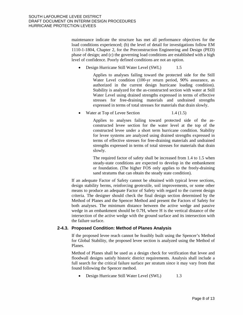
SOUTH LAFOURCHE LEVEE DISTRICT DRAFT DOCUMENT ON INTERIM DESIGN PROCEDURES HURRICANE PROTECTION LEVEES
Page 8 of 13
maintenance indicate the structure has met all performance objectives for the load conditions experienced; (b) the level of detail for investigations follow EM 1110-1-1804, Chapter 2, for the Preconstruction Engineering and Design (PED) phase of design; and (c) the governing load conditions are established with a high level of confidence. Poorly defined conditions are not an option.
• Design Hurricane Still Water Level (SWL) 1.5
Applies to analyses failing toward the protected side for the Still Water Level condition (100-yr return period, 90% assurance, as authorized in the current design hurricane loading condition). Stability is analyzed for the as-constructed section with water at Still Water Level using drained strengths expressed in terms of effective stresses for free-draining materials and undrained strengths expressed in terms of total stresses for materials that drain slowly.
• Water at Top of Levee Section 1.4 (1.5)
Applies to analyses failing toward protected side of the as-constructed levee section for the water level at the top of the constructed levee under a short term hurricane condition. Stability for levee systems are analyzed using drained strengths expressed in terms of effective stresses for free-draining materials and undrained strengths expressed in terms of total stresses for materials that drain slowly.
The required factor of safety shall be increased from 1.4 to 1.5 when steady-state conditions are expected to develop in the embankment or foundation. (The higher FOS only applies to the freely-draining sand stratums that can obtain the steady state condition).
If an adequate Factor of Safety cannot be obtained with typical levee sections, design stability berms, reinforcing geotextile, soil improvements, or some other means to produce an adequate Factor of Safety with regard to the current design criteria. The designer should check the final design section determined by the Method of Planes and the Spencer Method and present the Factors of Safety for both analyses. The minimum distance between the active wedge and passive wedge in an embankment should be 0.7H, where H is the vertical distance of the intersection of the active wedge with the ground surface and its intersection with the failure surface.
2-4.3. Proposed Condition: Method of Planes Analysis If the proposed levee reach cannot be feasibly built using the Spencer’s Method for Global Stability, the proposed levee section is analyzed using the Method of Planes.
Method of Planes shall be used as a design check for verification that levee and floodwall designs satisfy historic district requirements. Analysis shall include a full search for the critical failure surface per stratum since it may vary from that found following the Spencer method.
• Design Hurricane Still Water Level (SWL) 1.3

SOUTH LAFOURCHE LEVEE DISTRICT DRAFT DOCUMENT ON INTERIM DESIGN PROCEDURES HURRICANE PROTECTION LEVEES
Page 9 of 13
Applies to analyses failing toward the protected side for the Still Water Level condition (100-yr return period, 90% assurance, as authorized in the current design hurricane loading condition). Stability is analyzed for the as-constructed section with water at Still Water Level using drained strengths expressed in terms of effective stresses for free-draining materials and undrained strengths expressed in terms of total stresses for materials that drain slowly.
• Water at Top of Levee Section 1.2
Applies to analyses failing toward protected side of the as-constructed levee section for the water level at the top of the constructed levee under a short term hurricane condition. Stability for levee systems are analyzed using drained strengths expressed in terms of effective stresses for free-draining materials and undrained strengths expressed in terms of total stresses for materials that drain slowly.
The required factor of safety shall be increased from 1.4 to 1.5 when steady-state conditions are expected to develop in the embankment or foundation. (The higher FOS only applies to the freely-draining sand stratums that can obtain the steady state condition).
2-5. Seepage Analysis Piping and seepage analysis shall be performed in accordance with U. S. Army Corps of Engineers EM 1110-2-1913, 30 April 2000, Design and Construction of Levees.
2-6. Adjacent Structures Any adjacent structures (e.g., pump stations) shall be considered when analyzing the levee cross section.
2-7. Wall Design Since it is much more difficult to raise the elevation of a wall (as opposed to a levee), all hard structures shall be designed in accordance with the latest U. S. Army Corps of Engineers guidelines.
2-8. Levee Tie-ins and Overtopping Scour Protection Protection may be needed on a floodside slope to withstand the erosional forces of waves and stream currents. Protection may be beneficial on a protected side slope to withstand the erosional forces of overtopping waters. The required protection will vary, depending on a number of factors:
• The length of time that floodwaters are expected to act against a levee. If this period is brief, with water levels against the levee continually changing, grass protection may be adequate, but better protection may be required if currents or waves act against the levee over a longer period.
• The relative susceptibility of the embankment materials to erosion. Fine-grained soils of low plasticity (or silts) are most erodible, while fat clays are the least erodible.

SOUTH LAFOURCHE LEVEE DISTRICT DRAFT DOCUMENT ON INTERIM DESIGN PROCEDURES HURRICANE PROTECTION LEVEES
Page 10 of 13
• Structures floodside of the levee. Bridge abutments and piers, gate structures, ramps, and drainage outlets may constrict flow and cause turbulence with resultant scour.
• Turbulence and susceptibility to scour may result if levee alignment includes short-radius bends or if smooth transitions are not provided where levees meet high ground or structures.
• Requirements for slope protection are reduced when floodside levee slopes are very flat as may be the case for levees on soft foundations. Several types of slope protection have been used including grass cover, gravel, sand-asphalt paving, concrete paving, articulated concrete mat, and riprap, the choice depending upon the degree of protection needed and relative costs of the types providing adequate protection.
Performance data on existing slopes under expected conditions as discussed above are invaluable in providing guidance for the selection of the type of slope protection to be used.
Sometimes it may be concluded that low cost protection, such as grass cover, will be adequate in general for a levee reach, but with a realization that there may be limited areas where the need for greater protection may develop under infrequent circumstances. If the chances of serious damage to the levee in such areas are remote, good engineering practice would be to provide such increased protection only if and when actual problems develop. Of course, it must be possible to accomplish this expeditiously so that the situation will not get out of hand. In any event, high-class slope protection, such as riprap, articulated mat, or paving should be provided on floodside slopes at the following locations:
• Beneath bridges, since adequate turf cannot be generally established because of inadequate sunlight.
• Adjacent to structures passing through levee embankments.
Riprap is more commonly used than other types of revetments when greater protection than that afforded by grass cover is required because of the relative ease of handling, stockpiling, placement, and maintenance. Guidance on the design of riprap revetment to protect slopes against currents is presented in U. S. Army Corps of Engineers EM 1110-2-1601. Where slopes are composed of erodible granular soils or fine-grained soils of low plasticity, a bedding layer of sand and gravel or spalls, or plastic filter cloth should be provided beneath the riprap.

SOUTH LAFOURCHE LEVEE DISTRICT DRAFT DOCUMENT ON INTERIM DESIGN PROCEDURES HURRICANE PROTECTION LEVEES
Page 11 of 13
3. Construction Procedures for Quality Assurance / Quality Control 3-1. Classification of Methods
Levee embankments classified according to construction methods used are listed in the following table for levees composed of impervious and semipervious materials (i.e., those materials whose compaction characteristics are such as to produce a well-defined maximum density at a specific optimum water content). Where a levee has previously been constructed, compacted fill shall be used for the new levee project. Where there has been no previous levee project and multiple lifts are anticipated, semicompacted fill may be used for the levee project.
Classification According to Construction Method of Levees Composed of Impervious and Semipervious Materials
Category Construction Method Use Compacted Specification of:
a. Water content range with respect to standard effort optimum water content b. Loose lift thickness (6-9 in.) c. Compaction equipment (sheepsfoot or rubber- tired rollers) d. Number of passes to attain a given percent compaction based on standard maximum density e. Minimum required density
Provides embankment section occupying minimum space. Requires strong foundation of low compressibility and availability of borrow materials with natural water contents reasonably close to specified ranges. Used where field inspection is not constant throughout the project.
Semicompacted
Compaction of fill materials at their natural water content (i.e., no water content control). Borrow materials known to be too wet would require some drying before placement. Placed in thicker lifts than Compacted (12 in.) and compacted either by controlled movement of hauling and spreading equipment or by fewer passes of sheepsfoot or rubber- tired
The most common type of levee construction used in reaches where: a. There are no severe space limitations and steep-sloped Compacted embankments are not required. b. Relatively weak foundations could not support steep-sloped Compacted embankments. c. Underseepage conditions are such

SOUTH LAFOURCHE LEVEE DISTRICT DRAFT DOCUMENT ON INTERIM DESIGN PROCEDURES HURRICANE PROTECTION LEVEES
Page 12 of 13
rollers. Compaction evaluated relative to 15-blow compaction test.
as to required wider embankment base than is provided by Compacted construction. d. Water content of borrow materials or amount of rainfall during construction season is such as not to justify Compacted compaction.
Construction control of levees may present somewhat difficult problems. Construction operations may be carried on concurrently along many miles of levee. This means that much time is needed to cover the operations on many levee jobs. In addition, levee inspection personnel generally operate out of an area office which may be a considerable distance from the levee project. Under these conditions, the inspectors used must be well-trained to observe construction operations, minimizing the number of field density tests in favor of devoting more time to visual observations, simple measurements, and expedient techniques of classifying soils, evaluating the suitability of their water content, observing behavior of construction equipment on the fill, and indirectly assessing compacted field densities.
Some of the things that can happen during construction that can cause failure or distress of even low embankments on good foundations are given in the following table.
Embankment Construction Deficiencies Deficiency Possible Consequences
Organic material not stripped from foundation
Differential settlements; shear failure; internal erosion caused by through seepage
Highly organic or excessively wet or dry fill
Excessive settlements; inadequate strength
Placement of pervious layers extending completely through the embankment
Allows unimpeded through seepage which may lead to internal erosion and failure
Inadequate compaction of embankment (lifts too thick, haphazard coverage by compacting equipment, etc.)
Excessive settlements; inadequate strength; through seepage
Inadequate compaction of backfill around structures in embankment
Excessive settlements; inadequate strength; provides seepage path between structure and material which may lead to internal erosion and failure by piping
As a general rule levee embankments are constructed as homogeneous sections because zoning is usually neither necessary nor practicable. However, where materials of varying permeabilities are encountered in borrow areas, the more impervious materials should be placed toward the floodside of the embankment and the more pervious material toward the landside slope. Where required to improve underseepage conditions, landside berms should be constructed of the most pervious material available and floodside berms of the more impervious materials. Where impervious materials are scarce, and the major portion of the embankment must be built of pervious material, a central impervious core can be specified or, as is more often done, the floodside slope of the embankment can be

SOUTH LAFOURCHE LEVEE DISTRICT DRAFT DOCUMENT ON INTERIM DESIGN PROCEDURES HURRICANE PROTECTION LEVEES
Page 13 of 13
covered with a thick layer of impervious material. The latter is generally more economical than a central impervious core and, in most cases, is entirely adequate.
3-2. Compaction Procedure Within the crown of the levee, earthen fill shall be installed in lifts limited to 12” thick. Compaction tests are taken on every lift at no more than 500’ spacing.
Outside of the crown of the levee, earthen fill shall be installed in lifts limited to 12” thick. The compaction required outside of the crown of the levee should meet semi-compaction criteria established by the engineer. The berm material will consolidate over time. In all cases, the cross section of the levee shall meet the necessary stability requirements.
In cases where the berm is used as a temporary storage location for materials to be used in later lifts, no compaction tests are necessary. This material shall be placed so that water may drain.
3-3. Soil Testing Procedure Soil classification and proctor analysis tests shall be performed on the earthen fill at no more than 500’ spacing.
3-4. Stockpiled Material There may be cases in which it is economically feasible to excavate borrow material that will not be used until future lifts of the levee. Allowing this wet material to dry before placing it on the levee section, as opposed to hauling in dry material from outside sources, could save a great deal of money.
Stockpiled material shall be included in any analysis of the design section. There shall be no failure in the crown of the levee due to this stockpiled material.
In cases where the berm is used as a temporary storage location for materials to be used in later lifts, no compaction tests are necessary. This material shall be placed so that water may drain.

CLLC Position Paper
22
APPENDIX G: 2015 Legislative Issues

2015 LEGISLATIVE ISSUES by Reggie Dupre, Chair Legislative Committee
The main Legislative priority for CPRA and the Consortium for the 2015 State Legislative Session will be defensive rather than big new policy moves. Being this year is an election year for all Legislators and the fact that Gov Jindal is termed out, the main focus for 2015 is to protect the past reforms from those who wish to go backwards. Nevertheless, there are some bills and legislative instruments that we need to follow including:
• HCR #1 by Rep. Dove--This is the annual plan for CPRA. Last year, in 2014, was the first time there was an organized effort to kill the annual plan. With new leadership at CPRA, the Levee Districts must offer there complete support in passage of the last Annual Plan under Gov. Jindal.
• Allowing Political Subdivisions to use "Resources" for in house mitigation projects. Under current law, Political subdivisions can self-preform mitigation with public employees and equipment. Rep Dove will be filing a bill to change this to resources so that we can hire contractors’ equipment.
• Local bill for N. Lafourche Levee District--Rep Dove will also be filing a local bill on behalf of
North Lafourche Levee District to match the numbers of Commissioners to the number of Legislators providing nominations to the Governor.
• Change of "Per-Diem" for Levee District Commissioners--Rep Harrison will be filing a bill to
change the per diem paid to levee district commissioners. This amount has not changed since the 1980's. The "Regular" Levee districts are limited to a max. of $75 per meeting while the newer Levee Authorities earn about the same per diem as State Legislators. This will likely be the most controversial of the bills in 2015.
It seems important that the Legislative Committee of the Levee Dist Consortium, the CPRA, and the ALBL are all on the same page regarding issues before the State Legislature this year.

CLLC Position Paper
23
APPENDIX H: Appropriation of Levee Servitude in Louisiana, by David Peterson

ASSOCIATION OF LEVEE BOARDS OF LOUISIANA
74th
ANNUAL MEETING
LEGAL ADVISORY MEETING CLE
APPROPRIATION OF LEVEE SERVITUDES
IN LOUISIANA
David A. Peterson
Deputy General Counsel
Coastal Protection and Restoration Authority
Phone: 225-342-6505
Email: [email protected]

Appropriations Law – ALBL CLE Materials
December 3, 2014
Page 1 of 12
A. Appropriation of Levee Servitudes in Louisiana:
Traditionally, under Louisiana Civil Code Article 665 and its prior versions dating to
before the Louisiana Purchase, a servitude in favor of the public for purposes of constructing and
maintaining levees is imposed upon all land along navigable streams. Article 665 provides as
follows:
Art. 665. Legal public servitudes
Servitudes imposed for the public or common utility relate to the space which is
to be left for the public use by the adjacent proprietors on the shores of navigable
rivers and for the making and repairing of levees, roads, and other public or
common works. Such servitudes also exist on property necessary for the building
of levees and other water control structures on the alignment approved by the U.S.
Army Corps of Engineers as provided by law, including the repairing of hurricane
protection levees.
All that relates to this kind of servitude is determined by laws or particular
regulations. 1
Louisiana levee districts are authorized to adopt acts of appropriation through resolution to
exercise this public servitude when the levee district board determines that land burdened by the
servitude is necessary for levee or levee drainage purposes.2 While Article I, §4 of the Louisiana
Constitution guarantees that one cannot be deprived of his property except for public purpose
and with just compensation paid to the owner or into the court for his benefit, such guarantee is
not provided to owners of land burdened by a levee servitude under Article 665.3 The reason the
right to compensation is not extended to appropriated property is because the laws of the State of
Louisiana have long provided, even prior to the Louisiana Purchase,4 that a servitude is imposed
1 Acts 2006, Act 766 of the Louisiana Legislature added the language relating to alignments approved by the U.S.
Army Corps of Engineers. This significance of this addition will be discussed further below. 2 La. R.S. 38:301(C).
3 Dickson v. Board of Commissioners of Caddo Levee District, 210 La. 122, 26 So. 2d 474 (La. 1946); La. Const.
Article I, §4(E) and Article VI, §42(B). See also, DeSambourg v. Board of Commissioners for the Grand Prairie
Levee District, 621 So. 2d 602 (La. 1993). 4 See, Dickson, supra. for a comprehensive history of appropriations in Louisiana, specifically noting at p. 131:
“From the earliest Colonial days, when the Louisiana Territory was in the possession of France and Spain, no grants
of lands were ever given without a specific reservation being made therein for the common use of the public of all
rights to the shores of rivers and bayous upon which they might front. These two countries never divested
themselves of title to lands lying immediately adjacent to navigable streams. [French and Spanish land grants have
specific reservations of such riparian property.] This policy, during the Spanish occupation of the territory, became
merged with the law relative to servitudes to be found in the ancient Las Siete Partidas of Spain and, in time, found
its way into the First Civil Code adopted by the Territory of Orleans (comprising what is now known as the State of
Louisiana) in 1808, after the Louisiana Territory had been acquired by the United States, the basic principles relative
to servitudes in Las Siete Paretidas being included therein almost verbatim, thus insuring that the shores of
navigable rivers and streams in this state would always be kept free for the public levee and other public purposes.”
See also, DeSambourg, supra, for comprehensive history of the evolution of the levee districts in Louisiana and
appropriation of the levee servitude by those public entities.

Appropriations Law – ALBL CLE Materials
December 3, 2014
Page 2 of 12
on all lands bordering on navigable rivers and streams for construction and maintenance of
levees, roads, and other common or public works.5 Thus, public levee servitudes have been
around for centuries and the establishment thereof is deeply rooted in the Louisiana‟s French and
Roman civil law tradition. As noted by the U.S. Supreme Court, “the riparian owner enjoys his
property sub modo, i.e. subject to the right of the public to reserve space enough for levees,
public roads and the like” and “never acquires complete dominion”.6 The property “never passes
free of this reservation by a deed to a purchaser.”7 While the land in the remaining states of the
United States necessary for levee purposes can only be used after expropriation and proper
indemnification, the State of Louisiana and its designated levee districts and other political
subdivisions have the right to act first, i.e. the authority to appropriate such land to a use to
which it is subject under Civil Code Article 665, and talk later. Put simply, the act of
appropriation does not involve the acquisition of a right in property but the act of the levee board
providing notice to the owner of the land burdened with such servitude that the levee district
intends to exercise the public right to the property. As noted by the La. Supreme Court:
“[H]owever unfair it may seem to the owners of this type of land they are without right to
complain because their acquisition of such land was subject by law to this ancient servitude and
the private mischief must be endured rather than the public inconvenience or calamity.”8
Beginning with the adoption of Section 6 of Article XVI of the 1921 Constitution,
Louisiana law began providing payments for appropriated lands even though the law maintained
the “act first – talk later” procedure, the first amount paid being a price not to exceed the
assessed value for the preceding year.9 Nonetheless, since the state always had a right of
servitude over riparian property that it could have exercised without paying compensation, the
amounts provided are considered “purely gratuitous”.10
Beginning with the Louisiana
Constitution of 1974, Article VI, §42 provided that “lands and improvements thereon actually
used or destroyed for levees or levee drainage purposes shall be paid for as provided by law.” In
response to that provision, the legislature adopted what is now La. R.S. 38:301, providing for a
measure of compensation at fair market value and thus made payments for certain appropriations
consistent with the general constitutional provisions providing compensation for the
expropriation or taking of private property.11
Nonetheless, the payment under Louisiana law still
remained a gratuity, the legislature retaining the right under Article VI, §42 to provide no
compensation for appropriations, if it so desired. In fact, the statute specifically provides that no
compensation is due for batture lands12
or property under the control of the state or any political
subdivisions for the purpose of commerce.13
5 Dickson, supra at p. 128.
6 Eldridge v. Trezevant, 160 U.S 452, 16 S.Ct. 345, 40 L.Ed. 490 (1896) at 16 S.Ct. 347, quoting Ruch v. New
Orleans, 43 La. Ann. 275, 9 So. 473 (La. 1891); See also, Dickson, supra. 7 Id.
8 Dickson, supra. at p. 136.
9 Id. at p. 129.
10 Id.; See also, Danzinger v. U.S., 93 F.Supp. 70 (E.D. La. 1950).
11 See, Wynat Development Co. v. Board of Levee Com’rs for the Parish of Orleans, 97-2121, (La. 4/14/98), 710 So.
2d 783. 12
Batture lands are a class of riparian lands made up of alluvial accretions annually covered by “ordinary high
water,” i.e. the highest level the river inevitably reaches during annual seasons of high water, which is the highest
stage a river can be expected to reach annually, but not the level the water reaches during major flood events. Put
simply, this is the area of land between the ordinary low water mark and the ordinary high water mark on a stream.

Appropriations Law – ALBL CLE Materials
December 3, 2014
Page 3 of 12
In addition to providing the appropriate method by which compensation is to be provided,
La. R.S. 38:301 also provides the general procedure by which appropriation takes place.
Generally, the statute provides the following procedure for effectuating an appropriation and
compensating the landowner for such appropriation:
1. Adopt a formal resolution describing the area to be utilized for levee and levee drainage
purposes and delineating whether the areas will be burdened with a permanent or
temporary levee servitude.
2. Notice of the resolution shall be provided to the landowner by certified mail within five
days of the adoption of the resolution.14
3. Immediately after the adoption of the resolution, an estimate of the compensation due
shall be made, i.e. an appraisal should be conducted.
4. If revenues are available to pay the compensation due, the levee board shall pay such
compensation to the owner within one year of the actual taking, use, damage, or
destruction of the property.15
While not generally required by the statute, most levee districts by custom and practice publish
the appropriation resolution and attached maps, plats, or property descriptions in the official
journal of the levee district as well as file in the conveyance records of the clerk of court in the
parish where the property is located.16
With regard to Terrebonne Levee and Conservation District (TLCD) and the South
Lafourche Levee District (SLLD), the statute provides a slightly different but more specific
procedure for effectuating an appropriation and gratuitous compensation. The additional
provisions for the TLCD procedure require the following:
1. Following adoption of the appropriating resolution, notice is to be provided by
certified mail to the last record property owner as reflected in the parish
assessment rolls at the address recorded on the assessment rolls.17
2. Within ten days of adoption of the appropriating resolution, notice must also be
provided by publication in the official journal of the TLCD.
Nonetheless, the Article 665 servitude can burden lands landward of the ordinary high water mark. See,
DeSambourg, supra. 13
La. R.S. 38:301(C)(1)(i) and (j). 14
The statute is internally inconsistent in that Paragraph (C)(1)(a) provides for notice “within ten days of the date of
passage” of the appropriating resolution while Paragraph (C)(1)(g) provides that “[n]otice by certified mail shall be
given to the owner within five days of the adoption of the resolution.” Out of precaution, it is advisable and prudent
that levee districts provide the notice within five days rather than ten. 15
The statute distinguishes “use”, which occurs upon adoption of the resolution, from “actual use”, which
presumably requires some physical or overt action of the appropriating authority to exercise dominion over the
property appropriated. Thus, the one year time limit may not begin running on the date of adoption of the
appropriating resolution by the board. La. R.S. 38:301(C)(1)(g). 16
See Appendix A for a detailed suggested procedure for handling of appropriations. 17
The provision does not provide whether notice should be provided within ten days or five days after adoption of
the resolution but does indicate that notice is completed upon mailing. Therefore, it is advisable to use the five day
notice provision out of an abundance of caution. See, La. R.S. 38:301(C)(1)(b)(ii).

Appropriations Law – ALBL CLE Materials
December 3, 2014
Page 4 of 12
3. Payment of TLCD‟s estimated compensation is to be made by certified mail to the
last record property owner as reflected in the parish assessment rolls at the
address recorded therein.18
4. All claims regarding the compensation paid by TLCD shall be limited to the fair
market value of the property and must be filed in the parish district court within
180 days after the mailing of payment.
5. Additionally, an owner or co-owner of property appropriated by TLCD may,
within sixty days after adoption of the appropriating resolution, contest the
validity of the appropriation as it pertains to that owner‟s property interest by
filing a petition in the parish district court. After the filing of such petition, the
levee district may proceed to expropriate the property in accord with the
customary method of expropriation by levee districts provided in La. R.S. 38:351,
et seq. Failure to timely make such claim results in the loss of all rights to
challenge the appropriation, except claims for compensation.
Thus, this special procedure for TLCD provides additional protections to the landowner
regarding their ability to challenge compensation and the necessity of the appropriation while
allowing the levee district to rely on the assessors rolls for determining the appropriate parties for
notification and compensation purposes.19
Under federal jurisprudence, the U.S. Supreme Court, the lower appellate courts, and the
district courts have consistency approved the general appropriation of riparian property,
declaring it to be consistent with the due process clause of the U.S. Constitution and finding that
it does not constitute a taking requiring compensation under the 5th
Amendment of the U.S.
Constitution.20
Appropriation of the use of the levee servitude under Civil Code Article 665 has
been determined to be private injury resulting from the exercise of a legal right that is “damnum
absque injuria”, i.e., injury without loss.21
The U.S. Supreme Court has specifically found that
the historical background of the levee servitude and the appropriation process “makes clear that
the rights of the State in property subject to the servitude are very broad” and “can be exercised
in the way found to be „most expeditious from an engineering, economical, and practical
standpoint.‟”22
The Court further concluded:
18
The general one year period for making payment is still applicable. 19
Similar provisions are provided for the South Lafourche Levee District. 20
See, General Box Co. v. U.S., 351 U.S. 159, 76 S.Ct. 728, 100 L.Ed. 1055 (1956); Wolfe v. Hurley, 46 F.2d 515
(W.D.La.1930), affirmed 283 U.S. 801, 51 S.Ct. 493, 75 L.Ed. 1423 (1931); Maynard v. U.S. through U.S. Corps of
Engineers, Dept. of Army, 587 F.2d 788 (5th
Cir. 1979); Danzinger, supra. State jurisprudence has also consistently
held that the appropriation process and method of payment thereunder, while gratuitous, meets the due process
requirements of both the federal and state constitutions. See, DeSambourg, supra; Board of Commissioners of
Tensas Basin Levee District v. Franklin, 219 La. 859, 54 So. 2d 125 (1951); Delaune v. Board of Commissioners for
the Pontchartrain Levee District, 230 La. 117, 87 So. 2d 749 (1956); Hathorn v. Board of Commissioners of the Red
River, Atchafalaya, Bayou Boeuf Levee District, 218 So. 2d 335 (La. 3rd
Cir. 1969). 21
Danzinger v. U.S., supra. 22
General Box Co., supra., citing, Board of Commissioners of Tensas Basin Levee District v. Franklin, supra.

Appropriations Law – ALBL CLE Materials
December 3, 2014
Page 5 of 12
By law, and for the good of all, lands were made available to the State for levee
purposes in as convenient a manner to the State as was necessary for the public
welfare, and with little regard for the severity of the obligations imposed on the
individual property owner.23
Based on this analysis, the U.S. Supreme court found that the State can legally exercise its
“obviously comprehensive rights” without an opportunity to provide the owner of the land
burdened with a levee servitude advanced notice of its actions. Thus, the State of Louisiana and
its appropriating authorities can “act first and talk later” without violating the 5th
Amendment
takings clause and the 14th
Amendment due process clause.
The above discussion notwithstanding, it is noted that all of the current jurisprudence
approving the use of appropriation by levee districts to exercise the Article 665 public levee
servitude has dealt with riparian lands. Additionally, where lands were not riparian or used for a
levee purposes not associated with flooding on the stream on which the appropriated lands
fronted, i.e., including use of certain lands for back levee hurricane protection fronting Lake
Pontchartrain, the courts have found that appropriation could not be used to obtain a levee
servitude.24
Nonetheless, following Hurricane Katrina, the Louisiana legislature modified
Article 665 to impose a public levee servitude on “property necessary for the building of levees
and other water control structures on the alignment approved by the U.S. Army Corps of
Engineers as provided by law, including the repairing of hurricane protection levees.”25
This
addition effectively reversed the case law limiting the servitude to riparian lands in instances
where the Corps of Engineers has approved a particular levee alignment. The amendment now
allows levee districts to appropriate a levee servitude over lands, whether riparian or not, when
the Corps of Engineers approves a particular levee alignment. The potential issue here is
whether appropriations of such “alignment lands” result in the acquisition of a levee servitude
that had not previously and historically burdened the properties over which it will be imposed.
Therefore, the question could arise as to whether an appropriation of such property meets with
the same “due process” approved under the older jurisprudence and whether the new “alignment
lands” servitude constitutes a compensable taking of property as previously held by the courts in
the non-riparian appropriation cases. No appellate court cases have addressed this issue.
Nevertheless, appropriation of levee servitudes on “alignment lands” as a method of
condemnation should still hold up under a due process analysis. First, the appropriation process
has a long standing history in Louisiana and in most cases, provides payment to the landowner at
fair market value, even when such payment is not necessarily due. Second, while appropriation
uses a “take first but pay later” approach versus traditional expropriation “pay first” approach,
part of the reason the appropriation “take first” method for exercising the Article 665 servitude
has been approved by the courts at all levels is the recognized importance of levees in Louisiana
and the need to assure that levees construction is not delayed by the usual expropriation process
and that construction be carried out as expediently as possible for the purpose of protecting the
health, safety, and welfare of the public and avoiding calamity. In fact, since the enactment of
23
General Box Co., supra. 24
See, i.e. DeSambourg, supra; Delaune v. Board of Commissioners for the Pontchartrain Levee District, 230 La.
117, 87 So. 2d 749 (La. 1956) and its progeny. 25
Acts 2006, No. 776, § 1, effective August 15, 2006.

Appropriations Law – ALBL CLE Materials
December 3, 2014
Page 6 of 12
the 1974 Louisiana Constitution, the process as set forth in La. R.S. 38:301 guarantees that a
landowner will be fairly compensated for the levee servitude imposed and has a right to
challenge the amount of that compensation and the necessity for the appropriation. Other than
the timing of payment, appropriation therefore generally provides the same protections to a
landowner as traditional expropriation.26
Nonetheless, caution should be used when a levee
district appropriates non-riparian lands. It seems acquisition via a “quick take” expropriation
proceeding might be less prone to challenge unless a specific threat to public health, safety, and
welfare can be articulated to justify the need to use appropriation in as expeditious manner as
possible to avoid a potential calamity.
B. The Federal Uniform Relocation Act (URA) and Regulations and the Use of
Appropriation of Levee Servitudes for Federal Projects
The URA is a federal law that establishes minimum standards for federally funded programs and
projects that require the acquisition of real property (real estate) or to displace persons from their
homes, businesses, or farms. The URA‟s protections and assistance apply to the acquisition,
rehabilitation, or demolition of real property for federal or federally funded projects. The URA
is implemented through government-wide regulations at 49 CFR Part 24. The objectives of the
URA are (1) to provide uniform, fair and equitable treatment of persons whose real property is
acquired or who are displaced in connection with federally funded projects, (2) to ensure
relocation assistance is provided to displaced persons to lessen the emotional and financial
impact of displacement, (3) to ensure that no individual or family is displaced unless decent,
safe, and sanitary (DSS) housing is available within the displaced person's financial means, (4) to
help improve the housing conditions of displaced persons living in substandard housing, and (5)
to encourage and expedite acquisition by agreement and without coercion.27
Generally, the URA
applies to federal agencies or state agency, i.e. local or state agencies and political subdivisions,
acquiring property for federal projects or programs.28
Before a federal agency may approve a
grant to, or contract, or agreement with, a state agency, where federal financial assistance is
provided, the state agency is required to provide assurance that it will comply with the URA and
the regulations thereunder. For example and of relevance to most levee districts, all current
model Project Partnership Agreements and other cooperative agreements with the United States
Army Corps of Engineers require adherence to the URA.29
Nonetheless, a state agency may
obtain a waiver of compliance with the real estate acquisition provisions of the URA, 42 U.S.C.
§§4651-4651, if state law provides an exemption.30
In general, the real estate acquisition provisions of the URA and the implementing
regulations provide that an acquiring agency, whether state or federal, should follow certain
26
As previously noted infra, the appropriation procedures specific to TLCD and SLLD appear to provide even
greater protections to a landowner than the general procedures set forth in La. R.S. 38:301. 27
See “Overview of URA” at HUD website at
http://portal.hud.gov/hudportal/HUD?src=/program_offices/comm_planning/affordablehousing/training/web/relocati
on/overview. 28
42 U.S.C. §4629. 29
See model agreements at http://www.usace.army.mil/Missions/CivilWorks/ProjectPartnershipAgreements.aspx. 30
42 U.S.C. §4655 and 49 CFR §24.4

Appropriations Law – ALBL CLE Materials
December 3, 2014
Page 7 of 12
procedures when acquiring property for a federal project or program.31
The provisions are
applicable “to the greatest extent practicable under State law.”32
The procedures include the
following pertinent requirements that must be met before initiation of eminent domain
proceedings, i.e. expropriation:
1. Appraising the property and establishing just compensation prior to
initiating negotiations;
2. Inviting the property owner to accompany the appraiser during the
property inspection process;
3. Providing the owner with a written offer of just compensation and a
summary of what is being acquired;
4. Paying for property before possession, and;
5. Reimbursing expenses resulting from the transfer of title such as recording
fees, prepaid real estate taxes, or other expenses.33
Comparing the URA and its implementing regulations to the appropriation of levee
servitudes by a levee district under Louisiana law, it is clearly evident that the permissible
procedures under each law are in conflict. In particular, the URA requires certain actions be
taken before an acquiring agency may move forward with obtaining possession of property
needed for a federal project or program, including appraisal, notice, and offer and payment of
compensation. Appropriations under La. R.S. 38:301 allow these actions to be taken after the
property is appropriated or acquired through adoption of a levee board resolution. Nonetheless,
appropriations, as previously mentioned, have been permitted under Louisiana law since the
territory was governed by French and Spanish law and such procedure has been regularly
approved in both the federal and Louisiana courts. The appropriation procedure also additionally
assures that the landowner is compensated in accord with Louisiana law in a timely and fair
manner. Therefore, it would appear reasonable to be allowed to deviate from the URA when
using appropriation as a method to obtain levee servitudes for federal projects as the process is
generally within the spirit of the URA.
In addition to waivers being reasonable for appropriations under the URA and the
implementing regulations, it appears that long standing Louisiana jurisprudence would make the
URA inapplicable to any levee servitudes obtained validly through the appropriation procedure.
The basis of the URA is that the agency engaged in obtaining land rights by “acquiring” land
rights under threat of the exercise of a state‟s eminent domain authority. However, as set forth in
the Louisiana jurisprudence cited above, there is no “acquisition” involved in a levee district‟s
exercise of an Article 665 servitude through an appropriation resolution. In fact, the State of
Louisiana, for the benefit of the public, already owns a legal servitude over all riparian lands for
purpose of use for “levees, roads, and public works”, a servitude held by the sovereign prior to
the Louisiana Purchase and which has never been transferred to the private riparian owners. The
act of appropriation is simply notice to the riparian landowner that the state, through the levee
district, intends to exercise its right to use the levee servitude, a property right the public, i.e. the
State of Louisiana, already owns in perpetuity. The fact that the constitution and the state
31
See, generally, 42 U.S.C. §§ 4651 and 4652 and 49 CFR §§24.102 - 24.105. 32
49 CFR 24.101(5)(d) and 42 U.S.C. §4655(a)(1). 33
See, 42 U.S.C. §§4651 and 49 CFR §§24.102.

Appropriations Law – ALBL CLE Materials
December 3, 2014
Page 8 of 12
legislature provide compensation to the riparian owner when the state exercises its legal
servitude on certain types of underlying property does not change the character of the servitude
and the owner thereof. Such compensation is “merely gratuitous” and not compensation
resulting from the state‟s exercise of its right of eminent domain to acquire a right to property it
did not previously own under the long standing law of the state. Thus, since appropriation does
not involve the exercise of eminent domain, the URA is never triggered.34
34
As previously noted herein, the 2006 changes to Article 665 imposing a levee servitude upon “alignment lands”
might arguably be considered a “taking” under federal and state eminent domain jurisprudence. Therefore, the URA
might be triggered in such circumstances. Nonetheless, since the “act first – pay later” procedure provided in law
for appropriating a levee servitude meets due process requirements, a waiver of the URA procedural requirements
based on conflicting state law should be allowed and should be sought from the appropriate federal agency.

Appropriations Law – ALBL CLE Materials
December 3, 2014
Page 9 of 12
APPENDIX A: SUGGESTED APPROPRIATION PROCEDURE
1) Obtain documentation or survey of official alignment, whether approved by
Corps or the levee district, with description of property needed and the type of
servitude required, i.e. permanent or temporary, with property descriptions. A
map of official alignment will need to be obtained from Corps of Engineers, if
property is not riparian to a navigable waterway.
2) Adoption of the resolution by the Levee Authority:
a. The resolution must specify and delineate what areas are to be
appropriated and whether the areas appropriated will be burdened with a
permanent levee servitude or a temporary servitude for levee construction
purposes.
b. Based on C.C. Article 665, the servitude must be on a Corps alignment or
on a navigable waterway.
i. Regarding non-riparian land, the jurisprudence does allow for
appropriation of land that was originally riparian when separated
from the public domain even if it is not now riparian if the property
taken „is within range of the reasonable necessities of the situation,
as produced by the forces of nature, unaided by artificial causes”,
or includes “all adjoining lands within the reasonable necessities
for flood control unaided by artificial causes.” See, Board of
Commissioners for Pontchartrain Levee District v. Baron, 236 La.
846, 109 So.2d 441 (1959) and cases therein. If any of the land to
be appropriated would be using a Corps alignment under the new
provisions of Article 665, it would be helpful to have classified as
riparian or near riparian property. This would cover both aspects
of Article 665.
ii. It should also be noted that the jurisprudence indicates an
appropriation only provides a servitude, whereas an expropriation
would allow taking of fee title, subject to necessity of need for
such interest in the property.
c. Use, i.e. taking, occurs at the time the levee board formally adopts its
resolution specifically describing an area to be utilized for levees and
levee drainage purposes through the exercise or acquisition of a permanent
or temporary servitude. The “actual use” must occur within two years of
the adoption of the resolution. La. R.S. 38:301 does not specifically say
this but it should be assumed the resolution “description” of the property
to be taken should be via plat, metes and bounds, or other appropriate
acceptable property description. Thus, the statute can likely be interpreted
as providing that “use of the servitude” passes to the levee board upon

Appropriations Law – ALBL CLE Materials
December 3, 2014
Page 10 of 12
resolution adoption and therefore, grants immediate right of use of the
property.
3) Provide written notice to the owner of the property:
a. While La. R.S. 38:301 does not require filing, it is suggested that the
resolution be filed in the Parish Conveyance records. This could be
considered written notice to the landowner as well as any third parties.
This is also consistent with state law on filing of documents effecting real
property. It is suggested that filing should be made in both the parish
which is the domicile for the levee authority as well as the parish where
the property is located if the property is outside the domicile of the levee
district.
b. Send notice by certified mail to the owner of the property within five days
of the resolution. (As noted previously, the statute has two time limits for
notice, it would be suggested that following the shorter time limit would
prudent.)
c. The Terrebonne and South Lafourche Levee Districts‟ special provisions
provide the mail should be sent to the last record owner as reflected in the
parish assessment rolls at the assessment roll record address and that
“notice shall be completed upon mailing.” As there is a difference, it
might be safer to make sure notice is given to owner from assessment rolls
as well as any other available public records where other levee districts are
making an appropriation since there is an obvious distinction for
Terrebonne and South Lafourche.
d. While Terrebonne and South Lafourche Levee Districts are required to
publish in the official parish journal, there is no such requirement for other
levee districts. Nonetheless, it would appear to be prudent to follow this
procedure for any levee district as doing so adds another level of “due
process” notice in the event of a challenge and is a procedure that is
already being followed by some levee districts. If the parish of
appropriation is not the domicile parish of the levee district, publication in
the domicile parish and parish where property located would also be wise.
4) Estimate the Compensation due in accord with the provision of R.S. 38:301:
a. Estimation to be made “immediately after the actual taking”, no time
frame is given and thus would be subject to a reasonableness standard. A
time period of 90 – 120 days should be more than adequate to obtain
appraisals and easily defended in court.
b. The levee board must also make and estimate revenues available from all
sources from which to make the payment of the compensation.
c. The measure of compensation is provided in R.S. 38:301(C)(1)(h)
generally as “fair market value” with considerations for remainder
damages. Reasonable attorney fees, not exceeding 25% of the difference,
may be awarded if the amount awarded by a court is less than the
compensation provided by the levee district. The statute does not provide

Appropriations Law – ALBL CLE Materials
December 3, 2014
Page 11 of 12
or the number of appraisals that are necessary but guidance might be
found in the levee district expropriation provisions under La. R.S. 38:353,
requiring at least two appraisals.
d. While not required by the statute, it would likely be prudent for the levee
board to approve the amount of compensation by a resolution at one of its
meetings.
e. Compensation must be paid to “the owner within one year after the actual
taking, use, damage, or destruction of the property” but only “if revenues
[are] available to the levee board sufficient to pay the compensation due”.
See La. R.S. 38:301(C)(2). It is noted that “actual use” and “use”
(adoption of resolution) are used and defined separately in the statute. See
La. R.S. 38:301(C)(1)(g) and (C)(1). Thus, the one year appears to run
only from the time the levee district takes physical possession of the
property in some manner or begins activities impacting the property
appropriated. Caution however should be exercised as there appear to be
no jurisprudence on when the time period begins to run.

APPENDIX B: RELEVANT CASE LAW

| | Positive
As of: December 2, 2014 1:29 PM EST
DeSambourg v. Board of Comm’rs
Supreme Court of Louisiana
July 2, 1993, Decided
No. 93-C-0167
Reporter
621 So. 2d 602; 1993 La. LEXIS 2299
WARREN DeSAMBOURG AND MARY DeSAMBOURG
v. BOARD OF COMMISSIONERS FOR THE GRAND
PRAIRIE LEVEE DISTRICT
Subsequent History: [**1] Rehearing Denied September
2, 1993. Dissenting Opinion Dated September 2, 1993,
Reported in the Hardbound at: 624 So.2d 421.
Prior History: ON WRIT OF CERTIORARI TO THE
COURT OF APPEAL, FOURTH CIRCUIT, PARISH OF
PLAQUEMINES, STATE OF LOUISIANA.
Disposition: AFFIRMED.
Core Terms
levee, batture, river, servitude, appropriated, ordinary high,
feet, exemption, annually, trial court, destroyed, elevations,
damaged, reaches, riparian landowner, drainage purposes,
riparian, political subdivision, high water, bed, riparian
land, purposes, fill, statistical, landowners, inundated,
alluvion, borrow, flood, dirt
Case Summary
Procedural Posture
Plaintiff landowners appealed the decision of the Court of
Appeal, Fourth Circuit, Parish of Plaquemines (Louisiana),
which found that defendant parish was not required to
compensate the landowners for the parish’s taking of
″batture″ for levee purposes from the landowners’ riparian
lands pursuant to the exempt from compensation stated in
La. Const. art. 6, § 42 and La. Rev. Stat. Ann. §
38:301(C)(1)(a).
Overview
The United States Army Corps of Engineers directed the
parish to provide fill dirt from Shingle Point near English
Turn in Plaquemines Parish to complete two levee
improvement projects. The landowners claimed that the
parish owed compensation for the removed dirt and filed
suit. As its defense, the parish asserted the ″batture″
exception of La. Const. art. 6, § 42 and La. Rev. Stat. Ann.
§ 38:301(C)(1)(a). The trial court found that the fill dirt was
″batture″ and dismissed the suit. On appeal, the intermediate
appellate court affirmed. On further appeal, the court
affirmed. The court held that ″batture″ was that part of the
river bed that was uncovered at the time of low water, but
was covered annually at time of ordinary high water, and
that the upper boundary of batture was the equivalent of
mean high water and was determined by reviewing the
statistics on the elevations the river usually reached annually
over a sufficient period of time. The court held that the trial
court’s finding that all of the fill dirt at Shingle Point was
″batture″ was not clearly erroneous because the ordinary
high water line of 11.0 feet covered 97 to 99 percent of the
surface of Shingle Point.
Outcome
The court affirmed the decision of the intermediate appellate
court, which had found that the parish was not liable to
compensate the landowners for the removal of fill dirt from
their riparian land where the fill dirt came from below the
ordinary high water line, and therefore was ″batture.″
LexisNexis® Headnotes
Environmental Law > Land Use & Zoning > Eminent Domain
Proceedings
HN1 La. Const. art. 6, § 42 (1974) exempts the state and its
political subdivisions from compensating riparian
landowners for the exercise of its levee servitude when the
lands actually used or destroyed for levee or levee drainage
purposes are ″batture.″ The constitutional provision is
presently implemented in La. Rev. Stat. Ann. §
38:301(C)(1)(a).
David Peterson

Environmental Law > Land Use & Zoning > Eminent Domain
Proceedings
Governments > Public Improvements > Sanitation & Water
Real Property Law > Water Rights > Riparian Rights
HN2 Appropriation is the taking of a servitude. It is a mode
for the state and its political subdivisions to exercise its
levee servitude, whereby lands and improvements can be
taken for levees purposes, before the payment of
compensation as set forth in La. Const. art. 6, § 42(A) and
(B). The right of appropriation proceeds upon the principle
that the riparian owner enjoys his property sub modo, i.e.,
subject to the right of the public to reserve space enough for
levees, public roads, and the like. Over this space, the front
proprietor never acquires complete dominion. It never
passes free of this reservation by deed to purchaser. Unlike
expropriation, appropriation of riparian property does not
vest title property in the state or its political subdivisions.
Environmental Law > Land Use & Zoning > Eminent Domain
Proceedings
Governments > Local Governments > Duties & Powers
HN3 La. Const. art. 6, §§ 16 and 38 provide that levee
districts can be reorganized, merged, and consolidated with
a parish.
Environmental Law > Land Use & Zoning > Eminent Domain
Proceedings
Governments > Public Improvements > Sanitation & Water
Real Property Law > Water Rights > Riparian Rights
Transportation Law > Water Transportation > Mississippi River
HN4 Pursuant to the Mississippi River Flood Control Act of
1928, 33 U.S.C.S. § 701-709, the United States Army Corps
of Engineers (COE) oversees and maintains the Mississippi
River and levee system. Once the COE selects a site for
levee improvement, local governments are obligated to
furnish all needed rights of way and to appropriate the
necessary riparian property.
Environmental Law > Land Use & Zoning > Eminent Domain
Proceedings
HN5 The constitutional guarantee that property shall not be
taken or damaged by the state or its political subdivisions
except for public purposes and with just compensation paid
to the owner or into court for his benefit, does not apply to
the taking or appropriation of property pursuant to the levee
servitude as set forth in La. Const. art. 1, § 4 and La. Const.
art. 6, § 42. This ″levee servitude″ exception does not
offend the Fifth and Fourteenth Amendments to the United
States Constitution when the servitude is administered
impartially since title to riparian lands have been burdened
with the legal servitude for levee and road use from the time
those lands were separated from the public domain.
Environmental Law > Land Use & Zoning > Eminent Domain
Proceedings
Governments > Local Governments > Police Power
Governments > Police Powers
HN6 La. Const. art. 1, § 4 provides in part that every person
has the right to acquire, own, control, use, enjoy, protect,
and dispose of private property. This right is subject to
reasonable statutory restrictions and the reasonable exercise
of the police power. Property shall not be taken or damaged
by the state or its political subdivisions except for public
purposes and with just compensation paid to the owner or
into court for his benefit. Property shall not be taken or
damaged by any private entity authorized by law to
expropriate, except for a public and necessary purpose and
with just compensation paid to the owner. Art. 1, § 4 shall
not apply to appropriation of property necessary for levee
and levee drainage purposes.
Environmental Law > Land Use & Zoning > Eminent Domain
Proceedings
Governments > Public Improvements > Sanitation & Water
HN7 La. Const. art. 6, § 42 states in part that (A)
notwithstanding any contrary provision of this constitution,
lands and improvements thereon hereafter actually used or
destroyed for levees or levee drainage purposes shall be
paid for as provided by law. However, nothing contained in
this Paragraph with respect to compensation for lands and
improvements shall apply to batture or to property the
control of which is vested in the state or any political
subdivision for the purposes of commerce; and (B) nothing
in art. 6, § 42 shall prevent the appropriation of such
property before payment.
Environmental Law > Land Use & Zoning > Eminent Domain
Proceedings
Governments > Public Improvements > Sanitation & Water
Real Property Law > Water Rights > Riparian Rights
HN8 In Louisiana , title to riparian lands fronting on
navigable rivers is subject to the superior right of the
public’s legal servitude for the making and repairing of
levees, roads and other public and common works. This
legal servitude for levees and levee purposes has been
Page 2 of 15
621 So. 2d 602, *602; 1993 La. LEXIS 2299, **1
David Peterson

maintained through the transitions of the Civil Code as set
forth in La. Civ. Code Ann. art. 13 (1808), La. Civ. Code
Ann. art. 661 (1825), La. Civ. Code Ann. art. 661 (1870),
and La. Civ. Code Ann. art. 665 (1977). It applies to those
lands that were riparian when separated from the public
domain, and when the levee is necessary for the control of
flood waters from the river to which the land taken is
riparian.
Environmental Law > Land Use & Zoning > Eminent Domain
Proceedings
Real Property Law > Encumbrances > Restrictive Covenants >
Creation of Restrictive Covenants
HN9 Legal servitudes are limitations on ownership
established by law for the benefit of the general public or for
the benefit of particular persons as set forth in La. Civ. Code
Ann. art. 659 (1977).
Environmental Law > Land Use & Zoning > Eminent Domain
Proceedings
Governments > Public Improvements > Sanitation & Water
Governments > Public Lands > Land Grants
Real Property Law > Water Rights > Riparian Rights
HN10 La. Civ. Code Ann. art. 665 provides that servitudes
imposed for the public or common utility, relate to the space
which is to be left for the public use by the adjacent
proprietors on the shores of navigable rivers, and for the
making and repairing of levees, roads and other public or
common works. All that relates to this kind of servitude is
determined by laws or particular regulations.
Environmental Law > Land Use & Zoning > Eminent Domain
Proceedings
Governments > Public Improvements > Sanitation & Water
HN11 La. Rev. Stat. Ann. § 38:301(C)(1)(a) provides that all
lands, exclusive of batture, and improvements hereafter
actually taken, used, damaged, or destroyed for levee or
levee drainage purposes shall be paid for at fair market
value to the full extent of the loss.
Environmental Law > Land Use & Zoning > Eminent Domain
Proceedings
Governments > Public Improvements > Sanitation & Water
HN12 La. Rev. Stat. Ann. § 38:281(A) and (B) state in part
that all lands and improvements hereafter actually used,
damaged or destroyed for levees or levee drainage purposes
shall be paid for at fair market value to the full extent of the
loss. The measure of compensation for lands and
improvements taken or destroyed for levees and levee
drainage purposes shall be the fair market value of the
property taken or destroyed before the proposed use of the
property or construction of the levee or the levee drainage
facilities, without considering any change in value caused
by the construction of the levee or the levee drainage
facilities. However, nothing contained in this Subsection
shall apply to batture or to property, the control of which is
vested in the state or any political subdivision for the
purpose of commerce. ″Batture″ as used in this Section shall
have the same meaning as that term was defined by the
courts of this state as of the effective date of the Louisiana
Constitution of 1974.
Environmental Law > Land Use & Zoning > Eminent Domain
Proceedings
HN13 Although La. Const. art. 6, § 42 (1974) exempts
appropriated batture lands from the payment of
compensation, it does not provide a definition of the term.
The legislation implementing art. 6, § 42, La. Rev. Stat. Ann.
§ 38:281(1) , defines batture as having the same meaning as
that term was defined by the courts of this state as of the
effective date of the Constitution of Louisiana . This
definition is consonant with the Constitution’s use of the
term ″batture.″
Admiralty & Maritime Law > Marinas > General Overview
Admiralty & Maritime Law > Marinas > Duties & Rights
Admiralty & Maritime Law > ... > Business & Corporate
Compliance > Admiralty & Maritime > Marina Regulation
Environmental Law > Land Use & Zoning > Eminent Domain
Proceedings
Real Property Law > Water Rights > Riparian Rights
HN14 Title to alluvion is purely an accessory right, attaching
exclusively to riparian ownership, and incapable of existing
without it. The right of alluvion or batture is inherent in the
riparian property, resulting from natural as well as municipal
law as set forth in La. Civ. Code Ann. art. 499 (1979). Like
the bank, alluvion or batture belongs to the riparian owner
but, as long as it is not actually incorporated into the main
land, as when it is separated from it by a levee or bank, the
use of both the bank and batture remains in the public.
Consequently, the riparian landowner has only naked legal
title to the batture property subject to the servitude, without
right of usus and fructus.
Environmental Law > Land Use & Zoning > Eminent Domain
Proceedings
Page 3 of 15
621 So. 2d 602, *602; 1993 La. LEXIS 2299, **1
David Peterson
Real Property Law > Encumbrances > Limited Use Rights >
General Overview
Real Property Law > Encumbrances > Limited Use Rights >
Usufruct
HN15 La. Civ. Code Ann. art. 563 states that the usufruct
extends to the increase to the land caused by alluvion or
dereliction.
Admiralty & Maritime Law > Marinas > Duties & Rights
Environmental Law > Land Use & Zoning > Eminent Domain
Proceedings
Real Property Law > Water Rights > Accretion, Avulsion &
Reliction
Real Property Law > Water Rights > Riparian Rights
HN16 According to pre-1974 jurisprudence of the Louisiana
Supreme Court , batture is of alluvial origin; by accessory
right it belongs to the riparian landowner when it rises
above the bed of the stream or river; and it is subject to the
La. Civ. Code Ann. art. 665 levee servitude when it is on the
outside of the levee. Nevertheless, alluvial accretions are
not subject to the batture exemption from compensation
when it ceases to be covered annually by ″ordinary high
water.″
Civil Procedure > Appeals > Standards of Review > Clearly
Erroneous Review
HN17 Louisiana’s three-tiered court system allocates the
fact finding function to the trial courts.
Counsel: Hon. Mack E. Barham, Esq., Robert E. Arceneaux,
Esq., Matthew K. Brown, Esq., BARHAM &
ARCENEAUX; Counsel for Applicant.
Jack P. Brook, Esq., Norman F. Pizza, Esq., Michael A.
Stroud, Esq., BROOK, MORIAL, CASSIBRY & PIZZA;
Counsel for Respondent.
Judges: ORTIQUE, Justice. DENNIS, J. - dissents with
reasons. WATSON, J. - dissents. LEMMON, J. - concurs
with reasons.
Opinion by: ORTIQUE
Opinion
[*603] ORTIQUE, Justice 1
We granted writ to determine the meaning of ″batture″ as it
is used in the context of the batture exemption from
compensation for the state’s appropriation of riparian lands
pursuant to its levee servitude. 2 Riparian landowners at
Shingle [*604] Point filed eleven suits, which have been
consolidated, against the Board of Commissioners for the
Grand Prairie Levee District, now Plaquemines Parish
Government (″PPG″) 3 claiming fill dirt was appropriated
[**2] from their lands without compensation. PPG denies
liability claiming the landowners are not entitled to
compensation because the appropriated fill dirt was batture
taken for levee purposes and, therefore, exempt from
compensation pursuant to LSA-Const. Art. 6, § 42 and
LSA-R.S. 38:301(C)(1)(a). After a bench trial on the merits,
the court determined all of Shingle Point is batture, found no
1 Pursuant to Rule IV, Part 2, Section 3, Marcus, J. was not on the panel which heard and decided this case. See the footnote in State
v. Barras, 615 So.2d 285 (La. 1993).
2 HN1 The Louisiana Constitution of 1974 exempts the state and its political subdivisions from compensating riparian landowners for
the exercise of its levee servitude when the lands actually used or destroyed for levee or levee drainage purposes are ″batture.″
LSA-Const. Art. 6, § 42. The constitutional provision is presently implemented in LSA-R.S. 38:301(C)(1)(a). For the text of those
provisions, see notes 7 and 14, infra.
HN2 Appropriation is the taking of a servitude. A.N. Yiannopoulos, 2 La. Civil Law Treatise 3d (1991) § 88, n. 20 at p. 191. It is a mode
for the state and its political subdivisions to exercise its levee servitude, whereby lands and improvements can be taken for levees
purposes, before the payment of compensation. See LSA-Const. Art. 6, § 42 (A) and (B), at n. 7. The right of appropriation proceeds
upon the principle ″that the riparian owner enjoys his property sub modo, i.e., subject to the right of the public to reserve space enough
for levees, public roads, and the like. Over this space, the front proprietor never acquires complete dominion. It never passes free of this
reservation by deed to purchaser.″ Ruch v. City of New Orleans, 43 La. Ann. 275, 9 So. 473 (1891). Unlike expropriation, appropriation
of riparian property does not vest title property in the state or its political subdivisions. Delaune v. City of Kenner, 550 So. 2d 1386 (La.
App. 5th Cir. 1989), writ den., 553 So. 2d 475 (La. 1989).
3 HN3 LSA-Const. Art. 6, §§ 16 and 38 provide that levee districts can be reorganized, merged and consolidated with a parish. The
Grand Prairie Levee District was consolidated and merged into the Parish of Plaquemines and the levee district ceased to exist as a
separate entity.
Page 4 of 15
621 So. 2d 602, *602; 1993 La. LEXIS 2299, **1
David Peterson

compensation is due for the taking of the batture, and
dismissed plaintiffs’ suits. The court of appeal affirmed. 608
So. 2d 1100 (La. App. 4th Cir. 1992). In the context of the
batture exemption from compensation, ″batture″ is alluvial
accretions annually covered by ″ordinary high water,″ the
highest stage the river can be expected to reach annually in
seasons of high water. Applying that precept to the factual
findings of the trial court, we find no error in its conclusion
that all of the land taken by PPG, pursuant to its levee
servitude, was batture within the meaning of the
constitutional exemption from compensation and, therefore,
exempt from the payment of compensation.
[**3] I.
Shingle Point, near English Turn in Plaquemines Parish, is
an area of approximately fifty acres. It lies between the
Mississippi River and the levee on the river’s left descending
bank at River Mile 78. When the river is at its ordinary low
stage, the distance between the toe of the levee and the
water’s edge is about 900 feet. It is wooded and composed
of alluvion. Its artificial levee is 18.0 feet or more high and
topped with concrete upwards from 8.3 feet. Borrow pits 4
had previously been excavated in the area. These
consolidated suits concern borrow pit excavations for two
levee projects involving approximately sixteen acres of
Shingle Point.
The two levee improvement projects were initiated and
supervised by the United States Army Corps of Engineers
[**4] (″COE″). The COE specified the locations of the
levee projects and the areas to be appropriated, including the
appropriation of portions of Shingle Point for borrow pits. 5
Accordingly, in 1982 and 1983, a six acre area at the
southern end of Shingle Point was appropriated by
Plaquemines Parish Commission Council for the Grand
Prairie Levee District for the Scarsdale-Stella Levee Set
Back and Road Relocation Project, a project 2.1 miles from
the borrow pit site. An additional ten acre area of Shingle
Point was appropriated for excavation [*605] in 1986
through 1988 for the English Turn Levee Enlargement and
Concrete Slope Pavement Project, a project adjacent to the
borrow pit site. Both excavations involved the clearing of
shrubs and trees and the removal of fill dirt or borrow
material. The pit was located 100 feet from the toe of the
levee and extended 700 feet across.
[**5] Plaintiffs Warren and Mary DeSambourg, Albert and
Rosalie Schell, Sadie, Joseph, JoAnn and Linda Perino,
Charles and Angelina Mancuso, and Mary and Joseph
Seibert, Jr., filed their suits in July and August, 1984,
seeking damages for the fair market value of the property
taken for the Scarsdale project, severance damages and
attorneys fees. Plaintiffs Anthony and Marie LaGreco,
Joseph LaGreco, Emile LaGreco, Salvadore DiCarlo, Henry
Heier and Charles and Ina Miller, filed their suits in 1987
seeking damages for the fair market value of the property
taken for the English Turn Project, severance damages and
attorney’s fees.
PPG filed a motion for summary judgment, claiming all the
property appropriated is batture and exempt from
compensation. The trial court referred the motion to trial on
the merits. At trial, after the plaintiffs presented their
evidence and rested, the court granted summary judgment in
the suit of Charles and Ina Miller because the levee
servitude appropriated was not utilized, as borrow was not
taken from their property. Since the property appropriated
was not ″actually used, damaged or destroyed″ as is
required by LSA-R.S. 38:281(b), as amended by Acts of
1979, [**6] No. 676, the trial court found the Millers had
no basis for claiming compensation. The judgment against
the Millers, dismissing their suit, is now final.
Trial continued in the remaining ten suits to determine
whether the appropriated lands were batture. The trial court
adopted the definition of batture used in Boyce Cottonseed
Oil Mfg. Co. v. Board of Comm’rs, 160 La. 727, 107 So.
506, 508 (1926), on org & reh’g, that ″batture is that part of
the river bed which is uncovered at the time of low water,
but is covered annually at time of ordinary high water; when
it ceases to be covered at the time of ordinary high water, it
ceases to be batture and becomes the bank of the river.″ To
implement that definition, the trial court relied upon Wemple
v. Eastham, 150 La. 247, 90 So. 637, 638 (1922), which
declared that the ″ordinary high water stage″ is the ″highest
4 A ″borrow pit″ is an excavated area where material has been dug for use as fill at another location. Webster’s New Collegiate
Dictionary, 150th Anniv. Ed. (1981). ″Borrow″ or ″borrow material″ refers to the fill dirt excavated from the borrow pit.
5 HN4 Pursuant to the Mississippi River Flood Control Act of 1928, 33 U.S.C. § 701-709, the COE oversees and maintains the
Mississippi River and levee system. Once the COE selects a site for levee improvement, local governments like the PPG are obligated
to furnish all needed rights of way and to appropriate the necessary riparian property. Nevertheless, neither the COE nor the United States
government have an interest in this action. Moreover, the resolutions by the PPG, which authorized the appropriations of plaintiffs’ lands,
specifically state that the United States, its agents and employees are held blameless for any and all damages which may be caused by
the levee construction and land appropriations.
Page 5 of 15
621 So. 2d 602, *604; 1993 La. LEXIS 2299, **2
David Peterson

stage that it (the river) usually reaches at any one season of
the year.″
In finding for PPG and dismissing the ten suits, the trial
court rejected the plaintiffs’ theory that ordinary high water
stage is determined by examining [**7] the physical
characteristics of the bank, and where physical characteristics
are not clearly identifiable, by examining the types of
vegetation which exist in a hydrographic environment.
Instead, the trial court acceded to PPG’s theory that the
upper boundary of batture is the equivalent of mean high
water and is determined by reviewing the statistics on the
elevations the river usually reaches annually over a sufficient
period of time. Utilizing that test, which it found satisfies
the terms ″ordinary″ and ″annually,″ the trial court calculated
the mean high water at 11.0 feet, determined that Shingle
Point is 97% inundated when the water reaches that stage,
and concluded that all of Shingle Point is batture and subject
to the constitutional and statutory exemption from
compensation. The trial court accorded its conclusion with
an on-site inspection of Shingle Point on March 22, 1991,
when the river was at the 8.5 feet level, observing that ″with
the exception of a few high spots on the upriver portion,
water covered the area with only the tops of trees rising
above the waters.″
The court of appeal affirmed. DeSambourg v. Board of
Comm’rs for Grand Prairie Levee Dist., 608 So. 2d 1100
(La. App. 4th Cir. 1992). [**8] It found no error in the trial
court’s conclusion that all of Shingle Point was batture,
noting the record supported the findings that, on the
average, the highest point the river reaches at Shingle Point
in any given year is approximately 11.0 feet and 97 to 99%
of the surface of Shingle Point is inundated when the river
reaches 11.0 feet, the areas not inundated being isolated
spots created by man-made activity. 608 So. 2d at 1108.
[*606] We granted certiorari, 614 So. 2d 69 (La. 1993), to
determine the meaning of ″batture″ as it is used in the
context of the batture exemption from compensation when
the state appropriates riparian land while exercising its levee
servitude.
II.
HN5 The constitutional guarantee that property shall not be
taken or damaged by the state or its political subdivisions
except for public purposes and with just compensation paid
to the owner or into court for his benefit, does not apply to
the taking or appropriation of property pursuant to the levee
servitude. LSA-Const. Art. 1, § 4; 6 LSA-Const. Art. 6, § 42.7 This ″levee servitude″ exception does not offend the Fifth
and Fourteenth Amendments to the United [**9] States
Constitution when the servitude is administered impartially
since title to riparian lands have been burdened with the
legal servitude for levee and road use from the time those
6 LSA-Const. Art. 1, § 4 provides in pertinent part as follows:
§ 4. Right to Property
Section 4. HN6 Every person has the right to acquire, own, control, use, enjoy, protect, and dispose of private property. This
right is subject to reasonable statutory restrictions and the reasonable exercise of the police power.
Property shall not be taken or damaged by the state or its political subdivisions except for public purposes and with just
compensation paid to the owner or into court for his benefit. Property shall not be taken or damaged by any private entity
authorized by law to expropriate, except for a public and necessary purpose and with just compensation paid to the owner
. . .
This Section shall not apply to appropriation of property necessary for levee and levee drainage purposes.
(emphasis added.)
7 LSA-Const. Art. 6, § 42 provides in pertinent part:
§ 42. Compensation for Property Used or Destroyed; Tax
Section 42. HN7 (A) Compensation. Notwithstanding any contrary provision of this constitution, lands and improvements
thereon hereafter actually used or destroyed for levees or levee drainage purposes shall be paid for as provided by law.
However, nothing contained in this Paragraph with respect to compensation for lands and improvements shall apply to
batture or to property the control of which is vested in the state or any political subdivision for the purposes of commerce
. . .
Page 6 of 15
621 So. 2d 602, *605; 1993 La. LEXIS 2299, **6
David Peterson

lands were separated from the public domain. General Box
Co. v. United States, 351 U.S. 159, 76 S. Ct. 728, 100 L.Ed.
1055 (1956), reh’g den., 351 U.S. 990, 76 S. Ct. 1044, 100
L.Ed. 1502 (1956); Eldridge v. Trezevant, 160 U.S. 452, 16
S. Ct. 345, 40 L.Ed. 490 (1896). See also Delaune v. Board
of Comm’rs, 230 La. 117, 87 So. 2d 749, 751 (1956);
Dickson v. Board of Comm’rs of Caddo Levee Dist., 210 La.
121, 26 So. 2d 474, 478 (1946); State v. Richardson, 140 La.
329, 72 So. 984, 989-990 (1916); A.N. Yiannopoulos, 2 La.
Civil Law Treatise 3d (1991) §§ 86, 88.
[**10]
From the earliest Colonial days, when the Louisiana
Territory was in the possession of France and
Spain, no grants of lands were ever given without
a specific reservation being made therein for the
common use of the public of all rights to the shores
of rivers and bayous upon which they might front.
These two countries never divested themselves of
title to lands lying immediately adjacent to
navigable streams. This policy during the Spanish
occupation of the territory, became merged with
the law relative to servitudes to be found in the
ancient Las Siete Partidas of Spain and, in time,
found its way into the First Civil Code adopted by
the Territory of Orleans (comprising what is now
known as the State of Louisiana) in 1805, after the
Louisiana Territory had been acquired by the
United States, the basic principles relative to
servitudes in Las Siete Partidas being included
therein almost verbatim, thus insuring that the
shores of navigable rivers and streams in this state
would always be kept free for the public for levee
and other public purposes. Dickson v. Board of
Comm’rs of Caddo Levee Dist., 210 La. 121, 26
So. 2d 474, 478 (1946). [**11]
HN8 In Louisiana, title to riparian lands fronting on
navigable rivers is subject to the superior right of the
public’s legal servitude for the making and repairing of
levees, roads and other public and common works. 8 See
Delaune v. Board of [*607] Comm’rs, supra; Pruyn v.
Nelson Bros., 180 La. 760, 157 So. 585 (1934); Mayer v.
Board of Comm’rs for Caddo Levee Dist., 177 La. 1119, 150
So. 295 (1933); Dubose v. Levee Comm’rs, 11 La. Ann. 165
(1856); 2 La. Civil Law Treatise § 88. This legal servitude
for levees and levee purposes has been maintained through
the transitions of the Civil Code. See La. Civil Code of
1808, art. 13; La. Civil Code of 1825, art. 661; La. Civil
Code of 1870, art. 661, and LSA-C.C. art. 665 (1977). 9 It
applies to those lands that were riparian when separated
from the public domain, and when the levee is necessary for
the control of flood waters from the river to which the land
taken is riparian. Delaune v. Board of Comm’rs, supra; A.K.
Roy, Inc. v. Board of Comm’rs for the Pontchartrain Levee
Dist., 237 La. 541, 111 So. 2d 765 (1959). [**12] See
Comment, Levees and Batture in Louisiana, 21 Tul.L.Rev.
649, 651 (1947).
Louisiana’s sovereign settlers perceived that the riparian
lands which fronted on rivers or streams were of little or no
value if the arable soil was not protected from overflow and
inundation. Dickson v. Board of Comm’rs of Caddo Levee
Dist., 26 So. 2d at 478. [**13] Therefore, inserted in the
original land grants from the sovereign governments was
the onerous levee obligation, requiring the land proprietor to
build levees on the riparian lands and to keep them in repair.
Id, 26 So. at 478 [″in 1743 an ordinance commanded
planters along the Mississippi to make their levees safe
under penalty of the forfeiture of these lands to the Crown″];
Zenor v. Parish of Concordia, 7 La. Ann. 150 (1852); Wolfe,
Richard P., The Appropriation of Property for Levees: A
Louisiana Study in Taking Without Just Compensation, 40
Tul.L.Rev. 233, 247-248 (1966); 21 Tul.L.Rev. at 649. The
(B) Appropriation. Nothing in this Section shall prevent the appropriation of such property before payment.
(emphasis added.)
8 HN9 Legal servitudes are limitations on ownership established by law for the benefit of the general public or for the benefit of
particular persons. LSA-C.C. art. 659 (1977 revision), based on art. 664 of the La. Civil Code of 1870.
9 LSA-C.C. art. 665 provides as follows:
Art. 665. Legal public servitudes
HN10 Servitudes imposed for the public or common utility, relate to the space which is to be left for the public use by the adjacent
proprietors on the shores of navigable rivers, and for the making and repairing of levees, roads and other public or common works.
All that relates to this kind of servitude is determined by laws or particular regulations.
Page 7 of 15
621 So. 2d 602, *606; 1993 La. LEXIS 2299, **9
David Peterson

original theory was the riparian proprietor should bear the
burden and expense of protecting all people and their
possessions from annual inundations. Dickson v. Board of
Comm’rs of Caddo Levee Dist., supra. Cf. 2 La. Civil Law
Treatise § 88; 40 Tul.L.Rev. at 334-335; See also 21
Tul.L.Rev. at 649. This theory continued even after the
purchase of the Louisiana Territory by the United States, as
riparian [**14] proprietors were obligated to construct
levees at their own expense, and a right of action was
created in favor of neighboring landowners whose property
was damaged because of the proprietor’s failure to maintain
the levee, with the proprietor’s riparian lands being liable in
rem for the cost of construction of a proper levee and with
the proprietor being criminally responsible for the violation.
Act of March 18, 1816, La. Acts 2d Sess. 1816, at 106 et
seq; 40 Tul.L.Rev. at 334-335.
By the mid nineteenth century, governmental philosophy
and public practice changed. The onerous levee obligation
ceased falling solely on the shoulders of the riparian
landowners. Dickson v. Board of Comm’rs of Caddo Levee
Dist., supra. The necessity of an efficient and unified plan to
protect the entire state from inundation was apparent.
Comment, Civil Law Property - Levee Servitude - Civil
Code Article 665, 27 La.L.Rev. 321, 328 (1967). The first
levee district was created in 1852. Since 1878, the
construction, maintenance and supervision of Louisiana’s
levee system has been entirely a function of government. Id;
27 La.L.Rev. at 327. [**15] Cf. 2 La. Civil Law Treatise §
88, p. 189; 40 Tul.L.Rev. at 233; 21 Tul.L.Rev. at 649.
Despite the changed philosophy that the riparian landowner
is not solely responsible for levee obligations, the
philosophical change did not alter the reservation in title of
the state’s levee servitude and the state’s right to appropriate
riparian lands. Dickson v. Board of Comm’rs of Caddo
Levee Dist., supra. After the state assumed responsibility for
levees, no right of action for compensation existed for lands
appropriated pursuant to the levee servitude until Acts of
1892, No. 41 and Acts of [*608] 1894, No. 25 of the
General Assembly and the Louisiana Constitution of 189810 imposed the requirement that the Orleans Levee Board
provide compensation for appropriated lands. 11 Boyce
Cottonseed Oil Mfg. Co. v. Board of Comm’rs of Red River,
Atchafalaya & Bayou Boeuf Levee Dist., 160 La. 727, 107
So. 506 (1926). The Louisiana Constitution of 1921 extended
the right of compensation statewide. La. Const. of 1921, Art.
16, § 6. 12 The compensation, however, was considered a
″mere gratuity.″ [**16] Delaune v. Board of Comm’rs, 87
So. 2d at 753; Pruyn v. Nelson Bros., supra. Yet, both
constitutions adhered to the axiom that no compensation
was owed for the taking of batture. See Pruyn v. Nelson
Bros., supra.
[**17] The Louisiana Constitution of 1974 recognized and
reaffirmed the levee servitude as a constitutional, legal
10 La. Const. of 1898, Art. 312 provided in pertinent part as follows:
Art. 312. Any person whose property has been appropriated within twelve months prior to the adoption of this Constitution,
or whose property is hereafter appropriated by the Orleans levee board for levee purposes, shall have a right of action
against said board . . . for the value of said property . . .
Provided, that this shall not apply
(1) To batture property,
* * *
11 In Ward v. Board of Levee Comm’rs of Orleans Levee Dist., 152 La. 158, 92 So. 769, 771 (1922), this court explained,
But when those rural lands, thus incorporated into the city, had long been divided up into lots and sold, so that one man
owned only a small lot in front, and the land behind him belonged to others, it began to appear that it was no longer a case
of giving up a small part of one’s land and thereby getting protection for all the rest, but of one man being required to give
up all his land, together with the improvements thereon, in order to protect the lands, not of himself, but of others.
12 La. Const. of 1921, Art. 16, § 6 provided in pertinent part as follows:
§ 6. Compensation for property used or destroyed; tax
Page 8 of 15
621 So. 2d 602, *607; 1993 La. LEXIS 2299, **13
David Peterson

servitude. See LSA-Const. Art. 6, §§ 38-42. Admittedly, the
new Constitution altered the measure of the riparian
landowner’s compensation from the property’s ″assessed
value for the proceeding year″ to providing that for ″lands
and improvements . . . actually used or destroyed for levees
or levee drainage purposes [compensation] shall be paid as
provided by law.″ 13 LSA-Const. Art. 6, § 42(A).
Nevertheless, it steadfastly maintained the batture exemption
from compensation. Id. See Transcript, La. Const.
Convention of 1973, Vol. VIII, pp. 1604-1609 (10/4/73) and
2203-22 (11/08/73).
Implementing the 1974 constitutional provision, the
legislature increased compensation from ″assessed value″ to
″fair market value to the full extent of the loss″ for the
actual taking of improvements and all lands ″exclusive of
batture.″ (emphasis added) See LSA-R.S. 38:301, as [**18]
amended by Acts of 1985, No. 785. 14 See also Acts of 1978,
No. 314 and Acts of 1979, No. 676. 15 Thus, while
significant changes occurred [*609] in compensating
riparian landowners for lands and improvements
appropriated pursuant to the levee servitude, the batture
exemption from compensation remained constant. See La.
Section 6. Lands and improvements thereon actually used or destroyed for levees or levee drainage purposes, . . . shall be
paid for at a price not to exceed the assessed value of the preceding year; provided, that this shall not apply to batture, nor
to property the control of which is vested in the State or any subdivision thereof for the purpose of commerce; . . .
(emphasis added.)
13 See note 7, supra.
14 In 1985, Chapter 4 of Title 38, R.S. 38:281 through 1480.9, was amended and reenacted by Acts 1985, No. 785, effective July 22,
1985, to consist of R.S. 38:281 through 513. The amendment had the general effect of consolidating into a single comprehensive scheme
many parallel provisions.
LSA-R.S. 38:301(C)(1)(a) presently provides: ″HN11 All lands, exclusive of batture, and improvements hereafter actually taken, used,
damaged, or destroyed for levee or levee drainage purposes shall be paid for at fair market value to the full extent of the loss.″ (emphasis
added.) The general content of this provision had been contained in LSA-R.S. 38:281.
15 Acts of 1979, No. 835 amended and reenacted Subsections A and B of LSA-R.S. 38:281. Subsection B provided in pertinent part
as follows:
§ 281. Construction and maintenance of levees and levee drainage; measure of compensation; recreation functions; filling
vacancies
* * *
B. HN12 All lands and improvements hereafter actually used, damaged or destroyed for levees or levee drainage purposes
shall be paid for at fair market value to the full extent of the loss.
The measure of compensation for lands and improvements taken or destroyed for levees and levee drainage purposes shall
be the fair market value of the property taken or destroyed before the proposed use of the property or construction of the
levee or the levee drainage facilities, without considering any change in value caused by the construction of the levee or
the levee drainage facilities . . .
* * *
However, nothing contained in this Subsection shall apply to batture or to property, the control of which is vested in the
state or any political subdivision for the purpose of commerce.
″Batture″ as used in this Section shall have the same meaning as that term was defined by the courts of this state as of the
effective date of the Louisiana Constitution of 1974.
(emphasis added.)
Page 9 of 15
621 So. 2d 602, *608; 1993 La. LEXIS 2299, **17
David Peterson

Const. of 1898, Art. 312; La. Const. of 1921, Art. 16, § 6;
La. Const. of 1974, Art. 6, § 42. 16
[**19] HN13 Although the Louisiana Constitution of 1974
exempts appropriated batture lands from the payment of
compensation, it does not provide a definition of the term.
See LSA-Const. Art. 6, § 42. The legislation implementing
Art. 6, § 42, defines batture as having ″the same meaning as
that term was defined by the courts of this state as of the
effective date of the Constitution of Louisiana.″ LSA-R.S.
38:281(1), 301. Accord Acts of 1979, No. 676. This
definition is consonant with the Constitution’s use of the
term ″batture.″
III.
Batture is alluvion. Municipality No. 2 v. Orleans Cotton
Press, 18 La. 122, 210, 36 Am. Dec. 624 (1841);
Hollingsworth v. Chaffe, 33 La. Ann. 547 (1881); Ferriere v.
City of New Orleans, 35 La. Ann. 209 (1883); Seibert v.
Conservation Comm’n of Louisiana, 181 La. 237, 159 So.
375 (1935). See LSA-C.C. art. 499 (1979). It is formed
successively and imperceptibly by alluvial accretions
(sedimentation). Pulley & Erwin v. Municipality No. 2, 18
La. 278 (1841); Besson v. Mayor of Donaldsonville, 49 La.
Ann. 273, 21 So. 262 (1897); [**20] Esso Standard Oil Co.
v. Jones, 233 La. 915, 98 So. 2d 236, 242, 249 (1957), on
org & reh’g [growth is imperceptible if it can not be
perceived at any given moment]. Batture below the ordinary
low water mark is part of the bed of the river. 2 La. Civil
Law Treatise § 119. To be susceptible of private ownership,
the batture must be reclaimed from the river, i.e., it must
form sufficient elevation and magnitude to rise above the
waters and become part of the bank. Cochran v. Fort, 7
Mart. (N.S.) 662 (1829); Barre v. City of New Orleans, 22
La. Ann. 612 (1870); Ferriere v. City of New Orleans,
supra; La Branche’s Heirs v. Montegut, 47 La. Ann. 674, 17
So. 247 (1895). See LSA-C.C. art. 499 (1979); La. Civ. Code
of 1870 art. 509; see also 21 Tul.L.Rev. at 660.
HN14 Title to alluvion is purely an accessory right, attaching
exclusively to riparian ownership, and incapable of existing
without it. Heirs of Leonard v. City of Baton Rouge, 39 La.
Ann. 275, 4 So. 241 (1887); [**21] Succession of Delachaise
v. Maginnis, 44 La. Ann. 1043, 11 So. 715, 716 (1892);
Pulley & Erwin v. Municipality No. 2, supra; Municipality
No. 2 v. Orleans Cotton Press, supra; State v. Richardson,
supra. The right of alluvion or batture is inherent in the
riparian property, resulting from natural as well as municipal
law. Barre v. City of New Orleans, supra; Hollingsworth v.
Chaffe, supra. See LSA-C.C. art. 499 (1979); La. Civ.Code
of 1870 art. 509. Like the bank, alluvion or batture belongs
to the riparian owner but, as long as it is not actually
incorporated into the main land -- as when it is separated
from it by a levee or bank -- the use of both the bank and
batture remains in the public. Pulley & Erwin v. Municipality
No. 2, 18 La. at 283-4. See Louisiana Ice Manuf’g Co. v.
City of New Orleans, 43 La. Ann. 217, 9 So. 21 (1891);
Ward v. Board of Levee Comm’rs of Orleans Levee Dist.,
152 La. 158, 92 So. 769, 775 (1922) [**22] [held [*610]
that as to batture and the La. Const. of 1921, ″the levee
servitude extends only over the levees and the batture
formed between the levee and river″]. See LSA-C.C. art. 499
(1979); La. Civ. Code of 1870 art. 509. Consequently, the
riparian landowner has only naked legal title to the batture
property subject to the servitude, without right of usus and
fructus. Warriner v. Board of Comm’rs of Port of New
Orleans, 132 La. 1098, 62 So. 157, 159 (1913). See
LSA-C.C. art. 563 (1976); 17 2 La. Civil Law Treatise § 87;
21 Tul.L.Rev. at 661-663.
The [**23] land mass of batture susceptible of private
ownership can become quite extensive. In Cochran v. Fort,
supra, a cabin was built on the batture; in Minor’s Heirs v.
City of New Orleans, 115 La. 301, 38 So. 999 (1905), Hunt
v. City of New Orleans, 148 La. 754, 87 So. 736 (1921) and
Heirs of Leonard v. City of Baton Rouge, supra, railroad
tracks were built on the batture; in Succession of Delachaise
v. Maginnis, supra, Louisiana Ice Manuf’g Co. v. City of
New Orleans, supra, Ferriere v. City of New Orleans, supra,
Hunt v. City of New Orleans, supra, and St. Anna’s Asylum
v. City of New Orleans, 104 La. 392, 29 So. 117 (1900), one
or more city streets were located on the batture parallel to
16 Both Acts of 1979, No. 676, applicable to the Scarsdale appropriations, and LSA-R.S. 38:301, applicable to the English Turn
appropriations, which implement LSA-Const. Art. 6, § 42, exempt batture from compensation.
17 Acts of 1976, No. 103, enacting LSA-C.C. art. 563, reproduced the substance of La. Civil Code of 1870 art. 553, but changed the
law as it extends the right of the usufructuary to land formed in a river. Revision Comments, section (a). LSA-C.C. art. 563 provides
as follows:
Art. 563. Alluvion
HN15 The usufruct extends to the increase to the land caused by alluvion or dereliction.
Page 10 of 15
621 So. 2d 602, *609; 1993 La. LEXIS 2299, **18
David Peterson
the river. Further, batture terrain was described as wooded
pasturage in Louisiana Ry. & Navigation Co. v. Knox, 125
La. 454, 51 So. 493 (1910), [**24] and as ″soggy [land],
covered with a semiaquatic growth of willows, cottonwoods,
and cockle burrs″ in State v. Richardson, 72 So. at 986.
Batture has significant meaning in Louisiana history, law
and jurisprudence. In the context of litigation on riparian
rights of accretion, this court stated in Morgan v. Livingston,
6 Mart. (O.S.) 19, 216 (1819), that batture
is, according to Richlet and the French academy, a
marine term, and is used to denote a bottom of
sand, stone or rock mixed together, and rising
towards the surface of the water: its etymology is
from the verb battre, to beat: because a batture is
beaten by the water. In its grammatical sense, as a
technical word, and we believe in common
parlance, it is the elevation of the bed of a river,
under the surface of the water, since it is rising
towards it. It is, however, sometimes used to denote
the same elevation of the bank, when it has arisen
above the surface of the water, or is as high as the
land on the outside of the bank. (emphasis added)
The defendant therein endeavored, but failed, to establish
that the batture existed at [**25] a certain point in time and
was of the latter kind, a batture above the surface of the
water. Morgan’s definition was cited with approval in
Hollingsworth v. Chaffe, 33 La. Ann. at 551, and endorsed
in Heirs of Leonard v. City of Baton Rouge, 39 La. Ann. 275,
4 So. 241 (1886). In the latter case, riparian landowners
sought, but failed, to recover batture from the city claiming
the city was withholding more batture than was necessary
for public use. This court declared ″the word ’batture’ has a
precise legal signification,″ and provided a definition similar
to Morgan’s, but more pertinent to batture when it is
susceptible of private ownership: ″Vide Bouv. Law Dict.
verbo ″Batture″: ’An elevation of the bed of a river under
the surface of the water; but it is sometimes used to signify
the same elevation when it has risen above the surface. The
term ’battures’ is applied principally to certain portions of
the bed of the Mississippi river which are left dry when the
water is low, and are covered again, either in whole or in
part, by the annual swells.’″ 4 So. at 248. [**26] (emphasis
added)
This court subsequently gave meaning to batture in the
context of levee servitude appropriation in Boyce Cottonseed
Oil Mfg. Co. v. Board of Comm’rs, 107 So. at 508-509.
[*611] Plaintiff had prevailed on his claim that his land had
been destroyed for levee purposes within the meaning of the
Constitution of 1921 when the levee was built behind his
property, leaving the property between the levee and the
river. In rejecting defendant’s claim that the property was
batture property within the meaning of the Constitution’s
batture exemption from compensation, this court determined
without elaborating on the issue:
But plaintiff’s land was not batture. The batture is
that part of the river bed (sic) which is uncovered
at time of low water, but is covered annually at the
time of ordinary high water; when it ceases to be
covered at the time of ordinary high water, it
ceases to be batture and becomes part of the bank
of the river. R.C.C. 457; Ward v. Board of Levee
Commissioners, 92 So. 769, 772, 152 La. 158, 166.
Plaintiff’s land was not covered in times of ordinary
[**27] high water, although it had been covered
by water on several occasions in periods of
extraordinary high water during the last half of the
century. (emphasis in original) 107 So. at 508-509.
Boyce illustrates that merely because land is on the outside
of the levee, i.e., between the levee and the river, it is not
necessarily batture. The pivotal factor to the Boyce court
was whether the property was covered by ordinary high
water. The court decided the land was not batture without
specifying whether the land had alluvial origin. The factual
circumstances that plaintiff’s land and improvements ″were
thrown outside the levee″ imply, however, that either it was
not of alluvial origin or was of alluvial origin but had ceased
to be batture 18 because the land had risen to such a height
that it was not covered by ordinary high water.
[**28] From the foregoing we conclude that, HN16
according to pre-1974 jurisprudence of this court, batture is
of alluvial origin; by accessory right it belongs to the
riparian landowner when it rises above the bed of the stream
or river; and it is subject to the Article 665 levee servitude
when it is on the outside of the levee. Nevertheless, due to
the limiting language in Boyce (and Heirs of Leonard),
alluvial accretions are not subject to the batture exemption
from compensation when it ceases to be covered annually
by ″ordinary high water.″ See 21 Tul.L.Rev. at 661.
The manner in which the Boyce court used the phrase
″ordinary high water″ connotes that the phrase means the
18 Minor’s Heirs v. City of New Orleans, supra, and Succession of Delachaise v. Maginnis, supra, indicate that batture property can
cease to be batture.
Page 11 of 15
621 So. 2d 602, *610; 1993 La. LEXIS 2299, **23
David Peterson

highest level the river inevitably reaches during annual
seasons of high water. Ordinary high water, then, is the
highest water stage the river can be expected to reach
annually, but not the level the water reaches during major
flood events, i.e., reaches ″on several occasions in periods
of extraordinary high water during the last half of the
century.″ 107 So. at 509. This meaning is consistent with the
description of batture in [**29] Heirs of Leonard v. City of
Baton Rouge, 4 So. at 243, as land covered by ″annual
swells,″ and in Warriner v. Board of Comm’rs for the Port
of New Orleans, 62 So. at 158, as land subject to ″periodical
overflow.″ It is also consistent with the description of the
upper boundary of the bank employed in Morgan v.
Livingston, 6 Mart. (O.S.) at 229, that ″the bank is the space
which the water covers when the river is highest in any
season of the year,″ and in Wemple v. Eastham, 90 So. at
638, that it is ″the line which the edge of the water reaches
at its ordinary high stage -- that is, the highest stage that it
usually reaches at any season of the year.″ See LSA-C.C. art.
456. Moreover, this definition, derived from pre-1974
jurisprudence, peacefully coexists with the purpose of the
batture exemption, as it exposes a sufficient land surface for
the exemption to be practicably utilized. A more restrictive
meaning of ordinary high water would threaten the social
utility of the exemption, as well as emasculating its [**30]
practical purpose.
[*612] IV.
Plaintiffs’ theory that the upper boundary of batture must be
determined by the physical characteristics of ordinary high
water on the bank, is inharmonious and discordant with
Louisiana’s jurisprudential definition of batture. Plaintiffs’
botanist, Dr. Luther F. Holloway, accepted by the trial court
as an expert in determining vegetation demarcations,
indicated his working definition of ordinary high water,
which he derived from federal jurisprudence and on-site
observations, corresponded to the COE’s definition of the
phrase for its determination of navigational servitudes,
sovereignty boundary lines, etc. Dr. Holloway testified that
the ordinary high water line relates to physical fact criteria
and, basically, is the point in the river or stream where the
water duration physically marks the soil and vegetation.
Applying his definition, he placed the ordinary high water
mark of Shingle Point at 8.5 feet because the water plants
that tolerate substantial amounts of water ended at that line
break. Under his definition of ordinary high water, most of
Shingle Point cannot be batture merely because it is covered
with various trees. Such a definition is [**31] antithetic to
pre-1974 jurisprudence in which batture lands were described
as wooded pasturage and/or semiaquatic with ″growth of
willows, cottonwoods, and cockle burrs.″ See Louisiana Ry.
& Navigation Co. v. Knox, supra, and State v. Richardson,
supra. It is also contrary to the trial court’s on-site
observation which showed Shingle Point, including its
vegetation and trees, inundated at the 8.5 feet level.
Moreover, plaintiffs’ hydrologist, Dr. Chester C. Watson,
testified that the water level at Shingle Point is at or above
10.6 feet 5% of the year [approximately 18 days annually],
at or above 9.78 feet 10% of the year [approximately 36
days annually], and at or above 8.44 feet 20% of the year
[approximately 73 days annually]. Dr. Holloway also
admitted the natural flood plane at Shingle Point is around
11.0 feet. Nevertheless, under Dr. Holloway’s definition of
ordinary high water, flooding [which would be any water
levels above the 8.5 feet level] would persist 20% of the
year [approximately 73 days annually] and would occur
when the water is 0.2 of a foot above the toe (bottom) of
[**32] the levee at Shingle Point. Application of his
working definition of ordinary high water, which plaintiffs
claim is a standard of federal and common law, produces
results contrary to pre-1974 jurisprudence defining and
characterizing batture, and confuses the distinction between
major flood events and annual high water levels.
The construction of phrase ″ordinary high water″ as it
pertains to the batture exemption from compensation for
levee servitudes depends solely upon pre-1974 jurisprudence
of this state. The laws and jurisprudence of France, our
sister states, and the United States are irrelevant to the quest
for the meaning of ordinary high water in relation to the
levee servitude and the rights of riparian landowners in
Louisiana. State v. Richardson, 72 So. at 987. 19 The phrase
must be construed in the context of the nature of batture and
the history and purpose of Louisiana’s batture exemption.
Therefore, contrary to plaintiffs’ contentions, Louisiana is
not bound to indiscriminately follow a federal or common
19 In State v. Richardson, 72 So. at 987, this court declared that although as a matter of federal constitutional law, by virtue of her
sovereignty, Louisiana’s boundary line on navigable waters was fixed at the mean/ordinary high water mark, the rights of riparian
landowners is governed by Louisiana law. Consequently, riparian landowners on the banks of navigable rivers and streams own the
banks, which is the land between the ordinary low and the ordinary high stage of the water, or when the levee is in close proximity to
the water, the levee forms the bank. LSA-C.C. art. 456. Thus, the Richardson court concluded that the laws and jurisprudence of France,
our sister states, and the United States is not relevant to the inquiry of what ordinary or mean high water is in relation to the levee
servitude and the rights of riparian landowners. 72 So. at 987.
Page 12 of 15
621 So. 2d 602, *611; 1993 La. LEXIS 2299, **28
David Peterson

law definition of ordinary high water which has no
connection to our definition of batture, the levee servitude
[**33] or riparian landowner rights, as set forth in our
Constitution, legislation and jurisprudence.
[**34] [*613] V.
Applying these legal precepts to the findings and
determinations of the trial court, as affirmed by the court of
appeal, we find no error in their conclusions that all of
Shingle Point is batture.
Both lower courts agreed that Shingle Point is composed of
alluvial buildup, with the court of appeal indicating Shingle
Point was characterized by defendant’s fluvial
geomorphalogist as an accumulation of sediment on the
inside of a meander bend. 608 So. 2d at 1107. The trial court
concluded that Boyce and Wemple established the controlling
guidelines for determining whether the plaintiffs’
appropriated land was batture; that those cases meant
″ordinary high water″ is the highest stage that the river
usually reaches annually; and that statistics ″regarding the
elevations the river usually reaches during approximately
each year over a sufficient period of time″ can be employed
to satisfy the standards of Boyce and Wemple. The trial court
utilized evidence of mean high water, the average of annual
river stage peaks at a given location, to implement the
definition of ordinary high water. Its determination is
compatible with our interpretation [**35] of batture and
″ordinary high water″ as they pertain to the batture
exemption.
As previously stated, the manner in which the Boyce court
used ″ordinary high water,″ the phrase means the highest
level the river inevitably reaches during annual seasons of
high water, which is the highest stage the river can be
expected to reach yearly. The method employed for
determining ordinary high water by defense experts and
accepted by the trial court, is the method used for
determining mean high water, the highest stage reached by
the river approximately every year. The trial court did not
err by applying that standard. It is consistent with the
methodology accepted by this court for determining ordinary
low water. See Esso Standard Oil Co. v. Jones, 98 So. 2d at
242. Likewise, the corollary method is acceptable for
determining the level of ordinary high water.
The trial court’s calculation of mean high water was drawn
from almost a century of river gauge data accumulated by
the COE and reflected the normal behavior of the river
without consideration of unusually high or low annual
readings. The trial court indicated the overwhelming weight
[**36] of expert testimony revealed mean high water at the
times of the appropriations at Shingle Point was 11.0 feet
and, accordingly, adopted 11.0 feet as the ordinary high
water stage. 20 The trial court indicated that in 1973-75,
several years prior to the Scarsdale project excavation, land
elevations measured at Shingle point were as follows: 10.2,
7.2, 9.3, 6.9, 7.7, 6.1, 8.7, 8.4, 9.5 and 10.8 feet. Immediately
prior to the English Turn project excavation, the COE
recorded twenty-five land elevations. Two elevations
marginally exceeded 11.0 feet while the remaining
twenty-three elevations were as follows: 8.7, 8.9, 10.2, 8.2,
6.7, 8.7, 8.3, 11.0, 10.8, 9.6, 8.0, 10.5, 7.7, 5.5, 6.2, 8.2, 7.2,
8.1, 6.97, 9.2, 9.2, 9.3, and 8.0 feet. Thus, based on
elevational data showing 97% of Shingle Point is inundated
when the river reaches 11.0 feet; on evidence that the only
areas of Shingle Point not inundated when the river is 11.0
feet are isolated high spots created by man-made activity
(prior excavations); and on the trial court’s on-site inspection
which revealed ″with the exception of a few high spots on
the up river portion, water covered the area with only the
tops of the trees rising [**37] above the waters″ when the
river was 8.5 feet, the trial court concluded all of Shingle
Point is batture and exempt from compensation.
In its review of the correctness of the trial court’s factual
findings, the court of appeal indicated that testimonial
evidence based on historical maps/hydrographic surveys,
aerial photographs and river gauge data compiled by the
COE showed that while the maximum land elevations at
Shingle Point varied over time, annual high water elevations
of the river exceeded the [*614] highest land elevations. It
also indicated that expert witnesses concluded from their
analysis of river gauge records that, on average, the highest
stage the river reaches in any given year is approximately
11.0 feet. Based on the elevational data, the experts
concluded that 97 to 99% of the surface of Shingle Point is
[**38] inundated at the 11.0 feet stage, with the only areas
not inundated being isolated high spots created by man-made
activity. Therefore, it found no error in the trial court’s
conclusion that all of Shingle Point was batture at the time
of the appropriations and, consequently, exempt from
compensation under constitutional and statutory authority.
HN17 Louisiana’s three-tiered court system allocates the
fact finding function to the trial courts. Sistler v. Liberty
Mut. Ins. Co., 558 So. 2d 1106 (La. 1990); Virgil v.
20 In comparison, trial evidence showed floods which occur approximately every 9 years and which the National Weather Service labels
as a minimum flood stage, is the 12.5 feet level at Shingle Point.
Page 13 of 15
621 So. 2d 602, *612; 1993 La. LEXIS 2299, **32
David Peterson

American Guarantee and Liability Ins. Co., 507 So. 2d 825
(La. 1987). We find no error in the appellate court’s
determination that the trial court did not abuse its discretion
in evaluating the testimony of the parties’ expert witnesses
or in making its factual findings. Therefore, as the trial
court’s finding that the land taken from plaintiffs is batture,
is consistent with the definition of batture as the term is used
in the context of the batture exemption from compensation
for the state’s appropriation of riparian land pursuant to
LSA-Const. Art. 6, § 42 and LSA-R.S. 38:301(C)(1)(a), we
affirm.
DECREE
For the [**39] reasons assigned, the judgments of the lower
courts in favor of defendant and dismissing the plaintiffs’
consolidated suits, are affirmed. Costs are assessed against
plaintiffs.
AFFIRMED
Concur by: LEMMON
Concur
LEMMON, Justice, Concurring
The ordinary high water stage is the level that the river in
most years reaches and remains at for a substantial period of
time. The evidence in this case that the river almost every
year at Shingle Point reaches the level of eleven feet and
stays at that level for a substantial number of days supports
the trial judge’s conclusion that the ordinary high water
stage was eleven feet.
Dissent by: DENNIS
Dissent
[*421] DENNIS, J., dissenting.
I respectfully dissent.
The constitution declares that lands and improvements
actually used or destroyed for levees or levee drainage
purposes ″shall be paid for as provided by law,″ with the
exception of ″batture or property the control of which is
vested in the state or in an political subdivision for the
purpose of commerce.″ La. Const. art. 6 § 42 (1974).
Previously, the constitution had provided that all lands and
improvements actually used or destroyed for levee or levee
drainage purposes, ″shall be paid for at a price not to exceed
the assessed [**40] value of the preceding year; provided,
that this shall not apply to batture, nor to property the
control of which is vested in the state or any subdivision
thereof for the purposes of commerce.″ La. Const. art. 16 §
6 (1921). Under Article 665 of the Civil Code lands fronting
navigable rivers are burdened by a servitude of public use
for the construction and maintenance of levees.
For purposes of interpreting article 665 of the Civil Code
and Article 16, Section 6 of the 1921 Constitution, this court
has consistently defined batture as the area between ordinary
low and ordinary high stage of the water of a navigable
river. Boyce Cottonseed Oil Mfg. Co. Board of
Commissioners, 160 La. 727, 107 So. 506 (1926); Maynard
v. United States, through U.S.Corps of Engineers, 587 F.2d
788 (5th Cir. 1979). Therefore, levee boards are bound to
pay an indemnity for land between the ordinary high water
mark and a levee actually used or destroyed for levee
purposes. Boyce v. Cottonseed Oil Mfg. Co. v. Board of
Com., supra; See also Pruyn v. Nelson Brothers, 180 La.
760, 157 So. 585 (1926); [**41] Ward v. Board of Levee
Com., 152 La. 158, 92 So. 769 (1922); Mithoff v. Town of
Carrollton, 12 La. Ann. 185 (1857); De Ben v. Gerard, 4 La.
Ann. 30 (1849). This interpretation of ″batture″ for such
purposes has been adopted by the United States Supreme
Court. General Box Co. V. United States, 351 U.S. 159, 100
L. Ed. 1055, 76 S. Ct. 728 (1956); 2 Yiannopoulos, Property
§ 89.
A river consists of three things: ″the water, the bed, and the
banks.″ Morgan v. Livingston, 6 Mart. (O.S.) 19, 229
(1816); 2 Yiannopoulos, Property § 84. The water and bed
of a navigable river are public things, whereas the banks are
private things subject to public use. Id. The word ″bed″ is
not defined in the Louisiana Civil Code, but according to
necessary implication the bed is ″the land covered by the
water in its ordinary low stage.″ Wemple v. Eastham, 150
La. 247, 90 So. 637 (1922); 2 Yiannopoulos, supra.
Previously, in cases involving delimitation between bed and
bank, this court has rejected methods involving arithmetical
[**42] water level averaging and held that the testimony of
the witnesses who lived in the vicinity is to be favored over
such abstract mathematical measurements. Seibert v.
Conservation Comm. of La., 181 La. 237, 159 So. 375
(1935). The same problems presented by arithmetical
averaging to determine the ordinary low water mark in
Seibert are present when using statistical averaging to
determine the ″ordinary high water mark″ as is required in
this case. In summary, the fallacies and frailties involved in
arithmetical expert data are as follows:
Page 14 of 15
621 So. 2d 602, *614; 1993 La. LEXIS 2299, **38
David Peterson

* Peak flow and flood stages have historically been excluded
in Louisiana when determining the proper demarcation of
the bank of the river. Boyce v. Cottonseed Oil Mfg. Co. v.
Board of Com., supra; Wemple v. Eastham, supra.
[*422] * This court has never accepted arithmetical
computations of water levels to determine the low or high
water mark. Statistical averaging techniques are only
appropriate when determining the high tide line of waters
subject to tidal influence. To determine the ordinary high
water mark reference must be had to the physical
characteristics [**43] of the banks and bed of the water
body as determined by physical evidence or witness
testimony. Maloney, The Ordinary High Water Mark:
Attempts at Settling An Unsettled Boundary Line, 13 Land
and Water L Rev. 465, 467 (1978).
* There is an inherent danger in relying on expert witnesses,
even those in good faith, who are free to select which peaks
to include and exclude, the number of days and years that
are included in the average, and the duration of the levels
included in the calculation. The court in Willis v. U.S., 50 F.
Supp. 99 (S.D. Va. 1943) reasoned that arithmetical averaging
″would be inappropriate because any result reached would
depend upon a time period and frequency of occurrence
arbitrarily selected by the individual analyst. While useful
for engineering purposes, the statistical averaging approach
was ’utterly unreliable as a means of determining the
respective rights of the United States and the riparian
property owner.’″ Id. at 101; See Maloney, supra at 494-98.
* The problem created if statistical averaging is recognized
as the method for determining the high water mark is a
battle of experts. The court [**44] in Siebert, confronted
with conflicting expert testimony based on arithmetical
averaging, expressed the problem: ″Which is correct and
most reasonable in this particular instance is a matter of
considerable confusion. We therefore resort to lay testimony
which we find to have been used in connection with all
previous litigation of this nature.″
* A high water mark determined by statistical averaging is
an artificial, abstract line that may have no relationship with
the actual ″ordinary″ high water mark.
* The lay testimony in the record indicates that the water
does not always reach or ordinarily reach the 11 foot line.
* To further elaborate on the inherent problems with
statistical averaging, one reasonable interpretation of the
statistics presented by the defendant, Plaquemines Parish
Gov’t, indicates that the 11 foot line was not reached at any
time in 9 of the 13 years covered in the survey. This shows
that, given enough data and discretion, a good statistician
can prove one side of a proposition as easily as the other.
″We prove what we want to prove, and the real difficulty is
to know what we want to prove.″ Chartier, Systeme des
Beaux-Arts.
Accordingly, I believe [**45] we should adhere to our
former well established jurisprudence and require that the
decisions as to the ordinary high water mark be based on the
testimony of witnesses in the vicinity. The decision below
fails to follow this well established method accepted in our
earlier opinions. Otherwise, too much power will be given
to governments to use statistics to extend the mark shoreward
and take more land from private landowners without just
compensation. The constitutional provision which allows
the taking of batture without compensation should be
strictly construed.
Page 15 of 15
621 So. 2d 602, *421; 1993 La. LEXIS 2299, **42
David Peterson

| | Caution
As of: December 2, 2014 1:27 PM EST
Dickson v. Board of Comm’rs
Supreme Court of Louisiana
April 22, 1946
No. 37953
Reporter
210 La. 121; 26 So. 2d 474; 1946 La. LEXIS 773
DICKSON v. BOARD OF COM’RS OF CADDO LEVEE
DIST. et al.
Subsequent History: [***1] Rehearing Denied May 27,
1946.
Prior History: Appeal from First Judicial District Court,
Parish of Caddo; James U. Galloway, Judge.
Action by C. Bickham Dickson against the Board of
Commissioners of the Caddo Levee District and Board of
Commissioners of the Bossier Levee District for
compensation for loss of a part of plaintiff’s plantation by
erosion allegedly caused by artificial current created by
defendants. From a judgment for plaintiff, defendants appeal,
and plaintiff answers the appeal by seeking an increased
award.
Disposition: Judgment annulled, exception of no cause of
action maintained, and suit dismissed.
Core Terms
levees, River, boards, levee district, destroyed, servitude,
preceding year, purposes, streams, repair, riparian owner,
drainage purposes, assessed value, plantation, Engineers,
perfect, provisions, cut-offs, overflow, riparian, board of
commissioners, always, banks, front, no cause of action,
property owner, reservation, construct, navigable, drainage
Case Summary
Procedural Posture
Defendants, the boards of commissioners of two levee
districts, challenged a judgment of a First Judicial District
Court, Parish of Caddo (Louisiana), which was entered in
favor of plaintiff property owner in his suit for compensation
for losing part of his plantation by erosion allegedly caused
by an artificial current created by the boards. The owner
sought an increased award to conform to the amount that he
originally sued for.
Overview
Some boards cut two channels, known as cut offs, across
two tracts of land with the approval of a State Board of
Engineers, allegedly in an attempt to meet a legal duty to
avert the loss of all the levies and the properties in the
vicinity of the cut offs. An owner sued the boards to recover
compensation for part of his plantation that was lost due to
erosion allegedly created by an artificial current created in a
river as the result of the action taken by the boards. The
boards argued in part that the owner had no cause of action.
The board claimed that his right of recovery for land
destroyed for levee purposes fell under La. Const. art. XVI,
§ 6, and he that failed to avail himself of the rights
thereunder by specifying in his petition the assessed value
of his land. The owner claimed that the suit was brought
under La. Const. of 1921, art. 1, § 2 instead. A district court
entered a judgment against the boards. On appeal, the court
annulled the judgment and agreed that the owner failed to
state a cause of action because he failed to allege in his
petition that the destroyed property was assessed for taxes
during the preceding year and the amount of the assessment.
Outcome
The court annulled the judgment of the district court, and it
dismissed the suit.
LexisNexis® Headnotes
Governments > Public Improvements > Sanitation & Water
HN1 La. Const. of 1921, art. XVI, § 6 provides that lands
and improvements actually used or destroyed for levees or
levy drainage purposes shall be paid for at a price not to
exceed the assessed value for the preceding year.
Governments > Public Improvements > Sanitation & Water
David Peterson

Real Property Law > Encumbrances > Restrictive Covenants >
General Overview
Real Property Law > Water Rights > General Overview
Real Property Law > Water Rights > Riparian Rights
Transportation Law > Water Transportation > Waterways
HN2 A servitude is imposed upon all lands bordering on
navigable rivers and streams for the construction and
maintenance of levees, roads, and other common or public
works. A riparian owner enjoys his property sub modo, that
is, subject to the right of the public to reserve space enough
for levees, public roads, and the like. Over this space the
front proprietor never acquires complete dominion. It never
passes free of this reservation by a deed to a purchaser.
Governments > Public Improvements > Sanitation & Water
Real Property Law > Water Rights > Riparian Rights
HN3 La. Const. of 1921, art. XVI, § 6 specifically provides
that lands and improvements thereon actually used or
destroyed for levees or levee drainage purposes shall be
paid for at a price not to exceed the assessed value for the
preceding year.
Civil Procedure > Pleading & Practice > Pleadings > Rule
Application & Interpretation
Governments > Public Improvements > Sanitation & Water
Real Property Law > Water Rights > Riparian Rights
Tax Law > ... > Real Property Taxes > Assessment &
Valuation > General Overview
HN4 The test of the value of land used for levees and levee
drainage purposes as between a state and a property owner
is the amount that it was assessed for the preceding year.
The state has always had a right of servitude over rural
riparian property, and it could have exercised that right
without paying any compensation. Thus, the amounts thus
awarded to the owners of these lands in La. Const. of 1921,
art. XVI, § 6 is purely gratuitous. It is a payment made by
an agency of the state, a levee district, for what already
belonged to the state at the time of the adoption of the
Constitution. A petition that does not allege that a property
thus appropriated by the state for levees and levee drainage
purposes was assessed during the preceding year and the
amount of such assessment, does not state a cause of action.
Governments > Public Improvements > Sanitation & Water
Governments > State & Territorial Governments > Property
HN5 The construction, maintenance, and supervision of the
levee system of Louisiana is entirely a governmental
function, exercised for the benefit of all of the citizens by
the state.
Governments > Public Improvements > Sanitation & Water
Governments > State & Territorial Governments > General
Overview
HN6 In the 1878 La. Acts 5 Ex. Sess., reconstituting the
Board of State Engineers, the board is directed to report to
police juries the extent of levee repairs to be made with
estimates and specifications of the work.
Banking Law > Bank Activities > General Overview
Civil Procedure > ... > Jurisdiction > Jurisdictional Sources >
General Overview
Governments > Public Improvements > Sanitation & Water
Governments > State & Territorial Governments > Boundaries
HN7 1892 La. Acts 74, creating the Caddo Levee District,
stipulates that under its jurisdiction would lie all alluvial
lands and all lands subject to or liable to overflow from the
waters of the Red River or its tributaries or its outlets, on the
west side of the Red River south of the Arkansas State line.
Its board is directed to devise and adopt rules and regulations
for the carrying into effect and perfecting of a comprehensive
levee system, having for its object the perfect protection of
the entire district from overflow, and it is given the power to
do and perform any and all acts, necessary to carry out the
objects of the Act, by the thorough and perfect protection of
the lands of the district from damage by flood and for the
perfect drainage of the same. These identical provisions are
included in 1892 La. Acts 89 creating the Bossier Levee
District, with the exception that its functions are limited to
the east bank of Red River.
Administrative Law > Judicial Review > Standards of Review >
Abuse of Discretion
Civil Procedure > ... > Jurisdiction > Jurisdictional Sources >
General Overview
Governments > Public Improvements > Sanitation & Water
Real Property Law > Water Rights > Riparian Rights
HN8 The actions of levee district boards as governmental
agencies in locating, building, and maintaining levees is
jurisdictional and is not subject to review unless there has
been some palpable abuse. The right to construct the levees
certainly carries with it the right to protect them in any
manner found to be most expeditious from an engineering,
economical, and practical standpoint.
Governments > Public Improvements > Sanitation & Water
Page 2 of 7
210 La. 121, *121; 26 So. 2d 474, **474; 1946 La. LEXIS 773, ***1
David Peterson

Real Property Law > Eminent Domain Proceedings > General
Overview
HN9 Whether levee boards take the property of a plaintiff
for the construction of a levee and its drainage or whether
such property was destroyed as a result of such taking,
either in the construction of a new levee or the repair,
maintenance, or protection of an old one, is immaterial, for
the only redress given to the owners of the lands thus taken,
used, or destroyed is to be found in La. Const. of 1921, art.
XVI, § 6.
Counsel: A. S. Drew, of Minden, and A. M. Wallace, of
Benton, for appellants.
Herold, Cousin & Herold, of Shreveport, for appellee.
Judges: Fournet, Justice. O’Niell, C. J., absent. Kennon, J.,
recused.
Opinion by: FOURNET
Opinion
[*124] [**475] The plaintiff, C. Bickham Dickson, is
seeking to recover from the Board of Commissioners of the
Caddo Levee District and the Board of Commissioners of
the Bossier Levee District, in solido, the suma of $ 22,400
(with reservation of his right to sue for further damages) as
compensation [*125] for that portion of his plantation,
known [***2] as Sunflower Plantation, situated [**476] on
the left descending bank of the river lying on the river or
unprotected side of the levee and the pecan trees and crops
thereon destroyed by repeated and constantly increasing
erosion caused by the artificial current created in the river
and thrown against his plantation at a right angle by reason
of the cutting by these levee boards under joint agreement of
two straight channels or cut-offs across two tracts of land
peninsular in shape lying within the river side of the levees
approximately a mile above his property, one being in the
bend of the river on the west or Caddo parish side and
known as Fire Point, the other being in the bend of the river
on the east or Bossier parish side and known as Shreve’s
Island.
The defendants, after their exceptions of no cause and no
right of action were overruled, filed separate answers which,
in substance, are identical, it being admitted that the
channels were cut as alleged in plaintiff’s petition but
asserted that this action was taken for the mutual benefit of
the two levee boards and for the good of the public
generally. They averred further that despite the expenditure
of large sums of money [***3] for the building and
protection of levees and banks they were confronted with a
serious situation involving the loss of all of the levees and
properties in the vicinity of the two cut-offs, including the
plaintiff’s, if something was not done immediately and that
it was [*126] to solve this situation that, upon the
recommendation and with the approval of the State Board of
Engineers these cut-offs were made and that they not only
corrected the mischief sought to be remedied but also
enured to the benefit of all of the properties along these
cut-offs including the plaintiff’s, whose loss by erosion on
the southern portion of his plantation was compensated by
the accretions forming on the northern portion thereof. The
defendants further averred that the plaintiff acquired this
property with full knowledge of the existing conditions as
well as with full knowledge of the law of this state relative
to the obligation of a riparian owner abutting this river. They
also specially pleaded the prescription of one year.
The case was tried and submitted on the issues as thus made
up and the trial judge rendered judgment against the
defendants jointly and in solido in the sum of $ 5,000.
[***4] The defendants appealed and answering this appeal
the plaintiff asks that the judgment rendered in the lower
court be amended to award him the amount originally sued
for.
It is the contention of the appellants, which not only forms
the basis of their exceptions but also the defense set out in
their answers, that since the plaintiff’s claim is for the loss
of his property due to the destruction thereof by the action
of the defendant boards in the performance of a legal duty
to prevent the collapse of the levees along this river and
[*127] the ultimate protection of the properties abutting
thereon in their respective districts behind these levees, his
right to recover therefor is under Section 6 of Article XVI of
the Constitution of 1921 HN1 providing that lands and
improvements ″actually used or destroyed for levees or levy
drainage purposes * * * shall be paid for at a price not to
exceed the assessed value for the preceding year,″ and since
the plaintiff has failed to avail himself of the rights given
him thereunder by specifying in his petition the assessed
value of his land, he has no cause of action under the
holding of this court in the case of Lacour v. Red River,
Atchafalaya [***5] & Bayou Boeuf Levee District, 158 La.
737, 104 So. 636.
On the other hand the plaintiff’s contention is that the suit
was not brought under Section 6 of Article XVI of the
Constitution of 1921 for property actually taken or destroyed
for levee purposes, but, instead, was brought under Section
2 of Article I of the Constitution of 1921 (as well as the
Page 3 of 7
210 La. 121, *121; 26 So. 2d 474, **474; 1946 La. LEXIS 773, ***1
David Peterson

similar provisions to be found in the Fifth amendment to the
Constitution of the United States) guaranteeing that private
property shall not be taken or damaged except for public
purposes and after just and adequate compensation is paid,
for his property was destroyed for public purposes under the
authority of Act No. 7 of 1884 granting levee boards the
authority to cut across bends of streams [**477] for the
purpose of straightening them and [*128] was not used for
levee purposes as contemplated by the servitude imposed
thereon in our Revised Civil Code, particularly Article 665.
Despite the constitutional guarantee that one cannot be
deprived of his property except for public purposes and then
only after adequate indemnification in the manner prescribed
by law, in this state prior to the adoption of the Constitution
[***6] of 1921 property used for the construction and
drainage of levees was not paid for outside the district under
the control of the Orleans Levee Board (and even in that
district compensation was not paid prior to the Constitution
of 1898, which constitution in Article 312 provided that the
owners of such land had a right of action against the Orleans
Levee Board for ″the value of said property″) for the very
simple reason that under the express provisions of the laws
of this state HN2 a servitude was imposed upon all lands
bordering on navigable rivers and streams for the
construction and maintenance of levees, roads, and other
common or public works. As was pointed out by the
Supreme Court of the United States in Eldridge v. Trezevant,
160 U.S. 452, 16 S.Ct. 345, 347, 40 L.Ed. 490, quoting with
approval from Ruch v. New Orleans, 43 La.Ann. 275, 9 So.
473, ″’the riparian owner enjoys his property sub modo, i.
e., subject to the right of the public to reserve space enough
for levees, public roads, and the like. Over this space the
[*129] front proprietor never acquires complete dominion.
It never passes free of this reservation by a deed to a
purchaser.’″
By adoption of Section 6 [***7] of Article XVI of the
Constitution of 1921 it was HN3 specifically provided that
″Lands and improvements thereon hereafter actually used or
destroyed for levees or levee drainage purposes * * * shall
be paid for at a price not to exceed the assessed value for the
preceding year.″ In the case of Boyce Cottonseed Oil Mfg.
Co. v. Board of Commissioners of Red River, Atchafalaya
and Bayou Boeuf Levee District, 160 La. 727, 107 So. 506,
this language was compared with that used in Article 312 of
the Constitution permitting riparian property owners to
recover ″the value″ of land used for levees and levee
drainage purposes in the district under the control of the
Orleans Levee Board and concluded that because of the
inclusion of the above quoted provision in the 1921
Constitution it was the intention of its drafters that HN4 the
test of the value of such land as between the state and the
property owner would be the amount it was assessed for the
preceding year; further, that since the state has always had
a right of servitude over rural riparian property that it could
have exercised without paying any compensation, the
amounts thus awarded the owners of these lands in the
Constitution of 1921 was [***8] ″purely gratuitous.″ As
expressed in Mayer v. Board of Commissioners for Caddo
Levee [*130] District, 177 La. 1119, 150 So. 295, 296, ″It
is a payment made by the agency of the state -- the levee
district -- for what already belonged to the state at the time
of the adoption of the Constitution.″ This court also held in
Lacour v. Red River, Atchafalaya & Bayou Boeuf Levee
District, 158 La. 737, 104 So. 636, that a petition that does
not allege the property thus appropriated by the state for
levees and levee drainage purposes was assessed during the
preceding year and the amount of such assessment, does not
state a cause of action.
The plaintiff concedes this to be the law of this state but
contends that the joint action of the defendants in creating
these two cut-offs was neither for the repair or construction
of levees but for the protection of private property in the
respective levee districts from the caving banks of Red
River and to relieve these defendants of the necessity of
having to rebuild these levees at points some distance back
from the banks.
The defendants concede these cut-offs were not made for
the building or repair of any levee but they claim it was
done for [***9] the purpose of preserving from further
destruction the levees already in existence along these banks
and to protect valuable property in their respective districts
from floods; consequently, that [**478] such action comes
within the contemplation of Article 665 of the Revised Civil
[*131] Code creating the servitude for the making and
repair of levees.
In order that the proper construction may be placed on the
articles of our code relative to this servitude, it is necessary
that we understand the conditions that have existed in this
state and the historical background that has given rise to our
laws authorizing the appropriation of riparian lands for
levee purposes, their construction and maintenance.
From the earliest Colonial days, when the Louisiana Territory
was in the possession of France and Spain, no grants of
lands were ever given without a specific reservation being
made therein for the common use of the public of all rights
to the shores of rivers and bayous upon which they might
front. These two countries never divested themselves of title
to lands lying immediately adjacent to navigable streams.
Page 4 of 7
210 La. 121, *127; 26 So. 2d 474, **476; 1946 La. LEXIS 773, ***5
David Peterson

This policy, during the Spanish occupation of the territory,
became [***10] merged with the law relative to servitudes
to be found in the ancient Las Siete Partidas of Spain and,
in time, found its way into the First Civil Code adopted by
the Territory of Orleans (comprising what is now known as
the State of Louisiana) in 1805, after the Louisiana Territory
had been acquired by the United States, the basic principles
relative to servitudes in Las Siete Partidas being included
therein almost verbatim, thus insuring that the shores of
navigable rivers and streams in this state would always
[*132] be kept free for the public for levee and other public
purposes. These provisions remain in our codal law today,
with the result that while in all of the remaining states of the
Union lands necessary for leveee purposes can only be used
after expropriation and proper indemnification, in Louisiana
the state has the right to act first, i.e., the authority to
appropriate such land to a use to which it is subject under its
very title, and talk later.
The increasing importance of levees and the levee system in
this state has disclosed how vitally necessary this is. Even in
the early days it became apparent to the settlers along the
numerous streams, particularly [***11] to those along the
Mississippi, that lands fronting thereon were of little or no
value if the arable soil was not protected from overflow and
inundation. Consequently, clauses were inserted in land
grants imposing upon the grantees the obligation of building
levees on these lands and of keeping such levees in repair.
As early as 1727 a levee was constructed in New Orleans by
the then French governor and in 1743 an ordinance
commanded planters along the Mississippi to make their
levees safe under penalty of the forfeiture of these lands to
the Crown.
The riparian owner did not fare any better by the transfer of
the Louisiana Province to Spain. The persons obtaining
concessions along the river banks under the government of
that country were commanded in 1770 to construct levees
[*133] sufficient to prevent inundation during the first year
of their possession of these lands.
From this time the obligation of the riparian owner became
perceptibly more harsh, although we do find in 1808 the
first indication that the levees were thought to be so
important their construction and maintenance could not be
safely left up to the individual owners for at that time it was
required [***12] that the permission of 12 inhabitants of
plantations along the banks of a stream had to be secured
before a levee could be placed in front of one already in
existence. In 1816 land owners along the Mississippi were
required to keep at least one slave or other person constantly
at work on the levees fronting their property and they were
made liable for any damage suffered by other planters if a
break occurred in their levee. Inspectors were appointed to
supervise these works with authorization to requisition
slaves from other plantations, in cases of emergency, at the
expense of the owner permitting his levee to ″leak.″
The philosophy that the riparian owner alone should bear
the obligation of protecting all people and their possessions
from overflow then began a gradual but certain change. The
obligation was [**479] shifted from the riparian owner and
his burden somewhat lightened in 1852 by the formation of
the first levee district and the levying, in addition to
revenues [*134] derived from the sale of overflowed and
swamp lands granted the state by Congress, of a tax to raise
funds for levee work. The old system of requisitioning
slaves was abolished a year later and [***13] in 1866 all
laws authorizing the construction of levees at the expense of
the riparian proprietors were repealed. Act No. 20 of 1866;
Russell v. Board of Commissioners of Lake Borgne Basin
Levee District, 159 La. 330, 105 So. 361. The levees had
become so important to the public in general by 1878 that it
became apparent the task was no longer one that could be
placed on the shoulders of any one man or group of men. An
efficient and unified plan that would protect the entire state
against inundation was necessary. It was for this purpose
that the Board of State Engineers, originally created by Act
No. 7 of 1871, was reconstituted and the duty imposed upon
it of, among other things, carefully surveying the water
courses and levees of the state and reporting to the governor
the improvements necessary and the levees to be constructed
″which are of prime importance to the State at large.″ Act
No. 5 of 1878, Ex.Sess. From that time HN5 the
construction, maintenance, and supervision of the levee
system of this state has been entirely a governmental
function, exercised for the benefit of all of the citizens by
the state.
But this reversal of philosophy with respect to the obligations
of [***14] the individual riparian owners has not resulted
[*135] in a change with respect to the state’s authority to
take possession of lands deemed necessary for the
construction and repair of levees. Despite the repeated
contention in numerous litigations that Article 665, imposing
this servitude on riparian lands, controverts the constitutional
guarantee in both the state and federal Constitutions that no
one can be deprived of his inalienable rights of property
without due process of law, it has been consistently held by
this court and by the Supreme Court of the United States
that such constitutional requirements relate to the right of
expropriation and do not have the effect of abrogating our
law giving the state authority to appropriate land upon
which rights for the construction of levees, roads, and other
such public works have always been reserved.
Page 5 of 7
210 La. 121, *131; 26 So. 2d 474, **478; 1946 La. LEXIS 773, ***9
David Peterson

In 1898, for the first time, compensation was allowed for
such lands, but this constitutional provision was limited to
the district under the jurisdiction of the Orleans Levee
Board and until the Constitution of 1921 provided for
payment for these lands at a price not to exceed the assessed
value for the preceding year, without any [***15] limitation
as to any specific section of the state, the owners of property
in rural areas were still compelled to relinquish their lands
along navigable streams without receiving any compensation
therefor.
Thus it may be seen that in Louisiana, the catch basin of the
central part of the [*136] United States, flood control has
always been of utmost importance. This state’s protection
from the ruinous effects of the inundations to which
Louisiana has always been subjected because of geographical
location and the numerous streams and waterways
honeycombing the area, depends upon it.
There is no question but that from earliest times riparian
lands have been subject to this servitude. There is also no
question that but for the provisions in Section 6 of Article
XVI of the Constitution riparian owners throughout the state
would be today entitled to no compensation whatever for
lands taken, used, or destroyed for levee purposes. And
however unfair it may seem to the owners of this type of
land they are without right to complain because their
acquisition of such land was subject by law to this ancient
servitude and the private mischief must be endured rather
than the public inconvenience [***16] or calamity.
When the levees throughout the state were first put under
the jurisdiction of the police juries of the respective parishes
in 1887, it was for the purpose of vesting ″the control and
management of public levees″ in these bodies and they were
given all powers necessary and incidental [**480] thereto
for they were authorized ″to make such regulations as are
necessary and proper for the repairs and construction of
levees.″ Act No. 140 of 1877, Ex.Sess. This fundamental
and primary object has [*137] never been changed, though
jurisdiction over these matters has.
In Act No. 5 of 1878, Ex.Sess., HN6 reconstituting the
Board of State Engineers, this board was directed to report
to the police juries the extent of repairs to be made with
estimates and specifications of the work. By Act No. 88 of
1880 these police juries were ″invested with the management
and control of all completed public levees in this State,
which may require public care for protection and
preservation, and they are hereby authorized and required
to make such laws as may be necessary and proper for their
repair, preservation and protection.″ These duties eventually
developed upon the levee boards [***17] throughout the
districts of the state, but there was no fundamental change.
For example, Act No. 74 of 1892, HN7 creating the Caddo
Levee District (one of the defendants in this action),
stipulated that under its jurisdiction would lie ″All alluvial
lands and all lands subject to or liable to overflow from the
waters of the Red River or its tributaries or its outlets, on the
west side of the Red River south of the Arkansas State line.″
Its board was directed to ″devise and adopt rules and
regulations for the carrying into effect and perfecting of a
comprehensive levee system, having for its object the
perfect protection of the entire district from overflow,″ and
it was given the power ″to do and perform any and all acts,
necessary to carry out the objects of this Act, viz; the
thorough and perfect protection of the [*138] lands of this
District from damage by flood and for the perfect drainage
of the same.″ These identical provisions are included in Act
No. 89 of 1892 creating the Bossier Levee District, the other
defendant in the case, with the exception that its functions
were limited to the east bank of Red River. (Italics ours.)
It is obvious, therefore, that [***18] these boards, with the
assistance and under the supervision of the then State Board
of Engineers (changed by Act No. 2 of 1942 to the
Department of Public Works), had the greatest possible
latitude in locating these levees and in determining the
mode and place of building them, and the riparian owners
had no other recourse than to submit. These boards are not
compelled to follow the meanderings of the streams. If
found to be more expedient they can locate the levee a
distance back from the shore. HN8 The action of these
governmental agencies in locating, building, and maintaining
levees is jurisdictional and is not subject to review unless
there has been some palpable abuse. Peart v. Meeker, 45
La.Ann. 421, 12 So. 490; Dubose v. The levee
Commissioners, 11 La.Ann. 165. And the right to construct
these levees certainly carries with it the right to protect them
in any manner found to be most expeditious from an
engineering, economical, and practical standpoint.
It is our opinion, therefore, that HN9 whether the levee
boards in this case took [*139] plaintiff’s property for the
construction of a levee and its drainage or whether such
property was destroyed as a result of such taking, [***19]
either in the construction of a new levee or the repair,
maintenance, or protection of an old one, is immaterial, for
the only redress given to the owners of the lands thus taken,
used, or destroyed is to be found in Section 6 of Article XVI
of the Constitution of 1921.
It is obvious that the authority given the levee boards in Act
No. 7 of 1884 to cut across bends of streams for the purpose
Page 6 of 7
210 La. 121, *135; 26 So. 2d 474, **479; 1946 La. LEXIS 773, ***14
David Peterson

of straightening them contemplated the correction of just
such a situation as confronted the defendants in this case
and we think the property taken for the two cut-offs as well
as the property destroyed as a direct consequence thereof
was used or destroyed for levee purposes within the
contemplation of this provision of the Constitution of 1921
and is, therefore, compensable in accordance with the
provisions of this said section, i.e., at a price not to exceed
the assessed value for the year preceding the taking or
destruction thereof. Consequently, the plaintiff, having failed
to allege in his petition that [**481] the property so
destroyed was assessed for taxes during the preceding year
and the amount of such assessment, discloses no cause of
action under the holding of this court in [***20] Lacour v.
Red River, Atchafalaya & Bayou Boeuf Levee Dist., 158 La.
737, 104 So. 636.
[*140] For the reasons assigned the judgment of the district
court is annulled and set aside, the defendants’ exception of
no cause of action is maintained; and the plaintiff’s suit is
dismissed at his cost.
O’NIELL, C. J., absent.
KENNON, J., recused.
Page 7 of 7
210 La. 121, *139; 26 So. 2d 474, **480; 1946 La. LEXIS 773, ***19
David Peterson