ilit in-situ field vane shear testing - louisiana state … orleans systems independent levee...
TRANSCRIPT

New Orleans Systems Independent Levee Hurricane Katrina Investigation Team July 31, 2006
APPENDIX E: UC Berkeley Laboratory Testing and
ILIT In-Situ Field Vane Shear Testing
A series of laboratory tests were performed at the GeoEngineering Laboratory at the University of California at Berkeley on selected “relatively undisturbed” samples that were retrieved during the field investigation in New Orleans. Tests performed included
a) Particle size sieve analysis, ASTM D 422
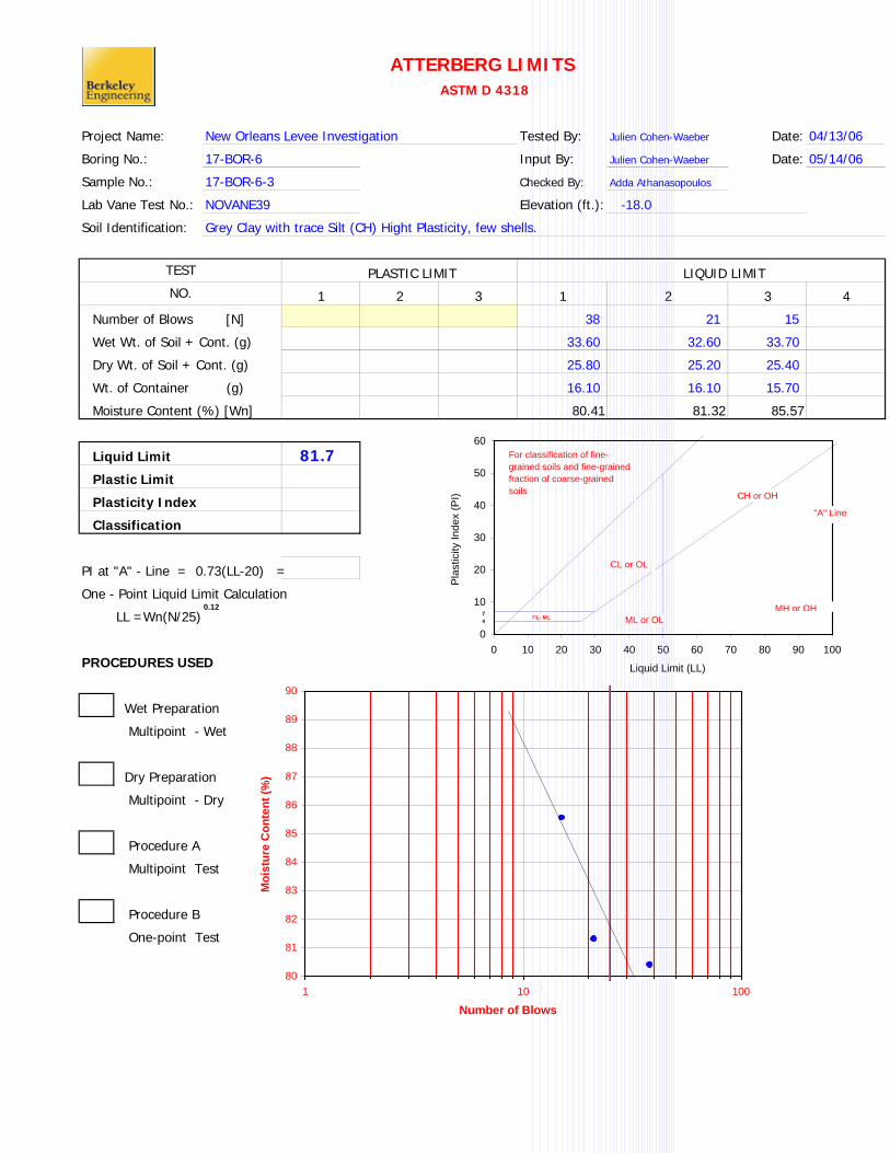
b) Atterberg Limits, ASTM D 4318
c) Permeability Test (Falling Head Method)
d) Direct Shear Test
e) Laboratory Vane Shear Test
Results of these tests are presented in this Appendix.
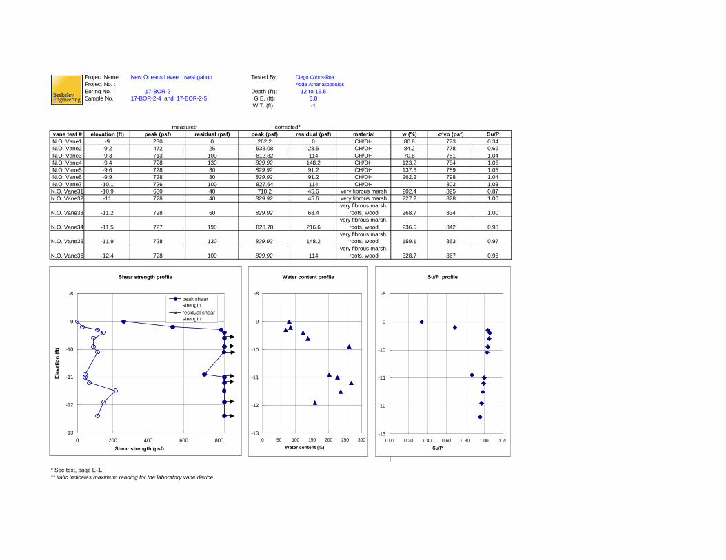
In addition, in-situ field vane shear tests (FVST; ASTM D2573) were performed at selected locations to evaluate peak and residual undrained soil shear strengths. These results are also presented in this Appendix.
Laboratory vane shear tests were performed to assess the undrained peak and residual shear strengths of cohesive materials serving as foundations for some of the levee embankments in New Orleans. A special set of procedures were developed for the sampling and laboratory vane shear testing of the sensitive organic clayey silt layer found at the 17th Street Canal breach site. This sensitive layer was very thin (typically 3/4” to 4”), it exhibited very low undrained shear strength and high sensitivity, and it was hidden under a layer of leaves and thin roots (and often intermixed, at least in part, with this obstructing overlying layer of organic detritus.)
Filed samples were “targeted by performing borings and CPT, as necessary, to precisely determine the depth of this critical layer at any given location. An additional boring was then performed adjacent to the previous boring(s) and/or CPT, and this “targeted sampling” borehole was drilled to within approximately 6-inches of the top of the targeted layer. A three-foot long, specially modified Shelby tube was then used to “oversample” the targeted layer; this oversampling captured approximately 2 to 2.5 feet of more competent material from below the highly sensitive layer, effectively “plugging” the base of the sampler so that the overall sample could be recovered. The 3-inch diameter Shelby tubes were modified by eliminating the “overcut” at the cutting lip, so that lateral expansion of the sample as it entered the tube would be eliminated.
Once the samples had been carefully transported to the laboratory, in order to reach the desired depth the soil was carefully hand-excavated from the end of the tube in 2-inch stages using a spoon and sharp blade. After each 2-inch layer had been slowly excavated, the tube was then cut with a rotary hand pipecutter (with stiffeners to reduce oval-disturbance. The process was repeated until the characteristic layer of organic and wind blown detritus was encountered, at which point the detritus was carefully hand-picked from the tube as hand excavation
E-1

New Orleans Systems Independent Levee Hurricane Katrina Investigation Team July 31, 2006
proceeded. The leaves and thin roots were carefully removed to expose the top of the targeted layer, so that the vane could be inserted.
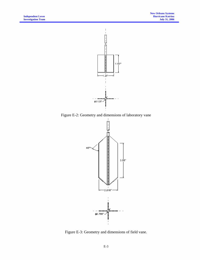
Since this layer was very thin, to avoid pushing the vane through the layer, once the layer was encountered in the Shelby Tube the vane was only inserted so that the metal blades were completely inside the soil, but not under it. That meant that the shear strength at the top of the rotating vane was not measured, and so a correction to the conventional (e.g.: ASTM) “vane factor” was required. For the vane geometry used (see Figure E.2) the required vane correction factor was found to be 0.84 times the conventional vane factor if the vane had been adequately embedded as to register full “top of vane” shear resistance. The vane shear test was performed at a rotational rate of 2 degrees/sec; a rate selected to represent relative rate of shear displacement behavior of interest with regard to the field cases being investigated.
As part of the field investigation, Field Vane Shear Tests were also performed at the 17th Street Canal breach site and at the London Avenue Canal distressed section. The results are presented in terms of peak and residual undrained shear strength. The dimensions of the vane used for these FVST tests are shown in Figure E-3. Rates of vane rotation were 1º per minute until the peak shear strength had been well-exceeded. The vane was then rotated five times, and then the residual strength measurement was again made at a rotational rate of 1º per minute.
Figure E-1: Laboratory vane shear testing of the thin layer of sensitive organic silty clay
E-2
New Orleans Systems Independent Levee Hurricane Katrina Investigation Team July 31, 2006
Figure E-2: Geometry and dimensions of laboratory vane
Figure E-3: Geometry and dimensions of field vane.
E-3

Project Name: Tested By: Julien Cohen-Waeber Date: 04/07/06Project No. : Input By: Julien Cohen-Waeber Date: 04/07/06Boring No.: Checked By: Diego Cobos-RoaSample No.: Depth (ft.)Soil Identification:
% Sand: 94.5 % Silt: NA % Clay: trace USCS: SP
New Orleans Levee Investigation
Particle-Size AnalysisASTM D 422
LAC-BOR-1LAC-BOR-1-2 9.5Poorly Graded Sand (SP), Grey, with trace clay
Grain Size Distribution
No.
200
No.
100
No.
40
No.
20
No.
10
No.
4
3/8
in.
3/4
in.
1.5
in.
3 in
.
CL
ML
0
10
20
30
40
50
60
70
80
90
100
0.001 0.01 0.1 1 10 100
Grain Diameter (mm)
Perc
ent F
iner

Project Name: Tested By: Julien Cohen-Waeber Date: 04/07/06Project No. : Input By: Julien Cohen-Waeber Date: 04/07/06Boring No.: Checked By: Diego Cobos-RoaSample No.: Depth (ft.)Soil Identification:
% Sand: 95.1 % Silt: NA % Clay: trace USCS: (SP) Poorly Graded Sand
LAC-BOR-1LAC-BOR-1-2 10.0Poorly Graded Sand (SP) Grey, with trace Clay
New Orleans Levee Investigation
Particle-Size AnalysisASTM D 422
Grain Size Distribution
No.
200
No.
100
No.
40
No.
20
No.
10
No.
4
3/8
in.
3/4
in.
1.5
in.
3 in
.
CL
ML
0
10
20
30
40
50
60
70
80
90
100
0.001 0.01 0.1 1 10 100
Grain Diameter (mm)
Perc
ent F
iner

Project Name: Tested By: Julien Cohen-Waeber Date: 04/13/06
Boring No.: 17-BOR-6 Input By: Julien Cohen-Waeber Date: 05/14/06
Sample No.: Checked By: Adda Athanasopoulos
Lab Vane Test No.: Elevation (ft.):
Soil Identification:
1 2 3 1 2 3 4
42 27 15
37.30 36.80 35.00
31.40 30.70 29.20
15.90 16.20 16.10
38.06 42.07 44.27
41.6
PI at "A" - Line = 0.73(LL-20) =
One - Point Liquid Limit Calculation
LL =Wn(N/25)
PROCEDURES USED
Wet Preparation
Multipoint - Wet
Dry Preparation
Multipoint - Dry
Procedure A
Multipoint Test
Procedure B
One-point Test
Grey Silty Clay (CL) trace fine sand, with few shells.
TEST
NO.
ATTERBERG LIMITS ASTM D 4318
New Orleans Levee Investigation
17-BOR-6-2
NOVANE24 -15.3
Number of Blows [N]
Wet Wt. of Soil + Cont. (g)
LIQUID LIMIT PLASTIC LIMIT
Dry Wt. of Soil + Cont. (g)
Wt. of Container (g)
Moisture Content (%) [Wn]
Liquid Limit
Plastic Limit
Plasticity Index
Classification
0
10
20
30
40
50
60
0 10 20 30 40 50 60 70 80 90 100
Liquid Limit (LL)
Pla
stic
ity In
dex
(PI)
0.12
CL or OL
ML or OLMH or OH
For classification of fine-grained soils and fine-grained fraction of coarse-grained soils
"A" Line
74
CH or OH
CL- ML
35
36
37
38
39
40
41
42
43
44
45
1 10 100
Number of Blows
Moi
stur
e C
onte
nt (%
)

Project Name: Tested By: Julien Cohen-Waeber Date: 04/13/06
Boring No.: Input By: Julien Cohen-Waeber Date: 05/14/06
Sample No.: Checked By: Adda Athanasopoulos
Lab Vane Test No.: Elevation (ft.):
Soil Identification:
1 2 3 1 2 3 4
19 23 41 12
40.00 32.20 36.00 35.60
33.50 27.80 30.90 30.00
16.10 15.60 15.20 16.00
37.36 36.07 32.48 40.00
35.5
PI at "A" - Line = 0.73(LL-20) =
One - Point Liquid Limit Calculation
LL =Wn(N/25)
PROCEDURES USED
Wet Preparation
Multipoint - Wet
Dry Preparation
Multipoint - Dry
Procedure A
Multipoint Test
Procedure B
One-point Test
Grey Sandy Clay (CL) very Sandy
TEST
NO.
ATTERBERG LIMITS ASTM D 4318
New Orleans Levee Investigation
LAC-BOR-2
LAC-BOR-2-3
NOVANE30 -13.0
Number of Blows [N]
Wet Wt. of Soil + Cont. (g)
LIQUID LIMIT PLASTIC LIMIT
Dry Wt. of Soil + Cont. (g)
Wt. of Container (g)
Moisture Content (%) [Wn]
Liquid Limit
Plastic Limit
Plasticity Index
Classification
0
10
20
30
40
50
60
0 10 20 30 40 50 60 70 80 90 100
Liquid Limit (LL)
Pla
stic
ity In
dex
(PI)
0.12
CL or OL
ML or OLMH or OH
For classification of fine-grained soils and fine-grained fraction of coarse-grained soils
"A" Line
74
CH or OH
CL- ML
30
31
32
33
34
35
36
37
38
39
40
1 10 100
Number of Blows
Moi
stur
e C
onte
nt (%
)
Project Name: Tested By: Julien Cohen-Waeber Date: 04/13/06
Boring No.: 17-BOR-6 Input By: Julien Cohen-Waeber Date: 05/14/06
Sample No.: Checked By: Adda Athanasopoulos
Lab Vane Test No.: Elevation (ft.):
Soil Identification:
1 2 3 1 2 3 4
38 21 15
33.60 32.60 33.70
25.80 25.20 25.40
16.10 16.10 15.70
80.41 81.32 85.57
81.7
PI at "A" - Line = 0.73(LL-20) =
One - Point Liquid Limit Calculation
LL =Wn(N/25)
PROCEDURES USED
Wet Preparation
Multipoint - Wet
Dry Preparation
Multipoint - Dry
Procedure A
Multipoint Test
Procedure B
One-point Test
Grey Clay with trace Silt (CH) Hight Plasticity, few shells.
TEST
NO.
ATTERBERG LIMITS ASTM D 4318
New Orleans Levee Investigation
17-BOR-6-3
NOVANE39 -18.0
Number of Blows [N]
Wet Wt. of Soil + Cont. (g)
LIQUID LIMIT PLASTIC LIMIT
Dry Wt. of Soil + Cont. (g)
Wt. of Container (g)
Moisture Content (%) [Wn]
Liquid Limit
Plastic Limit
Plasticity Index
Classification
0
10
20
30
40
50
60
0 10 20 30 40 50 60 70 80 90 100
Liquid Limit (LL)
Pla
stic
ity In
dex
(PI)
0.12
CL or OL
ML or OLMH or OH
For classification of fine-grained soils and fine-grained fraction of coarse-grained soils
"A" Line
74
CH or OH
CL- ML
80
81
82
83
84
85
86
87
88
89
90
1 10 100
Number of Blows
Moi
stur
e C
onte
nt (%
)

Project Name: Tested By: Julien Cohen-Waeber Date: 04/13/06
Boring No.: 17-BOR-6 Input By: Julien Cohen-Waeber Date: 05/14/06
Sample No.: Checked By: Adda Athanasopoulos
Lab Vane Test No.: Elevation (ft.):
Soil Identification:
1 2 3 1 2 3 4
39 27 14
32.30 32.70 31.80
25.50 25.50 24.80
15.90 15.30 15.60
70.83 70.59 76.09
72.5
PI at "A" - Line = 0.73(LL-20) =
One - Point Liquid Limit Calculation
LL =Wn(N/25)
PROCEDURES USED
Wet Preparation
Multipoint - Wet
Dry Preparation
Multipoint - Dry
Procedure A
Multipoint Test
Procedure B
One-point Test
Dry Wt. of Soil + Cont. (g)
Wt. of Container (g)
Moisture Content (%) [Wn]
Liquid Limit
Plastic Limit
Plasticity Index
Classification
Number of Blows [N]
Wet Wt. of Soil + Cont. (g)
LIQUID LIMIT PLASTIC LIMIT
Grey Clay (CH) High Plasticity.
TEST
NO.
ATTERBERG LIMITS ASTM D 4318
New Orleans Levee Investigation
17-BOR-6-3
NOVANE40 -18.3
0
10
20
30
40
50
60
0 10 20 30 40 50 60 70 80 90 100
Liquid Limit (LL)
Pla
stic
ity In
dex
(PI)
0.12
CL or OL
ML or OLMH or OH
For classification of fine-grained soils and fine-grained fraction of coarse-grained soils
"A" Line
74
CH or OH
CL- ML
70
71
72
73
74
75
76
77
78
79
80
1 10 100
Number of Blows
Moi
stur
e C
onte
nt (%
)

Project Name: Tested By: Julien Cohen-Waeber Date: 04/15/06
Boring No.: 17-BOR-6 Input By: Julien Cohen-Waeber Date: 05/14/06
Sample No.: Checked By: Adda Athanasopoulos
Lab Vane Test No.: Elevation (ft.):
Soil Identification:
1 2 3 1 2 3 4
48 22 15
34.30 32.60 34.30
28.20 26.50 27.70
16.10 15.60 16.00
50.41 55.96 56.41
54.2
PI at "A" - Line = 0.73(LL-20) =
One - Point Liquid Limit Calculation
LL =Wn(N/25)
PROCEDURES USED
Wet Preparation
Multipoint - Wet
Dry Preparation
Multipoint - Dry
Procedure A
Multipoint Test
Procedure B
One-point Test
Grey Silty Clay (CL) plastic.
TEST
NO.
ATTERBERG LIMITS ASTM D 4318
New Orleans Levee Investigation
17-BOR-6-3
NOVANE41 -18.5
Number of Blows [N]
Wet Wt. of Soil + Cont. (g)
LIQUID LIMIT PLASTIC LIMIT
Dry Wt. of Soil + Cont. (g)
Wt. of Container (g)
Moisture Content (%) [Wn]
Liquid Limit
Plastic Limit
Plasticity Index
Classification
0
10
20
30
40
50
60
0 10 20 30 40 50 60 70 80 90 100
Liquid Limit (LL)
Plas
ticity
Inde
x (P
I)
0.12
CL or OL
ML or OLMH or OH
For classification of fine-grained soils and fine-grained fraction of coarse-grained soils
"A" Line
74
CH or OH
CL- ML
50
51
52
53
54
55
56
57
58
59
60
1 10 100
Number of Blows
Moi
stur
e C
onte
nt (%
)

Project Name: Tested By: Julien Cohen-Waeber Date: 04/15/06
Boring No.: 17-BOR-6 Input By: Julien Cohen-Waeber Date: 05/14/06
Sample No.: Checked By: Adda Athanasopoulos
Lab Vane Test No.: Elevation (ft.):
Soil Identification:
1 2 3 1 2 3 4
44 31 17
33.10 32.40 31.00
26.00 25.70 24.40
15.60 15.90 15.70
68.27 68.37 75.86
72.0
PI at "A" - Line = 0.73(LL-20) =
One - Point Liquid Limit Calculation
LL =Wn(N/25)
PROCEDURES USED
Wet Preparation
Multipoint - Wet
Dry Preparation
Multipoint - Dry
Procedure A
Multipoint Test
Procedure B
One-point Test
Dry Wt. of Soil + Cont. (g)
Wt. of Container (g)
Moisture Content (%) [Wn]
Liquid Limit
Plastic Limit
Plasticity Index
Classification
Number of Blows [N]
Wet Wt. of Soil + Cont. (g)
LIQUID LIMIT PLASTIC LIMIT
Grey Silty Clay (CL) very plastic
TEST
NO.
ATTERBERG LIMITS ASTM D 4318
New Orleans Levee Investigation
17-BOR-6-3
NOVANE42 -18.9
0
10
20
30
40
50
60
0 10 20 30 40 50 60 70 80 90 100
Liquid Limit (LL)
Pla
stic
ity In
dex
(PI)
0.12
CL or OL
ML or OLMH or OH
For classification of fine-grained soils and fine-grained fraction of coarse-grained soils
"A" Line
74
CH or OH
CL- ML
606162636465666768697071727374757677787980
1 10 100
Number of Blows
Moi
stur
e C
onte
nt (%
)

Project Name: Tested By: Julien Cohen-Waeber Date: 04/15/06
Boring No.: LAC-BOR-1A Input By: Julien Cohen-Waeber Date: 05/14/06
Sample No.: Checked By: Adda Athanasopoulos
Lab Vane Test No.: Elevation (ft.)
Soil Identification:
1 2 3 1 2 3 4
36 32 23 15
26.70 29.00 26.10 30.10
18.90 20.10 19.00 20.30
15.40 16.00 15.90 16.00
222.86 217.07 229.03 227.91
222.5
PI at "A" - Line = 0.73(LL-20) 147.825
One - Point Liquid Limit Calculation
LL =Wn(N/25)
PROCEDURES USED
Wet Preparation
Multipoint - Wet
Dry Preparation
Multipoint - Dry
Procedure A
Multipoint Test
Procedure B
One-point Test
Dry Wt. of Soil + Cont. (g)
Wt. of Container (g)
Moisture Content (%) [Wn]
Liquid Limit
Plastic Limit
Plasticity Index
Classification
Number of Blows [N]
Wet Wt. of Soil + Cont. (g)
LIQUID LIMIT PLASTIC LIMIT
Black to Dark Grey Silty Clay (CL), with organics
TEST
NO.
ATTERBERG LIMITS ASTM D 4318
New Orleans Levee Investigation
LAC-BOR-1A-1
NOVANE49 -10.7
0
10
20
30
40
50
60
0 10 20 30 40 50 60 70 80 90 100
Liquid Limit (LL)
Pla
stic
ity In
dex
(PI)
0.12
CL or OL
ML or OLMH or OH
For classification of fine-grained soils and fine-grained fraction of coarse-grained soils
"A" Line
74
CH or OH
CL- ML
210211212213214215216217218219220221222223224225226227228229230
1 10 100
Number of Blows
Moi
stur
e C
onte
nt (%
)

Project Name: Tested By: Julien Cohen-Waeber Date: 04/13/06
Boring No.: LAC-BOR-1A Input By: Julien Cohen-Waeber Date: 05/14/06
Sample No.: Checked By: Adda Athanasopoulos
Lab Vane Test No.: Elevation (ft.)
Soil Identification:
1 2 3 1 2 3 4
27 22 15
33.80 36.50 38.60
28.10 30.40 31.40
15.60 15.90 16.10
45.60 42.07 47.06
43.3
PI at "A" - Line = 0.73(LL-20) =
One - Point Liquid Limit Calculation
LL =Wn(N/25)
PROCEDURES USED
Wet Preparation
Multipoint - Wet
Dry Preparation
Multipoint - Dry
Procedure A
Multipoint Test
Procedure B
One-point Test
Grey to Dark Grey, Sandy Clay (CL) Trace Organics
TEST
NO.
ATTERBERG LIMITS ASTM D 4318
New Orleans Levee Investigation
LAC-BOR-1A-1
NOVANE52 -11.2
Number of Blows [N]
Wet Wt. of Soil + Cont. (g)
LIQUID LIMIT PLASTIC LIMIT
Dry Wt. of Soil + Cont. (g)
Wt. of Container (g)
Moisture Content (%) [Wn]
Liquid Limit
Plastic Limit
Plasticity Index
Classification
0.12
CL or OL
ML or OLMH or OH
For classification of fine-grained soils and fine-grained fraction of coarse-grained soils
"A" Line
74
CH or OH
CL- ML
0
10
20
30
40
50
60
0 10 20 30 40 50 60 70 80 90 100
Liquid Limit (LL)
Pla
stic
ity In
dex
(PI)
40
41
42
43
44
45
46
47
48
49
50
1 10 100
Number of Blows
Moi
stur
e C
onte
nt (%
)

Project Name: Tested By: Julien Cohen-Waeber Date: 04/30/06Boring No.: LACW-BOR-1 Input By: Julien Cohen-Waeber Date: 05/14/06Sample No.: Checked By: Adda Athanasopoulos
Lab Test No.: Elevation (ft.):Soil Identification:
SHRP_Equipment_CorporationAutomatic_Testing_System_v.3.11
1OVERBURDEN: 4.5 divs
248.1231 psf
SHEAR RATE: 4.1E-05 in/sTOTAL DISP: 0.3065 in
MAX SHEAR STRESS: 0.804 psi115.776 psf
Su,DS 57.888 psfapprox Su,TX 75.3 psf
Displacementsinitial (in) final (in)0.5635 0.87
Total Time (sec)7476
1 -14.8Grey Silty Sandy Clay (CL)
DIRECT SHEAR TEST
New Orleans Levee Investigation
LACW-BOR-1-2
DIRECT SHEAR TEST 1LACW-BOR-1-2
0
0.5
1
1.5
2
2.5
3
3.5
4
4.5
0 0.1 0.2 0.3 0.4 0.5 0.6
Shear Distance (in)
Shea
r Str
ess
(psi
)

Project Name: Tested By: Julien Cohen-Waeber Date: 04/30/06Boring No.: LACW-BOR-1 Input By: Julien Cohen-Waeber Date: 05/14/06Sample No.: Checked By: Adda Athanasopoulos
Lab Test No.: Elevation (ft.):Soil Identification:
SHRP_Equipment_CorporationAutomatic_Testing_System_v.3.11
1 2OVERBURDEN: 0.9 18 divs
856.6892 1965.489 psf
SHEAR RATE: 3.17E-05 in/sTOTAL DISP: 0.31 in
MAX SHEAR STRESS: 2.76 psi397.44 psf
Φ 25 deg
Displacementsinitial (in) final (in)
0.476 0.786
Total Time (sec)9780
Grey Silty Sand (SM)2 -15.4
DIRECT SHEAR TEST
New Orleans Levee Investigation
LACW-BOR-1-2
DIRECT SHEAR TEST 2LACW-BOR-1-2
0
0.5
1
1.5
2
2.5
3
3.5
4
4.5
0 0.1 0.2 0.3 0.4 0.5 0.6
Shear Distance (in)
Shea
r Str
ess
(psi
)
vertical load 1
vertical load 2

Project Name: Tested By: Julien Cohen-Waeber Date: 05/01/06Boring No.: LACW-BOR-1 Input By: Julien Cohen-Waeber Date: 05/14/06Sample No.: Checked By: Adda Athanasopoulos
Lab Test No.: Elevation (ft.):Soil Identification:
SHRP_Equipment_CorporationAutomatic_Testing_System_v.3.11
1OVERBURDEN: 0.9 divs
856.6892 psf
SHEAR RATE: 4.88E-05 in/sTOTAL DISP: 0.527 in
MAX SHEAR STRESS: 3.631 psi522.864 psf
Φ 31.3 deg
Displacementsinitial (in) final (in)
0.33 0.857
Total Time (sec)10800
3 -15.8Grey Sand with Clay and Silt (SP)
DIRECT SHEAR TEST
New Orleans Levee Investigation
LACW-BOR-1-2
DIRECT SHEAR TEST 3LACW-BOR-1-2
0
0.5
1
1.5
2
2.5
3
3.5
4
4.5
0 0.1 0.2 0.3 0.4 0.5 0.6
Shear Distance (in)
Shea
r Str
ess
(psi
)

Project Name: Tested By: Julien Cohen-Waeber Date: 05/01/06Boring No.: LAC-BOR-4 Input By: Julien Cohen-Waeber Date: 05/14/06Sample No.: Checked By: Adda Athanasopoulos
Lab Test No.: Elevation (ft.):Soil Identification:
SHRP_Equipment_CorporationAutomatic_Testing_System_v.3.11
1OVERBURDEN: 0.9 divs
856.6892 psf
SHEAR RATE: 0.000106 in/sTOTAL DISP: 0.484 in
MAX SHEAR STRESS: 1.9992 psi287.8848 psf
Su,DS 143.9424 psfapprox Su,TX 187.1 psf
Displacementsinitial (in) final (in)
0.404 0.888
Total Time (sec)4551
4 -19.9Grey Silty Clay (CL)
DIRECT SHEAR TEST
New Orleans Levee Investigation
LAC-BOR-4-5
DIRECT SHEAR TEST 4LAC-BOR-4-5
0
0.5
1
1.5
2
2.5
3
3.5
4
4.5
0 0.1 0.2 0.3 0.4 0.5 0.6
Shear Distance (in)
Shea
r Str
ess
(psi
)

Project Name: Tested By: Julien Cohen-Waeber Date: 05/01/06Boring No.: LAC-BOR-4 Input By: Julien Cohen-Waeber Date: 05/14/06Sample No.: Checked By: Adda Athanasopoulos
Lab Test No.: Elevation (ft.):Soil Identification:
SHRP_Equipment_CorporationAutomatic_Testing_System_v.3.11
1OVERBURDEN: 0.9 divs
856.6892 psf
SHEAR RATE: 6.05E-05 in/sTOTAL DISP: 0.168 in
MAX SHEAR STRESS: 2.2512 psi324.1728 psf
Su,DS 162.0864 psfapprox Su,TX 210.7 psf
Displacementsinitial (in) final (in)
0.29 0.458
Total Time (sec)2775
5 -20.5Grey Silty Clay with trace Sand (CL)
DIRECT SHEAR TEST
New Orleans Levee Investigation
LAC-BOR-4-5
DIRECT SHEAR TEST 5LAC-BOR-4-5
0
0.5
1
1.5
2
2.5
3
3.5
4
4.5
0 0.1 0.2 0.3 0.4 0.5 0.6
Shear Distance (in)
Shea
r Str
ess
(psi
)

Project Name: Tested By: Julien Cohen-Waeber Date: 05/01/06Boring No.: LAC-BOR-2 Input By: Julien Cohen-Waeber Date: 05/14/06Sample No.: Checked By: Adda Athanasopoulos
Lab Test No.: Elevation (ft.):Soil Identification:
SHRP_Equipment_CorporationAutomatic_Testing_System_v.3.11
1OVERBURDEN: 0.9 divs
856.6892 psf
SHEAR RATE: 5.22E-05 in/sTOTAL DISP: 0.4975 in
MAX SHEAR STRESS: 4.1868 psi602.8992 psf
Su,DS 301.4496 psfapprox Su,TX 391.9 psf
Displacementsinitial (in) final (in)0.4955 0.993
Total Time (sec)9522
6 -15.4Grey Sandy Clay / Clayey Sand (SC/CL),
DIRECT SHEAR TEST
New Orleans Levee Investigation
LAC-BOR-2-3
DIRECT SHEAR TEST 6LAC-BOR-2-3
0
0.5
1
1.5
2
2.5
3
3.5
4
4.5
0 0.1 0.2 0.3 0.4 0.5 0.6
Shear Distance (in)
Shea
r Str
ess
(psi
)

Project Name: Tested By: Julien Cohen-Waeber Date: 05/06/06Boring No.: LAC-BOR-2 Input By: Julien Cohen-Waeber Date: 05/14/06Sample No.: Checked By: Adda Athanasopoulos
Lab Test No.: Elevation (ft.):Soil Identification:
Sample Dimentions:1 2
Beaker wt: 285.28 g Soil Height: 14.92 15.08 cmwt Beaker + dry Soil: 534.99 g
wt Soil: 249.71 g avg height: 15 cmBeaker Diam: 3.7846 cmBeaker Area: 11.249 cm2
Sample Density: 1.480 g/cm3
Water Cylinder:1 2
Volume: 775 1570 ccDrop in water Level: 30 60 cm2
Cylinder Area: 25.833 26.17 cm2
Avg Area: 26 cm2
TEST DATA AND RESULTS:
HeightTest No.
ho h1 h2 ho to h1 h0 to h2 k(0-1) k(0-2)
cm cm cm s s cm/s cm/s1 160 130 100 2625 6105 2.74E-03 2.67E-032 160 130 100 2435 5810 2.96E-03 2.80E-03
1 -15.1Grey Silty Sand (SM) Fine Sand.
PERMEABILITY TEST (FALLING HEAD METHOD)
New Orleans Levee Investigation
LAC-BOR-2-3
HYDRAULICCONDUCTIVITY
Time

Project Name: Tested By: Julien Cohen-Waeber Date: 05/06/06Boring No.: LAC-BOR-2 Input By: Julien Cohen-Waeber Date: 05/14/06Sample No.: Checked By: Adda Athanasopoulos
Lab Test No.: Elevation (ft.):Soil Identification:
Sample Dimentions:1 2
Beaker wt: 285.28 g Soil Height: 13.652 13.653 cmwt Beaker + dry Soil: 534.99 g
wt Soil: 249.71 g avg height: 13.6525 cmBeaker Diam: 3.7846 cmBeaker Area: 11.249 cm2
Sample Density: 1.626 g/cm3
Water Cylinder:1 2
Volume: 775 1570 ccDrop in water Level: 30 60 cm2
Cylinder Area: 25.833 26.17 cm2
Avg Area: 26 cm2
TEST DATA AND RESULTS:
HeightTest No.
ho h1 h2 ho to h1 h0 to h2 k(0-1) k(0-2)
cm cm cm s s cm/s cm/s1 160 130 100 7905 19515 8.29E-04 7.60E-04
HYDRAULICCONDUCTIVITY
Time
PERMEABILITY TEST (FALLING HEAD METHOD)
New Orleans Levee Investigation
LAC-BOR-2-32 -15.9Grey Silty Sand (SM) Fine Sand.
Project Name: New Orleans Levee Investigation Tested By: Diego Cobos-RoaProject No. : Adda AthanasopoulosBoring No.: 17-BOR-2 Depth (ft): 12 to 16.5Sample No.: 17-BOR-2-4 and 17-BOR-2-5 G.E. (ft): 3.8
W.T. (ft): -1
vane test # elevation (ft) peak (psf) residual (psf) peak (psf) residual (psf) material w (%) σ'vo (psf) Su/PN.O. Vane1 -9 230 0 262.2 0 CH/OH 80.8 773 0.34N.O. Vane2 -9.2 472 25 538.08 28.5 CH/OH 84.2 778 0.69N.O. Vane3 -9.3 713 100 812.82 114 CH/OH 70.8 781 1.04N.O. Vane4 -9.4 728 130 829.92 148.2 CH/OH 123.2 784 1.06N.O. Vane5 -9.6 728 80 829.92 91.2 CH/OH 137.6 789 1.05N.O. Vane6 -9.9 728 80 829.92 91.2 CH/OH 262.2 798 1.04N.O. Vane7 -10.1 726 100 827.64 114 CH/OH 803 1.03N.O. Vane31 -10.9 630 40 718.2 45.6 very fibrous marsh 202.4 825 0.87N.O. Vane32 -11 728 40 829.92 45.6 very fibrous marsh 227.2 828 1.00
N.O. Vane33 -11.2 728 60 829.92 68.4very fibrous marsh,
roots, wood 268.7 834 1.00
N.O. Vane34 -11.5 727 190 828.78 216.6very fibrous marsh,
roots, wood 236.5 842 0.98
N.O. Vane35 -11.9 728 130 829.92 148.2very fibrous marsh,
roots, wood 159.1 853 0.97
N.O. Vane36 -12.4 728 100 829.92 114very fibrous marsh,
roots, wood 328.7 867 0.96
* See text, page E-1.** italic indicates maximum reading for the laboratory vane device
measured corrected*
Water content profile
-13
-12
-11
-10
-9
-8
0 50 100 150 200 250 300
Water content (%)
Su/P profile
-13
-12
-11
-10
-9
-8
0.00 0.20 0.40 0.60 0.80 1.00 1.20
Su/P
Shear strength profile
-13
-12
-11
-10
-9
-8
0 200 400 600 800Shear strength (psf)
Elev
atio
n (ft
)
peak shearstrengthresidual shearstrength

Project Name: New Orleans Levee Investigation Tested By: Diego Cobos-Roa
Project No. : Adda Athanasopoulos
Boring No.: 17-BOR-3 Depth (ft): 6 to 8Sample No.: 17-BOR-3-2 G.E. (ft): -6.6
W.T. (ft): -8
vane test # elevation (ft) peak (psf) residual (psf) peak (psf) residual (psf) soil description w (%) σ'vo (psf) Su/PN.O. Vane8 -13.02 120 20 136.8 22.8 marsh 246 271.6 0.50N.O. Vane9 -13.12 34 0 38.76 0 marsh 277.6 274.3 0.14N.O. Vane10 -13.25 55 15 62.7 17.1 marsh 253.9 277.9 0.23N.O. Vane11 -13.35 153 30 174.42 34.2 marsh 127.4 280.7 0.62N.O. Vane12 -13.53 196 65 223.44 74.1 marsh, (+CH) 201.7 285.6 0.78N.O. Vane13 -13.71 206 75 234.84 85.5 CH w/OH 248.6 290.6 0.81N.O. Vane14 -14 200 60 228 68.4 CH w/OH 253.5 298.6 0.76N.O. Vane15 -14.2 202 50 230.28 57 CH 56 304.1 0.76N.O. Vane16 -14.4 308 70 351.12 79.8 CH 46.6 309.6 1.13
* See text, page E-1.
corrected*measured
Shear strength profile
-16
-15
-14
-13
-12
0 100 200 300 400 500 600 700
Shear strength (psf)
Elev
atio
n (ft
)
peak shearstrength
residual shearstrength
Water content profile
-16
-15
-14
-13
-12
0 50 100 150 200 250 300
Water content (%)
Su/P profile
-16
-15
-14
-13
-12
0.0 0.2 0.4 0.6 0.8 1.0 1.2
Su/P

Project Name: New Orleans Levee Investigation Tested By: Diego Cobos-RoaProject No. : Adda AthanasopoulosBoring No.: 17-BOR-6 Depth (ft): 7.5 to 12Sample No.: 17-BOR-6-2 and 17-BOR-6-3 G.E. (ft): -6.6
W.T. (ft): -8
vane test # elevation (ft) peak (psf) residual (psf) peak (psf) residual (psf) soil description w (%) σ'vo (psf) Su/P
N.O. Vane22 -14.6 175 50 199.5 57grey CH, traces organic, shells 90.4 315.16 0.63
N.O. Vane23 -15 195 50 222.3 57grey CH, traces organic, shells 60.9 326.2 0.68
N.O. Vane24 -15.3 270 55 307.8 62.7grey CH (some silt),
less shells 40.8 334.48 0.92
N.O. Vane25 -17.1 163 45 185.82 51.3light grey CL/CH,
some silt 73.4 384.16 0.48N.O. Vane26 -17.5 307 115 349.98 131.1 grey CH 95.5 395.2 0.89N.O. Vane27 -17.8 370 135 421.8 153.9 grey CH 84.7 403.48 1.05N.O. Vane39 -18 370 150 421.8 171 grey CH 55.8 409 1.03N.O. Vane40 -18.3 321 100 365.94 114 grey CH 83.5 417.28 0.88N.O. Vane41 -18.5 390 100 444.6 114 grey CH 61.4 422.8 1.05N.O. Vane42 -18.9 317 116 361.38 132.24 grey CH 88.9 433.84 0.83
*See text, page E-1.
measured corrected*
Shear strength profile
-20
-19
-18
-17
-16
-15
-14
-13
0 200 400 600Shear strength (psf)
Elev
atio
n (ft
)
peak shearstrengthresidual shearstrength
Water content profile
-20
-19
-18
-17
-16
-15
-14
-13
0 50 100 150 200 250 300
Water content (%)
Su/P profile
-20
-19
-18
-17
-16
-15
-14
-13
0.0 0.2 0.4 0.6 0.8 1.0 1.2
Su/P

Project Name: New Orleans Levee Investigation Tested By: Diego Cobos-RoaProject No. : Adda AthanasopoulosBoring No.: LAC-BOR-2 Depth (ft): 6 to 10Sample No.: LAC-BOR-2-2 and LAC-BOR-2-3 G.E. (ft): -6.4
W.T. (ft): -8
vane test # elevation (ft) peak (psf) residual (psf) peak (psf) residual (psf) soil description water content (%) σ'vo (psf) Su/P
N.O. Vane17 -10.3 136.8 51.3 155.952 58.482gray-black CH, org.
matter, wood, org. odor 132.8 215.48 0.72
N.O. Vane18 -10.47 205.2 51.3 233.928 58.482gray-black CH, org.
matter, wood, org. odor 122 220.172 1.06
N.O. Vane19 -10.6 242.82 72.96 276.8148 83.1744gray-black CH, org.
matter, wood, org. odor 93.3 223.76 1.24
N.O. Vane20 -10.7 307.8 94.62 350.892 107.8668gray CH w/ traces black
org. matter 50.2 226.52 1.55N.O. Vane21 -10.93 332.88 85.5 379.4832 97.47 gray clayey silt 34.7 232.868 1.63
N.O. Vane28 -12.3 125.4 11.4 142.956 12.996gray CH w/ traces black
org. matter 63.5 270.68 0.53N.O. Vane29 -12.6 171 39.9 194.94 45.486 grey CH 44.2 278.96 0.70N.O. Vane30 -13 193.8 57 220.932 64.98 gray clayey silt 45.6 290 0.76
*See text, page E-1.
measured corrected*
Shear strength profile
-15
-14
-13
-12
-11
-10
-9
0 50 100 150 200 250 300 350 400Shear strength (psf)
Elev
atio
n (ft
)
peak shearstrength
residual shearstrength
Water content profile
-15
-14
-13
-12
-11
-10
-9
0 50 100 150 200 250 300
Water content (%)
Su/P profile
-15
-14
-13
-12
-11
-10
-9
0.0 0.4 0.8 1.2 1.6
Su/P

Project Name: New Orleans Levee Investigation Tested By: Diego Cobos-RoaProject No. : Adda AthanasopoulosBoring No.: LAC-BOR-1A Depth (ft): 2 to 4Sample No.: LAC-BOR-1A-1 G.E. (ft): -7.7
W.T. (ft): -9
vane test # depth (ft) peak (psf) residual (psf) peak (psf) residual (psf) soil description water content (%) σ'vo (psf) Su/P
NO VANE 43 -9.7 340 35 387.6 39.9matter, wood, org.
odor 132.8 142.82 2.71
NO VANE 44 -9.9 306 50 348.84 57
g y , gmatter, wood, org.
odor 122 148.34 2.35
NO VANE 45 -10.05 372 50 424.08 57
g y , gmatter, wood, org.
odor 93.3 152.48 2.78
NO VANE 46 -10.2 280 34 319.2 38.76gray CH w/ traces black org. matter 50.2 156.62 2.04
NO VANE 47 -10.4 243 52 277.02 59.28 gray clayey silt 34.7 162.14 1.71
NO VANE 48 -10.6 102 14 116.28 15.96gray CH w/ traces black org. matter 63.5 167.66 0.69
NO VANE 49 -10.7 334 50 380.76 57 grey CH 44.2 170.42 2.23NO VANE 50 -10.9 194 40 221.16 45.6 gray clayey silt 45.6 175.94 1.26NO VANE 51 -11.1 217 50 247.38 57 gray clayey silt 147.4 181.46 1.36NO VANE 52 -11.2 227 56 258.78 63.84 gray clayey silt 58.6 184.22 1.40NO VANE 53 -11.4 528 10 601.92 11.4 gray clayey silt 189.74 3.17
*See text, page E-1.
corrected
Shear strength profile
-13
-12.5
-12
-11.5
-11
-10.5
-10
-9.5
-9
0 200 400 600 800Shear strength (psf)
Elev
atio
n (ft
)
peak shearstrengthresidual shearstrength
Water content profile
-13
-12.5
-12
-11.5
-11
-10.5
-10
-9.5
-9
0 50 100 150 200 250 300
Water content (%)
Su/P profile
-13
-12.5
-12
-11.5
-11
-10.5
-10
-9.5
-9
0.0 0.5 1.0 1.5 2.0 2.5 3.0 3.5 4.0
Su/P

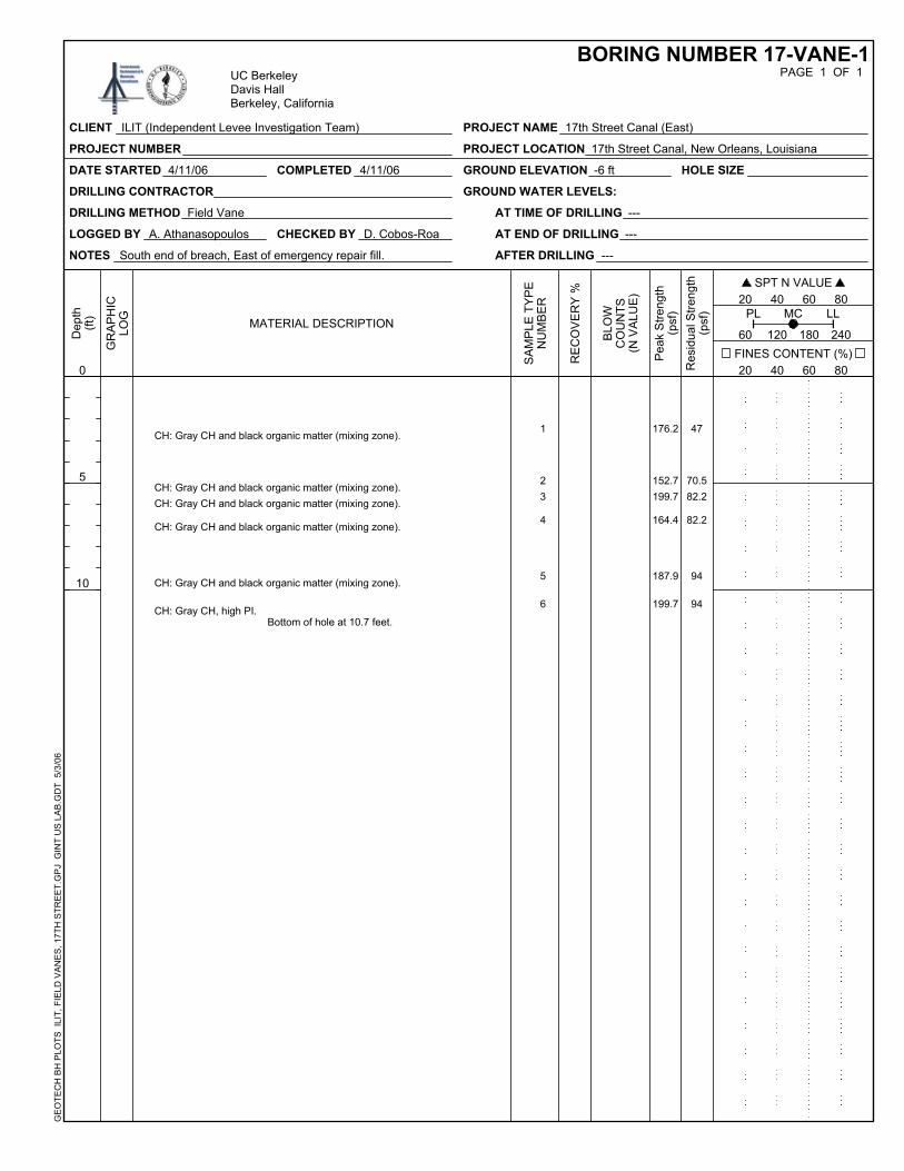
DATE STARTED 4/11/06 GROUND ELEVATION -6 ft
LOGGED BY A. Athanasopoulos
DRILLING METHOD Field Vane AT TIME OF DRILLING ---
AT END OF DRILLING ---
AFTER DRILLING ---
HOLE SIZE
DRILLING CONTRACTOR
Bottom of hole at 10.7 feet.
CHECKED BY D. Cobos-Roa
CH: Gray CH, high PI.
COMPLETED 4/11/06
GR
AP
HIC
LOG
SPT N VALUE 20 40 60 80
FINES CONTENT (%)
GROUND WATER LEVELS:
1
70.582.2
82.2
94
94
176.2
152.7199.7
164.4
NOTES South end of breach, East of emergency repair fill.
199.7
47
23
4
5
6
CH: Gray CH and black organic matter (mixing zone).
CH: Gray CH and black organic matter (mixing zone).CH: Gray CH and black organic matter (mixing zone).
CH: Gray CH and black organic matter (mixing zone).
CH: Gray CH and black organic matter (mixing zone). 187.9
BORING NUMBER 17-VANE-1UC BerkeleyDavis HallBerkeley, California
SA
MP
LE T
YP
EN
UM
BE
R
MATERIAL DESCRIPTION
PAGE 1 OF 1
Res
idua
l Stre
ngth
(psf
)
CLIENT ILIT (Independent Levee Investigation Team)
PROJECT NUMBER
PROJECT NAME 17th Street Canal (East)
PROJECT LOCATION 17th Street Canal, New Orleans, Louisiana
20 40 60 80
RE
CO
VE
RY
%
BLO
WC
OU
NTS
(N V
ALU
E)
60 120 180 240
Pea
k S
treng
th(p
sf)
GE
OTE
CH
BH
PLO
TS I
LIT,
FIE
LD V
AN
ES
, 17T
H S
TRE
ET.
GP
J G
INT
US
LA
B.G
DT
5/3
/06
PL LLMC
Dep
th(ft
)
0
5
10

DATE STARTED 3/12/06 GROUND ELEVATION -6.44 ft
LOGGED BY A. Athanasopoulos
DRILLING METHOD Field Vane AT TIME OF DRILLING ---
AT END OF DRILLING ---
AFTER DRILLING ---
HOLE SIZE
DRILLING CONTRACTOR
Bottom of hole at 8.4 feet.
CHECKED BY D. Cobos-Roa
CH: Soft, gray CH.
COMPLETED 3/12/06
GR
AP
HIC
LOG
SPT N VALUE 20 40 60 80
FINES CONTENT (%)
GROUND WATER LEVELS:
7
41.15.911.723.5
47.0
364.1
158.647.023.5
NOTES Center of breach, outside disturbed area (by school bus).
105.7
23.5
891011
12
Fill
MarshMarshCH: Gray CH and black organic matter (mixing zone).CH: Very soft, high PI, gray CH. 35.2
BORING NUMBER 17-VANE-2UC BerkeleyDavis HallBerkeley, California
SA
MP
LE T
YP
EN
UM
BE
R
MATERIAL DESCRIPTION
PAGE 1 OF 1
Res
idua
l Stre
ngth
(psf
)
CLIENT ILIT (Independent Levee Investigation Team)
PROJECT NUMBER
PROJECT NAME 17th Street Canal (East)
PROJECT LOCATION 17th Street Canal, New Orleans, Louisiana
20 40 60 80
RE
CO
VE
RY
%
BLO
WC
OU
NTS
(N V
ALU
E)
60 120 180 240
Pea
k S
treng
th(p
sf)
GE
OTE
CH
BH
PLO
TS I
LIT,
FIE
LD V
AN
ES
, 17T
H S
TRE
ET.
GP
J G
INT
US
LA
B.G
DT
5/3
/06
PL LLMC
Dep
th(ft
)
0
5

DATE STARTED 3/13/06 GROUND ELEVATION -1.78 ft
LOGGED BY A. Athanasopoulos
DRILLING METHOD Field Vane AT TIME OF DRILLING ---
AT END OF DRILLING ---
AFTER DRILLING ---
HOLE SIZE
DRILLING CONTRACTOR
Bottom of hole at 12.5 feet.
CHECKED BY D. Cobos-Roa
CH: Soft, gray CH.
COMPLETED 3/13/06
GR
AP
HIC
LOG
SPT N VALUE 20 40 60 80
FINES CONTENT (%)
GROUND WATER LEVELS:
13
82.2
23.5
11.7
35.2
52.9
411.1
328.9
164.4
105.7
NOTES North-East of displaced block.
140.9
23.5
14
15
16
17
18
Fill
Fill mixing with fibrous organic clay.
Marsh
CH: Gray CH and black organic matter (mixing zone).
CH: Very soft, high PI, gray CH. 117.5
BORING NUMBER 17-VANE-3UC BerkeleyDavis HallBerkeley, California
SA
MP
LE T
YP
EN
UM
BE
R
MATERIAL DESCRIPTION
PAGE 1 OF 1
Res
idua
l Stre
ngth
(psf
)
CLIENT ILIT (Independent Levee Investigation Team)
PROJECT NUMBER
PROJECT NAME 17th Street Canal (East)
PROJECT LOCATION 17th Street Canal, New Orleans, Louisiana
20 40 60 80
RE
CO
VE
RY
%
BLO
WC
OU
NTS
(N V
ALU
E)
60 120 180 240
Pea
k S
treng
th(p
sf)
GE
OTE
CH
BH
PLO
TS I
LIT,
FIE
LD V
AN
ES
, 17T
H S
TRE
ET.
GP
J G
INT
US
LA
B.G
DT
5/3
/06
PL LLMC
Dep
th(ft
)
0
5
10
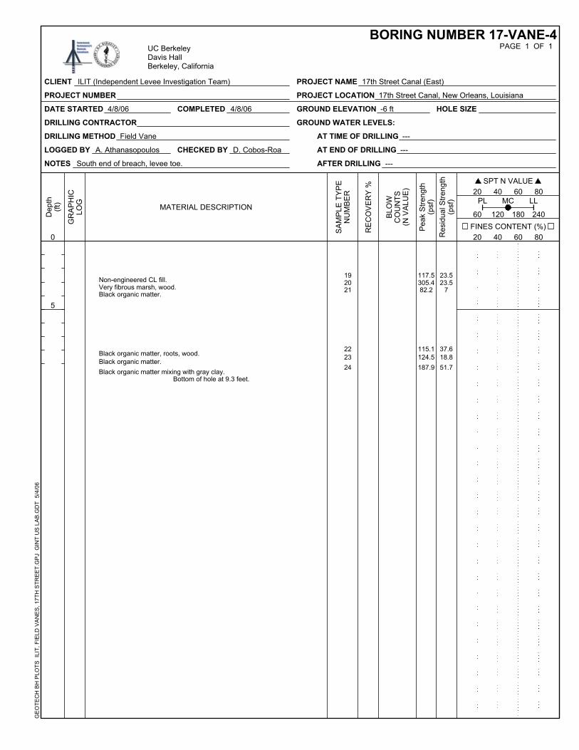
DATE STARTED 4/8/06 GROUND ELEVATION -6 ft
LOGGED BY A. Athanasopoulos
DRILLING METHOD Field Vane AT TIME OF DRILLING ---
AT END OF DRILLING ---
AFTER DRILLING ---
HOLE SIZE
DRILLING CONTRACTOR
Bottom of hole at 9.3 feet.
CHECKED BY D. Cobos-Roa
Black organic matter mixing with gray clay.
COMPLETED 4/8/06
GR
AP
HIC
LOG
SPT N VALUE 20 40 60 80
FINES CONTENT (%)
GROUND WATER LEVELS:
1923.5
7
37.618.851.7
117.5305.482.2
115.1
NOTES South end of breach, levee toe.
187.9
23.52021
222324
Non-engineered CL fill.Very fibrous marsh, wood.Black organic matter.
Black organic matter, roots, wood.Black organic matter. 124.5
BORING NUMBER 17-VANE-4UC BerkeleyDavis HallBerkeley, California
SA
MP
LE T
YP
EN
UM
BE
R
MATERIAL DESCRIPTION
PAGE 1 OF 1
Res
idua
l Stre
ngth
(psf
)
CLIENT ILIT (Independent Levee Investigation Team)
PROJECT NUMBER
PROJECT NAME 17th Street Canal (East)
PROJECT LOCATION 17th Street Canal, New Orleans, Louisiana
20 40 60 80
RE
CO
VE
RY
%
BLO
WC
OU
NTS
(N V
ALU
E)
60 120 180 240
Pea
k S
treng
th(p
sf)
GE
OTE
CH
BH
PLO
TS I
LIT,
FIE
LD V
AN
ES
, 17T
H S
TRE
ET.
GP
J G
INT
US
LA
B.G
DT
5/4
/06
PL LLMC
Dep
th(ft
)
0
5

DATE STARTED 4/8/06 GROUND ELEVATION -6 ft
LOGGED BY A. Athanasopoulos
DRILLING METHOD Field Vane AT TIME OF DRILLING ---
AT END OF DRILLING ---
AFTER DRILLING ---
HOLE SIZE
DRILLING CONTRACTOR
Bottom of hole at 8.4 feet.
CHECKED BY D. Cobos-Roa
Gray CH, traces organic.
COMPLETED 4/8/06
GR
AP
HIC
LOG
SPT N VALUE 20 40 60 80
FINES CONTENT (%)
GROUND WATER LEVELS:
25
44.635.247
11.7
72.8
152.7
176.2164.4129.2
NOTES South end of breach, levee toe.
164.4
23.5
262728
29
30
Organic matter.
CH/OHCH/OHCH/OH
Marsh, contact with gray CH. 52.9
BORING NUMBER 17-VANE-5UC BerkeleyDavis HallBerkeley, California
SA
MP
LE T
YP
EN
UM
BE
R
MATERIAL DESCRIPTION
PAGE 1 OF 1
Res
idua
l Stre
ngth
(psf
)
CLIENT ILIT (Independent Levee Investigation Team)
PROJECT NUMBER
PROJECT NAME 17th Street Canal (East)
PROJECT LOCATION 17th Street Canal, New Orleans, Louisiana
20 40 60 80
RE
CO
VE
RY
%
BLO
WC
OU
NTS
(N V
ALU
E)
60 120 180 240
Pea
k S
treng
th(p
sf)
GE
OTE
CH
BH
PLO
TS I
LIT,
FIE
LD V
AN
ES
, 17T
H S
TRE
ET.
GP
J G
INT
US
LA
B.G
DT
5/4
/06
PL LLMC
Dep
th(ft
)
0
5

DATE STARTED 4/9/06 GROUND ELEVATION -5 ft
LOGGED BY A. Athanasopoulos
DRILLING METHOD Field Vane AT TIME OF DRILLING ---
AT END OF DRILLING ---
AFTER DRILLING ---
HOLE SIZE
DRILLING CONTRACTOR
Bottom of hole at 9.6 feet.
CHECKED BY D. Cobos-Roa
Intermixing of black organic with gray clay.
COMPLETED 4/9/06
GR
AP
HIC
LOG
SPT N VALUE 20 40 60 80
FINES CONTENT (%)
GROUND WATER LEVELS:
3147
30.5
47
47
52.9
234.9187.9
150.3
211.4
NOTES North end of breach, levee toe, 6949 Bellaire St.
129.2
70.532
33
34
35
36
Organic matter.Organic matter, strong odor.Organic matter.
Organic matter.
Intermixing of black organic with gray clay. 129.2
BORING NUMBER 17-VANE-6UC BerkeleyDavis HallBerkeley, California
SA
MP
LE T
YP
EN
UM
BE
R
MATERIAL DESCRIPTION
PAGE 1 OF 1
Res
idua
l Stre
ngth
(psf
)
CLIENT ILIT (Independent Levee Investigation Team)
PROJECT NUMBER
PROJECT NAME 17th Street Canal (East)
PROJECT LOCATION 17th Street Canal, New Orleans, Louisiana
20 40 60 80
RE
CO
VE
RY
%
BLO
WC
OU
NTS
(N V
ALU
E)
60 120 180 240
Pea
k S
treng
th(p
sf)
GE
OTE
CH
BH
PLO
TS I
LIT,
FIE
LD V
AN
ES
, 17T
H S
TRE
ET.
GP
J G
INT
US
LA
B.G
DT
5/4
/06
PL LLMC
Dep
th(ft
)
0
5

DATE STARTED 4/11/06 GROUND ELEVATION 3.8 ft
LOGGED BY A. Athanasopoulos
DRILLING METHOD Field Vane AT TIME OF DRILLING ---
AT END OF DRILLING ---
AFTER DRILLING ---
HOLE SIZE
DRILLING CONTRACTOR
Bottom of hole at 15.2 feet.
CHECKED BY D. Cobos-Roa
Black organic matter.
COMPLETED 4/11/06
GR
AP
HIC
LOG
SPT N VALUE 20 40 60 80
FINES CONTENT (%)
GROUND WATER LEVELS:
37
49.3
49.3
65.8
4744.6
446.3
123.3
111.6
152.7
NOTES South end of breach, levee crest.
129.2
94
38
39
40
4142
Non-engineered CL fill.
Non-engineered CL fill.
Dark gray CH, traces organic.
Dark gray CH, traces organic, top of marsh.
Marsh, wood. 246.7
BORING NUMBER 17-VANE-7UC BerkeleyDavis HallBerkeley, California
SA
MP
LE T
YP
EN
UM
BE
R
MATERIAL DESCRIPTION
PAGE 1 OF 1
Res
idua
l Stre
ngth
(psf
)
CLIENT ILIT (Independent Levee Investigation Team)
PROJECT NUMBER
PROJECT NAME 17th Street Canal (East)
PROJECT LOCATION 17th Street Canal, New Orleans, Louisiana
20 40 60 80
RE
CO
VE
RY
%
BLO
WC
OU
NTS
(N V
ALU
E)
60 120 180 240
Pea
k S
treng
th(p
sf)
GE
OTE
CH
BH
PLO
TS I
LIT,
FIE
LD V
AN
ES
, 17T
H S
TRE
ET.
GP
J G
INT
US
LA
B.G
DT
5/4
/06
PL LLMC
Dep
th(ft
)
0
5
10
15

DATE STARTED 4/11/06 COMPLETED 4/11/06
GR
AP
HIC
LOG
SPT N VALUE
GROUND WATER LEVELS:
20 40 60 80
DRILLING CONTRACTOR
FINES CONTENT (%) 20 40 60 80
RE
CO
VE
RY
%
94
Organic matter, 80% wood.
70.5
29.4
352.4
211.4
47
43
44
45
CHECKED BY D. Cobos-Roa
Organic matter, 80% wood.
Bottom of hole at 16.6 feet.
NOTES North end of breach, levee crest.
GROUND ELEVATION 4 ft
LOGGED BY A. Athanasopoulos
DRILLING METHOD Field Vane AT TIME OF DRILLING ---
AT END OF DRILLING ---
AFTER DRILLING ---
HOLE SIZE
Gray, silty, sandy CL, traces black organic.
PROJECT NAME 17th Street Canal (East)
BLO
WC
OU
NTS
(N V
ALU
E)
PAGE 1 OF 1BORING NUMBER 17-VANE-8
PROJECT NUMBER
MATERIAL DESCRIPTION
PROJECT LOCATION 17th Street Canal, New Orleans, Louisiana
GE
OTE
CH
BH
PLO
TS I
LIT,
FIE
LD V
AN
ES
, 17T
H S
TRE
ET.
GP
J G
INT
US
LA
B.G
DT
5/4
/06
UC BerkeleyDavis HallBerkeley, California
CLIENT ILIT (Independent Levee Investigation Team)
0
5
10
15
60 120 180 240
PL LLMC
Res
idua
l Stre
ngth
(psf
)
Pea
k S
treng
th(p
sf)
SA
MP
LE T
YP
EN
UM
BE
R
Dep
th(ft
)
DRILLING CONTRACTOR GROUND WATER LEVELS:
CHECKED BY D. Cobos-Roa
DATE STARTED 4/11/06 COMPLETED 4/11/06
GR
AP
HIC
LOG
AFTER DRILLING ---
SPT N VALUE
AT END OF DRILLING ---
20 40 60 80
FINES CONTENT (%) 20 40 60 80
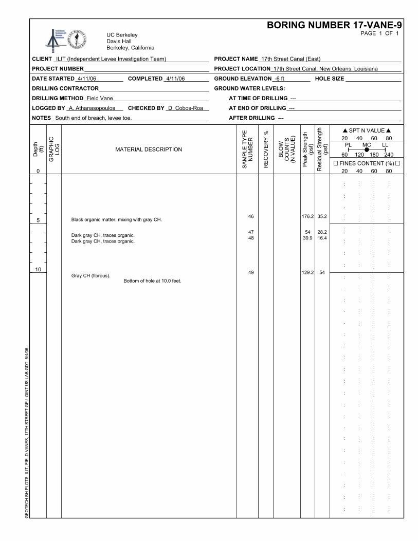
35.2Black organic matter, mixing with gray CH.
28.216.4
54
176.2
5439.9
129.2
46
47
HOLE SIZE
49
BLO
WC
OU
NTS
(N V
ALU
E)
Dark gray CH, traces organic.Dark gray CH, traces organic.
Gray CH (fibrous).Bottom of hole at 10.0 feet.
NOTES South end of breach, levee toe.
GROUND ELEVATION -6 ft
LOGGED BY A. Athanasopoulos
DRILLING METHOD Field Vane AT TIME OF DRILLING ---
48
PROJECT NAME 17th Street Canal (East)
RE
CO
VE
RY
%
PAGE 1 OF 1BORING NUMBER 17-VANE-9
MATERIAL DESCRIPTION
PROJECT NUMBER PROJECT LOCATION 17th Street Canal, New Orleans, Louisiana
GE
OTE
CH
BH
PLO
TS I
LIT,
FIE
LD V
AN
ES
, 17T
H S
TRE
ET.
GP
J G
INT
US
LA
B.G
DT
5/4
/06
UC BerkeleyDavis HallBerkeley, California
CLIENT ILIT (Independent Levee Investigation Team)
60 120 180 240
PL LL
Dep
th(ft
)
0
5
10
Res
idua
l Stre
ngth
(psf
)
Pea
k S
treng
th(p
sf)
SA
MP
LE T
YP
EN
UM
BE
R
MC


GR
AP
HIC
LOG
SPT N VALUE 20 40 60 80
FINES CONTENT (%) 60 120 180 240
20 40 60 80
RE
CO
VE
RY
%
BLO
WC
OU
NTS
(N V
ALU
E)
11.7
AT END OF DRILLING ---
199.71Organic silty clay, some roots.Bottom of hole at 2.5 feet.
NOTES LAC (East)- at max. tilt of wall, by the swimming pool
GROUND ELEVATION -4.68 ft
LOGGED BY A. Athanasopoulos
AT TIME OF DRILLING ---
AFTER DRILLING ---
HOLE SIZE
DRILLING CONTRACTOR GROUND WATER LEVELS:
CHECKED BY D. Cobos-Roa
DATE STARTED 3/15/06 COMPLETED 3/15/06
DRILLING METHOD Field Vane
PROJECT LOCATION London Avenue Canal, New Orleans, Louisiana
PAGE 1 OF 1BORING NUMBER LAC-VANE-1
CLIENT ILIT (Independent Levee Investigation Team) PROJECT NAME London Avenue Canal
GE
OTE
CH
BH
PLO
TS I
LIT,
FIE
LD V
AN
ES
, LO
ND
ON
AV
E C
AN
AL.
GP
J G
INT
US
LA
B.G
DT
5/4
/06
UC BerkeleyDavis HallBerkeley, California
PROJECT NUMBER
PL LLMC
Dep
th(ft
)
0 Res
idua
l Stre
ngth
(psf
)
Pea
k S
treng
th(p
sf)
SA
MP
LE T
YP
EN
UM
BE
R
MATERIAL DESCRIPTION
DATE STARTED 3/15/06 COMPLETED 3/15/06
GR
AP
HIC
LOG
SPT N VALUE
GROUND WATER LEVELS:
20 40 60 80
DRILLING CONTRACTOR
FINES CONTENT (%) 20 40 60 80
RE
CO
VE
RY
%
35.2
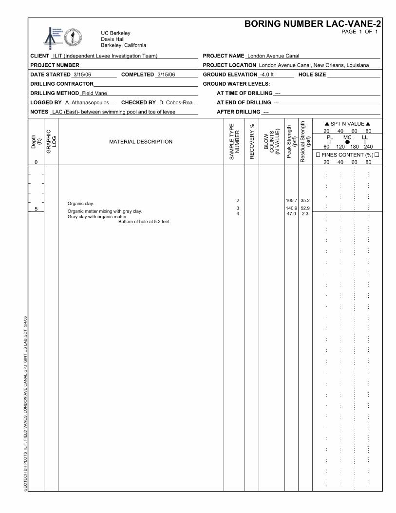
Gray clay with organic matter.
52.92.3
105.7
140.947.0
2
34
CHECKED BY D. Cobos-Roa
Organic matter mixing with gray clay.
Bottom of hole at 5.2 feet.
NOTES LAC (East)- between swimming pool and toe of levee
GROUND ELEVATION -4.0 ft
LOGGED BY A. Athanasopoulos
DRILLING METHOD Field Vane AT TIME OF DRILLING ---
AT END OF DRILLING ---
AFTER DRILLING ---
HOLE SIZE
Organic clay.
PROJECT NAME London Avenue Canal
BLO
WC
OU
NTS
(N V
ALU
E)
PAGE 1 OF 1BORING NUMBER LAC-VANE-2
PROJECT NUMBER
MATERIAL DESCRIPTION
PROJECT LOCATION London Avenue Canal, New Orleans, Louisiana
GE
OTE
CH
BH
PLO
TS I
LIT,
FIE
LD V
AN
ES
, LO
ND
ON
AV
E C
AN
AL.
GP
J G
INT
US
LA
B.G
DT
5/4
/06
UC BerkeleyDavis HallBerkeley, California
CLIENT ILIT (Independent Levee Investigation Team)
0
5
60 120 180 240
PL LLMC
Res
idua
l Stre
ngth
(psf
)
Pea
k S
treng
th(p
sf)
SA
MP
LE T
YP
EN
UM
BE
R
Dep
th(ft
)

DRILLING CONTRACTOR GROUND WATER LEVELS:
CHECKED BY D. Cobos-Roa
DATE STARTED 3/15/06 COMPLETED 3/15/06
GR
AP
HIC
LOG
AFTER DRILLING ---
SPT N VALUE
AT END OF DRILLING ---
20 40 60 80
FINES CONTENT (%) 20 40 60 80
35.2Stiff marsh.
35.2
5.95.9
540.3
199.7
9494
5
6
HOLE SIZE
8
BLO
WC
OU
NTS
(N V
ALU
E)
Organic matter mixing with gray clay.
High PI gray clay, traces of organic matter.High PI gray clay, traces of organic matter.
Bottom of hole at 7.1 feet.
NOTES LAC (East)- south end of rockfill, at levee toe.
GROUND ELEVATION -3.0 ft
LOGGED BY A. Athanasopoulos
DRILLING METHOD Field Vane AT TIME OF DRILLING ---
7
PROJECT NAME London Avenue Canal
RE
CO
VE
RY
%
PAGE 1 OF 1BORING NUMBER LAC-VANE-3
MATERIAL DESCRIPTION
PROJECT NUMBER PROJECT LOCATION London Avenue Canal, New Orleans, Louisiana
GE
OTE
CH
BH
PLO
TS I
LIT,
FIE
LD V
AN
ES
, LO
ND
ON
AV
E C
AN
AL.
GP
J G
INT
US
LA
B.G
DT
5/4
/06
UC BerkeleyDavis HallBerkeley, California
CLIENT ILIT (Independent Levee Investigation Team)
60 120 180 240
PL LL
Dep
th(ft
)
0
5
Res
idua
l Stre
ngth
(psf
)
Pea
k S
treng
th(p
sf)
SA
MP
LE T
YP
EN
UM
BE
R
MC

COMPLETED 4/10/06
60 120 180 240
GR
AP
HIC
LOG
SPT N VALUE 20 40 60 80
BLO
WC
OU
NTS
(N V
ALU
E)
58.7
DATE STARTED 4/10/06
FINES CONTENT (%) 20 40 60 80
RE
CO
VE
RY
%
LOGGED BY A. Athanasopoulos
11.75
117.5
105.71
9
10
Marsh with dark gray CH.
Marsh with dark gray CH, wood.Bottom of hole at 15.2 feet.
GROUND ELEVATION 4.3 ft
DRILLING METHOD Field Vane AT TIME OF DRILLING ---
AT END OF DRILLING ---
AFTER DRILLING ---
HOLE SIZE
DRILLING CONTRACTOR GROUND WATER LEVELS:
CHECKED BY D. Cobos-Roa
NOTES LAC North (East)- south end of rockfill, levee crest.
PROJECT LOCATION London Avenue Canal, New Orleans, Louisiana
PAGE 1 OF 1BORING NUMBER LAC-VANE-4
CLIENT ILIT (Independent Levee Investigation Team) PROJECT NAME London Avenue Canal
GE
OTE
CH
BH
PLO
TS I
LIT,
FIE
LD V
AN
ES
, LO
ND
ON
AV
E C
AN
AL.
GP
J G
INT
US
LA
B.G
DT
5/4
/06
UC BerkeleyDavis HallBerkeley, California
PROJECT NUMBER
PL LLMC
Dep
th(ft
)
Res
idua
l Stre
ngth
(psf
)
Pea
k S
treng
th(p
sf)
SA
MP
LE T
YP
EN
UM
BE
R
MATERIAL DESCRIPTION
0
5
10
15

GR
AP
HIC
LOG
SPT N VALUE 20 40 60 80
COMPLETED 4/10/06
FINES CONTENT (%) 20 40 60 80
RE
CO
VE
RY
%
BLO
WC
OU
NTS
(N V
ALU
E)
65.8
AT TIME OF DRILLING ---
23.5
129.2
199.7
Marsh with dark gray CH.
Marsh with dark gray CH, wood.Bottom of hole at 11.4 feet.
NOTES LAC North (East)- south end of rockfill, levee crest.
GROUND ELEVATION 4.3 ft
DRILLING METHOD Field Vane
AT END OF DRILLING ---
AFTER DRILLING ---
HOLE SIZE
DRILLING CONTRACTOR GROUND WATER LEVELS:
CHECKED BY D. Cobos-Roa
DATE STARTED 4/10/06
LOGGED BY A. Athanasopoulos
PROJECT LOCATION London Avenue Canal, New Orleans, Louisiana
PAGE 1 OF 1BORING NUMBER LAC-VANE-5
CLIENT ILIT (Independent Levee Investigation Team)
60 120 180 240
PROJECT NAME London Avenue Canal
GE
OTE
CH
BH
PLO
TS I
LIT,
FIE
LD V
AN
ES
, LO
ND
ON
AV
E C
AN
AL.
GP
J G
INT
US
LA
B.G
DT
5/4
/06
UC BerkeleyDavis HallBerkeley, California
PROJECT NUMBER
PL LLMC
Dep
th(ft
)
0
5
10
Res
idua
l Stre
ngth
(psf
)
Pea
k S
treng
th(p
sf)
SA
MP
LE T
YP
EN
UM
BE
R
MATERIAL DESCRIPTION

DATE STARTED 4/10/06 COMPLETED 4/10/06
GR
AP
HIC
LOG
SPT N VALUE
GROUND WATER LEVELS:
20 40 60 80
DRILLING CONTRACTOR
FINES CONTENT (%) 20 40 60 80
RE
CO
VE
RY
%
23.5
Organic clay, sandy at the tip.
23.5
11.7
117.570.5
25.8
1314
15
CHECKED BY D. Cobos-Roa
Marsh, roots.
Bottom of hole at 5.8 feet.
NOTES LAC North (East)- south end of rockfill, 50ft from levee toe.
GROUND ELEVATION -6.5 ft
LOGGED BY A. Athanasopoulos
DRILLING METHOD Field Vane AT TIME OF DRILLING ---
AT END OF DRILLING ---
AFTER DRILLING ---
HOLE SIZE
Marsh, roots.
PROJECT NAME London Avenue Canal
BLO
WC
OU
NTS
(N V
ALU
E)
PAGE 1 OF 1BORING NUMBER LAC-VANE-6
PROJECT NUMBER
MATERIAL DESCRIPTION
PROJECT LOCATION London Avenue Canal, New Orleans, Louisiana
GE
OTE
CH
BH
PLO
TS I
LIT,
FIE
LD V
AN
ES
, LO
ND
ON
AV
E C
AN
AL.
GP
J G
INT
US
LA
B.G
DT
5/4
/06
UC BerkeleyDavis HallBerkeley, California
CLIENT ILIT (Independent Levee Investigation Team)
0
5
60 120 180 240
PL LLMC
Res
idua
l Stre
ngth
(psf
)
Pea
k S
treng
th(p
sf)
SA
MP
LE T
YP
EN
UM
BE
R
Dep
th(ft
)

DRILLING CONTRACTOR GROUND WATER LEVELS:
CHECKED BY D. Cobos-Roa
DATE STARTED 4/10/06 COMPLETED 4/10/06
GR
AP
HIC
LOG
AFTER DRILLING ---
SPT N VALUE
AT END OF DRILLING ---
20 40 60 80
FINES CONTENT (%) 20 40 60 80
35.2Dar brown-black silty organic clay. 35.221.135.2
152.7108.1140.9117.5
1816
HOLE SIZE
17
BLO
WC
OU
NTS
(N V
ALU
E)
Organic clay.Mixing of black and gray organic clay.Dark brown organic clay.
Bottom of hole at 5.0 feet.
NOTES LAC North (East)- 6060 & 6078 Warrington St., 50' from levee toe.
GROUND ELEVATION -6.5 ft
LOGGED BY A. Athanasopoulos
DRILLING METHOD Field Vane AT TIME OF DRILLING ---
19
PROJECT NAME London Avenue Canal
RE
CO
VE
RY
%
PAGE 1 OF 1BORING NUMBER LAC-VANE-7
MATERIAL DESCRIPTION
PROJECT NUMBER PROJECT LOCATION London Avenue Canal, New Orleans, Louisiana
GE
OTE
CH
BH
PLO
TS I
LIT,
FIE
LD V
AN
ES
, LO
ND
ON
AV
E C
AN
AL.
GP
J G
INT
US
LA
B.G
DT
5/4
/06
UC BerkeleyDavis HallBerkeley, California
CLIENT ILIT (Independent Levee Investigation Team)
60 120 180 240
PL LL
Dep
th(ft
)
0
5
Res
idua
l Stre
ngth
(psf
)
Pea
k S
treng
th(p
sf)
SA
MP
LE T
YP
EN
UM
BE
R
MC