clup resource book e-copy nov2013
DESCRIPTION
CLUP Resource Book Integrating Climate Change Adaptation and Disaster Risk Reduction & Management Companion Resource Book to the HLURB Guidebook on Comprehensive Land Use Planning (CLUP) October 2013TRANSCRIPT
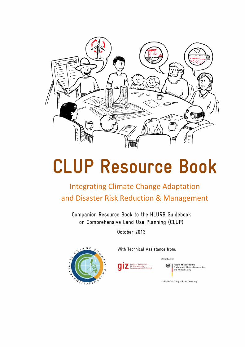
CLUP Resource Book Integrating Climate Change Adaptation
and Disaster Risk Reduction & Management
Companion Resource Book to the HLURB Guidebook on Comprehensive Land Use Planning (CLUP)
October 2013
With Technical Assistance from:
Imprint The Climate Change Commission, which is attached to the Office of the President of the Philippines, is an independent and autonomous agency with the same status as that of a national government agency. It is the lead policy-making body of the government tasked to coordinate, monitor and evaluate the programs and action plans of the government relating to climate change. It has formulated the National Strategic Framework on Climate Change (NSFCC), and the National Climate Change Action Plan (NCCAP). This publication is supported by the Deutsche Gesellschaft für Internationale Zusammenarbeit through the Support to the Climate Change Commission in the Implementation of the National Framework Strategy on Climate Change and the National Climate Change Action Plan (SupportCCC) Project and the Inventory of Methods for Adaptation to Climate Change (IMACC) Project in the Philippines, funded by the German Federal Ministry for the Environment, Nature Conservation and Nuclear Safety (BMU) under its International Climate Initiative. The BMU supports these initiatives based on a decision of the German Parliament. For more information please go to http://www.international-climate-initiative.com.
Acknowledgement The contents of this publication draw upon a series of consultations with the Housing and Land Use Regulatory Board (HLURB), as well as the expertise of various actors and a wide range of literature. It would not have been possible to produce this without the valuable contributions and active participation of the Policy Development Group and the regional planning officers of the HLURB.
Published by Support to the Climate Change Commission in Implementing the NCCAP Project Climate Change Office - Climate Change Commission Philippines
With support from the Inventory of Methods for Adaptation to Climate Change Project – GIZ-BMU Responsible at CCC Climate Change Office Rm. 238 Mabini Hall Malacañang Compound San Miguel, Manila Phone +63 2 735 3069 Email [email protected] www.climate.gov.ph Responsible at GIZ Support to the Climate Change Commission in the Implementation of the NFSCC and the NCCAP Project 9th Floor PDCP Bank Centre Rufino corner Leviste Streets, Salcedo Village 1227 Makati City, Philippines Phone +63 2 651 5100 www.giz.de Authors Dr. Rosa Perez Dr. Charlotte Kendra Gotangco Artwork Desiree Llanos Dee Climate Media Factory Place and date of publication Manila, Philippines October 2013
CONTENTS
INTRODUCTION
CHAPTER 1 Climate Processes and Impacts
CHAPTER 2 Theoretical Frameworks for Risk Assessment
CHAPTER 3 CCA and DRRM Entry Points
CHAPTER 4 Sector Impact Chain Analyses and Decision Trees
CHAPTER 5 CCA and DRRM Interfaces among the Local Plans
ACRONYMS USED
BDP Barangay Development Plan
CCA Climate Change Adaptation CCAP Climate Change Action Plan CDP Comprehensive Development Plan CLUP Comprehensive Land Use Plan DRRM Disaster Risk Reduction and Management DRRMP Disaster Risk Reduction and Management Plan IPCC Inter-governmental Panel on Climate Change LCCAP Local Climate Change Action Plan LDRRMP Local Disaster Risk Reduction and Management Plan LGU Local Government Units NCCAP National Climate Change Action Plan NDRRMP National Disaster Risk Reduction and Management Plan PDPFP Provincial Development and Physical Framework Plan PPA Programs, Projects and Activities
CHAPTER 1 CLIMATE IMPACTS 5
INTRODUCTION
The management of land resources has always been a major element in the
sustainable developmental objective and concern by all countries and by many peoples.
However, because of its finite condition, access and sharing the benefits of the land gets
more intense as populations grow and resources become more depleted and scarcer.
Control over limited land resources has been one, if not the key, reasons for most of the
social and political conflict in countries, including the Philippines.
The continued impact of extreme weather events attributed to global climate change
highlights the critical role of land use planning to address climate change mitigation and
adaptation measures by local communities, especially in developing countries.
The 2010 World Development Report (WDR 2010) stated that climate change will
affect numerous sectors and productive environments, including agriculture, forestry,
energy, and coastal zones, in developed and developing countries.
“Developing economies will be more affected by climate change, in part because of
their greater exposure to climate shocks and in part because of their low adaptive
capacity” (WDR 2010, p.40). Among the most vulnerable countries to the impact of
global climate change is the Philippines.
Adaptation and mitigation need to be integrated into a climate-smart development
strategy that increases resilience, reduces the threat of further warming, and improves
development outcomes (WDR 2010, p.44).
Recent global climate change risk assessments made by the World Bank (2011) and
Asian Development Bank (2012) showed that land use planning is a critical component in
any country’s climate change adaptation strategy.
6 CLUP RESOURCE BOOK
The importance of land use planning as a strategic climate change adaptation tool is
clearly stated in the Philippines’ National Framework Strategy on Climate Change
(NFSCC). Under the NFSCC, the integration of climate change and disaster risk reduction
into local land use and development plans, based on an integrated ecosystems approach
or ‘ridge-to-reef’ framework, is considered a major pillar of the country’s adaptation
plan.
Purpose of the Resource Book
Appropriate land use and land development is one of the most concrete ways to
implement CCA and DRRM, and to harmonize these with sustainable development goals.
At the local level, Section 14 of RA 9729, the Philippine Climate Change Act of 2010,
states that “LGUs shall be the frontline agencies for the formulation, planning and
implementation of climate change action plans in their respective areas, consistent with
the provisions of the Local Government Code, the Framework and the National Climate
Change Action Plan.” The Climate Change Act aims to systematically integrate the
concept of climate change in the policy formulation and development plans of all unit of
government to prepare for the impact of climate change. The Local Government Units
(LGUs) have also been tasked to formulate and implement their respective Local Climate
Change Action Plans (LCCAP) consistent with the Local Government Code, the National
Framework Strategy on Climate Change (NFSCC) and the National Climate Change Action
Plan (NCCAP). However, due to multiplicity of plans, the Climate Change Commission
envisions that the LCCAP should not represent a separate plan due to the multitude of
plans already required of the LGUs. This will only add to their burden and decrease the
effectiveness of the planning process. Rather, the LCCAP as an action plan should
represent a lens or framework to be applied or mainstreamed to already mandated plan
such as the CLUP. Thus, LGUs need an easy-to-use tool to facilitate the application of
climate lens in the CLUP that will complement the existing guidelines for CLUP
preparation.
The tool being visualized is packaged in a Resource Book that summarizes the
important considerations for climate change adaptation (CCA) and disaster risk reduction
and management (DRRM) in each of the 12 steps of the CLUP preparation. It includes the
CHAPTER 1 CLIMATE IMPACTS 7
theoretical background, guide questions, data needs and data sources, required analyses,
samples from case studies or other available literature, checklists and directories of other
appropriate resources.
This initiative answers the immediate needs of the LGUs already in the process of
revising their CLUPs, and it is also the precursor to a larger effort to enhance the CLUP
guidelines. The Resource Book will include, but not limited to, considerations of
typologies (e.g. coastal vs. inland, forested areas, upland vs. lowland) and improved
national standards (e.g. building/infrastructure standards) to integrate CCA and DRRM.
8 CLUP RESOURCE BOOK
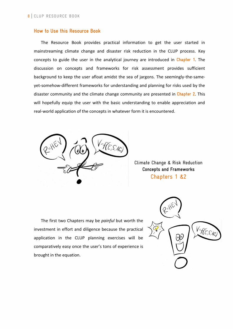
How to Use this Resource Book
The Resource Book provides practical information to get the user started in
mainstreaming climate change and disaster risk reduction in the CLUP process. Key
concepts to guide the user in the analytical journey are introduced in Chapter 1. The
discussion on concepts and frameworks for risk assessment provides sufficient
background to keep the user afloat amidst the sea of jargons. The seemingly-the-same-
yet-somehow-different frameworks for understanding and planning for risks used by the
disaster community and the climate change community are presented in Chapter 2. This
will hopefully equip the user with the basic understanding to enable appreciation and
real-world application of the concepts in whatever form it is encountered.
The first two Chapters may be painful but worth the
investment in effort and diligence because the practical
application in the CLUP planning exercises will be
comparatively easy once the user’s tons of experience is
brought in the equation.
Climate Change & Risk Reduction Concepts and Frameworks
Chapters 1 &2
CHAPTER 1 CLIMATE IMPACTS 9
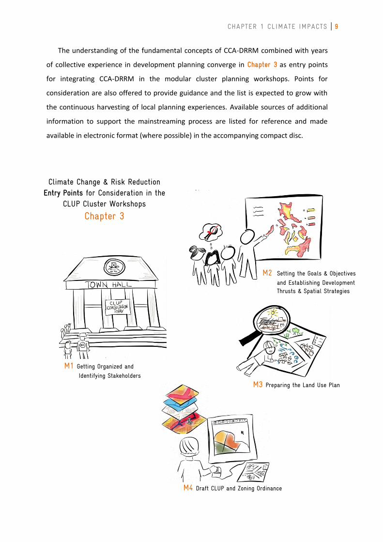
Climate Change & Risk Reduction Entry Points for Consideration in the
CLUP Cluster Workshops
Chapter 3
M1 Getting Organized and
Identifying Stakeholders
M2 Setting the Goals & Objectives
and Establishing Development Thrusts & Spatial Strategies
M3 Preparing the Land Use Plan
M4 Draft CLUP and Zoning Ordinance
The understanding of the fundamental concepts of CCA-DRRM combined with years
of collective experience in development planning converge in Chapter 3 as entry points
for integrating CCA-DRRM in the modular cluster planning workshops. Points for
consideration are also offered to provide guidance and the list is expected to grow with
the continuous harvesting of local planning experiences. Available sources of additional
information to support the mainstreaming process are listed for reference and made
available in electronic format (where possible) in the accompanying compact disc.
10 CLUP RESOURCE BOOK
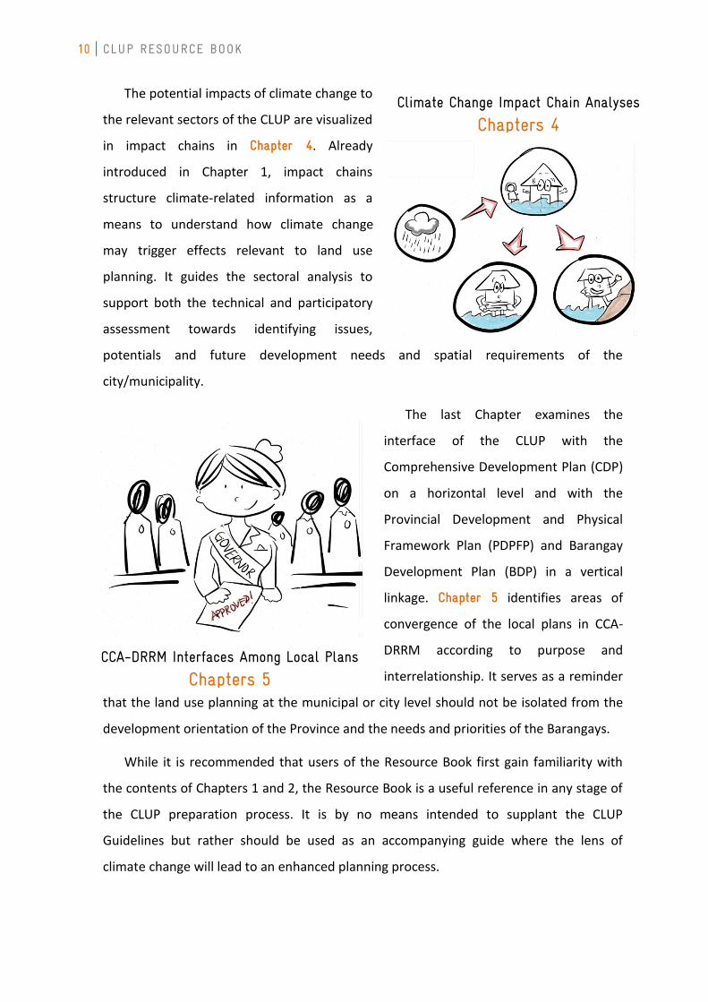
The potential impacts of climate change to
the relevant sectors of the CLUP are visualized
in impact chains in Chapter 4. Already
introduced in Chapter 1, impact chains
structure climate-related information as a
means to understand how climate change
may trigger effects relevant to land use
planning. It guides the sectoral analysis to
support both the technical and participatory
assessment towards identifying issues,
potentials and future development needs and spatial requirements of the
city/municipality.
The last Chapter examines the
interface of the CLUP with the
Comprehensive Development Plan (CDP)
on a horizontal level and with the
Provincial Development and Physical
Framework Plan (PDPFP) and Barangay
Development Plan (BDP) in a vertical
linkage. Chapter 5 identifies areas of
convergence of the local plans in CCA-
DRRM according to purpose and
interrelationship. It serves as a reminder
that the land use planning at the municipal or city level should not be isolated from the
development orientation of the Province and the needs and priorities of the Barangays.
While it is recommended that users of the Resource Book first gain familiarity with
the contents of Chapters 1 and 2, the Resource Book is a useful reference in any stage of
the CLUP preparation process. It is by no means intended to supplant the CLUP
Guidelines but rather should be used as an accompanying guide where the lens of
climate change will lead to an enhanced planning process.
Climate Change Impact Chain Analyses
Chapters 4
CCA-DRRM Interfaces Among Local Plans
Chapters 5
CHAPTER 2 FRAMEWORKS FOR RISK ASSESSMENT
11
CHAPTER 1: Climate Processes and Impacts
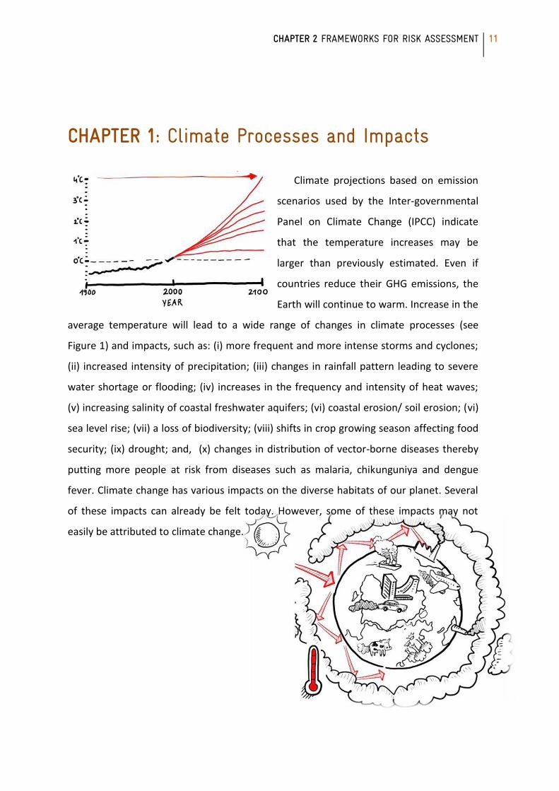
Climate projections based on emission
scenarios used by the Inter-governmental
Panel on Climate Change (IPCC) indicate
that the temperature increases may be
larger than previously estimated. Even if
countries reduce their GHG emissions, the
Earth will continue to warm. Increase in the
average temperature will lead to a wide range of changes in climate processes (see
Figure 1) and impacts, such as: (i) more frequent and more intense storms and cyclones;
(ii) increased intensity of precipitation; (iii) changes in rainfall pattern leading to severe
water shortage or flooding; (iv) increases in the frequency and intensity of heat waves;
(v) increasing salinity of coastal freshwater aquifers; (vi) coastal erosion/ soil erosion; (vi)
sea level rise; (vii) a loss of biodiversity; (viii) shifts in crop growing season affecting food
security; (ix) drought; and, (x) changes in distribution of vector-borne diseases thereby
putting more people at risk from diseases such as malaria, chikunguniya and dengue
fever. Climate change has various impacts on the diverse habitats of our planet. Several
of these impacts can already be felt today. However, some of these impacts may not
easily be attributed to climate change.
12 CLUP RESOURCE BOOK
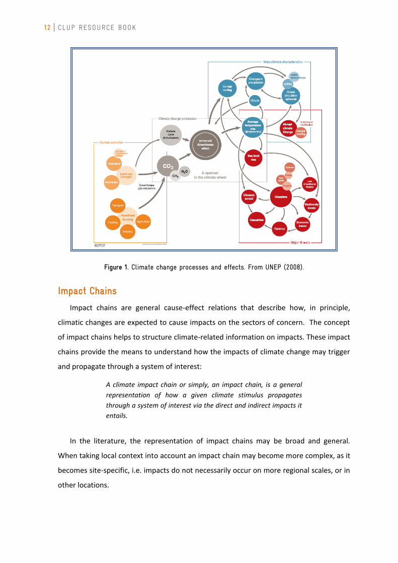
Figure 1. Climate change processes and effects. From UNEP (2008).
Impact Chains
Impact chains are general cause-effect relations that describe how, in principle,
climatic changes are expected to cause impacts on the sectors of concern. The concept
of impact chains helps to structure climate-related information on impacts. These impact
chains provide the means to understand how the impacts of climate change may trigger
and propagate through a system of interest:
A climate impact chain or simply, an impact chain, is a general
representation of how a given climate stimulus propagates
through a system of interest via the direct and indirect impacts it
entails.
In the literature, the representation of impact chains may be broad and general.
When taking local context into account an impact chain may become more complex, as it
becomes site-specific, i.e. impacts do not necessarily occur on more regional scales, or in
other locations.
CHAPTER 2 FRAMEWORKS FOR RISK ASSESSMENT
13
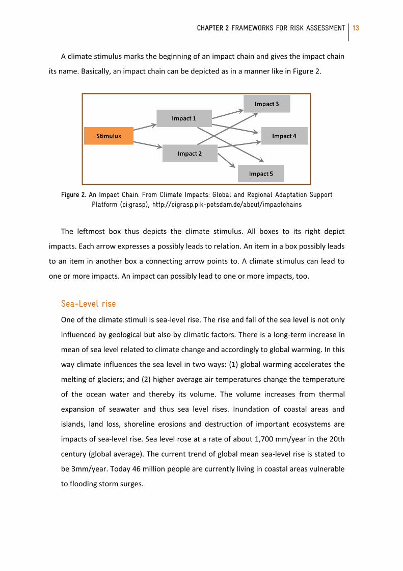
A climate stimulus marks the beginning of an impact chain and gives the impact chain
its name. Basically, an impact chain can be depicted as in a manner like in Figure 2.
Figure 2. An Impact Chain. From Climate Impacts: Global and Regional Adaptation Support Platform (ci:grasp), http://cigrasp.pik-potsdam.de/about/impactchains
The leftmost box thus depicts the climate stimulus. All boxes to its right depict
impacts. Each arrow expresses a possibly leads to relation. An item in a box possibly leads
to an item in another box a connecting arrow points to. A climate stimulus can lead to
one or more impacts. An impact can possibly lead to one or more impacts, too.
Sea-Level rise
One of the climate stimuli is sea-level rise. The rise and fall of the sea level is not only
influenced by geological but also by climatic factors. There is a long-term increase in
mean of sea level related to climate change and accordingly to global warming. In this
way climate influences the sea level in two ways: (1) global warming accelerates the
melting of glaciers; and (2) higher average air temperatures change the temperature
of the ocean water and thereby its volume. The volume increases from thermal
expansion of seawater and thus sea level rises. Inundation of coastal areas and
islands, land loss, shoreline erosions and destruction of important ecosystems are
impacts of sea-level rise. Sea level rose at a rate of about 1,700 mm/year in the 20th
century (global average). The current trend of global mean sea-level rise is stated to
be 3mm/year. Today 46 million people are currently living in coastal areas vulnerable
to flooding storm surges.
14 CLUP RESOURCE BOOK
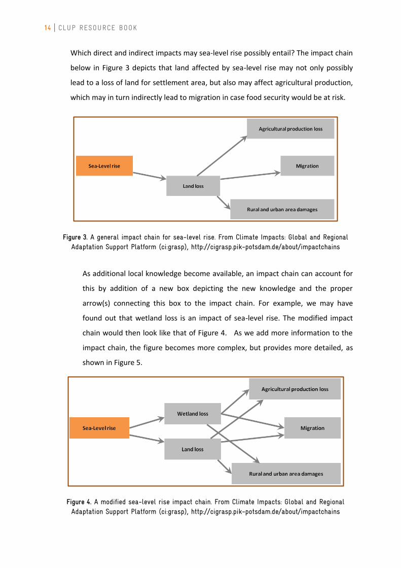
Which direct and indirect impacts may sea-level rise possibly entail? The impact chain
below in Figure 3 depicts that land affected by sea-level rise may not only possibly
lead to a loss of land for settlement area, but also may affect agricultural production,
which may in turn indirectly lead to migration in case food security would be at risk.
Figure 3. A general impact chain for sea-level rise. From Climate Impacts: Global and Regional Adaptation Support Platform (ci:grasp), http://cigrasp.pik-potsdam.de/about/impactchains
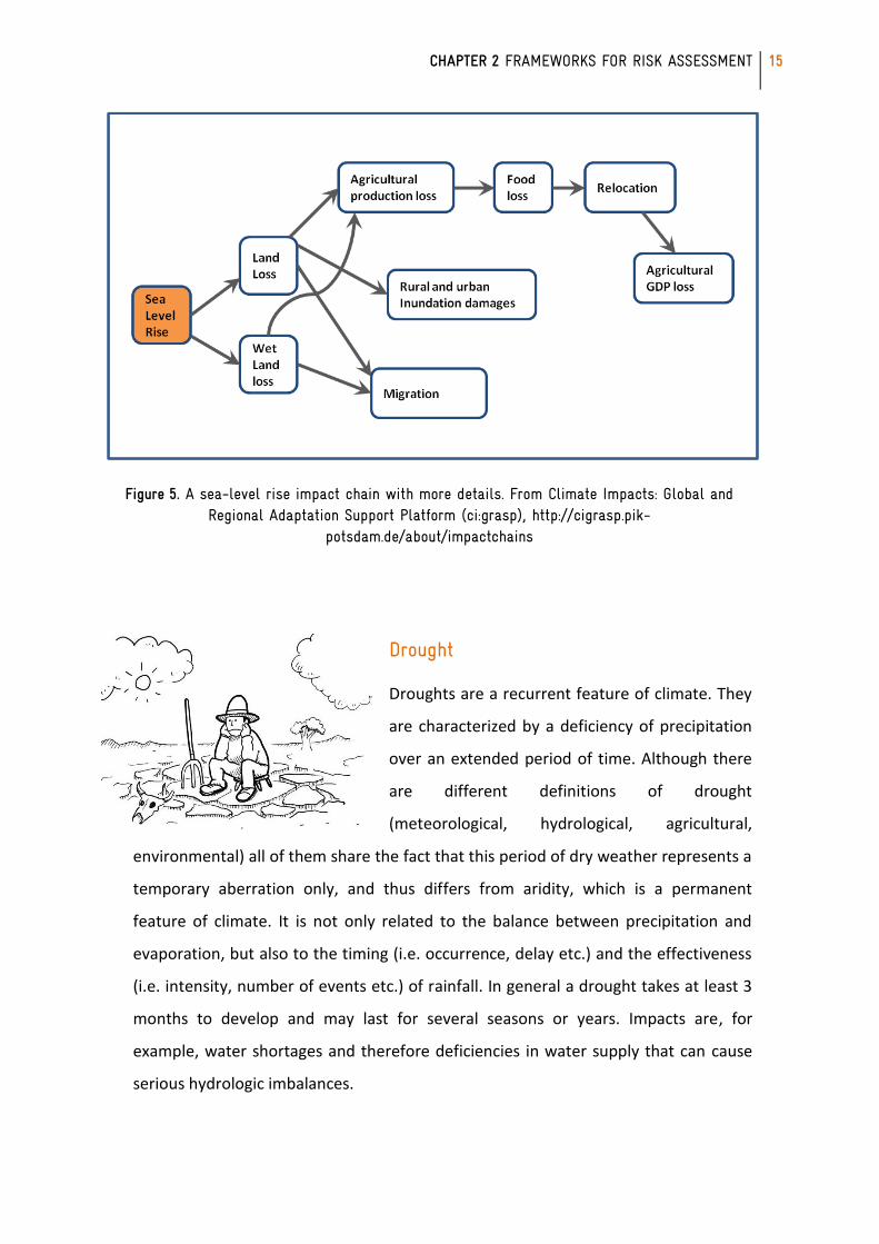
As additional local knowledge become available, an impact chain can account for
this by addition of a new box depicting the new knowledge and the proper
arrow(s) connecting this box to the impact chain. For example, we may have
found out that wetland loss is an impact of sea-level rise. The modified impact
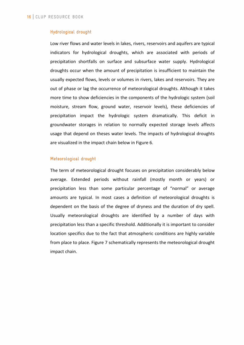
chain would then look like that of Figure 4. As we add more information to the
impact chain, the figure becomes more complex, but provides more detailed, as
shown in Figure 5.
Figure 4. A modified sea-level rise impact chain. From Climate Impacts: Global and Regional Adaptation Support Platform (ci:grasp), http://cigrasp.pik-potsdam.de/about/impactchains
CHAPTER 2 FRAMEWORKS FOR RISK ASSESSMENT
15
Figure 5. A sea-level rise impact chain with more details. From Climate Impacts: Global and Regional Adaptation Support Platform (ci:grasp), http://cigrasp.pik-
potsdam.de/about/impactchains
Drought
Droughts are a recurrent feature of climate. They
are characterized by a deficiency of precipitation
over an extended period of time. Although there
are different definitions of drought
(meteorological, hydrological, agricultural,
environmental) all of them share the fact that this period of dry weather represents a
temporary aberration only, and thus differs from aridity, which is a permanent
feature of climate. It is not only related to the balance between precipitation and
evaporation, but also to the timing (i.e. occurrence, delay etc.) and the effectiveness
(i.e. intensity, number of events etc.) of rainfall. In general a drought takes at least 3
months to develop and may last for several seasons or years. Impacts are, for
example, water shortages and therefore deficiencies in water supply that can cause
serious hydrologic imbalances.
16 CLUP RESOURCE BOOK
Hydrological drought
Low river flows and water levels in lakes, rivers, reservoirs and aquifers are typical
indicators for hydrological droughts, which are associated with periods of
precipitation shortfalls on surface and subsurface water supply. Hydrological
droughts occur when the amount of precipitation is insufficient to maintain the
usually expected flows, levels or volumes in rivers, lakes and reservoirs. They are
out of phase or lag the occurrence of meteorological droughts. Although it takes
more time to show deficiencies in the components of the hydrologic system (soil
moisture, stream flow, ground water, reservoir levels), these deficiencies of
precipitation impact the hydrologic system dramatically. This deficit in
groundwater storages in relation to normally expected storage levels affects
usage that depend on theses water levels. The impacts of hydrological droughts
are visualized in the impact chain below in Figure 6.
Meteorological drought
The term of meteorological drought focuses on precipitation considerably below
average. Extended periods without rainfall (mostly month or years) or
precipitation less than some particular percentage of “normal” or average
amounts are typical. In most cases a definition of meteorological droughts is
dependent on the basis of the degree of dryness and the duration of dry spell.
Usually meteorological droughts are identified by a number of days with
precipitation less than a specific threshold. Additionally it is important to consider
location specifics due to the fact that atmospheric conditions are highly variable
from place to place. Figure 7 schematically represents the meteorological drought
impact chain.

CHAPTER 2 FRAMEWORKS FOR RISK ASSESSMENT
17
Figure 6. Impacts of hydrological drought. From Climate Impacts: Global and Regional Adaptation Support Platform (ci:grasp), http://cigrasp.pik-potsdam.de/impacts/8
Figure 7. Meteorological drought impact chain. From Climate Impacts: Global and Regional Adaptation Support Platform (ci:grasp), http://cigrasp.pik-potsdam.de/impacts/8
18 CLUP RESOURCE BOOK
Precipitation
Precipitation can be simply defined as any form of water particles, whether liquid or
solid, that fall from the atmosphere and reach the ground” (NSIDC, 2010). When
cloud particles (condensed atmospheric water) become too heavy to remain
suspended in the air, they fall to earth as precipitation. In tropical countries like the
Philippines, the most common form of precipitation is rain. Sometimes,
thunderstorm clouds also produce hails.
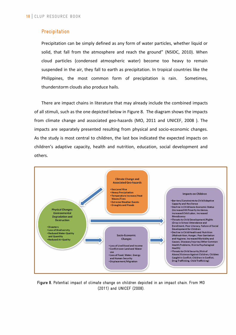
There are impact chains in literature that may already include the combined impacts
of all stimuli, such as the one depicted below in Figure 8. The diagram shows the impacts
from climate change and associated geo-hazards (MO, 2011 and UNICEF, 2008 ). The
impacts are separately presented resulting from physical and socio-economic changes.
As the study is most central to children, the last box indicated the expected impacts on
children’s adaptive capacity, health and nutrition, education, social development and
others.
Figure 8. Potential impact of climate change on children depicted in an impact chain. From MO (2011) and UNICEF (2008).
CHAPTER 2 FRAMEWORKS FOR RISK ASSESSMENT
19
Albedo is the fraction of solar energy (shortwave radiation) reflected from the Earth back into space. It is a measure of the reflectivity of the earth's surface. (Source: www.esr.org/outreach/glossary/albedo.html)
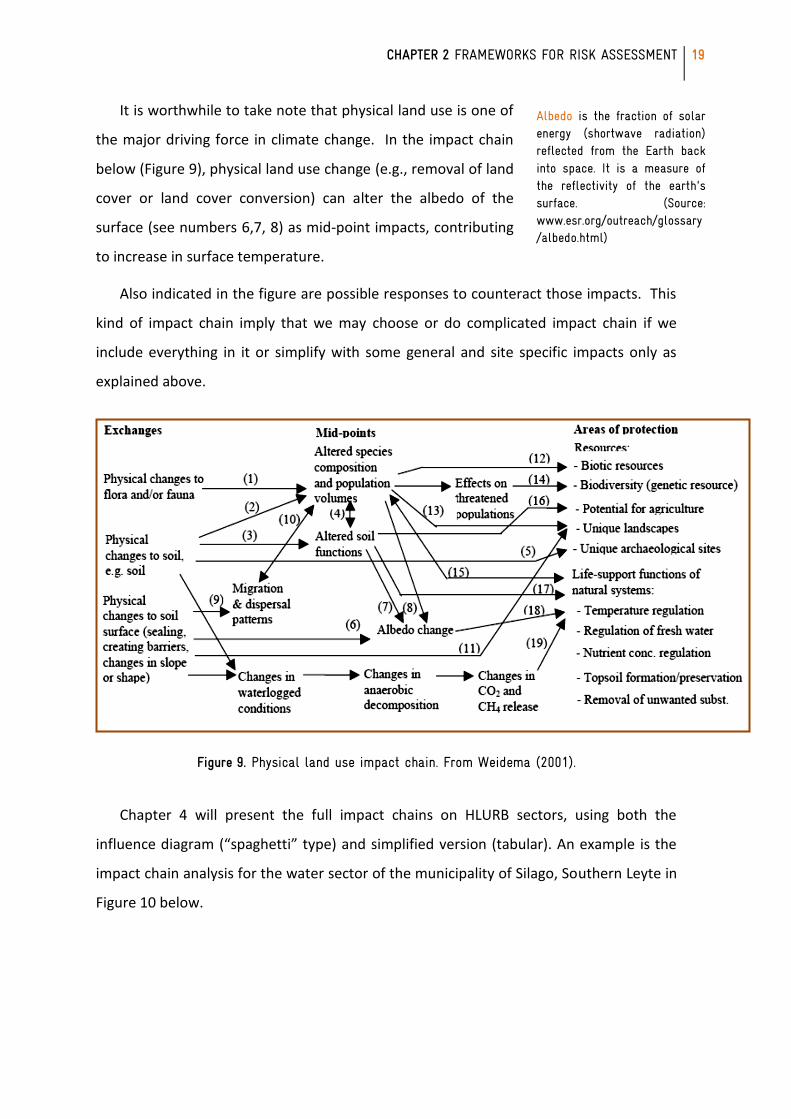
It is worthwhile to take note that physical land use is one of
the major driving force in climate change. In the impact chain
below (Figure 9), physical land use change (e.g., removal of land
cover or land cover conversion) can alter the albedo of the
surface (see numbers 6,7, 8) as mid-point impacts, contributing
to increase in surface temperature.
Also indicated in the figure are possible responses to counteract those impacts. This
kind of impact chain imply that we may choose or do complicated impact chain if we
include everything in it or simplify with some general and site specific impacts only as
explained above.
Figure 9. Physical land use impact chain. From Weidema (2001).
Chapter 4 will present the full impact chains on HLURB sectors, using both the
influence diagram (“spaghetti” type) and simplified version (tabular). An example is the
impact chain analysis for the water sector of the municipality of Silago, Southern Leyte in
Figure 10 below.
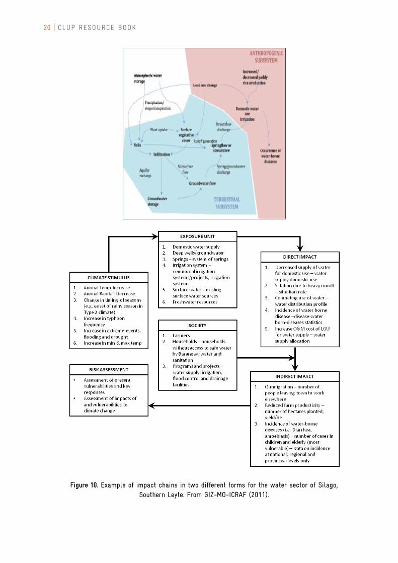
20 CLUP RESOURCE BOOK
Figure 10. Example of impact chains in two different forms for the water sector of Silago, Southern Leyte. From GIZ-MO-ICRAF (2011).
CHAPTER 2 FRAMEWORKS FOR RISK ASSESSMENT
21
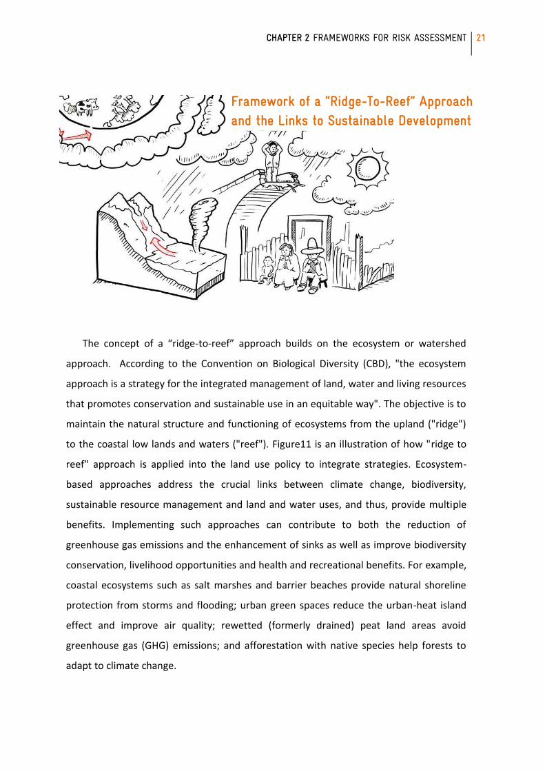
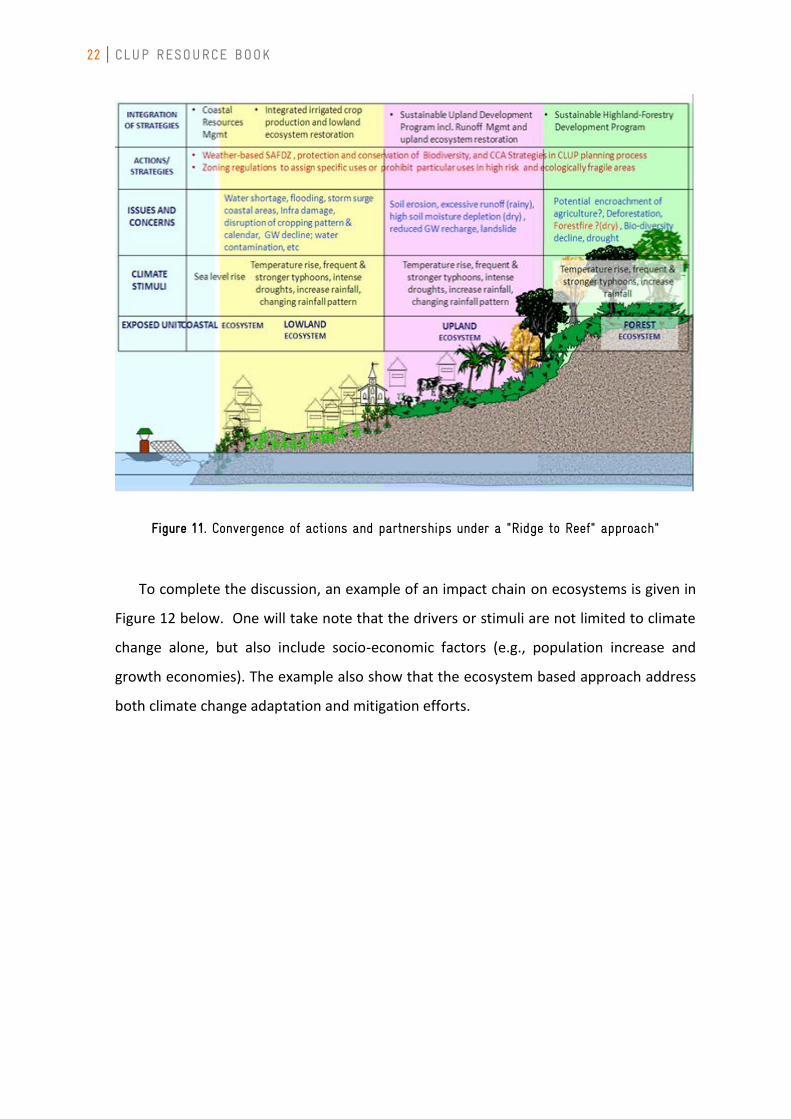
The concept of a “ridge-to-reef” approach builds on the ecosystem or watershed
approach. According to the Convention on Biological Diversity (CBD), "the ecosystem
approach is a strategy for the integrated management of land, water and living resources
that promotes conservation and sustainable use in an equitable way". The objective is to
maintain the natural structure and functioning of ecosystems from the upland ("ridge")
to the coastal low lands and waters ("reef"). Figure11 is an illustration of how "ridge to
reef" approach is applied into the land use policy to integrate strategies. Ecosystem-
based approaches address the crucial links between climate change, biodiversity,
sustainable resource management and land and water uses, and thus, provide multiple
benefits. Implementing such approaches can contribute to both the reduction of
greenhouse gas emissions and the enhancement of sinks as well as improve biodiversity
conservation, livelihood opportunities and health and recreational benefits. For example,
coastal ecosystems such as salt marshes and barrier beaches provide natural shoreline
protection from storms and flooding; urban green spaces reduce the urban-heat island
effect and improve air quality; rewetted (formerly drained) peat land areas avoid
greenhouse gas (GHG) emissions; and afforestation with native species help forests to
adapt to climate change.
Framework of a “Ridge-To-Reef” Approach and the Links to Sustainable Development
22 CLUP RESOURCE BOOK
Figure 11. Convergence of actions and partnerships under a "Ridge to Reef" approach"
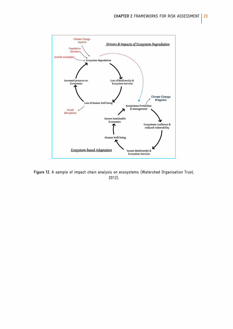
To complete the discussion, an example of an impact chain on ecosystems is given in
Figure 12 below. One will take note that the drivers or stimuli are not limited to climate
change alone, but also include socio-economic factors (e.g., population increase and
growth economies). The example also show that the ecosystem based approach address
both climate change adaptation and mitigation efforts.
CHAPTER 2 FRAMEWORKS FOR RISK ASSESSMENT
23
Figure 12. A sample of impact chain analysis on ecosystems (Watershed Organisation Trust, 2012).
24 CLUP RESOURCE BOOK
CHAPTER 2: THEORETICAL FRAMEWORKS FOR RISK AND VULNERABILITY ASSESSMENTS FOR LAND USE PLANNING
It is important to understand the fundamental concepts of risk and vulnerability that
CCA-DRRM seeks to address, and the frameworks employed to do so in order to facilitate
mainstreaming. Several frameworks of analysis exist. One of the most widely used in the
disaster risk community is UN-based, while that in the climate change community is IPCC-
based. Note, however, that these frameworks evolved separately, so the use of
terminologies may differ though the concepts may be similar. Awareness of similarities
and differences is crucial in avoiding misunderstandings and miscalculations, and in
ensuring consistency in the integration of CCA and DRRM in the CLUP process.
CHAPTER 2 FRAMEWORKS FOR RISK ASSESSMENT
25
This chapter outlines the basic definitions of terms under the UN- and IPCC-based
frameworks, and then maps corresponding terms in each framework. This will provide
the foundation for understanding the guidelines in this document, as well as the analyses
in the existing body of disaster risk and climate change literature and research that users
can be refer to as resources.
The Disaster Risk Framework (UN-based)
The United Nations-based framework for risk developed within the context of the
disaster risk reduction and management community. This framework acknowledges the
more common definition of risk being a product of the “probability of the event and its
negative consequences” (UNISDR 2009), but also sees risk as a result of the confluence of
a hazard and the vulnerability of exposed populations and assets.
In the United National Development Programme (UNDP) report on Reducing Disaster
Risks: A Challenge for Development (2004), the following operational definitions were
used for risk and its components to calculate a Disaster Risk Index (DRI) (these can be
found in Annex A):
Natural hazards: “Refer exclusively to earthquake, tropical cyclone, flood and
drought. Only frequencies and area of extent were considered in
the model… Secondary hazards triggered by the primary hazards
mentioned above (for example, landslides triggered by
earthquakes) are subsumed in the primary hazard.”
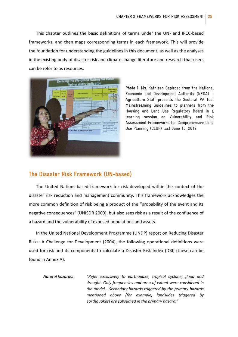
Photo 1. Ms. Kathleen Capiroso from the National Economic and Development Authority (NEDA) – Agriculture Staff presents the Sectoral VA Tool Mainstreaming Guidelines to planners from the Housing and Land Use Regulatory Board in a learning session on Vulnerability and Risk Assessment Frameworks for Comprehensive Land Use Planning (CLUP) last June 15, 2012.
26 CLUP RESOURCE BOOK
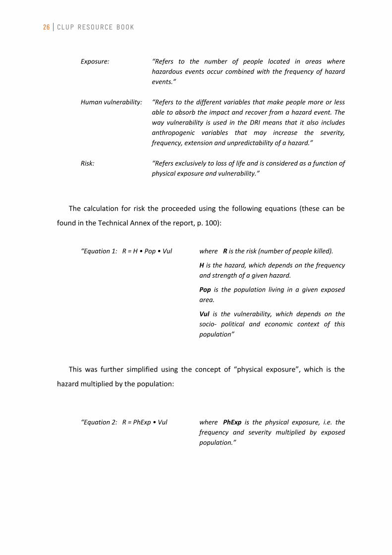
Exposure: “Refers to the number of people located in areas where
hazardous events occur combined with the frequency of hazard
events.”
Human vulnerability: “Refers to the different variables that make people more or less
able to absorb the impact and recover from a hazard event. The
way vulnerability is used in the DRI means that it also includes
anthropogenic variables that may increase the severity,
frequency, extension and unpredictability of a hazard.”
Risk: “Refers exclusively to loss of life and is considered as a function of
physical exposure and vulnerability.”
The calculation for risk the proceeded using the following equations (these can be
found in the Technical Annex of the report, p. 100):
“Equation 1: R = H • Pop • Vul where R is the risk (number of people killed).
H is the hazard, which depends on the frequency
and strength of a given hazard.
Pop is the population living in a given exposed
area.
Vul is the vulnerability, which depends on the
socio- political and economic context of this
population”
This was further simplified using the concept of “physical exposure”, which is the
hazard multiplied by the population:
“Equation 2: R = PhExp • Vul where PhExp is the physical exposure, i.e. the
frequency and severity multiplied by exposed
population.”
CHAPTER 2 FRAMEWORKS FOR RISK ASSESSMENT
27
These equations then became the basis for the determination of risk in a project
undertaken by the Manila Observatory for the Department of Environmental and Natural
Resources (DENR), entitled “Mapping Philippine Vulnerability to Environmental
Disasters” (2005). This project adapted the general framework:
Risk = Hazard x Exposure x Vulnerability
This framework was implemented through the use of geographic information systems
(GIS). The GIS approach allowed for development of thematic maps and layering of the
components of risk to determine compounded influences. The R = HEV framework and
similar equations have been used in various other studies as elaborated in Foerster et al.
(2009) (pages 13-14).
A more recent reference on the components and definitions of risk is the United
Nations International Strategy (UNISDR) book of terminology on disaster risk reduction
(2009). This defines risk and its components in the following manner:
“Hazard: A dangerous phenomenon, substance, human activity or
condition that may cause loss of life, injury or other health
impacts, property damage, loss of livelihoods and services, social
and economic disruption, or environmental damage.
Comment: The hazards of concern to disaster risk reduction as stated in footnote 3 of the Hyogo Framework are ‘… hazards of natural origin and related environmental and technological hazards and risks.’ Such hazards arise from a variety of geological, meteorological, hydrological, oceanic, biological, and technological sources, sometimes acting in combination. In technical settings, hazards are described quantitatively by the likely frequency of occurrence of different intensities for different areas, as determined from historical data or scientific analysis.”
“Exposure: People, property, systems, or other elements present in hazard
zones that are thereby subject to potential losses.
Comment: Measures of exposure can include the number of people or types of assets in an area. These can be combined with the specific vulnerability of the exposed elements to any
28 CLUP RESOURCE BOOK
particular hazard to estimate the quantitative risks associated with that hazard in the area of interest.”
“Vulnerability: The characteristics and circumstances of a community, system or
asset that make it susceptible to the damaging effects of a
hazard.
Comment: There are many aspects of vulnerability, arising from various physical, social, economic, and environmental factors. Examples may include poor design and construction of buildings, inadequate protection of assets, lack of public information and awareness, limited official recognition of risks and preparedness measures, and disregard for wise environmental management. Vulnerability varies significantly within a community and over time. This definition identifies vulnerability as a characteristic of the element of interest (community, system or asset) which is independent of its exposure. However, in common use the word is often used more broadly to include the element’s exposure.”
“Risk: The combination of the probability of an event and its negative
consequences.
Comment: This definition closely follows the definition of the ISO/IEC Guide 73. The word ‘risk’ has two distinctive connotations: in popular usage the emphasis is usually placed on the concept of chance or possibility, such as in ‘the risk of an accident’; whereas in technical settings the emphasis is usually placed on the consequences, in terms of ‘potential losses’ for some particular cause, place and period. It can be noted that people do not necessarily share the same perceptions of the significance and underlying causes of different risks”
“Disaster risk: The potential disaster losses, in lives, health status, livelihoods,
assets and services, which could occur to a particular community
or a society over some specified future time period.
Comment: The definition of disaster risk reflects the concept of disasters as the outcome of continuously present conditions of risk. Disaster risk comprises different types of potential losses which are often difficult to quantify. Nevertheless, with knowledge of the prevailing hazards and the patterns of population and socio-economic development, disaster risks can be assessed and mapped, in broad terms at least.”
“Disaster: A serious disruption of the functioning of a community or a
society involving widespread human, material, economic or
environmental losses and impacts, which exceeds the ability of
CHAPTER 2 FRAMEWORKS FOR RISK ASSESSMENT
29
the affected community or society to cope using its own
resources.
Comment: Disasters are often described as a result of the combination of: the exposure to a hazard; the conditions of vulnerability that are present; and insufficient capacity or measures to reduce or cope with the potential negative consequences. Disaster impacts may include loss of life, injury, disease and other negative effects on human physical, mental and social well-being, together with damage to property, destruction of assets, loss of services, social and economic disruption and environmental degradation.”
Given this framework for risk, disaster risk reduction and management are therefore
defined as the following processes:
“Disaster risk reduction: The concept and practice of reducing disaster risks through
systematic efforts to analyse and manage the causal factors of
disasters, including through reduced exposure to hazards,
lessened vulnerability of people and property, wise management
of land and the environment, and improved preparedness for
adverse events.
Comment: A comprehensive approach to reduce disaster risks is set out in the United Nations-endorsed Hyogo Framework for Action, adopted in 2005, whose expected outcome is ‘The substantial reduction of disaster losses, in lives and the social, economic and environmental assets of communities and countries.’ The International Strategy for Disaster Reduction (ISDR) system provides a vehicle for cooperation among Governments, organisations and civil society actors to assist in the implementation of the Framework. Note that while the term ‘disaster reduction’ is sometimes used, the term ‘disaster risk reduction’ provides a better recognition of the ongoing nature of disaster risks and the ongoing potential to reduce these risks.”
“Disaster risk management: The systematic process of using administrative directives,
organizations, and operational skills and capacities to implement
strategies, policies and improved coping capacities in order to
lessen the adverse impacts of hazards and the possibility of
disaster.
30 CLUP RESOURCE BOOK
Comment: This term is an extension of the more general term “risk management” to address the specific issue of disaster risks. Disaster risk management aims to avoid, lessen or transfer the adverse effects of hazards through activities and measures for prevention, mitigation and preparedness.”
Designing the CLUP to lessen exposure to hazards and manage land and water
resources is then a means of disaster risk reduction. The use of zoning ordinances to
implement a CLUP is also a very concrete example of a disaster risk management
measure.
The Climate Change Vulnerability Framework (IPCC-based)
In contrast to the risk-centered framework that evolved within the disaster
community, the framework that has evolved in the climate change community centers on
the concept of vulnerability. This “vulnerability”, however, is defined differently from
that of the disaster risk framework. The 2007 Fourth Assessment Report (AR4) of the
Intergovernmental Panel on Climate Change (IPCC) gives the following definition for
vulnerability (from the Glossary of Working Group 2 on Impacts, Adaptation and
Vulnerability):
“Vulnerability: Vulnerability is the degree to which a system is susceptible to,
and unable to cope with, adverse effects of climate change,
including climate variability and extremes. Vulnerability is a
function of the character, magnitude, and rate of climate change
and variation to which a system is exposed, its sensitivity, and its
adaptive capacity.”
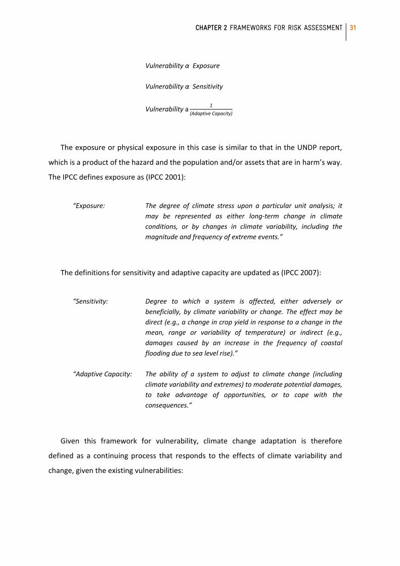
Clearly, in this framework, vulnerability comprises of three components, namely, (1)
the physical exposure, (2) the sensitivity of the system, and (3) its adaptive capacity.
Vulnerability is directly proportional (“α”) to the first two (i.e. if either physical exposure
or sensitivity increase, so does vulnerability), but inversely proportional to the last (i.e. if
adaptive capacity improves, vulnerability will decrease):
CHAPTER 2 FRAMEWORKS FOR RISK ASSESSMENT
31
Vulnerability α Exposure
Vulnerability α Sensitivity
Vulnerability a1
daptive apacity)
The exposure or physical exposure in this case is similar to that in the UNDP report,
which is a product of the hazard and the population and/or assets that are in harm’s way.
The IPCC defines exposure as (IPCC 2001):
“Exposure: The degree of climate stress upon a particular unit analysis; it
may be represented as either long-term change in climate
conditions, or by changes in climate variability, including the
magnitude and frequency of extreme events.”
The definitions for sensitivity and adaptive capacity are updated as (IPCC 2007):
“Sensitivity: Degree to which a system is affected, either adversely or
beneficially, by climate variability or change. The effect may be
direct (e.g., a change in crop yield in response to a change in the
mean, range or variability of temperature) or indirect (e.g.,
damages caused by an increase in the frequency of coastal
flooding due to sea level rise).”
“ daptive apacity: The ability of a system to adjust to climate change (including
climate variability and extremes) to moderate potential damages,
to take advantage of opportunities, or to cope with the
consequences.”
Given this framework for vulnerability, climate change adaptation is therefore
defined as a continuing process that responds to the effects of climate variability and
change, given the existing vulnerabilities:
32 CLUP RESOURCE BOOK
“ daptation: Adjustment in natural or human systems in response to actual or
expected climatic stimuli or their effects, which moderates harm
or exploits beneficial opportunities.”
In contrast, “mitigation” is used specifically to refer to actions that reduce
greenhouse gas emissions:
“Mitigation: An anthropogenic intervention to reduce the anthropogenic
forcing of the climate system; it includes strategies to reduce
greenhouse gas sources and emissions and enhancing
greenhouse gas sinks.”
However, certain mitigation initiatives can also be considered adaptation if they
involve lifestyle or operational adjustments that also lessen sensitivity or build resilience,
coping capacities or adaptive capacities (e.g. improved transportation systems or energy
infrastructure). Both adaptation and mitigation must be integrated in climate change
action planning.
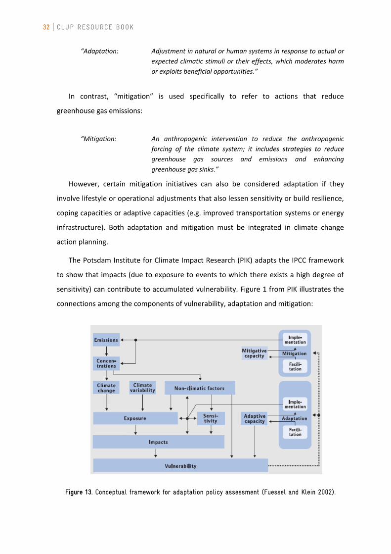
The Potsdam Institute for Climate Impact Research (PIK) adapts the IPCC framework
to show that impacts (due to exposure to events to which there exists a high degree of
sensitivity) can contribute to accumulated vulnerability. Figure 1 from PIK illustrates the
connections among the components of vulnerability, adaptation and mitigation:
Figure 13. Conceptual framework for adaptation policy assessment (Fuessel and Klein 2002).
CHAPTER 2 FRAMEWORKS FOR RISK ASSESSMENT
33
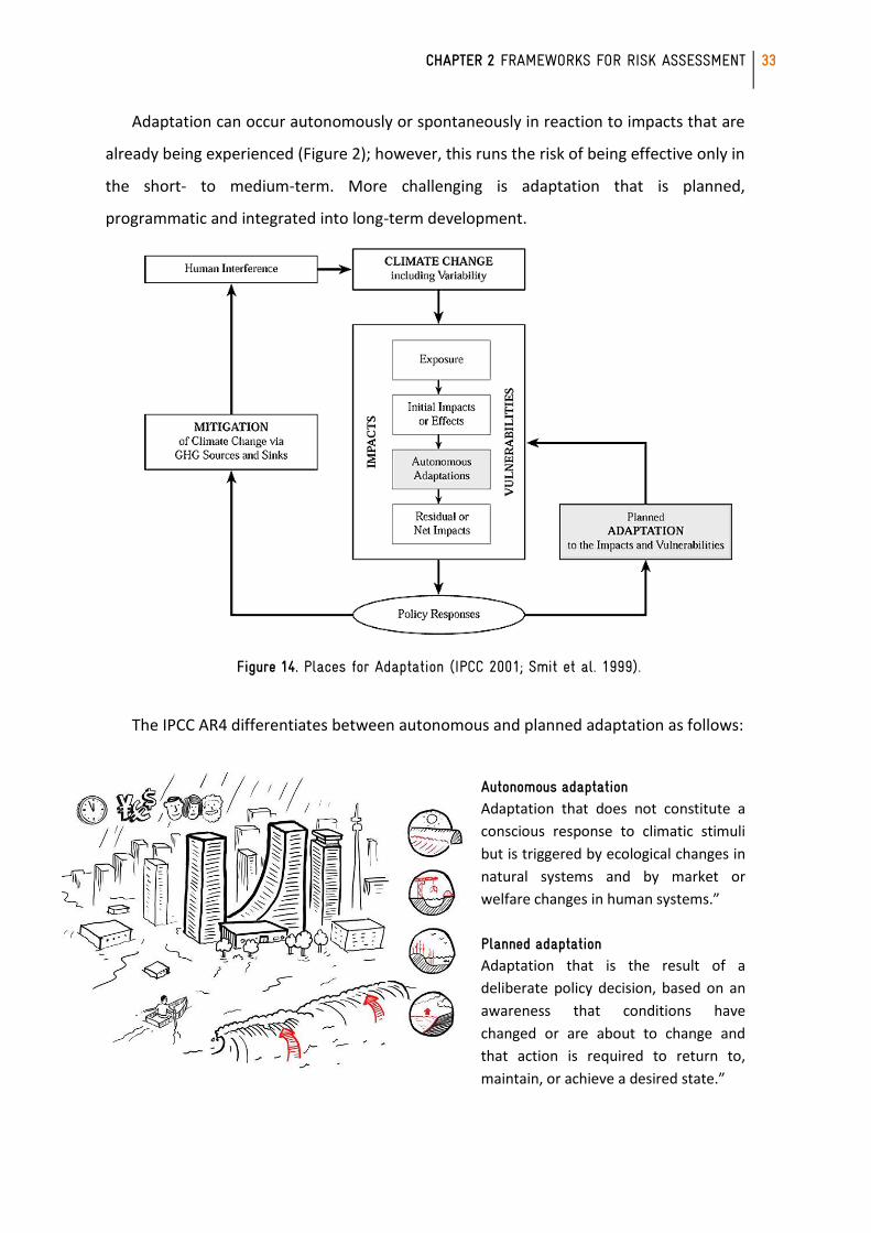
Adaptation can occur autonomously or spontaneously in reaction to impacts that are
already being experienced (Figure 2); however, this runs the risk of being effective only in
the short- to medium-term. More challenging is adaptation that is planned,
programmatic and integrated into long-term development.
Figure 14. Places for Adaptation (IPCC 2001; Smit et al. 1999).
The IPCC AR4 differentiates between autonomous and planned adaptation as follows:
Autonomous adaptation Adaptation that does not constitute a
conscious response to climatic stimuli
but is triggered by ecological changes in
natural systems and by market or
welfare changes in human systems.”
Planned adaptation Adaptation that is the result of a
deliberate policy decision, based on an
awareness that conditions have
changed or are about to change and
that action is required to return to,
maintain, or achieve a desired state.”
34 CLUP RESOURCE BOOK
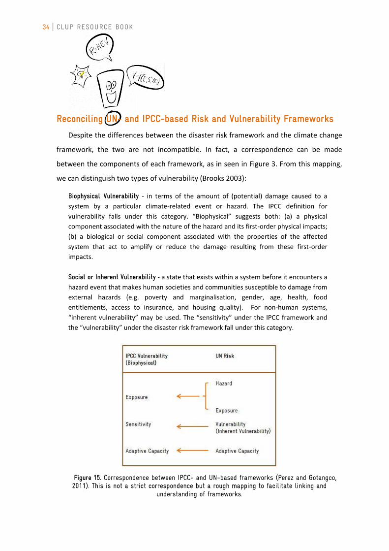
Reconciling UN- and IPCC-based Risk and Vulnerability Frameworks
Despite the differences between the disaster risk framework and the climate change
framework, the two are not incompatible. In fact, a correspondence can be made
between the components of each framework, as in seen in Figure 3. From this mapping,
we can distinguish two types of vulnerability (Brooks 2003):
Biophysical Vulnerability - in terms of the amount of (potential) damage caused to a
system by a particular climate-related event or hazard. The IPCC definition for
vulnerability falls under this category. “Biophysical” suggests both: (a) a physical
component associated with the nature of the hazard and its first-order physical impacts;
(b) a biological or social component associated with the properties of the affected
system that act to amplify or reduce the damage resulting from these first-order
impacts.
Social or Inherent Vulnerability - a state that exists within a system before it encounters a
hazard event that makes human societies and communities susceptible to damage from
external hazards (e.g. poverty and marginalisation, gender, age, health, food
entitlements, access to insurance, and housing quality). For non-human systems,
“inherent vulnerability” may be used. The “sensitivity” under the IPCC framework and
the “vulnerability” under the disaster risk framework fall under this category.
Figure 15. Correspondence between IPCC- and UN-based frameworks (Perez and Gotangco, 2011). This is not a strict correspondence but a rough mapping to facilitate linking and
understanding of frameworks.
CHAPTER 2 FRAMEWORKS FOR RISK ASSESSMENT
35
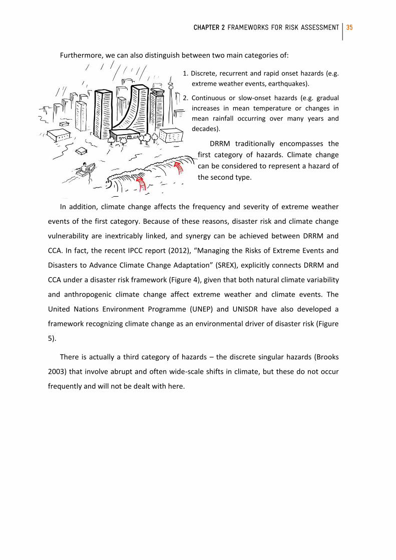
Furthermore, we can also distinguish between two main categories of:
1. Discrete, recurrent and rapid onset hazards (e.g.
extreme weather events, earthquakes).
2. Continuous or slow-onset hazards (e.g. gradual
increases in mean temperature or changes in
mean rainfall occurring over many years and
decades).
DRRM traditionally encompasses the
first category of hazards. Climate change
can be considered to represent a hazard of
the second type.
In addition, climate change affects the frequency and severity of extreme weather
events of the first category. Because of these reasons, disaster risk and climate change
vulnerability are inextricably linked, and synergy can be achieved between DRRM and
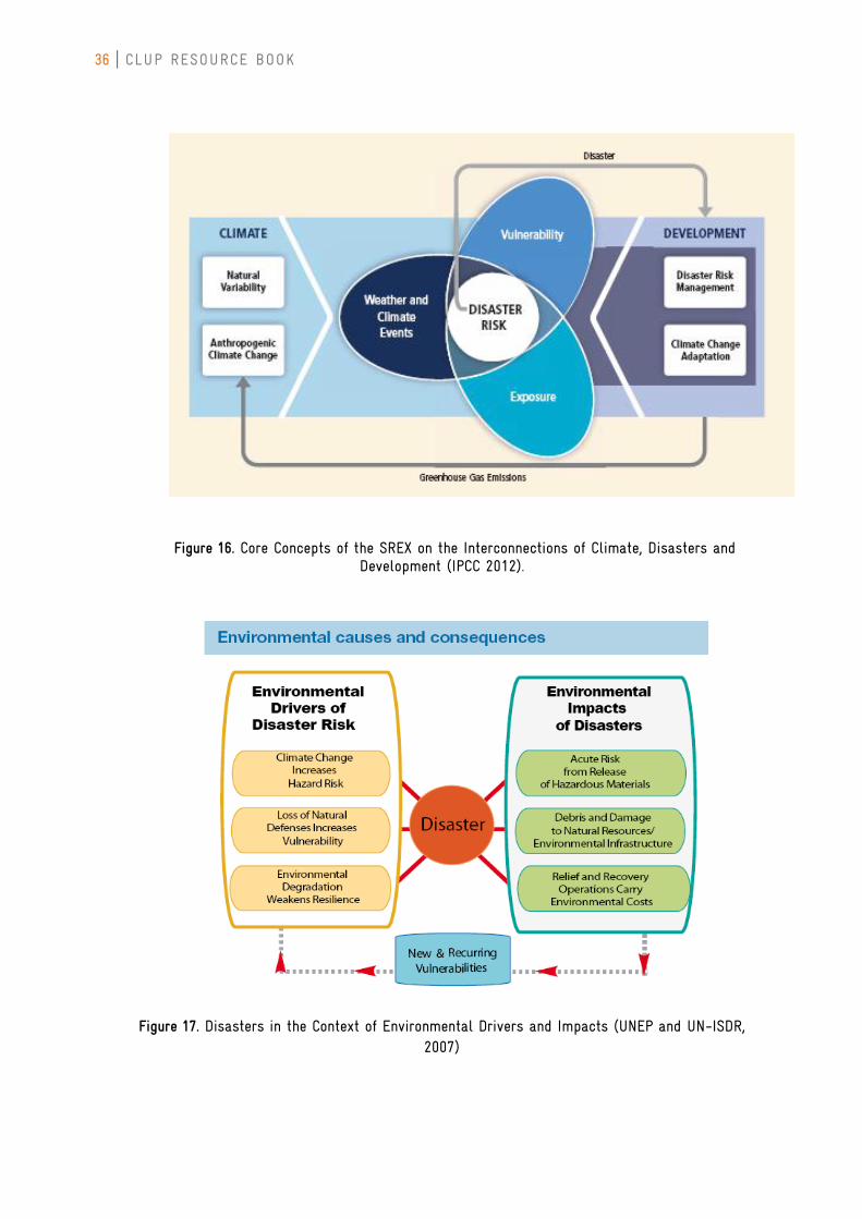
CCA. In fact, the recent IPCC report (2012), “Managing the Risks of Extreme Events and
Disasters to Advance Climate Change Adaptation” (SREX), explicitly connects DRRM and
CCA under a disaster risk framework (Figure 4), given that both natural climate variability
and anthropogenic climate change affect extreme weather and climate events. The
United Nations Environment Programme (UNEP) and UNISDR have also developed a
framework recognizing climate change as an environmental driver of disaster risk (Figure
5).
There is actually a third category of hazards – the discrete singular hazards (Brooks
2003) that involve abrupt and often wide-scale shifts in climate, but these do not occur
frequently and will not be dealt with here.
36 CLUP RESOURCE BOOK
Figure 16. Core Concepts of the SREX on the Interconnections of Climate, Disasters and Development (IPCC 2012).
Figure 17. Disasters in the Context of Environmental Drivers and Impacts (UNEP and UN-ISDR, 2007)
CHAPTER 2 FRAMEWORKS FOR RISK ASSESSMENT
37
The Risk Framework Used in the Resource Book
The framework used in this resource book is that of the R = HEV framework. From the
perspective of land use planning, this was deemed by HLURB to more appropriate and
easier to implement. LGUs already work with hazard maps and are familiar with the
concept of planning for low-, medium- and high-risk areas. In addition, the risk approach
is more consistent with the methods discussed in the NEDA Reference Manual1.
However, the framework is expanded beyond the DRRM realm to include climate change
considerations. This is done through the following:
1. Explicit inclusion of adaptive capacity
The framework for risk can be modified as follows to account for CCAP strategies
that improve long-term capacities to adapt to climate change:
2. Inclusion of gradual climate change into the list of hazards
Hazards can be discrete and recurrent, such as in the case of typhoons and extreme
rainfall events, droughts, landslides and earthquakes. However, hazards can also be
gradual and continuous, such as increases in mean temperatures, changes in rainfall
averages and distribution, sea level rise and coastal erosion. Many of the hazards of
climate change fall into the latter category, and are often neglected when risk analyses
are performed despite the impact they will have on land use. For example, development
along coastal areas should factor in projected changes in sea level and avoid permanent
residential areas where sea level rise becomes high. The allotment of agricultural vis-à-vis
urban areas should consider how yield may be affected by changes in temperature and
precipitation and whether current land dedicated to food production will suffice. In
addition, gradual climate changes may also affect the probability of ecological and
geophysical hazards. For example, development along slopes should account for possible
1 For purposes of reference and comparison, the framework use by the National Economic Development Authority (NEDA) Reference Manual on Mainstreaming DRR/CCA in Comprehensive Land Use Plans, entitled “Integrating Disaster Risk Reduction and Climate Change Adaptation (DRR/CCA) in Local Development Planning and Decision-making Process,” is discussed in Appendix A.
38 CLUP RESOURCE BOOK
changes in rainfall duration and amount that may affect soil quality and stability, and
increase the probability of landslides in the future.
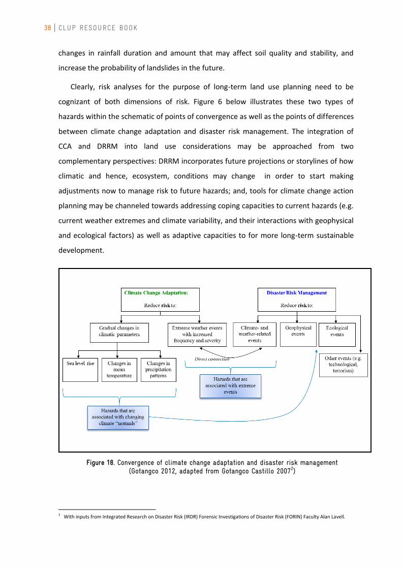
Clearly, risk analyses for the purpose of long-term land use planning need to be
cognizant of both dimensions of risk. Figure 6 below illustrates these two types of
hazards within the schematic of points of convergence as well as the points of differences
between climate change adaptation and disaster risk management. The integration of
CCA and DRRM into land use considerations may be approached from two
complementary perspectives: DRRM incorporates future projections or storylines of how
climatic and hence, ecosystem, conditions may change in order to start making
adjustments now to manage risk to future hazards; and, tools for climate change action
planning may be channeled towards addressing coping capacities to current hazards (e.g.
current weather extremes and climate variability, and their interactions with geophysical
and ecological factors) as well as adaptive capacities to for more long-term sustainable
development.
Figure 18. Convergence of climate change adaptation and disaster risk management (Gotangco 2012, adapted from Gotangco Castillo 20072)
2 With inputs from Integrated Research on Disaster Risk (IRDR) Forensic Investigations of Disaster Risk (FORIN) Faculty Alan Lavell.
CHAPTER 2 FRAMEWORKS FOR RISK ASSESSMENT
39
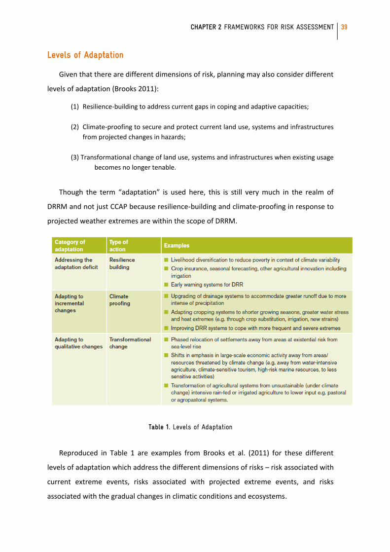
Levels of Adaptation
Given that there are different dimensions of risk, planning may also consider different
levels of adaptation (Brooks 2011):
(1) Resilience-building to address current gaps in coping and adaptive capacities;
(2) Climate-proofing to secure and protect current land use, systems and infrastructures
from projected changes in hazards;
(3) Transformational change of land use, systems and infrastructures when existing usage
becomes no longer tenable.
Though the term “adaptation” is used here, this is still very much in the realm of
DRRM and not just CCAP because resilience-building and climate-proofing in response to
projected weather extremes are within the scope of DRRM.
Table 1. Levels of Adaptation
Reproduced in Table 1 are examples from Brooks et al. (2011) for these different
levels of adaptation which address the different dimensions of risks – risk associated with
current extreme events, risks associated with projected extreme events, and risks
associated with the gradual changes in climatic conditions and ecosystems.
40 CLUP RESOURCE BOOK
CHAPTER 3: CCA & DRRM Entry Points
Building on the results of previous discussions on mainstreaming climate change in
local development plans, the HLURB Central and Regional staff gathered together in
December 2011 to revisit the CLUP Guidelines using a CCA-DRRM lens. The initiative was
spurred by HLURB’s CLUP Zero-Backlog Policy. The writeshop involved orientation on the
conceptual foundations of climate change and disaster risk reduction and management
enriched by the technical expertise and experience of HLURB planners and technical
experts that provided valuable inputs. The gathering resulted in the identification of
entry points of CCA-DRRM in the 12-step CLUP process. Available resources were also
identified to support the mainstreaming process. The entry points and resources are
summarized in the succeeding sections following the format of the modular approach of
the CLUP Cluster Workshops pursued by HLURB.
CHAPTER 4 SECTOR IMPACT CHAIN ANALYSES
41
Preliminary Activities
The preliminary activities collectively encompass the first two steps of the 12-step
CLUP process: Step 1: Getting Organized and Step 2: Identifying the Stakeholders. In the
Cluster Manual, these also include the steps taken to identify the LGUs forming the
cluster for the modular planning workshops, and formalize the agreements between the
LGU and HLURB as the implementer of the cluster approach.
Objectives Output CCA-DRRM Entry Points
To ensure that the needed resources for the planning activities are readily available.
Proposal for CLUP preparation/updating (including work program and budget)
SB/SP resolution approving the proposal for the preparation of CLUP
Identify of the ff. resources to enhance CLUP using the “climate lens”: o Financial/budget
requirements o Availability of resources,
including data sets and information system platforms needed to prepare risk analyses
o Required legislations (or ordinances) to establish MOAs with relevant partner agencies
o Possible need for external assistance, e.g. climate and disaster experts for TWGs
To obtain the commitment, support, and participation of the local executives, Sangguniang Bayan (SB)/Panglunsod (SP) members, Local Development Council (LDC), city/municipal department heads and their staff, and the whole community to the planning activities.
Executive Order designating members of the planning team, Technical Working Group (TWG), etc.
Defined roles/responsibilities of planning team, TWGs
Require representatives from DRRM Office and climate change office of local government in the planning team and TWGs (where it exists)
To establish the guiding
framework and focus of the planning activities.
Planning framework
Include climate change and disaster risk assessment frameworks and adaptation actions monitoring and evaluation frameworks in overall approach to planning.
To identify the key stakeholders and to assess their knowledge, interests and concerns related to the CLUP formulation, and how they might affect or be affected by the plan.
List of identified
stakeholders, their interests and related information.
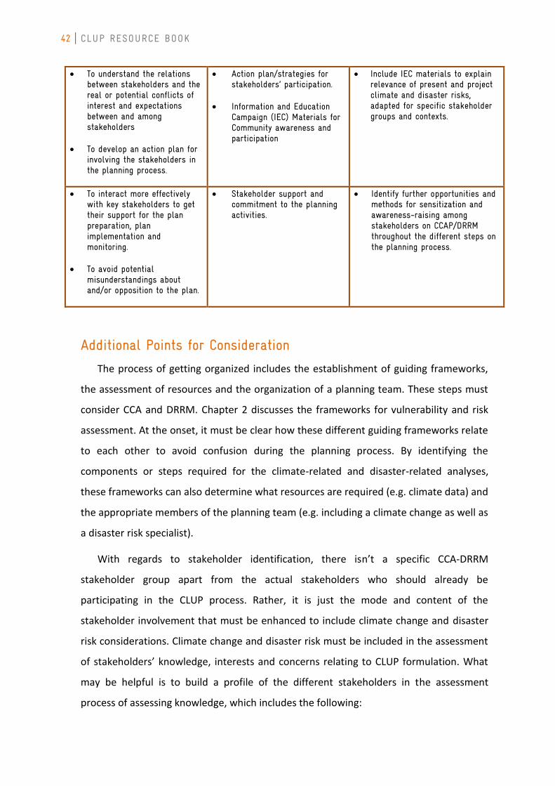
42 CLUP RESOURCE BOOK
To understand the relations between stakeholders and the real or potential conflicts of interest and expectations between and among stakeholders
To develop an action plan for involving the stakeholders in the planning process.
Action plan/strategies for stakeholders’ participation.
Information and Education Campaign (IEC) Materials for Community awareness and participation
Include IEC materials to explain relevance of present and project climate and disaster risks, adapted for specific stakeholder groups and contexts.
To interact more effectively with key stakeholders to get their support for the plan preparation, plan implementation and monitoring.
To avoid potential
misunderstandings about and/or opposition to the plan.
Stakeholder support and commitment to the planning activities.
Identify further opportunities and methods for sensitization and awareness-raising among stakeholders on CCAP/DRRM throughout the different steps on the planning process.
Additional Points for Consideration
The process of getting organized includes the establishment of guiding frameworks,
the assessment of resources and the organization of a planning team. These steps must
consider CCA and DRRM. Chapter 2 discusses the frameworks for vulnerability and risk
assessment. At the onset, it must be clear how these different guiding frameworks relate
to each other to avoid confusion during the planning process. By identifying the
components or steps required for the climate-related and disaster-related analyses,
these frameworks can also determine what resources are required (e.g. climate data) and
the appropriate members of the planning team (e.g. including a climate change as well as
a disaster risk specialist).
With regards to stakeholder identification, there isn’t a specific CCA-DRRM
stakeholder group apart from the actual stakeholders who should already be
participating in the CLUP process. Rather, it is just the mode and content of the
stakeholder involvement that must be enhanced to include climate change and disaster
risk considerations. Climate change and disaster risk must be included in the assessment
of stakeholders’ knowledge, interests and concerns relating to CLUP formulation. What
may be helpful is to build a profile of the different stakeholders in the assessment
process of assessing knowledge, which includes the following:
CHAPTER 4 SECTOR IMPACT CHAIN ANALYSES
43
• How have the stakeholders been affected by climate- and weather-related events
and other disasters in the past? Are stakeholder groups affected differentially,
e.g. directly vs. indirectly affected, extent of damages?
• What is the existing level of knowledge on CCA and DRRM and the relation to
land use within each stakeholder group? What extent of awareness-raising and
orientation is needed?
This profiling can help design the process of stakeholder consultations by allowing
planners to better determine (1) key stakeholders, typologies of stakeholder groups, and
(2) how to customize strategies for stakeholder participation and IEC materials for each
target group. The IEC materials should clearly explain, and to the extent possible,
contextualize, the connections between land use and climate change and disaster risk.
Other Relevant Resources in the Accompanying CD
Directory of experts from national agencies, public and private research institutions, state
universities and colleges
List of available IEC materials
44 CLUP RESOURCE BOOK
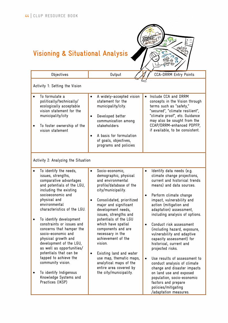
Visioning & Situational Analysis
Objectives Output CCA-DRRM Entry Points
Activity 1: Setting the Vision To formulate a
politically/technically/ ecologically acceptable vision statement for the municipality/city
To foster ownership of the vision statement
A widely-accepted vision statement for the municipality/city.
Developed better communication among stakeholders
A basis for formulation
of goals, objectives, programs and policies
Include CCA and DRRM concepts in the Vision through terms such as “safety,” “secured”, “climate resilient”, “climate proof”, etc. Guidance may also be sought from the CCAP/DRRM-enhanced PDPFP, if available, to be consistent.
Activity 2: Analyzing the Situation To identify the needs,
issues, strengths, comparative advantages and potentials of the LGU, including the existing socioeconomic and physical and environmental characteristics of the LGU.
To identify development constraints or issues and concerns that hamper the socio-economic and physical growth and development of the LGU, as well as opportunities/ potentials that can be tapped to achieve the community vision.
To identify Indigenous Knowledge Systems and Practices (IKSP)
Socio-economic, demographic, physical and environmental profile/database of the city/municipality.
Consolidated, prioritized major and significant development needs, issues, strengths and potentials of the LGU which have spatial components and are necessary in the achievement of the vision.
Existing land and water
use map, thematic maps, analytical maps of the entire area covered by the city/municipality.
Identify data needs (e.g. climate change projections, current and historical trends means) and data sources.
Perform climate change
impact, vulnerability and action (mitigation and adaptation) assessment, including analysis of options.
Conduct risk assessment (including hazard, exposure, vulnerability and adaptive capacity assessment) for historical, current and projected risks.
Use results of assessment to
conduct analysis of climate change and disaster impacts on land use and exposed population, socio-economic factors and prepare policies/mitigating /adaptation measures.
CHAPTER 4 SECTOR IMPACT CHAIN ANALYSES
45
To identify land requirements of the sectors and potential development areas.
Develop/compile CCAP-DRRM-
enhanced profile or database of the city/municipality.
Additional Points for Consideration
The vision clearly sets the tone for what should be achieved in the CLUP development
process, and should therefore acknowledge climate change and disaster risks as part of a
holistic approach.
The vision must be translatable into a concrete plan, therefore, it should be made
clear what descriptors like “climate resilient” or “climate-proofed” mean through the use
of clear indicators that will also be useful in the vision-reality gap analysis.
The Situational Analysis is the step in which the bulk of the climate change and
disaster risk analyses will be performed. However, this need not be too big an additional
burden to the analysis already required. For example, many thematic maps in the
situational analysis are already inputs to impact and vulnerability assessments.
Population and location of assets (e.g. coastal resources, agriculture, and physical
infrastructure) are inputs to Exposure assessment. Maps of poverty indices and other
socio-economic indicators can already contribute to the assessment of Social or Inherent
Vulnerability. Current hazards maps for DRRM analysis are also already included in the
list. Therefore, only a few more additional thematic maps may be needed.
Sample Vision Statement From the CLUP of Silago, Southern Leyte “A leading Agri- eco-tourism destination in the region with a climate resilient, empowered, peace loving, healthy, God fearing, self- reliant, and environment-friendly Silagonhon living in a safe, clean and sustainable environment with a diversified economy governed by competent Civil Servants.”
46 CLUP RESOURCE BOOK
What may be a helpful starting point is to identify potential indicators per component
of the climate change vulnerability and disaster risk analysis. From this list, it will be
easier to identify what thematic maps are already required and what additional ones are
needed to enhance the analysis with climate change and disaster risk lens. These
additional maps (see following samples) might include climate projections (e.g.
temperature change, rainfall change, sea level rise) for 2020 and 2050 or beyond. These
can inform not just the climate change analysis but also the disaster risk analysis in that
these will help determine how weather-related hazards will evolve with climate change
and how they might interact with existing geophysical hazards (e.g. landslides).
In the use of climate projections, however, it must be made clear what climate
scenarios these projections are based on. By “scenario”, we refer to a particular storyline
of how development decisions are made and populations evolve which in turn dictate the
amount of CO2 emissions and the resulting climate change. (A good reference on this is
the IPCC Special Report on Emissions Scenarios:
http://www.grida.no/publications/other/ipcc_sr/?src=/climate/ipcc/emission/. Note,
however, that the fifth assessment report of the IPCC will already be using new scenarios
called Representative Concentration Pathways or RCPs.) The reason that planners need
to know what scenario projections are based on is that they might end up planning for
impacts based on development decisions that are not what are actually taking place. As a
precaution, the worst-case scenarios should typically be used for planning (these are the
A2 family of scenarios in the aforementioned IPCC SRES document).
To summarize, the integration of CCA and DRRM into the analysis would consist of
these general steps:
• Application of risk framework: identifying variables for historical, current and
projected Hazard, Exposure, Vulnerability and Adaptive Capacity, and overlaying
them to produce historical, current and projected Risk maps.
• Impact chain analysis and threshold-setting: given how hazards can create
multiple impacts and given your current capacities and vulnerabilities as an LGU,
what risk levels are manageable? What risk levels are un-manageable? How
might these levels of risk change over time?
• Calculation of available land for development taking into account that some
areas with risk may still be developed if the risk can be managed through some
intervention (e.g. infrastructural, technological adaptive measures) or if the risk
CHAPTER 4 SECTOR IMPACT CHAIN ANALYSES
47
becomes un-manageable only at some future time (in which case, a phased
relocation or transformation will be implemented).
The key competencies required for such analyses would include map reading and
interpretation, RS-GIS skills, climate data analysis and processing, and understanding and
interpretation of climate projections.
Other Relevant Resources in the Accompanying CD
Inventory of Experts
Inventory of data and information sources
Sample CLUPs, maps and case studies
Proposed Outline of Sectoral Report of the CLUP, as presented in the NEDA Reference
Manual
48 CLUP RESOURCE BOOK
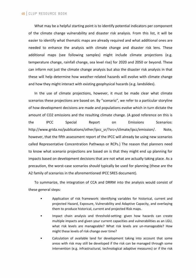
Sample Map: Minimum Data Requirements Regional or Provincial-level climate projections (depending on current availability for the LGU).
Figure 19. Projected Change in Seasonal Mean Temperature for Region 8 (PAGASA, 2011).
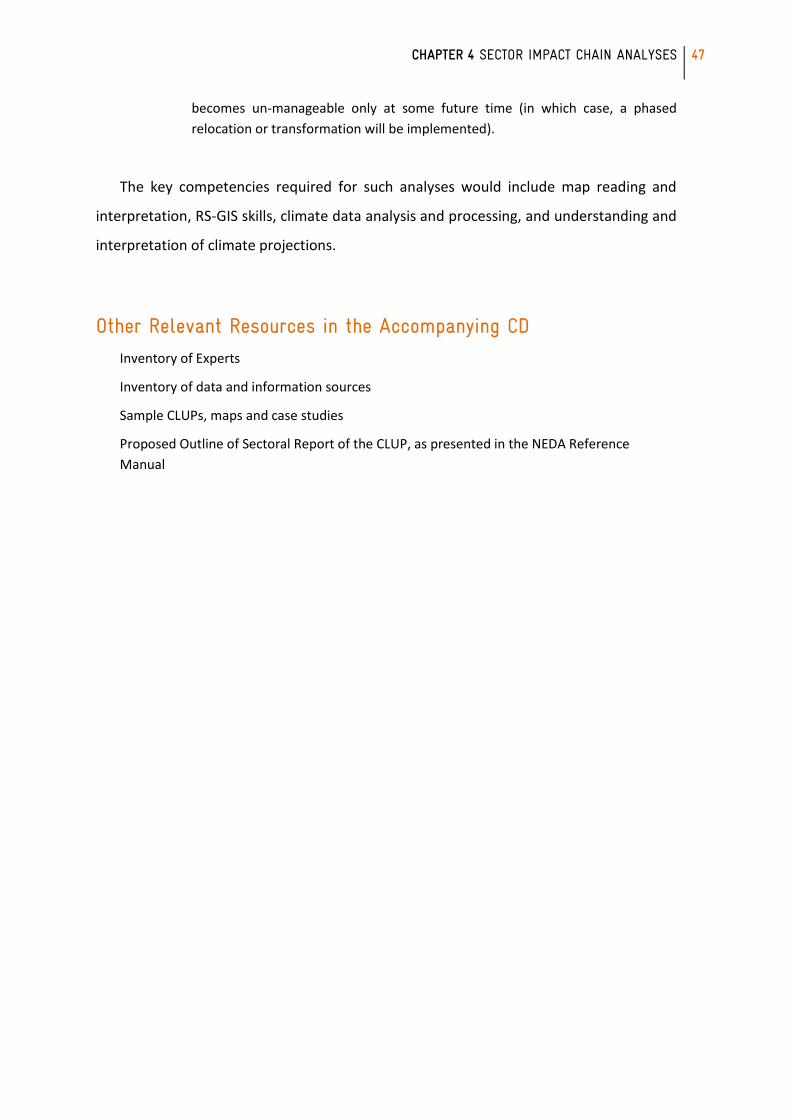
Sample Map: Ideal Data Requirements Downscaled, city/municipality-level climate projections (when available).
Figure 20. Land cover (2009) and projected temperature increase (2020) of Silago, Southern, Leyte
(GIZ-MO-ICRAF, 2010).
CHAPTER 4 SECTOR IMPACT CHAIN ANALYSES
49
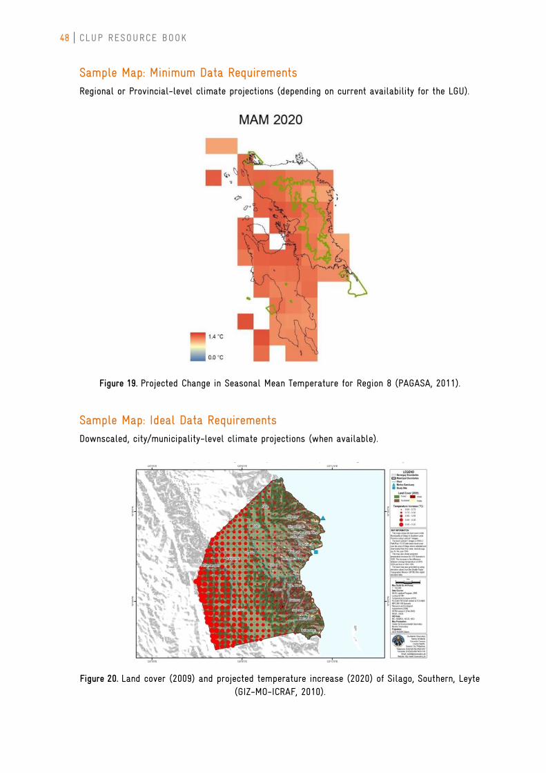
Sample Map: Minimum Data Requirements Provincial, municipal hazard susceptibility map from CSCAND Agencies (e.g. MGB, PhiVolcs).
Figure 21. Palo, Southern Leyte Tsunami Hazard Map (PHIVOLCS, 2007).
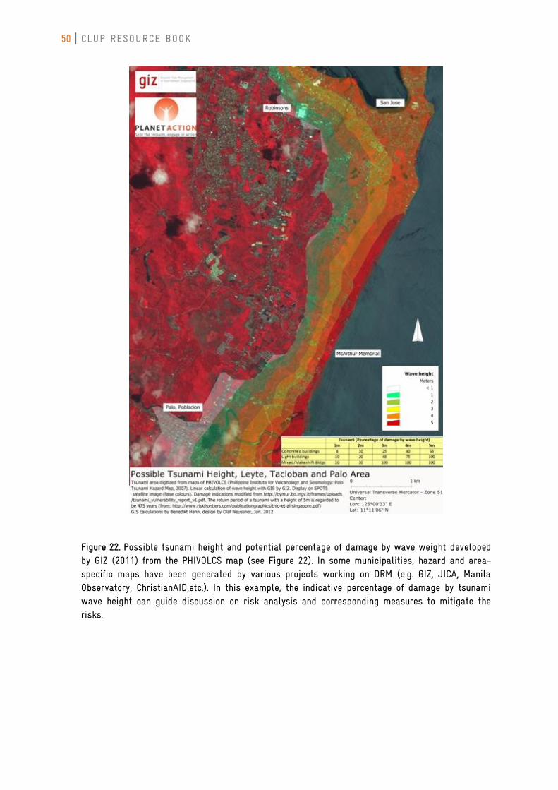
50 CLUP RESOURCE BOOK
Figure 22. Possible tsunami height and potential percentage of damage by wave weight developed by GIZ (2011) from the PHIVOLCS map (see Figure 22). In some municipalities, hazard and area-specific maps have been generated by various projects working on DRM (e.g. GIZ, JICA, Manila Observatory, ChristianAID,etc.). In this example, the indicative percentage of damage by tsunami wave height can guide discussion on risk analysis and corresponding measures to mitigate the risks.
CHAPTER 4 SECTOR IMPACT CHAIN ANALYSES
51
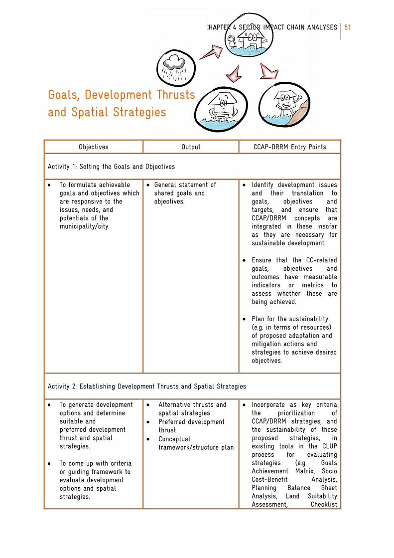
Goals, Development Thrusts and Spatial Strategies
Objectives Output CCAP-DRRM Entry Points
Activity 1: Setting the Goals and Objectives To formulate achievable
goals and objectives which are responsive to the issues, needs, and potentials of the municipality/city.
General statement of shared goals and objectives.
Identify development issues and their translation to goals, objectives and targets, and ensure that CCAP/DRRM concepts are integrated in these insofar as they are necessary for sustainable development.
Ensure that the CC-related goals, objectives and outcomes have measurable indicators or metrics to assess whether these are being achieved.
Plan for the sustainability
(e.g. in terms of resources) of proposed adaptation and mitigation actions and strategies to achieve desired objectives.
Activity 2: Establishing Development Thrusts and Spatial Strategies To generate development
options and determine suitable and preferred development thrust and spatial strategies.
To come up with criteria or guiding framework to evaluate development options and spatial strategies.
Alternative thrusts and spatial strategies
Preferred development thrust
Conceptual framework/structure plan
Incorporate as key criteria the prioritization of CCAP/DRRM strategies, and the sustainability of these proposed strategies, in existing tools in the CLUP process for evaluating strategies (e.g. Goals Achievement Matrix, Socio Cost-Benefit Analysis, Planning Balance Sheet Analysis, Land Suitability Assessment, Checklist
52 CLUP RESOURCE BOOK
To select appropriate or
suitable development thrust or spatial strategies.
criteria and other innovative techniques as may be agreed upon).
Additional Points for Consideration
If CCAP/DRRM was already sufficiently integrated in the situational analysis, then
climate change- and disaster risk-enhanced goals and objectives should naturally arise in
the discussion of possible solutions. Goals and objectives concerning, for example,
environmental protection, sustainable management, improvement of the quality of life,
among others, necessarily have to incorporate CCA and DRRM in order to be responsive
to current and future needs.
The goals and objectives “provide the benchmark by which the land use plan is
formulated, assessed, and evaluated.” Therefore, it is critical to ensure that these are
sustainable and measurable by a group of indicators. An integrated, cross-sectoral
perspective should also be applied in aligning the objectives across different problem
areas so that meeting targets in one sector does not conflict or lead to maladaptation in
another sector. In identifying development issues, there may be opportunity to include
climate change mitigation as well as adaptation goals, for example, if promoting growth
in the industrial or agricultural sector is involved.
CHAPTER 4 SECTOR IMPACT CHAIN ANALYSES
53
The spatial strategies in particular must be guided by medium- (2020) and long-term
(2050) climate projections. It is not enough to screen land suitability according to current
conditions (e.g. already known flooding areas, arid regions, etc.) since these conditions
may change in the future. In addition, not all areas with some level of risk necessarily
have to be avoided when it comes to development. In fact, given the demand for land
area, it may not be practical completely restrict development in all these areas. In the
planning process, areas with manageable risk should be differentiated from areas of high
and difficult-to-manage risk. Risk may be managed, for example, through infrastructural
innovations such as houses on stilts to avoid flooding. Being able to make this distinction
between “manageable” and “unmanageable” risk at certain time periods requires,
however, the determination of thresholds (e.g. level of flooding, strength of earthquakes)
beyond which the community would be unable to cope. Areas experiencing hazards
beyond these thresholds are those to be avoided completely, necessitating, in some
instances, transformational change if relocation is required.
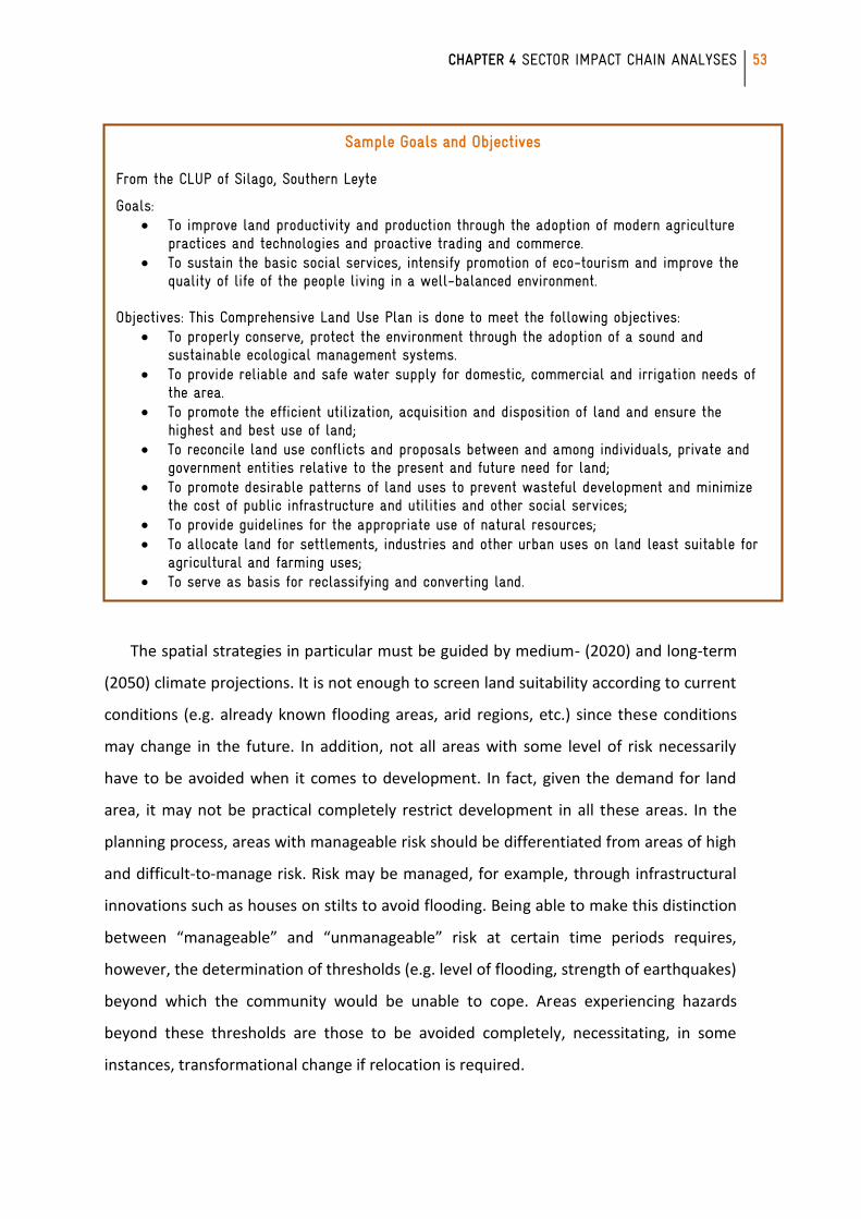
Sample Goals and Objectives From the CLUP of Silago, Southern Leyte
Goals: To improve land productivity and production through the adoption of modern agriculture
practices and technologies and proactive trading and commerce. To sustain the basic social services, intensify promotion of eco-tourism and improve the
quality of life of the people living in a well-balanced environment. Objectives: This Comprehensive Land Use Plan is done to meet the following objectives:
To properly conserve, protect the environment through the adoption of a sound and sustainable ecological management systems.
To provide reliable and safe water supply for domestic, commercial and irrigation needs of the area.
To promote the efficient utilization, acquisition and disposition of land and ensure the highest and best use of land;
To reconcile land use conflicts and proposals between and among individuals, private and government entities relative to the present and future need for land;
To promote desirable patterns of land uses to prevent wasteful development and minimize the cost of public infrastructure and utilities and other social services;
To provide guidelines for the appropriate use of natural resources; To allocate land for settlements, industries and other urban uses on land least suitable for
agricultural and farming uses; To serve as basis for reclassifying and converting land.
54 CLUP RESOURCE BOOK
Other Relevant Resources in the Accompanying CD
Sample research on indicators to be used for goal-setting
Sample research on strategies from pilot areas
Sample risk management strategies for development in low- to medium-risk areas
Sample Strategies From the CLUP of Silago, Southern Leyte
Strategies
Silago’s settlements are mostly concentrated along the coastal flat line, where infrastructures and institutional facilities are located notwithstanding the threats of Climate Change and Natural Disasters. The Future Silago will be overlooking the coastal waters, on a safe terrain and just very near to farmlands. Road Networks and circulation must be like a close circuit not open circuit as shown on the preferred development structure. We have to construct an Upland Road that would connect every end of Farm to Market Roads of every Barangay. This Upland Road will also serve as the delineation or demarcation line between A & D lands and Timber Lands. It will be easy to monitor our environment concerns if the access roads are in place. The religious implementation of the Municipal Environmental Code and the Zoning Ordinance will answer all the environmental problems that hinder Silago’s sustainable development. All stakeholders shall be responsible enough to monitor and implement what is written in the CLUP.
CHAPTER 4 SECTOR IMPACT CHAIN ANALYSES
55
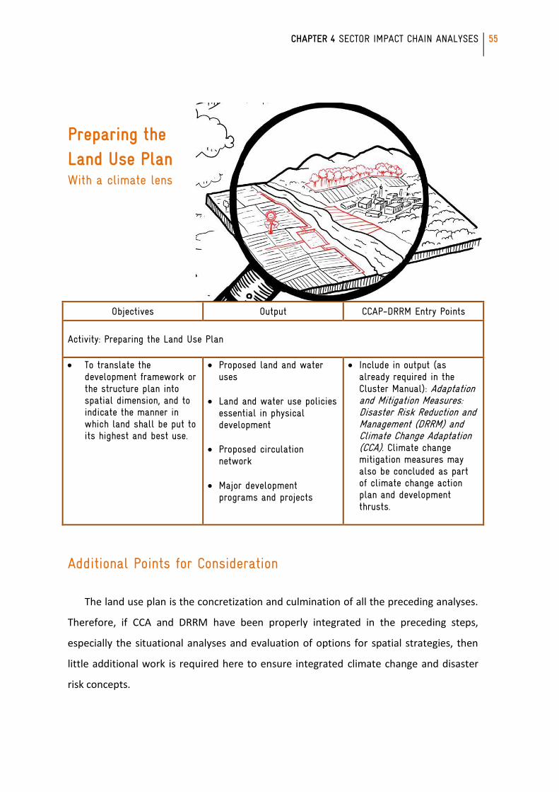
Preparing the Land Use Plan With a climate lens
Objectives Output CCAP-DRRM Entry Points
Activity: Preparing the Land Use Plan To translate the
development framework or the structure plan into spatial dimension, and to indicate the manner in which land shall be put to its highest and best use.
Proposed land and water uses
Land and water use policies essential in physical development
Proposed circulation
network Major development
programs and projects
Include in output (as already required in the Cluster Manual): Adaptation and Mitigation Measures: Disaster Risk Reduction and Management (DRRM) and Climate Change Adaptation (CCA). Climate change mitigation measures may also be concluded as part of climate change action plan and development thrusts.
Additional Points for Consideration
The land use plan is the concretization and culmination of all the preceding analyses.
Therefore, if CCA and DRRM have been properly integrated in the preceding steps,
especially the situational analyses and evaluation of options for spatial strategies, then
little additional work is required here to ensure integrated climate change and disaster
risk concepts.
56 CLUP RESOURCE BOOK
Remember to maintain the “climate (change) lens” in the land supply/demand
analysis. Note from climate projections how quality/type of land might change as climate
changes, e.g. some areas may become drier and not suited for agriculture, so appropriate
land uses might change in the future. Note also that a 2020 projection might have
different implications than a 2050 projection.
This step may also benefit from review / re-assessment: Does the integrated plan
adequately address the situational analysis performed in Step 4? In reviewing whether
the proposed CLUP adequately addresses the situational analysis, a cross-sectoral
perspective must be applied to ensure that policies for one sector do not result in
maladaptation in another. Define also beforehand what criteria can be used for judging
“adequacy”. The PPDO, HLURB and CCC may collaboratively develop and provide
guidelines for reviewing the plan through a “climate (change) lens.”
Other Relevant Resources in the Accompanying CD
Sample CLUPs, maps and case studies
CHAPTER 4 SECTOR IMPACT CHAIN ANALYSES
57
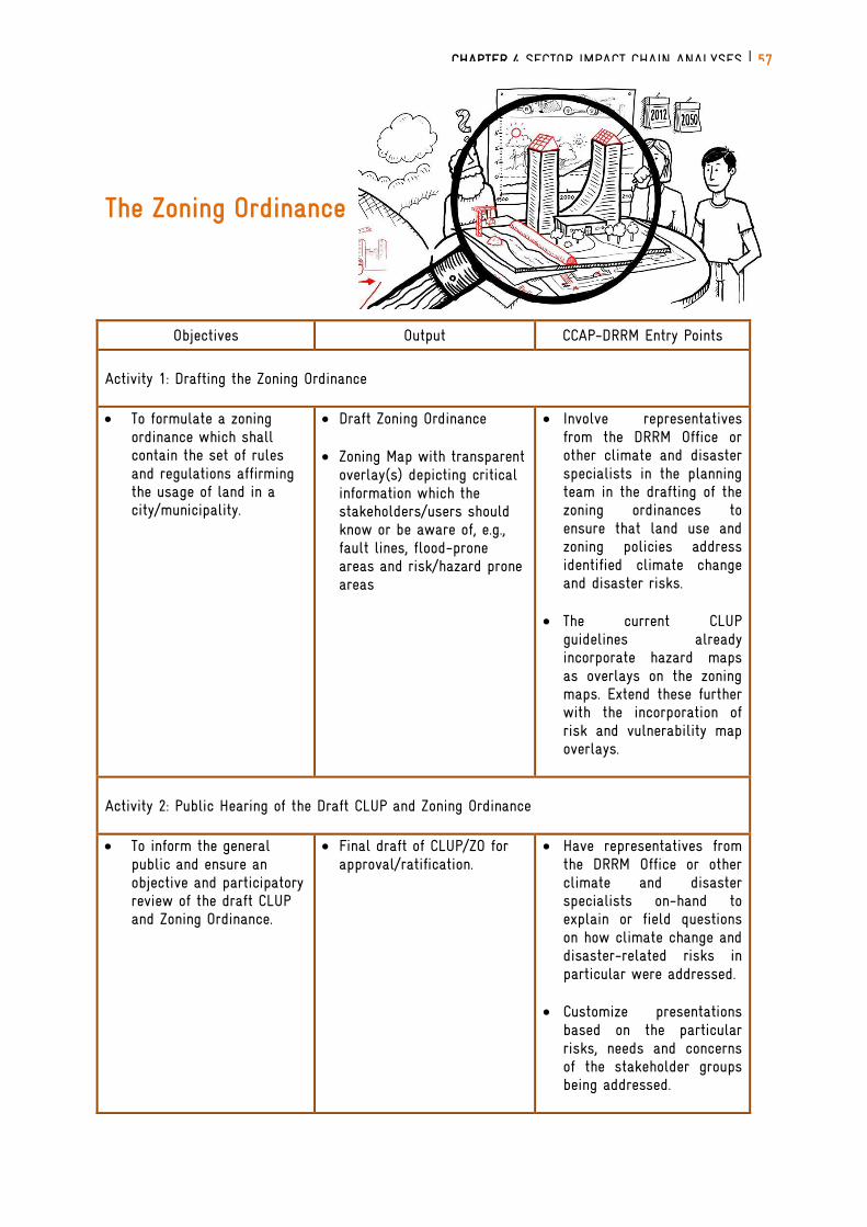
The Zoning Ordinance
Objectives Output CCAP-DRRM Entry Points
Activity 1: Drafting the Zoning Ordinance To formulate a zoning
ordinance which shall contain the set of rules and regulations affirming the usage of land in a city/municipality.
Draft Zoning Ordinance
Zoning Map with transparent overlay(s) depicting critical information which the stakeholders/users should know or be aware of, e.g., fault lines, flood-prone areas and risk/hazard prone areas
Involve representatives from the DRRM Office or other climate and disaster specialists in the planning team in the drafting of the zoning ordinances to ensure that land use and zoning policies address identified climate change and disaster risks.
The current CLUP
guidelines already incorporate hazard maps as overlays on the zoning maps. Extend these further with the incorporation of risk and vulnerability map overlays.
Activity 2: Public Hearing of the Draft CLUP and Zoning Ordinance To inform the general
public and ensure an objective and participatory review of the draft CLUP and Zoning Ordinance.
Final draft of CLUP/ZO for approval/ratification.
Have representatives from the DRRM Office or other climate and disaster specialists on-hand to explain or field questions on how climate change and disaster-related risks in particular were addressed.
Customize presentations based on the particular risks, needs and concerns of the stakeholder groups being addressed.
58 CLUP RESOURCE BOOK
Activity 3: Reviewing, Adopting and Approving the CLUP and Zoning Ordinance To review the CLUP and ZO
in terms of their consistency with national, regional, and other relevant plans, and to provide the legal mandate for their implementation.
Adopted/ ratified CLUP/ZO. Involve representative from climate change office and DRRM Office RLUC/PLUC.
Additional Points for Consideration
In crafting the zoning ordinance, clear criteria should be articulated and used to
evaluate whether the zoning ordinance addresses CCA and DRRM needs identified in the
previous steps. One such criterion should be the flexibility for policies to accommodate
possible shifts in appropriate land uses as climate changes. This is in accordance with the
suggested approach to Situational Analysis which considers projections at different time
periods (e.g. 2020, 2050) for a phased implementation of land use changes.
Likewise, in the review of the CLUP and ZO after the public hearing, the criteria
described above should be applied, and review body should involve experts that can
speak to the adequacy of the climate-proofing (i.e. the translation of climate change
research into impact and vulnerability assessments, then into CCAP strategies and
concrete land use policies).
During the public hearing, the need for the “climate lens” and the enhancement of
the CLUP in accordance with CCA and DRRM considerations need to be communicated to
the public. However, climate change and disaster risk are complex and multi-faceted
issues involving not just the physical dimension but also social, economic, political and
cultural dimensions. Thus, communication of multi-dimensional issues to a multi-
stakeholder using a holistic approach is a competency that must be built within the local
government units.
Other Relevant Resources in the Accompanying CD Sample zoning ordinance
Sample indicators
CHAPTER 4 SECTOR IMPACT CHAIN ANALYSES
59
Implementation and Monitoring
Objectives Output CCAP-DRRM Entry Points
Activity 1: Implementing the CLUP and ZO
To establish detailed operational plans for the implementation of the CLUP and ZO.
To establish institutional mechanisms responsive to the vision, goals and objectives of the CLUP.
To establish partnerships and
cooperation arrangement with stakeholders.
Approved Institutional Structure and Systems and Procedures
Investment Programs Information, Education
and Communication Plan (IEC)/Advocacy
Conduct CCA and DRRM institutional capacity-building activities for offices tasked with coordinating, implementing and monitoring. This will help ensure strict and appropriate translation of the CCAP/DRRM-enhanced CLUP to the Comprehensive Development Plan (CDP).
Activity 2: Monitoring, Reviewing and Evaluating the CLUP
To establish/assess the effectiveness of the CLUP as determined by the quality of life indicators set forth in the vision.
To evaluate conformity of land development projects issued permits and clearances with the approved ZO.
To assess impacts of land
development project issued permits and clearance on the local economy, environment and on social services.
Monitoring system and procedures, and set of indicators for quality of life assessment
Monitoring system and procedures for land use changes
Project Monitoring
Schemes (PMS)
Develop and include contextually appropriate CCA and DRRM indicators in the Monitoring and Evaluation System to continuously assess levels of risk. These indicators should embody the extent to which the desired adaptation mitigation or disaster risk management is being achieved, and should be measured at a frequency able to capture changing trends.
Incorporate results of the monitoring, review and evaluation as feedback for the next cycle of Steps 4 to 6 (of the 12-step CLUP process) as appropriate. The next
60 CLUP RESOURCE BOOK
To ensure completion of program or project being implemented through a systematic and progressive assessment based on timetables, cost and benefits to target groups or outcome.
cycle of situational analysis should also incorporate input from results of the implementation, monitoring and evaluation of CDP.
Additional Points for Consideration
Implementation of the CLUP and ZO will necessarily include the implementation of
policies, procedures, protocols, technologies and other infrastructures designed for
monitoring. It may not be enough to ensure strict implementation – if the CCA and DRRM
strategies were inadequate or flawed from the start, then strict implementation will only
be detrimental to building resilience. Thus, the parallel implementation of monitoring
methods is crucial for determining the effectiveness of the CCA/DRR strategy and
identifying when adjustments are necessary. Monitoring would require the clear
articulation of indicators of milestones achieved in the process of implementation, and of
success/failure of actual bottom-line outcomes. Recall that according to the discussion of
frameworks in Chapter 2, many socio-economic indicators and hazard indicators already
contribute to our understanding of evolving risk and vulnerability so any existing sectoral
indicators being used would already serve this co-benefit.
Though the 12-step process appears to be linear, the tasks of monitoring, reviewing
and evaluating the CLUP and ZO must be continuous, iterative and linked to the
implementation, monitoring and evaluation of the CDP. For this reason, there must be
opportunities to take corrective action on the CLUP when the need for it arises. In this
case, “corrective action” does not only apply to the implementation step. Rather,
adjustments may also be required if climate projections change, or finer-resolution
projections are made available, or other new information, methods or tools come to light
that will affect the situational analysis. Decisions or strategies implemented will also
affect the “baseline” hence the need to continuously re-evaluate CCA/DRR/development
directions.
CHAPTER 4 SECTOR IMPACT CHAIN ANALYSES
61
CHAPTER 4: SECTOR IMPACT CHAIN ANALYSES
The concept of impact chains structures climate-related information on the effects as
a means to understand how climate change may trigger these effects and how these
propagate through a system of interest (unit of analysis, e.g. land resources). A climate
impact chain is a general representation of how a given climate stimulus propagates
through a system of interest via the direct and indirect impacts it entails. A climate
stimulus is a climate-related variable that can cause impacts on human activities and the
environment. In Chapter 1, the concept of impact chain and its analyses were
introduced. Impact chains are also presented in different forms and complexities.
The succeeding sections of this chapter will provide examples of generalized impact
chains relevant to the CLUP sectors with the objective of guiding the sectoral analysis to
support both the technical and participatory assessment towards identifying issues,
potentials and future development needs and spatial requirements of the
city/municipality. Volume 2 of the HLURB CLUP Guidebook indicates that there are three
major sectors of interest: social sector, economic sector and the infrastructure sector.
Table 1 lists the sub-sectors under the major headings. Note that the climate stimuli
maybe the same for each sector/subsectors, but the impacts vary.
The way the sample impact chains are presented also differs, implying that there is
no correct or wrong way of doing the analyses. One can separate the analysis by
subsectors or can link up several subsectors into an integrated analysis right away. The
chains can also show linkages with other sectors.
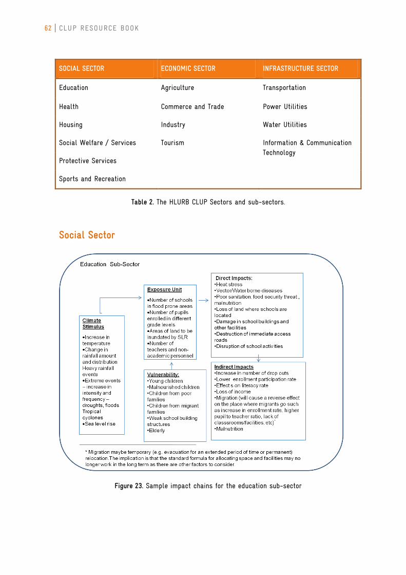
62 CLUP RESOURCE BOOK
SOCIAL SECTOR ECONOMIC SECTOR INFRASTRUCTURE SECTOR
Education Agriculture Transportation
Health Commerce and Trade Power Utilities
Housing Industry Water Utilities
Social Welfare / Services Tourism Information & Communication Technology
Protective Services
Sports and Recreation
Table 2. The HLURB CLUP Sectors and sub-sectors.
Social Sector
Figure 23. Sample impact chains for the education sub-sector
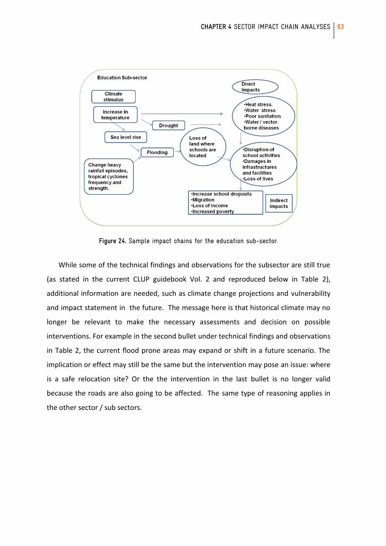
CHAPTER 4 SECTOR IMPACT CHAIN ANALYSES
63
Figure 24. Sample impact chains for the education sub-sector.
While some of the technical findings and observations for the subsector are still true
(as stated in the current CLUP guidebook Vol. 2 and reproduced below in Table 2),
additional information are needed, such as climate change projections and vulnerability
and impact statement in the future. The message here is that historical climate may no
longer be relevant to make the necessary assessments and decision on possible
interventions. For example in the second bullet under technical findings and observations
in Table 2, the current flood prone areas may expand or shift in a future scenario. The
implication or effect may still be the same but the intervention may pose an issue: where
is a safe relocation site? Or the the intervention in the last bullet is no longer valid
because the roads are also going to be affected. The same type of reasoning applies in
the other sector / sub sectors.
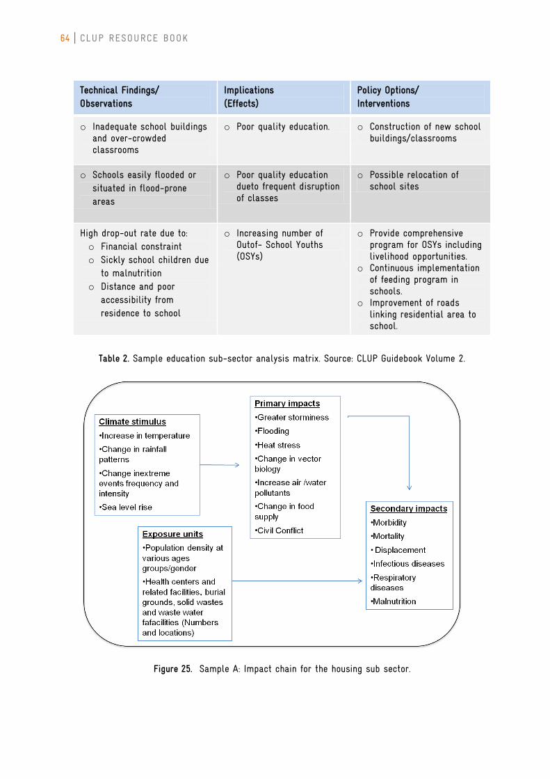
64 CLUP RESOURCE BOOK
Technical Findings/ Observations
Implications (Effects)
Policy Options/ Interventions
o Inadequate school buildings and over-crowded classrooms
o Poor quality education. o Construction of new school buildings/classrooms
o Schools easily flooded or situated in flood-prone areas
o Poor quality education dueto frequent disruption of classes
o Possible relocation of school sites
High drop-out rate due to: o Financial constraint o Sickly school children due
to malnutrition o Distance and poor
accessibility from residence to school
o Increasing number of Outof- School Youths (OSYs)
o Provide comprehensive program for OSYs including livelihood opportunities.
o Continuous implementation of feeding program in schools.
o Improvement of roads linking residential area to school.
Table 2. Sample education sub-sector analysis matrix. Source: CLUP Guidebook Volume 2.
Figure 25. Sample A: Impact chain for the housing sub sector.
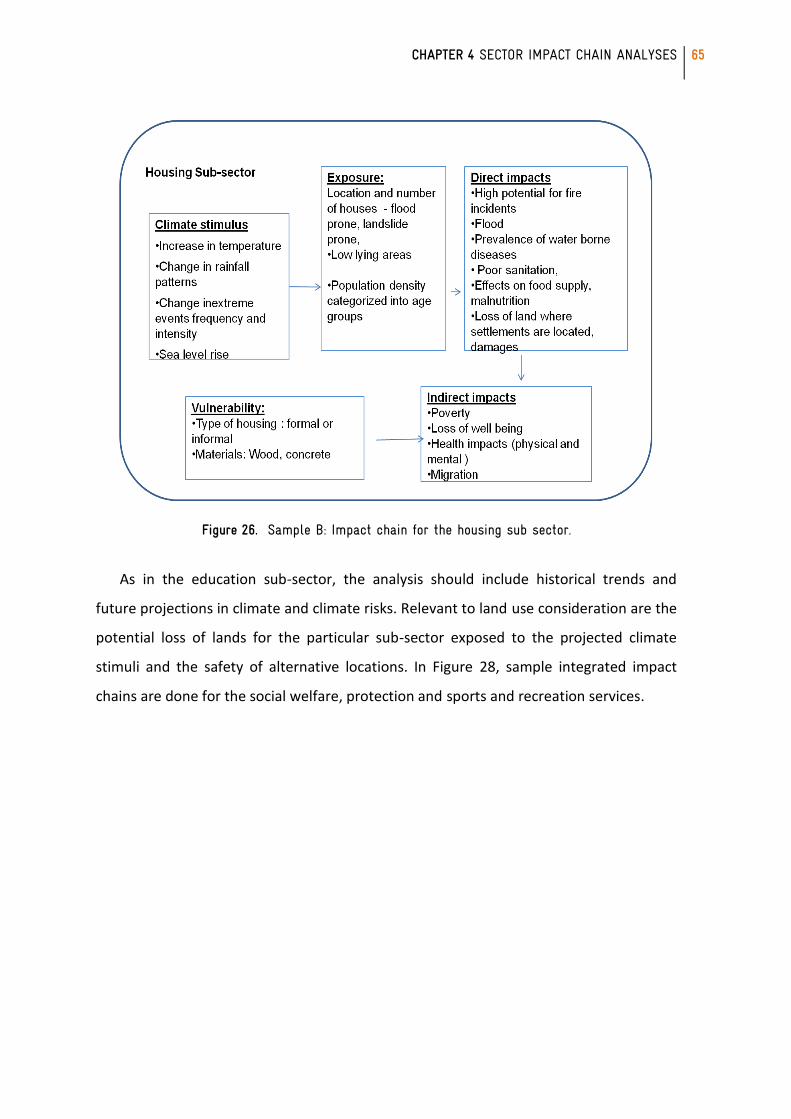
CHAPTER 4 SECTOR IMPACT CHAIN ANALYSES
65
Figure 26. Sample B: Impact chain for the housing sub sector.
As in the education sub-sector, the analysis should include historical trends and
future projections in climate and climate risks. Relevant to land use consideration are the
potential loss of lands for the particular sub-sector exposed to the projected climate
stimuli and the safety of alternative locations. In Figure 28, sample integrated impact
chains are done for the social welfare, protection and sports and recreation services.
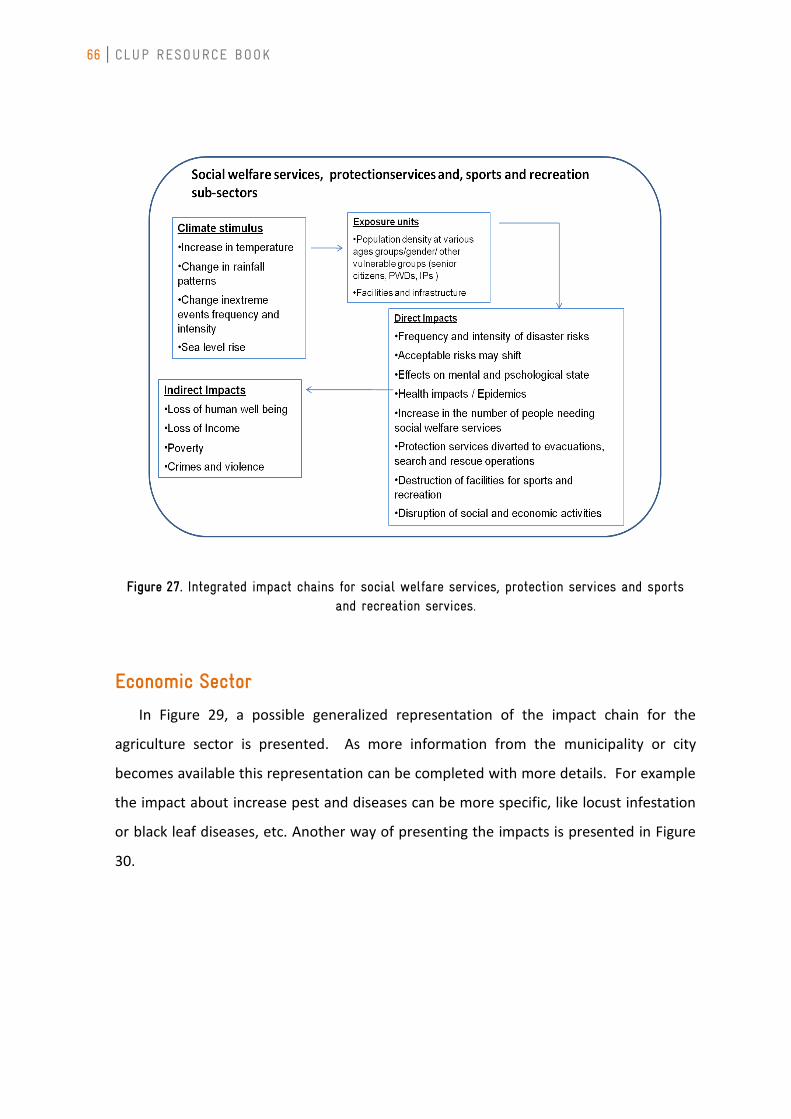
66 CLUP RESOURCE BOOK
Figure 27. Integrated impact chains for social welfare services, protection services and sports and recreation services.
Economic Sector
In Figure 29, a possible generalized representation of the impact chain for the
agriculture sector is presented. As more information from the municipality or city
becomes available this representation can be completed with more details. For example
the impact about increase pest and diseases can be more specific, like locust infestation
or black leaf diseases, etc. Another way of presenting the impacts is presented in Figure
30.
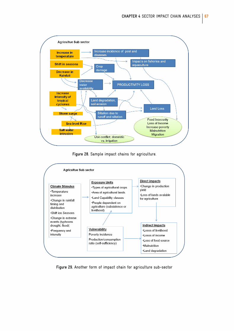
CHAPTER 4 SECTOR IMPACT CHAIN ANALYSES
67
Figure 28. Sample impact chains for agriculture.
Figure 29. Another form of impact chain for agriculture sub-sector
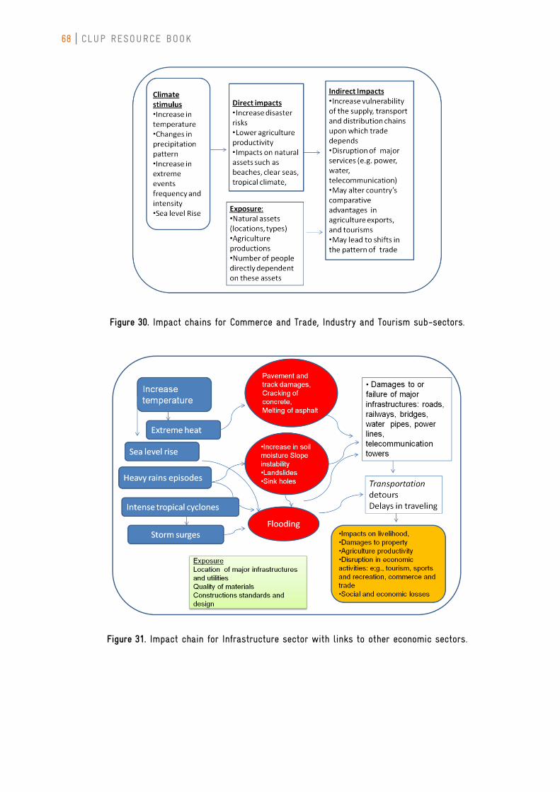
68 CLUP RESOURCE BOOK
Figure 30. Impact chains for Commerce and Trade, Industry and Tourism sub-sectors.
Figure 31. Impact chain for Infrastructure sector with links to other economic sectors.
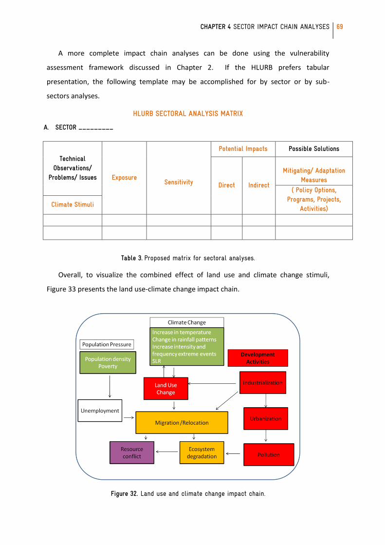
CHAPTER 4 SECTOR IMPACT CHAIN ANALYSES
69
A more complete impact chain analyses can be done using the vulnerability
assessment framework discussed in Chapter 2. If the HLURB prefers tabular
presentation, the following template may be accomplished for by sector or by sub-
sectors analyses.
HLURB SECTORAL ANALYSIS MATRIX
A. SECTOR _________
Technical Observations/
Problems/ Issues Exposure
Sensitivity
Potential Impacts Possible Solutions
Direct Indirect
Mitigating/ Adaptation
Measures
( Policy Options, Programs, Projects,
Activities) Climate Stimuli
Table 3. Proposed matrix for sectoral analyses.
Overall, to visualize the combined effect of land use and climate change stimuli,
Figure 33 presents the land use-climate change impact chain.
Figure 32. Land use and climate change impact chain.

70 CLUP RESOURCE BOOK
[This page is left intentionally blank.}
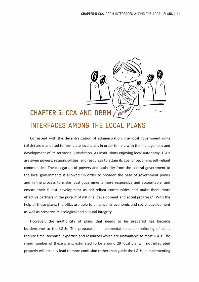
CHAPTER 5 CCA-DRRM INTERFACES AMONG THE LOCAL PLANS 71
CHAPTER 5: CCA AND DRRM
INTERFACES AMONG THE LOCAL PLANS
Consistent with the decentralization of administration, the local government units
(LGUs) are mandated to formulate local plans in order to help with the management and
development of its territorial jurisdiction. As institutions enjoying local autonomy, LGUs
are given powers, responsibilities, and resources to attain its goal of becoming self-reliant
communities. The delegation of powers and authority from the central government to
the local governments is allowed “in order to broaden the base of government power
and in the process to make local governments more responsive and accountable, and
ensure their fullest development as self-reliant communities and make them more
effective partners in the pursuit of national development and social progress." With the
help of these plans, the LGUs are able to enhance its economic and social development
as well as preserve its ecological and cultural integrity.
However, the multiplicity of plans that needs to be prepared has become
burdensome to the LGUs. The preparation, implementation and monitoring of plans
require time, technical expertise and resources which are unavailable to most LGUs. The
sheer number of these plans, estimated to be around 29 local plans, if not integrated
properly will actually lead to more confusion rather than guide the LGUs in implementing
72 CLUP RESOURCE BOOK
its mandate. Each LGU should therefore understand each plan as well as its
corresponding goals and objectives, in order for the LGU to ultimately achieve its vision.
This reality emphasizes the need for integration and further harmonization of the
different local plans. There are previous issuances on harmonization and even
synchronization that aims to provide such guidance but these remains insufficient to
encompass all the local plans especially in relation to climate change adaptation (CCA)
and disaster risk reduction (DRR).
The Local Plans and their Purposes
The local physical and development plans of the LGUs include the PDPFP, CLUP, CDP
and BDP:
The Provincial Development and Physical Framework Plan (PDPFP) is defined as a
document formulated at the provincial level that merges the traditionally separated
provincial physical framework plan and provincial development plan. The plans were
merged in order to address the disconnect between spatial and sectoral factors, and
between medium and long term concerns. The PDPFP embodies the long term vision of
the province. It determines the development goals, strategies, objectives or targets and
corresponding Programs, Projects and Activities (PPAs) of the province, which serve as
primary inputs to the provincial investment programming and subsequent budgeting plan
and implementation.
The Comprehensive Development Plan (CDP) is the document that pertains to the
multi-sectoral plan formulated at the city or municipal level. It embodies the vision,
sectoral goals, objectives, development strategies and policies of the LGU at the medium-
term and within the term of its local officials5. It contains the PPAs, which serve as
primary inputs to investment programming and subsequent budgeting and
implementation of projects of the LGU. It is comprehensive because it covers the five
development sectors, namely: Social, Economic, Environment, Physical or Infrastructure,
and Institutional6. It is referred to as the LGU’s action plan for development.
The Barangay Development Plan (BDP) is a document that pertains to the multi-
sectoral development plan formulated at the barangay level. It embodies the vision,
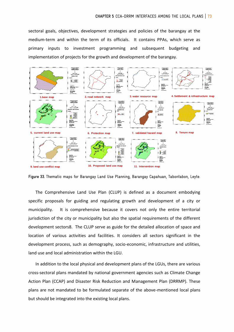
CHAPTER 5 CCA-DRRM INTERFACES AMONG THE LOCAL PLANS 73
sectoral goals, objectives, development strategies and policies of the barangay at the
medium-term and within the term of its officials. It contains PPAs, which serve as
primary inputs to investment programming and subsequent budgeting and
implementation of projects for the growth and development of the barangay.
Figure 33. Thematic maps for Barangay Land Use Planning, Barangay Capahuan, Tabontabon, Leyte.
The Comprehensive Land Use Plan (CLUP) is defined as a document embodying
specific proposals for guiding and regulating growth and development of a city or
municipality. It is comprehensive because it covers not only the entire territorial
jurisdiction of the city or municipality but also the spatial requirements of the different
development sectors8. The CLUP serve as guide for the detailed allocation of space and
location of various activities and facilities. It considers all sectors significant in the
development process, such as demography, socio-economic, infrastructure and utilities,
land use and local administration within the LGU.
In addition to the local physical and development plans of the LGUs, there are various
cross-sectoral plans mandated by national government agencies such as Climate Change
Action Plan (CCAP) and Disaster Risk Reduction and Management Plan (DRRMP). These
plans are not mandated to be formulated separate of the above-mentioned local plans
but should be integrated into the existing local plans.
Example: Thematic Maps for Barangay Land Use Planning
1.base map 2. road network map 3. water resource map 4. Settlement & infrastructure map
5. current land use map 6. Protection map 7. validated hazard map 8. Tenure map
9. land use conflict map 10. Proposed land use map 11. Intervention map
Reference: BondoCKonsult- PLUDP Training for MITs, Leyte Island, 2010
74 CLUP RESOURCE BOOK
The Climate Change Action Plan (CCAP) refers to a plan formulated by the
Government to address climate change concerns. The National Climate Change Action
Plan (NCCAP) is formulated by the Climate Change Commission, while the Local Climate
Change Action Plan (LCCAP) is formulated by the local government units.
The Disaster Risk Reduction and Management Plan (DRRMP) refers to a document
that sets out goals and specific objectives for reducing disaster risks together with related
actions to accomplish these objectives. The National Disaster Risk Reduction and
Management Plan (NDRRMP) is formulated and implemented by the Office of Civil
Defense. The NDRRMP shall provide for the following: the identification of hazards,
vulnerabilities and risks to be managed at the national level; disaster risk reduction and
management approaches and strategies to be applied in managing said hazards and risks;
agency roles, responsibilities and lines of authority at all government levels; and vertical
and horizontal coordination of disaster risk reduction and management in the pre-
disaster and post-disaster phases. The Local Disaster Risk Reduction and Management
Plan (LDRRMP) is formulated and implemented by the Local Disaster Risk Reduction and
Management Office (LDRRMO), and it is approved and monitored by the Local Disaster
Risk Reduction and Management Council (LDRRMC). The LDRRMC shall also evaluate the
implementation of the LDRRMPs and regularly review and evaluate the plans’
consistency with other national and local planning programs.
Interrelationship of the Different Local Plans
All of these plans are necessary and indispensable in the governance of the Local
Government Unit. The common denominator for all these plans is that all of them should
be geared towards the realization of the Vision of the LGUs. In many guide books,
visioning is usually incorporated. Should the LGU already have a vision statement, such
shall suffice and be used as guide for all the plans that the LGUs wish to formulate,
although crafting a vision statement is said to be proper during the preparation of the
CLUP for the cities and the municipalities. As for the province, it will not be a problem
since the guidelines have already merged the PPFP and the PDP into the PDPFP, thus the
crafting of a vision statement should occur during the preparation of the PDPFP.
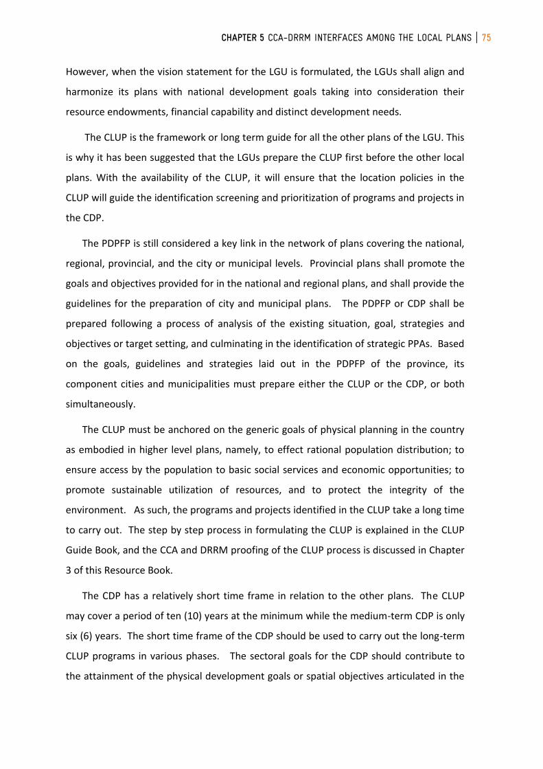
CHAPTER 5 CCA-DRRM INTERFACES AMONG THE LOCAL PLANS 75
However, when the vision statement for the LGU is formulated, the LGUs shall align and
harmonize its plans with national development goals taking into consideration their
resource endowments, financial capability and distinct development needs.
The CLUP is the framework or long term guide for all the other plans of the LGU. This
is why it has been suggested that the LGUs prepare the CLUP first before the other local
plans. With the availability of the CLUP, it will ensure that the location policies in the
CLUP will guide the identification screening and prioritization of programs and projects in
the CDP.
The PDPFP is still considered a key link in the network of plans covering the national,
regional, provincial, and the city or municipal levels. Provincial plans shall promote the
goals and objectives provided for in the national and regional plans, and shall provide the
guidelines for the preparation of city and municipal plans. The PDPFP or CDP shall be
prepared following a process of analysis of the existing situation, goal, strategies and
objectives or target setting, and culminating in the identification of strategic PPAs. Based
on the goals, guidelines and strategies laid out in the PDPFP of the province, its
component cities and municipalities must prepare either the CLUP or the CDP, or both
simultaneously.
The CLUP must be anchored on the generic goals of physical planning in the country
as embodied in higher level plans, namely, to effect rational population distribution; to
ensure access by the population to basic social services and economic opportunities; to
promote sustainable utilization of resources, and to protect the integrity of the
environment. As such, the programs and projects identified in the CLUP take a long time
to carry out. The step by step process in formulating the CLUP is explained in the CLUP
Guide Book, and the CCA and DRRM proofing of the CLUP process is discussed in Chapter
3 of this Resource Book.
The CDP has a relatively short time frame in relation to the other plans. The CLUP
may cover a period of ten (10) years at the minimum while the medium-term CDP is only
six (6) years. The short time frame of the CDP should be used to carry out the long-term
CLUP programs in various phases. The sectoral goals for the CDP should contribute to
the attainment of the physical development goals or spatial objectives articulated in the
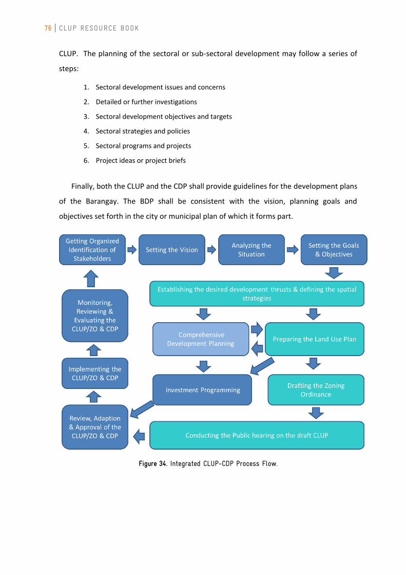
76 CLUP RESOURCE BOOK
CLUP. The planning of the sectoral or sub-sectoral development may follow a series of
steps:
1. Sectoral development issues and concerns
2. Detailed or further investigations
3. Sectoral development objectives and targets
4. Sectoral strategies and policies
5. Sectoral programs and projects
6. Project ideas or project briefs
Finally, both the CLUP and the CDP shall provide guidelines for the development plans
of the Barangay. The BDP shall be consistent with the vision, planning goals and
objectives set forth in the city or municipal plan of which it forms part.
Figure 34. Integrated CLUP-CDP Process Flow.

CHAPTER 5 CCA-DRRM INTERFACES AMONG THE LOCAL PLANS 77
CCA and DRRM
Aside from the physical and development plans required by law, the Climate Change
Law or Republic Act No. 9729 further required the LGUs to be the frontline agencies in
the formulation, planning and implementation of climate change action plans in their
respective areas in order to prevent and reduce the adverse impacts of climate change
and, at the same time, to maximize the benefits of climate change. The Disaster Risk
Reduction and Management Act (Republic Act No. 10121) on the other hand, requires
that each LGU formulate and implement a comprehensive and integrated LDRRMP in
accordance with the national, regional and provincial framework, and policies on disaster
risk reduction in close coordination with the local development councils (LDCs). Since
climate change and disaster risk reduction are closely interrelated, and effective disaster
risk reduction will enhance climate change adaptive capacity, the State shall integrate
disaster risk reduction into climate change programs and initiatives.
While both laws do not specifically provide that CCA and DRRMP should be integrated
into the existing required physical and development plans, it is the policy of the state
however to integrate the concept of climate change and disaster risk reduction in
various phases of policy formulation and development plans in various levels of
government. It is also the policy of the State to mainstream disaster risk reduction and
climate change in development processes such as policy formulation, socioeconomic
development planning, budgeting, and governance, particularly in the areas of
environment, agriculture, water, energy, health, education, poverty reduction, land-use
and urban planning, and public infrastructure and housing, among others.
CLUP: Interfaces among the PDPFP, CDP and BDP
The PDPFP is identified as an important link in the network of plans covering the
national (with regional and provincial), as well as the local (city or municipal levels). It
could be the most effective channel for cascading information and technology to all
levels of local government given that it is at the apex of the 3-tier local government
system. Furthermore, the key officers of the province, the governor and the
78 CLUP RESOURCE BOOK
Sangguniang Panlalawigan, are the vital links between the Region and its component
LGUs38. As a member of the Regional Development Council (RDC), the governor can
easily infuse CCA and DRR into the PDPFP based on the Regional Framework. The
Sangguniang Panlalawigan on the other hand, because of their power of automatic
review of all policies and actions of component LGUs, can ensure that the Climate Change
and Disaster Risk Reduction-proof PDPFP can be reconciled and integrated with the plans
of the component LGUs.
However, it is the CLUP that holds prominent connection among the local plans. CLUP
formation in fact adopts a combined top to bottom and bottom-up approach, wherein:
for the top to bottom approach, the CLUP utilizes the basis and framework of the PDPFP
and considers the goals and objectives of the PDPFP. The CLUP likewise details the land
use allocation already categorized in the provincial plans; and for the bottom-up
approach, the CLUP integrates the BDPs into the city or municipal plan to harmonize the
development goals and objectives of all barangays in cities or municipalities. As the
framework of the CDP, the CLUP uses the CDP as its implementing instrument and the
action plan for the local territory’s development.
Compared to the other local plans, the CLUP is a more permanent plan because of its
legally binding status after its enactment into a Zoning Ordinance. This status ensures the
continuity of the strategies and programs covered by the CLUP regardless of the periodic
changes of elective local officials and their platform of programs and priorities. The CLUP
is indeed a long term plan that can best serve as springboard for the integration of cross-
sectoral concerns such as climate change and disaster risk management. As discussed in
Chapter 3, each of the 12 steps in the CLUP preparation is an important entry point for
CCA and DRRM. The climate proofing of the CLUP can be a strategic opportunity to
mainstreaming CCA and DRRM to the other local plans.
To genuinely mainstream CCA and DRRM into the different physical and development
plans (whether PDPFP, CLUP, CDP or BDP), the local government units should be aware of
the interfaces where CCA and DRRM can be infused into these plans. While it can be
argued that CCA and DRRM cuts across all the planning steps and process in formulating
these plans, it is necessary however to identify these interfaces which shall be the
strategic points wherein CCA and DRRM can be optimally mainstreamed.
CHAPTER 5 CCA-DRRM INTERFACES AMONG THE LOCAL PLANS 79
Visioning
As discussed earlier in this chapter, there shall always be one vision for all the
different plans. While it is not expected to explicitly include CCA and DRR terms in the
vision statement, it is a must however that whoever is tasked to formulate the vision of
the LGU should be conscious of the National Framework Strategy on Climate Change.
LDRRMOs should also take active part in the visioning process as to provide inputs on
CCA and DRR.
It is important to saturate the planning process of the LGUs with CCA and DRR
frameworks in a stage as early as “Visioning” because by doing so, LGUs become aware
that their overall goal is the attainment of their vision that should not be hindered by
climate change and disasters. A vision of a city that is peaceful and safe from crime will
never be meaningful if its constituents are constantly pestered by floods and landslide.
Data Gathering and Situation Analysis
In this indispensable step, those who are tasked to provide technical inputs should
provide a complete set of data especially those that relates to climate change
vulnerability and disaster risks of the particular local territory. The local government
officials should be educated on Climate Change and Disaster Risk Reduction, in order to
be resilient and be prepared. They should likewise be open and accept the real state of
their territorial jurisdiction.
To illustrate, in the preparation of the CDP and the BDP, the CCA and DRR lens should
clearly reflect the effects of climate change and disaster that will be felt across all sectors
(whether social, economic, physical, environmental management or institutional). The
sectoral impact chain analysis should be very clear in the identification of the sectoral
development issues and concerns. The sectoral impact chain analysis will be a great input
in providing a truthful and holistic analysis of the situation of the LGU.
80 CLUP RESOURCE BOOK
Formulate Goals, Objectives, and Targets
The identified goals, objectives and targets should be responsive to the issues, needs,
and potentials of the locality. Given the exposure, sensitivity and adaptive capacity of the
particular locality identified during the data gathering and situation analysis, the LGU can
visualize an accurate picture of how CCA and DRRM can address these vulnerabilities.
This should result in a methodological formulation of goals, objectives and targets that
will help the LGU achieve its vision.
Draft Strategies, Programs, Projects and Activities
Programs, projects and activities (PPAs) should be tested thoroughly against the
framework of CCA and DRR. Even activities that do not necessarily relate to Climate
Change Adaptation or to Disaster Risk Reduction Management should still be evaluated
so as not to increase the risk, hazards and exposure of the LGU. The PPAs will help the
LGUs adapt, mitigate or manage the risk, hazards and exposure of the localities and
should not aggravate the existing situation. PPAs should be a logical result of a thorough
data gathering and a truthful situation analysis. The sectoral impact chain analysis will
also ensure that PPAs that will be included in the local plans shall have been seen
through the CCA and DRR lens.
Monitoring and Evaluation
The Step of Monitoring and Evaluation (M&E) forms an essential part of the regular
function of the local planning structure. It involves the coordination, monitoring and
evaluation of the development programs and projects of the LGUs. While it may be
seemingly seen as the final step in the planning and implementation process, it in fact
initiates a new cycle of local planning and implementation. As an iterative process, the
monitoring and evaluation ensures the systematic monitoring of the local plans and the
continuity of the planning process as it is a necessary step in restarting the whole cycle of
the process.
The M&E process should be an integrative and harmonious process that involves the
assessment of the effectiveness of the plan, and the over-all impact of the plan’s
strategies, programs, projects and activities. The plan should be thoroughly tested
CHAPTER 5 CCA-DRRM INTERFACES AMONG THE LOCAL PLANS 81
looking at whether each and every strategy, program, project and activity had been
implemented or not. In this process, the primary question should be whether or not the
planned PPAs were implemented? Accordingly, the next question should be “why?”—
why was it implemented or why was it not implemented? These questions would be very
helpful if the LGU would reflect when it endeavors to provide an answer. The LGU should
ascertain its strengths and weaknesses that contributed to the implementation or non-
implementation of the PPAs, as well as the opportunities and threats which facilitated or
hindered the implementation thereof.
During this process of monitoring and evaluation, it is assumed that the LGUs’ plans
had been prepared within the framework of CCA and DRR. If it is so, the monitoring and
evaluation would be consistent with the given framework and would definitely reflect the
strengths of the LGU in implementing its PPAs. If the CCA and DRR framework were
weak in the planning process, it will definitely manifest as a weakness of the LGU which
may contribute to the non-implementation of the PPAs. However, it does not mean that
the CCA and DRR framework used in the previous planning process should be static. The
M&E process also includes the assessment and evaluation of the CCA and DRR
framework utilized. This can be specifically done by evaluating the opportunities and
threats that the LGUs faced in implementing its PPAs. The LGU can basically ask— what
sort of changes in the climate affected the implementation of its PPAs? What sort of
disasters came about during the period of implementation of the plan?
After thoroughly reviewing each and every strategy, program, project and activities,
the LGUs should not forget to assess whether or not its goals, objectives and targets were
reached. It is then that why or why not, should be correspondingly asked. Again these
processes should be conducted within the framework of CCA and DRR by asking whether
there were changes in the climate and/or disasters that made the attainment of the
goals, objectives and targets impossible.
In monitoring and evaluating the local plans and its corresponding PPAs, the LGU
should make sure that the criteria for evaluation should follow the frameworks on CCA
and DRR. The CCA and DRR framework in the local plans will ensure that the LGUs can
plan on how to implement their activities and achieve their goals despite changes in the
climate and the risk of disasters. As the M&E system includes CCA Indicators and
82 CLUP RESOURCE BOOK
mechanisms that can continually monitor level of disaster risks and Climate Change
effects and emerging threats, the information derived from the M&E can be used to
identify the areas where the CCA and DRR requires further focus and specify which needs
further updating.
The M&E links the planning cycles and thereby results to new information and
opportunities. LGUs need to thoroughly monitor and evaluate its plans to provide the
LGUs with these new data, and a new opportunity to analyze the new (and revised)
situation. These new data and opportunity commences anew the cycle of planning. The
new information can come from: the assessment of the impacts of the PPAs, the effects
of regulatory measures as enforced, or the outcomes of land use allocations and
developments.
The M&E process ensures the continued relevance of the local plans. With the
continuous assessment and evaluation, the local plans endeavors to be reflective of the
needs of the people and the territories’ adaptive to its vulnerability to climate change
and disasters.
ANNEX 83
ANNEX A. THE NEDA FRAMEWORKS FOR RISK At the provincial planning level, initiatives to mainstream disaster risk reduction (DRR) and
climate change adaptation (CCA) have been spearheaded by the National Economic Development
Authority (NEDA). Funded by UNDP and AusAID, NEDA developed a Reference Manual on
Mainstreaming DRR/CCA in Comprehensive Land Use Plans, entitled “Integrating Disaster Risk
Reduction and Climate Change Adaptation (DRR/CCA) in Local Development Planning and
Decision-making Process” (2012). This was prepared based on the results of pilot-testing the
incorporation of disaster risk assessments in the planning of a cluster of municipalities within the
province of Surigao del Norte. The approach here employs a risk-centered framework. This risk
framework is a variation of the basic “risk = probability x consequence”:
Risk = Likelihood of Hazard x Severity of Consequence
This methodology employed by NEDA to operationalize these factors shows that this equation
can be translated into the R = HEV framework. “Likelihood of hazard”, in this case, is measured in
terms of recurrences or return period of specific events. The measure of the magnitude of the
hazard is implicit in the frequency analysis (e.g. determining the return period of different levels
or thresholds of rainfall). Clearly, this factor corresponds to the “Hazard” of R = HEV.
The “Severity of Consequence”, on the other hand, measures that degree of impact (e.g.
damages, deaths). It includes human, property and operational consequences. Consequence
analysis in this case determines the amount or value and vulnerabilities of exposed populations
and assets to explain how or why an area is susceptible to disasters. The definition for
vulnerability, however, in this manual seems to indicate that exposure is a component of
vulnerability rather than a separate factor:
“The community’s vulnerability may be defined by the exposure of the affected
population, their activities, condition of the environment (e.g. open space,
circulation and access, water availability, etc.) and the relationships which
increase or decrease their risks. A vulnerability analysis aids in showing the
degrees of exposure, defining causes, mechanisms which tend to result to
potential damage, loss or disruptions.”
This seems to be a hybrid of the social/inherent vulnerability used in the disaster risk framework
and the biophysical vulnerability of the climate change framework. Nevertheless, we can consider
“severity of consequences” to combine the exposure and vulnerability factors of R = HEV.
Another initiative is embodied in the NEDA MDG-F 1656 Project. Under this project, Vulnerability
Assessment (VA) and Impact Assessment (IA) tools were developed for the Agriculture, Forestry/
Biodiversity, Coastal and Marine, Health and Water sectors. These VA and IA tools primarily
followed the IPCC vulnerability framework, but customized the definitions and metrics across the
different sectors for the components of vulnerability. Cabrido et al. (2012) were then
commissioned to review these tools, develop a vulnerability index (based on sensitivity, exposure
and adaptive capacity indices), and mainstream vulnerability assessments into the Provincial
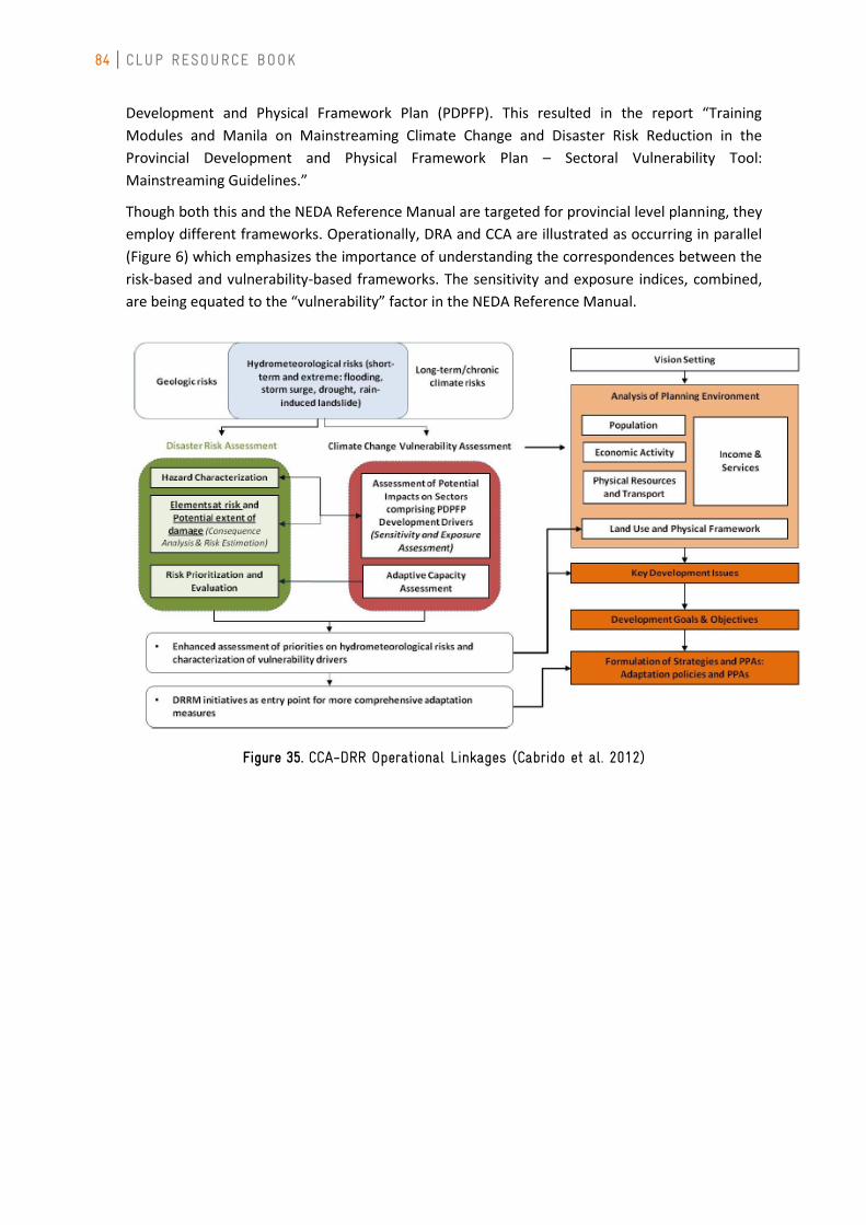
84 CLUP RESOURCE BOOK
Development and Physical Framework Plan (PDPFP). This resulted in the report “Training
Modules and Manila on Mainstreaming Climate Change and Disaster Risk Reduction in the
Provincial Development and Physical Framework Plan – Sectoral Vulnerability Tool:
Mainstreaming Guidelines.”
Though both this and the NEDA Reference Manual are targeted for provincial level planning, they
employ different frameworks. Operationally, DRA and CCA are illustrated as occurring in parallel
(Figure 6) which emphasizes the importance of understanding the correspondences between the
risk-based and vulnerability-based frameworks. The sensitivity and exposure indices, combined,
are being equated to the “vulnerability” factor in the NEDA Reference Manual.
Figure 35. CCA-DRR Operational Linkages (Cabrido et al. 2012)
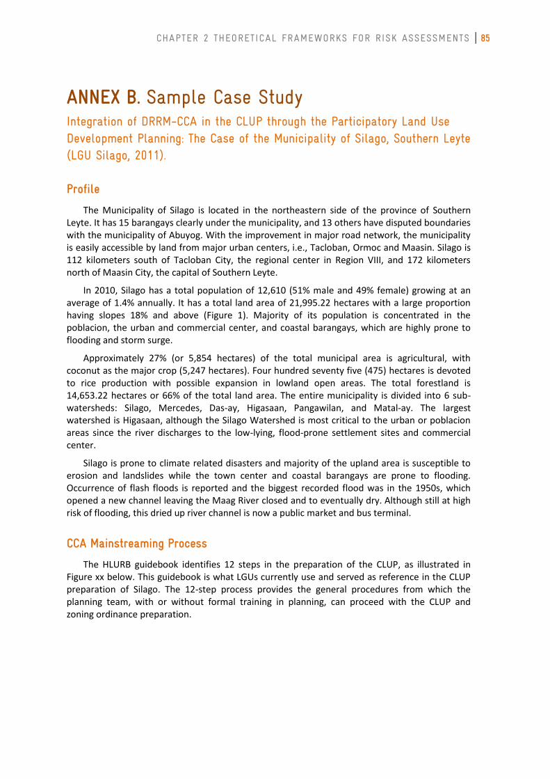
CHAPTER 2 THEORETICAL FRAMEWORKS FOR RISK ASSESSMENTS 85
ANNEX B. Sample Case Study Integration of DRRM-CCA in the CLUP through the Participatory Land Use Development Planning: The Case of the Municipality of Silago, Southern Leyte (LGU Silago, 2011).
Profile
The Municipality of Silago is located in the northeastern side of the province of Southern Leyte. It has 15 barangays clearly under the municipality, and 13 others have disputed boundaries with the municipality of Abuyog. With the improvement in major road network, the municipality is easily accessible by land from major urban centers, i.e., Tacloban, Ormoc and Maasin. Silago is 112 kilometers south of Tacloban City, the regional center in Region VIII, and 172 kilometers north of Maasin City, the capital of Southern Leyte.
In 2010, Silago has a total population of 12,610 (51% male and 49% female) growing at an average of 1.4% annually. It has a total land area of 21,995.22 hectares with a large proportion having slopes 18% and above (Figure 1). Majority of its population is concentrated in the poblacion, the urban and commercial center, and coastal barangays, which are highly prone to flooding and storm surge.
Approximately 27% (or 5,854 hectares) of the total municipal area is agricultural, with coconut as the major crop (5,247 hectares). Four hundred seventy five (475) hectares is devoted to rice production with possible expansion in lowland open areas. The total forestland is 14,653.22 hectares or 66% of the total land area. The entire municipality is divided into 6 sub-watersheds: Silago, Mercedes, Das-ay, Higasaan, Pangawilan, and Matal-ay. The largest watershed is Higasaan, although the Silago Watershed is most critical to the urban or poblacion areas since the river discharges to the low-lying, flood-prone settlement sites and commercial center.
Silago is prone to climate related disasters and majority of the upland area is susceptible to erosion and landslides while the town center and coastal barangays are prone to flooding. Occurrence of flash floods is reported and the biggest recorded flood was in the 1950s, which opened a new channel leaving the Maag River closed and to eventually dry. Although still at high risk of flooding, this dried up river channel is now a public market and bus terminal.
CCA Mainstreaming Process
The HLURB guidebook identifies 12 steps in the preparation of the CLUP, as illustrated in Figure xx below. This guidebook is what LGUs currently use and served as reference in the CLUP preparation of Silago. The 12-step process provides the general procedures from which the planning team, with or without formal training in planning, can proceed with the CLUP and zoning ordinance preparation.
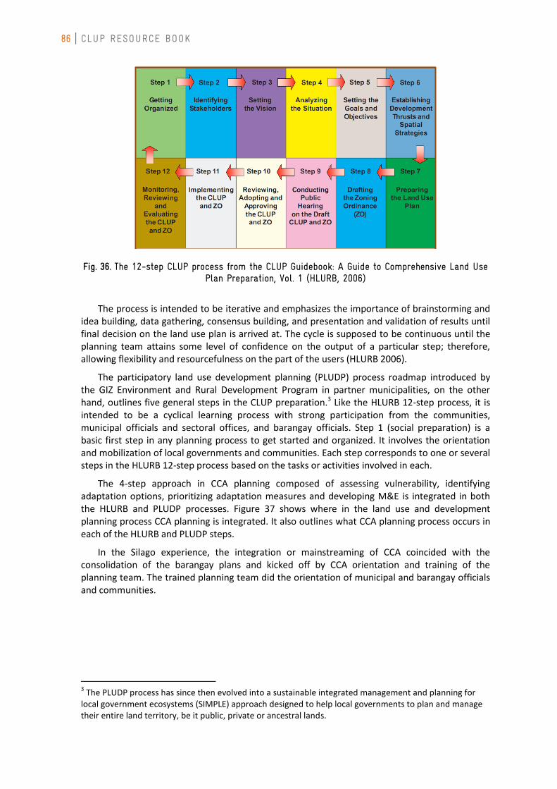
86 CLUP RESOURCE BOOK
Fig. 36. The 12-step CLUP process from the CLUP Guidebook: A Guide to Comprehensive Land Use Plan Preparation, Vol. 1 (HLURB, 2006)
The process is intended to be iterative and emphasizes the importance of brainstorming and idea building, data gathering, consensus building, and presentation and validation of results until final decision on the land use plan is arrived at. The cycle is supposed to be continuous until the planning team attains some level of confidence on the output of a particular step; therefore, allowing flexibility and resourcefulness on the part of the users (HLURB 2006).
The participatory land use development planning (PLUDP) process roadmap introduced by the GIZ Environment and Rural Development Program in partner municipalities, on the other hand, outlines five general steps in the CLUP preparation.3 Like the HLURB 12-step process, it is intended to be a cyclical learning process with strong participation from the communities, municipal officials and sectoral offices, and barangay officials. Step 1 (social preparation) is a basic first step in any planning process to get started and organized. It involves the orientation and mobilization of local governments and communities. Each step corresponds to one or several steps in the HLURB 12-step process based on the tasks or activities involved in each.
The 4-step approach in CCA planning composed of assessing vulnerability, identifying adaptation options, prioritizing adaptation measures and developing M&E is integrated in both the HLURB and PLUDP processes. Figure 37 shows where in the land use and development planning process CCA planning is integrated. It also outlines what CCA planning process occurs in each of the HLURB and PLUDP steps.
In the Silago experience, the integration or mainstreaming of CCA coincided with the consolidation of the barangay plans and kicked off by CCA orientation and training of the planning team. The trained planning team did the orientation of municipal and barangay officials and communities.
3 The PLUDP process has since then evolved into a sustainable integrated management and planning for
local government ecosystems (SIMPLE) approach designed to help local governments to plan and manage their entire land territory, be it public, private or ancestral lands.
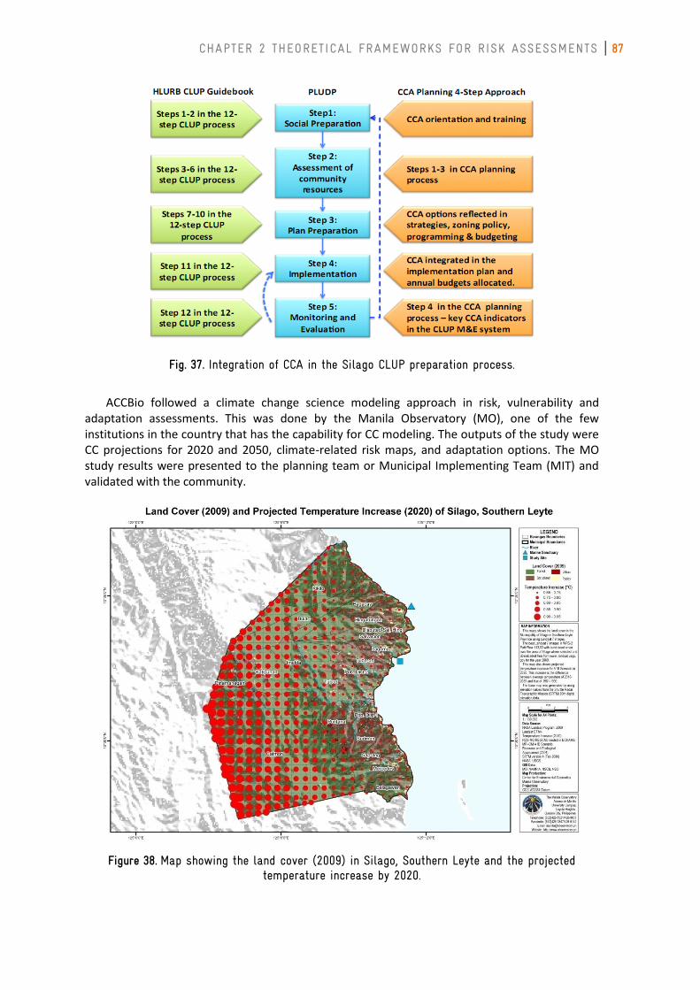
CHAPTER 2 THEORETICAL FRAMEWORKS FOR RISK ASSESSMENTS 87
Fig. 37. Integration of CCA in the Silago CLUP preparation process.
ACCBio followed a climate change science modeling approach in risk, vulnerability and adaptation assessments. This was done by the Manila Observatory (MO), one of the few institutions in the country that has the capability for CC modeling. The outputs of the study were CC projections for 2020 and 2050, climate-related risk maps, and adaptation options. The MO study results were presented to the planning team or Municipal Implementing Team (MIT) and validated with the community.
Figure 38. Map showing the land cover (2009) in Silago, Southern Leyte and the projected temperature increase by 2020.
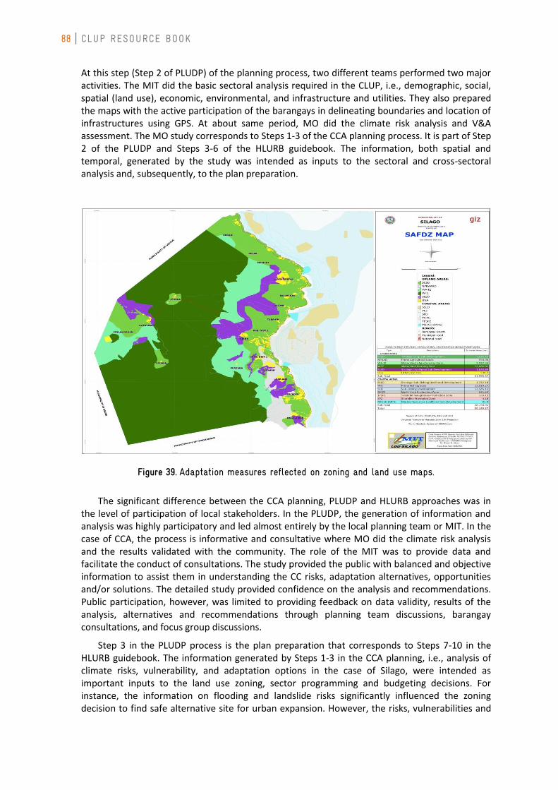
88 CLUP RESOURCE BOOK
At this step (Step 2 of PLUDP) of the planning process, two different teams performed two major activities. The MIT did the basic sectoral analysis required in the CLUP, i.e., demographic, social, spatial (land use), economic, environmental, and infrastructure and utilities. They also prepared the maps with the active participation of the barangays in delineating boundaries and location of infrastructures using GPS. At about same period, MO did the climate risk analysis and V&A assessment. The MO study corresponds to Steps 1-3 of the CCA planning process. It is part of Step 2 of the PLUDP and Steps 3-6 of the HLURB guidebook. The information, both spatial and temporal, generated by the study was intended as inputs to the sectoral and cross-sectoral analysis and, subsequently, to the plan preparation.
Figure 39. Adaptation measures reflected on zoning and land use maps.
The significant difference between the CCA planning, PLUDP and HLURB approaches was in the level of participation of local stakeholders. In the PLUDP, the generation of information and analysis was highly participatory and led almost entirely by the local planning team or MIT. In the case of CCA, the process is informative and consultative where MO did the climate risk analysis and the results validated with the community. The role of the MIT was to provide data and facilitate the conduct of consultations. The study provided the public with balanced and objective information to assist them in understanding the CC risks, adaptation alternatives, opportunities and/or solutions. The detailed study provided confidence on the analysis and recommendations. Public participation, however, was limited to providing feedback on data validity, results of the analysis, alternatives and recommendations through planning team discussions, barangay consultations, and focus group discussions.
Step 3 in the PLUDP process is the plan preparation that corresponds to Steps 7-10 in the HLURB guidebook. The information generated by Steps 1-3 in the CCA planning, i.e., analysis of climate risks, vulnerability, and adaptation options in the case of Silago, were intended as important inputs to the land use zoning, sector programming and budgeting decisions. For instance, the information on flooding and landslide risks significantly influenced the zoning decision to find safe alternative site for urban expansion. However, the risks, vulnerabilities and
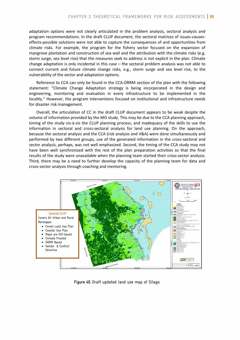
CHAPTER 2 THEORETICAL FRAMEWORKS FOR RISK ASSESSMENTS 89
adaptation options were not clearly articulated in the problem analysis, sectoral analysis and program recommendations. In the draft CLUP document, the sectoral matrices of issues-causes-effects-possible solutions were not able to capture the consequences of and opportunities from climate risks. For example, the program for the fishery sector focused on the expansion of mangrove plantation and construction of sea wall and the attribution with the climate risks (e.g. storm surge, sea level rise) that the measures seek to address is not explicit in the plan. Climate change adaptation is only incidental in this case – the sectoral problem analysis was not able to connect current and future climate change risks, e.g., storm surge and sea level rise, to the vulnerability of the sector and adaptation options.
Reference to CCA can only be found in the CCA-DRRM section of the plan with the following statement: “Climate Change Adaptation strategy is being incorporated in the design and engineering, monitoring and evaluation in every infrastructure to be implemented in the locality.” However, the program interventions focused on institutional and infrastructure needs for disaster risk management.
Overall, the articulation of CC in the draft CLUP document appears to be weak despite the volume of information provided by the MO study. This may be due to the CCA planning approach, timing of the study vis-à-vis the CLUP planning process, and inadequacy of the skills to use the information in sectoral and cross-sectoral analysis for land use planning. On the approach, because the sectoral analysis and the CCA (risk analysis and V&A) were done simultaneously and performed by two different groups, use of the generated information in the cross-sectoral and sector analysis, perhaps, was not well emphasized. Second, the timing of the CCA study may not have been well synchronized with the rest of the plan preparation activities so that the final results of the study were unavailable when the planning team started their cross-sector analysis. Third, there may be a need to further develop the capacity of the planning team for data and cross-sector analysis through coaching and mentoring.
Figure 40. Draft updated land use map of Silago.
Updated CLUP Covers All Urban and Rural Barangays
Forest Land Use Plan Coastal Use Plan Maps are GIS-based Climate Proofed DRRM Based Gender & Conflict
Sensitive
90 CLUP RESOURCE BOOK
The Silago CLUP is still in the process of legitimization, i.e., completion of Steps 9-10 of the HLURB 12-step process and the remaining tasks in Step 3 of the PLUDP. If the adaptation options were incorporated in the new land use allocation and zoning policy, programs and budgets, then adoption of the adaptation measures is assured. If the whole CCA planning process were followed, prioritized adaptation measures should be incorporated as well in the implementation strategy and annual budgets, key indicators of adaptation status identified and integrated in the M&E plan, and CCA part of the review and evaluation process.
Summary and Conclusions
There were two major interventions that facilitated the mainstreaming of CCA in the CLUP process of Silago. First is capacity building through the CCA orientation and training programs. The other is the study on climate risks, vulnerability and adaptation assessment by the Manila Observatory. Clearly, the interviews with the three active MIT members, who also composed the planning team, indicated very high awareness on climate change issues and appreciation of CCA planning. As observed during the Local Development Council assembly for the draft CLUP, the planning team showed confidence in communicating the results of the CLUP planning process. This confidence, however, was built through the years from the support of various GIZ programs to the province and the convergence in the delivery of GIZ assistance in Silago. Based on the documents reviewed and interviews conducted, several lessons can be learned from the mainstreaming process. These are:
a) Convergence of support in the delivery of technical assistance. The GIZ support to Leyte Island and the municipality of Silago can be traced back to its fisheries management program for the Visayan Sea in 2003. The assistance was continued with succeeding programs and its various components. Convergence provided the mass, in terms of financial and technical resources, and the continuity and made the delivery of technical assistance for CCA mainstreaming more efficient.
b) Detailed CC scenario modeling and risk analysis may not be necessary at the municipal level. While the results of the risk analysis and V&A were highly appreciated and provided confidence in the planning team to present the results, the detailed assessment of climate risks and downscaling of CC model to come with CC scenarios at the municipal level may not be necessary. Detailed assessments involve significant technical and financial resources as well as time that could delay the CLUP preparation or in addressing adaptation needs. The OECD policy guidance emphasized that the key is not in developing perfect information on the system of concern but in providing sufficient information to enable decision-makers thoughtful consideration of adaptation options. Majority of LGUs heavily rely on internal revenue allotment (IRA) and may generally not have the financial resources to hire external technical people to do detailed risk analysis, CC modeling and detailed vulnerability, impact and adaptation assessments (VIA). Climate projections, scenario building and detailed VIA may be more appropriate at the provincial level and provided by national government agencies that have the resources to perform highly technical analysis. Other than financial and technical constraints at the municipal level, there is also paucity of time series climate data required for CC modeling; hence, traditional or community knowledge may be used and may suffice in identifying risks but not for quantitative analysis of risks and climate projections.
c) CC science- and model-based CCA planning approach is not easily replicable in the most local government context. Replicability is the extent to which it is possible to reproduce an investigation, a study, or an approach. The CC science and model-based approach to risk assessment and VIA is relatively higher in cost than the participatory, qualitative alternative in understanding risks and vulnerability. It is also highly technical requiring external technical support and consultants to perform the task; therefore, highly
CHAPTER 2 THEORETICAL FRAMEWORKS FOR RISK ASSESSMENTS 91
consultant-dependent as well. Skills transfer therefore is difficult, or even not feasible, without providing formal training to local planners. For these reasons, the approach is difficult to replicate in most LGUs, especially those that are heavily dependent on internal revenue allotment and without the benefit of external technical assistance.
In summary, the Silago experience highlighted several factors that can contribute to success in mainstreaming and CLUP preparation, in general. These factors include:
1) Capacity building and skills development. The focus on capacity building (short-term training and mentoring) prior to the start of any technical activity, e.g., plan preparation, greatly contributed to the success of the PLUDP. The CCA mainstreaming benefited from the skills already developed among the participants when the mainstreaming started. There were skills fond to be critical to the CCA mainstreaming includes: participatory planning and facilitation that could be applied in community-based climate risk analysis and VIA; use of PRA tools; interpretation of climate information and data analysis; and map preparation and interpretation.
2) Social preparation. Social preparation through CCA orientation and awareness-raising for the MIT, communities and local officials facilitated support for the process.
3) Participatory approach. The participatory approach to the CLUP preparation, and to some extent the CCA mainstreaming, increased support, acceptance and ownership of the results. The MITs took the lead in the preparation of the CLUPs, which also built their confidence in facilitating community consultations and barangay assemblies.
4) External financing. While external financing may not a sustainable approach to development planning, it facilitated the process by building the capacity of key technical staff that comprised the planning team. The technical assistance also linked the municipality to experts from the local and national academic institutions, like the Visayas State University, Southern Leyte State University and the Manila Observatory.
What continues to be a challenge to LGUs though are technical capacity, financial constraints due to IRA-dependence, resourcing and leveraging investments to fund development and adaptation programs, and balancing short-term day-to-day concerns with long term objectives of CCA.
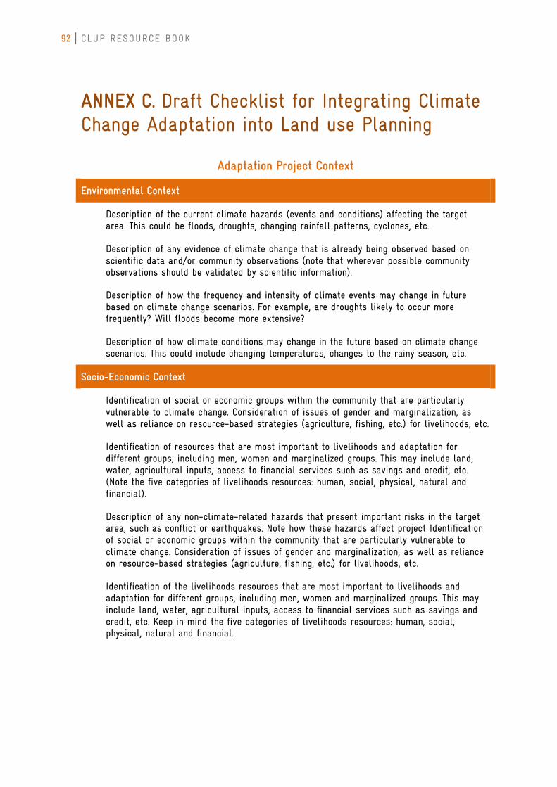
92 CLUP RESOURCE BOOK
ANNEX C. Draft Checklist for Integrating Climate Change Adaptation into Land use Planning
Adaptation Project Context
Environmental Context
Description of the current climate hazards (events and conditions) affecting the target area. This could be floods, droughts, changing rainfall patterns, cyclones, etc.
Description of any evidence of climate change that is already being observed based on scientific data and/or community observations (note that wherever possible community observations should be validated by scientific information).
Description of how the frequency and intensity of climate events may change in future based on climate change scenarios. For example, are droughts likely to occur more frequently? Will floods become more extensive?
Description of how climate conditions may change in the future based on climate change scenarios. This could include changing temperatures, changes to the rainy season, etc.
Socio-Economic Context
Identification of social or economic groups within the community that are particularly vulnerable to climate change. Consideration of issues of gender and marginalization, as well as reliance on resource-based strategies (agriculture, fishing, etc.) for livelihoods, etc.
Identification of resources that are most important to livelihoods and adaptation for different groups, including men, women and marginalized groups. This may include land, water, agricultural inputs, access to financial services such as savings and credit, etc. (Note the five categories of livelihoods resources: human, social, physical, natural and financial).
Description of any non-climate-related hazards that present important risks in the target area, such as conflict or earthquakes. Note how these hazards affect project Identification of social or economic groups within the community that are particularly vulnerable to climate change. Consideration of issues of gender and marginalization, as well as reliance on resource-based strategies (agriculture, fishing, etc.) for livelihoods, etc.
Identification of the livelihoods resources that are most important to livelihoods and adaptation for different groups, including men, women and marginalized groups. This may include land, water, agricultural inputs, access to financial services such as savings and credit, etc. Keep in mind the five categories of livelihoods resources: human, social, physical, natural and financial.
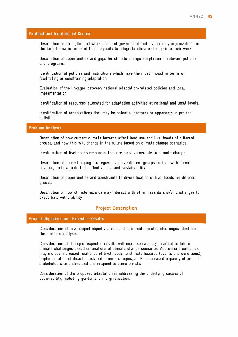
ANNEX 93
Political and Institutional Context
Description of strengths and weaknesses of government and civil society organizations in the target area in terms of their capacity to integrate climate change into their work.
Description of opportunities and gaps for climate change adaptation in relevant policies and programs.
Identification of policies and institutions which have the most impact in terms of facilitating or constraining adaptation.
Evaluation of the linkages between national adaptation-related policies and local implementation.
Identification of resources allocated for adaptation activities at national and local levels.
Identification of organizations that may be potential partners or opponents in project activities
Problem Analysis
Description of how current climate hazards affect land use and livelihoods of different groups, and how this will change in the future based on climate change scenarios.
Identification of livelihoods resources that are most vulnerable to climate change.
Description of current coping strategies used by different groups to deal with climate hazards, and evaluate their effectiveness and sustainability
Description of opportunities and constraints to diversification of livelihoods for different groups.
Description of how climate hazards may interact with other hazards and/or challenges to exacerbate vulnerability.
Project Description
Project Objectives and Expected Results
Consideration of how project objectives respond to climate-related challenges identified in the problem analysis.
Consideration of if project expected results will increase capacity to adapt to future climate challenges based on analysis of climate change scenarios. Appropriate outcomes may include increased resilience of livelihoods to climate hazards (events and conditions), implementation of disaster risk reduction strategies, and/or increased capacity of project stakeholders to understand and respond to climate risks.
Consideration of the proposed adaptation in addressing the underlying causes of vulnerability, including gender and marginalization.
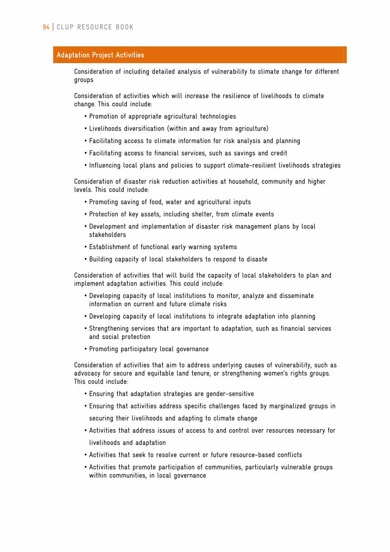
94 CLUP RESOURCE BOOK
Adaptation Project Activities
Consideration of including detailed analysis of vulnerability to climate change for different groups
Consideration of activities which will increase the resilience of livelihoods to climate change. This could include:
• Promotion of appropriate agricultural technologies
• Livelihoods diversification (within and away from agriculture)
• Facilitating access to climate information for risk analysis and planning
• Facilitating access to financial services, such as savings and credit
• Influencing local plans and policies to support climate-resilient livelihoods strategies
Consideration of disaster risk reduction activities at household, community and higher levels. This could include:
• Promoting saving of food, water and agricultural inputs
• Protection of key assets, including shelter, from climate events
• Development and implementation of disaster risk management plans by local stakeholders
• Establishment of functional early warning systems
• Building capacity of local stakeholders to respond to disaste
Consideration of activities that will build the capacity of local stakeholders to plan and implement adaptation activities. This could include:
• Developing capacity of local institutions to monitor, analyze and disseminate information on current and future climate risks
• Developing capacity of local institutions to integrate adaptation into planning
• Strengthening services that are important to adaptation, such as financial services and social protection
• Promoting participatory local governance
Consideration of activities that aim to address underlying causes of vulnerability, such as advocacy for secure and equitable land tenure, or strengthening women’s rights groups. This could include:
• Ensuring that adaptation strategies are gender-sensitive
• Ensuring that activities address specific challenges faced by marginalized groups in
securing their livelihoods and adapting to climate change
• Activities that address issues of access to and control over resources necessary for
livelihoods and adaptation
• Activities that seek to resolve current or future resource-based conflicts
• Activities that promote participation of communities, particularly vulnerable groups within communities, in local governance
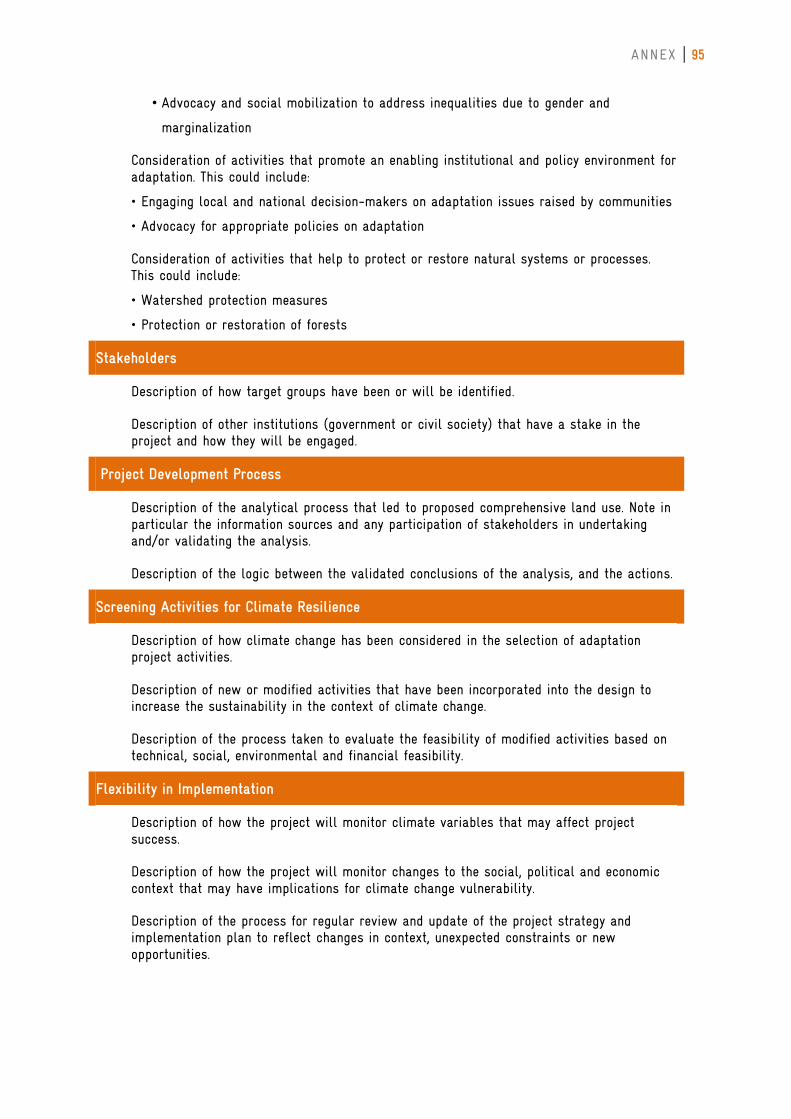
ANNEX 95
• Advocacy and social mobilization to address inequalities due to gender and
marginalization
Consideration of activities that promote an enabling institutional and policy environment for adaptation. This could include:
• Engaging local and national decision-makers on adaptation issues raised by communities
• Advocacy for appropriate policies on adaptation
Consideration of activities that help to protect or restore natural systems or processes. This could include:
• Watershed protection measures
• Protection or restoration of forests
Stakeholders
Description of how target groups have been or will be identified.
Description of other institutions (government or civil society) that have a stake in the project and how they will be engaged.
Project Development Process
Description of the analytical process that led to proposed comprehensive land use. Note in particular the information sources and any participation of stakeholders in undertaking and/or validating the analysis.
Description of the logic between the validated conclusions of the analysis, and the actions.
Screening Activities for Climate Resilience
Description of how climate change has been considered in the selection of adaptation project activities.
Description of new or modified activities that have been incorporated into the design to increase the sustainability in the context of climate change.
Description of the process taken to evaluate the feasibility of modified activities based on technical, social, environmental and financial feasibility.
Flexibility in Implementation
Description of how the project will monitor climate variables that may affect project success.
Description of how the project will monitor changes to the social, political and economic context that may have implications for climate change vulnerability.
Description of the process for regular review and update of the project strategy and implementation plan to reflect changes in context, unexpected constraints or new opportunities.
96 CLUP RESOURCE BOOK
Emergency Preparedness
Description of the emergency preparedness plan for the project/office, including training for staff and partners.
Cross Cutting Issues
Description of how gender and marginalization contribute to vulnerability to climate change.
Discussion of whether all target stakeholders have equal access to infrastructure and services necessary for adaptation.
Discussion of whether all target stakeholders have access to and control over critical livelihoods resources.
Identification of any existing or potential conflicts over resources which may impede adaptation efforts.
Description of how target stakeholders are engaged in local and national decision-making
Project Implementation and Management
Project Team and Partners
Ensure that the project team includes appropriate scientific and technical input on climate change and other related issues.
Description of how partners have been or will be selected.
Description of how capacity development for the project team and partners on climate change vulnerability and adaptation will be achieved.
Risks and Assumptions
Identification of assumptions related to strategies to increase adaptive capacity for future climate change.
Identification of assumptions regarding impacts of project activities on different groups within the community.
Identification of climate hazards that may present risks to project success, including future projections.
Integration of disaster risk reduction strategies to address climate hazards as a risk reduction strategy.
ANNEX 97
Information and Knowledge Management
Learning
Description of how reflection and learning processes will be systematically incorporated into project implementation.
Description of the strategy for building knowledge of staff, partners and target stakeholders on vulnerability and adaptation to climate change.
Monitoring & Evaluation
Note that project stakeholders, including particularly vulnerable groups, will be involved in monitoring & evaluation of project progress.
Note that the project will track both intended and unintended impacts of project activities.
Consideration of including indicators of adaptive capacity within the performance indicators.
Consideration of including process indicators.
Consideration of including indicators which monitor the policy and institutional environment for adaptation.
Note that indicators will be disaggregated to monitor results for different groups, including men, women and marginalized groups.
Documentation & Dissemination
Description of how dissemination of information and knowledge gained through the project will be undertaken.
98 CLUP RESOURCE BOOK
REFERENCES
ADB, 2012: Addressing Climate Change and Migration in the Asia and the Pacific, ISBN 978-92-9092-611-5
Brooks, Nick Simon Anderson, Jessica Ayers, Ian Burton and Ian Tellam, 2011: Tracking Adaptation and Measuring Development. IIED Climate Change Working Paper No. 1. Available from: http://pubs.iied.org/10031IIED.html.
Brooks, Nick, 2003: Vulnerability, risk and adaptation: A conceptual framework. Tyndall Centre Working Paper No. 38. Available from: http://tyndall.ac.uk/sites/default/files/wp38.pdf.
Cabrido, Candido, Jr., et al., 2012: Training Modules and Manila on Mainstreaming Climate Change and Disaster Risk Reduction in the Provincial Development and Physical Framework Plan – Sectoral Vulnerability Tool: Mainstreaming Guidelines.
DILG and HLURB Joint Memorandum Circular No. 1 Series of 2009 (October 19, 2009): Guidelines on the Harmonization of Comprehensive Land Use Plan (CLUP) and Comprehensive Development Plan (CDP) Preparation.
DILG – Bureau of Local Government Development: Rationalizing the Local Planning System (RPS): A Source Book (1st Edition, 2008)
DILG Memorandum Circular No. 2008-156 (October 22, 2008): Guide to Comprehensive Development Plan (CDP) Preparation for Local Government Unit.
DILG-NEDA-DBM-DOF JMC No. 1 Series of 2007 (March 8, 2007): Guidelines on the Harmonization of Local Planning, Investment Programming, Revenue Administration, Budgeting and Expenditure Management.
Draft Revised Implementing Rules and Regulations (IRR) of Republic Act No. 9729; accessed from http://climate.gov.ph/phocadownload/Laws%20and%20Policies/draft%20revised%20irr%20-%20RA%209729.pdf
Foerster, E. et al., 2009: State-of-the-art on vulnerability types. Enhancing resilience of communities and territories facing natural and na-tech Hazards (ENSURE) project. Available from: http://www.ensureproject.eu/ENSURE_Del1.1.1.pdf .
Fuessel, Hans-Martin and Richard J. T. Klein, 2002: Assessing Vulnerability and Adaptation to Climate Change: An Evolution of Conceptual Thinking pp. 45-59 in: A Climate Risk Management Approach to Disaster Reduction and Adaptation to Climate Change. (Proceedings of the UNDP Expert Group Meeting on "Integrating Disaster Reduction and Adaptation to Climate Change", Havana, Cuba, 17-19 June 2002)
GIZ-MO-ICRAF, 2011: Patterns of vulnerability in the forestry, agriculture, water, and coastal sectors of Silago,Southern Leyte, Philippines, ISBN: 978-971-94565-1-3
GIZ-MO-ICRAF, 2011: Patterns of vulnerability in the forestry, agriculture, water, and coastal sectors of Silago,Southern Leyte, Philippines, ISBN: 978-971-94565-1-3
Gotangco, Kendra, 2012: Understanding Vulnerability and Risk. Presentation delivered at the UNEP
HLURB, 2006: CLUP Guide Book Vol. 1 (2006)
ANNEX 99
IPCC, 2001: Contribution of Working Group II to the Third Assessment Report of the Intergovernmental Panel on Climate Change. [J.J. McCarthy, O.F. Canziani, N.A. Leary, D.J. Dokken, K.S. White (eds)]. Cambridge University Press, Cambridge, United Kingdom and New York, NY, USA.
IPCC, 2007: Glossary, Contribution of Working Group II to the Fourth Assessment Report of the Intergovernmental Panel on Climate Change. [M.L. Parry, O.F. Canziani, J.P. Palutikof, P.J. van der Linden and C.E. Hanson (eds)]. Cambridge University Press, Cambridge, United Kingdom and New York, NY, USA. Available from: http://www.ipcc.ch/pdf/glossary/ar4-wg2.pdf .
IPCC, 2012: Summary for Policymakers. In: Managing the Risks of Extreme Events and Disasters to Advance Climate Change Adaptation [Field, C.B., V. Barros, T.F. Stocker, D. Qin, D.J. Dokken, K.L. Ebi, M.D. Mastrandrea, K.J. Mach, G.-K. Plattner, S.K. Allen, M. Tignor, and P.M. Midgley (eds.)]. A Special Report of Working Groups I and II of the Intergovernmental Panel on Climate Change. Cambridge University Press, Cambridge, UK, and New York, NY, USA, pp. 1-19.
Limbona v. Mangelin, G.R. No. 80391 (February 28, 1989).
Manila Observatory and DENR, 2005: Mapping Philippine Vulnerability to Environmental Disasters. Available from: http://vm.observatory.ph.
Manila Observatory, 2011: Country Scoping of the Children’s Vulnerability to Climate Change in the Philippines
NEDA and ADB, Guidelines on Provincial/Local Planning and Expenditure Management, Volume 2: Provincial Development and Physical Framework Plan (2007).
NEDA, UNDP, AusAID, 2012: Integrating Disaster Risk Reduction and Climate Change Adaptation (DRR/CCA) in Local Development Planning and Decision-making Process: Reference Manual on Mainstreaming DRR/CCA in Comprehensive Land Use Plans.
Perez, Rosa and Kendra Gotangco, 2011: Vulnerability and Adaptation: Concepts and Frameworks. Presentation delivered at Building a Community of Practice: Improving Access to Climate Information Relevant to Adaptation. Century Park Hotel, Metro Manila, 14-16 November 2011.
Regional Adaptation Platform , Philippines workshop, March 21, 2012. Adapted from C. Kendra Gotangco Castillo, 2007: Developing a Community-based Co-Benefits Framework for Climate Change Adaptation and Disaster Risk Management in Oriental Mindoro, submitted to the Environmental Science Dept., Ateneo de Manila University, and the Manila Observatory.
Republic Act No. 7160: Local Government Code of 1991.
Republic Act No. 9729: Climate Change Act of 2009.
Republic Act No. 10121: Philippine Disaster Risk Reduction and Management Act of 2010.
Smit, B., I. Burton, R.J.T. Klein, and R. Street, 1999: The science of adaptation: a framework for assessment. Mitigation and Adaptation Strategies for Global Change, 4, 199–213.
UNDP, 2004: Reducing Disaster Risks: A Challenge for Development. John S. Swift Co., USA.
UNEP and UNISDR, 2007: Environment and disaster risk: emerging perspectives. 2007. Accessible from: http://postconflict.unep.ch/publications/env_vulnerability.pdf.
100 CLUP RESOURCE BOOK
UNEP, 2008: "Kick the Habit: A UN Guide to Climate Neutrality", UNEP/GRID-Arendal, ISBN: 978-92-807-2926-9
UNICEF, 2008: Framework of Children’s Vulnerability to Climate Change
UNISDR, 2009: Book of terminology on disaster risk reduction. Available from: http://www.unisdr.org/we/inform/terminology .
Watershed Organisation Trust, 2012: Biodiversity and Adaptation to Climate Change. pp-20. ISBN No.978-81-86748-29-9
WB, 2010: World Development Report 2010 – Development and Climate Change, ISBN No. 978-0-8213-7989-5
WB, 2011: Climate Change, Disaster Risk, and the Urban Poor. Washington, DC.
Weidema, B., 2001: Areas of protection and the impact chain; accessed from http://www.lca-net.com/files/impact-chain.pdf