climate-induced formation of a closed basin: great …geofaculty.uwyo.edu/heller/papers/heller gsab...
TRANSCRIPT

30113 2nd pages / 1 of 8
For permission to copy, contact [email protected]© 2010 Geological Society of America
Climate-induced formation of a closed basin: Great Divide Basin, Wyoming
Paul L. Heller1,†, Margaret E. McMillan2, and Neil Humphrey1
1Department of Geology and Geophysics, University of Wyoming, Laramie, Wyoming 82071, USA2Department of Earth Sciences, University of Arkansas at Little Rock, Little Rock, Arkansas 72204, USA
1
GSA Bulletin; Month/Month 2010; v. 1xx; no. X/X; p. 000–000; doi: 10.1130/B30113.1; 6 fi gures; 1 table; Data Repository item 2010158.
†E-mail: [email protected]
ABSTRACT
Large closed basins are often associated with regions of active tectonics. In contrast, we provide the example of the Great Divide Basin, in southern Wyoming, where climate change, through its impact on erosion and fl exure, provides the primary mechanism of basin closure. Two- and three-dimensional fl exural models that incorporate the effects of local basin abandonment due to aridity as well as minor extrabasinal extension demon-strate that basin closure with 40 m of base-ment relief (tilt) could have been achieved in the Great Divide Basin under reasonable assumptions of sediment rock density and fl exural rigidity. The primary drive for ba-sin abandonment was insuffi cient discharge that retarded river downcutting. Continued erosion in the surrounding drainage led to fl exural rebound, against which erosion by the outlet from the Great Divide Basin was unable to compete. Eventually, the basin became detached and isolated from the sur-rounding drainage, and a few tens of meters of differential tilt developed between the ba-sin fl oor and spillover point. An extra amount of tilt, up to a few meters, could have been at-tained by rift shoulder effects associated with minor nearby extension outside of the basin to the north. Hence, closure of the Great Di-vide Basin took place with no internal fault-ing, nor did it require any extrabasinal tec-tonic activity to force basin closure. Hence, basin closure and/or drainage reorganization need not record tectonic activity in all cases. Differential erosion provides an alternative hypothesis that does not refl ect local tectonic timing. Our model of the evolution of the Great Divide Basin illustrates a mechanism by which basins can become closed by cli-matic effects alone.
INTRODUCTION
Large closed basins are typically associated with active tectonism in a variety of settings. Examples include Pyramid Lake, Nevada (with 109 m relief between basin fl oor and spillover point), in an extensional setting; Death Valley, California (148 m), in a strike-slip setting; and Qinghai Lake, north-central China (28 m), in a compressional setting. Such basins may be dry or contain lakes, depending on water supply (Car-roll and Bohacs, 1999). In all cases, closed basin formation occurs where rates of sediment supply derived from surrounding mountain ranges lag behind rates of space created (accommodation) by tectonic activity in the basin (Carroll and Bo-hacs, 1999; Humphrey and Konrad, 2000; Garcia-Castellanos, 2007). Accommodation may result from basin subsidence or rate of surface uplift of a bounding tectonic sill. Typically, closed basins are geologically short-lived—once tectonism abates, continued sediment supply, coupled with erosional downcutting of the spillover point, even-tually eliminates topographic barriers to drainage.
The Great Divide Basin of south-central Wy-oming (Fig. 1) stands in contrast to closed ba-sins formed in tectonically active settings. The basin is a large (~104 km2), internally drained, topographic depression that sits at high elevation (2100 m average) astride the U.S. continental divide. With tens of meters of closure between basin fl oor and spillover point, the basin is as large as or larger than most closed basins. In this part of the Rocky Mountains, there is thought to be little recent tectonic activity (Flanagan and Montagne, 1993) and no known recent faulting within the basin. As such, an obvious tectonic origin of the Great Divide Basin is a diffi cult case to make. Alternatively, we suggest here that basin closure was primarily the result of an isostatic response to the climatically induced isolation of the basin from the surrounding drainages. Such a mechanism may play a role in other closed basins not directly controlled by active tectonism along their margins.
GREAT DIVIDE BASIN
The Great Divide Basin was originally part of a foreland basin bounded by the Sevier fold-and-thrust belt to the west during Cretaceous–early Eocene time. In Late Cretaceous time, the Laramide orogeny partitioned the foreland region into individual basins bounded by nar-row basement-cored ranges (Snoke, 1993). This event produced the thrust-bounded ranges and domal uplifts that surround the Great Divide Basin today (Fig. 1). During the early part of the Laramide orogeny, the basin was a part of the greater Green River Basin (Surdam and Stanley, 1980). Subsequent relative uplift of the Rock Springs Uplift to the west and the Rawlins Up-lift to the east (Fig. 1) during Late Cretaceous through Paleocene time further defi ned the mar-gins of the Great Divide Basin (Lillegraven et al., 2002; Mederos et al., 2005). The basin was not closed, however, until at least middle to late Miocene time (Hansen, 1986; Lillegraven and Ostresh, 1988). Prior to this time, the basin drained to the east, into the Platte River system.
Continued, subtle, post-Laramide tectonism has affected the Rocky Mountains, including regional doming that began after 8 Ma and was well on its way by ca. 4 Ma (McMillan et al., 2006). Local post-Laramide tectonism and volcanism close to the Great Divide Basin in-clude the extensional collapse of the Granite Mountains (beginning ca. 11–7 Ma; Anders et al., 2009) to the north, the propagation of the Rio Grande Rift to the east of the Sierra Madre Mountains (beginning 10–8 Ma; Mears, 1998; Keller and Baldridge, 1999), and eruption of the Leucite Hills (3–0.8 Ma; Lange et al., 2000) around the Rock Springs Uplift on the western margin of the basin.
It is unclear exactly when the Great Divide Basin became isolated from the Platte River drainage. Regional studies indicate that the basin and adjacent parts of the Northern Platte River drainage were buried under >600 m of Oligocene–Miocene basin fi ll after the end of
Heller et al.
2 Geological Society of America Bulletin, Month/Month 2010
30113 2nd pages / 2 of 8
FDFSDF
KDF
A
A′
40002000 30002500 3500Elevation (m)
15001000
50 km
Wind River Mountains
Rawlins Uplift
Rock Springs
Uplift
Ferris Mtns
Seminoe Mtns
Granite Mountains
Sierra Madre
Mountains
Chain Lakes Flat
Separation Flats
Red Desert
Basin
Green Mtns
Wamsutter Gap
Sand Gap
SinclairGap
Muddy Gap
GreenRiverBasin
N. P
la t t e River
Sweetwater River
HannaBasin
SL
Sand Creek
Medicine BowMountains
NGMF
SGMF
ParkRange
RawahRange
Rawlins
UT
CO
WYNE
ID
MT Great Divide Basin
300 km
N. Pla
tte R
iver
Rabbit Ears Range
LeuciteHills
109° W 108° W
107° W 106° W
42° N
41° N
GDB
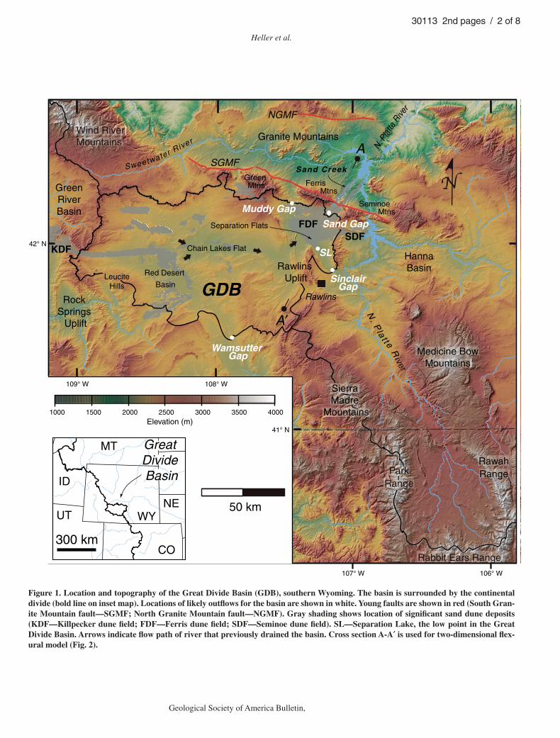
Figure 1. Location and topography of the Great Divide Basin (GDB), southern Wyoming. The basin is surrounded by the continental divide (bold line on inset map). Locations of likely outfl ows for the basin are shown in white. Young faults are shown in red (South Gran-ite Mountain fault—SGMF; North Granite Mountain fault—NGMF). Gray shading shows location of signifi cant sand dune deposits (KDF—Killpecker dune fi eld; FDF—Ferris dune fi eld; SDF—Seminoe dune fi eld). SL—Separation Lake, the low point in the Great Divide Basin. Arrows indicate fl ow path of river that previously drained the basin. Cross section A-A′ is used for two-dimensional fl ex-ural model (Fig. 2).
Climate control of closed basin formation
Geological Society of America Bulletin, Month/Month 2010 3
30113 2nd pages / 3 of 8
the Laramide orogeny (McMillan et al., 2006). These alluvial deposits in areas surrounding the basin reach an elevation of ~2200 m, roughly 250 m above the present spillover point out of the basin. The switch from net aggradation to net incision of Laramide basins in this part of the Rocky Mountains took place after 6.75 Ma, the age of tuffs found at the base of the Moon-stone Formation, located just north of the study area in the Granite Mountain block (Anders et al., 2009). Incision of the lowest 100 m of the Great Divide Basin took place over the past 1 m.y., based on the dates and elevations of lava fl ows found in the Leucite Hills, along the west-ern edge of the basin (Lange et al., 2000). Aban-donment of through-going drainage in the basin took place prior to 7 ka, the age of sand dunes shrouding the basin fl oor. Hence, closure of the Great Divide Basin by a few tens of meters took place between 1 Ma and 7 ka.
Today, the Great Divide Basin’s internal drainage consists of ephemeral streams that fl ow into large playas and small perennial lakes, or disappear beneath active eolian sand dune and sheet deposits. These arid landforms are consistent with modern conditions of low mean precipitation and high mean evaporation rates. Sand dune fi elds cross into the basin on its west-ern margin, occur on the leeward side of many playas within the basin, and blanket the basin’s northeastern margin (Fig. 1). Dune fi elds trend west to east, parallel to the prevailing westerly wind direction. Winds blow on average 25 km/h in summer and 36 km/h in winter from the west southwest (Martner and Marwitz, 1982). The largest fi elds include the Killpecker, Seminoe, and Ferris dunes (Fig. 1). The dune fi elds are as old as latest Pleistocene and have been ac-tive throughout the Holocene, with periods of activity coinciding with periglacial conditions (Mayer and Mahan, 2004). Sedimentary and geomorphic evidence from study of the Ferris dune fi eld suggests that wind strength, intensity, and direction have not varied much since the end of the Pleistocene (Gaylord, 1982).
Large playas coincide with the lowest eleva-tions in the basin and broadly defi ne three subba-sins separated by ridges of resistant fi ne-grained sedimentary rocks. The three subbasins include the northwest-southeast–trending Red Desert Basin, an east-west–trending longitudinal valley made up of the Lost Creek Basin, Battle Spring Flat, and Chain Lakes Flat (hereafter identifi ed collectively as the Chain Lakes Flat), and the northwest-southeast–trending Separation Flats (Fig. 1). The Red Desert Basin and Chain Lakes Flat are underlain by the predominantly fl uvial and lacustrine deposits of the Tertiary Battle Spring, Wasatch, and Green River formations (Bradley, 1964). Separation Flats is underlain
by Upper Cretaceous marine rocks of the Steele Shale, Cody Shale, Mesaverde, and Niobrara Formations (Barlow, 1953; Bayley, 1968).
TOPOGRAPHY
In order to determine where the Great Divide Basin drained prior to closure, we compiled a data set including elevations of divides and other potential overfl ow points, drainages, and possible burial of such features by eolian sand accumulations from a variety of sources includ-ing elevations from U.S. Geological Survey (USGS) digital elevation models (DEMs; 30 m resolution), spot elevations using mapping-grade Trimble differential GPS unit (DGPS) (20 cm resolution after postprocessing), avail-able geologic mapping, and well-log data from the Wyoming Oil and Gas Conservation Com-mission and Wyoming State Geological Survey.
The average elevation of the Great Divide Ba-sin is 2100 m above mean sea level. Total relief within the basin is signifi cant at ~1100 m differ-ence between the highest point along the crest of the Ferris Mountains (3050 m) and the lowest point in Separation Flats (1947 m). However, on average, the basin is quite fl at. Over 80% of the basin area falls within the 1947–2150 m elevation range, and less than 4% of the basin area is above 2300 m above mean sea level. It is important to note that there is very little high topography, and therefore mountain drainage, in the Great Divide Basin catchment (Fig. 1). In contrast, the North Platte drainage, bound-ing the east and north sides of the basin, drains much of the high topography in this part of the central Rocky Mountains.
Low points in each of the subbasins occur at 2005 m in the Red Desert Basin, 1970 m in the Chain Lakes Flat, and 1947 m in Separation Flats. The lowest points within each subbasin step down in a generally west-to-east pattern. Similarly, the spillover points today between the subbasins step down from west to east from 2038 m between Red Desert Basin and Chain Lakes Flat, to 2005 m between Chain Lakes Flat and Separation Flats, to 1996 m between Separa-tion Flats and the North Platte drainage (Fig. 1).
The lowest gaps along the basin divide (Fig. 1) include Wamsutter Gap (2051 m), Muddy Gap (2066 m), Sinclair Gap (1996 m), and Sand Gap (2097 m). The fi rst three sites have exposed Cre-taceous bedrock at the surface, and thus these are minimum spillover elevations. At the Sand Gap site, however, the minimum elevation is lo-cated among sand dunes within the Ferris dune fi eld. Sand dunes have blown over Sand Gap and migrated partway down Sand Creek to the north (Fig. 1). Bedrock exposed among the dunes at Sand Gap is at an elevation of 1990 m, which is
slightly lower than the elevation of the divide at Sinclair Gap. The largest horizontal distance be-tween bedrock exposures in the Sand Gap area is ~120 m. Therefore, it is possible that sand hides a buried, narrow valley beneath which bedrock basement may be somewhat lower.
Sand Gap seems the most likely outfl ow from the Great Divide Basin. Not only is bed-rock somewhat lower here than at other candi-date areas, but Sand Creek, which runs through Sand Gap to join the North Platte River (Fig. 1), has well-developed and extensive high terraces several meters above the current small creek. Bedrock clasts among terrace remnants suggest signifi cant outfl ow through Sand Creek. These terraces have been partially buried by migrating sand dunes. Thus, a river clearly fl owed through the gap prior to the period of Holocene dry-ing. Projection of terrace surfaces suggests that the spillover point at Sand Gap was not much below 1990 m. The maximum relief between the lowest spot in the basin, Separation Lake (at 1947 m), and the bedrock overfl ow at Sand Gap (1990 m) is 43 m. These sites are located roughly 30 km from each other. It is unclear what generated this closure.
ORIGIN OF BASIN CLOSURE
While there is no known tectonic activity along the northern basin margin, there is evi-dence of young normal faulting farther to the north, along the northern fl ank of the Ferris and Seminoe mountains. Love (1970) describes a west-northwest–trending normal fault, the South Granite Mountain fault (SGMF, Fig. 1) that bounds the southern edge of the Granite Mountain block. The structure is near vertical, probably becoming listric with depth (Black-stone, 1991) and places Miocene age depos-its (Moonstone Formation) against basement rocks. Displacement along the fault reaches up to 610 m at the far west end of the South Gran-ite Mountain fault (Love, 1970). However, cross sections constrained by well data indicate offset is closer to 200 m around the location of Sand Creek (Love, 1970; Blackstone, 1991). Subpar-allel faulting along the northern margin of the block (North Granite Mountain fault; Fig. 1) indicates that the Granite Mountains sit in a gra-ben (Love, 1970). Available age constraints in-dicate that normal faulting began between ca. 11 and 7 Ma, and may be continuing today (An-ders et al., 2009). Along the northern fl ank of the Seminoe Mountains, to the east of Great Di-vide Basin, truncated spurs provide geomorphic evidence of offset along the fault (Jaworowski, 1985). However, no similar topography is seen in the vicinity of Sand Creek, the proposed out-let of the Great Divide Basin (Fig. 1).
Heller et al.
4 Geological Society of America Bulletin, Month/Month 2010
30113 2nd pages / 4 of 8
Impact of Extrabasinal Tectonics
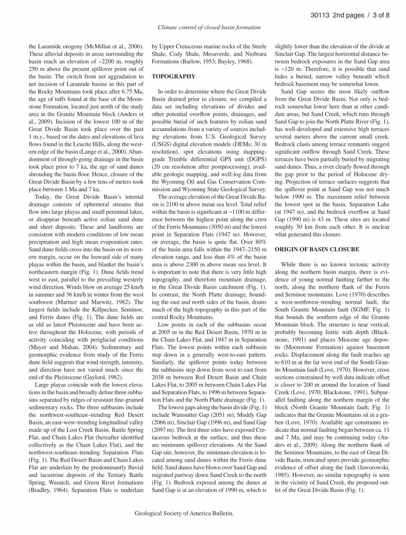
It is possible that if there were young, signifi -cant normal fault offset along the South Granite Mountain fault, it could have played a role in closing the Great Divide Basin. Normal offset would not close the basin by building a tectonic dam along Sand Creek. In fact, normal fault off-set, had it occurred along the drainage, would have led to the formation of a knickpoint, and would have accelerated erosion along the stream, facilitating downcutting. Instead, any signifi cant reduction in tectonic load by thinning of the crust along the margin of the Granite Mountain gra-ben could lead to fl exural rebound adjacent to the graben margins. This phenomenon contributes to the formation of “rift shoulders” (Weissel and Karner, 1989; Chéry et al., 1992). Tilting to the south away from the graben would help provide a slope that, under the right conditions, could contribute to closing of the Great Divide Basin.
In order to evaluate this mechanism as a cause of tilting in the eastern Great Divide Ba-sin, we constructed a simple two-dimensional fl exural model using cross sections of the Gran-ite Mountains provided by Love (1970). Two-dimensional modeling is appropriate because the load, the Granite Mountain graben, is an elongate feature, and we are modeling a location near the approximate midpoint of the graben margin, so that three-dimensional boundary ef-fects are unlikely to play a signifi cant role. The geologic history of the Granite Mountain block suggests that during, or following, downdrop of basement rocks, sedimentation took place. As-suming the South Granite Mountain fault does not offset the Moho, the result of the net effect of extension and basin fi lling is to replace basement rock (density ~2850 kg/m3) with sedimentary rock of density between 2200 and 2500 kg/m3. Thus, density contrast ranges from 350 to 650 kg/m3. For simplicity, we assume a rectan-gular load shape for the graben geometry. Load width is the half-width of the graben, which along our cross section is 24 km. The elastic plate is assumed to be laterally infi nite, and thus half the load is compensated for by that part of the plate that extends to the north. For fl exural rigidity, we assumed values ranging from 1022 to 1023 N•m. This range includes the best-fi t values for the subsidence geometry of the Cretaceous foreland basin across southern Wyoming (Jor-dan, 1981; Liu and Nummedal, 2004). Load height is ~200 m based on fault offset of the Split Rock Formation along a cross section near the modern Sand Creek (Love, 1970; Black-stone, 1991). We calculated the resultant relief (tilt) due to rift shoulder development between Sand Gap and Separation Lake (Fig. 2), which lie 30 km apart from each other. Sand Gap is
located ~3 km south of the South Granite Moun-tain fault (Fig. 1). Our estimates of relief were calculated for a variety of likely sediment-fi ll densities and fl exural rigidities. The tilt between Sand Gap and Separation Lake ranges from 2.5 m and 12.4 m, depending on the assumed density and rigidity (Table 1; Fig. 3, white bars). Such values fall far short of the required base-ment tilt of ~40 m that closes the basin.
Role of Climate Change
The Great Divide Basin today is very dry. The basin has low mean precipitation rates (12–30 cm/yr, avg. 1961–1990; U.S. Depart-ment of Commerce, 2005) coupled with high mean evaporation rates (>75 cm/yr of shallow lake evaporation, avg. 1956–1970; Farnsworth et al., 1982). Being on the continental divide,
16
12
8
4
00 10 20 30 40 50 60 70 80 90 100
Def
lect
ion
(m)
Distance from load center (km)
grabenfill 2400 kg/m3
2500 kg/m3
2300 kg/m3
ρs = 2200 kg/m3
Sand Gap Separation Lake
South GraniteMountain fault
A A′
GraniteMountain
block
Great Divide Basin
Figure 2. Calculated fl exural rebound due to graben development along the Granite Mountain block. Cross section A-A′ (Fig. 1) runs from the Granite Mountain block across the Great Divide Basin. Flexural response is calculated for rigidity of 1022.5 N•m and assumes that density of sediment fi lling Granite Mountain gra-ben ranges from 2200 to 2500 kg/m3, replacing material that is 2850 kg/m3. Results are calculated for fault offset of 200 m along the South Granite Mountain fault. Solid lines are fl exural profi les within Great Divide Basin; dashed lines are profi les within Gran-ite Mountain block. Locations of basin spillover (Sand Gap) and basin low point (Separation Lake) are shown.
TABLE 1. CALCULATED TILT RESULTING FROM RIFT SHOULDER AND REGIONAL EROSION
Flexural rigidityand equivalent effective elastic thickness (EET)
Sedimentary rockdensity (kg/m3)
Rift shoulder tilt (relief) from Separation Lake to
Sand Gap(M)
Erosional tilt (relief) from Separation Lake to Sand
Gap (M)
Total tilt (m)
1022 N•m 2200 12.4 50.6 63.0(EET = 11.7 km) 2300 10.5 56.6 67.1
2400 8.6 63.7 72.32500 6.7 72.0 78.7
1022.5 N•m 2200 6.6 27.1 33.7(EET = 20.0 km) 2300 5.6 29.7 35.3
2400 4.6 32.6 37.22500 3.6 35.9 39.5
1023 N•m 2200 4.7 18.7 23.4(EET = 25.2 km) 2300 4.0 20.3 24.3
2400 3.3 22.2 25.52500 2.5 24.2 29.7

Climate control of closed basin formation
Geological Society of America Bulletin, Month/Month 2010 5
30113 2nd pages / 5 of 8
overall elevations are high; however, there is very little relief within the catchment and sur-rounding range crests. As a result, there is little, if any, orographic impact on prevailing westerly weather fronts to force precipitation within the basin. In contrast, the North Platte River, which fl ows just east of the basin, originates in the high ranges of northernmost Colorado (Fig. 1). The catchment drains high ranges (>3500 m) where orographic effects promote high precipitation rates (up to >152 cm/yr, avg. 1961–1990; U.S. Department of Commerce, 2005), yielding pe-rennial river fl ow.
The stark difference in aridity between the ad-jacent drainages today raises the possibility that change in climate could have impacted the catch-ments in the past. Specifi cally, we consider the
impact of differential changes in discharge be-tween the Great Divide Basin and adjacent North Platte River drainage during Pleistocene time.
A change in climate alone need not yield any change in differential precipitation between the Great Divide Basin and North Platte River drainages. The nearly ten-fold difference in an-nual precipitation seen today due primarily to orographic effects could well have existed in Pleistocene time. In the study area, however, Pleistocene glaciation was limited to the head-waters of the North Platte River, with none forming along highlands of the Great Divide Basin (Pierce, 2004). Meltwater was released as glaciers retreated during times of warming cli-mate. This led to periods of high discharge in the Platte river drainage and likely increased ero-
2200
2400
2300
2500
2200
2400
2300
2500
0
10
20
30
40
50
60
70
80
Rel
ief b
etw
een
San
d G
ap a
nd S
epar
atio
n La
ke (
m)
2200
2400
2300
2500
ρsediment (kg/m3)
D = 1022.5 N•m
D = 1022 N•m
D = 1023 N•m
Will this do?
Figure 3. Calculated relative relief between the low point in the ba-sin (Separation Lake) and the inferred spillover point (Sand Gap) due to fl exural response related to unloading. Black bars result from removal of deposits along the North Platte River drainage as calculated from the three-dimensional (3-D) fl exural model. White bars show tilt due to rift shoulder effects from normal faulting within the Granite Mountain block. Results are for a range of ri-gidities (1022, 1022.5, 1023 N•m) and assumed density of sedimentary rocks (2200, 2300, 2400, 2500 kg/m3).
sion. Meanwhile, the absence of glaciers, and thereby signifi cant water storage, in the Great Divide Basin precluded similar magnitudes of stream incision. As a result, rapid downcutting along the Platte River during meltwater times was not matched in the Great Divide Basin—the latter of which was left literally high and dry.
Impact of Extrabasinal Erosion
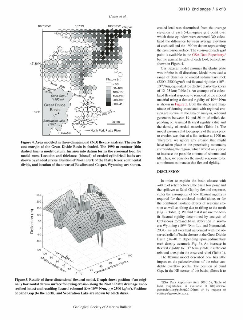
While the North Platte River continued to erode down to its present position, the Great Divide Basin became abandoned and then closed. The North Platte drainage has eroded a deep, wide val-ley just northeast of the much higher Great Divide Basin. It therefore seems possible that the strong asymmetry in erosion rates between these drain-ages may have contributed to closure of the basin due to regional isostatic response (i.e., fl exure). Was the fl exural uplift due to removal of basin fi ll in the North Platte drainage enough to lead to the observed differential uplift between Sand Creek Pass and Separation Lake?
In order to evaluate the fl exural effect of re-gional erosion, we applied a three-dimensional elastic fl exural model to the northeastern Great Divide Basin, in the vicinity of the Sand Gap spill-over point. To facilitate model construction, we assumed that the elevation of the Platte River near where the drainage from the Great Divide Basin once fl owed was close to the present elevation of the spillover at Sand Gap, i.e., 1990 m. Thus, we assume that any incision by the North Platte drainage below this elevation took place after the Great Divide Basin was no longer connected to the Platte River. The removal of material below this elevation would then lead to isostatic rebound in the area affected by the fl exural effects.
Figure 4 shows the present distribution of the 1990 m contour surrounding the modern Platte River. This contour line is assumed to represent the limits of Platte River erosion since isolation of the Great Divide Basin. We only modeled the region shown in Figure 4, an area of 100 × 120 km. This area includes the northeastern limit of the basin and adjacent parts of the North Platte River drainage from the towns of Rawlins to Casper, Wyoming. This modeled area is clos-est to the former spillover point at Sand Gap, where fl exural impacts would have been great-est. Erosion farther downstream along the North Platte River would have added to the calculated fl exural response; however, loads farther away have exponentially less impact on fl exure in the area of interest and are considered to have mini-mal impact on our results.
To facilitate modeling, we broke this region into a series of cylindrical point loads, each 5 km in diameter (Fig. 4), the removal of which leads to fl exural rebound. The height of each
Heller et al.
6 Geological Society of America Bulletin, Month/Month 2010
30113 2nd pages / 6 of 8
34
Seminoe Mtns
< 50 50–100 100–150 150–200 200–300 300–410
North Fork Platte River
continentaldivide
Sand Gap(1990 m)
Separation Lake(1947 m)
20 km
Casper
Ferris Mtns
Rawlins
107°W107°30′W 106°30′W
42°30′N
42°N
Great DivideBasin
1990 m
1990 m
Flexure (m)
Figure 4. Area modeled in three-dimensional (3-D) fl exure analysis. The north-east margin of the Great Divide Basin is shaded. The 1990 m contour (thin dashed line) is model datum. Incision into datum forms the erosional load for model runs. Location and thickness (binned) of eroded cylindrical loads are shown by shaded circles. Position of North Fork of the Platte River, continental divide, and location of the towns of Rawlins and Casper, Wyoming, are shown.
020
4060
80100
0
20
40
60
80
100
120
-100
-50
0
50
100
150
200
250
Distance East (km)Distance North (km)
Def
lect
ion
(m)
Figure 5. Results of three-dimensional fl exural model. Graph shows position of an origi-nally horizontal datum surface following erosion along the North Platte drainage as de-scribed in text and resulting fl exural rebound (D = 1022.5 N•m, ρs = 2500 kg/m3). Positions of Sand Gap (to the north) and Separation Lake are shown by black disks.
eroded load was determined from the average elevation of each 5-km-square grid point over which these cylinders were centered. We calcu-lated the difference between average elevation of each cell and the 1990 m datum representing the preerosion surface. The erosion of each grid point is available in the GSA Data Repository,1 but the general heights of each load, binned, are shown in Figure 4.
Our fl exural model assumes the elastic plate was infi nite in all directions. Model runs used a range of densities of eroded sedimentary rock (2200–2500 kg/m3) and fl exural rigidities (1022–1023 N•m, equivalent to effective elastic thickness of 12–25 km; Table 1). An example of a calcu-lated fl exural response to removal of the eroded material using a fl exural rigidity of 1022.5 N•m is shown in Figure 5. Both the shape and mag-nitude of doming associated with regional ero-sion are shown. In the area of analysis, rebound generates between 19 and 50 m of relief, de-pending on assumed fl exural rigidity value and the density of eroded material (Table 1). The model assumes that topography of the area prior to erosion was that of a fl at surface at 1990 m. Therefore, we ignore any erosion that might have taken place in the preexisting mountains surrounding the region, which would only serve to increase the possible amount of rebound and tilt. Thus, we consider the model response to be a minimum estimate at that fl exural rigidity.
DISCUSSION
In order to explain the basin closure with ~40 m of relief between the basin low point and the spillover at Sand Gap by fl exural response, either the assumption of low fl exural rigidity is required for the erosional model alone, or for the combined isostatic effects of regional ero-sion as well as tilting due to rifting to the north (Fig. 3; Table 1). We fi nd that if we use the best-fi t fl exural rigidity determined by analysis of Cretaceous foreland basin defl ection in south-ern Wyoming (1022.5 N•m; Liu and Nummedal, 2004), we get excellent agreement with the ob-served relief of basin closure in the Great Divide Basin (34–40 m depending upon sedimentary rock density assumed; Fig. 3). An increase in fl exural rigidity to 1023 N•m yields insuffi cient rebound to explain the observed relief (Table 1).
The fl exural model described here has little impact on the paleoelevations of the other can-didate overfl ow points. The position of Sand Gap, in the NE corner of the basin, allows it to
1GSA Data Repository item 2010158, Table of load magnitudes, is available at http://www. geosociety.org/pubs/ft2010.htm or by request to [email protected].

Climate control of closed basin formation
Geological Society of America Bulletin, Month/Month 2010 7
30113 2nd pages / 7 of 8
be maximally impacted by both the area of great-est erosion along the North Platte River to the northeast and the normal faulting to the north. We have not observed any other erosional or tec-tonic patterns in the vicinity of the other poten-tial overfl ow points around the basin that would yield comparable results from fl exural modeling.
It is possible that some additional relief may have been generated by local wind defl ation in the area of Separation Lake. We have ob-served occasional ventifact clasts in this part of the basin. Wind erosion on the order of 10 m would make it possible for the higher rigidity to provide a reasonable fi t. Regardless, we fi nd it interesting that rigidity of 1022.5 N•m best ex-plains both the Cretaceous subsidence history of southern Wyoming as well as our Pleistocene to Holocene reconstruction. This suggests there has been little net change in regional rigidity over the past ~70 m.y. across southern Wyo-ming, despite the Laramide crustal thickening that occurred during this time.
Model of Basin Evolution
Our results suggest that climate, leading to low erosion rates in the Great Divide Basin in contrast to high erosion rates nearby, coupled with an isostatic fl exural response can explain basin closure and most of the relief between the basin low point and spillover point. A key fac-tor to this interpretation is that the Great Divide Basin, once tributary to the North Platte River, is arid and has very little potential to integrate much precipitation despite its large size. None of the ranges surrounding the basin has high enough relief to force much orographic precipi-tation today. In addition, none of the ranges has large enough catchment area to provide signifi -cant discharge to the basin.
During Pleistocene time, glaciers that formed in the headwaters of the North Platte River (Fig. 6), but not in the Great Divide Basin, provided a means for high discharge during meltwater events during periods of glacial re-treat (e.g., Pelletier, 2009). Accelerated erosion along the North Platte River, but not the Great Divide Basin outfl ow, led to isolation of the lat-ter from the Platte drainage. Erosion in excess of 200 m by the North Platte River led to iso-static rebound that fl exed the northeast corner of the Great Divide Basin, creating signifi cant relief in the area of the basin outlet (i.e., tens of meters), which forced basin closure. Rigidi-ties of the order 1022.5 N•m generated a broad doming that affected the entire eastern part of the basin as well as nearby areas (Fig. 6). In ad-dition, normal faulting along the Granite Moun-tain block to the north of the Great Divide Basin (SGMF in Fig. 6) that took place sometime in
the past <11 m.y. encouraged minor back tilting due to fl exural rift shoulder effects. This added to closed basin relief, albeit to a minor extent.
Finally, windblown dunes formed as a result of continued aridifi cation of the central Rock-ies and adjacent Great Plains over Holocene time (Marrs et al., 1987). Dune fi elds are com-mon along the Wyoming Wind Corridor, which runs east across the southern half of Wyoming including the Great Divide Basin. A discontinu-ous line of sand dunes can be traced across the basin into the area of the basin outlet at Sand
Gap (Fig. 1). Sand dunes bank around the north-east basin margin and overtop the divide into the adjacent Platte River drainage. The dunes add as much as an extra ~100 m of relief to the basin closure in the area of Sand Gap.
CONCLUSIONS
Two- and three-dimensional fl exural analysis suggests that closure of the Great Divide Basin was likely due to enhanced erosion in the adja-cent North Platte River drainage. Enhancement of
Figure 6. Key elements for interpretation of climatic cause of clo-sure of the Great Divide Basin. Shaded region shows approximate area that underwent fl exural response and unloading due to erosion by the North Platte River (assuming fl exural rigidity of 1022.5 N•m) as well as thinning of the Granite Mountain block. Heavy dashed line follows approximate trace of previous drainage out of Great Divide Basin. SC—Sand Creek Gap, SL—Separation Lake.
Heller et al.
8 Geological Society of America Bulletin, Month/Month 2010
30113 2nd pages / 8 of 8
this closure was due to minor extrabasinal tectonic impact and the encroachment of sand dunes due to increased aridifi cation in Holocene time. In our model, differential erosion is caused by increased meltwater discharge during periods of deglacia-tion. Headwaters of the North Platte River were glaciated; the Great Divide Basin was not.
Because of the competition between the ef-fects of rift shoulder and erosional tilt, the results are not very sensitive to the sediment density as-sumed. The greater is the sediment density, the more erosional rebound plays a role, and the less rift shoulder uplift contributes. The amount of calculated tilt is sensitive to the fl exure rigidity of the lithosphere, producing a good fi t with ob-served basin relief if a rigidity of 1022.5 N•m is used. This value is the best fi t found by Liu and Nummedal (2004) in their study of Cretaceous foreland basin development across the same part of Wyoming. Hence, this suggests that net re-gional fl exural rigidity has not changed over the intervening ~70 m.y.
Isostatic impacts caused by differential ero-sion may play roles in drainage reorganizations and basin closure, and locally enhance structural features in a variety of locales (e.g., Simpson, 2004). Deep incision of the Grand Canyon by the Colorado River has led to in excess of 300 m of fl exural rebound (Pelletier, 2010). With broad wavelength deformation on the scale of 100 km, fl exural rebound may have led to drainage reor-ganization and drainage reversal along the can-yon rim. Similarly, Qinghai Lake, the largest lake in China, sits near the northeast margin of the Tibetan Plateau. The lake sits in a shallow closed basin that may owe its origins to basin closure due to nearby erosion by the Yellow River.
Our results indicate that the presence of a closed basin does not require, nor should be taken as proof of, tectonic activity. Flexural re-sponse to moderate differential erosion, as seen in this analysis, can generate tens of meters of tilt over wavelengths of many tens of kilometers. Such modest topography is suffi cient to close basins in most settings. An even greater degree of closure would have occurred if more incision had taken place. Although perhaps atypical, it seems that under special circumstances, climate alone can lead to closed basin formation.
ACKNOWLEDGMENTS
Field assistance was graciously provided by Pe-ter Beland, Max Garnier, Steve Holbrook, and Cliff Riebe. We thank Xiangyang Xie for allowing us to use his three-dimensional fl exure program, and PASS-CAL (IRIS) and Bryan Shuman for use of geophysi-cal equipment used to determine depth to bedrock. We benefi ted from discussions with Bryan Shuman and reviews by Peter Molnar and Christian Koeberl. Funding was made available through the Petroleum Research Fund of the American Chemical Society.
REFERENCES CITED
Anders, M.H., Saltzman, J., and Hemming, S.R., 2009, Neogene tephra correlations in eastern Idaho and Wyoming: Impli-cations for Yellowstone hotspot-related volcanism and tectonic activity: Geological Society of America Bulletin, v. 121, p. 837–856, doi: 10.1130/B26300.1.
Barlow, J.A., 1953, The Geology of the Rawlins Uplift, Car-bon County, Wyoming [Ph.D. thesis]: Laramie, Uni-versity of Wyoming, 179 p.
Bayley, R.W., 1968, Geologic Map of the Bradley Peak Quadrangle Carbon County, Wyoming: Washington, D.C., U.S. Geological Survey, 1 sheet.
Blackstone, D.L., Jr., 1991, Tectonic Relationships of the Southeastern Wind River Range, Southwestern Sweet-water Uplift, and Rawlins Uplift, Wyoming: Laramie, Geological Survey of Wyoming, 24 p.
Bradley, W.H., 1964, Geology of Green River Formation and associated Eocene rocks in southwestern Wyoming and adjacent parts of Colorado and Utah: U.S. Geological Survey Professional Paper 496-A, p. 1–86.
Carroll, A.R., and Bohacs, K.M., 1999, Stratigraphic clas-sifi cation of ancient lakes: Balancing tectonic and cli-matic controls: Geology, v. 27, p. 99–102, doi: 10.1130/0091-7613(1999)027<0099:SCOALB>2.3.CO;2.
Chéry, J., Lucazeau, F., Daignières, M., and Vi-lotte, J.P., 1992, Large uplift of rift fl anks: A ge-netic link with lithospheric rigidity?: Earth and Planetary Science Letters, v. 112, p. 195–211, doi: 10.1016/0012-821X(92)90016-O.
Farnsworth, R.K., Thompson, E.S., and Peck, E.L., 1982, Evaporation atlas for the contiguous 48 United States, in NOAA Technical Report 33: Washington, D.C., Of-fi ce of Hydrology, National Weather Service, National Oceanic and Atmospheric Administration, U.S. De-partment of Commerce, p. 26BI.
Flanagan, K.M., and Montagne, J., 1993, Neogene stra-tigraphy and tectonics of Wyoming, in Snoke, A.W., Steidtmann, J.R., and Roberts, S.M., eds., Geology of Wyoming, Volume 5: Laramie, Geological Survey of Wyoming, p. 572–607.
Garcia-Castellanos, D., 2007, The role of climate during high plateau formation; insights from numerical ex-periments: Earth and Planetary Science Letters, v. 257, p. 372–390, doi: 10.1016/j.epsl.2007.02.039.
Gaylord, D.R., 1982, Geologic history of the Ferris dune fi eld, south-central Wyoming, in Marrs, R.W., and Kolm, K.E., eds., Interpretation of the Windfl ow Char-acteristics from Eolian Landforms: Geological Society of America Special Paper 192, p. 65–82.
Hansen, W.R., 1986, Neogene tectonics and geomorphology of the eastern Uinta Mountains in Utah, Colorado and Wyoming: U.S. Geological Survey Professional Pa-per 1356, p. 1–78.
Humphrey, N.F., and Konrad, S.K., 2000, River incision or diversion in response to bedrock uplift: Geology, v. 28, p. 43–46, doi: 10.1130/0091-7613(2000)28<43:RIODIR>2.0.CO;2.
Jaworowski, C.C., 1985, Geomorphic Mapping and Trend Analysis of Quaternary Deposits with Implications for Late Quaternary Faulting, Central Wyoming Laramie [M.S. thesis]: University of Wyoming, 109 p.
Jordan, T.E., 1981, Thrust loads and foreland basin evolution, Cretaceous, western United States: American Association of Petroleum Geologists Bulletin, v. 65, p. 2506–2520.
Keller, G.R., and Baldridge, W.S., 1999, Lithospheric structure and evolution of the Rocky Mountains: Part II: Rocky Mountain Geology, v. 34, p. 121–130, doi: 10.2113/34.1.121.
Lange, R.A., Carmichael, I.S.E., and Hall, C.M., 2000, 40Ar/39Ar chronology of the Leucite Hills, Wyoming: Eruption rates, erosion rates, and an evolving tempera-ture structure of the underlying mantle: Earth and Plan-etary Science Letters, v. 174, p. 329–340, doi: 10.1016/S0012-821X(99)00267-8.
Lillegraven, J.A., and Ostresh, L.M., Jr., 1988, Evolution of Wyoming’s early Cenozoic topography and drain-age patterns: National Geographic Research, v. 4, p. 303–327.
Lillegraven, J.A., Snoke, A.W., and McKenna, M.C., 2002, Tectonic and paleogeographic implications of late Laramide geologic history in the northeastern corner of
Wyoming’s Hanna Basin: Rocky Mountain Geology, v. 39, p. 7–64, doi: 10.2113/39.1.7.
Liu, S., and Nummedal, D., 2004, Late Cretaceous sub-sidence in Wyoming: Quantifying the dynamic com-ponent: Geology, v. 32, p. 397–400, doi: 10.1130/G20318.1.
Love, J.D., 1970, Cenozoic Geology of the Granite Moun-tains Area, Central Wyoming: Washington, D.C., U.S. Geological Survey, 154 p.
Marrs, R.W., Kolm, K.E., and Gaylord, D.R., 1987, Dunes of the Wyoming Wind Corridor, southern Wyoming, in Stanley, S.B., Rocky Mountain section of the Geologi-cal Society of America: Boulder, Colorado, Geological Society of America, Centennial Field Guide, Rocky Mountain Section, p. 209–212.
Martner, B.E., and Marwitz, J.D., 1982, Wind charac-teristics in southern Wyoming: Journal of Applied Meteorology, v. 21, p. 1815–1827, doi: 10.1175/1520-0450(1982)021<1815:WCISW>2.0.CO;2.
Mayer, J.H., and Mahan, S.A., 2004, Late Quaternary stra-tigraphy and geochronology of the western Killpecker dunes, Wyoming: Quaternary Research, v. 61, p. 72–84, doi: 10.1016/j.yqres.2003.10.003.
McMillan, M.E., Heller, P.L., and Wing, S.L., 2006, History and causes of post-Laramide relief in the Rocky Moun-tain orogenic plateau: Geological Society of America Bulletin, v. 118, p. 393–405, doi: 10.1130/B25712.1.
Mears, B., Jr., 1998, Neogene normal faulting superposed on a Laramide uplift: Medicine Bow Mountains, Sierra Madre, and intervening Saratoga, Wyoming and Colo-rado: Contributions to Geology (Copenhagen), v. 32, p. 181–185.
Mederos, S., Tikoff, B., and Bankey, V., 2005, Geometry, timing and continuity of the Rock Springs Uplift, Wyoming, and Douglas Creek Arch, Colorado: Impli-cations for uplift mechanisms in the Rocky Mountain foreland, U.S.A.: Rocky Mountain Geology, v. 40, p. 167–191, doi: 10.2113/40.2.167.
Pelletier, J.D., 2009, The impact of snowmelt on the late Cenozoic landscape of the southern Rocky Mountains, USA: GSA Today, v. 19, no. 7, p. 4–11, doi: 10.1130/GSATG44A.1.
Pelletier, J.D., 2010, Numerical modeling of the late Ce-nozoic geomorphic evolution of Grand Canyon, Ari-zona: Geological Society of America Bulletin, v. 122, p. 595–608.
Pierce, K.L., 2004, Pleistocene glaciations of the Rocky Mountains, in Gillespie, A.R., Porter, S.C., and At-water, B.F., eds., The Quaternary Period in the United States: Developments in Quaternary Science: Amster-dam, Elsevier, p. 63–76.
Simpson, G., 2004, Role of river incision in enhancing de-formation: Geology, v. 32, p. 341–344, doi: 10.1130/G20190.2.
Snoke, A.W., 1993, Geologic history of Wyoming within the tectonic framework of the North American Cordillera, in Snoke, A.W., Steidtmann, J.R., and Roberts, S.M., eds., Geology of Wyoming, Volume 5: Laramie, Geo-logical Survey of Wyoming, p. 2–56.
Surdam, R.C., and Stanley, K.O., 1980, Effects of changes in drainage-basin boundaries on sedimentation in Eocene lakes Gosiute and Uinta of Wyoming, Utah, and Colorado: Geology, v. 8, p. 135–139, doi: 10.1130/0091-7613(1980)8<135:EOCIDB>2.0.CO;2.
U.S. Department of Interior, 2009, National Atlas: Precipi-tation of the Individual States and of the Contermi-nous States: http://www.nationalatlas.gov/index.html; http://www.nationalatlas.gov/printable/precipitation.html#list (accessed 2 April 2009).
Weissel, J.K., and Karner, G.D., 1989, Flexural uplift of rift fl anks due to mechanical unloading of the lithosphere during extension: Journal of Geophysi-cal Research, v. 94, p. 13,919–13,950, doi: 10.1029/JB094iB10p13919.
MANUSCRIPT RECEIVED 20 JUNE 2009REVISED MANUSCRIPT RECEIVED 2 FEBRUARY 2010MANUSCRIPT ACCEPTED 4 FEBRUARY 2010
Printed in the USA