chapter 8 - inner city objectives and policies
TRANSCRIPT

Nelson Resource Management Plan (31/03/08) 8-1
8 inner city
ICd Description
ICd.1 The Inner City Zone covers the commercial area of inner Nelson. It extends from Pioneer Park in the west, to include the Polytechnic and the government precinct in Albion Square on the eastern side. The Maitai River and residential areas form a natural boundary to the north, while the Cathedral and residential areas in the vicinity of Nile Street (East and West) define the southern extremity.
ICd.2 See the objective and policies relating to zones in Chapter 5 (district wide objectives and policies).
Within the Inner City there are two definable areas.
city centre
ICd.3 The City Centre is the area within the ring road formed by Collingwood, Halifax, and Rutherford Streets, and Selwyn Place. It also extends to the Maitai River along Trafalgar Street. This recognises the potential that exists to link the City Centre to this under-utilised natural feature, complementing the Church Steps and the Cathedral at the other end of Trafalgar Street. (It is considered that a City Centre zoning for the area bordering the Maitai River will generally result in activities with a higher standard of amenity, and more pedestrian traffic, than if the area were City Fringe.)
ICd.4 The City Centre is the heart of the city and provides a city and regional destination. It contains a concentration of mainly comparison shopping, services such as banks and offices, as well as a growing number of restaurants, cafes and other entertainment activities. All contribute to the City Centre being a commercial, cultural, tourist and recreational focal point to the city.
ICd.5 Past planning provisions have resulted in a compact form which is relatively easily walked from end to end. An important part of the character and functioning of the City Centre has been the progressive development since the 1960s of parking squares. These give vehicle access and parking directly behind the buildings on the main pedestrian streets.
ICd.6 The establishment of the ring road to divert through-traffic from using Bridge, Hardy and Trafalgar Streets, along with traffic calming measures, has reduced traffic volumes and impacts within the City Centre. Direct access from the ring road to the squares has also reduced the need for vehicles to travel down Hardy and Bridge Streets.
ICd.7 Streetscape works, including planting, street furniture and paving, have enhanced the amenity of the area as has the creation of the 1903 park.
ICd.8 Over most of the area, sites are highly developed as past planning provisions have allowed 100% coverage, with the Council providing car parking collectively.
ICd.9 The majority of the buildings within the City Centre are low rise, predominantly two storeys. There are only a handful of buildings in excess of 4 storeys. Many of the buildings date from the Victorian or Edwardian period, and many of these are of historic and architectural significance.
8-2 (31/03/08) Nelson Resource Management Plan
ICd.10 The term City Centre is used rather than “Central Business District” to reflect the multiplicity of functions and the community focus. While it is recognised that retailing is the primary activity in the City Centre, and is likely to remain so, the broader term City Centre better describes the range of functions served by the area.
city fringe
ICd.11 The City Fringe more or less surrounds the City Centre, on the outer side of the ring road.
ICd.12 Activities in the City Fringe are diverse and include convenience shopping (such as supermarkets), some service industries, large site retailing (such as bulk retail and second hand stores), offices, the Nelson Polytechnic, cultural and recreational facilities, wholesaling, and retailing to commercial users in the City Centre. Businesses tend to be more vehicle oriented. That is, people are more likely to drive to these businesses, and may in fact need to drive to a particular site.
ICd.13 The area has been formed as a result of transition to other activities and past contraction of the retail centre. This had tended to sprawl over a wide area until previous planning controls concentrated retail activity into the City Centre.
ICd.14 The appearance of the area is diverse, and includes substantial Government Service buildings, churches, the Polytechnic, converted dwellings, warehouses and purpose built commercial buildings.
ICd.15 The general appearance of the area tends therefore to be somewhat utilitarian, although landscaping has softened particularly the Government buildings and the Polytechnic. Heavy traffic volumes are experienced around the inner edge of the area. The area is frequently used for free all day parking, which has led to some congestion, particularly around the Polytechnic.
objective
IC1 form and access
A compact and convenient pedestrian oriented environment within the City Centre, which is supported and complemented by a predominantly vehicle oriented City Fringe of self-contained sites.
Reasons IC1.i The strength and usefulness of the City Centre, as the commercial and
cultural focus of the city, relies on the life that people bring to the area. Comparison shopping, and the recreational functions served by the City Centre, are enhanced by a pedestrian orientation. If the City Centre is dispersed, cohesion breaks down and it is no longer convenient for the people using it. This is an adverse effect on people, and the environment that is the City Centre. By providing the opportunity for activities to locate in the Fringe which are unsuited or unable to locate in the City Centre, the quality of the environment in the City Centre can be enhanced, eg. enabling vehicle based activities in the City Fringe reduces potentially adverse effects within the City Centre. A focus on supporting and complementing the City Centre is included to ensure the area enhances rather than weakens the role of the City Centre. The City Fringe is also an important location for activities that may be unsuited to the Industrial Zone or the Suburban Commercial areas. Likewise, the provision for limited large format retailing and complimentary activities on the site defined in Schedule N is in recognition of the appropriateness of that Site to accommodate growth in this retailing sector in an efficient manner that also maintains the strength and vitality of the commercial environment.

Nelson Resource Management Plan (31/03/08) 8-3
policy IC1.1 strength of city centre
Activities should not set up in locations, where singly or together with other activities, they are likely to have a significant adverse effect on the role of the City Centre as the focal point for the City. Within the city fringe, special provision is made for small scale activities in Nile Street West, while limited large format retailing is specifically provided for in the Schedule N (Industrial Zone in Tahunanui).
Explanation and Reasons IC1.1.i The policy is concerned with adverse effects of activities on the City Centre.
The City Centre is a physical resource in terms of the Act’s definition of natural and physical resources. When considered in conjunction with the definition of ‘environment’ the City Centre is an aspect of the Nelson City community that should be sustained.
IC1.1.ii The policy addresses the City Centre as an entity, and does not seek to protect particular existing activities. As noted in ICd.4, the City Centre is the commercial, cultural, tourist and recreational focal point to the city. The policy is concerned with the vitality of the City Centre as a whole. The City Centre is a complex interaction between the physical environment, including heritage buildings, landscaping, parking and traffic control, and the activities that occur within the area.
IC1.1.iii Certain activities setting up outside the City Centre can lead to a decline in the role of the Centre as a focal point for a range of purposes. Despite the mosaic of activities that make up the City Centre, retailing is the activity with the greatest potential impact. This is because it is a major attractor of people. Also, retailing can tend to form alternate centres or nodes to the detriment of the City Centre as a whole. This is not usually the case for other activities such as restaurants and cafés.
IC1.1.iv The City Centre has had a major investment of public money to support its role as a community focal point e.g. the creation of the parking squares, paving, planting and addition of street furniture, street closures and the development of the ring road system. Any significant decline in the City Centre would also threaten the viability of many heritage buildings which make a significant contribution to the character of Nelson, and the City Centre in particular.
IC1.1.v Restricting retailing in the City Fringe area has costs. A total prohibition would not allow businesses the flexibility to locate on sites that best suit their needs. Thus benefits would be lost to retailers and shoppers in terms of convenient vehicle-based shopping, and possibly cheaper prices. Hence, the Plan provides an appropriate opportunity for commercial activities in other complimentary locations.
IC1.1. vi These factors, however, must be weighed against the decline in the City Centre that would result if a totally hands-off approach were adopted. Controls have therefore been put in place to regulate the scale and nature of retailing activities with regard to their proximity and relationship to the City Centre from both a functional and locational basis. These controls recognise the growing physical demand for commercial activities, especially the large format retail trends, that may not be able to be met in the City Centre or could only be met at the expense of the present convenient pedestrian orientation of the City Centre. The City Centre is also better adapted to being served by public transport.
IC1.1.vii The policy focuses on activities that might adversely affect the City Centre, rather than total prohibition. It provides for retailing and other activities outside the City Centre so long as they do not adversely affect the Centre. Thus the methods that implement the policy allow as of right retailing in the City Fringe and as a controlled activity within schedule N in the Industrial Zone in Tahunanui that can be defined as having minor effects, or indeed that would be unsuited to a City Centre location. Finally, other retailing is considered as a discretionary activity on a case by case basis. This allows an effects based assessment of any possible adverse effects. This multi-pronged approach aims to capture the benefits of a more flexible approach, while maintaining the overall objective of a strong and vibrant City Centre, while enabling the community to meet its need for land for growth in the retailing sector.

8-4 (31/03/08) Nelson Resource Management Plan
IC1.1. viii Special provision has been made for Nile Street West, recognising the presence of the Rutherford Hotel and the high tourist foot traffic that this generates.
Methods IC1.1.ix Continue to enhance the desirability of the City Centre as a place for
people to visit and businesses to locate in eg. physical works to enhance the attractiveness of the City Centre (paving, planting etc), maintain and improve access to the City Centre and parking within, more pedestrian- friendly environment.
IC1.1.x Rules controlling retail activities in the City Fringe area and Industrial Zone which compete with the City Centre, which are unsuited to a City Centre location or are unable to be accommodated within other commercial zones.
policy IC1.2 large scale activities
Activities which are likely to generate large numbers of customers should be sited preferably within the City Centre, on sites with good physical linkages to the City Centre, or on the site defined by Schedule N (see Schedule N in the Industrial Zone).
Explanation and Reasons IC1.2.i This policy recognises the particular needs and effects of activities with a
large customer base. These are most likely to be large scale retail stores, such as warehouse trading operations, super stores or supermarkets. The policy gives preference to such activities located within the City Centre, subject to the availability of suitable sites and their effects being acceptable. This supports the City Centre as the commercial, cultural, tourist and recreational focal point of the city. It is recognised that in the Inner City, sites suitable for high customer-generating activities may only be available in the City Fringe. In such cases there should be strong linkages between the site and the City Centre itself. Again this helps reinforce the objective of a compact and convenient City Centre which is supported by the Fringe. Occasional events such as carnivals and festivals outside the City Centre would not be contrary to this policy.
Method IC1.2.ii Rules providing for large scale retail activities to locate: a) in close proximity to the ring road. b) otherwise on the site defined by Schedule N (see Schedule N in the Industrial
Zone).
policy IC1.3 access - city centre
Access of people and goods to and from the City Centre should be maintained and enhanced. Within the City Centre pedestrian accessibility and safety should be enhanced, and vehicle/pedestrian conflicts reduced, recognising in particular the needs of people with disabilities.
Explanation and Reasons IC1.3.i People get to the City Centre by foot, cycle, public transport and private
vehicles, with the private car being the dominant form of transport. The policy aims to ensure good access of vehicles to the City Centre, but to reinforce the dominance of pedestrians within the City Centre. The Squares provide a very good framework to build on. They bring people close to the main pedestrian streets, enabling them to leave their vehicles to complete a number of tasks on foot.
Methods IC1.3.ii Maintain and enhance ability of ring road to bring vehicles to City Centre. IC1.3.iii Create more parking squares. IC1.3.iv Further traffic calming. IC1.3.v Investigate improving public transport eg siting of bus stops, taxi stands. IC1.3.vi Improve cycling facilities.

Nelson Resource Management Plan (05/06/07) 8-83
Assessment Criteria Explanation
FWr.4.4
a) effects on water quality.
b) effects on aquatic ecosystems.
c) the degree to which the activity affects the existing classification and values of the waterbody (refer to Appendix 28.4 and Appendix 6). Where insufficient information is available, and for unspecified rivers, a site assessment will have to be supplied when an application is made for a discretionary activity.
d) disturbance of the bed.
e) the method and timing of works
f) duration of consent.
g) monitoring and reporting requirements.
h) review of consent conditions and the timing and purpose of the review.
i) any effects of the activity on network utilities.
j) flood capacity.
k) any effects on historic heritage including an archaeological site or a site where archaeological or cultural material is discovered.
FWr.4.5
Structures located in and under the beds of rivers and lakes can cause adverse effects. These range from visual intrusion on natural character and amenity values, to permanent effects on ecology and biota by restricting fish passage upstream of the structure or affecting water flow and the natural functioning of a river.
For these reasons, instream structures should generally not be a permitted activity so the Council has the opportunity to assess potential effects, and to require appropriate measures to be undertaken to avoid or reduce adverse effects. Where the effects are significant and cannot be adequately avoided or reduced, the structure should not be erected.
The following district wide policies are relevant to this rule:
DO17.1.3 (flood damage)
DO17.1.6 (structures in and under the beds of rivers, lakes and wetlands)
DO17.2.1 (activities and structures in the beds of rivers and lakes which affect network utility operations)
Activities adjoining a Riparian Overlay are also regulated by the ‘Riparian Overlay – activities on land identified with riparian values’ rule in each zone.

8-84 (05/06/07) Nelson Resource Management Plan
Item Permitted Controlled Discretionary/Non-complying
FWr.5
Bridges, culverts and fords
[note that this rule is a regional rule]
FWr.5.1
a) The placement or erection of a bridge over the bed of a river or lake is a permitted activity if:
i) any abutments are stabilised and protected against erosion, and
ii) the approaches to the bridge are constructed and maintained to minimise the discharge or runoff, and
iii) the bridge and its associated design structures is designed to convey a 1:50 year flood event (and 0.4m freeboard) in the following rivers: Reservoir Creek, Saxton Creek, Orphanage Creek, Orchard Creek, Poormans Valley Stream, Arapiki Stream, Jenkins Creek, York Stream, Maitai River, The Brook Stream, Oldham Creek, Todds Valley Stream, Wakapuaka River and its named tributaries and Whangamoa River and its named tributaries, and in any other rivers, the bridge and its associated design structures is designed to convey a 1:15 year flood event (with 0.4m freeboard).
b) An existing culvert or ford which was lawfully established prior to the freshwater plan change being made operative is a permitted activity if the structure does not adversely affect:
i) fish passage, or
ii) water quality, or
iii) flood capacity.
FWr.5.2
a) The placement or erection of a new culvert, and associated armouring, is controlled if:
i) the general conditions in Rule FWr.1.1 (excluding controls on aggregate extraction) are met, and
ii) the culvert is positioned so that the gradient and alignment are the same as the river, and
iii) the downstream floor of the culvert is set below the river bed level, and
iv) erosion immediately below the culvert is avoided by use of armouring materials such as rocks, and
v) the culvert is maintained so it does not become blocked by debris, and
vi) the culvert and its associated design structures is designed to convey a 1:50 year flood event (and 0.4m freeboard) in the following rivers: Reservoir Creek, Saxton Creek, Orphanage Creek, Orchard Creek, Poormans Valley Stream, Arapiki Stream, Jenkins Creek, York Stream, Maitai River, The Brook Stream, Oldham Creek, Todds Valley Stream, Wakapuaka River and its named tributaries and Whangamoa River and its named tributaries, and in any other rivers, the culvert and its associated design structures is designed to convey a 1:15 year flood event (with 0.4m freeboard).
b) Installation of a new ford is controlled if:
i) the general conditions in Rule FWr.1.1 are met, and
ii) the ford will raise the level of the bed by no more than 300mm, and
iii) the ford does not impede fish passage.
Control is reserved over the following matters:
i) damage to indigenous vegetation and habitats, and
ii) disturbance of river banks and river beds, and
iii) adverse effects on fish passage, and
iv) flood capacity. In this rule applications for controlled activities may be considered without notification and without the need to obtain written approval of affected persons, under section 94 of the Act.
FWr.5.3
Discretionary
a) A bridge, culvert or ford which cannot meet the conditions for a permitted activity, and
b) a culvert or ford which cannot meet the conditions for a controlled activity
is a discretionary activity.
In this rule applications for discretionary activities may be considered without notification and without the need to obtain written approval of affected persons, under section 94 of the Act.

Nelson Resource Management Plan (22/07/06) 8-95
Assessment Criteria Explanation
FWr.11.4
a) the scale of the activity.
b) any visual or noise effects.
c) safety considerations.
d) the effect of the proposal on non-commercial recreational activities.
FWr.11.5
While personal recreation activities such as kayaking have no adverse effects, commercial and motorised activities could adversely affect the amenity and natural values of surface waters.

8-96 (22/07/06) Nelson Resource Management Plan
Item Permitted Controlled Discretionary/Non-complying
FWr.12
Take, use, or diversion of surface water
[note that this rule is a regional rule]
FWr.12.1
a) The take, use, or diversion of surface water for reasonable domestic use is permitted if:
i) the relevant conditions in Appendix 28.3 are met, and
ii) the volume of the take does not exceed 1m
3 per residential unit per
day (plus 300 litres per bedroom for short term living accommodation) and there are no adverse effects on the water source, and
iii) the rate of take does not exceed 0.5 litres per second, and
iv) there is no take below any minimum flow specified in Appendix 28.2, and
v) the Council’s reticulated water supply is not available to the site.
b) The take or use of surface water for stock drinking water is permitted if the rate of take does not exceed 0.5 litres per second.
c) The take or use of surface water for fire fighting or the filling of fire ponds is permitted.
FWr.12.2
not applicable
FWr.12.3
Restricted Discretionary Activity
Any take, use or diversion of surface water that contravenes a permitted condition is a restricted discretionary activity if:
i) the relevant conditions in Appendix 28.3 are met, and
ii) the take or use does not exceed, individually or cumulatively, the allocation limits specified in Appendix 28.2, and
iii) the diversion does not cause any river to drop below the minimum flow specified in Appendix 28.2, and
iv) the distance between intake and return of the water does not exceed 500 metres, and
v) the diversion of water is not from one waterbody to another.
Discretion restricted to:
i) the design and location of the intake structure, and
ii) access to pipework for maintenance, and
iii) the volume and rate of take
iv) reliability of supply
v) effects on water source and values (as identified in Appendix 28.4), and
vi) effects on other lawfully established abstractions, and
vii) the quality of the water returned to a river by a diversion.
In this rule applications for restricted discretionary activities will be considered without notification, the written approval of affected persons will not be necessary, and notice of the application need not be served on any person, provided it can be shown that the building can be located in such a way as to ensure that access to the drain or pipe for maintenance or replacement purposes, can be achieved without causing adverse financial or physical effect on neighbouring properties or persons who are served by the same pipe or drain.
Discretionary
a) The take or use of surface water, for uses other than those listed as permitted, and
b) any activity specified as restricted discretionary which contravenes the restricted discretionary conditions,
is discretionary.
Non-complying
a) A take or use of surface water which exceeds the allocation limits specified in Appendix 28.2, and
b) a take or use below any specified minimum flow regime, except for permitted uses, and
c) a take, use, or diversion of water from wetlands or drainage of naturally occurring wetlands,
is non-complying.
Prohibited
All takes downstream from the NCC urban water supply intakes in the Maitai River and in the downstream reach of the Roding River within the NCC boundary, which did not exist prior to 9 October 2004 are prohibited.

Nelson Resource Management Plan (06/03/07) 8-113
Assessment Criteria Explanation
FWr.21.4
a) risk to public health and the environment
b) the sensitivity of the receiving environment
c) effects on existing uses of any waterbody affected by the discharge
d) practicable methods to decrease the potential for discharges
FWr.21.5
Sewage discharges to freshwater can occur from a sewage system overflow from a stormwater system, a discharge to land, or directly to freshwater. This rule applies to all of these overflow discharges.
Discharge of raw sewerage to waterbodies is unacceptable for public health, cultural and environmental reasons. However, overflows sometimes occur during heavy rain events due to inflow or infiltration of stormwater into the sewerage system, and when sewers block.
In this rule wastewater network discharges are a discretionary activity in recognition of the fact that they do happen, that it is an expensive problem to avoid, to provide certainty of conditions and the ability to prioritise works.
The following district wide objective and policy are relevant to this rule:
Objective: DO19.1 (highest practicable water quality)
Policy: DO19.1.5 (minimum quality)
8-114 (06/03/07) Nelson Resource Management Plan
Item Permitted Controlled Discretionary/Non-complying
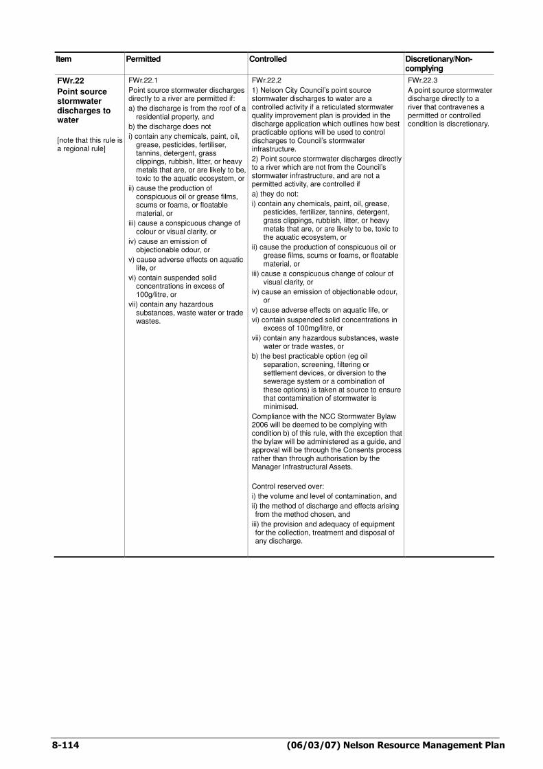
FWr.22
Point source stormwater discharges to water
[note that this rule is a regional rule]
FWr.22.1
Point source stormwater discharges directly to a river are permitted if:
a) the discharge is from the roof of a residential property, and
b) the discharge does not
i) contain any chemicals, paint, oil, grease, pesticides, fertiliser, tannins, detergent, grass clippings, rubbish, litter, or heavy metals that are, or are likely to be, toxic to the aquatic ecosystem, or
ii) cause the production of conspicuous oil or grease films, scums or foams, or floatable material, or
iii) cause a conspicuous change of colour or visual clarity, or
iv) cause an emission of objectionable odour, or
v) cause adverse effects on aquatic life, or
vi) contain suspended solid concentrations in excess of 100g/litre, or
vii) contain any hazardous substances, waste water or trade wastes.
FWr.22.2
1) Nelson City Council’s point source stormwater discharges to water are a controlled activity if a reticulated stormwater quality improvement plan is provided in the discharge application which outlines how best practicable options will be used to control discharges to Council’s stormwater infrastructure.
2) Point source stormwater discharges directly to a river which are not from the Council’s stormwater infrastructure, and are not a permitted activity, are controlled if
a) they do not:
i) contain any chemicals, paint, oil, grease, pesticides, fertilizer, tannins, detergent, grass clippings, rubbish, litter, or heavy metals that are, or are likely to be, toxic to the aquatic ecosystem, or
ii) cause the production of conspicuous oil or grease films, scums or foams, or floatable material, or
iii) cause a conspicuous change of colour of visual clarity, or
iv) cause an emission of objectionable odour, or
v) cause adverse effects on aquatic life, or
vi) contain suspended solid concentrations in excess of 100mg/litre, or
vii) contain any hazardous substances, waste water or trade wastes, or
b) the best practicable option (eg oil separation, screening, filtering or settlement devices, or diversion to the sewerage system or a combination of these options) is taken at source to ensure that contamination of stormwater is minimised.
Compliance with the NCC Stormwater Bylaw 2006 will be deemed to be complying with condition b) of this rule, with the exception that the bylaw will be administered as a guide, and approval will be through the Consents process rather than through authorisation by the Manager Infrastructural Assets.
Control reserved over:
i) the volume and level of contamination, and
ii) the method of discharge and effects arising from the method chosen, and
iii) the provision and adequacy of equipment for the collection, treatment and disposal of any discharge.
FWr.22.3
A point source stormwater discharge directly to a river that contravenes a permitted or controlled condition is discretionary.

Nelson Resource Management Plan (05/06/07) 9-67
Assessment Criteria Explanation
FWr.4.4
a) effects on water quality.
b) effects on aquatic ecosystems.
c) the degree to which the activity affects the existing classification and values of the waterbody (refer to Appendix 28.4 and Appendix 6). Where insufficient information is available, and for unspecified rivers, a site assessment will have to be supplied when an application is made for a discretionary activity.
d) disturbance of the bed.
e) the method and timing of works
f) duration of consent.
g) monitoring and reporting requirements.
h) review of consent conditions and the timing and purpose of the review.
i) any effects of the activity on network utilities.
j) flood capacity.
k) any effects on historic heritage including an archaeological site or a site where archaeological or cultural material is discovered.
FWr.4.5
Structures located in and under the beds of rivers and lakes can cause adverse effects. These range from visual intrusion on natural character and amenity values, to permanent effects on ecology and biota by restricting fish passage upstream of the structure or affecting water flow and the natural functioning of a river.
For these reasons, instream structures should generally not be a permitted activity so the Council has the opportunity to assess potential effects, and to require appropriate measures to be undertaken to avoid or reduce adverse effects. Where the effects are significant and cannot be adequately avoided or reduced, the structure should not be erected.
The following district wide policies are relevant to this rule:
DO17.1.3 (flood damage)
DO17.1.6 (structures in and under the beds of rivers, lakes and wetlands)
DO17.2.1 (activities and structures in the beds of rivers and lakes which affect network utility operations)
Activities adjoining a Riparian Overlay are also regulated by the ‘Riparian Overlay – activities on land identified with riparian values’ rule in each zone.

9-68 (05/06/07) Nelson Resource Management Plan
Item Permitted Controlled Discretionary/Non-complying
FWr.5
Bridges, culverts and fords
[note that this rule is a regional rule]
FWr.5.1
a) The placement or erection of a bridge over the bed of a river or lake is a permitted activity if:
i) any abutments are stabilised and protected against erosion, and
ii) the approaches to the bridge are constructed and maintained to minimise the discharge or runoff, and
iii) the bridge and its associated design structures is designed to convey a 1:50 year flood event (and 0.4m freeboard) in the following rivers: Reservoir Creek, Saxton Creek, Orphanage Creek, Orchard Creek, Poormans Valley Stream, Arapiki Stream, Jenkins Creek, York Stream, Maitai River, The Brook Stream, Oldham Creek, Todds Valley Stream, Wakapuaka River and its named tributaries and Whangamoa River and its named tributaries, and in any other rivers, the bridge and its associated design structures is designed to convey a 1:15 year flood event
(with 0.4m freeboard).
b) An existing culvert or ford which was lawfully established prior to the freshwater plan change being made operative is a permitted activity if the structure does not adversely affect:
i) fish passage, or
ii) water quality, or
iii) flood capacity.
FWr.5.2
a) The placement or erection of a new culvert, and associated armouring, is controlled if:
i) the general conditions in Rule FWr.1.1 (excluding controls on aggregate extraction) are met, and
ii) the culvert is positioned so that the gradient and alignment are the same as the river, and
iii) the downstream floor of the culvert is set below the river bed level, and
iv) erosion immediately below the culvert is avoided by use of armouring materials such as rocks, and
v) the culvert is maintained so it does not become blocked by debris, and
vi) the culvert and its associated design structures is designed to convey a 1:50 year flood event (and 0.4m freeboard) in the following rivers: Reservoir Creek, Saxton Creek, Orphanage Creek, Orchard Creek, Poormans Valley Stream, Arapiki Stream, Jenkins Creek, York Stream, Maitai River, The Brook Stream, Oldham Creek, Todds Valley Stream, Wakapuaka River and its named tributaries and Whangamoa River and its named tributaries, and in any other rivers, the culvert and its associated design structures is designed to convey a 1:15 year flood event (with 0.4m freeboard).
b) Installation of a new ford is controlled if:
i) the general conditions in Rule FWr.1.1 are met, and
ii) the ford will raise the level of the bed by no more than 300mm, and
iii) the ford does not impede fish passage.
Control is reserved over the following matters:
i) damage to indigenous vegetation and habitats, and
ii) disturbance of river banks and river beds, and
iii) adverse effects on fish passage, and
iv) flood capacity.
In this rule applications for controlled activities may be considered without notification and without the need to obtain written approval of
affected persons, under section 94 of the Act.
FWr.5.3
Discretionary
a) A bridge, culvert or ford which cannot meet the conditions for a permitted activity, and
b) a culvert or ford which cannot meet the conditions for a controlled activity
is a discretionary activity.
In this rule applications for discretionary activities may be considered without notification and without the need to obtain written approval of affected persons, under section 94 of the Act

Nelson Resource Management Plan (22/07/06) 9-79
Assessment Criteria Explanation
FWr.11.4
a) the scale of the activity.
b) any visual or noise effects.
c) safety considerations.
d) the effect of the proposal on non-commercial recreational activities.
FWr.11.5
While personal recreation activities such as kayaking have no adverse effects, commercial and motorised activities could adversely affect the amenity and natural values of surface waters.

9-80 (22/07/06) Nelson Resource Management Plan
Item Permitted Controlled Discretionary/Non-complying
FWr.12
Take, use, or diversion of surface water
[note that this rule is a regional rule]
FWr.12.1
a) The take, use, or diversion of surface water for reasonable domestic use is permitted if:
i) the relevant conditions in Appendix 28.3 are met, and
ii) the volume of the take does not exceed 1m
3 per residential unit per
day (plus 300 litres per bedroom for short term living accommodation) and there are no adverse effects on the water source, and
iii) the rate of take does not exceed 0.5 litres per second, and
iv) there is no take below any minimum flow specified in Appendix 28.2, and
v) the Council’s reticulated water supply is not available to the site.
b) The take or use of surface water for stock drinking water is permitted if the rate of take does not exceed 0.5 litres per second.
c) The take or use of surface water for fire fighting or the filling of fire ponds is permitted.
FWr.12.2
not applicable
FWr.12.3
Restricted Discretionary Activity
Any take, use or diversion of surface water that contravenes a permitted condition is a restricted discretionary activity if:
i) the relevant conditions in Appendix 28.3 are met, and
ii) the take or use does not exceed, individually or cumulatively, the allocation limits specified in Appendix 28.2, and
iii) the diversion does not cause any river to drop below the minimum flow specified in Appendix 28.2, and
iv) the distance between intake and return of the water does not exceed 500 metres, and
v) the diversion of water is not from one waterbody to another.
Discretion restricted to:
i) the design and location of the intake structure, and
ii) access to pipework for maintenance, and
iii) the volume and rate of take
iv) reliability of supply
v) effects on water source and values (as identified in Appendix 28.4), and
vi) effects on other lawfully established abstractions, and
vii) the quality of the water returned to a river by a diversion.
In this rule applications for restricted discretionary activities will be considered without notification, the written approval of affected persons will not be necessary, and notice of the application need not be served on any person, provided it can be shown that the building can be located in such a way as to ensure that access to the drain or pipe for maintenance or replacement purposes, can be achieved without causing adverse financial or physical effect on neighbouring properties or persons who are served by the same pipe or drain.
Discretionary
a) The take or use of surface water, for uses other than those listed as permitted, and
b) any activity specified as restricted discretionary which contravenes the restricted discretionary conditions,
is discretionary.
Non-complying
a) A take or use of surface water which exceeds the allocation limits specified in Appendix 28.2, and
b) a take or use below any specified minimum flow regime, except for permitted uses, and
c) a take, use, or diversion of water from wetlands or drainage of naturally occurring wetlands,
is non-complying.
Prohibited
All takes downstream from the NCC urban water supply intakes in the Maitai River and in the downstream reach of the Roding River within the NCC boundary, which did not exist prior to 9 October 2004 are prohibited.

Nelson Resource Management Plan (06/03/07) 9-97
Assessment Criteria Explanation
FWr.21.4
a) risk to public health and the environment
b) the sensitivity of the receiving environment
c) effects on existing uses of any waterbody affected by the discharge
d) practicable methods to decrease the potential for discharges
FWr.21.5
Sewage discharges to freshwater can occur from a sewage system overflow from a stormwater system, a discharge to land, or directly to freshwater. This rule applies to all of these overflow discharges.
Discharge of raw sewerage to waterbodies is unacceptable for public health, cultural and environmental reasons. However, overflows sometimes occur during heavy rain events due to inflow or infiltration of stormwater into the sewerage system, and when sewers block.
In this rule wastewater network discharges are a discretionary activity in recognition of the fact that they do happen, that it is an expensive problem to avoid, to provide certainty of conditions and the ability to prioritise works.
The following district wide objective and policy are relevant to this rule:
Objective: DO19.1 (highest practicable water quality)
Policy: DO19.1.5 (minimum quality)

9-98 (06/03/07) Nelson Resource Management Plan
Item Permitted Controlled Discretionary/Non-complying
FWr.22
Point source stormwater discharges to water
[note that this rule is a regional rule]
FWr.22.1
Point source stormwater discharges directly to a river are permitted if:
a) the discharge is from the roof of a residential property, and
b) the discharge does not
i) contain any chemicals, paint, oil, grease, pesticides, fertiliser, tannins, detergent, grass clippings, rubbish, litter, or heavy metals that are, or are likely to be, toxic to the aquatic ecosystem, or
ii) cause the production of conspicuous oil or grease films, scums or foams, or floatable material, or
iii) cause a conspicuous change of colour or visual clarity, or
iv) cause an emission of objectionable odour, or
v) cause adverse effects on aquatic life, or
vi) contain suspended solid concentrations in excess of 100g/litre, or
vii) contain any hazardous substances, waste water or trade wastes.
FWr.22.2
1) Nelson City Council’s point source stormwater discharges to water are a controlled activity if a reticulated stormwater quality improvement plan is provided in the discharge application which outlines how best practicable options will be used to control discharges to Council’s stormwater infrastructure.
2) Point source stormwater discharges directly to a river which are not from the Council’s stormwater infrastructure, and are not a permitted activity, are controlled if
a) they do not:
i) contain any chemicals, paint, oil, grease, pesticides, fertilizer, tannins, detergent, grass clippings, rubbish, litter, or heavy metals that are, or are likely to be, toxic to the aquatic ecosystem, or
ii) cause the production of conspicuous oil or grease films, scums or foams, or floatable material, or
iii) cause a conspicuous change of colour of visual clarity, or
iv) cause an emission of objectionable odour, or
v) cause adverse effects on aquatic life, or
vi) contain suspended solid concentrations in excess of 100mg/litre, or
vii) contain any hazardous substances, waste water or trade wastes, or
b) the best practicable option (eg oil separation, screening, filtering or settlement devices, or diversion to the sewerage system or a combination of these options) is taken at source to ensure that contamination of stormwater is minimised.
Compliance with the NCC Stormwater Bylaw 2006 will be deemed to be complying with condition b) of this rule, with the exception that the bylaw will be administered as a guide, and approval will be through the Consents process rather than through authorisation by the Manager Infrastructural Assets.
Control reserved over:
i) the volume and level of contamination, and
ii) the method of discharge and effects arising from the method chosen, and
iii) the provision and adequacy of equipment for the collection, treatment and disposal of any discharge.
FWr.22.3
A point source stormwater discharge directly to a river that contravenes a permitted or controlled condition is discretionary.
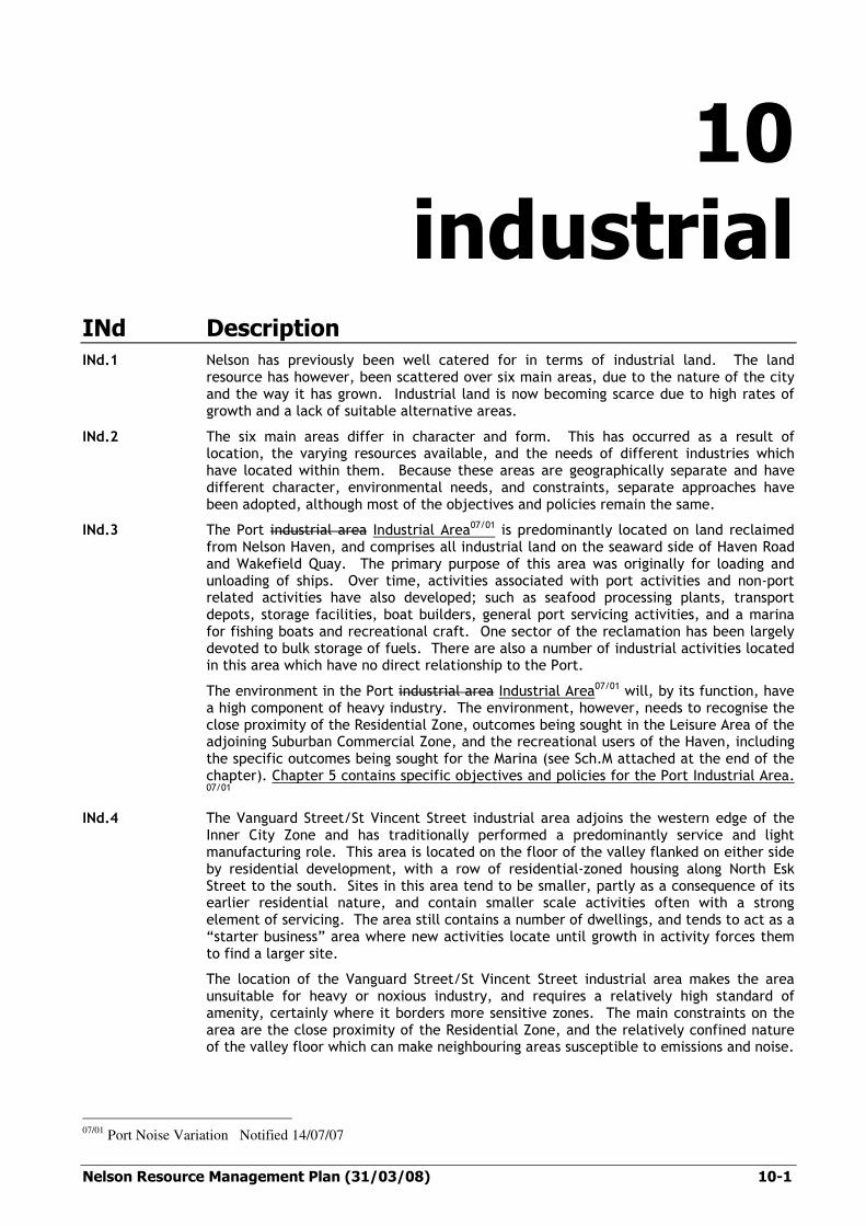
Nelson Resource Management Plan (31/03/08) 10-1
10 industrial
INd Description
INd.1 Nelson has previously been well catered for in terms of industrial land. The land resource has however, been scattered over six main areas, due to the nature of the city and the way it has grown. Industrial land is now becoming scarce due to high rates of growth and a lack of suitable alternative areas.
INd.2 The six main areas differ in character and form. This has occurred as a result of location, the varying resources available, and the needs of different industries which have located within them. Because these areas are geographically separate and have different character, environmental needs, and constraints, separate approaches have been adopted, although most of the objectives and policies remain the same.
INd.3 The Port industrial area Industrial Area07/01 is predominantly located on land reclaimed from Nelson Haven, and comprises all industrial land on the seaward side of Haven Road and Wakefield Quay. The primary purpose of this area was originally for loading and unloading of ships. Over time, activities associated with port activities and non-port related activities have also developed; such as seafood processing plants, transport depots, storage facilities, boat builders, general port servicing activities, and a marina for fishing boats and recreational craft. One sector of the reclamation has been largely devoted to bulk storage of fuels. There are also a number of industrial activities located in this area which have no direct relationship to the Port.
The environment in the Port industrial area Industrial Area07/01 will, by its function, have a high component of heavy industry. The environment, however, needs to recognise the close proximity of the Residential Zone, outcomes being sought in the Leisure Area of the adjoining Suburban Commercial Zone, and the recreational users of the Haven, including the specific outcomes being sought for the Marina (see Sch.M attached at the end of the chapter). Chapter 5 contains specific objectives and policies for the Port Industrial Area. 07/01
INd.4 The Vanguard Street/St Vincent Street industrial area adjoins the western edge of the Inner City Zone and has traditionally performed a predominantly service and light manufacturing role. This area is located on the floor of the valley flanked on either side by residential development, with a row of residential-zoned housing along North Esk Street to the south. Sites in this area tend to be smaller, partly as a consequence of its earlier residential nature, and contain smaller scale activities often with a strong element of servicing. The area still contains a number of dwellings, and tends to act as a “starter business” area where new activities locate until growth in activity forces them to find a larger site.
The location of the Vanguard Street/St Vincent Street industrial area makes the area unsuitable for heavy or noxious industry, and requires a relatively high standard of amenity, certainly where it borders more sensitive zones. The main constraints on the area are the close proximity of the Residential Zone, and the relatively confined nature of the valley floor which can make neighbouring areas susceptible to emissions and noise.
07/01
Port Noise Variation Notified 14/07/07

10-2 (31/03/08) Nelson Resource Management Plan
INd.5 The Tahunanui industrial area is the largest industrial area in the city, and consequently has attracted large scale operations such as timber yards, contractors’ depots, and processing plants. This area is also surrounded on three sides by residential development. Some of the area remains to be filled to a satisfactory ground level or needs to be serviced before it can be used for industrial purposes, or both.
The Tahunanui industrial area is the most able to accommodate heavier industries because of the buffering effect of the larger size of the area and the larger size of individual sites within it. There are some constraints around the perimeter because of the location of the Residential Zone.
INd.6 The airport adjoins the Tahunanui industrial area. It includes land designated for aerodrome purposes. The area contains a unique range of airport related activities, including the runway, terminal, support services (such as hangars and maintenance areas), the flying school and rental car operations. Chapter 5 contains additional objectives and policies for the airport.
The airport also adjoins the Coastal Marine Area, areas valued for recreation, and is close to residential areas. This places some constraints on the nature, and particularly the effects, of activities which may occur in this area.
INd.7 To the south of the city, and located between Main Road Stoke and the Waimea Inlet, the Nayland Road South portion of the Industrial Zone contains several major food-related industries, including apple processing, apple packing, and fruit cool stores. This area adjoins residentially zoned land at the southern end of Stoke, and is bounded by the Stoke bypass on its seaward side.
The area is envisaged as a location for ‘clean’ industries, which will not conflict with the requirements of regionally important food processing industries. Industries which give rise to significant emissions of dust, particulates or noxious contaminants would generally be unsuited for this industrial area.
INd.8 The Saxtons Industrial area lies between the Nayland Road South Industrial area and the city boundary with Tasman District Council. This area has historically been occupied by a freezing works. A significant part of the land is now no longer owned or utilised by the freezing works industry. Allied or similar industries occupy some parts of the ex-freezing works facilities, or new purpose-built structures have been constructed in their place. It is anticipated that this area will be utilised, in part, by heavy engineering-type industries. Lighter industrial activities are establishing towards the northern end of the ex-freezing works property and a new internal road system has been developed.
objective
IN1 efficient use of resources
The efficient use of natural and physical resources within the Industrial Zone.
Reasons
IN1.i Land suitable for industrial activity is in short supply within Nelson in the medium term. While there is an adequate supply of land for the life of this plan provided that the resource is carefully managed, it is likely that at present rates of growth the supply will be exhausted within the following planning period. There are no large areas remaining within existing urban boundaries that can be zoned to cater for industrial needs without encountering severe constraints. Nelson City is a small area geographically, and has little remaining undeveloped flat land or land of suitable topography for industrial activity. It is critical therefore that what industrial land is left be used efficiently.
IN1.ii Within this plan there has been a significant area of land made available for specialist industrial use at Nayland Road South. There has also been an overall contraction of the supply of general industrial land as a number of former “spot” industrial zones have been rezoned to commercial. This is in recognition that, firstly, spot industrial zones are not appropriate particularly within residential zones, and that the continuation of these zones is contrary to the philosophy expressed in this Plan.

Nelson Resource Management Plan (31/03/08) 10-3
Secondly, it recognises that the activities that were located within these areas are largely commercial in nature in any case, and as such are better served by a commercial zoning.
policy
IN1.1 limit non-industrial activities
Non-industrial activities should not locate within the Industrial Zone except where they are consistent with policies IN1.2 to IN1.4.
Explanation and Reasons
IN1.1.i Because the industrial land supply within the city is very limited, it is considered paramount that activities which are provided for and able to be accommodated elsewhere, and which do not have the range of actual and potential effects on the local environment which industrial activities have, are restricted within the zone.
IN1.1.ii The existing industrial areas have a community investment in them in terms of infrastructure such as the road network and provision of services. It is in the interest of sustainability of these resources that industrial land remains available for industrial activity.
Methods IN1.1.iii Establish an Industrial Zone. IN1.1.iv Rules regulating establishment of non-industrial activities.
policy IN1.2 retail activities
Retail activities should not locate in the Industrial Zone unless a) they directly serve industrial activity or workers employed in industrial areas, or b) are ancillary to the industrial use of the site, or c) they are of a scale and nature incompatible with commercial zones, or d) they are located within the site defined in Schedule N.
Explanation and Reasons
IN1.2.i Retail activities in particular have tended to drift into industrial areas under the guise of warehousing or servicing. Many of the areas previously favoured for this style of activity have now been provided for with a commercial zoning i.e. the Inner Fringe area. Specific provision has also been made for such large format retailing in Tahunanui in Schedule N. This policy recognises that there are retail and other large format activities which either have a particular need for an industrial location, are simply not suited to zones where the pattern of development may be more intense or vulnerable to adverse effects that some types of retail activity may generate, or simply cannot be accommodated within commercial zones on the basis of land supply and demand and market growth. Which area of the industrial zone such retail activities may locate in is a matter taken into account. A retail operation at Tahunanui may have no impact at all on other outcomes sought by the plan, however, the same activity in the Vanguard St area may. This is due to the relationship between Vanguard Street and the city centre, and in particular the rules and policies that provide for large-scale retail activities generating high levels of patronage to occur adjoining the ring-road.
IN1.2.ii See also objectives and policies of Inner City and Suburban Commercial Zones.
Method IN1.2.iii Rules regulating and specifically providing for (Schedule N) retail activities
in the Industrial Zone.

10-4 (31/03/08) Nelson Resource Management Plan
policy
IN1.3 non-industrial activities in the pPort Industrial aArea
Non-industrial activities should not locate in the Port iIndustrial aArea unless they have a direct relationship with the coastal environment, or the marina, or the port.07/01
Explanation and Reasons
IN1.3.i Marine-related activities which are not industrial activities have a need to locate in the Port Industrial Area industrial area07/01. These include activities which service the Port, such as customs offices, those which directly service the marina or users of the marina, or activities which have a direct relationship with the coast i.e. sea-scouts. Other activities may also be appropriate, provided they do not contravene other outcomes sought by the Plan in terms of the appropriate location of non-industrial activities. The approach has been to allow these activities by consent way of exception07/01, rather than creating either a special zone for marine-related activities, or a commercial zoning which would permit more than is necessary and conflict with the efficiency of use objective particularly in relation to the reclamation.
Methods IN1.3.ii Rules establishing greater flexibility for marine-related activities which wish
to locate adjacent to the marina. IN1.3.iii Rules regulating establishment of non marine-related activities.
policy
IN1.4 non-industrial activities in the airport area
Non-industrial activities should not locate in the Airport industrial area unless they have a direct relationship with the airport.
Explanation and Reasons
IN1.4.i The Airport industrial area is the land in the Industrial Zone to the west of Trent Drive. There are air-related activities which are not necessarily industrial activities, but are directly related to the airport, and cannot be sensibly located elsewhere. These may be activities such as the aeroclub, and other compatible recreational and educational facilities. The approach has been to allow these activities by way of exception, rather than creating either a special zone for the airport or a commercial zoning which would permit more than is necessary and conflict with the efficiency of use objective.
Methods IN1.4.ii Rules regulating establishment of non-airport-related industries. IN1.4.iii Assessment criteria for resource consents.
objective
IN2 amenity of industrial and adjoining areas
Maintenance and enhancement of the amenity of the Industrial Zone and adjoining zones.
Reasons IN2.i All areas have some amenity requirements to enable activities to work
successfully within them. Industrial areas have amenity requirements in terms of environmental quality: for water, sewerage, air, and appearance. The maintenance of an appropriate environment, and enhancement of that environment where it is below an acceptable standard, is critical to the success of the zone and the activities which locate within it.
07/01
Port Noise Variation Notified 14/07/07

Nelson Resource Management Plan (31/03/08) 10-5
policy
IN2.1 maintenance of amenity, Nayland Road South
Activities that may have an adverse environmental effect in terms of air quality and amenity on the resource processing industries should not locate in the Nayland Road South Industrial area.
Explanation and Reasons
IN2.1.i Nayland Road South presently contains industry that is important for the regional economy, and is highly sensitive to other industrial activities. Maintenance of the present high quality environment is vital for these activities. Dust and other particulate contamination, and other air discharges have the potential to downgrade this environment.
IN2.1.ii The location of these industries in this area is historical. At the time that these industries located here, they were surrounded by mainly orcharding activity which posed little threat to their operations. Over time residential zones have expanded towards this area, and other changes in the area and to rural activities have meant that continued rural use of this buffer area is no longer viable. This area has therefore been rezoned to cater for a range of compatible activities adjoining this specialist area.
IN2.1.iii Note that these provisions are intended to be interim until such time as Council notifies its air quality provisions.
Method IN2.1.iv Rules limiting the activities that may occur within the Nayland Road South
industrial area.
policy
IN2.2 nuisances
Activities should not produce, beyond the boundaries of the site and in particular on any zone boundary, levels of adverse effects such as noise, dust, and other discharges to air, shading, and glare, which detract (or have the potential to detract) from adjacent activities and the surrounding environment.
Explanation and Reasons
IN2.2.i While higher levels of effects are to be expected in an industrial zone than would be acceptable in other environments, there should not be unreasonable levels of effects which limit the ability of adjacent activities to operate eg. activities which rely on reasonable air quality. Nor should activities adversely affect the health and safety of people employed in the area.
IN2.2.ii Adverse effects such as shading of adjacent properties, visual effects of 07/01outdoor storage of materials and equipment, and noise can seriously degrade the environment of adjacent properties which may be zoned for other activities. This policy primarily seeks to ensure that where activities establish on the edges of the Industrial Zone, care is taken to ensure that these effects do not occur or are minimised and/or mitigated07/01.
IN2.2.iii It also seeks to ensure that activities do not establish in areas where conflicts are particularly likely due to environmental factors. An example is the Vanguard - St Vincent Street area where residential activity occurs in close proximity to industrial activity in an environment where air circulation is limited by topography. Activities which discharge contaminants into the air should be avoided, or will be required to exercise particularly high standards to ensure that public safety is not endangered.
IN2.2.iv Within the Nayland Road South industrial area, there are a number of existing dwellings. In this area, the policy seeks to provide protection for those living within this industrial environment, as well as for those that adjoin the area.
07/01
Port Noise Variation Notified 14/07/07

10-6 (31/03/08) Nelson Resource Management Plan
Methods N2.2.v Rules limiting the adverse effects of activities within the Vanguard Street/St
Vincent Street industrial area. IN2.2.vi Performance standards controlling production of noise and other emissions,
dust, glare. IN2.2.vii Rules controlling screening, and heights of buildings, and emanation of noise
at boundaries of zones. IN2.2.viii Limitation on use of hazardous substances in the Vanguard Street/St Vincent
Street area. IN2.2.ix Setbacks of industrial activities and landscaping requirements where
industrial activities occur on zone boundaries. IN2.2.x Rules requiring provision of setbacks and/or a landscaped bund along the
residential/industrial interface in the Nayland Road South area. IN2.2.xi A Port Noise Mitigation Plan and rules requiring mitigation for noise affected
properties adjacent to the Port Industrial Area. IN2.2.xii Rules requiring acoustic insulation for buildings with bedrooms and/or living
areas within and adjacent to the Port Industrial Area. IN2.2.xiii A Port Noise Management Plan to include methods to reduce noise
emissions.07/01
policy
IN2.3 traffic routes
Industrial activities should not create adverse traffic effects in adjacent zones.
Explanation and Reasons
IN2.3.i Many industrial activities tend to attract large volumes of traffic to the site, or volumes of heavy traffic which may be incompatible with adjacent routes. This policy seeks to ensure that access to industrial areas remains along routes which have been developed to cope with this type of activity, rather than through other zones, in particular residential and some commercial zones.
Method IN2.3.ii Establish and maintain road hierarchies.
policy
IN2.4 limit incompatible activities
Activities which require higher standards of amenity than complying industrial activities should not locate within the Industrial Zone, other than in special circumstances.
Explanation and Reasons
IN2.4.i There are a number of activities which are attracted to industrial areas because of matters such as a requirement for a large site, central location, cheaper land, and generally good infrastructure. Examples are some types of large scale retailing, building supply, garden and patio supply and other forms of trade suppliers, service activities, office accommodation and even residential living. An Industrial Zone may not contain a suitable environment for these activities, resulting in public health and safety issues, and complaints. As these activities are provided for elsewhere with a more suitable environment, it is in the interests of the City that these activities are discouraged from locating in industrial areas, other than where provided for in a managed way e.g. the provision for large format retailing within Schedule N in Tahunanui. See also objective IN1 and policy IN1.1 regarding efficiency of use of industrial land.
IN2.4.ii It is also not in the interests of the city as a whole for activities such as retailing, other than of a trade or large format type, to locate out of zone, particularly when assessed against the objectives for the Inner City Zone.
07/01
Port Noise Variation Notified 14/07/07

Nelson Resource Management Plan (31/03/08) 10-7
Methods IN2.4.iii Rules regulating establishment of non-industrial activities in the Industrial
Zone. IN2.4.iv Establishment of an Inner City Zone and a Suburban Commercial Zone which
cater for non-industrial and commercial activities. IN2.4.v Council works and activities, such as paving and planting, that make the City
Centre area more attractive for retailing and similar activities. IN2.4.vi Rules in the Inner Fringe Zone, Suburban Commercial Zone, and Schedule N.
policy
IN2.5 streetscape
Activities should present a pleasant appearance to the road or other public space.
Explanation and Reasons
IN2.5.i Many of the industrial areas have important through-routes traversing the zone to areas beyond, and form part of the city road network. It is important that these areas present a pleasant appearance to both users within and traversing the area, to maintain environmental standards for Nelson.
IN2.5.ii A pleasant appearance can be maintained through attractive landscaping, and maintenance of that landscaping, through good design of buildings, and the location of offices and public services adjacent to the street. Signs and other advertising devices are important to identify premises. However, too many signs in a particular area may detract from any amenity that the area possesses.
IN2.5.iii Particular areas such as Bolt Road and Quarantine and Parkers Roads act as a gateway to the city to visitors arriving or departing via the airport. Retention and enhancement of an attractive entrance way is therefore very important for the city.
Methods IN2.5.iv Council tree planting and landscaping in the road reserve. IN2.5.v Council initiatives where it develops land eg. as with the Pascoe Street
industrial park. IN2.5.vi Rule requiring set back of buildings and landscaping along the frontage with
major roads, including the access road to the airport. IN2.5.vii Rules regulating the size and number of signs.
policy
IN2.6 servicing constraints
Development should occur in areas that are serviced. Areas that are not serviced can be developed provided adverse effects are avoided, remedied or mitigated.
Explanation and Reasons
IN2.6.i Areas that have servicing constraints may be able to be developed where the developer can provide the services or meet the full costs of servicing, thereby mitigating against the effects of development. Servicing constraints must be addressed before development can proceed.
IN2.6.ii The Tahunanui industrial area includes a large portion of land which is not adequately serviced. It is not in the interests of the zone for parts of the area to be developed on a piecemeal basis by activities which do not require servicing. Rather, the area requires a comprehensive development plan including matters such as filling to bring ground levels to a height where servicing can take place, or some other mechanism employed. See also objective IN1 (efficient use of resources) and Chapter 5.
IN2.6.iii There are also significant constraints on water availability and sewerage in the Vanguard/St Vincent Street, Tahunanui, Nayland Road South and Airport industrial areas. In the Vanguard/St Vincent Street, Tahunanui, and Airport areas this is due to the existing lines being close to capacity, and in the Nayland Road South area due to the size of the supply lines servicing the area. No new activities with a high demand for water can presently be accommodated in these areas unless these lines are upgraded.

10-8 (31/03/08) Nelson Resource Management Plan
Methods IN2.6.iv Trade waste bylaws. IN2.6.v Limitation on development in service-limited areas.
policy
IN2.7 activities on the coast
Industrial activities located on the coast should present an attractive appearance, and avoid, as far as practicable, adverse effects on the coastal environment.
Explanation and Reasons
IN2.7.i Industrial developments near the coast can have a significant effect on the amenity of an area. Industrial buildings tend to be large and often utilitarian in appearance. This policy seeks to ensure that where industrial sites are visible from the water, they present an attractive appearance in terms of site and building layout and landscaping where this is practicable in terms of the operational use of the site.
Method IN2.7.ii Rules requiring that all applications for buildings in these areas obtain a
resource consent for a controlled activity in terms of site appearance.
INe environmental results anticipated and
performance indicators
INe.i The following results are expected to be achieved by the foregoing objectives, policies and methods. The means of monitoring whether this Plan achieves the necessary outcomes are also detailed below.
Anticipated Environmental Result
Indicators Data Source
INe.1
Creation of a more clearly defined industrial sector
INe.1.1
Changes in numbers of non-industrial activities located in industrial zones
Business surveys
Compliance monitoring of consents
INe.2
Slowing of growth of non-industrial development within industrial zones
INe.2.1
Changes in availability of industrial land
As above
Repeat vacant land surveys
(5 yearly)
INe.3
Adverse effects of use and development in the industrial zones which are controlled to acceptable levels of environmental quality
INe.3.1
a) Changes in ambient noise levels and other environmental effects at selected locations
b) Complaints received about adverse effects
Data collected at selected sites
Council’s Complaints Register

Nelson Resource Management Plan (13/03/08) 10-17
Assessment Criteria Explanation
INr.23.4
a) any actual or potential cumulative effects of allowing such activities to locate in the Port Industrial Area Zone
07/01 and such effects on other
zones.
b) the scale of the activity in relation to the industrial area it will serve.
c) the relationship of the proposed activity to the coastal marine area and to activities in the coastal marine area.
d) the efficiency and sustainability of use of Port infrastructure and resources.
INr.23.5
Rule provides exception for activities which rely on the special characteristics of the port area and zone which may not otherwise be permitted in the area, but which relate directly to or serve activities in the port area and coastal marine area. For the avoidance of doubt, activities that are permitted by other rules in this table eg. network utilities, are not constrained by rule INr.23.1.
The intention of the rule is to ensure that any office, recreational and other facilities within the area relate directly to or serve activities in the port area and coastal marine area. This ensures that there is limited scope for the intrusion of non-port related activities into the Port Industrial Area without the need for resource consent, protects scarce industrial and reclaimed land, minimises the need to reclaim more, and maximises the use of land for port related activities.
INr.24.4
a) the effects on the Coastal Marine Area.
b) the relationship of the activity to the airport.
c) the efficiency and sustainability of use of airport infrastructure and resources.
d) any actual or potential cumulative effects of allowing such activities to locate in the Zone.
INr.24.5
Rule provides exception for activities which rely on the special characteristics of the area and Zone which may not otherwise be permitted in the area. For the avoidance of doubt, activities that are permitted by other rules in this table e.g. network utilities, are not constrained by rule INr.24.1.
INr.25.4
a) the length of time, and the level by which, the noise standards will be exceeded, and the likely disturbance that may cause.
b) the nature and location of nearby activities and the effects they may experience.
c) the topography of the site, and the neighbouring areas, and any influence this might have on noise transmission.
d) any opportunities to mitigate the noise.
e) the effectiveness of, and in particular the certainty provided by, any conditions or controls that might be imposed on the activity.
INr.25.5
Engine run ups or testing can give rise to noise levels in the order of 80-95dBA which can create sleep disturbance.
07/01
Port Noise Variation Notified 14/07/07

10-18 (31/03/08) Nelson Resource Management Plan
Item Permitted Controlled Discretionary/Non-complying
INr.26
Nayland Road South Restrictions
INr.26.1
Industrial activities in the Nayland Road South industrial area are permitted if they:
a) involve the handling, storage, processing or packaging of fruit or vegetable products, or
b) involve activities which are incidental to, or directly complement the above food processing industries.
INr.26.2
Activities involving the sale of landscape supplies, plants or gardening materials on Lots 1 and 2 DP 18299 are controlled.
Control reserved over:
a) location of goods having the potential to generate dust and other airborne contaminants
b) methods used to mitigate the effects of airborne contaminants
INr.26.3
Activities that contravene a permitted condition or a controlled standard are discretionary.
INr.27
Buildings and structures - height
INr.27.1
Buildings and structures are permitted if:
a) maximum height is:
i) 12m, or
ii) 15m in the Nayland Road South industrial area, or to the south of Saxton Road West and bounded by Whakatu Drive and Main Road Stoke.
b) buildings (except for any aerial) do not penetrate a recession plane starting at 2.5m vertically above the road boundary, increasing at an angle of 45º inclined into the site, where the road is a State Highway, arterial, principal or collector road, and
c) buildings do not penetrate a recession plane in accordance with Appendix 15 (daylight admission – residential) where the site adjoins the Residential Zone, and for sites in the Nayland Road South industrial area, any other zone. Where the site adjoins the 5 metre strip (being part of Lot 34 DP349352 and Lot 34 DP362586) the site boundary shall be deemed to be the eastern boundary of the said strip for the purposes of measuring daylight angles.
(see MW.78 ‘Height’ for definition [including chimneys] and MW.79 ‘Height measurement’).
INr.27.2
not applicable
INr.27.3
Activities which contravene a permitted condition are discretionary.

Nelson Resource Management Plan (31/03/08) 10-59
industrial zone
Assessment Criteria Explanation
INr.73.4
a) the matters in Appendix 13.
b) the extent of compliance with Appendices 10 to 12, and 14
c) the extent of compliance with plan provisions relating to streams, drains leading to streams, and any other waterbodies on the land to be subdivided.
d) effects on traffic, road network, access, parking, stormwater management, water supply, sewage reticulation, and power and telecommunication services.
e) the extent of compliance with the design standards and construction requirements in the Council’s Engineering Standards.
f) the extent to which the land is subject to natural hazards, or included in inundation, floodpaths, fault areas and slope risk overlays, and whether any risks can be remedied or mitigated.
g) the pattern of subdivision and how it relates to the desired environmental outcomes, amenity values for the locality, and efficient use of infrastructure.
h) the actual and legal protection of significant natural features or heritage items, and means to avoid or mitigate significant changes to the landscape or amenity values of the area.
i) the extent to which the proposal has regard to Maori values, particularly any traditional, cultural, or spiritual aspect relating to the land.
ij any consultation, including with tangata whenua as appropriate, and the outcome of that consultation.
k) avoidance, remedy or mitigation of adverse effects of the subdivision, including temporary effects of construction.
l) financial contributions (see Chapter 6).
m) the development potential of other adjacent land.
n) the ground level required to avoid the effects of flooding.
o) the type of inundation likely to be experienced, whether it be stormwater ponding, tidal inundation, or some other combination of circumstances which could lead to surface flooding.
p) effects on neighbouring properties, especially stormwater runoff.
q) provision of adequate flow paths for surface flooding.
r) the possibility of an overloaded public storm water system overflowing onto private property.
s) effects of allotment size and shape, including on amenities of neighbourhood and on the potential efficiency and range of uses of the land.
t) the values for esplanade purposes outlined in Table 6.1 or 6.2, Appendix 6, including any additional information regarding the values of the reserve or strip sought for the purposes outlined in section 229 of the Act.
u) any circumstances which make the taking of the esplanade reserve or strip (or the width stated in Appendix 6, Table 6.2) inappropriate, including (but not limited to) the nature of existing development, reasons of security, public safety, minor boundary adjustment.
v) any existing protection of the area including any existing esplanade reserves or strips or any protective covenants.
w) alternative ways in which the esplanade values identified in the area can be provided for including (but not limited to) the use of esplanade strips and protective covenants.
x) the assessment matters in Table DO6.1.1 regarding the type of protection appropriate in given circumstances.
y) In the Nayland Road South industrial area, the extent to which industrial activities could affect the amenity of adjoining residential sites.
z) The density of planting, mature height and species of plant proposed in any required landscaping.
INr.73.5
Subdivision is a controlled activity so that conditions can be imposed on the development to ensure a satisfactory standard of amenity, the minimisation of adverse effects and that the site can be adequately serviced.
There is no minimum size for allotments, leaving this to the market to determine. Subdividers should note that the proposed allotment should be capable of accommodating a building or an activity which complies with the rules in this Zone.
The controls also enable consideration to be had to the development potential of nearby land, so that the level of servicing provided is appropriate to the likely future demand in the area. This allows consideration of future roading patterns, and demands on sewers and other services, to avoid the need for costly and disruptive upgrading later.
The Act states the preservation of the natural character of the river and coastal margins to be matters of national importance. This includes public access along these, and protection of areas of significant indigenous flora and the habitats of indigenous fauna, contained within them. It provides a number of mechanisms to achieve this protection including the taking of esplanade reserves and strips.
The river and coastal margins on the Planning Maps and in Appendix 6, Table 6.2, have been identified as containing riparian values in accord with section 229 of the Act. In some cases riparian protection already exists, or special circumstances exist, which make the taking of esplanade reserves or strips unnecessary. In other cases a lesser width, or an alternative way of achieving riparian protection may be more appropriate. In these situations, a discretionary consent application is needed, in order to depart from the standards set out for a normal subdivision.
Where a subdivision is discretionary, and the allotment adjoins any river or the coastal margin, then an esplanade reserve or strip may be required as a condition of the subdivision consent, having regard to the values identified in Appendix 6, Table 6.1.
The minimum ground levels set are based on the best estimates from the Ministry for the Environment for likely sea level rise caused by global climate change. This takes account of predicted spring tides and expected tidal surges, and their consequent effects on stormwater ponding.
Sites below the minimum levels stated for controlled activities will be assessed individually to ensure that ground or floor heights are sufficient to protect the site from inundation.
See Rule INr.54 (earthworks) where a site is being filled.
In the Nayland South industrial area, a special rule has been imposed to ensure a landscaped bund is constructed when subdivision occurs on land adjoining the residential zone. A similar subdivision rule has been imposed on the residential zone. The purpose of the landscaped bund is to ensure the Nayland Road South industrial area can coexist alongside a residential zone.

10-60 (31/03/08) Nelson Resource Management Plan
Rules relating to Overlays on Planning Maps
Item Permitted Controlled Discretionary/Non-complying
INr.74
Services Overlay
Subdivision
INr.74.1
Subdivision is not a permitted activity.
INr.74.2
not applicable
INr.74.3
Subdivision in the Services Overlay, is discretionary, if:
a) every allotment (other than an access lot) complies with the standards relating to stormwater and sewerage in Appendix 14 (design standards), and
b) every allotment (other than an access lot) is connected through gravity fed pipes to the Council water supply system.
INr.75
Heritage Overlays
Subdivision
INr.75.1
Subdivision is not a permitted activity.
INr.75.2
not applicable
INr.75.3
Subdivision of any allotment shown on the Planning Maps to contain a Heritage Overlay is discretionary.
INr.75A
Activities in Schedule N
INr.75A.1
Schedule N applies
INr.75A.2
Schedule N applies
INr.75A.3
Schedule N applies
Nelson Resource Management Plan (31/03/08) 10-61
Assessment Criteria Explanation
INr.74.4
a) the assessment matters in Rule INr.73 (subdivision: general).
b) the extent to which servicing has regard to the development potential of other land in the vicinity, including the development of an integrated system of roading, stormwater, sewerage, water and other servicing reticulation. In some areas special regard has to be had to the roading pattern, to avoid precluding future development of adjacent areas. In other areas there are particular servicing constraints which need special attention.
c) the cost effectiveness of the servicing system, with particular regard to ongoing operation and maintenance costs.
d) the extent to which fill is needed to ensure adequate fall for stormwater and sewer drainage, and any effects on adjacent land or waterways.
e) financial contributions in accordance with Chapter 6.
f) the need for linkages from allotments to Council services, including expansion of capacity or extension of mains.
g) the cumulative effects of such subdivisions.
INr.74.5
Subdivision in the Services Overlay is a discretionary activity rather than a controlled activity. This provides more flexibility in the range and type of conditions that can be imposed, recognising particular sites and circumstances. It also allows the option of declining a subdivision if the site or the development is unsuitable.
The areas defined on the Planning Maps include areas where the provision of services to subdivisions is not straightforward. There may be constraints on the capacity of existing systems, or the area may need filling in order to get the necessary fall for stormwater or sewer drainage. Special regard also has to be had to the roading pattern, to avoid precluding future development of other areas, as well as ensuring that the capacity of services has regard to the development potential of neighbouring land.
In other cases, the area may be above the contour to which the Council can supply water, where the landowner would have to provide their own supply. Such situations are a non-complying activity. The Council wishes to avoid a proliferation of small individual systems, and will be looking for proposals that integrate with other developments, and have the ability to serve a wider area. Since the Council often ends up maintaining these systems, ongoing operating and maintenance costs are important.
There are also areas where services can be supplied, but where additional conditions may apply eg. an additional financial contribution towards the cost of a special water supply, or special conditions regarding the point where the public supply may be accessed.
The Council’s Engineering Section holds copies of maps which define the servicing constraints in more detail.
INr.75.4
a) the extent to which trade-offs might be appropriate to ensure the values of the listed item are protected, providing that these have minor environmental effects, or are not contrary to the Objectives and Policies of this Plan, and any effects are on the public rather than the private environment (ie. people’s private property rights).
eg. allowing averaging of the minimum site requirements, or an overall reduction in the size of some sites, to ensure sufficient land was retained around a heritage building or protected tree.
eg. allow flexibility in the shape factor requirements to ensure a heritage item or tree was not compromised, while allowing reasonable use of the land concerned.
eg. protecting the item in common or public reserve in lieu of reserve contributions.
b) the extent to which subdivision of the land is likely to adversely affect the values for which the item was listed and whether conditions on the use of the site are needed to avoid, remedy or mitigate this.
c) the assessment matters in Rule INr.73 (subdivision: General).
INr.75.5
Making subdivision a discretionary activity where a heritage item, or a protected tree, is located on the section, provides more flexibility in the options that can be explored. It provides more scope to meet the owner’s needs to use the site, and the needs of the wider community to preserve the item in question. If a controlled activity procedure were used, these options would be much more limited by the minimum site and other requirements set out in those rules.
The aim in making subdivision in such cases discretionary is to find “win-win” situations where this is possible and reasonable, not to penalise the owner of the site.
INr.75A.4
See Schedule N
INr.75A.5
See Schedule N

10-62 (31/03/08) Nelson Resource Management Plan
freshwater rules
Item Permitted Controlled Discretionary/Non-complying
FWr.1
Disturbance of river and lake beds, and wetlands
[note that this rule is a regional rule]
FWr1.1
a) The disturbance of beds associated with:
i) the removal of vegetation and flood debris which has been deposited into or on the bed, including trees, or
ii) the removal of pest plants and litter
is permitted.
b) The disturbance of the beds of rivers and lakes, and wetlands, for the purpose of:
- restoration or enhancement of natural in-stream or out-of-stream values, including fish passage, or
- cleaning of discharge outlets and energy dissipaters, or
- the use of vehicles in river beds (does not apply to vehicle crossings – see rule FWr.2) associated with lawfully established activities
is permitted if the following general conditions are met.
General conditions
i) the activity:
- shall not affect sediment levels or vegetation in all lower tidal reaches of waterbodies during the main spawning period of inanga (15 March to 31 May), and
- shall not be carried out between 1 April and 15 August in all water bodies upstream of the tidal reach (which extends for a length 5 times the width of the river mouth) for the protection of koaro and kokopu species spawning habitat, unless ambient levels of sediment are returned within 48 hours of construction commencing within the waterbody, and
- shall not be carried out during the trout spawning period (1 May to 30 September) in the Maitai, Brook, Whangamoa, Wakapuaka, Lud and Teal rivers and Poorman Stream, and
ii) there shall be no storage, mixing or refuelling of fuel, oil, paints, agrichemicals or other similar substances within the bed or within 5m of the banks of any flowing river, or any wetland, and
iii) any activity associated with bed disturbance shall not, after reasonable mixing, give rise to any of the following effects in the receiving waters:
- the production of any conspicuous oil or grease films, scums or foams, or floatable or suspended materials, or
- any conspicuous change of colour or visual clarity, or
- any emission of objectionable odour, or
- any significant adverse effects on aquatic life, and
iv) the use of vehicles and machinery in the wetted bed shall be avoided where possible, and
v) fish passage shall be maintained, both during construction and afterwards, and
vi) any riparian areas which are disturbed shall be rehabilitated to the same state or better than that which existed prior to the disturbance, except for the direct approaches to the crossing, and
vii) the bed disturbance activity shall not impede legal right to foot access to and along the waterbody, where it exists, unless public notice has been given in accordance with a health and safety plan.
FWr.1.2
1. The disturbance of the bed of a river for the purpose of maintaining:
a) peak flow capacity, or
b) surrounding land stability, or
c) public safety
is a controlled activity if:
i) the general conditions in Rule FWr.1.1 are met, and
ii) any plantings are of native species or exotic species suitable to the conditions, and
iii) any rocks used look similar to those naturally occurring in the area, and
iv) the work is undertaken in such a way that habitats are maintained in the beds and margins of rivers and lakes.
2. Control is reserved over the following matters:
i) disturbance to riverbanks, and
ii) the timing and duration of the activity, and
iii) the method of undertaking the activity, and
iv) the avoidance, remedying, or mitigation of adverse effects and any alternative options which would result in less adverse effects, and
v) maintenance of existing structures including bridges within streams and roads adjacent to water bodies (margins).
The application need not be notified, the written approval of affected parties will not be necessary and notice of applications need not be served on any person.
FWr.1.3
Discretionary
Activities that are not specified as permitted or controlled (including pipes and cables for network utilities), or which contravene the conditions for permitted or controlled activities, are discretionary.
Non-complying
Activities that disturb the bed of any wetland, other than as provided for as a permitted activity, are non-complying.

Nelson Resource Management Plan (05/06/07) 10-67
Assessment Criteria Explanation
FWr.4.4
a) effects on water quality.
b) effects on aquatic ecosystems.
c) the degree to which the activity affects the existing classification and values of the waterbody (refer to Appendix 28.4 and Appendix 6). Where insufficient information is available, and for unspecified rivers, a site assessment will have to be supplied when an application is made for a discretionary activity.
d) disturbance of the bed.
e) the method and timing of works
f) duration of consent.
g) monitoring and reporting requirements.
h) review of consent conditions and the timing and purpose of the review.
i) any effects of the activity on network utilities.
j) flood capacity.
k) any effects on historic heritage including an archaeological site or a site
where archaeological or cultural material is discovered.
FWr.4.5
Structures located in and under the beds of rivers and lakes can cause adverse effects. These range from visual intrusion on natural character and amenity values, to permanent effects on ecology and biota by restricting fish passage upstream of the structure or affecting water flow and the natural functioning of a river.
For these reasons, instream structures should generally not be a permitted activity so the Council has the opportunity to assess potential effects, and to require appropriate measures to be undertaken to avoid or reduce adverse effects. Where the effects are significant and cannot be adequately avoided or reduced, the structure should not be erected.
The following district wide policies are relevant to this rule:
DO17.1.3 (flood damage)
DO17.1.6 (structures in and under the beds of rivers, lakes and wetlands)
DO17.2.1 (activities and structures in the beds of rivers and lakes which affect network utility operations)
Activities adjoining a Riparian Overlay are also regulated by the ‘Riparian Overlay – activities on land identified with riparian values’ rule in each zone.

10-68 (05/06/07) Nelson Resource Management Plan
Item Permitted Controlled Discretionary/Non-complying
FWr.5
Bridges, culverts and fords
[note that this rule is a regional rule]
FWr.5.1
a) The placement or erection of a bridge over the bed of a river or lake is a permitted activity if:
i) any abutments are stabilised and protected against erosion, and
ii) the approaches to the bridge are constructed and maintained to minimise the discharge or runoff, and
iii) the bridge and its associated design structures is designed to convey a 1:50 year flood event (and 0.4m freeboard) in the following rivers: Reservoir Creek, Saxton Creek, Orphanage Creek, Orchard Creek, Poormans Valley Stream, Arapiki Stream, Jenkins Creek, York Stream, Maitai River, The Brook Stream, Oldham Creek, Todds Valley Stream, Wakapuaka River and its named tributaries and Whangamoa River and its named tributaries, and in any other rivers, the bridge and its associated design structures is designed to convey a 1:15 year flood event (with 0.4m freeboard).
b) An existing culvert or ford which was lawfully established prior to the freshwater plan change being made operative is a permitted activity if the structure does not adversely affect
i) fish passage, or
ii) water quality, or
iii) flood capacity.
FWr.5.2
a) The placement or erection of a new culvert, and associated armouring, is controlled if:
i) the general conditions in Rule FWr.1.1 (excluding controls on aggregate extraction) are met, and
ii) the culvert is positioned so that the gradient and alignment are the same as the river, and
iii) the downstream floor of the culvert is set below the river bed level, and
iv) erosion immediately below the culvert is avoided by use of armouring materials such as rocks, and
v) the culvert is maintained so it does not become blocked by debris, and
vi) the culvert and its associated design structures is designed to convey a 1:50 year flood event (and 0.4m freeboard) in the following rivers: Reservoir Creek, Saxton Creek, Orphanage Creek, Orchard Creek, Poormans Valley Stream, Arapiki Stream, Jenkins Creek, York Stream, Maitai River, The Brook Stream, Oldham Creek, Todds Valley Stream, Wakapuaka River and its named tributaries and Whangamoa River and its named tributaries, and in any other rivers, the culvert and its associated design structures is designed to convey a 1:15 year flood event (with 0.4m freeboard).
b) Installation of a new ford is controlled if:
i) the general conditions in Rule FWr.1.1 are met, and
ii) the ford will raise the level of the bed by no more than 300mm, and
iii) the ford does not impede fish passage.
Control is reserved over the following matters:
i) damage to indigenous vegetation and habitats, and
ii) disturbance of river banks and river beds, and
iii) adverse effects on fish passage, and
iv) flood capacity.
In this rule applications for controlled activities may be considered without notification and without the need to obtain written approval of affected persons, under section 94 of the Act.
FWr.5.3
Discretionary
a) A bridge, culvert or ford which cannot meet the conditions for a permitted activity, and
b) a culvert or ford which cannot meet the conditions for a controlled activity
is a discretionary activity.
In this rule applications for discretionary activities may be considered without notification and without the need to obtain written approval of affected persons, under section 94 of the Act.

Nelson Resource Management Plan (22/07/06) 10-79
Assessment Criteria Explanation
FWr.11.4
a) the scale of the activity.
b) any visual or noise effects.
c) safety considerations.
d) the effect of the proposal on non-commercial recreational activities.
FWr.11.5
While personal recreation activities such as kayaking have no adverse effects, commercial and motorised activities could adversely affect the amenity and natural values of surface waters.

10-80 (22/07/06) Nelson Resource Management Plan
Item Permitted Controlled Discretionary/Non-complying
FWr.12
Take, use, or diversion of surface water
[note that this rule is a regional rule]
FWr.12.1
a) The take, use, or diversion of surface water for reasonable domestic use is permitted if:
i) the relevant conditions in Appendix 28.3 are met, and
ii) the volume of the take does not exceed 1m
3 per residential unit per
day (plus 300 litres per bedroom for short term living accommodation) and there are no adverse effects on the water source, and
iii) the rate of take does not exceed 0.5 litres per second, and
iv) there is no take below any minimum flow specified in Appendix 28.2, and
v) the Council’s reticulated water supply is not available to the site.
b) The take or use of surface water for stock drinking water is permitted if the rate of take does not exceed 0.5 litres per second.
c) The take or use of surface water for fire fighting or the filling of fire ponds is permitted.
FWr.12.2
not applicable
FWr.12.3
Restricted Discretionary Activity
Any take, use or diversion of surface water that contravenes a permitted condition is a restricted discretionary activity if:
i) the relevant conditions in Appendix 28.3 are met, and
ii) the take or use does not exceed, individually or cumulatively, the allocation limits specified in Appendix 28.2, and
iii) the diversion does not cause any river to drop below the minimum flow specified in Appendix 28.2, and
iv) the distance between intake and return of the water does not exceed 500 metres, and
v) the diversion of water is not from one waterbody to another.
Discretion restricted to:
i) the design and location of the intake structure, and
ii) access to pipework for maintenance, and
iii) the volume and rate of take
iv) reliability of supply
v) effects on water source and values (as identified in Appendix 28.4), and
vi) effects on other lawfully established abstractions, and
vii) the quality of the water returned to a river by a diversion.
In this rule applications for restricted discretionary activities will be considered without notification, the written approval of affected persons will not be necessary, and notice of the application need not be served on any person, provided it can be shown that the building can be located in such a way as to ensure that access to the drain or pipe for maintenance or replacement purposes, can be achieved without causing adverse financial or physical effect on neighbouring properties or persons who are served by the same pipe or drain.
Discretionary
a) The take or use of surface water, for uses other than those listed as permitted, and
b) any activity specified as restricted discretionary which contravenes the restricted discretionary conditions,
is discretionary.
Non-complying
a) A take or use of surface water which exceeds the allocation limits specified in Appendix 28.2, and
b) a take or use below any specified minimum flow regime, except for permitted uses, and
c) a take, use, or diversion of water from wetlands or drainage of naturally occurring wetlands,
is non-complying.
Prohibited
All takes downstream from the NCC urban water supply intakes in the Maitai River and in the downstream reach of the Roding River within the NCC boundary, which did not exist prior to 9 October 2004 are prohibited.

Nelson Resource Management Plan (06/03/07) 10-97
Assessment Criteria Explanation
FWr.21.4
a) risk to public health and the environment
b) the sensitivity of the receiving environment
c) effects on existing uses of any waterbody affected by the discharge
d) practicable methods to decrease the potential for discharges
FWr.21.5
Sewage discharges to freshwater can occur from a sewage system overflow from a stormwater system, a discharge to land, or directly to freshwater. This rule applies to all of these overflow discharges.
Discharge of raw sewerage to waterbodies is unacceptable for public health, cultural and environmental reasons. However, overflows sometimes occur during heavy rain events due to inflow or infiltration of stormwater into the sewerage system, and when sewers block.
In this rule wastewater network discharges are a discretionary activity in recognition of the fact that they do happen, that it is an expensive problem to avoid, to provide certainty of conditions and the ability to prioritise works.
The following district wide objective and policy are relevant to this rule:
Objective: DO19.1 (highest practicable water quality)
Policy: DO19.1.5 (minimum quality)

10-98 (06/03/07) Nelson Resource Management Plan
Item Permitted Controlled Discretionary/Non-complying
FWr.22
Point source stormwater discharges to water
[note that this rule is a regional rule]
FWr.22.1
Point source stormwater discharges directly to a river are permitted if:
a) the discharge is from the roof of a residential property, and
b) the discharge does not
i) contain any chemicals, paint, oil, grease, pesticides, fertiliser, tannins, detergent, grass clippings, rubbish, litter, or heavy metals that are, or are likely to be, toxic to the aquatic ecosystem, or
ii) cause the production of conspicuous oil or grease films, scums or foams, or floatable material, or
iii) cause a conspicuous change of colour orvisual clarity, or
iv) cause an emission of objectionable odour, or
v) cause adverse effects on aquatic life, or
vi) contain suspended solid concentrations in excess of 100g/litre, or
vii) contain any hazardous substances, waste water or trade wastes
FWr.22.2
1) Nelson City Council’s point source stormwater discharges to water are a controlled activity if a reticulated stormwater quality improvement plan is provided in the discharge application which outlines how best practicable options will be used to control discharges to Council’s stormwater infrastructure.
2) Point source stormwater discharges directly to a river which are not from the Council’s stormwater infrastructure, and are not a permitted activity, are controlled if
a) they do not:
i) contain any chemicals, paint, oil, grease, pesticides, fertilizer, tannins, detergent, grass clippings, rubbish, litter, or heavy metals that are, or are likely to be, toxic to the aquatic ecosystem, or
ii) cause the production of conspicuous oil or grease films, scums or foams, or floatable material, or
iii) cause a conspicuous change of colour of visual clarity, or
iv) cause an emission of objectionable odour, or
v) cause adverse effects on aquatic life, or
vi) contain suspended solid concentrations in excess of 100mg/litre, or
vii) contain any hazardous substances, waste water or trade wastes, or
b) the best practicable option (eg oil separation, screening, filtering or settlement devices, or diversion to the sewerage system or a combination of these options) is taken at source to ensure that contamination of stormwater is minimised.
Compliance with the NCC Stormwater Bylaw 2006 will be deemed to be complying with condition b) of this rule, with the exception that the bylaw will be administered as a guide, and approval will be through the Consents proves rather than through authorisation by the Manager Infrastructural Assets.
Control reserved over:
i) the volume and level of contamination, and
ii) the method of discharge and effects arising from the method chosen, and
iii) the provision and adequacy of equipment for the collection, treatment and disposal of any discharge.
FWr.22.3
A point source stormwater discharge directly to a river that contravenes a permitted or controlled condition is discretionary.
Nelson Resource Management Plan (31/03/08) 10-107
Other activities wanting to set up in the area have to apply for a resource consent. This allows each case to be judged on its merits (having regard to the above assessment criteria). Some activities may enhance the area. Others may be inappropriate and should be declined. Key factors are effects on amenity, and the restricted availability of space.
10-108 (31/03/08) Nelson Resource Management Plan
Schedule Industrial Zone
Sch.N Quarantine Road Large Formal Retail
N.1 Application of the schedule
This schedule applies to the site shown as Schedule N on Planning Maps 22 and 23, being the former Honda Site in Tahunanui (the Site). The Site is also identified on the plan provided with this Schedule.
This Schedule is referred to in Rule INr.75A.
N.2 Permitted activities
The extent to which the Industrial Zone Rule Table applies to this Site is explained in N.3(5) below.
N.3 Controlled activities
An activity on the site is controlled if:
1) the total gross floor area of all activities on the Site (excluding yard display space and parking) does not exceed 30,000m2; and
2) it is:
a) a trade related activity (see definition provided); or
b) a retail activity (see definition provided) occupying premises of no less than 500m2 in gross floor area; or
c) a restaurant, takeaway food outlet or retail services provided that the total gross floor area devoted to such activities does not exceed the lesser of 1,200m2 or 4% of the gross floor area that exists on the Site at any time; or
d) car parking; and
3) It is not a supermarket (see definition provided); and
4) With the exception of the activities referred to in clause 2(c) and 2(d) above, each activity is located in a separate building or premises. A building or premises in which an activity is undertaken may not be co-occupied by any other business under any lease, sublease, licence, concession or otherwise, unless the co-occupants individually satisfy clause 2 of this rule; and
5) The activities provided for under N.3 shall comply with the permitted activity rules for the Industrial Zone, with the exception of INr.21 and INr.22.
For the purposes of this schedule, any reference in INr.22.1 “Office facilities” to “industrial use” is regarded as being a reference to a controlled activity under this schedule.
INr.21 does not apply to land within Schedule N.
Control is reserved over:
(i) the layout of the central parking area;
(ii) the provision of appropriate landscape planting within the parking area (including large trees planted at 15m centres), and in locations that help mitigate the impacts of large unmodulated facades;
(iii) the provision of safe pedestrian access and links within the parking area;
(iv) the provision for adequate lighting within the parking area;
(v) the colour of the external walls that face the boundary of the site;
(vi) the modulation of externally facing walls;
(vii) the ongoing provision of sufficient vehicular and pedestrian access to the Site from Pascoe Street and from the Site to Pascoe Street;
Nelson Resource Management Plan (31/03/08) 10-109
(viii) the maintenance of open space, and appropriate landscaping (including large specimen trees), on all of the land identified as “open space” on the plan provided within this Schedule. (The purpose of this criterion is to exclude buildings. It is however anticipated that appropriate signage be located within the open space area).
Definitions relevant to this Schedule:
Large Format Retailing:
Means those activities provided for in N.3.2(b)
Trade Related Activity:
Means an activity that is engaged in the supply, by sale or hire, of goods or services in any one or more of the following areas or categories: automotive, marine, building, farming, agricultural, garden, patio, catering, industrial and safety products, office furniture and equipment.
Retail Activity:
Any land, building or part of building on or in which goods are displayed, sold, or offered for sale or hire direct to the public.
Supermarket:
Means an individual retail outlet with a gross floor area of not less than 500m2 (or an equivalent area, including related back of house unloading, storage, preparation, staff and equipment space, within a larger store) and selling a comprehensive range of;
a) fresh meat and produce; and
b) of chilled, frozen, packaged, canned and bottled foods and beverages; and
c) of general housekeeping and personal goods, including (but not limited to) cooking, cleaning and washing products; kitchenwares; toilet paper, diapers, and other paper tissue products; magazines and newspapers; greeting cards and stationary; cigarettes and related product; barbeque and heating fuels; batteries, flashlights and light bulbs; films; pharmaceutical, health and personal hygiene products and other toiletries.
N.4 Discretionary activities
Activities that contravene N3.5 are discretionary activities. The relevant assessment criteria are provided in the Rule Table for the Industrial Zone.
N.5 Non-Complying activities
Activities that contravene N3.1, or N3.2, or N3.3, or N3.4 are non-complying activities.
N.6 Explanation This schedule provides for limited large format retailing on a defined site. It recognises
that only limited opportunities exist in the City Centre and the City Fringe for trade-related and large format retailing and that the stores that may establish on this site are of a type that may affect the amenity of the City Centre and City Fringe if they were located there. This schedule seeks therefore to make provision for the increasing demand for such stores in such a way as will not adversely affect the sustainability of the Inner City Zone and other commercially zoned centres. It seeks to achieve this by limiting retail opportunities on the site to stores that are clearly trade-related and otherwise to stores that trade as single entities with a strict minimum floor area of 500m2.

10-110 (31/03/08) Nelson Resource Management Plan

Nelson Resource Management Plan (05/06/07) 11-65
Assessment Criteria Explanation
FWr.4.4
a) effects on water quality.
b) effects on aquatic ecosystems.
c) the degree to which the activity affects the existing classification and values of the waterbody (refer to Appendix 28.4 and Appendix 6). Where insufficient information is available, and for unspecified rivers, a site assessment will have to be supplied when an application is made for a discretionary activity.
d) disturbance of the bed.
e) the method and timing of works
f) duration of consent.
g) monitoring and reporting requirements.
h) review of consent conditions and the timing and purpose of the review.
i) any effects of the activity on network utilities.
j) flood capacity.
k) any effects on historic heritage including an archaeological site or a site
where archaeological or cultural material is discovered.
FWr.4.5
Structures located in and under the beds of rivers and lakes can cause adverse effects. These range from visual intrusion on natural character and amenity values, to permanent effects on ecology and biota by restricting fish passage upstream of the structure or affecting water flow and the natural functioning of a river.
For these reasons, instream structures should generally not be a permitted activity so the Council has the opportunity to assess potential effects, and to require appropriate measures to be undertaken to avoid or reduce adverse effects. Where the effects are significant and cannot be adequately avoided or reduced, the structure should not be erected.
The following district wide policies are relevant to this rule:
DO17.1.3 (flood damage)
DO17.1.6 (structures in and under the beds of rivers, lakes and wetlands)
DO17.2.1 (activities and structures in the beds of rivers and lakes which affect network utility operations)
Activities adjoining a Riparian Overlay are also regulated by the ‘Riparian Overlay – activities on land identified with riparian values’ rule in each zone.

11-66 (05/06/07) Nelson Resource Management Plan
Item Permitted Controlled Discretionary/Non-complying
FWr.5
Bridges, culverts and fords
[note that this rule is a regional rule]
FWr.5.1
a) The placement or erection of a bridge over the bed of a river or lake is a permitted activity if:
i) any abutments are stabilised and protected against erosion, and
ii) the approaches to the bridge are constructed and maintained to minimise the discharge or runoff, and
iii) the bridge and its associated design structures is designed to convey a 1:50 year flood event (and 0.4m freeboard) in the following rivers: Reservoir Creek, Saxton Creek, Orphanage Creek, Orchard Creek, Poormans Valley Stream, Arapiki Stream, Jenkins Creek, York Stream, Maitai River, The Brook Stream, Oldham Creek, Todds Valley Stream, Wakapuaka River and its named tributaries and Whangamoa River and its named tributaries, and in any other rivers, the bridge and its associated design structures is designed to convey a 1:15 year flood event (with 0.4m freeboard).
b) An existing culvert or ford which was lawfully established prior to the freshwater plan change being made operative is a permitted activity if the structure does not adversely affect
i) fish passage, or
ii) water quality, or
iii) flood capacity.
FWr.5.2
a) The placement or erection of a new culvert, and associated armouring, is controlled if:
i) the general conditions in Rule FWr.1.1 (excluding controls on aggregate extraction) are met, and
ii) the culvert is positioned so that the gradient and alignment are the same as the river, and
iii) the downstream floor of the culvert is set below the river bed level, and
iv) erosion immediately below the culvert is avoided by use of armouring materials such as rocks, and
v) the culvert is maintained so it does not become blocked by debris, and
vi) the culvert and its associated design structures is designed to convey a 1:50 year flood event (and 0.4m freeboard) in the following rivers: Reservoir Creek, Saxton Creek, Orphanage Creek, Orchard Creek, Poormans Valley Stream, Arapiki Stream, Jenkins Creek, York Stream, Maitai River, The Brook Stream, Oldham Creek, Todds Valley Stream, Wakapuaka River and its named tributaries and Whangamoa River and its named tributaries, and in any other rivers, the culvert and its associated design structures is designed to convey a 1:15 year flood event (with 0.4m freeboard).
b) Installation of a new ford is controlled if:
i) the general conditions in Rule FWr.1.1 are met, and
ii) the ford will raise the level of the bed by no more than 300mm, and
iii) the ford does not impede fish passage.
Control is reserved over the following matters:
i) damage to indigenous vegetation and habitats, and
ii) disturbance of river banks and river beds, and
iii) adverse effects on fish passage, and iv) flood capacity.
In this rule applications for controlled activities may be considered without notification and without the need to obtain written approval of affected persons, under section 94 of the Act.
FWr.5.3
Discretionary
a) A bridge, culvert or ford which cannot meet the conditions for a permitted activity, and
b) a culvert or ford which cannot meet the conditions for a controlled activity
is a discretionary activity.
In this rule applications for discretionary activities may be considered without notification and without the need to obtain written approval of affected persons, under section 94 of the Act.

Nelson Resource Management Plan (22/07/06) 11-77
Assessment Criteria Explanation
FWr.11.4
a) the scale of the activity.
b) any visual or noise effects.
c) safety considerations.
d) the effect of the proposal on non-commercial recreational activities.
FWr.11.5
While personal recreation activities such as kayaking have no adverse effects, commercial and motorised activities could adversely affect the amenity and natural values of surface waters.

11-78 (22/07/06) Nelson Resource Management Plan
Item Permitted Controlled Discretionary/Non-complying
FWr.12
Take, use, or diversion of surface water
[note that this rule is a regional rule]
FWr.12.1
a) The take, use, or diversion of surface water for reasonable domestic use is permitted if:
i) the relevant conditions in Appendix 28.3 are met, and
ii) the volume of the take does not exceed 1m
3 per residential unit per day (plus 300
litres per bedroom for short term living accommodation) and there are no adverse effects on the water source, and
iii) the rate of take does not exceed 0.5 litres per second, and
iv) there is no take below any minimum flow specified in Appendix 28.2, and
v) the Council’s reticulated water supply is not available to the site.
b) The take or use of surface water for stock drinking water is permitted if the rate of take does not exceed 0.5 litres per second.
c) The take or use of surface water for fire fighting or the filling of fire ponds is permitted.
FWr.12.2
not applicable
FWr.12.3
Restricted Discretionary Activity
Any take, use or diversion of surface water that contravenes a permitted condition is a restricted discretionary activity if:
i) the relevant conditions in Appendix 28.3 are met, and
ii) the take or use does not exceed, individually or cumulatively, the allocation limits specified in Appendix 28.2, and
iii) the diversion does not cause any river to drop below the minimum flow specified in Appendix 28.2, and
iv) the distance between intake and return of the water does not exceed 500 metres, and
v) the diversion of water is not from one waterbody to another.
Discretion restricted to:
i) the design and location of the intake structure, and
ii) access to pipework for maintenance, and
iii) the volume and rate of take
iv) reliability of supply
v) effects on water source and values (as identified in Appendix 28.4), and
vi) effects on other lawfully established abstractions, and
vii) the quality of the water returned to a river by a diversion.
In this rule applications for restricted discretionary activities will be considered without notification, the written approval of affected persons will not be necessary, and notice of the application need not be served on any person, provided it can be shown that the building can be located in such a way as to ensure that access to the drain or pipe for maintenance or replacement purposes, can be achieved without causing adverse financial or physical effect on neighbouring properties or persons who are served by the same pipe or drain.
Discretionary
a) The take or use of surface water, for uses other than those listed as permitted, and
b) any activity specified as restricted discretionary which contravenes the restricted discretionary conditions,
is discretionary.
Non-complying
a) A take or use of surface water which exceeds the allocation limits specified in Appendix 28.2, and
b) a take or use below any specified minimum flow regime, except for permitted uses, and
c) a take, use, or diversion of water from wetlands or drainage of naturally occurring wetlands,
is non-complying.
Prohibited
All takes downstream from the NCC urban water supply intakes in the Maitai River and in the downstream reach of the Roding River within the NCC boundary, which did not exist prior to 9 October 2004 are prohibited.

Nelson Resource Management Plan (06/03/07) 11-95
Assessment Criteria Explanation
FWr.21.4
a) risk to public health and the environment
b) the sensitivity of the receiving environment
c) effects on existing uses of any waterbody affected by the discharge
d) practicable methods to decrease the potential for discharges
FWr.21.5
Sewage discharges to freshwater can occur from a sewage system overflow from a stormwater system, a discharge to land, or directly to freshwater. This rule applies to all of these overflow discharges.
Discharge of raw sewerage to waterbodies is unacceptable for public health, cultural and environmental reasons. However, overflows sometimes occur during heavy rain events due to inflow or infiltration of stormwater into the sewerage system, and when sewers block.
In this rule wastewater network discharges are a discretionary activity in recognition of the fact that they do happen, that it is an expensive problem to avoid, to provide certainty of conditions and the ability to prioritise works.
The following district wide objective and policy are relevant to this rule:
Objective: DO19.1 (highest practicable water quality)
Policy: DO19.1.5 (minimum quality)

11-96 (06/03/07) Nelson Resource Management Plan
Item Permitted Controlled Discretionary/Non-complying
FWr.22
Point source stormwater discharges to water
[note that this rule is a regional rule]
FWr.22.1
Point source stormwater discharges directly to a river are permitted if:
a) the discharge is from the roof of a residential property, and
b) the discharge does not
i) contain any chemicals, paint, oil, grease, pesticides, fertiliser, tannins, detergent, grass clippings, rubbish, litter, or heavy metals that are, or are likely to be, toxic to the aquatic ecosystem, or
ii) cause the production of conspicuous oil or grease films, scums or foams, or floatable material, or
iii) cause a conspicuous change of colour or visual clarity, or
iv) cause an emission of objectionable odour, or
v) cause adverse effects on aquatic life, or
vi) contain suspended solid concentrations in excess of 100g/litre, or
vii) contain any hazardous substances, waste water or trade wastes.
FWr.22.2
1) Nelson City Council’s point source stormwater discharges to water are a controlled activity if a reticulated stormwater quality improvement plan is provided in the discharge application which outlines how best practicable options will be used to control discharges to Council’s stormwater infrastructure.
2) Point source stormwater discharges directly to a river which are not from the Council’s stormwater infrastructure, and are not a permitted activity, are controlled if
a) they do not:
i) contain any chemicals, paint, oil, grease, pesticides, fertilizer, tannins, detergent, grass clippings, rubbish, litter, or heavy metals that are, or are likely to be, toxic to the aquatic ecosystem, or
ii) cause the production of conspicuous oil or grease films, scums or foams, or floatable material, or
iii) cause a conspicuous change of colour of visual clarity, or
iv) cause an emission of objectionable odour, or
v) cause adverse effects on aquatic life, or
vi) contain suspended solid concentrations in excess of 100mg/litre, or
vii) contain any hazardous substances, waste water or trade wastes, or
b) the best practicable option (eg oil separation, screening, filtering or settlement devices, or diversion to the sewerage system or a combination of these options) is taken at source to ensure that contamination of stormwater is minimised.
Compliance with the NCC Stormwater Bylaw 2006 will be deemed to be complying with condition b) of this rule, with the exception that the bylaw will be administered as a guide, and approval will be through the Consents process rather than through authorisation by the Manager Infrastructural Assets.
Control reserved over:
i) the volume and level of contamination, and
ii) the method of discharge and effects arising from the method chosen, and
iii) the provision and adequacy of equipment for the collection, treatment and disposal of any discharge.
FWr.22.3
A point source stormwater discharge directly to a river that contravenes a permitted or controlled condition is discretionary.

Nelson Resource Management Plan (05/06/07) 12-81
Assessment Criteria Explanation
FWr.4.4
a) effects on water quality.
b) effects on aquatic ecosystems.
c) the degree to which the activity affects the existing classification and values of the waterbody (refer to Appendix 28.4 and Appendix 6). Where insufficient information is available, and for unspecified rivers, a site assessment will have to be supplied when an application is made for a discretionary activity.
d) disturbance of the bed.
e) the method and timing of works
f) duration of consent.
g) monitoring and reporting requirements.
h) review of consent conditions and the timing and purpose of the review.
i) any effects of the activity on network utilities.
j) flood capacity.
k) any effects on historic heritage including an archaeological site or a site
where archaeological or cultural material is discovered.
FWr.4.5
Structures located in and under the beds of rivers and lakes can cause adverse effects. These range from visual intrusion on natural character and amenity values, to permanent effects on ecology and biota by restricting fish passage upstream of the structure or affecting water flow and the natural functioning of a river.
For these reasons, instream structures should generally not be a permitted activity so the Council has the opportunity to assess potential effects, and to require appropriate measures to be undertaken to avoid or reduce adverse effects. Where the effects are significant and cannot be adequately avoided or reduced, the structure should not be erected.
The following district wide policies are relevant to this rule:
DO17.1.3 (flood damage)
DO17.1.6 (structures in and under the beds of rivers, lakes and wetlands)
DO17.2.1 (activities and structures in the beds of rivers and lakes which affect network utility operations)
Activities adjoining a Riparian Overlay are also regulated by the ‘Riparian Overlay – activities on land identified with riparian values’ rule in each zone.

12-82 (05/06/07) Nelson Resource Management Plan
Item Permitted Controlled Discretionary/Non-complying
FWr.5
Bridges, culverts and fords
[note that this rule is a regional rule]
FWr.5.1
a) The placement or erection of a bridge over the bed of a river or lake is a permitted activity if:
i) any abutments are stabilised and protected against erosion, and
ii) the approaches to the bridge are constructed and maintained to minimise the discharge or runoff, and
iii) the bridge and its associated design structures is designed to convey a 1:50 year flood event (and 0.4m freeboard) in the following rivers: Reservoir Creek, Saxton Creek, Orphanage Creek, Orchard Creek, Poormans Valley Stream, Arapiki Stream, Jenkins Creek, York Stream, Maitai River, The Brook Stream, Oldham Creek, Todds Valley Stream, Wakapuaka River and its named tributaries and Whangamoa River and its named tributaries, and in any other rivers, the bridge and its associated design structures is designed to convey a 1:15 year flood event (with 0.4m freeboard).
b) An existing culvert or ford which was lawfully established prior to the freshwater plan change being made operative is a permitted activity if the structure does not adversely affect:
i) fish passage, or
ii) water quality, or
iii) flood capacity.
c) Placement or erection of a new culvert is a permitted activity [in the rural zone] if:
i) the catchment area above the culvert does not exceed 50ha in a forested catchment or 10ha in other rural catchments, and
ii) the culvert is not associated with a residential development, and
iii) the downstream floor of the culvert is set below the river bed level, and
iv) the culvert is no greater than 20m in length and
v) the general conditions in FWr.1.1 are met, and
vi) detail of the site and culvert dimensions is forwarded to the Council within one month of construction, and
vii) the culvert and its associated design structures is designed to convey a 1:50 year flood event (with 0.4m freeboard) in the following rivers: Reservoir Creek, Saxton Creek, Orphanage Creel, Orchard Creek, Poormans Valley Creek, Arapiki Stream, Jenkins Creek, York Stream, Maitai River, The Brook Stream, Oldham Creek, Todds Valley Stream, Wakapuaka River and its named tributaries and Whangamoa River and its named tributaries, and in any other rivers, the bridge and its associated design structures is designed to convey a 1:15 year flood event (with 0.4m freeboard).
FWr.5.2
a) The placement or erection of a new culvert, and associated armouring, is controlled if:
i) the general conditions in Rule FWr.1.1 (excluding controls on aggregate extraction) are met, and
ii) the culvert is positioned so that the gradient and alignment are the same as the river, and
iii) the downstream floor of the culvert is set below the river bed level, and
iv) erosion immediately below the culvert is avoided by use of armouring materials such as rocks, and
v) the culvert is maintained so it does not become blocked by debris, and
vi) the culvert and its associated design structures is designed to convey a 1:50 year flood event (and 0.4m freeboard) in the following rivers: Reservoir Creek, Saxton Creek, Orphanage Creek, Orchard Creek, Poormans Valley Stream, Arapiki Stream, Jenkins Creek, York Stream, Maitai River, The Brook Stream, Oldham Creek, Todds Valley Stream, Wakapuaka River and its named tributaries and Whangamoa River and its named tributaries, and in any other rivers, the culvert and its associated design structures is designed to convey a 1:15 year flood event (with 0.4m freeboard).
b) Installation of a new ford is controlled if:
i) the general conditions in Rule FWr.1.1 are met, and
ii) the ford will raise the level of the bed by no more than 300mm, and
iii) the ford does not impede fish passage.
Control is reserved over the following matters:
i) damage to indigenous vegetation and habitats, and
ii) disturbance of river banks and river beds, and
iii) adverse effects on fish passage, and
iv) flood capacity. In this rule applications for controlled activities may be considered without notification and without the need to obtain written approval of affected persons, under section 94 of the Act.
FWr.5.3
Discretionary
a) A bridge, culvert or ford which cannot meet the conditions for a permitted activity, and
b) a culvert or ford which cannot meet the conditions for a controlled activity
is a discretionary activity.
In this rule applications for discretionary activities may be considered without notification and without the need to obtain written approval of affected persons, under section 94 of the Act.

Nelson Resource Management Plan (22/07/06) 12-93
Assessment Criteria Explanation
FWr.11.4
a) the scale of the activity.
b) any visual or noise effects.
c) safety considerations.
d) the effect of the proposal on non-commercial recreational activities.
FWr.11.5
While personal recreation activities such as kayaking have no adverse effects, commercial and motorised activities could adversely affect the amenity and natural values of surface waters.

12-94 (22/07/06) Nelson Resource Management Plan
Item Permitted Controlled Discretionary/Non-complying
FWr.12
Take, use, or diversion of surface water
[note that this rule is a regional rule]
FWr.12.1
a) The take, use, or diversion of surface water for reasonable domestic use is permitted if:
i) the relevant conditions in Appendix 28.3 are met, and
ii) the volume of the take does not exceed 1m
3 per residential unit per
day (plus 300 litres per bedroom for short term living accommodation) and there are no adverse effects on the water source, and
iii) the rate of take does not exceed 0.5 litres per second, and
iv) there is no take below any minimum flow specified in Appendix 28.2, and
v) the Council’s reticulated water supply is not available to the site.
b) The take or use of surface water for stock drinking water is permitted if the rate of take does not exceed 0.5 litres per second.
c) The take or use of surface water for fire fighting or the filling of fire ponds is permitted.
FWr.12.2
not applicable
FWr.12.3
Restricted Discretionary Activity
Any take, use or diversion of surface water that contravenes a permitted condition is a restricted discretionary activity if:
i) the relevant conditions in Appendix 28.3 are met, and
ii) the take or use does not exceed, individually or cumulatively, the allocation limits specified in Appendix 28.2, and
iii) the diversion does not cause any river to drop below the minimum flow specified in Appendix 28.2, and
iv) the distance between intake and return of the water does not exceed 500 metres, and
v) the diversion of water is not from one waterbody to another.
Discretion restricted to:
i) the design and location of the intake structure, and
ii) access to pipework for maintenance, and
iii) the volume and rate of take
iv) reliability of supply
v) effects on water source and values (as identified in Appendix 28.4), and
vi) effects on other lawfully established abstractions, and
vii) the quality of the water returned to a river by a diversion.
In this rule applications for restricted discretionary activities will be considered without notification, the written approval of affected persons will not be necessary, and notice of the application need not be served on any person, provided it can be shown that the building can be located in such a way as to ensure that access to the drain or pipe for maintenance or replacement purposes, can be achieved without causing adverse financial or physical effect on neighbouring properties or persons who are served by the same pipe or drain.
Discretionary
a) The take or use of surface water, for uses other than those listed as permitted, and
b) any activity specified as restricted discretionary which contravenes the restricted discretionary conditions,
is discretionary.
Non-complying
a) A take or use of surface water which exceeds the allocation limits specified in Appendix 28.2, and
b) a take or use below any specified minimum flow regime, except for permitted uses, and
c) a take, use, or diversion of water from wetlands or drainage of naturally occurring wetlands,
is non-complying.
Prohibited
All takes downstream from the NCC urban water supply intakes in the Maitai River and in the downstream reach of the Roding River within the NCC boundary, which did not exist prior to 9 October 2004 are prohibited.

Nelson Resource Management Plan (06/03/07) 12-111
Assessment Criteria Explanation
FWr.21.4
a) risk to public health and the environment
b) the sensitivity of the receiving environment
c) effects on existing uses of any waterbody affected by the discharge
d) practicable methods to decrease the potential for discharges
FWr.21.5
Sewage discharges to freshwater can occur from a sewage system overflow from a stormwater system, a discharge to land, or directly to freshwater. This rule applies to all of these overflow discharges.
Discharge of raw sewerage to waterbodies is unacceptable for public health, cultural and environmental reasons. However, overflows sometimes occur during heavy rain events due to inflow or infiltration of stormwater into the sewerage system, and when sewers block.
In this rule wastewater network discharges are a discretionary activity in recognition of the fact that they do happen, that it is an expensive problem to avoid, to provide certainty of conditions and the ability to prioritise works.
The following district wide objective and policy are relevant to this rule:
Objective: DO19.1 (highest practicable water quality)
Policy: DO19.1.5 (minimum quality)

12-112 (06/03/07) Nelson Resource Management Plan
Item Permitted Controlled Discretionary/Non-complying
FWr.22
Point source stormwater discharges to water
[note that this rule is a regional rule]
FWr.22.1
Point source stormwater discharges directly to a river are permitted if:
a) the discharge is from the roof of a residential property, and
b) the discharge does not
i) contain any chemicals, paint, oil, grease, pesticides, fertiliser, tannins, detergent, grass clippings, rubbish, litter, or heavy metals that are, or are likely to be, toxic to the aquatic ecosystem, or
ii) cause the production of conspicuous oil or grease films, scums or foams, or floatable material, or
iii) cause a conspicuous change of colour or visual clarity, or
iv) cause an emission of objectionable odour, or
v) cause adverse effects on aquatic life, or
vi) contain suspended solid concentrations in excess of 100g/litre, or
vii) contain any hazardous substances, waste water or trade wastes.
FWr.22.2
1) Nelson City Council’s point source stormwater discharges to water are a controlled activity if a reticulated stormwater quality improvement plan is provided in the discharge application which outlines how best practicable options will be used to control discharges to Council’s stormwater infrastructure.
2) Point source stormwater discharges directly to a river which are not from the Council’s stormwater infrastructure, and are not a permitted activity, are controlled if
a) they do not:
i) contain any chemicals, paint, oil, grease, pesticides, fertilizer, tannins, detergent, grass clippings, rubbish, litter, or heavy metals that are, or are likely to be, toxic to the aquatic ecosystem, or
ii) cause the production of conspicuous oil or grease films, scums or foams, or floatable material, or
iii) cause a conspicuous change of colour of visual clarity, or
iv) cause an emission of objectionable odour, or
v) cause adverse effects on aquatic life, or
vi) contain suspended solid concentrations in excess of 100mg/litre, or
vii) contain any hazardous substances, waste water or trade wastes, or
b) the best practicable option (eg oil separation, screening, filtering or settlement devices, or diversion to the sewerage system or a combination of these options) is taken at source to ensure that contamination of stormwater is minimised.
Compliance with the NCC Stormwater Bylaw 2006 will be deemed to be complying with condition b) of this rule, with the exception that the bylaw will be administered as a guide, and approval will be through the Consents process rather than through authorisation by the Manager Infrastructural Assets.
Control reserved over:
i) the volume and level of contamination, and
ii) the method of discharge and effects arising from the method chosen, and
iii) the provision and adequacy of equipment for the collection, treatment and disposal of any discharge.
FWr.22.3
A point source stormwater discharge directly to a river that contravenes a permitted or controlled condition is discretionary.

Nelson Resource Management Plan (05/06/07) 14-25
Assessment Criteria Explanation
FWr.4.4
a) effects on water quality.
b) effects on aquatic ecosystems.
c) the degree to which the activity affects the existing classification and values of the waterbody (refer to Appendix 28.4 and Appendix 6). Where insufficient information is available, and for unspecified rivers, a site assessment will have to be supplied when an application is made for a discretionary activity.
d) disturbance of the bed.
e) the method and timing of works
f) duration of consent.
g) monitoring and reporting requirements.
h) review of consent conditions and the timing and purpose of the review.
i) any effects of the activity on network utilities.
j) flood capacity.
k) any effects on historic heritage including an archaeological site or a site
where archaeological or cultural material is discovered.
FWr.4.5
Structures located in and under the beds of rivers and lakes can cause adverse effects. These range from visual intrusion on natural character and amenity values, to permanent effects on ecology and biota by restricting fish passage upstream of the structure or affecting water flow and the natural functioning of a river.
For these reasons, instream structures should generally not be a permitted activity so the Council has the opportunity to assess potential effects, and to require appropriate measures to be undertaken to avoid or reduce adverse effects. Where the effects are significant and cannot be adequately avoided or reduced, the structure should not be erected.
The following district wide policies are relevant to this rule:
DO17.1.3 (flood damage)
DO17.1.6 (structures in and under the beds of rivers, lakes and wetlands)
DO17.2.1 (activities and structures in the beds of rivers and lakes which affect network utility operations)
Activities adjoining a Riparian Overlay are also regulated by the ‘Riparian Overlay – activities on land identified with riparian values’ rule in each zone.

14-26 (05/06/07) Nelson Resource Management Plan
Item Permitted Controlled Discretionary/Non-complying
FWr.5
Bridges, culverts and fords
[note that this rule is a regional rule]
FWr.5.1
a) The placement or erection of a bridge over the bed of a river or lake is a permitted activity if:
i) any abutments are stabilised and protected against erosion, and
ii) the approaches to the bridge are constructed and maintained to minimise the discharge or runoff, and
iii) the bridge and its associated design structures is designed to convey a 1:50 year flood event (and 0.4m freeboard) in the following rivers: Reservoir Creek, Saxton Creek, Orphanage Creek, Orchard Creek, Poormans Valley Stream, Arapiki Stream, Jenkins Creek, York Stream, Maitai River, The Brook Stream, Oldham Creek, Todds Valley Stream, Wakapuaka River and its named tributaries and Whangamoa River and its named tributaries, and in any other rivers, the bridge and its associated design structures is designed to convey a 1:15 year flood event (with 0.4m freeboard).
b) An existing culvert or ford which was lawfully established prior to the freshwater plan change being made operative is a permitted activity if the structure does not adversely affect:
i) fish passage, or
ii) water quality, or
iii) flood capacity.
FWr.5.2
a) The placement or erection of a new culvert, and associated armouring, is controlled if:
i) the general conditions in Rule FWr.1.1 (excluding controls on aggregate extraction) are met, and
ii) the culvert is positioned so that the gradient and alignment are the same as the river, and
iii) the downstream floor of the culvert is set below the river bed level, and
iv) erosion immediately below the culvert is avoided by use of armouring materials such as rocks, and
v) the culvert is maintained so it does not become blocked by debris, and
vi) the culvert and its associated design structures is designed to convey a 1:50 year flood event (and 0.4m freeboard) in the following rivers: Reservoir Creek, Saxton Creek, Orphanage Creek, Orchard Creek, Poormans Valley Stream, Arapiki Stream, Jenkins Creek, York Stream, Maitai River, The Brook Stream, Oldham Creek, Todds Valley Stream, Wakapuaka River and its named tributaries and Whangamoa River and its named tributaries, and in any other rivers, the culvert and its associated design structures is designed to convey a 1:15 year flood event (with 0.4m freeboard).
b) Installation of a new ford is controlled if:
i) the general conditions in Rule FWr.1.1 are met, and
ii) the ford will raise the level of the bed by no more than 300mm, and
iii) the ford does not impede fish passage.
Control is reserved over the following matters:
i) damage to indigenous vegetation and habitats, and
ii) disturbance of river banks and river beds, and
iii) adverse effects on fish passage, and
iv) flood capacity.
In this rule applications for controlled activities may be considered without notification and without the need to obtain written approval of affected persons, under section 94 of the Act.
FWr.5.3
Discretionary
a) A bridge, culvert or ford which cannot meet the conditions for a permitted activity, and
b) a culvert or ford which cannot meet the conditions for a controlled activity
is a discretionary activity.
In this rule applications for discretionary activities may be considered without notification and without the need to obtain written approval of affected persons, under section 94 of the Act.

Nelson Resource Management Plan (22/07/06) 14-37
Assessment Criteria Explanation
FWr.11.4
a) the scale of the activity.
b) any visual or noise effects.
c) safety considerations.
d) the effect of the proposal on non-commercial recreational activities.
FWr.11.5
While personal recreation activities such as kayaking have no adverse effects, commercial and motorised activities could adversely affect the amenity and natural values of surface waters.

14-38 (22/07/06) Nelson Resource Management Plan
Item Permitted Controlled Discretionary/Non-complying
FWr.12
Take, use, or diversion of surface water
[note that this rule is a regional rule]
FWr.12.1
a) The take, use, or diversion of surface water for reasonable domestic use is permitted if:
i) the relevant conditions in Appendix 28.3 are met, and
ii) the volume of the take does not exceed 1m
3 per residential unit per day
(plus 300 litres per bedroom for short term living accommodation) and there are no adverse effects on the water source, and
iii) the rate of take does not exceed 0.5 litres per second, and
iv) there is no take below any minimum flow specified in Appendix 28.2, and
v) the Council’s reticulated water supply is not available to the site.
b) The take or use of surface water for stock drinking water is permitted if the rate of take does not exceed 0.5 litres per second.
c) The take or use of surface water for fire fighting or the filling of fire ponds is permitted.
FWr.12.2
not applicable
FWr.12.3
Restricted Discretionary Activity
Any take, use or diversion of surface water that contravenes a permitted condition is a restricted discretionary activity if:
i) the relevant conditions in Appendix 28.3 are met, and
ii) the take or use does not exceed, individually or cumulatively, the allocation limits specified in Appendix 28.2, and
iii) the diversion does not cause any river to drop below the minimum flow specified in Appendix 28.2, and
iv) the distance between intake and return of the water does not exceed 500 metres, and
v) the diversion of water is not from one waterbody to another.
Discretion restricted to:
i) the design and location of the intake structure, and
ii) access to pipework for maintenance, and
iii) the volume and rate of take
iv) reliability of supply
v) effects on water source and values (as identified in Appendix 28.4), and
vi) effects on other lawfully established abstractions, and
vii) the quality of the water returned to a river by a diversion.
In this rule applications for restricted discretionary activities will be considered without notification, the written approval of affected persons will not be necessary, and notice of the application need not be served on any person, provided it can be shown that the building can be located in such a way as to ensure that access to the drain or pipe for maintenance or replacement purposes, can be achieved without causing adverse financial or physical effect on neighbouring properties or persons who are served by the same pipe or drain.
Discretionary
a) The take or use of surface water, for uses other than those listed as permitted, and
b) any activity specified as restricted discretionary which contravenes the restricted discretionary conditions,
is discretionary.
Non-complying
a) A take or use of surface water which exceeds the allocation limits specified in Appendix 28.2, and
b) a take or use below any specified minimum flow regime, except for permitted uses, and
c) a take, use, or diversion of water from wetlands or drainage of naturally occurring wetlands,
is non-complying.
Prohibited
All takes downstream from the NCC urban water supply intakes in the Maitai River and in the downstream reach of the Roding River within the NCC boundary, which did not exist prior to 9 October 2004 are prohibited.

Nelson Resource Management Plan (06/03/07) 14-55
Assessment Criteria Explanation
FWr.21.4
a) risk to public health and the environment
b) the sensitivity of the receiving environment
c) effects on existing uses of any waterbody affected by the discharge
d) practicable methods to decrease the potential for discharges
FWr.21.5
Sewage discharges to freshwater can occur from a sewage system overflow from a stormwater system, a discharge to land, or directly to freshwater. This rule applies to all of these overflow discharges.
Discharge of raw sewerage to waterbodies is unacceptable for public health, cultural and environmental reasons. However, overflows sometimes occur during heavy rain events due to inflow or infiltration of stormwater into the sewerage system, and when sewers block.
In this rule wastewater network discharges are a discretionary activity in recognition of the fact that they do happen, that it is an expensive problem to avoid, to provide certainty of conditions and the ability to prioritise works.
The following district wide objective and policy are relevant to this rule:
Objective: DO19.1 (highest practicable water quality)
Policy: DO19.1.5 (minimum quality)

14-56 (06/03/07) Nelson Resource Management Plan
Item Permitted Controlled Discretionary/Non-complying
FWr.22
Point source stormwater discharges to water
[note that this rule is a regional rule]
FWr.22.1
Point source stormwater discharges directly to a river are permitted if:
a) the discharge is from the roof of a residential property, and
b) the discharge does not
i) contain any chemicals, paint, oil, grease, pesticides, fertiliser, tannins, detergent, grass clippings, rubbish, litter, or heavy metals that are, or are likely to be, toxic to the aquatic ecosystem, or
ii) cause the production of conspicuous oil or grease films, scums or foams, or floatable material, or
iii) cause a conspicuous change of colour or visual clarity, or
iv) cause an emission of objectionable odour, or
v) cause adverse effects on aquatic life, or
vi) contain suspended solid concentrations in excess of 100g/litre, or
vii) contain any hazardous substances, waste water or trade wastes
FWr.22.2
1) Nelson City Council’s point source stormwater discharges to water are a controlled activity if a reticulated stormwater quality improvement plan is provided in the discharge application which outlines how best practicable options will be used to control discharges to Council’s stormwater infrastructure.
2) Point source stormwater discharges directly to a river which are not from the Council’s stormwater infrastructure, and are not a permitted activity, are controlled if
a) they do not:
i) contain any chemicals, paint, oil, grease, pesticides, fertilizer, tannins, detergent, grass clippings, rubbish, litter, or heavy metals that are, or are likely to be, toxic to the aquatic ecosystem, or
ii) cause the production of conspicuous oil or grease films, scums or foams, or floatable material, or
iii) cause a conspicuous change of colour of visual clarity, or
iv) cause an emission of objectionable odour, or
v) cause adverse effects on aquatic life, or
vi) contain suspended solid concentrations in excess of 100mg/litre, or
vii) contain any hazardous substances, waste water or trade wastes, or
b) the best practicable option (eg oil separation, screening, filtering or settlement devices, or diversion to the sewerage system or a combination of these options) is taken at source to ensure that contamination of stormwater is minimised.
Compliance with the NCC Stormwater Bylaw 2006 will be deemed to be complying with condition b) of this rule, with the exception that the bylaw will be administered as a guide, and approval will be through the Consents process rather than through authorisation by the Manager Infrastructural Assets.
Control reserved over:
i) the volume and level of contamination, and
ii) the method of discharge and effects arising from the method chosen, and
iii) the provision and adequacy of equipment for the collection, treatment and disposal of any discharge.
FWr.22.3
A point source stormwater discharge directly to a river that contravenes a permitted or controlled condition is discretionary.