cerrado national parks beyond biodiversity … · as zonas de amortecimento no entorno de unidades...
TRANSCRIPT

UNIVERSITY OF BRASILIA CAMPUS OF PLANALTINA
Graduate Program in Environmental Sciences
CERRADO NATIONAL PARKS BEYOND BIODIVERSITY
CONSERVATION: CULTURAL ECOSYSTEM SERVICES AND ENVIRONMENTAL RISKS
M.Sc. student: Ariane de Almeida Rodrigues Advisor: Mercedes Maria da Cunha Bustamante Co-advisor: Edson Eyji Sano A thesis submitted to the faculty at the University of Brasília in partial fulfillment of the requirements for the degree of Master of Science in the Graduate Program in Environmental Sciences. Area of Concentration: Structure, Dynamics and Environmental Conservation Research area: Management and Conservation of Natural Resources
Brasília, DF, Brazil
July, 2017
2
UNIVERSIDADE DE BRASÍLIA CAMPUS PLANALTINA
Programa de Pós-Graduação em Ciências Ambientais
PARQUES NACIONAIS DO CERRADO PARA ALÉM DA
CONSERVAÇÃO DA BIODIVERSIDADE: SERVIÇOS ECOSSISTÊMICOS CULTURAIS E RISCOS AMBIENTAIS
Mestranda: Ariane de Almeida Rodrigues Orientadora: Mercedes Maria da Cunha Bustamante Co-orientador: Edson Eyji Sano Dissertação apresentada à Universidade de Brasília como requisito parcial para a obtenção do título de Mestre no Programa de Pós-Graduação em Ciências Ambientais. Área de concentração: Estrutura, dinâmica e conservação ambiental Linha de pesquisa: Manejo e conservação de recursos naturais
Brasília, DF
Julho de 2017

3
4
ARIANE DE ALMEIDA RODRIGUES
CERRADO NATIONAL PARKS BEYOND BIODIVERSITY CONSERVATION: CULTURAL ECOSYSTEM SERVICES AND
ENVIRONMENTAL RISKS
A thesis submitted to the faculty at the University of Brasília in partial fulfillment of the
requirements for the degree of Master of Science in the Graduate Program in
Environmental Sciences.
Approved by the Examination Committee:
Committee Chair (Thesis Advisor): _______________________________________
Maria Mercedes da Cunha Bustamante, Ph.D.
Committee Member: ___________________________________________________
Éder de Souza Martins, Ph.D.
Committee Member: ___________________________________________________
Marcia Nunes Macedo, Ph.D.
Brasília, DF, Brazil
July, 2017
5
ABSTRACT
Buffer zones around protected areas can minimize negative human impacts and stimulate the sustainable use of natural resources. Conversely, land-use in these zones can potentially deteriorate ecological processes and biodiversity conservation inside the area under protection. In this study, we address human-environment interaction in the buffer zones of 13 Brazilian Cerrado National Parks, with a twofold perspective: as vulnerable ecosystems under land-use change pressure, and as important sources of services that sustain human wellbeing. Two analyses were conducted. The first one was aimed at revealing opportunities to expand and complement the touristic attractions around eight Cerrado National Parks opened for visitation, by taking advantage of their scenic views. The methods were based on remote sensing derived landscape biophysical attributes, three key categories related to visual and ecological qualities and six indicators. Results identified profiles of the selected parks, relating their biophysical characteristics to their main touristic potential. Strong hilly topographies, in general, were associated with wide visual scale and high complexity while flat topographies favored water related recreational services. The second analysis investigated protected areas more sensitive to land use and land cover change disturbances carried by hydrologic flows. Three factors that influence natural areas sensitivity, encompassing soil and hydrologic natural characteristics, and measures of exposure from land use and land cover change in the buffer zone were obtained from remote sensing data. The results revealed three groups of parks to be targeted for prevention and mitigation measures. The group classified as high risk sustains high rates of conversion in their buffer zones and additional characteristics that aggravate potential impacts. The group classified as high land-use exhibited the highest rates of conversion in their buffer zones, and should also be prioritized for adaptive management. Another group of parks exhibited high sensitivity to disturbances from hydrologic flows and should be targeted for prevention of land use and land cover change in the buffer zone. Although our research focused on National Parks located in the Brazilian Cerrado, the studied area is representative of tropical ecosystems with relevant specie richness and high land use conversion pressure.
Keywords: scenic view, tourism, erosion, savanna, contamination.

6
RESUMO EXPANDIDO
As zonas de amortecimento no entorno de unidades de conservação podem minimizar os impactos antrópicos negativos e estimular o uso sustentável dos recursos naturais. Por outro lado, o uso da terra nessas zonas pode potencialmente deteriorar os processos ecológicos e a conservação da biodiversidade dentro da área protegida. Neste estudo, abordamos a interação homem-ambiente nas zonas de amortecimento de 13 Parques Nacionais do Cerrado Brasileiro, sob dupla perspectiva: como ecossistemas vulneráveis sob intensa pressão de conversão do uso da terra e como importantes fontes de serviços que sustentam o bem-estar humano. Foram realizadas duas análises. A primeira teve como objetivo apontar oportunidades para expandir e complementar as atrações turísticas em torno de oito Parques Nacionais abertos para visitação, aproveitando suas vistas panorâmicas. Os métodos foram baseados em atributos biofísicos derivados de sensoriamento remoto, três categorias principais relacionadas à qualidade visual e ecológica e seis indicadores. Os resultados identificaram perfis para os parques selecionados, relacionando suas características biofísicas com seu principal potencial turístico. As topografias mais acidentadas, em geral, foram associadas a maior amplitude de escala visual e complexidade, enquanto topografias planas favorecem serviços recreativos relacionados à água. A segunda análise investigou áreas protegidas mais sensíveis a distúrbios de mudanças do uso e cobertura do solo transportadas por fluxos hidrológicos. A partir de dados de sensoriamento remoto, foram identificados três fatores que influenciam a sensibilidade ambiental, abrangendo características naturais pedológicas e hidrológicas, bem como medidas de exposição à conversão do uso e cobertura do solo na zona de amortecimento. Os resultados revelaram três grupos de parques a serem priorizados para aplicação de medidas de mitigação e prevenção. O grupo classificado como de alto risco sustenta altas taxas de conversão em suas zonas de amortecimento e outras características que agravam os impactos potenciais. O grupo classificado como de alto uso da terra mostrou as maiores taxas de conversão em suas zonas de amortecimento e também deveria ser priorizado para manejo adaptativo. Outro grupo de parques exibiu grande sensibilidade a perturbações nos fluxos hidrológicos e deveria ser direcionado para prevenção de mudanças de cobertura e uso da terra na zona de amortecimento. Embora o estudo tenha focado em Parques Nacionais localizados no Cerrado brasileiro, a área de estudo é representativa de ecossistemas tropicais com relevante riqueza de espécies e alta pressão de conversão do uso da terra.
Palavras-chave: vista cênica, turismo, erosão, savana, contaminação.

7
To my supporting and loving family,
To my dear husband,
To my brilliant advisors,
To all the friends from the University of Brasília,
Thank you!
I am deeply grateful to have you in my life.

8
TABLE OF CONTENTS CHAPTER 1.CONTEXTUALIZATION ...................................................................... 14
1.1. Study area: Cerrado National Parks ................................................................... 21
CHAPTER 2. AS FAR AS THE EYE CAN SEE: SCENIC VIEW IN CERRADO
NATIONAL PARKS ................................................................................................... 26
2.1. Introduction ......................................................................................................... 26
2.2. Materials and Methods ....................................................................................... 29
2.3. Results ................................................................................................................ 33
2.4. Discussion .......................................................................................................... 39
2.5. Conclusions ........................................................................................................ 42
CHAPTER 3.CERRADO NATIONAL PARKS: IDENTIFYING AREAS UNDER HIGH
RISK FROM DISTURBANCES TRANSMITTED THROUGH WATER FLOWS ........ 43
3.1. Introduction ......................................................................................................... 43
3.2. Materials and Methods ....................................................................................... 50
3.3. Results ................................................................................................................ 52
3.4. Discussion .......................................................................................................... 55
3.5. Conclusions ........................................................................................................ 59
CONCLUDING REMARKS ........................................................................................ 60
REFERENCES .......................................................................................................... 61
SUPPLEMENTARY MATERIAL ................................................................................ 73
9
LIST OF FIGURES
Fig. 1. Greenhouse gas emissions associated with land use in Brazil ...................... 17
Fig. 2. Cultivated area (in Mha) with soy, corn and cotton in the Brazilian Cerrado... 17
Fig. 3. Map of original vegetation cover in the Brazilian biomes ............................... 19
Fig. 4. Ecosystem services categories according to the Millennium Ecosystem
Assessment ............................................................................................................... 20
Fig. 5. Map of the study area encompassing 13 National Parks located in the
Brazilian Cerrado biome ............................................................................................ 23
Fig. 6. Panoramic views of eight Brazilian National Parks selected as study area ... 29
Fig. 7. Scenic view analysis process for eight National Parks in the Brazilian Cerrado
opened to visitors ...................................................................................................... 32
Fig. 8. Viewshed in the eight selected National Parks located in the Brazilian Cerrado
and opened for visitation ........................................................................................... 34
Fig. 9. Terrain roughness (units in meters) inside the viewsheds of eight selected
National Parks in the Brazilian Cerrado ..................................................................... 35
Fig. 10. Grassland, savanna and forest coverage inside the viewsheds of the eight
selected National Parks located in the Cerrado biome and opened for visitation ..... 36
Fig. 11. Drainage density classes ranging from very low to very high in the eight
selected National Parks located in the Cerrado biome and opened for visitation ..... 37
Fig. 12. Hierarchical cluster dendogram identifying four groups among eight Cerrado
National Parks opened for visitation .......................................................................... 38
Fig. 13. Radar chart of the biophysical scenic view profiles for eight selected National
Parks located in the Cerrado biome and opened for visitation .................................. 38
Fig. 14. Biophysical profiles of eight National Parks from the Brazilian Cerrado ....... 39
Fig. 15. Vulnerability framework showing the relationship among variables and
aspects related to degradation processes from land use and land cover change
disseminated through the water flow ......................................................................... 46
Fig. 16. Chemical pollution in Latin American protected areas ................................. 47
Fig. 17. Analysis process to identify areas under high risk from disturbances
transmitted through water flows in 13 National Parks located in the Brazilian Cerrado
and their buffer zones ................................................................................................ 50
10
Fig. 18. Example of pixel digital numbers and the directions they represent in the flow
direction layer, created from a DEM, using hydrology functions available in ArcGIS to
model water flow ........................................................................................................ 51
Fig. 19. Aggregated land-use and land cover data (in percentage of the total area)
inside 10 km radius buffer zones around 13 Brazilian National Parks located in the
Cerrado ...................................................................................................................... 52
Fig. 20. Land-use and land cover proportional area inside 10 km radius buffer zones
around 13 Brazilian National Parks located in the Cerrado ....................................... 52
Fig. 21. Average sand content in 13 Brazilian Cerrado National Parks ..................... 53
Fig. 22. Drainage density (in km km-2) inside the 10 km buffer zones of 13 Brazilian
National Parks located in the Cerrado ....................................................................... 53
Fig. 23. Flow direction for 13 National Parks located in the Cerrado ........................ 54
Fig. 24. Comparison between 13 National Parks, located in the Brazilian Cerrado, in
terms of environmental risk ....................................................................................... 55
11
LIST OF TABLES
Table 1. Correspondence between protected areas categories according to the
Brazilian system (SNUC Category) and the International Union for Nature
Conservation system (IUCN Category) ..................................................................... 18
Table 2. Protected areas cover in the Cerrado, by category and jurisdiction ............ 22
Table 3. Main characteristics of 13 Cerrado National Parks selected as study area. 24
Table 4. Total visitors registered in Brazilian protected areas during 2015, according
to their category. ........................................................................................................ 28
Table 5. Framework for scenic view ecological-visual assessment .......................... 30
Table 6. Pesticides consumption in Brazil, in 2011 ................................................... 47
Table 7. Impacts and potential consequences for soil and water parameters after
land use change from cerrado-to-crop and cerrado-to-pasture ................................. 49

12
SUPPLEMENTARY MATERIAL
Table S1. Values for scenic view indicators, related to biophysical characteristics in
eight National Parks located in the Cerrado, opened for visitors ............................... 73
Fig. S1. Bar chart with the values and standard deviation of biophysical scenic view
indicators in eight National Parks located in the Cerrado, opened for visitors .......... 73
Fig. S2. Stacked bar chart with the bioprofiles of scenic potential in eight National
Parks located in the Cerrado, opened for visitors ...................................................... 74
Fig. S3. Variation of radar chart in Fig. 13, displaying the biophysical scenic view
profiles for the eight selected National Parks located in the Cerrado biome and
opened for visitation .................................................................................................. 74
13
LIST OF ABBREVIATIONS
ALOS Advanced Land Observing Satellite ANA Brazilian National Water Agency (Agência Nacional de Águas) BA Bahia State, Brazil CDB Convention of Biological Diversity CES Cultural Ecosystem Service(s) CONAMA National Environmental Council (Conselho Nacional de Meio
Ambiente) DEM Digital Elevation Model DF Distrito Federal, Brazil DSM Digital Surface Model ES Ecosystem Services FUNATURA Fundação Pró-Natureza (Fundação Pró-Natureza) GO Goiás State, Brazil IBGE Brazilian Institute of Geography and Statistics (Instituto Brasileiro de
Geografia e Estatística) ICMBIO Chico Mendes Institute for Biodiversity Conservation (Instituto Chico
Mendes de Conservação da Biodiversidade) IUCN International Union for Conservation of Nature JAXA Japan Aerospace Exploration Agency LULCC Land Use and Land Cover Change MA Maranhão state, Brazil MATOPIBA Maranhão, Tocantins, Piauí and Bahia Cerrado region MEA Millennium Ecosystem Assessment MG Minas Gerais state, Brazil MMA Brazilian Ministry of Environment (Ministério do Meio Ambiente) MODIS Moderate-Resolution Imaging Spectroradiometer MS Mato Grosso do Sul state, Brazil MT Mato Grosso state, Brazil NASA National Aeronautics and Space Administration NP(s) National Park(s) PA(s) Protected Area(s) PI Piauí State, Brazil SNUC National System of Conservation Units (Sistema Nacional de
Unidades de Conservação) SRTM Shuttle Radar Topography Mission TNC The Nature Conservancy TO Tocantins State, Brazil UNEP-WCMC United Nations Environment World Conservation Monitoring Centre
14
CHAPTER 1 CONTEXTUALIZATION
Societies are not isolated systems, they are connected to broader ecological
systems from which they withdraw goods and services for their maintenance. The
benefits that people obtain from natural systems are ecosystem services (ES) (MEA
2005a), characterized by stocks and flows of matter and energy. Although demands
of society for ES are often determined by political and socio-economical decisions,
the capacity of ecosystems to supply these services is governed by the laws of
thermodynamic and mass conservation (Burger et al. 2012).
The supply of ES corresponds to the ecosystem's ability to provide a group of
services and products beneficial to society in a given location and period (Burkhard
et al. 2012). The calculation of the current supply depends on the demand, which
corresponds to the total services consumed by the social group in a given area, in
the same period (Burkhard et al. 2012). In general, there is a separation between
places that produce ES and places where these services are consumed. In
globalized markets, this separation includes international displacements of nutrients,
biomass, and extensive socio-environmental impacts, that feedback reducing the
capacity of ecosystems to sustain the production in the long term (Foley et al. 2005,
Burger et al. 2012, Austin et al. 2013, Godar et al. 2016). The scenario in Brazil is
illustrative of that vicious circle. Brazil is a leading exporter of agricultural products
(Martinelli et al. 2010), a position sustained with high levels of land concentration and
deforestation (Lapola et al. 2014). There is a current focus on shot-term over long-
term needs that produces extensive environmental imbalances worldwide,
representative of our current era, the Anthropocene (Foley et al. 2005).
The Anthropocene is characterized by deep human influence on the planet,
including the lithosphere, atmosphere, hydrosphere and biosphere (Crutzen 2002,
Zalasiewicz et al. 2011, Richter et al. 2015). Human activities have pushed the planet
outside the expected range of variability for key ecological processes and increased
the risk of abrupt planetary environmental changes (Rockström et al. 2009). Land
use and land cover change (LULCC) is one of the human-determined environmental
modifications that have scaled from local to global influence. LULCC is a driver of
global environmental change with cascading effects. It impacts climate, water
15
balance, air quality, biogeochemical cycles, biological diversity, transmission of
diseases and many other ecological processes, with possible long term decline in
human wellbeing (Foley et al. 2005).
Nevertheless, among the subset of global ecosystem boundaries, land-use
change is below the zone of high risk (Steffen et al. 2015). This perspective on
LULCC boundaries, however, considers major tropical, temperate and boreal forests
controls over climate (Steffen et al. 2015). Non-forest ecosystems are
underestimated, encompassing some of the biodiversity hotspots, Earth’s most
biologically rich and threatened areas (Myers et al. 2000). This is the case of the
Cerrado, the Brazilian savanna biome, one of the 36 current world hotspots for
biodiversity conservation (Critical Ecosystem Partnership Fund 2017).
The Cerrado is Brazil’s second largest biome, after the Amazon. It occupies an
area of over 2 million km2 (IBGE 2004) which is comparable to the combined area of
England, France, Germany, Italy and Spain (Lahsen et al. 2016). The heterogeneity
of relief, soils, climate and fire regimes along the Cerrado create a vast array of
vegetation cover or plant physiognomies, establishing a gradient of grasslands,
savannas and forests (Eiten 1972, 1977, Ribeiro and Walter 1998, Oliveira-Filho and
Ratter 2002). Climate variability is one of the major controls over the ecosystem
processes. Cerrado’s climate is characterized by strong seasonality, with five to six
months of water deficit throughout the year (from April/May until September/October)
(Eiten 1972, Silva et al. 1998).
The heterogeneity of habitats sustains the most biologically rich savanna in
the world (Klink and Machado 2005). The Cerrado concentrates one third of Brazilian
biodiversity (Silva and Bates 2002, Klink and Machado 2005), with high endemism
for some groups, such as lizards (45%), upper plants (44%), amphibians (50%) and
herbaceous plants (70%) (Machado et al. 2008). The biological diversity is highly
threatened by the loss of habitats. The intense LULCC process in the Cerrado
started in the early 1970s, to make way for the expansion of Brazilian agricultural
production, driven by the demands of the international markets (Klink and Moreira
2002, Mueller and Martha Júnior 2008). About 43% of its original natural vegetation
cover was suppressed in a very short time span and converted to cultivated pasture
(25.5%), annual (8.5%) and perennial (3.1%) crops (MMA 2015).
Nowadays, the Cerrado remains highly threatened. Despite the tendency
towards decoupling agricultural production and LULCC (Lapola et al. 2014),
16
deforestation still advances around 6,000 km2 per year in the Cerrado (MMA 2015).
Native vegetation loss is higher in the northern region, in areas suitable for
agriculture that still hold large extents of Cerrado, mostly in the states of Maranhão,
Tocantins, Piauí and Bahia, a region known as MATOPIBA (Spera et al. 2016). The
accumulated and ongoing LULCC in the Cerrado threatens not only the rich
biodiversity, but also the far-reaching benefits that societies obtain from this
ecosystem (MEA 2005b) and that have been overlooked (Lahsen et al. 2016).
The hydrological services provided by the Cerrado for freshwater recharge
and distribution are critical for Brazil and South America. The biome feeds water for
eight of the 12 major Brazilian hydrologic basins, contributing to 94% of the São
Francisco, 71% of the Tocantins-Araguaia and 71% of the Paraná-Paraguai basins
(Lima and Silva 2005). The extensive presence of deep and well-drained Oxisols
(46% of the Cerrado) (Reatto and Martins 2005), along with native vegetation root
systems, provide an essential service to recharge national aquifers (Oliveira et al.
2005). Cerrado’s vegetation deep roots reach the water table in deep soil horizons
and return water to the atmosphere through evapotranspiration, maintaining the
water balance in the dry season and in dryer years (Oliveira et al. 2005, Bucci et al.
2008, Cabral et al. 2015). Agricultural expansion replaces the Cerrado with shallow
rooted vegetation, reducing evapotranspiration and changing the water balance
(Arantes et al. 2016, Spera et al. 2016), while producing increased runoff and erosion
(Oliveira et al. 2015). Albedo and surface roughness are also modified, with predicted
impacts of higher temperature and longer dry periods in the future (Hoffman and
Jackson 2000).
The Cerrado also maintain substantial carbon stocks, with a high fraction of its
biomass stocked underground (Miranda et al. 2014). Original carbon stocks in the
biome are estimated to be around 21.3 ± 7.5 PgC (Leite et al. 2012). Although
savannas can be accounted as carbon sinks under undisturbed conditions (Grace et
al. 2014), Cerrado’s carbons stocks have been quickly mobilized, mainly through
LULCC and increased fire regimes (Grace et al. 2006). Carbon emissions from
LULCC vary considerably depending on the management practices adopted, that
may include the use of fire (Bustamante et al. 2012), crop rotations and tillage
practices (Batlle-Bayer et al. 2010, Bustamante and Ferreira 2011). Nevertheless,
deforestation and agriculture activity have historically been the largest contributors to
Brazilian CO2 emissions (Fig. 1).

17
Fig. 1. Greenhouse gas emissions associated with land use in Brazil. a, Emissions from land-use change (deforestation) in the Brazilian biomes. b, Emissions from agriculture (enteric fermentation, manure decomposition, fertilizer use and other sources) and LUC (deforestation). Numbers inside the bars denote percentage share relative to nationwide total CO2e emissions (all sectors) in a given year. Error bars represent estimated uncertainty intervals for the LUC sector (a), with the agricultural sector indicated in purple and agriculture plus LUC shown in black (b). Agriculture includes emissions from the application of limestone over topsoils and from energy use for agriculture-related transport. The 100-year global warming potential method was used for conversion of CH4 and N2O to CO2e, where 1 CO2e = 21 CH4 = 310 N2O. Source: Lapola et al. (2014).
Food provision is another important ES provided by the Cerrado. According to
Rudorff et al. (2015), in 2013/2014, the Cerrado was responsible for 51.9% of the
Brazilian cultivated soy area (15.66 Mha) (Fig. 2). Pasturelands occupied 26.4% of
the Cerrado area In the beginning of the 2000’s (Sano et al. 2010). Crop farming and
cattle ranching contributed with 23% of 2016 national gross domestic product (GDP)
(Oliveira and Cieglinski 2016), but social equity and environmental degradation
outcomes are excluded from the economic equation (Lahsen et al. 2016).
Fig. 2. Cultivated area (in Mha) with soy, corn and cotton in the Brazilian Cerrado. The values refer to the first harvest, in three different periods (2000/2001, 2006/2007 and 2013/2014), in the whole Cerrado (first), and separately for the MATOPIBA region and other states within the Cerrado. Source: Rudorff et al. (2015), with adaptations.
18
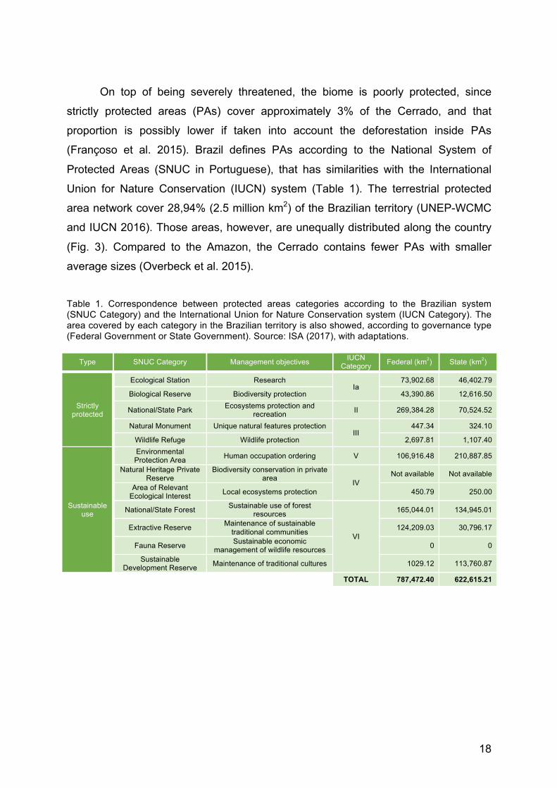
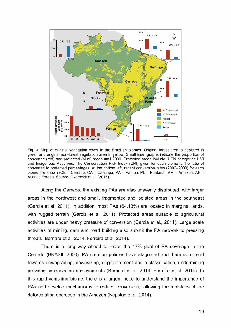
On top of being severely threatened, the biome is poorly protected, since
strictly protected areas (PAs) cover approximately 3% of the Cerrado, and that
proportion is possibly lower if taken into account the deforestation inside PAs
(Françoso et al. 2015). Brazil defines PAs according to the National System of
Protected Areas (SNUC in Portuguese), that has similarities with the International
Union for Nature Conservation (IUCN) system (Table 1). The terrestrial protected
area network cover 28,94% (2.5 million km2) of the Brazilian territory (UNEP-WCMC
and IUCN 2016). Those areas, however, are unequally distributed along the country
(Fig. 3). Compared to the Amazon, the Cerrado contains fewer PAs with smaller
average sizes (Overbeck et al. 2015).
Table 1. Correspondence between protected areas categories according to the Brazilian system (SNUC Category) and the International Union for Nature Conservation system (IUCN Category). The area covered by each category in the Brazilian territory is also showed, according to governance type (Federal Government or State Government). Source: ISA (2017), with adaptations.
Type SNUC Category Management objectives IUCN Category Federal (km2) State (km2)
Strictly protected
Ecological Station Research Ia
73,902.68 46,402.79
Biological Reserve Biodiversity protection 43,390.86 12,616.50
National/State Park Ecosystems protection and recreation II 269,384.28 70,524.52
Natural Monument Unique natural features protection III
447.34 324.10
Wildlife Refuge Wildlife protection 2,697.81 1,107.40
Sustainable use
Environmental Protection Area Human occupation ordering V 106,916.48 210,887.85
Natural Heritage Private Reserve
Biodiversity conservation in private area IV
Not available Not available
Area of Relevant Ecological Interest Local ecosystems protection 450.79 250.00
National/State Forest Sustainable use of forest resources
VI
165,044.01 134,945.01
Extractive Reserve Maintenance of sustainable traditional communities 124,209.03 30,796.17
Fauna Reserve Sustainable economic management of wildlife resources 0 0
Sustainable Development Reserve Maintenance of traditional cultures 1029.12 113,760.87
TOTAL 787,472.40 622,615.21
19
Fig. 3. Map of original vegetation cover in the Brazilian biomes. Original forest area is depicted in green and original non-forest vegetation area in yellow. Small inset graphs indicate the proportion of converted (red) and protected (blue) areas until 2009. Protected areas include IUCN categories I–VI and Indigenous Reserves. The Conservation Risk Index (CRI) given for each biome is the ratio of converted to protected percentages. At the bottom left, recent conversion rates (2002–2009) for each biome are shown (CE = Cerrado, CA = Caatinga, PA = Pampa, PL = Pantanal, AM = Amazon, AF = Atlantic Forest). Source: Overbeck et al. (2015).
Along the Cerrado, the existing PAs are also unevenly distributed, with larger
areas in the northwest and small, fragmented and isolated areas in the southeast
(Garcia et al. 2011). In addition, most PAs (64.13%) are located in marginal lands,
with rugged terrain (Garcia et al. 2011). Protected areas suitable to agricultural
activities are under heavy pressure of conversion (Garcia et al., 2011). Large scale
activities of mining, dam and road building also submit the PA network to pressing
threats (Bernard et al. 2014, Ferreira et al. 2014).
There is a long way ahead to reach the 17% goal of PA coverage in the
Cerrado (BRASIL 2000). PA creation policies have stagnated and there is a trend
towards downgrading, downsizing, degazettement and reclassification, undermining
previous conservation achievements (Bernard et al. 2014, Ferreira et al. 2014). In
this rapid-vanishing biome, there is a urgent need to understand the importance of
PAs and develop mechanisms to reduce conversion, following the footsteps of the
deforestation decrease in the Amazon (Nepstad et al. 2014).

20
Beyond the well-recognized goal of biodiversity conservation, PAs are
identified as cornerstones to ES provision, including provisioning, regulating, cultural
and supporting services (Fig. 4). Different studies have demonstrated the role of PA
networks in climate change mitigation and adaptation strategies, water supply,
protection of wild crop relatives, sustainable fisheries, disaster mitigation and
maintenance of cultural diversity (Lopoukhine et al. 2012). Close to a third of the
world’s largest cities depend on PAs for their freshwater supply (Dudley and Stolton
2003). As a result, the expansion of PA network and improvements in their
governance models have gained importance as cornerstones to adaptation and
mitigation strategies, in response to global warming and land conversion (Dudley et
al. 2010). A better understanding of the ES provided by the Cerrado PAs has
potential to highlight social and economic benefits of investing in the expansion and
management improvement of in situ conservation networks.
Fig. 4. Ecosystem services categories according to the Millennium Ecosystem Assessment. Source: MEA (2003 p. 57).
PAs offer opportunities for people to interact with nature through various
recreational, aesthetical and other cultural ecosystem services (CES) (MEA et al.
2005a, Ament et al. 2016, De Vos et al. 2016). People who experience more frequent
contact with nature are more likely to manifest positive feelings, attitudes and
behavior toward the natural environment and its value (Soga and Gaston 2016),
which may be an essential step towards a more sustainable society. Furthermore,

21
CES can provide revenues to enable the maintenance and expansion of PA networks
by means of ecotourism activities (Maciejewski et al. 2015, Souza 2016). Although
nature-based tourism has been a long debated issue, only recently it has been
integrated in the ecosystem services framework as an activity that encompasses
multiple bundles of CES provision (Ament et al. 2016). Studies about CES are limited
compared to the number of publications on other ES categories, especially in Latin
America (Martín-López et al. 2012).
In this study, we investigated the aesthetic services provided by PAs, a topic
not yet well elucidated for the Cerrado. We also identify PAs under higher pressure
from anthropogenic activities, considering diverse degrees of sensitivity to these
activities. Therefore, we address human-environment interaction regarding the
Cerrado biome, with a twofold perspective: (1) as a fragmented and vulnerable
ecosystem under land-use change pressure; and (2) as an important natural system
that provides services to sustain human wellbeing. The focus lies on the dynamic
relationship between PAs and their surroundings, where positive and negative
interactions are concurrent. More specifically, our study objective was to evaluate
scenic view services, along with sensitivity and exposure to disturbances
disseminated through hydrologic flows in Cerrado National Parks and their buffer
zones. We tested two hypotheses:
1. Biophysical characteristics can predict different opportunities to obtain benefits
from the scenic panoramic views of PAs.
2. Soil and hydrologic characteristics can reveal PAs that are more sensitive to
LULCC disturbances transmitted through water flows.
Both hypotheses, concerning scenic view and exposure/sensitivity to
disturbance, were applied to Cerrado National Parks. Eight parks were accessed in
chapter two and thirteen in chapter three. Since they are common subjects for the
analysis carried out in the following chapters, before moving forward it is important to
present our study area.
1.1. Study area: Cerrado National Parks
Among the PA management categories, National Park was selected for this
study based on its distinguished effectiveness to protect the Cerrado, along with its
management objectives to promote ecotourism and protect scenic beauty (Carranza
22
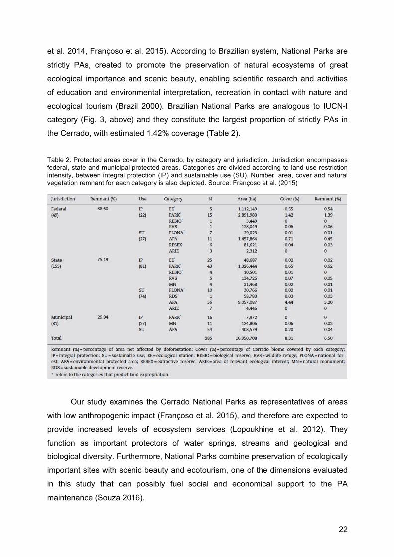
et al. 2014, Françoso et al. 2015). According to Brazilian system, National Parks are
strictly PAs, created to promote the preservation of natural ecosystems of great
ecological importance and scenic beauty, enabling scientific research and activities
of education and environmental interpretation, recreation in contact with nature and
ecological tourism (Brazil 2000). Brazilian National Parks are analogous to IUCN-I
category (Fig. 3, above) and they constitute the largest proportion of strictly PAs in
the Cerrado, with estimated 1.42% coverage (Table 2).
Table 2. Protected areas cover in the Cerrado, by category and jurisdiction. Jurisdiction encompasses federal, state and municipal protected areas. Categories are divided according to land use restriction intensity, between integral protection (IP) and sustainable use (SU). Number, area, cover and natural vegetation remnant for each category is also depicted. Source: Françoso et al. (2015)
Our study examines the Cerrado National Parks as representatives of areas
with low anthropogenic impact (Françoso et al. 2015), and therefore are expected to
provide increased levels of ecosystem services (Lopoukhine et al. 2012). They
function as important protectors of water springs, streams and geological and
biological diversity. Furthermore, National Parks combine preservation of ecologically
important sites with scenic beauty and ecotourism, one of the dimensions evaluated
in this study that can possibly fuel social and economical support to the PA
maintenance (Souza 2016).

23
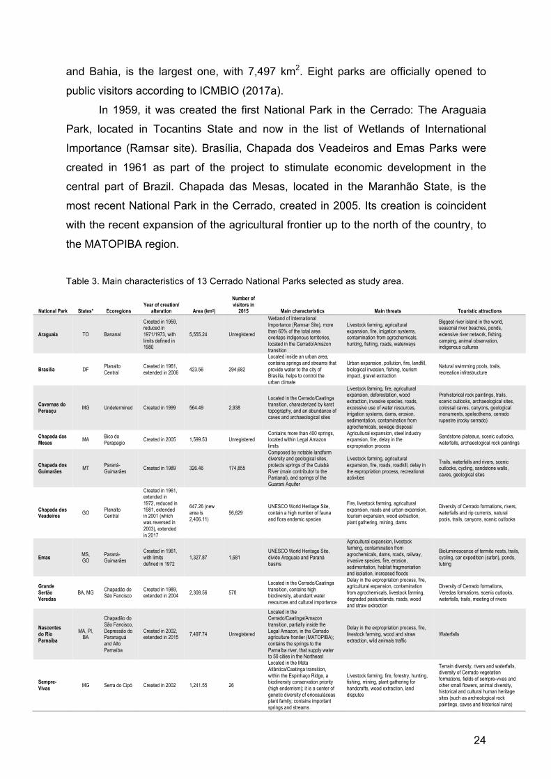
Thirteen National Parks located in the Cerrado were selected (Fig. 5). Lençóis
Maranhenses and Serra das Confusões Parks, although located in the Cerrado
biome, were not included in this study because vegetation in these parks is not
typical of Cerrado. In fact, Lençóis Maranhenses present vegetation from three
biomes – Amazonia, Cerrado and Caatinga – and ~2/3 of the park corresponds to
sandy dunes. Vegetation from the Serra das Confusões is typical of Caatinga biome.
Due to the several difficulties to compare data from different biomes, we also
disregarded the Chapada Diamantina and Sete Cidades Parks. They are mostly
composed of Cerrado vegetation, but are located outside of the Cerrado biome.
Fig. 5. Map of the study area encompassing 13 National Parks located in the Brazilian Cerrado biome. Sources: Polygon of Brazil and the Cerrado from IBGE (2004) and polygons of parks from ICMBIO (2016a).
The parks are distributed in nine states, 11 ecoregions, under varying
environmental conditions (Table 3). Serra do Cipó Park National Park, located in the
Minas Gerais State, is the smallest one, with 316 km2 (Table 2). Conversely,
Nascentes do Rio Parnaíba National Park, located in the states of Maranhão, Piauí
24
and Bahia, is the largest one, with 7,497 km2. Eight parks are officially opened to
public visitors according to ICMBIO (2017a).
In 1959, it was created the first National Park in the Cerrado: The Araguaia
Park, located in Tocantins State and now in the list of Wetlands of International
Importance (Ramsar site). Brasília, Chapada dos Veadeiros and Emas Parks were
created in 1961 as part of the project to stimulate economic development in the
central part of Brazil. Chapada das Mesas, located in the Maranhão State, is the
most recent National Park in the Cerrado, created in 2005. Its creation is coincident
with the recent expansion of the agricultural frontier up to the north of the country, to
the MATOPIBA region.
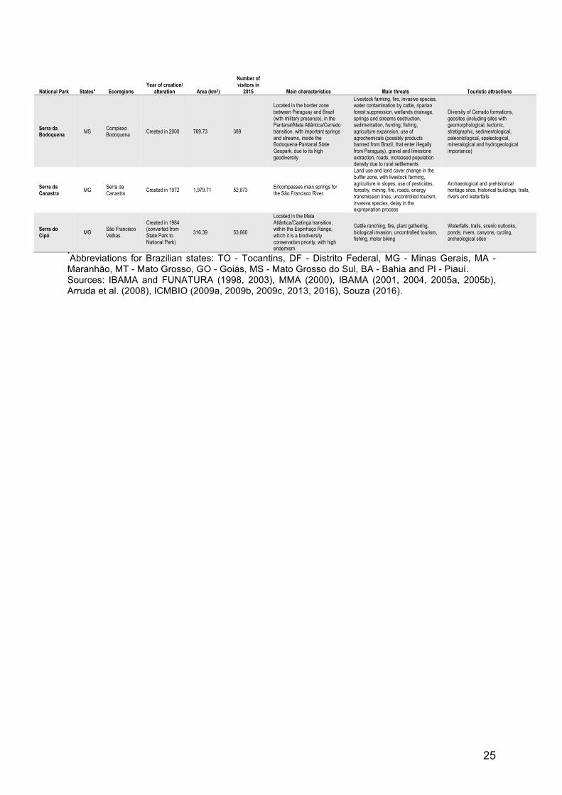
Table 3. Main characteristics of 13 Cerrado National Parks selected as study area.
National Park States* Ecoregions Year of creation/
alteration Area (km2)
Number of visitors in
2015 Main characteristics Main threats Touristic attractions
Araguaia TO Bananal
Created in 1959, reduced in 1971/1973, with limits defined in 1980
5,555.24 Unregistered
Wetland of International Importance (Ramsar Site), more than 60% of the total area overlaps indigenous territories, located in the Cerrado/Amazon transition
Livestock farming, agricultural expansion, fire, irrigation systems, contamination from agrochemicals, hunting, fishing, roads, waterways
Biggest river island in the world, seasonal river beaches, ponds, extensive river network, fishing, camping, animal observation, indigenous cultures
Brasília DF Planalto Central
Created in 1961, extended in 2006 423.56 294,682
Located inside an urban area, contains springs and streams that provide water to the city of Brasília, helps to control the urban climate
Urban expansion, pollution, fire, landfill, biological invasion, fishing, tourism impact, gravel extraction
Natural swimming pools, trails, recreation infrastructure
Cavernas do Peruaçu MG Undetermined Created in 1999 564.49 2,938
Located in the Cerrado/Caatinga transition, characterized by karst topography, and an abundance of caves and archaeological sites
Livestock farming, fire, agricultural expansion, deforestation, wood extraction, invasive species, roads, excessive use of water resources, irrigation systems, dams, erosion, sedimentation, contamination from agrochemicals, sewage disposal
Prehistorical rock paintings, trails, scenic outlooks, archaeological sites, colossal caves, canyons, geological monuments, speleothems, cerrado rupestre (rocky cerrado)
Chapada das Mesas MA Bico do
Parapagio Created in 2005 1,599.53 Unregistered Contains more than 400 springs, located within Legal Amazon limits
Agricultural expansion, steel industry expansion, fire, delay in the expropriation process
Sandstone plateaus, scenic outlooks, waterfalls, archaeological rock paintings
Chapada dos Guimarães MT Paraná-
Guimarães Created in 1989 326.46 174,855
Composed by notable landform diversity and geological sites, protects springs of the Cuiabá River (main contributor to the Pantanal), and springs of the Guarani Aquifer
Livestock farming, agricultural expansion, fire, roads, roadkill, delay in the expropriation process, recreational activities
Trails, waterfalls and rivers, scenic outlooks, cycling, sandstone walls, caves, geological sites
Chapada dos Veadeiros GO Planalto
Central
Created in 1961, extended in 1972, reduced in 1981, extended in 2001 (which was reversed in 2003), extended in 2017
647.26 (new area is 2,406.11)
56,629 UNESCO World Heritage Site, contain a high number of fauna and flora endemic species
Fire, livestock farming, agricultural expansion, roads and urban expansion, tourism expansion, wood extraction, plant gathering, mining, dams
Diversity of Cerrado formations, rivers, waterfalls and rip currents, natural pools, trails, canyons, scenic outlooks
Emas MS, GO
Paraná-Guimarães
Created in 1961, with limits defined in 1972
1,327.87 1,681 UNESCO World Heritage Site, divide Araguaia and Paraná basins
Agricultural expansion, livestock farming, contamination from agrochemicals, dams, roads, railway, invasive species, fire, erosion, sedimentation, habitat fragmentation and isolation, increased floods
Bioluminescence of termite nests, trails, cycling, car expedition (safari), ponds, tubing
Grande Sertão Veredas
BA, MG Chapadão do São Fancisco
Created in 1989, extended in 2004 2,308.56 570
Located in the Cerrado/Caatinga transition, contains high biodiversity, abundant water resources and cultural importance
Delay in the expropriation process, fire, agricultural expansion, contamination from agrochemicals, livestock farming, degraded pasturelands, roads, wood and straw extraction
Diversity of Cerrado formations, Veredas formations, scenic outlooks, waterfalls, trails, meeting of rivers
Nascentes do Rio Parnaíba
MA, PI, BA
Chapadão do São Fancisco, Depressão do Paranaguá and Alto Parnaíba
Created in 2002, extended in 2015 7,497.74 Unregistered
Located in the Cerrado/Caatinga/Amazon transition, partially inside the Legal Amazon, in the Cerrado agriculture frontier (MATOPIBA); contains the springs to the Parnaíba river, that supply water to 50 cities in the Northeast
Delay in the expropriation process, fire, livestock farming, wood and straw extraction, wild animals traffic
Waterfalls
Sempre-Vivas MG Serra do Cipó Created in 2002 1,241.55 26
Located in the Mata Atlântica/Caatinga transition, within the Espinhaço Ridge, a biodiversity conservation priority (high endemism); it is a center of genetic diversity of eriocauláceas plant family; contains important springs and streams
Livestock farming, fire, forestry, hunting, fishing, mining, plant gathering for handcrafts, wood extraction, land disputes
Terrain diversity, rivers and waterfalls, diversity of Cerrado vegetation formations, fields of sempre-vivas and other small flowers, animal diversity, historical and cultural human heritage sites (such as archeological rock paintings, caves and historical ruins)
25
National Park States* Ecoregions Year of creation/
alteration Area (km2)
Number of visitors in
2015 Main characteristics Main threats Touristic attractions
Serra da Bodoquena MS Complexo
Bodoquena Created in 2000 769.73 389
Located in the border zone between Paraguay and Brazil (with military presence), in the Pantanal/Mata Atlântica/Cerrado transition, with important springs and streams, inside the Bodoquena-Pantanal State Geopark, due to its high geodiversity
Livestock farming, fire, invasive species, water contamination by cattle, riparian forest suppression, wetlands drainage, springs and streams destruction, sedimentation, hunting, fishing, agriculture expansion, use of agrochemicals (possibly products banned from Brazil, that enter illegally from Paraguay), gravel and limestone extraction, roads, increased population density due to rural settlements
Diversity of Cerrado formations, geosites (including sites with geomorphological, tectonic, stratigraphic, sedimentological, paleontological, speleological, mineralogical and hydrogeological importance)
Serra da Canastra MG Serra da
Canastra Created in 1972 1,979.71 52,673 Encompasses main springs for the São Francisco River.
Land use and land cover change in the buffer zone, with livestock farming, agriculture in slopes, use of pesticides, forestry, mining, fire, roads, energy transmission lines, uncontrolled tourism, invasive species, delay in the expropriation process
Archaeological and prehistorical heritage sites, historical buildings, trails, rivers and waterfalls
Serra do Cipó MG São Francisco
Velhas
Created in 1984 (converted from State Park to National Park)
316.39 53,660
Located in the Mata Atlântica/Caatinga transition, within the Espinhaço Range, which it is a biodiversity conservation priority, with high endemism
Cattle ranching, fire, plant gathering, biological invasion, uncontrolled tourism, fishing, motor biking
Waterfalls, trails, scenic outlooks, ponds, rivers, canyons, cycling, archeological sites
*Abbreviations for Brazilian states: TO - Tocantins, DF - Distrito Federal, MG - Minas Gerais, MA - Maranhão, MT - Mato Grosso, GO - Goiás, MS - Mato Grosso do Sul, BA - Bahia and PI - Piauí. Sources: IBAMA and FUNATURA (1998, 2003), MMA (2000), IBAMA (2001, 2004, 2005a, 2005b), Arruda et al. (2008), ICMBIO (2009a, 2009b, 2009c, 2013, 2016), Souza (2016).
60
CONCLUDING REMARKS
The two proposed hypothesis were confirmed by our results. Biophysical
measures of visual scale (panoramic view area), topographic heterogeneity
(roughness and slope variability) and biological diversity (Shannon’s Diversity and
Eveness Indexes) proved to be appropriate (in terms of objectivity) indicators of
touristic and scenic potentials. We were able to create biophysical profiles to the
studied parks revealing differences in their aptitude to offer cultural ecosystem
services. Limitations of the proposed model are mostly related to the absence of
other variables, such as built infrastructure and socioeconomic factors, that strongly
influence visitation potential, and could not be integrated in the analysis.
Additionally, soil (sand content) and hydrologic (drainage density and
direction) characteristics were able to define parks under higher sensitivity to LULCC
disturbances transmitted through water flows. The indicators provided qualitative
measurements of risk to identify areas for priority management, focusing on different
land-use degradation drivers and tendencies. Main limitations are the difficulty to
rank those aspects and integrate them with other mechanisms that potentially impact
protected areas. In order to reach a vulnerability measure, adaptive capacity was the
missing component in our analysis.
Our main contributions are methodological, covering two aspects of protected
areas rarely mentioned in the scientific literature. Although this study focused only on
National Parks located in the Brazilian Cerrado biome, the proposed approaches can
be extended to other tropical areas with species-rich ecosystems under high
pressures of land use conversion.
61
REFERENCES
Alexandre, B., R. Crouzeilles, and C. E. V. Grelle. 2010. How can we estimate buffer
zones of protected areas? A proposal using biological data. Natureza a Conservacao 8:165–170.
Alin, S. R., C. M. O, A. S. Cohen David L Dettman, M. R. Palacios-Fest Terra, and B. A. McKee. 2002. Effects of land-use change on aquatic biodiversity: A view from the paleorecord at Lake Tanganyika, East Africa. Geology 30:1143–1146.
Allen Consulting Group. 2005. Climate Change Risk and Vulnerability: Promoting an efficient adaptation response in Australia. Page Report to the Australian Greenhouse Office, Department of the Environment and Heritage.
Alonso, M. A., M. P. A. Maqua, A. B. Andray, T. C. Prieto-Lavin, R. M. C. Gonzalez, and G. C. Castellano. 2004. Guía para la elaboración de estudios del medio físico: contenido y metodología. Fifth edition. Ministerio de Medio Ambiente, Secretaría General del Medio Ambiente, Madrid.
Ament, J. M., C. A. Moore, M. Herbst, and G. S. Cumming. 2016. Cultural Ecosystem Services in Protected Areas: Understanding Bundles, Trade-Offs, and Synergies. Conservation Letters 0:1–11.
Andrade, R. G., A. H. de C. Teixeira, J. F. Leivas, G. B. S. da Silva, S. F. Nogueira, D. de C. Victoria, L. E. Vicente, and É. L. Bolfe. 2015. Indicativo de pastagens plantadas em processo de degradação no bioma Cerrado. Pages 1585–1592Anais XVII Simpósio Brasileiro de Sensoriamento Remoto. Instituto Nacional de Pesquisas Espaciais (INPE), João Pessoa.
Arantes, A. E., L. G. Ferreira, and M. T. Coe. 2016. The seasonal carbon and water balances of the Cerrado environment of Brazil: past, present, and future influences of land cover and land use. ISPRS Journal of Photogrametry and Remote Sensing 117:66–78.
Arruda, M. B., C. E. B. Proença, S. Rodrigues, E. S. Martins, R. C. Martins, and R. N. Campos. 2008. Ecorregiões, Unidades de Conservação e Representatividade Ecológica do Bioma Cerrado. Pages 229–270in S. Sano and S. P. Almeida, editors.Cerrado: ecologia e flora. Embrapa, Brasília.
Austin, A. T., M. M. C. Bustamante, G. B. Nardoto, S. K. Mitre, T. Pérez, J. P. H. B. Ometto, N. Ascarrunz, M. C. Forti, K. Longo, M. E. Gavito, and L. A. Martinelli. 2013. Latin America ’ s Nitrogen Challenge. Science 340:149.
Balla, D., O. G. Varga, and M. Zichar. 2016. Accuracy assessment of different soil databases concerning WRB reference soil groups. Landscape & Environment 10:1–12.
Barbosa, Á. G. 2008. As Estratégias de Conservação da Biodiversidade na Chapada dos Veadeiros: Conflitos e Oportunidades. UnB.
Batlle-Bayer, L., N. H. Batjes, and P. S. Bindraban. 2010. Changes in organic carbon stocks upon land use conversion in the Brazilian Cerrado: A review. Agriculture, Ecosystems and Environment 137:47–58.
Bernard, E., L. A. O. Penna, and E. Araújo. 2014. Downgrading, downsizing, degazettement, and reclassification of protected areas in Brazil. Conservation
62
Biology 28:939–950. Birgé, H. E., R. A. Bevans, C. R. Allen, D. G. Angeler, S. G. Baer, and D. H. Wall.
2016. Adaptive management for soil ecosystem services. Journal of Environmental Management 183:371–378.
Bishop, I. D., and D. W. Hulse. 1994. Prediction of scenic beauty using mapped data and geographic information systems. Landscape and Urban Planning 30:59–70.
Bomfim, A. 2004. O ambiente conflituoso do ecoturismo na Chapada dos Veadeiros. Page II Encontro da Associação Nacional de Pós-Graduação e Pesquisa em Ambiente e Sociedade. ANPPAS, Indaiatuba.
BRASIL. 2000. A Convenção sobre Diversidade Biológica - CDB, cópia do Decreto Legislativo no 2, de 5 de junho de 1992. Brasília.
Brazil. 2000. Lei no. 9985, de 18 de julho de 2000. Casa Civil, Presidência da República, Brazil.
Bucci, S. J., F. G. Scholz, G. Goldstein, F. C. Meinzer, A. C. Franco, Y. Zhang, and G. Y. Hao. 2008. Water relations and hydraulic architecture in Cerrado trees: Adjustments to seasonal changes in water availability and evaporative demand. Brazilian Journal of Plant Physiology 20:233–245.
Burger, J. R., C. D. Allen, J. H. Brown, W. R. Burnside, A. D. Davidson, T. S. Fristoe, M. J. Hamilton, N. Mercado-Silva, J. C. Nekola, J. G. Okie, and W. Zuo. 2012. The macroecology of sustainability. PLoS Biology 10.
Burkhard, B., F. Kroll, S. Nedkov, and F. Müller. 2012. Mapping ecosystem service supply, demand and budgets. Ecological Indicators 21:17–29.
Bustamante, M. M. C., and L. G. Ferreira. 2011. Land use change and the carbon budget in the Brazilian Cerrado. Page in M. J. Hill and Niall P. Hanan, editors. Ecosystem Function in Savannas: measurement and modeling at landscape to global scales. CRC Press, Boca Raton.
Bustamante, M. M. C., L. A. Martinelli, J. P. H. B. Ometto, J. B. do Carmo, V. Jaramillo, M. E. Gavito, P. I. Araujo, A. T. Austin, T. P??rez, and S. Marquina. 2014. Innovations for a sustainable future: Rising to the challenge of nitrogen greenhouse gas management in Latin America. Current Opinion in Environmental Sustainability 9:73–81.
Bustamante, M. M. C., C. A. Nobre, R. Smeraldi, A. P. D. Aguiar, L. G. Barioni, L. G. Ferreira, K. Longo, P. May, A. S. Pinto, and J. P. H. B. Ometto. 2012. Estimating greenhouse gas emissions from cattle raising in Brazil. Climatic Change 115:559–577.
Cabral, O. M. R., H. R. da Rocha, J. H. Gash, H. C. Freitas, and M. A. V Ligo. 2015. Water and energy fluxes from a woodland savanna (cerrado) in southeast Brazil. Journal of Hydrology: Regional Studies 4:22–40.
Carneiro, F. F., L. G. da S. Augusto, R. M. Rigotto, K. Friedrich, and A. C. Búrigo. 2015. Dossiê ABRASCO: um alerta sobre os impactos dos agrotóxicos na saúde. Escola Politécnica de Saúde Joaquim Venâncio/Fiocruz, Expressão Popular, Rio de Janeiro,São Paulo.
Carranza, T., A. Balmford, V. Kapos, and A. Manica. 2014. Protected area effectiveness in reducing conversion in a rapidly vanishing ecosystem: The
63
Brazilian Cerrado. Conservation Letters 7:216–223. Carvalho, F. M. V., P. De Marco, and L. G. Ferreira. 2009. The Cerrado into-pieces:
Habitat fragmentation as a function of landscape use in the savannas of central Brazil. Biological Conservation 142:1392–1403.
Castro, E. V. de, T. B. Souza, and B. Thapa. 2015. Determinants of Tourism Attractiveness in the National Parks of Brazil. Parks 21:51–62.
Cavalcanti, M. M., W. R. Borges, M. P. Rocha, L. S. da Cunha, and E. X. Seimetz. 2011. Investigação Geofísica (Eletrorresistividade e GPR) nos Limites do Lixão da Estrutural e do Parque Nacional de Brasília – DF (Resultados Preliminares). Pages 343–34812th International Congress of the Brazilian Geophysical Society (EXPOGEF). Rio de Janeiro, Brazil.
Chan, K. M. A., T. Satterfield, and J. Goldstein. 2012. Rethinking ecosystem services to better address and navigate cultural values. Ecological Economics 74:8–18.
Critical Ecosystem Partnership Fund. 2017. Where we work. http://www.cepf.net/where_we_work/Pages/default.aspx#.WSiJ-cbOpE4.
Crutzen, P. J. 2002. Geology of mankind. Nature 415:23. Daniel, T. C. 2001. Whither scenic beauty? Visual landscape quality assessment in
the 21st century. Landscape and Urban Planning 54:267–281. Dellamatrice, P. M., and R. T. R. Monteiro. 2014. Revista Brasileira de Engenharia
Agrícola e Ambiental Principais aspectos da poluição de rios brasileiros por pesticidas Main aspects of the pollution in Brazilian rivers by pesticides:1296–1301.
Dramstad, W. E., M. S. Tveit, W. J. Fjellstad, and G. L. A. Fry. 2006. Relationships between visual landscape preferences and map-based indicators of landscape structure. Landscape and Urban Planning 78:465–474.
Dudley, N., and S. Stolton. 2003. Running Pure: The importance of forest protected areas to drinking water.
Dudley, N., S. Stolton, A. Belokurov, L. Krueger, N. Lopoukhine, K. MacKinnon, T. Sandwith, and N. Sekhran. 2010. Natural Solutions: Protected areas helping people cope with climate change.
Eiten, G. 1972. The Cerrado Vegetation of Brazil. Botanical Review 38:201–341. Eiten, G. 1977. Delimitação do Conceito de Cerrado. Arquivos do Jardim Botânico do
Rio de Janeiro XXI:125–134. Ewers, R. M., and A. S. L. Rodrigues. 2008. Estimates of reserve effectiveness are
confounded by leakage. Trends in Ecology and Evolution 23:113–116. FAO. 2004. Fertilizer use by crop in Brazil. Development Division. Food and
Agriculture Organization of the United Nations:64. Ferreira, J., L. E. O. C. Aragão, J. Barlow, P. Barreto, E. Berenguer, M. Bustamante,
T. A. Gardner, A. C. Lees, A. Lima, J. Louzada, R. Pardini, L. Parry, C. A. Peres, P. S. Pompeu, and M. Tabarelli. 2014. Brazil’S Environmental Leadership At Risk. Science 346:706–707.
Fleury, L. C., and J. P. De Almeida. 2009. A conservação ambiental como critério de relações entre grupos e valores: representações e conflitos no entorno do

64
Parque Nacional das Emas, Goiás. Ambiente & Sociedade 12:357–372. Foley, J. a, R. Defries, G. P. Asner, C. Barford, G. Bonan, S. R. Carpenter, F. S.
Chapin, M. T. Coe, G. C. Daily, H. K. Gibbs, J. H. Helkowski, T. Holloway, E. a Howard, C. J. Kucharik, C. Monfreda, J. a Patz, I. C. Prentice, N. Ramankutty, and P. K. Snyder. 2005. Global consequences of land use. Science (New York, N.Y.) 309:570–4.
Françoso, R. D., R. Brandão, C. C. Nogueira, Y. B. Salmona, R. B. Machado, and G. R. Colli. 2015. Habitat loss and the effectiveness of protected areas in the Cerrado Biodiversity Hotspot. Natureza e Conservação 13:35–40.
Frank, S., C. Fürst, L. Koschke, A. Witt, and F. Makeschin. 2013. Assessment of landscape aesthetics - Validation of a landscape metrics-based assessment by visual estimation of the scenic beauty. Ecological Indicators 32:222–231.
Fry, G., M. S. Tveit, Å. Ode, and M. D. Velarde. 2009. The ecology of visual landscapes: Exploring the conceptual common ground of visual and ecological landscape indicators. Ecological Indicators 9:933–947.
Ganem, R. S. 2015. Zonas de amortecimento de unidades de conservação. Brasília. Garcia, A. S., H. O. Sawakuchi, M. E. Ferreira, and M. V. R. Ballester. 2017.
Landscape changes in a neotropical forest-savanna ecotone zone in central Brazil: The role of protected areas in the maintenance of native vegetation. Journal of Environmental Management 187:16–23.
Garcia, F. N., L. G. Ferreira, and J. F. Leite. 2011. Áreas Protegidas no Bioma Cerrado: fragmentos vegetacionais sob forte pressão. Pages 4086–4093XV Simpósio Brasileiro de Sensoriamento Remoto - SBSR. Instituto Nacional de Pesquisas Espaciais, Curitiba.
Germino, M. J., W. A. Reiners, B. J. Blasko, D. McLeod, and C. T. Bastian. 2001. Estimating visual properties of rocky mountain landscapes using GIS. Landscape and Urban Planning 53:71–83.
Gobster, P. H., J. I. Nassauer, T. C. Daniel, and G. Fry. 2007. The shared landscape: What does aesthetics have to do with ecology? Landscape Ecology 22:959–972.
Godar, J., C. Suavet, T. A. Gardner, E. Dawkins, and P. Meyfroidt. 2016. Balancing detail and scale in assessing transparency to improve the governance of agricultural commodity supply chains. Environmental Research Letters 11:35015.
Grace, J., J. S. José, P. Meir, H. S. Miranda, and R. A. Montes. 2006. Productivity and carbon fluxes of tropical savannas. Journal of Biogeography 33:387–400.
Grace, J., E. Mitchard, and E. Gloor. 2014. Perturbations in the carbon budget of the tropics. Global Change Biology 20:3238–3255.
Grecchi, R. C., Q. H. J. Gwyn, G. B. Bénié, A. R. Formaggio, and F. C. Fahl. 2014. Land use and land cover changes in the Brazilian Cerrado: A multidisciplinary approach to assess the impacts of agricultural expansion. Applied Geography 55:300–312.
Guerra, J. A. T., M. A. Fullen, M. do C. O. Jorge, and S. T. Alexandre. 2014. Soil Erosion and Conservation in Brazil. Anuário do Instituto de Geociências - UFRJ 37:81–91.
65
Guo, Z., L. Zhang, and Y. Li. 2010. Increased dependence of humans on ecosystem services and biodiversity. PLoS ONE 5.
Gyssels, G., J. Poesen, E. Bochet, and Y. Li. 2005. Impact of plant roots on the resistance of soils to erosion by water : a review. Progress in Physical Geography 29:189–217.
Hansen, A. J., and R. DeFries. 2007. Ecological mechanisms linking protected areas to surrounding lands. Ecological Applications 17:974–988.
Hengl, T., J. Mendes de Jesus, G. B. M. Heuvelink, M. Ruiperez Gonzalez, M. Kilibarda, A. Blagotić, W. Shangguan, M. N. Wright, X. Geng, B. Bauer-Marschallinger, M. A. Guevara, R. Vargas, R. A. MacMillan, N. H. Batjes, J. G. B. Leenaars, E. Ribeiro, I. Wheeler, S. Mantel, and B. Kempen. 2017. SoilGrids250m: Global gridded soil information based on machine learning. Page Plos One.
Hernández-Morcillo, M., T. Plieninger, and C. Bieling. 2013. An empirical review of cultural ecosystem service indicators. Ecological Indicators 29:434–444.
Hoefel, M. da G., F. F. Carneiro, L. M. P. Santos, M. B. Gubert, E. M. Amate, and W. dos Santos. 2013. Acidentes de trabalho e condições de vida de catadores de resíduos sólidos recicláveis no lixão do Distrito Federal Accidents at work and living of Distrito Federal. Rev Bras Epidemiol 16:774–785.
Hoffman, W. A., and R. B. Jackson. 2000. Vegetation-Climate Feedbacks in the Conversion of Tropical Savanna to Grassland. American Meteorological Society 13:1593–1602.
Hunke, P., E. N. Mueller, B. Schröder, and P. Zeilhofer. 2015. The Brazilian Cerrado: Assessment of water and soil degradation in catchments under intensive agricultural use. Ecohydrology 8:1154–1180.
IBAMA. 2001. Plano de Manejo do Parque Nacional do Araguaia - TO. Ministério do Meio Ambiente, Brasília.
IBAMA. 2004. Plano de Manejo do Parque Nacional das Emas. Ministério do Meio Ambiente, Brasília.
IBAMA. 2005a. Plano de Manejo do Parque Nacional da Serra da Canastra. Ministério do Meio Ambiente, Brasília.
IBAMA. 2005b. Plano de Manejo do Parque Nacional das Cavernas do Peruaçu. Ministério do Meio Ambiente, Brasília.
IBAMA, and FUNATURA. 1998. Plano de Manejo do Parque Nacional de Brasília. Ministério do Meio Ambiente, Brasília.
IBAMA, and FUNATURA. 2003. Plano de Manejo do Parque Nacional Grande Sertão Veredas. Ministério do Meio Ambiente, Brasília.
IBGE. 2004. Mapa Temático - Mapa de Biomas do Brasil. Instituto Brasileiro de Geográfia e Estatística, Rio de Janeiro.
IBGE. 2016. Cidades@. https://cidades.ibge.gov.br/. ICMBIO. 2009a. Plano de Manejo do Parque Nacional da Chapada dos Veadeiros.
Ministério do Meio Ambiente, Brasília. ICMBIO. 2009b. Plano de Manejo do Parque Nacional da Serra do Cipó. Ministério
66
do Meio Ambiente, Brasília. ICMBIO. 2009c. Plano de Manejo do Parque Nacional da Chapada dos Guimarães.
Ministério do Meio Ambiente, Brasília. ICMBIO. 2013. Plano de Manejo do Parque Nacional da Serra da Bodoquena.
Ministério do Meio Ambiente, Brasília. ICMBIO. 2016a. Mapa Temático e Dados Geoestatísticos das Unidades de
Conservação Federais. http://www.icmbio.gov.br/portal/geoprocessamento1/51-menu-servicos/4004-downloads-mapa-tematicoe-dados-geoestatisticos-das-uc-s.
ICMBIO. 2016b. Plano de Manejo do Parque Nacional das Sempre-Vivas. Ministério do Meio Ambiente, Brasília.
ICMBIO. 2017a. Unidades Abertas a Visitação. http://www.icmbio.gov.br/portal/visitacao1/unidades-abertas-a-visitacao.
ICMBIO. 2017b. Painel Dinâmico de Informações: Banco de Dados sobre Unidades de Conservação Federais. http://qv.icmbio.gov.br/QvAJAXZfc/opendoc2.htm?document=painel_corporativo_6476.qvw&host=Local&anonymous=true.
ISA. 2017. Unidades de Conservação no Brasil (online database). https://uc.socioambiental.org.
Kandziora, M., B. Burkhard, and F. Müller. 2013. Interactions of ecosystem properties, ecosystem integrity and ecosystem service indicators: A theoretical matrix exercise. Ecological Indicators 28:54–78.
Kim, Y. H., S. Rana, and S. Wise. 2004. Exploring multiple viewshed analysis using terrain features and optimisation techniques. Computers and Geosciences 30:1019–1032.
Klink, C. A., and R. B. Machado. 2005. Conservation of the Brazilian Cerrado. Conservation Biology 19:707–713.
Klink, C. A., and A. G. Moreira. 2002. Past and current human occupation, and land use. Pages 69–88in P. S. Oliveira and R. J. Marquis, editors.The cerrados of Brazil: ecology and natural history of a neotropical savanna. Columbia University Press, New York.
Lahsen, M., M. M. C. Bustamante, and E. L. Dalla-Nora. 2016. Undervaluing and Overexploiting the Brazilian Cerrado at Our Peril. Environment: Science and Policy for Sustainable Development 58:4–15.
Lapola, D. M., L. a. Martinelli, C. a. Peres, J. P. H. B. Ometto, M. E. Ferreira, C. a. Nobre, A. P. D. Aguiar, M. M. C. Bustamante, M. F. Cardoso, M. H. Costa, C. a. Joly, C. C. Leite, P. Moutinho, G. Sampaio, B. B. N. Strassburg, and I. C. G. Vieira. 2014. Pervasive transition of the Brazilian land-use system. Nature Climate Change 4:27–35.
Leisher, C., J. Touval, S. M. Hess, T. M. Boucher, and L. Reymondin. 2013. Land and forest degradation inside protected areas in latin america. Diversity 5:779–795.
Leite, C. C., M. H. Costa, B. S. Soares-Filho, and L. De Barros Viana Hissa. 2012. Historical land use change and associated carbon emissions in Brazil from 1940
67
to 1995. Global Biogeochemical Cycles 26:1–13. Lima, J. E. F. W., and E. M. Da Silva. 2005. Estimativa da produção hídrica
superficial do Cerrado brasileiro. Pages 61–72in A. Scariot, J. C. Souza-Silva, and J. M. Felfili, editors.Cerrado: Ecologia, Biodiversidade e Conservação. Ministério do Meio Ambiente, Brasília.
Lindemann-Matthies, P., X. Junge, and D. Matthies. 2010. The influence of plant diversity on people’s perception and aesthetic appreciation of grassland vegetation. Biological Conservation 143:195–202.
Lopoukhine, N., N. Crawhall, N. Dudley, P. Figgis, C. Karibuhoye, D. Laffoley, J. M. Londoño, K. MacKinnon, and T. Sandwith. 2012. Protected areas: providing natural solutions to 21st Century challenges. S.a.P.I.E.N.S 5:1–16.
Macedo, M. C. M. 1997. Sustainability of pasture production in the savannas of tropical America. Pages 391–400Proceedings of the XVIII International Grassland Congress.
Machado, R. B., L. M. de S. Aguiar, A. A. J. F. Castro, C. de C. Nogueira, and M. B. Ramos Neto. 2008. Caracterização da fauna e flora do Cerrado. Page 1198in F. G. Faleiro and A. L. de Farias Neto, editors.Savanas: desafios e estratégias para o equilíbio entre a sociedade, agronegócio e recursos naturais. Embrapa Cerrados, Planaltina.
Maciejewski, K., A. De Vos, G. S. Cumming, C. Moore, and D. Biggs. 2015. Cross-scale feedbacks and scale mismatches as influences on cultural services and the resilience of protected areas. Ecological Applications 25:11–23.
Martín-López, B., I. Iniesta-Arandia, M. García-Llorente, I. Palomo, I. Casado-Arzuaga, D. G. Del Amo, E. Gómez-Baggethun, E. Oteros-Rozas, I. Palacios-Agundez, B. Willaarts, J. A. González, F. Santos-Martín, M. Onaindia, C. López-Santiago, and C. Montes. 2012. Uncovering ecosystem service bundles through social preferences. PLoS ONE 7.
Martinelli, L. A., R. Naylor, P. M. Vitousek, and P. Moutinho. 2010. Agriculture in Brazil: Impacts, costs, and opportunities for a sustainable future. Current Opinion in Environmental Sustainability 2:431–438.
MEA. 2003. Ecosystems and their services. Pages 49–70in J. Alcamo, N. J. Ash, C. D. Butler, J. B. Callicott, D. Capistrano, S. R. Carpenter, J. C. Castilla, R. Chambers, K. Chopra, A. Cropper, G. C. Daily, P. Dasgupta, R. de Groot, T. Dietz, A. Kumar, Duraiappah, M. Gadgil, K. Hamilton, R. Hassan, E. F. Lambin, L. Lebel, R. Leemans, L. Jiyuan, J.-P. Malingreau, R. M. May, A. F. McCalla, T. (A. J. . McMichael, B. Moldan, H. Mooney, S. Naeem, G. C. Nelson, N. Wen-Yuan, I. Noble, O. Zhiyun, S. Pagiola, D. Pauly, S. Percy, P. Pingali, R. Prescott-Allen, W. V. . Reid, T. H. Ricketts, C. Samper, R. (Bob) Scholes, H. Simons, F. L. Toth, J. K. Turpie, R. T. Watson, T. J. Wilbanks, M. Williams, S. Wood, Z. Shidong, and M. B. Zurek, editors.Ecosystems and Human Well-being: A Framework for Assessment. First edition. Island Press, Washington.
MEA. 2005a. MA Conceptual Framework. Pages 25–36in R. Hassan, R. Scholes, and N. Ash, editors.Ecosystems and human well-being: current state and trends : findings of the Condition and Trends Working Group. Island Press.
MEA. 2005b. Ecosystems and Human Well-being: Synthesis. Page (W. V. Reid, H.
68
A. Mooney, A. Cropper, S. Doris Capistrano, tephen R. Carpenter, K. Chopra, P. Dasgupta, T. Dietz, A. Kumar, Duraiappah, R. Hassan, R. Kasperson, R. Leemans, R. M. May, T. (A. J. . McMichael, P. Pingali, C. Samper, R. Scholes, R. T. Watson, A. H. Zakri, Z. Shidong, N. J. Ash, E. Bennett, P. Kumar, M. J. Lee, C. Raudsepp-Hearne, H. Simons, J. Thonell, and M. B. Zurek, Eds.). Island Press, Washington.
MEA, R. de Groot, and P. S. Ramakrishnan. 2005a. Cultural and Amenity Services. Pages 457–474in R. Hassan, R. Scholes, and N. Ash, editors.Ecosystems and human well-being: current state and trends : findings of the Condition and Trends Working Group. Island Press.
MEA, R. Kasperson, and D. Kirstin. 2005b. Vulnerable peoples and places. Pages 143–164in R. Hassan, R. Scholes, and N. Ash, editors.Ecosystems and human well-being: current state and trends : findings of the Condition and Trends Working Group. Island Press.
Merten, G. H., and J. P. G. Minella. 2013. The expansion of Brazilian agriculture: Soil erosion scenarios. International Soil and Water Conservation Research 1:37–48.
Metzger, M. J., M. D. A. Rounsevell, L. Acosta-Michlik, R. Leemans, and D. Schröter. 2006. The vulnerability of ecosystem services to land use change. Agriculture, Ecosystems and Environment 114:69–85.
Miranda, S. do C. de, M. Bustamante, M. Palace, S. Hagen, M. Keller, and L. G. Ferreira. 2014. Regional variations in biomass distribution in Brazilian Savanna Woodland. Biotropica 46:125–138.
MMA. 2000. Cadastro Nacional de Unidades de Conservação. Ministério do Meio Ambiente, Brasília. http://www.mma.gov.br/areas-protegidas/cadastro-nacional-de-ucs/consulta-gerar-relatorio-de-uc.
MMA. 2015. Mapeamento do Uso e Cobertura do Cerrado: Projeto TerraClass Cerrado 2013. Brasília.
Moraes, M. C. P. de, K. de Mello, and R. H. Toppa. 2017. Protected areas and agricultural expansion: Biodiversity conservation versus economic growth in the Southeast of Brazil. Journal of Environmental Management 188:73–84.
Moreira, J. C., F. Peres, A. C. Simões, W. A. Pignati, E. de C. Dores, S. N. Vieira, C. Strüssmann, and T. Mott. 2012. Contaminação de águas superficiais e de chuva por agrotóxicos em uma região do estado do Mato Grosso. Ciência & Saúde Coletiva 17:1557–1568.
Mueller, C. C., and G. B. Martha Júnior. 2008. A Agropecuária e o Desenvolvimento Socioeconômico Recente do Cerrado. Page in F. G. Faleiro and A. L. Farias Neto, editors. Savanas: desafios e estratégicas para o equilibrio entre sociedade, agronegocio e recursos naturais. Embrapa Cerrados, Planaltina.
Myers, N., R. A. Mittermeier, C. G. Mittermeier, G. A. B. da Fonseca, and J. Kent. 2000. Biodiversity hotspots for conservation priorities. Nature 403:853–858.
Nepstad, D., D. Mcgrath, C. Stickler, A. Alencar, A. Azevedo, B. Swette, T. Bezerra, M. Digiano, J. Shimada, R. Seroa, E. Armijo, L. Castello, P. Brando, M. C. Hansen, M. Mcgrath-horn, O. Carvalho, and L. Hess. 2014. Slowing Amazon deforestation through public policy and interventions in beef and soy supply chains. Science 344:1118–1123.

69
Netto, P. B., V. V. Mecenas, and E. S. Cardoso. 2005. APA de Cafuringa: a última fronteira natural do DF. Secretaria do Meio Ambiente e Recursos Hídricos do Distrito Federal, Brasília.
New7Wonders Foundation. 2007. New 7 Wonders of the World. https://new7wonders.com.
Oliveira-Filho, A. T., and J. A. Ratter. 2002. Vegetation Physiognomies and Woody Flora of the Cerrado Biome. Pages 91–120in P. S. Oliveira and R. J. Marquis, editors.The Cerrados of Brazil: Ecology and Natural History of a Neotropical Savanna. Columbia University Press, New York.
Oliveira, K., and A. Cieglinski. 2016. CNA prevê expansão de 2% do agronegócio em 2017. http://agenciabrasil.ebc.com.br/economia/noticia/2016-12/cna-preve-expansao-de-2-do-agronegocio-em-2017.
Oliveira, P. T. S., E. Wendland, M. A. Nearing, R. L. Scott, R. Rosolem, and H. R. da Rocha. 2015. The water balance components of undisturbed tropical woodlands in the Brazilian cerrado. Hydrology and Earth System Sciences 19:2899–2910.
Oliveira, R. S., L. Bezerra, E. A. Davidson, F. Pinto, C. A. Klink, D. C. Nepstad, and A. Moreira. 2005. Deep root function in soil water dynamics in cerrado savannas of central Brazil. Functional Ecology 19:574–581.
Overbeck, G. E., E. Vélez-Martin, F. R. Scarano, T. M. Lewinsohn, C. R. Fonseca, S. T. Meyer, S. C. Müller, P. Ceotto, L. Dadalt, G. Durigan, G. Ganade, M. M. Gossner, D. L. Guadagnin, K. Lorenzen, C. M. Jacobi, W. W. Weisser, and V. D. Pillar. 2015. Conservation in Brazil needs to include non-forest ecosystems. Diversity and Distributions 21:1455–1460.
Paiva, R. J. O., R. S. Brites, and R. B. Machado. 2015. The role of protected areas in the avoidance of anthropogenic conversion in a high pressure region: A matching method analysis in the core region of the brazilian cerrado. PLoS ONE 10:1–24.
Parron, L. M., M. M. C. Bustamante, and D. Markewitz. 2011. Fluxes of nitrogen and phosphorus in a gallery forest in the Cerrado of central Brazil. Biogeochemistry 105:89–104.
Pereira, E. C., L. da S. Alves, E. C. Antunes, and A. Pasqualetto. 2004. Reservas Particulares do Patrimônio Natural como zona de amortecimento do Parque Nacional da Chapada dos Veadeiros. Universidade Católica de Goiás.
Pereira, R. F., I. Karmann, T. D. A. Ferreira, D. De Almeida, and G. Ruy. 2006. Geomorfologia e Hidrogeologia Cárstica do Parque Nacional Cavernas do Peruaçu. Page XLIII Congresso Brasileiro de Geologia. Aracaju.
Peres, F., and J. C. Moreira. 2007. Saúde e ambiente em sua relação com o consumo de agrotóxicos em um pólo agrícola do Estado do Rio de Janeiro , Brasil. Saúde, Ambiente e Agrotóxicos:612–621.
Pignati, W., J. C. Moreira, F. Peres, E. Dores, C. Lourencetti, P. Zeilhofer, O. Weber, A. Pinto, T. Mott, M. Pignatti, and A. B. Silva. 2012. Agrotóxicos, alimentos e impactos na saúde e no ambiente. Brasília.
Pinto, J. R. R., E. E. Sano, C. M. Reino, and C. A. D. Pinto. 2009. National parks in the cerrado and the types of preserved vegetation. Natureza & Conservacao 7:149–163.
70
Rana, S. 2003. Fast approximation of visibility dominance using topographic features as targets and the associated uncertainty. Photogrammetric Engineering & Remote Sensing 69:881–888.
Reatto, A., and É. de S. Martins. 2005. Classes de solo em relação aos controles da paisagem do bioma Cerrado. Cerrado: Ecologia, Biodiversidade e Conservação:47–59.
Reynolds, J., K. Wesson, A. Desbiez, J. Ochoa-Quintero, and P. Leimgruber. 2016. Using Remote Sensing and Random Forest to Assess the Conservation Status of Critical Cerrado Habitats in Mato Grosso do Sul, Brazil. Land 5:12.
Ribeiro, J. F., and B. M. T. Walter. 1998. Fitofisionomias do bioma Cerrado. Pages 89–166in S. M. Sano and S. P. de Almeida, editors.Cerrado: ambiente e flora. Embrapa Cerrados, Planaltina.
Richter, D. deB, A. R. Bacon, Z. Brecheisen, and M. L. Mobley. 2015. Soil in the Anthropocene. Page IOP Conference Series: Earth and Environmental Science (EES).
Rocha, G. F., L. G. Ferreira, N. C. Ferreira, and M. E. Ferreira. 2011. Detecção de desmatamentos no bioma Cerrado entre 2002 e 2009: padrões, tendências e impactos. Rev Bras Cartogr 63:341–349.
Rockström, J., W. Steffen, K. Noone, Å. Persson, F. S. I. Chapin, E. Lambin, T. M. Lenton, M. Scheffer, C. Folke, H. J. Schellnhuber, B. Nyknist, C. A. de Wit, T. Hughes, S. van der Leeuw, H. Rodhe, S. Sörlin, P. K. Snyder, R. Costanza, U. Svedin, M. Falkenmark, L. Kalberg, R. W. Corell, V. J. Fabry, J. Hansen, B. Walker, D. Liverman, K. Richardson, P. Crutzen, and J. Foley. 2009. Planetary Boundaries : Exploring the Safe Operating Space for Humanity. Ecology and Society 14:32.
Rodríguez-Jorquera, I. A., P. Siroski, W. Espejo, J. Nimptsch, P. G. Choueri, R. B. Choueri, C. A. Moraga, M. Mora, and G. S. Toor. 2017. Latin American protected areas: Protected from chemical pollution? Integrated Environmental Assessment and Management 13:360–370.
Rudorff, B., J. Risso, and et al. 2015. Análise Geoespacial da Dinâmica das Culturas Anuais no Bioma Cerrado: 2000 a 2014. Page Agrosatélite.
Ruszkiczay-Rüdiger, Z., L. Fodor, E. Horváth, and T. Telbisz. 2009. Discrimination of fluvial, eolian and neotectonic features in a low hilly landscape: A DEM-based morphotectonic analysis in the Central Pannonian Basin, Hungary. Geomorphology 104:203–217.
Salgado, T. R., J. Lacerda, and R. Viana. 2014. Impactos da atividade turística à economia municipal de Alto Paraíso de Goiás, Brasil. Mercator 13:75–91.
Sano, E. E., R. Rosa, J. L. S. Brito, L. G. Ferreira, E. E. Sano, R. Rosa, J. L. S. Brito, and L. G. Ferreira. 2010. Land cover mapping of the tropical savanna region in Brazil. Environ Monit Assess 166:113–124.
Santana, O. A., J. I. Encinas, R. S. Corrêa, and A. F. C. Júnior. 2008. Soil and “Cerrado” trees nutrients and metals in adjacent sanitary landfill area. CERNE 14:212–219.
Santos, D. B. M., D. M. G. de Sousa, and W. J. Goedert. 2008. Balanço do Potássio em Solo do Cerrado no Sistema Plantio Direto. Simpósio Internacional Savanas
71
Tropicais 1. Schirpke, U., F. Timmermann, U. Tappeiner, and E. Tasser. 2016. Cultural
ecosystem services of mountain regions: Modelling the aesthetic value. Ecological Indicators 69:78–90.
Schröter, D., L. Acosta-Michlik, A. W. Arnell, M. B. Araújo, F. Badeck, M. Bakker, A. Bondeau, H. Bugmann, T. Carter, A. C. de la Vega-Leinert, M. Erhard, G. Z. Espiñeira, F. Ewert, U. Fritsch, P. Friedlingstein, M. Glendining, C. A. Gracia, T. Hickler, J. House, M. Hulme, S. Kankaanpää, R. J. T. Klein, B. Krukenberg, S. Lavorel, R. Leemans, M. Lindner, J. Liski, M. J. Metzger, J. Meyer, T. Mitchell, F. Mohren, P. Morales, J. M. Moreno, I. Reginster, P. Reidsma, M. Rounsevell, E. Pla, J. Pluimers, I. C. Prentice, A. Pussinen, A. Sánchez, S. Sabaté, S. Sitch, B. Smith, J. Smith, P. Smith, M. T. Sykes, K. Thonicke, W. Thuiller, G. Tuck, G. van der Werf, J. Vayreda, M. Wattenbach, D. W. Wilson, F. I. Woodward, S. Zaehle, B. Zierl, S. Zudin, and W. Cramer. 2005. ATEAM Final report 2004.
SIEG. 2014. Mapa de Aptidão Agrícola das Terras. http://www.zee.go.gov.br. Silva, F. A. M., E. D. Assad, and B. A. Evangelista. 1998. Caracterização Climática
do Bioma Cerrado. Pages 70–88in S. M. Sano and S. P. de Almeida, editors.Cerrado: Ecologia e Flora. Embrapa Cerrados, Brasília.
Silva, J. M. C. da, and J. M. Bates. 2002. Biogeographic Patterns and Conservation in the South American Cerrado: A Tropical Savanna Hotspot. BioScience 52:225.
Soga, M., and K. J. Gaston. 2016. Extinction of experience: The loss of human-nature interactions. Frontiers in Ecology and the Environment 14:94–101.
Souza, T. do V. S. B. 2016. Recreation Classification, Tourism Demand and Economic Impact Analyses of the Federal Protected Areas of Brazil. University of Florida.
Spadotto, C. A., and A. J. Spadotto. 2006. Problemas ambientais no manejo de pastagens: uso de pesticidas e fertilizantes e mineralização do rebanho. Pages 425–437in C. G. S. Pedreira, J. C. de Moura, S. C. da Silva, and V. P. de Faria, editors.Anais do 23° Simpósio sobre Manejo da Pastagem. Fundação de Estudos Agrários Luiz de Queiroz (FEALQ), Piracicaba.
Spera, S. A., G. L. Galford, M. T. Coe, M. N. Macedo, and J. F. Mustard. 2016. Land-use change affects water recycling in Brazil’s last agricultural frontier. Global Change Biology 22:3405–3413.
Steffen, W., K. Richardson, J. Rockström, S. Cornell, I. Fetzer, E. Bennett, R. Biggs, and S. Carpenter. 2015. Planetary boundaries: Guiding human development on a changing planet. Science (New York, N.Y.) 348:1217.
Tavares, M. de F. D., and B. Nakagomi. 2016. Brasília: Utopia Urbana a a Desconstrução da Paisagem Idealizada. Page XIV Coloquio Internacional de Geocrítica Las utopías y la construcción de la sociedad del futuro. Barcelona.
UNEP-WCMC, and IUCN. 2016. Protected Planet: Protected Area Profile for Brazil from the World Database of Protected Areas (WDPA). www.protectedplanet.net.
UNESCO/WHC. 2001. Cerrado Protected Areas: Chapada dos Veadeiros and Emas National Parks. http://whc.unesco.org/en/list/1035/.
72
Vendramini, J. M. B., M. L. A. Silveira, J. C. B. Dubeux Jr., and L. E. Sollenberger. 2007. Environmental impacts and nutrient recycling on pastures grazed by cattle. Revista Brasileira de Zootecnia 36:139–149.
Vivacqua, M., and P. F. Vieira. 2005. Conflitos socioambientais em Unidades de Conservação. Revista Política & Sociedade:139–162.
De Vos, A., G. S. Cumming, C. A. Moore, K. Maciejewski, and G. Duckworth. 2016. The relevance of spatial variation in ecotourism attributes for the economic sustainability of protected areas. Ecosphere 7.
Wells, M. P., and K. E. Brandon. 1993. The Principles and Practice of Buffe Zones and Local Parlicipation in Biodiversity Conservation. Ambio 22:157–162.
Wherrett, J. R. 2000. Creating Landscape Preference Models Using Internet Survey Techniques. Landscape Research 25:79–96.
Willis, C. 2015. The contribution of cultural ecosystem services to understanding the tourism-nature-wellbeing nexus. Journal of Outdoor Recreation and Tourism 10:38–43.
Zalasiewicz, J., M. Williams, A. Haywood, and M. Ellis. 2011. The Anthropocene: a new epoch of geological time? Phil. Trans. R. Soc. A 369:835–841.
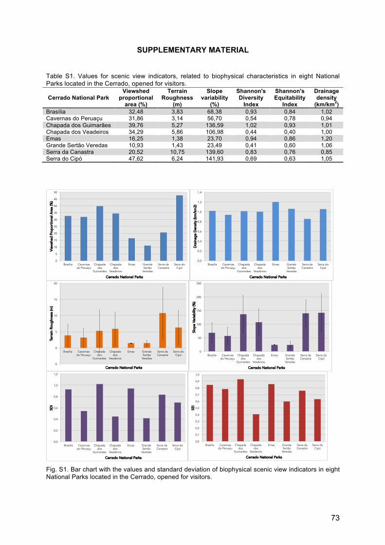
73
SUPPLEMENTARY MATERIAL Table S1. Values for scenic view indicators, related to biophysical characteristics in eight National Parks located in the Cerrado, opened for visitors.
Cerrado National Park Viewshed
proportional area (%)
Terrain Roughness
(m)
Slope variability
(%)
Shannon's Diversity
Index
Shannon's Equitability
Index
Drainage density
(km/km2) Brasília 32,48 3,83 68,38 0,93 0,84 1,02 Cavernas do Peruaçu 31,86 3,14 56,70 0,54 0,78 0,94 Chapada dos Guimarães 39,76 5,27 136,59 1,02 0,93 1,01 Chapada dos Veadeiros 34,29 5,86 106,98 0,44 0,40 1,00 Emas 16,25 1,38 23,70 0,94 0,86 1,20 Grande Sertão Veredas 10,93 1,43 23,49 0,41 0,60 1,06 Serra da Canastra 20,52 10,75 139,60 0,83 0,76 0,85 Serra do Cipó 47,62 6,24 141,93 0,69 0,63 1,05
Fig. S1. Bar chart with the values and standard deviation of biophysical scenic view indicators in eight National Parks located in the Cerrado, opened for visitors.
0
5
10
15
20
25
30
35
40
45
50
Brasília Cavernas do Peruaçu
Chapada dos
Guimarães
Chapada dos
Veadeiros
Emas Grande Sertão
Veredas
Serra da Canastra
Serra do Cipó
Vie
wsh
ed P
ropo
rtio
nal A
rea
(%)
Cerrado National Parks
0,0
0,2
0,4
0,6
0,8
1,0
1,2
1,4
Brasília Cavernas do Peruaçu
Chapada dos
Guimarães
Chapada dos
Veadeiros
Emas Grande Sertão
Veredas
Serra da Canastra
Serra do Cipó
Dra
inag
e D
ensi
ty (k
m/k
m2)
Cerrado National Parks
-5
0
5
10
15
20
Brasília Cavernas do Peruaçu
Chapada dos
Guimarães
Chapada dos
Veadeiros
Emas Grande Sertão
Veredas
Serra da Canastra
Serra do Cipó
Terr
ain
Roug
hnes
s (m
)
Cerrado National Parks
0
50
100
150
200
250
Brasília Cavernas do Peruaçu
Chapada dos
Guimarães
Chapada dos
Veadeiros
Emas Grande Sertão
Veredas
Serra da Canastra
Serra do Cipó
Slop
e Va
riabi
lity
(%)
Cerrado National Parks
0,0
0,2
0,4
0,6
0,8
1,0
1,2
Brasília Cavernas do Peruaçu
Chapada dos
Guimarães
Chapada dos
Veadeiros
Emas Grande Sertão
Veredas
Serra da Canastra
Serra do Cipó
SDI
Cerrado National Parks
0,0
0,1
0,2
0,3
0,4
0,5
0,6
0,7
0,8
0,9
1,0
Brasília Cavernas do Peruaçu
Chapada dos
Guimarães
Chapada dos
Veadeiros
Emas Grande Sertão
Veredas
Serra da Canastra
Serra do Cipó
SEI
Cerrado National Parks

74
Fig. S2. Stacked bar chart with the bioprofiles of scenic potential in eight National Parks located in the Cerrado, opened for visitors. The objective environmental and ecological indicators depicted in the chart indicate different opportunities to explore touristic activities in each park. Flat parks register higher drainage density and offer more opportunities for water recreational activities, inside the park. Hilly parks can offer panoramic views to viewers in the surroundings of the park.
Fig. S3. Variation of radar chart in Fig. 13, displaying the biophysical scenic view profiles for the eight selected National Parks located in the Cerrado biome and opened for visitation. Five visual and ecological indicators can be seen: Shannon Evenness Index (SEI), slope variability, drainage density, terrain roughness and viewshed area.
0
10
20
30
40
50
60
70
80
90
100
Brasília Cavernas do Peruaçu
Chapada dos Guimarães
Chapada dos Veadeiros
Emas Grande Sertão Veredas
Serra da Canastra
Serra do Cipó
Scen
ic V
iew
Indi
cato
rs (%
)
Cerrado National Parks
Shannon's Eveness Index (%)
Drainage Density (%)
Viewshed Proportional Area (%)
Slope Variability (%)
Terrain Roughness (%)
0
10
20
30
40
50
60
70
80
90
100 Shannon's Eveness Index
Drainage Density
Viewshed Area Slope Variability
Terrain Roughness
Brasília Cavernas do Peruaçu Chapada dos Guimarães
Chapada dos Veadeiros Emas Grande Sertão Veredas
Serra da Canastra Serra do Cipó