cegr697: geographic information systems application in transportation chapter 3: data acquisition...
TRANSCRIPT
CEGR697: Geographic Information Systems Application in Transportation
Chapter 3: Data Acquisition and processing
Instructor: Min-Wook [email protected]
443-885-1442www.eng.morgan.edu\~cegr697

Chapter 2: Introduction of ArcGIS
2
Outline Chapter 2 Objective
Understand/Get familiar with some useful spatial data popularly used for GIS-T
List of Useful Spatial Data MdProperty Data Census Tracks / Census Block Groups / Census Blocks TAZ by local MPO (Metropolitan Planning
Organization) TIGER file

Chapter 2: Introduction of ArcGIS
3
MdProperty Data What data we can get?
Tax Maps, Parcel data, Appraisal data, Aerial imagery, ZIP code boundary files, Land use/land cover data, Census geography and census demographic data, Priority Funding Area (PFA) designations, Legislative and congressional district boundary files, Flood plain data, Generalized zoning designations, Protected land boundaries, Sewer service area boundaries
Where to get? Maryland Department of Planning

Chapter 2: Introduction of ArcGIS
4
MdProperty Data For Montgomery County my_ex03.mxd

Chapter 2: Introduction of ArcGIS
5
MdProperty Data For Allegany County my_ex04_Allegany.mxd

Chapter 2: Introduction of ArcGIS
6
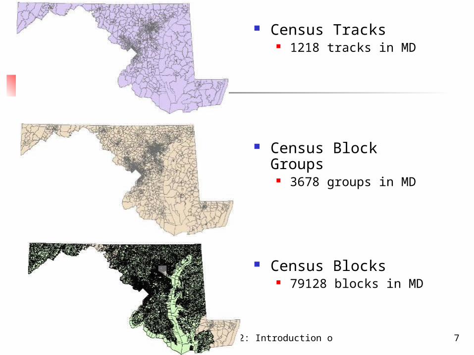
Census Tracks Census tracts
are geographic regions defined for the purpose of taking a census are delineated for most metropolitan areas and other densely populated
counties by local census statistical areas committees are small, relatively permanent statistical subdivisions of a county. usually have between 2,500 and 8,000 persons and are designed to be
homogeneous with respect to population characteristics, economic status, and living conditions.
coincide with the limits of cities, towns or other administrative areas census tracts are subdivided into block groups and census blocks
. can be obtained from MdProperty View data with demographic information
See, MdPro_Mont_CT_SPC83Census Tracks
Block Groups
Blocks
Chapter 2: Introduction of ArcGIS
7
Census Tracks 1218 tracks in MD
Census Block Groups 3678 groups in MD
Census Blocks 79128 blocks in MD

Chapter 2: Introduction of ArcGIS
8
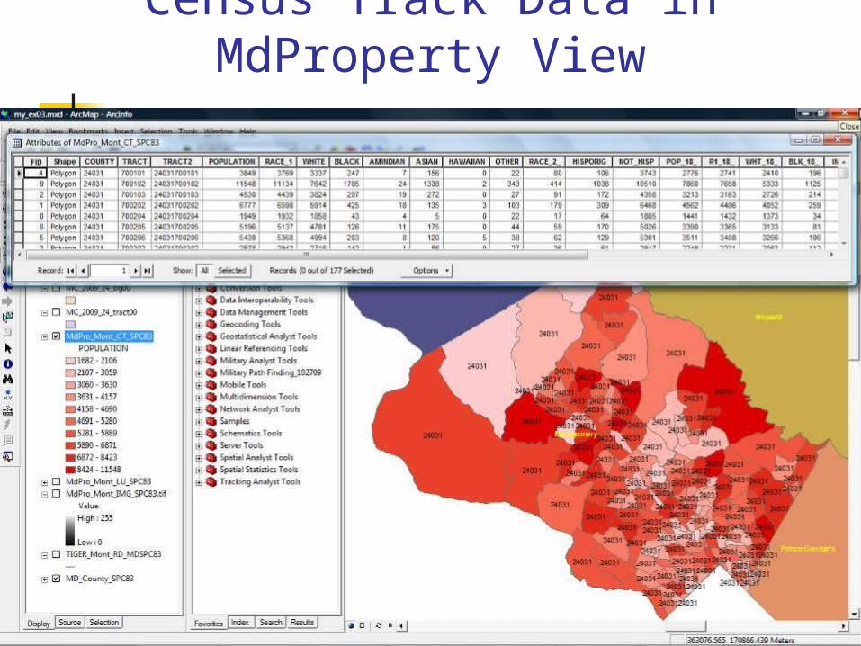
Census Track Data in MdProperty View
What data we can get from it? (see handout) Total Population of each census track
White, Black, Asian, etc. Total population of 18 years old and over
White, Black, Asian, etc.
Chapter 2: Introduction of ArcGIS
9
Census Track Data in MdProperty View

Chapter 2: Introduction of ArcGIS
10
TAZ by local MPO Traffic Analysis Zone
A traffic analysis zone (TAZ) is a special area delineated by state and/or local transportation officials for tabulating traffic-related data- especially journey-to-work and place-of-work statistics.
A TAZ usually consists of one or more census blocks, block groups, or census tracts, and is constructed by census block information.
The critical information included in a TAZ are No. of automobiles, Household income, and employment within these zones. This information helps to further the understanding of trips that are produced and
attracted within the zone. TAZ data can be obtained from local MPO
MWCOG (Metropolitan Washington Council of Government BMC (Baltimore Metropolitan Council)

Chapter 2: Introduction of ArcGIS
11
Traffic Analysis Zone

Chapter 2: Introduction of ArcGIS
12
TIGER/Line®Shapefiles Topologically Integrated Geographic Encoding and Referencing
system TIGER/Line®Shapefiles are spatial extracts from the Census
Bureau's MAF/TIGER database, containing features such as roads, railroads, rivers, as well as legal and statistical geographic areas.
You can download TIGER/Line®Shapefiles of the area that you are interested in, and use it to make your road network.
http://www.census.gov/geo/www/tiger/
The TIGER/Line®Shapefiles do not include demographic data, but they contain geographic entity codes that can be linked to the Census Bureau’s demographic data, available on American FactFinder

Chapter 2: Introduction of ArcGIS
13
TIGER files for Montgomery County
TIGER file
Maryland Highways from other sources