cartographic activities in polandthe national report on the cartographic activities in poland from...
TRANSCRIPT

INSTITUTE OF GEODESY AND CARTOGRAPHY
POLISH NATIONAL COMMITTEE
FOR INTERNATIONAL CARTOGRAPHIC ASSOCIATION
CARTOGRAPHIC ACTIVITIES
IN POLAND 2015–2018
NATIONAL REPORT
Presented to
the 18th General Assembly of the International Cartographic Association
Tokyo, Japan July 2019
HEAD OFFICE OF GEODESY AND CARTOGRAPHY
Warsaw 2019

2
POLISH NATIONAL COMMITTEE
FOR INTERNATIONAL CARTOGRAPHIC ASSOCIATION Joanna Bac-Bronowicz, Jerzy Balcerzak, Marek Baranowski, Elżbieta Bielecka, Renata Brzozowska, Tadeusz Chrobak, Dariusz Dukaczewski (secretary), Dariusz Gotlib, Adam Iwaniak, Krzysztof Kałamucki, Beata Konopska, Jolanta Korycka-Skorupa, Zenon Kozieł, Adam Linsenbarth, Beata Medyńska-Gulij, Pavel Neytchev, Bożena Ogorzelska, Robert Olszewski (chairman), Jerzy Ostrowski, Jacek Pasławski, Tomasz Panecki, Paweł Pędzich, Anna Radomyska, Jerzy Siwek, Lucyna Szaniawska, Małgorzata Wieczorek, Jerzy Zieliński
Compiled and edited by: Renata Brzozowska, Justyna Kacprzak and Anna Radomyska,
based on materials supplied by Joanna Bac-Bronowicz, Marek Baranowski, Elżbiet Bielecka, Paweł Cebrykow, Tadeusz Chrobak, Paweł Derek, Dariusz Dukaczewski, Konrad Eckes, Elżbieta Knapek, Natalia Kopiec, Jolanta Korycka – Skorupa, Jacek Kozak, Zenon Kozieł, Krystian Kozioł, Jadwiga Maciaszek, Beata Medyńska-Gulij, Józef Mikołajków, Albina Mościcka, Tomasz Niedzielski, Robert Olszewski, Waldemar Rudnicki, Adam Rysiewicz, Adam Sobków, Stanisław Szombara, Jacek Wolski, Maciej Zych.
Final editing by: Marek Baranowski, Dariusz Dukaczewski and Jerzy Ostrowski
Head Office of Geodesy and Cartography ul. Wspólna 2, 00-926 Warszawa, Poland
http://www.gugik.gov.pl
Translated by:
SUMMA LINGUAE TECHNOLOGIES
Summa Linguae S.A. ul. Conrada 63, 31-357 Kraków
3
CONTENTS
1. INTRODUCTION ...................................................................................................... 4 2. PARTICIPATION OF POLISH CARTOGRAPHERS IN THE
INTERNATIONAL CARTOGRAPHIC ASSOCIATION (ICA) ............................. 4 3. ORGANIZATIONAL STRUCTURE AND TASKS OF THE GEODETIC AND
CARTOGRAPHIC SERVICE IN POLAND ............................................................ 6 4. ACTIVITY OF POLISH CARTOGRAPHIC ORGANIZATIONS .......................... 8 5. MAPPING AND PUBLISHING ACTIVITY ......................................................... 14 5.1. Topographic and general geographic maps ............................................................. 14 5.1.1. The database for topographic objects (BDOT10k) and the databases for general
geographic objects (BDOO) .................................................................................. 15 5.2.1. The National Database of Topographic Objects Management System
(KSZBDOT) .......................................................................................................... 17 5.3.1. Topographic maps ................................................................................................. 18
5.2. Orthophotomap and Digital Terrain Model ............................................................. 19 5.3. Thematic maps and atlases ...................................................................................... 21 5.4. School maps and atlases .......................................................................................... 41 5.5. Atlases for the blind and the visually impaired persons .......................................... 46 5.6. General use maps and atlases .................................................................................. 48 5.7. Cartographic literature ............................................................................................. 50 5.8. Geographical names ................................................................................................. 51 6. EDUCATION IN CARTOGRAPHY ...................................................................... 54 7. RESEARCH AND IMPLEMENTATION WORKS IN CARTOGRAPHY ........... 61 8. CARTOGRAPHIC COLLECTIONS ...................................................................... 75 9. INTERNATIONAL MAP YEAR IN POLAND ..................................................... 76
APPENDIX
Selective bibliography of polish cartographic publications
A. ATLASES ................................................................................................................ 78 HISTORICAL ATLASES ....................................................................................... 78 STATISTICAL ATLASES OF POLAND AND VOIVODSHIPS ......................... 80 SCHOOL ATLASES ............................................................................................... 82
B. MAPS ....................................................................................................................... 83 THEMATIC MAPS ................................................................................................. 83 TOURIST MAPS .................................................................................................... 84
C. CARTOGRAPHIC LITERATURE ......................................................................... 85 HISTORY OF CARTOGRAPHY ........................................................................... 86 CONTEMPORARY CARTOGRAPHY IN POLAND ........................................... 88 GEODETIC BASIS. CARTOGRAPHIC PROJECTIONS ..................................... 89 THEORETICAL AND METHODOLOGICAL PROBLEMS ............................... 90 TOPOGRAPHIC AND THEMATIC MAPS .......................................................... 91 MAP PERCEPTION AND USE ............................................................................. 94 TOPONYMS IN AND FOR CARTOGRAPHY ..................................................... 96 DIGITAL TECHNOLOGIES .................................................................................. 96 REMOTE SENSING MAPPING ............................................................................ 99 GIS. SPATIAL INFORMATION INFRASTRUCTURE ..................................... 100

4
1. Introduction
The National Report on the cartographic activities in Poland from 2015–2018, addressed
to the delegates of the 18th General Assembly of the International Cartographic Association in Tokyo, Japan, is the twelfth such a report that has been prepared by the Polish cartographers since the moment of the admission of Poland as a member of the Association in 1964. The previous reports were sent to the General Assemblies in New Delhi (1967), Moscow (1976), Tokyo (1980), Perth (1984), Morelia (1987), Barcelona (1995), Ottawa (1999), Durban (2003), Moscow (2007), Paris (2011) and Rio de Janeiro (2015). The current Report, just as the above-mentioned items, has been mainly compiled on the basis of reports provided by the offices, research and educational institutions, organizations, libraries and publishers. The information, posted on the websites of these institutions and published in recent years on various occasions in different professional journals, as well as the documents of the conferences dedicated to the cartography, and to the related disciplines, have been used in this Report.
This Report has been prepared in the Head Office of Geodesy and Cartography in Warsaw on the initiative of the National Committee for International Cartographic Association.
The report contains information about the activities of various associations operating in the field of cartography and geomatics, about recent work in the field of official cartography, in particular about maps elaborated for the needs of the blind and visually impaired persons. Research and implementation work on innovative technologies in the production of topographic and thematic maps has been highlighted. The particular attention was paid to geographic names problems. On the other hand, information on the production of maps for school use has been limited to basic data.
A specific feature of all Polish national reports is the last part thereof: the selective bibliography of cartographical publications, which were released in the successive four-year periods. The bibliography closing this Report takes into account more important atlases and maps (most of all the official topographic and thematic maps), and then the selected academic textbooks, monographs and scientific articles as well as important conference papers to reflect the interests and research results of Polish specialists in various fields – from the history of cartography, through important conference submissions to the application of modern digital technologies and infrastructure of spatial information.
2. Participation of Polish cartographers in the International Cartographic Association (ICA)
The active participation of Polish cartographers in various forms of activity of the International Cartographic Association has a long, half-century tradition. Poland was accepted into this prestigious organization as early as in 1964 and it has belonged to the most active ICA members since. In the past, two representatives of Poland – Prof. Lech Ratajski and Prof. Andrzej Ciołkosz – served as the Vice-Presidents of the Association, four Poles became the Heads of various commissions, and two – Prof. Stanisław Pietkiewicz in 1982 and Prof.

5
Andrzej Ciołkosz in 2003 received the Honorary Membership of ICA. The Poles hosted the 11th International Conference in Warsaw in summer 1982 and organized several meetings of commissions and working groups of the Association. We take an active part in various international, regional and thematic cartographic conferences and seminars, regularly present our achievements at the accompanying exhibitions and make our contribution to the activity of numerous commissions of ICA.
Since the beginning, the official national representative of Poland in the Association has been the Institute of Geodesy and Cartography seated in Warsaw. The participation of Polish cartographers in various events and initiatives organized by ICA is supported and coordinated by the National Committee for ICA, which was established in 1976 at the Institute of Geodesy and Cartography. The Committee includes at present 27 members who represent the main cartographic institutions and organizations in Poland, whose activities are related to the cartography. Prof. Andrzej Ciołkosz had been a Chairman of this Committee by March 2015; currently Prof. Robert Olszewski from the Department of Cartography of the Warsaw University of Technology has been fulfilling this function. The Committee maintains the regular contacts and cooperates with the authorities of the International Cartographic Association, makes arrangements for the Polish participation in various cartographic conferences (by preparing national reports, motions, opinions, initiatives, exhibits for international exhibitions and competitions), it takes part in organizing international cartographic events in Poland. It is also a medium for the exchange of information related to the activity of the ICA commissions and working groups.
Polish delegation took part in the previous 16th General Assembly of the International Cartographic Association in Rio de Janeiro in August 2015, as well as in 17th Extraordinary General Assembly of the International Cartographic Association in Washington in August 2017. In Rio de Janeiro Polish cartographers presented 6 papers, while in Washington - 13 papers and 2 posters. Poland was also traditionally present at the International Cartographic Exhibitions, showing 8 maps, 3 atlases (including 1 atlas for blind and visually impaired persons) and 2 numerical products in Rio de Janeiro, and 7 maps, 4 atlases (including 1 atlas for blind and visually impaired persons) in Washington. The Historical Atlas of Poland for blind and visually impaired persons was awarded the Second Price the during International Cartographic Competition in 2017.
Polish children have participated in 2015 and 2017 in Barbara Petchenik Children’s Map Competition. Polish cartographers participated in the conferences and workshops organized or co-organised by the Association, for instance in Joint ICA Workshop of ICA Commission on Education & ICA Commission on Maps and Internet in Curitiba, Brazil (2015), Joint ICA Symposium of ICA Commissions on Cartography and Children, Maps for Blind and Partially Sighted People, Planetary Cartography, Cartography for Early Warning and Crisis Management: “Cartography beyond the ordinary world’ in Niterói, Brazil (2015), 6th ICA International Conference on Cartography and GIS in Albena, Bulgaria (2016) and 7th ICA International Conference on Cartography and GIS in Sozopol, Bulgaria (2018), as well as The EuroCarto Heritage Conference in Vienna (2015).
In 2015 – 2017 period Polish National Committee for ICA coordinated the celebration of The International Year of Map in Poland. During two years over 90 national cartographic events was organized.

6
In the period under Report, Polish cartographers took part in the works of the following commissions and working groups of ICA:
– Commission on Cartography and Children; – Commission on Cartography in Early Warning and Crisis Management; – Commission on Cognitive Issues in Geographic Information Visualization; – Commission on Cartographic Heritage into the Digital; – Commission on Generalization and Multiple Representation; – Commission on SDI and Standards; – Commission on Map Projections; – Commission on Maps and the Internet; – Commission on Mountain Cartography; – Commission on Open Source Geospatial Technologies; – Commission on Toponymy; – Commission on Ubiquitous Mapping.
Among ICA affiliated members there are one organization and one enterprise from Poland: Association of Polish Cartographers and Eko-Graf Cartographic Publishing House in Wrocław.
Polish cartographers actively cooperate with representatives of the ICA, an example of which is the Department of Cartography and Geomatics at the University of Adam Mickiewicz (UAM) in Poznan, which in 2015-2018 established many direct contacts with the persons from ICA: President Georg Gartner, President Menno-Jane Kraak, Vice-President David Forrest and Chairman of the Commission on Topographic Mapping Alexander Kent.
3. Organizational structure and tasks of the Geodetic and Cartographic Service in Poland
According to the act of May 17, 1989 under the name of ‘Geodetic and Cartographic
Law’, the Geodetic and Cartographic Service in Poland incorporates: 1) Geodetic and cartographic supervisory bodies:
Surveyor General of Poland;
Voivodes [Governors] executing their responsibilities through voivodeship geodetic and cartographic supervision inspectors in the 16 voivodeships [provinces];
2) Geodetic and cartographic administrative bodies:
Chairmen of Voivodeship Assemblies executing their responsibilities through voivodeship surveyors from the 16 voivodeships;
County Chief Officials executing their responsibilities through county surveyors as well as commune heads and mayors.
The tasks of the Geodetic and Cartographic Service include, among others: 1) Implementation of the State policy in the scope of geodesy and cartography; 2) Organizing and funding the geodetic and cartographic work; 3) Managing the State geodetic and cartographic resource;
7
4) Monitoring the government offices, public institutions and entrepreneurs in terms of their compliance with the regulations on geodesy and cartography;
5) Managing the State register of borders and areas of the units of the State territorial division;
6) Producing the topographic and thematic maps of the country as well as its basic map;
7) Granting professional authorisations (licences) and managing the register of authorised persons;
8) Initiating the scientific studies, research and development work in the field of geodesy and cartography;
9) Cooperation with national, international and regional organizations as well as authorities and offices of other countries who demonstrate expertise in the field of geodesy and cartography,
10) Managing the databases, to cover spatial data sets of the spatial information infrastructure, regarding:
the national register of the geodetic, gravimetric and magnetic basic matrices;
the records of lands and buildings (cadastre)
the geodetic register of utilities network;
the national register of borders and areas of the units of the State territorial division;
the State register of geographical names;
the register of localities, streets and addresses;
the register of real estate prices and values;
topographic objects in detail to ensure the creation of standard cartographic products on the scales of 1:10,000–1:100,000, including cartographic studies on digital terrain model;
general geographic objects in detail to ensure the creation of standard cartographic products on a scale of 1:250,000 and smaller, including cartographic studies on digital terrain model;
the detailed geodetic matrices;
air photos, satellite images, orthophotomaps and digital terrain model. The Surveyor General of Poland is the main administrative body in terms of geodesy and
cartography. He/she is supervised by the Minister of Administration and Digitalization. The Surveyor General of Poland executes his/her responsibilities through the central administration body: the Head Office of Geodesy and Cartography, where the Surveyor General acts as the Chairman. The Surveyor General is supported in his/her activities by the Deputy Surveyor General of Poland, the Chief Executive Director and directors of subordinate organizational units. One of them is the Department of Geodesy, Cartography and Geographic Information Systems. The Surveyor General of Poland is appointed for the 5-year tenure by the Prime Minister, in the aftermath of an open competition.
The State Geodetic and Cartographic Council and the Commission on Standardization of Geographical Names Outside the Republic of Poland operate alongside the Surveyor General

8
of Poland. The State Geodetic and Cartographic Council is an opinion-making and advisory body.
4. Activity of Polish cartographic organizations
The following cartographic associations operate in Poland:
Cartographical Division of the Polish Geographical Society, whose history is the longest, as its origins date back to the Cartographic Commission of the Polish Geographical Society established in 1966,
Association of Polish Cartographers, it was established in 1999, when Poland became one of the countries where cartographers have their own independent professional organization,
Team for the History of Cartography at the Institute of History of Science, Polish Academy of Sciences
In addition, issues related to cartography are dealt with by the Polish Association for Spatial Information and the Commission of Geoinformatics at the Polish Academy of Arts and Sciences.
The Cartographical Division of the Polish Geographical Society cultivates the
traditions of the former Cartographical Commission of this Society (1966–1999). By the end of 2018 the Division numbered 59 members. Since 2012, Professor Marek Baranowski from the Institute of Geodesy and Cartography has been the Chairman of the Division. The main aim of the Division’s activity is the organization of cooperation and exchange of experience between research, educational and production centres which are engaged in cartography in different areas and aspects as well as the popularization of cartography, especially among numerous teachers of geography, the members of the Society. The fulfilling of these goals is mainly possible due to the organizing national conferences, seminars and cartographic schools as well as by virtue of publishing of its own journal and other publications.
The national cartographic conferences have been organized, for the most part – annually, since 1968, in different cities of Poland in the partnership with the local cartographic training centres and other institutions and organizations related to cartography. There were four such conferences in the years 2015–2018:
The 38th National Cartographic Conference ‘Map in Information Society’ held in Warsaw in September 2015 (22 papers, 6 posters), organized in cooperation with the Head Office of Geodesy and Cartography and the Department of Geoinformatics, Cartography and Remote Sensing at the University of Warsaw;
The 39th National Cartographic Conference ‘Cartographic visualization in science and practice’ held in Zwierzyniec and Lviv in September 2016 (31 papers, 10 posters), organized in cooperation with the Department of Cartography and Geomatics at the Maria Curie-Skłodowska University in Lublin, the Lublin Branch of the Polish Geographical Society and the Roztocze National Park;

9
The 40th National Cartographic Conference ‘Map in the service of science’ held in Wrocław in September 2017 (27 papers, 16 posters), organized in cooperation with the Department of Geoinformatics and Cartography at the University of Wrocław;
The 41st National Cartographic Conference ‘Functionality and aesthetics of maps’ held in Gdańsk in September 2018 (27 papers, 6 posters), organized in cooperation with the Cartography, Remote Sensing and Geographical Information Systems Department at the Limnology Faculty of the University of Gdańsk and the Gdańsk Library of the Polish Academy of Sciences.
Abstracts of papers delivered are to be found in conference materials, while selected papers have been published in the ‘Polish Cartographical Review’, which is quarterly of the Division.
Fig. 1. Conference materials of the 41st National Cartographic Conference held in Gdańsk
The Cartographical Division of the Polish Geographical Society since the very beginning of its existence has been co-working with the Department of Cartography (in 2013 it was renamed the Chair of Geoinformatics and Cartography) at the University of Wrocław while organizing the annual so-called “cartographical schools” – these are multi-day training conferences composed of lectures, exhibitions and discussions.
Since 2009, upon the initiative of the Division and in cooperation with various universities, annual competitions of master's theses in the field of cartography and geoinfomatics have been organized.
The Cartographical Division publishes regularly a professional journal, the quarterly “Polish Cartographical Review”. It is published as the continuation of the periodical that was its precursor and had been published in Lwów for 11 years (1923 – 1934) under the same title. This new Warsaw edition has been distributed since 1969. Since 2014 the Quarterly has been publishing all its articles in English.

10
Fig. 2. Polish Cartographical Review
At the end of 2014 the Division started the intensive preparation for the celebration of the
International Map Year at the national, regional and local levels. The activity was coordinated by the Chairman of the Division, Professor Marek Baranowski.
Information about the Division and the report on its current activities are available on the website https://www.kartografia.org.
The Association of Polish Cartographers (APC) is a professional, scientific-technical
organization uniting the Polish cartographers on the basis of voluntary membership. By the end of 2018 the Association numbered 190 regular members and 4 supporting members. Ms Joanna Bac-Bronowicz, Prof. from the Department of Geodesy and Geoinformatics, at Wrocław University of Technology, has been the Chairperson of the Management Board of APC since the very beginning of its existence.
The statutory objectives of the Association include representing the interests of designers and professionals actively involved in the cartographer profession in the country and abroad, protection of the profession and copyrights of cartographers, raising the level of knowledge, technical culture and professional qualifications of members of the Association, popularizing scientific, technical and economic issues in the field of cartography, cooperating with relevant units of state and local administration in the field of cartography and conducting exchange of organizational and scientific and technical experiences with related organizations abroad. In order to honour scientists and practitioners making a significant contribution to the development of cartography, a Chapter was established in 2015 and the rules laid down for awarding the APC Medal named after Professor Andrzej Makowski, died in 2013, professor at the Warsaw University of Technology. So far, this medal has been awarded to professors: Władysław Pawlak, Ewa Krzywicka-Blum, Janusz Gołaski and Izabella Krauze – Tomczyk.
The Association's activities are carried out through the participation of the Board and members in the work on the legal regulations concerning cartography in Poland together with the Head Office of Geodesy and Cartography, organization of conferences, symposia and other forms of exchange of information and views on the cartographer profession and the actual state of Polish cartography, as well as publishing articles and news on the quality of

11
Polish cartography, protection of the rights of authors – cartographers, etc. Organizing competitions called THE MAP OF THE YEAR and THE INTERNET MAP OF THE YEAR.
In May 2015, the Association co-organized in Wrocław the so-called Academy Of Cartography And Geoinformatics under the name of: ‘Digital topographic maps – theory and workshops’, (together with the Head Office of Geodesy and Cartography and the Department of Geoengineering, Mining and Geology at the Wrocław University of Technology). The Academy was devoted to the use of the Database of Topographic Objects (BDOT10k) as an information source for the elaboration of maps, and in particular digital topographic maps. The Academy was planned in the form of lectures and workshops. The subject of the lectures was the BDOT10k data model and the process of data generalization and update within the entire course of the elaboration of digital topographic maps, ways of preparing a cartographic presentation as well as the range of using topographic maps. Military and maritime cartography issues were presented as well. The workshop was devoted to getting acquainted with the KARTO component of topographic maps and update processes of the Database of Topographic Objects (BDOT10k) as well as updating topographic maps. Classes were conducted by the most prominent theorists and practitioners in the field of topographic cartography and geoinformatics.
In March 2017, the Association organized in Wroclaw the Academy Of Cartography And Geoinformatics under the name of “Editing Digital Thematic Maps – Science and Practice” devoted to the issues of cartographic thematic studies in the digital form, and in particular to the results of the EnviDMS project carried out by the Head Office of Geodesy and Cartography. Co-organizers were the Head Office of Geodesy and Cartography, as well as the Warsaw and Wrocław Universities of Technology. Immediately after the Academy, the 9th Polish National Symposium Of Geoinformation was organized under the name of “Thematic maps of the natural environment”. Representatives of science, practitioners were invited to participate in both geoinformation meetings as well as the administration employees who deal with issues related to cartography on a daily basis. Monographic and scientific papers and posters were presented, preceded by short speeches by the participants. Articles have been published in point-rated magazines.
The annual competition “The Map of the Year”, which has been organized regularly by the Association since 2000, is one of the most popular events among the Polish cartographers. Each year more than 10 leading cartographic publishers participate in the competition. The members of the Association vote in the contest for the atlases and maps submitted by the publishers in four categories: “tourists maps”, “city maps”, “the wall maps and atlases for schools” and “other printed maps and atlases”. Since 2011 the competition “The Internet Map of the Year” has been organized, and after the death, in 2013, of Dr Eng. Krzysztof Buczkowski – the distinguished academic teacher from the Warsaw University of Technology – the main prise of his name is awarded.
Map contests of 2014, 2015, 2016 and 2017 had been organized. As it has already been mentioned at the beginning of the Report, since 2012, the
Association of Polish Cartographers has been the affiliated member of the International Cartographic Association and cooperates with the ICA in the dissemination of information about conferences and other forms of activities of the organization.

12
The Association had also assumed patronage and took part in student seminars and other undertakings such as: GIS-Day 2018, GIS Challenge 2018, awarded prizes for outstanding papers, posters and diploma theses in the field of cartography and geoinformation. It has supported school competitions for students “Map Master”, whose goal is to broaden the orientation on the physical and political map of Poland and the world.
From 2018, the Association has been participated in giving opinions on legal acts in a set agreement of all national geodetic and cartographic organizations. Programs and conference materials as well as various information about the work of APC are published in the “Bulletin of Polish Cartographers Society” (by the end of 2018, 27 issues were published). More information is to be found on the website www.polishcartography.pl.
The Team for the History of Cartography is a scientific unit operating since 1974 at the
Ludwik and Alexander Birkenmajer Institute of History of Science, Polish Academy of Sciences in Warsaw, according to the Institute Statute. The aim of the Team is to inspire, coordinate and help in researching the history of cartography, concerning in particular Polish land, both, the historical and contemporary, as well as the old Polish Commonwealth, to popularize knowledge in this field. The chairman of the team is from 2011 prof. Radosław Skrycki from the Institute of History and International Relations, University of Szczecin.
In 2015–2018, the Team for the History of Cartography at the Institute of History of Science of the Polish Academy of Sciences organized the following events:
on 24–26 September 2015, in Wrocław, the 29th Polish National Conference for Cartography Historians “The Map as an Interpretive Narration”. Co-organizers of the conference were: History Atlas Laboratory in the History Institute at the University of Wrocław, Department of Geoinformatics and Cartography of the Institute of Geography and Regional Development at the University of Wrocław;
on 13–15 October 2016, in Toruń, the 30th Polish National Conference for Cartography Historians “Military Cartography of the Countries of the Younger Europe of the XVI-XX Century”. The co-organizers of the conference were: the Institute of History and Archival Science at the Nicolaus Copernicus University in Toruń;
on 19–21 October 2017, in Nieborów, the 31st Polish National Conference for Cartography Historians “Old Maps and Historical Atlases”. Co-organizers of the conference were: the Museum of Warsaw and the Museum in Nieborów and Arkadia;
on October 11–13, 2018, in Warsaw, the 32nd Polish National Conference for Cartography Historians “A Map in the Service of the State”. Co-organizers of the conference were: the Royal Castle in Warsaw – the Museum: Residence of Kings and Res Publica and the Museum of Warsaw.
Selected papers from these conferences are published in subsequent volumes of the series “From the History of Cartography” has been published since 1979.
The Commission on Geoinformatics at the Polish Academy of Arts and Sciences
(PAU) has been operating since 1998 and is one of five commissions of the 4th Department of Natural Sciences of PAU. The Commission deals with the methods of obtaining, analysing and visualizing data to describe the terrestrial space-time in information technology. The Commission consists of geographers, geologists, geophysicists, surveyors, photogrammetry

13
and remote sensing specialists, representatives of mining sciences and IT specialists. The main task of the Commission is to exchange experiences between specialists from various disciplines in the field of geoinformatics, stimulate the development of this science and propagate its results. The form of the Commission”s activities are monthly scientific meetings and organizing or co-organizing national and international scientific conferences. The commission also runs the journal “Geoinformatica Polonica”. (http://www.pau.krakow.pl/index.php/pl/struktura/wydzialy-i-komisje/wydzial-iv-przyrodniczy/komisje-przy-wydziale-iv/komisja-geoinformatyki).
In the years 2015–2018, the chairman of the board of the Commission was Professor Tadeusz Chrobak. The editor-in-chief of the journal Geoinformatica Polonica was Prof. Dr hab. Eng. Jadwiga Maciaszek.
In the years 2015–2018, 26 ordinary meetings took place. Moreover, on two occasions (in November 2016 and 2017), the Commission co-organized the celebration of the Krakow GIS Day (as part of the global GIS Day). In November 2015, the Commission sponsored the Seminar of Students Scientific Circles at the AGH University of Science and Technology in Kraków, and in May 2017 The PAU Commission of Geoinformatics together with the Remote Sensing Section of the Space and Satellite Research Committee at the Polish Academy of Sciences organized a seminar on “Remote sensing and geoinformatics in forest research”, with four papers.
The subject matter of the meetings often refers directly to the problems of cartography. An example of this may be the subjects of the following speeches:
8 April 2015, Dr hab. Zenon Kozieł – Nicolaus Copernicus University in Toruń: “The idea of developing and concept of application called Geographical and statistical atlas of the Kuyavian-Pomeranian Voivodeship”;
October 14, 2015, Dr Eng. Krystian Kozioł – Faculty of Mining Surveying and Environmental Engineering at AGH: “The significance of fixed points in generalization process for MRDB”;
11 May 2016, Dr hab. Eng. Adam Piórkowski – Faculty of Geology, Geophysics and Environmental Protection at AGH: “Developing maps of optimal commuting times for the needs of the civil service”.
In the years 2015-2018, four editions of the journal Geoinformatica Polonica were
published (volumes 14, 15, 16 and 17), containing in total 44 scientific articles and one memoir. Full texts of articles (in English) are available on the journal”s website (http://www.ejournals.eu/GP/). The subject matter of the works covers a wide range of geoinformatics issues, including cartographic ones.
In the magazine, issues related to mining cartography were presented on a number of occasions, having a functional application, especially when drawing up spatial development plans.

14
5. Mapping and publishing activity
Head Office of Geodesy and Cartography is responsible for the elaboration and
publication of official maps in Poland. Apart from the Head Office, maps and atlases for the needs of science and the state economy are also issued by research institutes – mainly Polish Geological Institute – National Research Institute and the Institute of Meteorology and Water Management – National Research Institute, various institutes of the Polish Academy of Sciences and universities as well as some of the science societies and geodetic and cartographic enterprises. Many privately-owned companies and cartographic publishers operating in the Polish market publish general use maps, e.g.: school, road and tourist maps.
A separate important role in Polish cartography is performed by the geographical service of the Polish Army, operating in the organizational structure of the Ministry of National Defence. Currently, it is an independent organizational unit of the Ministry of National Defence as the High Command for Geospatial Recognition. Under its command are the Military Geographical Centre in Warsaw and specialized units in Komorów, Toruń and Leszno. The primary goal of the High Command for Geospatial Recognition is the elaboration and acquisition of analogue and digital geographic products, primarily topographic maps for the needs of the armed forces.
An important institution in the field of cartography is the Naval Hydrographic Office (HOPN); in accordance with the Act of March 21, 1991 (with later amendments) on the maritime areas of the Republic of Poland and maritime administration, it is an institution performing the tasks of the state maritime hydrographic service in the field of hydrography and marine cartography. One of its statutory tasks is to develop, issue and update: nautical charts, nautical publications and digital navigational charts. HOPN has represented Poland in the International Hydrographic Organization (IHO) since joining the body in 1926.
5.1. Topographic and general geographic maps The tasks of the Surveyor General of Poland in the scope of the standard topographic
and geographic maps are defined by the Geodetic and Cartographic Law dated May 17, 1989 (Journal of Laws of 2019, item 725), as amended.
The above mentioned Act provides the legal framework for the realization of the objectives in the scope of managing databases, namely the databases of topographic objects (BDOT10k) detailed enough to enable the creation of standard maps on the scales of 1:10,000 – 1:100,000, and furthermore, the databases of general geographic objects (BDOO250k) detailed enough to enable the creation of standard cartographic designs on the scales of 1:250,000 – 1:1,000,000.

15
5.1.1. The database for topographic objects (BDOT10k) and the databases for general
geographic objects (BDOO) The Head Office of Geodesy and Cartographyimplemented in 2009-2015 period the
project “Georeferenced Database of Topographic Objects (GBDOT) along with the national management system” as a result of which the Database of Topographic Objects covering the whole country was prepared in detail corresponding to the scale of 1:10 000. As a result of the above activities, the area of Poland is covered by the BDOT10k database, homogeneous in terms of quality and validity, as well as by the BDOO databases, containing information about classes of objects, including among others: watercourse networks, road and rail networks, utilities networks, buildings and facilities, land cover and use, protected areas, administrative division units, other information about the topography.
Implementation of the Database of Topographic Objects has been, and still is one of the
main tasks carried out by the Geodetic and Cartographic Service in Poland. In 2015-2018, the database was updated with respect to the area of 187,540 km², and in 2018 alone, 99,790 km² have been updated. The area to be updated was selected on the basis of ongoing monitoring of changes taking place in the field.
Fig. 3. The area of Poland where the updates of BDOT10k database have been completed
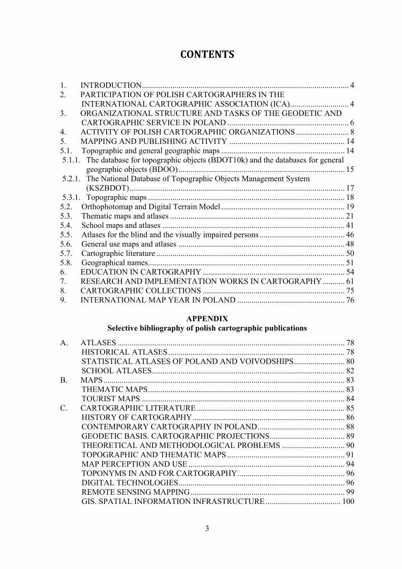
As part of the Centre for Spatial Analysis of Public Administration (CAPAP) project
carried out in the Head Office of Geodesy and Cartography in 2015–2018, data was prepared to allow maintaining cross-border data of the Polish BDOT10k database consistent with data from the Czech ZABAGED database and the Slovak ZBGIS database. As a result of the
16
activities, among others, the thematic layer with various “CP” connection points linking objects on both sides of the border has been created.
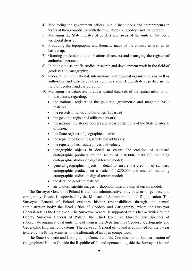
At the same time, research and development works have been carried out in the field of
the generalization of the database of topographic objects (BDOT10k) to elaborate on the database of general geographic objects (BDOO). As part of the CAPAP project, existing explications have been developed in the field of generalization of object classes: building developments, roads and hydrography.
Fig. 5. Object class OT_PTZB_A (building development) in the BDOO database. On the left – primary illustration, on the right – the newly developed illustration
Fig. 4. Connection points in the ZABAGED, ZBGIS and BDOT10k databases
17
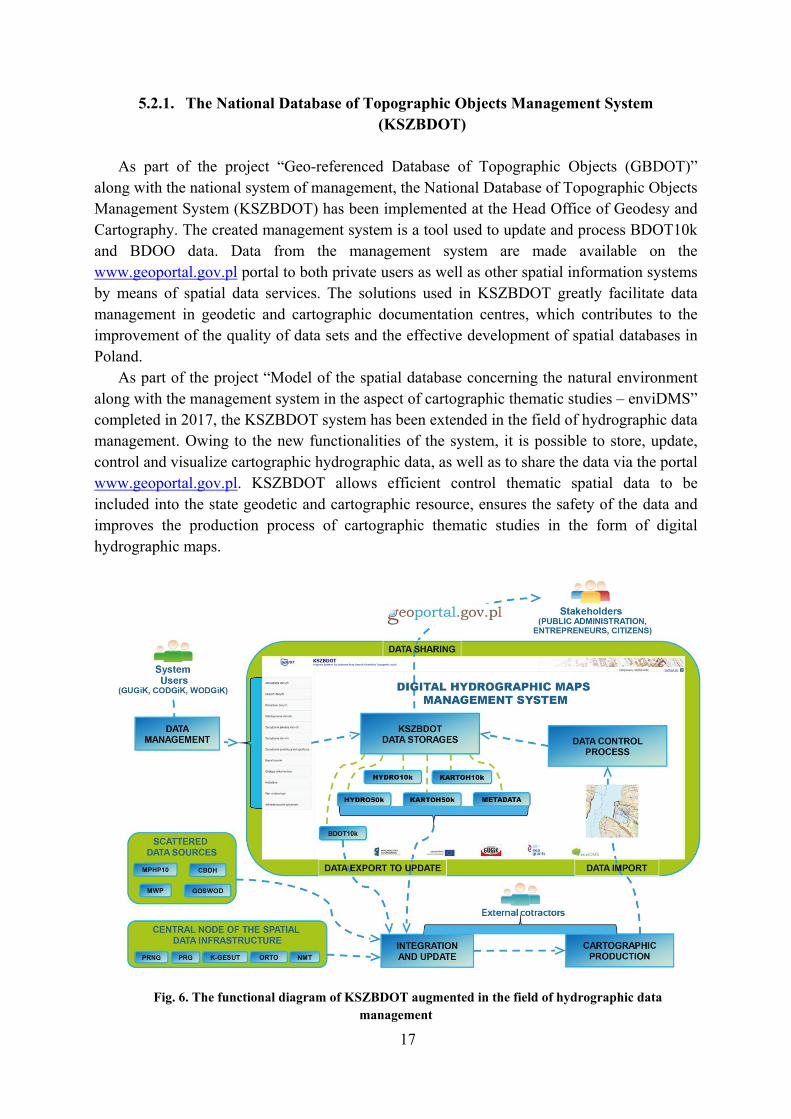
5.2.1. The National Database of Topographic Objects Management System (KSZBDOT)
As part of the project “Geo-referenced Database of Topographic Objects (GBDOT)”
along with the national system of management, the National Database of Topographic Objects Management System (KSZBDOT) has been implemented at the Head Office of Geodesy and Cartography. The created management system is a tool used to update and process BDOT10k and BDOO data. Data from the management system are made available on the www.geoportal.gov.pl portal to both private users as well as other spatial information systems by means of spatial data services. The solutions used in KSZBDOT greatly facilitate data management in geodetic and cartographic documentation centres, which contributes to the improvement of the quality of data sets and the effective development of spatial databases in Poland.
As part of the project “Model of the spatial database concerning the natural environment along with the management system in the aspect of cartographic thematic studies – enviDMS” completed in 2017, the KSZBDOT system has been extended in the field of hydrographic data management. Owing to the new functionalities of the system, it is possible to store, update, control and visualize cartographic hydrographic data, as well as to share the data via the portal www.geoportal.gov.pl. KSZBDOT allows efficient control thematic spatial data to be included into the state geodetic and cartographic resource, ensures the safety of the data and improves the production process of cartographic thematic studies in the form of digital hydrographic maps.
Fig. 6. The functional diagram of KSZBDOT augmented in the field of hydrographic data management
18
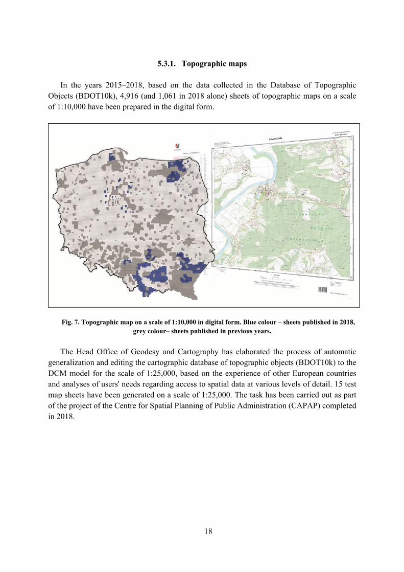
5.3.1. Topographic maps
In the years 2015–2018, based on the data collected in the Database of Topographic
Objects (BDOT10k), 4,916 (and 1,061 in 2018 alone) sheets of topographic maps on a scale of 1:10,000 have been prepared in the digital form.
Fig. 7. Topographic map on a scale of 1:10,000 in digital form. Blue colour – sheets published in 2018, grey colour– sheets published in previous years.
The Head Office of Geodesy and Cartography has elaborated the process of automatic
generalization and editing the cartographic database of topographic objects (BDOT10k) to the DCM model for the scale of 1:25,000, based on the experience of other European countries and analyses of users' needs regarding access to spatial data at various levels of detail. 15 test map sheets have been generated on a scale of 1:25,000. The task has been carried out as part of the project of the Centre for Spatial Planning of Public Administration (CAPAP) completed in 2018.

19
Fig. 8. Visualization of the BDOT10k database
Fig. 9. Topographic map on a scale of 1:25,000
5.2. Orthophotomap and Digital Terrain Model A database of aerial and satellite imagery as well as an orthophotomap and Digital Terrain
Model are maintained at the Head Office of Geodesy and Cartography. It was updated in 2015–2018 period,
As part of the work commissioned by the Agency for Restructuring and Modernization of Agriculture, the cycle of covering the country with an orthophotomap using a terrain pixel size from 25 to 50 cm had been completed and the next cycle of updating this data was started, to cover the area of the whole country with an orthophotomap using a terrain pixel size of 25 cm within the years 2018–2020. In addition, during the last four years the Head

20
Office of Geodesy and Cartography as well as other entities of the lower level of administration (counties and cities) implemented a number of job orders aimed at elaboration of an orthophotomap with a terrain pixel size ranging from 3 cm to 10 cm.
Fig. 10. An orthophotomap with a terrain pixel size from 3 cm to 10 cm.
Along with the growing interest and demand for digital orthophotomaps, the demand for
high-resolution altitude data is growing rapidly in Poland. One of the main tasks carried out by the Head Office of Geodesy and Cartography is continuous elaboration and ongoing update of the high resolution numerical terrain model (1 m grid) and the numerical model of land cover (with grid size of 1 m outside the cities and 0.5 m in urban areas) in the airborne laser scanning technology (ALS) for the whole country area. These products based on ALS measurement data with a density of 4 pts/m² and 12 pts/m² are distinguished for an altitude accuracy not exceeding 0.2 m. In 2015–2018 period, altitude data for a total area of 33,618 km² have been completed, which allowed to ensure full coverage of the country with the data and a partial update of the areas with the lowest timeliness. The ALS data is one of the most commonly used spatial data collected by the users in the central resource, and its use is growing dynamically from year to year. It also constitute a source data set for the elaboration of other products to supply the state geodetic and cartographic resource (e.g. orthophotomaps) and a key material for the elaboration of strategic products from the point of view of national security, including the process of elaboration of flood risk maps and flood hazards.

21
Fig. 11. Data from aerial laser scanning (ALS).
Following the needs of users and trends in the development of spatial databases observed
in Europe, the Head Office of Geodesy and Cartography in 2017–2018 developed 3D models of buildings in the LoD2 standard based on the central Database of Topographic Objects and the database of the numerical terrain model. In 2018, more than 8,732,000 3D models of buildings were build for the area of 10 out of 16 voivodeships [provinces] (61% of Poland).
Fig. 12. 3D models of buildings in the LoD2 standard.
5.3. Thematic maps and atlases
According to the “Geodetic and Cartographic Law Act”, The Surveyor General of Poland
is to elaborate, maintain and provide cartographic thematic and special studies, i.e. hydrographic, environmental, geomorphological, soil and agricultural maps, land cover, land use,, as well as databases of technical infrastructure, average transaction prices of land,
22
administrative division of the country, atlas studies on the Republic of Poland and maps for the visually impaired.
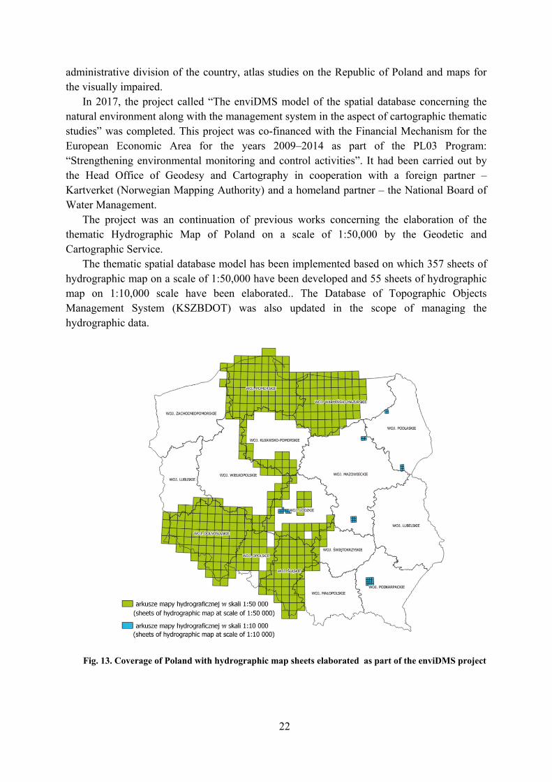
In 2017, the project called “The enviDMS model of the spatial database concerning the natural environment along with the management system in the aspect of cartographic thematic studies” was completed. This project was co-financed with the Financial Mechanism for the European Economic Area for the years 2009–2014 as part of the PL03 Program: “Strengthening environmental monitoring and control activities”. It had been carried out by the Head Office of Geodesy and Cartography in cooperation with a foreign partner – Kartverket (Norwegian Mapping Authority) and a homeland partner – the National Board of Water Management.
The project was an continuation of previous works concerning the elaboration of the thematic Hydrographic Map of Poland on a scale of 1:50,000 by the Geodetic and Cartographic Service.
The thematic spatial database model has been implemented based on which 357 sheets of hydrographic map on a scale of 1:50,000 have been developed and 55 sheets of hydrographic map on 1:10,000 scale have been elaborated.. The Database of Topographic Objects Management System (KSZBDOT) was also updated in the scope of managing the hydrographic data.
Fig. 13. Coverage of Poland with hydrographic map sheets elaborated as part of the enviDMS project
23
The database model build as part of the project enables harmonization of the high quality, up-to-date spatial data along with their cartographic visualization in the form of digital cartographic thematic studies.
The hydrographic database elaborated in accordance with the adopted model is fed with data from registers kept by the Geodetic and Cartographic Services and other public institutions.
The database consists of four categories of object classes:
surface water and groundwater,
water management facilities,
quality and protection of water,
phenomena and other objects. Geological mapping is one of the basic scientific tasks and statutory activities of the
Polish Geological Institute – National Research Institute (PGI-NRI). The Institute elaborates thematic maps on various scales in the field of geology, hydrogeology, engineering geology, economic and environmental geology, geophysics and environmental geochemistry covering the entire country or selected regions, depending on the subject and the needs.
Geological maps and maps related to geology issues are implemented depending on the needs on detailed scales (from 1:10,000 scale for maps and geological engineering atlases of selected areas) through serial thematic maps on a scale of 1:50,000 covering the entire country area (geological, lithogenetic, hydrogeological, geo-environmental maps) to synthetic overview maps on 1:200,000 – 1:500,000 scales. All currently elaborated maps are prepared in the form of databases and feed the geographic information system. They are made available in paper form, and new maps elaborated in digital form can be made available as databases or network services.
One of the most important tasks carried out by PGI-NRI as part of geological mapping are
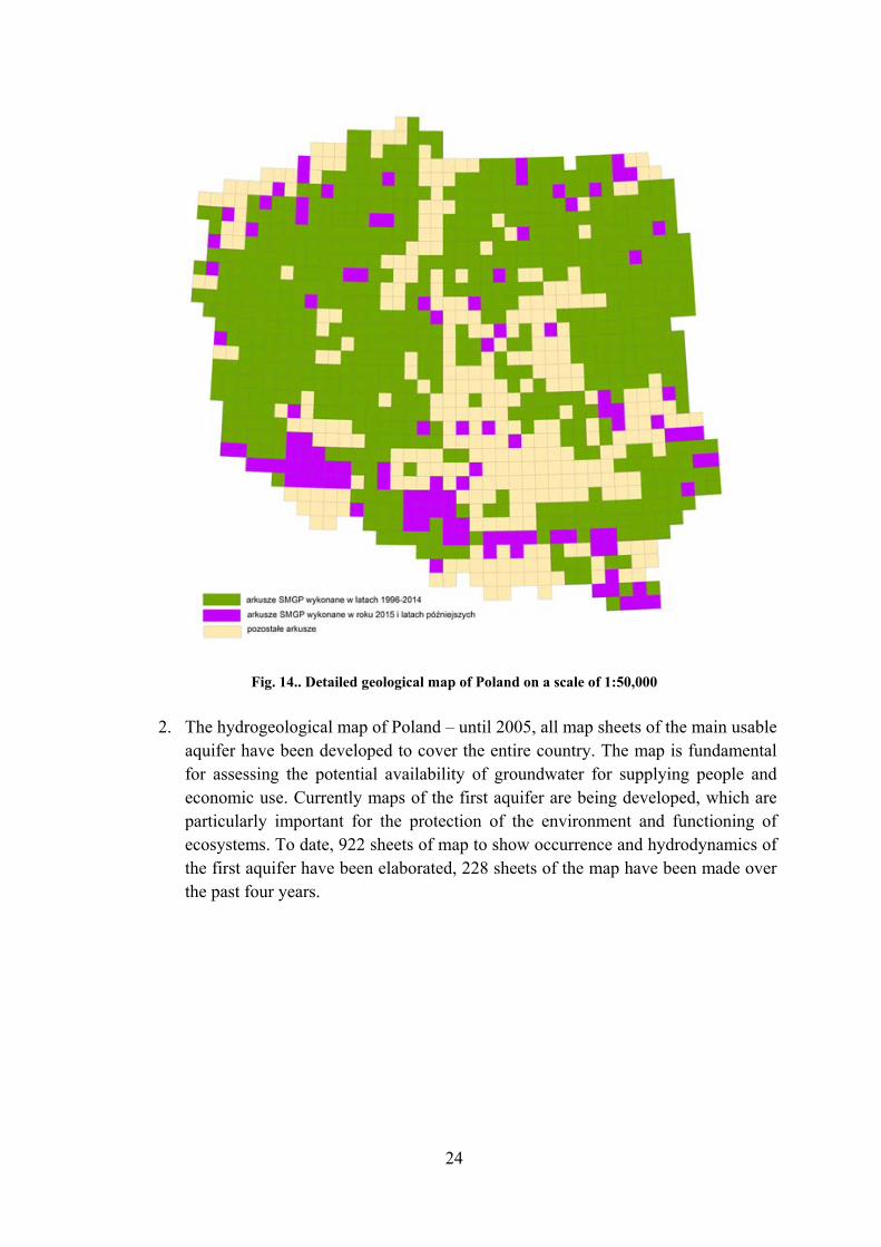
the detailed thematic maps on a scale of 1:50,000, which ultimately are to cover the entire country – a total of 1069 sheets. These are multi-annual programs, under which successive sheets of individual maps are systematically elaborated. The current progress is as follows:
1. The detailed Geological Map of Poland – has been developed for the whole country over the last 60 years. Some older maps were only published in the form of an offset print only. Until now, the digital version of 754 map sheets has been elaborated, the remaining map sheets made with traditional methods are updated taking into account the latest data and entered into databases. In the years 2015-2018, another 112 sheets of the map have been elaborated and prepared to be published in digital form.
24
Fig. 14.. Detailed geological map of Poland on a scale of 1:50,000
2. The hydrogeological map of Poland – until 2005, all map sheets of the main usable
aquifer have been developed to cover the entire country. The map is fundamental for assessing the potential availability of groundwater for supplying people and economic use. Currently maps of the first aquifer are being developed, which are particularly important for the protection of the environment and functioning of ecosystems. To date, 922 sheets of map to show occurrence and hydrodynamics of the first aquifer have been elaborated, 228 sheets of the map have been made over the past four years.

25
Fig. 15. H. Hydrogeological map of Poland on 1:50,000 scale. The first aquifer – occurrence and hydrodynamics
At the same time, maps of the first aquifer sensitivity to pollution and water quality were
elaborated. To date, 433 sheets of this map have been published.

26
Fig. 16.. Hydrogeological map of Poland on a scale of 1:50,000. The first aquifer – sensitivity to pollution, water quality
3. The geo-environmental map of Poland is addressed first of all to institutions, local governments, state administration, as entities dealing with rational management of natural environment resources. In the aftermath of successive updates, this map has become an extensive geo-environmental database, with the main emphasis put on the indication of the existing and potential raw material resources in Poland, environmental protection conditions and potential conflicts related to, inter alia, the mining extraction of minerals. In 2015, the update of 467 map sheets was completed (the area of south-western Poland), it had been carried out in the years 2013-2015. In the years 2016-2019, the update of the rest of the country has been carried out, to include 602 sheets.
4. The lithogenetic map of Poland to show simplified information about the construction and formation of the surface zone, processed on the basis of the Detailed Geological Map of Poland – up to now a total of 750 sheets of the map have been developed, out of which 75 sheets in the years 2015 – 2018.

27
Fig. 17. The lithogenetic map of Poland on a scale of 1:50,000
The Institute of Meteorology and Water Management – National Research Institute (IMWM NRI) is also publishing:
The geological map of the crystalline substrate of the Polish part of the Eastern European platform on a scale of 1:1,000,000 (2017),
The geological map of the southern part of the cross-border area of Poland and Belarus, on a scale of 1: 250,000 (2017),
The geological map of Polish Tatras on a scale of 1:50,000 (2016),
Revision and update of 13 sheets of the Geological Map of Poland on a scale of 1:200,000.
The PGI-NRI maps are widely made available through geoportal GeoLOG, where scans
of maps issued in paper version, including explanations and additional data, are presented and available for download. In addition, work is currently underway on a new form of providing geological information within the Central Geological Database (CBDG) using the Portal for ArcGIS platform. The portal provides access to digital cartographic resources accumulated in

28
PGI-NRI resources in a consistent manner, in one place, updated on a regular basis as new data is acquired.
The Institute of Meteorology and Water Management – National Research Institute
(IMWM NRI) is a representative of Poland in the World Meteorological Organization. Its main objectives are to conduct research and to perform the function of national institution in the fields of meteorology, hydrology, oceanography, water management and engineering, quality of water resources, waste management, treatment of waste sediments.
In the years 2015-2018, at the Institute of Meteorology and Water Management – National Research Institute (IMWM NRI), a number of cartographic tasks have been carried out in cooperation with other institutions and as independent initiatives.
As part of the project implemented in 2014-2016, namely “The Integrated Spatial Data Monitoring System for Improving Air Quality in Kraków”, co-financed by EDG funds (Norwegian grants), the IMWM NRI team participated in creating the Coverage and Airing Atlas of Kraków, and was responsible for the part of the Atlas devoted to assessing the conditions of airing Kraków. Atlas received two awards in the 2016 Map of the Year competition organized by the Management Board of the Association of Polish Cartographers: 2nd place in the category “Other maps and atlases (printed)” and the Audience Award. http://obserwatorium.um.krakow.pl/Dane/WS/MonitAir/MonitAir-Atlas_Czesc_tekstowa.pdf.
IMWM NRI has participated in the elaboration of the “Tatra Mountains. Nature Inanimate Atlas” consisting of 28 plates (with 82 maps). It is the first trilingual (English, Polish, Slovak) thematic atlas to cover the entire Tatra Mountains. The IMWM NRI team co-authored the plates titled “Precipitation and snow cover”, “Clouds, wind and other selected meteorological phenomena”, “Synoptic situations resulting in extreme weather phenomena”. The authors or co-authors of 18 have been persons affiliated to the Institute of Geography and Spatial Management at the Jagiellonian University.
Atlas of solar conditions in Poland, which has been elaborated in cooperation with the meteorological services of Lithuania, Latvia and Estonia as an extension of the Baltic Solar Atlas project is presented on the Internet portal http://klimat.pogodynka.pl/pl/solar-atlas.

29
Fig. 18. Atlas of solar conditions in Poland
The Atlas of Meteorological Risks in Poland was the original publication of IMWM NRI published in 2015. The publication has been the result of substantive work carried out as part of the ISOK project (IT System of Country Shield against extraordinary threats). It contains a comprehensive selection of climatological maps to show the temporal and spatial diversity of the occurrence of extreme events and weather phenomena in Poland over the years 1951–2010. In addition, the team of the Institute of Meteorology and Water Management – NRI has been the author of flood risk preliminary assessment maps, flood hazard maps, flood risk maps, as well as maps of meteorological hazards and maps of other hazards constituting a significant part of the national ISOK portal https://imgw.isok.gov.pl/krajowy-portal-isok.html.

30
Fig. 19. Atlas of meteorological hazards in Poland
In addition, specific production of thematic maps is undertaken to present products and
optimize processes. An example of such activities in the area of hydrology are: 1) maps showing the current hydrological situation, maps of the Baltic ice, maps of the
forecasted daily sum of precipitation, etc., 2) flood hazard maps (MZP) and flood risk maps (MRP) – prepared by IMWM NRI for
the ISOK project and the subsequent “Review and update of MZP and MRP” project (activities started in 2017),
3) batch generator of cartographic versions of flood hazard maps (MZP) and flood risk maps (MRP) related to the implementation of the Flood Directive. The tool was created in the years 2015-2017 as a result of process optimization, which enables generating a cartographic version of MZP and MRP based on map projects connected to a spatial database. Data presented in MZP and MRP will have appropriate cartographic representation in the form of selected symbols for point, line and surface objects.
The Institute of Meteorology and Water Management – National Research Institute (IMWM NRI) is also publishing:
1) maps showing the current meteorological (weather) conditions,

31
2) maps showing climatic conditions presented on the internet portal http://klimat.pogodynka.pl/ and in the periodically published “Bulletin of Polish Climate Monitoring” and “the Southern Baltic Monitoring Bulletin”.
Hydrographic Office of the Polish Navy (HOPN) develops and publishes marine navigation maps as part of the national and international collections (INT). According to the current “Catalogue of Nautical Charts and HOPN Nautical Publications”, 60 maps are published and kept up to date. Of these, 30 maps cover Polish sea areas, 19 of which constitute INT collection. In addition, OPN is the publisher of 3 atlases with of maps for small vessels to cover the Polish coast with adjacent inland waters . These studies, depending on the scale and purpose, are prepared in accordance with the adopted division into general, littoral, approach and port maps. Polish navigational charts are based on the Mercator projection system using the ellipsoid and the WGS-84 reference system. They meet all the standards of the International Hydrographic Organization.
The Polish marine areas are also covered entirely with cells of the Electronic Navigation Chart (ENC). These maps are vector products. They are used in Electronic Chart Display and Information Systems (ECDIS). The Hydrographic Office of the Polish Navy is the sole author of ENC for the Polish territorial waters. 61 ENC cells are maintained as the permanent service in bands 2-5.
It should be noted that both sea charts and cells of the Electronic Navigation Chart are updated on a weekly basis. For sea charts, the update source is issued by HOPN “Wiadomości Żeglarskie” [Sailing News], and for ENC cells, the updates are distributed by an authorized distribution service (PRIMAR).
The nautical publications issued by HOPN, which include Baltic Pilotage, Lists of navigation lights and beacons and nautical radios, signs, abbreviations, terminology used on maps published by HOPN or the above-mentioned “Wiadomości Żeglarskie” constitute a significant supplement to the content presented on the nautical charts. More information about the activities of HOPN is available at: http://www.HOPN.gov.pl.

32
Fig. Mapa morska w skali 1:250 000
In recent years there has been an increase in activity of Statistics Poland (GUS) in the area of cartography. A few years ago, cartography in GUS was limited mainly to in-text and annexed statistical maps placed in publications issued by GUS and voivodeship [provincial] statistical offices. This type of cartographic studies is still present, however, other forms of cartographic presentation of statistical data have been significantly expanded. Internet solutions with the Geostatistics Portal and Regional Atlas, which are purely cartographic products, are important in this context. Data visualizations on maps are also available, among others on the websites of the “Strateg System”, Knowledge Databases and international statistics. A separate, significant group of GUS publications are statistical atlases, included in cartographic thematic studies. In the years 2015-2018, a total of 18 statistical atlases have been issued by the public statistics.
The Geostatistics Portal (https://geo.stat.gov.pl/) is a modern solution for the cartographic presentation of the resultant statistical information obtained by means of the general censuses, e.g. the Universal Agricultural Census 2010 (PSR 2010) and the National Population and Housing Census 2011 (NSP 2011) and the Local Data Bank (LDB). Users of the portal can carry out geostatistical analyses based on the resultant statistical information which are in the Portal resources and use a wide range of additional functionalities, for example: prepare thematic maps based on their own data, perform spatial queries in real time, use LDB data to the full extent with access to many important time series at different presentation levels or carry out an advanced edition of the map printout for publication purposes.
Fig. 20. Sea map on a scale of 1: 250,000

33
Fig. 21. A screenshot of the Geostatistics Portal site
Atlas of Regions (http://swaid.stat.gov.pl/SitePagesDBW/AtlasRegionow.aspx) – is a map module that enables a wide range of recipients quick and convenient access to the most important statistical data describing spatial units by means of the choropleth and diagram maps, using interactive options to determine the territorial scope, moment of time, analytical parameters. The Atlas contains information on the economic, demographic, social and environmental state of administrative division units (country, voivodeship [province], poviat [county], municipality) and statistical division units (regional arrangements).
Fig. 22. View of the Atlas of Regions site

34
The “Demographic Atlas of Poland” was published in 2017 by Statistics Poland and provide a wide range of the most important demographic processes taking place in Poland. The Atlas has 128 pages with 126 maps (mainly choropleth and diagram maps) and 165 charts. The maps represent data from 2016 mainly for Poland, divided into municipalities, poviats and voivodeships. In addition, 11 maps have been devoted to the European Union with data for countries or NUTS 2 statistical units. In a separate chapter, the most important demographic data from ten censuses hitherto (1921-2011) have been provided. The atlas won the first place in the 18th competition run by the Association of Polish Cartographers “Map of the Year 2017”, in the category “Other Maps and Printed Atlases”.
Fig. 23. Cover of the Demographic Atlas of Poland
The Statistical Atlas of Poland – it was issued in 2018 on the occasion of the 100th anniversary of the Statistics Poland. The Atlas has 216 pages with 281 maps and 175 charts. 108 maps out of the total number are the full-page maps (for Poland and European Union). In the atlas, maps made by the cartogram and cartodiagram method predominate, which were used on 263 maps. The maps of Poland placed in the atlas have scales 1:3,800,000, 1:9,000,000, maps of Europe or the European Union – 1:21,500,000, and world maps 1:200,000,000. The atlas has seven thematic sections dedicated to the position and division of Poland, its human capital, quality of life, economy, environment and international

35
comparisons. The development level of the country has been presented in the atlas, in conjunction with regional and local conditions, as well as in comparison with the circumstances in the European Union and rest of the world. The economic, social and environmental content, as well as the territorial aspects considered in the studies are to provide information support for spatial analyses aimed at monitoring the implementation of public policy objectives.
Fig. 24. Cover of the Statistical Atlas of Poland and sample maps
Statistical atlases of voivodeships [provinces] are a series of 16 atlases issued in 2018 by individual provincial Statistical Offices in cooperation with the Statistics Poland. Each atlas include 104 pages with 165 maps: 76 maps of the voivodeship, 76 maps of Poland on a scale of 1:9,500,000, one administrative map of Poland on a scale of 1:3,800,000, 11 maps of the European Union on a scale of 1:21,500,000 and one political map of Europe on a scale of 1:21,500,000. Atlases have a uniform format, hence they use different scales for maps of provinces – from 1:900,000 for the Opolskie and Świętokrzyskie voivodeships to 1:1,500,000 for the Mazowieckie and Wielkopolska voivodeships. The thematic content of the voivodeship atlases is similar to the Statistical Atlas of Poland.
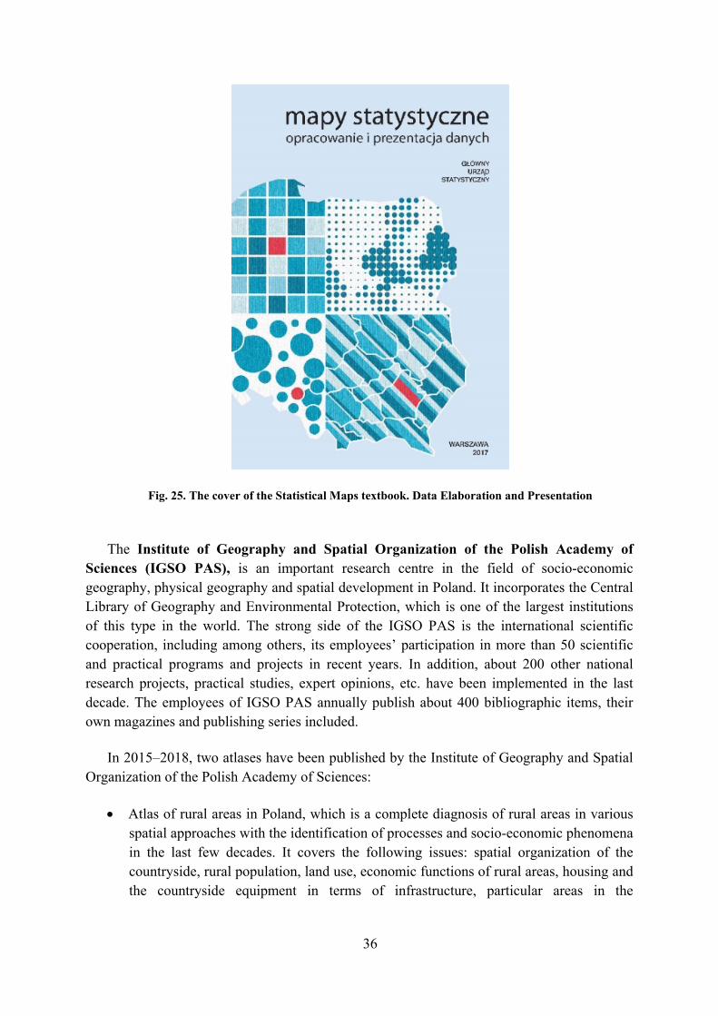
The Statistics Poland has also published a manual on statistical cartography. The publication has been given a title of “Statistical Maps”. The study and presentation of the data was released in 2017. The main purpose of the publication is to familiarize non-cartographers with cartographic standards for the presentation of statistical data resulting from the Polish cartography and statistics tradition, as well as to show the possibilities and problems resulting from the use of GIS software to develop statistical maps. The emphasis has been placed on issues closely related to the elaboration of statistical maps, especially in printed form or to be posted as illustrations in the Internet publications. The handbook provides the theoretical basis for the proper preparation of maps for the needs of statistical publications. It is also being used to disseminate among statisticians the knowledge of what statistical maps are intended for, what may be presented by means of them and how to properly develop such maps.
36
Fig. 25. The cover of the Statistical Maps textbook. Data Elaboration and Presentation
The Institute of Geography and Spatial Organization of the Polish Academy of Sciences (IGSO PAS), is an important research centre in the field of socio-economic geography, physical geography and spatial development in Poland. It incorporates the Central Library of Geography and Environmental Protection, which is one of the largest institutions of this type in the world. The strong side of the IGSO PAS is the international scientific cooperation, including among others, its employees’ participation in more than 50 scientific and practical programs and projects in recent years. In addition, about 200 other national research projects, practical studies, expert opinions, etc. have been implemented in the last decade. The employees of IGSO PAS annually publish about 400 bibliographic items, their own magazines and publishing series included.
In 2015–2018, two atlases have been published by the Institute of Geography and Spatial Organization of the Polish Academy of Sciences:
Atlas of rural areas in Poland, which is a complete diagnosis of rural areas in various spatial approaches with the identification of processes and socio-economic phenomena in the last few decades. It covers the following issues: spatial organization of the countryside, rural population, land use, economic functions of rural areas, housing and the countryside equipment in terms of infrastructure, particular areas in the
37
countryside as well as planning and management of rural areas. The atlas is available on the website https://www.igipz.pan.pl/atlas-obszarow-wiejskich-zgwirl.html.
Electoral Atlas of Poland, illustrating and explaining the political background and social moods, the results of the successive elections (parliamentary, presidential, local government, referendum, European), historical-cultural and socio-economic determinants. The analysis is supplemented with the presentation of permanent and variable elements of electoral geography, taking into account the occurrence of functional areas, national minorities, regionalisms, ethnic and religious groups.
Polish Air Navigation Services Agency (PANSA) is the national provider of air navigation services for the Polish airspace. The PANSA Geographical Information Systems Section carried out cartographic studies for the needs of civil aviation. As part of the obligation to provide current aeronautical data by the Flight Information Service, the following items are published by PANSA in accordance with the AIRAC publishing cycle: AIP, AIP-VFR and AIP-MIL. Each publication contains a number of maps, including airport map, map of airport obstacles, SID, STAR, IAC, VAC, VOC, VFR.
For the needs of pilots performing flights in the uncontrolled space, FIS maps are issued (available at http://www.fis.pansa.pl) and the air map of Poland – ICAO
38
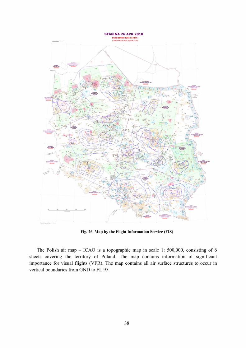
Fig. 26. Map by the Flight Information Service (FIS)
The Polish air map – ICAO is a topographic map in scale 1: 500,000, consisting of 6 sheets covering the territory of Poland. The map contains information of significant importance for visual flights (VFR). The map contains all air surface structures to occur in vertical boundaries from GND to FL 95.

39
Fig. 27. The air map of Poland – ICAO on a scale of 1:500,000
The map of air routes – ICAO, it covers the Flight Information Region (FIR) Warsaw, to show routes of RNAV area navigation. The map contains information significant for navigation along air routes in accordance with the provisions relevant to flights based on aircraft instruments.

40
Fig. 28. Enroute Chart o Poland – RNAV Routes on a scale of 1:1,000,000
For the needs of airspace management, the Airspace Maps on the 1:500,000 scale were published.

41
Fig. 29. Airspace Chart of Poland on a scale of 1: 500,000
5.4. School maps and atlases
Nowa Era [New Era] is the largest educational publishing house in Poland with a comprehensive and modern offer including all subjects at all educational stages. Its offer includes publishing series, school textbooks, teaching aids for teachers, solutions for schools and kindergartens, directors, teachers and students. Currently 59 wall maps, interactive maps, posters and other educational aids are available, and the most popular among them are: the Geographical Atlas for pupils in grades 5–8 at primary schools (Poland, continents, world) and the Historical Atlas for pupils in grades 5–8 at primary schools.

42
Fig. 30. The Geographical Atlas (on the left side) and Historical Atlas. Publisher Nowa Era
Among the educational publications of the School and Pedagogical Publishing House (WSiP) – textbooks, exercise books, atlases, plates and other materials for pupils as well as methodological materials for teachers – about 600 maps are being published every year. Depending on the subject, as well as the educational segment they are addressed to, complexity levels thereof are diverse and various cartographic methods are used.
In the process of developing maps, modern graphic programs and geographic information systems GIS are used (as this allows to maintain the most up-to-date substantive mater). The effects of the above-mentioned activities may be seen, among others, in geographical and historical atlases as well as textbooks on history and geography. A lot of attention is paid to education in the field of cartography, many tabular comparisons regarding map interpretation, explanations of cartographic methods and cartographic transformations are provided. The textbooks on geography published in the reported period include, among others, many valuable maps regarding the current geographic issues. Among them, the following should be noted: the map of flood hazards in Wrocław (Fig. 31.), locations of active and closed mines in central England and the Ruhr area, the relief map of the model river system, maps of natural

43
disaster hazards in the United States, the landscape map and nature protection in Kenya. Interactive solutions and animated maps are effectively tested and published.
Fig. 31. „Atlas Geografia Klasy 5-6 Szkoła podstawowa”. The map of flood hazards in Wroclaw. Publisher School and Pedagogical Publishing House
The “Geography. Atlas. Primary School. Grades 5–6” is the item to be distinguished among the publications issued. It contains over 90 maps designed in a modern manner, 30 charts and drawings and over 100 photographs of places shown on the maps. The thematic map keys have been placed on convenient foldable wings, which greatly facilitates the use of the atlas. The Atlas includes maps consistent with the content of the new core curriculum, e.g. detailed maps of crops in Denmark and Hungary and the economic map of France (Fig. 32.). The juxtaposition of maps with satellite images on the same scale and hypsographical curves of the continents are worth mentioning as well.

44
Fig. 32. Geography. Atlas. Primary school. Grades 5-6. Map of the economy of France
Noteworthy are up-to-date choropleth and diagram maps concerning migration, power industry, urbanization or air transport in Europe as well as attractive spatial drawings of the most important elements of the landscape, as well as young post-glacial forms in the lowlands and in the mountains.
45
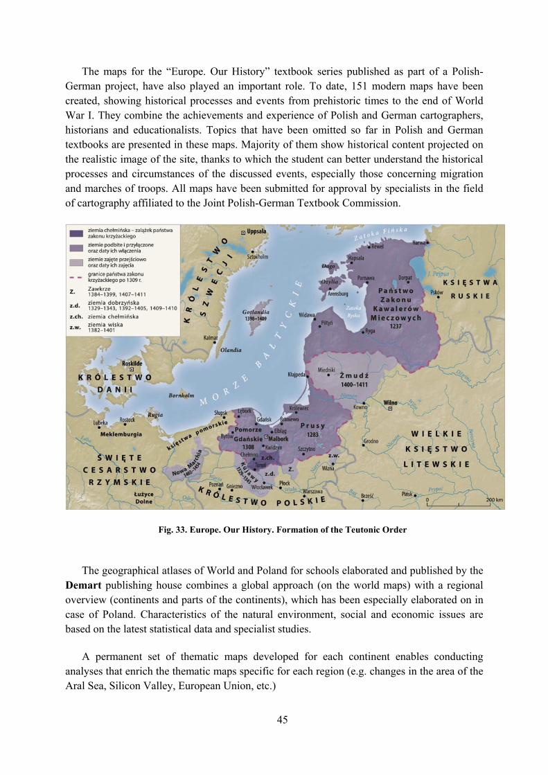
The maps for the “Europe. Our History” textbook series published as part of a Polish-German project, have also played an important role. To date, 151 modern maps have been created, showing historical processes and events from prehistoric times to the end of World War I. They combine the achievements and experience of Polish and German cartographers, historians and educationalists. Topics that have been omitted so far in Polish and German textbooks are presented in these maps. Majority of them show historical content projected on the realistic image of the site, thanks to which the student can better understand the historical processes and circumstances of the discussed events, especially those concerning migration and marches of troops. All maps have been submitted for approval by specialists in the field of cartography affiliated to the Joint Polish-German Textbook Commission.
Fig. 33. Europe. Our History. Formation of the Teutonic Order
The geographical atlases of World and Poland for schools elaborated and published by the Demart publishing house combines a global approach (on the world maps) with a regional overview (continents and parts of the continents), which has been especially elaborated on in case of Poland. Characteristics of the natural environment, social and economic issues are based on the latest statistical data and specialist studies.
A permanent set of thematic maps developed for each continent enables conducting analyses that enrich the thematic maps specific for each region (e.g. changes in the area of the Aral Sea, Silicon Valley, European Union, etc.)

46
Fig. 34. The School Geographical Atlas, Demart
5.5. Atlases for the blind and the visually impaired persons
In 2018, under the Operational Program “Digital Poland 2014-2020”, the project of the Public Administration Centre for Spatial Analyses (CAPAP) was completed, where the extended and updated version of the School Geographical Atlas of Poland for the blind and visually impaired persons was elaborated by the Head Office of Geodesy and Cartography. The digital version of the Atlas has been prepared for two printing technologies and relief embossing, i.e. expanding (swell) paper and thermoforming.

47
Fig. 35. The Geographical Atlas of Poland for the blind and the visually impaired – on swell paper
Zagadnienia prezentowane w Atlasie zostały podzielone na 3 bloki tematyczne: 1. Środowisko geograficzne Polski – 11 plansz: (Fig. 18).
Fig. 36. The Geographical Atlas of Poland for the blind and the visually impaired – thermoforming

48
The final version of the new edition of the Geographical Atlas of Poland therefore includes a set of 34 maps in digital form, both in swell paper technology and in thermoforming technology (along with text appendices), and what is more, issue of analogue version thereof in separate volumes (loose map sheets to be stored in files) has also been presumed.
The Polish blind and visually impaired foundation “Trakt” published in 2016 the “Historical Atlas of Poland” for the blind and visually impaired persons. This Atlas at the international exhibition under the XVIII International Cartographic Conference ICA which took place in July 2017 in Washington, was awarded the second place in the category of “educational cartographic products”.
Fig. 37.”Historical Atlas of Poland” for the blind and visually impaired. persons
5.6. General use maps and atlases Many atlases and maps for general purposes, mainly for tourism, are elaborated and
published in Poland by almost one hundred medium-sized and small-sized private publishing houses and agencies, and at least 20 of these enterprises are the specialized cartographic publishers. These companies, representing various experience, are of different profiles and territorial range of products. They are located mainly in large cities, i.e. Warsaw, Kraków,
49
Wrocław, Katowice, Poznań, Lódź and Lublin, but several of them also operate in smaller towns, such as Jelenia Góra, Piła and Sopot.
The offer presented by the major market publishers of cartographic products is very rich, diverse and well visible in the Polish bookstores and shopping malls. It consists of common geographical and historical atlases of the World, as well as of Poland, the atlases and road maps and finally of the most abundant variety of tourist maps to present the most attractive regions of the country. The atlases and city maps are as well as numerous, they are often issued in the graphically unified series. In the recent years the plans of large and medium cities, issued together on one sheet with several plans of smaller towns from their neighbourhood, have been very popular.
Only a few publishers offer their road maps, tourist maps and city plans for the territory of the whole country. These are mainly companies such as: Express Map, Daunpol, Demart and Wojskowe Zakłady Kartograficzne [Military Cartographic Works] in Warsaw, Compass in Kraków and Eko-Graf in Wrocław. Interests of a large part of publishers is focused on the regions, the publishers are related to in respect of their business’s locations. This part of publishers includes, among others, Plan in Jelenia Góra, BiK in Piła and Kartpol in Lublin.
A long series of maps issued by the Military Cartographic Works should be distinguished separately. These are military topographical maps on a scale of 1:50,000 with the overprinted tourist content and the description of the region and its sights on the sheet reverse.
The source of information about the size and scope of an offer of every individual publisher is a catalogue or directory of its products, including the atlases and maps, both printed ones, as well as those placed on the web.
Electronic maps and atlases constitute a fairly new group of cartographic publications. While first, simple maps of this kind appeared in Poland as early as in 1993, it was not until the late 1990s that such maps gained wider use among the general public. Currently published Polish electronic maps and atlases generally fall into two distinct categories: the first one contains general reference maps and atlases of the world and Poland, whereas the other contains numerous maps and on-line services designed primarily for route-planning purposes.
The Surveyor General of Poland maintains a geoportal of spatial information infrastructure (www.geoportal.gov.pl), where a vector resource and official cartographic works are published. It is possible to view spatial data and search for spatial data sets and services belonging to the National Infrastructure of Spatial Information. The content of the map in the National Geoportal consists of 6 basic layers and 7 catalogues including supplementary layers: The State Border Register, The State Border Register – Addresses, Land and Building Records, Land Utility Networks, Spatial Development Plans, grids and coordinate systems, public facilities, other institutions data, data timeliness, terrain, data to be downloaded, topographic data and the Orthophotomap.
In addition, there are numerous geoportals of local range in Poland – to cover a voivodeship [province], poviat [county] or municipality, and in many of them, especially at the level of municipalities cadastral information is also stored.
The most widely used group of digital mapping items are products of varied quality intended for route planning. Maps and services of this type are available in three different forms. Most of these products are based on vector cartographic databases containing the full

50
road network (corresponding to 1:50 000 scale), integrated with a set of maps of all cities and towns as well as the large villages, with street-level detail and house numbering.
5.7. Cartographic literature
The cartographic literature is very diverse in Poland. To sum up the number of all
published textbooks, dissertations, articles, reports, reviews, manuals and catalogues, we get almost 300 items a year. Recently, the issues covered by them have been more and more dominated by problems of modern technologies and solutions (computer geo-visualization, numerical terrain models, spatial information infrastructure, various GIS applications), with less interest in theoretical issues and methods of cartographic presentation. Scientific theses and articles are published primarily in:
The quarterly journal “Polish Cartographic Review” (until 2015 “Polski Przegląd Kartograficzny”) with a supplement in Polish http://ppk.net.pl/ (also on-line: https://content.sciendo.com/view/journals/pcr/pcr-overview.xml – starting with the volume 47, 2015 – articles in English) issued by the Cartographic Department of the Polish Geographical Society, the only magazine devoted exclusively to cartography;
The half-yearly journal “Geodezja i Kartografia” / “Geodesy and Cartography” http://journals.pan.pl/dlibra/journal/113056 and on-line https://content.sciendo.com/view/journals/geocart/geocart-overview.xml issued by the Geodesy Committee of the Polish Academy of Sciences;
The quarterly journal “Roczniki Geomatyki” / “Annals of Geomatics” http://rg.ptip.org.pl/ issued by the Polish Society for Spatial Information (PTIP) since 2003. The journal is devoted to geomatics, geospatial technology and geoinformation science, it illustrates progress in the acquisition, storage, delivery, management and use of geospatial information. To access articles online use the link http://rg.ptip.org.pl/index.php/rg/issue/archive.
“Geoinformatica Polonica” http://www.ejournals.eu/GP/ – the series published by the Geoinformatics Commission at the Polish Academy of Arts and Sciences;
“Archives of Photogrammetry, Cartography and Remote Sensing”, http://ptfit.sgp.geodezja.org.pl – a series published by four related scientific societies.
A new periodical which replaced long-published “Prace Instytutu Geodezji i Kartografii” (Proceedings of the Institute of Geodesy and Cartography) is a half-yearly “Geoinformation Issues”, at http://www.igik.edu.pl/geoinformation-issuess, published in English by this Institute since 2009.
Practical issues of Polish geodesy and cartography, including legal and organizational problems, as well as technological issues dominate in two monthlies, i.e. “Przegląd Geodezyjny” [Geodetic Review] and “Geodeta. Magazyn geoinformacyjny” [The Surveyor. Geoinformation Magazine]. The half-yearly “Biuletyn Stowarzyszenia Kartografów Polskich” [Bulletin of the Association of Polish Cartographers] deals with similar issues.
In the English-language general geographic journal “Geographica Polonica”, published by the Institute of Geography and Spatial Organization of the Polish Academy of Sciences,

51
there is a “Poland on Maps” section. By the end of 2018, 14 thematic inserts have been published there, to present various types of natural and socio-economic issues, mainly for the whole country on a scale of 1:2,500,000.
The most substantial books published in the 2015–2018 period were::
Beata Medyńska – Gulij: Kartografia. Zasady i zastosowania geowizulalizacji. Warszawa 2015, dodruk 2017 (Cartography. Principles and applications of geovisualization).
Stanisław Alexandrowicz, Jarosław Łuczyński, Radosław Skrycki: Historia kartografii ziem polskich do końca XVIII wieku, Warszawa 2017 (Historia of cartography of Plish lands to edn of the 18th century).
Paweł Cebrykow: Generalizacja map statystycznych, Lublin 2017 (Generalizacion of statistical maps).
Marek Pieniążek, Maciej Zych: Mapy statystyczne: Opracowanie i prezentacja danych, Warszawa 2017 (Statistical maps. Elaboration and prezentacion of data).
Beata Medyńska – Gulij, Tadeusz T. Żuchowski: European topography in eighteen century manuscript maps, Poznań 2018.
Waldemar Spallek: Polskie szkolne atlasy geograficzne 1771–2012, Wrocław 2018 (Polish school geographical atlases 1771–2012.
Detailed information about these books are provided in the attached bibliography.
5.8. Geographical names Works on the standardization of geographical names are carried out in Poland by the two
official bodies: 1. The minister competent for public administration, who, in accordance with the Act of
29 August 2003 on the official names of localities and physiographic objects, deals with matters related to determining, suspending or changing official names of towns and physiographic objects located on the territory of the Republic of Poland;
2. The Surveyor General of Poland, who, in accordance with the Act of 17 May 1989 on Land Surveying and Cartographic Law, deals with matters related to: a) standardization of Polish-language name-calling of geographic objects located
outside the borders of the Republic of Poland (exonimes), b) the database of the state register of geographical names (PRNG), containing
current and historical information on names of localities and parts thereof as well as names of physiographic objects (referred to in the Act of 29 August 2003 on the official names of localities and physiographic objects).
In order to perform the aforementioned tasks, two Committees fulfil their function as advisory bodies: 1. Commission on Names of Localities and Physiographic Objects operating at the ministry
for public administration,

52
2. Commission on Standardization of Geographical Names Outside the Republic of Poland at the Office of Surveyor General of Poland. The results of work of the Commission are the official lists of names of the countries and
non-self-governing territories (issued every two years), the lists of the Polish names of geographical objects located outside the Republic of Poland (issued every five years), the toponymic guides and the rules of romanization. In the years 2015-2019, two new issues of the “Official list of names of countries and nonself-governing territories” were prepared and published by the Commission (in 2015 and 2017), and a new, updated version of the “Official list of Polish geographical names of the world” has been prepared, which is to be printed at the end of 2019. In addition, in year of 2015-2019, the Commission for Standardization of Geographical Names Outside the Republic of Poland made changes to a total of 1171 Polish names of geographical objects of the world (including Polish names of building structures), by introducing 931 new names, making alterations to 180 names and cancelling 60 names.
Fig. 38. Publications of the Commission on Standardization of Geographical Names Outside the Republic of Poland
The official list of names of countries and nonself-governing territories includes 195
countries recognized by the Republic of Poland (i.e. 193 member states of the United Nations Organization, plus Kosovo and Vatican City) as well as 69 nonself-governing territories. In appendix to the list there is a record of 10 territories with an undetermined or disputed international status. The names of countries, territories and their capitals included in the list have been approved by the Ministry of Foreign Affairs.
The official list of Polish geographical names of the world contains the names of 13,359 geographical objects for which the Polish names are recommended. The list includes the names of objects from all continents, as well as the names of the undersea objects; on the other hand, objects entirely located within Poland were not taken into account. The list has been divided into eight parts (chapters): seven of them correspond to particular parts of the

53
world, the eighth is dedicated to the undersea objects. The above publications are available free of charge on the Commission's website at: http://ksng.gugik.gov.pl/wydawnictwa.php
The National Register of Geographic Names (PRNG) – is an official, central reference
database containing reliable, up-to-date names of geographical objects as recommended for official use. The information in the register is the most complete data set containing current and former names of localities and physiographic objects belonging to the Republic of Poland, along with extensive characteristics. As of January 2019, the PRNG database contains a total of 252,302 names of geographic objects within the territory of the Republic of Poland, including 124,616 names of localities and 127,686 names of physiographic objects. Data of the PRNG is available free of charge on the website of the Head Office of Geodesy and Cartography at: http://www.gugik.gov.pl/pzgik/dane-bez-oplat/dane-z-panstwowego-rejestru-nazw-geograficznych-prng. Data is available in three formats: gml., shp., xlsx., broken down by locality names and names of physiographic objects, and updated on the website every 3 months. The data is also available in the form of spatial data services via the national spatial information infrastructure portal www.geoportal.gov.pl, where it is possible to display, search, browse and download (e.g. by means of the ATOM service) names along with attributes according to the adopted criteria. The PRNG data is updated on the Geoportal once a week.
Fig. 39. The National Register of Geographic Names on the Geoportal.

54
Fig. 40. The Database of the National Register of Geographic Names.
6. Education in cartography
The education of specialists in cartography at the academic level is conducted in Poland as
a speciality within geographical studies at universities in Warsaw, Wrocław, Lublin, Poznań and Toruń, and also as part of bachelor studies on surveying at the Warsaw University of Technology, the Military University of Technology in Warsaw and the Stanisław Staszic AGH University of Science and Technology in Kraków. Moreover, the essentials of cartography and geoinformatics are conveyed to all the students of geodesy and geography at universities, as well as to the students of engineering colleges.
The Department of Geoinformatics, Cartography and Remote Sensing at the Faculty
of Geography and Regional Studies of the University of Warsaw was established on September 1, 2014 as a result of the merger of the Department of Cartography with the Department of Geoinformatics and Remote Sensing.
For more information please visit http://geoinformatics.uw.edu.pl/. Out of the 23-person team of employees (including one habilitated Doctor, 13 PhDs, 4
Masters of Science and 5 post-graduate students), nine deal with cartography in a diverse thematic range. In recent years, the following research fields have been implemented at the University of Warsaw: empirical research and assessment of methodical correctness, effectiveness and usability of maps, visualization of processes and phenomena occurring in the geographical space using GIS, formalization, automation and evaluation of the results of the generalization process, assessment and verification of calibration methods for old maps, research in the field of automatic generalization of topographic and general geographical maps, and research related to the elaboration of concepts regarding historical databases and updating thereof.

55
In the Department of Geoinformatics, Cartography and Remote Sensing at the Warsaw University, in 2015–2019, six people have been awarded PhD titles, and two of the doctoral dissertations concerned cartography. Currently, two post-graduates are studying cartography as part of a doctoral study at the Faculty of Geography and Regional Studies.
Geography at universities is taught on the three following levels: bachelor, MSc and doctoral studies. In case of bachelor studies, students may choose a geoinformation module to expand their knowledge of geoinformatics, cartography and remote sensing during three terms. At the end of this stage, they prepare bachelor's theses in these fields. In the years 2015-2019, the BA diploma in the field of geoinformatics has been granted to 42 people.
Geoinformatics, cartographic and remote sensing are also part of the specialization during geographic studies at the master's level. For two years, students are educated in cartography, remote sensing and GIS. Their master's theses on cartography cover the editing of maps, methods of cartographic presentation, designing mobile applications and animated maps. 52 persons have completed the speciality courses in geoinformatics, cartography, remote sensing over the years 2015-2019. Graduates find their employment in cartographic publishing houses, GIS companies, telecommunications companies, public institutions, universities and other scientific centres.
In the Department of Geoinformatics and Cartography (ZGK) at the University of
Wrocław, specialists in the field of modern geoinformatics, geostatistics, spatial data modelling and forecasting, cartographic visualization and geo-visualization methodologies, map and atlas design, cartography history and basic legislation in the field of surveying and cartographic activities are educated. 21 graduates have obtained their master's degrees in the field of geoinformatics and cartography over the years 2015-2018. The topics of their diploma theses covered applications of geographic information systems in environmental research, forecasting and modelling of phenomena in GIS, data mining and geoprocessing, cartographic visualization methodologies, map and atlases design, map perception, toponomy, remote sensing and photogrammetry. One of the diploma theses took in 2017 the second place in the national master's thesis competition in the field of cartography and geoinformation. In November 2018, two first-year students of the geoinformatics and cartography specialities took part in Mapping Hackathon in Kraków, organized by the Jagiellonian University Circle of Geographers, the AGH University of Science and Technology Dahlta Circle of Surveyors and the Map_IT HERE Technologies company. As part of the competition, students from the University of Warsaw together with three other students founded the Hit the Spot team, who won the entire hackathon with their “The Place” application design.
Since 2016, Department of Geoinformatics and Cartography ZGK employees have taught classes on geographic information systems for volunteer high school students. In addition, as part of the popularization of science, the Department ZGK employees delivered numerous lectures, conducted workshops and organized exhibitions in the field of cartography and geoinformatics for various groups of recipients: from pre-schoolers, through primary and secondary school pupils, to clubs of history and culture enthusiasts.
The Department of Geoinformatics and Cartography at the University of Wrocław, in cooperation with the Cartographic Department of Polish Geographical Society, have
56
organized two successive “Cartographic Schools” – the several-day international training conferences in English with lectures, exhibitions and discussions on up-to-date topics:
23rd Cartographic School 2016, “Applications of unmanned aerial vehicles in geosciences”,
24th Cartographic School 2018, “Unmanned aerial vehicles in Earth and environmental sciences”.
In 2015, the Department of Geoinformatics and Cartography at the University of Wrocław, in cooperation with the Cartographic History Team at the Institute of the History of Sciences of the Polish Academy of Sciences, organized the 29th National Conference of Cartography Historians called “Map as an Interpretational Narrative”. In 2017, the Department, in cooperation with the Cartographic Department of PTG, organized the 40th Nationwide Cartographic Conference called “Map in the Service of Science”.
The Department of Cartography and Geomatics at the Maria Curie-Skłodowska
University in Lublin (UMCS) was established in 1964 as an independent Chair of Cartography, whose founder was prof. Franciszek Uhorczak. During 55 years of its existence, the unit has been developing scientific, educational and organizational activities in line with new trends in science and technology changes. In 1970, its name was changed to the Department of Cartography and was finally renamed in 2011 to the present of its name. Currently, the Division staff consists of 9 employees, including five scientific-educational, two educational and two scientific-engineering ones. The head of the unit is Dr hab. Andrzej Czerny, the Professor at UMCS.
In the Department of Cartography and Geomatics at the Maria Curie-Skłodowska University, in the mentioned period, the speciality under the name of Cartography and Geoinformation had been offered to students, which was later replaced with the thematic block Cartographic Visualization and Map Design. The employees of the Division have defended 48 bachelor's and 13 master's theses, including one honoured in the PFRON competition – Open doors.
Within the last five years, the Division has been the initiator and organizer of the national and international conferences. The following conferences have been organized:
The 40th Congress of Polish Geographical Society – Lublin 2015, “Limits of Geography”,
The 39th National Cartographic Conference Lublin–Zwierzyniec 2016, “The Cartographic Visualization”,
The 1st International Cartographic Plain-Air on the subject “Content, Forms and Functions of Thematic Maps in the Era of Geographical Information Systems”, Lublin–Zwierzyniec 2018.
Furthermore, employees of the Division have organized cartographic exhibitions titled Roztocze National Park on Old and Contemporary Maps, The Old Maps from the Collections of the Geographical Society in Lima as well as the Lublin Region on Old Maps. The last one of the exhibitions has been organized as part of the International Year Map celebrations.

57
In the Department of Geomatics and Cartography at the Nicolaus Copernicus University in Toruń (UMK) three persons have been awarded their PhDs in the field of cartography and GIS, and 28 titles (on average 7 per year) of geography masters with the speciality of Environmental Geoinformation have been also awarded by the Department. The master's theses covered, among others: geostatistical maps, social engagement in cities, the use of terrestrial laser scanning (TLS), etc. One master's thesis written by Kamila Barbara Walenciak (thesis supervisor Zenon Kozieł), took the first place in the 7th National Competition for Master's Theses in the Field of Cartography and Geoinformation (2015). The work also took the first place in the nationwide competition of diploma theses in the field of Urban Planning and Spatial Management, in the category “Spatial Management” (2016).
The Department's structure includes a Laboratory of Cartographical Collections and Digital Reprography. These collections are used every day by the research workers at the Faculty of Geosciences of UMK, post-graduate students and other students. They contain a collection of around 30,000 topographic and thematic maps (including about 1500 tourist maps), and 500 atlases. Currently, about 2,000 maps (dLibra) and over 5,400 maps (GAIKK) have been included into online digital resources. For more info please visit the site: https://www.geo.umk.pl/kgik/.
49 MSc theses in the field of cartography, as well as 37 bachelor and engineering papers
have been developed in the years 2015–2018 in the Department of Cartography and Geomatics at the University of Adam Mickiewicz in Poznań (UAM). 5 MSc theses took the highest places in nationwide competitions and 2 were awarded honours. “The National Competition for Diploma Papers in the Field of Cartography, Geomatics and Geoinformation” initiated by prof. Beata Medyńska-Gulij in Poznan in May 2009 has been regularly repeated and the 9th competition was held in May 2017, in Poznań again, with 19 participants from universities other than Polish.
Currently, the Poznań cartographic centre coordinates the educational process in the following fields: “Geodesy and Cartography” – the 7-term engineering course and two MSc courses: the 3-term course “Cartography and Geomatics” and the 4-term course “Geography, the Cartography and Remote Sensing Speciality”.
At least twice a year, the Department of Cartography and Geomatics at UAM hosted scientists from the world's most prestigious cartographic centres, who gave lectures and conducted seminars for students.
In October 2018, an academic “Surveying, Cartography and Geomatics Garden” was opened as the first of its kind in the world, which, according to the original project of prof. Beata Medyńska-Gulij and her students, enabled us to perceive many spatial correlations and was also a kind of testing ground for students (Fig.41).

58
Fig. 41. The Surveying, Cartography and Geomatics Garden in the Collegium Geographicum at the Adam Mickiewicz University in Poznan, October 2018.
During the 28th International Cartographic Conference in Washington, in July 2017, the
Poznań cartographic centre has been represented by five scientists with four papers and one poster.
In the years 2015–2018, the team of Poznań cartographers has published 17 articles in international journals cited in SCOPUS and WEB of SCIENCE. The articles are available on the websites: http://kartografia.amu.edu.pl/index_en.html http://kartografia.amu.edu.pl/index.html.
Education in the Division of Cartography at the Warsaw University of Technology
(WUT), directed from 2015 by Professor Robert Olszewski, has been conducted by two scientific and educational staff. The Division also has two assistant professors, two senior lecturers and five assistants. In the period covered by this report, four post-graduate students cooperated with the Division of Cartography, conducting also educational classes.
The employees of the Division of Cartography took part in the creation of the Chancelor's
Team for innovative Forms of Education – INFOX. Professor Robert Olszewski, has been managing the work of the INFOX Team since 2018.
The changes implemented in 2015 in education conducted by the employees of the Division of Cartography have generally been related to classes conducted as part of the new course of “Geoinformatics”, as members of the entire faculty have been involved there. In 2019, the first year of students completed the course, those, who had started in 2015. The employees of the Division of Cartography also take an active part in conducting interdisciplinary project classes carried out by INFOX and available to students of all faculties at the Warsaw University of Technology. Thus, the list of subjects presented below includes the full, current scope of educational work carried out by the Division of Cartography .

59
One of the major achievements of employees of the Division of Cartography in the discussed period of time was the elaboration of a concept and a general program for the new field of study called “Geoinformatics” at the Faculty of Surveying and Cartography of the Warsaw University of Technology. This is the first course of this type at a university of technology in Poland and the second in general. The initiator and main executor of the activities has been Professor Dariusz Gotlib.
The original program developed for the “Geoinformatics” course at the Faculty of Surveying and Cartography at WUT has been granted the “Prospective Field of Studies” certificate twice as part of the “National Accreditation Program” organized jointly by the Foundation for Development of Education and Universities and the PRC Agency (2016 and 2017). In 2017, the course was also awarded an extraordinary honour called “Laurel of Innovation”.
Employees of the Division of Cartography were also co-authoring the concept and core curriculum for the new speciality called “Mobile Mapping System and Navigation”. This shall become the first speciality in the history of the Faculty to be taught in English, to be launched in the year 2020. The cartographic block is one of the pillars of the new speciality.
In recent years, the Division of Cartography has started to tighten its cooperation with the Department of Remote Sensing, Photogrammetry and Spatial Information Systems. The cooperation is carried out both in the field of education and science. In the first area, it was particularly visible during the modernization of the program of studies at the second-degree course of “Surveying and Cartography” (a new geoinformation profile was introduced), co-creation of the program for studies in English called “Mobile Mapping and Navigation Systems” and the implementation of the Geoinformatics Contest at WUT.
The employees of the Division of Cartography and students of the S&C speciality “Cartography and Geographical Information Systems” at WUT have been continuing for years the tradition of student placements and trips. Every year, students of the speciality participate in the placements in Bezmiechowa, where they implement projects in the field of modern tourist cartography and learn teamwork. Every year, they also take part in a hydrographic course organized by the Naval Academy, which culminates measurement cruise on board hydrographic ships. The permanent point of the student placement program in the field of cartography is also a visit to the Polish Air Navigation Services Agency where the method of developing and using maps by flight controllers is analysed. Listed below in Italics are subjects taught in the 2018/19 academic year by employees of the Division of Cartography:
1) The course of Surveying and Cartography – the full-time bachelor studies: Introduction to databases (term 3), Spatial databases – elective subject (term 3), Basics of
cartographic mapping (term 4), Introduction to navigational cartography – elective course (term 5), Topographic cartography (term 5), Field exercises in photogrammetry and cartography – elective course (term 6), Basics of cartographic visualization (term 6), The spatial data infrastructure – elective course (term 7, block B), The cartographic multimedia and three-dimensional visualizations – elective course (term 7).
2) The course of Surveying and Cartography – the full-time master's degree studies – profile B (term 1): Geostatistics, Spatial Data Infrastructure, Cartographic Modelling

60
3) The course of Surveying and Cartography – the full-time master's degree studies –Cartography and GIS speciality:
Digital map production systems (term 2), Field exercises (term 2), Generalization of geographic information (term 2), Computer graphics in cartography (term 2), Mathematical cartography (term 2), Thematic cartography (term 2), Cartographic 3D models (term 2), Designing spatial databases (term 2), Mobile cartography (term 3), Selected topics of geoinformatics (term 3), Advanced geographic analyses (term 3), C&GIS diploma seminar (term 3).
4) The course of Surveying and Cartography – the part-time bachelor studies: Databases and spatial data models (term 3), Basics of cartographic mapping (term 4),
Spatial data infrastructure (term 5), Basics of cartographic visualization (term 5), Spatial Data Infrastructure II – elective subject (term 6), Topographic cartography ( term 6), Mapmaking – elective subject (term 6), Thematic cartography – elective subject (term 7), Cartographics – elective subject (term 7), Cartographic digital systems – elective subject (term 7), Diploma seminar – engineering (term 8).
5) The course of Surveying and Cartography – the full-time master's degree studies (Cadastre and Spatial Information Systems Speciality):
Cartographic modelling (term 2), Basics of geostatistics (term 4). 6) The course of Geoinformatics (the full-time bachelor studies): Introduction to geomatics (term 1), Design Thinking – elective subject (term 2),
Information systems architecture – elective subject (term 2), Databases and spatial data models (term 3), Developing geoinformation computer applications (term 4 , 5), Basics of cartographic mapping (term 4), Basics of cartographic visualization (term 4), Smart cities – elective subject (term 5), Social cartography – neo-cartography – elective subject (term 5), The spatial data Internet sharing (term 5), Mobile location and navigation applications – elective subject (term 6), Building information modelling (BIM) – elective subject (term 6), Multimedia and DTP – elective subject (term 6), Programming mobile geoinformation applications – elective subject (term 6), Overview of navigational cartography – elective subject (term 6), Topographic databases (term 6), Geoinformation systems design (engineering project) (term 6), Diploma seminar (term 6).
7) The course of Spatial Management Spatial databases (term 2, Eng.). 8) All courses of study at Warsaw University of Technology – the elective subjects: Creative Design Semester, UniStartApp, Product Development Project, ME 210, Rat
Relay. Projects such as the Creative Design Semester (KSP) or UniStartApp are implemented in
cooperation of WUT with external entities from the social and economic environment (companies, public institutions, associations, etc.). The PdP and ME 210 projects are carried out in international cooperation with Design Factory Global Network – the organization uniting over 30 universities on 6 continents.
During the implementation of projects organized by the INFOX Team, the methodology of Design Thinking and Project Based Learning is used, and many of the projects implemented include geoinformation components and advanced, digital cartographic studies.
61
87 MSc and engineering theses have been defended in the Division of Cartography over the years 2015-2018, and at the beginning of 2019, the first graduates of Geoinformatics completed bachelor studies. Furthermore, five PhD dissertations of employees and post-graduate students in the Division of Cartography have been defended.
At the Faculty of Geoengineering, Mining and Geology, at Wrocław University of
Technology in 2017, within the course of “Surveying and Cartography” a speciality program of “Geomatics” was launched. As part of this speciality, subjects in cartography and geomatics are lectured. 25 persons is to complete their classes this year with the title of MSc Eng. in the speciality, and what is more, 4 diploma theses are to cover cartographic issues. In 2015, the “Geoinformatics” speciality program at the “Faculty of Mining and Geology” was launched, and 12 digital mapping projects have been defended during the two editions of the master’s degree courses. The above-mentioned master's theses concerned both environmental engineering and monuments as well as digital maps for the visually impaired.
At the Faculty of Civil Engineering and Surveying at the Military University of
Technology in Warsaw, education in cartography is carried out on bachelor studies, both civilian and military, in the Cartography course duration of 92 hours (civil studies) and 168 hours for military studies. In addition, all students have a mandatory Topography subject with a week-long field practice. The subjects closely related to cartography are: Spatial Information Systems, SIS, TIS Applications. The cartography program in military studies is extended with special cartographic studies for the needs of the army (e.g. Vmap, passability maps, synoptic charts, meteorological contour charts). Cartographic interest is deepened individually owing to the activity of the student scientific club Geopixel. Three extracurricular papers have been awarded in national and international competitions.
In the last four years, about 50 bachelor and 30 master's theses devoted to cartography and spatial information systems have been defended by students. Three diploma theses won prizes in nationwide competitions (2015, 2017, 2018) in cartography, geoinformation and geodesy.
7. Research and implementation works in cartography
The scientific research in cartography is carried out in Poland in higher education institutions and units thereof (institutes, departments, divisions) dealing with cartography and geoinformatics, as well as in some institutes of the Polish Academy of Sciences and in the Institute of Geodesy and Cartography.
Institute of Geodesy and Cartography (IGiK) in Warsaw is the largest research unit in
Poland to deal with issues of geoinformation and cartography. The main area of research conducted at the Institute in 2015-2018 have been issues related to the analysis and modelling of spatial information and its visualization (geo-visualisation).
62
The original methodology of analysis and processing of satellite radar data (COSMO-SkyMed and TerraSAR-X) developed in IGiK allowed to create a map of local deformations in Warsaw in the period 2011 – 2017, with an accuracy of 0.2 mm (Fig. 42).
The sustained work on space-time cartographic animations intended for users of various age groups and various degrees of visual impairment with the use of visualization devices with traditional and e-paper screens enabled the elaboration of an entity methodology for the design of space-time cartographic animations.
As part of the SERENE program, the IGiK team created a geoportal to show locations of plantations for energy plants in Poland (willow, poplar, miscanthus, Pennisetum purpureum, maize) as well as a geoportal prototype for the Integrated Spatial Planning Monitoring and Testing. Another very innovative solution was the geoportal asap.farmer.pl (Advanced Sustainable Agriculture Production), designed to support precision farming.
The Institute participated in the SATURN project (SATellite applications for URbaN Mobility) concerning Bordeaux (France) and GALENA (Galileo – based solutions for urban freight transport international project).
The photogrammetric team at IGiK has developed a methodology for detecting mass graves of the World War II in forest areas, using satellite data of high resolution (WorldView -3, -4), lidar data and old aerial photographs. As a result of the research, a number of maps of burial tomb locations have been elaborated.
The Institute has completed work on the CORINE Land Cover nomenclature level 5 and 6 for Poland, which is used, inter alia, to develop the methodology for monitoring the existing land use in Poland (ELU – Existing Land Use monitoring), as it enables large-scale thematic mapping. It should be mentioned here that the Institute participated in the implementation of the project CORINE Land Cover for the fifth time (this time in CORINE Land Cover 2018), organized by the European Environment Agency. IGiK also participated in the verification of the so-called “local products” as part of the Copernicus land monitoring project (Urban Atlas, High Resolution Layers – HRL, coastal zones – Riparian zones and Natura 2000). In 2015, IGiK published the Map of Forest Areas (in accordance with the Kyoto Protocol), the Drought Hazards Map, as well as a set of maps of Historical Names of Wałeckie Lake District.
In 2018, IGiK published the Biblical Atlas, edited by Professor Adam Linsenbarth, based
on the new results of research made by biblical scholars, archaeologists and cartographers.

63
Fig. 42. A fragment of the map of local deformations in Warsaw in the period 2011 – 2017 developed at the Institute of Geodesy and Cartography.
Much of the IGiK cartographic work will be available for the public in the near future through the specialized OGNIWO geoportal. Currently, the IGiK Digital Library provides access to full-text and bibliographic databases in geodesy and cartography and disciplines related to them. The library also allows access to unpublished scientific research studies (doctoral dissertations, research project results). The IGiK Digital Library is a member of the Federation of Digital Libraries and the Europeana network.
More information about the Institute is available at: www.igik.edu.pl. In the Team for Geographic Information Systems and Cartography at the Institute of
Geography and Spatial Organization of the Polish Academy of Sciences (IGSO PAS), the work has been focused on the terrestrial laser scanning (TLS) and on its use in mapping and natural environment research. The measurements were performed, among others, in the Polish Carpathians and in Podkarpacie region, in the caves of the Nida Basin and in the area of Polish Lowlands (mainly in the Lower Vistula Valley) (for more info see: https://www.igipz.pan.pl/zsigik-projekty-tls-realizacja.html). The efforts made in previous years to develop and issue a new National Atlas of Poland, former edition of which had been developed mainly at IGSO PAS, were continued as well. Unfortunately, the idea of creating this prestigious work has encountered numerous difficulties.
IGSO PAS has also participated actively in expert work and consultations, including work on the project: “Developing digital competence of e-administration – training programs and publications for users of the spatial information infrastructure” implemented under the Operational Program Knowledge Education Development (POWER) and on the subject: “Spatial development” (implementation of the INSPIRE Directive). A number of thematic synthetic maps have also been elaborated, including those for annual reports on the situation

64
in municipalities with regard to planning, for evaluation projects concerning transport development and investments, or for the Responsible Development Strategy.
As part of the conceptual and implementation work at IGSO PAS, a new GraphScape tool has also been created to analyse the spatial structure and level of communication within the landscape. The main goal of creating the GraphScape program is to fill the gap between classic spatial configuration methods based on patch-metrics and the approach aimed at determining functional connectivity within the landscape using graph analysis methods. (for more info see: https://www.igipz.pan.pl/GraphScape.html).
In addition, IGSO PAS was the initiator and co-organizer of two cartographic exhibitions: “Poland on Maps: the Issues of Spatial Management and Development” in connection with the International Map Year 2015–2016 (May 2, 2016, at the Scientific Station of the Polish Academy of Sciences in Paris) and “The Contemporary Issues of Spatial Management and Development in Poland” on the occasion of the Jubilee of the 100th Anniversary of the Polish Geographical Society and the Year of Polish Geography 2018 (March 19, 2018, in the Column Hall of the Polish Parliament House, Warsaw).
For many years research interests of cartographers in the Department of Geoinformatics,
Cartography and Remote Sensing at the Faculty of Geography and Regional Studies of the University of Warsaw have been related to the methods of cartographic presentation, both in theoretical aspect (classification and methodical basis for cartographic presentation) and in practical aspects (examination of usability and perception of maps).
Over the years 2017-2020, the Division is to maintain implementation of the research project of the National Science Centre, namely: “The Evaluation of Cartographic Presentation Methods in the Context of Map Perception and the Effect of Visual Transmission”. Its aim is to develop a coherent methodology for the evaluation of map types and cartographic presentation methods and to verify whether newly developed methods, that are outside the classic cartographic canon, should be included into the classification of cartographic presentation methods. The project is related to map perception surveys carried out in randomly selected secondary schools across Poland.
The remote sensing research carried out at present have been focused on issues related to the use of aerial and satellite images for studies concerning natural environment and the social and economic issues in Poland, Europe, as well as in the area of operation of the Polish Research Station in Antarctica. Ground-based remote sensing methods are being developed to acquire reference data for calibration and verification of aerial and satellite images, as well environmental monitoring.
In the Department of Geoinformatics and Cartography at the University of Wrocław
(ZGK UWr), research has been carried out both in traditional cartography and widely understood geoinformatics. The cartographical research has been focused on the history of cartography and the design of maps and atlases. As part of the first of the two areas, studies on the development of Polish school geographical atlases published in 1771-2012 have been completed. In the aftermath thereof, a comprehensive monograph by Waldemar Spallek has been issued, which is the first comprehensive item in the scientific literature devoted to the most common type of atlas cartography works.

65
The most important cartographic achievement, including many new methodological
solutions, is developed by Marcin Wodziński and Waldemar Spallek “Historical Atlas of Hasidism” published by Princeton University Press. In the United States, the atlas received the Nahum M. Sarna Award in the scientific works category of the 2018 National Jewish Book Awards. Employees of ZGK UWr have also participated in the consultation of the new hydrographic map of Poland 1:50,000, supporting this way the development of official cartography.
Fig. 43. Waldemar Spallek: Polish school geographical atlases 1771-2012

66
Fig. 44. Historical Atlas of Hasidism published by Princeton University Press (Wodziński, Spallek, 2018)
The geoinformatics research has covered two areas. The first was the use of methods of
geographic information systems, spatial statistics and geostatistics to solve environmental problems. The examples of such activities are the projects more and more widely represented among the Department of Geoinformatics and Cartography UWr achievements, carried out in overlapping areas of geographic information systems, biology, climatology and geomorphometry, implemented on various spatial scales, including microscale. The second direction of geoinformatics research included the design and implementation of new geoinformatics systems to operate in real time and offer spatial, map information for crisis management needs. Such solutions include: a warning system for selected hydrological hazards together with a map service, a system for detecting missing people using unmanned aircrafts and allowing real-time visualization of results, a system for forecasting ocean level changes based on satellite raster altimeter data or a system for generating water equivalent of snow, using unmanned aircrafts.
In 2015–2018, the issue of the use of unmanned aircrafts in geographic surveys has been particularly noticeable in scientific publications prepared by the Department of Geoinformatics and Cartography UWr. These were not only application works, but mainly publications reporting new methods of processing spatial data acquired by drones. The results
67
of these studies have been published in prestigious magazines, including: Geomatics, Natural Hazards and Risk, Journal of Field Robotics, Cold Regions Science and Technology, Environmental Monitoring and Assessment, Hydrology and Earth System Sciences, or Pure and Applied Geophysics.
The scientific activity of the employees of the Department of Cartography and
Geomatics at the Maria Curie-Skłodowska University in Lublin (UMCS) have been focused on several research fields to follow tradition of the Department and those that result from contemporary trends. The interests include presentation methodology and cartographic editing as well as the history of cartography. The directions that have appeared in the research relatively recently and been developed in the Department are primarily historical geography (Historical GIS). The items to unite all the research directions mentioned above are the modern tools used to carry out the analyses and data visualization based on GIS software.
Among the achievements resulting from the research mentioned above, four scientific monographs should be mentioned: “Generalization of Statistical Maps”, “Former Topographical Maps in Geographic and Historical Studies”, “Basics of Cartographic Visualization”, “Bychawa 1919–1939, the Cartographic Reconstruction of the City”, as well as over a dozen articles published in renowned scientific journals. The results of research work in the form of scientific promotions should also be mentioned: the employee of the Department has been awarded the academic degree of doctor habilitated and 3 PhD proceedings have been successfully completed.
In the Department of Geomatics and Cartography at the Faculty of Earth Sciences of
the Nicolaus Copernicus University in Toruń (NCU), all scientific and research work has been derived from the application of modern geoinformation methods that are associated with cartographic and in particular the geomatic method of research support. As part of multimedia cartography, the theory of geo-composition has still been developed, in the form of commonly available geo-visualization and videography items. This may be evidenced by the “Internet Atlas of the Kujawsko-Pomorskie Voivodship” completed in 2015, which so far is the only application of this type and the regional atlas in Poland. The European project on the “Historical Atlas of Polish Cities” is under implementation as part of the continuation of the financial grant, in cooperation with the Faculty of Historical Sciences of the Nicolaus Copernicus University in Toruń, as well as research centres in Kraków and Wrocław. In the aftermath of the work, 15 atlases for Polish cities (Strzegom, Namysłów, Oława, Gliwice, Wieliczka, Koronowo, Włocławek, Mrągowo, Ząbkowice Śląskie, Bochnia, Milicz, Strzelin, Wrocław, Jelenia Góra, Fordon), have been developed in the past four years. More info on the website: http://atlasmiast.umk.pl/.
In the Department of Cartography and Geomatics at the Faculty of Geographical
and Geological Sciences of the Adam Mickiewicz University in Poznań, the following directions of research have been developed: the cartographic method of research in shaping the natural environment, the geomatic basis for acquiring and managing spatial data, and usefulness thereof; the cartographic visualization and geo-visualization of spatial accessibility and spatial behaviour; using maps and visualizations to indicate the efficiency and

68
effectiveness of graphic and technology solutions in animated, mobile and multimedia cartography with the inclusion of such systems as Augmented Reality and Virtual Reality. On the other hand, as part of internet cartography, research work has been focused on the design of effective responsive (RWD) graphical user interfaces (GUI); the history of cartography in the aspect of creating cartographic rules and determining the potential of old maps for research on the natural environment; visualization of pre-industrial topographic space in the 19th century (economic history), visualization of the European topographic space on multi-sheet manuscript maps from the 18th century (history of art).
At the Poznań cartographic centre, in the years 2014–2018, three projects have been carried out: German-Polish Foundation for Science DWUTS / 100328, with Ruhr-University-Bochum, 2016–2018, Development of the cultural landscape of German and Polish industrial centres; National Science Centre Poland: NCN2013/09/B/HS2/01182, 2014–2018, Visualization of the topographical space in Europe on manuscript multi-sheet maps from the 18th century; National Science Centre Poland: N2013/11/B/HS3/03905, 2014–2019, Preindustrial space of Greater Poland in the 19th Century.
In the years 2015–2017, under the supervision of Beata Medyńska-Gulij, three doctoral dissertations have been defended strictly in the field of cartography, and in 2018 two doctoral proceedings were opened. In January 2018, the manager of the Department, Ms Beata Medyńska-Gulij was awarded the title of professor – which has ended the long period of the lack of an active full professor in Polish academic cartographic centres.
On April 12, 2018 in Eddleston in Scotland, as part of the activities of the Institute of
Geography and Spatial Management of the Jagiellonian University (IGSM UJ) in Kraków, reopening of the so-called Great Polish Map of Scotland was celebrated. The map is a three-dimensional model of the surface profile of Scotland – it had been developed in 1974–1975. Its originator was Jan Tomasik, a soldier of Polish Armed Forces in Great Britain, and in the 1970s – the owner of the “Barony Castle” estate in Eddleston in Scotland. The map had been designed and made by the employees of the Institute of Geography at the Jagiellonian University, as the unit had been called then, primarily by Kazimierz Trafas and Roman Wolnik. It is the world's largest three-dimensional model/map (50 m x 40 m, scale of 1:10,000), which is located in the open air.The restoration of the map in recent years took place owing to the efforts of the Scottish charity organization called Mapa Scotland (http://www.mapascotland.org/home/).
As mentioned before, in cooperation with IMWM NRI, the “Atlas of the Tatra Mountains
– Inanimate Nature” was developed and published in 2015 byTPN Publisher, Zakopane. It was a trilingual (English, Polish, Slovak) cartographic work (http://tpn.pl/nowosci/atlas-tatr), edited by K. Dąbrowska and M. Guzik. The Atlas contains 28 loose sheets with maps, illustrations and a brief substantive commentaries. The maps cover the entire Tatra Mountains (Polish and Slovak part), some of them even reach much further, showing the Tatras in a broader context. The Atlas has been the result of many years of work of various research teams and contains the latest state of knowledge about the inanimate nature in Tatra Mountains.
69
Among the 82 authors of the maps, 20 of them have been affiliated to IGSM UJ and constituted the largest group among the authors of the Atlas. They were the authors or co-authors of 18 out of the 28 sheets of the Atlas.
The portal of Małopolska tourist routes (2014-2018)
http://szlakimalopolski.gis.geo.uj.edu.pl/) has been developed by IGSM UJ Department in cooperation with COTG PTTK and GISonLine company in 2014, and is updated annually (last update as of 2018). In addition to the cartographic visualization of the current network of tourist, hiking, cycling and horse tracks, made on general geographic and thematic foundations (regional/administrative division, orthophotomap, tourist map) along with tourist attractions in the vicinity of the routes, there are tools available on the portal to search for routes using simple spatial analyses. The portal is integrated with the Sightseeing Portal (https://malopolska.szlaki.pttk.pl), which contains detailed descriptions of routes and tourist attractions.
The scientific activity of the employees of the Division of Cartography at the Warsaw
University of Technology (WUT) in recent years has focused on several interrelated trends:
review of map concepts and cartographic modelling that are fundamental to cartography,
development of the cartographical test method, geostatistics and spatial data mining,
development of a mobile cartography school,
development of cartography for interior of buildings,
using geographic information modelling methods to create the so-called smart cities,
development of social geo-engagement methods using methods of gamification, game engines and elements of augmented reality,
integration of cartographic modelling methods and artificial intelligence algorithms as well as multi-agent systems,
development of the cartographic mapping theory with particular emphasis on the triaxial ellipsoid mappings and application thereof to maps of extra-terrestrial objects,
the interdisciplinary cooperation in the field of integration of cartographic modelling methods and humanistic research – applied social sciences and historical sciences,
searching for and promoting new geoinformatic technologies and applications of geoinformation.
As part of the development of individual directions, both projects and European grants
have been implemented. As a result of the scientific work in the Division of Cartography of WUT, several dozen articles and conference speeches (both Polish and international) have been provided, three monographs and seven doctoral dissertations carried out under the supervision of independent employees of the Division of Cartography have been published.
Defining the concept of the map and features of cartographic modelling: This area of
research is related to defining the theoretical foundations of cartography. The studies completed by Dr hab. Eng. Dariusz Gotlib and Dr hab. Eng. Robert Olszewski and implemented together with Dr hab. Marek Baranowski enabled us to formulate eight unique

70
features of cartographic modelling. This allowed for a modern definition of the essence and role of cartography and a universal approach to the concept of the map, matching both classical cartographic works and modern electronic elaborations. It also made it possible to determine the place of cartographic modelling in the general modelling process described in the ISO standards, in the field of geographic information. These views and the results of the research have been presented both at the national forum (Committee of Geodesy PAS, conferences, seminars) and the international forum (in Washington, during the XVIII Conference ICA. The description of the concepts developed (Fig. 45) and the considerations made has been used as a summary chapter in the post-conference monograph, namely “Advances in Cartography and GIScience” (from the Springer series “Lectures Notes in Geoinformation and Cartography”).
Fig. 45. From the real world to the conceptual scheme – the concept of cartographic modelling as an analogy to the general modelling scheme based on the ISO 19101 standard
Cartographic research method, spatial data mining and geostatistics: The Geo-Media
Enterprise Intelligence project has been implemented jointly by the Division of Cartography at WUT with Intergraph Polska company (now HEXAGON) and the Wrocław Institute of Spatial Information and Artificial Intelligence Applications. As part of the project, an innovative methodology of spatial data mining and a dozen or so algorithms in this field have been developed, and a number of them selected to be implemented in the GIS – Geomedia Pro tooling environment.
The result of the project has also been the publication of the scientific monograph by Anna Fiedukowicz, Jędrzej Gąsiorowski and Robert Olszewski “Selected Methods of Spatial Data Mining”.
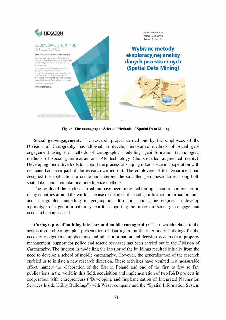
71
Fig. 46. The monograph “Selected Methods of Spatial Data Mining” Social geo-engagement: The research project carried out by the employees of the
Division of Cartography has allowed to develop innovative methods of social geo-engagement using the methods of cartographic modelling, geoinformation technologies, methods of social gamification and AR technology (the so-called augmented reality). Developing innovative tools to support the process of shaping urban space in cooperation with residents had been part of the research carried out. The employees of the Department had designed the application to create and interpret the so-called geo-questionaries, using both spatial data and computational intelligence methods.
The results of the studies carried out have been presented during scientific conferences in many countries around the world. The use of the idea of social gamification, information tools and cartographic modelling of geographic information and game engines to develop a prototype of a geoinformation system for supporting the process of social geo-engagement needs to be emphasised.
Cartography of building interiors and mobile cartography: The research related to the
acquisition and cartographic presentation of data regarding the interiors of buildings for the needs of navigational applications and other information and decision systems (e.g. property management, support for police and rescue services) has been carried out in the Division of Cartography. The interest in modelling the interior of the buildings resulted initially from the need to develop a school of mobile cartography. However, the generalization of the research enabled us to initiate a new research direction. These activities have resulted in a measurable effect, namely the elaboration of the first in Poland and one of the first (a few so far) publications in the world in this field, acquisition and implementation of two R&D projects in cooperation with entrepreneurs (“Developing and Implementation of Integrated Navigation Services Inside Utility Buildings”) with Wasat company and the “Spatial Information System

72
to Support Administration at the Shopping Centre” with Cherry company. An important element in the implementation of this research trend has been the elaboration of the concept and prototype design of “The Information System for Real Estate Belonging to Warsaw University of Technology” (Fig. 47).
Fig. 47. An example of one of the visualizations of the Main Building of the Warsaw University of Technology as part of the “Warsaw University of Technology Information System”.
Integration of cartographic modelling methods and artificial intelligence algorithms
as well as multiagent systems: Research conducted in this field has been related to the use of the so-called computational
intelligence for advanced processing of geographic information, to support the cartographic modelling process. In recent years, particular emphasis has been put on the use of artificial neural networks and so-called multi-agent systems for processing geographic information and cartographic visualization of the results of data mining. The results of scientific works have been published in scientific magazine “Applied Sciences” i “Sensors”.
New geoinformatic technologies and applications of geoinformation: This direction of
scientific activity of employees of the Division of Cartography has been related to the search for new technologies and applications of geoinformation. In the discussed period, the active measures taken to demonstrate the importance of geoinformation for the development of smart cities should be considered as the most important achievement. These activities have resulted, among others, in elaboration of the concept of a geoinformation integrating platform, followed by the first in Poland monograph in this field, namely: “SMART CITY. Spatial Information in the Management of a Smart City” edited by Dariusz Gotlib and Robert Olszewski prepared and published by the PWN publishing house.
Gaining an international grant financed from the funds of the European program Horizon 2020 “FabSpace 2.0” has also been the result of the research studies. The employees of the
73
WUT Division of Cartography played a key role in the implementation of the project. The partner of the WUT Division of Cartography in the implementation of the project was a company called OPEGIEKA Elbląg.
The original concept of the “Centre of Geospatial Analyses” developed by Dariusz Gotlib and implemented as part of the CENAGIS project, coordinated by the Warsaw University of Technology, addressed to the entire geoinformation industry in Poland has also resulted from pursuit of the development of the latest geoinformatic technologies and the search for new geoinformation applications. The project has been financed from EU funds under the Regional Operational Program for Mazowieckie Voivodship and is the largest project in the history of the Faculty of Geodesy and Cartography at the Warsaw University of Technology.
Theory of cartographic mapping: In mathematical cartography, research has primarily
been conducted on the determination of cartographic projections of the triaxial ellipsoid and application thereof in maps of extra-terrestrial objects. Among others, a method of constructing cylindrical equidistant projections in the direction of meridians and cylindrical equiareal projections have been developed, as well as pseudo-cylindrical equidistant projections towards parallels, azimuthal equidistant projections towards meridians and azimuthal equiareal projections. These methods are characterized by the use of elliptical integrals and Jacobi's elliptical functions. A method for constructing conformal projections of the triaxial ellipsoid which are characteristic of small distortions of projections has also been developed.
In 2015, the schoolbook by Dr hab. Eng. Paweł Pędzich, namely “Basics of cartographic mapping with computer applications” was published.
Interdisciplinary research: Over the last five years, employees of the Division of
Cartography have conducted intensive interdisciplinary research, cooperating with IT specialists, historians, archaeologists and specialists in applied social sciences.
The result of cooperation with the National Heritage Board of Poland (NID) has been the elaboration and implementation of the concept of the NID thematic geoportal. Employees of the Division of Cartography have developed a concept and geoinformatic tools for aggregating spatial data, a multi-scale system of visualization of thematic data and the so-called cartographic matrix. The cooperation has been implemented as part of a targeted project under the name of “The Concept and Implementation of Cartographic Visualization of Immovable Monuments in Information Portals of the National Heritage Board of Poland”. The system developed has been implemented by NID and been made available by the Ministry of Culture and National Heritage (Fig. 48).
The employees of the WUT Division of Cartography in the years 2014–2016 have also been the main trustees of the interdisciplinary project carried out jointly with the team of the Institute of Applied Social Sciences of the University of Warsaw. The aim of the project has been to develop the Database of Objects of Living Culture and the construction of an information system to manage and provide information about such objects. The database has been designed and implemented in the PostGIS environment. As part of the project, a geoportal to display the contents of the database has also been developed – over three million records of spatially referenced objects of the so-called living culture.

74
From 2018, the Division has also participated in the implementation of the scientific project titled “Online Atlas of Independent Poland”, carried out in collaboration with the Institute of History of the Polish Academy of Sciences.
Fig. 48. The NID thematic geoportal – www.mapy.zabytki.gov.pl.
The Team of the Integrated Geodesy and Cartography Chair at the Faculty of
Mining Surveying and Environmental Engineering of the AGH University of Science and Technology in Kraków has conducted research on developing the Multi-Resolution, Multi-Presentation Databases and using cartographic generalization in this regard. Research topics have concerned the automation of cartographic generalization of linear objects (for example: river network, coastline, road network) as well as area surface objects (for example: water reservoirs). Research has been continued on the automation of the generalization process of anthropogenic objects (buildings and land development) on various scales. Methods of objective generalization have also been developed with the use of minimum object dimensions and the recognition standard. Part of the work has also concerned the modification of recognition standards taking into account the colour contrast or the width of the symbol on the map. In addition to the mainstream research, the Chair team has conducted analyses of historical cartographic studies used as source materials in comparisons with contemporary record data. New applications have also been sought for cartographic projections, and projections binding in Poland have been analysed in terms of distortions. Work has also been undertaken in the field of cartographic methodology, making suggestions about automation of the dot charts or analysing anamorphic maps. Interactive cartographic studies to show historical objects have also been performed.
The subject of scientific research conducted by the employees of the Faculty of Civil
Engineering and Geodesy at the Military University of Technology (MUT) has mainly

75
consisted in methodical work on the analysis of variability of characteristics of objects and geographic data, as well as methods of presenting this variability effectively. It have mostly been issues related to the assessment of the quality and applicability of geographic data from the user's point of view, analyses of changes in geographical names of towns and physiographic objects in the context of linking nonspatial data to them (movable monuments), effective geo-visualization of land cover changes and land use, with particular emphasis on land development. Faculty staff has also dealt with issues related to the elaboration of maps for the blind and visually impaired, and in particular the automation of production process thereof, as well as implementation of the 3D printing technology in cartography.
In the reported period, the Military University of Technology has organized two editions of the National Diploma Papers Competition in the field of cartography, geomatics and geoinformation – in 2015 and 2018. In 2015, 21 graduates from 12 academic centres took part in the competition. In 2018, 18 graduates from 8 academic centres participated.
8. Cartographic collections
The Central Library of Geography and Environmental Protection operating at the Institute
of Geography and Spatial Organization PAS in Warsaw (http://www.cbgios.pan.pl) has one of the largest collections of cartographic documents from around the world in Poland. This collection includes over 98,000 maps sheets and 5,700 atlases. It contains both new cartographic documents, also issued in electronic version, as well as old ones, including over 100 atlases issued before the year 1800. Information on a significant part of this collection is made available online as part of the nationwide Polish central catalogue of scientific and academic libraries NUKAT (http://katalog.nukat.edu.pl) and through the on-line local catalogue.
The library also keeps digitalizing its collection, which afterwards is successively made available at http://rcin.org.pl. Currently, there are over 2,300 cartographic objects in the Digital Repository of Scientific Institutes (RCIN), most of which are in the Public Domain. Until 2021, as part of the implementation of a three-year project “Open Resources in the Digital Repository of Scientific Institutes (OZwRCIN)”, financed from the resources of the Operational Program Digital Poland of the European Union, this platform will be modernized and enriched, among others with another 2,100 maps or more and atlases from the collections of the Central Library of Geography and Environmental Protection, which will represent European military cartography (mainly from the period of World War I and II).
The University of Wrocław has one of the largest cartographic collections in Poland, they
are collected at the Department of Cartographic Collection of the University Library (15,000 sheets of maps and volumes of atlases, 10,000 sheets of section maps) and at the Cartographic History Department of the Geoinformatics and Cartography Division (2,400 atlases, 38,500 sheets of maps). The collections of the Department are intensively used in teaching the geography and research on the history of school cartography.

76
The old topographic maps of Lower Silesia from the collections of the Cartographic History Department had been made available in a georeferenced form on the geoportal of the Lower Silesia Voivodeship [Province] (http://geoportal.dolnyslask.pl/imap/). Currently, the Leopoldina online project is being implemented, and as part of which, the digitization and creation of a scientific description of a part of the Studio's collections has been started. Digital copies of the most valuable maps and atlases will be successively made available on the Internet.
9. International Map Year in Poland
Polish cartographers have gladly welcomed establishing the International Map Year
(IMY) by ICA. At the end of 2014, the National Committee of Celebrations of the International Map Year in Poland was established, composed of outstanding Polish cartographers and people representing institutions important for Polish cartography. Honorary patronage over the IMY celebrations in Poland has been assumed by the Surveyor General of Poland, Dr Eng. Kazimierz Bujakowski. At that time, an initiative was put forward to make a list of events to be signed with the logo of the International Map Year. A website has been created at the Institute of Geodesy and Cartography, dedicated to all activities undertaken as part of the IMY in Poland. The National Map Days have also been established and considered to be an excellent opportunity to disseminate knowledge about the map, in various locations in the country at one time.
The first Map Days were organized on 28–31 May 2015. During that period of time, a number of scientific, educational and public institutions have organized various events to promote maps in Polish society. For example, the Head Office of Geodesy and Cartography in the period 29–30 May 2015 organized open days in the Main Geodetic and Cartographic Documentation Centre, when you could visit the headquarters of the Centre and familiarize yourself with cartographic materials collected in the state geodetic and cartographic resources as well as with modern technologies that support the national infrastructure of spatial information. Another example was the open scientific session under the name of “A Map at the Service of Society” organized by the Cartography, Remote Sensing and Geographic Information Systems Laboratory of Limnology Department at the University of Gdańsk.
In 2016, as part of the Map Week in Poland this time (30 May – 5 June 2016), exhibitions, a picnic devoted to old maps, regional conferences, among others in Wrocław as well as lectures on maps were organized. For two years, a number of cartographic events (conferences, exhibitions, seminars, etc.) have been marked with the IMY logo (“We love maps”) and during the events, the ideas of this ICA initiative have been spread. They have included two National Cartographic Conferences, two National Conferences of Cartographic Historians, a special session International Map Year at the 25th Conference of the Polish Society for Spatial Information (2015) and the Academy of Cartography and Geoinformatics in Wrocław (2015).
A full list of 86 events related to the International Map Year in Poland is available on the following website: https://rokmapy.bull-design.com.pl/pl/wydarzenia/lista-wydarzen. This website (https://rokmapy.bull-design.com.pl/) also contains an abundant information about the

77
IMY celebrations in Poland, descriptions of selected events, downloadable materials and map galleries.
During the European Symposium on Cartography organized in Vienna by the International Cartographic Association and the Vienna University of Technology in November 2015, the activities undertaken in Poland as part of the International Map Year were presented. Former ICA President, Georg Gartner pointed out the way IMY is organized in Poland as a model example for other countries, emphasizing, among others, a large number of events held (around 60 at that time).
IMY was also advertised in the Polish media. In addition to the items published in the Polish Cartographic Review (Vol. 45, 2013, No. 4, pp. 364, Vol. 47, 2015, No. 2, pp. 160-161, Vol. 47, 2015, No. 2, pp. 145-147; 47, 2015, No. 2, p. 178) and in PCR (Vol. 1, No. 1, 2016, pp. 130-131), articles were published, among others in “Geography at School”, in “VIP” magazines and “The Surveyor”. The Map Year was also an opportunity to conduct an interview with M. Baranowski in Radio dla Ciebie [Radio for You] in August 2016 (find more on the website http://www.rdc.pl/informacje/tajemnice-kartografii-mapa-jest-starsza-niz-cywilizacja-i-pismo-posluchaj/).
The International Map Year has been a great opportunity to promote the map and its role in the modern world. It seems that the Polish cartographic environment has taken advantage of this opportunity successfully.
Fig. 49. Home page of the International Map Year in Poland (https://rokmapy.bull-design.com.pl).

78
Appendix
SELECTIVE BIBLIOGRAPHY OF POLISH CARTOGRAPHIC PUBLICATIONS
2015–2018
A. ATLASES
Historical atlases
1. Atlas historyczny Polski. Mapy szczegółowe XVI wieku, 4. Wielkopolska w drugiej
połowie XVI wieku. Eds. M. Słoń, K. Chłapowski. Elab. A. Borek et al. Warszawa: Polska Akademia Nauk, Instytut Historii, 2017, 6 folded maps, text 502 pp. (Historical atlas of Poland. Detailed maps of the 16th century. Wielkopolska in the second half of the 16 century).
2. Atlas dziejów Pomorza i jego mieszkańców – Kaszubów. Elab. J. Mordawski. Gdańsk: Zrzeszenie Kaszubsko-Pomorskie, 2017, 104 pp. (Historical atlas of Pomerania and its inhabitants Kashubes).
3. Atlas historyczny miast polskich. Tom IV, Śląsk, zeszyt 6, Strzegom – Historical Atlas of Polish Towns. Vol. IV, Silesia, fasc. 6, Strzegom. Historical content D. Adamska et al. Cartogr. elab. J. Połamarczuk, M. Siehankiewicz. Wrocław: Polska Akademia Nauk, Instytut Archeologii I Etnologii, 2015, 24 tabl., text 74 pp.
4. Atlas historyczny miast polskich. Tom IV, Śląsk, zeszyt 11, Namysłów – Historical Atlas of Polish Towns. Vol. IV, Silesia, fasc. 11, Namysłów. Historical content M. Chorowska et al. Cartogr. elab. J. Połamarczuk, M. Siehankiewicz. Wrocław: Polska Akademia Nauk, Instytut Archeologii I Etnologii, 2015, 20 tabl., text 52 pp.
5. Atlas historyczny miast polskich. Tom IV, Śląsk, zeszyt 12, Oława – Historical Atlas of Polish Towns. Vol. IV, Silesia, fasc. 12, Oława. Historical content M. Chorowska et al. Cartogr. elab. J. Połamarczuk, M. Siehankiewicz. Wrocław: Polska Akademia Nauk, Instytut Archeologii I Etnologii, 2015, 29 tabl., text 72 pp.
6. Atlas historyczny miast polskich. Tom IV, Śląsk, zeszyt 15, Gliwice – Historical Atlas of Polish Towns. Vol. IV, Silesia, fasc. 15, Gliwice. Historical content A. Barciak, P. Boroń. Cartogr. elab. M. Sepiał. Wrocław: Polska Akademia Nauk, Instytut Archeologii I Etnologii, 2015, 32 tabl., text 76 pp.
7. Atlas historyczny miast polskich. Tom V, Małopolska, zeszyt 3, Wieliczka – Historical Atlas of Polish Towns. Vol. IV, Silesia, fasc. 15, Gliwice. Historical content Z. Beiersdorf et al. Cartogr. elab. T. Szpytma. Toruń – Kraków: Wydawnictwo Naukowe

79
Uniwersytetu Mikołaja Kopernika, Muzeum Żup Krakowskich Wieliczka, Uniwersytet Pedagogiczny w Krakowie, 2015, 34 tabl., text 24 pp.
8. Atlas historyczny miast polskich. Tom II, Kujawy. Zeszyt 2, Koronowo – Historical Atlas of Polish Towns. Vol. II. Kujavia, Fasc. 2, Koronowo. Historical content E. Okoń, R. Czaja. Cartogr. elab. R. Golba, Z. Kozieł, A. Pilarska. Toruń: Wydawnictwo Naukowe Uniwersytetu Mikołaja Kopernika, 2016, 20 tabl., text 76 pp.
9. Atlas historyczny miast polskich. Tom II, Kujawy. Zeszyt 4, Włocławek – Historical Atlas of Polish Towns. Vol. II. Kujavia, Fasc. 4, Włocławek. Historical content R. Czaja. A. Marynowska, T. Wąsik. Cartogr. elab. R. Golba, Z. Kozieł, A. Pilarska. Toruń: Wydawnictwo Naukowe Uniwersytetu Mikołaja Kopernika, 2016, 19 tabl., text 82 pp.
10. Atlas historyczny miast polskich. Tom III, Mazury. Zeszyt 3, Mrągowo – Historical Atlas of Polish Towns. Vol. III, Masuria, Fasc.3, Mrągowo. Historical content J. Gancewski, R. Czaja. Cartogr. elab. D. Chwiałkowski et al. Toruń: Wydawnictwo Naukowe Uniwersytetu Mikołaja Kopernika, 2016, 11 tabl., text 24 pp.
11. Atlas historyczny miast polskich. Tom IV, Śląsk. Zeszyt 17, Ząbkowice Śląskie – Historical Atlas of Polish Towns. Vol. IV Silesia, Fasc.17, Ząbkowice Śląskie. Historical content R. Eysymont et al. Cartogr. elab. M. Siehankiewicz, R. Gliński. Toruń: Wydawnictwo Naukowe Uniwersytetu Mikołaja Kopernika, 2016, 23 tabl., text 55 pp.
12. Atlas historyczny miast polskich. Tom V, Małopolska. Zeszyt 4, Bochnia – Historical Atlas of Polish Towns. Vol. V, Lesser Poland, Fasc.4, Bochnia. Historical content R. Beiersdorf et al. Cartogr. elab. T. Szpytma. Toruń, Kraków Wydawnictwo Naukowe Uniwersytetu Mikołaja Kopernika, Uniwersytet Pedagogiczny w Krakowie, 2016, 28 tabl., text 32 pp.
13. Atlas historyczny miast polskich. Tom IV, Śląsk. Zeszyt 7, Milicz – Historical Atlas of Polish Towns. Vol. IV, Silesia, Fasc. 7, Milicz. Historical content M. Chorowska et al. Cartogr. elab. M. Siehankiewicz, J. Połamarczuk. Wrocław: Polska Akademia Nauk, Instytut Archeologii i Etnologii, 2017, 21 tabl., text 56 pp.
14. Atlas historyczny miast polskich. Tom IV, Śląsk, Zeszyt 10, Strzelin – Historical Atlas of Polish Towns, Vol. IV, Silesia, Fasc. 10, Strzelin. Historical content D. Adamska et al. Cartogr. elab. M. Siehankiewicz. Wrocław: Polska Akademia Nauk, Instytut Archeologii i Etnologii, 2017, 27 tabl., text 58 pp.
15. Atlas historyczny miast polskich. Tom IV, Śląsk, Zeszyt 13, Wrocław – Historical Atlas of Polish Towns. Vol. IV, Silesia, Fasc. 13, Wrocław, Historical content C. Buśko et al. Cartogr. elab. K. Chrzan, J. Połamarczuk, M. Siehankiewicz. Wrocław: Polska Akademia Nauk, Instytut Archeologii i Etnologii, 2017, 85 tabl., text 122 pp.

80
16. Atlas historyczny miast polskich. Tom IV, Śląsk, Zeszyt 14, Jelenia Góra – Historical Atlas of Polish Towns. Vol. IV, Silesia, Fasc. 14, Jelenia Góra. Historical content D. Adamska et al. Cartogr. elab. M. Siehankiewicz, J. Połamarczuk. Wrocław: Polska Akademia Nauk, Instytut Archeologii i Etnologii, 2017, 37 tabl., text 58 pp.
17. Atlas historyczny miast polskich. Tom II, Kujawy, Zeszyt 3, Fordon – Historical Atlas of Polish Towns. Vol. II Kujawy, Fasc.3, Fordon. Historical content E. Okoń, R. Czaja. Cartgr. elab. R. Golba, Z. Kozieł, A. Pilarska. Toruń: Wydawnictwo Naukowe Uniwersytetu Mikołaja Kopernika, 2018, 18 tabl., text 48 pp.
18. Atlas biblijny. Concept and editing A. Linsenbarth. Texts S. Jankowski, A. Linsenbarth, K. Mielcarek. Elab. of maps C. Mazur, A. Lipowicz. Warszawa – Pelplin: Instytut Geodezji i Kartografii, Wydawnictwo Bernardinum, 327 pp. (The Bible Atlas).
19. Historical atlas of Hasidism. Elab. M. Wodziński, cartography by W. Spallek. Princeton: Princeton University Press, 2018, 265 pp. Edition In Polish: Chasydyzm. Atlas historyczny. Kraków – Budapeszt – Syrakuzy: Wydawnictwo Austeria, 2019, 296 pp.
Statistical atlases of Poland and voivodships
20. Atlas demograficzny Polski. Editorial team J. Balcerzak et al. Warszawa: Główny
Urząd Statystyczny, 2017, 128 pp. (Demographic Atlas of Poland).
21. Atlas statystyczny Polski. Warszawa: Główny Urząd Statystyczny, 2018, 216 pp. (Statistical Atlas of Poland).
22. Atlas statystyczny województwa dolnośląskiego. Wrocław: Urząd Statystyczny we Wrocławiu, 2018, 104 pp. (Statistical Atlas of Dolnośląskie Voivodship).
23. Atlas statystyczny województwa kujawsko-pomorskiego. Bydgoszcz: Urząd Statystyczny w Bydgoszczy, 2018, 104 pp. (Statistical Atlas of Kujawsko-Pomorskie Voivodship).
24. Atlas statystyczny województwa lubelskiego. Lublin: Urząd Statystyczny w Lublinie, 2018, 104 pp. (Statistical Atlas of Lubelskie Voivodship).
25. Atlas statystyczny województwa lubuskiego. Zielona Góra: Urząd Statystyczny w Zielonej Górze, 2018, 104 pp. (Statistical Atlas of Lubuskie Voivodship).
26. Atlas statystyczny województwa łódzkiego. Łódź: Urząd Statystyczny w Łodzi, 2018, 104 pp. (Statistical Atlas of Łódzkie Voivodship).
27. Atlas statystyczny województwa małopolskiego. Kraków: Urząd Statystyczny w Krakowie, 2018, 104 pp. (Statistical Atlas of Małopolskie Voivodship).

81
28. Atlas statystyczny województwa mazowieckiego. Warszawa: Urząd Statystyczny w Warszawie, 2018, 104 pp. (Statistical Atlas of Mazowieckie Voivodship).
29. Atlas statystyczny województwa opolskiego. Opole: Urząd Statystyczny w Opolu, 2018, 104 pp. (Statistical Atlas of Opolskie Voivodship).
30. Atlas statystyczny województwa podkarpackiego. Rzeszów: Urząd Statystyczny w Rzeszowie, 2018, 104 pp. (Statistical Atlas of Podkarpackie Voivodship).
31. Atlas statystyczny województwa podlaskiego. Białystok: Urząd Statystyczny w Białymstoku, 2018, 104 pp. (Statistical Atlas of Podlaskie Voivodship).
32. Atlas statystyczny województwa pomorskiego. Gdańsk: Urząd Statystyczny w Gdańsku, 2018, 104 pp. (Statistical Atlas of Pomorskie Voivodship).
33. Atlas statystyczny województwa śląskiego. Katowice: Urząd Statystyczny w Katowicach, 2018, 104 pp. (Statistical Atlas of Śląskie Voivodship).
34. Atlas statystyczny województwa świętokrzyskiego. Kielce: Urząd Statystyczny w Kielcach, 2018, 104 pp. (Statistical Atlas of Świętokrzyskie Voivodship).
35. Atlas statystyczny województwa warmińsko-mazurskiego. Olsztyn: Urząd Statystyczny w Olsztynie, 2018, 104 pp. (Statistical Atlas of Warmińsko-Mazurskie Voivodship).
36. Atlas statystyczny województwa wielkopolskiego. Poznań: Urząd Statystyczny w Poznaniu, 2018, 104 pp. (Statistical Atlas of Wielkopolskie Voivodship).
37. Atlas statystyczny województwa zachodniopomorskiego. Szczecin: Urząd Statystyczny w Szczecinie, 2018, 104 pp. (Statistical Atlas of Zachodniopomorskie Voivodship).
Other thematic atlases
38. Atlas geologiczny Polski. Scient. eds. J. Nawrocki, A. Becker. Elab. P.
Aleksandrowski et al. Warszawa: Państwowy Instytut Geologiczny – Państwowy Instytut Badawczy, 2017, 170 pp., 3 folded tabl. (Geological Atlas of Poland).
39. Atlas zagrożeń meteorologicznych Polski – Meteorological Hazard Atlas of Poland. Elab. Z. Ustrnul et al. Instytut Meteorologii i Gospodarki Wodnej – Państwowy Instytut Badawczy. Kraków: Wydawnictwo Attyka, 2015, 164 pp.
40. Geograficzno-polityczny atlas Polski. Polska w świecie współczesnym – Atlas of Poland’s political geography. Poland in the modern world. Conceived and edited by M. W. Solarz. Elab. M. Zych, J. Talacha et al. Warszawa: Uniwersytet Warszawski, Wydział Geografii i Studiów Regionalnych, Trzecia strona, 2018, 248 pp. (all texts and explanations in Polish and English).

82
41. Atlas obszarów wiejskich w Polsce. Ed. J. Bański. Warszawa: Polska Akademia Nauk, Instytut Geografii i Przestrzennego Zagospodarowania, 2016, 158 pp. (Atlas of rural areas in Poland).
42. Atlas wyborczy Polski. Eds. M. Kowalski, P. Śleszyński. Warszawa: Polska Akademia Nauk, Instytut Przestrzennego Zagospodarowania, 2018, 355 pp. (Electoral Atlas of Poland).
43. Atlas Tatr – Przyroda nieożywiona. Atlas Tatier – Nieživa príroda. Atlas of the Tatra Mountains – Abiotic Nature. Collect. elaboration. Eds. K. Dąbrowska, M. Guzik. Cartogr. editing Zakład Kartograficzny Sygnatura, Wydawnictwo Kartograficzne Polkart. Zakopane: Tatrzański Park Narodowy, 2015, 28 sheets, text 42 pp.
44. Atlas województwa kujawsko-pomorskiego – Atlas of Kuyavian and Pomeranian Province. Cartogr. editing Z. Kozieł. Toruń: Wydawnictwo Naukowe Uniwersytetu Mikołaja Kopernika, 2015, 142 pp.
School atlases
45. Atlas geograficzny. Polska, kontynenty, świat. Szkoła podstawowa, klasy 5–8.
Warszawa: Nowa Era, 2018, 136 pp. (Geographical atlas. Poland, continents, the world. Primary school, grades 5–8).
46. Świat, Polska. Szkolny atlas geograficzny. Aktualne kompedium wiedzy. Warszawa: Demart SA, 2018, 176 pp. (The world, Poland. Geographical school atlas. Current compendium of knowlegde).
47. Szkolny atlas Polski. Geografia, historia, regiony. Polska w XXI wieku z historią w tle. Warszawa: Demart SA, 2018 (School atlas of Poland. Geography, history, regions. Poland in the 21st century with history in a background).
48. Atlas historyczny. Od starożytności do współczesności. Dla klas 5–8 szkoły podstawowej. Warszawa: Nowa Era, 2017 (Historical atlas. From antiquity to the present day. For 5–8 grades of primary school).
49. Atlas geograficzny Polski dla niewidomych i słabowidzących. Warszawa: Główny Urząd Geodezji i Kartografii, 2017 (Geographical atlas of Poland for blind and visually impaired).
50. Atlas historyczny Polski dla niewidomych i słabowidzących. Ed. M. Olczyk. Warszawa: Fundacja Polskich Niewidomych I Słabowidzących “Trakt”, 2016 (Historical atlas of Poland for blind and visually impaired).

83
B. MAPS
Topographic maps
1. Mapa topograficzna 1:10 000. Sheets of Topographical map of Poland at the scale 1:10,000 edited by Marshal’s Offices of Voivodships (Urzędy Marszałkowskie Województw) in 2015–2018:
edition 2015 – 1738 sheets edition 2016 – 864 sheets edition 2017 – 1245 sheets edition 2018 – 1069 sheets Together: 4916 sheets
Thematic maps
2. Map of physico-geographical mesoregions of Poland. Modified version of J.
Kondracki’s regionalisation. 1:2,500,000. Edited by J. Solon and J. Borzyczkowski. Warszawa: Institute of Geography and Spatial Organization, Polish Academy of Sciences, 2018 (with list of names of regions, also anex to Geographia Polonica, vol. 91, no. 2).
3. Mapa geologiczna podłoża krystalicznego polskiej części platformy wschodnioeuropejskiej – Geological map of cristaline basement of the Polish part of the Eastern European Platform. 1:1,000,000. Elab. E. Krzemińska, L. Krzemiński. Warszawa: Państwowy Instytut Geologiczny – Państwowy Instytut Badawczy, 2017. Two sheets and explanatory text 52 pp.
4. Mapa geologiczna południowej części obszaru przygranicznego Polski i Białorusi, rejon Białej Podlaskiej i Brestu – Geological map of southern part of Polish-Belarussian cross-border area, vicinity of Biała Podlaska and Brest. 1:250,000. Warszawa – Kraków: Państwowy Instytut Geologiczny – Państwowy Instytut Badawczy, 2017.
5. Roślinność rzeczywista pasów wydmowych Kampinoskiego Parku Narodowego. Mapa fitosocjologiczna. 1:50,000. Elab. J. Matuszkiewicz et al. Izabelin: Petit, Kampinoski Park Narodowy, 2015. (Real vegetation of dune belts in Kampinoski National Park. Phytosociologic map).
6. Wody termalne. Skarb Małopolski. 1:200,000 and 1:40,000. Cartogr. elab. Compass. Kraków: Urząd Marszałkowski Województwa Małopolskiego. Departament Środowiska, 2015 (Thermal waters – treasure of Małopolska).
7. Lotnicza mapa Polski – ICAO. Aeronautical chart of Poland – ICAO. 1:500,000. Warszawa: Polska Agencja Żeglugi Powietrznej, 2018.
84
Tourist maps
8. Białowieża Forest and neighbourhood. Tourist map. 1:50,000. Eds. P. Pietroń, R.
Trzmielewski. Kraków. Wydawnictwo Kartograficzne Compass with co-operation of Białowieża National Park, 2017.
9. Góry Wałbrzyskie i Kamienne. Mapa turystyczna – tourist map – Wanderkarte – turistická mapa. 1:40,000. Elab. K. Biernat, A. Fret, K. Marciniak. Wrocław: Wydawnictwo Kartograficzne Eko-Graf, 2018 (Wałbrzyskie and Kamienne Mountains in Sudetes. Tourist map).
10. Lubelszczyzna. Roztocze. Polesie. Mapa turystyczna. 1:75,000. Warszawa: ExpressMap Polska Sp. z o.o., 2016, Seria Comfort Map (Lublin Region. Roztocze Upland, Polesie, Tourist map).
11. Okolice Warszawy. Wschód-zachód. Mapa turystyczna, Tourist map, Turistenkarte. 1:100,000. Elab. A. Filak, T. Darmochwał. Warszawa: DT Mapy, 2018 (Environs of Warsaw. West-East).
12. Okolice Wrocławia dla aktywnych. 1:100,000. Elab. Team of Studio Plan. Wrocław: Studio Plan, 2017 (Environs of Wrocław for actives).
13. Park Krajobrazowy „Dolina Bystrzycy”. Mapa turystyczna – tourist map. 1:50,000. Wrocław: Dolnośląski Zespół Parków Krajobrazowych, Wydawnictwo Kartograficzne Eko-Graf, 2018 (Dolina Bystrzycy Landscape Park. Tourist map).
14. Park Krajobrazowy Podlaski Przełom Bugu i gmina Terespol. Mapa geologiczno-turystyczna. 1:75,000. Elab. J. Rychel at al. Warszawa: Państwowy Instytut Geologiczny – Państwowy Instytut Badawczy, 2016 (Podlasie Gap of the Bug Landscape Park and commune Terespol. Geological-tourist map).
15. Roztocze. Różnorodność przyrodnicza i dziedzictwo kulturowe. Mapa przyrodniczo-turystyczna – Roztocze. Natural diversity and heritage. Tourist and heritage map. 1:75,000. Three sheets. Elab. Kartpol s.c., Lublin. Zwierzyniec: Roztoczański Park Narodowy, 2016 (Map in tree language versions: Polish, English and Ukrainian).
16. Tatry Polskie i Słowackie. Mapa turystyczna. 1:50,000. Ed. J. Korpak. Kraków: Wydawnictwo Kartograficzne Compass, 2016 (Polish and Slovakian Tatra Mts. Tourist map).
17. Transgraniczne Polesie. Mapa turystyczna. 1:400,000. Elab. Team of Kartpol. Lublin: Lubelska Regionalna Organizacja Turystyczna, Kartpol s.c., 2015 (Transborder Polesie. Tourist map).

85
18. Warmia i Mazury. Mapa atrakcji turystycznych. 1:225,000. Ed. M. Maryniak. Kraków: Wydawnictwo Kartograficzne Compass, 2018 (Warmia and Masuria. Map of tourist attractions).
19. Województwo Lubelskie. Mapa turystyczna – Tourist map. 1:300,000. Elab. P. Cebrykow at al. Lublinl: Kartpol s.c., 2015 (Lubelskie Voivodship. Tourist map).
20. Wybrzeże Bałtyku. Jarosławiec – Ustka – Łeba. Mapa turystyczna, tourist map, Wanderkarte. 1:50,000. Elab. K. Biernat, K. Marciniak. Wrocław: Wydawnictwo Kartograficzne Eko-Graf, 2018 (Baltic Sea Coast. Jarosławiec – Ustka – Łeba).
C. CARTOGRAPHIC LITERATURE
Bibliographies. Catalogues of exhibitions
1. Bartoszewicz H.: Wielka kartografia małych miast XVIII–XIX wieku. Katalog wystawy. Warszawa – Pułtusk: Archiwum Główne Akt Dawnych, Akademia Humanistyczna im. A. Gieysztora, 2016, 56 pp. (Great cartography of small towns of 17th–19th century. Catalogue of exhibition in the Central Archives of Old Records in Warsaw).
2. Borowicz D.: Bibliografia publikacji Profesora Władysława Pawlaka. In: Profesor Władysław Pawlak, współtwórca wrocławskiej szkoły kartograficznej. Wrocław: Instytut Geografii i Rozwoju Regionalnego Uniwersytetu Wrocławskiego, 2017, pp. 106–128 (Bibliography of Prof. Władysław Pawlak’s publications).
3. Kozica K.: Piękne i rzadkie. Najsłynniejsze mapy I Rzeczypospolitej z kolekcji Tomasza Niewodniczańskiego w zbiorach Zamku Królewskiego w Warszawie – Muzeum. Katalog wystawy. In: Mapa w służbie państwa. XXXII Ogólnopolska Konferencja Historyków Kartografii. Warszawa: Wydawnictwo IHN PAN, Muzeum Warszawy, 2018 (Beautiful and rare maps of the Polish-Lithuanian Commonwealth from the Tomasz Niewodniczański collection in the Library of Royal Castle in Warsaw – Museum. Catalogue of exhibition).
4. Mapa i jej historia. Katalog wystawy. Polska Akademia Nauk. Biblioteka Gdańska. „Międzynarodowy Rok Mapy”. Elab. A. Wytyk, M. Pelczar. Gdańsk: Biblioteka Gdańska, 2015, 23 pp. (Map and its history. Polish Academy of Sciences, Gdańsk Library. International Map Year. Catalogue of exhibition in Gdańsk, May 2015).
5. Pałuszejko G., Kozica K: Polskie globusy z XIX–XXI wieku. 100 globusów na 100-lecie Polskiego Towarzystwa Geograficznego. Kartografowie, wydawcy, producenci. Lublin-Warszawa: Muzeum Lubelskie, Warszawskie Przedsiębiorstwo Geodezyjne, 2018, 256 pp. (Polish globes from the 19th–21st centuries. 100 globes for centenary of the Polish Cartographical Society. Cartographers, publishers, producers).

86
History of cartography
6. Alexandrowicz S., Łuczyński J., Skrycki R.: Historia kartografii ziem polskich do
końca XVIII wieku. Warszawa: Wydawnictwo DiG, 447 pp. (History of cartography of Polish lands to end of the 18th century).
7. Borowicz D.: Dawne mapy przedmiotem manipulacji i narzędziem propagandy. Z Dziejów Kartografii, vol. 21, 2017, pp. 183–202, summ.: Old maps as a subject to mainpulation and propaganda tool.
8. Dudzicka G., Gazicka-Wójtowicz D.: Ucieczka Beniowskiego z Kamczatki i jego odkrywczy rejs po północnym Pacyfiku w świetle rękopiśmiennej mapy odnalezionej w zbiorach Biblioteki Instytutu Geografii I Przestrzennego Zagospodarowania PAN. In: 250 rokiv Barskij konfederacii. Materialy miznarodnoi naukovoj istoryko-kraeznavcoj konferencji, 11 travnia 2018. Winnica: PP Baliuk, pp. 50–68 (Beniowski’s flight from Kamchatka and his exploratory cruise on the northern Pacific Ocean in the light of manuscript map found in collection of the Library to the Institute of Geography and Spatial Organization, Polish Academy of Sciences).
9. Franczak G.: Filologia mapy. Badanie dawnej kartografii metodą krytyki tekstu na przykładzie toponimii mapy Księstwa Połockiego S. Pachołowieckiego z 1580 roku. Terminus, vol. 19, no. 1 (42), pp. 193–252, summ.: The philology of a map. Studying old cartography using the method of textual criticism: the case of toponymy of the map of the Principality of Polotsk by S. Pachołowiecki from 1580.
10. Konopska B.: Adaptations of foreign geographical atlases from before 1989 published for the Polish users. Polish Cartographical Review, vol. 47, 2015, no. 4, pp. 213–224.
11. Konopska B., Ostrowski J.: Rola geografów w tworzeniu i rozwijaniu polskiej kartografii szkolnej w okresie międzywojennym i po II wojnie światowej. In: Rola geografii w utrwalaniu niepodległości Polski i jej rozwoju. Ed. A. Jackowski. Kraków: Instytut Geografii i Gospodarki Przestrzennej UJ, 2018, pp. 184–210, summ.: Role of geographers in creating and developing Polish school cartography in the interwar period as well as after World War II.
12. Korycka-Skorupa J., Pasławski J.: The beginings of the choropleth presentation. Polish Cartographical Review, vol. 49, 2017, no. 4, pp. 187–198.
13. Medyńska-Gulij B., Żuchowski T. J.: European topography in eighteen century manuscript maps. Poznań: Bogucki Wydawnictwo Naukowe, 2018, 215 pp., 48 figs col.

87
14. Medyńska_Gulij B., Żuchowski T. J.: Analysis of drawing techniques used on European topographic maps in the eighteenth century. The Cartographical Journal, vol. 55. 2018, no. 4, pp. 309–325.
15. Osowska A., Przybytek D.: Thematic maps in Eugeniusz Romer’s „Geographical and Statistical Atlas of Poland” from 1916 – the historical and methodological perspective (on the 100-year anniversary of the publication). The Cartographical Review, vol. 48, 2016, no. 2, pp. 77–86.
16. Ostrowski W., Karsznia I, Panecki T.: Comparative analysis of a characterization of the built-up area and settlement network on Polish topographic maps from the 19th, 20th and 21st centuries. Polish Cartographical Review, vol. 50, 2018, no. 2, pp. 73–86.
17. Panecki T.: The comparison of the scope of content and classification methods on topographical maps of Polish territory annexed by Russia issued at the turn of 19th and 20th century. Polish Cartographical Review, vol. 47, 2015, no. 1, pp. 45–52.
18. Panecki T.: Quantitative assessment of the scope of content of selected topographic maps of Polish lands from the 19th and the first half of the 20th century. Polish Cartographical Review, vol. 49, 2017, no.4, pp. 151–165.
19. Profesor Władysław Pawlak, współtwórca wrocławskiej szkoły kartograficznej. Eds. W. Spallek, T. Niedzielski. Wrocław: Instytut Geografii i Rozwoju Regionalnego Uniwersytetu Wrocławskiego, 2017, 132 pp. (Professor Władysław Pawlak, co-creator of the Wrocław cartographical school).
20. Prokop P.: The first medium-scale topographic map of Galicia (1779–1783) – survey, availability and importance. Geographia Polonica, vol. 90, 2017, no. 3, pp. 97–104.
21. Skrycki R.: Polska historia kartografii – próba oceny ostatnich 40 lat. In: Szkoły, ośrodki i twórcy polskiej historii kartografii (1945-2015). Eds. T. Bogacz, B. Konopska. Z Dziejów Kartografii, vol. 20, 2016, pp. 15–23, summ.: Polish history of cartography – an attempt to assess the last 40 years.
22. Sobczyński E., Pietruszka J.: Military aeronautical charts in the past and today. Polish Cartographical Review, vol. 50, 2018, no. 1, pp. 5–30.
23. Spallek W.: Evolution of longitude description system. Example of Polish school geographical atlases (1771–2012). Polish Cartographical Review, vol. 49, 2017, no. 4, pp. 177–186.
24. Spallek W.: Polskie szkolne atlasy geograficzne 1971–2012. Rozprawy Naukowe Instytutu Geografii i Rozwoju Regionalnego Uniwersytetu Wrocławskiego, no. 42, Wrocław 2018, 458 pp., summ.: Polish geographical school atlases 1771–2012.

88
25. Strzelecki K.: Wykorzystanie aplikacji MapAnalyst w badaniu dawnych map. Słupskie Prace Geograficzne, vol. 13, 2016, pp. 213–227, summ.: Using MapAnalyst application in study of old maps.
26. Szaniawska L.: Mapa dokumentem rosyjskiej kolonizacji Syberii do połowy XVIII wieku. Z Dziejów Kartografii, vol. 21, 2017, pp. 121–143, summ.: A map as a document of Russian colonization of Siberia until the mid-18th century.
27. Szaniawska L.: Geological content on maps and in accompanying text developed until the end of the 18th century. Polish Cartographical Review, vol. 49, 2017, no. 2, pp. 79–91.
28. Szaniawska L.: Lithological maps visualizing the achievements of geological science in the first half of the 19th century. Polish Cartographical Review, vol. 50, 2018, no. 2, pp. 87–109.
29. Szkoły, ośrodki i twórcy polskiej historii kartografii (1945–2015). Eds. T. Bogacz, B. Konopska. Z Dziejów Kartografii, vol. 20, 2016, 171 pp. (Schools, centres and creators of Polish history of cartography, 1945–2015).
30. Weszpiński P.: Cartographic image of immaterial elements in a city on the example of city maps of Warsaw from 1642 until the end of the 19th century. Polish Cartographical Review, vol. 49, no. 4, pp. 167–176.
31. Wolski J.: Kartografia topograficzna Bojkowszczyzny Zachodniej (1772–1939). In. Bojkowczyszna Zachodnia – wczoraj, dziś i jutro, vol. 1. Monografie Instytutu Geografii i Przestrzennego Zagospodarowania PAN, 17, 2016, pp. 107–174, summ.: Topographic cartography of the Western Boyko Region (1772–1939).
32. Wytyczak R.: Usage of the Atlas of Silesia from 1752 in European cartographic publications. Polish Cartographical Review, vol. 50, 2018, no. 1, pp. 47–56.
Contemporary cartography in Poland
33. Baranowski M.: Międzynarodowy Rok Mapy w Polsce. Polish Cartographical Review.
Suplement w języku polskim, vol. 2, 2017, no. 1, pp. 121–123 (International Map Year in Poland).
34. Cartographic activities in Poland 2011–2014. National report. Presented to the 16th General Assembly of the International Cartographic Association. Rio de Janeiro, Brazil, August 2015. Compiled by B. Konopska, J. Ostrowski. Institute of Geodesy and Cartography. Polish National Committee for International Cartographic Association. Warsaw: Head Office of Geodesy and Cartography, 2015, 52 pp.

89
35. Czterdziestolecie Zespołu Historii Kartografii przy Instytucie Historii Nauki Polskiej Akademii Nauk. Eds. T. Bogacz, B. Konopska. Z Dziejów Kartografii, vol. 19, 2015, 107 pp. (The 40th anniversary of the Team for the History of Cartography to the Institute of History of Science, Polish Academy of Sciences).
36. Izdebski W.: Informacja przestrzenna w Polsce – teoria i praktyka. Roczniki Geomatyki, vol. 15, 2017, no. 2 (27), pp. 175–186, summ.: Spatial information in Poland – theory and practice.
37. Konopska B., Pasławski J.: Polish adaptation of foreign geographical atlases for general use at the turn of the 20th and 21st centuries. Polish Cartographical Review, vol. 47, 2015, no. 2, pp. 77–90.
38. Olędzki J. R., Dukaczewski D., Będkowski K.: Oddział Teledetekcji i Geoinformatyki Polskiego Towarzystwa Geograficznego. In: Polskie Towarzystwo Geograficzne w setną rocznicę działalności. Ed. M. Sobczyński. Łódź: Polskie Towarzystwo Geograficzne, Wydział Nauk Geograficznych Uniwersytetu Łódzkiego, 2018, vol. 2, pp. 527–571. (Division of Remote Sensing and Geoinformatics of the Polish Geographical Society).
39. Ostrowski J.: Komisja Kartograficzna i Oddział Kartograficzny Polskiego Towarzystwa Geograficznego. In: Polskie Towarzystwo Geograficzne w setną rocznicę działalności. Ed. M. Sobczyński. Łódź: Polskie Towarzystwo Geograficzne, Wydział Nauk Geograficznych Uniwersytetu Łódzkiego, 2018, vol. 2, pp. 583–625. (Cartographical Commission and Cartographical Division of the Polish Geographical Society).
40. Rutkowski H.: Work on the historical atlas of the sixteenth-century Poland. Polish Cartographical Review, vol. 50, 2018, no. 4, pp. 223–231.
41. Słomska K., Korycka-Skorupa J.: The teaching of cartography and topography in the Polish primary school. Polish Cartographical Review, vol. 48, 2016, no. 1, pp. 29–40.
42. Sobczyński E., Pietruszka J.: NATO revolution in the Polish military cartography. Polish Cartographical Review, vol. 49, 2017, no. 3, pp. 121–133.
43. Zych M., Medolińska K.: New statistical atlases of voivodships and Poland. Polish Cartographical Review, vol. 50, 2018, no. 4, pp. 183–196.
Geodetic basis. Cartographic projections
44. Bielecka E., Pokonieczny K., Kamiński P.: Charakterystyka rozmieszczenia
przestrzennego punktów poziomej osnowy szczegółowej. Roczniki Geomatyki, vol.

90
13, 2015, no. 3 (69), pp. 201–208, summ.: Description of spatial distribution of detailed horizontal geodetic control points.
45. Kadaj R.: The combined geodetic network adjusted in the reference ellipsoid – a comparison of three functional models for GNSS observations. Geodesy and Cartography, vol. 65, 2016, no. 2, pp. 229–257.
46. Kuboń N., Plewako M.: Examining the accuracy of positioning using selected smartphone applications. Geomatics, Landmanagement and Landscape, 2018, no. 4, pp. 65–77.
47. Latoszek K. J.: Optymalizacja odwzorowania wielostożkowego Polski według kryterium Airy’ego. Roczniki Geomatyki, vol. 13, 2015, no. 2 (68), pp. 109–123, summ.: Optimization of a polyconic projection for Poland with aspect to Airy’s criterion.
48. Ligas M., Szombara S.: Geostatistical prediction of a local geometric geoid-kriging and cokriging with the use of EGM2018 geopotential model. Studia Geophysica et Geodetica, vol. 62, 2018, no. 2, pp. 187–205.
49. Maciuk K.: Integration of GPS and GLONASS systems in geodetic satellite measurements. Geoinformatica Polonica, vol. 14, 2015, pp. 75–83.
50. Pędzich P.: From cartography of the Universe to molecular cartography – the use of map projections. Polish Cartographical Review, vol. 47, 2015, no. 4, pp. 191–201.
51. Pędzich P.: Measures and visualization methods of map projection distortions with the use of „python matplotlib library” as an example. Polish Cartographical Review, vol. 48, 2016, no. 3, pp. 101–114.
52. Pędzich P.: Image of the World on polyhedral maps and globes. Polish Cartographical Review, vol. 48, 2016, no. 4, pp. 197–210.
53. Pędzich P.: Equidistant map projections of a triaxial ellipsoid with the use of reduced coordinates. Geodesy and Cartography, vol. 66, 2017, no. 2, pp. 271–290.
54. Pędzich P.: The method of construction of cylindrical and azimuthal equal-area map projections of a tri-axial ellipsoid. Geodesy and Cartography, vol. 67, 2018, no. 2, pp. 271–294.
Theoretical and methodological problems
55. Baranowski M., Gotlib D.,Olszewski R.: Properties of cartographic modelling under
contemporary definitions of a map. Polish Cartographical Review, vol. 48, 2016, no. 3, pp. 91–100.

91
56. Baranowski M., Gotlib D., Olszewski R.: Próba zdefiniowania domeny współczesnej kartografii. Roczniki Geomatyki, vol 16, 2018, no. 4 (83), pp. 269–281, summ.: An attempt to define the domain of contemporary cartography.
57. Całka B.: Comparing continuity and compactness of choropleth map classes. Geodesy and Cartography, vol. 67, 2018, no. 1, pp. 21–34.
58. Cebrykow P.: Cartographic generalization yesterday and today. Polish Cartographical Review, vol. 49, 2017, no. 1, pp. 5–15.
59. Ciołkosz A.: Współczesne oblicze kartografii przeznaczonej do powszechnego użytku. Czasopismo Geograficzne, vol. 86, 2015, no. 1-2, pp. 71–90, summ.: Current image of cartography dedicated to common use.
60. Korycka-Skorupa J., Pasławski J.: The place of the “quantitative signature symbols” in the classification of the cartographic presentation methods. Polish Cartographical Review, vol. 49, 2017, no. 2, pp. 59–66.
61. Krzywicka-Blum E.: Map Functions. Springer International Publishing Switzerland, 2015, 207 pp. “Springer Geography” XIX.
62. Mazur M.: Method vs. form – an attempt to classify cartographic presentation methods. Polish Cartographical Review, vol. 49, 2017, no. 2, pp. 47–57.
63. Medyńska-Gulij B.: Kartografia. Zasady i zastosowania geowizualizacji. Warszawa: Wydawnictwo Naukowe PWN, 2015, 228 pp. (Cartography. Principles and applications of geovisualization).
64. Pokojski W., Pokojska P.: Voronoi diagrams – inventor, method, applications. Polish Cartographical Review, vol. 50, 2018, no. 3, pp. 141–150.
Topographic and thematic maps
65. Augustyniak J., Kuźma M., Pędzich P.: Review of the methods of cartographic
presentation of warfare. Polish Cartographical Review, vol. 47, 2015, no. 3, pp. 147–158.
66. Brzezińska-Klusek M., Drachal J., Mirończuk A.: Mapa nazw zabytkowych jako forma ochrony dziedzictwa kulturowego. Przykład Pojezierza Wałeckiego. Prace Komisji Krajobrazu Kulturowego, no. 29, 2015, pp. 71–77, summ.: Map of historic names as a form of cultural heritage protection: an example of Wałeckie Lakeland.
67. Calka B., Cahan B.: Interactive map of refuge movement in Europe. Geodesy and Cartography, vol. 65, 2016, no. 2, pp. 139–147.

92
68. Cebrykow P.: Elaboration of topographic bases for statistical maps, their contents and importance. Polish Cartographical Review, vol. 49, 2017, no. 3, pp. 97–106.
69. Czaja R.: Historical Atlas of Polish Towns. Between source edition and the cartographic presentation of research on the history of towns. Studia Geohistorica, no. 6, 2018, pp. 80–89.
70. Jancewicz K., Borowicz D.: Tourist maps – definition, types and contents. Polish Cartographical Review, vol. 49, 2017, no. 1, pp. 27–41.
71. Kruczkowska B., Solon J., Wolski J.: Mapping ecosystem services – a new regional-scale approach. Geographia Polonica, vol. 90, 2017, no. 4, pp. 503–520.
72. Kowalczyk A.: Kartografia turystyczna – problemy metodologiczne i metodyczne. In. Uwarunkowania i plany rozwoju turystyki. Turystyka w badaniach geograficznych. Turystyka i Rekreacja – Studia i Prace, vol. 15, Poznań 2015, pp. 9–31, summ.: Tourist cartography – methodological and methodical problems.
73. Kozieł Z.: Idea opracowania oraz główne założenia koncepcyjno-redakcyjne Atlasu Województwa Kujawsko-Pomorskiego. Polish Cartographical Review. Suplement w języku polskim, vol. 1, 2016, no. 2, pp. 223–228, summ.: The idea of publishing and main conceptual-editorial principles of the Atlas of the Kujawsko-Pomorskie Voivodship.
74. Kuna J.: Cartographic visualization of Jewish heritage in cross-border tourist project “Shtetl Routes” (Poland, Belarus, Ukraine). Polish Cartographical Review, vol. 48, 2016, no. 4, pp. 173–183.
75. Lisek K., Nieścioruk K.: The cartographic methods of presentation and GIS tool in analysis of historical data on the example of Great War cemeteries in southern Poland. Polish Cartographical Review, vol. 47, 2015, no. 4, pp. 225-239.
76. Ławniczak R., Kubiak J.: Geometric accuracy of topographical objects at Polish topographic maps. Geodesy and Cartography, vol. 65, 2016, no. 1, pp. 55–66.
77. Łucjan K., Wojtanowicz P.: Continuous or discontinuous? Empirical study on animated maps. Polish Cartographical Review, vol. 50, 2018, no. 3, pp. 127–140.
78. Mapy krajobrazu kulturowego. Przegląd doświadczeń. Eds. J. Plit, U. Myga-Piątek. Prace Komisji Krajobrazu Kulturowego, no. 27, 2015, 108 pp. (Maps od cultural landscape – review of experiences).
79. Meksuła M. W., Grzechnik L.: Concept of a landscape map accoring to Professor Franiszek Uhorczak. Polish Cartographical Review, vol. 48, 2016, no. 3, pp. 129–140.
80. Olczyk M.: Labels on coloured tactile maps (typhlomaps) – the Polish experiences. Polish Cartographical Review, vol. 50, 2018, no. 4, pp. 197–209.

93
81. Pastusiak T.: Consistency of data presented on modern maps of ice cover in the Arctic. Polish Cartographical Review, vol. 48, 2016, no. 2, pp. 55–66.
82. Pieniążek M., Zych M.: Mapy statystyczne. Opracowanie i prezentacja danych. Warszawa: Główny Urząd Statystyczny, 2017, 260 pp. (Statistical maps. Data elaboration and presentation).
83. Pokonieczny K., Mościcka A.: The influence of the shape and size of the primary field on developing military passability maps. ISPRS International Journal of Geoinformation, vol. 7, 2018, no. 7, pp. 1–27.
84. Rączkowska Z., Zwoliński Z.: Digital geomorphological map of Poland. Geographia Polonica, vol. 88, 2015, no. 2, pp. 205–210.
85. Sobczyński E., Pietruszka J.: Przyszłość map topograficznych. Przegląd Sił Zbrojnych, 2018, no. 3, pp. 127–139 (The future of topographic maps).
86. Solon J., Borzyszkowski J., et al.: Physico-geographical mesoregions of Poland: Verification and adjustment of boundaries on the basis of contemporary spatial data. Geographia Polonica, vol. 91, 2018, no. 2, pp. 143–170 and folded map 1:2 000 000.
87. Sosnowska M., Karsznia I.: Methodology for mapping the average transaction prices of residential premises using GIS. Polish Cartographical Review, vol. 48, 2016, no. 4, pp. 161–171.
88. Stępień T., Klimczak H.: The use of anamorphic images in the development of transit maps. Geodesy and Cartography, vol. 65, 2016, no. 1, pp. 81–94.
89. Szady B.: Historical cartography of confessions and religions in the Polish-Lithuanian Commonwealth: Between historical geography and spatial history. Studia Geohistorica, no. 6, 2018, pp. 136–148.
90. Śleszyński P.: Mapa przestrzennego zróżnicowania współczesnych procesów demograficznych w Polsce. In: Sytuacja demograficzna Polski jako wyzwanie dla polityki społecznej i gospodarczej. Warszawa: Rządowa Rada Ludnościowa, 2018, pp. 84–108 (Map of spatial differentiation of the current demographic processes in Poland).
91. Śleszyński P., Solon J.: A map of the landscape diversity of Poland. Geographia Polonica, vol. 90, 2017, no. 3, pp. 369–377.
92. Wabiński J., Mościcka A.: Trzeci wymiar na mapie krain geograficznych – koncepcja tyflomapy w druku 3D. Roczniki Geomatyki, vol. 15, 2017, no. 4 (79), pp. 391–409, summ.: The third dimension on the map of geographical areas – the concept of a tactile map in 3D printing.

94
93. Wielebski Ł.: Wizualizacja kartograficzna dostępności przestrzennej w modelu monocentrycznym. Studia i Prace z Geografii, no. 49, Poznań 2015, 133 pp., summ.: Cartographic visualization of spatial accessibility in a monocentric model.
94. Zmiany krajobrazów kulturowych w obrazie kartograficznym. Eds. E. Regulska, J. Plit. Prace Komisji Krajobrazu Kulturowego, 28, 2015, 120 pp. (Changes in cultural landascapes in the cartographic image).
Map perception and use
95. Chądzyńska D., Gotlib D.: Maps in video games – range of applications. Polish
Cartographical Review, vol. 47, 2015, no. 3, pp. 137–145.
96. Chądzyńska D., Gotlib D.: Spatial data processing for the purpose of video games. Polish Cartographical Review, vol. 48, 2016, no. 1, pp. 41–50.
97. Cybulski P.: Wpływ sugestywności wizualnej na dostrzeganie zmian przez użytkownika mapy animowanej. Studia i Prace z Geografii, no. 61, Poznań 2017, 127 pp., summ.: Impact of visual suggestiveness on noticing changes by a user of the animated map.
98. Doskocz A.: Accuracy assessment of planimetric large-scale map data for decision making. Geodesy and Cartography, vol. 65, 2016, no. 1, pp. 3–12.
99. Dukaczewski D.: Designing static and animated maps for users from different age groups dedicated to electronic paper visualization devices. In: Proceedings of the 6th ACI/ICA International Conference on Cartography and GIS, 13-17 June 2016, Albena, Bulgaria. Eds. T. Bandrova, M. Konecny, vol. 1, pp. 378–385.
100. Kaim D., Kozak J., Kolecka N., Ziółkowska E., Ostafin K., Ostapowicz K., Gimmi U., Munteanu C., Radelofi V. C.: Broad scale forest cover reconstruction from historical topographic maps. Applied Geography, vol. 67, 2016, pp. 39–48.
101. Klapa P.: The proces of map calibration and its impact on the quality and accuracy of cartographic materials. Geomatics, Landmanagement and Landscape, 2018, no. 1, pp. 33–44.
102. Korycka-Skorupa J.: Effectiveness of cartographic presentation methods applied within small-scale thematic maps in the press and on the Internet. Polish Cartographical Review, vol. 47, 2015, no. 1, pp. 5–17.
103. Kuźma M., Mościcka A.: Evaluation of the accessibility of archival cartographic documents in digital libraries. The Electronic Library, vol. 36, 2018, no. 6, pp. 1062–1081.
95
104. Lorek D.: Multimedia integration of cartographic source materials for researching and presenting phenomena from economic history. Geodesy and Cartography, vol. 65, 2016, no. 2, pp. 271–281.
105. Lupa M., Szombara S., Chuchro M., Chrobak T.: Limits of colour perception in the context of minimum dimensions in digital cartography. ISPRS International Journal of Geo-Information, vol. 6, no. 9, pp. 1–20.
106. Ławniczak R.: Źródła kartograficzne jako podstawa analizy wybranych form rzeźby terenu Polski. Studia i Prace Geograficzne, no. 66, Poznań 2018, 159 pp., summ.: Cartographic sources as a basis for the analysis of selected landforms of Poland.
107. Łucjan K.: Perception of the contents of animated maps. Polish Cartographical Review, vol. 48, 2016, no. 4, pp. 149–160.
108. Panecki T.: The evaluation of archival maps in geohistorical research. Miscellanea Geographica, vol. 19, 2015, no. 4, pp. 72–77.
109. Pastusiak T.: The problem of the availability of nautical charts and publications on the Northern Sea Route. Polish Cartographical Review, vol. 47, 2015, no. 1, pp. 63–72.
110. Pirowski T., Wietrzykowska K., Timek M.: Analysis of land use and land cover maps suitability for modelling population density of urban areas – redistribution to new spatial units based on the object classifications of RapidEye data. Geoinformatica Polonica, vol. 17, 2018, pp. 65–75.
111. Reolon Schmidt M. A., de Alencar Mendonça, Wieczorek M.: Avaliaçao preliminar de fatores que impactam o desepenho de la leitura de mapas topograficos de diferentes paises. Revista Brasileira de Cartografia, vol. 69, 2017, no. 2, pp. 389–399, summ.: Preliminary evaluation on factors that impact performance on reading topographic maps from different countries.
112. Słomska K.: Evaluation of selected maps used in early school education in Poland and proposal of a new solution. Polish Cartographical Review, vol. 49, 2017, no. 2, pp. 67–77.
113. Słomska K.: Types of maps used as a stimuli in cartographical empirical research. Miscellanea Geographica, vol. 22, 2018, no. 3, pp. 157–171.
114. Żyszkowska W.: Map perception: Theories and research in the second half of the twentieth century. Polish Cartographical Review, vol. 47, 2015, no. 4, pp. 179–190.
115. Żyszkowska W.: Visual features of cartographic representation in map perception. Polish Cartographical Review, vol. 48, 2016, no. 1, pp. 5–15.
116. Żyszkowska W.: Levels and properties of map perception. Polish Cartographical Review, vol. 49, 2017, no. 1, pp. 17–26.
96
Toponyms in and for cartography
117. Borun M.: Przyczynek do badań nad wielojęzycznymi nazwami miejscowymi na
mapach internetowych. Folia Turistica, no. 42, Kraków 2017, pp. 203–224, summ.: A preamble to research on multilingual toponyms on Internet maps.
118. Kacprzak J., Zieliński J.: Problematyka standaryzacji i wizualizacji Państwowego Rejestru Nazw Geograficznych (PRNG). Polish Cartographical Review. Suplement w języku polskim, vol. 2, 2017, no. 1, pp. 85–92, summ.: Standardization and visualization of data in the National Register of Geographical Names (NRGN).
119. Konopska B., Bogacz T.: Names on maps as element of the discussion about relativism in the understanding of national identity (based on the example of western and northern Poland territories after 1945 and 1989). Polish Cartographical Review, vol. 49, 2017, no. 4, pp. 199–207.
120. Urzędowy wykaz nazw państw i terytoriów niesamodzielnych. The 4th up-to-dated edition. Elab. A. Czerny, M. Zych. Komisja Standaryzacji Nazw Geograficznych poza Granicami Rzeczypospolitej Polskiej przy Głównym Geodecie Kraju. Warszawa: Główny Urząd Geodezji i Kartografii, 2017, XVI, 74 pp.; inlet in English: Official list of names of countries and non-self governing territories, Head Office of Geodesy and Cartography, 22 pp.
121. Wolnicz-Pawłowska E.: The fiftieth anniversary of the first United Nations Conference on the Standardization of Geographical Names. Polish Cartographical Review, vol. 49, 2017, no. 3, pp. 135–146.
122. Wolnicz-Pawłowska E., Ostrowski J.: Wkład polskich geografów I językoznawców w standaryzację nazw geograficznych. Polish Cartographical Review. Suplement w języku polskim, vol. 2, 2017, no. 2, pp. 245–249, (Contribution of Polish geographers and linguists in the standardization of geographical names).
123. Zych M.: The contemporary cartographic presentation of geographical names of objects lying on the border between Poland and the Czech Republic. Polish Cartographical Review, vol. 47, 2015, no. 3, pp. 159–174.
Digital technologies
124. Bęcek K.: Real-time mapping: Contemporary challenges and the Internet of Things
as the way forward. Geodesy and Cartography, vol. 65, 2016, no. 2, pp. 129–137.

97
125. Bielecka E., Leszczyńska M.: Użyteczność danych o lasach udostępnionych w serwisie OpenStreetMap. Sylwan, vol. 162, 2018, no. 6, pp. 460–468, summ.: Usability of the OpenStreetMap forest data.
126. Chrobak T., Szombara S., Kozioł K., Lupa M.: A method for assessing generalized data accuracy with linear object resolution verification. Geocarto International, vol. 32, 2017, no. 3, pp. 238–256.
127. Cybulski P.: Design rules and practices for animated maps online. Journal of Spatial Science, vol. 61, 2016, no. 2, pp. 461–471.
128. Dąbrowska-Zielińska K., Bartold M., Gurdak R.: POLWET – system for new space-based products for wetland under Ramsar Convention. Geonformation Issues, vol. 8, no. 1(8), pp. 25–35.
129. Gosiewski D.: Metodyka i system przetwarzania danych pozyskiwanych masowo w celu numerycznego modelowania powierzchni z wykorzystaniem struktury GRID. Olsztyn: Wydawnictwo Uniwersytetu Warmińsko-Mazurskiego, 2017, 541 pp., summ.: Methodology and system of processing data collected in bulk for digital surface modelling using GRID structure.
130. Gradka R.: Analysis of the distribution and density of measurement points in terms of terrain modelling. Geomatics, Landmanagement and Landscape, 2017, no. 3, pp. 35–45.
131. Gradka R., Kwinta A.: A short review of interpolation methods used for terrain modelling. Geomatics, Landmanagement and Landscape, 2018, no. 4, pp. 29–47.
132. Horbiński T., Cybulski P.: Similarities of global web mapping services functionality in the context of responsive web design. Geodesy and Cartography, vol. 67, 2018, no. 2, pp. 159–177.
133. Jankowska M.: Charakter prawny mapy cyfrowej. Warszawa: Wolters Kluwer Polska SA, 2017, 638 pp. (Legal nature of the digital map).
134. Karsznia I.: Metodyka automatyzacji generalizacji wybranych elementów Bazy Danych Ogólnogeograficznych. Warszawa: Uniwersytet Warszawski, Wydział Geografii i Studiów Regionalnych, 2015, 152 pp. (Methodology of automated generalization of chosen elements of the General Geographic Database).
135. Karsznia I., Leszczuk M.: Kontekstowa generalizacja konturów zabudowy z wykorzystaniem narzędzi morfologii matematycznej. Roczniki Geomatyki, vol. 15, 2017, no. 2(77), pp. 187–200, summ.: Context-dependent building generalization based on mathematical morphology operations.
136. Koszewski K., Kowalski P., Olszewski R., Włochyński L.: Map portal as a tool to share information on cultural heritage illustrated by the National Heritage Board
98
Geoportal. In: Advances in Digital Cultural Heritage: International Workshop, Funchal, Madeira, Portugal, June 28, 2017. Revised selected papers, pp. 48–64.
137. Król K.: Comparative analysis of the performance of selected raster map viewers. Geomatics, Landmanagement and Landscape, 2018, no. 2, pp. 23–32.
138. Lupa M., Szombara S., Kozioł M., Chromiak W.: The use of minimal geometries in automated building generalization. In: Architectures and Structures: facing the challenges of data proliferation and growing variety: 14th International Conference, BDAS 2018. Poznań, Poland, Sept. 18–20 2018, proceedings. Eds. S. Kozielski et al. Cham: Springer Nature Switzerland, 2018, pp. 390–403.
139. Nowak da Costa J., Bielski C.: Toward “Tourism for All” – improving maps for persons with reduced mobility. International Archiv. Photogrammetry, Remote Sensing, Spatial Information Science, vol. 42, no. 4, pp. 475–482.
140. Olszewski R., Gnat M., Fiedukowicz A.: Artificial neural networks and fuzzy inference systems for line simplification with extended WEA metric. Geodesy and Cartography, vol. 67, 2018, no. 2, pp. 255–269.
141. Osmólska A. Hawryło P.: Using a GEOBIA framework for integrating different data sources and classification methods in context of land use/lad cover mapping. Geodesy and Cartography, vol. 67, 2018, no. 1, pp. 99–116.
142. Siwek J., Wacławik W.: Can analytical shading be art? Reflections on the canvas of experiments with ArcGIS and Surfer. Polish Cartographical Review, vol. 47, 2015, no. 3, pp. 121–135.
143. Szafraniec J.E.: Moja mapa. Tworzenie map w technologiach geoinformacyjnych. Katowice: Wydawnictwo Uniwersytetu Śląskiego, 2018, 282 pp., summ.: My map. Creating maps in geoinformation technologies.
144. Szombara S.: Comparison of methods used in cartography for the skeletonization of areal objects. Geoinformatica Polonica, vol. 14, 2015, pp. 85–94.
145. Szypuła B.: Geomorphometric comparison of DEMs built by different interpolation methods. Landform Analysis, vol. 32, 2016, pp. 45–58.
146. Tyszkowski S., Kaczmarek H., Linowski S., Marszalewski W.: Testing of different elevation models based on combined airborne and long-range terrestrial laser scanning for assessment of river bank erosion. Geographia Polonica, vol. 90, 2017, no. 4, pp. 493–498.
147. Wrochna A.: Cyfrowa Mapa Polski i jej wykorzystanie do sporządzania map tematycznych. Przegląd Geodezyjny, vol. 88, 2016, no. 5, pp. 12–14, summ.: Digital Map of Poland and its utilization in preparing thematic maps.

99
Remote sensing mapping
148. Affek A.: Hidden cultural heritage in the abandoned landscape – identification and
interpretation using airborne LiDAR. Geographia Polonica, vol. 89, 2016, no. 3, pp. 411–414.
149. Bochenek Z., Ziółkowski D., Bartold M., Orłowska K., Ochtyra A.: Monitoring forest biodiversity and the impact of climate on forest environment using high-resolution satellite images. European Journal of Remote Sensing, vol. 51, 2018, no. 1, pp. 166–181.
150. Fryskowska A., Wróblewski P.: Mobile laser scanning accuracy assessment for the purpose of base-map updating. Geodesy and Cartography, vol. 67, 2018, no. 1, pp. 35–55.
151. Golenia M., Zagajewski B., Ochtyra A., Hościło A.: Semiautomatic land cover mapping according to the 2nd level of the CORINE Land Cover legend. Polish Cartographical Review, vol. 47, 2015, no. 4, pp. 203–212.
152. Grabska E.: Ocena możliwości wykorzystania satelitarnych danych optycznych I radarowych do identyfikacji użytków rolnych. Prace Geograficzne, no. 148, Kraków: Instytut Geografii i Gospodarki Przestrzennej UJ, 2017, pp. 136–155, summ.: Assessment of a potential use of satellite optical and radar data for the identification of agriculture land types.
153. Hościło A., Tomaszewska M.: CORINE Land Cover 2012 – 4th CLC inventory completed in Poland. Geoinformation Issues, vol. 6, 2015, no. 1(6), pp. 49–58.
154. Jędrych M., Zagajewski B., Marcinkowska-Ochtyra A.: Application of Sentinel-2 and EnMAP new satellite data to the mapping of alpine vegetation of the Karkonosze Mountains. Polish Cartographical Review, vol. 49, 2017, no. 3, pp. 107–119.
155. Jurecka M., Niedzielski T.: A procedure for delineating a search region in the UAV-based SAR activities. Geomatics, Natural Hazards and Risk, vol. 8, 2017, no. 1, pp. 53–72.
156. Kraszewski B., Karwel A. K., Kurczyński Z., Ziółkowski D.: Integration of digital surface models from photogrammetric and airborne laser scanning data for the processing of radar imagery. In: 16th International Multidisciplinary Scientific Geoconference SGEM 2016, Albena, Bulgaria. Book 2, vol. II, pp. 917–924.
157. Krówczyńska M., Wilk E., Pabjanek P., Zagajewski B., Meuleman K.: Mapping asbestos-cement roofing with the use of APEX hyperspectral airborne imagery: Karpacz area, Poland – a case study. Miscellanea Geographica, vol. 20, 2016, no. 1, pp. 41–46.

100
158. Kuboń N., Plewako M.: Examining the accuracy of positioning using selected smartphone applications. Geomatics, Landmanagement and Landscape, 2018, no. 4, pp. 65–77.
159. Łyszkowicz A. B., Bernatowicz A.: Current state of art of satellite altimetry. Geodesy and Cartography, vol. 66, 2017, no. 2, pp. 259–270.
160. Niedzielski T., Spallek W., Witek-Kasprzak M.: Automated snow extent mapping based on orthophoto imagery from unmanned aerial vehicles. Pure and Applied Geophysics, vol. 175, 2018, no. 9: Applications of unmanned aerial vehicles in geosciences, pp. 3343–3355.
161. Sarnowski Ł., Podgórski Z., Brykała D.: Modelowanie 3D zasięgu i pola widoczności przy wykorzystaniu zdjęć lotniczych. Prace Komisji Krajobrazu Kulturowego, vol. 39, 2018, no. 1, pp. 5–24, summ.: 3D viewshed modelling using aerial photographs.
162. Smaczyński M., Medyńska-Gulij B.: Low aerial imagery – an assessment of georeferencing errors and the potential for use in environmental inventory. Geodesy and Cartography, vol. 66, 2017, no. 1, pp. 89–104.
163. Szostak M., Bochenek J.: Using airborne laser scanning data for automation of land cover mapping in the aspect of monitoring forest succession areas. Geoinformatica Polonica, 17, 2018, pp. 91–97.
164. Śleszyński P.: Expected traffic speed in Poland using Corine Land Cover, SRTM-3 and detailed population places data. Journal of Maps, vol. 11, 2015, no. 2, pp. 245–254.
GIS. Spatial information infrastructure
165. Bac-Bronowicz J., Głażewski A., Liberadzki P., Wilczyńska I.: Harmonizacja modeli
pojęciowych BDOT10 i BDOT500 w kontekście wymiany danych. Roczniki Geomatyki, vol. 13, 2015, no. 4(70), pp. 295–305, summ.: Harmonization of conceptual models of the reference databases BDOT10 and BDOT500 considering data exchange.
166. Bac-Bronowicz J., Górniak-Zimroz J., Pactwa K.: Wykorzystanie baz danych topograficznych do opracowań kartograficznych w górnictwie odkrywkowym. Roczniki Geomatyki, vol. 13, 2015, no. 4(70), pp. 307–319, summ.: The use of topographic database to cartographic elaboration in surface mining.
167. Bielawski B.: Ocena rozdzielczości pojęciowej wybranych składników Krajowej Infrastruktury Informacji Przestrzennej. Roczniki Geomatyki, vol. 15, 2017, no. 2(77), pp. 159–174, summ.: Determining the conceptual resolution of selected components of the National Spatial Data Infrastructure.

101
168. Bielecka E.: Geographical data sets fitness of use evaluation. Geodetski Vestnik, vol. 59, 2015, no. 2, pp. 345–348.
169. Bielecka E.: Blended learning as an alternative to traditional GIS learning in higher education. In: GIS in higher educations in Poland. Curriculums, issues, discussion. Ed. J. Jażdzewska, Łódź 2016, pp. 60–73.
170. Bielecka E., Dukaczewski D., Janczar E.: Spatial data infrastructure in Poland – lessons learnt from so far achievements. Geodesy and Cartography, vol. 67, 2018, no. 1, pp. 3–20.
171. Bielecka E., Medyńska-Gulij B.: Zur Geodateninfrastuktur in Polen. Kartographische Nachrichten, vol. 65, 2015, no. 4, pp. 201–208, summ.: Geodata Infrastructure in Poland.
172. Doskocz A.: Zakres możliwych błędów w bazach danych map wielkoskalowych. Acta Scientiarium Polonorum, Geodesia et Descriptio Terrarum, 14(1-2), 2015, pp. 19–34, summ.: Size of possible errors in databases of large scale maps.
173. Dukaczewski D., Ciołkosz-Styk A.: Narodowe i regionalne geoportale krajów Unii Europejskiej i Europejskiego Obszaru Gospodarczego. Kierunki rozwoju w latach 2010–2015. Przegląd Geodezyjny, vol. 87, 2015, no. 9, pp. 2–9 (National and regional geoportals of the European Union and European Economic Area countries. Directions of development in 2010–2015).
174. Fiedukowicz A., Gąsiowrowski J., Olszewski R.: Wybrane metody eksploracyjne analizy danych przestrzennych (Spatial Data Mining). Warszawa: Wydział Geodezji i Kartografii Politechniki Warszawskiej, 2015, 148 pp. (The chosen exploration methods of spatial data analyse [Spatial Data Mining]).
175. Gajos-Gržetić M.: Reprezentacja nauki o geoinformacji w wybranych językach informacyjno-wyszukiwawczych. Katowice: Wydawnictwo Uniwersytetu Śląskiego, 2017, 244 pp., summ.: Representation of geoinformation science in selected information retrieval languages.
176. Geonformatics and atmospheric science. Eds. T. Niedzielski, K. Migała. Basell: Birkhäuser, 2018, 278 pp. (collection of articles from Pure and Applied Geophysics, vol. 174, 2017, no. 2).
177. Głowacka A., Pluta M.: The application of GIS spatial planning. Geomatics, Landmanagement and Landscape, 2016, no. 3, pp. 49–56.
178. Gotlib D., Wyszomirski M.: Cele i wybrane problemy konwersji modeli BIM na modele GIS. Roczniki Geomatyki, vol. 16, 2018, no. 1(80), pp. 19–31, summ.: Conversion between BIM and GIS models – objectives and selected issues.

102
179. Halik L.: Challenges in converting Polish topographic database of built-up areas into 3D virtual reality geovisualization. The Cartographic Journal, vol. 55, 2018, no. 4, pp. 391–399.
180. Halik J., Medyńska-Gulij B.: The differentiation of point symbols using selected visual variables in the mobile augmented reality system. The Cartographic Journal, vol. 54, 2017, no. 2, pp. 147–156.
181. Izdebski W.: Analysis of the cadastral published in the Polish Spatial Data Infrastructure. Geodesy and Cartography, vol. 66, 2017, no. 2, pp. 227–240.
182. Izdebski W.: Dobre praktyki udziału gmin i powiatów w tworzeniu infrastryktury danych przestrzennych w Polsce. Third enlarged ed., Warszawa: Geosystem Sp. z o.o., 2018, 261 pp. (Good practices of participation of communes [gminas] and counties [powiatas] in creating the spatial data infrastructure in Poland).
183. Izdebski W., Malinowski Z.: Rola mapy zasadniczej w państwowym zasobie geodezyjnym i kartograficznym. Przegląd Geodezyjny, vol. 89, 2017, no. 11, pp. 5–11, summ.: Role of base map in National Geodetic and Cartographic Resource.
184. Jurecka M., Niedzielski T., Migoń P.: A novel GIS-based tool for estimating present-day ocean reference depth using automatically processed gridded bathymetry data. Geomorphology, vol. 260, 2016, pp. 91-–98.
185. Kukulska A., Salata T., Cegielska K., Szylar M.: Methodology of evaluation and correction of geometric data topology in QGIS software. Acta Scientiarum Polonorum. Formatio Circumiectus, 17(1), 2018, pp. 125–138.
186. Kuryłowicz A., Koziak M., Kozioł K.: Interactive map of KL Płaszów concentration camp in ArcGIS Story Map application. Roczniki Geomatyki, vol. 15, 2017, no. 3, pp. 319–333.
187. Malczewski J., Jaroszewicz J.: Podstawy analiz wielokryterialnych w systemach informacji geograficznej. Warszawa: Oficyna Wydawnicza Politechniki Warszawskiej, 2018, 254 pp. (Foundations of multicriterial analyses in Geographical Information Systems).
188. Markowska A., Korycka-Skorupa J.: An evaluation of GIS tools for generating area cartograms. Polish Cartographical Review, vol. 47, 2015, no. 1, pp. 19–29.
189. Mościcka A., Kuźma M.: Spatio-temporal database of places located in the border area. ISPRS International Journal of Geo-Information, vol. 7, 2018, no. 3, pp. 1–18.
190. Mościcka A., Zwirowicz-Rutkowska A.: On the use of geographic information in humanities research infrastructure: A case study on cultural heritage. ISPRS International Journal of Geo-Information, vol. 7, 2018, no. 3, pp. 1–18.

103
191. Olszewski R., Gąsiorowski J., Hajkowska M.: Spatio-temporal modelling as a tool of the decision-making system supported the policy of effective usage of EU funds in Poland. Computational Science and its Applications – ICCSA 2015, PT III Book Series: Lecture Notes in Computer Science, vol. 9175, pp. 576–590.
192. Panecki T., Związek T., Myrda G.: The spatial database development for research on settlements and afforestation in Nowy Tomyśl Plain in early modern times. Studia Geohistorica, no. 6, 2018, pp. 186–205.
193. Rabczyński T., Kubik T., Ptak R.: GIS as a tool to analyse the history of Silesia and the changes in its political (and cultural) geography. Studia Geohistorica, no. 4, 2016, pp. 113–141.
194. Sielicka K., Karsznia I.: Automatyzacja procesu generalizacji danych przestrzennych jako realizacja zapisów INSPIRE. Roczniki Geomatyki, vol. 16, 2018, no. 2(81), pp. 141–152, summ.: Automation of the spatial data generalization process as implementation of provisions of the INSPIRE directive.
195. Smart city. Informacja przestrzenna w zarządzaniu inteligentnym miastem. Eds. D. Gotlib, R. Olszewski. Warszawa: Wydawnictwo Naukowe PWN, 2016, 266 pp. (Smart city. Spatial information in management of an intelligent town. Collect. elab.).
196. Szady B.: Spatio-temporal databases as research tool in historical geography. Geographia Polonica, vol. 89, no. 3, pp. 359–370.
197. Szczepanek R.: Systemy informacji przestrzennej z QGIS. Podręcznik akademicki. Kraków: Wydawnictwo Politechniki Krakowskiej, 2017, 169 pp. (Spatial information systems with QGIS. The academic manual).
198. Templin T.: Mobilny GIS – aktualne trendy, perspektywy rozwoju i wyzwania kształcenia. Roczniki Geomatyki, vol. 14, 2016, no. 2(72), pp. 221–230, summ.: Mobile GIS – state of the art, future trends and education challenge.
199. Werner P., Jażdżewska I., Zwoliński Z.: Current state and future perspectives of university education of GIS and geoinformation in Poland. In: GIS in higher education in Poland. Curriculums, issues, discussion. Ed. I. Jażdżewska. Łódź: Wydawnictwo Uniwersytetu Łódzkiego, 2015, pp. 5–23.
200. Zwirowicz-Rutkowska A.: On the use of IT investment assessment methods in the area of spatial data infrastructure. Geodesy and Cartography, vol. 65, 2016, no. 1, pp. 111–122.