capturing scientific knowledge for water … scientific knowledge for water resources sustainability...
TRANSCRIPT

Capturing Scientific Knowledge for Water Resources
Sustainability in the Rio Grande Area
Natalia Villanueva-Rosales
Cyber-ShARE Center of Excellence,
Department of Computer Science
University of Texas at El Paso, US
Luis Garnica Chavira1
Center for Environmental Resources &
Management
University of Texas at El Paso, US
Smriti Rajkarnikar Tamrakar1
Cyber-ShARE Center of Excellence,
Department of Computer Science
University of Texas at El Paso, US
Deana Pennington
Cyber-ShARE Center of Excellence,
Geology Department
University of Texas at El Paso, US
Raul Alejandro Vargas-Acosta
Cyber-ShARE Center of Excellence,
Department of Computer Science
University of Texas at El Paso, US
Frank Ward
Department of Agricultural Economics
and Agricultural Business
New Mexico State University, US
Alex S. Mayer
Department of Civil and Environmental
Engineering
Michigan Technological University, US
ABSTRACT
This paper presents our experience in capturing scientific
knowledge for enabling the creation of user-defined modeling
scenarios that combine availability and use of water resources with
potential climate in the middle Rio Grande region. The knowledge
representation models in this project were created and validated by
an international, interdisciplinary team of scientists and engineers.
These models enable the automated generation of water
optimization models and visualization of output data and
provenance traces that support the reuse of scientific knowledge.
Our efforts include an educational and outreach component to
enable students and a wide variety of stakeholders (e.g., farmers,
city planners, and general public) to access and run water models.
Our approach, the Integrated Water Sustainability Modeling
Framework, uses ontologies and light-weight standards such as
JSON-LD to enable the exchange of data across the different
components of the system and third-party tools, including modeling
and visualization tools. Future work includes the ability to
automatically integrate further models (i.e., model integration).
CCS CONCEPTS
• Computer methodologies → Artificial intelligence →
Knowledge representation and reasoning
KEYWORDS
Knowledge representation, provenance, workflow visualization,
interdisciplinary research.
1 Affiliated with the University of Texas at El Paso when producing this work.
1 INTRODUCTION
The Middle Rio Grande watershed is comprised of parts of southern
New Mexico and far west Texas in the U.S. and northern
Chihuahua in Mexico. Figure 1 contains a map illustrating the
study area of this project modified from [24] using Google My
Maps. Over the past 100 years, the Middle Rio Grande has been the
primary source of water in this desert region, providing water for
substantive irrigated agriculture and to three municipalities with a
combined population of over 2 million people. The surface water
in the region is highly managed in accordance with national
treaties, state compacts, and water rights that date back well over a
century [25]. However, due to recent periods of severe drought and
growing demand, the river alone no longer meets regional water
needs, leading to increased groundwater use and dropping water
tables [22]. Sustainable water management in this region faces a
number of drivers of change, including: 1) climate change that is
impacting both water supply and demand [11]; 2) agricultural
practices and trends, including high water demand crops and
greater reliance on groundwater for irrigation [22]; 3) urban growth
[16]; and 4) growing demand for environmental services such as
riverside habitat and environmental flows [9]. A core question is
how can water be managed so that the three competing sectors—
agricultural, urban, and environmental—can realize a
sustainable future in this challenged water system?
Investigating potential ways to achieve long term water
sustainability requires the use of simulation models that integrate
the biophysical workings of the natural system with human choices

N Villanueva-Rosales et al.
2
that impact the system. Such modeling approaches enable the
computational testing of alternative climate, population, and water
use scenarios that can improve understanding of the coupled
human-natural system and facilitate discussion among researchers,
water managers, and other stakeholders [28]. A wide range of water
models exist – typically focusing on one aspect of the system (e.g.
groundwater, surface water, or water economics). Exploring
potential solutions to water sustainability requires integration
across these aspects, addressed by researchers from different
disciplines using different modeling approaches [1]. Yet the
resulting infrastructure must be lightweight, usable, and useful for
people with a wide range of technical skills – including
stakeholders who may have limited modeling and technical
experience [13].
This paper discusses the efforts of a large, interdisciplinary
group to create a water modeling framework to address this
problem. Our solution, the Integrated Water Sustainability
Modeling Framework or IWASM for short, combines hydrologic
biophysical models [15] with an economic optimization model [26]
into a “bucket model” implemented in the General Algebraic
Modeling System (GAMS) [8]. Bucket model is a longstanding
phrase used by hydrologic modelers for models that consider water
storage as a set of buckets that have inflows (increasing storage)
and outflows (decreasing storage). The IWASM bucket model
simulates major water sources, uses and losses and water supply
constraints to improve our understanding of hydrology, agronomy,
institutions, and economics that guide analysis of policy and
management and answer questions important to stakeholders. A
key challenge in this collaborative project was developing a shared
understanding of team members’ expertise and how their research
could contribute to a more comprehensive whole. Integration of
deep knowledge has been identified as one of seven key challenges
confronting interdisciplinary teams [4]. One approach to
overcoming this challenge is to facilitate structured team
interactions that expose team members to vocabulary, concepts,
and methods with which they may be unfamiliar [20]. The team
must evolve their understanding of the problem from initially ill-
structured, vague, and incomplete to well-structured, explicitly
represented, and integrated across disciplines.
Our approach uses knowledge representation languages and
tools to automate the exchange of data between IWASM modules
and third-party tools. IWASM Web-based interfaces support the
use of the bucket model by stakeholders. A provenance trace
describes the people, institutions, entities, and activities involved in
producing, influencing, or delivering some of data or thing [18].
Capturing provenance for the execution model, including
information about the model, input parameters, and output
variables aims to support the understanding and reusability of the
bucket model. The representation of data and provenance in this
project is further described in sections 2 and 3. One example of
reusing provenance trace is the visualization of provenance through
a third-party visualization suite with minimal effort. We envision
that other tools that can ingest data in standard Web-based
languages such as JSON-LD [3] and the Web Ontology Language
- OWL [19] will further demonstrate the ability to share and reuse
scientific knowledge and resources using knowledge representation
languages.
Figure 1: Map of the study area extending from Elephant Butte
Reservoir in Southern New Mexico through the El Paso/Ciudad
Juarez region in Texas and Chihuahua, Mexico to the entrance
of the Rio Conchos from Mexico modified from [24].
2 IDENTIFIYING DATA AND KNOWLEDGE
FOR WATER SUSTAINABILITY
MODELING IN THE RIO GRANDE AREA
Due to the interdisciplinary nature of this project, the modeling
team was exposed in the early stages to artifacts such as concept
maps that allowed them to represent and negotiate the minimal
information needed to communicate with members from
disciplines including Computer Science, Civil Engineering,
Hydrology and Agriculture. Concept maps, diagrams, and Excel
files were generated to create a shared understanding of the bucket
model, its inputs, output, and parameters as well as the semantics
of these data. Through several workshops and meetings, the
modeling and the development team identified the importance of
keeping track of data sources, user-defined parameters, and
workflow steps every time an instance of the model was generated.
The need of tracking provenance information was also identified
by potential end-users of IWASM through a survey [21]. This
survey was taken by 36 scientists and students working on water
resources modeling in the El Paso – Juarez border area during the
Regional Water Symposium in January 2017 at the University of
Texas at El Paso. Respondents came from a diverse pool of
disciplines, including: Water Sustainability, Hydrology, Geology,
Environmental Science, Economics, and Computer Science. After
a short demo of IWASM, the respondents answered a list of
questions using a five-point from “strongly disagree” to “strongly
agree” and open-ended questions. Survey results showed that most
of the respondents considered it important to know the source of
the data (88% of respondents responded agree or strongly agree).
Moreover, 88% of the respondents indicated that knowing the

Capturing Scientific Knowledge for
Water Resources Sustainability in the Rio Grande Area
3
source of the parameters used in the model would instill trust in the
model and 81% of respondents indicated that data and model
provenance increased their trust to use or reproduce a water model
generated from IWASM. Similarly, 88% of the respondents
considered important to know how the data was manipulated to
generate a water model. In addition, 85% of respondents considered
that it would be easier for them to replicate a water model if the
provenance of data and workflow is provided to them along with
the model outputs. A slightly smaller percentage of respondents
(69%) indicated that they were willing to spend additional time
annotating data sources and workflows so that other people could
reuse them. In general, respondents indicated that a provenance
trace is important for them. This survey, along with input of the
research team influenced the design decisions for modelling
metadata, including provenance, in IWASM.
3 CAPTURING DATA AND KNOWLEDGE
FOR WATER SUSTAINABILITY
The bucket model requires a variety of data inputs that originate
from multiple decoupled sources and heterogeneous formats, e.g.,
spreadsheets, database records or full text documents. To integrate
these data and formats, JSON-LD was chosen due to its lightweight
characteristic of serializing Linked Data. Most of the data retrieved
to execute the bucket model in IWASM is transformed semi-
automatically by using third-party transformation, e.g., CSV-to-
JSON [5]. Data is manually curated and annotated with vocabulary
describing modeling or provenance concepts e.g., agriculture, thus
IWASM extends JSON-LD standards.
{ "modelOutputs" : [{
"varLabel" : "Discounted Net Regional Farm Income",
"varCategory" : "Summary",
"varName" : "T_ag_ben_v",
"varValue" : [{
"p" : "1-policy_hist",
"w" : "1-w_supl_base",
"value" : 1884324.28 }],
"varDescription" : "Discounted net present value of regional
farm income",
"varUnit" : "1000 USD" }],
"@context": {
"modelOutputs": "http://purl.org/wf4ever/wfdesc#Output",
"rdfs" : "http://www.w3.org/2000/01/rdf-schema/",
"sio" : "http://semanticscience.org/resource/"
"varLabel": { "@id": "rdfs:label", "@type": "xsd:string"},
"varCategory": { "@id": "sio:SIO_000137",
"@type": "xsd:string"
} } }
Figure 2: Excerpt of IWAMS output composed by a variable,
corresponding value and annotations.
Figure 2 provides an example of the output variable farm
income represented as an array of JSON objects. The object context
enables the semantic annotation of fields with linked-data
vocabulary, e.g., the SIO Ontology [7].
4 AUTOMATING THE DATA INTEGRATION
AND EXCHANGE OF DATA IN THE
WATER SUSTAINABILITY MODEL
Figure 3 shows an excerpt of a JSON-LD file containing the
provenance trace of a sample user-scenario execution on IWASM.
The terms used to annotate the JSON-LD are mapped to the PROV-
O ontology [14] and schema.org vocabulary [10]. This figure
illustrates how the JSON-LD describes that the model-outputs were
generated by the previous task in the user-scenario execution called
review-and-run and it was derived from a list of variables. Note
that terms wasGeneratedBy and wasAttributedTo are mapped to
PROV-O by using the JSON-LD context containing the namespace
prov, and terms hasName and hasURL from schema.org to extend
the description of the modeling agent.
{"@id": "Step5: model-outputs",
"@type": "prov:Entity",
"wasGeneratedBy": "review-and-run",
"wasAttributedTo": "Modeling Agent",
"wasDerivedFrom": "List of Variables",
"Modeling Agent": [{
"@id": "prov:SoftwareAgent",
"@type": "@id",
"hasName": "The General Algebraic Modeling System
(GAMS)",
"hasURL": "https://www.gams.com/" }],
"@context": {
"prov" : "http://www.w3.org/ns/prov#",
"sch" : "http://schema.org/",
"wasGeneratedBy" : "prov:wasGeneratedBy",
"wasAttributedTo" : "prov:wasAttributedTo",
"wasDerivedFrom" : "prov:wasDerivedFrom",
"hasName" : "sch:name",
"hasURL" : "sch:url"
} }
Figure 3: Excerpt of JSON-LD file containing provenance data
of a user-scenario execution in IWASM.
5 CAPTURING PROVENANCE IN IWASM
The bucket model requires a large number of data sources, fixed
parameters, and customizable parameters. In this project, we used
a design pattern for workflow execution described in the wprov
namespace which has also been used by the research team in the
context of biodiversity modeling [21]. A design pattern in the
context of this project is a generic, yet customizable, solution that
N Villanueva-Rosales et al.
4
provides a template to represent generic elements and their
relationships. The provenance captured in IWASM is mapped to
PROV-O and other widely-used controlled vocabularies including
the Workflow Description (wfdesc) [23] and Dublin Core
Metadata Initiative (dcterms) [27]. The provenance trace captured
in IWASM captures the main components of the user-scenario
execution including: workflow information, user-scenario
execution steps, inputs, parameter collection, and output (variable)
results.
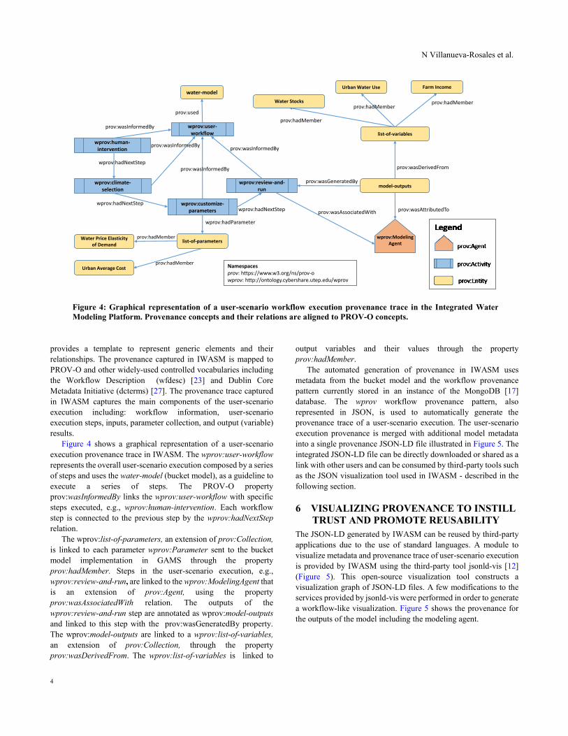
Figure 4 shows a graphical representation of a user-scenario
execution provenance trace in IWASM. The wprov:user-workflow
represents the overall user-scenario execution composed by a series
of steps and uses the water-model (bucket model), as a guideline to
execute a series of steps. The PROV-O property
prov:wasInformedBy links the wprov:user-workflow with specific
steps executed, e.g., wprov:human-intervention. Each workflow
step is connected to the previous step by the wprov:hadNextStep
relation.
The wprov:list-of-parameters, an extension of prov:Collection,
is linked to each parameter wprov:Parameter sent to the bucket
model implementation in GAMS through the property
prov:hadMember. Steps in the user-scenario execution, e.g.,
wprov:review-and-run, are linked to the wprov:ModelingAgent that
is an extension of prov:Agent, using the property
prov:wasAssociatedWith relation. The outputs of the
wprov:review-and-run step are annotated as wprov:model-outputs
and linked to this step with the prov:wasGeneratedBy property.
The wprov:model-outputs are linked to a wprov:list-of-variables,
an extension of prov:Collection, through the property
prov:wasDerivedFrom. The wprov:list-of-variables is linked to
output variables and their values through the property
prov:hadMember.
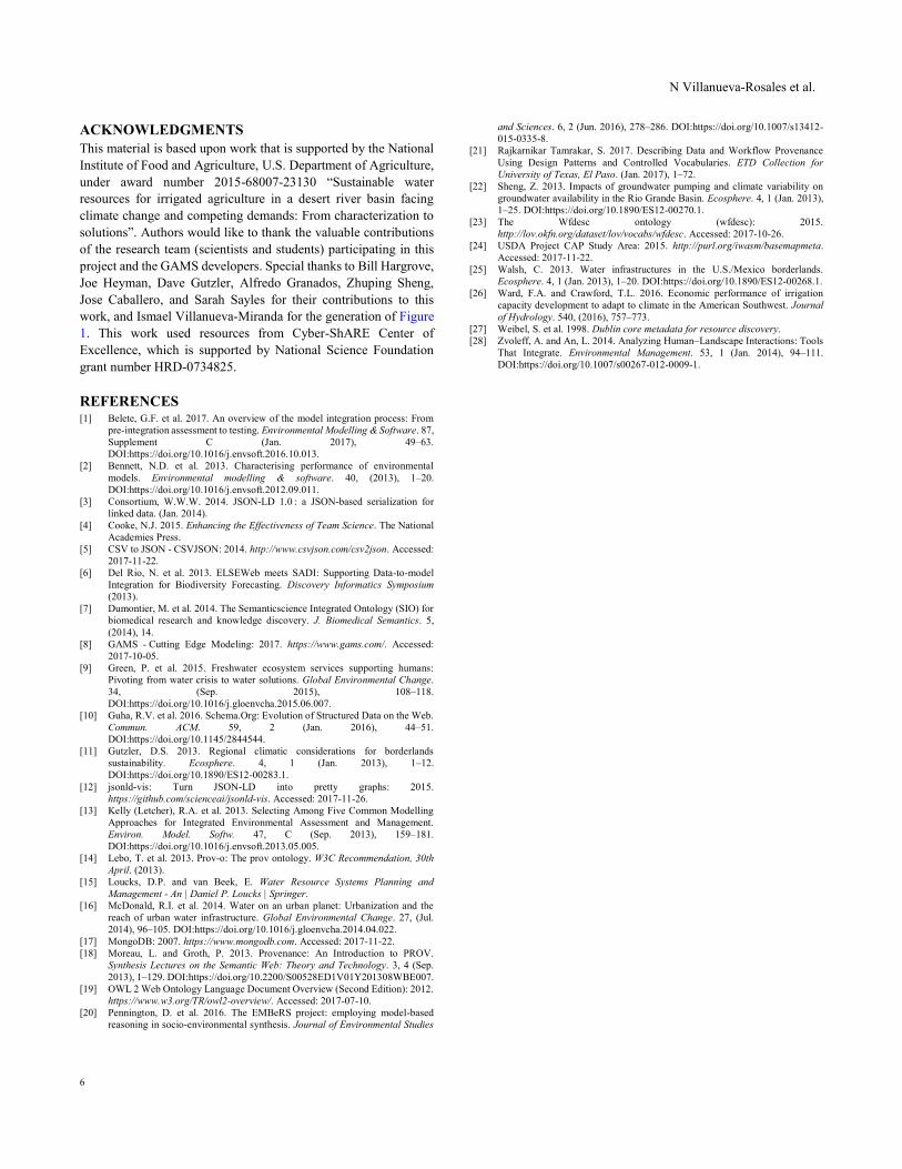
The automated generation of provenance in IWASM uses
metadata from the bucket model and the workflow provenance
pattern currently stored in an instance of the MongoDB [17]
database. The wprov workflow provenance pattern, also
represented in JSON, is used to automatically generate the
provenance trace of a user-scenario execution. The user-scenario
execution provenance is merged with additional model metadata
into a single provenance JSON-LD file illustrated in Figure 5. The
integrated JSON-LD file can be directly downloaded or shared as a
link with other users and can be consumed by third-party tools such
as the JSON visualization tool used in IWASM - described in the
following section.
6 VISUALIZING PROVENANCE TO INSTILL
TRUST AND PROMOTE REUSABILITY
The JSON-LD generated by IWASM can be reused by third-party
applications due to the use of standard languages. A module to
visualize metadata and provenance trace of user-scenario execution
is provided by IWASM using the third-party tool jsonld-vis [12]
(Figure 5). This open-source visualization tool constructs a
visualization graph of JSON-LD files. A few modifications to the
services provided by jsonld-vis were performed in order to generate
a workflow-like visualization. Figure 5 shows the provenance for
the outputs of the model including the modeling agent.
prov:used
wprov:user-workflow
wprov:human-intervention
water-model
model-outputs
list-of-variables
prov:wasDerivedFrom
wprov:climate-selection
wprov:customize-parameters
wprov:review-and-run
wprov:Modeling Agent
Water Stocks
Urban Water Use Farm Income
prov:wasAttributedTo
prov:hadMember
prov:hadMemberprov:hadMember
wprov:hadNextStep
wprov:hadNextStepwprov:hadNextStep
prov:wasInformedBy
prov:wasInformedByprov:wasInformedBy
prov:wasInformedBy
prov:wasAssociatedWith
prov:wasGeneratedBy
list-of-parametersWater Price Elasticity
of Demand
prov:hadMember
prov:hadMember
wprov:hadParameter
Urban Average Cost Namespacesprov: https://www.w3.org/ns/prov-owprov: http://ontology.cybershare.utep.edu/wprov
Figure 4: Graphical representation of a user-scenario workflow execution provenance trace in the Integrated Water
Modeling Platform. Provenance concepts and their relations are aligned to PROV-O concepts.

Capturing Scientific Knowledge for
Water Resources Sustainability in the Rio Grande Area
5
7 PRELIMINARY EVALUATION
From the scientific perspective, a standard model evaluation
approach was used to verify that the model works as intended and
produces believable results. This approach relies on selecting a time
period to simulate for which observational data exists - in this case
reservoir capacity, streamflow at two gauges, and groundwater
depth in specific wells were used. The data are subdivided into two
parts [2]. The first part is used to calibrate the model (training
dataset) and the second part is used to test how well results match
observations. A twenty-year period from 1994 to 2013 was used.
Simulated results for this time period were strongly correlated with
observations, indicating the model has acceptable validity.
To verify that the infrastructure created was generating the same
results as if the modeling tool GAMS was executed directly we
used a black box approach - a model with the same inputs was
generated both using GAMS directly and using the Web interface.
The outputs of the two models were compared to make sure they
were the same and thus verify that the Web-based graphical user
interface, web service executions, and the infrastructure created
was generating the expected results.
From the end-user perspective, we evaluated the usability of the
graphical user interface in a number of ways. Initially we asked
team members and others affiliated with the project to step through
a series of tasks and provide feedback through a survey as described
in section 2. Then, we asked other participants in two workshops to
step through the same tasks and provide feedback, both through a
survey and facilitated discussion. Lastly, we recruited five students
with agricultural backgrounds to test the interface, assuming they
would more closely represent our agricultural stakeholders.
We are in the process of incorporating suggestions from end-
users into current versions of the bucket model and graphical user
interface.
8 CONCLUSIONS
This paper reports in our efforts towards providing a Web-based
platform – IWASM that enables the generation of user-scenario
executions of the bucket model that integrates biophysical
workings of nature with human choices that impact IWASM. User
scenarios include alternative climate, population, and water usage
that can improve understanding of the coupled human-natural
system and facilitate discussions and policy making among a wide
range of stakeholders. This highly-interdisciplinary endeavor used
proven techniques for knowledge negotiation, including the
creation of concept models, and the development of common
vocabularies through ontologies and knowledge representation
languages that enable the integration and exchange of data through
the Web. The requirements elicitation process as well as the
development of IWASM was driven by the interdisciplinary
research team of this project along with input from potential end-
users. As a result, IWASM provides a friendly interface that
enables user-scenario executions of the bucket model as well as
outputs of the system with a provenance trace serialized as a JSON-
LD file. The provenance visualization module illustrates the reuse
of JSON-LD files by third-party tools and fosters the understanding
and reusability of models by end-users, including stakeholders that
may not be familiar with modeling systems.
9 FUTURE WORK
The bucket model is constantly evolving to support additional
features such as the dynamic generation of parameters. IWASM is
also being updated to support these changes. We are in the process
of incorporating additional models of water including simulation
models of water consumption using different modeling tools. Our
ultimate goal is to enable users to ask English-like scientific
questions that will trigger the automatic selection and execution of
a modeling algorithm exposed as a Semantic Web Service based on
our previous work on workflow orchestration for biodiversity
sciences [6]. This new feature will also assist end-users in the
selection of parameters using context provided by ontologies.
Additional data will be needed for new versions of the data model,
including data provided by members of the research team in
Mexico. These data introduces the challenge of integrating data
collected through different survey protocols, different unit scales
(e.g., Metric instead of English) and languages (e.g., Spanish). We
will pursue the use of further ontologies and ontology mappings to
automate the integration of these data that ultimately represents
different perspectives in studying water sustainability.
Figure 5: Visualization of provenance trace generated for a user-scenario execution using the third-party tool jsonld-vis.
N Villanueva-Rosales et al.
6
ACKNOWLEDGMENTS
This material is based upon work that is supported by the National
Institute of Food and Agriculture, U.S. Department of Agriculture,
under award number 2015-68007-23130 “Sustainable water
resources for irrigated agriculture in a desert river basin facing
climate change and competing demands: From characterization to
solutions”. Authors would like to thank the valuable contributions
of the research team (scientists and students) participating in this
project and the GAMS developers. Special thanks to Bill Hargrove,
Joe Heyman, Dave Gutzler, Alfredo Granados, Zhuping Sheng,
Jose Caballero, and Sarah Sayles for their contributions to this
work, and Ismael Villanueva-Miranda for the generation of Figure
1. This work used resources from Cyber-ShARE Center of
Excellence, which is supported by National Science Foundation
grant number HRD-0734825.
REFERENCES [1] Belete, G.F. et al. 2017. An overview of the model integration process: From
pre-integration assessment to testing. Environmental Modelling & Software. 87,
Supplement C (Jan. 2017), 49–63.
DOI:https://doi.org/10.1016/j.envsoft.2016.10.013.
[2] Bennett, N.D. et al. 2013. Characterising performance of environmental
models. Environmental modelling & software. 40, (2013), 1–20.
DOI:https://doi.org/10.1016/j.envsoft.2012.09.011.
[3] Consortium, W.W.W. 2014. JSON-LD 1.0 : a JSON-based serialization for
linked data. (Jan. 2014).
[4] Cooke, N.J. 2015. Enhancing the Effectiveness of Team Science. The National
Academies Press.
[5] CSV to JSON - CSVJSON: 2014. http://www.csvjson.com/csv2json. Accessed:
2017-11-22.
[6] Del Rio, N. et al. 2013. ELSEWeb meets SADI: Supporting Data-to-model
Integration for Biodiversity Forecasting. Discovery Informatics Symposium
(2013).
[7] Dumontier, M. et al. 2014. The Semanticscience Integrated Ontology (SIO) for
biomedical research and knowledge discovery. J. Biomedical Semantics. 5,
(2014), 14.
[8] GAMS - Cutting Edge Modeling: 2017. https://www.gams.com/. Accessed:
2017-10-05.
[9] Green, P. et al. 2015. Freshwater ecosystem services supporting humans:
Pivoting from water crisis to water solutions. Global Environmental Change.
34, (Sep. 2015), 108–118.
DOI:https://doi.org/10.1016/j.gloenvcha.2015.06.007.
[10] Guha, R.V. et al. 2016. Schema.Org: Evolution of Structured Data on the Web.
Commun. ACM. 59, 2 (Jan. 2016), 44–51.
DOI:https://doi.org/10.1145/2844544.
[11] Gutzler, D.S. 2013. Regional climatic considerations for borderlands
sustainability. Ecosphere. 4, 1 (Jan. 2013), 1–12.
DOI:https://doi.org/10.1890/ES12-00283.1.
[12] jsonld-vis: Turn JSON-LD into pretty graphs: 2015.
https://github.com/scienceai/jsonld-vis. Accessed: 2017-11-26.
[13] Kelly (Letcher), R.A. et al. 2013. Selecting Among Five Common Modelling
Approaches for Integrated Environmental Assessment and Management.
Environ. Model. Softw. 47, C (Sep. 2013), 159–181.
DOI:https://doi.org/10.1016/j.envsoft.2013.05.005.
[14] Lebo, T. et al. 2013. Prov-o: The prov ontology. W3C Recommendation, 30th
April. (2013).
[15] Loucks, D.P. and van Beek, E. Water Resource Systems Planning and
Management - An | Daniel P. Loucks | Springer.
[16] McDonald, R.I. et al. 2014. Water on an urban planet: Urbanization and the
reach of urban water infrastructure. Global Environmental Change. 27, (Jul.
2014), 96–105. DOI:https://doi.org/10.1016/j.gloenvcha.2014.04.022.
[17] MongoDB: 2007. https://www.mongodb.com. Accessed: 2017-11-22.
[18] Moreau, L. and Groth, P. 2013. Provenance: An Introduction to PROV.
Synthesis Lectures on the Semantic Web: Theory and Technology. 3, 4 (Sep.
2013), 1–129. DOI:https://doi.org/10.2200/S00528ED1V01Y201308WBE007.
[19] OWL 2 Web Ontology Language Document Overview (Second Edition): 2012.
https://www.w3.org/TR/owl2-overview/. Accessed: 2017-07-10.
[20] Pennington, D. et al. 2016. The EMBeRS project: employing model-based
reasoning in socio-environmental synthesis. Journal of Environmental Studies
and Sciences. 6, 2 (Jun. 2016), 278–286. DOI:https://doi.org/10.1007/s13412-
015-0335-8.
[21] Rajkarnikar Tamrakar, S. 2017. Describing Data and Workflow Provenance
Using Design Patterns and Controlled Vocabularies. ETD Collection for
University of Texas, El Paso. (Jan. 2017), 1–72.
[22] Sheng, Z. 2013. Impacts of groundwater pumping and climate variability on
groundwater availability in the Rio Grande Basin. Ecosphere. 4, 1 (Jan. 2013),
1–25. DOI:https://doi.org/10.1890/ES12-00270.1.
[23] The Wfdesc ontology (wfdesc): 2015.
http://lov.okfn.org/dataset/lov/vocabs/wfdesc. Accessed: 2017-10-26.
[24] USDA Project CAP Study Area: 2015. http://purl.org/iwasm/basemapmeta.
Accessed: 2017-11-22.
[25] Walsh, C. 2013. Water infrastructures in the U.S./Mexico borderlands.
Ecosphere. 4, 1 (Jan. 2013), 1–20. DOI:https://doi.org/10.1890/ES12-00268.1.
[26] Ward, F.A. and Crawford, T.L. 2016. Economic performance of irrigation
capacity development to adapt to climate in the American Southwest. Journal
of Hydrology. 540, (2016), 757–773.
[27] Weibel, S. et al. 1998. Dublin core metadata for resource discovery.
[28] Zvoleff, A. and An, L. 2014. Analyzing Human–Landscape Interactions: Tools
That Integrate. Environmental Management. 53, 1 (Jan. 2014), 94–111.
DOI:https://doi.org/10.1007/s00267-012-0009-1.