c1 site planning and design principles table of contents · c1 site planning and design principles...
TRANSCRIPT

C1 Site Planning and Design Principles
Penrith Development Control Plan 2014 C1 Site Planning and Design Principles C1-1
Table of Contents
C1 SITE PLANNING AND DESIGN PRINCIPLES 2
1.1. SITE PLANNING 3 1.1.1. SITE ANALYSIS 4 1.1.2. KEY AREAS WITH SCENIC AND LANDSCAPE VALUES 5 1.2. DESIGN PRINCIPLES 11 1.2.1. APPLICATION OF CERTIFICATION SYSTEM 11 1.2.2. BUILT FORM - ENERGY EFFICIENCY AND CONSERVATION 11 1.2.3. BUILDING FORM - HEIGHT, BULK AND SCALE 13 1.2.4. RESPONDING TO THE SITE’S TOPOGRAPHY AND LANDFORM 14 1.2.5. SAFETY AND SECURITY (PRINCIPLES OF CRIME PREVENTION THROUGH ENVIRONMENTAL
DESIGN) 17 1.2.6 MAXIMISING ACCESS AND ADAPTABILITY 35

Penrith Development Control Plan 2014 C1 Site Planning and Design Principles C1-2
C1 Site Planning and Design Principles
A. Background
What is Site Planning?
Site planning is a design tool used to determine an appropriate development outcome based on an analysis of the development site’s constraints.
Good site planning starts with a comprehensive analysis of the site, within the immediate and regional context. It encompasses broader decisions regarding building orientation and placement on the site, including location of associated structures and infrastructure such as access and circulation arrangements.
The complexity of the site planning process will vary depending on the scale and nature of the proposed development and the constraints affecting the site. Minor development may only require a site plan and a simple accompanying statement, whereas development of a certain scale or nature or where the site is highly constrained, may result in more detailed plans and supporting technical reports being required to support a development application. This should be discussed with officers from Council’s Development Services Department prior to lodgement of the development application.
Adopting a Comprehensive Site Planning Process
Undertaking a thorough site analysis of the site assists in guiding the development concept and improves development outcomes through improvements in sustainability and design quality. Adopting good site planning principles results in improved development outcomes that translate to:
Economic sustainability and cost benefits: A considered site design will reduce the
demolition, construction and operational costs of buildings;
Social Sustainability: Addressing the needs of the local community will improve quality of life, local vitality and enhance community identity;
Environmental Sustainability: Ensuring the proposal minimises impact or even
enhances environmental impacts; and
Better Planning and Urban Design Outcomes: Achieving a development that integrates with the desired surrounding built form and landscape character.
What is the Aim of this Section of the Plan?
This Plan seeks to achieve high quality, sustainable development outcomes for all development requiring consent or approval by Council. The Plan seeks to achieve this by providing a range of controls for development that encompass various design and sustainability criteria.
This Section provides an overview of the key site planning and design principles applicable to all developments. It illustrates how the design of any development should adopt an integrated approach to improve design quality and sustainability.
B. General Objectives
a) To improve the sustainability of development through improved site planning that takes into account social, economic and environmental opportunities and constraints;
b) To ensure that developments address the key principles of site planning, urban design and design excellence by:
i) responding to the natural topography and landform of the site;
Penrith Development Control Plan 2014 C1 Site Planning and Design Principles C1-3
ii) protecting areas of scenic or visual importance in the City of Penrith;
iii) adopting a height, massing and scale that accords with the analysis of the site and minimises visual impact;
iv) incorporating safety and security measures in its design;
v) utilising, where possible, sustainable materials that minimise impacts on the environment, maintenance and waste; and
vi) incorporating the principles of universal design to maximise accessibility for all people.
c) To ensure that non-residential buildings (and their future uses) are designed to incorporate design and sustainable excellence by:
i) being accredited under the Australian Buildings Greenhouse Ratings certification system, now part of the National Australian Built Environment Rating System (NABERS) and/or Green Star certification system, whichever is applicable; and
ii) ensuring that energy and water consumption is minimised.
C. How to Use this Section
This Section summarises the key criteria for achieving a high quality design and sustainable development outcome. The Section should be read in conjunction with the other relevant sections of this Plan and relevant planning instruments.
D. Other Relevant Sources of Information
Some additional sources of relevant information include:
a) Building Code of Australia (BCA): The BCA contains provisions related to access for
people with a disability. Where the provision of the BCA is a higher standard than this Plan, the provision in the BCA will prevail.
b) State Environmental Planning Policy 65 - Design Quality of Residential Flat Development and the associated Residential Flat Design Code (2002): These apply only to residential flat buildings of a particular height and scale; and
c) AMCORD (Australian Model Code for Residential Development) (1995): This applies
to residential development.
1.1. Site Planning
A. Background
The first rule of site planning is to understand the site. Site planning requires the collection
of information on existing natural, constructed and other features of the site, with the aim of:
a) Understanding the existing form of a locality and the relationships that have caused its development;
b) Identifying the qualities and character of the existing urban form; and
c) Identifying a successful development pattern and inappropriate developments.
The level of analysis required will vary depending on the scale of the proposal. Different levels of analysis are:
a) Regional analysis (the regional context in relation to nearest urban centres, major
services and infrastructure, and broad environmental catchments);

Penrith Development Control Plan 2014 C1 Site Planning and Design Principles C1-4
b) Local analysis (the local context around the site including local services and
infrastructure, local environmental issues, and the local built form and landscape context of the site); and
c) Site analysis (the immediate context around and within the
site including adjacent built form and services, site environmental issues and key site opportunities and constraints).
B. Objectives
a) To ensure that the site's context has been analysed and considered to ensure that development is designed on a ‘whole of building’ approach; and
b) To protect and enhance areas with high scenic and landscapes values which contribute to the character of the City of Penrith.
1.1.1. Site Analysis
Site analysis involves looking at the features of the site and the immediate surrounding area and, where possible, presenting the information in a diagrammatical plan(s). It includes the site and the immediate context – usually up to 50m or 100m in any direction from the site (depending on the scale of development, the proposed land use and its impacts).
Site analysis should include plan and section drawings of the existing features of the site at the same scale as the site and landscape plan. That plan should include the following minimum elements:
the site’s dimensions and areas;
north point and the site’s orientation (e.g. solar access);
topography (with 0.5m to 1m contours);
road and pedestrian access points;
services and infrastructure (e.g. electricity poles, stormwater drainage lines, natural drainage, kerb crossings and easements);
rights of way;
views to and from the site (more detail is provided below);
site overland flows and drainage patterns;
geotechnical characteristics of the site and suitability for development;
location of site in relation to shops, community facilities and transport;
heritage items on site or on adjoining properties;
form and character of adjacent and opposite buildings in the streetscape, including both sides of any street that the development fronts;
location and use of any existing buildings or built features on the site;
location and important characteristics of adjacent public, communal and private open spaces;
location of significant vegetation on the site;
location of any significant noise sources on and in the vicinity of the site; and
Site
Local
Regional
Penrith Development Control Plan 2014 C1 Site Planning and Design Principles C1-5
assessment of site contamination and/or remediation.
Not all of the elements listed above will be relevant for every development or site. You are strongly recommended to contact Council’s Development Services Department to discuss the requirements for your proposal prior to lodgement of a development application.
Further information on site planning can be found in Appendix F5 – Technical Information.
1.1.2. Key Areas with Scenic and Landscape Values
A. Background
This Section focuses on particular locations in the City of Penrith that are visible from major roads and other public places and have important scenic and landscape values. These locations are identified on the Penrith LEP 2010 Scenic and Landscape Values Map.
Key to the site analysis and planning process is minimising likely visual impact as a result of new development. This section identifies the key principles that should be addressed in a visual impact assessment and when such an assessment is required.
The locations identified on the Penrith LEP 2010 Scenic and Landscape Values Map
include, but are not limited to:
Land along the Blue Mountains escarpment;
Land which has views to and from the Nepean River;
Land within the riverine corridors of South and Ropes Creek;
Land along major roads, including the M4 Motorway;
Land that can be viewed from the Main Western Railway Line;
Land within the Mulgoa Valley precinct, including vistas from major heritage items in the valley (see the Mulgoa Valley Section of this Plan);
Land within Industrial Precincts 4 and 8 which have views to and from the Nepean River and the Blue Mountains escarpment, and within Industrial Precincts 7 and 9 which can be viewed from elevated locations elsewhere in the City (see the Industrial Development Section of this Plan); and
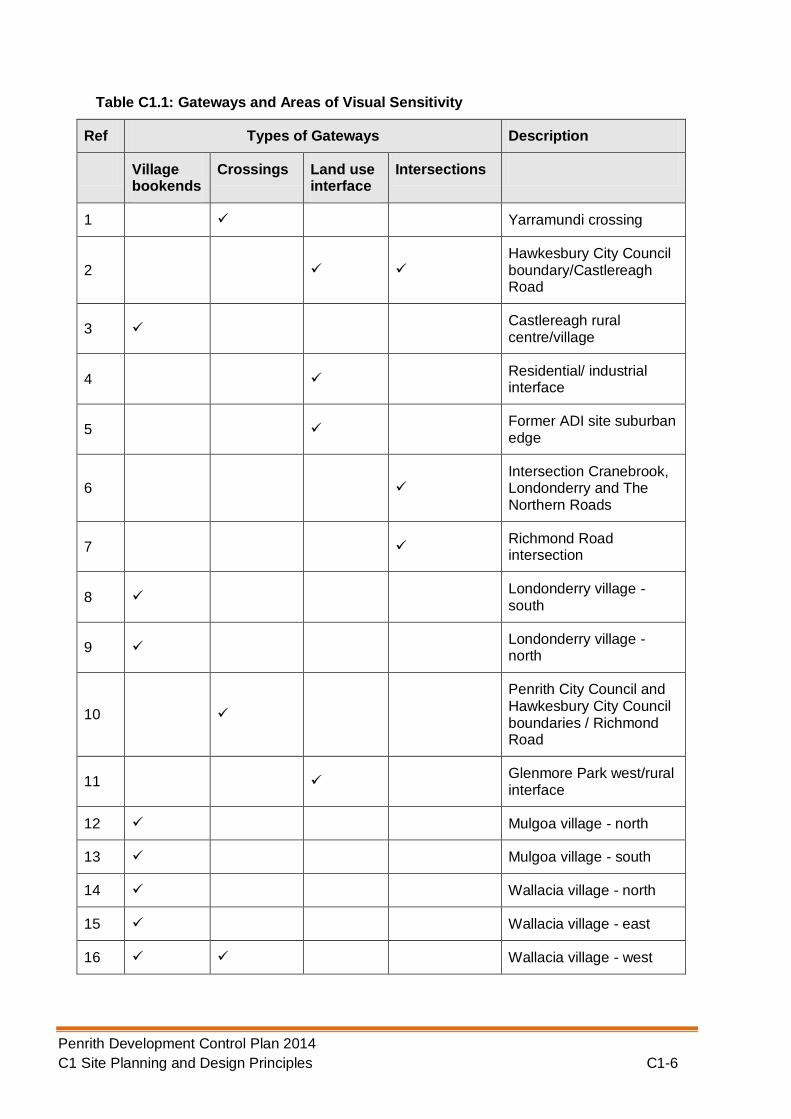
Land at important gateways. Table C1.1 and Figure C1.1 below identify gateways in the City of Penrith. The design of new development at these locations requires a special response given their visual sensitivity.
Gateways are distinctive sites or spatial sequences which denote a change in a spatial or visual experience. They have a variety of configurations and scales from regional significance to neighbourhood scale. They can be marked by changes such as land use, density of development, vegetation, topography and space. Some are site specific places of environmental identity and others provide a sense of transition. They can be entrances and destinations. Gateways may also be located at sites such as significant community congregation areas, public art installations, municipal buildings and ceremonial places. Types of gateways in Penrith City providing a sense of arrival or transition may include crossings, village bookends, land use interfaces, intersections and cultural gateways.
See the Technical Information Appendix for a more detailed definition of gateways.
Penrith Development Control Plan 2014 C1 Site Planning and Design Principles C1-6
Table C1.1: Gateways and Areas of Visual Sensitivity
Ref Types of Gateways Description
Village bookends
Crossings Land use interface
Intersections
1 Yarramundi crossing
2 Hawkesbury City Council boundary/Castlereagh Road
3 Castlereagh rural centre/village
4 Residential/ industrial interface
5 Former ADI site suburban edge
6 Intersection Cranebrook, Londonderry and The Northern Roads
7 Richmond Road intersection
8 Londonderry village - south
9 Londonderry village - north
10
Penrith City Council and Hawkesbury City Council boundaries / Richmond Road
11 Glenmore Park west/rural interface
12 Mulgoa village - north
13 Mulgoa village - south
14 Wallacia village - north
15 Wallacia village - east
16 Wallacia village - west

Penrith Development Control Plan 2014 C1 Site Planning and Design Principles C1-7
Ref Types of Gateways Description
Village bookends
Crossings Land use interface
Intersections
17 Glenmore Park east/rural interface
18 Elizabeth Drive intersection
19 Luddenham village - north
20 Kemps Creek rural centre - west
21 Kemps Creek rural centre - east
22 M4 entry over the Nepean River
23 Blue Mountains/Penrith Council boundary at Old Bathurst Road
Penrith Development Control Plan 2014 C1 Site Planning and Design Principles C1-8
Figure C1.1: Gateways and Areas of Visual Sensitivity

Penrith Development Control Plan 2014 C1 Site Planning and Design Principles C1-9
B. Principles
The following key principles should be addressed in a visual impact assessment to minimise the visual impact of the development and protect areas with high scenic and landscape values:
Protect and enhance the visual diversity and scenic quality of gateways and view sheds within the City of Penrith, including detailed, mid and long range views;
Protect and enhance the key regional natural features that contribute to the character of Penrith as a City, including the Blue Mountains escarpment, the Nepean River, other riparian corridors and bushland reserves;
Protect, maintain and enhance other important natural features, including ridgelines, hillsides, watercourses and riparian corridors, vegetation and landform;
Protect, maintain and enhance backdrops and settings that contribute to the local identity;
Protect, maintain and enhance views and vistas from vantage points, including main road corridors and other public places;
Conserve and enhance historic landscapes, properties and their curtilages;
Plan and site new development to enhance local identity. Development is to effectively integrate with the surrounding landscape so that any change as a result of the new development does not compromise the character of the landscape. Issues such as context, scale, size, built form and height, setbacks/buffers, landform, structural space (private and public), streetscape, vegetation and infrastructure are to be addressed;
Strengthen local identity through consistency and/or compatibility of design. Design development to take into account issues such as scale, form, line, colour, texture, lighting, existing vegetation, open space and landscaping;
Use vegetation to frame scenic views, provide interest or change, define new space, provide backdrops and visually connect all other elements within the setting; and
At gateways, reinforce the distinct experience of arrival or passing from one landscape character type to the next, through legible site planning and design.
C. Controls
1) New proposals on land identified in the LEP Scenic and Landscape Values Map (including gateway sites) or on land zoned E1 National Parks and Nature Reserves or E2 Environmental Conservation, are to submit a visual impact assessment with their development application. This assessment involves describing, analysing and evaluating the visual impacts of the proposed development, and identifying measures to minimise the impacts and ensure the development is sympathetic to the scenic and landscape character of the area.
2) Table C1.2 below identifies what type of visual impact assessment must be prepared and who can prepare it. The Submission Requirements Appendix provides details on the requirements for both types of visual impact assessment. In the table below, there are some parameters that require an opinion or determination from Council. In this regard, applicants will need to contact Council’s Development Services Department for advice.

Penrith Development Control Plan 2014 C1 Site Planning and Design Principles C1-10
Table C1.2: Visual Impact Assessment Requirements
Category Definition Type of Visual Impact Assessment (VIA)
Who can prepare it?
1 New single dwelling houses or significant alterations and additions to single dwelling houses
Dual occupancy and secondary dwellings
Minor alterations and additions to commercial and industrial development as determined by Council
Other minor development as determined by Council
VIA 1 The designer of the development
2 Any development located in proximity to a gateway
Any development in category 1 which in the opinion of Council would have a significant visual impact on the locality
Any other development.
VIA 2 Business or individual with a professional background in design and experienced in visual assessment (e.g. architects, landscape architects, urban designers or town planners)
Penrith Development Control Plan 2014 C1 Site Planning and Design Principles C1-11
1.2. Design Principles
A. Background
This Section of the Plan highlights the general design principles for development and illustrates how compliance with the objectives and controls will achieve a higher standard of built form and design excellence.
B. Objectives
a) To ensure that development is undertaken in a sustainable manner, demonstrating this through the application of the Building Sustainability Index (BASIX), Green Star and/or Australian Buildings Greenhouse Ratings certification system, where appropriate;
b) To ensure that development is designed on a ‘whole of building’ approach by:
i) responding to the site’s context, the desired scale and character of an area, and minimising impacts on key views, scenic values and where applicable, rural character;
ii) responding to climatic and contemporary environmental conditions by:
encouraging passive solar building design;
allowing reasonable daylight access to all developments and the public domain;
reducing the necessity for, or improve the control of, mechanical heating and cooling;
reducing the energy consumed by installed appliances and equipment;
improving the indoor environmental quality of occupants;
minimising greenhouse gas emissions;
iii) minimising likely bulk and scale impacts of a building;
iv) considering the natural topography and landform and minimise excavation and likely visual impacts of the development;
v) ensuring that the development (including the public domain):
has incorporated the Crime Prevention Through Environmental Design (CPTED) principles of surveillance, access control, territorial management and space management into its design; and
is accessible and useable for all members of the community.
1.2.1. Application of Certification System
a) Non-residential developments, including mixed-use developments, with a construction cost of $1 million or more are to demonstrate a commitment to achieving no less than 4 stars under Green Star or 4.5 stars under the Australian Building Greenhouse Rating system, now part of the National Australian Built Environment Rating System (NABERS).
1.2.2. Built Form - Energy Efficiency and Conservation
a) The selection criteria for construction materials, including internal fit-out work, should include detailed documentation of their energy efficiency properties.
b) Buildings should be designed on passive solar design principles which:

Penrith Development Control Plan 2014 C1 Site Planning and Design Principles C1-12
i) Respond to orientation to maximise the northerly aspect and solar access in the cooler periods;
ii) Reduce overheating in summer and promote solar gain in winter; and
iii) Ensure there is adequate cross flow of air by utilising natural ventilation, resulting in a reduction in the use of mechanical ventilation and/or air-conditioning systems.
c) The future use and occupants of the building should be considered in the design and location of building services/equipment to ensure that:
i) The thermal comfort of occupants is optimised through zoning sections of the floor area to
ii) of building services is provided enable individual control of heating and cooling;
iii) Lighting systems and fittings have reduced energy consumption that are also appropriate for the use/activity located in that part of the building;
iv) The equipment or service will be used and its future use will not affect other elements of sustainability; and
v) Sub-metering to individual tenancies within the development to enable individual monitoring of consumption performance.
d) Common and service areas in the building should incorporate energy and water efficiency/conservation measures in their design and location.
Figure C1.2: Diagram showing application of design principles to enhance amenity and to provide good water and energy efficiency. (Source: Urban: sustainable solutions for a developing Australia (January 2008) Socially Sound p32.)

Penrith Development Control Plan 2014 C1 Site Planning and Design Principles C1-13
1.2.3. Building Form - Height, Bulk and Scale
a) Context: An applicant must demonstrate how all proposed buildings are consistent with
the height, bulk and scale of adjacent buildings and buildings of a similar type and use.
b) Character: An applicant must demonstrate how any building's height, bulk and scale will
avoid or minimise negative impacts on an area's landscape, scenic or rural character (where relevant) taking into account the topography of the area, the surrounding landscape and views to and from the site.
c) Articulation: Where the dimension of the building is 20m or more, an applicant must
demonstrate how the building or surface has been articulated (either through built form or materials) to minimise impact on bulk and scale.
d) Overshadowing: Building locations, height and setbacks should seek to minimise any
additional overshadowing of adjacent buildings and/or public spaces where there would be a significant reduction in amenity for users of those buildings/spaces.
e) Setbacks/Separations: Buildings should be sufficiently set back from property boundaries and other buildings to:
i) Maintain consistency with the street context and streetscape character, especially street/front setbacks;
ii) Maximise visual and acoustic privacy, especially for sensitive land uses;
iii) Maximise deep root planting areas that will support landscape and significant tree plantings integrated with the built form, enhancing the streetscape character and reducing a building's visual impact and scale;
iv) Maximise permeable surface areas for stormwater management; and
v) Minimise overshadowing.
f) Building Façade Treatment: The aim is to ensure that any built form will:
i) promote a high architectural quality commensurate with the type of building and land use;
ii) adopt façade treatments which define, activate and enhance the public domain and street character;
iii) ensure that building elements are integrated into the overall building form and façade design;
iv) compose façades with an appropriate scale, rhythm and proportion that responds to the building's desired contextual character;
v) design façades to reflect the orientation of the site using elements such as sun shading, light shelves and appropriate glazing as environmental controls;
vi) express important corners by giving visual prominence to parts of the façade, for example, a change in building articulation, material or colour, roof expression or building height, and
vii) co-ordinate and integrate building services to improve the visual presentation.
g) Roof Design: The roof is an important architectural element of any building and:
i) the shape and form of the roof should respond to its surrounding context and minimise visual impact from any key viewpoints; and
ii) should consider opportunities for incorporating ‘green roofs’.

Penrith Development Control Plan 2014 C1 Site Planning and Design Principles C1-14
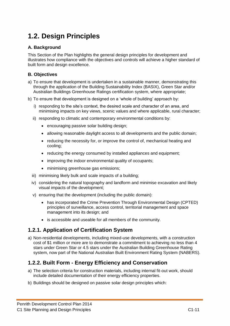
1.2.4. Responding to the Site’s Topography and Landform
a) Applicants must demonstrate how the development responds to the natural topography and landform of the site based on analysis drawings.
b) Any built form should be located, oriented and designed to minimise excavation, cut and fill in accordance with the requirements of the Land Management Section of this Plan.
c) The built form should respond to the natural topography by:
i) Avoiding steep slopes for buildings;
ii) Aligning the built form with the contours; and
iii) Utilising split level design on gentler slopes.
d) Where relevant, buildings should be placed so there is a backdrop of a hill, slope or rise behind the building. In this way, the ridgeline of any building is lower than the highest level of any hill, slope or rise on which the building is placed to avoid being visible above that hill, slope or rise.
The following diagrams illustrate how building design can best respond to a site’s natural topography, minimising excavation and potential visual impacts, and in turn, reducing construction costs.

Penrith Development Control Plan 2014 C1 Site Planning and Design Principles C1-15
Figures C1.3: Buildings on Sloping Land
Penrith Development Control Plan 2014 C1 Site Planning and Design Principles C1-16

Penrith Development Control Plan 2014 C1 Site Planning and Design Principles C1-17
1.2.5. Safety and Security (Principles of Crime Prevention through Environmental Design)
A. Background
The design of buildings and public spaces has an impact on perceptions of safety and security, as well as actual opportunities for crime. When development is appropriately designed, it can reduce the likelihood of crimes being committed.
There are four main principles of CPTED– natural surveillance, access control, territorial reinforcement and space management. Incorporating these four principles of CPTED can help to create a safe and secure environment that encourages activity, vitality and viability, enabling a greater level of security. They can also assist in minimising the incidence of crime and contribute to perceptions of increased public safety.
Applicants should use this section as a tool in the design of developments. However, not all measures outlined below will be relevant for all types of development. For dwelling houses and dual occupancy developments, the CPTED principles may be delivered by simple measures such as:
Installing a peephole in the front door;
Locating a window of a living area to face the street; and
Maintaining the property, particularly the landscaping.
B. Referrals and Required Information
Council is committed to ensuring that developments reduce the potential for crime. As such, Council has developed and entered into a protocol with the NSW Police Service which stipulates what type of developments will be referred to the Police and associated timeframes for response. The following developments will generally be referred to the Police:
Multi dwelling housing and residential flat buildings, where there are more than 15 dwellings.
Mixed use developments that include 15 or more dwellings.
Major new or upgrading of commercial premises (business, office or retail premises).
New industrial complexes with or without multiple industrial units comprising 1,000m2
or more in floor space.
New educational establishments or significant upgrading of existing educational establishments.
New railway stations or significant upgrading of existing railway stations.
Large recreational facilities and community facilities such as community centres.
Large child care centres.
New registered clubs or pubs including applications for extended hours of operation, gaming rooms and nightclubs.
Highway service centres, service stations and some food and drink premises including drive through restaurants.
New health services facilities and residential care facilities, including hospitals, nursing homes and medical centres and larger upgrades to these facilities.
Unusual developments such as brothels and amusement centres.

Penrith Development Control Plan 2014 C1 Site Planning and Design Principles C1-18
New public housing estates or significant upgrades to existing estates.
Automatic Teller Machines which are located on the street and or near openings of buildings.
Generally all of the information listed below will be required to be submitted with your development application if you are lodging one of the above types of development:
Measures that have been taken to ensure compliance with this section of the DCP.
Results of any community safety assessments/audits, crime risk assessments or consultation that has been undertaken prior to the lodgement of the application.
Community Safety Management plans for commercial premises such as hotels, clubs, sex industry premises and any other development that has the potential to attract members of the public either as paying or non-paying customer/visitor.
Information from the NSW Police that may be requested as part of the approvals process and/or undertaken by way of Council/Police protocol.
In some cases, Council may request this information with other types of development application if it is considered warranted.
C. Principles
Principle 1: Natural Surveillance
Providing opportunities for effective surveillance, both natural and technical, can reduce the attractiveness of crime targets. Good surveillance means that people can see what others are doing thereby deterring ‘would-be offenders’ from committing crime in areas with high levels of surveillance. From a design perspective, ‘deterrence’ can be achieved by:
Locating public services in areas of high activity;
Providing clear sightlines between public and private places;
Avoiding blind corners in pathways, stairwells, hallways and car parks;
Ensuring that the range of land uses within a building increases opportunities for natural surveillance;
Providing natural surveillance into communal and public areas;
Locating entries that are clearly visible from the street;
Designing fences that maximise natural surveillance from the street to the building and from the building to the street, and minimise opportunities for intruders to hide;
Installing security grilles, shutters and doors that allows natural observation of the street;
Installing effective lighting in public places that does not produce glare or dark shadows; and
Ensuring that landscaping does not obstruct natural surveillance or provides a place to hide or entrap victims
.

Penrith Development Control Plan 2014 C1 Site Planning and Design Principles C1-19
Principle 2: Access Control
Physical and symbolic barriers can be used to attract, channel or restrict the movement of people, and in turn, minimise opportunities for crime.
Effective access control can be achieved by:
Ensuring buildings are clearly identified by street number;
Providing clear entry points;
Creating landscapes and physical locations that channel and group pedestrians into target areas;
Using vegetation as barriers to deter unauthorised access;
Using building materials/security that reduces the opportunity for intruder access;
Designing public spaces that attract rather than discourage people from gathering;
Restricting access to internal areas or high-risk areas such as loading or service areas;
Ensuring there are appropriate security measures in place commensurate for the range of land uses within a building/development; and
Ensuring that parking areas are clearly identified by signage to prevent unintended access and to assist persons trying to find their car.
Clear building entrance not obscured by vegetation
Controlled access Clear sight lines
Clear sight lines to encourage natural surveillance

Penrith Development Control Plan 2014 C1 Site Planning and Design Principles C1-20
Principle 3: Territorial Reinforcement
This principle relies on the users of spaces or areas feeling that they have some ownership of public space and therefore are more likely to gather and enjoy that space. The ownership of space increases the likelihood that people who witness crime in or adjacent to that space will respond by quickly reporting it or by attempting to prevent it.
Territorial reinforcement can be achieved in the design of the development by:
Having distinct transitions/boundaries between the public and private areas; and
Clearly defining spaces to express a sense of ownership and reduce illegitimate use/entry.
Principle 4: Space Management
Public space that is attractive and well maintained is inviting to users and becomes a well used space. Linked to the principle of territorial reinforcement, space management ensures that the space is appropriately utilised and well cared for.
Space management includes:
Creating a 'cared for’ image through proper maintenance regimes;
Rapid repair of vandalism and graffiti, the replacement of burned out pedestrian and car park lighting and the removal or refurbishment of decayed physical elements;
Using materials that reduce the opportunity for vandalism; and
Encouraging design that promotes pride and a sense of place for the community.
Permeable barrier
Clear Identification of units
Removal of graffiti Encouraging a ‘cared for’ space
Penrith Development Control Plan 2014 C1 Site Planning and Design Principles C1-21
D. Controls
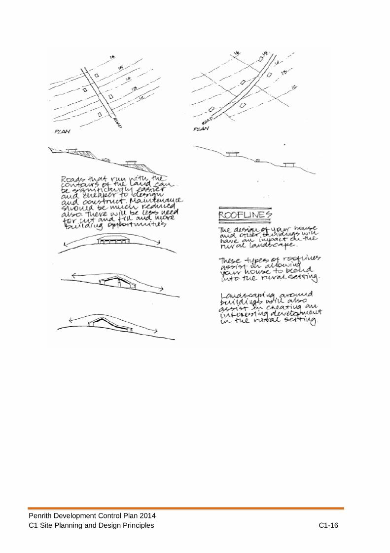
1) Lighting: Lighting plays a vital role in crime prevention and personal safety as you can
see and respond to what is around you and ahead of you. Others can also see you, which further reduces the likelihood of a crime being committed.
a) All areas intended to be used at night should allow appropriate levels of visibility.
b) Pedestrian pathways, lane ways and access routes in outdoor public spaces should be lit to the minimum Australian Standard of AS1158. Lighting should be consistent in order to reduce the contrast between shadows and illuminated areas. Lighting should be designed in accordance with AS4282 – Control of the obtrusive effects of outdoor lighting.
c) Lighting should have a wide beam of illumination, which reaches to the beam of the next light, or the perimeter of the site or area being traversed. Lighting should clearly illuminate the faces of users of pathways.
d) Streetlights should shine on pedestrian pathways and possible entrapment spaces as well as on the road.
e) Lights should be directed towards access/egress routes to illuminate potential offenders, rather than towards buildings or resident observation points.
f) Lighting should take into account all vegetation and landscaping that may act as an entrapment spot.
g) Lighting should be designed so that it is “vandal tough” or difficult for vandals to break.
h) Where appropriate, use movement sensitive and diffused lights.
i) Avoid lighting spillage onto neighbouring properties as this can cause nuisance and reduce opportunities for natural surveillance.
j) Illuminate possible places for intruders to hide.
k) As a guide, areas should be lit to enable users to identify a face 15m away.
l) All lighting should be maintained and kept in a clean condition with all broken or burnt out globes replaced quickly.
m) Use energy efficient lamps/fittings/switches to save energy.
Note: Please refer to the Public Domain Section for further controls on lighting which may
need to be incorporated into the development application.
Appropriate lighting of a footpath and street
Well lit pedestrian pathways

Penrith Development Control Plan 2014 C1 Site Planning and Design Principles C1-22
2) Fencing: If fencing is too high or made of inappropriate materials it reduces the
opportunity for casual surveillance of the street and for users of the public domain to see what activities are taking place on your site. This then further increases the likelihood of a crime being committed.
a) Fence design should maximise natural surveillance from the street to the building and from the building to the street, and minimise the opportunities for intruders to hide.
b) Front fences should preferably be no higher than 1.2m. Where a higher fence is proposed, it will only be considered if it is constructed of open materials e.g. spaced pickets, wrought iron etc. Fences greater than 1.2m will require the consent of Council.
c) If noise insulation is required, install double-glazing at the front of the building rather than a high solid fence (greater than 1m).
Note: Please be aware that Council has several other sections within this Plan which relate to fencing which you may also need to refer to.
Lighting that considers the vegetation to ensure
that the area of illumination is maximised
Wide circle of illumination that
meets the next
Lighting that respects the neighbouring property
owners by not causing a lighting nuisance

Penrith Development Control Plan 2014 C1 Site Planning and Design Principles C1-23
3) Car Parking: Poorly designed car parks whether underground or not can be a dangerous
environment for their users. Through the provision of some basic design elements, such as lighting and signage these spaces can be made safer.
a) Car parks, aisles and manoeuvring areas shall be:
i) designed with safety and function in mind, and
ii) have dimensions in conformity with Australian Standards 2890 - Parking Facilities. Relevant parts of this standard are:
AS2890. 1 - Off-street parking.
AS2890.2 - Commercial vehicle facilities.
AS2890.3 - Bicycle parking facilities.
b) Where parking spaces are to be provided for people with disabilities, these spaces are to:
i) be suitably located near entrances to the building and lifts/ access ramps, if required;
ii) be provided in accordance with Australian Standards 1428.1 - Design for access and mobility; and
iii) have appropriate signage and tactile pavement treatments, where required.
Fencing design that promotes
natural surveillance
Greater than 1.2m in height is
open.
Double-glazing at the front of the
property to allow surveillance

Penrith Development Control Plan 2014 C1 Site Planning and Design Principles C1-24
c) The design of car parking areas should incorporate the following elements:
i) provision of a safe and convenient vehicle entry and exit that avoids traffic/pedestrian conflict and impacts on the surrounding road; and
ii) the internal (vehicular) circulation network is free of disruption to circulating traffic and ensures pedestrian safety.
d) The movement of pedestrians throughout the car park should be clearly delineated by all users of the car park and minimises conflict with vehicles.
e) The design of the car park should ensure that passive surveillance is possible and where appropriate, incorporate active measures such as cameras and security patrols. Car parks should be designed to minimise dark areas through the provision of appropriate lighting.
f) Large car parks should incorporate communication devices such as:
i) Intercoms
ii) Public address systems
iii) Telephones
iv) Emergency alarms.
g) To ensure users of large car parks are easily able to determine their location, exit and access points, security intercoms and the like, appropriate signage is to be included.
h) All surfaces in the car park should be painted in light coloured paint or finished in light grey concrete to reflect as much light as possible.
i) All potential entrapment points should be avoided, e.g. under stairs, blind corners and wide columns. Adequate lighting and mirrors should be used when certain design features are unavoidable.
Note: Please be aware that Council has several other sections in this Plan relating to car
parking which you may also need to refer to. :
Safe movement of pedestrians promoted Disabled car space provided

Penrith Development Control Plan 2014 C1 Site Planning and Design Principles C1-25
4) Entrapment spots and blind corners: Entrapment spots and blind corners provide
opportunities for perpetrators of crime to hide and or commit crime.
a) Pathways should be direct. All barriers along pathways should be permeable including landscaping, fencing etc.
b) Consider the installation of mirrors to allow users to see ahead and around corners. The installation of glass or stainless steel panels in stairwells can also assist in this regard.
c) Entrapment spots adjacent to main pedestrian routes such as a storage area or small alley should be eliminated from all designs.
d) If entrapment spots are unavoidable they should be well lit with aids to visibility such as convex mirrors and locked after hours.
e) To eliminate excuse making for individuals to loiter, avoid placement of seating near or adjacent to ATM’s, public phone boxes, toilets, corridors and isolated locations.
Clearly labelled exit within car park
Permeable barrier Mirrors that allow viewing
around the corner
Phone within car park

Penrith Development Control Plan 2014 C1 Site Planning and Design Principles C1-26
5) Landscaping: Trees and shrubs that are inappropriately located can easily reduce
surveillance opportunities and provide entrapment spots and blind corners.
a) Avoid medium height vegetation with concentrated top to bottom foliage. Plants such as low hedges and shrubs, creepers, ground covers and high-canopied vegetation are good for natural surveillance.
b) Trees with dense low growth foliage should be spaced or crown raised to avoid a continuous barrier.
c) Use low ground cover or high-canopied trees with clean trunks.
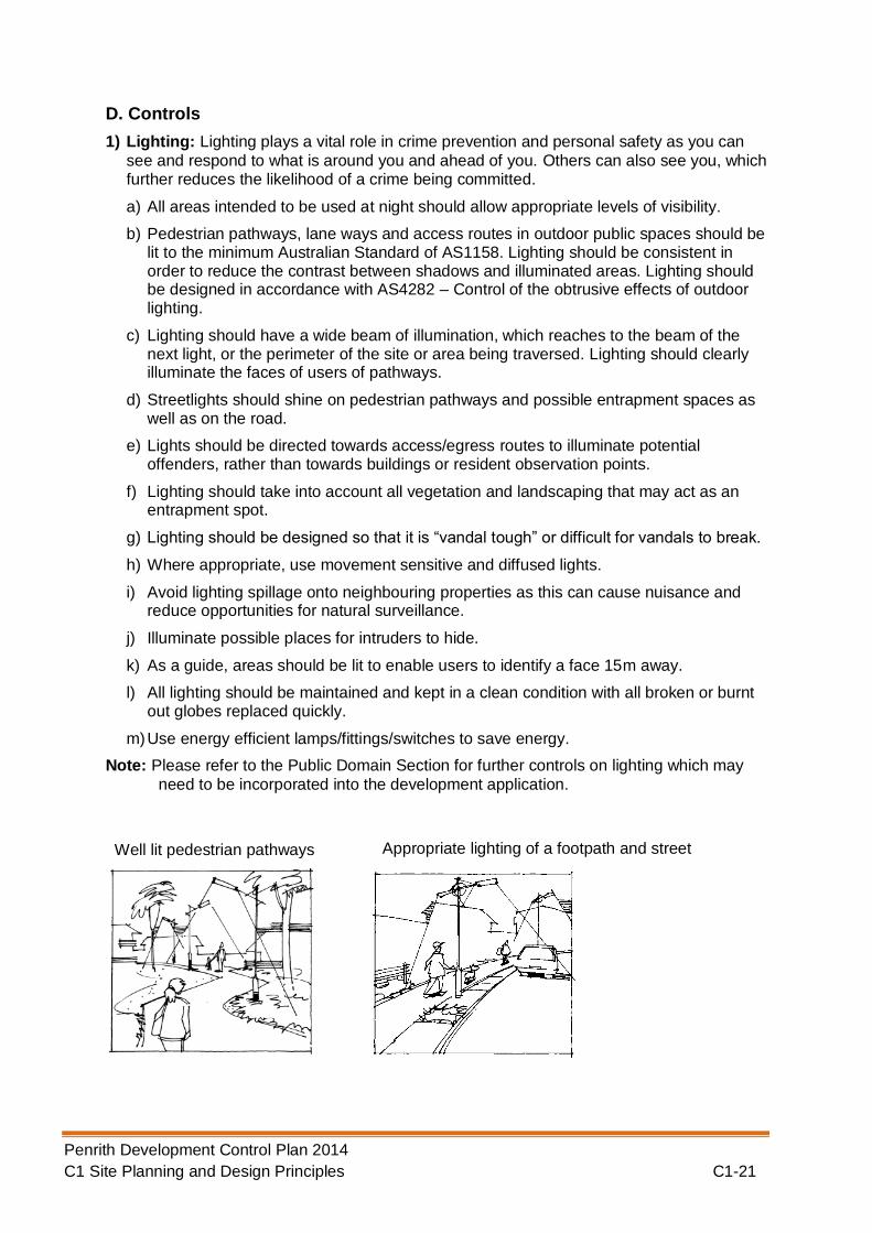
d) Avoid vegetation, which conceals the building entrance from the street.
e) Avoid vegetation screening of all public use toilets.
f) Avoid vegetation that impedes the effectiveness of public and private space lighting. Use “green screens” (wall hugging vegetation that cannot be hidden behind) if screening large expanses of fencing to minimise graffiti.
Note: Refer to the Public Domain Section for more information on lighting.
Glass panels used in stairwells to promote visibility
High and low vegetation
No seats outside toilets to minimise opportunity for loitering
Penrith Development Control Plan 2014 C1 Site Planning and Design Principles C1-27
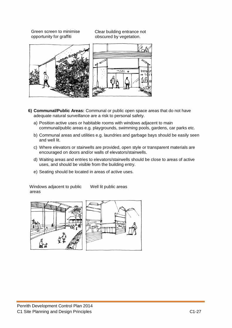
6) Communal/Public Areas: Communal or public open space areas that do not have
adequate natural surveillance are a risk to personal safety.
a) Position active uses or habitable rooms with windows adjacent to main communal/public areas e.g. playgrounds, swimming pools, gardens, car parks etc.
b) Communal areas and utilities e.g. laundries and garbage bays should be easily seen and well lit.
c) Where elevators or stairwells are provided, open style or transparent materials are encouraged on doors and/or walls of elevators/stairwells.
d) Waiting areas and entries to elevators/stairwells should be close to areas of active uses, and should be visible from the building entry.
e) Seating should be located in areas of active uses.
Windows adjacent to public areas
Well lit public areas
Green screen to minimise
opportunity for graffiti Clear building entrance not
obscured by vegetation.

Penrith Development Control Plan 2014 C1 Site Planning and Design Principles C1-28
7) Movement predictors: Movement predictors are routes which people move through on a
regular and predictable basis such as a pedestrian underpass. Careful design is needed to ensure that they are not included in a development or are appropriately treated where included to reduce the risk. Through site links are another type of movement predictor, however, unlike under passes these can provide a benefit to the community if designed appropriately to ensure safety.
a) Pedestrian underpasses should not be included in new developments. Where existing developments, which include underpasses, are being redeveloped all efforts should be made to remove them.
b) Where movement predictors are used the users of it should have clear site lines so they can see what is ahead and behind at all times.
c) Lighting of movement predictors is essential. Natural lighting should be used where possible with consideration given to wall and ceiling materials to help reflect light.
d) Emergency intercoms, telephones and security videos should be included in the design of movement predictors. Adequate consideration should be given to who will be monitoring such equipment.
e) No entrapment spots should be included in any movement predictor.
Transparent elevators Seating in active areas
Bridge instead of underpass Movement predictor well lit

Penrith Development Control Plan 2014 C1 Site Planning and Design Principles C1-29
8) Entrances: Entrances to all types of development that are not visible from the public domain provide an opportunity for perpetrators of crime to hide and or commit crime. Entrances to all types of development need to be clearly visible and legible so that the users can obtain entry quickly and expediently.
a) Entrances should be at prominent positions and clearly visible and legible to the users.
b) Design entrances to allow users to see into the building before entering.
c) Entrances should be easily recognisable through design features and directional signage.
d) Minimise the number of entry points – no more than 10 dwellings should share a common building entry.
e) If staff entrances must be separated from the main entrance, they should maximise opportunities for natural surveillance from the street.
f) Avoid blank walls fronting the street.
g) In industrial developments, administration/offices should be located at the front of the building.
Entrance clear and visible
Security video used Clear sight lines

Penrith Development Control Plan 2014 C1 Site Planning and Design Principles C1-30
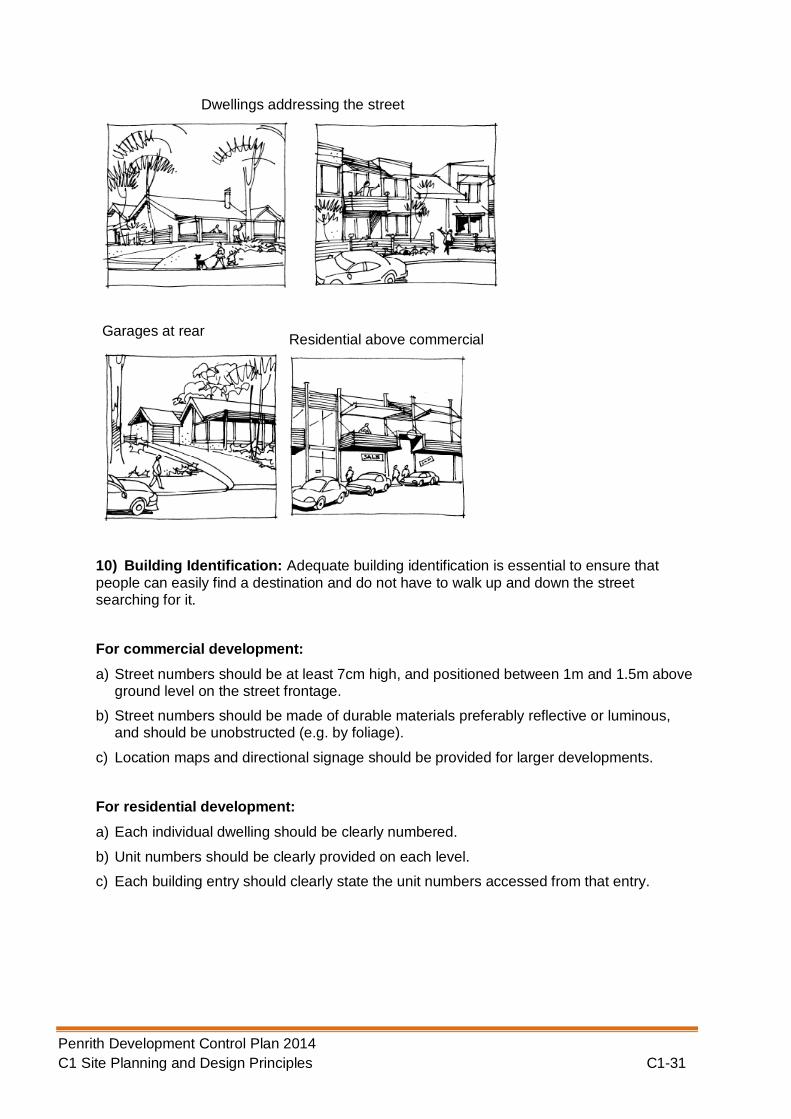
9) Site Building and Layout: Buildings should be sited so that they address the street and
promote surveillance of the street from the dwelling and of the dwelling.
a) For single dwellings and dual occupancies, orientate the main entrance towards the street or both streets if located on a corner.
b) For townhouses/villas/multiple units, ensure that part of the building addresses the street or both streets if located on a corner.
c) Position habitable rooms with windows at the front of the dwelling.
d) Garages and carports should not dominate the front façade of the building.
e) Access to dwellings or other uses above commercial/retail development should not be from rear lanes.
f) Offset windows, doorways and balconies to allow for natural observation while protecting privacy.
Blank walls avoided to minimise opportunity for graffiti
Offices at front of building
Entry points minimised
Penrith Development Control Plan 2014 C1 Site Planning and Design Principles C1-31
10) Building Identification: Adequate building identification is essential to ensure that
people can easily find a destination and do not have to walk up and down the street searching for it.
For commercial development:
a) Street numbers should be at least 7cm high, and positioned between 1m and 1.5m above ground level on the street frontage.
b) Street numbers should be made of durable materials preferably reflective or luminous, and should be unobstructed (e.g. by foliage).
c) Location maps and directional signage should be provided for larger developments.
For residential development:
a) Each individual dwelling should be clearly numbered.
b) Unit numbers should be clearly provided on each level.
c) Each building entry should clearly state the unit numbers accessed from that entry.
Garages at rear Residential above commercial
Dwellings addressing the street

Penrith Development Control Plan 2014 C1 Site Planning and Design Principles C1-32
11) Security: A crucial part of a crime prevention strategy is the use of security hardware
and/or personnel to reduce opportunities for unauthorised access.
a) Install intercom, code or card locks or similar for main entries to buildings including car parks.
b) Main entry doors for apartment buildings should be displayed requesting residents not to leave doors wedged open.
c) Australian Standard 220 - door and window locks should be installed in all dwellings.
d) Consider installing user/sensor electronic security gates at car park entrances, garbage areas and laundry areas etc, or provide alternative access controls.
e) Entry to basement parking should be through security access via the main building.
f) External storage areas should be well secured and well lit.
g) Install viewers on entry doors to allow residents to see who is at the door before it is opened.
h) If security grilles are used on windows they should be operable from inside in case of emergencies.
i) Ensure skylights and/or roof tiles cannot be readily removed or opened from outside.
j) Consider monitored alarm systems.
k) Provide lockable gates on side and rear access.
l) Consider building supervisors or security guards.
Location board for larger developments
Clear identification of units
Street number size and positioning

Penrith Development Control Plan 2014 C1 Site Planning and Design Principles C1-33
Note: If you are proposing security gates to control access, you will need to liaise with the
emergency service providers such as Police, Fire Brigade and Ambulance to ensure that they can gain access.
12) Ownership and Space Management: It is important that people have a sense of ownership of a place whether it is residential or commercial as a person who feels attached to a place is more likely to watch out for it and the other users of it.
Security cards used where
necessary
Well – lit storage area
Doors not to be wedged open
Security camera at entrance to allow viewing of visitors
Secure car park

Penrith Development Control Plan 2014 C1 Site Planning and Design Principles C1-34
a) Ensure that dwellings or groups of dwellings are readily recognizable by the residents through the use of design features such as colouring, roof forms, vegetation, paving, artworks, fencing, furniture etc.
b) Physical and/or psychological barriers, e.g. fences, gardens, lawn strips, varying textured surfaces can be used to define different spaces.
c) Ensure the speedy repair or cleaning of damaged or vandalised property.
d) Provide for the swift removal of graffiti.
e) Provide information advising where to go for help and how to report maintenance or vandalism problems.
f) Council, through its Community Safety Partnership Initiatives can provide residents with Community Safety advice on how to enhance property and personal safety and how to promptly report criminal or inappropriate behaviour to relevant authorities.
Note: The Penrith Community Safety Partnership oversees the implementation of the
Penrith Community Safety Plan. Strategies in the Community Safety Plan include the conducting of Community Safety Audits.
An initiative of the partnership is to provide commercial property owners with some general “good amenity” tips to contribute to overall presentation of specific neighbourhoods. This document will be provided to all commercial properties prior to and/or at the conclusion of community safety audits/assessments surrounding their premises to promote “self rectification” and neighbourhood responsibility.
13) Way finding/ finding help: The ability to escape, communicate or find help when in
danger can be assisted through improved signage and legible design. Moreover,
Distinctive entrance and style for different parts of a development
Removal of graffiti Process to report vandalism

Penrith Development Control Plan 2014 C1 Site Planning and Design Principles C1-35
knowing where you are in a large open space or shopping centre contributes to a feeling of safety.
a) Signs should be large and legible, with strong colours, standard symbols (e.g. for washrooms) and simple graphics. They should indicate where to go for help or assistance.
b) Signs should be strategically located at entrances and near activity nodes such as intersections of corridors or paths.
c) Signs should indicate how to report maintenance problems in the complex.
d) The main pedestrian route through a large building, sets of building or areas of open public space should be indicated as such with appropriate signage.
e) Where exits to pedestrian routs are closed after hours this should be indicated at the entrance to the route and information on alternative routes should clearly advised.
f) Signs that provide way finding information should not be relied upon solely, the overall legibility of the design needs to be well considered. Users of the space need to be able to intuitively understand where they are within the complex or area and how they can get away.
1.2.6 Maximising Access and Adaptability
A. Background
New developments and the spaces around them should be accessible and useable to all people. Developments should be designed and constructed beyond their initial or first use to
Clear signage and way finding devices incorporated into the development

Penrith Development Control Plan 2014 C1 Site Planning and Design Principles C1-36
ensure that buildings are durable and capable of adaptability in the future. The ‘whole of building approach’ should consider how the building design, finishes and materials used in the construction phase affect the amenity and safety of future occupants of the building. This approach maximises the liveability and longevity of the buildings by ensuring that adaptability and accessibility is integral to the design and construction of the development. For example, houses could be designed with reinforced shower walls will allow for future installation of grab rails. Wider doorways can facilitate easier movement of less able occupants. Lever taps and door handles are designed for easier use by both young children and older people. Similar principles can apply to commercial and industrial developments. Designing flexibility into a building will increase the lifespan and marketability of the development.
B. Principles
There are a number of principles of universal design which, when considered in the planning and design stage, add very little to the cost of the development but make a great deal of difference to the overall useability of the development. These principles can be applicable to both external and internal areas. (The principles go beyond the requirements of the Australian Standard for Adaptable Housing (AS 4299-1995)).
a) Principle 1 – Equitable use: The design is useful and marketable to people with diverse abilities.
b) Principle 2 – Flexibility in use: The design accommodates a wide range of individual
preferences and abilities.
c) Principle 3 – Simple and intuitive use: Use of the design is easy to understand regardless of the individual’s experience, knowledge, language skills or current concentration levels.
d) Principle 4 – Perceptible information: The design communicates useable information effectively to the user regardless of ambient conditions or the user’s sensory abilities.
e) Principle 5 – Tolerance for error: The design minimises hazards and the adverse
consequences of accidental or unintended actions.
f) Principle 6 – Low physical effort: The design can be used effectively and comfortably
with a minimum of fatigue.
g) Principle 7 – Size and space for approach and use: Appropriate size is provided for
approach, manipulation and use regardless of users body size, posture or mobility.
C. Controls
Dwellings
The Australian Network for Universal Design (ANUHD) recommends the following minimum criteria for inclusion in a universally designed home:
1) Easy access: People of all ages and abilities are able to gain easy access to the
dwelling from the front boundary or car park to the entrance of the dwelling.
2) At least one level entrance: The dwelling includes at least one level entrance to
enable all home occupants to enter and exit the dwelling with ease.
3) Bathroom, living space and bedroom on the entrance level: The level entry to the dwelling provides a living space, bathroom and toilet, and a bedroom space or space capable of accommodating a bedroom space.

Penrith Development Control Plan 2014 C1 Site Planning and Design Principles C1-37
4) Bathrooms designed for easy adaption: The bathroom provides a hobless shower
and accommodates more generous internal circulation spaces to enable future adaptation.
5) Reinforcement of bathroom walls: Walls in the bathroom and shower are reinforced
to enable future installation of grab rails, if required by home occupants.
6) Kitchen access: The kitchen design enables all home occupants to easily manoeuvre within the kitchen area and between fixed kitchen benches.
7) Easy access to doors and corridors: The internal passages and doorways within the
dwelling facilitate ease of movement between rooms and accommodate the circulation needs of all home occupants.
8) Consistent installation of switches, power outlets and window controls: Light
switches, power outlets and other operational devices are installed at a consistent height to ensure ease of access for all home occupants.
9) Easy operable door, tap and window controls: Door and window operating hardware
is easy to manipulate and can be operated by the home occupants regardless of age or ability.
10) Slip resistance of floor surfaces: Kitchens, bathrooms and laundries feature flooring
which provides slip resistance in both wet and dry conditions.
Development involving frequent public use
It is more important that development which involves frequent public use conforms to the principles of Universal Design, wherever practical, as it is this form of development where equity of access is most critical. This type of development includes (but is not limited to):
Public halls;
Entertainment facilities;
Function centres, restaurants, registered clubs and the like;
Large retail centres (including bulky goods development); and
Large office buildings.
Development applications for any of the above uses should address the principles of Universal Design in the Statement of Environmental Effects.
D. Lifting the Bar
The following represent some ways in which applicants can demonstrate additional commitment to the principles expressed in this Section. Demonstration of this commitment may lead to Council considering variation of development controls.
a) Adopt high quality building design that is visually attractive, innovative and improves sustainability outcomes through its design, including the management of vegetation and landscape, water, land and waste in accordance with this Plan;
b) Address impacts on sensitive adjacent land uses through careful site planning, building design and landscape treatment; and
c) Reduce the use of timber from old growth forests, rainforests and forests/plantations which do not have certified environmentally responsible forest management practices. Applicants need to demonstrate that a significant percentage of the timber and composite timber products used in the building and construction works has Forest Stewardship Council Certification (see www.fsc.org), utilises reused or recycled timber or is specified using the Friends of the Earth 'Good Wood Guide' 9th Edition.