building enterprise geospatial web solution for forest sector geoforest – a case study
DESCRIPTION
Building Enterprise Geospatial Web solution for Forest sector GeoForest – A Case Study. Vivek Chitale*, M. Vinayak Rao**, Geetanjali Mehta, Dhrubajyoti Sarma. Presented by:-Vivek Chitale Technical Director NIC Bhopal [email protected]. GeoForest. - PowerPoint PPT PresentationTRANSCRIPT

Building Enterprise Geospatial Web solution for Forest sector
GeoForest – A Case Study Vivek Chitale*, M. Vinayak Rao**, Geetanjali Mehta, Dhrubajyoti Sarma
Presented by:-Vivek Chitale Technical Director NIC Bhopal

Essential for survival and sustenance of life
Helps in conservation of soil, water resources, environment
It is a natural habitat for wild life & biodiversity
Potentially contribute to global climate change
Essence of Forest

Rapid Urbanisation
Enormous pressure on the forest resources for fuel wood and fodder
Mining, irrigation, hydroelectric projects
Encroachments for agriculture, cattle feeding
Decrease in rain fall
Deplition of Forests

Forestry is a major government enterprise in IndiaIt has 20% of geographical area as forest & 200,000 forest villages275 million rural poor depends on forest for part of livelihoods National Commission on Agriculture in 1976 recommended the reorganization of state forestry departments and advocated the concept of social forestry National Forest Policy, 1988 focuses on ensuring environmental stability, restoring the ecological balance, and preserving the remaining forests In 2006 forestry in India underwent a major change with the passage of the Forest Rights Act, Overpopulation, farming and environmental factors are major causes of dwindling forest cover
National Forests

Forest Area in M.P.
Total Forest Area 94,689.38 sq.km (30.71%)
Total forest cover 76,429 sq. km. (24.79%)
No. of Villages 22,600 (42.85% Forest Habitation)
Tiger State Harbors 20% of India’s Tiger Population
Forest Resources
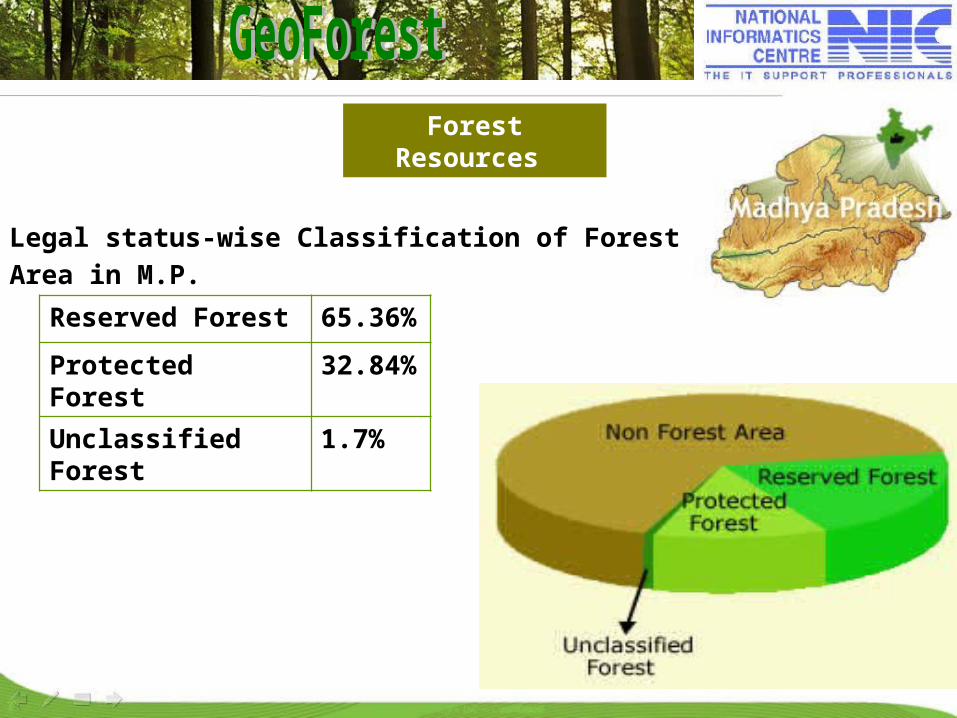
Legal status-wise Classification of Forest Area in M.P.
Reserved Forest 65.36%
Protected Forest 32.84%
Unclassified Forest 1.7%

Forest Types
Classification of forest area & forest types
State-wise Forest Area Classification

62 territorial divisions
9 National parks.
25 Wildlife sanctuaries.
Preparation of Working Plans for territorial divisions
Preparation of Management Plan for National Park/Wildlife Sanctuary.
Pioneering the JFM (Joint Forest Management) movement.
M.P Forest Department
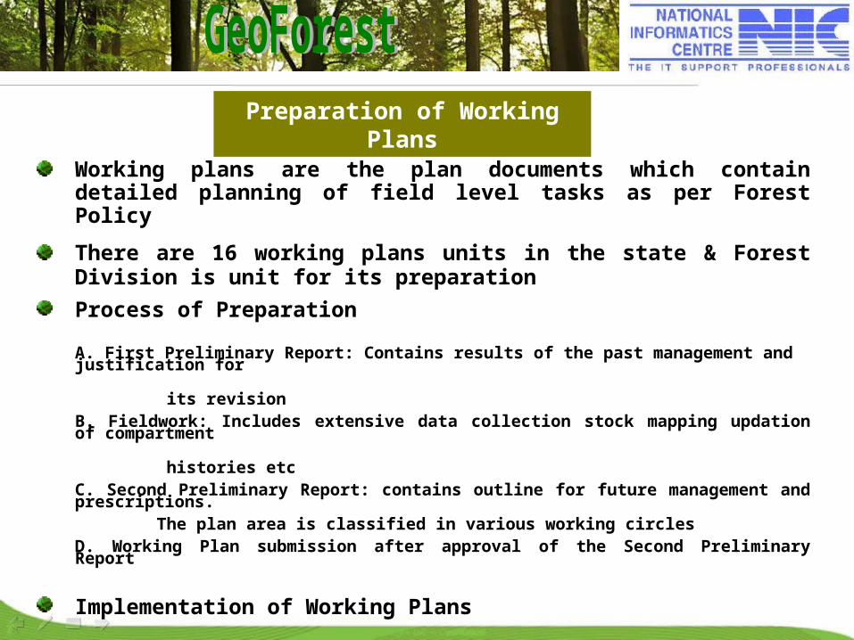
Working plans are the plan documents which contain detailed planning of field level tasks as per Forest Policy
There are 16 working plans units in the state & Forest Division is unit for its preparation
Process of Preparation
A. First Preliminary Report: Contains results of the past management and justification for
its revision B. Fieldwork: Includes extensive data collection stock mapping updation of compartment
histories etcC. Second Preliminary Report: contains outline for future management and prescriptions.
The plan area is classified in various working circlesD. Working Plan submission after approval of the Second Preliminary Report
Implementation of Working Plans
Preparation of Working Plans

Role of GIS in Forest Management
Working Plan
Forest Density, Forest type, Crop Composition, Site Quality, Contours, Soil Map, Road network, Encroachments, Volume data, Wild life sighting, villages, Boundaries, Research plots and Fire affected area, Plantations etc.
Geospatial technology facilitates collection, storing, retrieval, transfer and display of geographically reference spatial data with its corresponding attribute information to meet a specific requirement.
Demarcation of Forest Area
Division, Range, Blocks, Compartments,sub-compartment boundariesand boundary pillars
Management Plans
Working Circles, Felling Series, Periodic Blocks and coupe numbers.

(Internet Geomatics-based Forest Mapping)
http://gismp.nic.in/GeoForest
Scope of the project
Creation of Enterprise GeoDatabase
Integration of attribute data with digital data
Generation of the required thematic maps.
Development of enterprise Web-based application
Query based output in the form of derived maps for printing
Updation of spatial data using PDA device

Application Requirements
SPATIAL DATA
GENERATE PLAN FORMATS
ATTRIBUTE PROFILE
CHANGE DETECTION
QUERY
Information for Field Officers
NAVIGATION

Creation of Forest Stock map InventoryDigitization of ~ 4500 Forest Stock Map (1:15,000)
- Variance in maps (legend, naming conventions etc.)- Gaps in spatial data- Geo-referencing Issues- Mosaicking issues
Reconsilation issues/problems (in Integration of spatial and attribute data)Design of enterprise spatial Geodatabase Design of an SOA architecture
Issues/Challanges
GeoForest Spatial Component
Forest Ranges, Compartments with their legal status (RF/PF/UC) Locations of Munara, various Forest Species, Guest House/Rest House etc. in the forestWater Bodies
Classification of forest, forest type, site quality
Working circles, felling series & coupes pertaining to a working plan
Attribute Component
Compartment Details (Notified Area, Working Plan Year etc.)
Linkage of Compartment with Forest Beat & Block
Census data
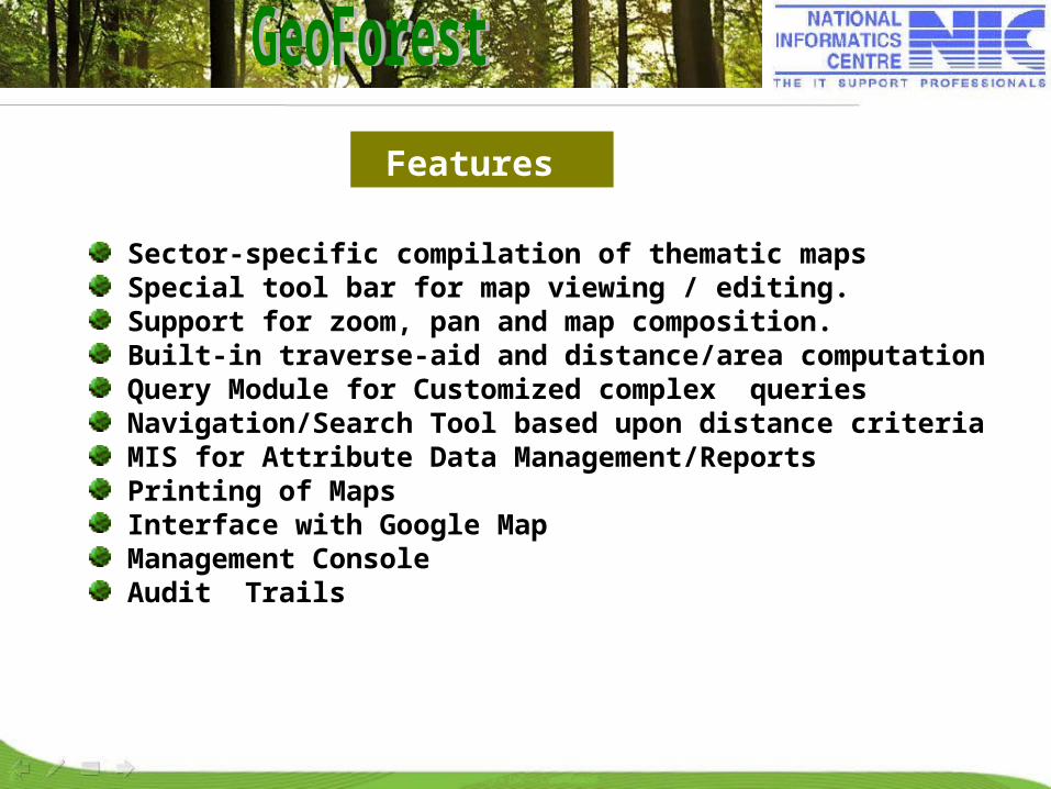
Features
Sector-specific compilation of thematic mapsSpecial tool bar for map viewing / editing.Support for zoom, pan and map composition.Built-in traverse-aid and distance/area computationQuery Module for Customized complex queriesNavigation/Search Tool based upon distance criteriaMIS for Attribute Data Management/ReportsPrinting of MapsInterface with Google MapManagement Console Audit Trails
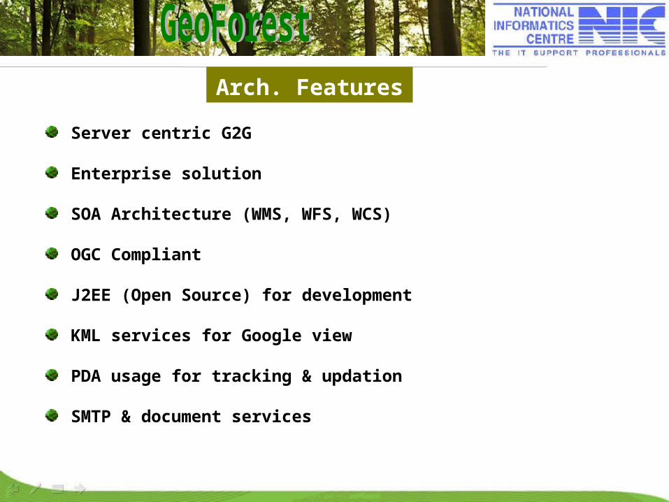
Arch. Features
Server centric G2G
Enterprise solution
SOA Architecture (WMS, WFS, WCS)
OGC Compliant
J2EE (Open Source) for development
KML services for Google view
PDA usage for tracking & updation
SMTP & document services
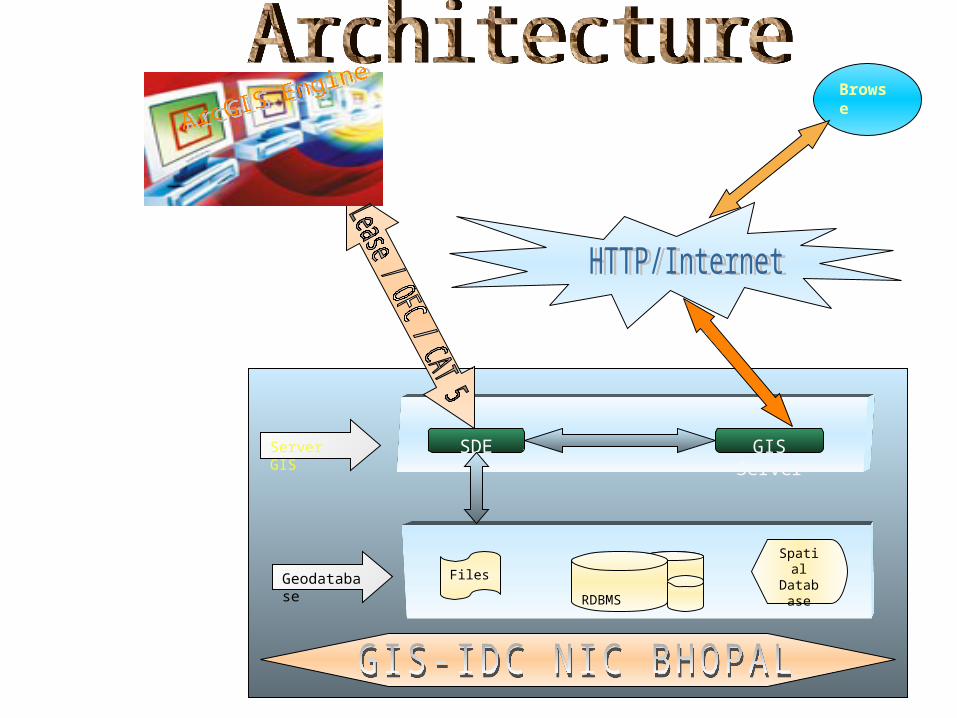
Files RDBMS
SpatialDatabas
eGeodatabase
GIS ServerSDEServer GIS
Browse
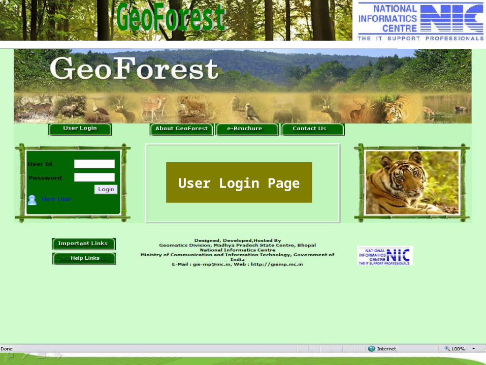
User Login Page

Thematic maps
Profiles
Map Contents
Working CircleCompartment BoundaryCompartment (Legal Status)Forest ClassificationForest AgeForest TypeForest Site Quality
Zoom In Zoom Out
Habitation Search
Pan Full ExtentNextPrevious
Map Print
Measure
Habitations ProfileCoupe ProfileCompartment ProfileQuery ShellNavigationSearchEditing Tool

M.P State with Compartment Legal Status
Thematic Map (Compartment Legal Status)
Reserved Forest
Protected Forest

Thematic map on Forest Classification depicting various classes under which forest area is covered
Thematic Map (Forest Classification)
Under Stock

Working Circle
Thematic Map (Working Circle)
SCI

Forest Type
Thematic Map (Forest Type)
Mixed
Sal
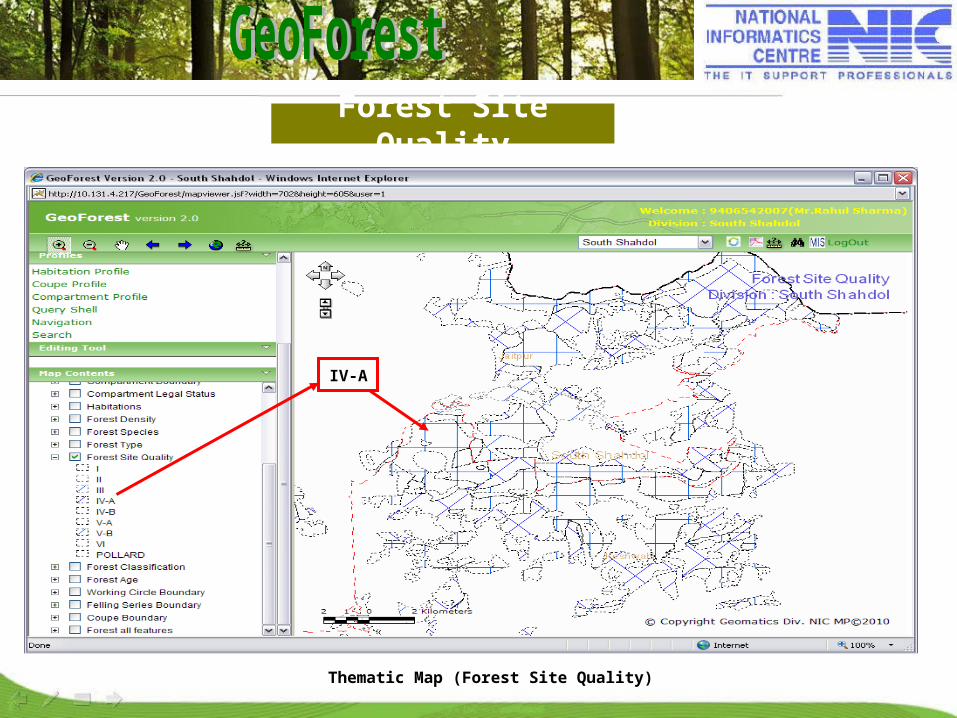
Forest Site Quality
Thematic Map (Forest Site Quality)
IV-A

Felling Series Boundary
Thematic Map (Felling Series Boundary)
RDF
Plantation

Coupe Boundary
Thematic Map (Coupe Boundary)
SCI
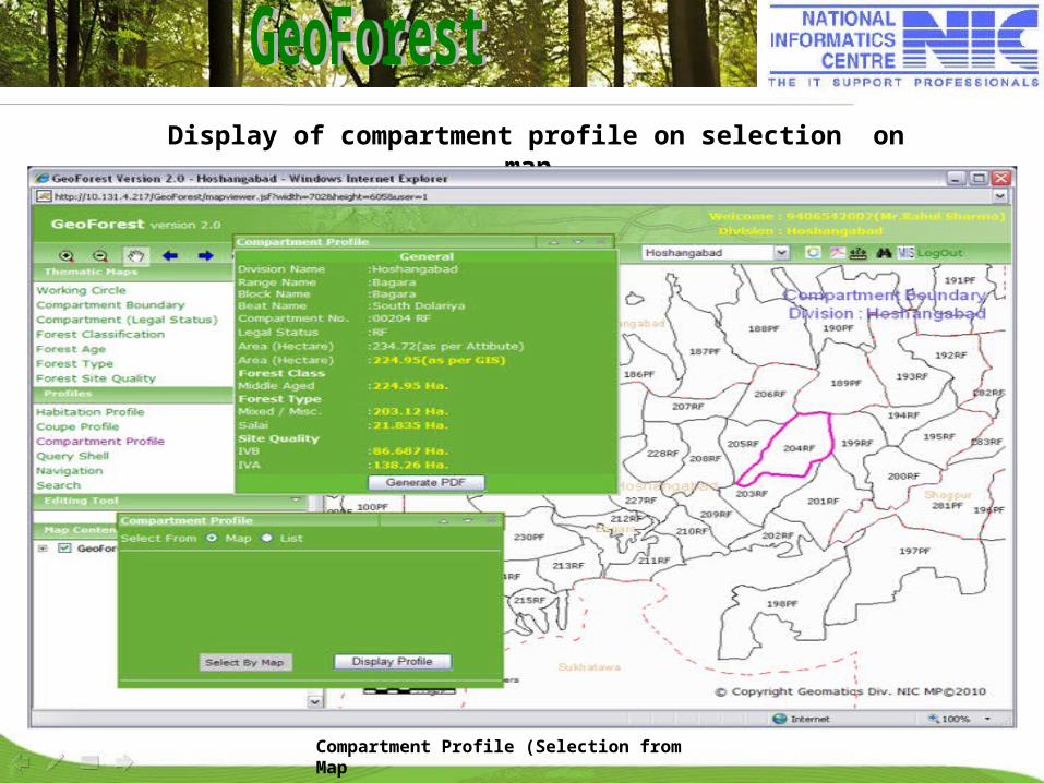
Display of compartment profile on selection on map.
Compartment Profile (Selection from Map
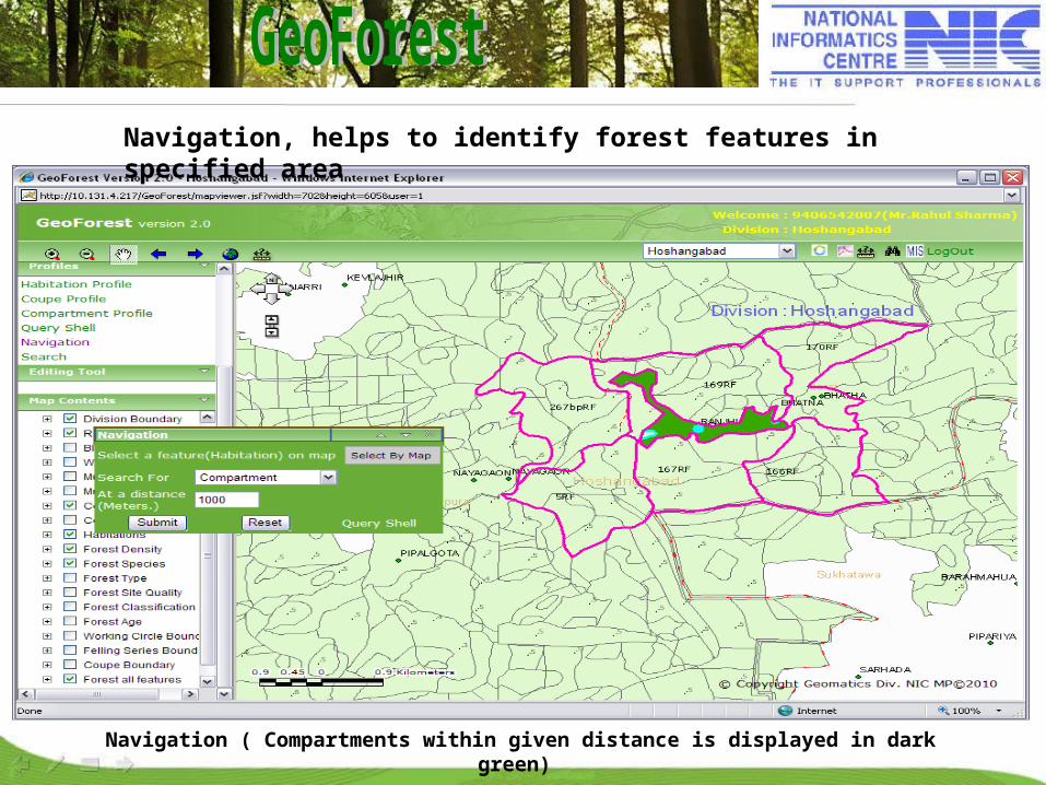
Navigation ( Compartments within given distance is displayed in dark green)
Navigation, helps to identify forest features in specified area
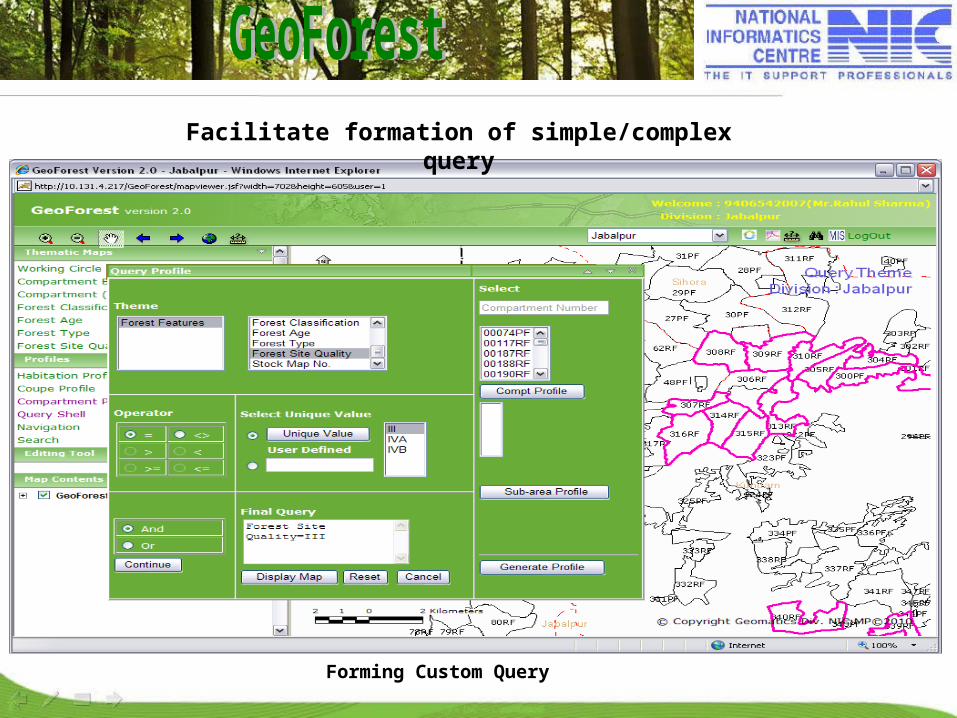
Forming Custom Query
Facilitate formation of simple/complex query

Area measurement
Measurement of area for polygon feature.
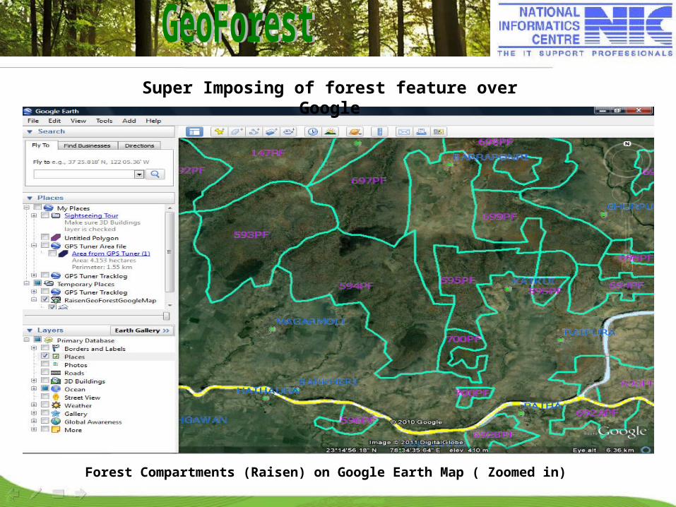
Forest Compartments (Raisen) on Google Earth Map ( Zoomed in)
Super Imposing of forest feature over Google

Impact/Benefits
Provides holistic view of entire forest area, its various classifications, types, spread of species etc.
Helps in Gap analysis and standardization
Facilitates WPO at remote places in Working Plan/Management Plan Preparation
Change Detection
Can be used to access the existing forest resource and decide treatment programs to enrich forest.
Helps to achieve transparency & easiness in planning & monitoring processes.

Conclusion
G-Governance coupled with emerging Spatial technology plays an important role in all area of governance It is state-of-the-art models to the government for Forest Sector OGC compliant Enterprise DSS on SOA architecture for macro-level planning can be built in a cost-effective manner It can play vital role in formulating appropriate Working Plans and drawing effective management plans and reports.Its capacity to make accurate and periodic assessments of forest resources will facilitate monitoring of changes in the forest statusNational level replication potential