what defines geospatial - federation of american scientists · chapter geospatial intelligence:...
TRANSCRIPT
CHAPTER GEOSPATIAL INTELLIGENCE: CAPSTONE CONC
Why geospatial intelligence? What defines geospatialintelligence as a discipline? Simply put, geospatial intelligence isabout the integration of NIMA’s existing imagery and geospatialanalysis capabilities for the digital information environment of thetwenty-first century. The convergence of our imagery andgeospatial tradecrafts and the emergence of our new, integrateddiscipline of geospatial intelligence represent the fulfillment ofthe vision of NIMA’s founders. By unifying our unique ability toprecisely model the environment and to remotely monitordynamic world events, we are transforming into a powerfulnew discipline that is truly greater than the sum of its parts.
Our transformation has altered the conceptual framework of ourdiscipline and the way it relates to the larger context of theprofession of intelligence. At the same time that technology hasenabled the integration of our tradecraft and tools, the worldenvironment has changed dramatically. The September 11 terroristattacks have caused our nation to rethink our tenets of nationalsecurity and reevaluate our approach to the collection, analysis,and dissemination of intelligence.
With these changes in our conceptual framework, it is essential that we understand what is changing,what remains the same, and why. As the functional manager for geospatial intelligence, I have launchedan effort to develop a formal body of National Geospatial Intelligence Doctrine. This body of doctrinewill provide the conceptual link between our national security strategy and the plans and proceduresthat guide our actions. Our doctrine will reflect a community of shared beliefs, a stable set of truthsthat, while enduring, remains flexible enough to embrace new concepts.
With Geospatial Intelligence, our capstone concept, we take our first step toward a formal doctrineof geospatial intelligence. Geospatial Intelligence speaks of our heritage, defines our core values,and provides the intellectual foundation for our ongoing transformation. It outlines our enduringcharacteristics and our evolving and emerging capabilities.
Although this capstone concept introduces geospatial intelligence as a new term in the intelligencelexicon, our mission remains the same. While our concepts, methods, technology, and terminologyevolve, the essential qualities demanded of NIMA remain unchanged—satisfy our customers’geospatial intelligence needs at any moment, for any purpose.
Know the Earth … Show the way!
JAMES R. CLAPPER, JR.Lieutenant General, USAF (Ret.)Director
Foreword
2 | GEOSPATIAL INTELLIGENCE: CAPSTONE CONCEPT CHAP
Geospatial Intelligenceoutlines the capstone conceptfor the National Imagery andMapping Agency (NIMA).While this document primarilyaddresses NIMA, the principlesit outlines are generallyapplicable for geospatialintelligence practitionersthroughout the NationalSystem for GeospatialIntelligence (NSGI).
This capstone conceptdescribes our highest enduringprinciples, providing theconceptual link betweenour national strategy and theplans, procedures, andmethods that geospatialintelligence professionalsdevelop and apply in theirwork every day. It respondsto the direction set in theNational Security Strategy,the National Strategy forHomeland Security, theQuadrennial Defense Review,Joint Vision 2020, and the
This capstone concept publication introduces the term geospatial intelligence tothe lexicon of national security. It describes the common framework of shared beliefs asthey apply to imagery, imagery intelligence, and geospatial information, hereafterreferred to collectively as geospatial intelligence.
Strategic Intent for the U.S.Intelligence Community.It draws heavily upon theenduring principles we haveinherited from joint andservice doctrine, thetransformational principlesdescribed in the NIMACommission Report, and thelessons we have learned inrecent operations from Bosniaand Kosovo to the Global Waron Terrorism.
This document:
* describes the nature of anew intelligence discipline;
* explains the radical shiftsin the geopolitical land-scape and the advancingtechnologies that aretransforming the imageryand geospatial tradecrafts;
* outlines our evolving andemerging processing andremote sensing capabilities,
Introduction
encompassing the entirerange of sources fromreconnaissance satellites toairborne platforms andcommercial providers;
* explains the power ofgeospatial intelligenceas a medium formulti-disciplinaryintelligence collaborationand visualization.
This capstone conceptbegins a dialog about thenature of our evolvingdiscipline. It is the first wordon geospatial intelligence, butnot the last. While it answersseveral important questions,many others remain to beanswered. GeospatialIntelligence builds upon thelegacy of established joint andservice doctrine, and sets thestage for our development ofa formal doctrine of geospatialintelligence for NIMA andthe NSGI.
CHAPTER GEOSPATIAL INTELLIGENCE: CAPSTONE CONC
Intelligence—and how we use it—is our f irst line of defense against terrorists and the threat posed byhostile states. Designed around the priority of gathering enormous information about a massive f ixed object—the Soviet Bloc—the intelligence community is coping with the challenge of following a farmore complex and elusive set of targets.
National Security Strategy
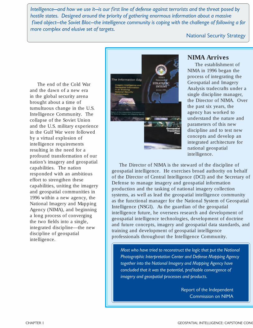
The end of the Cold Warand the dawn of a new erain the global security arenabrought about a time oftumultuous change in the U.S.Intelligence Community. Thecollapse of the Soviet Unionand the U.S. military experiencein the Gulf War were followedby a virtual explosion ofintelligence requirementsresulting in the need for aprofound transformation of ournation’s imagery and geospatialcapabilities. The nationresponded with an ambitiouseffort to strengthen thesecapabilities, uniting the imageryand geospatial communities in1996 within a new agency, theNational Imagery and MappingAgency (NIMA), and beginninga long process of convergingthe two fields into a single,integrated discipline—the newdiscipline of geospatialintelligence.
NIMA ArrivesThe establishment of
NIMA in 1996 began theprocess of integrating theGeospatial and ImageryAnalysis tradecrafts under asingle discipline manager,the Director of NIMA. Overthe past six years, theagency has worked tounderstand the nature andparameters of this newdiscipline and to test newconcepts and develop anintegrated architecture fornational geospatialintelligence.
The Director of NIMA is the steward of the discipline ofgeospatial intelligence. He exercises broad authority on behalfof the Director of Central Intelligence (DCI) and the Secretary ofDefense to manage imagery and geospatial informationproduction and the tasking of national imagery collectionsystems, as well as lead the geospatial intelligence communityas the functional manager for the National System of GeospatialIntelligence (NSGI). As the guardian of the geospatialintelligence future, he oversees research and development ofgeospatial intelligence technologies, development of doctrineand future concepts, imagery and geospatial data standards, andtraining and development of geospatial intelligenceprofessionals throughout the Intelligence Community.
I
Most who have tried to reconstruct the logic that put the NationalPhotographic Interpretation Center and Defense Mapping Agencytogether into the National Imagery and Mapping Agency haveconcluded that it was the potential, prof itable convergence ofimagery and geospatial processes and products.
Report of the IndependentCommission on NIMA
4 | GEOSPATIAL INTELLIGENCE: CAPSTONE CONCEPT CHAP
inevitable result of powerfulforces of change in ourstrategic environment. Themajor catalysts for this changehave been a radical shift in thethreat environment, theevolving nature of conflict, andthe revolutionary technologiesof the digital age. Workingtogether, these forces haveprovided both the impetus andthe means for the convergenceof the imagery analysis andgeospatial tradecrafts into thesingle, integrated discipline ofgeospatial intelligence.
Uncertain ThreatEnvironment
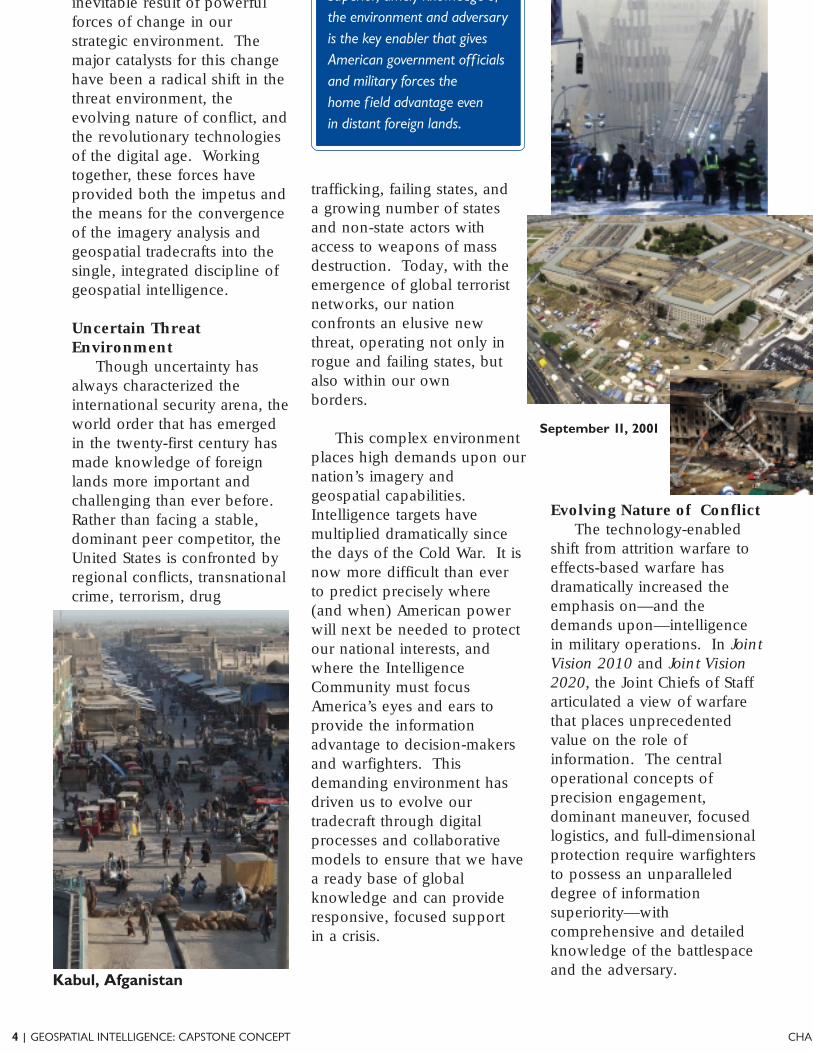
Though uncertainty hasalways characterized theinternational security arena, theworld order that has emergedin the twenty-first century hasmade knowledge of foreignlands more important andchallenging than ever before.Rather than facing a stable,dominant peer competitor, theUnited States is confronted byregional conflicts, transnationalcrime, terrorism, drug
Kabul, Afganistan
Superior, timely knowledge ofthe environment and adversaryis the key enabler that givesAmerican government off icialsand military forces thehome f ield advantage evenin distant foreign lands.
September 11, 2001
trafficking, failing states, anda growing number of statesand non-state actors withaccess to weapons of massdestruction. Today, with theemergence of global terroristnetworks, our nationconfronts an elusive newthreat, operating not only inrogue and failing states, butalso within our ownborders.
This complex environmentplaces high demands upon ournation’s imagery andgeospatial capabilities.Intelligence targets havemultiplied dramatically sincethe days of the Cold War. It isnow more difficult than everto predict precisely where(and when) American powerwill next be needed to protectour national interests, andwhere the IntelligenceCommunity must focusAmerica’s eyes and ears toprovide the informationadvantage to decision-makersand warfighters. Thisdemanding environment hasdriven us to evolve ourtradecraft through digitalprocesses and collaborativemodels to ensure that we havea ready base of globalknowledge and can provideresponsive, focused supportin a crisis.
Evolving Nature of ConflictThe technology-enabled
shift from attrition warfare toeffects-based warfare hasdramatically increased theemphasis on—and thedemands upon—intelligencein military operations. In JointVision 2010 and Joint Vision2020, the Joint Chiefs of Staffarticulated a view of warfarethat places unprecedentedvalue on the role ofinformation. The centraloperational concepts ofprecision engagement,dominant maneuver, focusedlogistics, and full-dimensionalprotection require warfightersto possess an unparalleleddegree of informationsuperiority—withcomprehensive and detailedknowledge of the battlespaceand the adversary.
CHAPTER GEOSPATIAL INTELLIGENCE: CAPSTONE CONCI
information age warfarehave turned the Cold Warmodel of national intelligenceupside down. In thecentralized model of the ColdWar era, intelligence reportswritten by tactical units weresifted and analyzed by nationalagencies for the benefit ofnational decision makers.In today’s more distributedmodel, the nationalintelligence collection systemsand subject-matter expertise
once dedicated to supporting aselect group of nationaldecision makers now support avastly expanded base oftheater and tactical users aswell. Interoperability hasbecome essential in thesedistributed worldwidenetworks of intelligenceproducers and consumers,where finished intelligenceoften ends up in the guidancesystem of a tactical missile.
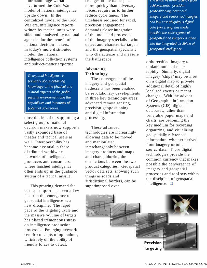
This growing demand fortactical support has been a keyfactor in the emergence ofgeospatial intelligence as anew discipline. The rapidpace of the targeting cycle andthe massive volume of targetshas placed tremendous stresson intelligence productionprocesses. Emerging network-centric concepts of operations,which rely on the ability offriendly forces to detect,
The union of three technologicalachievements: precisiongeopositioning, advancedimagery and sensor technologies,and low cost ubiquitous digitaldata processing, has madepossible the convergence ofgeospatial and imagery analysisinto the integrated discipline ofgeospatial intelligence.
PrecisionTargeting
Geospatial Intelligence isprimarily about obtainingknowledge of the physical andcultural aspects of the globalsecurity environment and thecapabilities and intentions ofpotential adversaries.
changes in the battlespacemore quickly than adversaryforces, require us to furtherreduce cycle times. Thetimeliness required for rapid,precision engagementdemands closer integrationof the tools and processesof the imagery specialists whodetect and characterize targetsand the geospatial specialistswho characterize and measurethe battlespace.
AdvancingTechnology
The convergence of theimagery and geospatialtradecrafts has been enabledby revolutionary developmentsin three key technology areas:advanced remote sensing,precision geopositioning,and digital informationprocessing.
These advancedtechnologies are increasinglyallowing data to be movedand manipulatedinterchangeably betweenimagery products and mapsand charts, blurring thedistinctions between the twoproduct categories. Geospatialvector data sets, showing suchthings as roads andjurisdictional borders, can besuperimposed over
orthorectified imagery toupdate outdated mapsrapidly. Similarly, digitalimagery “chips” may be inseton a digital map to provideadditional detail of highlylocalized events or recentchanges. With the adventof Geographic InformationSystems (GIS), digitaldatabases, rather thanvenerable paper maps andcharts, are becoming thekey medium for recording,organizing, and visualizinggeospatially referencedinformation, whether derivedfrom imagery or othersource data. These digitaltechnologies provide thecommon currency that makespossible the convergence ofimagery and geospatialprocesses and tool sets withinthe discipline of geospatialintelligence. ❏
6 | GEOSPATIAL INTELLIGENCE: CAPSTONE CONCEPT CHAP
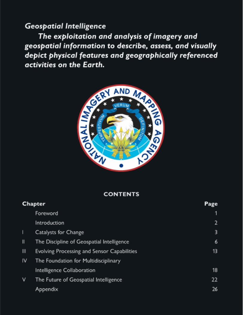
Geospatial Intelligence—The exploitation and analysis of imagery and geospatial informationto describe, assess, and visually depict physical features and geographically referencedactivities on the Earth.
Unifying the strengths ofimagery analysis and mapping,charting, and geodesy,geospatial intelligence hasemerged as a new discipline,separate and distinct from itspredecessors. To understandthe nature of this newdiscipline, it is important toexamine its enduring elements.A set of defining characteristicsoutlines the essential qualitiescommon to both the imageryand the geospatial specialties.An integrated body oftradecraft draws upon eachof our specialties to bringcapabilities that far surpasswhat any could accomplishalone. The human analyst,endowed with a unique setof traits, plays a central andtimeless role in our trade.Finally, geospatial intelligencecan be used for a wide rangeof applications that are vital toour nation’s security.
II
DefiningCharacteristics
As a discipline, geospatialintelligence is defined primarily
An Intelligence DisciplineGeospatial intelligence
is first an intelligencediscipline, and therefore sharesthe general qualities andattributes of the broader fieldof intelligence. It primarilyaims to understand thecapabilities and intentions ofpotential adversaries and thephysical and cultural aspectsof the global securityenvironment. Geospatialintelligence confrontsnon-cooperative targets thatmay be trying to conceal theiractivities from the UnitedStates and our allies. Ournation therefore requires theuse of clandestine means tocollect information about themand sensitive analyticaltechniques to understand themeaning of this information.Like other intelligencedisciplines, geospatialintelligence aims to produce
trusted knowledge. Itexamines new information inthe context of our existingknowledge base andinformation obtained fromother sources to arrive uponvalid conclusions about thesecurity situation. Geospatialintelligence responds tospecific requirements, either tosupport policy decisionsor the planning andexecution of military or civilnational security operations.Because collection andproduction assets are limitedand time is an importantfactor, geospatial intelligencemust focus on meetingthe highest priority needsof national securitydecision-makers according tofinite timetables.
Geospatial intelligence aims toreduce uncertainty, providinga knowledge advantage in timefor a decision to be made or anaction to be taken to advance orprotect national interests.
by three qualities: its characteras an intelligence discipline, itsunique analytic tradecraft, andits fundamental spatial andtemporal nature.
CHAPTER GEOSPATIAL INTELLIGENCE: CAPSTONE CONC
Geospatial intelligenceis an analytical discipline,defined by its analytictradecraft—the complementaryand related skill sets ofgeospatial specialists andimagery analysts—rather thanby a particular source of data.Geospatial intelligence reliesupon data from multiplecollection sources, includingremote sensing, open sources,and human sources. In thisrespect, it differs from thetraditional collectiondisciplines, which are definedby the skills associated witha single collection source.Its focus is not on its source,but rather on its ultimateproduct—an integrated, digital,visual picture of the globalsecurity situation.
Fundamental Spatial andTemporal Nature
Geospatial intelligenceis also characterized by itsfundamental spatial andtemporal nature. It is focusedprimarily on examiningtangible, physical things.Geospatial intelligenceobserves and measures thephysical world, drawingconclusions based on thespatial relationships amongobjects as they change overtime. It uses both qualitativeand quantitative methods,analyzing geometric attributeslike shape, size, dimension,distance, movement, pattern,elevation, and location tocharacterize geographic areasand reach conclusions aboutintelligence issues. It is thiselemental spatial and temporalnature that unites ourconstituent tradecrafts anddistinguishes geospatial
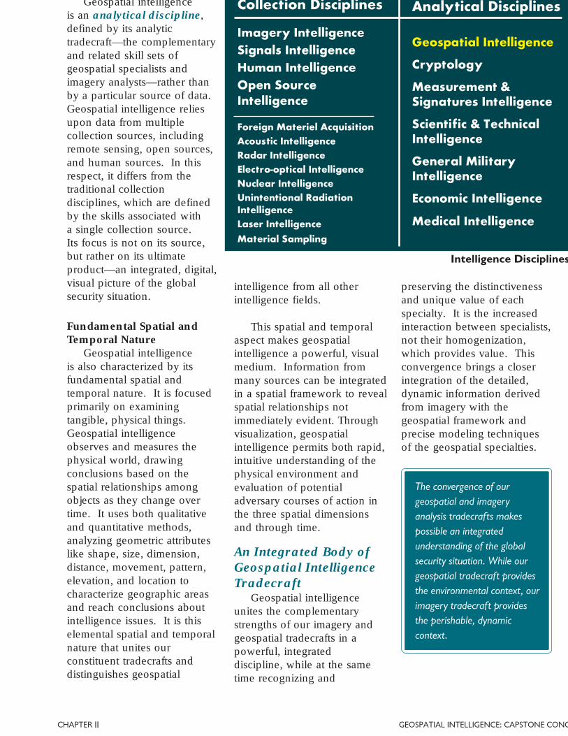
Collection Disciplines
Imagery IntelligenceSignals IntelligenceHuman IntelligenceOpen SourceIntelligence
Foreign Materiel AcquisitionAcoustic IntelligenceRadar IntelligenceElectro-optical IntelligenceNuclear IntelligenceUnintentional RadiationIntelligenceLaser IntelligenceMaterial Sampling
Analytical Disciplines
Geospatial Intelligence
Cryptology
Measurement &Signatures Intelligence
Scientific & TechnicalIntelligence
General MilitaryIntelligence
Economic Intelligence
Medical Intelligence
The convergence of ourgeospatial and imageryanalysis tradecrafts makespossible an integratedunderstanding of the globalsecurity situation. While ourgeospatial tradecraft providesthe environmental context, ourimagery tradecraft providesthe perishable, dynamiccontext.
intelligence from all otherintelligence fields.
This spatial and temporalaspect makes geospatialintelligence a powerful, visualmedium. Information frommany sources can be integratedin a spatial framework to revealspatial relationships notimmediately evident. Throughvisualization, geospatialintelligence permits both rapid,intuitive understanding of thephysical environment andevaluation of potentialadversary courses of action inthe three spatial dimensionsand through time.
An Integrated Body ofGeospatial IntelligenceTradecraft
Geospatial intelligenceunites the complementarystrengths of our imagery andgeospatial tradecrafts in apowerful, integrateddiscipline, while at the sametime recognizing and
preserving the distinctivenessand unique value of eachspecialty. It is the increasedinteraction between specialists,not their homogenization,which provides value. Thisconvergence brings a closerintegration of the detailed,dynamic information derivedfrom imagery with thegeospatial framework andprecise modeling techniquesof the geospatial specialties.
Intelligence Disciplines
II
8 | GEOSPATIAL INTELLIGENCE: CAPSTONE CONCEPT CHAP
have developed methods ofmeasuring and modeling thephysical environment withunprecedented precision.These methods enable theprecise geolocation andmeasurement of objects andfeatures on imagery, helpingus to better quantify ourcharacterization of intelligencetargets. This ability toprecisely quantify knowledgegained from imagery addstremendous value forgeospatial intelligenceconsumers. It enables us toproduce intelligence that ishighly actionable, especially intactical applications such astargeting and navigation, andbrings more confidence topolicy decisions.
Using GeographicInformation Systems (GIS),geospatial specialists bringnew analytic tools to bear onmany traditional intelligenceproblems. These tools allowdata to be organized andvisualized in a geospatialcontext, enabling a betterintegration of environmentalfactors in intelligence problemsolving. By allowing a moreinteractive approach to theanalysis of environmentaleffects and adversaryobservables, GIS capabilitiesprovide potential to improvethe collection, as well asanalysis, of intelligence,enabling scarce collectionassets to be focused on areaswhere targets of interest aremost likely to be found.
the dynamic, detailed contentto our overall picture of thesecurity environment. Imageryanalysts detect importantworld events in near-real time,updating decision-makers onrapidly changing situationswith a high degree ofconfidence and detail. At thesame time, imagery serves asan important basis for long-term historical research andtrend analysis. Imageryanalysis is a powerful meansfor detecting and measuringchanges, whether rapid orgradual, in the globalsecurity situation.
Imagery has long been vitalas a source for geospatialapplications such as mapping,charting, and geodesy as wellas intelligence analysis. Sincethe development of aerial(and later, satellite)photoreconnaissance,
overhead imagery has beenunmatched for rapidlyrecording large amountsof spatial data. Imagerycollection managementhas historically played animportant role in theintegration of our discipline,balancing the requirementsfor collecting source data tosatisfy both intelligence andgeospatial productionrequirements. Digital imageryhas opened new avenues forintegrating our tradecrafts,enabling the developmentof increasingly integratedproducts, such as imagerymaps, three-dimensional flythrough scenes, and othertailored geospatial intelligence.
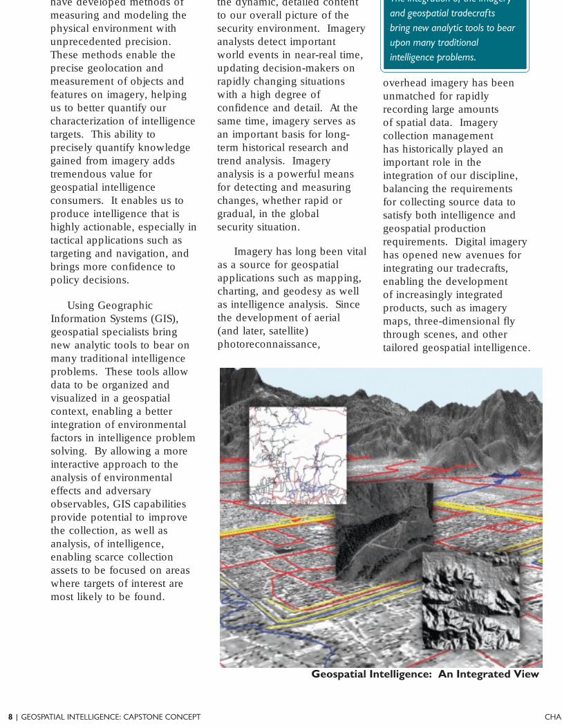
Geospatial Intelligence: An Integrated View
The integration of the imageryand geospatial tradecraftsbring new analytic tools to bearupon many traditionalintelligence problems.
CHAPTER GEOSPATIAL INTELLIGENCE: CAPSTONE CONC
As we progress in theintegration of our tools,processes, and products,imagery and geospatialspecialists will discover newways to leverage this bodyof tradecraft to produceintelligence that is moreintuitively understandable,more predictive, and moreactionable for nationalsecurity decision-makers.
The human analyst is ourmost important geospatialintelligence asset. Whilethe technologies of ourdiscipline offer valuable tools,vastly improving our ability toproduce intelligence, theirprimary value is in improvingthe performance of the humananalyst.
The GeospatialIntelligence Analyst
Geospatial IntelligenceSpecialties
Aeronautical AnalystsCartographers
Collection ManagersGeodesists
GeophysicistsGeographers
Geospatial AnalystsHydrographers
Imagery AnalystsImagery Performance Officers
Imagery InterpretersImagery ScientistsMarine AnalystsOceanographers
Regional AnalystsTarget AnalystsTerrain Anaylsts
Topographic Analysts
Criticalthinking istherefore themost essentialelement ofour tradecraft.True analysisgoes beyondthe mereextraction andrepetition ofintelligence
facts from a collectionsource. The geospatialintelligence analystunderstands methods ofacquiring data, evaluatingits quality, andsystematically examiningit in light of existingknowledge to reach ameaningful conclusionabout the environment orthe adversary. Thegeospatial intelligenceanalyst performs threebasic functions: anextraction function, usingspecialized skills andknowledge to recognizeinformation of intelligenceinterest, a filteringfunction, shielding theconsumer frominformation overload, anda synthesis function,logically assembling
relevant facts that reasonablylead to a significant conclusion.
The ability to communicategeospatial intelligenceinformation clearly, quickly,and effectively using multiplemedia in multiple dimensionsis a key skill of the geospatialintelligence analyst.Visualization is our preferredmedium for communicatinggeospatial intelligence.Knowledge is most rapidlyabsorbed by the minds of ourconsumers when it transmittedby visual media—whether as ahardcopy map, a digital image,or a three-dimensionalsimulation. However, masteryof the basic skills of clearwriting and effective briefingwill always be essential. It isup to the analyst to choosethe best available means toobjectively and authoritativelycommunicate the intelligencefacts, his or her analyticaljudgments, and any remainingknowledge gaps.
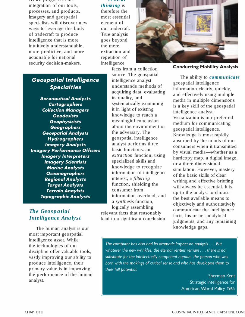
Conducting Mobility Analysis
II
The computer has also had its dramatic impact on analysis . . . Butwhatever the new wrinkles, the eternal verities remain . . . there is nosubstitute for the intellectually competent human—the person who wasborn with the makings of critical sense and who has developed them totheir full potential.
Sherman KentStrategic Intelligence for
American World Policy 1965
10 | GEOSPATIAL INTELLIGENCE: CAPSTONE CONCEPT CHAP
analyst's chiefcommodity is aset of provenmodels andmethods—atradecraft—that can beapplied to anintelligenceproblem. It isthe tradecraft of geospatialintelligence that allows theanalyst to reduce ambiguousor contradictory data to a fewuseful conclusions thatincrease the potential forvictory on a battlefield orreduce uncertainty in a policydecision. These methods areboth quantitative andqualitative, and constitute boththe art and science ofgeospatial intelligence.
Informing StatecraftGeospatial intelligence
provides knowledge nationalleaders need to makeinformed decisions on mattersof national security andforeign affairs. It plays acentral role in identifyingstrategic threats, providingwarnings of war, predictinghumanitarian crises, andverifying internationaltreaty compliance. It enablesnational decision-makers tomonitor crisis situations asthey develop and measure orforecast the effects of foreignpolicy decisions. Geospatialintelligence providesinformation useful in thenegotiation of internationalagreements and in theprotection of U.S. diplomatic
facilities overseas.Geospatial intelligenceincreases confidence inpolicy decisions byreducing uncertainty,risk, and surprise.
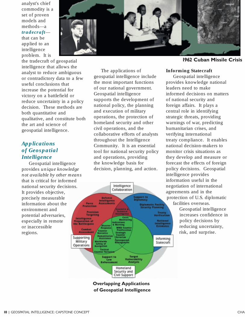
Applicationsof GeospatialIntelligence
Geospatial intelligenceprovides unique knowledgenot available by other meansthat is critical for informednational security decisions.It provides objective,precisely measurableinformation about theenvironment andpotential adversaries,especially in remoteor inaccessibleregions.
The applications ofgeospatial intelligence includethe most important functionsof our national government.Geospatial intelligencesupports the development ofnational policy, the planningand execution of militaryoperations, the protection ofhomeland security and othercivil operations, and thecollaborative efforts of analyststhroughout the IntelligenceCommunity. It is an essentialtool for national security policyand operations, providingthe knowledge basis fordecision, planning, and action.
1962 Cuban Missile Crisis
Overlapping Applicationsof Geospatial Intelligence
CHAPTER GEOSPATIAL INTELLIGENCE: CAPSTONE CONCE
navigation andtargeting systems, itprovides U.S. air, land,and naval forcesimportant tacticaladvantages. Preciseknowledge of thebattlespace in acommon frame ofreference enables thesynchronization of
widely dispersed maneuverforces to achieve a commonobjective. Geospatialintelligence gives warfighters a
critical understanding of anadversary's strategicinfrastructure andvulnerabilities, permittingprecision strikes againststrategic and tactical targets inall weather conditions. Whenstrike missions arecomplete, geospatialintelligence is theprimary means ofbattle damageassessment, enablingcommanders toassess the results andorder re-strikes ifnecessary.
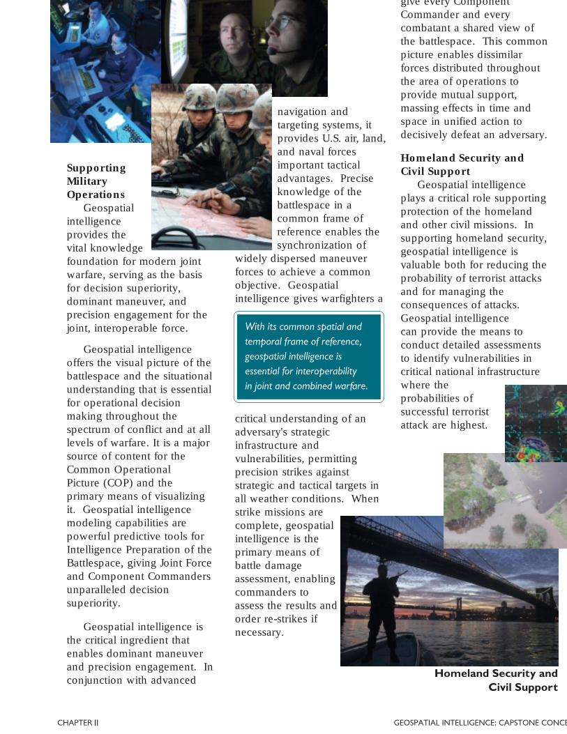
SupportingMilitaryOperations
Geospatialintelligenceprovides thevital knowledgefoundation for modern jointwarfare, serving as the basisfor decision superiority,dominant maneuver, andprecision engagement for thejoint, interoperable force.
Geospatial intelligenceoffers the visual picture of thebattlespace and the situationalunderstanding that is essentialfor operational decisionmaking throughout thespectrum of conflict and at alllevels of warfare. It is a majorsource of content for theCommon OperationalPicture (COP) and theprimary means of visualizingit. Geospatial intelligencemodeling capabilities arepowerful predictive tools forIntelligence Preparation of theBattlespace, giving Joint Forceand Component Commandersunparalleled decisionsuperiority.
give every ComponentCommander and everycombatant a shared view ofthe battlespace. This commonpicture enables dissimilarforces distributed throughoutthe area of operations toprovide mutual support,massing effects in time andspace in unified action todecisively defeat an adversary.
Homeland Security andCivil Support
Geospatial intelligenceplays a critical role supportingprotection of the homelandand other civil missions. Insupporting homeland security,geospatial intelligence isvaluable both for reducing theprobability of terrorist attacksand for managing theconsequences of attacks.Geospatial intelligencecan provide the means toconduct detailed assessmentsto identify vulnerabilities incritical national infrastructurewhere theprobabilities ofsuccessful terroristattack are highest.
Geospatial intelligence isthe critical ingredient thatenables dominant maneuverand precision engagement. Inconjunction with advanced
Homeland Security andCivil Support
II
With its common spatial andtemporal frame of reference,geospatial intelligence isessential for interoperabilityin joint and combined warfare.
12 | GEOSPATIAL INTELLIGENCE: CAPSTONE CONCEPT CHAP
Intelligence CollaborationGeospatial intelligence
supports IntelligenceCommunity analysts,providing imagery, imageryintelligence, geospatialinformation, and geospatialintelligence analysis skillsand techniques to supportthe centralized analysis ofall-source intelligence.Geospatial intelligence is animportant source forscientific and technicalintelligence and basic
NIMA, The Geospatial IntelligenceFunctional Manager
As functional manager for the National System for GeospatialIntelligence (NSGI), NIMA exercises stewardship of our nation’sgeospatial intelligence capability from the national to the tactical level.Through this functional management responsibility, NIMA:
• Acts to identify and advocate NSGI community requirements and
to manage the nation’s geospatial intelligence investments toensure interoperability and collaboration among our partners
and consumers;
• Develops and manages the NSGI technical architecture and guides the community’s researchand development efforts;
• Promotes common standards for imagery and geospatial information systems and providestraining in the tradecraft of geospatial intelligence;
• Develops policy to promote interoperability and protect sensitive geospatial intelligence
sources and analytical techniques; and
• Leads the NSGI in the development of doctrine to guide the employment of geospatialintelligence capabilities and of innovative future concepts to ensure we remain the world
leader in geospatial intelligence.
intelligence provides data andproducts on selected urbanareas of interest, land andmaritime entry and exit points,identification and assessmentof foreign threats, and extentand scope of natural and man-made damage. In cases ofterrorist attack or naturaldisaster, geospatial intelligencecan rapidly give federalagencies and first responders acomprehensive and detailedview of the scene, helpingthem to make the bestpossible decisions inpreparation, response, andrecovery actions. Geospatialintelligence also plays anessential role in a wide range
including drug interdiction,humanitarian relief and aspermitted by law, support tolaw enforcement.
Country Studies and MilitaryCapabilities Studies. It is amajor source of economicintelligence information,providing useful insights intoforeign agricultural andindustrial production.Geospatial intelligence isalso used to support thedevelopment of DefenseIntelligence Assessmentsand National IntelligenceEstimates, which represent theconsensus position of theIntelligence Community onmatters of critical strategicimportance to nationalpolicymakers and planners. ❏
CHAPTER GEOSPATIAL INTELLIGENCE: CAPSTONE CONCE
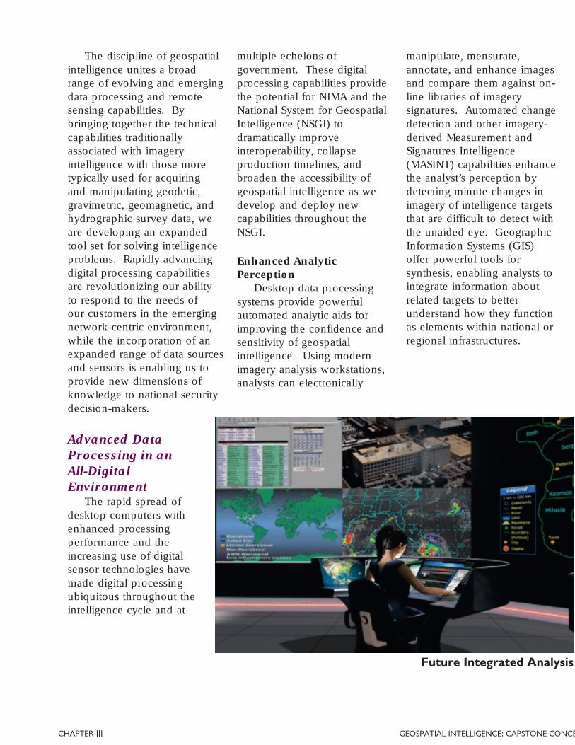
The discipline of geospatialintelligence unites a broadrange of evolving and emergingdata processing and remotesensing capabilities. Bybringing together the technicalcapabilities traditionallyassociated with imageryintelligence with those moretypically used for acquiringand manipulating geodetic,gravimetric, geomagnetic, andhydrographic survey data, weare developing an expandedtool set for solving intelligenceproblems. Rapidly advancingdigital processing capabilitiesare revolutionizing our abilityto respond to the needs ofour customers in the emergingnetwork-centric environment,while the incorporation of anexpanded range of data sourcesand sensors is enabling us toprovide new dimensions ofknowledge to national securitydecision-makers.
Advanced DataProcessing in anAll-DigitalEnvironment
The rapid spread ofdesktop computers withenhanced processingperformance and theincreasing use of digitalsensor technologies havemade digital processingubiquitous throughout theintelligence cycle and at
Enhanced AnalyticPerception
Desktop data processingsystems provide powerfulautomated analytic aids forimproving the confidence andsensitivity of geospatialintelligence. Using modernimagery analysis workstations,analysts can electronically
manipulate, mensurate,annotate, and enhance imagesand compare them against on-line libraries of imagerysignatures. Automated changedetection and other imagery-derived Measurement andSignatures Intelligence(MASINT) capabilities enhancethe analyst’s perception bydetecting minute changes inimagery of intelligence targetsthat are difficult to detect withthe unaided eye. GeographicInformation Systems (GIS)offer powerful tools forsynthesis, enabling analysts tointegrate information aboutrelated targets to betterunderstand how they functionas elements within national orregional infrastructures.
multiple echelons ofgovernment. These digitalprocessing capabilities providethe potential for NIMA and theNational System for GeospatialIntelligence (NSGI) todramatically improveinteroperability, collapseproduction timelines, andbroaden the accessibility ofgeospatial intelligence as wedevelop and deploy newcapabilities throughout theNSGI.
III
Future Integrated Analysis
14 | GEOSPATIAL INTELLIGENCE: CAPSTONE CONCEPT CHAP
Analytic AssetsAdvanced processing
capabilities improve theefficiency of geospatialintelligence operations byautomating simple, manual, orrepetitive production tasks andallowing human analysts tofocus on more complexgeospatial intelligenceproblems. Capabilities such asautomated feature extraction,pattern recognition, automatedchange detection, andautomated search and retrievalhave proven useful inmaximizing the use of valuablehuman analysts. Theseadvanced capabilities offergreat potential to enable thelimited analytic assets of NIMAand the NSGI to better managethe enormous volume of datacollected by our worldwideintelligence collection system.
Managing ComplexCollection Strategies
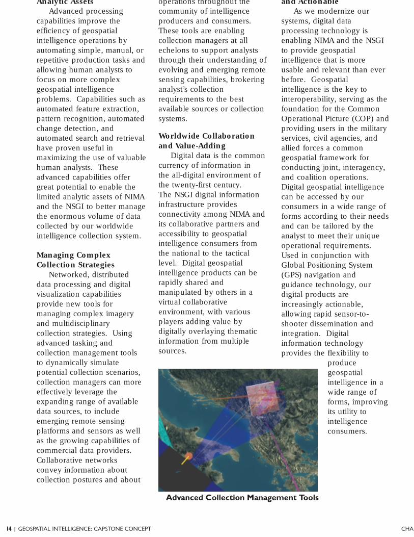
Networked, distributeddata processing and digitalvisualization capabilitiesprovide new tools formanaging complex imageryand multidisciplinarycollection strategies. Usingadvanced tasking andcollection management toolsto dynamically simulatepotential collection scenarios,collection managers can moreeffectively leverage theexpanding range of availabledata sources, to includeemerging remote sensingplatforms and sensors as wellas the growing capabilities ofcommercial data providers.Collaborative networksconvey information aboutcollection postures and about
operations throughout thecommunity of intelligenceproducers and consumers.These tools are enablingcollection managers at allechelons to support analyststhrough their understanding ofevolving and emerging remotesensing capabilities, brokeringanalyst’s collectionrequirements to the bestavailable sources or collectionsystems.
Worldwide Collaborationand Value-Adding
Digital data is the commoncurrency of information inthe all-digital environment ofthe twenty-first century.The NSGI digital informationinfrastructure providesconnectivity among NIMA andits collaborative partners andaccessibility to geospatialintelligence consumers fromthe national to the tacticallevel. Digital geospatialintelligence products can berapidly shared andmanipulated by others in avirtual collaborativeenvironment, with variousplayers adding value bydigitally overlaying thematicinformation from multiplesources.
and ActionableAs we modernize our
systems, digital dataprocessing technology isenabling NIMA and the NSGIto provide geospatialintelligence that is moreusable and relevant than everbefore. Geospatialintelligence is the key tointeroperability, serving as thefoundation for the CommonOperational Picture (COP) andproviding users in the militaryservices, civil agencies, andallied forces a commongeospatial framework forconducting joint, interagency,and coalition operations.Digital geospatial intelligencecan be accessed by ourconsumers in a wide range offorms according to their needsand can be tailored by theanalyst to meet their uniqueoperational requirements.Used in conjunction withGlobal Positioning System(GPS) navigation andguidance technology, ourdigital products areincreasingly actionable,allowing rapid sensor-to-shooter dissemination andintegration. Digitalinformation technologyprovides the flexibility to
producegeospatialintelligence in awide range offorms, improvingits utility tointelligenceconsumers.
Advanced Collection Management Tools
CHAPTER GEOSPATIAL INTELLIGENCE: CAPSTONE CONCE
Remote SensingCapabilities
The discipline of geospatialintelligence unites a broadrange of evolving andemerging remote sensingcapabilities, includingtraditional imagery systems;sources associated withgeodetic, gravimetric,geomagnetic, and hydrographicsurveying; and imagery-derivedMASINT systems. Our ability
to effectively leverage thesecapabilities is growingappreciably as they areintegrated more fully into theNSGI architecture, allowingmore integrated collectionmanagement and data analysis.A growing range of collectionplatforms and sources isimproving our access to targetsand increasing our ability toconduct persistent surveillance,to obtain broad area coverage,and to more effectively employnational collection capabilities.The NSGI leverages allavailable sources, whethergovernment or commercial;space-based, airborne,seagoing, or ground-based.Sensor advances are expandingour use of the electromagneticspectrum and other physicalphenomena, improving ourability to counter denial anddeception measures, toconduct surveillance and trackmoving targets, to preciselymeasure terrain features, andto remotely characterizematerials and substances.
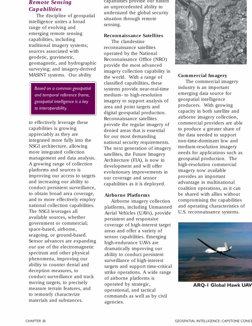
Airborne PlatformsAirborne imagery collection
platforms, including UnmannedAerial Vehicles (UAVs), providepersistent and responsivecoverage of high-interest targetareas and offer a variety ofsensor capabilities. Emerginghigh-endurance UAVs aredramatically improving ourability to conduct persistentsurveillance of high-interesttargets and support time-criticalstrike operations. A wide rangeof airborne platforms isoperated by strategic,operational, and tacticalcommands as well as by civilagencies.
Reconnaissance SatellitesThe clandestine
reconnaissance satellitesoperated by the NationalReconnaissance Office (NRO)provide the most advancedimagery collection capability inthe world. With a range ofclassified capabilities, thesesystems provide near-real-timemedium- to high-resolutionimagery to support analysis ofarea and point targets anddigital geospatial production.Reconnaissance satellitesprovide the regular imagery ofdenied areas that is essentialfor our most demandingnational security requirements.The next generation of imagerysatellites, the Future ImageryArchitecture (FIA), is now indevelopment and will offerevolutionary improvements inour coverage and sensorcapabilities as it is deployed.
Commercial ImageryThe commercial imagery
industry is an importantemerging data source forgeospatial intelligenceproducers. With growingcapacity in both satellite andairborne imagery collection,commercial providers are ableto produce a greater share ofthe data needed to supportnon-time-dominant low andmedium-resolution imageryneeds for applications such asgeospatial production. Thehigh-resolution commercialimagery now availableprovides an importantadvantage in multinationalcoalition operations, as it canbe shared with allies withoutcompromising the capabilitiesand operating characteristics ofU.S. reconnaissance systems.
ARQ-1 Global Hawk UAV
III
Based on a common geospatialand temporal reference frame,geospatial intelligence is a keyto interoperability.
capabilities provide our nationan unprecedented ability tounderstand the global securitysituation through remotesensing.

16 | GEOSPATIAL INTELLIGENCE: CAPSTONE CONCEPT CHAP
Spectral ImageryExpanding our use of the
electromagnetic spectrum, weare dramatically increasing ourability to defeat denial anddeception and understanddevelopments in the nationalsecurity situation.Panchromatic imagery,both electro-optical andfilm-based, has beenthe mainstay forImagery Intelligence(IMINT) for years andcontinues to be ourmost important source.Infrared imageryenables analysts todetect and identifyactivity based onthermal signatures.Multispectral imagery
Active SensingTechnologies
A growing range of activesensing capabilities thatincludes Synthetic ApertureRadar (SAR) and laser imaging
in defeating camouflage,characterizing foliage,assessing crop yields,and analyzing coastal
hydrography.Emerginghyperspectralandultraspectral
imagery capabilitiesprovide new tools,allowing analysts tocharacterize substancesin effluent flows andsmoke plumes,
distinguish between realaircraft and inflatable decoys,identify material properties ofnew weapons systems, anddetect vehicles based on theirunique paint signatures.
Motion ImageryThe emergence of motion
imagery sensors, such as thereal-time video capability ofthe Predator UAV system,has provided a valuablenew tool for persistent
imagery from an enduranceplatform, analysts can monitorhigh-interest activities in themission space, to includetracking moving, fleeting, andemerging targets andobservance of rapidlydeveloping events as theyoccur. Motion imageryprovides increased resolutionin the time domain, offeringcombatant commanders andcivil authorities a level ofsituational understanding ofdynamic events that farsurpasses what is possible withsingle-frame imagery.
UAV Motion Imagery
LIDAR Image of World Trade CenteDebris Field
Imagery-Derived
MASINT
systems serves as a powerfulcomplement to spectral imagery.SAR is useful in countering denialand deception and essential forimaging in weather and lightingconditions that prohibit opticalcollection. SAR can also be usedto provide a Moving TargetIndicator capability for thedetection and tracking of mobile
CHAPTER GEOSPATIAL INTELLIGENCE: CAPSTONE CONCE
technologies like LightDetection and Ranging(LIDAR) and InterferometricSAR (IFSAR), integrated intoairborne or space-basedplatforms, enable us tocharacterize the Earth's surfaceelevation and hydrographywith unprecedented speedand precision. AirborneLIDAR is increasinglysupplanting the Navy'soceangoing research vessels,increasing by orders ofmagnitude our ability to collectprecise hydrographic surveydata over large areas. LIDARand IFSAR systems have madepossible the production ofhigh-resolution digitalelevation data on a large scale.Such data can be used togenerate highly detailed,accurate three-dimensionalmodels of structures andterrain for detailed operationalplanning and missionrehearsal.
III
to be precisely positionedanywhere on the globe. Thesegeophysical sensingcapabilities provide newdimensions of knowledgeabout the mission space,enabling production of tailoredgeospatial intelligence to giveU.S. policymakers, warfighters,and civil agencies a uniqueinformation advantage. ❏
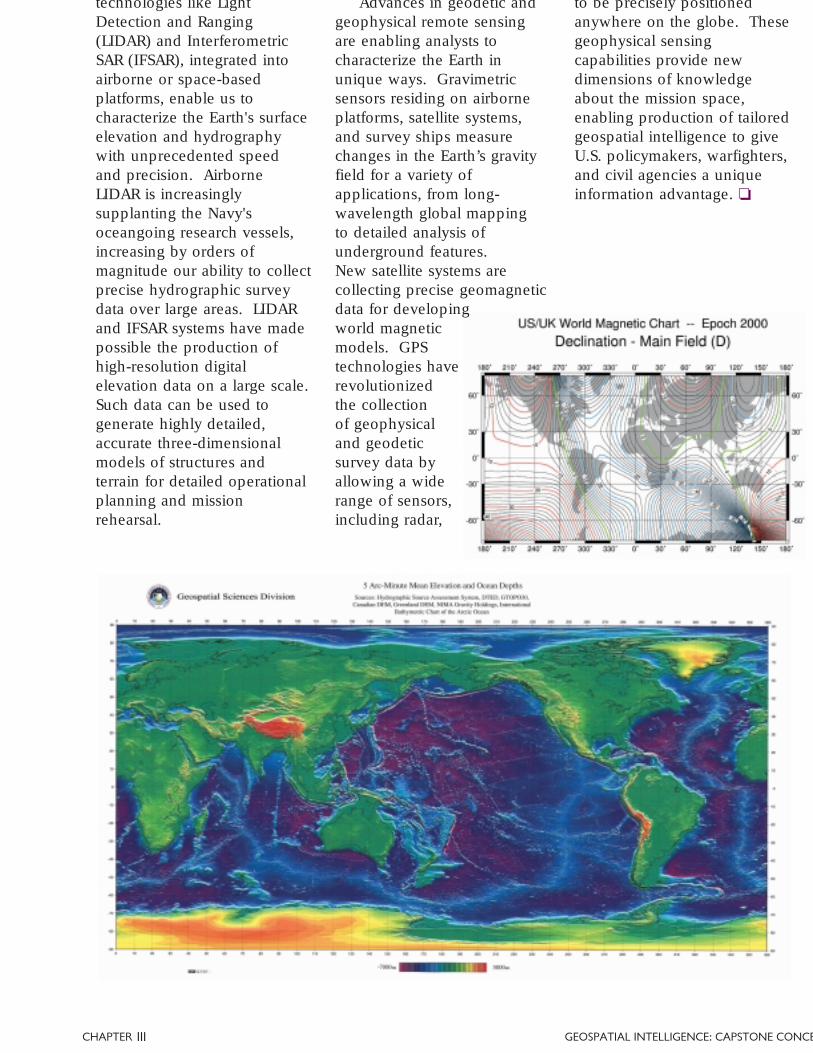
Advances in geodetic andgeophysical remote sensingare enabling analysts tocharacterize the Earth inunique ways. Gravimetricsensors residing on airborneplatforms, satellite systems,and survey ships measurechanges in the Earth’s gravityfield for a variety ofapplications, from long-wavelength global mappingto detailed analysis ofunderground features.New satellite systems arecollecting precise geomagneticdata for developingworld magneticmodels. GPStechnologies haverevolutionizedthe collectionof geophysicaland geodeticsurvey data byallowing a widerange of sensors,including radar,
18 | GEOSPATIAL INTELLIGENCE: CAPSTONE CONCEPT CHAP
Collaborative SourceData Collection andDistribution
A key concept for rapid,multi-source integration isto conduct collaborationand information sharingamong intelligence producersas far upstream in theintelligence cycle as possible.Collaboration in the collectionand distribution of source datashortens the collectionstovepipes, allowing earlyinformation sharing andconcurrent processing andanalysis of data by intelligenceproducers in multipledisciplines and at multipleechelons.
Breaking theStovepipes
The emergence ofgeospatial intelligence as acohesive, integrated disciplinehas fundamentally altered theway imagery and geospatialspecialists contribute to theoverall mission of theIntelligence Community.The series of consolidationsthat ultimately resulted inthe establishment of NIMA in1996 provided the communitya center of excellence for theimagery and geospatialtradecrafts and an environmentconducive to the developmentof innovative new concepts.Geospatial intelligence isemerging as a better, strongerpartner among the intelligencedisciplines, speaking with onevoice and equipped to play amore substantial role insolving the problems facingthe Intelligence Community.
The major challenge forthe Intelligence Communitytoday is to provide information
With respect to collaboration and fusion of the various collection disciplines, or INTs, the Commissionbelieves that NIMA should hold a premier place because it ‘owns’ the geospatial construct. NIMAprovides the logical context for fusion of Signals Intelligence (SIGINT), especially ElectronicIntelligence (ELINT), with imagery.
Report of the IndependentCommission on NIMA
superiority for an expandedbase of operational usersagainst adversaries who aregrowing increasinglysophisticated in their ownintelligence and denial anddeception capabilities.Overcoming this challengerequires us to break someof the barriers to informationsharing—the stovepipes—thatlimit interoperability andcooperation among theintelligence disciplines. Itmeans more closely integratingmultiple data streams,leveraging all of our collectionand production capabilities,while simultaneouslyaccelerating cycle times forproducing usable, finishedintelligence.
Geospatial intelligenceoffers great promise to facilitateunprecedented collaborationand rapid fusion of informationfrom multiple intelligencesources and producers in theemerging all-digitalenvironment. Building on the
long-established precedent ofmaps and charts as a basis forintelligence fusion, geospatialintelligence provides newapproaches for multidisciplinarycollaboration, both in thecollection and distribution ofintelligence source data and inthe analysis and production offused, finished intelligence.
CHAPTER GEOSPATIAL INTELLIGENCE: CAPSTONE CONCE
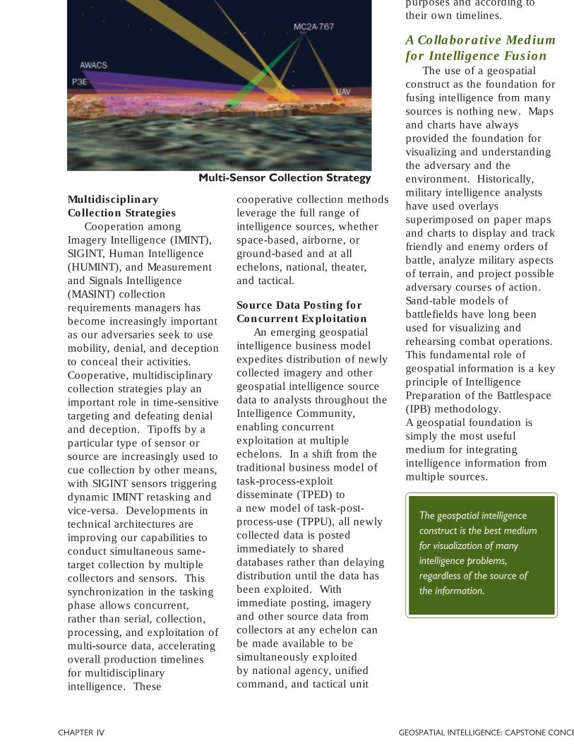
MultidisciplinaryCollection Strategies
Cooperation amongImagery Intelligence (IMINT),SIGINT, Human Intelligence(HUMINT), and Measurementand Signals Intelligence(MASINT) collectionrequirements managers hasbecome increasingly importantas our adversaries seek to usemobility, denial, and deceptionto conceal their activities.Cooperative, multidisciplinarycollection strategies play animportant role in time-sensitivetargeting and defeating denialand deception. Tipoffs by aparticular type of sensor orsource are increasingly used tocue collection by other means,with SIGINT sensors triggeringdynamic IMINT retasking andvice-versa. Developments intechnical architectures areimproving our capabilities toconduct simultaneous same-target collection by multiplecollectors and sensors. Thissynchronization in the taskingphase allows concurrent,rather than serial, collection,processing, and exploitation ofmulti-source data, acceleratingoverall production timelinesfor multidisciplinaryintelligence. These
Source Data Posting forConcurrent Exploitation
An emerging geospatialintelligence business modelexpedites distribution of newlycollected imagery and othergeospatial intelligence sourcedata to analysts throughout theIntelligence Community,enabling concurrentexploitation at multipleechelons. In a shift from thetraditional business model oftask-process-exploitdisseminate (TPED) toa new model of task-post-process-use (TPPU), all newlycollected data is postedimmediately to shareddatabases rather than delayingdistribution until the data hasbeen exploited. Withimmediate posting, imageryand other source data fromcollectors at any echelon canbe made available to besimultaneously exploitedby national agency, unifiedcommand, and tactical unit
A Collaborative Mediumfor Intelligence Fusion
The use of a geospatialconstruct as the foundation forfusing intelligence from manysources is nothing new. Mapsand charts have alwaysprovided the foundation forvisualizing and understandingthe adversary and theenvironment. Historically,military intelligence analystshave used overlayssuperimposed on paper mapsand charts to display and trackfriendly and enemy orders ofbattle, analyze military aspectsof terrain, and project possibleadversary courses of action.Sand-table models ofbattlefields have long beenused for visualizing andrehearsing combat operations.This fundamental role ofgeospatial information is a keyprinciple of IntelligencePreparation of the Battlespace(IPB) methodology.A geospatial foundation issimply the most usefulmedium for integratingintelligence information frommultiple sources.
cooperative collection methodsleverage the full range ofintelligence sources, whetherspace-based, airborne, orground-based and at allechelons, national, theater,and tactical.
Multi-Sensor Collection Strategy
The geospatial intelligenceconstruct is the best mediumfor visualization of manyintelligence problems,regardless of the source ofthe information.
IV
purposes and according totheir own timelines.
20 | GEOSPATIAL INTELLIGENCE: CAPSTONE CONCEPT CHAP
Digital technologies havedramatically increased thecollaborative power ofgeospatial intelligence in twoimportant ways. First, theyhave restored the geospatialspecialist as a collaborativepartner in multidisciplinaryintelligence production.Because maps and charts havehistorically been produced inmass quantities as finishedgoods, the role of themapmakers and chart makersin the overall intelligenceeffort has been easilyoverlooked. Near-real-timedigital remote sensing andnetworked data processingsystems are changing that,enabling geospatial specialiststo be fully engaged ascollaborative partners in thefusion process.
Second, these technologieshave enabled the emergenceof digital geospatialinformation as a powerfulcollaborative medium. Theevolution from paper mapsand intelligence reports tonetworked digitalinformation systemsmakes it possiblefor intelligenceanalysts andcollectors ingeographicallydispersedlocations tocollaborate invirtualnetworks,overlayingmultiplelayers of
MultidisciplinaryAnalyst Teams
Increasingly, we are relyingupon multidisciplinary teamsof intelligence analysts to solvehard intelligence problems,defeat denial and deception,and track and fix mobiletargets. Multidisciplinary cellsof imagery analysts andcryptologists, for example,have been particularlysuccessful, and partnershipsamong other disciplines aregrowing. By bringingtogether specialists frommultiple disciplines, alongwith their unique tradecrafts
and toolsets, in an interactiveenvironment, we are betterable to apply the full range ofour intelligence capabilities.Multidisciplinary intelligenceteams have made great
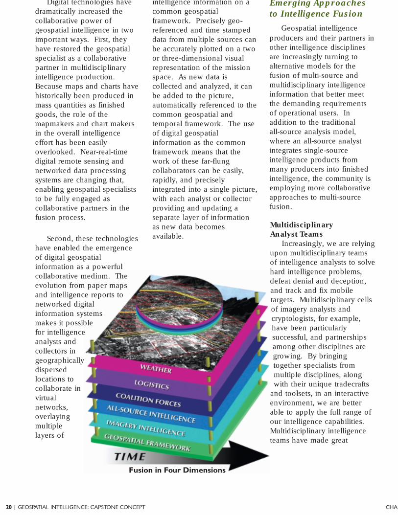
intelligence information on acommon geospatialframework. Precisely geo-referenced and time stampeddata from multiple sources canbe accurately plotted on a twoor three-dimensional visualrepresentation of the missionspace. As new data iscollected and analyzed, it canbe added to the picture,automatically referenced to thecommon geospatial andtemporal framework. The useof digital geospatialinformation as the commonframework means that thework of these far-flungcollaborators can be easily,rapidly, and preciselyintegrated into a single picture,with each analyst or collectorproviding and updating aseparate layer of informationas new data becomesavailable.
Fusion in Four Dimensions
Emerging Approachesto Intelligence Fusion
Geospatial intelligenceproducers and their partners inother intelligence disciplinesare increasingly turning toalternative models for thefusion of multi-source andmultidisciplinary intelligenceinformation that better meetthe demanding requirementsof operational users. Inaddition to the traditionalall-source analysis model,where an all-source analystintegrates single-sourceintelligence products frommany producers into finishedintelligence, the community isemploying more collaborativeapproaches to multi-sourcefusion.
CHAPTER GEOSPATIAL INTELLIGENCE: CAPSTONE CONCE
Fused GeospatialIntelligence
Information from multiplesources can also be integratedinto fused, finished geospatialintelligence products. WhileIMINT has traditionally beenour primary data source, othercollection disciplines provideessential information about themission space not otherwiseavailable. Informationobtained from HUMINTsources, such as architecturaldrawings, or SIGINT sources,such as the location of radar orcommunications emitters, adds
progress in reducing theintelligence production cycletimes typically associated withthe traditional, serial all-sourceanalysis model by workingconcurrently to produce anintegrated product fromthe start.
Through thesecollaborative multidisciplinaryapproaches, geospatialintelligence producers areplaying a much moresignificant role in theIntelligence Community.
IV
tremendous value to our ownsource data when fused in thedigital, visual medium ofgeospatial intelligence.Geospatial intelligencetradecraft and tools haveproven valuable in the analysisof information obtained fromthese collateral sources,providing unique insight intospatial aspects of the data.When fused into finishedgeospatial intelligence, thesesources add importantdimensions to analysis of themission space, resulting in amore complete picture forintelligence consumers.
Leveraging our commongeospatial and temporalframework as a collaborativemedium, engaging ourpartners interactively, andtaking advantage of digitalnetworks and tools, we aremaking tremendous progressin accelerating the speed ofmulti-disciplinary intelligence.Multidisciplinary intelligencecollaboration brings to bearthe full capability of theIntelligence Community toreduce uncertainty, compressour intelligence cycletimelines, and provideunprecedented knowledgeof the global securityenvironment. ❏
22 | GEOSPATIAL INTELLIGENCE: CAPSTONE CONCEPT CHAP
We must transform our intelligence capabilities and build new ones to keep pace with the nature of thethreats. Intelligence must be appropriately integrated with our defense and law enforcement systemsand coordinated with our allies and friends. We need to protect the capabilities we have so that we donot arm our enemies with the knowledge of how best to surprise us.
National Security Strategy
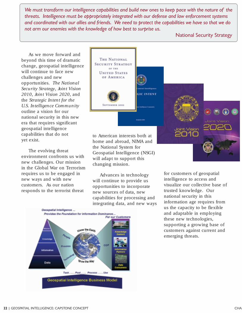
As we move forward andbeyond this time of dramaticchange, geospatial intelligencewill continue to face newchallenges and newopportunities. The NationalSecurity Strategy, Joint Vision2010, Joint Vision 2020, andthe Strategic Intent for theU.S. Intelligence Communityoutline a vision for ournational security in this newera that requires significantgeospatial intelligencecapabilities that do notyet exist.
The evolving threatenvironment confronts us withnew challenges. Our missionin the Global War on Terrorismrequires us to be engaged innew ways and with newcustomers. As our nationresponds to the terrorist threat
Advances in technologywill continue to provide usopportunities to incorporatenew sources of data, newcapabilities for processing andintegrating data, and new ways
to American interests both athome and abroad, NIMA andthe National System forGeospatial Intelligence (NSGI)will adapt to support thischanging mission.
for customers of geospatialintelligence to access andvisualize our collective base oftrusted knowledge. Ournational security in thisinformation age requires fromus the capacity to be flexibleand adaptable in employingthese new technologies,supporting a growing base ofcustomers against current andemerging threats.
CHAPTER GEOSPATIAL INTELLIGENCE: CAPSTONE CONCE
Geospatial IntelligenceOnline
Fully realizing the vision ofNIMA’s founders—a seamlessintegration of our imagery andgeospatial capabilities from thenational to the tactical levels—requires us to complete thetransformation that began withNIMA’s creation.
This transformation iscomprehensive, affecting everyaspect of NIMA and the NSGI.Its objective is a future statethat will enable us toguarantee informationsuperiority for our nationalsecurity in the digital age. Inthat state, we will beincreasingly interoperable andadaptable, responding morerapidly to changing worldconditions. We will makecapabilities that today seemexotic more widely available,less expensive, and moretimely. This future state isdefined by four characteristics:
• Geospatial IntelligenceAnalysis. We will fullyintegrate the processes,products, and tools ofimagery analysts andgeospatial specialists,while maintaining theadvanced capabilitiesof each specialty. Thecomplete integrationof our discipline willenable us to apply ourtradecraft to provide morepredictive analysis andplace more emphasison decision supportintelligence.
Environment. We willmigrate our processes,systems, and tools to anall-digital, data-centricenvironment, beginningwith significantimprovements to ourinfrastructure. Ournetworks, systems,applications, and databasesmust be integrated so thatthe needed content canbe quickly retrieved anddelivered electronically.Migration to this integrateddigital environment will bethe key to futurecollaboration andinteroperability, providingaccessibility to users andpartners worldwide,facilitating dynamicupdates to our knowledgebase, and acceleratingour processes.
• A Seamless,ComprehensiveE-Business Strategy.We will embracecomprehensive e-business
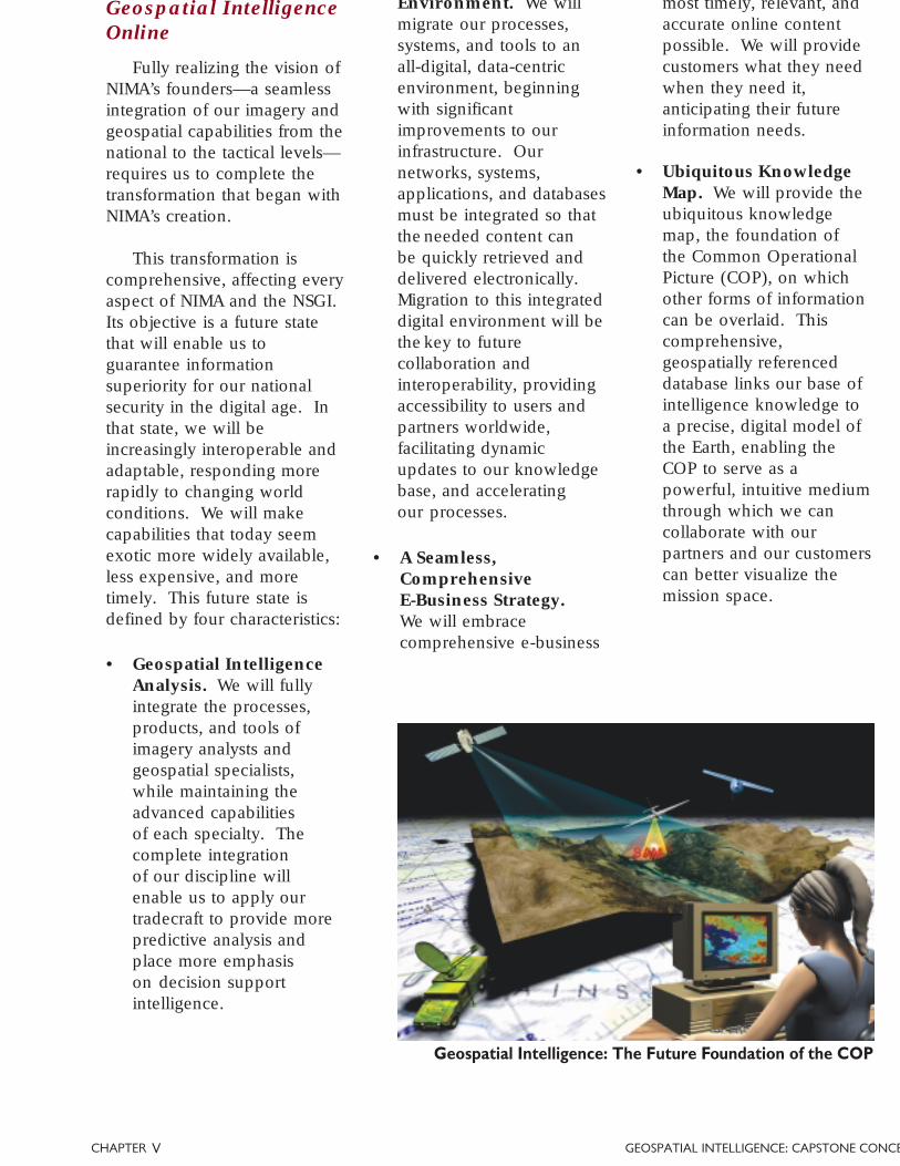
• Ubiquitous KnowledgeMap. We will provide theubiquitous knowledgemap, the foundation ofthe Common OperationalPicture (COP), on whichother forms of informationcan be overlaid. Thiscomprehensive,geospatially referenceddatabase links our base ofintelligence knowledge toa precise, digital model ofthe Earth, enabling theCOP to serve as apowerful, intuitive mediumthrough which we cancollaborate with ourpartners and our customerscan better visualize themission space.
Geospatial Intelligence: The Future Foundation of the COP
most timely, relevant, andaccurate online contentpossible. We will providecustomers what they needwhen they need it,anticipating their futureinformation needs.
V
24 | GEOSPATIAL INTELLIGENCE: CAPSTONE CONCEPT CHAP
The convergence of ournation’s imagery andgeospatial capabilities is animperative of the currentera, made necessary by thechallenges of the changingnational security environmentand the emerging concepts ofwarfare, and made possible bythe revolution in informationtechnology. The demandsof the current globalenvironment require a robustability to provide a growingset of intelligence consumers afully integrated visual pictureof the security situation.
Geospatial intelligence is aunique intelligence discipline,defined by its analyticalmethods and its fundamentalspatial and temporal nature.It unifies our imagery andgeospatial tradecrafts,capitalizing on our abilitiesboth to precisely model theEarth and to obtain detailedand dynamic understandingof world events throughremote sensing. Throughgreater interaction between theimagery and geospatialspecialties, enabled byincreasingly commonprocesses and tools and a newemphasis on integrated teams,we are expanding ourtradecraft beyond oldboundaries to help our
of understanding.
Our integrated disciplineunites a broad range ofevolving and emerginginformation processing andremote sensing capabilities,providing a comprehensive setof tools for characterizing thesecurity situation. Thisconvergence enables us toleverage an expanded set ofpowerful analytical tools,bringing together capabilitiessuch as the power ofGeographic InformationSystems for organizing andaccessing information and theenhanced perception madepossible by Measurement andSignals Intelligence processingtechniques. We are able tointegrate a growing range ofdata sources, includingnational, theater, tactical, andcommercial data providers,expanding both our access totargets and our use of theelectromagnetic spectrum andother physical phenomena toprovide new dimensions ofknowledge about the nationalsecurity situation.
The emergence ofgeospatial intelligence hasgiven new significance to therole of our discipline in theIntelligence Community,offering promise as thefoundation for
collaboration in this new all-digital environment. As arobust partner to ourcounterparts in the community,we are working to break thestovepipes that limitcollaboration and informationsharing, both among thedisciplines and across multipleechelons. Geospatialintelligence revitalizes the longhistory of maps and charts asthe critical tools of theintelligence trade, providing apowerful medium that enablesfaster, more responsiveprocesses for multidisciplinaryintelligence fusion.
We will continue to work tofulfill the vision of NIMA’sfounders as we build the futureNational System for GeospatialIntelligence architecture,translating concepts intocapabilities. Our goal is afuture state that providesgeospatial intelligence online,taking advantage of the fullpotential of our geospatialintelligence tradecrafts,leveraging an all-digitalinfrastructure, harnessing thebest practices of e-business,and using the visual power ofthe evolving COP to provideour customers the knowledgeadvantage for decision,planning, and action. ❏

CHAPTER GEOSPATIAL INTELLIGENCE: CAPSTONE CONCE
26 | GEOSPATIAL INTELLIGENCE: CAPSTONE CONCEPT CHAP
Official References
National Security Strategy of the United States of America, 2002
National Strategy for Homeland Security, 2002
Quadrennial Defense Review Report, 2001
Director of Central Intelligence Strategic Intent for the United States Intelligence Community, March 1999
Joint Vision 2010
Joint Vision 2020, June 2000
Joint Publication 2-0, Doctrine for Intelligence Support to Joint Operations, March 2000
Joint Publication 2-01, Joint Intelligence Support to Military Operations, November 1996
Joint Publication 2-01.1, JTTP for Intelligence Support to Targeting, April 2002
Joint Publication 2-01.3, JTTP for Joint Intelligence Preparation of the Battlespace, March 2000
Joint Publication 2-02, National Intelligence Support to Joint Operations, September 1998
Joint Publication 2-03, JTTP for Geospatial Information and Services Support to Joint Operations
Joint Publication 6-0, Doctrine for Command, Control, Computer, and Communications Support toJoint Operations, May 1995
United States Imagery and Geospatial Information Service (USIGS) Glossary
NIMA Statement of Strategic Intent, January 2002
The Information Edge: Imagery Intelligence and Geospatial Information in an Evolving National SecurityEnvironment, Report of the Independent Commission on the National Imagery and Mapping Agency,December 2000
Transforming NIMA Through People, Process and Technology, NETIPT Final Report, September 2002
United States Imagery and Geospatial Information Service (USIGS) CONOPS, December 2000
Multi-INT CONOPS (Draft)
USIGS Geospatial Transformation Plan, August 2001
Unofficial References
Best Truth: Intelligence in the Information Age, Bruce D. Berkowitz and Allan E. Goodman, 2000
The Craft of Intelligence, Allen Dulles, 1963
Strategic Intelligence for American World Policy, Sherman Kent, 1965