birmingham development plan 2031 infrastructure delivery plan
TRANSCRIPT

Birmingham
Development Plan 2031
Infrastructure Delivery Plan
June 2014

1
Contents Acronyms Page 1.0 Introduction 1.1 Purpose of the IDP 5 1.2 Aims of the IDP 6 1.3 Links to Community Infrastructure Levy 6 1.4 National Infrastructure Plan, 2011- A New Strategy 7 1.5 National Planning Policy Framework, 2012 8 1.6 Definition of ‘Infrastructure’ 8 1.7 Methodology 10 1.8 Scale of growth 11 2.0 City-wide infrastructure issues Environment and sustainability 16
- Flood risk management - Water and waste water disposal - Electricity distribution and transmission - Gas distribution and transmission - Waste - Biodiversity and geodiversity - Smart energy - Green infrastructure and climate change adaptation - Heritage assets - Minerals
Homes and neighbourhoods 36
- Early years education and childcare - Mainstream and special school provision - Further/ higher education and local employment initiatives - Housing - Healthcare facilities - Emergency services - Sport, leisure and community facilities
Economy and network of centres 55
- Employment land - Network of centres

2
Connectivity 59
- Strategic and local highway network - Rail services - Rapid transit and local bus network - Walking and cycling - Digital connectivity
3.0 Infrastructure issues relating to the Growth Areas and 75
wider infrastructure requirements 4.0 Delivery of infrastructure 4.1 Partners 84 4.2 Funding 87 4.3 Planning mechanisms for growth and the delivery of 90
infrastructure 4.4 Monitoring and review 90 APPENDICES Appendix 1- Infrastructure Delivery Plan Schedule

3
Acronyms AAP Area Action Plan AD Anaerobic Digester AEP Annual Exceedance Probability BCC Birmingham City Council BCR Birmingham Cycle Revolution BDEC Birmingham District Energy Company BDP Birmingham Development Plan BID Business Improvement District BMAP Birmingham Mobility Action Plan BMHT Birmingham Municipal Housing Trust CFMP Catchment Flood Management Plans CCGs Clinical Commissioning Groups CHP Combined Heat and Power CIL Community Infrastructure Levy CP Control Period DCLG Department for Communities and Local Government DDA Disability Discrimination Act DfE Department for Education DfT Department for Transport EA Environment Agency EFA Education Funding Agency EfW Energy from Waste EH English Heritage ERDF European Regional Development Funding EZ Enterprise Zone FTTP Fibre To The Premises GBSLEP Greater Birmingham and Solihull Local Enterprise Partnership GBSLTB Greater Birmingham & Solihull Local Transport Board GI Green Infrastructure GIA Green Infrastructure and Adaptation GPF Growing Places Fund HCA Homes and Communities Agency HA Highways Agency HIL Highway Improvement Line HLF Heritage Lottery Fund HS2 High Speed 2 H&WB Health and Well-Being IDACI Income Deprivation Affecting Children Index IDP Infrastructure Delivery Plan JSNA Joint Strategic Needs Assessment LDO Local Development Order LEP Local Enterprise Partnership LIF Local Infrastructure Fund LPA Local Planning Authority LSTF Local Sustainable Transport Fund LTB Local Transport Board LTPP Long Term Planning Process LTP Local Transport Plan NDP Neighbourhood Development Plan NEET Not in Education, Employment or Training NHB New Homes Bonus NIA Nature Improvement Area NPPF National Planning Policy Framework

4
PDCS Preliminary Draft Charging Schedule PRISM Policy Responsive and Integrated Strategic Model PVI Private, Voluntary and Independent RGF Regional Growth Fund RIS Regional Investment Site SDP Site Delivery Plan SEP Strategic Economic Plan SFRA Strategic Flood Risk Assessment SHN Strategic Highway Network SINC Site of Importance for Nature Conservation SLINC Site of Local Importance for Nature Conservation SOA Super Output Area SPD Supplementary Planning Document SQPS Statutory Quality Partnership Scheme STW Severn Trent Water SUE Sustainable Urban Extension TCM Town Centre Manager TEED Tyseley Environmental Enterprise District TIF Tax Increment Financing TRO Traffic Regulation Order TWA Transport and Works Act WCML West Coast Main Line WRMP Water Resource Management Plan

5
1.0 Introduction 1.1 Purpose of the Infrastructure Delivery Plan 1.1.1 This Infrastructure Delivery Plan (IDP) forms a key part of the evidence base
for the Birmingham Development Plan (BDP). Whilst the BDP sets out the spatial planning framework for the city up to 2031, the IDP identifies the key infrastructure projects necessary to support the City's growth aspirations. The document has been produced in consultation with officers at the City Council, statutory consultees and external stakeholders and organisations.
1.1.2 The BDP sets out ambitious proposals for the growth of the City, including
51,100 new homes, 350,00 sqm gross of comparison retail floorspace (by 2026), a minimum of 745,000 sqm gross of office floorspace and a minimum reservoir of employment land covering 96 hectares. Birmingham’s population is expected to increase significantly over the plan period, and this level of development is therefore necessary to support population forecasts. The IDP seeks to demonstrate that there are no major infrastructure constraints on delivering this level of growth. Delivering these proposals will require appropriate supporting infrastructure to be put in place, including transport, open space, schools, utilities and health and leisure services.
1.1.3 The National Planning Policy Framework (NPPF) places significant emphasis
on the delivery of policies and proposals within Development Plans and that LPAs should submit a Development Plan which it considers sound, namely that it is positively prepared, justified, effective and consistent with national policy. To be effective, the Development Plan should be deliverable over its period and based on effective joint working on cross-boundary strategic priorities (NPPF, para 182). The BDP proposes a significant level of growth and the necessary infrastructure to support development has been clearly identified to ensure that sustainable development is achieved.
1.1.4 The IDP relates to the Site Delivery Plan that has also been prepared, which
demonstrates that the overall spatial strategy set out in the BDP is deliverable, with a focus on the Growth Areas and other key development sites. The IDP has informed the Site Delivery Plan as it identifies infrastructure requirements for specific sites, alongside wider delivery issues including land assembly, accessibility, remediation, the need for demolition and environmental considerations.
1.1.5 This version of the IDP accompanies the submission version of the
Birmingham Development Plan, and is an update of the October 2013 version. This document fully supersedes the 2013 version.
1.1.6 The IDP is a live document, which will be amended over the plan period as
new funding opportunities arise and infrastructure priorities change. The IDP will be reviewed at regular intervals post adoption to reflect these changes.

6
1.2 Aims of the Infrastructure Delivery Plan 1.2.1 The aims of the IDP include:
• assess existing infrastructure capacity and needs in the City in the context of the BDP proposals and identify the lead organisations to deliver and manage infrastructure;
• identify key infrastructure projects to support growth and costs for providing the infrastructure;
• align the implementation of the IDP with the aims and objectives of relevant local strategies/ partnerships; and
• identify if there is any funding gap for the delivery of the infrastructure projects, which justifies the need to adopt a city-wide CIL.
1.2.2 The IDP highlights potential funding sources and ensures that resources are
directed towards the most important schemes which are critical to unlocking and supporting growth. In this respect the IDP will be used to influence the budgets of infrastructure providers.
1.3 Links to Community Infrastructure Levy (CIL) 1.3.1 The IDP will have strong links to the Community Infrastructure Levy (CIL).
The Community Infrastructure Levy Regulations came into force on 6th April 2010, and are intended to secure funding for key infrastructure to support growth.
1.3.2 The CIL is a charge which Local Authorities in England and Wales are
empowered, but not required, to charge on most types of new development in their area. In areas where a CIL is in place, the proceeds will be spent on local and, where necessary, sub regional infrastructure to support new development. Whilst a range of public funding opportunities will be made available over the plan period to help deliver infrastructure, it is anticipated that there will be a funding gap, which justifies the need for a CIL. The CIL will seek to make a contribution towards addressing some of the funding gap, which is particularly important as section 106 agreements will be significantly scaled back in April 2015.
1.3.3 Where chargeable development takes place in an area for which there is a
Town or Parish Council, a proportion of the CIL will pass to that Council (15%). In the absence of these Councils, the charging authority will retain the funds to spend in accordance with the wishes of the local community. Where an adopted Neighbourhood Development Plan (NDP) is in place, the proportion of CIL that will be spent on locally identified priorities is higher (25%). At present, two NDPs are being prepared in Birmingham, which include Balsall Heath and the Jewellery Quarter.
1.3.4 Consultation on the Preliminary Draft Charging Schedule (PDCS) was
undertaken in December 2012 and the City Council will consult again on the revised Draft Charging Schedule in autumn 2014. At this stage, a draft of the CIL Regulation 123 List will be published, which aims to identify the priority
7
infrastructure projects that will benefit from CIL funding. These projects will be based on the infrastructure requirements identified in this document. An Examination in Public (EiP) for CIL will take place in early 2015.
1.3.5 In accordance with the Regulations, Birmingham’s CIL will be implemented
following the adoption of the BDP. The City Council has commissioned GVA to consider the viability of a CIL charge in Birmingham, and charges have been identified for different forms of development (as a cost per square metre).
1.4 National Infrastructure Plan, 2011- A New Strategy 1.4.1 High quality infrastructure is fundamental to achieving economic growth at
both a local and national level, and the importance and need for new and improved infrastructure is highlighted in the Treasury’s National Infrastructure Plan. The Plan was last updated in December 2013, and contains major commitments to improve the UK’s transport and broadband networks as well as steps to attract major new private sector investment. The revised Plan identifies over 640 projects valued at approximately £310 billion to 2015 and beyond, and despite cutbacks to public sector expenditure, central government continues to allocate significant funds to support key infrastructure projects. Many of these projects are critical to unlocking growth and creating employment opportunities, which is especially important given the projected population growth in Birmingham over the plan period.
1.4.2 To date, the National Infrastructure Plan has funded a number of
infrastructure projects in Birmingham, which include:
• The completion of Selly Oak New Road- the road will provide access to a number of key development sites, including the new hospital development and the Sainsbury’s mixed use development, as well as improving access to the A38 Bristol Road Corridor.
• Progression of HS2- environmental impact surveys have been undertaken along the route, alongside refinements to the route design to lessen the impact of HS2. This work is critical to enabling HS2 to progress, which will directly impact on Birmingham with the proposed station at Curzon Street and a maintenance depot in Washwood Heath.
• Growing Places Fund (GPF) - funding has been secured from the GPF, administered by the Greater Birmingham and Solihull Local Enterprise Partnership (GBSLEP), to help bring forward the Regional Investment Site in Aston, which is branded the Advanced Manufacturing Hub. The funding will be used to fund a package of highway improvement works and site acquisitions.
• M6 (junctions 5-8) Smart Motorway Scheme- motorists travelling on the M6 near Birmingham are now benefiting from improved journey times following the launch of the new smart motorways scheme. A ten-mile stretch of the carriageway is now open to hard shoulder running during peak travel times, The scheme is one which has been in the pipeline for several years and witnessed considerable investment to introduce new signage, markings and technologies to facilitate faster travel.

8
1.5 National Planning Policy Framework, 2012 1.5.1 At the heart of the NPPF is the presumption in favour of sustainable
development and for plan-making this means that LPAs should positively seek opportunities to meet the development needs of their area. This includes planning for the social, economic and environmental needs of communities. To ensure that sufficient development opportunities are identified to meet the needs of a growing population, LPAs should work with other authorities and providers to:
• assess the quality and capacity of infrastructure for transport, water supply, wastewater and its treatment, energy (including heat), telecommunications, utilities, waste, health, social care, education, flood risk and coastal change management, and its ability to meet forecast demands; and
• take account of the need for strategic infrastructure including nationally significant infrastructure within their areas (NPPF para 162).
1.6 Definition of ‘infrastructure’ 1.6.1 The Planning Act 2008 provides a wide definition of the infrastructure which
can be funded by the CIL and other sources, including transport, flood defences, schools, hospitals and other health and social care facilities. This definition allows the CIL to be used to fund a broad range of facilities such as play areas, parks and green spaces, cultural and sports facilities and district heating schemes. This gives LPAs flexibility to choose what infrastructure they need to help deliver policies and proposals within adopted Development Plans.
1.6.2 Table 1 highlights different forms of infrastructure provision and potential
delivery partners, but it needs to be noted that this list is not exhaustive. The key infrastructure projects necessary to support growth are identified in the Infrastructure Delivery Plan Schedule at the end of the document.

9
Table 1- Infrastructure Types Type of infrastructure Potential delivery partners
Transport, including airport, strategic and local highway network, High Speed 2, public transport (rail/ bus/ metro), walking and cycling
BCC/ DfT/ Centro/ Network Rail/ public transport operators/ private sector/ Highways Agency / GBSLEP
Energy, including gas, electricity and low or zero carbon energy generation
BCC (Birmingham’s Green Commission)/ Western Power/ private sector / National Grid
Waste management, including collection and disposal and waste as a resource
BCC/ private sector
Digital connectivity, including broadband and wireless connections
Digital Birmingham / BCC/ private sector
Water, including water supply and treatment and drainage and flood risk
BCC/ Environment Agency/ Severn Trent Water/ South Staffordshire Water/ University of Birmingham/ neighbouring local authorities
Minerals BCC/ West Midlands Regional Aggregates Working Party/ private sector
Education, including early years, primary, secondary, special school provision, further education and adult education provision
BCC/ DfE/ Academies/ Free Schools/ Education Funding Agency/ Private, Voluntary and Independent (PVI) early year providers
Health, including GPs, dental surgeries, hospitals and health centres
BCC/ NHS England/ Clinical Commissioning Groups (CCGs)/ Hospital Trusts
Community facilities, including community centres/ libraries and cemeteries and crematoria
BCC/ third sector organisations/ voluntary sector
Culture and leisure, including heritage assets, sport and leisure facilities, museums/ galleries and public art
BCC/ private sector/ English Heritage/ Arts Council/ third sector organisations/ voluntary sector
Emergency services, including police, fire, ambulance and community support
BCC/ West Midlands Police Authority / West Midlands Fire Service/ West Midlands Ambulance Service NHS Foundation Trust
Open space, including parks, public open space, sports pitches, children’s play areas and allotments
BCC/ Sport England/ Natural England
Waterways, including rivers and canals
BCC/ Environment Agency/ Canals and Rivers Trust
Biodiversity, including wildlife sites (SLINCS/ SINCS), local nature reserves and SSSIs
BCC/ Wildlife Trust/ Nature Improvement Area Partnership

10
1.7 Methodology 1.7.1 The IDP has been prepared alongside the BDP, and the key infrastructure
projects to deliver and support growth have been identified. Areas within the City with significant growth potential have been considered when preparing the IDP, including large-scale housing proposals and employment generating uses. Such development will place considerable pressure on existing infrastructure, and projects have been identified which seek to support new development, ensuring it is delivered in the most sustainable way. A wide range of projects have been identified, ranging from new/ improved highways infrastructure and enhanced public transport provision to new/ improved green infrastructure and enhanced sport and leisure facilities. These projects are necessary to delivering social, economic and environmental infrastructure provision as part of new development.
1.7.2 Since the commencement of the BDP (formerly Core Strategy), a number of
formal consultation periods have been undertaken on key documents, namely the ‘Core Strategy Consultation Draft’ (December, 2010), ‘Planning for Birmingham’s Growing Population- Options Consultation’ (October, 2012) and the pre-submission version of BDP (December, 2013). Comments submitted on these documents have informed the IDP and City Council departments have been engaged throughout its preparation. Relevant statutory agencies, external stakeholders and organisations have also been contacted to input into the document, including utility providers. This has ensured that infrastructure projects critical to supporting and sustaining growth over the plan period have been incorporated. The information provided by City Council officers and external organisations have addressed the following issues:
• Is there existing capacity to meet the future growth outlined in the BDP;
• If not, is future capacity identified in the service plans/ programmes of infrastructure providers to address the infrastructure requirements of growth; and
• Where there are gaps arising from this growth, how these can these be addressed.
1.7.3 Section 2 identifies city-wide infrastructure issues based on 4 key themes,
which include ‘environment and sustainability’, ‘homes and neighbourhoods’, ‘economy and network of centres’ and ‘connectivity’. The themes are broken down into topics, including strategic and local highway network, rail services, flood risk management etc. A standard template has been used for this section, which includes the following information:
• Lead agency
• Evidence base
• Background and current issues with provision
• Impact of growth proposals on infrastructure requirements 1.7.4 This approach has enabled existing and future infrastructure provision to be
explored at a city-wide level and how the BDP proposals will impact on infrastructure needs. In addition to this, Section 3 explores infrastructure issues relating to the Growth Areas and the proposed sustainable urban extension and employment land allocation at Sutton Coldfield. These key areas of growth need to be accompanied by the necessary infrastructure to support new development, and this section identifies site specific

11
infrastructure requirements, alongside approximate costs and timescales. Section 3 also summarises city-wide and other local infrastructure projects outside of the Growth Areas.
1.7.5 The IDP Schedule (Appendix 1) lists all of the projects necessary to support
and deliver the growth aspirations in the BDP. It is broken down into a number of sections, including a specific section on the City’s Growth Areas (expanding on Section 3). This is followed by a section which covers city-wide infrastructure requirements, which is sub-divided by infrastructure types (as identified in Section 2). Projects with committed funding sources for all or part of the project or where anticipated funding has been identified are highlighted in green, which is especially important as committed projects provide certainty to developers and potential investors as well as demonstrating the deliverability of BDP proposals.
1.7.6 The Schedule distinguishes between essential and desirable infrastructure
projects, and for the purpose of the IDP the following definitions have been developed and applied:
• Essential- projects that are key to delivering the growth aspirations of the BDP and meeting its objectives for sustainable development.
• Desirable- projects which would support the growth aspirations and sustainability objectives of the BDP and will be delivered should appropriate funding be secured.
1.8 Scale of growth 1.8.1 The City Council is committed to a strategy focused on delivering sustainable
growth and promoting Birmingham in the regional, national and international context.
1.8.2 Over the period to 2031 the BDP proposes the following levels of growth
within Birmingham’s administrative boundary to support its growing population and the ongoing strengthening and diversification of its economy:
• 51,100 additional dwellings;
• Two Regional Investment sites of 20 and 25 hectares and a 80 hectare employment site at Peddimore;
• A minimum reservoir of 96 hectares of land for employment use;
• The creation of approximately 100,000 additional jobs to provide for the City’s growing population and to reduce existing levels of unemployment and worklessness;
• About 350,000 sqm gross of comparison retail floorspace by 2026;
• A minimum of 745,000 sqm gross of office floorspace in the network of centres;
• New waste facilities to increase recycling and disposal capacity and minimise the amount of waste sent directly to landfill; and
• New and expanded school provision where appropriate and new community facilities.
1.8.3 Delivering the City’s growth agenda will require significant development in a
number of Growth Areas (see Figure 1) which will play an important role in providing new homes, jobs and supporting facilities.

12
Figure 1: Growth Areas within the City

13
1.8.4 The focus for growth will primarily be upon re-using existing urban land. The City Centre as the regional centre and key growth point has established itself as the economic engine of the City and wider region and as such is the focus for significant levels of housing, retail and office development. Birmingham has a number of further key locations outside the City Centre where there is significant opportunity for growth, and the City Council will continue to work proactively in these locations with existing landowners, stakeholders and other agencies to bring forward developments. Growth Areas outside the City Centre include:
• Sutton Coldfield;
• Greater Icknield;
• Aston, Newtown and Lozells;
• Bordesley Park;
• Eastern Triangle;
• Selly Oak and South Edgbaston;
• Longbridge;
• Peddimore; and
• Langley Sustainable Urban Extension. 1.8.5 To meet the needs of the growing population and ensure that sufficient high
quality accessible land is available for economic development, the City Council is also proposing the expansion of the urban area through the release of Green Belt land. This will enable the delivery of a planned sustainable urban neighbourhood and a large employment site both located in the northeast of the City’s administrative boundary.
1.8.6 It is imperative that new development is accompanied by the necessary
infrastructure to support growth, which will enable sustainable development to be achieved. Whilst it is difficult to identify all the infrastructure requirements for the plan period, infrastructure projects to enable and support the delivery of growth have been identified, many of which will be delivered in the short-term (within the next 5 years). The City Council will continue to engage with infrastructure providers post adoption of the BDP to ensure that infrastructure projects are progressed, thereby enabling growth and the objectives of the BDP to be realised.
Cross boundary infrastructure issues 1.8.7 Birmingham lies at the heart of the West Midlands Region and there are
important links between the City and adjoining areas, and this has implications for the provision of infrastructure. The following issues have been considered when preparing the IDP:
• The main international gateway to Birmingham is provided by Birmingham Airport, which adjoins the NEC complex in Solihull. The Airport’s runway has recently been extended, which will positively impact on Birmingham’s economy; the capacity of the M42, junction 6, is not raised as an issue in this regard. There are significant opportunities to improve connectivity with the City Centre particularly along the A45 corridor and infrastructure projects have been identified to enhance accessibility along this route.

14
• There is a significant amount of in-commuting to Birmingham from adjoining areas, including South East Staffordshire, Solihull, South Warwickshire, North Worcestershire and the Black Country. Providing high quality and frequent public transport links between these areas and Birmingham is a key priority and this is acknowledged in the IDP.
• There are some important cross-boundary issues between South-West Birmingham and adjoining areas of Bromsgrove District. The former MG Rover car plant at Longbridge is a key example, which straddles the boundary and is the subject of an adopted Area Action Plan prepared jointly by Birmingham City Council and Bromsgrove District Council. Infrastructure projects have been identified, some of which need to be delivered before development can commence.
• The City Council supports the on-going strategy for the regeneration of the Black Country, which lies to the west of Birmingham, as complementary to the City Council’s growth agenda. At a more local level, there are important links between the residential areas of North-West Birmingham and adjoining areas of Sandwell, which fall within a former Housing Market Renewal Area.
• Infrastructure provision in some instances straddles administrative boundaries, which is often the case with healthcare services and community facilities. City Hospital is currently located in Birmingham, but the majority of the site is likely to come forward for redevelopment as part of the Greater Icknield growth area and a new build hospital is proposed in neighbouring Sandwell. The funding arrangements for the new Midland Metropolitan Hospital are currently being considered and the facility will benefit both Sandwell and Birmingham residents.
• The Greater Birmingham and Solihull LEP seeks to drive sustainable private sector growth and job creation across the area and recognises the importance of cross boundary working. The LEP’s City Deal seeks to create a bespoke package of measures to drive economic growth with an emphasis on strong, efficient and sustainable transport infrastructure that connects the wider conurbation. The LEPs Strategic Economic Plan (March 2013) includes a substantial list of infrastructure schemes identified as key to delivering growth within the area.
• The Government is proposing to provide enhanced rail capacity across the country through a new High Speed Rail Network (HS2), which will promote economic growth. The new route would initially link London to Birmingham (Phase 1), then on to Manchester and Leeds. As part of Phase 1, the West Midlands metropolitan area could see 22,000 new jobs, with significant benefits for Birmingham as the route is likely to act as a catalyst for large scale development, particularly in the City Centre.
• There is limited scope for the extraction of minerals in Birmingham, given the built up nature of the area. In terms of primary provision, the City relies on imports from other locations to support economic growth, including Solihull, Walsall, Staffordshire, Warwickshire and Shropshire. However, the City does have a number of secondary aggregate recycling facilities which minimise the amount of construction and demolition waste sent to landfill and these facilities are an important source of aggregate supply. In terms of waste, the City has a number of waste management facilities, including the Tyseley Energy from

15
Waste plant. However, there are no active landfill sites in the City, and as a result, some of its waste is sent to landfill outside of Birmingham’s boundary. Given the reliance on other areas in relation to minerals and waste, partnership working with neighbouring authorities is on-going.
• As part of the Birmingham Development Plan, a Duty to Cooperate Statement (2014) has been produced which outlines the ongoing cross-boundary consultation in relation to a range of issues including housing provision, employment land, minerals and waste and transportation. The Duty to Cooperate paper also outlines the consultation undertaken to resolve any potential issues associated with the Growth Areas. In addition, the West Midlands Cross-LEP Transport Group has developed the “Midlands Connect” Programme, which is mainly focused on developing the strongest possible case for strategic transport investment in the region to support employment and long-term growth.
1.8.8 Cross boundary infrastructure issues are explored in further detail in the
sections that follow.

16
2.0 City-wide infrastructure issues Environment and sustainability Flood risk management Lead Agency • Environment Agency
• Birmingham City Council Evidence Base • Flood and Water Management Act, 2010
• National Planning Policy Framework, 2012
• Trent Catchment Flood Management Plan, 2009
• Birmingham Preliminary Flood Risk Assessment, 2011
• Level 1 Strategic Flood Risk Assessment, 2012
• Level 2 Strategic Flood Risk Assessment, 2012
• Birmingham Surface Water Management Plan (not yet published)
• Humber Basin River Management Plan, 2009 Background and current issues with provision
The Flood and Water Management Act 2010 sets out the responsibilities for managing flood risk. The Environment Agency is responsible for managing the risk of flooding from main rivers and the City Council as Lead Local Flood Authority is responsible for local flood risk management. The City Council as Local Planning Authority also has responsibilities in relation to flood risk and must take account of NPPF policies in relation to flood risk. The Environment Agency set out their strategic approach to managing flood risk in Catchment Flood Management Plans (CFMP), which are strategic planning documents that provide an overview of the main sources of flood risk and how these can be managed in a sustainable framework for the next 50 to 100 years. The main policy action for Birmingham from the CFMP is to ‘take further action to reduce flood risk (now and in the future)’. In accordance with the NPPF, the City Council has prepared a Strategic Flood Risk Assessment (SFRA), which demonstrates that Birmingham is at risk of flooding in a number of existing residential areas as well as a number of proposed development sites. A Sequential Test has been undertaken for key housing and employment sites across the City and the results demonstrate that over 50% of residential and commercial sites are at risk of fluvial or surface water flooding, or they are located within 250 metres of an historic flooding record. Further evidence is presented in the Birmingham Surface Water Management Plan which demonstrates the surface water flood risk posed to Birmingham and highlights 15 local flood risk areas across the City with the most significant surface water flood risk. Alongside this an action plan has been developed highlighting areas for maintenance, further investigation, mitigation and policy changes. The Environment Agency also set out their approach to managing the water environment in River Basin Management Plans which are prepared to meet the requirements of the Water Framework Directive. The Humber River Basin Management Plan outlines the current state of the water environment and what actions will be taken to address the pressures. The Environment Agency aims to work with water companies and local government to assess the implications of housing growth on

17
sewage treatment works discharges and consequently on receiving river water quality. Good development planning needs to consider a number of issues relevant to this Plan, including housing locations, sewage treatment options, initiatives to reduce flow to sewage works, water efficiency measures and the reduction of nutrients from diffuse pollution. Flood defences are in place along some of the rivers and in some places provide protection from flooding up to an annual probability of 1 in 100 Years (1% AEP). The majority of the flood defences only offer a standard of protection of 1 in 50 Year (2% AEP) or less. In addition to the formal defences there are numerous informal defences in private ownership where responsibility for maintenance lies with the riparian owner and the standard of protection and maintenance regimes are unknown. In addition to flood defences to reduce the probability of flooding, flood warnings have been in operation in the Tame catchment for a number of years as a means of reducing the impacts of flooding. Flood Warning is provided on the River Tame, River Cole and the River Rea.
Impact of growth proposals on infrastructure requirements
A number of key development sites within Birmingham are located within flood zones, and flood risk mitigation measures (including flood defence) will need to be incorporated as part of development proposals to enable growth to take place. Furthermore, some development sites will not be viable unless flood defence works are undertaken prior to development. Schemes to address flooding and flood risk have been identified, and such projects are regarded as essential to enable development to take place over the plan period. Funding has been partly identified for these works, which are explained in more detail below. Policies in the BDP (eg. Policy TP6) and the Strategic Flood Risk Assessment aim to steer development away from areas of highest flood risk. However, where this is not possible, mitigation measures will need to be put in place, ensuring that they do not increase flood risk elsewhere and that surface water is managed effectively on site. In many cases it will be possible to link the requirements for development with strategic flood mitigation works. Mitigation of local impacts of specific developments may be managed on site through local measures developed in agreement with the relevant Authority. Work is ongoing to identify measures to mitigate area-wide impacts, the delivery potential of which will be dependent on:
• Phasing of strategic sites.
• The availability of national funding, including Flood Defence Grant in Aid.
• The availability of CIL and other developer contributions. Proposed and necessary works for a number of rivers/ watercourses in the City are highlighted below, which are needed to support and mitigate the effects of new development.

18
River Rea and Tributaries There is a considerable amount of development proposed in the Rea catchment, but currently any improvements to flood risk are done on an ad-hoc basis through the planning process. More than 2,500 properties are at risk in a 1% or 100 year event. The Environment Agency, Birmingham City Council and Severn Trent Water have set up the River Rea Partnership to develop options and explore funding opportunities to reduce flood risk and deliver environmental improvements in the River Rea catchment. Initial work has already begun to identify potential schemes for communities across the River Rea catchment and identify land that may be required for future alleviation works. The results from this study will be used by the EA and the City Council to better inform new development. Areas of particular importance within this catchment include:
• River Rea at the Southern Gateway, Longbridge, Edgbaston, Cotteridge, Stirchley and Digbeth
• Hanging Brook
• Wood Brook
• Stonehouse Brook Hockley Brook There is a considerable amount of development proposed in the Hockley Brook catchment, however, recent modelling of the Hockley Brook (through the Birmingham Surface Water Management Plan) has shown that the channel is an important flood defence asset and contains the 1 in 100 year flow (flood zone 3), thus increasing the availability of developable land adjacent to it. In order to ensure that the development proposed can continue it is essential that the channel is maintained. River Tame at Witton The Perry Barr and Witton Flood Risk Management Scheme stretches from the One Stop Shopping Centre in Perry Barr to Hurricane Business Park near Bromford. There are 1,408 properties potentially at risk of river flooding from the River Tame in the Perry Barr and Witton areas - this includes 774 residential and 634 commercial properties as well as a number of potential development sites. The Perry Barr and Witton Flood Risk Management Scheme is one of four separate projects that take forward the recommendations of the River Tame Flood Risk Management Strategy (published in May 2011), which aims to reduce flood risk to people and properties along the River Tame. Delivering flood risk works in this area will help support the growth aspirations in the adopted Aston, Newtown and Lozells Area Action Plan (AAP). The Environment Agency is proposing to increase upstream storage, repair existing defences and build new defences. This will significantly reduce flood risk in the area for flood events with between a 1 in 100 and 1 in 200 chance (1% - 0.5% annual probability) of occurring in any one year. The scheme within Birmingham includes improving the flood defences along Brookvale Road and Tameside Drive, providing some new defences at Tame Road and Elliot Way, and the removal

19
of structures which currently impede flood flows. River Tame at Bromford The Bromford Flood Risk Management Scheme stretches from Spaghetti Junction to Castle Vale. The current defences in Bromford manage the risk to 2,160 properties, and the proposed scheme will manage the risk of flooding to an additional 1,239 properties. The Environment Agency proposes to improve defences to manage flood risk in Bromford and Castle Vale. These will be built to a 1% annual probability of flooding. This work will improve the viability of a number of development sites currently within flood zones 2 and 3. Detailed design is expected to commence in 2015.

20
Water and waste water disposal
Lead Agency • Severn Trent Water (majority of the City)
• South Staffs Water (north of the City mainly Sutton Coldfield)
Evidence Base • Severn Trent Waters Water Resource Management Plan 2010-2035
• South Staffs Waters Water Resource Management Plan 2010-2035
Background and current issues with provision
It is vital that sufficient water supply and adequate waste water treatment and disposal facilities are provided to cater for the current population and future growth. Severn Trent supply water to the majority of the City, with South Staffs covering parts of north Birmingham, mainly Sutton Coldfield. The Minworth Sewage Treatment works, owned by Severn Trent, deals with waste water from Birmingham and the surrounding area and is one of the largest facilities in the country. The Minworth facility deals with both domestic and industrial discharges, and has undergone significant upgrades since 2005 to reduce impacts on the River Tame. The Water Act 2003 requires water companies to develop and publish Water Resource Management Plans (WRMP) covering a period of 25 years and for these plans to be updated every 5 years. These WRMPs set out how the water company intend to manage water supply and demand. For Severn Trent Water the overall aim of their supply / demand strategy is to achieve and maintain the level of headroom necessary to ensure they can deliver their target levels of service at least cost to customers, whilst minimizing the impact on the environment. They plan to do this in part by reducing leakage and managing the demand for water, and partly by developing new resources. Severn Trent’s long-term strategy seeks to make better use of their existing resources by maximising their sustainable use and further integrating their network. This strategy is aligned with their supply resilience plans and future water supply investments will provide both resilience and supply / demand benefits. South Staffs do not forecast a supply demand deficit within the 25 year plan horizon, therefore major resource development or demand management measures are not required to address a supply shortfall. They aim to reduce demand through encouraging greater usage of meters and reinforcing their activities in the area of water efficiency. They will also continue to maintain leakage at the economic level and continue to focus on their successful energy management programme and maintaining their pumps to the highest efficiency levels in the industry.
Impact of growth proposals on infrastructure requirements
Both companies have been consulted and neither anticipates any major issues preventing the level of growth proposed in the BDP. However, water supply issues will need to be considered on a site by site basis with the developer bearing the costs of improvements to the water supply network where necessary. Policy TP3 Sustainable Construction intends to reduce water demand from new developments by making them more water efficient. Standard meters are fitted on a compulsorily basis to all new properties and both companies require meters to be installed when there is a change of occupier. Both companies undertake regular activities to increase awareness of water efficiency reducing demand.

21
In terms of waste water the existing Minworth Sewage Treatment works has adequate capacity to deal with future growth, however, Severn Trent has identified the potential loss of Frankley treatment works as a possible issue. Severn Trent’s Birmingham resilience strategy includes a new Edgbaston groundwater source and two new aquifer storage and recovery schemes to provide resilience cover for the potential loss of Frankley treatment works. These schemes will also provide an increase in deployable output once they are operational.

22
Electricity distribution and transmission
Lead Agency • National Grid
• Western Power Distribution
Evidence Base
• National Grid 10 year statement on proposed enhancements to electricity transmission network, 2012
• Western Power West Midlands Distribution Generation Constraint Map, 2013
Background and current issues with provision
Ensuring that Birmingham has sufficient energy capacity to support its growth is essential. The National Grid is responsible for the transmission of electricity across the country, with Western Power Distribution being responsible for the local distribution network in Birmingham and throughout the Midlands, South West and South Wales. Electricity is transported across the country through the National Grid at 275,000 or 400,000 volts. It is reduced to 132,000 volts for regional distribution at substations known as Grid Supply Points. From there it distributed to further substations via overhead lines or underground cables at 132,000 volts. The voltage is reduced again to 33,000 volts and subsequently to 11,000 volts. The distribution network then carries electricity to cities, towns and villages where distribution substations transform the voltage to 230 volts. The 132,000 volt underground cable between the Grid Supply Point at Nechells and the substation at Erdington has been identified as being constrained by the potential for Thermal Overload and may require reinforcement.
Impact of growth proposals on infrastructure requirements
Policies TP1, TP3 and TP4 aim to reduce the City’s carbon footprint, promote sustainable construction and promote low and zero carbon energy generation. Together these policies will help to reduce energy demand and lower pressure on the electricity distribution and transmission networks. Both Western Power Distribution and the National Grid have indicated that existing electricity distribution and transmission networks could cope with the scale of growth proposed in the BDP. Consequently, neither has any planned works to increase provision within Birmingham. Where new development is proposed, connection to appropriate utilities would be the responsibility of the developer. Western Power Distribution has indicated that there may be the need for additional provision in Eastside, although this is dependent on the impact of the proposed HS2 station on other development proposals for the area. This will be monitored as proposals progress.

23
Gas distribution and transmission
Lead Agency • National Grid
Evidence Base
• National Grid Gas 10 year statement, 2013
• National Grid Gas Distribution Long Term Development Plan, 2012
Background and current issues with provision
Ensuring that Birmingham has sufficient energy capacity to support its growth is essential. The National Grid is responsible for the transmission of gas across the country. It is also responsible for much of the distribution network, including Birmingham. The National Grid has no gas transmission assets located within the administrative area of Birmingham, however, it owns and operates lower-pressure distribution gas mains in the West Midlands, delivering gas to around 11 million homes, offices and factories. National Grid does not supply gas, but provides the networks through which it flows.
Impact of growth proposals on infrastructure requirements
Policies TP1, TP3 and TP4 aim to reduce the City’s carbon footprint, promote sustainable construction and promote low and zero carbon energy construction. Together these policies will help to reduce energy demand and lower pressure on the gas distribution and transmission networks. The National Grid has not indicated that there are any issues with the gas distribution and transmission networks coping with the scale of growth in the BDP. As a result, there are no planned works to increase provision in Birmingham. Where new development is proposed, connection to appropriate utilities would be the responsibility of the developer.

24
Waste
Lead Agency • Birmingham City Council Evidence Base • Update to Waste Capacity Study, 2014
• Refresh of the Municipal Waste Strategy, 2012
• Total Waste Strategy, 2011
• Waste Capacity Study, 2010
Background and current issues with provision
The City Council as Waste Disposal Authority is responsible for the treatment and disposal of municipal waste within the City. It is also the accountable lead body for taking forward the Total Waste Strategy for the City which includes commercial and industrial, construction demolition and excavation and hazardous waste streams alongside municipal waste. In terms of the total waste produced by the City, Birmingham has capacity to manage 4 to 4.5 million tonnes of waste per annum of which 2-2.5 million tonnes is waste transfer capacity. Waste going through a waste transfer station will require further treatment/disposal. Birmingham has limited disposal capacity with no active landfills in the City and the Tyseley Energy from Waste facility taking only municipal waste. The Waste Capacity Study (2010) explored a range of issues including predicted waste arisings and current and future capacity requirements for the management of the City's waste. The Study considered all types of waste including household, commercial/ industrial and construction/ demolition waste. The key findings of the study are as follows:
• There is a need to treat waste as a resource, move waste up the waste hierarchy and treat waste as near to the source as possible.
• European and national legislation aims to significantly reduce the amount of waste sent to landfill. The landfill tax has made the reuse of waste increasingly viable.
• Total waste arisings in Birmingham are not expected to increase in the period to 2026. Total waste arisings are currently in the region of 3.2 million tonnes per annum and mid range forecasts in the period to 2026 remain in the region of 3.1 to 3.2 million tonnes.
• 404,000 to 690,000 tonnes of the City's waste per annum will still need to be sent to landfill in 2026. The City should aim to reduce this figure through the development of new waste treatment methods. Examples could include the Tyseley Energy from Waste facility accepting commercial waste.
• There is a shortage of Material Recycling Facilities (MRFs) in the City. The study showed that over 27,000 tonnes of waste is currently being exported to facilities outside of Birmingham.
• There is potential for the City to increase capacity to deal with specific waste streams such as food waste. This could include facilities such as Anaerobic Digestion.
• The Birmingham Development Plan will need to make land available within industrial areas where waste management activities can be developed.
The refresh of the Municipal Waste Management Strategy (2012) commits the City to:

25
• Achieving levels of municipal waste reduction year on year, which are better than the national average for England.
• Defining a specific re-use target to demonstrate the City Council’s regard to the Waste Hierarchy.
• Reaching a 50% recycling and composting target by 2020 and at least 60% by 2026.
• Ensuring that nothing shall be sent to landfill wherever economically and environmentally practicable that can be re-used, recycled or disposed of more effectively elsewhere.
• Continue to develop recycling infrastructure to secure sustainable markets for all collected recyclable materials and gain best value for them wherever economically and environmentally practicable.
• Consider and appraise all future re-use, recycling, energy recovery and disposal contracting options to ensure the City has flexible and suitable provision that meets its long-term future needs.
• Explore the possibilities for re-use and recycling incentive schemes which are underpinned by learning from the 2012 Rewards Recycling pilot projects and elsewhere.
• Ensuring heat recovery from the Tyseley Energy from Waste Plant. Residential waste is currently collected on a weekly basis, and the majority is sent to Tyseley Energy from Waste plant which processes around 350,000 tonnes of municipal waste from Birmingham per year. A small proportion of residual waste is sent to landfill. The site also has a separate high temperature facility for processing clinical waste. Birmingham has three fortnightly kerbside recycling collection schemes. The City is changing its approach to residential waste management in the short-term, and is currently rolling out the introduction of wheelie bins for residents and a charge has been introduced for the collection of garden waste. Five household recycling centres operate across Birmingham at Norris Way (Sutton Coldfield), Montague Street (Perry Barr), Lifford Lane (Kings Norton), Redfern Road (Tyseley) and Castle Bromwich. They support up to twenty different recycling streams and a re-use centre run by the Jericho Foundation operates at Norris Way.
Update to Waste Capacity Study, 2014
An addendum to the Waste Capacity Study (2010) has recently been prepared (February 2014). Data from the 2012 EA returns suggests that of the 1.57 million tonnes of waste received at permitted facilities in Birmingham in 2012, 570,000 tonnes could be identified as originating from Birmingham and a further 650,000 tonnes from across the West Midlands region. In terms of waste originating in Birmingham, 1.2 million tonnes of waste was identified as being accepted at permitted facilities across the country, as above 570,000 tonnes was handled at facilities in Birmingham and a further 550,000 tonnes handled at facilities in the West Midlands but outside of Birmingham.
On the basis of the above and consistent with the 2010 Waste Capacity Study, data suggests that Birmingham is achieving the ‘equivalent self-sufficiency’ principle. However, as Birmingham does not have any landfill sites and given its urban nature is unlikely to do so, there is a need to

26
consider the reliance on export of waste from Birmingham to landfill sites outside of the authority area and the remaining life of these facilities. Data also suggests that waste is expected to grow over the period up to 2030/31 by around 20%. In line with government policy and the importance of moving waste up the waste hierarchy, this highlights the opportunities for increased management of wastes within Birmingham and that this is reflected in the nature of future facilities required.
As highlighted in the 2010 Waste Capacity Study, it is therefore important that future planning policy reflect the relevant importance of providing opportunities for the development or expansion of waste facilities which provide for the reuse, recycling and recovery of energy from waste where possible.
Impact of growth proposals on infrastructure requirements
The BDP contains a number of policies to deal with the waste arising within the City and promotes Tyseley as an Environmental Enterprise District suitable for future waste management operations. Existing infrastructure is sufficient to deal with municipal waste arisings in the City although improvements will be made to existing facilities. There are proposals to increase capacity at the Tyseley Energy from Waste Plant by introducing a third waste stream which will allow the facility to accept commercial waste. The utilisation of Combined Heat and Power from the Tyseley plant is also proposed as part of the proposal to promote Tyseley as an Environmental Enterprise District (policy TP13, TP14 and TP15). The feasibility of developing an Anaerobic Digester (AD) plant is also being considered. An AD plant would allow food and other types of waste to be used to recover energy. There are also planned improvements through the redevelopment of the three Household Recycling Centres at Montague Street, Perry Barr and Lifford Lane and the disposal of the Redfern Road depot. The City Council will be the lead on delivering both the Municipal Waste Strategy and the Total Waste Strategy. The existing contract for disposal of municipal waste is held through a joint venture company, Veolia E. S. Birmingham Ltd (VESB). The company is owned principally by the private waste contractor Veolia. This contract will expire in 2019 at which time the Municipal Waste Strategy will be reviewed offering an opportunity to implement further proposed schemes such as a city-wide household food recycling scheme which under the terms of the current contract would be very difficult to do.
27
Biodiversity and Geodiversity
Lead agency • Birmingham City Council
• The Wildlife Trust for Birmingham and the Black Country
Evidence base
• Green Living Spaces Plan (Birmingham City Council, 2013)
• Draft Your Green and Healthy City SPD (Birmingham City Council; 2013) (Council approval anticipated following adoption of BDP)
• Birmingham and Black Country Nature Improvement Area (NIA) Programme
• Birmingham and the Black Country Biodiversity Action Plan (Birmingham and Black Country Biodiversity Partnership, 2010)
• The Nature Conservation Strategy for Birmingham (adopted as SPG in 1996)
• Birmingham’s Green Commission - Building a Green City (Birmingham Green Commission, 2013) and Carbon Road Map (Birmingham Green Commission, November 2013)
Background and current issues with provision
The natural environment is vitally important; as well as having intrinsic value, there are clear links between a healthy natural environment and our own quality of life. The economic and social benefits that arise from the natural environment are known as ecosystem services. As well as providing habitats for wildlife, semi-natural open spaces have value because of the range of informal recreation, community and educational uses which they support. They have a role in combating climate change - acting as carbon sinks, contributing to sustainable drainage solutions, ameliorating the effects of air pollution, and having a role in climate change adaptation strategies. These spaces provide a connected ecological network; green corridors such as rivers and canals, and stepping stones such as gardens, allotments, playing fields and cemeteries help to link key biodiversity sites, enabling wildlife to move through an otherwise impermeable urban landscape. Securing the long term protection and enhancement of Birmingham’s natural green and water spaces are an important priority for the City Council as they are essential in becoming a healthy and well adapted city. Nature Improvement Areas (NIAs) are a flagship policy of the Government’s Natural Environment White Paper; Birmingham and the Black Country was selected as one of 12 “pilot” NIAs and has been funded by DEFRA for an initial three year period (April 2012-March 2015). The key objectives of the Birmingham and Black Country Nature Improvement Area (NIA) reflect the key messages in the Natural Environment White paper. The NIA’s objectives are:
• Bigger – increase the amount of wildlife habitat in Birmingham and the Black Country;
• Better - enhance the value of existing habitats across Birmingham and the Black Country;
• More – increase the number of sites with wildlife value across Birmingham and the Black Country;
• Joined – target action on corridors and stepping stones for biodiversity; and
• People – involve local communities in biodiversity action.

28
The NIA programme has identified six ‘Delivery Themes’ to help target and prioritise actions. Within each Delivery Theme, priority and secondary actions have been identified, which are relevant in providing an initial focus (to March 2015) for the Infrastructure Delivery Plan. Birmingham has the following designated sites of nature conservation value:
• 2 nationally important Sites of Special Scientific Interest (SSSIs) in Birmingham – Sutton Park and Edgbaston Pool. At c. 900 ha, Sutton Park is the largest single area of semi-natural open space in the city. It is also important for its archaeological interest.
• 11 Local Nature Reserves (LNRs), covering over 300ha of semi-natural green space, including parts of Kingfisher Country Park, Woodgate Valley Country Park and Plantsbrook Reservoirs.
• Over 170 non-statutory “Local Sites”- Sites of Importance for Nature Conservation (SINCS) and Sites of Local Importance for Nature Conservation (SLINCs). Together these sites cover c. 5% of the City area, and range in size from small ponds and species-rich hedgerows, to the geological exposures at Rubery Cutting and extensive areas of semi-natural open space such as Sheldon Country Park and Newhall Valley Country Park.
Non-designated areas also have value for biodiversity and provide habitat linkages for more mobile species. The Biodiversity Action Plan for Birmingham and the Black Country lists the 23 priority habitat types found in Birmingham and the Black Country, as well as five local priority habitats which are also important components of the City’s ecological network – ancient woodland, canals, allotments, gardens and parks and open space. The ‘Green Living Spaces Plan’ contains multi-layered challenge maps, which identify parts of the City where there is high demand and low supply for the ecosystem services that green infrastructure (including semi-natural green space) provides. These maps allow for a targeted approach to GI (including biodiversity) enhancements, focusing actions where there are gaps in provision.
Impact of growth proposals on infrastructure requirements
Development proposals which have a direct or indirect impact on biodiversity and geodiversity will have to be mitigated in accordance with policies in the BDP and guidance in adopted SPDs. Policy TP8 – Biodiversity and Geodiversity – seeks to encourage the maintenance, enhancement and restoration of sites of national and local importance for biodiversity and geodiversity. The implementation of essential projects within the IDP Schedule, including the NIA programme, Allotment Improvement Plan and park schemes, will enhance biodiversity and nature conservation as well as the general well-being of local communities. The City Council seeks to provide new and enhanced green infrastructure, including the provision of natural habitats, in areas of deficiency as identified in the Green Living Spaces Plan. New development, particularly housing growth, offers the opportunity to provide this new / enhanced provision, which will support biodiversity.

29
Smart Energy
Lead Agency
• Birmingham City Council
Evidence Base
• Birmingham’s Green Commission - Building a Green City,2013
• Smart Commission Vision Statement, 2013
• Birmingham Carbon Roadmap, 2013
• Birmingham Decentralised Energy Strategy (to be published 2014)
• Birmingham Sustainable Energy Action Plan, 2011
• Birmingham Climate Change Action Plan, 2010
• Draft Your Green and Healthy City SPD, 2013 (Council approval anticipated 2015)
• Waste Capacity Study, 2010
• Total Waste Strategy, 2011
• Update to Waste Capacity Study, 2014
Background and current issues with provision
Creating a Green City and a Smart City are priorities for the Council, and two commissions have been established to drive these forward. Priority areas to achieve these include:
• Accelerating investment in how we heat and power the city.
• Creating more local renewable energy.
• Widening our investment in the City’s energy efficiency
programme for buildings.
Birmingham has a vision to be a leading green city with an ambitious 60% reduction in total carbon dioxide (CO2) emissions by 2027 against a 1990 baseline. The Carbon Roadmap has established the strategic plans and links which will help to realise the Vision, with the Smart City Roadmap complementing these strategic aims. A low carbon future, one which decreases energy consumption, particularly from fossil fuels, will help the City overcome challenges to economic austerity, diminishing resources, growth and change sustainably. The approach will help local people and businesses to overcome issues of energy insecurity arising from high, volatile fossil fuel costs and improve quality of life, health and wellbeing. One of the key partners currently working to help the city achieve its low carbon aims is Birmingham District Energy Company (BDEC) - a partnership between Birmingham City Council and Cofely. BDEC operates Combined Heat and Power (CHP) schemes, which produce electricity, heat and chilled water. There are currently three gas CHP schemes in the City Centre. These are located at Broad Street, Aston University and the Children’s Hospital and serve a number of high consuming public and private sector buildings. The scheme contains 6.6Mw of CHP and produces over 41,000MWh of energy per year, with 6,700MWh of electricity and 4,900MWh of chilled water (saving approximately 14,000 tonnes of CO2 emissions per annum). A connection between the Broad Street and Aston University schemes is currently being made via Birmingham New Street Station. Biomass CHP has also been utilised in some developments and schools in the City, with wider connections being made. The expansion of these systems and networks, both in the City Centre and the rest of the City, will be a significant driver in Birmingham reducing its carbon emissions.

30
The City Council’s waste contract, due for renewal in 2019, is currently being reviewed, to consider the opportunities to maximise the energy potential of waste from the Veolia contract and other waste capacity. The current energy from waste capacity is focused on incineration at Tyseley and generates 25Mwh per annum, enough to power 41,000 homes. There is the potential for other energy from waste generating facilities which could link in to a decentralised energy approach to provide more extensive city wide district heating solutions. The European Bioenergy Research Institute at Aston University is a centre of excellence in bioenergy technologies which is acting as a focal point for supporting regional businesses with technology transfer and growth opportunities. Biomass, often called bioenergy or biofuel, is biological material derived from living, or recently living organisms. In the context of biomass for energy this is often used to mean plant based material, but can include food waste and industrial waste and co-products.
Impact of growth proposals on infrastructure requirements
The growth outlined in the BDP provides an opportunity to create and expand sustainable energy networks across the City. As referred to in the Waste section (pages 24-26), opportunities to create energy from waste will be maximised and the City Council will promote such energy generation schemes in appropriate locations. The IDP Schedule details the essential energy related infrastructure requirements for the City, and this has clear links to achieving a sustainable mix of energy supply. There is significant potential to expand CHP networks across the City Centre and throughout the Growth Areas, as envisaged by the BDP. The Green Commission’s Carbon Roadmap lists a number of projects which are delivering Birmingham’s energy priorities. The City Council are developing a Decentralised Energy Strategy for the city to understand the opportunities for investment in energy infrastructure. It will highlight the expansion and growth of district energy schemes as a key priority in accelerating investment in how we heat and power the city. Establishing district energy networks using mixed use development opportunities will provide good opportunities to link networks to existing adjacent areas. The levels of growth set out in the BDP, particularly in the City Centre will offer a number of opportunities. This approach will have a significant role to play in achieving the City’s carbon reduction targets and energy security and reducing energy bills. The existing built environment and location of energy users will influence the development of the network, including the location of public buildings as anchor loads and connections to high intensity users.

31
Green infrastructure and climate change adaptation
Lead Agency
• Birmingham City Council (through the Green Infrastructure and Adaptation Delivery Group)
Evidence Base
• Green Living Spaces Plan (BCC), 2013
• Draft Your Green and Healthy City SPD, 2013
• Birmingham and Black Country Nature Improvement Area (NIA) Programme
• Birmingham and the Black Country Biodiversity Action Plan, 2010
• The Nature Conservation Strategy for Birmingham (adopted as SPG in Dec 1996)
• Birmingham’s Green Commission - Building a Green City, 2013
• BUCCANEER Birmingham; Birmingham Urban Climate Change Adaptation with Neighbourhood Estimates of Environmental Risk
Background and current issues with provision
The natural environment is vitally important; as well as having intrinsic value, it is accepted that there are clear links between a healthy natural environment and our own quality of life. The economic and social benefits that arise from the natural environment are known as ecosystem services. More than one fifth of the city’s area consists of parks, nature reserves, allotments, golf courses and playing fields, many of which are linked by rivers, watercourses and canals. Birmingham has an extensive network of canals, which are key wildlife corridors as well as offering potential for tourism, recreation, freight and connectivity for pedestrians and cyclists. Since 1983 the City Council has been a partner in the Canal Improvement Programme, which has secured improvements to and restoration of canals as part of a strategy for the physical and environmental regeneration of inner city areas. Generally, green infrastructure provides the following benefits:
• Provides direct sport and recreational benefits.
• Urban green and open spaces and city trees all make a positive contribution to helping the City adapt to a changing climate.
• Promotes urban quality and improves the image and attractiveness of areas.
• Helps with managing flood risk and water attenuation and helps manage urban storm water; and improving water quality.
• Promotes human health through air quality improvement and recreation opportunities.
• Provides green space and the opportunity for environmental education.
• Offers alternative routes and safe routes for commuters travelling on foot or by bicycle and for leisure cycling and walking.
• Provides ‘breathing’ spaces, bringing in cleaner air and allowing wildlife close in to the city centre.
• Provides quiet places away from urban noise.
• Stimulates community cohesion by providing shared spaces that people can get attached to and derive value from.
• Provides recreational, landscape and tourism assets.
• Helps to protect landscapes of historic significance.
• Provides valuable habitats for urban wildlife.
32
Maintaining and enhancing Birmingham’s natural green and water spaces in the long term is essential to maintain a healthy city which can adapt to the effects of climate change. The Green Living Spaces Plan sets out how the distribution of ecosystem services needs to be more evenly distributed across the City to help the area adapt to the impacts of climate change. This can be achieved through the provision of green infrastructure and Biophilic design principles. In Spring of 2014 Birmingham Council formally agreed to join the Biophilic Cities Network, the only UK city to be invited; a global network of green cities committed to combining the themes of health and well-being, with access to the natural environment and spatial planning.
Impact of growth proposals on infrastructure requirements
The sustainable growth and development of the City, particularly housing development, offers the opportunity to provide green infrastructure to help meet current and future needs. In particular, a targeted approach will seek to address gaps in provision. The Green Living Spaces Plan identifies areas of high demand for green infrastructure with current low supply. These areas will be targeted for enhancements, such as habitat creation and green spaces. In terms of the Growth Areas, a number of green spaces which would benefit from enhancements have been identified as a priorities for investment:
• Cofton Park, footpaths and landscape (Kings Norton/ Longbridge);
• Walkers Heath playing fields, brook, bridleways and landscape;
• Falcon Lodge Skate/ BMX/ adult gym;
• Glebe Farm recreation ground, health and fitness trail, footpaths and landscape; and
• Edgbaston Reservoir, footpaths and landscape. Canals are a major focus for urban regeneration, and new developments adjacent to canals will be expected to enhance their setting and use. Where appropriate, the enhancement of canals and their settings will be secured through planning obligations. To ensure that canals continue to create living, working and leisure environments and unique value and quality, all new canalside developments should be designed in accordance with the Canalside Development in Birmingham - Design Guidelines. Once adopted, the ‘Your Green and Healthy City’ SPD will provide a sustainability statement checklist to applicants and developers, which will help them shape their development proposals so they are sustainable and consistent with BDP policy.

33
Heritage assets
Lead Agency • Birmingham City Council
• English Heritage
Evidence Base
• Heritage at Risk Register – West Midlands, 2013
• BCC Historic Environment Record
• BCC Historic Landscape Characterisation
• BDP Green Belt Archaeology and Historic Environment Assessment, 2013
• Birmingham’s Heritage Strategy 2013-2018
Background and current issues with provision
The Planning (Listed Buildings and Conservation Areas) Act 1990 places several duties on planning authorities with regard to the preservation of listed buildings and the designation, preservation and enhancement of conservation areas. The Ancient Monuments and Archaeological Areas Act 1979 relates to scheduled monuments. It is an offence to undertake works to a scheduled monument without prior consent from the Secretary of State for Culture, Media and Sport. Paragraph 126 in the NPPF requires local planning authorities to set out in their Local Plan a positive strategy for the conservation and enjoyment of the historic environment. Paragraph 169 requires local planning authorities to have up-to-date evidence about the historic environment in their area and use it to assess the significance of heritage assets and the contribution they make to their environment. This evidence base can also be used to predict the likelihood that currently unidentified heritage assets, particularly sites of historic and archaeological interest, will be discovered in the future. It also requires local planning authorities to maintain or have access to a historic environment record. Known heritage assets in the City are highlighted in the table below: Designation Number
Scheduled monuments 14 Registered Parks and Gardens
14
Listed buildings Grade I: 22 Grade II*: 109 Grade II: 1372 Source: National Heritage List for England
Locally listed buildings 449 Conservation Areas 30 Sites on Historic Environment Record
2959
The West Midlands 2013 Heritage at Risk Register states that there are 12 grade I or II* listed buildings at risk, 4 listed places of worship, 1 scheduled monument and 9 conservation areas. It identifies two priority sites in Birmingham, including the Grand Hotel (Colmore Row, Birmingham City Centre) and Newman Brothers Coffin Furniture Works (13-15 Fleet Street,

34
Hockley). Works are underway on both of these buildings which should result in their removal from the at risk list. Several grade II* listed buildings are included in the Heritage at Risk Register. The Heritage Strategy particularly highlights Moseley Road Baths and the Golden Lion in Cannon Hill Park. There is a need to continue to update the Historic Environment Record, with information derived from new development, from the City Council’s own assessments and from other sources.
Impact of growth proposals on infrastructure requirements
A key objective of the BDP is to protect and enhance the City’s heritage and historic environments, and policy TP12 recognises that such environments will be central to shaping the City’s future. The BDP will seek to promote and enhance historic assets in all their forms in supporting the delivery of distinctive places. The historic environment will be respected, protected, enhanced and managed for its contribution to character, local distinctiveness and sustainability. Heritage assets are non-renewable and are vulnerable to damage by insensitive development. Appropriate conservation of heritage assets contributes to sustainable development and can enhance the design quality of new development. Opportunities will arise during the plan period to bring historic buildings back into sustainable economic use that retains their significance, including residential, employment and community uses. The conservation and, where appropriate, enhancement of historic parks and gardens will contribute to green infrastructure requirements. The canal network and associated buildings also form part of the historic environment and improvements to these areas will also positively impact on green infrastructure and connectivity for both people and wildlife.

35
Minerals
Lead Agency • West Midlands Aggregates Working Party
• Minerals industry
• Birmingham City Council
Evidence Base • West Midlands Aggregates Working Party: Annual Report (2009)
• National and Regional Guidelines for aggregates provision in
England 2005-2020 (2009)
• Local Aggregate Assessment by Metropolitan Authorities- in
preparation (2014)
Background and current issues with provision
Birmingham City Council as a unitary authority has responsibility for strategic work on minerals. The national and local guidelines for aggregates provision in England 2005 to 2020 provide a target production figure for primary aggregates for the West Midlands, which has been apportioned to sub-regions following advice from the West Midlands Aggregates Working Party. This provision assumes that approximately 25% of the overall aggregates requirement will be provided by alternative materials such as secondary & recycled aggregates. The West Midlands County sub-region is required to make provision for 0.55 million tonnes of primary sand & gravel resources per annum to help meet national and regional requirements The only local authorities with viable sand & gravel resources in this sub-region are Solihull and Walsall. This requirement is being met through the policies contained in the emerging / adopted Development Plans in Solihull and Walsall. A local aggregate assessment is currently being undertaken by the Metropolitan Authorities and the City Council is participating in this study. There are minerals present in Birmingham which are of local and national importance, including sand, gravel and coal. However, given the built up nature of the area, these are already largely sterilised and unviable for extraction. There are no active or inactive mineral extraction sites in Birmingham, although there are eight aggregate recycling facilities.
Impact of growth proposals on infrastructure requirements
The growth proposals in the BDP will require minerals as part of their construction. However, given the fact that the majority of minerals are already sterilised due to the built up nature of the area, there is limited scope for the extraction of minerals within Birmingham. The City will need to rely on imports from other locations to support its economic growth. This issue is being raised with other local authorities under the Duty to Cooperate. The recycling of aggregates will continue to be supported in Birmingham, however this will not require additional infrastructure given expected waste arisings of Construction, Demolition and Excavation Waste (CD&EW); the presence of permanent CD&EW facilities already in the City and the use of mobile aggregate recycling equipment on development sites. The use of site waste management plans (a legal requirement), sustainable construction requirements of the BDP and landfill tax will help reduce the use of minerals.

36
Homes and neighbourhoods Early years education and childcare
Lead Agency • Birmingham City Council
Evidence Base • The Local Authority (Duty to Secure Early Years Provision Free of Charge) Regulations 2012 (SI 2012/2488)
• Schools and Early Years Finance Regulations 2013
Background and current issues with provision
Birmingham City Council has a statutory duty as outlined in the Childcare Act 2006 to manage the childcare market to ensure sufficiency of childcare for children aged 0 – 14 years (16 years for those with Special Educational Needs) and to provide a free early years education place for all 3 and 4 year olds and vulnerable 2 year olds. Birmingham City Council must secure availability of 570 hours of free early education provision over at least 38 weeks for each eligible child in a 12 month period from the date at which the entitlement starts until the child reaches compulsory school age. This works out at 15 hours per week. Take-up of the early years education entitlement for 3 and 4 year olds currently stands at 84%. This needs to be increased to 90% of the population in the next 2 years. Furthermore, free early education has become a statutory entitlement for eligible two year olds since 1st September 2013, with the City Council having a duty to secure provision. The need to increase take up of early years entitlement for 3 and 4 year olds combined with the additional capacity for the introduction of the 2 year old entitlement, has led to a predicted increase of places required to be approximately 5000 places by September 2014. These places will be required across the city, but primarily focused on the top 40% most deprived SOAs according to the Income Deprivation Affecting Children Index (IDACI). Local authorities are required to fund early education places through an Early Years Single Funding Formula (EYSFF) which is part of the Schools and Early Years Finance Regulations 2013. Funding is allocated through the Dedicated Schools Grant (DSG) on take-up of places for 3 and 4 year olds and on expected delivery of places for 2 year olds which currently allows for some trajectory building for capacity of places.
Impact of growth proposals on infrastructure requirements
The growth outlined in the BDP will have implications for the provision of early years education and childcare facilities. The use of existing facilities should be optimised and new provision provided where there is an identified need. As stated in policy TP35, the provision of high quality facilities to create a learning environment will be as important as the overall level of education provision. The extension of early years provision to meet the new requirement for 2-year olds requires complex re-modelling of existing provision and identification of capacity across all providers, including school nursery and reception classes, nursery schools, children’s centres and private, voluntary and independent childcare providers (PVI). This is a complex task involving both capacity projections and change management so that sufficient, appropriate pathways for children and families are provided

37
where they will be required. Where a shortfall in provision is identified, funding will be sought to deliver facilities in areas of need.

38
Mainstream and special school provision Lead Agency • Birmingham City Council
Evidence Base • Education Development Plan and Special Education Development
Plan, 2014
• Annual forecasts of school place requirements
• Annual analysis of supply of places from Birmingham schools and neighbouring authorities
• Annual Education Sufficiency Requirements, setting out projected requirements to meet growth
Background and current issues with provision
As a direct result of the increasing birth rate, the number of pupils requiring a Reception place in the city’s primary schools has increased year on year since September 2005, when 12,828 children were admitted into Reception classes in Birmingham as compared to 14,003 pupils in 2009, rising to over 15,000 by September 2011. The latest data for 2010/11 shows there has been a further increase to a new peak of 17,564 births. In addition, net migration into the city exceeds previous levels and has shown an upward trend over the past three years, which is placing even greater pressure on existing school infrastructure. Growth in demand for school places is expected to be maintained for the foreseeable future, and housing growth will add to existing pressures for school places across the city.
Pupil number projections indicate that further additional places will have to be provided year on year until at least 2019 to the extent that there will need to be over 15,000 more primary school places in September 2019 than ten years earlier. To date, over 10,600 additional primary places have been provided across the city through expansion of existing provision and further investment is required to create the sufficiency of places needed.
Birmingham’s growing population began to increasingly impact on sufficiency of mainstream secondary schools in 2013. It is anticipated that overall demand for Year 7 places will outstrip supply by September 2014, with some areas struggling to meet local demand in September 2013. It is unclear the extent to which Free Schools provision and expansion of existing schools will meet the increased demand for places within mainstream secondary provision. There is a corresponding increase in demand for special school provision, compounded by trends that indicate a particularly sharp incline in numbers of very young children with the highest complexity of need. Over 400 additional places have been provided within the special school sector since 2010 with no significant expansion or capital investment programme to support this. An excess of temporary accommodation and short-term solutions are in place to accommodate this demand and this is now being addressed through major investment of Basic Need capital funding into special education provision. The table below highlights the number of children in Birmingham schools in 2013 (including community, voluntary aided, voluntary controlled, foundation, academies and free schools):

39
School Type Number
of schools
Total number of pupils 2013
Primary
300 69,500
Secondary
75 98,000
Special
27 4,000
Total 402 171,500
Strategic planning of additional school places requires careful co-ordination of a range of data including birth data, migration patterns, parental preference patterns and proposals for Free Schools and Academy expansions. A collaborative approach with all education providers in the City is necessary to ensure that new provision is located where there is greatest need. In addition, there is a growing need for significant investment in buildings that are reaching the end of their lives and/or fail to provide learning environments of a standard that will contribute to outstanding education provision.
It is evident that the capital funding available from central government to meet basic need and maintain the school estate is not sufficient to provide for the existing and additional school places that the city requires. There is therefore a need to review and develop alternative funding and/or delivery models for additional school places.
Impact of growth proposals on infrastructure requirements
Housing growth proposed in the BDP will have a significant impact on the City’s education facilities. Accommodating an increase in pupil numbers will require the expansion of existing schools and in some cases the provision of new facilities. The expansion in education provision needs to be linked with the growth agenda, and BDP policy supports new development and the expansion of education facilities to ensure adequate provision across the City. An Education Development Plan has been prepared for Birmingham, which sets out the City’s approach to Basic Need. It will address the key priority of providing sufficient, suitable education places to meet increased demand over the period to 2031, both in early years and school age education settings. It will set out how we will forecast where early years and school places will be provided and how we intend to work with partners to secure sufficient, suitable and sustainable provision in the most appropriate locations. Given the existing capacity issues within schools, even areas where small scale housing development takes place will have an impact on provision. A Special Education Development Plan will address the City’s approach to developing education pathways for young people with Special Educational Needs. The City Council’s Schools Capital Programme (funded predominantly through the Department for Education’s annual capital grant allocation) will continue to deliver additional places to meet Basic Need. School programmes are developed and delivered by BCC, which are updated annually to reflect latest demographic data and respond to the changing

40
landscape as Free Schools and Academies exercise increased autonomy and freedoms to provide new places independent of Local Authority plans. For the most part, additional primary place projects to date have involved expansion of existing schools either through expansion and/or refurbishment of existing spaces. Moving forwards, there will be an increased emphasis on making best use of available space and a need to explore new school provision both in areas where there are no further expansion options and where new housing developments are sufficient to warrant entirely new provision. Securing developer contributions has been the longstanding government position for providing additional school places generated by new development, and this approach will continue to be applied. BCC would therefore require contributions through the new Community Infrastructure Levy (CIL) and section 106 agreements as appropriate to ensure that families moving into the new housing will be able to access school places. Large-scale housing proposals will require the necessary infrastructure to support development, and the following new build proposals have been identified (subject to central government’s delivery of additional schools through the Free Schools programme):
• Early years provision, primary schools and 1 secondary school to support the sustainable urban extension at Sutton Coldfield; and
• 1 new secondary school to support housing growth at Greater Icknield.
At this point in time, it is not known how these education facilities will be delivered. For example, new build provision may be provided via the Free School model or developers may collectively provide facilities on site as part of a section 106 agreement. This will be explored in more detail when detailed proposals are brought forward. In addition to projects driven directly from housing development, there are significant expansion requirements to meet population growth in many areas of the City, as set out in the annually updated Education Sufficiency requirements. This includes an identified need for a new secondary school in Hodge Hill from September 2014. Birmingham’s policy for calculating Section 106 contributions is based on a method of estimating pupil yields from housing developments that is both well-tested and widely used by local authorities across the country. At present, the policy calculates demand for mainstream primary and secondary provision, however the policy will be reviewed to ensure that calculations adequately reflect the need to provide additional special school places and early years provision.

41
Further/ higher education and local employment initiatives
Lead Agency • Birmingham City Council
• Colleges and Universities
Evidence Base
• Estate strategies and proposals for further and higher education providers.
Background and current issues with provision
Birmingham has 5 universities attended by around 72,000 students, which are important assets for the City. These include:
• Aston University in the City Centre;
• Birmingham City University in Eastside, Perry Barr and Edgbaston;
• University of Birmingham in Edgbaston;
• Newman University College in Bartley Green; and
• University College Birmingham in the City Centre. In addition the City has a number of large further education colleges for students over 16 years of age who have left school and wish to continue their education towards academic and vocational education qualifications. These include:
• Birmingham Metropolitan College, with campuses in the City Centre, Sutton Coldfield, Great Barr and Erdington;
• Bournville College in Northfield; and
• South and City College Birmingham with campuses in Bordesley Green, Handsworth, Digbeth and Hall Green.
The universities in particular and their students bring many positive benefits to the City. They enhance the reputation of Birmingham as a dynamic and vibrant location, create a critical mass for the delivery of goods, services and events, provide local businesses with skilled workers and seasonal part time workers and they can aid regeneration and investment in older properties.
Impact of growth proposals on infrastructure requirements
The City Council’s vision for the future is for the City’s universities to flourish and grow and for their strong academic and research base to stimulate growth in both the current and emerging business sectors. Policy TP35 states that the development and expansion of the city’s universities and further education colleges will be supported. Links between the universities and other research and development establishments will also be promoted. A number of the universities have plans for growth, including the University of Birmingham’s Edgbaston Campus, Birmingham City University is relocating the Perry Barr Campus to Eastside and Edgbaston and Aston University is preparing a masterplan which outlines their development aspirations. The University of Birmingham’s proposal for a new sports centre, including a 50m pool for public use, will provide significant benefits to both the student population and the residents of Birmingham. Proposals for the expansion of colleges and universities and the relocation of BCU will be supported by both existing and future infrastructure improvements. For example, recent works completed on the Bristol Road in Selly Oak has resulted in environmental improvements and better facilities for pedestrians, cyclists, buses and car parking, which has

42
positively impacted on the University of Birmingham’s Edgbaston Campus. Local employment initiatives The IDP Schedule refers to initiatives leading to meaningful employment and improved access to jobs and training for young people and Birmingham’s residents more generally. As stated in Policy TP25, the City Council will work closely with developers to identify and promote training opportunities for local people. Colleges and universities within the City will play a key part in ensuring that people are up-skilled and sufficiently trained to access employment, particularly in the growth sectors, including business, financial and professional services, creative and digital media, life sciences and advanced manufacturing. The City Council will work with education providers, mainly through the Employment Access Team, to identify the most appropriate ways to link training and skills with employment opportunities.

43
Housing
Lead Agency • Birmingham City Council Evidence Base
• Birmingham Strategic Housing Market Assessment, 2012
• Birmingham Strategic Housing Land Availability Assessment (SHLAA), 2012
• Joint Gypsy and Traveller Accommodation Assessment, 2008
• Gypsy and Traveller, and Travelling Showpeople Accommodation Assessment, 2014
Background and current issues with provision
The provision of sufficient quality and quantity of housing to meet the City’s growing population is a central part of the strategy of the BDP. The type and condition of the home in which every person resides, together with the quality of the immediate surroundings, is one of the most important factors affecting quality of life. This is further emphasised given the fact that housing is the largest land user in the City and new housing is the most widespread form of development. The BDP strategy for urban regeneration and economic revitalisation seeks to ensure that Birmingham’s residents can live in comfortable and affordable homes in sustainable and successful neighbourhoods. There are a number of post war housing estates across the city, which were mainly built by the City Council in the 1950s and 1970s. These estates, which are characterised by a poor environment, social issues and empty properties, include the Kings Norton Three Estates and Druids Heath. The Three Estates of Primrose, Pool Farm and Hawkesley are situated at the southern boundary of the city covering an area of 159 hectares. They consist of a mixture of post war terraced and high rise developments. The Kings Norton Planning Framework (2010) sets out proposals to create a place of choice for existing and future residents. These include a phased demolition of some 800-900 properties, re-provision of a significant level of affordable housing, the creation of approximately 1,400 new dwellings, new retail provision, community facilities and a network of new roads, pedestrian routes and public transport improvements. Druids Heath comprises a mixture of low rise and high rise buildings, the majority of which were erected by the City Council. The area is in need of major redevelopment/ renewal to improve the quality of place and regenerate the residential, environmental, social and economic fabric. The renewal of the estate will provide an opportunity to increase the size of the adjoining Maypole Centre. Given the significant amount of new housing that needs to be delivered within the city over the plan period, best use will need to be made of the existing dwelling stock, and vacant residential properties will need to be brought back into use. Whilst vacancies are highest in the private sector, the City Council will seek, through implementation of its Empty Homes Strategy and the use of Compulsory Purchase Orders, to encourage the physical improvement and occupation of vacant homes of all tenures. Gypsies, Travellers and Travelling Showpeople Gypsies, Travellers and Travelling Showpeople have distinct accommodation needs with the lack of good quality sites impacting on health and education. The City Council will seek to enable the provision of

44
suitable sites in appropriate locations. Impact of growth proposals on infrastructure requirements
New housing development is proposed within all of the Growth Areas, with the exception of Peddimore. The infrastructure requirements to support this growth are picked up in Section 3 (Infrastructure issues relating to the Growth Areas and wider infrastructure requirements). In addition to this, the BDP also contains a specific policy on ‘Housing Regeneration’ (TP31) to deliver improved environmental quality and housing offer, and a number of established housing estates/ areas have been identified as potential regeneration opportunities. A number of these areas could only be brought forward provided that the necessary infrastructure requirements are delivered. These areas are identified in the IDP Schedule, and are highlighted below:
• Druids Heath and Maypole - The Druids Heath Estate will be the focus for selective redevelopment and renewal to create a new urban neighbourhood, and deliver long-term social, economic and environmental improvements including over 500 dwellings.
• Kings Norton Three Estates - Major redevelopment to create a sustainable neighbourhood in accordance with the adopted Kings Norton Planning Framework with a net increase of 500 new homes post redevelopment. Infrastructure requirements include new roads and improvements to public open space.
• Bromford Estate- The Estate will be the focus for improvements to the existing housing stock, the environment and local amenities, including the provision of enhanced community facilities.
Replacement rates on cleared sites will be maximised subject to the provision of high quality accommodation within a high quality environment. In redeveloping cleared sites the City Council will address not only housing needs but, where appropriate, will identify opportunities to improve local employment, open space provision, playing fields, community facilities (including sport/ health/education) and the quality of the local environment. At the heart of the City’s growth agenda is the promotion of sustainable neighbourhoods, which include a range of housing types, sizes and tenures, including affordable housing. These sustainable neighbourhoods are a means of supporting the City’s increasing and diverse population and in order to flourish they will be supported by high quality local infrastructure and services, including a thriving network of local centres, which are accessible by a range of sustainable travel options. All new residential development will be expected to demonstrate how it contributes towards delivering the concept of sustainable neighbourhoods. Gypsies, Travellers and Travelling Showpeople The Gypsy and Traveller, and Travelling Showpeople Accommodation Assessment was undertaken in 2014. The study identifies a need for an additional 8 permanent pitches by 2031, a Transit Site of 10 to 15 pitches and a Stopping Place of 5 pitches. Transit Sites are permanent sites intended for temporary use where the length of stay generally varies between 28 days and 3 months and Stopping Places are intended for one night stays. The location of potential sites will be considered, alongside the infrastructure requirements to support development in the foreseeable

45
future. The Assessment also found that 3 additional plots were required for Travelling Showmen but that these could be accommodated on the existing Travelling Showmen’s site.

46
Healthcare facilities
Lead Agency • Birmingham City Council (Public Health)
• Clinical Commissioning Groups (CCGs)
• NHS England
Evidence Base
• Joint Strategic Needs Assessment (JSNA) for Birmingham, 2012
• Developing Birmingham’s Joint Health and Wellbeing Strategy, 2012
• CCG websites
Background and current issues with provision
As part of NHS reforms (Health and Social Care Act 2012), Primary Care Trusts (PCTs) were abolished on the 31st March 2013. PCTs were largely administrative bodies, responsible for commissioning primary, community and secondary health services from providers. PCTS have been replaced by Clinical Commissioning Groups (CCGs), which consist of groups of GPs that are responsible for planning and designing local health services in England. They do this by 'commissioning' or buying health and care services including:
• Planned hospital care;
• Urgent and emergency care;
• Rehabilitation care;
• Community health services; and
• Mental health and learning disability services. CCGs work with patients and health and social care partners (e.g. local hospitals, local authorities, local community groups etc) to ensure services meet local needs. They are overseen by NHS England at a national level, which also commissions some services itself. These services include general practice, pharmacy, dentistry and special services. There are 3 CCGs within Birmingham, which are highlighted below. GP surgeries/ health centres and hospitals which fall within the CCG areas are also identified:
• Sandwell and West Birmingham - includes 110 GP surgeries/ health centres and City Hospital in Winson Green.
• Birmingham Cross City - includes 117 GP surgeries/ health centres and a number of hospitals, including Birmingham Children’s Hospital in the City Centre, Heartlands Hospital in Bordesley Green, Good Hope Hospital in Sutton Coldfield and Queen Elizabeth Hospital in Edgbaston.
• Birmingham South Central- includes 48 GP surgeries/ health centres.
Alongside the above, there are a significant number of other healthcare facilities across the city, including dental surgeries and hospices. Neighbouring CCGs and the services they provide also impact on the city, as many residents access services beyond Birmingham’s boundary. The Health and Social Care Act 2012 has also resulted in the Public Health function of the NHS being transferred to local authorities, which have taken on the new responsibility of improving the health and well being of communities. Local authorities are in the process of embedding the new Public Health function into their activities, tailoring local solutions to local problems to improve health and reduce inequalities.

47
Birmingham’s Joint Strategic Needs Assessment (2012) provides an overview of the health and social care needs of the city, which has informed Birmingham’s Health and Wellbeing Strategy. The latter is required as part of the Health and Social Care Act and explores a wide range of factors that impact on health, including a healthy standard of living, ensuring a decent home for all, delivering a safer environment etc. Health inequalities are a significant issue in Birmingham, with many areas experiencing high levels of multiple deprivation, leading to poor health outcomes. Whilst life expectancy for females in the city is comparable to the national average, this is not the case for males. Birmingham’s inner city neighbourhoods, which contain a high concentration of BME communities, are generally worse in health, with greater levels of coronary heart disease and type 2 diabetes when compared to national averages. There is a clear correlation between deprivation and poor health and planning and regeneration within the City provides an opportunity to help address heath inequalities. Considering the wider determinants of health is critical when planning for the long-term growth of the city in terms of regular exercise, healthy eating, how communities and people are connected, a commitment to lifelong learning, job creation etc. Over recent years, the sharp increase in fast food outlets has been a concern and there is a need to ensure that an over concentration of such uses is avoided to help reduce above average levels of obesity and other associated health problems.
Impact of growth proposals on infrastructure requirements
The provision of healthcare services will be reviewed in areas where significant growth is proposed and services will be retained where there is an identified need. As the Public Health function of the NHS has recently transferred to local authorities, this provides an opportunity for greater partnership working on healthcare provision. Policy TP36 in the BDP states the City Council’s commitment to helping tackle health issues in the city and will promote and support proposals for the development of new and improved healthcare infrastructure to support Birmingham’s growing population. Aside from built healthcare provision, there is also the wider issue of creating sustainable communities, which will deliver health benefits. The BDP recognises the importance of green infrastructure and sport and leisure facilities, the delivery of affordable housing of a decent standard and improved access to public transport provision as key to ensuring people’s health and wellbeing. There are a number of potential healthcare proposals within Birmingham or within proximity to its boundary, which are yet to be finalised. When delivered, these proposals would result in improved healthcare provision for existing and future residents:
• A new acute hospital, Midland Metropolitan, is proposed for land within Sandwell adjacent to the boundary with Birmingham. Should this proceed, the acute functions currently provided at City Hospital and Sandwell General Hospital will be merged at the new hospital. Sandwell and West Birmingham Hospitals NHS Trust intend there to be an ongoing health use at the current City Hospital site with the

48
Birmingham Treatment Centre, Eye Hospital and existing environs retained to serve this purpose. The business case for these proposals has been approved by the Department for Health and it is anticipated that the final decision will be made by the Treasury in the next few months.
• The relocation of Birmingham Children’s Hospital to Edgbaston, which would create a cluster of healthcare provision and medical technologies.

49
Emergency services
Lead Agency • West Midlands Police
• West Midlands Fire Service
• West Midlands Ambulance Service NHS Foundation Trust
Evidence Base
• Representations on the Core Strategy Consultation Draft (2010) and Planning for Birmingham’s Growing Population (2012)
• West Midlands Police/ West Midlands Fire Service/ West Midlands Ambulance Service NHS Trust websites
• Birmingham Community Safety Partnership Annual Report (2011/12)
Background and current issues with provision
Crime and community safety
West Midlands Police is the second largest police force in the country, covering an area of 348 square miles and serving a population of almost 2.8 million. It has a statutory duty to provide an efficient and effective police force for its area, and the local authority is also statutorily required to consider crime and disorder and community safety in the exercise of its duties with the aim of achieving a reduction in crime. The NPPF sets out the strategic priorities for local planning authorities, including the provision of infrastructure, and security is specifically referred to.
The West Midlands Police Force is divided into 10 local policing units (LPUs), four of which fall within the city including Birmingham North, Birmingham East, Birmingham South and Birmingham West and Central. Police stations and safety facilities are important community facilities, and police presence seeks to minimise crime and disorder. A number of police stations within the city have been identified for closure within the next 2 years to achieve budget savings, and these include Steelhouse Lane in the city centre, along with stations in Edgbaston and Aston. Custody facilities will move to new sites in Perry Barr and a ‘super block’ in Sandwell.
Tackling crime, the fear of crime and its impact is challenging. The Birmingham Community Safety Partnership’s Annual Report (2011/12) refers to crime reduction performance across the city which reduced by 8.4% for the period 2011/2012. For this period, there were 7,697 fewer total recorded crimes compared with the previous year, with robbery having the largest reduction. Crime figures for different types of crime for the period 2011/2012 are summarised below:
• The most violent offences were concentrated in the Ladywood Ward, which includes the city centre with a high proportion of visitors throughout the daytime and evening period, increasing the opportunities for crime.
• Domestic burglaries are most prevalent in the Selly Oak Ward, which is attributed to the high number of students living in the area (offence rate per 1000 households was 40.3 compared to the city average of 16.9).
• There were 941 fewer robberies in Birmingham compared to the previous year.
• Vehicle crime fell by 11.6%, following a 10.1% increase the previous year. Offences were most likely to take place in the Ladywood Ward and Nechells Ward.
The Annual Report identifies strategic priorities for 2012/13 which include total recorded crime, perceptions of safety, anti-social behaviour, victims

50
and vulnerability, city centre night time economy, gang and youth violence, counter terrorism and integrated offender management. Fire and rescue West Midlands Fire Service has a duty under the Crime and Disorder Act 1998 to help reduce crime and anti-social behaviour in the community. The Service works with a range of key partners and organisations to help make Birmingham a safer place to live, work and visit. In particular, fire safety work is carried out with business and education providers. There are 15 fire stations across the city, which are geographically spread. These include: Aston Ladywood
Highgate
Bournbrook
Ward End
Northfield Billesley Hay Mills
Sutton Coldfield
Erdington Perry Barr Woodgate
Ladywood
Handsworth Sheldon
Ambulance service The West Midlands Ambulance Service NHS Foundation Trust has consistently been one of the top performing ambulance trusts in the country. The service provides around 200 ambulances and more than 100 rapid response vehicles across the West Midlands region every day. The fleet of ambulances is prepared in one of 15 new hubs and respond from a network of more than a hundred Community Ambulance Stations. Hubs are located in Erdington and Northfield.
Impact of growth proposals on infrastructure requirements
The BDP recognises the importance of emergency services and policy TP43 seeks to promote the efficient and safe use of the existing transport network, which enables emergency services to reach their destinations speedily and safely. Blue routes across Birmingham ensure that the needs of the emergency services are taken into account when decisions are made on the city’s highway network, particularly in relation to measures such as traffic calming. In terms of existing built provision, the police estate has recently been reviewed and a number of stations will be closed over the next few years, as stated above. However, emergency services represent a key form of social infrastructure, and it needs to be ensured that such provision is sufficient to support population growth. The City Council will continue to engage with the emergency services in seeking to ensure that future infrastructure is delivered in the most appropriate locations. Policy PG3 in the BDP refers to the need to create well designed and high quality new developments, which incorporate security and crime reduction measures that design out crime through carefully considered interventions. These measures will need to be considered by applicants when preparing development proposals.

51
Sport, leisure and community facilities
Lead Agency
• Birmingham City Council
Evidence Base
• Strategic Framework for the development of Sport & Physical Activity Facilities in Birmingham, 2013
• Birmingham Investment Strategy and Action Plan (currently being prepared)
• Playing Pitch Strategy, 2011
• Draft Sports Halls and Artificial Grass Pitch (AGP) Strategy, 2010
Background and current issues with provision
Sport and leisure facilities Birmingham has a wide range of sport and leisure facilities, ranging from small sports halls through to major stadia. This includes two football stadia, Edgbaston Cricket Ground, National Indoor Arena, Alexander Stadium and Perry Barr and Hall Green stadia. Whilst the majority of sports facilities provide local provision for Birmingham’s residents, a number of the large scale facilities attract visitors from further field and host national and international events. The Playing Pitch Strategy (2011) states that there are a total of 276 playing pitch sites currently in use, which provide a total of 686 playing pitches across a range of sports, including football, cricket, rugby and hockey. However, not all are currently available for community use. Three broad ownership categories have been identified and are highlighted in the table below.
Ownership/Management No. of sites No. of pitches % (of sites) in
community use
Birmingham City Council* 205 514 96%*
Private Providers 57 118 89%
Further / Higher Education
14 54 57%
Total 276 686 67%
*Not all sites currently have pitches operational
The Strategy contains priorities for action to reduce recorded deficiencies in provision across Birmingham’s ten districts, with some areas needing improvements in quality whilst others need a greater number of sports pitches. There are 27 artificial grass pitches across Birmingham at 25 separate sites. There are 14 pitches in the South, 11 in the Central Area and 2 in the North. The City Council seeks to maximise such provision and will continue to work with partners (including clubs, non government bodies and the commercial and education sector) to deliver the identified shortfall (15 pitches across the city).
There are four active synthetic athletics tracks within Birmingham: Alexander Stadium (Perry Barr), Wyndley Leisure Centre (Sutton Coldfield), University of Birmingham (Edgbaston) and Fox Hollies Leisure Centre (Yardley). Of these four, three offer a high quality service. Fox Hollies track is struggling because of design and lack of investment. Three other tracks

52
are making little or no contribution towards community athletics: Holloway Head (derelict), Small Heath Leisure Centre (tarmac sprint straight) and King Edwards School (cinder track with minimal community use and close to the University track).
An Investment Strategy and Action Plan is currently being prepared for pitches (natural turf and artificial) and athletic tracks in Birmingham for the period up to 2022. The strategy is intended to provide a framework for delivering the (updated) priorities identified in the adopted needs and evidence base, namely the Playing Pitch Strategy (2011) and the draft Sports Halls and Artificial Grass Pitch (AGP) Strategy. Once finalised, the document will identify City Council priorities for pitch and athletic track provision in the city. Whilst there is a need for additional/ improved playing pitches (both artificial and natural), there is also a recognised deficiency in swimming pool provision, as identified in the Sports Facilities Strategy. The potential for a City of Birmingham Swimming Pool has previously been considered, which would provide a 50m pool able to host national swimming events. It is anticipated that this would help address existing insufficient provision; however, there are no firm proposals for this type of facility at present. There is also a case to develop centres of excellence. These, where possible, should be multi-sport hubs of strategic facilities to enable the city to deliver at a regional and national level on key reputational and priority sports. A strategic framework for the development of sport and physical activity facilities in Birmingham has been prepared, which will result in the closure of some facilities or alternative operating models. All existing facilities have been reviewed in terms of their offer and location to ensure that sites remain in areas of greatest need. The main driver is the need to create a new modern leisure service that targets the inactive and prioritises health outcomes using the community asset base. This includes canals, parks and streets, in addition to a modern network of geographically spread facilities. The finalised proposals for built provision are highlighted below:
• 11 sites will be managed under a framework for private management- 5 existing (Harborne/ Beeches Pool/ Cocks Moor Woods/ Fox Hollies/ Wyndley) and 6 new builds (Sparkhill/ Erdington/ Icknield Port Loop/ Longbridge/ Shard End/ Stechford).
• There will be 10 asset transfers to the community, schools or other third sector providers (Arthur Terry School/ Bartley Green CLC/ Billesley Tennis Centre/ New Birmingham Indoor Bowls Centre/ Castle Pool/ Chamberlain Health and Fitness Centre/ Great Barr CLC/ Laurel Road/ Moseley School Health and Fitness Centre/ Stockland Green CLC).
• 6 health and well-being centres (former leisure centres, including Handsworth/ Kingstanding/ Nechells/ Saltley/ Small Heath/ Newtown) and 5 well-being hubs (mixture of community centres or park buildings, including Aston Park Pitches/ Calthorpe Pavilion/ Firs and Bromford Community Centre/ Hamstead Pavilion/ Stanhope Community Centre). Shard End is also being considered as a well-being centre, with the potential to be delivered with the LIFT programme.

53
• 2 new sports hubs run by the community (Holford Drive/ Billesley Sports Village) and 2 existing sport hubs (Edgbaston Reservoir/ Alexander Stadium).
• 9 old and tired buildings will close to make way for 6 new build centres, managed through the framework contract. The table below provides further information on closures and associated new provision.
Existing buildings that will eventually close
Associated new provision
District Timescale
Newtown Pool and Fitness Centre
Icknield Port Loop Ladywood 1.4.2017
Colmers CLC Longbridge new build
Northfield 1.4.2017
Court Road Sparkhill new build
Hall Green 1.9.2015
Erdington Leisure Centre
Erdington new build
Erdington 1.4.2017
Moseley Road Swimming Pool
Sparkhill new build
Hall Green 1.9.2015
Northfield Pool and Fitness Centre
Longbridge new build
Northfield 1.4.2017
Shard End Community Leisure Centre
Shard End new build
Hodge Hill 1.4.2017
Stechford Cascades
Stechford new build
Yardley 1.4.2017
Tiverton Pool and Fitness Centre
University Pool new build (50m pool for both students and wider community)
Selly Oak 1.4.2016
A number of the existing sites will close when new local provision becomes operational. These sites will be transferred across to the framework providers from the 1st April 2015 until their closure. The exception, however, is Newtown Pool, which will be run as a wellbeing centre, due to the deprivation of the immediate area and customer base. Active parks programme The City Council wants to use its parks, open spaces and outdoor activity sites to help people get active and stay active. The benefits of this are known to impact on health and well-being. For the last year Be Active, the Ranger Service and Birmingham Open Spaces Forum (BOSF) have been piloting the Active Parks scheme in a number of local parks, which includes the provision of gym equipment, team sports and exercise classes. The scheme will be rolled out to cover 50 parks and open spaces, which are familiar, unthreatening venues, free and very local.

54
Community facilities There are a wide range of community facilities across the city aside from the sport and leisure facilities mentioned above. These include libraries, places of worship and community centres, which benefit local communities, many of which are located in the network of established centres. There are 41 libraries in the city, with over 4 million people visiting them per year, accessing both books and IT facilities. They are therefore a key form of social infrastructure and are particularly important in the deprived areas of Birmingham. The Library of Birmingham has recently opened in the city centre (replacing Central Library), and it offers an extensive range of services and resources for all learning and leisure pursuits, including reading, learning new skills, studying for a qualification and business planning.
Impact of growth proposals on infrastructure requirements
The strategic framework for the development of sport and physical activity facilities in Birmingham has been finalised, and key sites for investment have been identified, which will benefit both existing and future residents. Whilst the framework has a clear focus on prioritising projects in areas of deprivation, it also needs to be ensured that sport and leisure provision is provided for within the Growth Areas to ensure peoples general health and well-being. The IDP Schedule contains a general project for ‘sport and leisure facilities’, as it is recognised that growth proposals in the BDP will have an impact on existing provision. Policy TP11 states that the City Council will keep the provision of sports facilities within Birmingham under review in the light of changing demands and preferences, and where deficiencies are identified will aim to work with partners to address these. Specifically, there is a recognised need for a swimming pool within the Greater Icknield Growth Area given the significant number of new homes proposed, and this forms part of an outline planning application that has recently been approved for the Icknield Port Loop area. Policy TP20 in the BDP refers to the network and hierarchy of centres throughout the City, which will be the preferred locations for town centre uses including community facilities. To ensure that these centres are a focus for community life, community facilities will be supported and new provision delivered as part of significant development proposals.

55
Economy and network of centres Employment land
Lead Agency • Birmingham City Council
Evidence Base • Employment Land Review, BCC 2012
• Employment Land Study for the Economic Zones and Key Sectors, WECD 2012
• Employment Land and Office Targets Study, 2013
• Birmingham City Centre Enterprise Zone Investment Plan, 2012 Background and current issues with provision
Ensuring a suitable supply of employment land is vital to ensuring the continued prosperity of Birmingham’s economy. This enables new businesses to locate in Birmingham and existing businesses to expand without leaving the City. The current supply of employment land within the City is at worryingly low levels particularly in the better quality categories of best and good urban. The safeguarding of 54 hectares of land at Washwood Heath for the HS2 depot has exacerbated this situation. Core Employment Areas have been identified within established employment locations. These areas will be retained in employment use unless exceptional justification exists for a change of use. They will be the focus of economic regeneration activities and additional development opportunities likely to come forward during the plan period. Furthermore, key sites within the Core Employment Areas have been identified as Economic Zones. The aim of these zones is to focus investment from key sectors that the City is well placed to accommodate.
Impact of growth proposals on infrastructure requirements
The anticipated growth of Birmingham’s population over the plan period means that the overall demand for employment land will be higher. Given the shortage of suitable brownfield sites within the urban area to meet the City’s needs for large industrial sites, policy GA6 proposes to create an 80 hectare high quality employment site at Peddimore, Minworth. Delivering this proposal will require significant infrastructure improvements to service the site. The IDP Schedule identifies the key infrastructure requirements to enable development. However, the majority of the city’s employment land supply is in the Core Employment Areas in the existing urban area. Types of support include measures to improve operational and functional efficiency and the quality and attractiveness of these areas to stimulate new investment and job creation. In particular, improvements to the transport network will be encouraged to improve access, reduce congestion and reduce conflict with adjacent residential areas where this exists. There is significant potential to improve a number of these areas by making enhancements to local infrastructure. There is potential to generate funding to support these enhancements by securing section 106/ CIL contributions from proposals involving the appropriate loss of employment land to alternative, higher value uses (policy TP19). The IDP Schedule refers to essential infrastructure projects to support employment growth in the City, and a number of examples are highlighted below:

56
• The Birmingham City Centre Enterprise Zone Investment Plan (2012) identifies infrastructure projects to unlock development and growth in the city centre, including the redevelopment of New Street Station, enhancing pedestrian connections and digital connectivity.
• A package of highway improvement works to support the Aston Regional Investment Site (RIS) has been identified and funding secured to improve accessibility to/ from the site.
• Improvement works to Tyseley Bridge are necessary to improve accessibility to the Tyseley Environmental Improvement District (TEED).
The City Council will seek to support the Economic Zones by utilising external sources of funding to improve the quality and attractiveness of the specific sites to the identified sectors. For instance the Growing Places Fund is currently being used to address access issues at the Advanced Manufacturing Hub (Aston Regional Investment Site).

57
Network of centres
Lead Agency
• Birmingham City Council
Evidence Base
• Shopping and Local Centres SPD, 2012
• Birmingham Big City Plan, 2011
• Birmingham Retail Needs Assessment (2009) and Retail Needs Update (2013)
Background and current issues with provision
One of the characteristics of Birmingham is its extensive network of centres, which provide a focus for growth in the retail, office and leisure sectors. Centres also act as a focus for local community life and ensure that services are available in accessible locations. The network and hierarchy of centres will be the preferred location for retail and office development over the plan period. The hierarchy and network of centres include:
• Birmingham City Centre as the regional centre;
• Sutton Coldfield as the sub-regional centre;
• 20 strategic District Centres; and
• 50 Neighbourhood Centres. A comprehensive list of all the centres is highlighted in the BDP under Policy T20. In addition to these, there are many small parades of shops that serve local areas and other areas offering specialist retail provision. These centres act as a focus for local life and successful communities, as they provide shops, services and facilities to meet local need as well as providing opportunities for growth, investment and local employment. The City Council is committed to maintaining the vitality and viability of these centres, both for the economy of the City, as well as for those who live, work in or visit Birmingham. Working to improve the quality of the network is a key objective within national planning policy, which is reflected in the BDP. As part of the preparation of the adopted Shopping and Local Centres SPD (2012), surveys were undertaken for all of the centres within the network. Whilst this informed policy within the SPD, in terms of restricting non retail uses, it also provided a health check of each centre as current land uses were recorded alongside vacancy rates. The surveys were completed in August 2011, at which point there were higher than average vacancy rates in a number of centres, including Erdington, Hay Mills, Sparkhill and Villa Road. Recent data suggests that the North West and Midlands have been hardest hit by the economic downturn, with the highest retail vacancy rates in the country. These vacancy rates are attributed to both a reduction in disposable income, but also the increasing trend of online shopping. It is therefore important that centres are revitalised and remain attractive, safe and accessible locations to shop, live and work. A number of Town Centre Managers (TCMs) have been appointed across the city, which are primarily funded by the City Council. However, there are a number of TCMs who are funded through established Business Improvement Districts (BIDs). TCMs seek to work in partnership with retailers and occupiers to

58
promote the vitality and viability of centres, and identify local priorities to promote growth and investment. Centres with a TCM include Stratford Road/Ladypool Road, Soho Road and Sutton Coldfield.
Impact of growth proposals on infrastructure requirements
Policy TP23 in the BDP seeks to maintain and enhance the vitality and viability of the centres within the network. These centres will be the preferred locations for retail, office, entertainment and community uses (e.g. health centres, education, social services and religious buildings). Aside from the City Centre and Sutton Coldfield, a number of District Centre Growth Points are identified within the policy, which have the potential to accommodate significant comparison/convenience retail and office development. These Growth Points (Perry Barr/ Birchfield, East Birmingham and Selly Oak) are also identified Growth Areas. There is also potential for growth in several other District Centres, notably Erdington, Mere Green and Northfield. The scale of any future developments should be appropriate to the size and function of the centre. As the majority of new development will be concentrated in existing centres, infrastructure provision is already well established, including highways, public transport provision, healthcare and community facilities. However, new development will result in a need for enhanced and new infrastructure provision to address the cumulative impacts of growth. The key projects to support development are summarised in Section 3 (Infrastructure issues relating to the Growth Areas and wider infrastructure requirements) and the Infrastructure Delivery Plan Schedule. As higher than average vacancy rates continue to be a problem in some areas of the City, it is key that infrastructure improvements are delivered in these centres to ensure their revitalisation and greater occupancy levels. Such infrastructure, which could include public realm enhancement projects and improvements to the highway network, would encourage a greater level of private sector investment. This is especially important given the increasing challenge of online retailing, and an attractive and safe shopping environment is necessary to generate footfall. Where TCMs are in place, local infrastructure priorities will be identified and potential funding sources explored to ensure healthy and sustainable centres.

59
Connectivity Strategic and local highway network
Lead Agency • Birmingham City Council
• Highways Agency
Evidence Base • West Midlands Local Transport Plan 2011-2026 (2011)
• PRISM (Policy Responsive and Integrated Strategic Model) refresh, (2013)
• BDP Transport Evidence Base - Stage 1 Scoping (2012)
• BDP Transport Evidence Base - Stage 2 Context (2014)
• BDP Transport Evidence Base - Stage 3 Initial Results (2014)
• BDP Transport Evidence Base - Stage 4 Emerging Green Belt Strategic Movement Infrastructure Plan (2014)
• Towards a World Class Integrated Transport Network - Supporting Growth & Regeneration in the West Midlands (2013)
• Transport Analysis of Green Belt Options (2013)
• Birmingham Mobility Action Plan - Green Paper (2013)
• Highways Agency’s Route Strategies
• Transport and Infrastructure Evidence Base and Strategy (2014)
Background and current issues with provision
Birmingham’s Strategic Highway Network (SHN) consists of a limited number of high capacity major routes that are critical in maintaining good accessibility within the City, be it directly to the City Centre or other key areas. The City Council will protect capacity and target investment to increase accessibility along selected elements of the SHN, whilst ensuring a primacy for environmental improvement and road safety. The Highways Agency is responsible for the construction and maintenance of motorways and major trunk roads in England (Strategic Road Network), which is the strategic network of roads used to move people and freight around the country. One of the defining features of Birmingham is the presence of transport corridors radiating from the City Centre throughout Birmingham, which include the Strategic Highway Network and a number of other key routes. These corridors provide essential means of connectivity and because of the accessibility that this brings, they are also locations for more intensive and higher density forms of development. Many of the Birmingham’s centres are located within transport corridors, which include the A34, A38, A41, A45, A47, A435, A457, A441 and A5127. On those roads which are not part of the SHN, the presumption is that local considerations should predominate. Matters such as environmental impact, safety, access control, pedestrian and cyclist needs and the function of the road will be key factors in planning future development, determining planning applications, highway design and identifying routes for special types of vehicles, eg. HGVs and buses. There are various Highway Improvement Lines (HILs) across the City which safeguard land for the implementation of future highway and public transport schemes, many of which would support new development opportunities. A major issue with existing highway provision within and surrounding the
60
City is congestion at key hotspots. The schemes outlined will mitigate against congestion but also encourage modal shift through prioritising modes other than the private car on the highway network.
Impact of growth proposals on infrastructure requirements
Limited elements of the Strategic Highway Network will need upgrading to meet the requirements of the BDP and these are set out below. Elsewhere on the SHN only limited improvements are anticipated and will be delivered within available resources and other funding opportunities. The West Midlands Metropolitan Area has developed a ‘Policy Responsive and Integrated Strategic Model’ (PRISM) to consider land use and transport interaction and to evaluate the implications of demand changes and supply changes such as the growth agenda in the BDP. This Model was refreshed in 2013 to take account of recent developments across the Birmingham and beyond, which will inform the IDP. HILs will continue to be reviewed to ensure they reflect the transport priorities of the Birmingham Development Plan. The following ‘Key HIL Schemes’ will be protected for transport improvements:
1) A4540 Ring Road Improvements; 2) A456 Hagley Road - Lordswood Road to Five Ways; 3) A457 Dudley Road - Spring Hill to City Road; 4) A38 Bristol Road - Selly Oak (Phase 1b, Selly Oak Triangle
Improvements); 5) A4167 Highgate Road - Ring Road to Stratford Road; 6) A435 Alcester Road South - Hawkhurst Road to Warstock Road; 7) A5127 Gravelly Hill - Aston Expressway to Kingsbury Road (in
relation to Green Belt expansion); 8) A4040 Station Road/Iron Lane – Stechford; 9) A4040 / A5127 Six Ways – Erdington; 10) A4040 Stockfield Road and Yardley Road to the Swan
Roundabout; 11) A5127 Sutton Coldfield Relief Road to support the adopted Sutton
Coldfield Regeneration Framework SPD; 12) B4128 Bordesley Green – Rapid Transit Route development; 13) Battery Way / Spring Road; and 14) A5127 / B4137 Lichfield Road - Aston Hall Road - related to
Regional Investment Site. The highway improvement lines within the City relate to a number of the infrastructure projects identified in the IDP Schedule. In addition, there are a number of smaller-scale improvement lines which will continue to be protected. To support the growth aspirations in the BDP, numerous highway improvement projects have been identified, which are highlighted in the IDP Schedule and specific BDP policy. These are necessary to support the Growth Areas and the cumulative impacts of development across the City. A number of these projects will be delivered in the short-term (within 5 years) to help support new development, including a package of works on Birmingham Ring Road (Pinch Points funding secured) and highway improvement works to support the Aston RIS (GPF, LPPF and HCA funding secured). The City Council will continue to explore potential funding opportunities to ensure the delivery of highway proposals, many

61
of which are already part funded. Given the importance of highway infrastructure, which is acknowledged by Central Government as a means of enabling development, it is anticipated that a greater proportion of funding will be devolved to LEPs and allocated to LAs over the plan period. Langley SUE and Peddimore In terms of the proposed Langley SUE and Peddimore, highway improvement works, including a new access road off the A38, would need to be delivered before development is operational. In addition to this, transport corridors connecting the sites with Sutton Coldfield, Birmingham City Centre and adjoining residential areas will need to be upgraded, as will key links into parts of Staffordshire and Warwickshire. Minor routes which are adversely impacted by increased traffic as a result of the development will also require mitigation in the form of traffic calming or other similar measures. The ‘Green Belt Development Movement Infrastructure Plan’ (2014) provides a movement strategy for the Langley SUE and Peddimore, and highlights the geographical spread of the corridors that will require intervention to mitigate the effects of development. The strategy focuses on walking and cycling for local movements plus supporting public transport provision, and recognises that the private car will be a vital mode of travel to/from North Solihull, Staffordshire and Warwickshire with some opportunities for cycling and public transport. The document provides a detailed summary of proposed schemes which are required to come forward to support/mitigate the predicted transport impacts of the two sites, along with associated costs. Impacts and potential improvements to the Strategic Road Network (SRN) will need to be fully investigated in partnership with the Highways Agency and adjoining local highway authorities. An existing impact assessment of the M42 Junction 9 demonstrates that Peddimore and the Langley SUE would have an adverse impact on the operation of the junction during peak periods. As such, a number of mitigation options have been explored to ensure reduced impact on the SRN and the local routes which intersect with it (i.e. A446, A4097). Going forward, a mechanism will be put in place to ensure the appropriate delivery of the preferred scheme, and to agree funding streams and contributions. The development will need to contribute towards the costs of the scheme, particularly improvements associated with access to/from Curdworth. Further work is also ongoing at M6 Junction 5 to ensure continued operation post development. Birmingham City Council will work in partnership with the HA, to ensure a collaborative approach. More detail on these infrastructure requirements is provided in the IDP Schedule.

62
Rail services
Lead Agency • Network Rail
• Train operating companies (London Midland, Virgin Trains, Chiltern Railways, CrossCountry Trains, Arriva Trains Wales)
• Centro
Evidence Base
• Control Period 4 Delivery Plan Update (2011)
• Draft Delivery Plan for Control Period 5, 2014-19 (Network Rail)
• West Coast Route Utilisation Strategy (2010)
• West Midlands & Chilterns Route Utilisation Strategy (2010)
• West Midlands LTP3 (2011)
• West Midlands Regional Rail Forum draft Rail Vision (2013)
• Network Rail Strategic Business Plan (2013)
• Greater Birmingham and Solihull LEP Strategic Economic Plan (2014)
Background and current issues with provision
Network Rail own and manage the country’s rail infrastructure, including the tracks, signalling systems, tunnels etc. Network Rail also own and are responsible for the long term maintenance of most of the stations in the West Midlands and manage the Region’s largest station at Birmingham New Street. All other Birmingham stations are currently managed by London Midland apart from Birmingham Moor Street, which is managed by Chiltern Railways. Rail services in the West Midlands are currently provided by 5 different franchised train operators of which London Midland provides around 70 of the services and carries around 60% of the passengers. The services are all currently specified by the Department for Transport which also sets regulated fare levels and quality and performance standards for the franchised operators. Centro, in discussion with local stakeholders, is currently developing a proposition for a devolved West Midlands rail franchise from 2017, which would enable the local rail services to be specified and managed at the regional level rather than by the Department for Transport.
Network Rail is required to produce five-yearly plans, which set out how it intends to develop national rail infrastructure in a manner consistent with the outputs and funding that is to be become available, as specified by the Department for Transport (DfT). These five year time spans are referred to as Control Periods. Control Period 4 concluded in March 2014, and a number of improvements were committed for this period, including Birmingham New Street Gateway (under construction) and works are proposed or will be undertaken at several stations throughout Birmingham to make them DDA compliant, including Northfield, Selly Oak and Sutton Coldfield. The IDP Schedule highlights projects which relate to Control Periods 5 (2014-2019) and 6 (2019-2024). Network Rail is currently involving local stakeholders, including the City Council, in its Long Term Planning Process (LTPP) which seeks to assess potential demand and high-level conditional outputs for passenger and freight services over a 30-year timeline to 2043. This will inform more detailed planning for development of the rail network in CP6 (2019-24) and beyond. The West Coast Main Line (WCML) is the busiest route in the country, with inter-city, local passenger and freight services all vying for scarce track capacity. An upgrade of the WCML was completed in 2008 at a cost of

63
£9bn, which saw the number of high-speed Pendolino trains between Birmingham International to London increase to 3 per hour, albeit at the expense of more local rail services in Birmingham. However, performance on this key national route remains poor, largely due to ongoing problems with infrastructure which were not resolved by the WCML upgrade. Chiltern Railways also provides two fast trains per hour to London Marylebone from Moor Street Station since the re-opening of platform 4. On train peak capacity continues to be an issue across the West Midlands where passenger numbers have increased by 94% between 2000/1 and 2011/12. As a result of this, meeting future passenger demand is likely to be challenging. The Department for Transport’s High Level Output Specification has specified the delivery of an additional 10% morning peak capacity between 2014 and 2019. However, this is significantly below the levels of background passenger growth currently being experienced. There are a number of railway lines that run through the City, including the Coventry Line (part of the WCML, which provides direct links to Birmingham Airport and NEC), the Cross City Line, the Walsall Line and the Snow Hill Line. Centro manage a number of Park and Ride sites within the City that are linked to suburban rail stations. These Park and Ride sites collectively provide 2,242 parking spaces and include Acocks Green, Blake Street, Chester Road, Four Oaks, Hall Green, Kings Norton, Lea Hall, Northfield, Selly Oak, Sutton Coldfield, Wylde Green and Yardley Wood. There is an issue with rail service provision in some areas of the City. The Coventry Line now has a reduced service frequency at some stations in order to accommodate 3 Virgin Pendolino trains per hour between Birmingham and London. There are no local train services to existing stations on lines from Birmingham to Tamworth and Nuneaton. There are no local stations or local passenger services on the:
• Camp Hill Line (Kings Heath, Hazelwell, Moseley)
• Water Orton Line (Fort, Castle Vale)
• Sutton Park Line (Walmley, Sutton Park) Some service frequencies between Birmingham and centres outside of the City remain poor (including Milton Keynes, Worcester, Stratford-upon-Avon, Cardiff, and Glasgow), whilst journey times to other destinations (including Manchester, Nottingham and Yorkshire) remain comparatively slow. High Speed 2 Connectivity to the wider Region and beyond is key to Birmingham’s economic competitiveness, and this will be significantly enhanced with the implementation of HS2, which is currently being progressed by Central Government. HS2 will deliver much needed enhanced rail capacity and connectivity between the West Midlands and Britain’s other major conurbations, placing Birmingham at the heart of a new national high speed rail network.

64
The first phase of HS2 will link the West Midlands with London and the existing HS1 line. Two new stations will be created in the West Midlands, one in Birmingham City Centre (adjacent to the existing Moor Street Station) and one in Solihull (Birmingham Interchange), which will be connected to Birmingham Airport, the National Exhibition Centre and Birmingham International station. Work on phase 1 will start in 2017, with completion expected in 2026.
The second phase of HS2 will link Birmingham with Manchester, East Midlands, Sheffield and Leeds by 2032/33. There will also be through services from Birmingham to destinations on the existing rail network such as Newcastle and Scotland which will be provided by trains capable of running on both HS2 and the “classic” network. Rail freight The efficient movement of freight is important to Birmingham’s economy. Over recent years it has become more cost effective to transport certain items e.g. bulk materials, aggregates and large volumes of non-perishable goods by rail. At the same time the environmental credentials of rail are also increasingly being used to encourage its use as a lower carbon alternative to road freight. The West Midlands rail network is a predominately twin-track, mixed-use network carrying passenger and freight services. At the centre point of the UK’s rail network, the West Midlands experiences a significant level of ‘through’ freight trains as well as freight trains accessing freight terminals in and around Birmingham and the wider metropolitan area. There are a number of active railfreight facilities in the city at Landor Street, Small Heath (Tyseley), Castle Bromwich and Washwood Heath, although the latter is impacted by the proposed Rolling Stock Maintenance Depot as part of HS2. Freightliner Ltd at Landor Street handles 16 daily Freightliner services to and from the UK’s deep sea ports.
Impact of growth proposals on infrastructure requirements
The BDP encourages a more sustainable pattern of transport use, and new development will require improvements in rail provision, new stations where appropriate and the re-instatement of passenger rail services on some lines would assist with modal shift and help alleviate congestion on the highway network. The BDP also recognises the need to support access to and facilities around railway stations to encourage use and meet the needs of users. Specific projects are identified in the IDP Schedule, the majority of which are regarded as essential to supporting the growth of Birmingham. These projects include:
• Birmingham New Street Station is being upgraded to cope with increased passenger numbers and provide an enhanced ‘Gateway’ to the city region. The Midland Metro expansion, which is currently on site, will link the new station with Corporation Street, Colmore Row, Snow Hill Station, Jewellery Quarter and the existing Metro Line 1 to the Black Country. Works are also due for completion in 2015. This project is fully funded.
• Perry Barr Public Transport Hub, which will create a bus and rail public transport interchange within the heart of Perry Barr/

65
Birchfield District Centre. Funding opportunities are currently being explored.
• The recently established Greater Birmingham and Solihull Local Transport Board has short-listed the ‘One Station’ project, which will improve public realm between New Street Station and Moor Street Station (and the proposed HS2 station), in terms of quality and function as an efficient transport interchange space. The project is fully funded.
• Snow Hill Line Enhancements (platform 4) project will improve transport network capacity, connectivity and increased access to labour market and businesses. Funding opportunities are currently being explored.
• Sutton Public Transport Interchange, which would be located in proximity to the railway station (site to be confirmed), enabling more convenient multi modal sustainable journeys. Funding opportunities are currently being explored.
The IDP Schedule also refers to a number of desirable projects, which would support the growth aspirations and sustainability objectives of the BDP and will be delivered should appropriate funding become available. These include:
• The Camp Hills Chords project, which would enable two new suburban rail lines to be run into Moor Street Station – one from Kings Norton through Kings Heath and Moseley and one from Tamworth through Kingsbury, Castle Vale and Fort Parkway. As there are currently no local stations or local passenger services on these lines, this proposal would address this deficiency and would support wider housing and employment growth. The Sutton Park Line has been assessed and is not essential to deliver development in the green belt.
• Environmental and access improvements to rail station and services across Birmingham, including Cross City Line, West Coast Main Line and Marylebone Line.
The need for frequent and improved rail services in areas of housing and employment growth is recognised. The City Council will continue to work with Centro and other partners to ensure that projects key to delivering growth are progressed. The IDP Schedule details progress with the above projects in relation to timescales, cost and funding sources. Whilst HS2 is likely to be delivered towards the latter part of the plan period, it will deliver significant economic benefits for Birmingham and the wider Region. It will reduce journeys times to the capital with particular benefits for the commercial and business sector in the City Centre. In addition, HS2 will also release capacity on the WCML for more local services, which will positively impact on a number of the Growth Areas in the BDP, including Bordesley Park and wider east Birmingham.

66
Rail freight The railheads referred to above are located within well established Core Employment Areas, and the importance of rail freight facilities within these areas is recognised as key to achieving future economic growth. Freightliner Ltd at Landor Street is the busiest terminal within Birmingham and is a crucial hub for the City and surrounding region. A number of other sites have potential for future use as rail freight facilities, and these will continue to be explored with landowners. Support for rail freight improvements in the City will assist with resolving freight issues in the wider region and would help relieve rail traffic congestion through Birmingham.

67
Rapid transit and local bus network
Lead Agency • Centro
• Public transport operators
Evidence Base
• West Midlands LTP3 (2011)
• Centro Integrated Transport Prospectus (2013)
• Birmingham Mobility Action Plan - Green Paper (2013)
Background and current issues with provision
Public transport provision within Birmingham and the wider Region is co-ordinated by the Integrated Transport Authority (ITA), Centro. Whilst Centro does not directly operate public transport services, it provides subsidy support for non-profitable, but in-demand, services. In 2011, Centro published the third Local Transport Plan for the West Midlands, which covers transport projects for the 7 metropolitan authorities, including Birmingham. LTP3 has both a Strategy and Implementation Plan, which seeks to address current and future infrastructure capacity needs up to 2026. Birmingham benefits from a comprehensive bus network, with services being provided by a number of different operators; principally by National Express West Midlands. The vast majority of services are operated on a commercial basis, although Centro does provide some subsidy primarily at times when patronage is lower, including evenings, Sundays and in more rural areas. Centro broadly works to a set of access standards to ensure that residents of the West Midlands have convenient and easy access to a frequent local bus service. Bus service provision is generally comprehensive throughout Birmingham. However, it is not always possible to provide direct services for all passengers to all areas. Centro seeks to ensure that journeys can be completed through a minimal number of changes between services. Where key interchange points have been identified Centro look to provide facilities at these locations, including bus shelters and an enhanced level of information provision. Where gaps in the network are identified Centro works with operators to identify any commercial opportunities or consider subsidising additional services. Midland Metro Line 1 opened in 1999, which is a light rail system between Wolverhampton and Birmingham City Centre, currently terminating at Snow Hill Station. The line carries more than 5.2 million passengers a year. Travel Midland Metro, part of the concessionaire Altram, operates Midland Metro seven days a week with a turn-up-and-go eight-minute frequency during the day. The line provides a frequent and reliable form of public transport to many in-commuters into the City, as well as providing connectivity to a number of strategic centres in the Black Country, including Wolverhampton and West Bromwich. An extension of the line to New Street Station was approved in 2012, and will be operational in 2015.
Impact of growth proposals on infrastructure requirements
The development proposed in the BDP will result in a greater number of trips within the City and beyond its boundaries and it is essential that public transport provision is enhanced and new services introduced to encourage people to travel in a sustainable way. There are a number of policies within the BDP which promote sustainable modes of travel and Policy TP40

68
specifically identifies the key public transport infrastructure projects which are necessary to support and deliver growth. The City Council will continue to work with key partners (including Centro and public transport operators) to ensure that projects are delivered. A number of infrastructure projects are highlighted below (and in greater detail in the IDP Schedule), which will help to support and deliver the growth aspirations in the BDP. The essential projects to support growth include:
• The extension of Midland Metro Line 1 is currently on site and will take Midland Metro from its current terminus at Snow Hill and extend it into the heart of the city to New Street Station. This route will ensure that high quality public transport links serve and support the 'New Street Gateway' scheme and maximise the benefits of the regeneration of the station and the surrounding area. The project is fully funded.
• Metro extension- New Street Station to Centenary Square (including re-design of Centenary Square). This project would improve connectivity, increase capacity, reduce congestion and support the viability of existing and new developments at Paradise Circus and within the Broad Street/Brindley Place entertainment and office quarter. The project is fully funded. There is a longer-term proposal to extend the route to Edgbaston via Broad Street and Fiveways, but funding has not been secured for this.
The IDP Schedule also refers to a number of desirable projects, which would support the growth aspirations and sustainability objectives of the BDP and will be delivered should appropriate funding become available. These include:
• Hagley Road SPRINT- scheme relates to the National Express West Midlands/Centro partnership agreement “Transforming Bus Travel Plus”, which gives a commitment to implement the first SPRINT route serving Birmingham City Centre by 2016. This major project has been shortlisted by the Greater Birmingham and Solihull Local Transport Board, with the potential to deliver on site between 2015-2019. The project is majority funded.
• The West Midlands LTP3 Implementation Strategy (2011) includes a rapid transit route connecting Birmingham City Centre and Birmingham Airport, which would serve development and regeneration sites in the City Centre (including Eastside), Bordesley Park, Meadway, Birmingham Business Park and the NEC, before connecting to the airport. The proposal would also serve HS2 stations in Birmingham and Solihull. Funding opportunities for a rapid transit route through the east of the City are currently being explored and this rapid transit route could take the form of Metro or SPRINT.
• Centro’s ‘Integrated Transport Prospectus” sets out further rapid transit proposals serving Birmingham, which could take the form of Metro or SPRINT. These proposals will be further developed as part of the Birmingham Mobility Action Plan. In some cases, SPRINT

69
may be delivered in the short-term followed by a longer-term proposal for Metro. Rapid transit proposals include the City Centre to Walsall (via A34, Walsall Road) and City Centre to Maypole, with the potential for a park and ride facility at Maypole. The above projects are identified in the IDP Schedule.
Policy TP40 refers to the expansion of a number of park and ride sites across the city, including Kings Norton, Four Oaks and Lea Hall. However, as patronage levels increase over time, and to encourage modal shift, additional sites may be identified within Birmingham and existing sites expanded. Centro and the City Council have been working collaboratively on a Statutory Quality Partnership Scheme (SQPS), which has been introduced in the City Centre. The SQPS commits partners to adhering to operational standards, such as vehicle quality, information provision, bus stop infrastructure and the provision of enforceable bus lanes. Highway schemes to provide bus priority, alleviate congestion and improve reliability and punctuality also form part of the agreement. Good and reliable bus services are key to the City Centre's local economy, and the SQPS will ensure that standards in service delivery are maintained which is particularly important given the scale of development proposed in the City Centre, including the Enterprise Zone.

70
Walking and cycling
Lead Agency • Birmingham City Council
Evidence Base • Bike Birmingham: A Sustainable City’s Cycling Strategy 2011 – 2015
• Birmingham Cycle Revolution - City-Wide Cycling Infrastructure Plan to 2030 (Phases 1 and 2)
• Birmingham Mobility Action Plan (2013)
• Birmingham’s Green Commission - Building a Green City (2013)
• Green Living Spaces Plan (BCC, 2013)
• Birmingham Walking Strategy (2003)
• Manual for Streets (2010)
• Rights of Way Improvement Plan (2007)
• Birmingham Mobility Action Plan - Green Paper (2013)
Background and current issues with provision
Walking Walking forms an integral part of everyday life and is an active travel mode that promotes healthy lifestyles as well as contributing to sustainable transport objectives. The provision of a pleasant walking environment has a significant role to play in supporting quality of life in the city, and it is recognised that high quality walking routes need to be provided both within built up areas and throughout parks and greenspaces. Birmingham is committed to encouraging walking as a means of getting around the city, and the City Council has delivered a range of public realm improvements over recent years with a view to ensuring that walking is a safe and attractive option. Interconnect Birmingham, for example, aims at improving streets and spaces in Birmingham’s extended city core. Birmingham’s Rights of Way Improvement Plan (ROWIP) and the definitive map of routes support Birmingham’s commitment to preserving walking routes across the city and improving their level of maintenance. Cycling Cycling has the capacity to deliver on key City Council objectives: carbon reduction, relief of traffic congestion (and the economic costs of), health improvement, improved liveability and an increase in children’s independent mobility. Cycling, however, is still at a low level in Birmingham, comprising some 1-2% of trips. It is generally acknowledged that this is due to a cycling environment that is perceived as hazardous by the majority of the population. In order to encourage greater cycle use, this poor safety perception has to be improved by reducing the proximity of motor vehicles in locations where flows and speeds are relatively high. Birmingham has a certain amount of cycling infrastructure, but this is characterised by a number of off-road routes and canal towpaths. There is a relative lack of infrastructure to provide a comfortable cycling environment on busier roads. These roads tend to be the most well known and direct routes to major destinations, and use of them is almost unavoidable for some part of any urban cycling journey. An additional series of quiet parallel back street routes are also required for those new

71
to cycling or those who prefer a quieter journey. Significant lengths of canal towpaths require upgrading with sealed surfaces and the completion of the off-road (green corridor) network is also required. Greater cycle parking and cycle hire facilities are required to encourage cycle use.
Impact of growth proposals on infrastructure requirements
As pedestrians are at the top of the road user hierarchy, the BDP contains specific policy (TP38) to promote the provision of safe, pleasant walking environments throughout Birmingham. Pedestrian routes as part of new development will be both direct and overlooked and existing routes will be improved to ensure safe and secure walking environments. The City Council will continue to work with partners, including Centro, to make it easier and safer to walk to bus stops, train stations and Metro stops. The ‘Smart Network, Smarter Choices’ project, which is funded by the Local Sustainable Transport Fund, aims to help people travel in a more sustainable way , which not only reduces impact on the environment but also improves peoples health and well-being. A number of walking related projects are identified in the IDP Schedule, including ‘Improved City Centre Connections’ and ‘Smart Network, Smarter Choices Corridors: Phase 2’. Improvements to green infrastructure over the plan period will also enhance walking routes in parks, open spaces and along the canal network. The importance of cycling and other sustainable modes of travel are promoted in the BDP to encourage modal shift and improve accessibility. Policy TP39 specifically refers to cycling and Policy TP44 refers to cycling in relation to accessibility standards for new development. These policies will ensure that cycling infrastructure is delivered as part of growth proposals, including Greater Icknield, Longbridge, Bordesley Park, Selly Oak, Perry Barr, Aston (Regional Investment Site), Sutton Coldfield and the eastern growth corridor. Cycling accessibility will also be promoted in the more deprived areas of the city, enabling access to employment opportunities, whilst also improving people’s health and well-being. In addition to enhancing the public cycle network, developers are also required to provide cycle parking for staff and visitors at ‘trip end’ facilities, which will be identified in green travel plans and the City Council’s ‘Top Cycle Location’ programme. Current programmed provision is highlighted below, which positively relates to the Growth Areas identified in the BDP:
• Bike North Birmingham infrastructure in Erdington and Sutton Coldfield.
• Local Sustainable Transport Fund funded ‘Smarter Networks, Smarter Choices’ corridors.
• Completion of the Cole Valley Route in East Birmingham. A comprehensive network of cycling provision under the banner of Birmingham Cycle Revolution (BCR) has been developed and the City Council has recently secured £17m from the Cycle City Ambition Fund for

72
phase 1 of the project. The City Council is also committing £7.3m to enable the first phase to be delivered. The BCR network will form the basis of cycling infrastructure development through to 2031. It comprises:
• Main corridor routes
• Parallel back street provision
• Green corridors
• Canal towpath upgrades

73
Digital connectivity
Lead Agency • Digital Birmingham, Birmingham City Council
• Telecommunications providers
• Broadband Delivery UK (BDUK)
Evidence Base
• Correspondence from Digital Birmingham (2013)
• National Infrastructure Plan (2011)
• Britain’s Superfast Broadband Future (2010)
Background and current issues with provision
The Governments National Infrastructure Plan and NPPF highlight the importance of an efficient and reliable communications infrastructure to support economic growth. At the national level there is a target to achieve near complete coverage of households to a minimum broadband service level of 2Mbps by 2015. There is also the EU superfast broadband target of 30Mbps to 100Mbps by 2020. Digital Birmingham was established in 2006 as the driving force to ensure that the benefits of digital and new emerging technologies are available to all people, businesses and sectors in the city. The key priorities of Digital Birmingham are:
• Stimulating economic growth and inward investment
• Delivering a green, sustainable and efficient city
• Growing citizen participation
• Influencing policy and strategy
• Profiling the city's digital credentials The aim is to ensure high speed ubiquitous internet access, however, as it is recognised that this is an area where technological change is rapid it is considered unrealistic to set fixed standards but instead to seek adoption of the best current open technology standards available. Basic broadband services are available on a near universal basis across Birmingham. Variations in services mean that speeds can and do vary dramatically based on a property’s proximity to a local exchange. Approximately 85% of properties across the City can receive a so called ‘superfast’ broadband product. There are still parts of the City that currently cannot access a superfast product. Of particular concern is the lack of services in and around the Birmingham Enterprise Zone. Fibre to the premises (FTTP) is considered by many as being the only true future proof method of connectivity. This technology has the potential to offer virtually unlimited speeds, for both uploading and downloading of data. Currently neither BT nor Virgin roll-out FTTP as standard. In general, they only deploy if for dedicated business services. Very few properties across the City currently benefit from FTTP and the City Council is keen to remedy this.
Impact of growth proposals on
The scale of development proposed in the BDP offers significant opportunities to address both the gaps in provision of superfast broadband services and the provision of FTTP. Of particular importance is the
74
infrastructure requirements
opportunity to provide open ducting and other shared or multi-provider external infrastructure as part of wider redevelopment proposals, increasing the opportunities for FTTP to be provided by telecommunications providers. Digital Birmingham are currently working on a Digital Districts programme which seeks to provide the fibre optic infrastructure for superfast broadband products in the Jewellery Quarter, Digbeth and Eastside helping to address the identified gap in provision of services in and around the Birmingham Enterprise Zone. Initially, this will begin with a programme of demand stimulation activities that will encourage businesses to adopt faster connectivity. The primary lever for this is a voucher scheme which subsidises the cost of connection by up to £3000. This scheme has resulted in a host of new telecoms suppliers coming to the city, offering new affordable, easily accessible high speed products to SMEs. In later phases it is envisaged that broadband interventions will be expanded to include other key areas of regeneration and growth, notably east Birmingham between the City Centre and the NEC and airport. The delivery of communications infrastructure will be promoted to align with other underground works where feasible to minimise the impact on roads. Provision of the appropriate infrastructure and building designs to maximise the opportunities presented by digital technologies will be responsibility of the developer.

75
3.0 Infrastructure issues relating to the Growth Areas and wider infrastructure requirements
3.1.1 As explained in Section 1.8, the BDP is a growth strategy focused on spatial
Growth Areas where significant levels of development, particularly housing growth, will be directed up to 2031. Growth in employment, housing, retail and community uses will also take place outside of the Growth Areas, and the IDP identifies city-wide infrastructure projects that are necessary to support more small scale growth and the cumulative impacts of development.
3.1.2 The levels of growth set out in the BDP will place pressure on existing
infrastructure, as well as generating the need for new infrastructure (as illustrated in Section 2). The majority of the Growth Areas are within the existing built up area where there is already infrastructure in place to support communities and businesses. However, given the scale of development proposed, infrastructure will need to be enhanced to support development, particularly the highway and public transport network. Overall, it is considered that there are no major capacity issues.
3.1.3 The BDP proposes Green Belt release to accommodate two Growth Areas; one
area for housing and one for employment. These will be on greenfield sites adjacent to the existing urban area in Sutton Coldfield. Consequently the infrastructure requirements for these areas are likely to be more significant, and the delivery of development is more dependent on the provision of infrastructure to be brought forward. The projects contained in the IDP Schedule for these areas are the critical infrastructure needed to develop these Growth Areas.
3.1.4 The IDP Schedule (Appendix 1) contains the short and longer term projects
needed to support the overall levels of growth in the BDP, having considered the expected timeframes for the delivery of new development. The short term projects will be delivered over the next five years and many of the projects in this timeframe have committed or anticipated funding in place. Longer term projects are also identified which will be delivered towards the latter part of the plan period and will ensure that development is delivered in a sustainable way.
3.1.5 A number of the projects in the IDP Schedule are site/area specific and are
targeted at helping to facilitate development in the Growth Areas and other locations. None-site specific projects in the IDP Schedule relate to local or city wide infrastructure which needs to be delivered. Table 2 summarises the strategic site specific infrastructure requirements for the Growth Areas, including the land identified for Green Belt release in Sutton Coldfield. Table 3 identifies projects that are either city-wide or located outside the Growth Areas (local infrastructure requirements). Appendix 1 expands on Tables 2 and 3. Approximate costs for the projects have been identified where this information is available; however, these are subject to change as projects are progressed and feasibility work is undertaken.
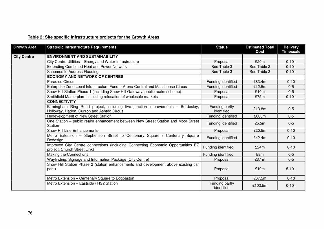
76
Table 2: Site specific infrastructure projects for the Growth Areas
Growth Area Strategic Infrastructure Requirements Status Estimated Total Cost
Delivery Timescale
City Centre ENVIRONMENT AND SUSTAINABILITY
City Centre Utilities – Energy and Water Infrastructure Proposal £20m 0-10+
Extending Combined Heat and Power Network See Table 3 See Table 3 0-10+
Schemes to Address Flooding See Table 3 See Table 3 0-10+
ECONOMY AND NETWORK OF CENTRES
Paradise Circus Funding identified £83.4m 0-10
Enterprise Zone Local Infrastructure Fund - Arena Central and Masshouse Circus Funding identified £12.5m 0-5
Snow Hill Station Phase 1 (including Snow Hill Gateway, public realm scheme) Proposal £10m 0-5
Smithfield Masterplan - including relocation of wholesale markets Proposal £75m 0-10+
CONNECTIVITY
Birmingham Ring Road project, including five junction improvements – Bordesley, Holloway, Haden, Curzon and Ashted Circus
Funding partly identified
£13.8m 0-5
Redevelopment of New Street Station Funding identified £600m 0-5
One Station – public realm enhancement between New Street Station and Moor Street Station
Funding identified £5.5m 0-5
Snow Hill Line Enhancements Proposal £20.5m 0-10
Metro Extension – Stephenson Street to Centenary Square / Centenary Square Redesign
Funding identified £42.4m 0-10
Improved City Centre connections (including Connecting Economic Opportunities EZ project, Church Street Link)
Funding identified £24m 0-10
Making the Connections Funding identified £8m 0-5
Wayfinding, Signage and Information Package (City Centre) Proposal £3.1m 0-5
Snow Hill Station Phase 2 (station enhancements and development above existing car park)
Proposal £10m 5-10+
Metro Extension – Centenary Square to Edgbaston Proposal £67.5m 0-10
Metro Extension – Eastside / HS2 Station Funding partly identified
£103.5m 0-10+

77
Rail improvements to Tamworth / Sutton Park / Camp Hill Leicester Line / Services / Stations (including Moor Street)
See Table 3 See Table 3 0-10+
Birmingham Cycle Revolution See Table 3 See Table 3 0-10+
Eastside (City Centre) to Birmingham Airport (HS2 Interchange) – Rapid Transit / SPRINT
See Table 3 See Table 3 10+
Greater Icknield HOMES AND NEIGHBOURHOODS
New Secondary School Funding partly identified
£16-18m 0-10
New Leisure Centre Funding partly identified
£8m 0-10
CONNECTIVITY
Dudley Road / Spring Hill Corridor Highway Improvements Proposal £30m 0-10+
Birmingham Cycle Revolution
See Table 3 See Table 3 0-10+
Aston, Newtown & Lozells AAP (including Perry Barr)
ENVIRONMENT AND SUSTAINABILITY
Schemes to Address Flooding See Table 3 See Table 3 0-10+
HOMES AND NEIGHOBOURHOODS
Aston Newtown and Lozells Area Action Plan (AAP) - Housing Regeneration Programme (Phase 2 & 3)
Funding partly identified
£47m 0-5
ECONOMY AND NETWORK OF CENTRES
Aston Regional Investment Site – Advanced Manufacturing Hub, Economic Zone (including Highways Agency scheme)
Funding identified £8m 0-10+
Food Hub, Perry Barr (Economic Zone) Proposal £5m 0-10
CONNECTIVITY
Perry Barr highway improvement works and public realm Proposal £8.6m 0-10
Birmingham- A34 SPRINT Funding partly identified
£40m 0-5
Perry Barr public transport hub Proposal £8m 0-10+
Major road corridors developed as key gateways and green corridors
See Table 3 See Table 3 0-10+
Sutton Coldfield
CONNECTIVITY
Sutton Boulevard (Birmingham Road) Proposal £5m 0-5

78
Sutton Coldfield Relief Road Proposal £6.7m 0-10+
Highway and Transportation Improvements 3 schemes: Holland Road / Lower Queen Street corridor; Birmingham Road / Queen Street / Brassington Avenue junction improvement; Birmingham Road / Jockey Road junction improvement
Proposal £4m 0-10
Tamworth / Sutton Park Line / Camp Hill Chords and diversion of Leicester services and Camp Hill line local services / enhanced local service provision / Moor Street increased passenger handling capacity
See Table 3 See Table 3 0-10+
Public transport interchange Proposal £5m 0-5
Increased park and ride capacity on the Cross City Line Proposal TBC 0-10+
A38 Sutton Coldfield Bypass (Maintenance) Proposal £3.45m 5-10
Langley Sustainable Urban Extension (SUE)
ENVIRONMENT AND SUSTAINABILITY
Play facilities, local public open space and allotments Proposal TBC 0-10+
HOMES AND NEIGHBOURHOODS
Early years provision, primary schools and 1 secondary school Proposal TBC 0-10+
ECONOMY AND NETWORK OF CENTRES
Local centre uses and public realm (including shops, business, health, pubs, cafes and community buildings)
Proposal TBC 0-10+
CONNECTIVITY (projects also relate to Peddimore)
Direct/ indirect highway improvements (including improvements to M42, junc 9) Proposal £34.6m 0-10+
Public transport provision (bus and rail) Proposal £20.8m 0-10+
Walking and cycling improvements Proposal £12.08m 0-10+
Tamworth / Sutton Park Line / Camp Hill Chords and diversion of Leicester services and Camp Hill line local services / enhanced local service provision / Moor Street increased passenger handling capacity
See Table 3 See Table 3 0-10+
A38 Sutton Coldfield Bypass (Maintenance) Proposal £3.45m 5-10
Peddimore ENVIRONMENT AND SUSTAINABILITY
Landscape enhancements to mitigate the effects of development Proposal TBC 0-10+
CONNECTIVITY
Highway improvements (including Kingsbury Road / Cottage Lane junction improvements)
Proposal Included in costs for Langley SUE
0-10+
Public transport provision (bus) Proposal 0-10+
Walking and cycling improvements Proposal 0-10+
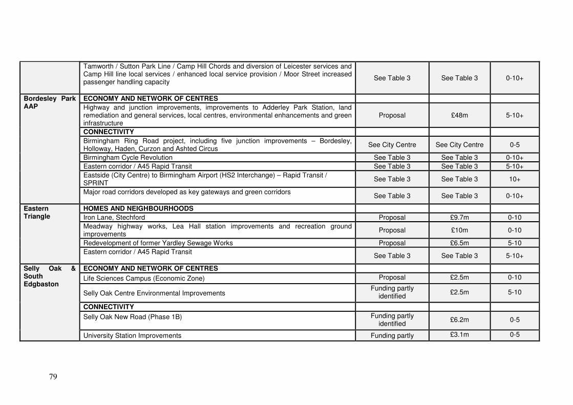
79
Tamworth / Sutton Park Line / Camp Hill Chords and diversion of Leicester services and Camp Hill line local services / enhanced local service provision / Moor Street increased passenger handling capacity
See Table 3 See Table 3 0-10+
Bordesley Park AAP
ECONOMY AND NETWORK OF CENTRES
Highway and junction improvements, improvements to Adderley Park Station, land remediation and general services, local centres, environmental enhancements and green infrastructure
Proposal £48m 5-10+
CONNECTIVITY
Birmingham Ring Road project, including five junction improvements – Bordesley, Holloway, Haden, Curzon and Ashted Circus
See City Centre See City Centre 0-5
Birmingham Cycle Revolution See Table 3 See Table 3 0-10+
Eastern corridor / A45 Rapid Transit See Table 3 See Table 3 5-10+
Eastside (City Centre) to Birmingham Airport (HS2 Interchange) – Rapid Transit / SPRINT
See Table 3 See Table 3 10+
Major road corridors developed as key gateways and green corridors
See Table 3 See Table 3 0-10+
Eastern Triangle
HOMES AND NEIGHBOURHOODS
Iron Lane, Stechford Proposal £9.7m 0-10
Meadway highway works, Lea Hall station improvements and recreation ground improvements
Proposal £10m 0-10
Redevelopment of former Yardley Sewage Works Proposal £6.5m 5-10
Eastern corridor / A45 Rapid Transit
See Table 3 See Table 3 5-10+
Selly Oak & South Edgbaston
ECONOMY AND NETWORK OF CENTRES
Life Sciences Campus (Economic Zone) Proposal £2.5m 0-10
Selly Oak Centre Environmental Improvements Funding partly
identified £2.5m 5-10
CONNECTIVITY
Selly Oak New Road (Phase 1B)
Funding partly identified
£6.2m 0-5
University Station Improvements Funding partly £3.1m 0-5
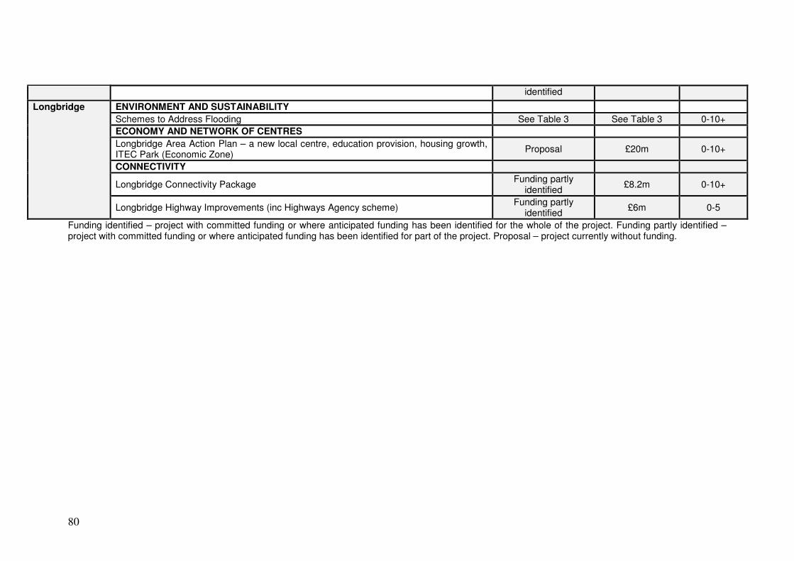
80
identified
Longbridge ENVIRONMENT AND SUSTAINABILITY
Schemes to Address Flooding See Table 3 See Table 3 0-10+
ECONOMY AND NETWORK OF CENTRES
Longbridge Area Action Plan – a new local centre, education provision, housing growth, ITEC Park (Economic Zone)
Proposal £20m 0-10+
CONNECTIVITY
Longbridge Connectivity Package Funding partly
identified £8.2m 0-10+
Longbridge Highway Improvements (inc Highways Agency scheme) Funding partly
identified £6m 0-5
Funding identified – project with committed funding or where anticipated funding has been identified for the whole of the project. Funding partly identified – project with committed funding or where anticipated funding has been identified for part of the project. Proposal – project currently without funding.

81
Table 3: City-wide and local infrastructure requirements (outside of the Growth Areas)
Scheme Strategic Infrastructure Requirements Status Estimated Total Cost
Delivery Timescale
ENVIRONMENT AND SUSTAINABILITY
Flood Risk Management
City-Wide Schemes to Address Flooding* Funding partly
identified £76.7m 0-10+
Waste Energy from Waste Infrastructure Proposal £50m 0-10+
Biodiversity & Geodiversity
Landscape-scale Biodiversity Enhancements Funding identified £2m (to 2015) 0-10+
Smart Energy Extending the City Centre and citywide Combined Heat and Power Network* Proposal TBC 0-10+
Green Infrastructure and Climate Change Adaptation
Allotment Improvement Plan Proposal £3m 0-10+
Parks Infrastructure Growth Schemes Funding partly
identified £3.5m (to 2013) 0-10+
Reservoir Work to Park Pools Funding partly
identified £5m (up to 2015) 0-10+
Canalside improvements (including canal features) Proposal TBC 0-10+
Heritage assets at risk Proposal TBC 0-10+ HOMES AND NEIGHBOURHOODS
Education Education provision (early years, mainstream and special schools)
Funding partly identified (short term)
See Appendix 1 0-10+
Education provision, 18-25 years of age Funding partly
identified (short term) See Appendix 1 0-10+
Full Participation (18-25 years of age)/ General Training and Employment Initiatives Proposal TBC 0-10+
Housing Kings Norton 3 Estates Regeneration Proposal £16 0-10+
Druids Heath Regeneration Proposal TBC 5-10+
Bromford Housing Estate Proposal TBC 5-10+
Healthcare Facilities Natural Health Improvement Zone
Funding partly identified
£1m 0-10+
Food Charter and Food Council Funding partly
identified £0.5m 0-10+
People, Place & Purpose Intelligent Health SMART Routes Funding partly
identified £0.5m 0-10+
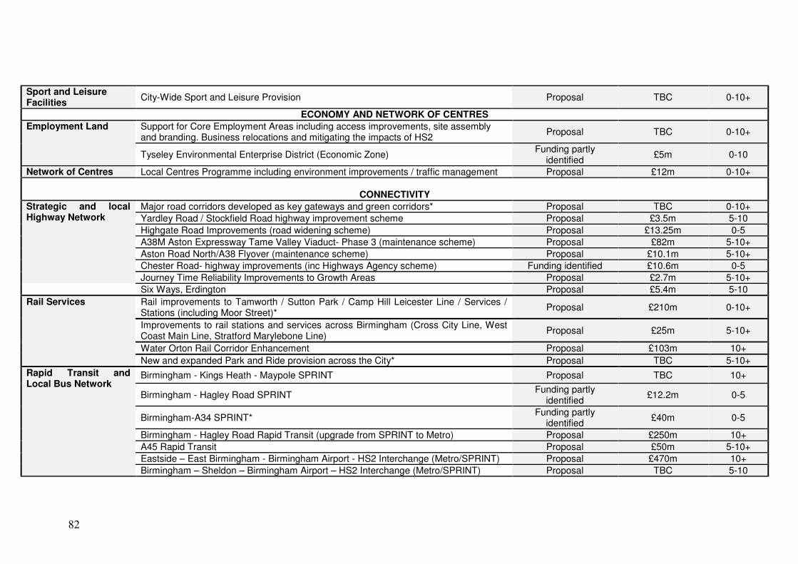
82
Sport and Leisure Facilities
City-Wide Sport and Leisure Provision Proposal TBC 0-10+
ECONOMY AND NETWORK OF CENTRES
Employment Land Support for Core Employment Areas including access improvements, site assembly and branding. Business relocations and mitigating the impacts of HS2
Proposal TBC 0-10+
Tyseley Environmental Enterprise District (Economic Zone) Funding partly
identified £5m 0-10
Network of Centres Local Centres Programme including environment improvements / traffic management Proposal £12m 0-10+
CONNECTIVITY
Strategic and local Highway Network
Major road corridors developed as key gateways and green corridors* Proposal TBC 0-10+
Yardley Road / Stockfield Road highway improvement scheme Proposal £3.5m 5-10
Highgate Road Improvements (road widening scheme) Proposal £13.25m 0-5
A38M Aston Expressway Tame Valley Viaduct- Phase 3 (maintenance scheme) Proposal £82m 5-10+
Aston Road North/A38 Flyover (maintenance scheme) Proposal £10.1m 5-10+
Chester Road- highway improvements (inc Highways Agency scheme) Funding identified £10.6m 0-5
Journey Time Reliability Improvements to Growth Areas Proposal £2.7m 5-10+
Six Ways, Erdington Proposal £5.4m 5-10
Rail Services Rail improvements to Tamworth / Sutton Park / Camp Hill Leicester Line / Services / Stations (including Moor Street)*
Proposal £210m 0-10+
Improvements to rail stations and services across Birmingham (Cross City Line, West Coast Main Line, Stratford Marylebone Line)
Proposal £25m 5-10+
Water Orton Rail Corridor Enhancement Proposal £103m 10+
New and expanded Park and Ride provision across the City* Proposal TBC 5-10+
Rapid Transit and Local Bus Network
Birmingham - Kings Heath - Maypole SPRINT Proposal TBC 10+
Birmingham - Hagley Road SPRINT Funding partly
identified £12.2m 0-5
Birmingham-A34 SPRINT* Funding partly
identified £40m 0-5
Birmingham - Hagley Road Rapid Transit (upgrade from SPRINT to Metro) Proposal £250m 10+
A45 Rapid Transit Proposal £50m 5-10+
Eastside – East Birmingham - Birmingham Airport - HS2 Interchange (Metro/SPRINT) Proposal £470m 10+
Birmingham – Sheldon – Birmingham Airport – HS2 Interchange (Metro/SPRINT) Proposal TBC 5-10

83
Smart Network, Smarter Choices Corridor Proposal £25m 0-10
Bartley Green SPRINT Funding partly
identified £30m 10+
Walking and Cycling Birmingham Cycle Revolution* Funding identified £24.3m 0-10+
Digital Connectivity Open access ducting TBC TBC TBC
Funding identified – project with committed funding or where anticipated funding has been identified for the whole of the project. Funding partly identified – project with committed funding or where anticipated funding has been identified for part of the project. Proposal – project currently without funding. * City Wide Projects which have site specific proposals in the Growth Areas.

84
4.0 Delivery of infrastructure 4.1 Partners 4.1.1 The delivery of infrastructure to support the growth identified in the BDP will
require a partnership approach. As a Local Authority, Birmingham City Council has a number of responsibilities and obligations it has to meet and therefore has a pivotal role as an infrastructure and service provider. The roles the Council fulfils include:
• Local Planning Authority
• Local Highway Authority
• Local Education Authority
• Waste and Minerals Authority
• Strategic Housing Authority
• Social Care Service Provider
• Lead Local Flood Authority
• Public Health 4.1.2 As Local Planning Authority, Birmingham City Council has an important role to
play in setting the level of and securing developer contributions, including CIL in the future, to deliver the necessary infrastructure to support development.
4.1.3 In line with its role and responsibilities, the City Council will have a lead role in
coordinating and delivering infrastructure in Birmingham to support growth. The Council will work closely and in partnership with a number of organisations across both the public and private sector to achieve this. As a major landowner within Birmingham, the City Council will play a leading role in bringing sites forward for development.
4.1.4 There are close links between Birmingham and the rest of the West Midlands,
including the Black Country, Worcestershire and Warwickshire. This includes both Local Authorities and Local Enterprise Partnerships, and on-going discussions have taken place on a number of key issues, including housing and economic growth. The Council will work with these neighbouring authorities and organisations to ensure that cross boundary infrastructure issues are addressed to help deliver growth and development in the area.
4.1.5 Organisations in the public sector as well as other agencies are also
responsible for meeting their statutory obligations and responding to growth. The Council will continue to work closely with these agencies to maximise funding opportunities and to identify the most effective and timely delivery mechanisms for the necessary infrastructure.
4.1.6 Table 4 identifies some of the partners who will have a key role in the provision
of infrastructure. Further partners are identified for specific projects in the IDP Schedule.

85
Table 4: Key partners to deliver infrastructure requirements Partner Role
Greater Birmingham & Solihull Local Enterprise Partnership (GBSLEP)
The LEP plays a key role in coordinating economic activity across its area. The Birmingham City Centre Enterprise Zone, City Deal and High Speed 2 are some of the LEP’s main priorities. The LEP also has a role in funding infrastructure, such as through the GBS Local Transport Board. This role will increase in the future through the allocation of the Single Local Growth Fund.
Local Authorities Whilst the City Council works in partnership with authorities within the GBSLEP, it also works in collaboration with adjacent Local Authorities and those in the wider region. This is particularly important as Birmingham is the largest of the UK’s core cities with a sphere of influence that extends beyond its administrative boundaries. A significant level of growth needs to be delivered in Birmingham over the plan period, and it is acknowledged that a degree of this growth will need to be accommodated within adjoining areas. In light of this, on-going discussions have taken place with a range of local authorities throughout the preparation of the BDP, including the Black Country, Coventry and Warwickshire, Worcestershire and Staffordshire.
Homes & Communities Agency (HCA)
The HCA is the national housing and regeneration agency for England. HCA provide investment for new affordable housing and to improve existing social housing, as well as for regenerating land. Their portfolio in Birmingham includes a number of sites in the Growth Areas, including part of the Regional Investment Site in Aston, the proposed Sustainable Neighbourhood at Greater Icknield, Eastside in the City Centre and Longbridge. The HCA will be a key partner in implementing regeneration proposals for these areas.
Centro Centro, as the Integrated Transport Authority, promotes and develops public transport networks across the West Midlands Metropolitan area, including bus, rail and Midland Metro. Centro is responsible for preparing the Local Transport Plan which sets out the priorities for transport investment over a 15 year period. Centro has helped drive forward transport projects in Birmingham, including New Street Station, the Midland Metro extension and SPRINT.
Highways Agency The Highways Agency is responsible for operating, maintaining and improving the strategic road network on behalf of the Secretary of State. Birmingham lies at the heart of the UK motorway network and the Highways Agency plays a key role in maintaining and improving the network and in assessing the impact of new development on it.
Network Rail Network Rail is responsible for the UK rail network, both rail infrastructure and certain stations. Growth in the Birmingham area will impact on the rail network, including the need for enhanced rail infrastructure. Network Rail is
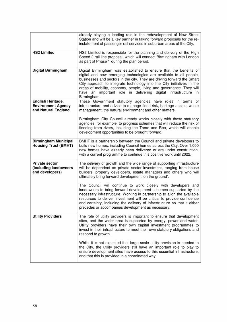
86
already playing a leading role in the redevelopment of New Street Station and will be a key partner in taking forward proposals for the re-instatement of passenger rail services in suburban areas of the City.
HS2 Limited HS2 Limited is responsible for the planning and delivery of the High Speed 2 rail line proposal, which will connect Birmingham with London as part of Phase 1 during the plan period.
Digital Birmingham Digital Birmingham was established to ensure that the benefits of digital and new emerging technologies are available to all people, businesses and sectors in the city. They are driving forward the Smart City approach to integrate technology into the City initiatives in the areas of mobility, economy, people, living and governance. They will have an important role in delivering digital infrastructure in Birmingham.
English Heritage, Environment Agency and Natural England
These Government statutory agencies have roles in terms of infrastructure and advice to manage flood risk, heritage assets, waste management, the natural environment and other matters. Birmingham City Council already works closely with these statutory agencies, for example, to progress schemes that will reduce the risk of flooding from rivers, including the Tame and Rea, which will enable development opportunities to be brought forward.
Birmingham Municipal Housing Trust (BMHT)
BMHT is a partnership between the Council and private developers to build new homes, including Council homes across the City. Over 1,000 new homes have already been delivered or are under construction, with a current programme to continue this positive work until 2022.
Private sector (including landowners and developers)
The delivery of growth and the wide range of supporting infrastructure will be dependent on private sector investment, ranging from house builders, property developers, estate managers and others who will ultimately bring forward development ‘on the ground’. The Council will continue to work closely with developers and landowners to bring forward development schemes supported by the necessary infrastructure. Working in partnership to align the available resources to deliver investment will be critical to provide confidence and certainty, including the delivery of infrastructure so that it either precedes or accompanies development as necessary.
Utility Providers The role of utility providers is important to ensure that development sites, and the wider area is supported by energy, power and water. Utility providers have their own capital investment programmes to invest in their infrastructure to meet their own statutory obligations and respond to growth. Whilst it is not expected that large scale utility provision is needed in the City, the utility providers still have an important role to play to ensure development sites have access to this essential infrastructure, and that this is provided in a coordinated way.

87
4.2 Funding 4.2.1 The delivery of the infrastructure identified in the IDP Schedule will require
significant resources over the plan period. The two main sources of funding to deliver infrastructure to support growth will come from the public and private sectors. A wide range of key infrastructure projects already have committed funding in place for all or part of the project or anticipated funding has been identified. These projects are highlighted green in the IDP Schedule and total approximately £1.1 billion.
4.2.2 Public sector funding will come from the City Council, Government and other
public agencies at the national and local level. Whilst this funding has been a significant resource in providing infrastructure in the past, it is currently constrained due to the prevailing economic conditions. However, the level of public funding will vary over the plan period to reflect local and national priorities, programmes and initiatives. The Government has already introduced a number of funding streams to incentivise development, and the City Council has funding programmes in place to deliver elements of infrastructure.
4.2.3 In the future, LEPs will have a greater control over certain public funding to help
stimulate economic growth. From 2015, LEPs will be able to access £2 billion a year of central Government funding from the Single Local Growth Fund. This Fund will comprise existing funding streams, including part of the New Homes Bonus, local authority transport funding and further education funding, into a single fund.
4.2.4 Private sector funding will predominantly come from the development industry
as part of securing the delivery of development sites. New developments will predominantly be expected to meet their own on-site infrastructure needs, from provision of utilities to a new road junction to access the site. Section 106 contributions and section 278 agreements will still be used to secure on site infrastructure. The City Council will introduce a CIL post BDP adoption to ensure that local and strategic infrastructure needs are funded by new development to help address the overall funding gap.
4.2.5 The wider economic conditions are highly likely to change during the plan
period and this will impact on the availability of funding. In improved market conditions, it is likely that additional infrastructure can be funded by the private sector, although public sector funding will still have an important role to play.
4.2.6 Further details of funding for infrastructure are contained in the IDP Schedule.
Funding for the delivery of short term projects in the majority of cases is already in place, which demonstrates a strong commitment to new infrastructure. Longer term projects identified are key projects that are needed to help deliver the growth set out in the BDP. All projects will be regularly reviewed and may be subject to change depending on changing priorities and where infrastructure needs are greatest. Where a project is to be part or fully funded by the City Council, a Full Business Case will need to be prepared, where the importance and need for infrastructure will be justified to support the growth of the City.
4.2.7 Table 5 highlights potential funding opportunities to deliver the infrastructure
needs of the BDP. Further funding streams are identified in the Infrastructure Delivery Plan Schedule.

88
Table 5: Potential funding sources to deliver infrastructure Funding Summary
Community Infrastructure Levy (CIL)
A charge on certain types of development to spend on a range of infrastructure to support the growth of an area. CIL is not yet in place in Birmingham, but is expected to be by April 2015.
Planning Obligations (Section 106 Agreements)
Funding / infrastructure provided as part of a development to make it acceptable in planning terms. Can only relate directly to the development. This mechanism is already extensively used in the City, particularly to help deliver affordable housing.
Section 278 Agreements
Funding by developers for necessary highway improvements as part of securing permission for development sites. Already used extensively in Birmingham as part of granting planning permissions.
Capital Investment Programmes
Investment in infrastructure by service providers to meet their own statutory obligations and responding to growth, including:
• Utility providers in their equipment and sites.
• The Council in its assets, including highways, leisure and open spaces.
• Network Rail and the Highways Agency in their networks.
Regional Growth Fund (RGF)
A Government fund totalling £3.2 billion, to support projects and programmes that are using private sector investment to create economic growth. There have been five bidding rounds so far, with the sixth expected to be announced in summer 2014. Birmingham has already benefitted from RGF to help deliver a number of projects. Infrastructure investment includes £15.7m to upgrade the A45 to enable the runway extension at Birmingham Airport.
Growing Places Fund (GPF)
A Government fund totalling £500m to address infrastructure constraints, promote economic growth and delivery of jobs and houses. The fund is managed locally by the GBSLEP. The fund is recyclable so that monies are repayable and can be used to support future projects. The GBSLEP has been allocated £15m, and part of this has already been allocated to help provide infrastructure to support regeneration schemes at Greater Icknield and the Aston Regional Investment Site.
European Regional Development Fund (ERDF)
ERDF is focused on reducing economic disparities within and between member states by supporting economic regeneration and safeguarding jobs. The current programme covers the period 2014 to 2020 and the GBSLEP area has been allocated €255.8m (including European Social Fund allocation). Birmingham has benefited from ERDF funding to provide infrastructure, including Eastside Park in the City Centre. It is also used to provide financial support to businesses to invest (including funding for businesses in Digbeth, Jewellery Quarter, Tyseley and East and North Birmingham), and this also helps provide infrastructure as part of these developments.
New Homes A financial incentive for Local Authorities to ensure that the economic

89
Bonus (NHB) benefits of housing growth are returned to the communities where growth takes place. The NHB commenced in April 2011. It match funds the additional council tax raised for new homes and properties brought back into use, with an additional amount for affordable homes, for the following six years. Birmingham earned £3.2m from the NHB in 2011/12 and an additional £4.2m for 2012/13. So far the NHB has been used to contribute to the Council’s overall funding pot, with the affordable homes element used to build new affordable homes. The Council is exploring the potential to use this fund to help incentivise housing development, which could include the provision of infrastructure, to increase the amount of NHB received. However, account will need to be taken of the assumptions regarding NHB already built into the Council’s financial plans and the overall financial pressures of the Council. From 2015/16 the Government will topslice around 35% of NHB to help fund LEPs.
Enterprise Zone / Tax Increment Financing (TIF) / Business Rates Retention
The Government has proposed that it will allow Local Authorities borrowing powers, known as TIF, to borrow against predicted growth in their locally raised business rates. They can use the borrowing to fund key infrastructure and other capital projects, which will support locally driven economic development and growth. In announcing Enterprise Zones, Government is supporting LEPs by enabling them to retain the uplift in business rates when new development takes place in the Zone. In Birmingham, TIF was part of the City Deal package agreed with Government. The funding approach to support the City Centre Enterprise Zone has adopted a TIF like approach. The LEP has an Enterprise Zone Investment Plan to 2017/18 setting out how £128m will be invested in infrastructure and programmes to deliver development by borrowing against future business rates income. This long-term income (until 2038) can be used by the LEP to delivery projects to support its priorities. DCLG launched the Local Infrastructure Fund earlier in the year to promote development within Enterprise Zones, and 2 projects within the City Centre EZ have been shortlisted. In addition to this, the Enterprise Zones Capital Grant Fund has recently been announced. The GBSLEP and City Council will work in partnership to identify potential eligible projects for the Fund.
Greater Birmingham & Solihull Local Transport Board (GBSLTB)
The GBSLTB has recently been established to prioritise and oversee the delivery of Local Major Transport Schemes. There is a funding allocation of £24m from the Department for Transport for the 2015-19 delivery period. A provisional programme of schemes has been agreed with the GBSLTB which will be developed for final funding approval in advance of April 2015 when the funding becomes available. The schemes in Birmingham include One Station, Metro Extension (New Street Station to Centenary Square), Making the connections for growth (City Centre) and Hagley Road SPRINT.
Infrastructure Guarantees Scheme
The Government have made up to £40bn of financial guarantees for certain types of infrastructure project in the UK through this scheme. The Infrastructure (Financial Assistance) Act 2012 envisages that the Treasury may provide financial support for a wide range of infrastructure projects, including utilities and transport facilities, to initiate and fund construction of the project.

90
4.3 Planning mechanisms for growth and the delivery of infrastructure 4.3.1 A number of planning tools are available to the City Council to enable growth
and aid the delivery of infrastructure. These plans can help to give certainty to the market to invest, help prioritise investment, and also to coordinate the activities of partners to ensure infrastructure is in place to support development.
4.3.2 In addition to the BDP, there are already a number of statutory plans which
have already been adopted by the City Council, including the Longbridge and Aston, Newtown & Lozells Area Action Plans (AAP). These plans identify the infrastructure needs to facilitate growth in these areas. The emerging Bordesley Park AAP and Balsall Heath Neighbourhood Development Plan (NDP) will also identify infrastructure needs for these areas.
4.3.3 The City Council will keep the need for additional statutory plans under review
to ensure that growth and infrastructure provision can be planned for and progressed. The use of other planning documents, such as Supplementary Planning Documents and informal planning documents (such as regeneration frameworks and development briefs) will also be used to aid the delivery of infrastructure.
4.3.4 The West Midlands Local Transport Plan 3 (LTP3) also supports the transport
investment and infrastructure needed to support growth in the BDP. Any updates or reviews of the LTP and its Implementation Plan will need to take account of the infrastructure identified in the IDP to support growth priorities.
4.4 Monitoring and review
4.4.1 It is intended that the IDP will be reviewed on an annual basis, as it is
acknowledged that infrastructure requirements and priorities will change over the plan period. As there is a strong relationship between the IDP and BDP, a monitoring framework for both documents is being developed which will be taken forward in the Annual Monitoring Report. Monitoring the implementation of the infrastructure projects identified in the IDP will give a clear indication of the progress towards achieving the objectives of the BDP.

Project
How does the scheme
support and enable
growth as identified in
the BDP?
Delivery
PartnersMechanisms Cost
Potential Funding
Sources
Committed and
Anticipated Funding
Anticipated
Funding GapFunding Status Delivery Issues
Lead Partner/
ContactNotes
Essential or
Desirable
0-5 yrs 5-10 yrs 10+ yrs
City Centre Utilities -Energy and Water
InfrastructureGA1 x x x Private / BCC
Private with potential for public
sector support£20m
Private/Enterprise
Zone£0m £20m On-going BCC
Provision of energy
and water
infrastructure
Essential
Paradise Circus GA1 x x
BCC /
Developers/
Argent/ BTPS
Joint venture to deliver with EZ
investment for public
infrastructure works
£83.4m Enterprise Zone £83.4m £0Full business case
approved
Under development.
Remodelling of gyratory to
facilitate development and
necessary access.
Planning permission
granted.
BCC Essential
Enterprise Zone Local Infrastructure Fund -
Arena Central and Masshouse Circus GA1 x Developers Enterprise Zone £12.5m
Local Infrastructure
Fund (Government)£12.5m £0
Works relate to
infrastructure to
prepare sites for
development
Government granted
outline approval for the 2
separate bids. BCC now
reviewing bids. Final
approval expected summer
2014.
Developers
Funding relates to
the ask of
Government, not to
the total cost of the
projects. 2
separate bids -
Masshouse £8.7m,
Arena Central
£3.8m
Essential
Snow Hill Station Phase 1 GA1 xBCC/ Centro /
Colmore BIDPublic/ Private £10m
BCC/ London Midland/
Centro/ Colmore BID/
CIL
£0m £10m
Business Case
undertaken for LEP's
Strategic Economic
Plan (SEP)
Landownership issues
need to be addressed.
BCC/ Colmore
BID
The development
will create an
efficient transport
interchange,
increased public
transport
patronage and
opportunities for
public realm
enhancement as
well as delivering
economic benefits
to the wider Snow
Hill District.
Desirable
Smithfield Masterplan - including relocation
of wholesale markets, access improvements
and public realm
GA1 x x x BCC / GBSLEP Enterprise Zone £75m BCC / Enterprise Zone TBC TBC TBC
Site within Enterprise
Zone. Relocation of
markets approved by
Cabinet. Full Business
Case being prepared.
BCC Essential
Appendix 1: Infrastructure Delivery Plan Schedule
Timescales
GROWTH AREAS
Definitions:
Essential - Projects that are key to delivering the growth aspirations of the BDP and meeting its objectives for sustainable development.
Desirable - Projects which would support the growth aspirations and sustainability objectives of the BDP and will be delivered should appropriate funding be secured.
Projects shaded in green are those with committed funding sources for all or part of the project or where anticipated funding has been identified. Approximate costs for most of the projects are highlighted, however, these are subject to change as projects are progressed and feasibility work is undertaken. Infrastructure requirements for the Growth Areas are
identified below, followed by city-wide and local infrastructure needs to support new development.
City Centre
ENVIRONMENT AND SUSTAINABILITY
ECONOMY AND NETWORK OF CENTRES
1

Project
How does the scheme
support and enable
growth as identified in
the BDP?
Delivery
PartnersMechanisms Cost
Potential Funding
Sources
Committed and
Anticipated Funding
Anticipated
Funding GapFunding Status Delivery Issues
Lead Partner/
ContactNotes
Essential or
Desirable
0-5 yrs 5-10 yrs 10+ yrs
Timescales
Birmingham Ring Road
City Centre and Bordesley
Park Growth Areas,
including TP37 and TP43
x DfT/ BCC Public sector £13.8m DfT/BCC £9.7m £4.1m
Pinch Point funding
of £9.4m allocated, in
addition to £300k
S106. £4.1m
requested via LGF.
Scheme being delivered
for five junctions-
Bordesley, Holloway,
Haden, Curzon and Ashted
Circus.
BCC Essential
Redevelopment of New Street Station GA1/TP37 /TP40 x
Centro / BCC /
Department for
Transport/
Network Rail /
ERDF
Public sector funding
£600million (£398
million of public
money)
DfT/ERDF/ Network
Rail£600m £0 All funding identified
Under construction, due for
completion 2015. Network Rail Essential
One Station - public realm enhancement
between New Street and Moor Street
Stations
GA1 /TP38/TP39 x
BCC / DfT /
Centro / Network
Rail / Hammerson
/ public transport
operators
BCC and Centro will be the
joint delivery authority. £5.5m
Major scheme
funding/Centro/ Local
Transport
Board/HS2/private/BC
C/EZ
£5.5m £0
Concept design
agreed. Currently
being worked up to
constructible design
with necessary
consents. LTB have
indicated scheme will
receive funding of
£3.5m subject to
development of Full
Business Case
Dependant on successful
negotiations with Network
Rail to replace s278
proposals for New Street
Gateway.
BCC/Centro Essential
Snow Hill Line Enhancements GA1 /TP40 x xNetwork Rail /
Centro / BCCPublic £20.5m
DfT / Network Rail /
Centro/ LTB£0 £20.5m
LGF bid submitted
March 2014. £LGF -
£9.5m, LA - £0.5m,
Third Party - £10.5m.
To be confirmed. Network Rail
The scheme will
increase core rail
services from 6 to
8 trains per hour
(excluding
Chiltern).
Feasibility study
being undertaken.
Essential
Metro Extension - Stephenson Street to
Centenary Square/ Centenary Square Re-
design
GA1 /TP40 x x BCC / Centro
Metro extension delivered by
Centro and complementary
highway works and Centenary
re-design delivered by BCC.
£42.4m (including
Centenary Square
re-design at £8m
and
complementary
highway works)
Major Scheme
Funding/Enterprise
Zone/Centro/Private/B
CC/Local Transport
Board
£42.4m £0
Part of total funding
from Enterprise Zone
(£25m). LTB have
indicated scheme will
receive additional
funding of £8m.
Subject to
development of Full
Business Case.
TWA Order in place. Metro
extension and Centenary
Square re-design will be
delivered alongside Arena
Central / Paradise Circus.
BCC / Centro
Preliminary design
completed with
Business Case
Essential
Improved City Centre connections
(including Connecting Economic
Opportunities EZ project, Church Street
Link)
GA1 /TP38/TP39 x xBCC / Centro /
BIDsPublic £24m Enterprise Zone / CIL £24m £0
Part of total funding
from Enterprise Zone
(£16m). BID scheme
totalling £8m.
Funding subject to
development of Full
Business Case
Traffic Management. BCC
Improve
pedestrianisation in
the City Centre in
accordance with
the Big City Plan.
Implementation of
the Interconnect
project to improve
wayfinding.
Essential
Making the Connections GA1 /TP38/TP39 xBCC / Centro /
BIDPublic £8m Enterprise Zone/ LTB £8m £0m
LTB £6.8m, LA
£0.4m, Third Party
£0.8m.
Traffic Management. All
land is public highway, and
therefore owned/under
control of BCC.
BCC
Wayfinding
facilities to improve
movement
throughout the city.
Funding approved
through LTB.
Essential
CONNECTIVITY
2

Project
How does the scheme
support and enable
growth as identified in
the BDP?
Delivery
PartnersMechanisms Cost
Potential Funding
Sources
Committed and
Anticipated Funding
Anticipated
Funding GapFunding Status Delivery Issues
Lead Partner/
ContactNotes
Essential or
Desirable
0-5 yrs 5-10 yrs 10+ yrs
Timescales
Wayfinding, Signage and Information
Package (City Centre)GA1 /TP38/TP39 x BCC / SMBC Public £3.1m LGF/LA £0m £3.1m
LGF bid submitted
March 2014.TBC TBC
This scheme
proposes to install
public transport
infrastructure, as
part of the
interconnect
wayfinding
programme within
the wider
Birmingham city
centre area and
Solihull town
centre. This project
aims to make it
easier to navigate
and encourage
walking around the
key urban areas.
Desirable
Snow Hill Station Redevelopment Phase 2
(station enhancements and development
above existing car park)
GA1 /TP38/TP39/TP40 x x
BCC / Network
Rail / Centro /
Private sector
Public/ Private £10m (BCC only)DfT / Network Rail /
Centro/ Private/ CIL£0 £10m Proposal
Planning approval
required/ constraints need
to be determined. Major
traffic management issues.
Relocation of bus network.
BCC/ Centro/
Network Rail
Snow Hill station
has been
highlighted by the
emerging Snow Hill
District Masterplan
as a priority for
transformational
change through
redevelopment and
improvements to
the passenger
experience.
Desirable
Metro Extension - Centenary Square to
EdgbastonGA1 /TP40 x x BCC / Centro Development Management £67.5m
Major Scheme
Funding/Enterprise
Zone/Centro/Private/B
CC/Local Transport
Board/ CIL
£0m £67.5m
Feasibility work being
undertaken. Local
Growth Fund bid
submitted - LGF
£59.8m, £3.7m Third
Party, £4.0m LA
Centro would need to
refresh land acquisition
powers associated with the
2005 TWA Order.
BCC/ Centro Essential
Metro Extension - Eastside / HS2 Station GA1 /TP40 x x x BCC / CentroDevelopment Management /
TWA order required£103.5m
Major scheme
funding/Centro/HS2/pri
vate/BCC/scheme
revenues/ CIL
£62.1m £41.4m
Feasibility work being
undertaken. Local
Growth Fund bid -
LGF £41.4m, £62.1m
EZ/ DfT/ Prudential
Borrowing
Affected by HS2 proposals
and scheme for Martineau
Galleries.
Centro Essential
New leisure centre GA2 x xBCC / private
sector
Greater Icknield Masterplan,
Development Management£8m BCC/ Private/ CIL £2m £6m
Proposal (proportion
of funding identified)
New facility expected to be
delivered through City
Council's Framework
Agreement. Will be
delivered as part of the
Icknield Port Loop site.
BCC Essential
New secondary school GA2 x x
BCC / DfE / Free
Schools /
Academies
Greater Icknield Masterplan,
Development Management£16-18m
Public (DfE)/ Private/
CIL£1.2-4.3m TBC
Proposal in
Masterplan, S106 for
IPL includes
education
contribution with
£1.2m required and
up to £4.3m with
overage
Type of school will need to
be explored. Free school
may come forward.
BCC Essential
Greater Icknield
HOMES AND NEIGHBOURHOODS
3

Project
How does the scheme
support and enable
growth as identified in
the BDP?
Delivery
PartnersMechanisms Cost
Potential Funding
Sources
Committed and
Anticipated Funding
Anticipated
Funding GapFunding Status Delivery Issues
Lead Partner/
ContactNotes
Essential or
Desirable
0-5 yrs 5-10 yrs 10+ yrs
Timescales
Dudley Road / Spring Hill Corridor Highway
Improvement WorksGA2 x x x BCC
Greater Icknield Masterplan,
Development Management£30m
Major scheme bid from
Department of
Transport/ CIL
£0m £30m
Draft Greater Icknield
Masterplan
completed. Local
Growth Fund bid
submitted - LGF
£22.4m, LA £4.1m,
Third Party £3.5m
Need for land assembly,
likely to be delivered in
phases as Greater Icknield
key sites come forward.
BCC Essential
Aston, Newtown and Lozells Area Action
Plan (AAP) - housing regeneration
programme (phase 2 and 3)
GA3 x BCC / HCAAston, Newtown, Lozells AAP /
Newtown Masterplan£47m Public/Private/ CIL £21m £26m
To be funded through
BMHT
Works ongoing. Subject to
funding availability.BCC/BMHT Essential
Aston Regional Investment Site - Advanced
Manufacturing Hub Economic Zone (inc HA
pinch point scheme at Salford Circus)
GA3 x x x BCC / HCA
Aston, Newtown and Lozells
AAP/ LDO adopted for majority
of RIS/ Planning Management
£8m for
infrastructure, land
acquisition and
site remediation
Public/Private £8m £0m
Funding secured
through Growing
Places Fund, match
funding by BCC and
HCA, section 106
AAP adopted. Possible
CPO to complete site
assembly. Part of Phase 1
available and on the
market.
BCC/ HCA
HA pinch point
improvement
scheme has
recently started on
site at Salford
Circus (M6, junc
6),. The project is
fully funded.
Essential
Food Hub, Perry Barr (Economic Zone) GA3 x x BCC / Private Development Management £5m Public/Private/ CIL £0m £5m Ongoing
Junction improvements
and start up/ business
support.
BCC
The Food Hub is
the preferred site
for the relocation of
Birmingham's
wholesale markets.
Planning
application
expected in late
2014.
Essential
Perry Barr highway improvement works and
public realm GA3 x x BCC / Centro
Development Management,
adopted AAP £8.6m
Public and Private
Sector/ CIL/ S106£0m £8.6m
LGF bid submitted -
£6m LGF, £1.3m LA,
£1.3m Third Party.
The impact of potential
highway improvements on
development sites will
need to be considered.
Cost also includes
potential site acquisitions.
BCC
Masterplan
proposed for Perry
Barr District
Centre, which will
identify land use
options and
necessary
infrastructure
works to support
growth. Project
cost also includes
land acquisitions.
Desirable
Perry Barr Public Transport Hub GA3 x x x Public / Private
Adopted AAP, proposed
Masterplan, Centro's funding
programme
£8m Public/Private/ CIL £0m £8m
Identified in adopted
AAP and in Centro's
funding programme
Subject to funding
availability.BCC
Proposal is
scalable and could
be delivered in
phases.
Essential
Sutton Boulevard (Birmingham Road) GA4 x BCC
Planning and Regeneration /
Transportation / Birmingham
Landscape Practice Group /
Urban Design
£5m Public/ CIL £0m £5mSutton Town Centre
SPD adopted
Dependent upon highway
and transport
improvements.
BCC Essential
Sutton Coldfield Relief Road GA4 x x x
BCC /
Development
Partner
Planning and Regeneration /
Transportation£6.7m
Major scheme bid from
Department of
Transport/ CIL
£0m £6.7mSutton Town Centre
SPD adopted
Implementation of HILs
and need for land
acquisitions.
BCC Essential
Aston, Newtown and Lozells AAP (including Perry Barr)
CONNECTIVITY
Sutton Coldfield
CONNECTIVITY
HOMES AND NEIGHBOURHOODS
CONNECTIVITY
ECONOMY AND NETWORK OF CENTRES
4

Project
How does the scheme
support and enable
growth as identified in
the BDP?
Delivery
PartnersMechanisms Cost
Potential Funding
Sources
Committed and
Anticipated Funding
Anticipated
Funding GapFunding Status Delivery Issues
Lead Partner/
ContactNotes
Essential or
Desirable
0-5 yrs 5-10 yrs 10+ yrs
Timescales
Sutton Coldfield Highway and
Transportation Improvements: 3 schemes:
Holland Road / Lower Queen Street
corridor; Birmingham Road /Queen Street /
Brassington Avenue junction improvement;
Birmingham Road / Jockey Road junction
improvement
GA4 x xBCC / Private
Sector
Planning and Regeneration /
Transportation£4m Public/Private/ CIL £0m £4m
Sutton Town Centre
SPD adopted
Implementation of HILs
and need for land
acquisitions.
BCC Essential
Tamworth / Sutton Park Line / Camp Hill
Chords and diversion of Leicester services
and Camp Hill line local services / Enhanced
local service provision / Moor Street
increased passenger handling capacity
GA4 and GA5 x x x
Network Rail /
Centro / BCC/
Warwickshire CC
/ Staffordshire CC
/ Train Operating
Company
Network Rail (through their
powers), Development
Management
£210m (approx.)Centro / Network Rail /
BCC/ CIL£0m £210m Control Period 5/6
Seeking funding through
Control Period 5/6. Network Rail Desirable
Increased park and ride capacity on Cross
City lineGA4 and GA5 x x x
Network Rail /
Centro / BCC/
Staffordshire CC /
Train Operating
Company
Network Rail (through their
powers). Development
Management
TBCCentro / Network Rail /
BCC/ CILTBC TBC TBC TBC Network Rail Desirable
Sutton Public Transport Interchange GA4 and GA5 x BCC / CentroPlanning and Regeneration /
Transportation / Centro£5m BCC/Centro/ CIL £0 £5m
Sutton Town Centre
SPD adopted
No suitable site currently
identified. Impact on wider
transport network within
Town Centre dependent
on location.
BCC Essential
Play facilities, local public open space and
allotments GA5 x x x
BCC /
developers
Development Management,
Planning and Regeneration
It is anticipated
that developers
will fund/ deliver
new infrastructure
as part of
development
proposals
TBC TBC TBC
It is anticipated that
this will be funded by
the development
Specific requirements to
be confirmed when the
Masterplan for the Langley
SUE is progressed, and
the location of these
facilities will be finalised
when development
proposals are brought
forward.
BCC Essential
Early years provision, primary schools and
1 secondary school GA5 x x x
BCC / DfE /
developers
Development Management,
Planning and Regeneration
Given the scale of
development
proposed, it is
anticipated that
developers will
collectively fund /
deliver new build
infrastructure as
part of
development
proposals.
TBC TBC TBC
It is anticipated that
this will be funded by
the development
Specific requirements to
be confirmed when the
Masterplan for the Langley
SUE is progressed, and
the location of new
education provision will be
finalised when
development proposals are
brought forward.
BCC Essential
HOMES AND NEIGHBOURHOODS
ENVIRONMENT AND SUSTAINABILITY
Sustainable Urban Extension
5

Project
How does the scheme
support and enable
growth as identified in
the BDP?
Delivery
PartnersMechanisms Cost
Potential Funding
Sources
Committed and
Anticipated Funding
Anticipated
Funding GapFunding Status Delivery Issues
Lead Partner/
ContactNotes
Essential or
Desirable
0-5 yrs 5-10 yrs 10+ yrs
Timescales
Local centre uses and public realm
(including shops, business, health, pubs,
cafes and community buildings)
GA5 x x x BCC / developers Development Management,
Planning and Regeneration
It is anticipated
that developers
will fund / deliver
new infrastructure
as part of
development
proposals
TBC TBC TBC
It is anticipated that
this will be funded by
the development
Specific requirements to
be confirmed when the
Masterplan for the Langley
SUE is progressed, and
the location of local centre
uses will be finalised when
development proposals are
brought forward. Public
Health are exploring the
healthcare requirements
for the amount of housing
proposed.
BCC Essential
Direct highway improvements (Minworth
Roundabout, new junction access off A38)GA5 and GA6 x x x
BCC / developers
/ Highways
Agency
Development Management,
Planning and Regeneration,
Transportation
£15.83mLGF, BCC,
Developers£0m £15.83m
LGF Funding bid
submitted: £5m LGF
Land, impact on SRN,
approvals. BCC Essential
Indirect highway improvements (including a
number of junction improvements -
Lindridge Road / Whitehouse Common
Road, Tamworth Road / Whitehouse
Common Road, Rectory Road / Whitehouse
Common Road, Hollyfield Road / Reddicap
Heath Road, Walmley Road / Hollyfield
Road, Tyburn Roundabout, Spitfire
Roundabout, Walmley Ash / Webster Way,
Walmley Ash / Euchelhurst Road) and traffic
management schemes (53 locations
identified)
GA5 and GA6 x x x
BCC / developers
/ Highways
Agency
Development Management,
Planning and Regeneration,
Transportation, S106
It is anticipated
that developers
will fund/ deliver
new infrastructure
as part of
development
proposals. Total
cost is estimated
to be £15.23m for
highway and traffic
management
schemes.
LGF, BCC,
Developers£0m £15.23m
It is anticipated that
works will be part
funded by the
development
Upgrades to corridors
connecting the site with
Sutton Coldfield,
Birmingham City Centre
and the adjoining area will
be required. Impacts and
potential improvements to
the Strategic Road
Network will need to be
fully investigated in
partnership with the
Highways Agency and
adjoining highway
authorities.
BCCEssential and
Desirable
Improvements to M42 (junction 9) and the
local highway to mitigate traffic growth
Mitigation options could include: A446
northbound two lane approach to A4091
roundabout; review A446 eastbound
approach to M42 junction 9 for capacity;
A466 to M42(S) direct on-slip; A4097
Kingsbury Road eastbound approach to
M42 junction 9 additional capacity and
revised lanes; M42(N) to A4097 westbound
direct off-slip; Curdworth Lane / A4097
junction improvements (signals); Curdworth
area amenity scheme; replace M6 toll slip
roundabout with on-demand signals for
M42 junction 9 to M6 Toll on-slip movement.
GA5 and GA6 x x x
BCC / developers
/ Highways
Agency /
Warwickshire CC
/ Staffordshire CC
Development Management,
Planning and Regeneration,
Transportation, S106, S278
It is anticipated
that developers
will part fund/
deliver new
infrastructure as
part of
development
proposals -
particularly those
improvements
associated with
Curdworth
(estimated to be
£3.5m)
LGF, BCC, WCC,
SCC, Developers£0m £3.5m
It is anticipated that
works will be part
funded by the
development. Design
options are being
developed, with a
view that funding will
be required from
several sources.
Impacts and potential
improvements to the
Strategic Road Network
will need to be fully
investigated in partnership
with the Highways Agency
and adjoining highway
authorities. A mechanism
will be created to ensure
that an appropriate
scheme is delivered that
will mitigate issues on both
the local and strategic
highway. The scheme may
also involve land take.
BCC
Improvements are
necessary to
support growth in
Birmingham, as
well as
Staffordshire and
Warwickshire.
Improvements at
M42 Junction 9 are
also essential to
supporting access
to existing
businesses within
the area such as
Hams Hall.
Essential
CONNECTIVITY (projects also relate to Peddimore)
ECONOMY AND NETWORK OF CENTRES
6

Project
How does the scheme
support and enable
growth as identified in
the BDP?
Delivery
PartnersMechanisms Cost
Potential Funding
Sources
Committed and
Anticipated Funding
Anticipated
Funding GapFunding Status Delivery Issues
Lead Partner/
ContactNotes
Essential or
Desirable
0-5 yrs 5-10 yrs 10+ yrs
Timescales
A38 Sutton Coldfield Bypass Maintenance GA5 and GA6 x BCC Public £3.45m LGF / LA £0m £3.45m Proposal TBC BCC
Capital
maintenance &
enhancement
works on the A38
Sutton Coldfield
Bypass dual
carriageway (from
Minworth Island to
Junction T3).
Desirable
Walking and cycling improvements- a
network of integrated pedestrian and cycle
routes will be required throughout the site
which should be linked to the adjoining
employment area at Peddimore, the North
Birmingham Cycle network, Sutton
Coldfield Town Centre, Birmingham City
Centre and other local centres
GA5 and GA6 x x x BCC / developers
Development Management,
Planning and Regeneration,
Transportation, developers
It is anticipated
that developers
will fund/ deliver
new infrastructure
as part of
development
proposals. Total
cost is estimated
to be £12.08m.
LGF, BCC,
Developers£0m £12.08m
It is anticipated that
works will be funded
by the development
TBC BCC
Curdworth, Water
Orton and Coleshill
will specifically
benefit from
improved
pedestrian/cycle
access to/from the
SUE and
Peddimore.
Essential and
Desirable
Public transport provision - high capacity
limited stop bus services such as a SPRINT
scheme along A38 corridor, extension of the
classic bus network and overlay new
services with modification to classic
network
GA5 and GA6 x x x
Centro / BCC /
Bus Operating
Companies
Centro, Development
Management
£20.8m (including
£11.7m for
SPRINT Route
and £2.6m for
CityLink
infrastructure).
LGF, BCC,
Developers£0m £20.8m
It is anticipated that
this will be funded by
the development
Transport studies have
been undertaken to inform
BDP policy. New/ re-routed
public transport services to
new housing and
employment opportunities
required.
BCC/ CentroEssential and
Desirable
Public transport provision -rail services (see
proposed rail improvements to Sutton
Coldfield)
GA5 and GA6 x x x
Network Rail /
Centro / BCC/
Warwickshire CC
/ Staffordshire CC
/ Train Operating
Companies
Network Rail (through their
powers). Development
Management
£210m (full
package)
Centro / Network Rail /
BCC/ CIL£0
£210m from 2009
study (full package)Control Period 5/6
Seeking funding through
Control Period 5/6. Network Rail Desirable
Landscape enhancements to mitigate the
effects of development GA6 x x x BCC / developers
Development Management,
Planning and Regeneration
To be funded/
delivered by
developers as part
of development
proposals.
TBC TBC TBC
It is anticipated that
this will be funded by
the development
Landscape and
Archaeology Assessments
will inform land take/ buffer
zones for development.
Extent of employment land
to be determined to
minimise impact on
landscape/ archaeology.
BCC Essential
ENVIRONMENT AND SUSTAINABILITY
Peddimore
7

Project
How does the scheme
support and enable
growth as identified in
the BDP?
Delivery
PartnersMechanisms Cost
Potential Funding
Sources
Committed and
Anticipated Funding
Anticipated
Funding GapFunding Status Delivery Issues
Lead Partner/
ContactNotes
Essential or
Desirable
0-5 yrs 5-10 yrs 10+ yrs
Timescales
Highway improvements (including
Kingsbury Road / Cottage Lane junction
improvements)
GA5 and GA6 x x x BCC / developers
Development Management,
Planning and Regeneration,
Transportation
Included within
costs for
Sustainable Urban
Extension
Developer, BCC, LGF
Included within costs
for Sustainable Urban
Extension
Included within costs
for Sustainable
Urban Extension
It is anticipated that
this will be part
funded by the
development
Given the amount of
employment land proposed
(80 ha), the access works
would need to be delivered
before development is
operational. Upgrades to
corridors connecting the
site with Sutton Coldfield,
Birmingham City Centre
and the adjoining area will
be required. Impacts and
potential improvements to
the SHN will need to be
fully investigated in
partnership with the
Highways Agency and
adjoining highway
authorities.
BCCEssential and
Desirable
Walking and cycling improvements- a
network of integrated pedestrian and cycle
routes will be required throughout the site
which should be linked to the adjoining
residential areas, the North Birmingham
Cycle network, Sutton Coldfield Town
Centre, Birmingham City Centre and other
local centres
GA5 and GA6 x x x BCC / developers
Development Management,
Planning and Regeneration,
Transportation, developers
Included within
costs for
Sustainable Urban
Extension
TBC
Included within costs
for Sustainable Urban
Extension
Included within costs
for Sustainable
Urban Extension
It is anticipated that
this will be funded by
the development
TBC BCC
Curdworth, Water
Orton and Coleshill
will specifically
benefit from
improved
pedestrian/cycle
access to/from the
SUE and
Peddimore.
Essential and
Desirable
Public transport provision - high capacity
limited stop bus services such as a SPRINT
scheme along A38 corridor, extension of the
classic bus network and overlay new
services with modification to classic
network. Potential park and ride provision
on the Peddimore site will be considered.
GA5 and GA6 x x x
Centro / BCC /
Bus Operating
Companies
Centro, Development
Management
Included within
costs for
Sustainable Urban
Extension
TBC
Included within costs
for Sustainable Urban
Extension
Included within costs
for Sustainable
Urban Extension
It is anticipated that
this will be funded by
the development
New/ re-routed public
transport services to new
housing and employment
opportunities required.
BCC Essential and
Desirable
Bordesley Park AAP - highway and junction
improvements, improvements to Adderley
Park Station, land remediation and general
services, local centres, environmental
enhancements and green infrastructure
GA7 x x
BCC / Centro /
HCA / Private
Sector
Bordesley Park AAP /
Development Management
£48m-
Infrastructure
works dependent
on preferred
option, but likely to
include: highways /
access £20m;
decontamination
works £10m; local
centres £10m;
walkability &
sustainable
transport £5m; and
environment &
green
infrastructure £3m.
BCC / Centro / HCA /
Private Sector/ CIL£0 £48m
Pre submission
version of the AAP is
currently being
prepared.
Extent and availability of
public sector funding
needs to be determined.
Further funding required
for land acquisitions.
BCC / Centro /
HCA / Private
sector
Essential
CONNECTIVITY
Bordesley Park AAP
ECONOMY AND NETWORK OF CENTRES
8

Project
How does the scheme
support and enable
growth as identified in
the BDP?
Delivery
PartnersMechanisms Cost
Potential Funding
Sources
Committed and
Anticipated Funding
Anticipated
Funding GapFunding Status Delivery Issues
Lead Partner/
ContactNotes
Essential or
Desirable
0-5 yrs 5-10 yrs 10+ yrs
Timescales
Iron Lane, Stechford GA8 x x
BCC / Centro /
HCA / Private
Sector
Development Management,
Stechford Framework. £9.7m
BCC / Centro / HCA /
Private Sector/ CIL£0 £9.7m
Framework being
prepared. LGF bid
submitted.
Relocation of existing
businesses plus relocation
of waste transfer licence.
Works to Iron Lane,
Station Road widening,
station enhancement and
public realm. Further
funding required for land
acquisitions.
BCC / Private
sector
Major bid submitted
to LTB but project
not short-listed.
Essential
Yardley Sewage Works - former sewage
works in Green Belt - whether progressed
will depend on level of contamination and
reclamation costs
GA8 x
BCC/ Centro/
HCA/ Private
Sector
Development Management £6.5mBCC/Centro/ HCA/
Private Sector/ CIL£0m £6.5m
Progression of
proposal will depend
on technical solution
to ground issues and
costs.
Extent and availability of
public sector funding
needs to be determined.
Extent of potential
contamination plus
potential access
improvements. Relocation
of Yardley and District
Rugby Club changing
facilities and club house to
opposite side of Cole Hall
Road.
BCC Essential
Meadway - highway works, Lea Hall station
improvements and recreation ground
improvements
GA8 x x
BCC / Centro /
HCA / Private
Sector
Development Management,
BCC ownerships
£10m (highway
works, station and
open space
improvements)
BCC/ Centro/ HCA/
Private Sector/ CIL£0 £10m
Extent and availability of
public sector funding
needs to be determined.
Potential relocations
depending on scheme.
Further funding required
for land acquisitions.
BCC Essential
Life Sciences Campus Edgbaston/Selly Oak
(Economic Zone)GA9 x x
Private Sector /
NHS / public
sector
Planning Management/ Selly
Oak SPD£2.5m
RGF/LEP/City
Deal/Other public/
private sector/ CIL
£0 £2.5m
Selly Oak SPD in
preparation. Full
Business Case
approved.
Remediation necessary to
enable delivery of Life
Sciences Campus. £2.5m
relates to access
requirements. Further
funding required for land
acquisitions.
BCC/ Private
sector
One of the six
Economic Zones.
£2m bid from
LEP/RGF for
delivery of Life
Sciences Campus
Essential
Selly Oak Centre Environmental
ImprovementsGA9 x BCC BCC Capital Scheme £2.5m Public/ Private/ CIL
£0.5m (Local
Sustainable Transport
Fund)
£2mSelly Oak SPD in
preparation.
Funding. Also dependent
on completion of Phase 1b
of Selly Oak new road.
BCC
Environmental
improvements and
transport
interchange
Desirable
Selly Oak New Road Phase 1B GA9 x BCC Public £6.2m Public/ Private/ CIL £2.6m £3.6m
CPO approved-
planning permission
granted. Selly Oak
SPD in preparation.
LGF bid submitted -
£3.6m LGF, £533k
LA, £2.0m
Sainsbury's
Remaining phase
dependent on relocation of
Sainsbury's.
BCC Essential
University Station Improvements GA9 x
BCC / Centro /
Operator /
Network Rail
Public Private £3.1m NSIP Fund / LGF £0.5m £2.6m LGF bid submitted
Land agreements with
University and Network
Rail.
Centro Desirable
CONNECTIVITY
Selly Oak and South Edgbaston
ECONOMY AND NETWORK OF CENTRES
Eastern Triangle
HOMES AND NEIGHBOURHOODS
9

Project
How does the scheme
support and enable
growth as identified in
the BDP?
Delivery
PartnersMechanisms Cost
Potential Funding
Sources
Committed and
Anticipated Funding
Anticipated
Funding GapFunding Status Delivery Issues
Lead Partner/
ContactNotes
Essential or
Desirable
0-5 yrs 5-10 yrs 10+ yrs
Timescales
Longbridge Area Action Plan- a new local
centre, education provision, housing
growth, ITEC Park (Economic Zone)
GA10 x x xBCC / Private (St
Modwen) Longbridge Area Action Plan £20m
Private / Public/ S106 /
LIT/ CIL£0m £20m
Longbridge AAP
adopted which sets
out the planning
policy context for the
area.
Public sector funding
opportunities need to be
explored. A number of the
projects will be triggered by
development, whilst others
are necessary to enable
development.
BCC/St Modwen
Superfast
broadband
infrastructure
required for
Longbridge site
including 4G.
Essential
Longbridge Connectivity Package GA10 x x x
BCC / Centro /
Network Rail /
Private
Public £8.2m
Private
sector/S106/LIT/ CIL/
LGF
£3.2m £5m LGF bid submitted.
Longbridge AAP adopted
which sets out the planning
policy context for the area.
Detailed design work
undertaken. CPO required.
BCC/St Modwen/
Centro/London
Midland
Outputs include
refurbishment of
Longbridge
Railway Station
and park and ride
expansion,
enhanced bus
services,
wayfinding strategy
and improved
pedestrian
connectivity.
Essential
Longbridge Highways Improvements (inc
HA pinch point scheme to M5, junc 4)GA10 x
BCC / Private (St
Modwen) Public £6.0m
Private
sector/S106/LIT/ CIL£2.8m £3.2m LGF Sought
HA pinch point
improvement scheme has
recently started on site,
which has been designed
to tackle congestion by
widening the junction and
creating a new lane (M5
junc 4 ). The project is fully
funded.
BCC/St Modwen
Junction
improvement works
at: Longbridge
Lane, Tessall
Lane, Turves
Green, Coombes
Lane, Cofton Road,
Groveley Lane and
creation of junction
off A38 to provide
access to RIS,
ITEC Park and
West Works site.
Essential
Longbridge
ECONOMY AND NETWORK OF CENTRES
CONNECTIVITY
10
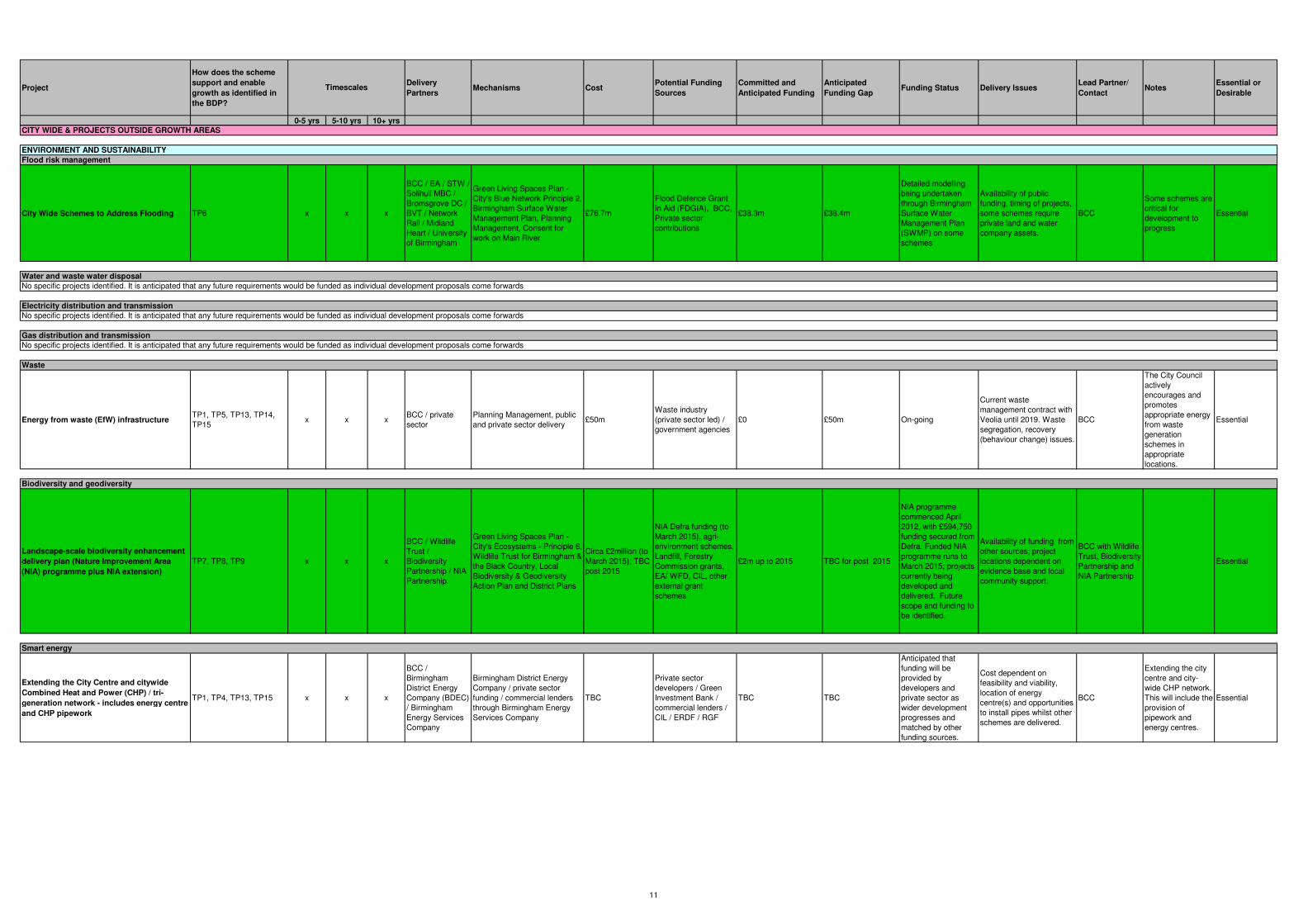
Project
How does the scheme
support and enable
growth as identified in
the BDP?
Delivery
PartnersMechanisms Cost
Potential Funding
Sources
Committed and
Anticipated Funding
Anticipated
Funding GapFunding Status Delivery Issues
Lead Partner/
ContactNotes
Essential or
Desirable
0-5 yrs 5-10 yrs 10+ yrs
Timescales
City Wide Schemes to Address Flooding TP6 x x x
BCC / EA / STW /
Solihull MBC /
Bromsgrove DC /
BVT / Network
Rail / Midland
Heart / University
of Birmingham
Green Living Spaces Plan -
City's Blue Network Principle 2,
Birmingham Surface Water
Management Plan, Planning
Management, Consent for
work on Main River
£76.7m
Flood Defence Grant
In Aid (FDGIA), BCC,
Private sector
contributions
£38.3m £38.4m
Detailed modelling
being undertaken
through Birmingham
Surface Water
Management Plan
(SWMP) on some
schemes
Availability of public
funding, timing of projects,
some schemes require
private land and water
company assets.
BCC
Some schemes are
critical for
development to
progress
Essential
Energy from waste (EfW) infrastructure TP1, TP5, TP13, TP14,
TP15 x x x
BCC / private
sector
Planning Management, public
and private sector delivery £50m
Waste industry
(private sector led) /
government agencies
£0 £50m On-going
Current waste
management contract with
Veolia until 2019. Waste
segregation, recovery
(behaviour change) issues.
BCC
The City Council
actively
encourages and
promotes
appropriate energy
from waste
generation
schemes in
appropriate
locations.
Essential
Landscape-scale biodiversity enhancement
delivery plan (Nature Improvement Area
(NIA) programme plus NIA extension)
TP7, TP8, TP9 x x x
BCC / Wildlife
Trust /
Biodiversity
Partnership / NIA
Partnership
Green Living Spaces Plan -
City's Ecosystems - Principle 6,
Wildlife Trust for Birmingham &
the Black Country, Local
Biodiversity & Geodiversity
Action Plan and District Plans
Circa £2million (to
March 2015); TBC
post 2015
NIA Defra funding (to
March 2015), agri-
environment schemes,
Landfill, Forestry
Commission grants,
EA/ WFD, CIL, other
external grant
schemes
£2m up to 2015 TBC for post 2015
NIA programme
commenced April
2012, with £594,750
funding secured from
Defra. Funded NIA
programme runs to
March 2015; projects
currently being
developed and
delivered. Future
scope and funding to
be identified.
Availability of funding from
other sources; project
locations dependent on
evidence base and local
community support.
BCC with Wildlife
Trust, Biodiversity
Partnership and
NIA Partnership
Essential
Extending the City Centre and citywide
Combined Heat and Power (CHP) / tri-
generation network - includes energy centre
and CHP pipework
TP1, TP4, TP13, TP15 x x x
BCC /
Birmingham
District Energy
Company (BDEC)
/ Birmingham
Energy Services
Company
Birmingham District Energy
Company / private sector
funding / commercial lenders
through Birmingham Energy
Services Company
TBC
Private sector
developers / Green
Investment Bank /
commercial lenders /
CIL / ERDF / RGF
TBC TBC
Anticipated that
funding will be
provided by
developers and
private sector as
wider development
progresses and
matched by other
funding sources.
Cost dependent on
feasibility and viability,
location of energy
centre(s) and opportunities
to install pipes whilst other
schemes are delivered.
BCC
Extending the city
centre and city-
wide CHP network.
This will include the
provision of
pipework and
energy centres.
Essential
Flood risk management
ENVIRONMENT AND SUSTAINABILITY
Electricity distribution and transmission
Gas distribution and transmission
Smart energy
Waste
Biodiversity and geodiversity
CITY WIDE & PROJECTS OUTSIDE GROWTH AREAS
No specific projects identified. It is anticipated that any future requirements would be funded as individual development proposals come forwards
No specific projects identified. It is anticipated that any future requirements would be funded as individual development proposals come forwards
No specific projects identified. It is anticipated that any future requirements would be funded as individual development proposals come forwards
Water and waste water disposal
11

Project
How does the scheme
support and enable
growth as identified in
the BDP?
Delivery
PartnersMechanisms Cost
Potential Funding
Sources
Committed and
Anticipated Funding
Anticipated
Funding GapFunding Status Delivery Issues
Lead Partner/
ContactNotes
Essential or
Desirable
0-5 yrs 5-10 yrs 10+ yrs
Timescales
Allotment Improvement Plan TP7, TP8, TP9 x x x
Public Health &
Allotments
Working Party /
GIA Delivery
Group
Green Living Spaces Plan -
City's Productive Landscapes
Principle 4. To follow timeline
of funding profile
£3mBCC capital/ internal
land exchange, CIL£0 £3m
£3 million required for
urgent restoration of
allotments as
identified in asset
study
Sites identified, awaiting
consent. Delivered by
Green Infrastructure and
Adaptation Delivery Group;
Planning permissions
required for a number of
sites.
BCC Parks Essential
Parks Infrastructure Growth Schemes- 10
schemes - 1 per district
TP2, TP7, TP8, TP9,
TP11x x x BCC
Green Living Spaces Plan -
Principle 7, Parks Asset
Management Programme +
multiple challenge map; 10
schemes- one for each district
to 2020
£3.5 million for
2013; £10 million
needed over 5
years- 2015-20
Local Improvement
Budget £3.5million
single pot. Other
funding sources need
to be explored.
£3.5 million for 2013 £2 million per year
Priorities informed by
multiple challenge
maps for Birmingham
from Green Living
Spaces Plan, and
include Northfield,
Selly Oak, Sutton
Coldfield, Yardley
and Ladywood.
Future funding and
scope to be explored.
Delivered by Green
Infrastructure and
Adaptation Delivery Group;
Planning permissions for
some schemes.
BCC Parks Essential
Reservoir Work to Park Pools TP7, TP8 x x xBCC / Highways /
EA
Green Living Spaces Plan -
City's Blue Network Principle 2,
Rotation of inspections, reports
& upgrades
£5m up to 2015;
funding post 2015
TBC
Safety Budgets, BCC
Capital & EA flood
defence budgets
£320,000 for 2013 £4.7m
Draft schemes in
place, permissions
awaited. Future
funding to be
identified.
Delivered by Green
Infrastructure and
Adaptation Delivery Group;
Reservoir Act Legislation.
BCC Parks
This project
addresses Health
& Safety at Work
Act and Reservoir
Act
Essential
Canalside improvements (including canal
features) TP2, TP7, TP12 x x x
BCC / Canals and
Rivers Trust /
Sustrans /
Environment
Agency
Development Management,
Green Living Spaces Plan -
City's Blue Network Principle 2,
Cycle City Ambition Fund,
Heritage Strategy/ Historic
Environment SPD
TBC CIL, S106 TBC TBC Ongoing
Potential to secure funding
from developers for
canalside development
proposals.
BCC/ Canal and
Rivers TrustEssential
Heritage assets at risk TP12 x x x
BCC / English
Heritage /
Birmingham
Conservation
Trust
Development Management/
Heritage Strategy/ Historic
Environment SPD
TBCCIL, other sources
may include HLF, EHTBC TBC Ongoing
It is anticipated that
projects will be funded as
individual development
proposals are brought
forward.
BCC
Essential to
conserve the
significance of non-
renewable assets
Essential
x £6.4m
£3.4m confirmed to
2015, future DfE
allocations TBC.
£1m for 2015
x x TBC TBC TBC
x £84.4m to 2017Confirmed funding to
2017 of £61.1m£23m
x x TBC TBC TBC
BCC / DfE /
Academies / Free
Schools / EFA
Estimated 8100 primary
places required to 2017,
sustained growth likely to
extend beyond 2017.
Identification of preferred
options managed through
Expressions of Interest
process. Delivery across
new education landscape
involves new partnership
working.
BCC / DfE /
Academies / Free
Schools / EFA/
Private, Voluntary
and Independent
(PVI) early years
providers /
children's centres
Education Development Plan
TP35
Green infrastructure and climate change adaptation
New early years education infrastructure for
nursery provision
Cabinet approval for
Basic Need funding
of £31.1m funding
envelope for
indicative
requirements to
2016, to be taken
through BCC
gateways as projects
emerge
Heritage assets
Up to 8000 additional
places required by 2015;
identification of preferred
options managed through
Expressions of Interest.
Delivery complex due to
range of providers across
the delivery sector.
Additional Mainstream Primary Places to
meet population growth
DfE annual Basic
Need Grant funding,
CIL, S106, existing
schools (surplus
budgets, additional
spaces), Free Schools
BCC Education &
Skills
Infrastructure
Strategy to make
better use of
existing space and
influence location
of Free School s to
meet basic need in
order to reduce
funding gap for
additional places
and deliver within
available
resources.
Essential
Essential
Minerals
Early years education and childcare/ Mainstream and special school provision
No specific projects identified.
HOMES AND NEIGHBOURHOODS
New central
government
requirement
introduced from
2013 for free 15hrs
nursery provision
for vulnerable 2yr
olds.
BCC Education &
Skills
Infrastructure
Education Development Plan
Cabinet approval for
£3.2m for
requirements to
2015.
TP35
Early Years Capital
(DFE), Section 106,
CIL
12

Project
How does the scheme
support and enable
growth as identified in
the BDP?
Delivery
PartnersMechanisms Cost
Potential Funding
Sources
Committed and
Anticipated Funding
Anticipated
Funding GapFunding Status Delivery Issues
Lead Partner/
ContactNotes
Essential or
Desirable
0-5 yrs 5-10 yrs 10+ yrs
Timescales
x
BCC / DfE /
Academies / Free
Schools / EFA
Education Development Plan £76.9m to 2017
DfE annual Basic
Need Grant funding,
CIL, S106, existing
schools (surplus
budgets, additional
spaces), Free Schools
£16.9m confirmed
funding to 2015, a
further £9.6m to 2016.
£38m
BCC Education &
Skills
Infrastructure
x x TBC TBC TBC
x £62.8m to 2017
Confirmed funding of
£44m Basic Need to
2016
£19.7m
x x TBC TBC TBC
Planned Maintenance Investment in the
existing schools estateTP35 x x x
BCC/ DfE/
Academies/ Free
Schools/ EFA
Education Development Plan £60m 2014-2019Annual grant funding
from DfE / EFA
£11m 2013/14 grant
funding, anticipate up
to £4m match funding
annually from LA
maintained schools.
TBC
Capital maintenance
annual grant funding
is approved annually
through cabinet
gateways for
allocation to planned
maintenance and
dual funded
maintenance
projects.
New central government
initiatives may address the
worst condition need, e.g.
Priority Schools Building
Programme 2 in 2014-
2019.
BCC Education &
Skills
Infrastructure
Strategy to support
effective asset
management and
planned
maintenance
programme,
levering co-
investment from
schools to upgrade
and sustainably
maintain the
estate.
Most extreme
condition need:
Essential .
Planned
investment to
maintain an
estate that
supports
outstanding
education
provision:
Desirable.
New Education, provision 18-25 years TP35 x x x
BCC / DfE /
Academies / Free
Schools / FE and
HE partners /
EFA / ISPs
Education Development Plan £5.5m
DfE - Demographic
Growth Capital Fund,
CIL, S106, LEP
Growth Fund
£5.5m secured to 2015
through bids from BCC
schools / delivery
partners
Nil
Cabinet approval for
£3m BCC projects
where funding
secured to 2015
EFA and SFA funding only
allocated on annual basis,
Free School creation
dependent on independent
groups submitting
successful applications to
DfE.
BCC Education &
Skills
Infrastructure
The priority for post-
16 infrastructure
investment in
Birmingham is to
reduce gaps in
provision for young
people with SENs
and other
vulnerable groups.
Essential
BCC Education &
Skills
Infrastructure
Further/higher education
Additional Special School Places to meet
population growth and growth in demand
BCC / DfE /
Academies / Free
Schools / EFA
Education Development Plan
DfE annual Basic
Need Grant funding,
CIL, S106, existing
schools (surplus
budgets, additional
spaces), Free Schools
Strategy to make
better use of
existing space and
influence location
of free schools to
meet basic need in
order to reduce
funding gap for
additional places
and deliver within
available resources
Essential
Cabinet approval for
Basic Need funding
of £26.5m. Funding
envelope for
indicative
requirements to
2016, to be taken
through BCC
gateways as projects
emerge.
TP35
Cabinet approval for
Basic Need funding
of £43.1m. Funding
envelope for
indicative
requirements to
2016, to be taken
through BCC
gateways as projects
emerge
Additional Mainstream Secondary Places to
meet population growth
Est 10,350 additional
secondary places required
to 2019, sustained growth
will extend beyond 2019.
Identification of preferred
options managed through
Expressions of Interest
process. Delivery across
new education landscape
involves new partnership
working. Appetite for
expansion within existing
spaces and creation of
Free Schools by central
government is likely to
increase supply of places
and reduce the affordability
gap
Strategy to make
better use of
existing space and
influence location
of free school s to
meet basic need in
order to reduce
funding gap for
additional places
and deliver within
available resources
Essential
Estimated 800 new places
required by 2017,
sustained growth expected
beyond 2017.
TP35
13

Project
How does the scheme
support and enable
growth as identified in
the BDP?
Delivery
PartnersMechanisms Cost
Potential Funding
Sources
Committed and
Anticipated Funding
Anticipated
Funding GapFunding Status Delivery Issues
Lead Partner/
ContactNotes
Essential or
Desirable
0-5 yrs 5-10 yrs 10+ yrs
Timescales
Full Participation (18-25 years)- initiatives to
ensure young people remain in education
and training leading to meaningful
employment/ general training and
employment initiatives to improve access to
jobs and training for Birmingham residents
TP25, TP35 x x x
Birmingham
Youth
Employment
Partnership /
schools / FE and
HE colleges /
ISPs/ employers
and businesses /
GBSLEP / NAS /
DWP
Full Participation Plan,
Apprenticeship Strategy and
NEET Strategy
TBCPublic/Private/ CIL/
S106TBC TBC Ongoing
Need to ensure that
development opportunities
are brought forward to
enable job creation.
BCC Essential
Kings Norton 3 Estates regeneration TP31 x x xBCC / Private
sector
Housing/ Planning
Management
£6m (+ £10m for
maintenance)
Private
sector/S106/CIL£0 £16m
Planning Framework
adopted
Land assembly and
infrastructure to include
new roads and
improvements to open
space. CPO process.
BCC /BMHT Essential
Druids Heath regeneration TP31 x xBCC / Private
Sector
Housing/ Planning
ManagementTBC Public/Private/ CIL TBC TBC TBC BCC/ BMHT
Long term project -
detailed information
not clear at present
Essential
Bromford regeneration TP31 x xBCC / Private
Sector
Housing/ Planning
ManagementTBC Public/Private/ CIL TBC TBC TBC BCC/ BMHT
Long term project -
detailed information
not clear at present
Essential
Natural Health Improvement Zones (NHIZs)/
Biophilic CityTP7, TP36 x x x
Public Health / Air
Quality
Management
Team / University
of Birmingham /
Parks Service
Green Living Spaces Plan - A
Healthy City Principle 3
Approx.£1m over
5 year period 2015-
20 (£200,000 per
year)
Birmingham Tree
Bond, BCC Carbon
Budget, Forestry
Commission Grant,
Natural England GI
Fund & Research
Grants, CIL
£10,000 per year from
public agencies and
research grants
£190,000 per year
Potential locations
now mapped, Public
Health England
supportive, new
initiative for 2014
onwards
To be delivered via the
Green Infrastructure and
Adaptation Delivery Group
reporting to the Green
Commission; linked to
asthma prevention and
cardio-vascular reduction;
JSNA top priorities.
BCC Public
Health,
Parks &
Highways/ Amey
plc
NHIZs seek to
tackle the growing
evidential link
between traffic
emissions and poor
health, particularly
in relation to air
bourn particles.
The Zones will be
declared in areas
of Birmingham
which score poorly
for both health and
environmental
factors (below a set
benchmark).
Essential
Birmingham's Food Charter and Food
Council - new 'A -Z of Food & Growing
Programme' Birmingham Healthy Eating &
Community Growing Programme
TP9, TP36 x x x
Public Health /
Birmingham Food
Council / Health &
Well Being Board
/ BCC Parks
Green Living Spaces Plan -
City's Productive Landscapes
Principle 4
Approx. £0.5m
over ten year
period (circa.
£50,000 per year)
Public Health,
Birmingham Food
Council; Health and
Well Being Board;
Sustainable Food
Cities Programme, CIL
Circa. £10,000 per year
Sustainable Food
Cities Programme,
Health and Well Being
Board
£40,000 per yearLive projects from
April 2014
Delivered by Green
Infrastructure and
Adaptation Delivery Group
and Birmingham Food
Council; Public Health
lead; linked to obesity
reduction; JSNA top
priorities.
BCC Public
Health &
Birmingham Food
Council
Essential
People, Place & Purpose Intelligent Health
SMART Routes
TP7, TP36, TP37, TP38,
TP39, TP40, TP44 x x x
Public Health /
GP Consortia /
Be-active / BCC /
Schools / Centro
Green Living Spaces Plan-A
Healthy City Principle 3
Approx. £0.5m
over ten year
period (£50,000
per year)
Public Health People
& Place; Centro LSTF,
Schools; research
grants, CIL
£5,000 per year £45,000 per yearNew initiative for
2014 onwards
Delivered by Green
Infrastructure and
Adaptation Delivery Group;
Public Health lead; linked
to obesity reduction and
top 5 non-communicable
diseases - JSNA top
priorities.
BCC Public
Health, Health
Intelligence,
Centro, BCC
services
Desirable
Healthcare facilities
Emergency services
Housing
Sport and leisure facilities
No specific projects identified. It is anticipated that any future requirements would be funded by the emergency services
14

Project
How does the scheme
support and enable
growth as identified in
the BDP?
Delivery
PartnersMechanisms Cost
Potential Funding
Sources
Committed and
Anticipated Funding
Anticipated
Funding GapFunding Status Delivery Issues
Lead Partner/
ContactNotes
Essential or
Desirable
0-5 yrs 5-10 yrs 10+ yrs
Timescales
City Wide Sport and Leisure Provision
(including Active Parks Programme)TP11 x x x
BCC / Sport
England / national
governing bodies
/ local sports
teams and groups
/ Contractors
appointed through
Framework
Agreement /
schools / third
sector
BCC's Strategic Framework for
sport and physical activity TBC
BCC/ Sport England/
CIL/ S106/ private
operators
TBC TBC
A strategic
framework for the
development of sport
and physical activity
facilities in
Birmingham has
been prepared by the
Council. Funding will
be allocated in
accordance with the
priorities in the
framework.
Given the diversity of sport
provision across the City,
site specific issues will
need to be identified.
BCC/ contractors
appointed through
the framework
agreement
In addition to built
provision, funding
needs to be
secured for the
Active Parks
Programme.
Essential
Support for Core Employment Areas
including access improvements, site
assembly and branding. Business
relocations and mitigating the impact of
HS2. The Battery Way Extension is
recognised as a key project, which includes
the completion of a link road between
Warwick Road and Reddings Lane.
TP16, TP18 x x xBCC / private
sector
Development Management,
briefs and frameworksTBC TBC TBC TBC
Availability of public and
private sector funding
needs to be determined.
Battery Way Extension will
be delivered through s278
if retail consent is
implemented (£3.5m).
BCC Desirable
Tyseley Environmental Enterprise District
(Economic Zone) and Tyseley BridgeTP15, TP16 x x x
BCC / Private
Sector / Network
Rail
Tyseley Environmental
Enterprise District (TEED)
Framework in place
£5mBCC/Centro/HCA/
Private Sector/ CIL£0.9m £4.1m
Support already in
place. Business
support £0.9m.
Extent and availability of
public sector funding
needs to be determined.
Market demand to invest
and grow businesses.
Works to the weight
restricted Tyseley Bridge is
a key project to support
growth in the TEED.
BCC Essential
Local Centres Programme inc
environmental improvements/ traffic
management - (e.g. Acocks Green,
Edgbaston, Erdington, Glebe Farm,
Harborne, Kingstanding, Sparkbrook, Perry
Barr and Sutton Coldfield)
TP20, TP23 x x xBCC / Private
Sector
Development Management,
Local Centres Programme£12m BCC/ CIL £0 £12m
Availability of public and
private sector funding
needs to be determined.
BCC Essential
Major road corridors developed as key
gateways and green corridors, including
A45/A34/A41/A47. Delivery of individual
sites, support to core employment areas
and highway/environmental improvements
TP18, TP43 x x x
BCC / Centro /
HCA / Private
Sector
Frameworks in place or being
prepared TBC
BCC/ Centro/ HCA/
Private Sector/ CILTBC TBC TBC
Extent and availability of
public sector funding
needs to be determined.
Market demand to invest
and grow businesses.
BCC Desirable
Yardley Road / Stockfield Road - highway
improvement scheme to complement / tie in
to works north of Swan Island
TP20, TP43 x BCC Public £3.5m BCC/ CIL £0m £3.5m
There is a need to
enhance no. 11 bus route
and improve access to
Tyseley area.
BCC Desirable
A38M Aston Expressway Tame Valley
Viaduct- Phase 3 (maintenance scheme)
TP43, Aston, Newtown
and Lozells Growth Area
(GA3), City Centre Growth
Area (GA1)
x x BCC / HA Public £82m
Major scheme bid from
Department of
Transport / BCC
corporate resources/
CIL / LGF
£0m £82mFeasibility work
undertaken BCC Essential
ECONOMY AND NETWORK OF CENTRES
Employment land
Network of centres
Strategic and local highway network
CONNECTIVITY
15
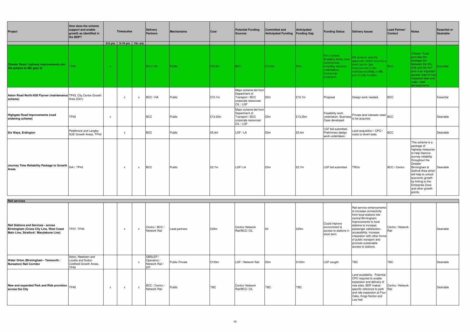
Project
How does the scheme
support and enable
growth as identified in
the BDP?
Delivery
PartnersMechanisms Cost
Potential Funding
Sources
Committed and
Anticipated Funding
Anticipated
Funding GapFunding Status Delivery Issues
Lead Partner/
ContactNotes
Essential or
Desirable
0-5 yrs 5-10 yrs 10+ yrs
Timescales
Chester Road- highway improvements (inc
HA scheme to M6, junc 5)TP43 x BCC/ HA Public £10.6m BCC £10.6m £0m
Fully funded.
Enabling works have
commenced,
including statutory
undertakers
diversions/
protection.
HA scheme recently
approved, which involves a
pinch points type
improvement to the
northbound offslip of M6,
junc 5 (fully funded).
BCC
Chester Road
provides the
strategic link
between the M6,
A38 and the A47
and is an important
access road for key
industrial sites and
major retail
developments.
Essential
Aston Road North/A38 Flyover (maintenance
scheme)
TP43, City Centre Growth
Area (GA1)x x BCC / HA Public £10.1m
Major scheme bid from
Department of
Transport / BCC
corporate resources/
CIL / LGF
£0m £10.1m Proposal Design work needed. BCC Essential
Highgate Road Improvements (road
widening scheme)TP43 x BCC Public £13.25m
Major scheme bid from
Department of
Transport / BCC
corporate resources/
CIL / LGF
£0m £13.25m
Feasibility work
undertaken. Business
Case developed
Private land interests need
to be acquired. BCC Desirable
Six Ways, ErdingtonPeddimore and Langley
SUE Growth Areas, TP43x BCC Public £5.4m LGF / LA £0m £5.4m
LGF bid submitted.
Preliminary design
work undertaken.
Land acquisition / CPO /
costs to divert stats.BCC Desirable
Journey Time Reliability Package to Growth
AreasGA1, TP43 x x BCC Public £2.7m LGF/ LA £0m £2.7m LGF bid submitted TROs BCC / Centro
This scheme is a
package of
highway measures
to help improve
journey reliability
throughout the
Greater
Birmingham &
Solihull Area which
will help to unlock
economic growth
by linking to the
Enterprise Zone
and other growth
points.
Desirable
Rail Stations and Services - across
Birmingham (Cross City Line, West Coast
Main Line, Stratford / Marylebone Line)
TP37, TP40 x xCentro / BCC /
Network RailLead partners £25m
Centro/ Network
Rail/BCC/ CIL£0 £25m
Could improve
environment &
access to stations in
short term
Rail service enhancements
to increase connectivity
from local stations into
central Birmingham.
Improvements to local
stations to increase
passenger satisfaction,
accessibility, increase
integration with other forms
of public transport and
promote sustainable
access to stations.
Centro / Network
RailDesirable
Water Orton (Birmingham - Tamworth /
Nuneaton) Rail Corridor
Aston, Newtown and
Lozells and Sutton
Coldfield Growth Areas,
TP40
x
GBSLEP /
Operators /
Network Rail /
DfT
Public Private £103m LGF / Network Rail £0m £103m LGF sought TBC TBC Desirable
New and expanded Park and Ride provision
across the City TP40 x x x
BCC / Centro /
Network Rail Public TBC
Centro/ Network
Rail/BCC/ CILTBC TBC
Land availability. Potential
CPO required to enable
expansion and delivery of
new sites. BDP makes
specific reference to park
and ride expansion at Four
Oaks, Kings Norton and
Lea Hall.
Centro / Network
RailDesirable
Rail services
16

Project
How does the scheme
support and enable
growth as identified in
the BDP?
Delivery
PartnersMechanisms Cost
Potential Funding
Sources
Committed and
Anticipated Funding
Anticipated
Funding GapFunding Status Delivery Issues
Lead Partner/
ContactNotes
Essential or
Desirable
0-5 yrs 5-10 yrs 10+ yrs
Timescales
Birmingham-Kings Heath-Maypole SPRINT TP37, TP40 x Centro Public and private TBCDfT Major Scheme/
CILTBC TBC Proposal Centro Desirable
Birmingham-Hagley Road SPRINT TP37, TP40 xCentro/ BCC/
operatorsPublic and private £12.2m
DfT Major Scheme,
Local Authority,
Transport Operators/
CIL
£8.1m £4.1mPreliminary Design
StageSubject to full funding. Centro
All highways land,
no known barriers.Desirable
Birmingham - Hagley Road Rapid Transit
(upgrade from SPRINT to Metro)TP37, TP40 x
Centro/ BCC/
operatorsPublic and private £250m
DfT Major Scheme/
CIL£0 £250m Proposal TWA Order needed. Centro Desirable
Birmingham- A34 SPRINT
TP37, TP40, Aston,
Newtown and Lozells
Growth Area
xCentro/ BCC/
operatorsPublic and private £40m BCC/Centro/ CIL £5m £35m Proposal Centro Desirable
Birmingham-Bartley Green SPRINT TP37, TP40 xCentro/ BCC/
operatorsPublic and private £30m BCC/Centro/ CIL/LGF £5m £25m Proposal Centro Desirable
A45 Rapid Transit
Bordesley Park and
Eastern Triangle Growth
Areas, TP37, TP40
x xCentro/ BCC /
SMBC / operatorsPublic and private £50m LGF/ Centro/ BCC/CIL £0m £50m LGF sought
Funding opportunities and
land take. Centro Desirable
Eastside – East Birmingham - Birmingham
Airport - HS2 Interchange Metro/SPRINTTP37, TP40, Bordesley
Park Growth Area x
Centro/ BCC/
SMBC/ operators/
DfT
Public and private £470mDfT Major Scheme/
CIL/ LGF£0m £470m Proposal
TWA Order needed. In the
range of £2 – 10m per km
Bus Rapid Transit or in
the region of £25m per km
light rail (2012 prices).
BCC/ Centro
Route needs to be
determined and
whether Metro or
BRT is taken
forward.
Desirable
Birmingham – Sheldon – Birmingham
Airport – HS2 Interchange Metro/SPRINT
TP37, TP40, Bordesley
Park Growth Area x
Centro / BCC /
DfT / Birmingham
Airport
Public and private TBCCentro / DfT / BCC/
CIL/ LGF£0 TBC Proposal
Need for TWA Order, land
acquisitions and
environmental
assessment.
BCC/ Centro
Route needs to be
determined and
whether Metro or
BRT is taken
forward.
Desirable
Smart Network, Smarter Choices Growth
Areas - Phase 2 TP37, TP40 x x BCC / Centro Public £25m
DfT/ Public/ Private/
CIL/ LGF£0m £25m Proposal
Subject to funding and
availability of
complementary revenue
funding to provide smarter
choices measures.
BCC / Centro
Corridor based
integrated
infrastructure
package for small
scale junction
improvements,
public transport
infrastructure and
walking and
cycling. Would
build on the
identified LTP
Strategic Smart
Route Network and
Route
Management
Strategy work.
Essential
Birmingham Cycle Revolution TP37, TP39 x x x BCC
Planning & Regeneration /
Transportation Urban Design/
Green Living Spaces Plan -
City's Greenways Principle 5
£24.3mCycle City Ambition
Grant, DfT, BCC£24.3m £0m
£17m funding from
Cycle City Ambition
and additional £7.3m
from BCC confirmed.
Initial network alignments
developed. Additional
feasibility work needs to be
undertaken. TROs will be
needed to make some of
the proposals effective.
BCC Essential
Walking and Cycling
Rapid transit and local bus network
17
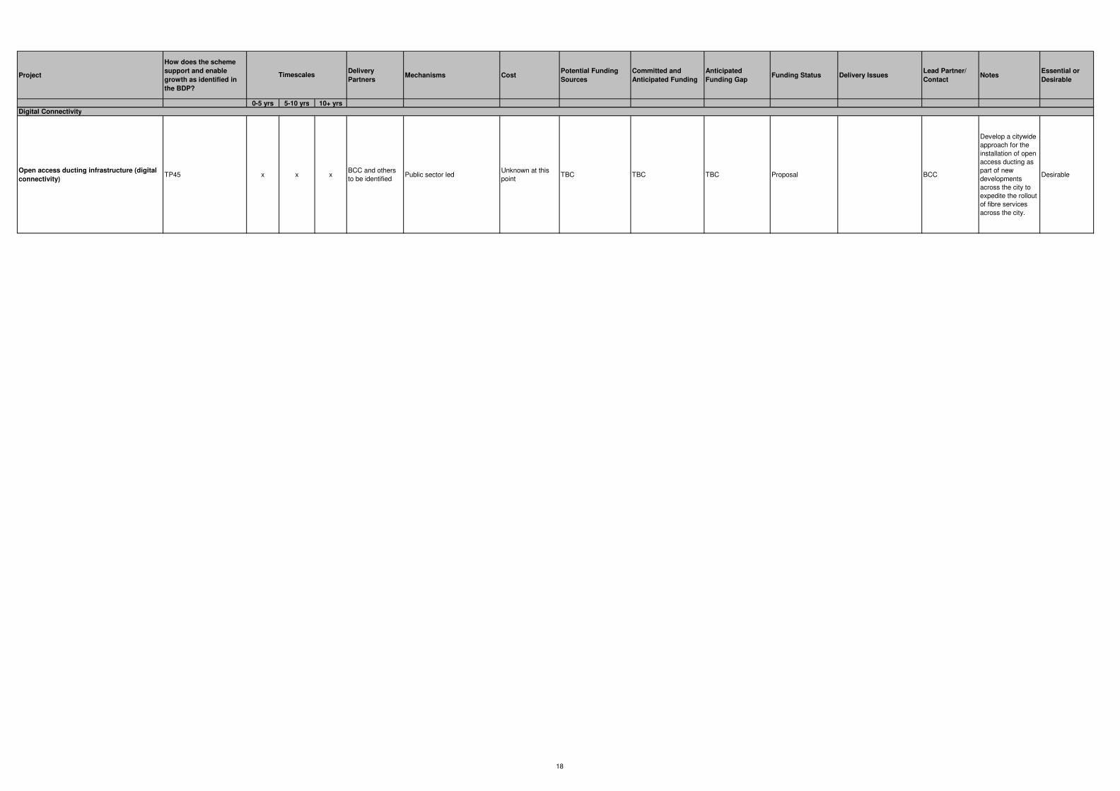
Project
How does the scheme
support and enable
growth as identified in
the BDP?
Delivery
PartnersMechanisms Cost
Potential Funding
Sources
Committed and
Anticipated Funding
Anticipated
Funding GapFunding Status Delivery Issues
Lead Partner/
ContactNotes
Essential or
Desirable
0-5 yrs 5-10 yrs 10+ yrs
Timescales
Open access ducting infrastructure (digital
connectivity)TP45 x x x
BCC and others
to be identified Public sector led
Unknown at this
pointTBC TBC TBC Proposal BCC
Develop a citywide
approach for the
installation of open
access ducting as
part of new
developments
across the city to
expedite the rollout
of fibre services
across the city.
Desirable
Digital Connectivity
18