beginnings (from past to present: the history of adams county)
TRANSCRIPT
BeginningsPinery Road Days
A fter centuries of occupation bynative people, Adams county wel-
comed its earliest European-Americansettlers in the 1820s and '30s. An old industrywinding down in central Wisconsin--the fur trade--and a new industry just arrived--logging--brought
newcomers to the county.
In 1827, when Wisconsin was still a part of
Michigan Territory, Amable and Judith Bourassa
Grignon built a trading post in the sloughs on thewest bank of the Wisconsin River in what is now
the northwestern comer of Petenwell Lake. After a
flood wiped out their first establishment, theGrignons moved across the river to a site near the
mouth of "Grignon's" or 14-Mile Creek in the
future Town of Rome. The cabin they built in 1829
can be called the first home erected by a non-
Indian in Adams County.
Part of Wisconsin's oldest French-Indian, fur-trading family, the Grignons were welcomed by
the Ho-Chunk and Menominee Indians who still
held legal title to this stretch of the WisconsinRiver Valley. The Indians traded deer hides and
beaver pelts for tools, powder, flints, tobacco,
pipes and other goods that the Grignons broughtupriver by canoe from Portage. In 1832, Amableobtained Indian permission and built a sawmillupriver opposite Nekoosa, but the Grignonscontinued to live on 14 Mile Creek, where Judithgave birth to a son named Robert in 1837. He isrecorded as the first child of European heritageborn within the future bounds of Adams County.
About the same time as the Grignons weresettling in what became the Town of Rome,another French-Indian trader, Francis Provonsal,opened a post on the west bank of the Wisconsin afew miles north of Petenwell Rock. Provonsal alsotraded with the Indians on both sides of the riverand the family remained in the area for manyyears. Provonsal's son, Frank, started a ferry atPetenwell Rock in 1856 and ran it until he waskilled in a brawl with an Indian named Bill Dandyin 1869. His wife Charlotte then "manned" theferry until 1875.
In the 1820s and for most of the 1830s,Wisconsin north and west of the Fox-WisconsinRiver waterway was not open to Americansettlement. The land was still Indian territory
18
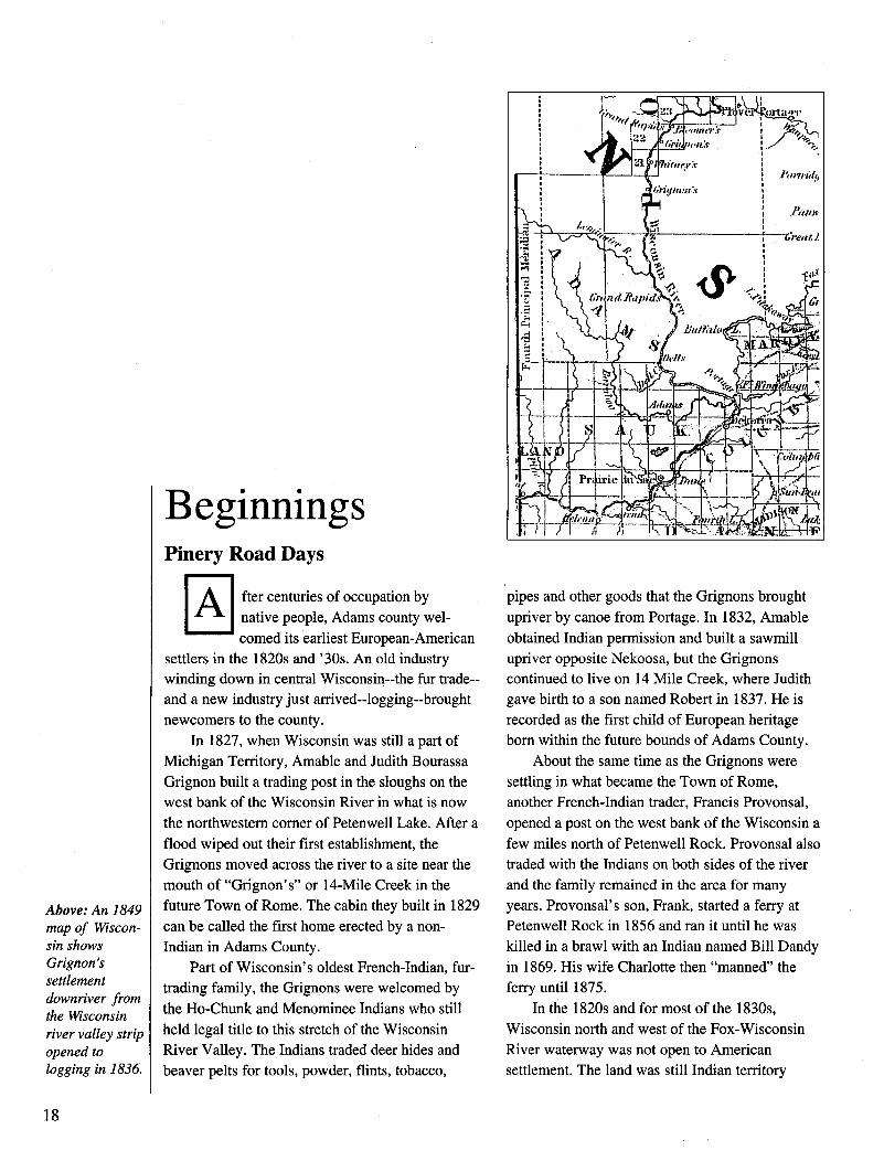
Above: An 1849map of Wiscon-sin showsGrignon'ssettlementdownriver fromthe Wisconsinriver valley stripopened tologging in 1836.

Big Flats settlers Victor, Andrew, Baby Eva, Oline, Milton Harry, Lars and Martin Nelson, 1904 in front of their log home.
19

under the control of the Ojibwes, Menominees and
Ho-Chunks. Traders like the Grignons and the
Provonsals were welcome because the Indiansneeded the goods they offered. Only occasionallydid the Indians allow others to intrude in their
territory.Daniel Whitney was one of the first. In
exchange for powder, shot, tobacco, seed corn and
other goods, he received permission from the
Menominees to build a dam and water-poweredsawmill on the east side of the rapids at Nekoosa
in 1832. The water-powered mill consisted of a
simple up-and-down or "muley" saw that turned
out rough-cut pine boards that were assembled into
rafts and floated down the Wisconsin to market.Whitney's was the first dam and sawmill on
the Wisconsin, the predecessor of many more to
come. Though not in Adams County it had an
important influence here. To operate, the sawmill
needed equipment and workers, but any craft
larger than a canoe usually could not navigate the
sandy and shallow Wisconsin River above the
Dells and no railroads existed anywhere near
Wisconsin in 1832. Therefore, in order to supplyhis mill, Whitney built a road to it from the nearest
point where supplies could be obtained, Portage.
Following ancient, Indian trails, crossing the
prairies, skirting the hills and marshes, the sawmill
owner blazed a roadway that ran from Portage
north and west to Grignon's then upriver to his
mill opposite Nekoosa. Since it connected the
settled part of Wisconsin to the forests and
sawmill country in the north, Whitney's trail was
called the Pinery Road. From the time it was
blazed until it was supplanted by railroads in the
1870s, the Pinery Road was used heavily by
lumbermen cutting the forest of the upper Wiscon-
sin Valley and by the settlers who joined them inAdams County and points north.
About the same time that Whitney was blazing
his trail in Adams County, the Black Hawk "War"
took place. Federal troops and militia men from
the state of Illinois and the Wisconsin portion of
the territory of Michigan, pursued a band of Sauk
Indians led by Chief Black Sparrow Hawk across
southern Wisconsin from Lake Koshkonong to the
Mississippi River. The chase ended in 1833, with
heavy Indian losses, Black Hawk captured and his
people banished to reservations in Iowa. As a
result, settlers in southern Wisconsin pressured
territorial and federal officials to expand the area
open for settlement. A series of treaties followed--
in 1832 and 1837 with the Ho-Chunk; in 1836 and
1848 with the Menominee--in which the Indians
relinquished their claims to central Wisconsin,
including Adams County.
The 1836 Menominee Treaty opened a six-
mile wide stretch of territory on the Wisconsin
River, between "Grignon's Bend" and Wausau, to
logging and saw milling. The communities of
Nekoosa, Port Edwards, Wisconsin Rapids,
Plover, Stevens Point, Mosinee and Wausau all
began as a result of this treaty. With more saw-
mills operating upriver, traffic on Daniel
Whitney's Pinery Road increased, even though it
ran through lands still closed to settlement.
On one of his trips to Portage, Whitney met a
man named Robert Wakely and persuaded him to
come upriver and work at his sawmill. Wakely and
his wife Ann, taking advantage of a period of high
water, helped pole a keelboat up the Wisconsin to
a spot where an underwater rock shelf formed a
natural crossing known as the "shallow place" or
Pointe Basse. Just north of what became the
Adams/Wood County line, Pointe Basse was at the
intersection of the Pinery Road and several other
trails. It was also the first resting place for river
rafters who had completed the arduous run down
the string of rapids that began at Biron and ended
at Nekoosa. With traffic by land and river at hand,
the Wakelys opened an inn at Pointe Basse.
At Wakely's, river drivers beached the "rapids
pieces" or small lumber rafts they had manhandled
through the rapids upstream and coupled them into
larger "Wisconsin River" rafts which they then
steered through the usually calm, shallow water in
the Adams County stretch of river.
Hazards here included "Grignon's Bend" at
the mouth of 14 Mile Creek where the current
could shove a raft into the bank and hold it there,
and the "Roche-A-Cri Flats," where the Big and
Little Roche-A-Cri Creeks met the Wisconsin and
created sandbars where the cumbersome rafts
could run aground. The shifting sands also caused
a bottleneck at Castle Rock, which could so clog
up with grounded lumber rafts that some river
drivers called it "the bridge." When they reached
the Head of the Dells at the southern edge of
20
Adams County, the rivermen once again beachedtheir rafts. Now the larger "Wisconsin River" raftswere disassembled into smaller "rapids pieces"better able to negotiate the narrow, fast-movingriver.
Wakely's Pointe Basse developed into a busylittle village of about twelve buildings and, in1845, acquired one of the first post offices on theWisconsin above Portage. It survived until railroaddevelopment began to bring an end to lumberrafting on the Wisconsin. The Wakely Inn wasdisassembled in 1873, the boards made into a raftand floated downstream to be rebuilt as a hotel inLone Rock.
Settlement at the other southern end of AdamsCounty was encouraged by the 1837 Ho-Chunk
Treaty, which opened up what became Sauk,Juneau and eastern Columbia County to non-Indians. The ink on this treaty, which many Ho-Chunk refused to recognize, was barely dry whenRobert Allen built an outpost on Black HawkIsland in the river at the head of the Dells. Al-though federal troops from Fort Winnebago,rightly suspecting that he was selling to theIndians, raided the place and confiscated Allen'swhiskey supply, his Dell House became a regularstopping place for river men rafting lumber fromupriver and a gathering place for prospectivesettlers from downstream.
Across the river from Allen's tavern was thestretch of ground north of Portage, west of the FoxRiver and east of the Wisconsin, where the Pinery
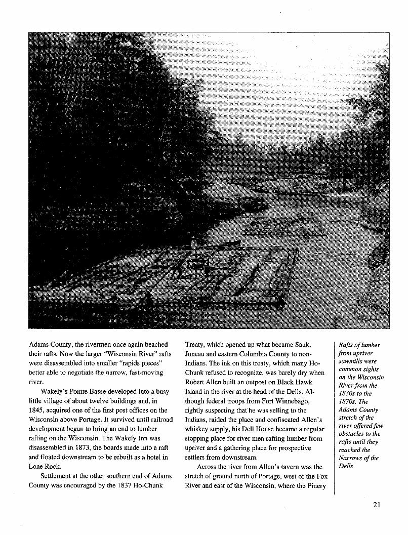
Rafts of lumberfrom upriversawmills werecommon sightson the WisconsinRiver from the1830s to the1870s. TheAdams Countystretch of theriver offered fewobstacles to therafts until theyreached theNarrows of theDells
21
Road ran, and which eventually became western
Columbia and Adams County. It was still part of
the Menominee nation, a fact which delayed, but
did not deter white settlers from moving in.
Generally credited as the first to settle in southern
Adams County is Jared Walsworth. A frontier type
with no identified occupation other than as "the
notorious trader," Jared was related to Silas
Walsworth, a prominent riverman, agent for the
American Fur Company, storekeeper and judge in
Portage.Jared Walsworth married well for the time and
the place. By capturing the heart, or at least the
assent of a Menominee woman, (name unknown)
he was allowed to live in a tribal village located a
few miles west of Lake Mason. He also got a
paying job, since the Menominee nominated him
as a tribal blacksmith entitled to receive treaty
money from the federal government in return for
making and repairing traps, hoes, pots and other
metal items for the tribe.
In 1838, with the Ho-Chunk moving out,
white folks moving in, and the Menominee his
welcoming in-laws, Walsworth opened a tavern
built of logs on the Pinery Road in Section 30 of
the Town of Dell Prairie. About fifteen miles out
of Portage, Walsworth's Tavern was ideally sited
to become a stopping point for lumberjacks and
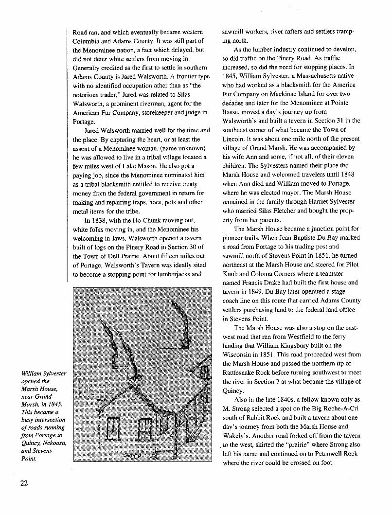
William Sylvesteropened theMarsh House,near GrandMarsh, in 1845.This became abusy intersectionof roads runningfrom Portage toQuincy, Nekoosa,and StevensPoint.
sawmill workers, river rafters and settlers tramp-
ing north.As the lumber industry continued to develop,
so did traffic on the Pinery Road. As traffic
increased, so did the need for stopping places. In
1845, William Sylvester, a Massachusetts native
who had worked as a blacksmith for the America
Fur Company on Mackinac Island for over two
decades and later for the Menominee at Pointe
Basse, moved a day's journey up from
Walsworth's and built a tavern in Section 31 in the
southeast comer of what became the Town of
Lincoln. It was about one mile north of the present
village of Grand Marsh. He was accompanied by
his wife Ann and some, if not all, of their eleven
children. The Sylvesters named their place the
Marsh House and welcomed travelers until 1848
when Ann died and William moved to Portage,
where he was elected mayor. The Marsh House
remained in the family through Harriet Sylvester
who married Silas Fletcher and bought the prop-
erty from her parents.
The Marsh House became a junction point for
pioneer trails. When Jean Baptiste Du Bay marked
a road from Portage to his trading post and
sawmill north of Stevens Point in 1851, he turned
northeast at the Marsh House and steered for Pilot
Knob and Coloma Comers where a teamster
named Francis Drake had built the first house and
tavern in 1849. Du Bay later operated a stage
coach line on this route that carried Adams County
settlers purchasing land to the federal land office
in Stevens Point.
The Marsh House was also a stop on the east-
west road that ran from Westfield to the ferry
landing that William Kingsbury built on the
Wisconsin in 1851. This road proceeded west from
the Marsh House and passed the northern tip ofRattlesnake Rock before turning southwest to meet
the river in Section 7 at what became the village ofQuincy.
Also in the late 1840s, a fellow known only as
M. Strong selected a spot on the Big Roche-A-Cri
south of Rabbit Rock and built a tavern about one
day's journey from both the Marsh House and
Wakely's. Another road forked off from the tavern
to the west, skirted the "prairie" where Strong also
left his name and continued on to Petenwell Rock
where the river could be crossed on foot.
22

With bends, twists and turns in the road, each name on the map and not much else. Settlers of the
one of the taverns--Walsworth's, Sylvester's,Strong's, Wakely's--was fifteen to twenty miles
away from its neighbor. It was a good trip on foot,
by oxcart, or on horseback and one that an increas-ing number of people were making throughout the1840s.
Two very important factors still delayedsettlement in Adams County. First was the legal
title held by the Menominee tribe, second was theabsence of a survey by which individual parcels of
land could be identified and purchased. Delaysettlement yes, but the presence of Indians and the
lack of surveyors did not prevent it.Throughout the late 1840s, settlers moved into
the Briggsville/Big Spring area that evolved into
the Town of New Haven. James and Ann BriggsCrothers, Ira and Ursula Edwards Ward, Uri andMarinda Morey Morse, James and Sally BestRamsey, Luther Stowell, Matthew Buckley and
Henry Landt were among those who arrived priorto the survey in 1851.
In 1847, Ephraim and Lucinda Hecocks came
up the Pinery Road and squatted on land near thetown line and built what has been called the "first
frame house in Dell Prairie town." The Davisfamily then came along, settled a few miles westof Jordan Lake and gave their name to the junctionof the Pinery Road and four other trails--DavisCorners.
Farther north in the glacial lakes territory thatbecame the Town of Jackson was the log cabin of"a hunter and trapper" named Jordan who left his
1850s remembered the cabin, but not the man.About two miles northeast of the lake could befound the farm of Dutch immigrant Jacob Vromanand a bit farther on the new home of Chester andOlive Jones who arrived by oxcart in 1849.
Settlers also came up the Wisconsin RiverValley along the river road into Dell Prairie andSpringville. Henry and Lorenzo Van Wie, of anold New York Dutch family, settled near whatbecame known as Olin in 1847. One year later a
New Yorker named James Edson built a dam onPlainville Creek in Dell Prairie and started whatbecame the county's first village, Plainville. Evenfarther up river was Henry W. Kingsbury, whomay have settled at the site of the village ofQuincy, then known as "Kingsbury's Crossing," asearly as 1844.
Others followed, but not in any great number.The federal census of 1850 reported a total of 187non-Indian people living in what was then AdamsCounty, which also included nearly all of thefuture Juneau county.
The 1850s--Indians Out, Settlers In
The Menominees held the last recognizedtribal claim to land in central Wisconsin untilOctober, 1848. At a meeting with federal officialsat Lake Poygan in Winnebago County, theMenominees agreed to exchange land that becameall or part of Adams, Juneau, Marquette,Waushara, Green Lake, Winnebago, Waupaca,
Rising abovethe prairie,Pilot Knob(County J and3rd Avenue)guided travel-ers on thebranch of thePinery Roadthat ran fromthe MarshHouse toHancock andStevens Point.It later helpedtravelers fromFriendshipfollow the roadto the Wiscon-sin CentralRailroad depotabout five mileseast at LibertyBluff
23

Shawano and Outagamie counties for 600,000
acres in Minnesota and $350,000 in cash. Earlier
that year, in March, the first "Adams County" had
been mapped west of the Wisconsin River. With
the Menominee leaving, the east side of the riverwas now open to "squatters" who claimed land not
by right of payment but by possession.
Squatters had to then defend their claims from
interlopers on the property itself and at the federal
land office. Squatters in the Big Spring-Briggsville
area organized a "Claim Protection Association"
whose members promised to help each other run
off latecomers, even those who followed the legal
nicety of actually buying a piece of property
before they settled on it.Purchasing land became easier in 1851 and
'52, when the survey was completed throughout
the county and the federal land office moved from
Mineral Point to the more accessible StevensPoint. The going rate for land purchased directly
from the federal government was $1.25 per acre.
The Homestead Act, which granted land to settlers
who promised to improve it, was not passed until
1862, too late for those who came in the 1850s.
State militia, and federal military veteranscould exchange "warrants" they had received aspay for land. For example, ninety days of duty in
the Black Hawk "War" with the Illinois or Michi-
gan militia was worth eighty acres of federal landanywhere in the country. While some veterans
used their warrants to obtain a homestead, manyothers sold theirs at a discount to real estate"speculators" who used them to claim land theythen sold to settlers at a mark-up.
The village of Friendship owes its birth to
speculator Henry Whitney who bought 80 acres at
the rapids of the Roche-A-Cri sight unseen, then
quickly sold the promising property to developersLuther Stowell and William Burbank. They platted
a village with lots they then sold at a mark-up.
Needless to say, since they were perceived as
driving up the price of land, speculators were oftenunpopular in frontier communities.
In the 1850s, the central Wisconsin River
Valley was on the frontier. It was the place where
settlers sought new homes, where the non-Indian
population soared, where farm, schools andchurches began and local government was orga-nized. By 1860, counties that were less than
sparsely populated in 1850 were filling up with
people. Juneau county had 8,770 people in 1860,
as did Waushara. Portage county had 7,507residents and Adams county grew to 6,492.
Most of the newcomers to Adams Countywere native-born white Americans. They came
from New England, New York and other north-
The AtchersonHouse, one of thefirst commercialbuildings inFriendship, wasbuilt shortly afterthe villagebecame thecounty seat.
24

eastern states and had ancestors who had migratedfrom Great Britain or Holland. They were joinedin Adams County by newly-arrived Irish, Germanand Norwegian immigrants. In addition, AdamsCounty was also home to an African-Americancommunity as early as 1852. Many pioneers cameby water via the Erie Canal and the Great Lakes.Once they landed at Milwaukee or another LakeMichigan port they set out on foot or in wagonsfor the frontier where land cost less than in settledareas.
A sampling of settlers from these early yearsillustrates the ethnic roots, place of origin andoccupations of the pioneers of Adams County.
James and Sally Best Ramsey came from Ohioto new Haven in 1850, accompanied by their 21year-old-son, Robert. Remembered by New Havenhistorian Archie Crothers as "a large man of greatforce" Robert farmed 400 acres, raised cattle and"always several yoke of oxen." He used his oxento break the virgin soil of New Haven for himselfand his neighbors. "I personally, remember havingseen him" wrote Crothers, "with his big wooden-beamed breaking plow, with ten yoke of oxenhitched to it for power, plowing up virgin soil and
turning under brush and small trees in the pro-cess."
Another man who used his oxen well was UriMorse, a farmer who came to New Haven fromwestern New York in 1849. Morse was remem-bered as having learned about the outbreak of theCrimean War between Russia and Turkey in 1854earlier than anyone else in the area. Knowing thatwar usually stimulated grain prices, he wentaround to his neighbors and bought as much wheatas he could. He then freighted it to Milwaukee byoxcart where it commanded a top price. Whathappened when Morse's neighbors learned abouthis successful speculation with their wheat has notbeen recorded.
Morse made the ten-day trip to sell his wheatin Milwaukee, because local mills that might havepurchased and marketed it for him had yet to bebuilt. In a few years, Morse could have availedhimself of the services of Massachusetts emigrantNewel Carpenter. A millwright in the literal senseof the term, he arrived on the banks of WhiteCreek in 1850 and, downstream of the presentvillage, built a water-powered sawmill. Thelumber he made was used to build some of the first
NewelCarpenter, whobuilt the firstmills at Eastonand WhiteCreek at hishome nearWhite Creek
25

frame buildings in the vicinity of White Creek and
Easton. A few years later Carpenter also built grist
mills at White Creek and Easton.
About the same time Newel Carpenter was
settling on the lower reaches of White Creek,
Jonathan and Sarah Colby left Vermont and
moved to 160 acres farther upstream. Members of
their family have combined farming and teaching
ever since and illustrate the pioneer commitment
to public education that was the foundation of the
school system.
Shortly after the Colbys arrived, the first
public school teacher on record in the county was
at work. In 1853, 15-year-old Amelia Seward,
native of Alleghany County, New York, went to
work in School District No. 1, Town of Jackson.
Her first school house was a 12' x 12' smokehouse
on the Vroman property. She was the first of
hundreds of young woman, many of them teenag-
ers, who brought a basic education to rural people.
The farmers who loaned their smokehouse for
Seward's school were from New York, descen-
dants of Dutch immimigrants. Two Vromanfamilies--Josiah and Elizabeth, Jacob and Fannie--
settled in Jackson in 1850. Jacob Vroman was an
avid hunter, who shot at least one deer every year
from 1848 to 1898. He also bagged many black
bears and, according to one author, "three elk, the
only ones ever shot in the state."
Game was plentiful on the frontier, as reported
by Sophronia Temple, who came from Granby,
Massachusetts with her husband Timothy to a farm
on the Wisconsin near Plainville. "There are some
bears here yet," she wrote to friends in Granby in
1856, "five were killed last summer....have a
plenty of partridges, prairie chickens and wild
ducks in the creek near the house."
The Wisconsin River provided sustenance in
the form of fish and game, and also supplied jobs.
James Trumbull, who came to Quincy from
Vermont with his parents Simeon and Helen in
1857, left home at age 16 to spend 25 years
tending lumber rafts on the Wisconsin and Missis-sippi. Appropriately, the Castle Rock Dam is built
on the site of the original Trumbull farm.Matthew Buckley, a wheelwright from Ireland
who settled on 200 acres in New Haven in 1849
also left the farm to work as a river rafter everyspring for twenty years. In winter, George
Harrington, another New Yorker, left the eighty
acres he cleared in Easton in 1855 to work as a
logger up the Wisconsin and Yellow Rivers. Many
county settlers followed Harrington's example,
sending young men to the lumber camps to earncash to lift the mortgage and improve the farm.
Others raised grain, meat and vegetables for sale
to lumber rafters, as well as work horses, mules
and oxen that they sold to logging contractors
26
Gilbert VanKuren andfamily at theirhome in theTown ofMonroe. Asmall lakewhich boretheir name isnow part ofLake Petenwell.

working in the pine woods up the Wisconsin
River.At home, the river also made work for ferry
keepers, like Dana and Annette Billings, who left
Vermont for 160 acres in Springville in 1851, and
for Henry W. Kingsbury, who was already running
a ferry at Quincy when he started a stage line to
Kilbourn after the railroad arrived there in 1857.
The county had at least three chartered ferries in
operation in the 1850s: Billing's in Springville,
Kingsbury's in Quincy, Provonsal's at Petenwell
Rock--and probably a few unchartered ones.
One of the early and regular users of
Provonsal's ferry was the family of Pratt and
Mehitable Dawes, who built a log cabin in Section
17, Town of Monroe in 1852. Members of a
Boston Yankee family, one of whose members
rode with Paul Revere at the start of the War of
Independence, the Dawes certainly did their share
to promote growth in Adams County. They
brought nine children with them.
Matthew Buckley, the river rafter, was one of
many Irish immigrants who settled in the county.
Among them were William Kershaw, who left
Ireland for 280 acres in New Haven in 1857--
where he entered politics--while David and Mary
Murphy, acquired 100 acres in Dell Prairie. Work
on the railroad from Portage to Kilbourn in 1856-
57 introduced many other Irish families to New
Haven and Dell Prairie where they formed the
nucleus of Irish-Catholic and Irish-Protestant
communities.The 1850s saw the first large-scale migration
not only of Irish but also of Germans and Norwe-
gians to Wisconsin and Adams County. Thaddeus
Leute came from Baden to 150 acres in Dell
Prairie in 1854. His descendents later developed
the family farm into a country resort for Wisconsin
Dells' tourists. Among the other early German
immigrants were Bavarian farmers Franz Wohlfert
who came to Jackson in 1855, and Urban and
Margarita Huber who acquired 80 acres in Jackson
in 1858. Fritz "Dittbender," whose name was
Americanized into Dittbumrner, became one of the
largest landowners in Quincy, starting with his
first purchase of 100 acres in 1860.
Two Norwegian communities began in Adams
County in the 1850s. Newcomers from the Norwe-
gian settlement in the Columbia County Town of
Newport moved north into New Haven but the
larger and better-known Norwegian community
remains in Strongs Prairie. In 1850, blacksmith
Peter Larson settled in what became the village of
Arkdale, soon followed by farmers Olaf Tallefson
and Isaac Rosgard. The story is told that the
Rosgards had tethered a cow to a stake for the
night on land they planned to purchase. When they
awoke the next morning, the cow was gone. The
Rosgards set off in search of the animal and soon
found her grazing on pasture much richer than that
which they had chosen. Following the cow's lead,
the Rosgards changed their claim.
By 1853, the Norwegian community in
Strongs Prairie had grown large enough to orga-
nize an Evangelical Lutheran Congregation that is
the oldest surviving church in the county.
While records and stories of the Norwegian
and other communities abound, little is known of
the county's African-American pioneers. In
historical material compiled by Arthur Kingsbury
in the 1950s, the story is told of a group of young
men from Brookside who, shortly after the county
was surveyed in 1851, followed the markers north
to Roche-a-Cri Creek. When they reached the site
of the village of Friendship, "they came upon a
group of log cabins and people near them were
running and seemed very frightened. They turned
out to be Negroes who thought the boys were law
Yankees whosettled on the"Roche-a Cree"in the 1850s: (1-r), Alice ElyMunroe,George HermanMunroe,unidentifiedman, AlmaBurhite, MayFay, LeanderFay.
27

officers after them."It was not unusual in the years before the Civil
War for runaway slaves or freed Blacks to settleon the frontier, out of harm's way. What happenedto these original settlers of Friendship is notknown. However, in 1860, census takers foundfour families totalling twenty "Black" or "Mixed"settlers in Adams County: Leonard and SusanManley, Isaac and Sarah Collins, Robert and JoisValentine, John and Margaret Joyce. Farmers withchildren in school, they all lived in the Town ofNewark Valley, which later became that part ofQuincy and Strongs Prairie between CountyHighways F and J and west of County Highway Nto the Wisconsin River.
The southern half of the county, plus Strong'sPrairie attracted the largest number of settlers inthe 1850s. The marshes and sand prairies ofPreston, Big Flats, Richfield, Leola and Romewere more thinly populated than the southerntowns. For example, in 1860, Big Flats, thenknown as Brownville, had a population of 55(none named Brown), Leola had no more than 155and Rome, 134.
Not surprisingly, since most of the newcdmerswere farmers, towns with more fertile soil at-tracted more settlers. New Haven, Dell Prairie,Springville and Strong's Prairie all had popula-
tions above six hundred on the census of 1860. By1870, New Haven would have nearly nine hundredpeople and Strong's Prairie more than one thou-sand. They would remain the largest and mostprosperous towns in the county for the rest of thecentury.
Water Power And VillagesThe first village in Adams County was
Plainville, in the Town of Dell Prairie. At itsnucleus was a sawmill built on Plainville Creek byNew Yorker James Edson in 1849. Edson stayedonly briefly, but Plainville grew into a villagewhich, by 1856 had "30 or more homes all toldand three good framed barns, one blacksmith shop,one tavern, one store, one church and otherfixings." The mill supplied lumber and perhapspower for C.W. Armstrong's furniture shop.Armstrong was such a craftsman, it was said that,"his skill was watched with wonder by the Indianswho yet owned the land." By the 1870s, the milland furniture shop, and most of Plainville itselfwas gone, but another mill was in operationslightly north at Olin, then called New Winsor.
Another early sawmill was built by JeremiahLandt at Big Spring in New Haven. It must nothave been very busy because when Solon Piercecame to New Haven in 1854, he reported that
28
The Ladies Aidof the NorwegianLutheran Church,Arkdale at theHans and BerthaWarp house northof Arkdale, 1903.

"there were only four framed houses in...NewHaven, mostly finished, and those were all oak,except the nails and shingles." W.S. Piercebought the sawmill that year and remodelled itinto a grist mill, with new grindstones and"machinery" hauled by wagon from Madison.The grist mill brought farmers to the village, soPierce opened a hotel and general store. Ablacksmith followed, so did Henry Wilber, whoopened another store. The post office, run byJohn Russell for many years, opened in 1857 andas Solon Pierce later wrote, "the place began toassume very much the appearance of a village."The mill at Big Spring continued to operate untilit was destroyed by fire in the late 1930s.
About the same time as Big Spring wasgetting started, the village of Cascade was alsoon its way. Seth Thompson had a grist mill builtthere in 1853 and filed the first plat for a villagein the county. Cascade was forced to change itspicturesque name to White Creek in 1855 as theprice of acquiring a post Office.
White Creek followed the now familiardevelopment pattern. After the mill was built,David Bacon, blacksmith and storekeeper, arrivedand went into business. Bacon family memberslater ran a store in the village and built a hotel thatwas the largest in the county for many years. Italso served as the regular stop for the stage coachfrom Quincy and Friendship to the railroad in
Wisconsin Dells. Solon Pierce, the first attorney to
practice in the county, hung out his shingle here
before moving to Friendship. By 1876, the White
Creek mill was owned by J.B. McIntyre and
equipped with rollers to grind fine flour.
In 1852 or '53 Jerry Bacon dammed Campbell
Creek, hired Newel Carpenter to build a grist mill
and gave birth to the village of Easton. In the
Above:Plainville, thecounty's firstplatted village.Below:The damand mill at BigSpring.
29
___ ____ ___ ~

Above: theWhite CreekMill at right.Below: theGreenwoodStore and postoffice.
1860s, a general store opened, a blacksmith
arrived and the post office began. To process wool
from the sheep local farmers were raising, John
Lambert, the blacksmith, built a carding mill that
also used water power from the Easton dam. After
the wool was carded, Mrs. Capron and Mrs.
Schoff, who lived in the village, spun it into yarn
which they then sold to "fullers" in Baraboo who
processed it into a heavy cloth used for men's
pants.The carding mill was gone by the 1870s, but
the "Stone House" was already built and occupied
by John and Emma Pease Walton. It would remainan Easton landmark until it was demolished in the
1980s. The original Easton mill
was improved to grind flour and,when owned by Fred Witt in the
1890s, specialized in the produc-tion of buckwheat flour.
Several mills and the
villages that followed were built
on the Big Roche-A-Cri Creek.
First and farthest upstream in
Section 29 of the Town of Leola
was the saw mill built by JohnSylvester in 1856. Sylvester wasthe son of Marsh House propri-etor William Sylvester, which
meant he had lived in the county
longer than just about anyone butthe Indians. Sylvester logged pine
on the creek, milled it intoboards then renortedlv hauled it
30
.... .., A%, .... ... . ..I A
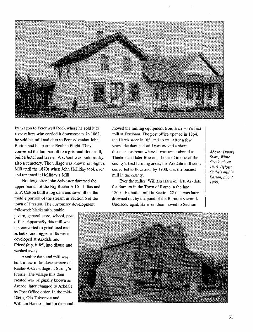
by wagon to Petenwell Rock where he sold it toriver rafters who carried it downstream. In 1862,he sold his mill and dam to Pennsylvanian JohnBarton and his partner Reuben Flight. Theyconverted the lumbermill to a grist and flour mill,built a hotel and tavern. A school was built nearby,also a cemetery. The village was known as Flight'sMill until the 1870s when John Holliday took overand renamed it Holliday's Mill.
Not long after John Sylvester dammed theupper branch of the Big Roche-A-Cri, Julius andE. P. Cotton built a log dam and sawmill on themiddle portion of the stream in Section 6 of thetown of Preston. The customary developmentf ll d bl k u ^ i^^,4i ,-,
moved the milling equipment from Harrison's firstmill at Fordham. The post office opened in 1864,the Harris store in '65, and so on. After a fewyears, the dam and mill was moved a shortdistance upstream where it was remembered asThiele's and later Bower's. Located in one of thecounty's best farming areas, the Arkdale mill soonconverted to flour and, by 1900, was the busiestmill in the county.
Ever the miller, William Harrison left Arkdalefor Barnum in the Town of Rome in the late1860s. He built a mill in Section 22 that was laterdrowned out by the pond of the Barnum sawmill.Undiscouraged, Harrison then moved to Section
UiIoweu:a. UismthllUI , sItaie,
tavern, general store, school, postoffice. Apparently this mill wasnot converted to grind feed and,as better and bigger mills weredeveloped at Arkdale andFriendship, it fell into disuse andwashed away.
Another dam and mill wasbuilt a few miles downstream ofRoche-A-Cri village in Strong'sPrairie. The village this damcreated was originally known as
Arcade, later changed to Arkdaleby Post Office order. In the mid-1860s, Ole Tulverson andWilliam Harrisonn hnilt a dam and
31
Above: Dunn'sStore, WhiteCreek, about1910. Below:Colby's mill inEaston, about1900.
TV,..,L ,.111 X L.A•.ILL4LL la. U AILL L .ALl• -•, - 1%.&

Above: Thevillage of ]Holliday's Millwas located onAspen Avenuebetween 6th and7th Avenues. Right:Built in the 1860s,the Arkdale millserved the county'sleading farmcommunity inStrong's Prairie.
10 where he built another mill on the bank of 14Mile Creek that he operated until the early 1900s.
__ ~___ __
32
The village that developed here was known as
New Rome.
William Harrison should go down in history
as the leading founder of villages in the county.
Fordham was short-lived, but New Rome lasted
until the 1970s and Arkdale is still intact today. In
addition, although he did not found the village,
William Harrison had an interest in the mill at
Friendship.The waterpower site on the Little Roche-A-
Cri at the foot of what was then known as Rocky
Rock was developed by New Yorkers Luther
Stowell and William Burbank in 1857. They had
purchased the eighty-acre village site from
speculator Henry Whitney, built a grist mill and
platted a village called Friendship, after their home
town in New York.
Friendship had rivals upstream in the villages
of Preston and Fordham. Located about two miles
east of Friendship, at the common corer of
Sections 33 and 34 of Preston and Sections 3 and 4
of Adams, the village of Preston was platted
around a mill site owned by John and Diana Hill,
and Thomas and Ann Marsden early in 1857. It is

unclear whether a mill was ever actually built
there, but Hill's store and a post office were soon
in operation.About two miles upstream of Preston village,
in Section 35, Town of Preston, the village of
Fordham grew around the dam built by William
Harrison. On the Pinery Road with good water
power, Fordham already had a mill and hotel when
Stowell and Burbank built their dam at Friendship.
Either Preston or Fordham could have developed
into a larger village, but Friendship got the nod
when Stowell and other villagers promised to built
a court house if the voters opted to move the
county seat from Quincy. They agreed and Friend-
ship grew, while Fordham, which lost its mill to
Arkdale, and Preston, which lost its post office to
Friendship, diminished.
Nearly all the villages that existed in Adams
County in the 1800s were located at water power
sites developed in the 1850s. Arkdale came along
in the 1860s and New Rome in the 1870s--also at
water power sites. To be sure, crossroads commu-
nities with a single store, rural school, post office
or country church also existed, but anyplace
bearing some semblance to a village grew around
a water-powered mill. Not until 1911, when the
railroad arrived, would villages develop away
from places where water falling over rocks
generated power.
Filling the Map, 1860s-'80sIn 1871, the Adams County board announced
that 56,000 acres of state-owned land--about 12
percent of the county--was still unsettled and for
sale at 50 cents an acre. Most of this land was in
the northern and eastern townships, dominated by
infertile sandy soil and wetlands. Preston, popula-
tion 162 in 1875; Big Flats, 154; Richfield, 220;
Leola, 217; were the most sparsely settled towns.
Due to the Barnum sawmill and village, Rome
enjoyed a temporary population increase to 330 in
the early 1870s, but declined to 250 and dropping
by 1885. By comparison, the most populous town
in the county, Strongs Prairie, had 934 people in
1875, while number-two New Haven had 847. The
fact that Rome and Big Flats were double-town-
ships, covering about twice as much area as New
Haven, Jackson or Easton, yet had only one-half as
many people, and that the Town of Colburn had
still to be carved out of Leola and Richfield, well
illustrates the thin spread of settlement in northern
and northeastern Adams County.
The Friendshipmill, about1900.
33

Nonetheless, settlers did make homes in theblowsand and wetland towns. In the 1850s,Thomas and Anna Shipway opened an inn fortravelers on the Pinery Road in Section 18 of BigFlats about one-quarter mile west of the presentjunction of State Highway 13 and County High-way C. The first Big Flats post office opened aboutone-quarter mile north in 1862 and the first townschool followed about one-half mile west in 1869.As the population grew in the 1880s, another postoffice called Beatrice opened in Section 6, closedafter two years, then reopened in the 1900s.
The Danish migration to the town began in the1870s, when Carl Sorensen and Andrew Paulsonpurchased land in Section 10. Other Danesfollowed and the community was named Niebull,either after the home village of the Danes or oftheir German neighbors. A school and churchfollowed and Big Flats began to develop.
Settlement in Richfield began along the roadfrom Grand Marsh to Stevens Point on the burroak prairie north of Pilot Knob in the 1850s.Growth continued on a fairly steady basis, pro-ceeding north along the glacial moraine to theColoma Flats in what is now the Town of Colburn.Settlers also moved west down the old "state road"which ran from Pilot Knob to Fordham andFriendship.
In January 1866, Ebenezer Moffitt, who hadjust arrived in the Spring Bluff area, wrote thefollowing description of Lincoln and Richfield in aletter to his family back in New York:"Dear Brother and Sister
We have got to the promised land and it is socold that it takes the cows horns off that and itnever rains here. It hant rained here since wecome here nor been but one cloudy day since wecome here. The sun shines all the time except nitesand Sundays. The land is so level that you can'ttell when you go down hill. It was snowing all dayyesterday and today the snow is about afoot deep.I heard that you got a chance to sell your farm, Ithink you can get a farm here bigger and nicerthan yours....Hoskins has got a very nice farm of160 acres with a good barn and house. Harris hasgot the same number of acres with a good barnand a log house. Lad has got a 240 acre that canbe had for one thousand dollars...If you get hereyou can find land enough to buy if you like it. Ithink you never seen a nicer leveler country...wecan't tell how good it is yet but it looks as nice asnice. I tell you you don't know how nice it is inLincoln....
You can go from Kilbourn to Fordham thirtymiles and not find a hill...I been east seven miles,west four miles and hardly a stone. If you want tobuy land now is the time for it is very cheap."
34
Big Flatschurch group,about 1900.
One person attracted to the "cheap" land wasRuel Hotchkiss, who paid $200 for a log cabin andbarn plus fifty acres of wooded ground and thirtyof cleared in Section 3 of Richfield in 1869.
Although Hotchkiss was a wheat farmer atfirst, selling some, eating some, and parchingsome to use as a coffee substitute, he also grewhops and clover seed. In 1899, the Colomanewspaper reported that "E. Hotchkiss came tomarket with nineteen bags of clover seed worth asmuch as nineteen wagon loads of potatoes."
Not even "cheap" land could bring more than
a few settlers to Leola in the 1850s. The greatmarsh covering nearly all of the town delayedsettlement. Early histories mention that UriahDorman set up a hotel in Section 1 on thePlainfield-Wisconsin Rapids road in 1858 andlater built a steam-powered sawmill that was stillrunning in the late 1870s. It is easy to understandhow travelers would have found Dorman's Inn,harder to guess where he found enough logs to run
a sawmill for twenty years. At the other end of the
town, on the Big Roche-A-Cri at Holliday's mill,the logs ran out in the 1860s.
People were about as hard to find in Leola aslogs. There were 217 residents in 1875, 240 in1895. Schools at Dormanville, Polebridge and theaptly named Farview did not open until the 1890sor later. Not until the drainage schemes of the late
1890s and 1900s dried up some stretches ofwetland did population grow. By 1905, Leola'snumbers more than doubled to 546.
The Town of Rome had its first wave of
settlement in the 1850s, led by New Yorkers whonamed it: W.W. Burhite, Joseph Smith, MorrisBurrows, Loren Finch, J.R. Hamond, CalvinChester. They concentrated in the northwesternpart of the town close to the river and the bustlinglittle sawmill town of Nekoosa. Growth was slow,however, with the first school opening in 1869 onland in Section 2 donated by Calvin Chester. Thiswas also the site of the original New Rome postoffice which opened in 1858. It later moved to the
Harrison mill site on 14 Mile Creek in Section 10,
later known as Deer Lodge Lake.Interest in Rome was stimulated in 1865 when
an outfit known as the St. Louis and WisconsinLumber Company built a sawmill on the Wiscon-sin in Section 26. These were the salad days oflumber rafting on the river, with many a load of
boards floated all the way down the Wisconsin andthe Mississippi to St. Louis. The new mill washoused in a building 80 x 120 feet and operatedunder the name of the Barnum Lumber Company.The origin of the name is unclear, although onenews report of the time attributes it to St. Louislumberman Tiburon Barnum.
Be that as it may, and although it was on theriver, the Barnum mill site did not have sufficentwater power to run a mill large enough to meet thedemands of the St. Louis market. Instead thelumber company bought a $28,000 steam engine torun the saws. It was shipped to New Lisbon inJuneau County by rail, then hauled by oxen acrossthe sands of Necedah and Armenia to the Wiscon-sin, and somehow moved across the river.
By 1870, the mill was up and running, withtwo circular saws and an edger capable of turningout 50,000 board feet of lumber a day. In threemonths of operation that year, the mill had thirtyemployees who produced about one million boardfeet of lumber that was assembled into rafts andshipped down river.
In 1871, the mill was purchased and improvedby the Weed Lumber Company of Oshkosh. TheBarnum mill sat on a side channel separated fromthe main river by a long, narrow island. WeedLumber built a dam at the downriver side of thischannel to create a "pond" where logs could bestored prior to milling. As a result, water backedup into the creek nearby where William Harrisonhad built a grist mill, flooding him out. As com-pensation, Weed gave Harrison enough lumber to
build a new mill out of harm's way on 14 MileCreek at New Rome.
Barnum Lumber hummed along in 1872, '73,'74 and '75, with shingle, planing and lathe millsadding value to the basic product of rough cutboards. A village grew nearby with housing forabout sixty workers and their families, a companystore, a hotel and Methodist Episcopal church. Itwas, as one reporter wrote, a "bustling hive ofindustry." The hive continued to bustle for thesummer season of 1876 then, as was customary, itshut down in the fall to await a new supply of logsthe following spring.
On one night in November, mill managerAndrew Bean was accosted by a armed man on theroad to Nekoosa. Bean pulled out his own pistoland scared off his mysterious assailant. Two days
35

later a fire broke out in the mill buildings and "in
an almost incredibly short time they were reduced
to a mass of smouldering ruins." It was later
discovered that pumps meant to provide water for
fire fighting had been tampered with and arson
was likely. The mills that were "the finest" in the
valley shut down, never to reopen.
There is some suggestion that the Barnum mill
was destroyed by a disgruntled worker--the same
person who had accosted Bean--but it is just as
likely to have been destroyed by accident or by its
owners. Situated at the tail end of a string of mills
that ran down river from Stevens Point to
Nekoosa, Barnum was the last mill on the river to
receive logs from the dwindling supply upstream.
Since many a sawmill operator was not above
filching logs from competitors, it is likely that
many of Barnum's logs were diverted to mills
upstream. Be that as it may, the days of driving
logs to mills and rafting the output to market were
also numbered, had been ever since railroads
reached Wisconsin Rapids, Plower and Stevens
Point in the early 1870s. With railroads to deliver
milled boards, sawmills stopped shipping them by
water. Located many miles away from the nearest
railroad, Barnum was becoming more of a losing
proposition everyday.
Furthermore, it was not unusual for pioneer
lumbermen to "sell" a failing mill to the insurance
Population of Adams County
Towns ................ 860..........1900.............1960...........1997AdamsAdams, City*Brownville*ChesterBig FlatsColburnDell PrairieEastonFriendship, Village*Grand MarshJacksonLeolaLincolnMonroeNew ChesterNew Haven*Newark ValleyPrestonQuincyRichfieldRomeSpringvilleStrongs PrairieWhite Creek
company by setting it on fire and collecting on the
coverage. Perhaps it happened at Barnum.
In any event, Barnum was Adams county's
first and largest industrial operation of the 19th
century. Its loss was felt most acutely in Rome,
where growth was set back for a generation. In the
1870s, after the town dug a drainage ditch that
promised to transform the marshes east of
Dyracuse Rock into cropland, settlers came to the
southeastern corer of Rome. But in between
Dyracuse and New Rome village stood twenty
sections and more of land still in state or federal
ownership. Not until the 1890s, when immigrants
from central Europe occupied the sands in the
central and southern part of the town, would the
population of Rome again increase.
By the 1900s, the pioneering days were over
in Adams county, so was the stagnation that had
stifled population growth as well as rural andindustrial development. In the 1890s, new immi-
grants from central and eastern Europe, and
Americans already here, would look with opti-
mism on the sparsely-settled sands and marshes of
Adams County. Aided by drainage schemes, new
methods of farming and the promise of a railroad
on its way, Adams county got a second start.
462 588 497 1,3081,301 1,776
56372
550392
650 581349 487
427528 589155 384
479364 595
397614 693118295243303134615604207
377432417654568958
246142411393560
449207283196422515
337249165181368644
764168
1,223923801
729244345357
1,887518
1,1551,001
1602,146
8741,109
Wisconsin Dells, City 5Total.....................6,497.........9,141............7,566.......17,493
36
Right: Uniden-tified motherand child.After threedecades ofalmost nogrowth, countypopulationgrew dramati-cally in the1890s.

From Past To Present: The History of Adams County - Link PagePrevious The Pinery Road 17
Next Who We Were, 1900 37
Return to Electronic Index Page