asst rpt striger cl mongowin twp - ontario · whitefish driver indian reserve c surrendered portion...
TRANSCRIPT

N T S 1*1 IA
MONGOWINO10
Assessment Report
Stringer Claims
Mongowin Township
ONTARIO
March 17, 1981*
D.W. Constable B Se., F.G,A.C.
RECEIVED
•//1NING

eaaa MONGOWIN
Table of Contents010C
Introduction ........................................... Page l
Property Description, Location, Access and Physiography. Page 2
Qeology ..........*.................................*... Page 3
Linecutting ................................. *.......... Page k
EM - VLF Survey ....................................... * Page k
Interpretation and Conclusions ................ .*....... Page 5
Maps in Pocket:
(a) EM - VLF Results, Cutler Station
(b) EM - VLF Results, Annopolis Station
li fe-

- l -
Introduction
This report describes a linecutting and EM -VLF survey over
Six contiguois unpatented mining claims owned by Ed and Roger
Stringer. The claims are lor- *i in Mongowin township just east
of the McMillan Mine and the ^aims straddle House Lake* Access
is from highway 6, westward, on a fair weather bush road to the
McMillan Mine site.
The area is underlain by a seouence of Huronian age,
Gowganda Formation rocks consisting of east-west striking,
steeply dipping argillites, greywackes and niiartzitos. Ooid is
known to occur in the area, mostly in ouartz veins and associated
with pyrite, chalcopyrite, carbonate and arsenopyrite.
The present survey attempted to define electromagnetic
conductors over House Lako particularly in order to delineate
faults which could be auriferous.

- 2 ~
Property Description, Location, Access and Physiography
The property consists of six (6) unpatented contiguous
mining claims, which can be described:
Claim No. Owner Lie, No.
605720 R. Stringer C32622
6822W R. Stringer C32622
6^7727 E. Stringer ' C32593
6it7728 E. Stringer C32593
6i*7729 K. Stringer C32593
6^7730 E. Stringer C32593
The claims are located in Mongowin township, Sudbury Mining
Division. They straddle House Lake. Access is by highway 6,
from Espanola to Manitoulin Island. A fair weather bush road is
taken westward from 6 near West River. This bush road proceeds
along the north shore of House Lake to the McMillan Mine Townsite;
a distance of roughly two miles. During winter the lake provides
access from the mihesite.
The area is generally rugged but in the claim area relief
seldom exceeds 100 feet. Outcrop-is plentiful along the lake
shores and heights of land. Timber is second growth mainly
poplar, jackpines and hardwoods. Water is plentiful. Overburden
ie shallow and generally sandy soil covered.

f.:. :
- 3 -
Geology
The area has been periodically mapped since l8l*8. The most
recent mapping was by CARD. ( 06S Geoscience Report 131, 1976 )
The area is underlain by a Precambrian sequence of the
Huromian Supergroup consisting mainly of metasediments. These
rocks were folded, faulted and metamorphosed. Then the sequence
was intruded by several ages of diabaise and amphibolite dykes.
In the subject claim group the rocks belong to the Gowganda
Formation, principally conglomerates, nrglllites greywackes and
quartzites. A Nipissing diabaise dyke trends northwesterly
across the western two claims of the group.
Folding consists of several phases and domaines but generally
the folding is tight with east-west axis and shallow, double
plunges. Faults are east-west, northeasterly and north westerly.
Movements are significant in both horrizontal and vertical senses.
Metamorphism is greenschist and lower amphibolite facies.
The first economic interest in the area in the 1900*s was
for copper-nickel near ultramafic plugs. Later in the 1920*s and
30^6 gold was discovered in the region. Gold was generally
found in quartz veins in nuartzites. The gold was generally free
and associated with carbonates, cuartz, pyrite, cholopyrite and
arsenopyrite. The McMillan Mine from 193^-37 produced more than
10,000 ounces of gold for an average recovered grade of 0.18
onces per ton.
m

Present Program
Linecutting
Linecutting consisted of establishing a base line along the
east-west claim line south of House Lake. Lines were turned off
at 400 foot intervals and run by compass and chained at 100 foot
intervals. The lake was picketed.
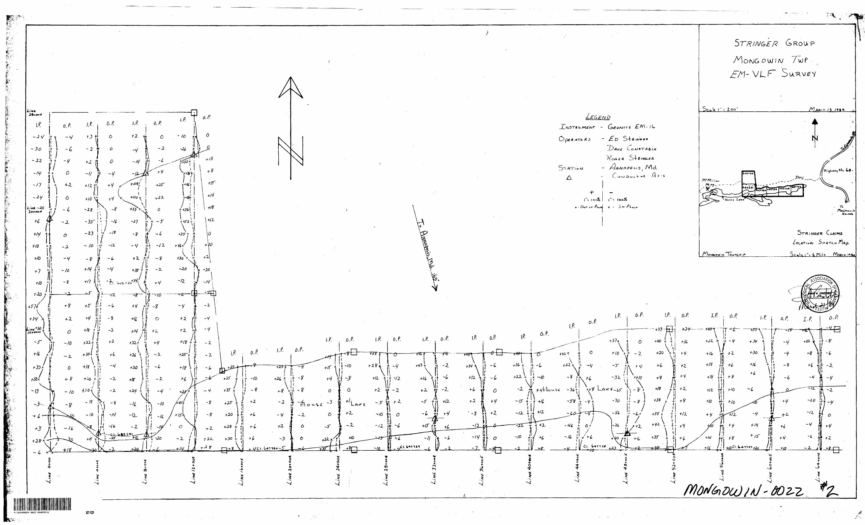
EM - VLF Survey
A Geonics EM-16 instrument was utilized for this survey.
This is a ona-man instrument which measures the vertical destortion
of a primary electrical field caused by proximity to a secondary
field due to sulfides, graphite, clay or water-filled faults.
The distortion is read in percentage for this survey. Both in
phase and out of phase readings were read for Cutler- Maine
(2J*.OKHz) and Annapolis (31.4 KHz) Stations.
The results were plotted on a I"s200' scale map by profile
U" s 10096). Conductor axis were interpreted on each map.

;:w:m
- 5 -
Interpretation and Conclusions
Both the Annopolis and Cutler maps had very few conductors
present* The sole area of anomalies on both maps is on claim
605720; specifically the northern half of the cisir.
(Lines 8 and 12 * GOE at 23 and 2k * 00 N) These conductors
are of moderate strength and lie on land. The profiles suggest
a northerly dip, but this is not conclusive.
I suggest prospecting over this area and I suspect the
conductors may be due to graphitic argillite or maybe a
topographic effect.
l:i


791267)791260
7*1235 U79I23* 79123'* 'l7?-.*! G72700 7 2IO33 .
791208 •79I207J/ ,9l20K j 79P20
BLOCK Ap
S.R.O.
WHITEFISH DRIVER
INDIAN RESERVE
C SURRENDERED PORTION
FOR STATUS REFER TO
Curtin Twp. - M.745

IV Ontario
i.'.' 1
Cji' .'11 1 :. - :
•' j. ̂
j : P
t
IId8.
t'-mv ,m-
T 1
TECHN1O
Type of Siirvey(s) L. UVM. t
Township nr Area l ' '
Claim Holder(s) /- D
i^-ea fv*-
Riirvry Company C-O TSj' * ' **^ .^x.
Author of Report . ,J..Xft
Address of Author 1 o '*^
Covering Dates of Survey *^
Total Miles of Line Cut
SPECIAL PROVISIONS CREDITS REQUESTED
ENTER 40 days (include line cutting) for first survey.ENTER 20 days for each additional survey using same grid.
Ministry of Natural ResourcesGEOPHYSICAL - GEOLOGICAL - GEOCH
TECHNICAL DATA STATEMEhT
P!!.
EMICALr
0 BE ATTACHED AS AN APPENDIX TO TECHNICAL REPORT FACTS SHOWN HERE NEED NOT BE REPEATED IN REPORT ^L REPORT MUST CONTAIN INTERPRETATION, CONCLUSIONS ETC.
iJ^OC^" ^rA/l- VJ *-^ fa S *-O*v**i0J1 '. ^~, —— fS^SL^^- c 0 3^*3^
^A-N) ' ^ f c "^ 3 ( 0 -5 ^^ O i "^^ f^i CUC^*t X^ ^*- *^ ^- ̂ ^ i- t. J
*T**ll? C**^l.t~t.-r,sv±Zt*--v To C^o MS -r Avst f &S*. ^T^At^AJCSTo/o C^r-T 5uD4v^, &AJ*^.57s^/ ~ /V\cv--v^Cv "3 ySv
/(linecutting to office)
DAYS ,, , . . per claim Geophysical
—Electromagnetic — \0C* — s
— Magnrtomrt'"r.. , - —
—Radiometric..,.,... ,.-Othfr
npnlngira]
AIRBORNE CREDITS (Special piovision credits do not apply to airborne mrveyi)
Magnetometer. . ,......... Fler'™rnacmetic R.-iHinmMrir
/y) -^ , LDATE: f'Lu-sA 2'|P*f
Res. Geol.
Previous Surveys
(enter dayj per clairn}-^^
SIGNATTIREj— z^tL,^ ( ̂ ••f~0*^"u{-*-Aulrtor of Report or Agent
Qualifications . . X -- - s ' f ^--^
File No. Type Date Claim Holder
837 (6/70)
MINING CLAIMS TRAVERSED Litt numerically
^ * CoOt5^7*^.o-, (prefix) , (number)^ . Utf-Tj.i'j
-0* i? /b- CD^T^^SS. (D ip 7 2VS. 4^-7730S (^83241
:::::::::ii:nKtt; tl V fci^
TO^2TOMINING UND5 SECTION
i1t
M
t]

-
RES
ISTI
VIT
YG
RA
VIT
YEL
ECTR
OM
AG
NET
ICM
AG
NET
IC25"
Of
K,
0 Q.
0 0.
nn
M
to
n
Tt
***—
tp
M
-1
n
wo
2.
v,;O
- 3
0-3
O
l- l
I l
s- i
0 s
-s -4?
-o 3 n
3 n
DO
*~3
S
3'
S.—
o
l.:| ID D
50
T5
TK
j *n
-^
S
rs
o^
-a
j3^
c c
o
o3
3o
n
•^
^ a o w
ES" 5 5" 3 W O D C S o
ta B)
IA ft
•t
*-* n̂ *B
O 3 i c 3 0. o"
8 o"
1
•f 1
1 i
s l
g i i
15
** c
3 "c
o"
5
2 - o
" c
B. 8
3
I
g g.
S
-S
S 3
o s
f* 5
o "
-5
2 -2
, 2
2
^
S
S x:
•3 -*
S "^
Q.
ft
3 rt wt n e\-
'
*'
^
-. .^ r •i t 7"
h r Of ij o" r i^ F t-
'T
*
i
O ^^M
•^•^ o i D
ft ^ "
r — * ^D
i? B- 5"
•C
n
T •* -D•4 2L CD
^
OQ
*"*
C.
*™^
o"
23
" so"
H "S s fi;
t 0 A l O
f l; ^ rt R 3 ^ r
co
es
w w
.ff
s -a
-S
o"
o"
53
- a
Qo
S-o x-
o S *-*- o" w
—
\iz.
s g-
^ 5
g.i
SS'
38

^d\!?; y*#*.Mx!#v-:''?-Reuori of Wi'tr.v .;:*PReport of Wuri-, ','rV'iif'';Naiwtii'.[ ; r' l ?..'-''v:',,. . . 'r . , '^ccck - 'ooophyiical. Geological. (hi* lo'"
Of. i niivs rrriiMt CHiciilitci! H: t M*' "E siicndiiiiici" 'rfliofi miiy Hi' rniriutl in Hit "txocnci. Da\t Cr." eolunmk. Do noi use tMMlHd flf*ni t mlqvv,
Geocnpinical and f xponcsi-'-ires/
. i L/ a . -.(Dm* ot buivtf Urom *i lo) lloul Miln ol lifii Cut
/W//? tl/.heciueilod perEflfii Claim m Columns at iioin Minino Claims Traveitod (List i n n umencal it-uiicncel
F W *ic4t •OfSnioritl iitmp t h* MTI* prid:
i, .KOPixlitutei (f KCiutiti
fumufr' o' o* rf.i tcw*'*o rv I'mf*()Ofl O' *VO'k.
l l)*;*tiy ccrlily lri*t l h*ve I Pf'ionti fl'iu mimv - ViOrtKilo* o l l l-f t acit tt l lorlh i n Hit ftepo'l Ci Wo'k enntni-d hoiciu, having performed l lit- work O) mtnnitcJ mm* rjunng tnd/0' a 'lrr I M compitiign (nil il.t- jmnexmi icpun i i Hut.
..-.i.- .10.......X/Wtf J

— "'••••"'''•V' 'f- ' .•V.'-'"' -'x-,-^i^^W'mv''^-:, -Rtjpon ol V7 '- '
...ifin.. ti|.);i[v n'i lin* kum, aiiwli liiisi Ivott;: -- i 'Niv d;ivr rreri'i:. CJilcuiniHfi in ine
"txiHM..!injic." trriion niov' lit'enured "' I'n "Iwncj. Diiyj Cr." columns.
- Do not oke shjeli'il are.u beloiv.
-WON GO w ///
HfOK'neior k Licene* N
iDtie ot Si/'vfv llrcm *i Uil
f.y j7 l W ?; Day J Mo. V' .j "
;1 oi
Ctt'riin; Rpuuciied pet Each Claim n. Coiumrrfyt nnhl Viunnn Claims liaveru'cl dm in inimrnc^l'ieouence)

fcp^^^SWji'-i 1 Resources
Ontario-"'i
Technical Assessment Work Credits On*
1984 09 11
F\\t
2.6534Mining FUco'dtr'i Ripori of Work Mo. 84 . •j g j, 84-'
Recorded Holder
Township or AreaEDWARD STRINGERMONOGOWIN TOWNSHIPS
-
-l"
f
Type of survey and number of Assessment days credit per claim
Geophysical 40
ElfftMynignttlf .,,. , ,,,, . ,. ,, ,, riiyt
lrvi.iMripnUrif.llon. , , riayi
Section 77 (19) S** "Mlnlnp CUImi AiitiMtf" column
n.~*.mir,i
Man days G Airborne O
Special provision 0 Ground D
Q Credits have been reduced because of partial coverage of clalmt.
D Credits have been reduced because of corrections to work date* and figures of applicant.
Mining Cltimj Aueutd
S 647727 to 730 inclusive 605720 682241
CREDIT ALLOWED FOR TRAVERSING PROPERTY ONLY ONCE
Special crediu under section 77 (16) for thr following mining claims
\lo creditl have been allowed for the following mining claims
D not sufficiently covered by th* lurvty LJ lniu(fici*nt technical dm filed
The Mining Recorder may reduce the above credits if necessary In order that the total number of approved assessment days recorded on :*"MCh Claim doea not exceed the maximum allowed as follows: Geophysical — 00; Geological — 40; Geochemical — 40; Stction 77(19) — 60:te ' -
V'S
l1984 03 27 Your File: 18-19
Our File: 2.6534
f-' Mr. V.C. MillerMining RecorderMinistry of Natural Resources199 Larch StreetSudbury, OntarioP3E 5P9
Dear Sir:
We have received reports and maps for a Geophysical (Electromagnetic) Survey submitted under Special Provisions (credit for Performance and Coverage) on Mining Claims S 605720, i 682241, S647727 to 30 Inclusive In the Township of Mongowin.
This material will be examined and assessed and a statement of assessment work credits will be Issued.
Yours sincerely,
S.E. YundtDirectorLand Management Branch
Whitney Block, Room 6643 Queen's Park Toronto, Ontario M7A 1W3 Phone:(416)965-6918
A, Barr:mc
cc: Edward Stringer 206-119 Sandra Box 136Garson, Ontario POM 1VO
cc: Roger Stringer374 Parchment Street Espanola, Ontario POP 1KO
cc: David H. Constable 10 Kingston Court Sudbury, Ontario P3A 1C9

June 21, 1984 Our File: 2.6534
Edward StringerSuite 206119 SandraBox 136 *Garson* Ontario lPOM 1VO
Dear Sir:
RE: Geophysical (YLF) Survey submitted on MiningClaims S 605720 et a1 1n the Township of Mongowin
Enclosed are the plans, 1n duplicate, for the above-mentioned survey. Please plot the raw daU readings at each station and return the maps, 1n duplicate, to this office, quoting file 2.6534.
For further Information, please contact Mr. Ray Plchette at (416)965-4888.
Yours sincerely,
i
S.E, YundtDirectorLand Management Branch
Whitney Block, Room 6643Queen's ParkToronto, OntarioM7A 1W3Phone:(416)965-4888D. Ifiherwoodstnccc: Mining Recorder
Sudbury, Ontario
cct David Constable 10 Kingston Court Sudbury, Ontario P3A 1C9
End.
GC: Roger Stringer374 Parchment Street Espanola, Ontario POP 1KO

i -'
; ?Ministryof Natural Resources
1984 09 11 Your File: 84-18 A 84-19 Our File: 2.6534
V.C. MillerMining RecorderMinistry of Natural fter.ources199 Larch StreetSudbury, OntarioP3E 5P9
Enclosed are two copies of a Notice of Intent with statements listing a reduced rate of assessment work credits to be allowed for a technical survey. Please forward one copy to the recorded holder of the claims and retain the other. In approximately fifteen days from the above date, a final letter of approval of these credits will be sent to you. On receipt of the approval letter, you may then change the work entries on the claim record sheets.For further information, if required, please contact Mr. R.J. Pichette at 416/965-4888.
Yours sincerely,
ii-'t* ''i.' - *'-/
l
..E. Yu'dtDirectorLand Management Branch
Whitney Block, Room 6643 Queen's Park Toronto, Ontario M7A 1W3
t 1*S. Hurst:me ^' Ends.
cc: Edward Stringer Suite 206 119 Sandra Box 136Garson, Ontario POM 1VO
cc: Mr. G.H. FergusonMining 4 Lands CommissionerToronto, Ontario
845
*.^y^^^";^^;^t?!(!^^W*^ ^**:**t''X'y^'-v*:*;V'f.F '*t.*wt

Ministry o1NaturalResources
Ontario
Notice of Intent
for Technical Reports
1984 09 11
2.6534/84-18 S 84-19
An examination of your survey report indicates that the requirements of The Ontario Mining Act have not been fully met to warrant maximum assessment work credits. This notice is merely a warning that you will not be allowed the number of assessment work days credits that you expected and also that in approximately 15 days from the above date, the mining recorder wil' be authorized to change the entries on his record sheets to agree with the enclosed statement. Please note that until such time as the recorder actually changes the entry on the record sheet, the status of the claim remains unchanged.
If you are of the opinion that these changes by the mining recorder will jeopardize your claims, you may during the next fifteen days apply to the Mining and Lands Commissioner for an extension of time. Abstracts should be sent with your application.
If the reduced rate of credits does not jeopardize the status of the claims then you need not seek relief from the Mining and Lands Commissioner and this Notice of Intent may be disregarded.
If your survey was submitted and assessed under the "Special Provision-Performance and Coverage" method and you are of the opinion that a re-appraisal under the "Man-days" method would result in the approval of a greater number of days credit per claim, you may, within the said fifteen Bay period,' submit assessment work breakdowns listing the employees names, addresses and the dates and hours they worked. The new work breakdowns should be submitted direct to the Land Management Branch, Toronto. The report will be re-assessed and a new statement of credits based on actual days worked will be issued.
mm846 CM/5)

If * '.-. -. -i 'V'j. '. ''.- " - J"
10 03 Your File: 64-18 li 84-19 Our File: 2.6534
Mining RecorderMinistry of Natural Resources199 Larch StreetCydf/ury, OntarioP3E 5P9
Dear Sir;!
RE: Hotlcs of Intent dated September 11, 1984 Geophysical (VLF) Survey on Mining Claims S 605720 et al 1n the Township of Mongowin
Tha assessment work credits, as listed with the above-mentioned Notice of Intent, have been approved as of the above date.
Please Inform the recorded holder of these mining claims and so Indicate on your records.
Yours sincerely,
S.E. YundtDirectorLand Management Branch
Whitney Block, Room 6643Queen's ParkToronto, OntarioH7A 1M3Phone:(416)965-4888
S. Hurst:me
cc: Edward Stringer Suite 205 119 Sandra Box 136Garson, Ontario POM 1YO
End.
cc: Mr. G.H. FergusonMining a Lands Commissioner Toronto, Ontario
cc: Resident Geologist Sudbury, Ontario

RECEIVEDMAR 2 2 1984
MINING LANDS SECTIOM

'GeotechnicalRar.nrtRePort Approval
Filft
,^7- .., , ..••'.;,;V^,, Mining Lands Comments
'{ / ,,-
l') ' -
--
lGeophysics f? CO
Commanti
^ ^u—qZ,
Approved "' "ffj-Wtih to we tgsin with correctionsDele Slg
To: Geology - Expenditures (JjCommentt
Approved |~1 With to lee esain with correction*Slgniture
To: Geochemistry
Approved Qwiih to leeepiln with eorrectioniDate Signiture
x Mining Lands Section, Room 6462, Whitby Block, (Tel: 6-1380)
GeotechnicalReportApproval
^1 ' Wining Lands Comments
7/ - ' y rs ' ^ x
To: Geophysics
0ApprOVKJ [~~] W iih 10 n e agai
lo: Geology - Expenditures
With totef igain with corr*clioni
To: Geochemistry
rn Approvtd LJ With \n iti again with corrtcdoni
: Mining Lands Section, Room 6462, Whitney Block. (Tel: 5-1380)
iV'^V!-::'-. -Y."*H*.''?'^.-'' 5:^ V : :^ -:
:pse:|Wwl^p:.S^jKfp^^

r^c*r&ttH AP (5)
ft:
Locffl"Eb //v "Tjte/w THE (x)
**j*;-''
x

r
STRINGER G ROUP
- A * f O
9 - Our * r n^*J
DC AT i o w 3 K f T f- H /l A p
If. o.P. IP. AP.If o./7-
I/?. O.R
il*I ^t -r
, .-"n1 . •'•••r..
-if0L3N l KOSNOW
/-"7" —
**
'
11
\
t
1
1
A-'.*
yt
M?W VJ ̂'^LIV^"UH7J.SVIC" WO'O.V)O7
?
n-o-/
hJ
v
i Am y A//mo
d^noyc)
c'i^ ^r - x^00| -J^ol *.^|
-f-
eva
V/-L* ^
cy
^
r-r^
-O*LL*'*) MO/7 ^
y-o
\rd